
Agriculture


Beaver Reintroduction
Peatland Restoration
Managed Realignment
Seagrass
Warming, Acidification, Deoxygenation

Towards a catchment to coast understanding of the transport of material between land and the coastal sea
Andy Rees (apre@pml.ac.uk)
& Keila Guillen Onate
(kgu@pml.ac.uk)


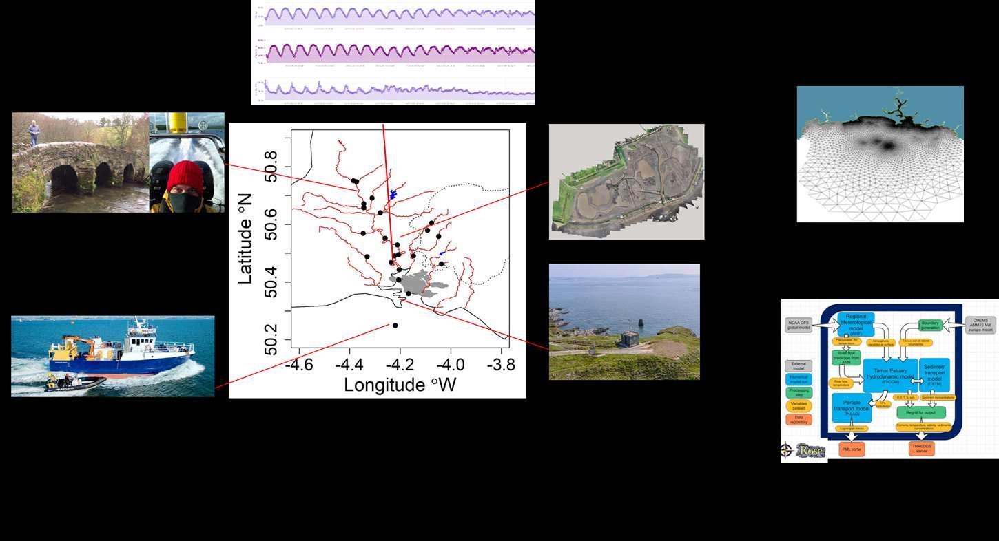
AgZero+ Project in Tamar catchment (2022-27)
PML
2017-2018 River Tamar monthly at Gunnislake
Tamar estuary quarterly between Calstock and ~Devils Point
2019-2020
River Tamar Catchment, monthly sampling at:
Tamar - North Tamerton, Druxton, Horsebridge, Gunnislake, Saltash; Ottery -
Ham Mill Bridge; Inny - Treburly; Lyd – Lifton; Tavy – Hill Bridge, Denham Bridge; Walkham – Merrivale; Plym – Cadover
Bi-monthly sampling of estuary between Calstock and ~Devils Point
2020 – 2022
River Tamar Catchment, monthly sampling at:
Tamar - Gunnislake, Saltash, Devils Point; Tavy – Hill Bridge; Colly Brook – Peter Tavy; Walkham – Merrivale; Plym – Cadover Previous
during LOCATE project
sampling
Location River LATITUDE LONGITUDE GRID REF. OSGB HEALE BRIDGE/Boldford Carey 50.6710536 -4.316145 SX359863 TETCOTT Claw 50.74782 -4.37279 SX327969 LIFTON Lyd 50.640785 -4.279321 SX389848 NEW BRIDGE Lynher 50.487987 -4.331225 SX 347679 HAM MILL BRIDGE Ottery 50.657628 -4.3441 SX345868 DENHAM BRIDGE Tavy 50.49077 -4.148188 SX477679 N TAMERTON Tamar 50.751557 -4.385717 SX319974 GUNNISLAKE Tamar 50.52866 -4.212261 SX433723 CALSTOCK Tamar 50.49576 -4.20672 SX435685 COTEHELE Tamar 50.491229 -4.223043 SX423680 HALTON QUAY Tamar 50.467929 -4.236367 SX413655 CARGREEN Tamar 50.442684 -4.203831 SX435627 SALTASH Tamar 50.40728 -4.205775 SX433587 DEVILS POINT Tamar 50.359945 -4.167329 SX459533
sampling positions
AgZero+
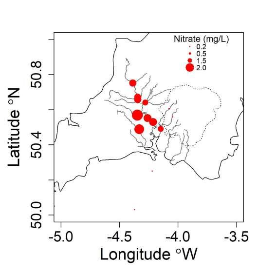
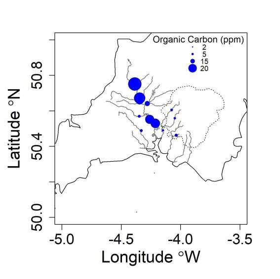
Catchment – annual means
Tamar

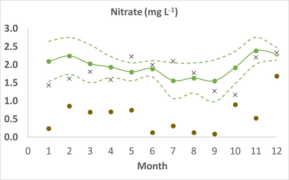
Mean (± 1sd) nitrate at Gunnislake (2017 – 2022)
X nitrate at Gunnislake 2021
nitrate at Saltash 2021
Nitrate variability
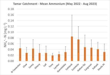
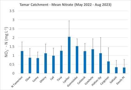
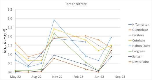
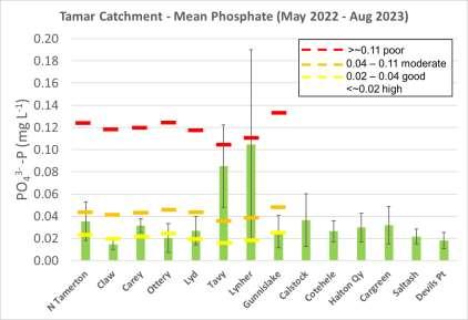
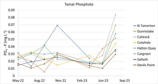
Temperature, Salinity, Conductivity, Oxygen, Nitrate, Nitrite, Ammonium, Phosphate, Silicate, CDOM, DOC, DIC, Alkalinity, Carbon Dioxide, pH, Nitrous Oxide, Methane, Particulate Carbon, Particulate Nitrogen, Suspended Solids, Bacteria, Algae, DNA/RNA
Tamar Catchment May 2022 to August 2023
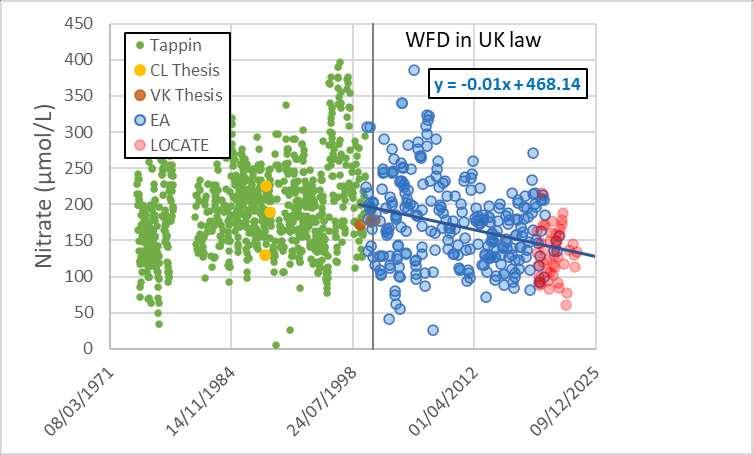
– 50 year nitrate trend
Gunnislake
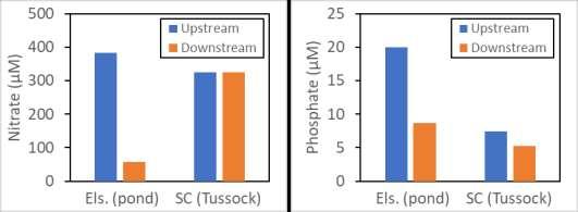

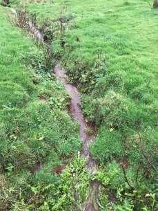
Farmland – Pond & Tussock
Holding back the flow!
Upstream
Within enclosure
Upstream
Within enclosure
Incoming tide
Outgoing tide

Incoming tide
Outgoing tide
Beaver enclosure
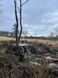

Wetland 100µM = 1.4 mg/L – N 1.0µM = 0.031 mg/L - P
Calstock
Vis4Sea Objectives.
• The project will build a cohesive Open Data Cube to facilitate the use of in situ sampling, automated sensor network and multi-source, multi-sensor satellite data for monitoring the water quality in Plymouth Sound, UK and the Fitzeroy River, Australia.
• Optical, machine and deep learning algorithms will be applied to the satellite data to facilitate the generation of novel water quality parameters to address specific environmental case studies on the effect of sewage, agricultural and heavy metal effluent on intertidal surfaces and seagrasses.
• The output will be a freely available to stakeholders to facilitate the monitoring and management of water quality and carbon sequestration in the Plymouth Sound and Fitzeroy River catchments.
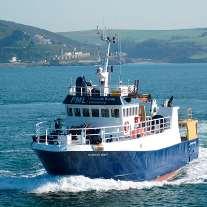
In situ samples
Integrating multi-source data to ADIAS.

Multisensor, resolution satellite data

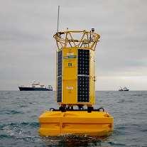
Buoy data

Optical SPM products

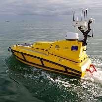
Autonomous vehicles
Open data cube
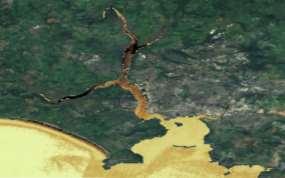
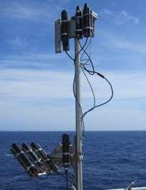
Optical sensors
(mg/m 3 )
SPM
Vis4Sea ODC data.
High resolution EO data
Validation – Chl-a
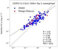

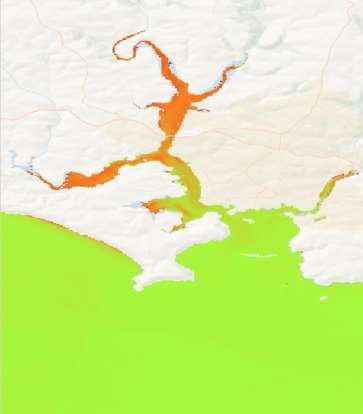
CERTO MSI v2 60m
Chl-a (mg/m3), 2020-Sept-21
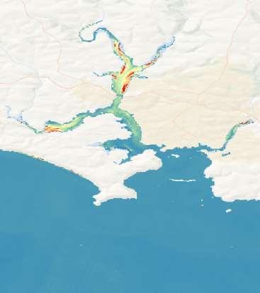
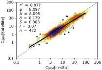
Validation – TSM

CERTO MSI v2 60m
TSM (g/m3), 2020-Sept-21

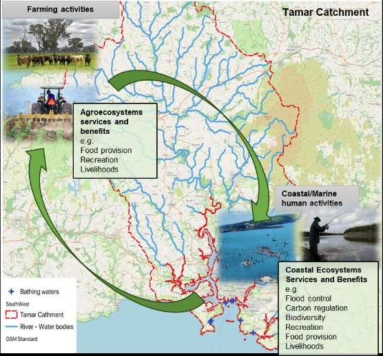
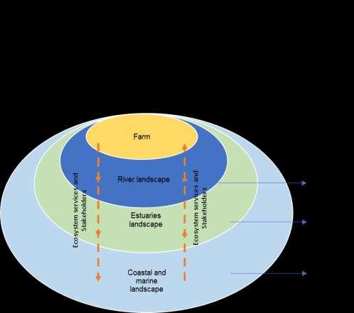
Trade-offs analysis between farmland and coastal zones
What?
• What are the trade-offs between farmland and coastal ecosystem services and their beneficiaries (Stakeholders)?
• How can these trade-offs change with the implementation of net zero+ innovations in farms?
Why?
• To identify winners and losers under current farming practices, and to evaluate the role of net zero+ innovative farming practices in mitigating trade-offs.
How?
• Under a participatory approach, workshops will be used to identify tradeoffs and the stakeholders’ preferences over ecosystem services being traded off among farming and coastal social-ecological systems.
Current stage
• Preparing workshops with researchers and professionals working in the Tamar Catchment.
