_literature review _case studies
_literature review
_Urban agriculture
Urban agriculture in Singapore has been gaining attention due to its potential and innovative approach. This review will focus on these aspects as well as the examples of urban agriculture in Singapore, drawing from recent studies.
_environmental benefits
Urban agricultural initiaves (UAIs) foster a genuine connection with nature and facilitate pro-environmental behaviour spillover. This is archived through tactile involvement with nature and exposure to pro-environmental behaviours (Sean Olivia Nicholas, Groot and Harré, 2023).
_social and psychological benefits
UAIs enable friendships and learning to communicate with diverse peoples. They also increase self-awareness and gratitude. These benefits are facilitated through a culture of open-mindedness that encourages social interaction and encouragement of reflection (Sean Olivia Nicholas, Groot and Harré, 2023).
_socio-cultural benefits
The review captured research in four overarching thematic areas: community engagement and cohesion, health and well-being, economic opportunities, and education. The analysis revealed growth in research on the social impacts of gardens and farms. (Ilieva et al., 2022)
_example
1. Rooftop farms are popping up across the city-state, cultivating crops including tomatoes, eggplant, spearmint, basil, sorrel, tomatillos, and lemons (Appolloni et al., 2021).
2. Vertical farming, a space-efficient method that involves growing crops in vertically stacked layers or on vertical structures (Urban Redevelopment Authority, n.d.).
3. Community garden - City Sprouts Urban Farm.
4. Green Walls and Aquaponics that contribute to the city’s sustainability and green innovation (Cardinali et al., 2023).
_conclusion
Urban agriculture in Singapore offers a range of benefits, not just enhancing food resilience also improving the environmental to social and psychological. Singapore’s innovative approach to urban agriculture is reshaping the city’s landscape.
04
co-located solar panels and greenery rooftop urban farming green walls extensive green roofs communal rooftop gardens landscape refreshment areas (communal spaces) landscape refreshment areas (greenery) covered communal ground gardens landscape decks communal pavilions communal planter boxes rooftop outoodr refreshment areas
Figure 11: URA’s Landscaping for urban spaces and high rise programme (LUSH) (Author’s own)
_Addressing infrastructure barrier and enhancing public spaces
Urban planning is a critical aspect of city development, and the role of public spaces in enhancing the livability and functionality of cities cannot be overstated (Sas-Bojarska and Rembeza, 2016). This review will look into the challenges posed by infrastructure barriers and the potential of public spaces in mitigating these issues.
_infrastructure barriers and city fragmentation
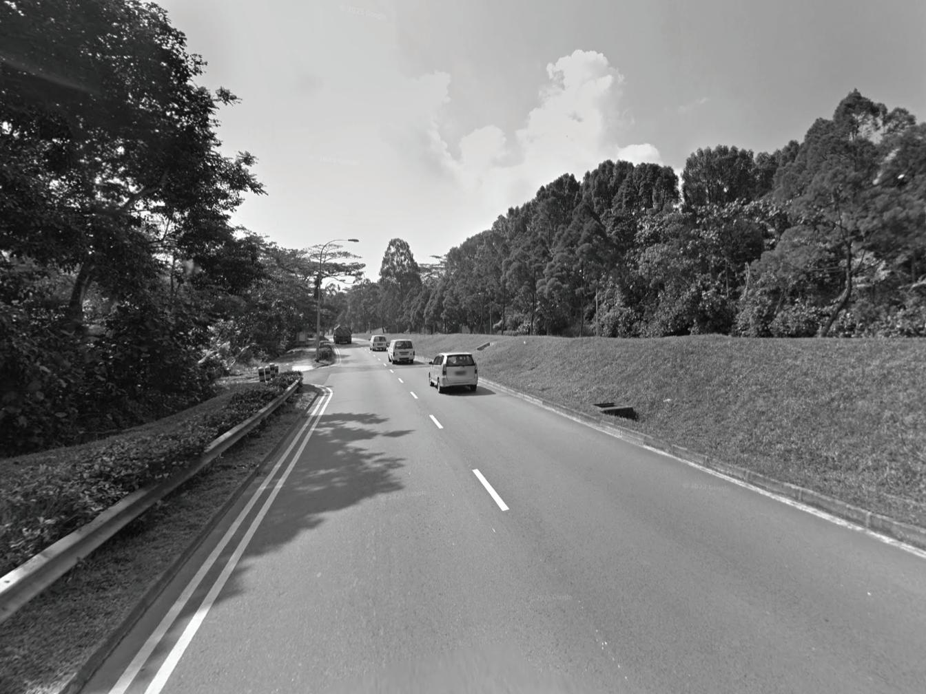
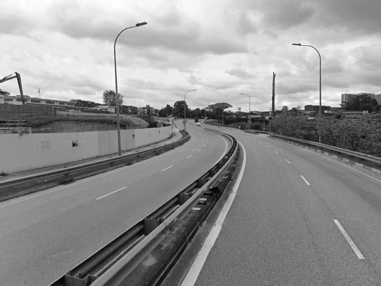
The fragmentation of contemporary cities due to the increasing number of technical barriers like roads, railways, and infrastructural objects. These barriers generate a variety of problems of different nature, disrupting the coherence of urban spaces and posing challenges to city dwellers’ mobility and accessibility (Sas-Bojarska and Rembeza, 2016).
_role of public spaces
Public spaces are identified as crucial elements in connecting the urban tissue. They serve as nodes of interaction, fostering social cohesion, and enhancing the aesthetic appeal of cities. To avoid the negative effects of infrastructure barriers, a city should be designed as a coherent organism in terms of spatial, environmental, infrastructural, social, and visual aspects (Sas-Bojarska and Rembeza, 2016).
_case study
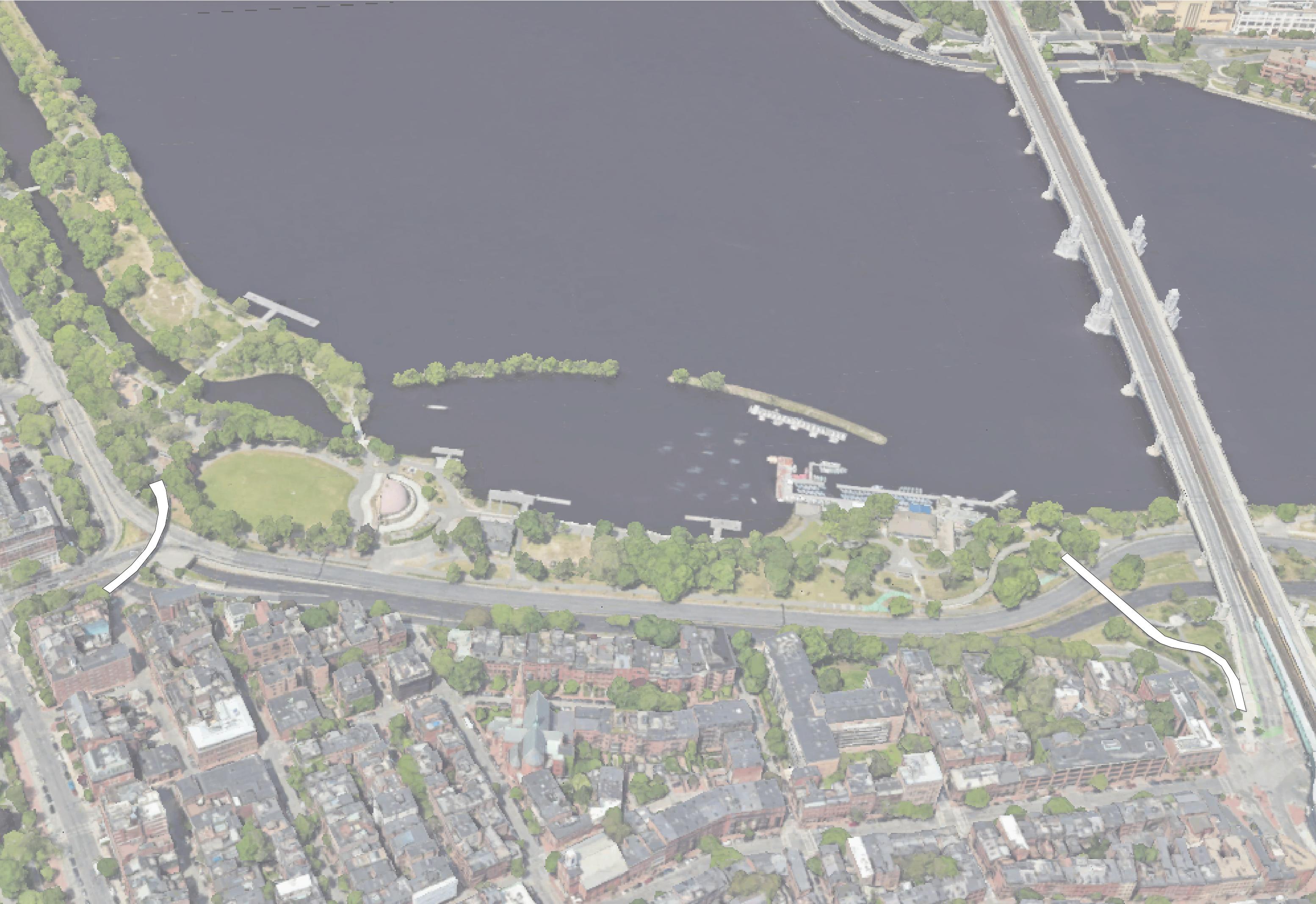
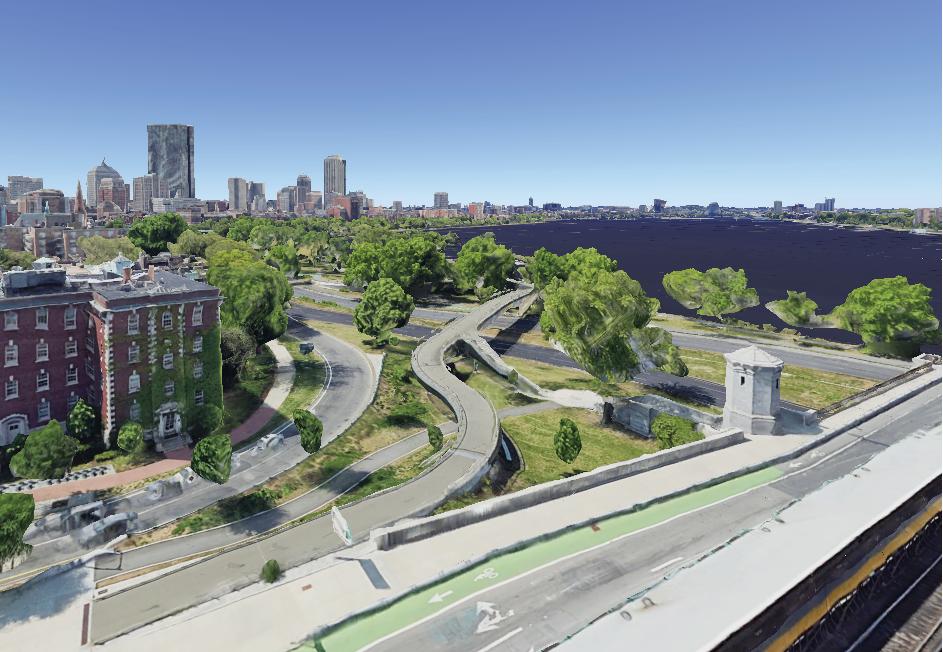
The case study of the Charles River Esplanade in Boston demonstrates that, despite the technical barrier and traffic caused by Storrow Drive, the Charles River was not cut off from the city. The effect of barriers is being minimised by relevant planning and connecting public spaces with bridges to access the river park. The perfect exposure of the river, along with the public spaces, has stepped effectively into the lives of the community, making the Charles River a perfect place for leisure activities (Sas-Bojarska and Rembeza, 2016).
_conclusion
The public spaces, especially the most attractive ones such as waterfronts, should be integrated with the urban fabric - if not continuous, at least with special links. Safe access for users is essential. Every city space, especially those with a view, should not be successful until they are not effectively connected to urban areas. The creation of a coherent public spaces system with safe and attractive access to all parks in the city is essential.
_Hybrid walkable urban networks of Hong Kong
This review focus on the multi-level pedestrian accessibility and walkability within the public and quasi-public realm in Hong Kong with the redevelopment of Taikoo Place in Quarry Bay as a case study, offering valuable insights into the character of the city’s public spaces (Choi et al., 2023).
_public space and public activity
The value of public space as a space for public activity and debate is under increasing scrutiny, both in Hong Kong and internationally. The hybrid form of interior open and transit space in a commercial setting was explored . These spaces have become a central part of the city’s planning, designed to both serve and profit from the high level of pedestrian traffic. (Choi et al., 2023).
_pedestrian behaviour patterns
The pedestrian behaviour patterns were studied to interrogate the value and significance of linked-spaces within commercial districts. These spaces serve and profit from the high level of pedestrian traffic, contributing to the unique urban fabric of Hong Kong (Choi et al., 2023).
_built environment
The built environment of Hong Kong, characterised by its compactness, intensive build-up, and extreme density, has led to the emergence of a layered, multi-level public and quasi-public realm of interior spaces. These spaces are serviced by covered walkways, offering a unique pedestrian experience (Choi et al., 2023).
_conclusion
Hybrid walkable urban networks from underground, to street level, to elevated walkways are important in enhancing walkability and connectivity especially in high-density cities, as well as commericial and business value.
9
_literature review
Figure 12: Charles River Esplanade in Boston (Source: Google Earth,2023)
Figure 13: Bridge connects to Charles River Esplanade in Boston (Source: Google Earth,2023)
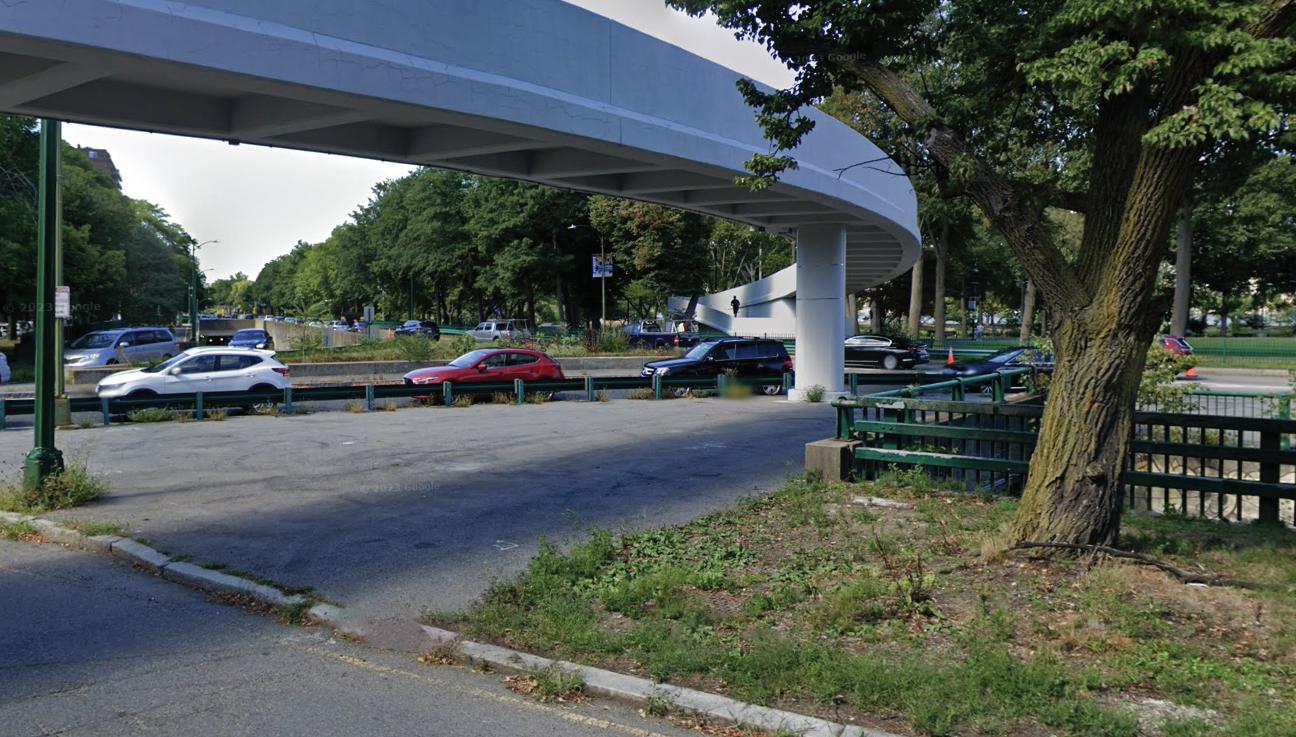
Figure 14: The space underneath the bridges are not well addressed (Source: Google Earth,2023)
04
Figure 15: Taikoo Place First level Interior Public realm amenities, event places and facilities in Taikoo Place (Source: Figure 4, Choi et al., 2023)
Figure 16: Potential pedestrian flow level base on the 3D exterior and interior pedestrian network in Taikoo Place district (Source: Figure 8, Choi et al., 2023)
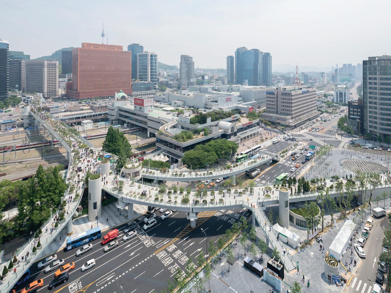
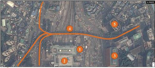
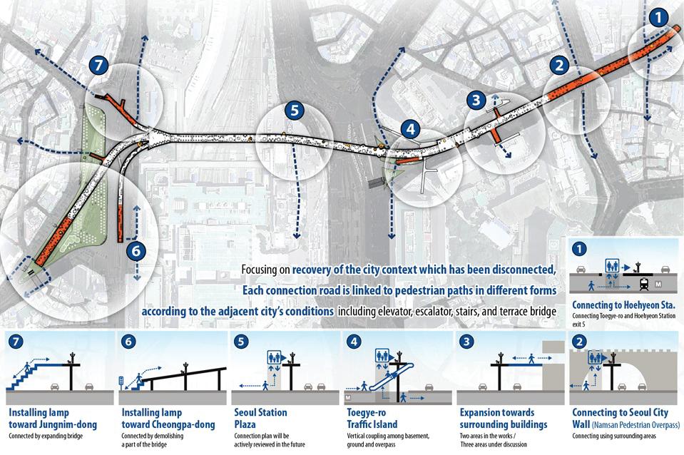
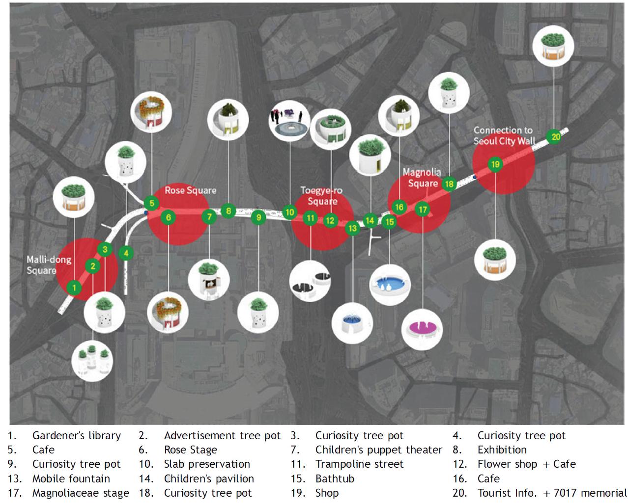
_Seoullo 7017 skygarden, Seoul, South Korea
The Seoullo 7017 is a regeneration project to transform the abondened overpass into an elevated pedestrian walkway and skygarden.
_the walkability evaluation
connectivity
In the vicnity of the existing overpass, there were four main identity nodes that were not interconnected. Consequently, the government decided to extend the skywalk to establish a connection among all these nodes. The aim not only to enhance connectivity for the public but also revitalise these places through the anticipated surge in pedestrian traffic (Hong, 2018). The proposal for the new pedestrian access involves connections to the surrounding areas through underground, ground-level, and above-ground pathways.
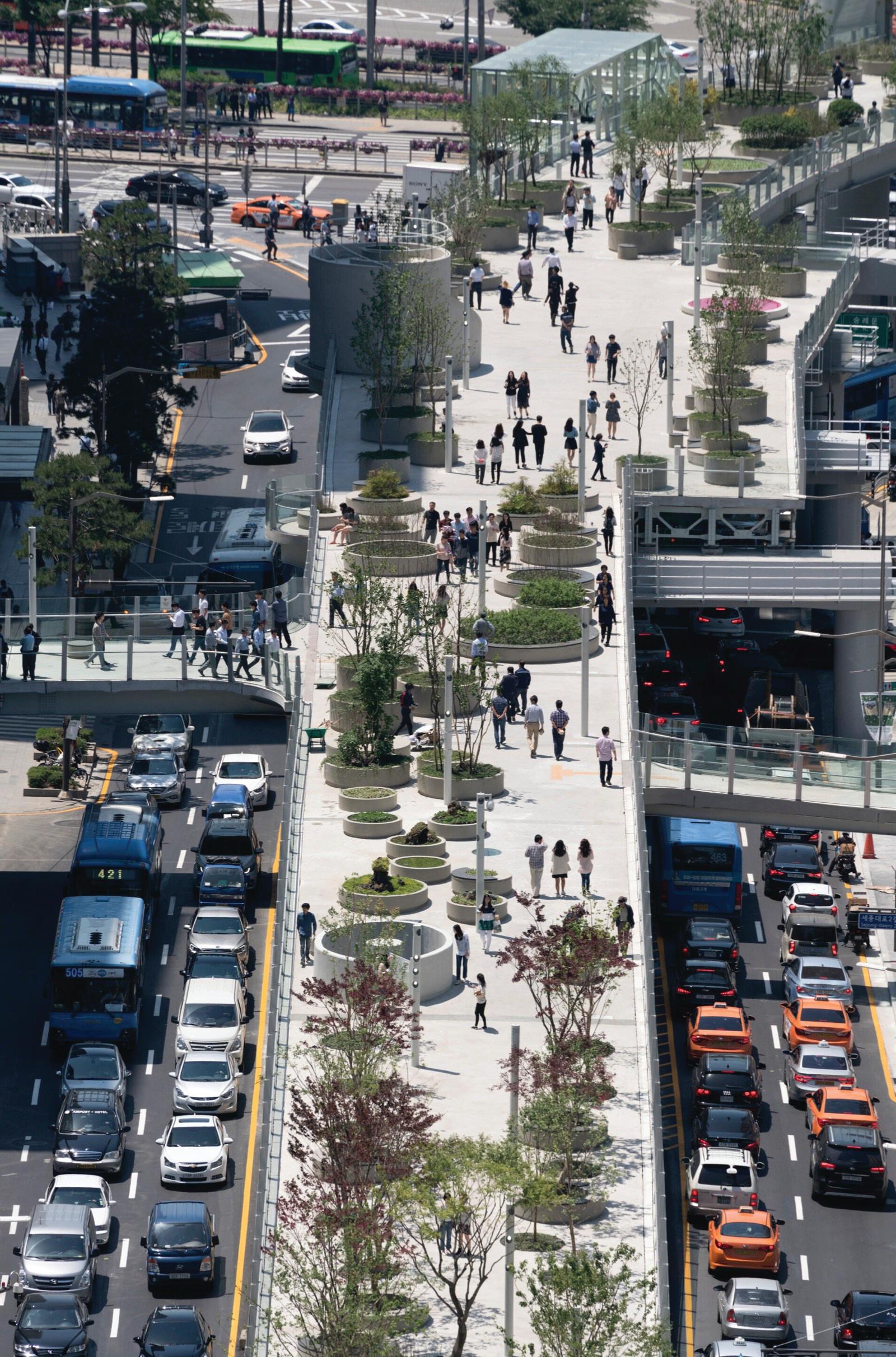
comfort & safety
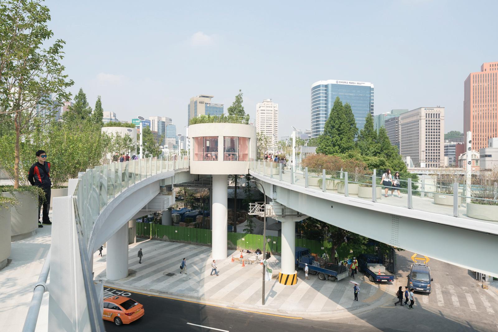
The elevated bridge offers a safe passage for pedestrians, shielding them from the vehicular traffic below. However, the bridge lacks sufficient shelters for weather protection. Additionally, the raised planters proposed along the overpass present issues with barrier-free access and obstruct the pedestrian flow during peak hour. These factors contribute to an uncomfortable and inefficient walking experience.
wayfinding
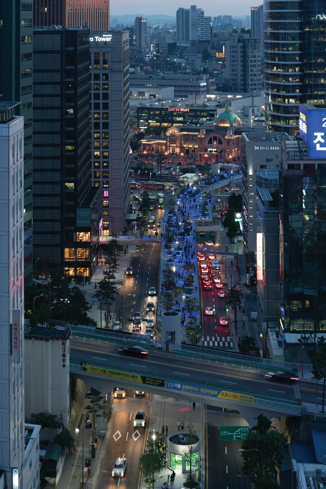
The pedestrian bridge, open to the sky, offers easy orientation due to its overlooking view of the surroundings. Additionally, there are detailed maps and signages, complete with well-marked amenities and connection points, to guide pedestrians throughout their journey.
_Seoullo 7017 skygarden, Seoul, South Korea
amenities
Numerous seating areas are available for relaxation, and a diverse array of amenities encourages public engagement, exploration, and enjoyment. These include retail outlets, shops, and playgrounds.
aesthetics
The walkway is incorporated a total of 24,000 plants, including trees, shrubs, and flowers. For seating, 135 flowerpots were utilised, which consisted of 66 small, 50 medium, and 19 large pots. The sky garden provide an abundant visual pleasant for the public. There is also attractive lighting for enhanced visibility during the night.
_conclusion
The Seoullo 7017 overpass regeneration project serves as an excellent example of urban renewal aimed at enhancing city connectivity for pedestrians. By introducing a sky garden as a public realm, it underscores the importance of walkability. This is further enhanced through strategic landscaping and the provision of amenities that encourage public engagement, making the journey more interesting. Additionally, it contributes to environmental, social, and economic benefits.
discussion
The accessibility and visibility could be enhanced by using a sunken planter design instead of a raised one. Additionally, there is potential to utilise the spaces beneath the overpass.
_case studies
of Seoul Station Overpass and disconnected nodes (Source: Figure 1,
Figure 18: Location map
Hong, 2018)
Figure 19: Proposed pedestrian access (Source: Urban SDG Knowledge Platform, 2024)
culture station seoul 284 seoul station seoul square seoul station overpass yonsei foundation building
Figure 17: The Seoullo 7017 (Source: MVRDV, 2024)
04
Figure 20: The amenities (Source: Table 4, Hong, 2018)
Figure 23: The shop and space underneath (Source: Arch daily and Ossip van Duivenbode, 2017)
Figure 21: The landscaping (Source: MVRDV, 2024)
Figure 22: The night lighting (Source: Arch daily and Ossip van Duivenbode, 2017)
_design development
_the design development through morphological layers
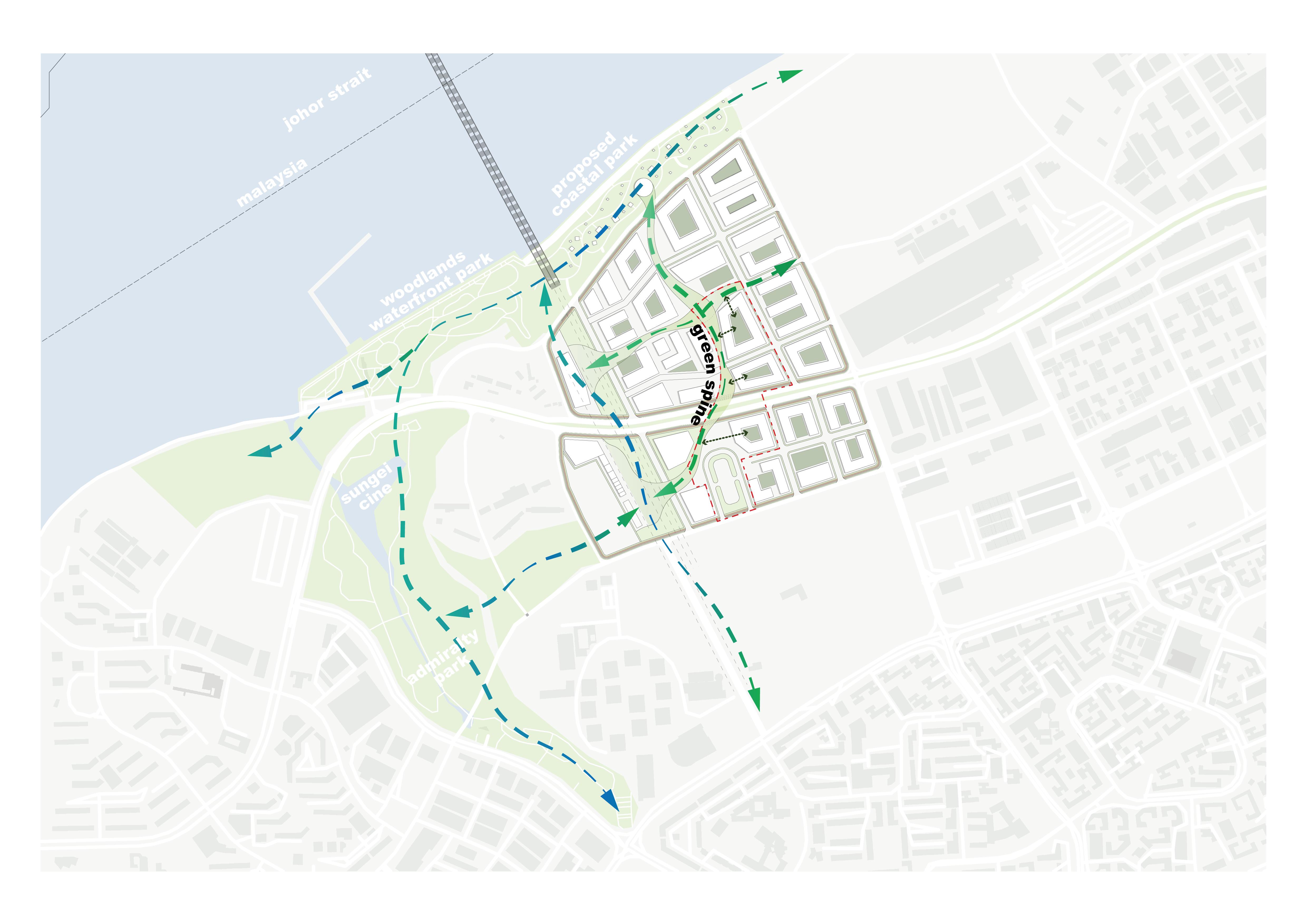
_blue and green infrastructure
The blue and green network is initially merged with the adjacent parks to bolster climate resilience, improve liveability and biodiversity. In addition, the Agri-food spine also functions as a green corridor that is interwoven with the open spaces and passageways of the nearby buildings, facilitating site navigation for people. It provides a hands-on, immersive nostalgic experience while also incorporating elements of urban agriculture such as urban farming and farmers’ markets, offering a novel mode of engagement.
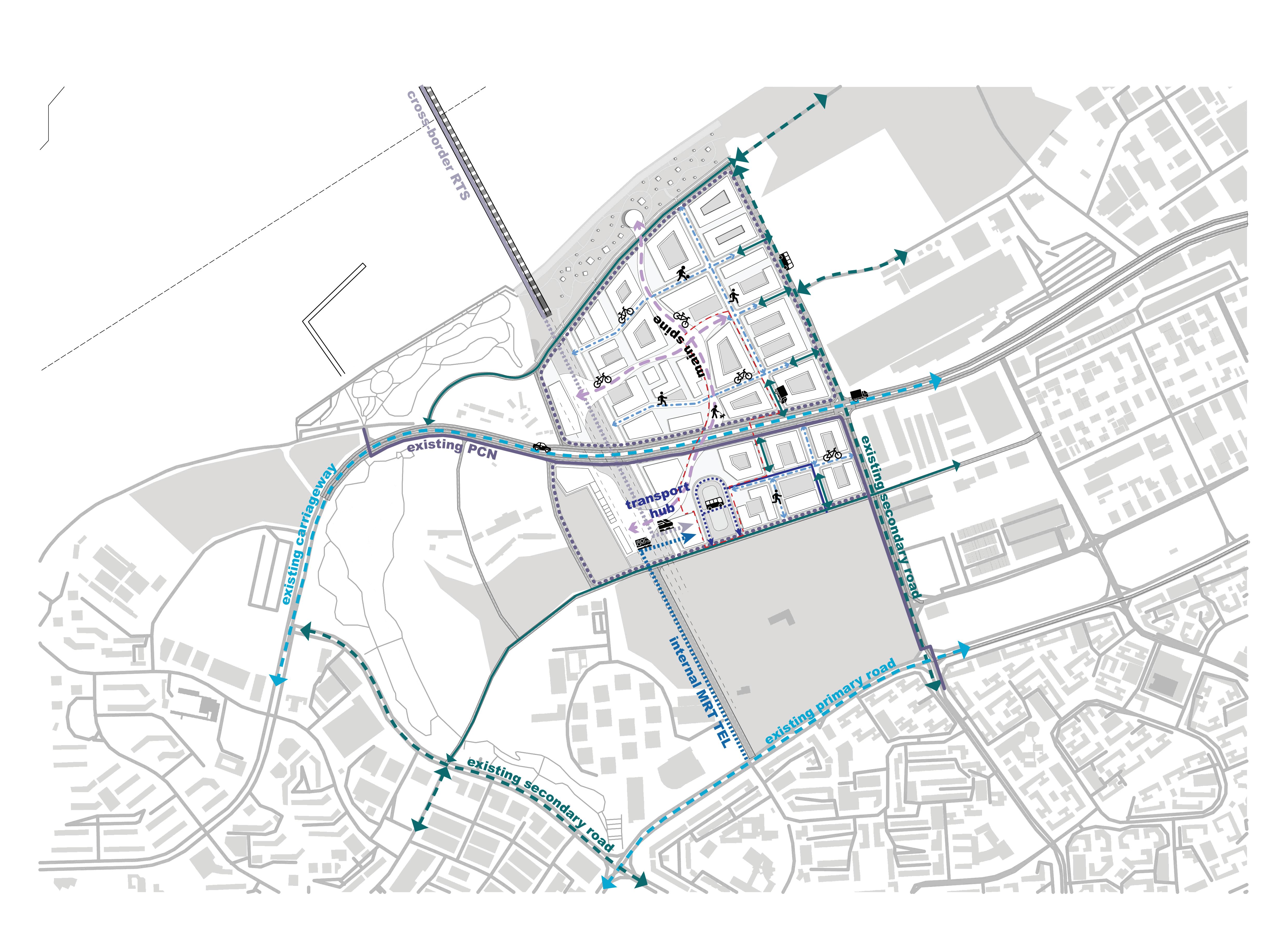
_street network
The existing carriageway will evolve to transit priority corridor, featuring bus priority lanes together with wider footpaths and dedicated cycling paths. The ground floor is driven by a ‘car-lite’ ambition, by moving private cars and heavy goods vehicles underground and replacing them with people-centric streets for walking and cycling. Besides, the Agri-food spine also serves as underground pedestrian links seamlessly connected to existing transport hub to enhance walkability and enabling people to travel comfortably under extreme weather.
proposed secondary road proposed park connector network
_design development 06
Figure 27: Design development diagram_blue & green infrastructure (Author’s own)
existing primary road existing secondary road existing park connector network RTS link MRT existing bus route within site proposed shared path potential bus route site boundary Agri-food spine (main spine) existingunderground transporthub
Figure 28: Design development diagram_street network (Author’s own)
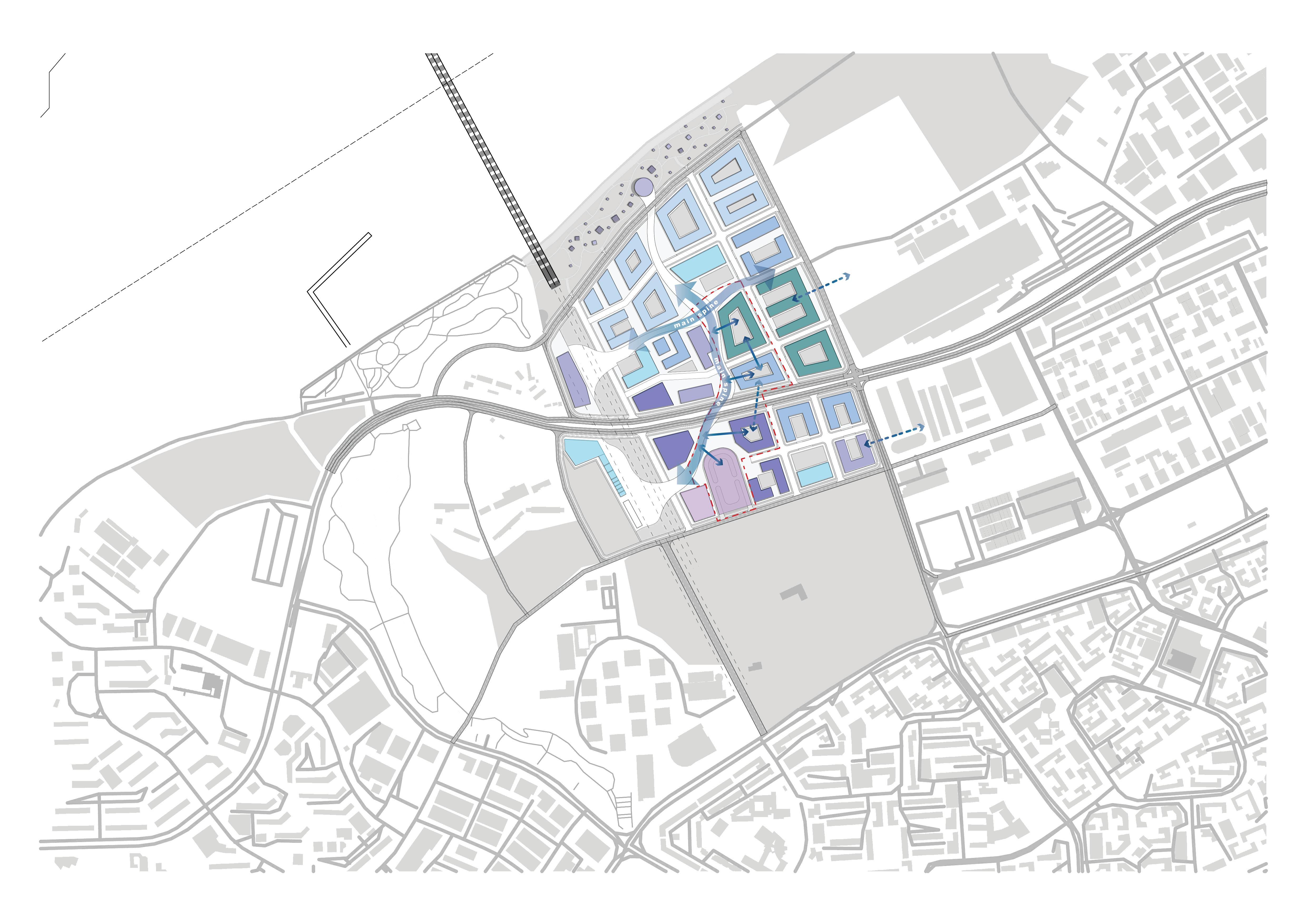
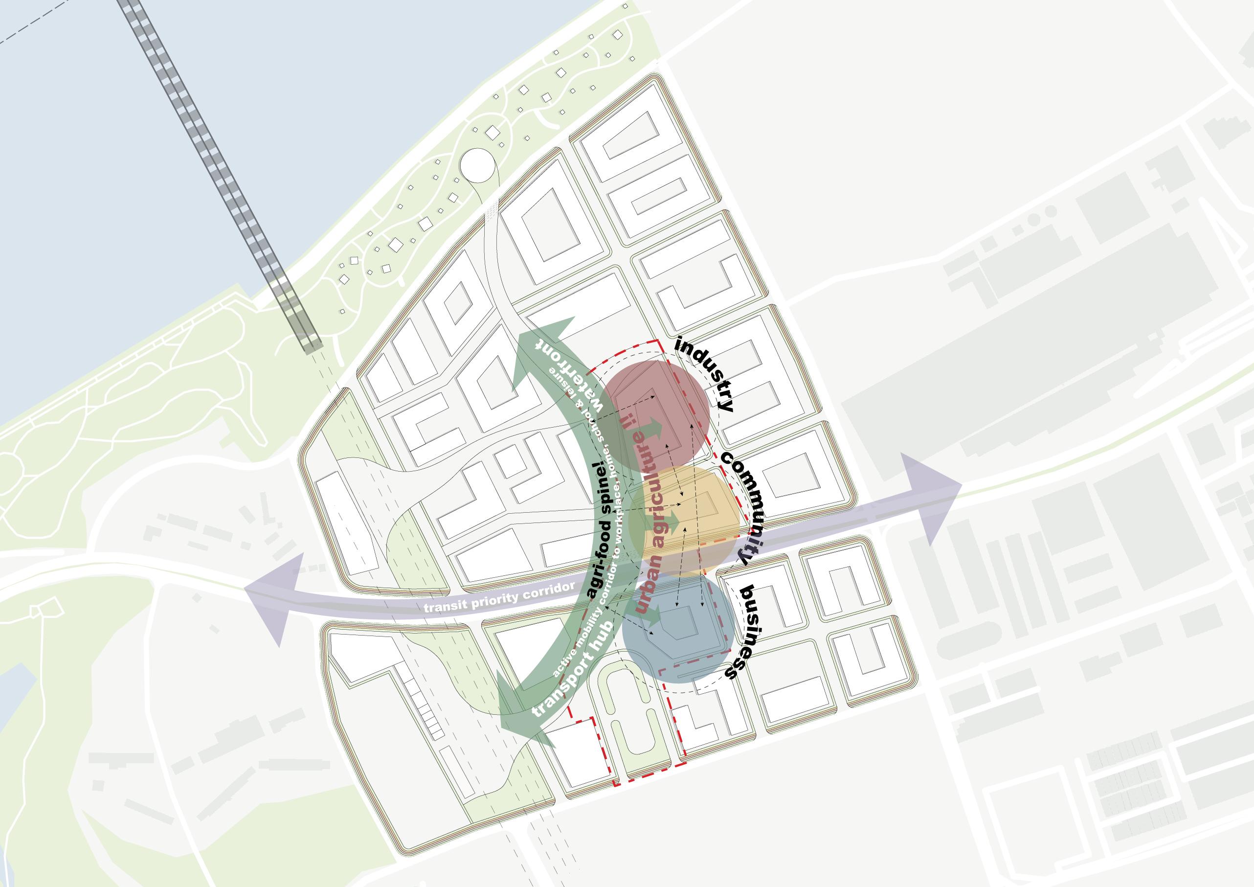
_land use and block design
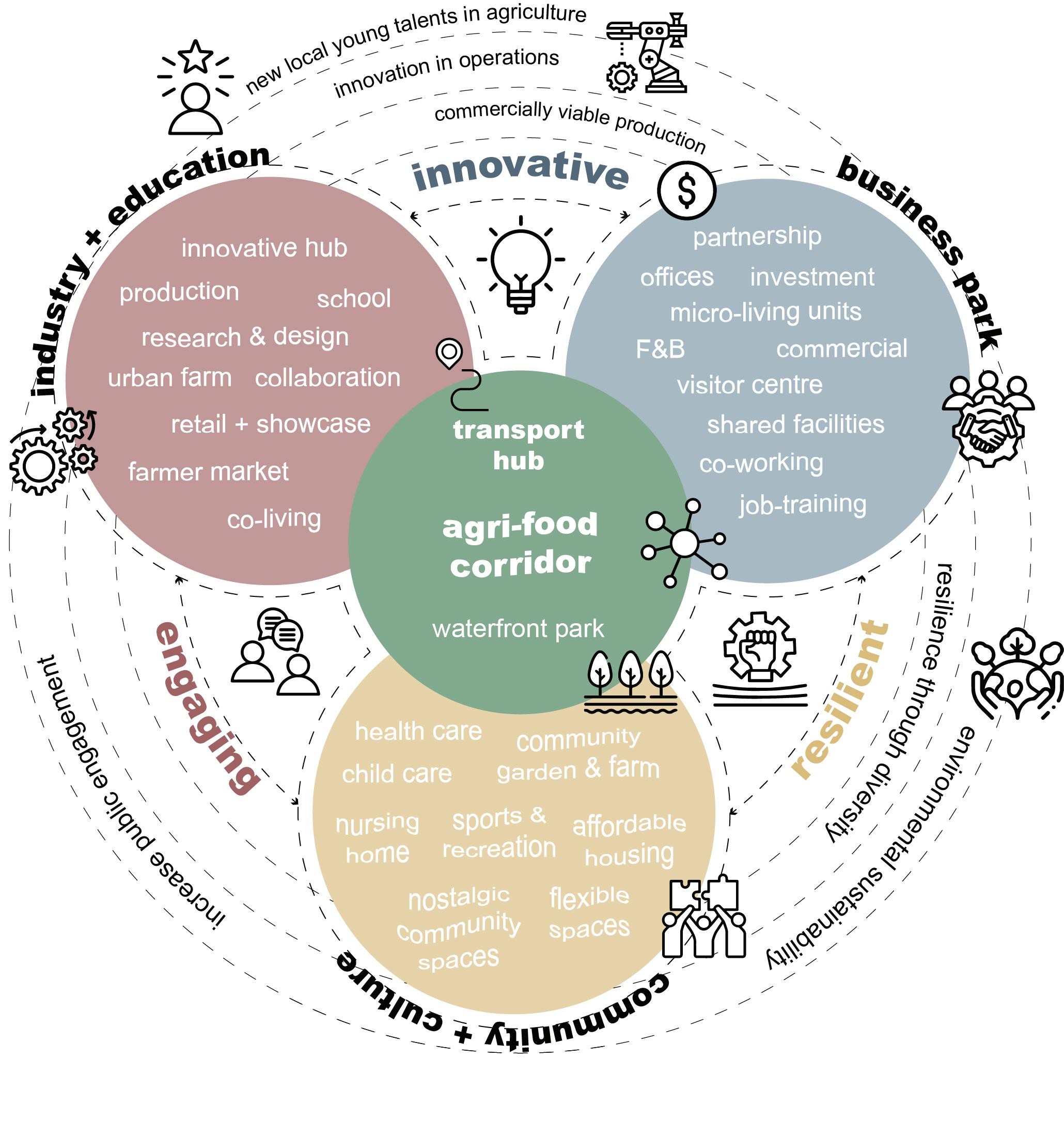
The three blocks are structured as ‘vertical village’ to create a balanced and vibrant mix of programme between industry + education, community + culture and business park as well as sports and recreational facilities. Each block celebrates a distrint character that resonates with the surrounding zoning. Spaces for public engagement, education, shared facilities, and knowledge sharing are integrated through the Agri-food spine. This main spine, running through the core of the site and linking to the transport hub, connects these spaces and offers efficient mobility options.
To enhance the walkability of the grid network, parallel network of pedestrianised thoroughfares and throughblock links are introduced, which reduce the length of blocks and increase intersection density, resulting in a more permeable urban fabric. The entrance for vehicles leading to the basement for service and parking is strategically located off the existing roadway. This design ensures minimal disruption to pedestrian traffic and is well concealed from sight. The service lane or back of house is conveniently positioned next to the vehicular entrance for easy access and servicing. A dedicated cycling path leading to the basement parking has also been incorporated to enhance safety.
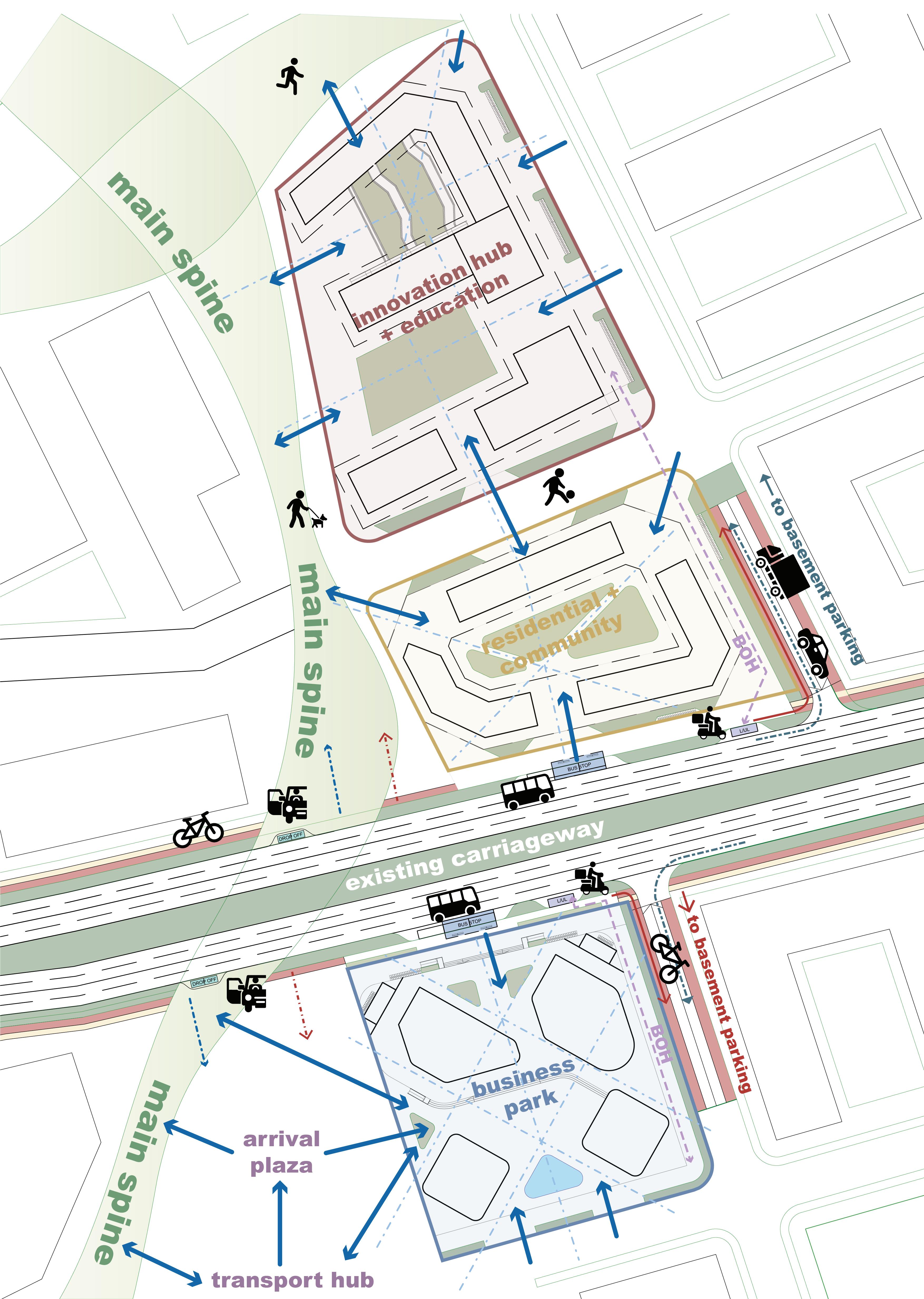
_plot design
The building corner articulations are shaped to create a welcoming entrance, which helps to enhance the legibility of the urban fabric. The building corner area then serves as an outdoor refreshment area (ORA) with seating that extends from the food & beverage (F&B) units within the building. These areas provide opportunities for outdoor dining, which can contribute to vibrancy along streets and in public spaces. The streets are also enlivened with activity-generating uses such as shops, eateries, and galleries (AGU) that offer active frontages and create engaging activities that people can partake in. These elements are essential for creating vibrant streetscapes.
The block is diversified with various plot sizes to cater to different usages, enhancing liveability and visual interest. The perimeters of the blocks are recessed to integrate wider covered walkways for weather protection and also allow for ORA and AGU. The business and industrial blocks are designed to blur the boundaries between private and public spaces, creating a campus-like environment that is permeable to encourage creative interactions with the community
industry industry education residential residential _design development
29: Design development diagram_land use (Author’s own) Figure 30: Design development diagram_block use (Author’s own) 10 20 40 60 80 100 active frontage main access point main entrance service acess vertical circulation core BOH/ service/ storage proposed new bus stop drop-off light delivery shared path for walk-cycle dedicate cycling path PCN 06 Figure 31: Design development diagram_plot design (Author’s own) active frontage main access point main entrance service acess vertical circulation core BOH/ service/ storage perimeter block courtyard block courtyard block with back-to-back plots 0 10 20 40 60 80 100 proposed new bus stop drop-off light delivery shared path for walk-cycle dedicate cycling path PCN industry + education community + culture business park education transport hub commercial + residential cultural/ hospitality
Figure

_building design
The design of the buildings is tailored to leverage microclimate elements such as wind and shade, fostering comfortable environments that reduce the buildings’ dependence on mechanical cooling.
To facilitate optimal wind flow, wind corridors are preserved through developments aligned with the direction of the prevailing wind. The building forms also designed to optimize shade for passive cooling by situating public spaces and windows within naturally shaded areas of the development. Besides, the unique stepped design of the building is adopted to channel wind to the street via a downwash effect, as well as
enhance the imageability and legibility of the place.
The building heights transition from high to low towards the waterfront to enhance wind capture. The permeable design of the courtyard block also promotes air circulation through and around buildings, mitigating heat accumulation. The buildings are oriented north-south to minimize direct sunlight exposure and reduce heat gain. The inclusion of more greenery also helps to decrease heat absorption and emission. The featured bridge also provide shading to keep the public realm on ground comfortable enough to support street life.
_placemaking
In order to uphold the primary goal of food security, all available urban spaces are harnessed for food cultivation, including rooftops, balconies, streets, and open spaces, which are transformed into rooftop gardens, community gardens, and vertical farming systems. These initiatives can boost local food production, cut down on transportation distances, and improve access to fresh produce. The local farmers and producers are encouraged to cultivate food within city by supporting farmers’ markets, food cooperatives, and direct-to-consumer sales. This is to prioritise short supply chains to reduce food miles and advocate for sustainable practices.
Public engagement in planning and decision-making related to food security to raise awareness about food security issues and empower individuals to take action. Implementation programs to educate public about sustainable food choices, nutrition, and the importance of local food systems and reduce food waste at all stages, from production to consumption.
The Agri-food spine is interconnected to all these spaces to create a place that was approachable, accessible, and centered on the diversity of cultures and demographics of Singapore. By intensifying urban greenery not only for a cooler city also provide high environmental quality that can house 800 people per ha.
06
Figure 32: Design development diagram_building design (Author’s own)
Figure 33: Design development diagram_placemaking (Author’s own)
_design development
_design proposal
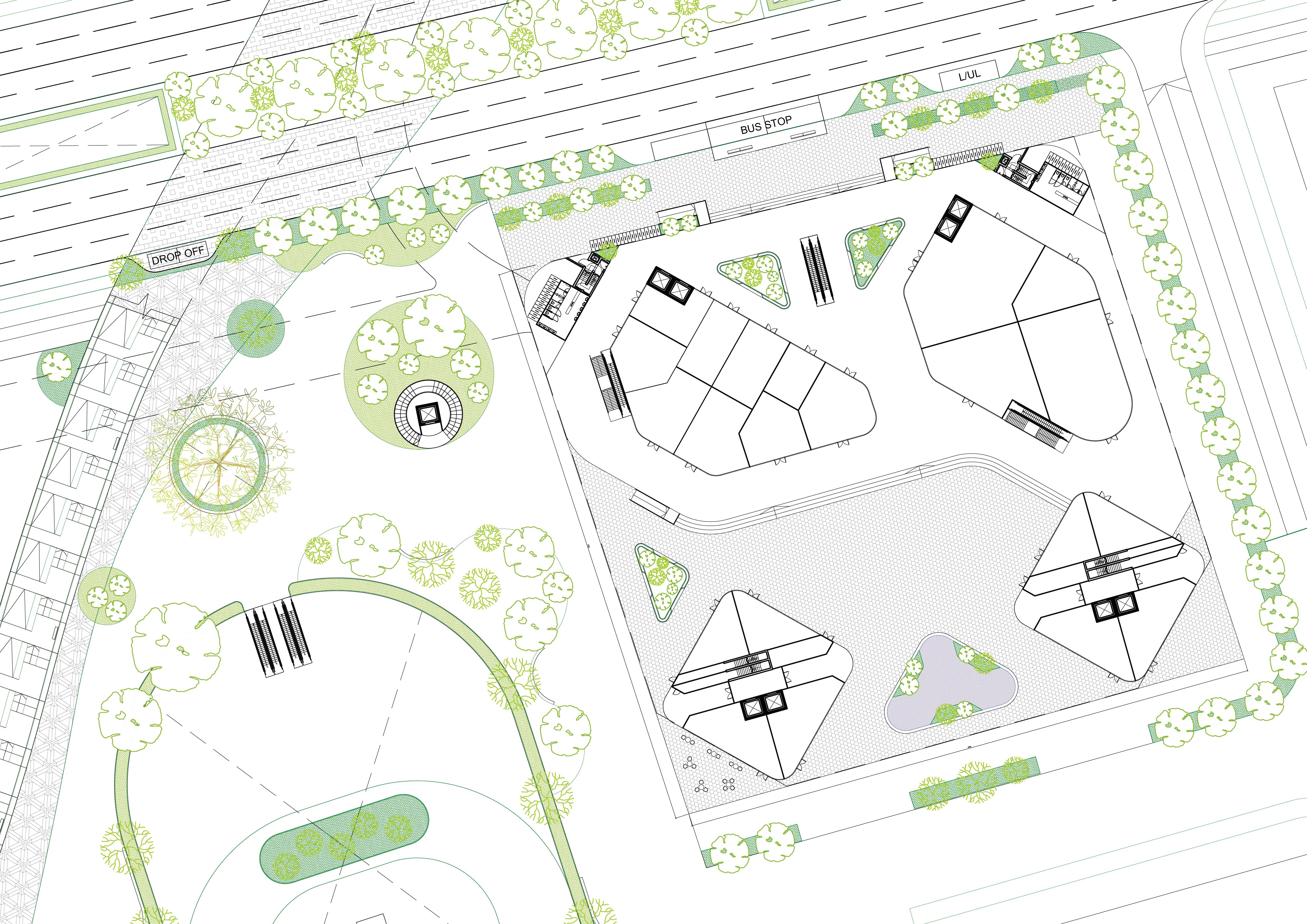
Figure 34: Overall master plan (Author’s own) _design proposal 07 10 20 40 60 80 100 scale 1:4000
_blue & green
infrastructure
The Agri-food spine functions as a green corridor that is interwoven with all the open green spaces making them accessible to people and part of daily lives. It provides a hands-on, immersive nostalgic experience incorporating elements of urban agriculture such as urban farming and farmers’ markets, as well as community facilities offering a novel mode of engagement.
agri-food spine urban agriculture urban agriculture bicyclelots bicycle lots bicyclelots bicyclelots bicyclelots bicycle lots testing plot sharedlab playground fitnessarea communitygarden functionroom storage co-workingspace social corner exhibition shop shop childcarecentre community farming community farming vegetablegarden link bridge active aeging hub collaboration meetingsharedroom cafe sensory garden flower garden communal planter boxes street market skygarden observatory businterchange urban play moreurbanplay groundfloor agri-foodspine to RTS/ MRT station B2 & B3 togroundfloor information centre shop pedestrianmall shop shop shop shop shop shop f&b foodproduction/ foodprocessing/ foodstorage/ foodpackage carparking indoor galleryfarming f&b f&b community market community kitchen F&B F&B F&B F&B F&B F&B F&B F&B retail spices herbgarden spices herb garden raingarden raingarden retail retail retail retail retail bicyclelots bicyclelots bicycle lots bicycle lots bicyclelots bicyclelots bicyclelots bicyclelots lobby lift lobby lobby lift lobby lobby loading/ unloading loading/ unloading lift lobby lobby carparking carparking bicycle lots bicyclelots bicycle lots retail retail retail shared M&Espace shared M&Espace retail urbanterrain reception workshop workshop amphitheater food hub mph engagementinnovative hub visitorcentre retail showcase communitylibrary shop shop shop petgarden shop shop shop shop shop communitylivingroom/garden ORA landscape refreshment area landscape refreshment area ORA ORA communityplaza foodmarket retail jobtraining community investment F&B arrival hall totransporthub toagri-food corridor transporthubbelow void to basement void to basement void to basement void basement aquaponic void basement void basement F&B ORA ORA services services F&B F&B F&B F&B F&B F&B retail retail retail retail retail retail retail retail retail ecopond F&B F&B F&B F&B community centre pharmacy communitylearning/ lecturehall urbanfarm communityfarm communityfarm urbanplay festivalsquare agri-food spine farmers’ sunday market farmers’ sunday market hydroponic hydroponic exhibition bicyclelots bicycle lots bicyclelots bicycle lots bicycle lots bicycle lots bicyclelots bicycle kiosk bicycle kiosk toilet toilet basement basement urbanterrain orchard orchard orchard 07 _design proposal
0 10 5 20 40 60 80 100 scale 1:2000 festival square aquaponic hydroponic plant urban farming community farming community garden/ farm landscape refreshment area food market orchard urban forest communal planter boxes sky garden rain garden urban play spices & herb garden farmers market sensory garden Figure 35: Proposed blue & green infrastructure (Author’s own) Ground Floor Plan Basement Floor Plan 4th Storey Floor Plan community kitchen urgan agriculture community market
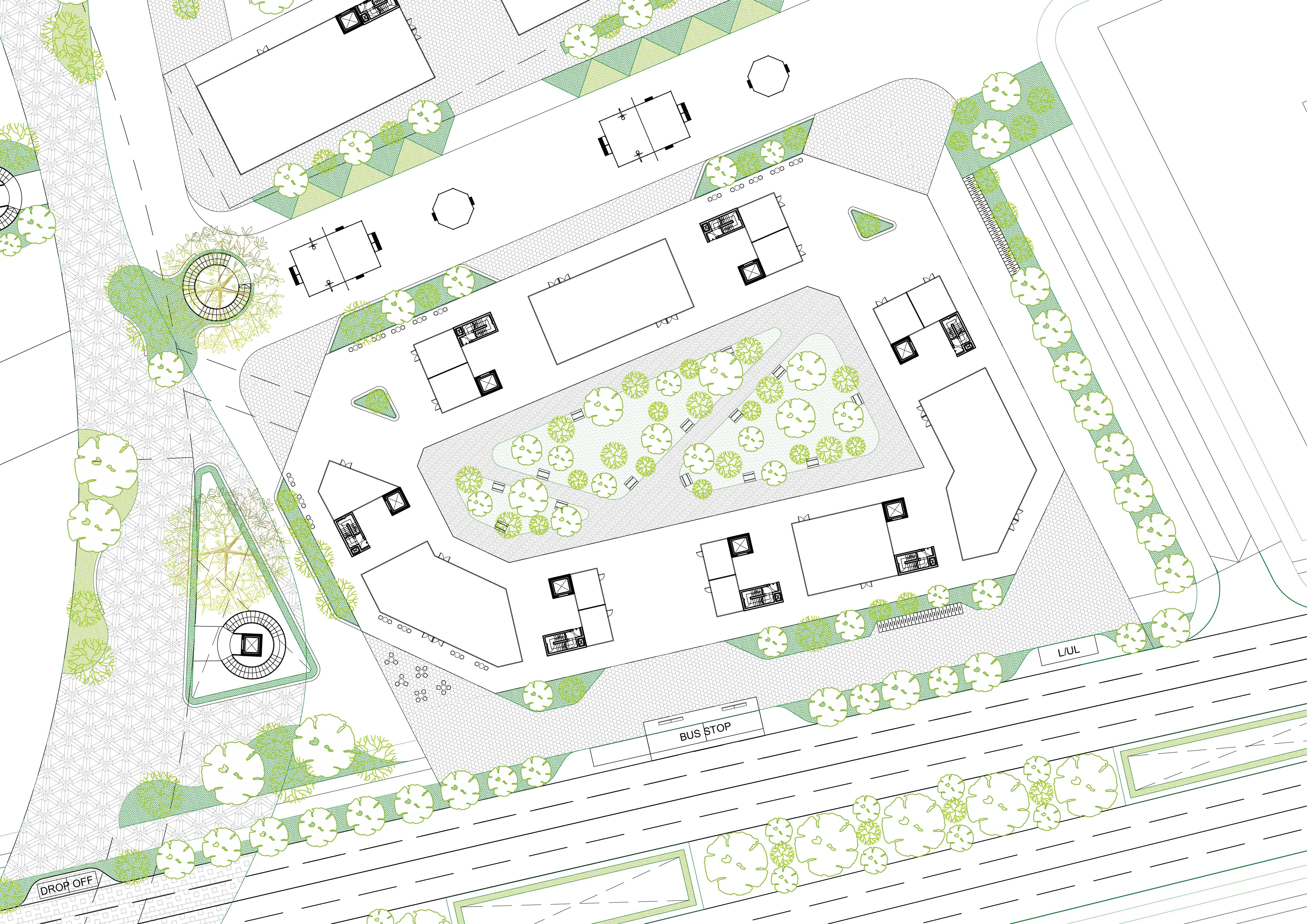
_access & mobility
The Agri-food spine functions as an active mobility corridor, integrating cycling paths and park connectors that linked up with all the streets within neighbourood, will offter interesting journeys for both leisure and commutes. Shared path will support safe and barrier-free walking and cycling also be lined with public spaces and rest stop.
Looking ahead, the basement parking could potentially be repurposed as a logistics or courier hub to support e-commerce. Additionally, autonomous vehicles (AVs) could play a role in these underground logistic networks, leading to significant manpower savings. As emerging transport technologies continue to evolve, they contribute to more efficient travel and help realize the vision of car-lite towns
agri-food spine urban agriculture urban agriculture bicyclelots bicycle lots bicyclelots bicyclelots bicyclelots bicycle lots testing plot sharedlab playground fitnessarea communitygarden functionroom storage co-workingspace social corner exhibition shop shop childcarecentre community farming community farming vegetablegarden link bridge active aeging hub collaboration meetingsharedroom cafe sensory garden flower garden communal planter boxes street market skygarden observatory businterchange urban play tomoreurbanplay atgroundfloor agri-foodspine RTS/ MRT station at B2 B3 togroundfloor information centre shop pedestrianmall shop shop shop shop shop shop f&b foodproduction/ foodprocessing/ foodstorage/ foodpackage carparking indoor galleryfarming f&b f&b community market community kitchen F&B F&B F&B F&B F&B F&B F&B F&B retail spices herbgarden spices & herb garden raingarden raingarden retail retail retail retail retail bicyclelots bicyclelots bicycle lots bicycle lots bicyclelots bicyclelots bicyclelots bicyclelots lift lobby lift lobby lift lobby lobby lift lobby loading/unloading loading/ unloading lobby lift lobby carparking carparking bicycle lots bicyclelots bicycle lots retail retail retail shared M&Espace shared M&Espace retail urbanterrain reception workshop workshop amphitheater food hub mph engagementinnovative hub visitorcentre retail showcase communitylibrary shop shop shop petgarden shop shop shop shop shop communitylivingroom/garden ORA landscape refreshment area landscape refreshment area ORA ORA communityplaza foodmarket retail jobtraining community investment F&B arrival hall transporthub corridoragri-food transporthubbelow void basement void basement void basement void basement aquaponic void basement voidto basement F&B ORA ORA services services F&B F&B F&B F&B F&B F&B retail retail retail retail retail retail retail retail ecopond F&B F&B F&B F&B community centre pharmacy communitylearning/ lecturehall urbanfarm communityfarm communityfarm urbanplay festivalsquare agri-food spine farmers’ sunday market farmers’ sunday market hydroponic exhibition bicyclelots bicycle lots bicyclelots bicycle lots bicycle lots bicycle lots bicyclelots bicycle kiosk bicycle kiosk toilet toilet to basement to basement urbanterrain orchard orchard orchard 07 _design proposal
0 10 5 20 40 60 80 100 scale 1:2000 Figure 36: Proposed access & mobility (Author’s own) Ground Floor Plan Basement Floor Plan 4th Storey Floor Plan proposed secondary road proposed shared path (within neighbourhoods) agri-food spin (shared path) proposed pedestrian links proposed transit priority corridor decicated bus lane dedicated cycling path proposed PCN proposed new bus stop drop-off light delivery
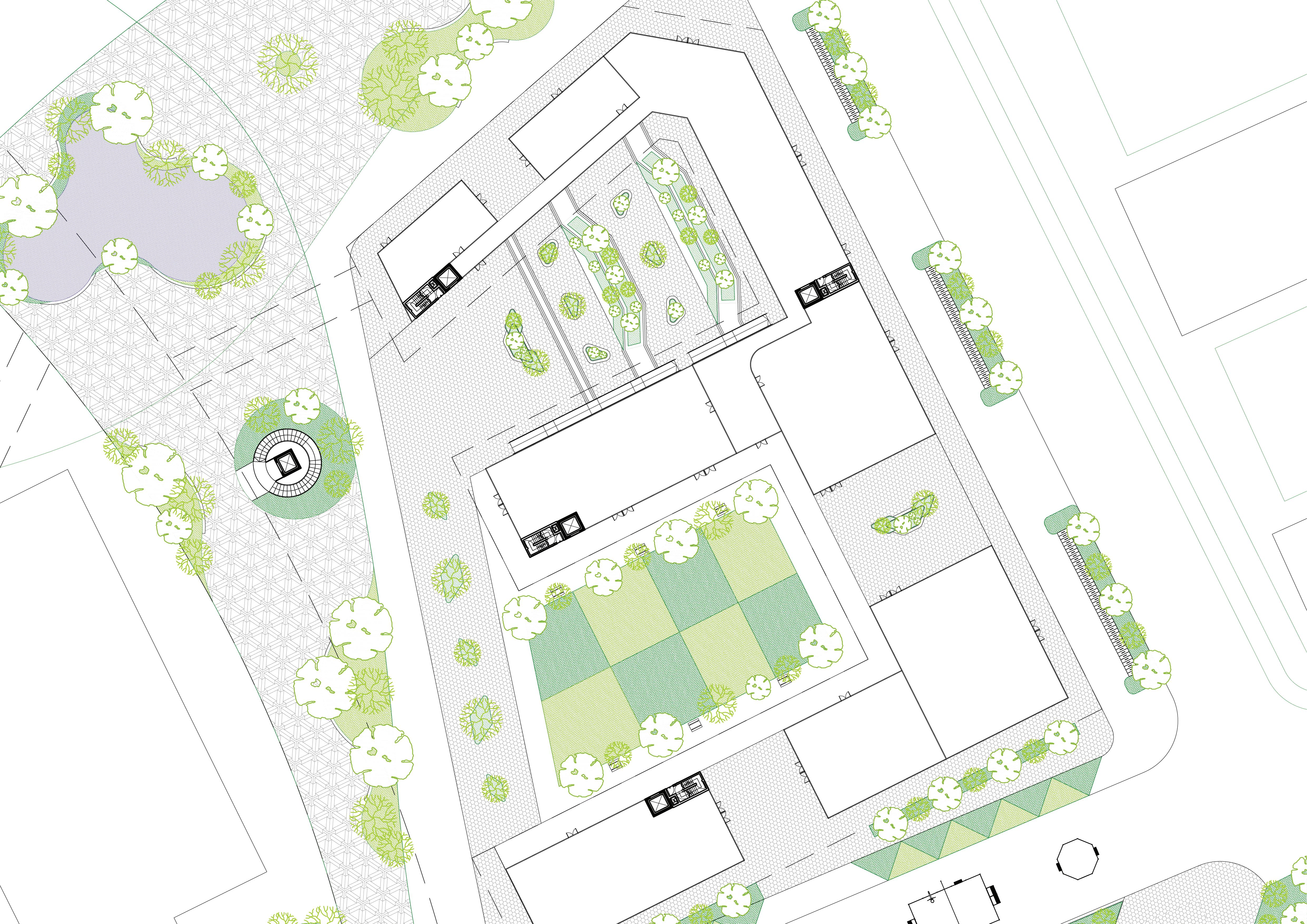
_land use
The three blocks are structured as ‘vertical village’ to create a balanced and vibrant mix of programme between industry + education, community + culture and business park as well as sports and recreational facilities.
Each block celebrates a distrint character that resonates with the surrounding zoning. Spaces for public engagement, education, shared facilities, and knowledge sharing are integrated through the Agri-food spine.
This main spine, running through the core of the site and linking to the transport hub, connects these spaces and offers efficient mobility options.
agri-food spine urban agriculture urban agriculture bicyclelots bicycle lots bicyclelots bicyclelots bicyclelots bicycle lots testing plot sharedlab playground fitnessarea communitygarden functionroom storage co-workingspace social corner exhibition shop shop childcarecentre community farming community farming vegetablegarden link bridge active aeging hub collaboration meetingsharedroom cafe sensory garden flower garden communal planter boxes street market skygarden observatory businterchange urban play moreurbanplay groundfloor agri-foodspine to RTS/ MRT station B2 B3 groundfloor information centre shop pedestrianmall shop shop shop shop shop shop f&b foodproduction/ foodprocessing/ foodstorage/ foodpackage carparking indoor galleryfarming f&b f&b community market community kitchen F&B F&B F&B F&B F&B F&B F&B F&B retail spices herbgarden spices & herb garden raingarden raingarden retail retail retail retail retail bicyclelots bicyclelots bicycle lots bicycle lots bicyclelots bicyclelots bicyclelots bicyclelots lobby lift lobby lobby lift lobby lobby loading/unloading loading/ unloading lift lobby lobby carparking carparking bicycle lots bicyclelots bicycle lots retail retail retail shared M&Espace shared M&Espace retail urbanterrain reception workshop workshop amphitheater food hub mph engagementinnovative hub visitorcentre retail showcase communitylibrary shop shop shop petgarden shop shop shop shop shop communitylivingroom/garden ORA landscape refreshment area landscape refreshment area ORA ORA communityplaza foodmarket retail jobtraining community investment F&B arrival hall totransporthub toagri-food corridor transporthubbelow void to basement void to basement void to basement void to basement aquaponic void basement void basement F&B ORA ORA services services F&B F&B F&B F&B F&B F&B retail retail retail retail retail retail retail retail ecopond F&B F&B F&B F&B community centre pharmacy communitylearning/ lecturehall urbanfarm communityfarm communityfarm urbanplay festivalsquare agri-food spine farmers’ sunday market farmers’ sunday market hydroponic hydroponic exhibition bicyclelots bicycle lots bicyclelots bicycle lots bicycle lots bicycle lots bicyclelots bicycle kiosk bicycle kiosk toilet toilet basement basement urbanterrain orchard orchard orchard 07 _design proposal
0 10 20 40 60 80 100 scale 1:2000 Figure 37: Proposed land uses (Author’s own) Ground Floor Plan Basement Floor Plan 4th Storey Floor Plan industry (innonative) community/ sport & recreation business F&B services education transport hub shop/ retail culture
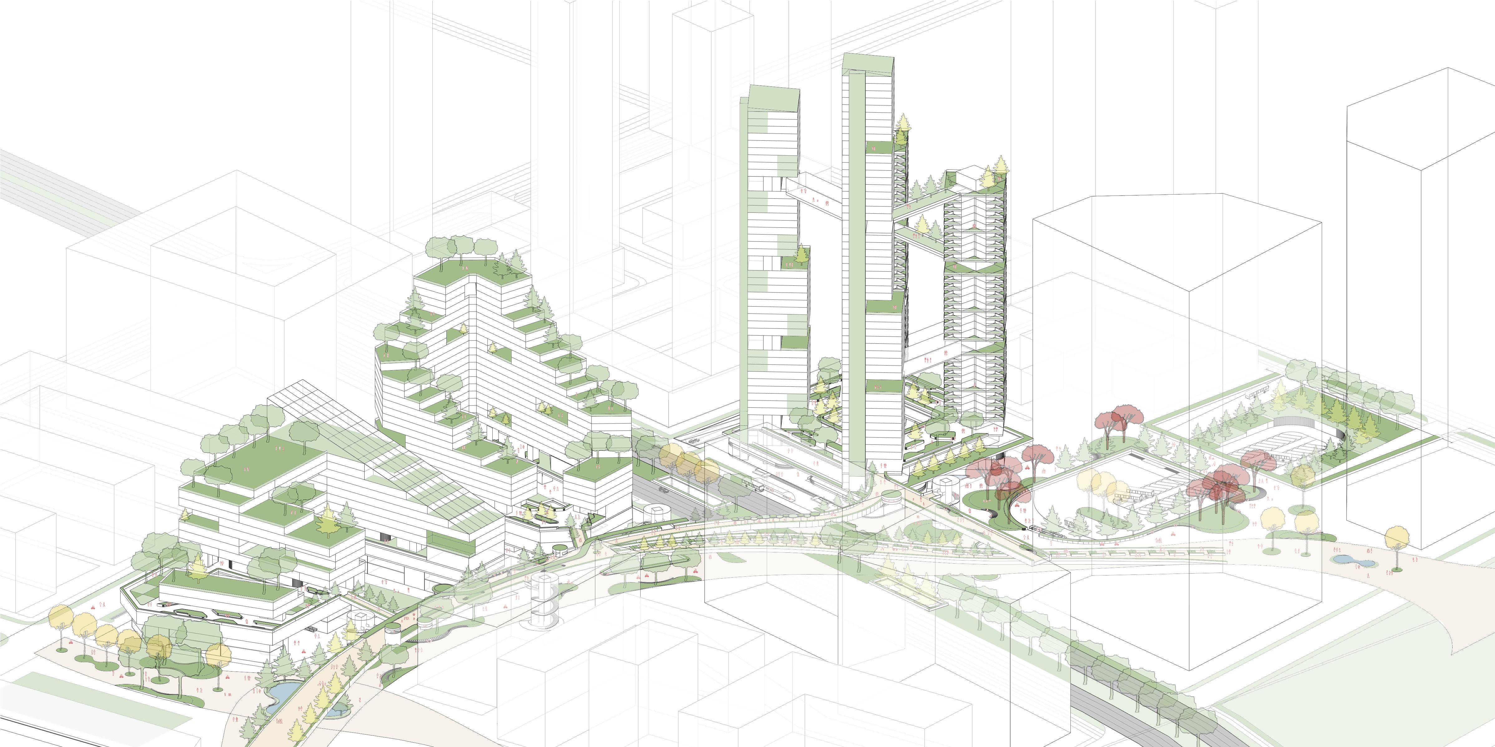
_block design
Block 1
Buidling typology: Courtyard + tower block
Function: This building typology combines business towers and residential blocks, with link bridges serving as shared facilities. The commercial and community spaces are strategically located within the courtyard block below. The maximum building width is 24m, which allows for natural ventilation on both sides. The overall design aims to create a dynamic and integrated environment that caters to both business and residential needs.
_design proposal Figure 38: Proposed building and street typology - Block 1 (Author’s own) 07
community plaza basement parking pedestrian mall entrance plaza eating house commercial commercial urban forest community garden urban farming sky garden conference eco pond A block 2 block 3 block 1 shared path 15m green buffer 3m building setback 6m sky terrace 18m courtyard 38m internal corridor 4m building width 20m shared path 12m tree planting + services verge4.2m tree planting + services verge4.2m bus prioritylane 3.5m bus prioritylane 3.5m cycling path 2.5m walking path 2m transit prioritycorridor 10.5m transit prioritycorridor 10.5m central median 12m
_block design
Block 2
Buidling typology: Stepped courtyard block
Function: This building block seamlessly integrates affordable housing with a nursing home, child care center, and a medical center, creating an immersive and therapeutic environment for living, working, playing, and even farming on the green roof. The co-location of the children’s playground and senior fitness area encourages intergenerational bonding between child care and nursing home residents. Notably, the community living room serves as a vibrant hub for social interaction, fostering cohesion within the diverse cultural society.
07 _design proposal
shared path/ building setback 12m green buffer 3m green buffer 5m green buffer 5m coevred walkway/ ORA/AGU 4m coevred walkway/ ORA/AGU 4m coevred walkway/ ORA/AGU 4m coevred walkway/ ORA/AGU 4m coevred walkway 4m community living room/ garden 24.5m building width 12m building width 12m building setback 3.5m tree planting + services verge4.2m bus prioritylane 3.5m transit prioritycorridor 10.5m urban play17m Figure 39: Proposed building and street typology Block 2 (Author’s own) B playground commercial urban play urban play outdoor fitness affordable housing community farm community farm affordable housing co-working community living room sky garden medical centre commercial pedestrian mall car parking block 2 block 3 block 1
_block design
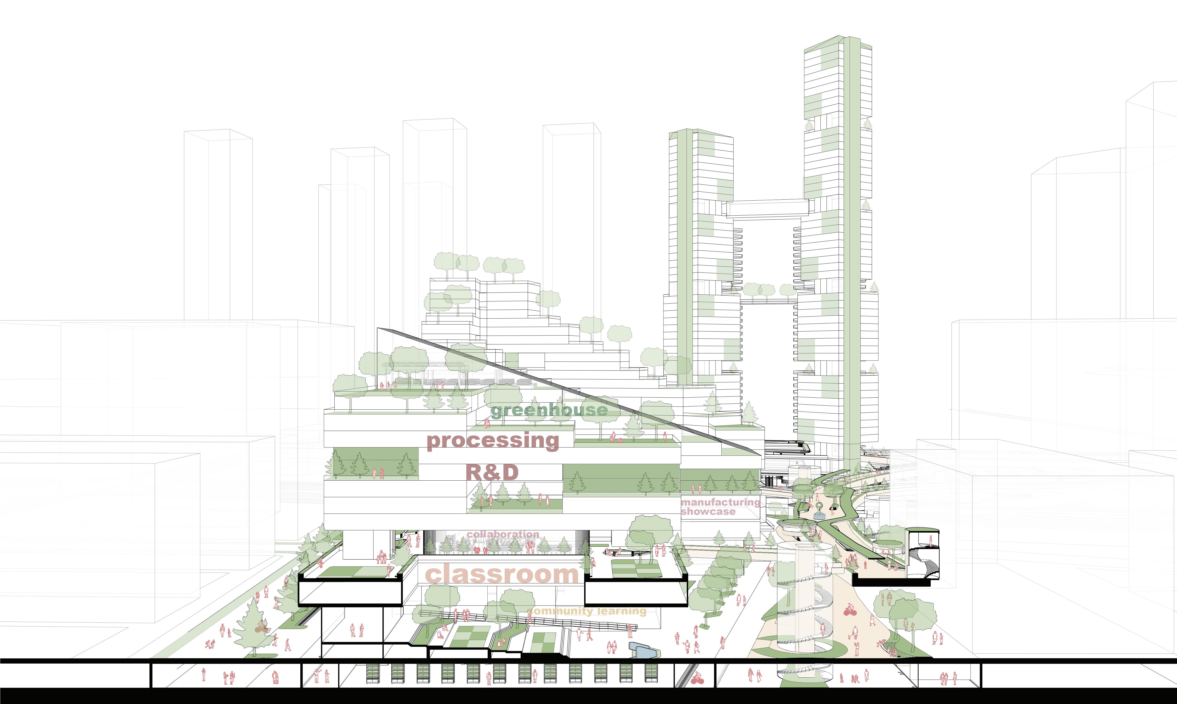
Block 3
Buidling typology: Perimeter block with courtyard
Function: This food industry block is seamlessly combined with an agriculture technology school, creating an innovative agri-food hub that encourages community engagement and learning. The unique program keeps the public engaged and informed, demystifying 21st-century food production and providing a glimpse into how high-tech agriculture can contribute to Singapore’s next frontier of sustainable development. This integrated approach will strengthen food security and generate employment opportunities in the green sector.
07 _design proposal
green buffer 5m green buffer 5m building setback 3.5m urban play 17m coevred walkway/ 4m coevred walkway/ 4m coevred walkway/ 4m coevred walkway/ 4m coevred walkway/ 4m community learning/ lecture hall 16m coevredwalkway/ ORA/AGU 4m coevredwalkway/ ORA/AGU 4m public realm/ agri-food spine 50m courtyard 35m community amphitheater 21m thoroughfare/ORA/AGU 16m thoroughfare/ORA/AGU 9m Figure 40: Proposed building and street typology - Block 3 (Author’s own) C urban agriculture classroom indoor farming pedestrian mall classroom workshop classroom co-working classroom laboratory musuem/ shared training facilities collaboration research & design office office processing greenhouse manufacturing manufacturing office accommodation terrace garden landscape refreshment area rooftop farming urban play urban play block 2 block 3 block 1
07 _design proposal landscape refreshment area communityplaza food market retail jobtraining community investment F&B arrival hall totransporthub transporthubbelow void to basement F&B ORA ORA services services F&B F&B F&B F&B F&B F&B retail retail retail retail retail retail retail retail retail ecopond bicycle lots bicycle lots bicycle kiosk bicycle kiosk toilet toilet to basement orchard _plot design Block 1
plots
scale 1:500 Figure 41:Block 1 Ground Floor Plan 5 0 10 15 20 25 30 35 40 45 50 agri-food corridor ramp 1:20 seating
Back-to-back
Key features: The is clear distinction between front and back. The corner plots are chamfered to enlarge the frontage towards the street, resulting in higher commercial value.
Key features: The individual plots are arranged along the perimeter towards the streets and create a central courtyard. There are active frontage on both sides to towards the street and communal spaces within the block interior. To enhance the walkability, thoroughfares and throughblock links are introduced which reduce the length of blocks and increase intersection density, resulting in a more permeable urban fabric.
The building corner articulations are shaped to create a welcoming entrance, which helps to enhance the legibility of the urban fabric. The building corner area then serves as an outdoor refreshment area (ORA) with seating that extends from the food & beverage (F&B) units within the building. These areas provide opportunities for outdoor dining, which can contribute to vibrancy along streets and in public spaces.
07 _design proposal
Open
_plot design Block 2
row
scale 1:500 Figure 42: Block 2 Ground Floor Plan 5 0 10 15 20 25 30 35 40 45 50 communitylibrary shop shop shop petgarden shop shop shop shop shop communitylivingroom/garden ORA landscape refreshment area ORA ORA void to basement void to basement void to basement F&B F&B F&B F&B community centre pharmacy urbanplay agri-food spine farmers’ sunday market hydroponic bicycle lots bicycle lots to basement ramp 1:15 gradient
Key features: There is clear orientation of public fronts to street with semi private backs oriented towards courtyard spaces within the block interior. Yet public fronts facing courtyards to blur the boundaries between semi-private and public spaces, creating a campus-like environment that is permeable to encourage creative interactions with the community.
07 _design proposal _plot design Block
3 Joined courtyard - medium grain
scale 1:500 Figure 43: Block 3 Ground Floor Plan 5 0 10 15 20 25 30 35 40 45 50 reception workshop workshop community amphitheater food hub mph engagementinnovative hub visitorcentre retail+showcase aquaponic communitylearning/ lecturehall urbanfarm festivalsquare agri-food spine farmers’ sunday market hydroponic exhibition bicycle lots bicycle lots bicycle lots
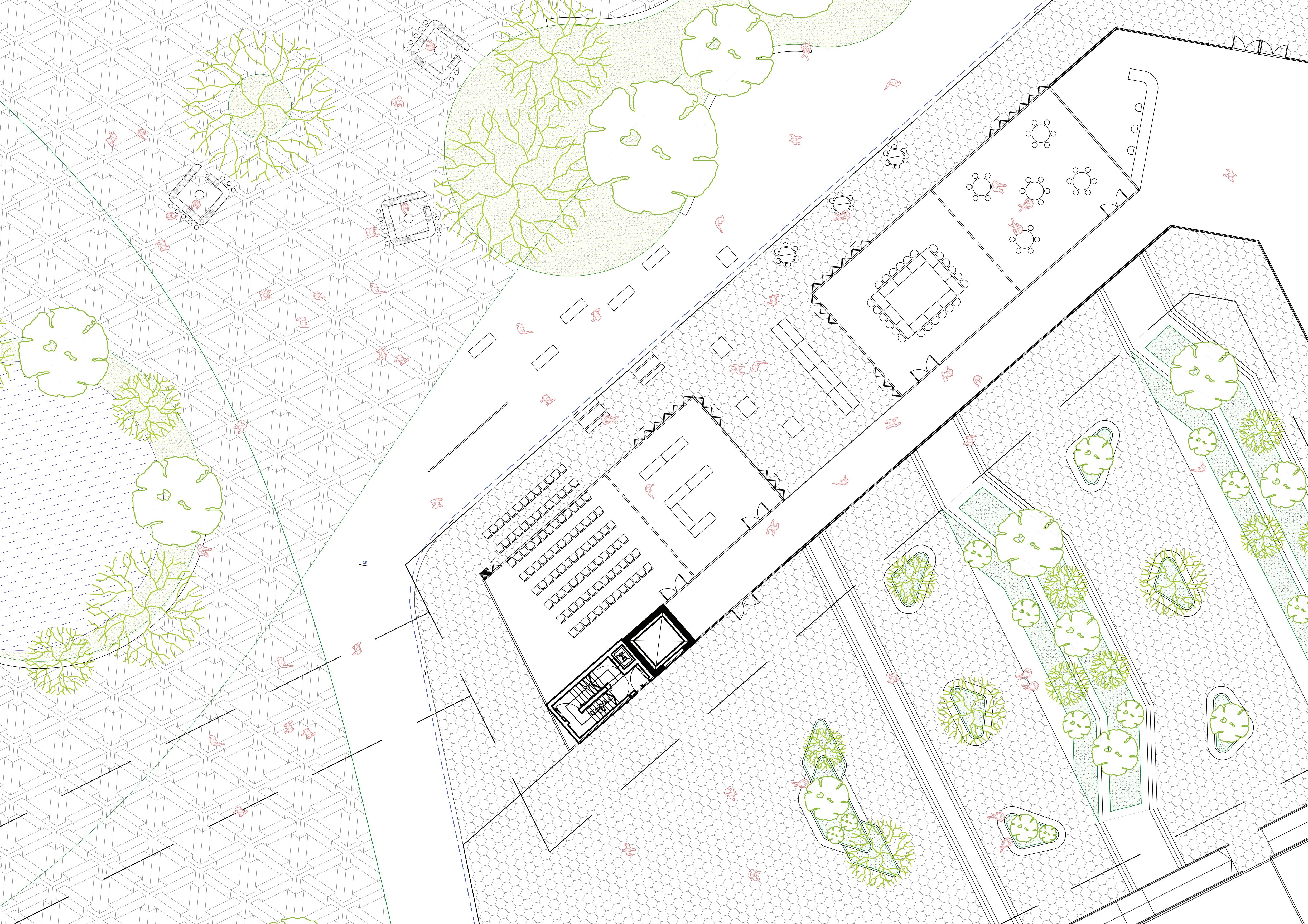
_detailed block design
The agriculture technology school places a strong emphasis on multi-disciplinary, collaborative learning, and experiential project-based exercises. The workshop and classroom scale serve as an ideal testing ground for adaptable campus principles. Flexibility allows for different programming needs on a day-to-day basis, showcasing student projects and facilitating community learning. Notably, the school seamlessly connects with the public realm - the agri-food spine - which encourages public engagement. Overall, it will function as an agri-food hub for knowledge, sustainability, and innovation.
07 _design proposal
Block 3
scale 1:200
44:
Block 3 Ground Floor reception workshop/communitylearning workshop/communitylearning community amphitheater aquaponic festivalsquare agri-foodspine 0 1 2 3 4 5 10 15 20
Figure
Detailed
07 _design proposal Figure 45: Overall Master Plan - Ground Floor 0 10 5 20 40 60 80 100
07 _design proposal Figure 46: Overall Master Plan 4th Storey 0 10 5 20 40 60 80 100
_building design
Block 1
The business tower, being the tallest building in the development, serves as a prominent landmark that stands out in the cityscape.
_building design
Block 2 & 3
The stepped building design aims to maximise open green spaces and achieve 100% landscape replacement in high-density developments. Simultaneously, it prioritises enhancing human connections with nature. It is also a crucial tool for environmental sustainability. Unique building from also contribute to imageability and legibility of the city.
07 _design proposal
Figure 47: Block 1 building design (Author’s own) Figure 48: Block 2 & 3 building design (Author’s own)

_public realm
The Agri-food spine functions as a public realm that connects with the urban agriculture system across quasi-public spaces, including growth, research, design, production, and commercialization. This integration spans multiple layers—underground, at ground level, and even above ground (up to the 4th storey).
07 _design proposal
exhibition/ information centre urban forest orchard urban farming sky garden pedestrian mall transit priority corridor street market exhibition urban play urban agriculture fountain cafe f&b observatory aquaponic flower shop sensory garden farmers’ market street market farmers’ market flower shop outdoor fitness sensory garden fountain green house urban agriculture cafe F&B aquaponic observatory Figure 49: Public realm design (Author’s own) community garden D
07 _design proposal
(Author’s own)
Figure 50: Axonometric
07 _design proposal backlane 6m balcony/ private garden 4m balcony/ private garden 4m courtyard 32.5m covered walkway 4m covered walkway 4m public realm 21m public realm 34m agri-food spine/ featured bridge 15m atrium/ arrival hall 64m building width 24m mircro housing unit width 6m mircro housing unit width 6m common facilities 12m green buffer 3m cycling path 3.8m cycling path 3.8m 2 way driveway 7.4m Figure 51: Section E - Block 1 (Author’s own) E block 2 block 3 block 1 basement parking food hub food hub commercial commercial micro housuing unit micro housuing unit micro housuing unit micro housuing unit co-living co-living sky terrace community garden skygarden rooftop garden rooftop farming community farming
07 _design proposal backlane 6m building width/ thorough block 12m building width/ thorough block 12m public realm 8.5m street market 7m agri-food spine 15m pocket green 7m green buffer +bicycle shelter 4.8m cycling path 3.8m cycling path 3.8m 2 way driveway 7.4m Figure 52: Section F Block 2 (Author’s own) coevred walkway/ ORA/AGU 6m coevred walkway/ ORA/AGU 4m community living room 25m community living room 33m skygarden 15m block 2 block 3 block 1 F playground link bridge basement parking shared path shared path pedestrian mall commercial shared M&E space outdoor fitness active aeging hub nursing home affordable housing rooftop garden accomodation active aeging hub medical centre co-working childcare centre childcare centre
_conclusion
Woodlands North Coast represents a cohesive vision for Singapore, where a comprehensive plan for scaling up urban agriculture unites government agencies, farmers, producers, retailers, communities, corporations, and institutions. Together, they share a mission to ensure a sustainable future.
_recommendations
Holistic Collaboration
Prioritise collaboration across diverse stakeholders, including government agencies, local communities, and private entities. Create a shared vision for sustainable urban development by working together to achieve common goals.
Integrated Design
Integrate urban agriculture into the city fabric—connecting it with public spaces, transportation networks, and existing infrastructure. This holistic approach ensures that agriculture becomes an integral part of urban life.
Innovation and Adaptability
Encourage innovative solutions that adapt to changing needs. Explore smart technologies to optimise space and resource use. Flexibility in design allows adjustments as the urban agriculture landscape evolves.
_recommendations
Education and Awareness
Designers play a role in educating the public about urban agriculture’s benefits. Create showcase, workshops, or interactive experiences that raise awareness and inspire community participation. Foster a sense of ownership and pride in sustainable practices.
Resilience and Climate Considerations
Given Singapore’s vulnerability to climate change, designers should prioritise resilient designs. Explore flood-resistant infrastructure, and energy-efficient systems, toward long-term sustainability and adaptability.
The success of urban agriculture relies on collaboration, creativity, and a deep understanding of the local context. Future designers can shape a greener, more sustainable future and guaranteeing food security.
08 _conclusion
green buffer +bicycle shelter 6m green buffer 3m public realm/ shared path 15m observatory 6.4m agri-food spine 11m public realm 30m building width 20m building width 13m community amphitheatre 35m Figure 53: Section G Block 3 (Author’s own) coevred walkway/ ORA/AGU 4m building setback 5m coevred walkway 4m block 2 block 3 block 1 G urban agriculture urban agriculture classroom gallery eating house classroom indoor farming rainwater harvesting pedestrian mall pedestrian mall commercial
Investigating Food Security in Urban Singapore
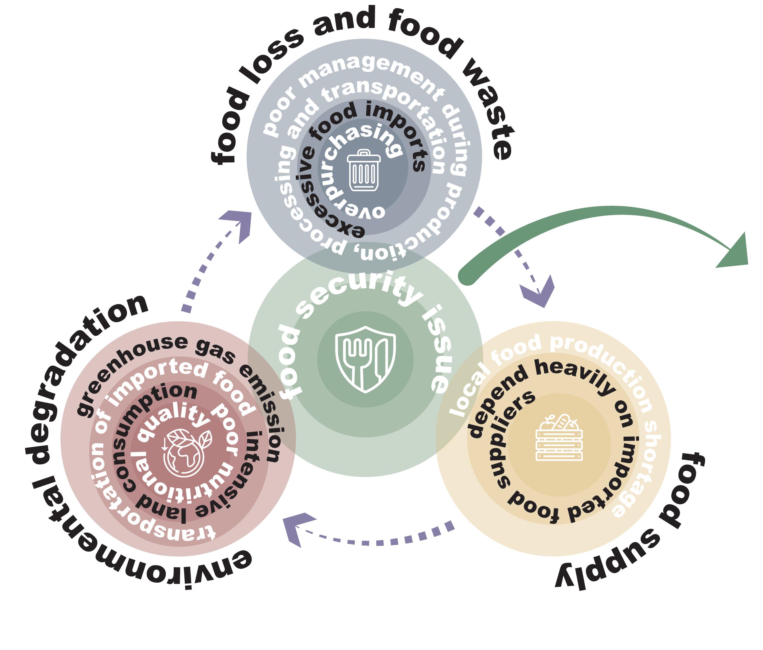
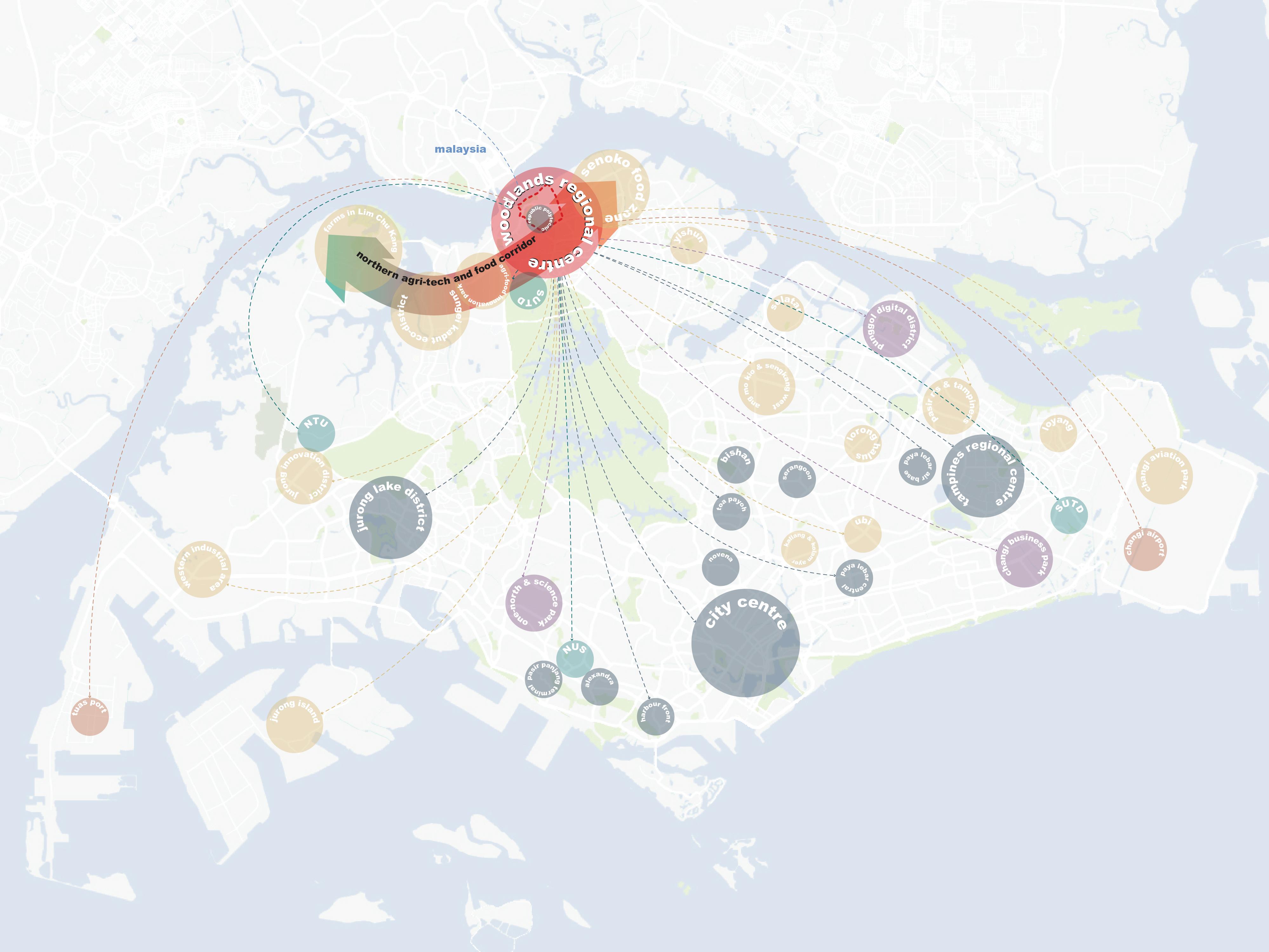
The urban design assignment provided a compelling opportunity to explore the critical issue of food security within the context of Singapore’s rapid urban intensification. This investigation aligns seamlessly with Singapore’s visionary goal known as “30 by 30.” By aiming to generate 30% of its nutritional needs locally by 2030, Singapore seeks to enhance food security within its city-state boundaries. The urgency of this mission was further underscored by the global COVID-19 pandemic, which exposed the vulnerabilities of intricate global supply chains. Consequently, the assignment focused on understanding how urban agriculture—through innovation, technology, and ecological practices—can transform urban spaces into resilient food production hubs. Additionally, the site is fall within the Northern Agri-Tech and food corridor, so there is potential to cultivate food resilience.
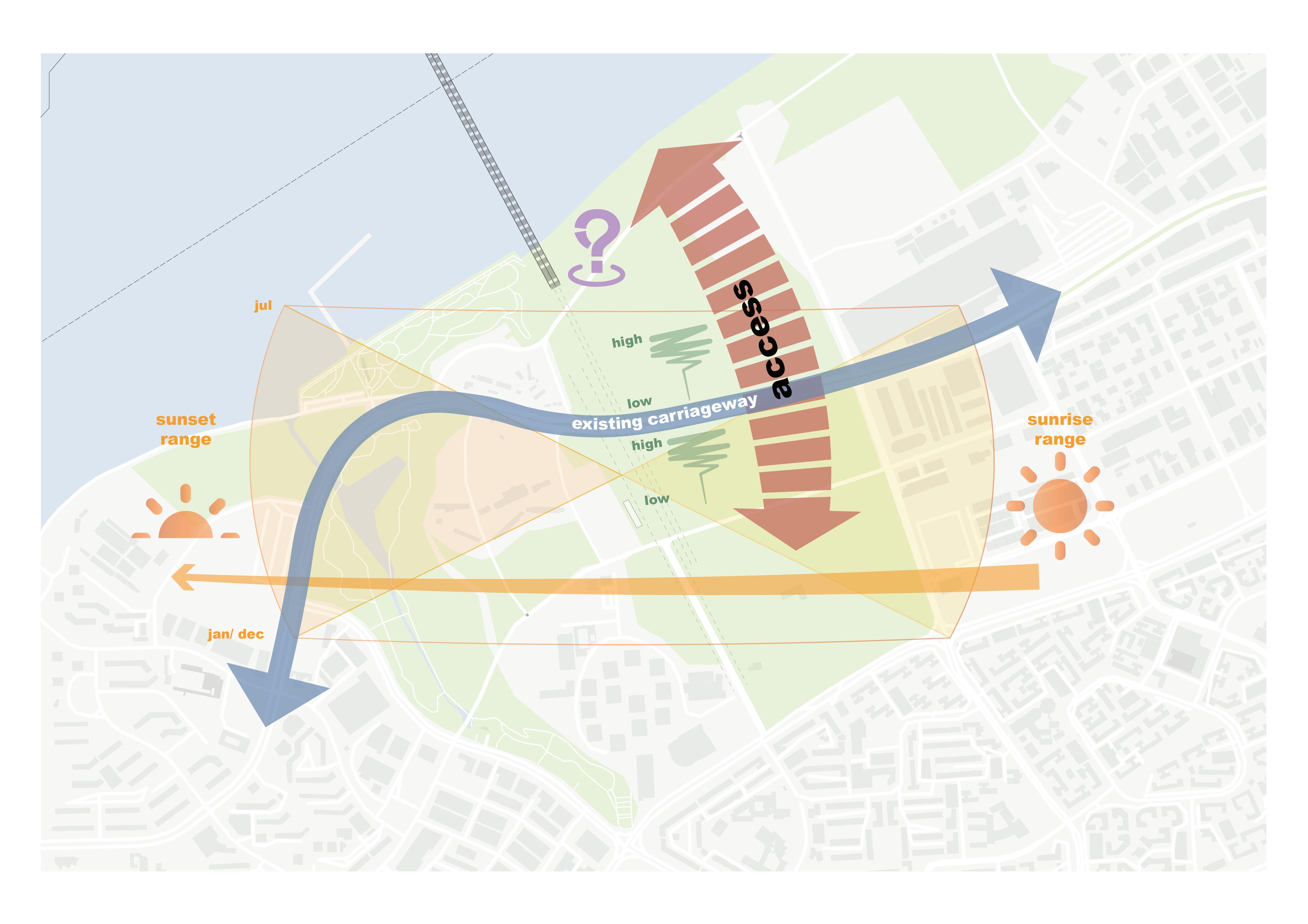
Navigating Infrastructure Challenges
During the assignment, I grappled with unique challenges posed by existing infrastructure. The active carriageway and the uneven topography of the two parcels of land demanded thoughtful solutions. To address these issues, I conducted an extensive literature review and case studies on elevated pedestrian walkways and underground pedestrian links. While the idea of burying the existing carriageway and converting it into a pedestrian street seemed logical, practical constraints—such as disrupting traffic flow on a major road—rendered this option less feasible. Instead, I proposed a distinctive featured bridge. This bridge not only serves as a public realm but also seamlessly integrates with the urban agriculture system, forming what I refer to as the “agri-food spine.” This
Investigating Food Security in Urban Singapore
innovative approach encourages public engagement while honoring the historical identity of the site as a former plantation. The integrated of the food industry value chain, which includes growth, research and design, production, and commercialisation, is all co-located in one place. This integration of farming into the daily urban experiences of the community cultivates a food-resilient future, promoting co-living and co-working. This contributes to the health of the urban ecosystem and offers social and economic benefits to the community, including exciting job opportunities close to home.
Areas for Further Research
1. Food Processing and Production: A deeper understanding of food processing and production is essential. By researching specific crop yields and their requirements, we can better tailor the design of urban agriculture plots to serve their intended purpose effectively.
2. Incorporating Traditional Farming Systems: Singapore has a rich history of traditional farming practices. Incorporating these time-tested methods into our urban agriculture design could yield innovative solutions. By blending modern techniques with traditional wisdom, we can enhance sustainability and resilience.
Improvement
Narrative and Presentation Skills: Feedback from tutorials and presentations highlighted the need to improve my narrative and presentation abilities. I took this advice seriously, dedicating significant effort to crafting a compelling vision statement. However, there remains ample room for growth in both my presentation skills and time management.
In conclusion, this assignment provided valuable insights into the intricate balance between urban development and food security. As future designers, we must continue to explore novel approaches, collaborate across disciplines, and advocate for sustainable solutions that nourish both our cities and our communities.
_reflective summary 09
Appolloni, E., Orsini, F., Specht, K., Thomaier, S., Sanyé-Mengual, E., Pennisi, G. and Gianquinto, G. (2021). The global rise of urban rooftop agriculture: A review of worldwide cases. Journal of Cleaner Production, 296(126556), p.126556. doi:https://doi.org/10.1016/j.jclepro.2021.126556.
Arch daily and Ossip van Duivenbode (2017). SEOULLO Skygarden / MVRDV. Adsttc.com. Available at: https://images.adsttc.com/media/images/59f1/26d5/b22e/3819/9400/0399/large_jpg/134_Skygarden_Seoul_%C2%A9Ossip.jpg?150 8976336 [Accessed 12 May 2024].
Cardinali, M., Balderrama, A., Arztmann, D. and Pottgiesser, U. (2023). Green walls and health: An umbrella review. Nature-Based Solutions, [online] 3(2772-4115), p.100070. doi:https://doi.org/10.1016/j.nbsj.2023.100070.
Choi, H.S., Bruyns, G., Reeve, A. and Cui, M. (2023). The negotiated public realm in the contemporary city: hybrid walkable urban networks of Hong Kong. City, Territory and Architecture, [online] 10(1). doi:https://doi.org/10.1186/s40410-023-00194-5.
Google (2023). Google Earth. Google.com. Available at: https://earth.google.com/web/search/charles+river+esplanade+boston/@42.35731743 [Accessed 12 May 2024].
Hong, Y. (2018). Actual condition of Seoullo 7017 overpass regeneration project based on field surveys. Frontiers of Architectural Research, [online] 7(3), pp.415–423. doi:https://doi.org/10.1016/j.foar.2018.06.007.
Ilieva, R.T., Cohen, N., Israel, M., Specht, K., Fox-Kämper, R., Fargue-Lelièvre, A., Poniży, L., Schoen, V., Caputo, S., Kirby, C.K., Goldstein, B., Newell, J.P. and Blythe, C. (2022). The Socio-Cultural Benefits of Urban Agriculture: A Review of the Literature. Land, [online] 11(5), p.622. doi:https://doi.org/10.3390/land11050622.
MVRDV (2024). Seoullo 7017 Skygarden . https://www.mvrdv.com/projects/208/seoullo-7017-skygarden. Available at: https://www.mvrdv.com/media/uploads/Webreszie_6(1).jpg?width=1920 [Accessed 12 May 2024].
National Archives of Singapore (n.d.). Singapore Naval Base. [Online] www.nas.gov.sg. Available at: https://www.nas.gov.sg/archivesonline/photographs/record-details/52289931-38f8-11e6-b4c5-0050568939ad [Accessed 11 May 2024]. Source: The National Archives, UK.
Sas-Bojarska, A. and Rembeza, M. (2016). Planning the City Against Barriers. Enhancing the Role of Public Spaces. Procedia Engineering, [online] 161(1877-7058), pp.1556–1562. doi:https://doi.org/10.1016/j.proeng.2016.08.626.
Sean Olivia Nicholas, Groot, S. and Harré, N. (2023). Understanding urban agriculture in context: environmental, social, and psychological benefits of agriculture in Singapore. Local Environment, 28(11), pp.1–17. doi:https://doi.org/10.1080/13549839.2023.2238721.
URA Singapore (n.d.). Republic of Singapore - Master Plan 1958. [online] www.ura.gov.sg. Available at: https://www.ura.gov.sg/dc/mp58/mp58map_index.htm [Accessed 11 May 2024].
Urban Redevelopment Authority (n.d.). Urban Farming. [online] www.ura.gov.sg. Available at: https://www.ura.gov.sg/Corporate/Get-Involved/Plan-Our-Future-SG/Innovative-Urban-Solutions/Urban-Farming [Accessed 12 May 2024].
Urban SDG Knowledge Platform (2024). Seoullo 7017. [online] Urbansdgplatform.org. Available at: http://www.urbansdgplatform.org/upload/csd/seoullo7(outcome).jpg [Accessed 12 May 2024].
visit korea (2024). Seoullo 7017 . [online] Visitkorea.or.kr. Available at: https://tong.visitkorea.or.kr/cms/resource/12/3081412_image2_1.jpg [Accessed 12 May 2024].
10
_bibliography


 Figure