How can Buildings and Open Spaces be strategically woven together to create vibrant, engaging urban environments?
Programming & Functional Layout
Mixed-Use Integration
Pedestrian-friendly Design
Public Space Activation
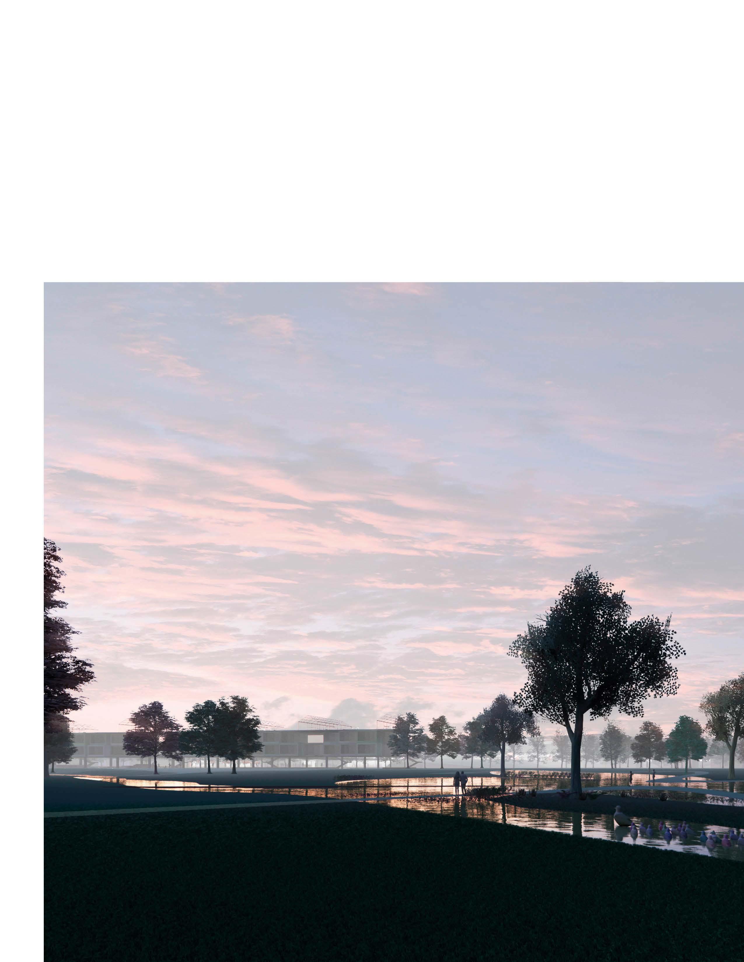
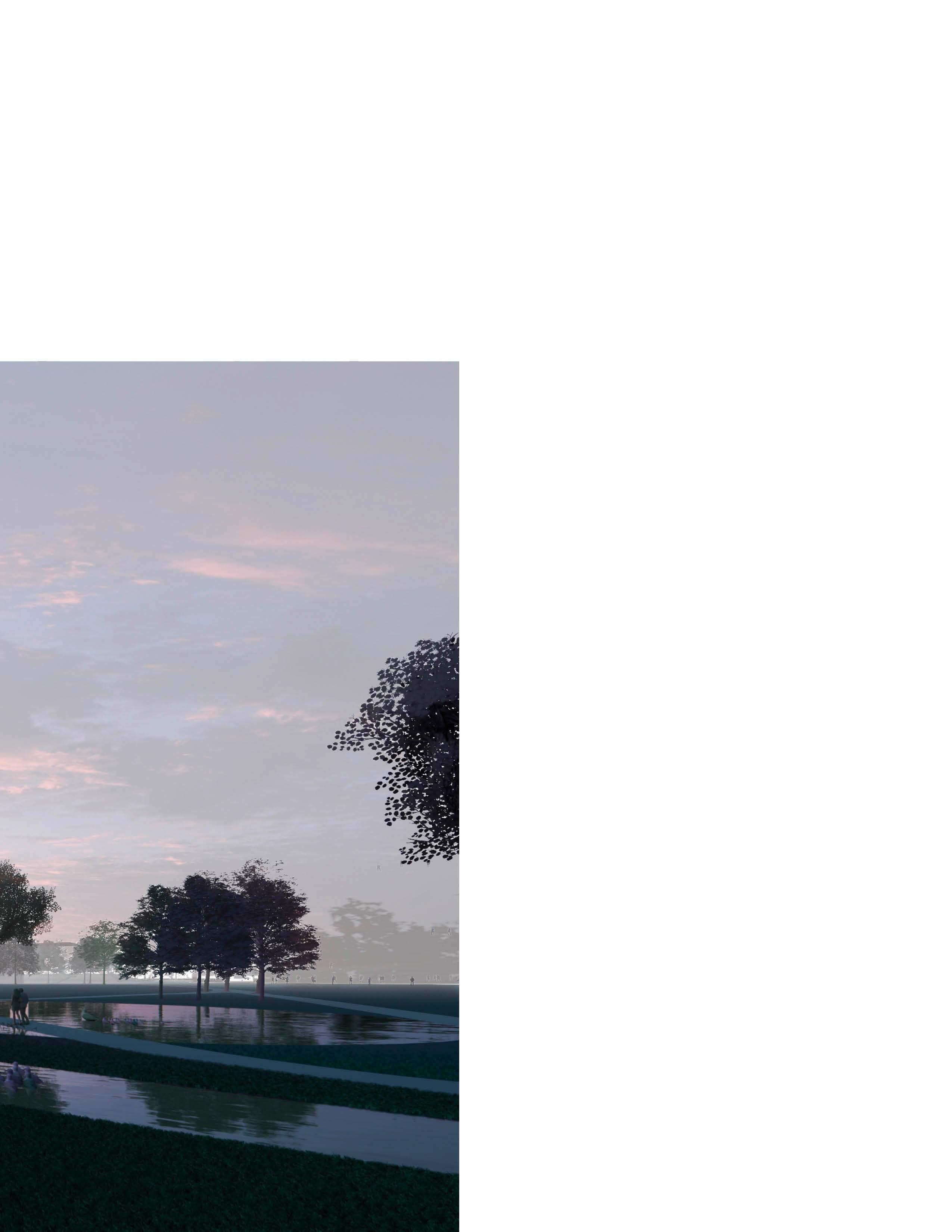
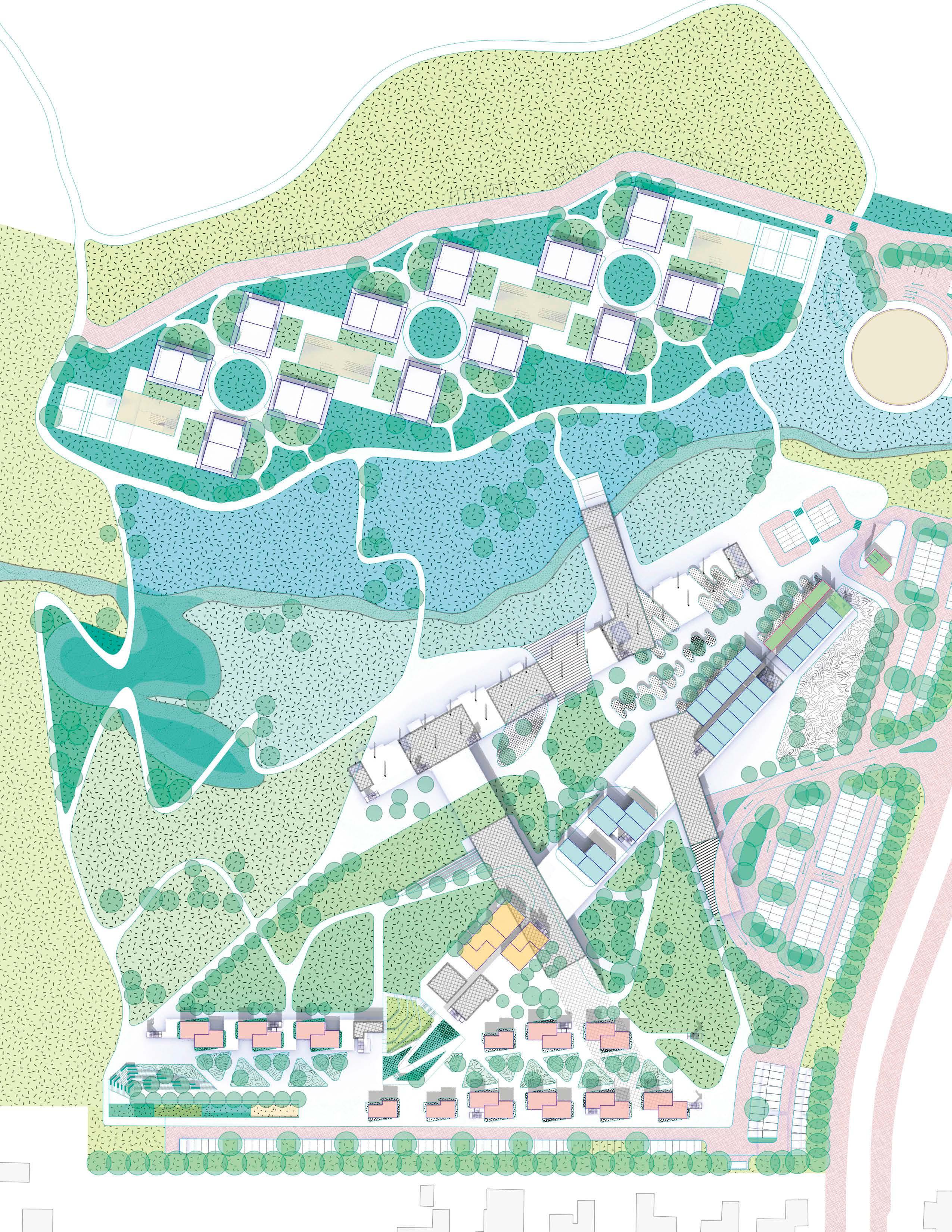
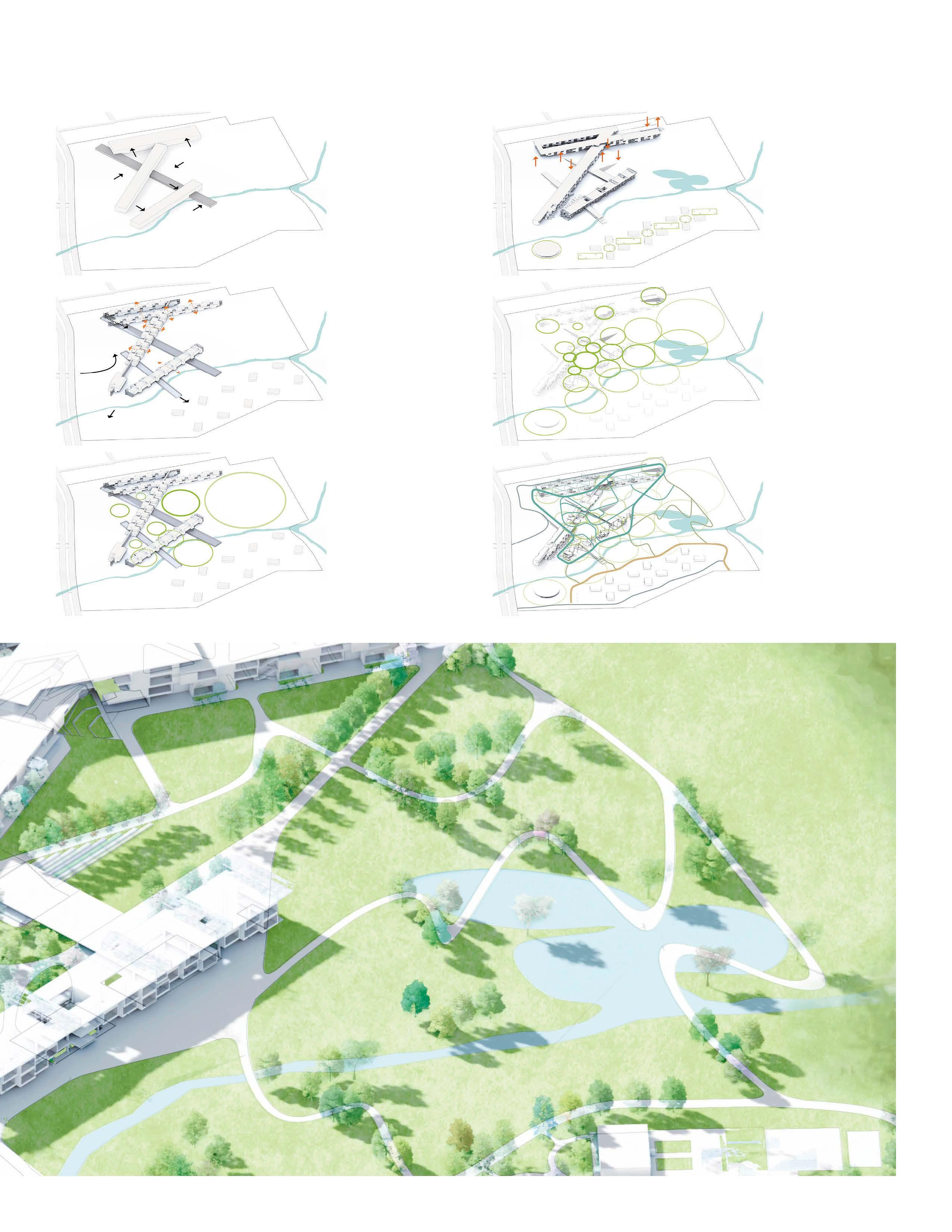
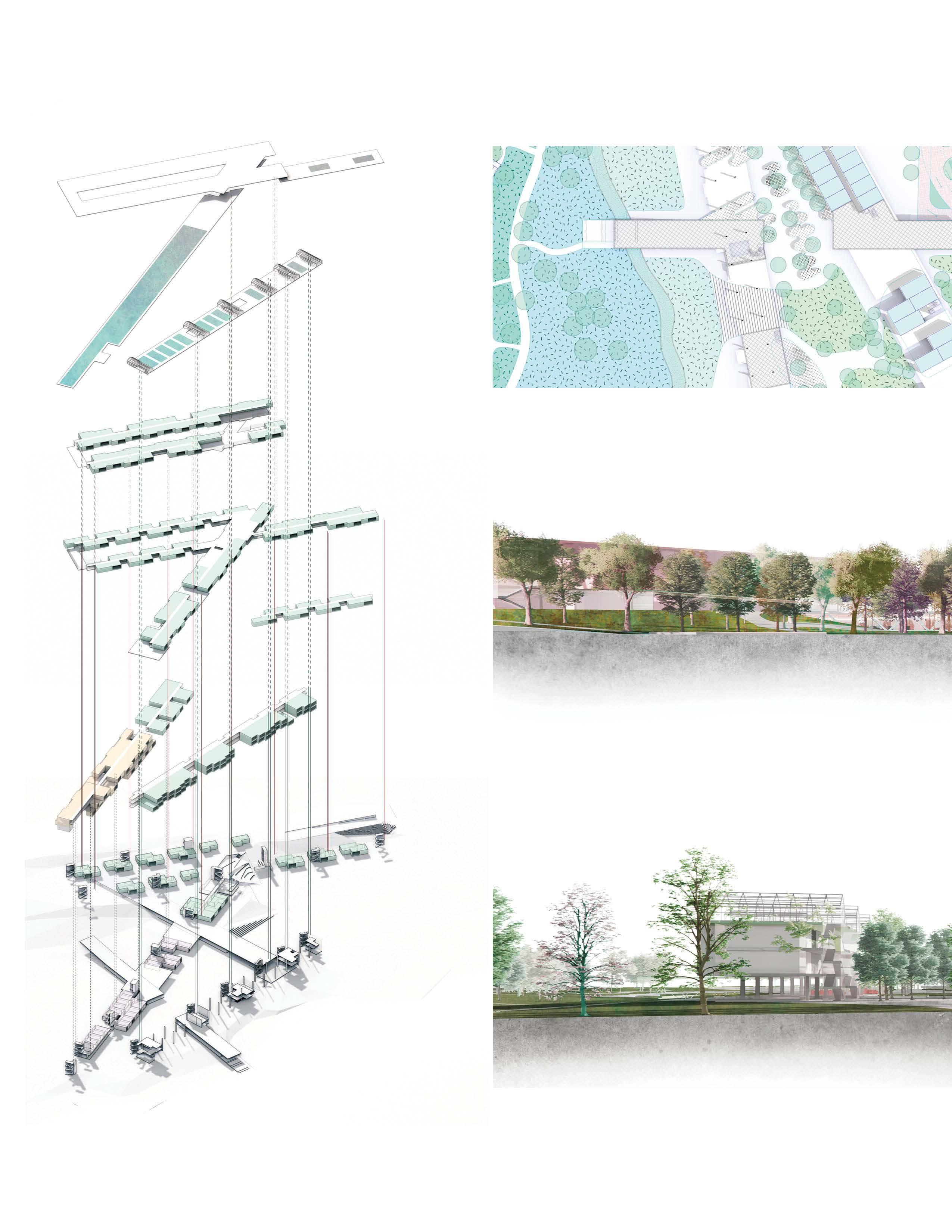
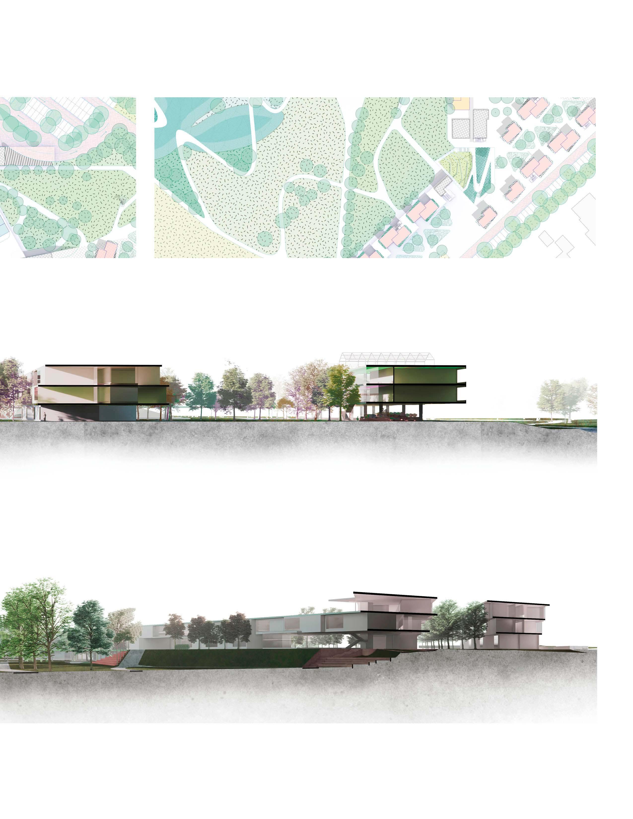
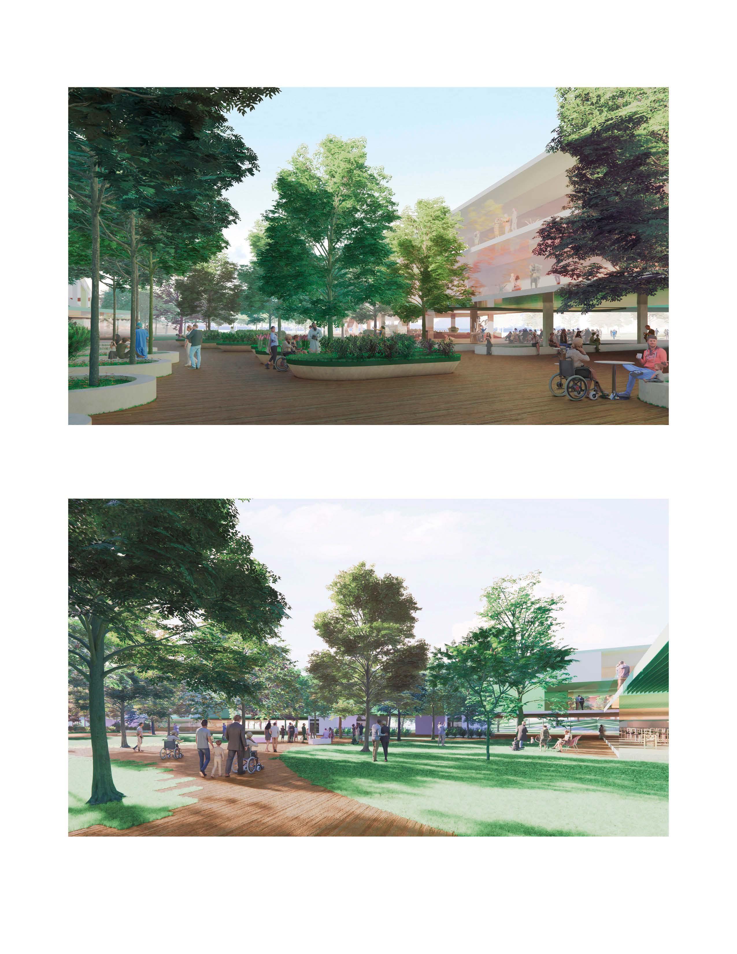
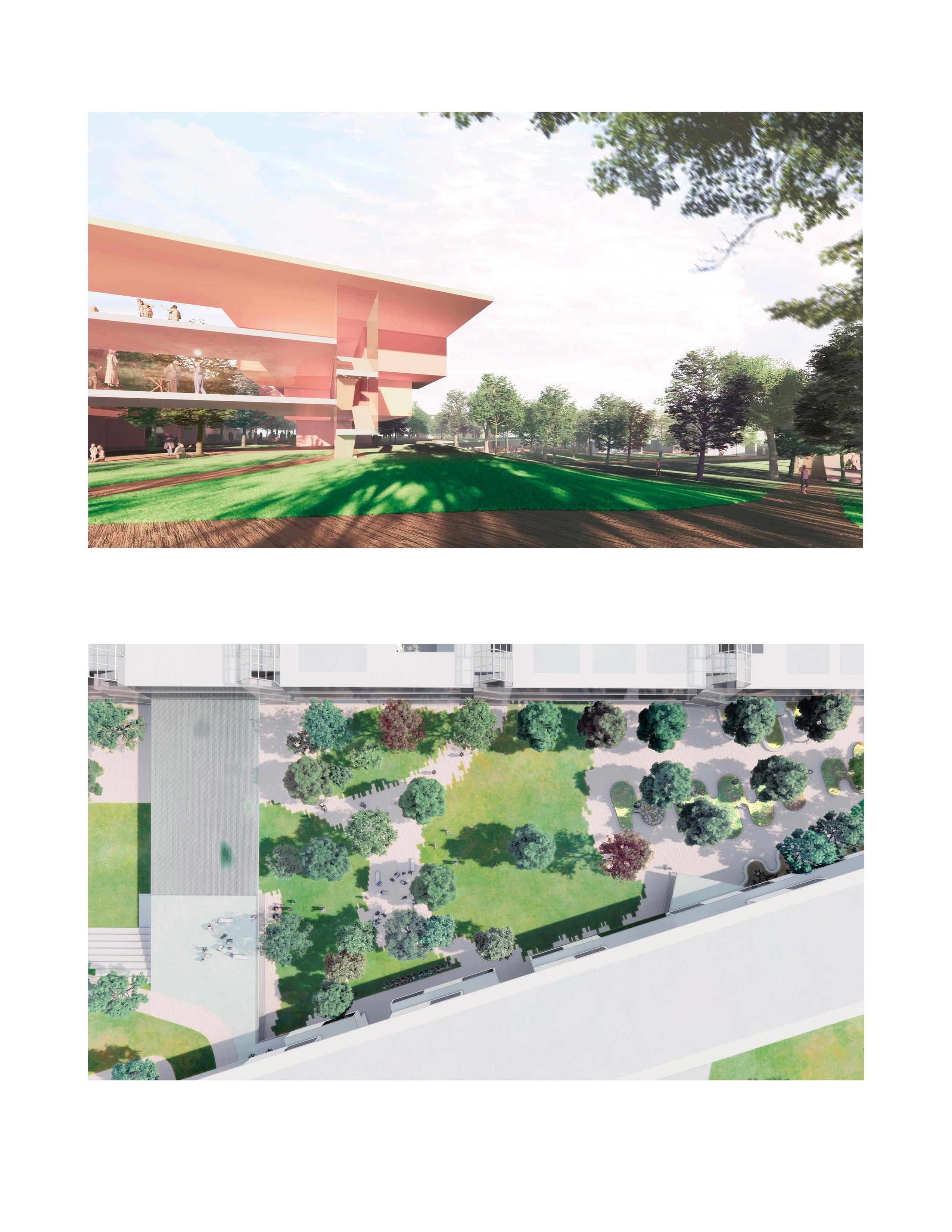
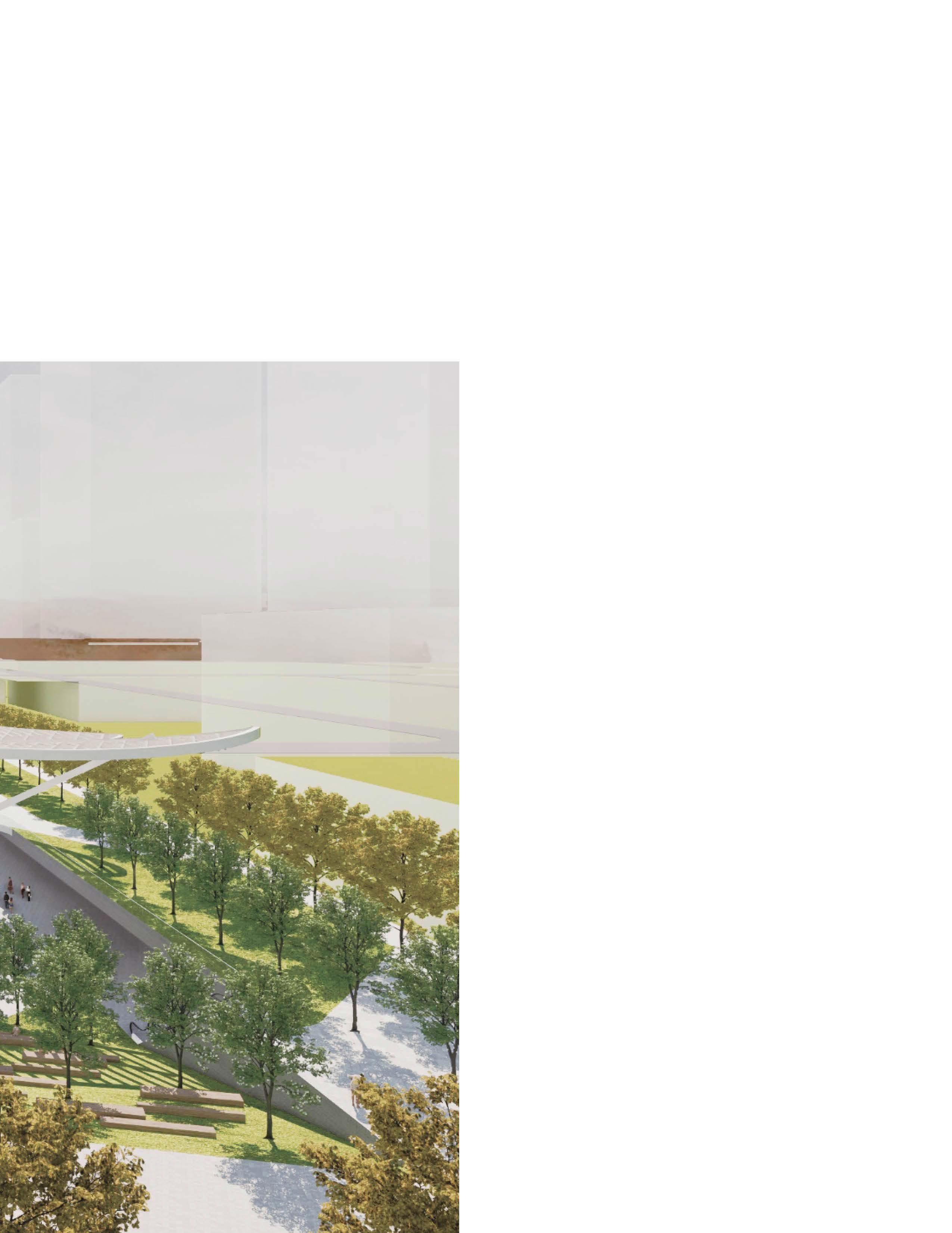
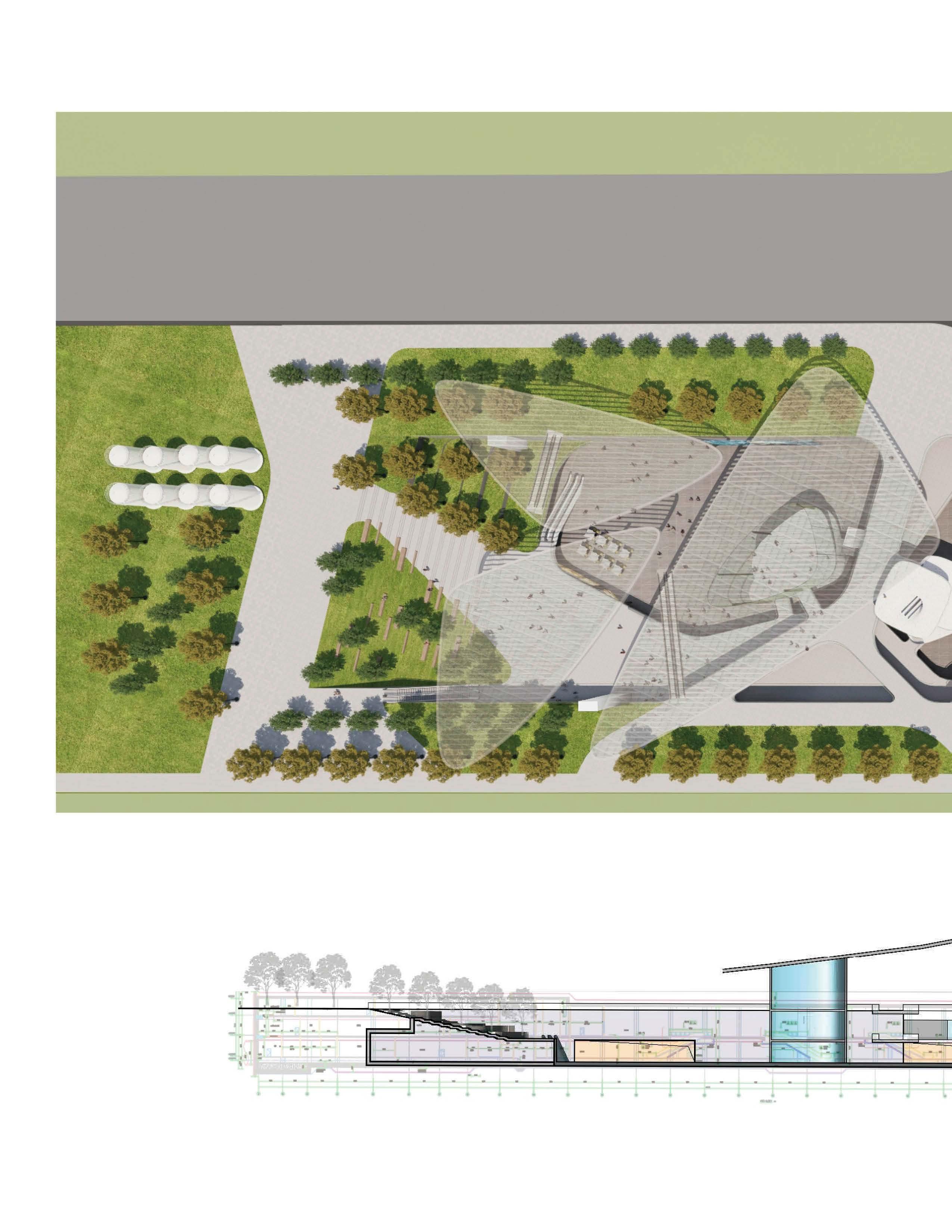
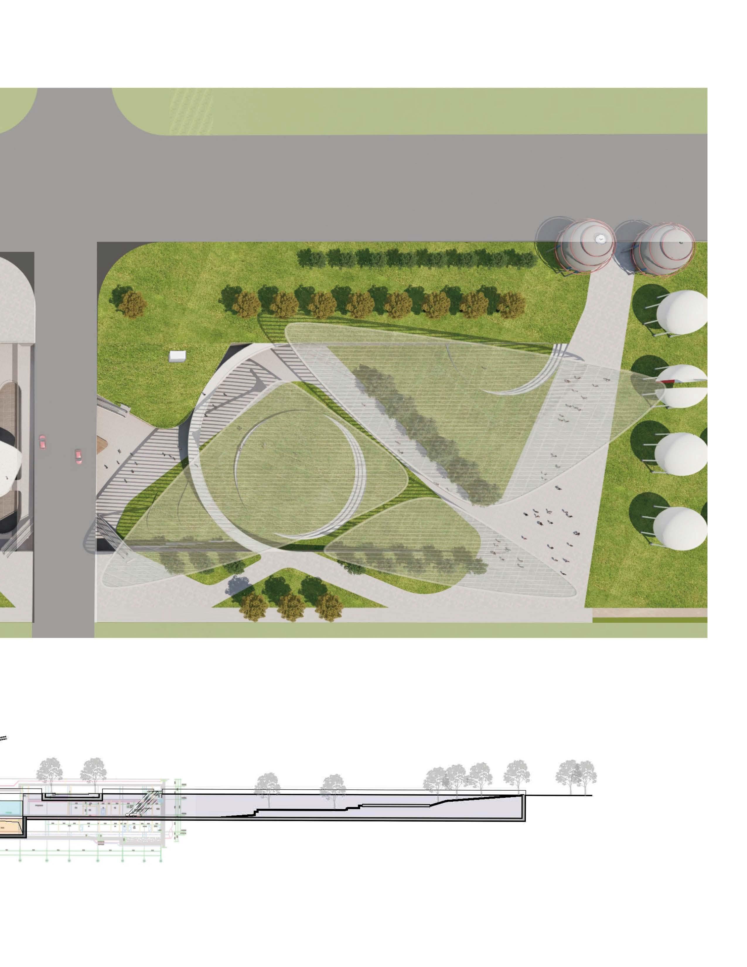
PENNINGTON PARK
A1
Pennington Park
Celebrating Active Senior Living through Seamless Blending Architecture and Landscape
2020 Spring
Professor: Bruce G. Sharky
Individual Design
Graduate Studio Design Award for Design Excellence
Typology
Senior Living
Location
Baton Rouge, LA
Narrative
Care for senior residents should holistically integrate healthcare services with active living environments. This design moves beyond traditional institutional designs toward creating spaces that inspire vitality, autonomy, and meaningful social engagement. Senior living is re-envisioned as an organic integration of architectural and landscaped spaces, fostering diverse interactions at multiple scales—from indoor living areas and outdoor natural settings to thoughtfully designed transitional interfaces.
Inspired by globally recognized best practices, this design adopts the Continuing Care Retirement Community (CCRC) concept, accommodating a spectrum of housing solutions ranging from independent living to assisted care, memory care, and rehabilitation services. Within this integrated community, residents receive tailored support that seamlessly adapts to their evolving care requirements, maintaining continuity and enhancing dignity.
The design emphasizes a purposeful blending of architectural and landscaped spaces, curating a variety of spatial experiences tailored to seniors of varying activity levels and preferences Richly designed outdoor areas invite residents to enjoy abundant sunlight, lush greenery, fresh air, and stimulating sensory environments. A carefully crafted range of landscape-architecture interfaces—from peaceful gardens and intimate courtyards to vibrant communal spaces—encourages residents to regularly engage with outdoor settings and maintain an active lifestyle.
Meticulous attention is given to the connectivity and navigability between diverse spaces. The design incorporates accessible, intuitive, and aesthetically pleasing pathways and transitions. Key details include non-slip paving, outdoor furniture, ample shading structures, strategically placed resting spots, and carefully integrated planting schemes to promote safe and comfortable navigation. Complementary indoor spaces further encourage community participation and social interaction. Collectively, these carefully considered design interventions greatly enhance residents’ autonomy, safety, and overall well-being, celebrating and enriching the senior living experience.
Independent Living
Potential Assisted Living
Assisted Living
Independent Garden House
Community Parking
Restaurant Area Parking
Main Entrance
Truck Load-off
Admin and Convenience Store
Drop-off
Parking
The Enjoyment
Interior Common Space
Caregiver Station
Pool & Therapy
The Studio
Memory Care Drop-off and Clinic
Cart Parking
Independent Living
The Courtyard
Canopy Plaza
Veggie Garden
Sitting Stage
The Forest
The Tunnel
Assisted Living
Healing Garden
Central Lawn and Plaza
Ground Floor Plaza
Grass Slope
The Meadow
The Lake
The Park
Bridge
Independent Housing
Tennis Court
The Restaurant
Parking for customer
Existing Pennington Trial
Alternative Trail
Landscape and Accessibility
Pavement
Lawn Slope Sitting
Buffer
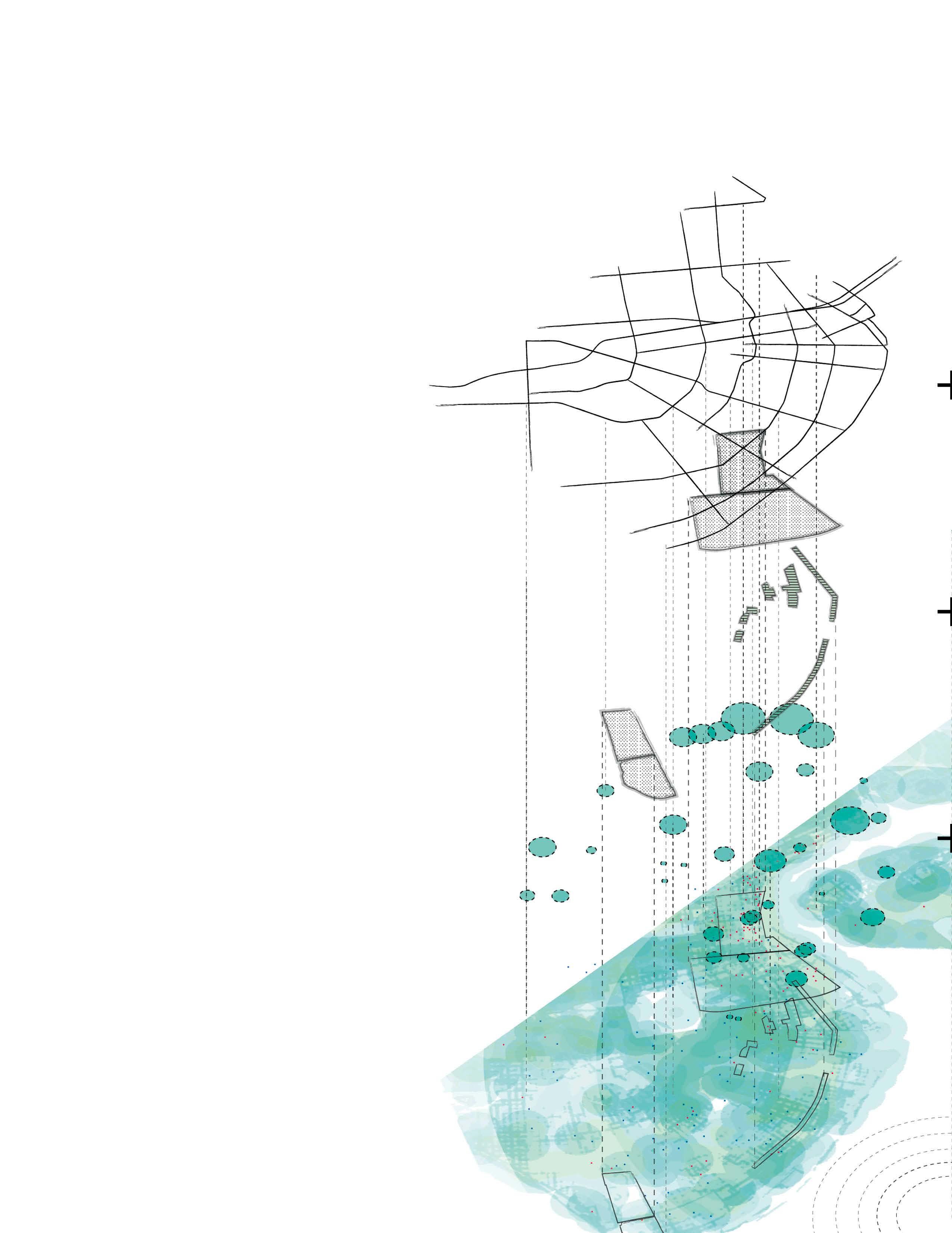
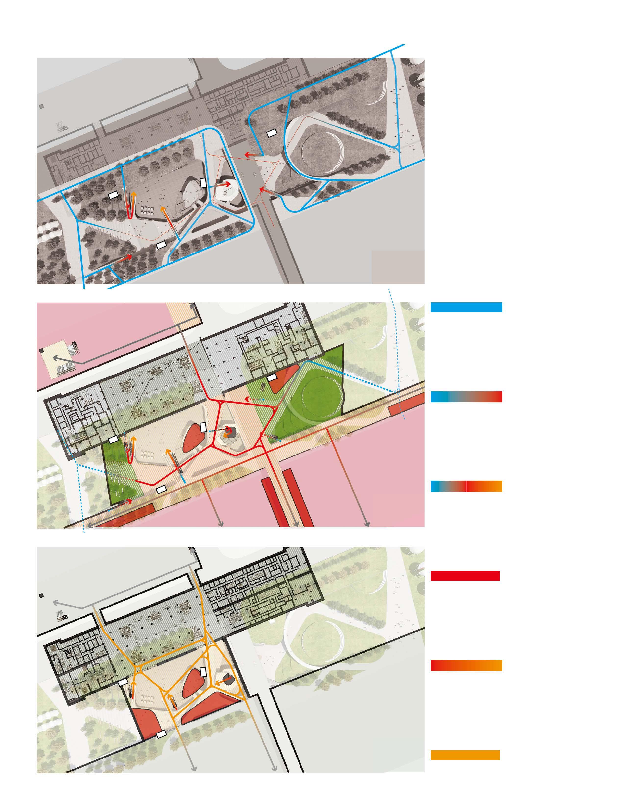
Design Strategy Step 1: Dynamic Unit Design
Classic Senior Living
Isolated Housing or housed in cube
Passively receiving service
Medical centered society.
Senior Campus
Clustered Units
The units are group into mini cluster, offering different level of accessibility and activeness could be achieved.
Dynamic Interface
Landscape and Architecture are weaved when they meet, forming a dynamic interface that celetrate active lifestyle.
Active living
The spectrum of space provide active connection from living unit to collective space, to activities and landscape.
Step
The Park Ground Floor Plaza Independent Unit Central Lawn and Plaza
The Forest Lawn ADA Path
Independent Unit The Enjoyment Assisted
Living
Independent Living Memory Care & Medical Service
Rooftop Garden
Sections
Section A
Section A
Section
Slope
Independent Unit
Assisted Living Sitting Stairs
The Tunnel
Central Lawn and Plaza
Independent Unit
Ground Floor Plaza
The Park
Section B
Sit N’ Chat
Admin + Store
The Studio Healing Yard
Ground Floor Plaza
Independent Living
Assisted Living Independent Living
Central Lawn and Plaza
Admin and Store
The Enjoyment
The Forest
The Studio (Entrance)
Sit’n Chat
Healing Garden
Canopy The Enjoyment
Central Lawn Central Plaza
Drop Off
The Tunnel
Stage
ADA Ramp
Assisted Living
The Enjoyment
Collective Space
Collective Space
Independent Living
The Courtyard
The Forest
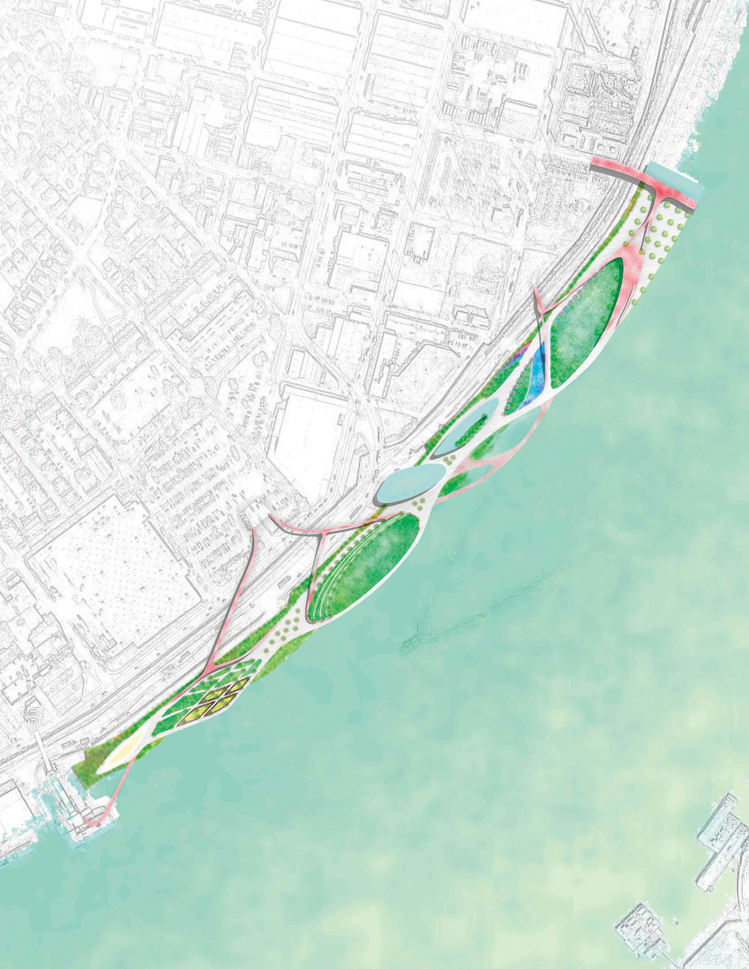
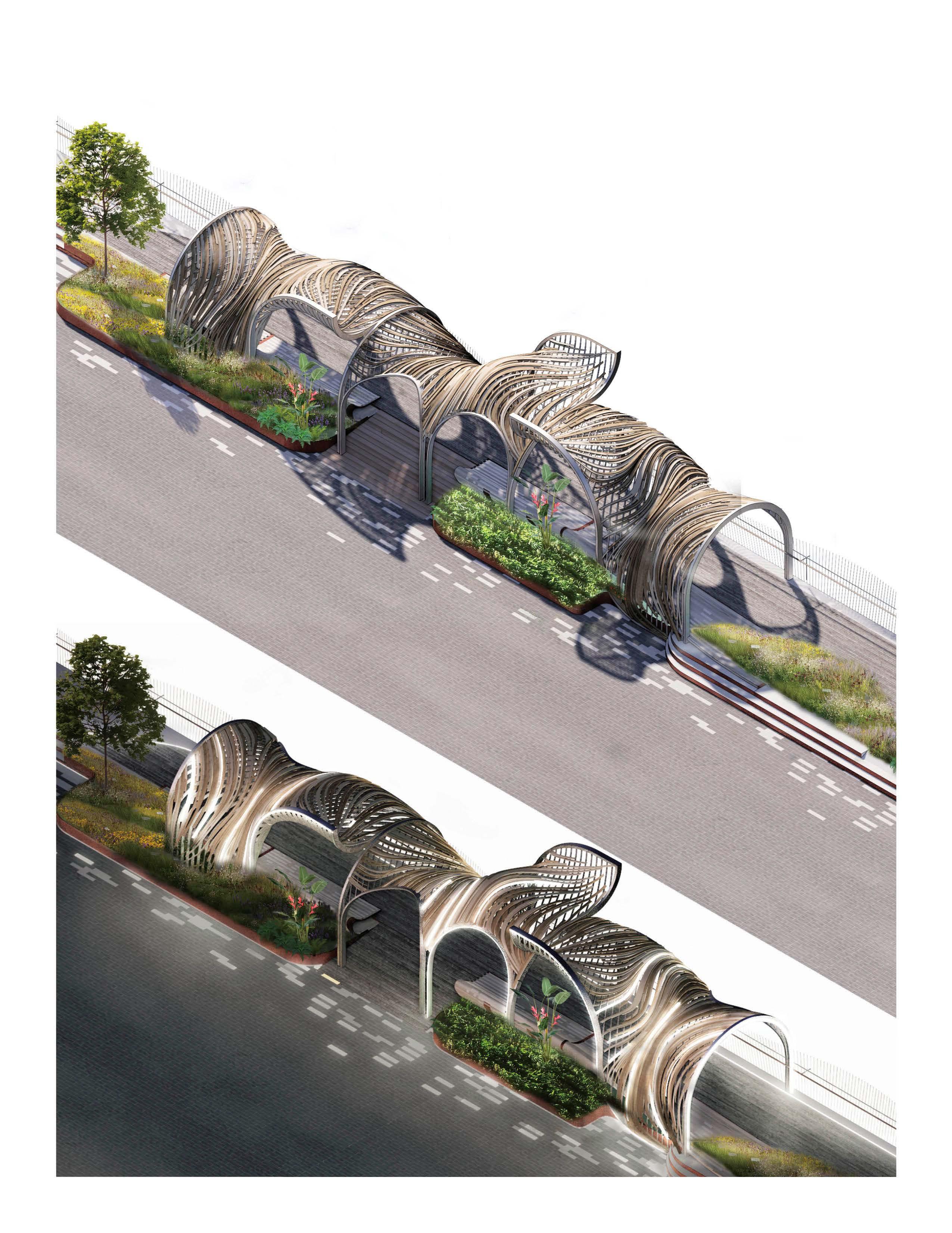
CALL OF RIVER
Call of River: Relink New Orleans to the Mississippi River
2018
Professor: Lake Douglas
Individual Design
Spine CBD and French Quarter
Popular commercial tourism street & block
Audubon Park
Existing parks
Marginalization
Inequality, and the water- front seems to be forgotten.
Existing heat map modeled in ArcGIS using mode Buffer, Weighted Overlay Raw data collected from ArcGIS Online and TPL
Grown spine
A smooth walk along waterfront from Woldenberg to Audubon
Frontier
A new way to experience NOLA & embrace life.
Typology
Landscape Urbanism Design + Park Design
Location
New Orleans, LA
Narrative
Once a vibrant heart of New Orleans, the waterfront has become fragmented and underutilized.
This project explores a dual-directional design strategy: bottom-up, emphasizing community-driven aspirations for public space, and top-down, considering the visions and interests of developers, commercial entities, and urban stakeholders. By analyzing and recombining these multi-layered perspectives, the design establishes a flexible yet coherent typology for urban parks along the riverfront. Ultimately, the project aims to transform the fragmented waterfront into a cohesive, active urban belt, reconnecting the people, the city fabric, and the Mississippi River—seamlessly linking Audubon Park with the downtown waterfront.
A smooth & walkable belt all along waterfront from Woldenberg to Audubon Park Radiation BOOM!
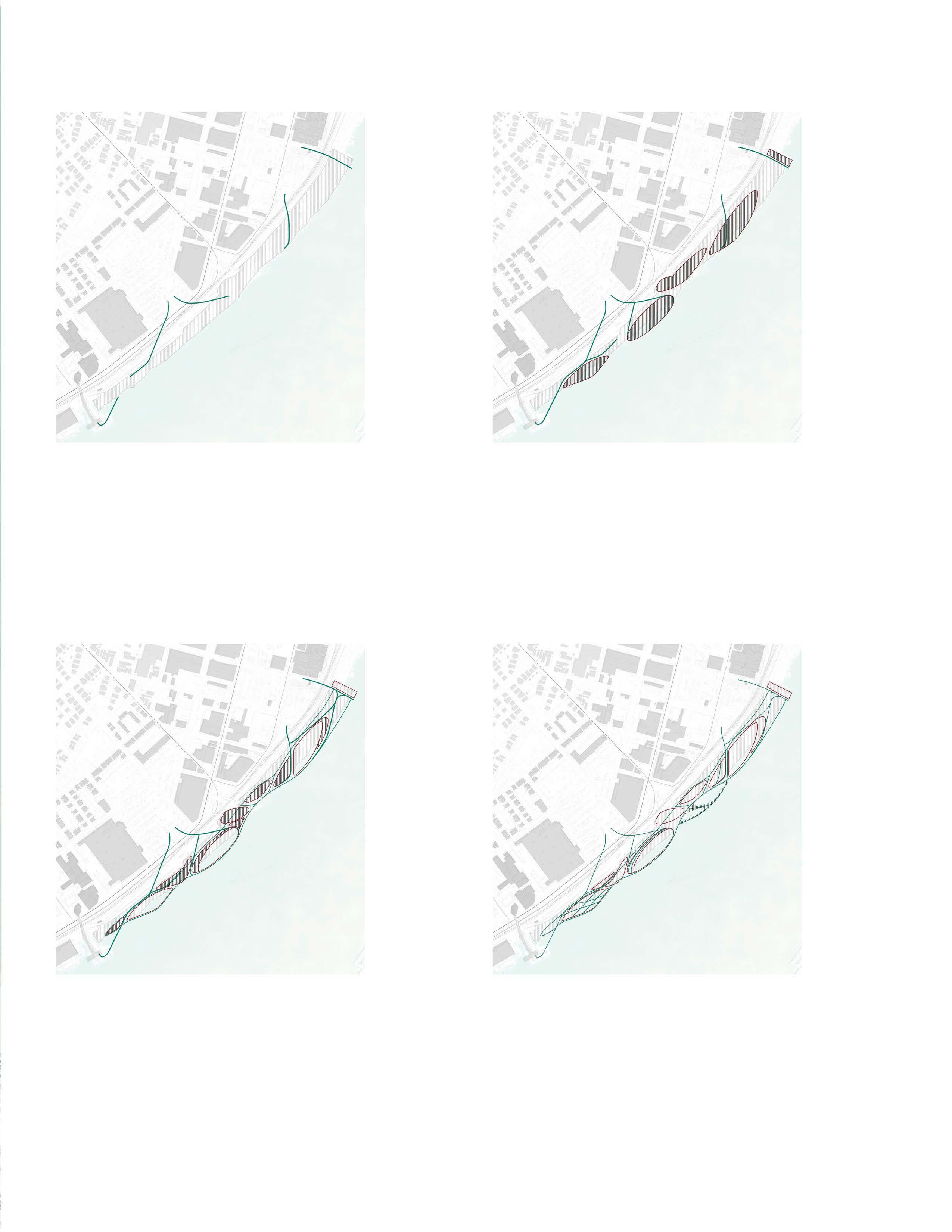
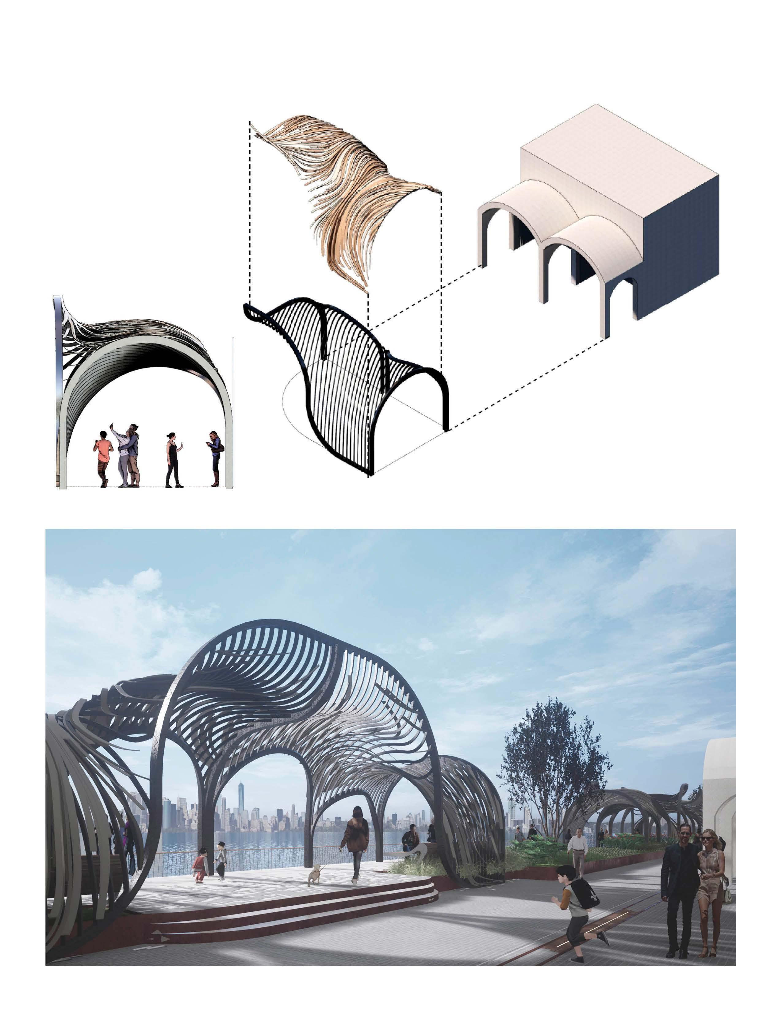
Park A - Plans
Park A - Design Generation
01.Access
Bridging existing gaps in the urban fabric by responding to surrounding conditions and enhancing walkability—making the site more accessible while drawing people toward emerging activity nodes along the riverfront.
Establishing a clear orientation anchored by key urban nodes, while introducing a dynamic, fluctuating shoreline that enhances spatial diversity and interaction with the river.
03.Interaction
Leveraging programming to create internal connections between distinct spaces, recombining them into a cohesive and continuous spatial experience.
Weaving paths through and across varied programs and spatial conditions, the design forms an interwoven park system that invites exploration and fosters connectivity.
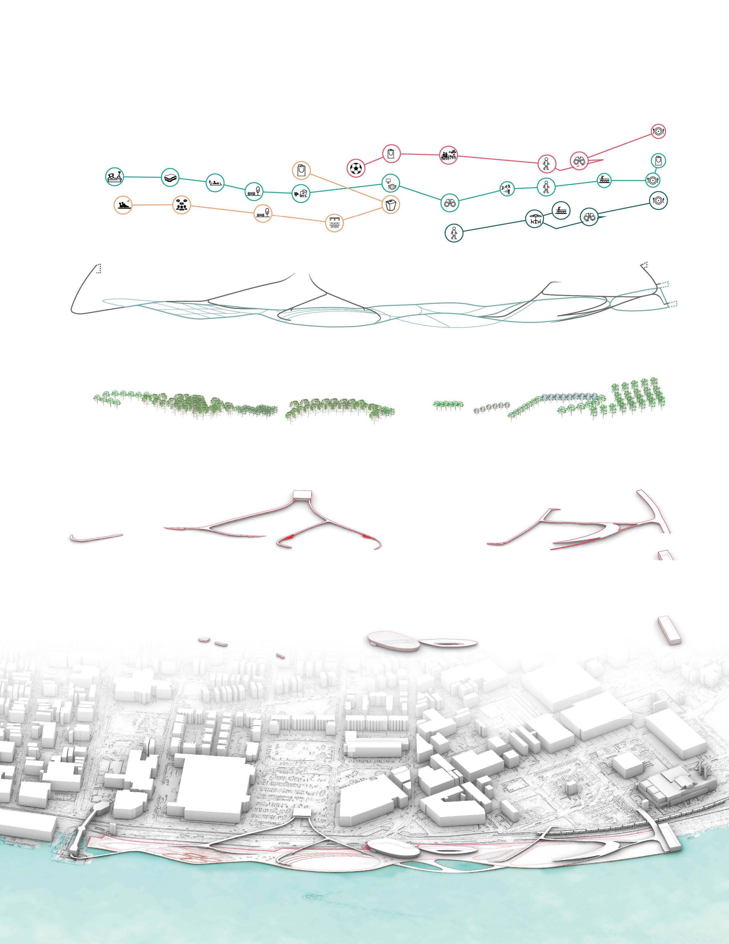
Park A - Proposed layers
Canopy
Vertical connection
Service facility
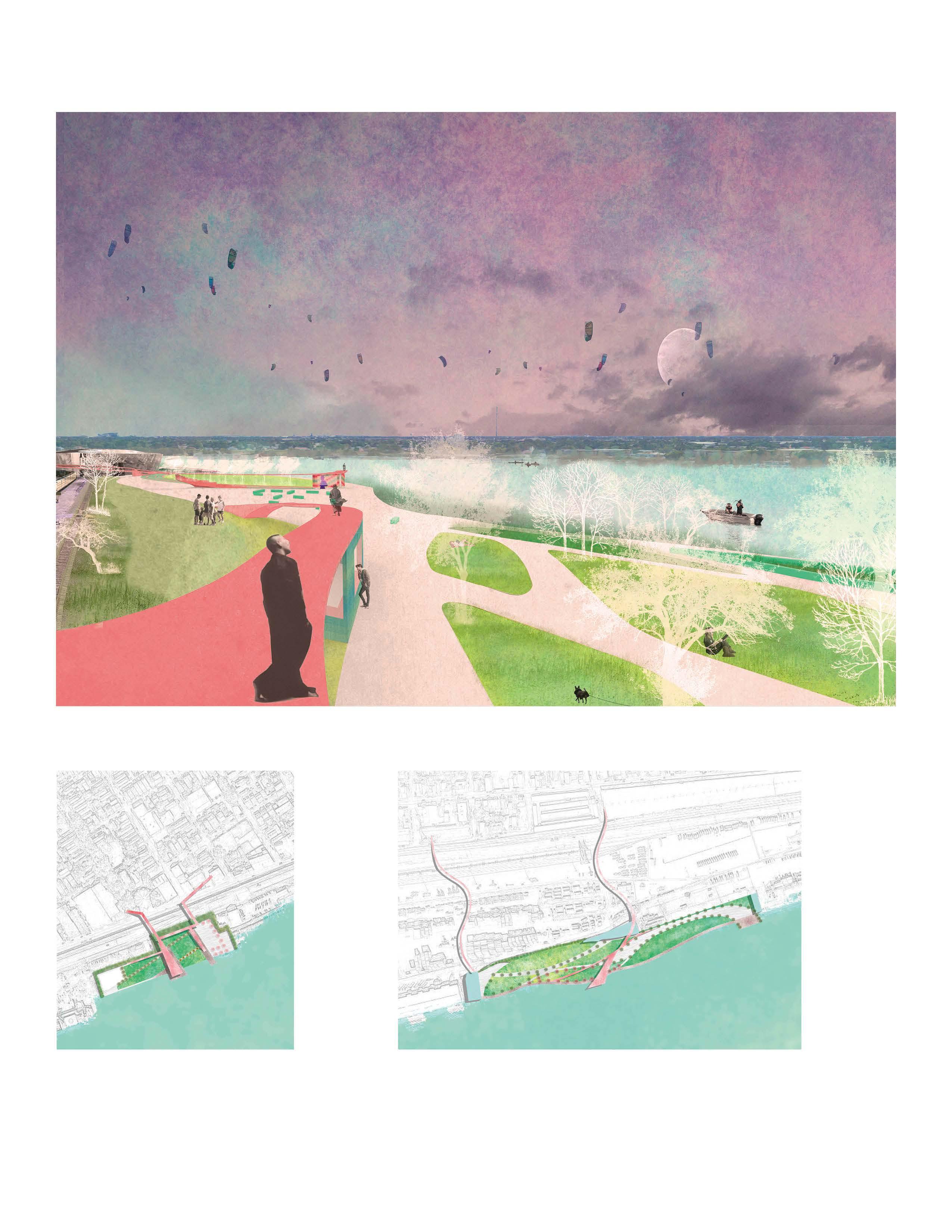
Park A - Perspective
Park B & Park C - Plans
B.Potential spot
1.Plaza
2.Sitting stairs
3.Skywalk
4.Pavement
5.Great lawn
6.Stairs
7.Shop under skywalk
8.Ramp
9.Sports field
C.Potential spot
1.Shop & building
2.Lawn
3.Riverside deck
4.Pavement
5.Skywalk
6.Building
7.Ramp (canopy underneath)
8.Shop under skywalk
9.Birdview deck
10. Pavement
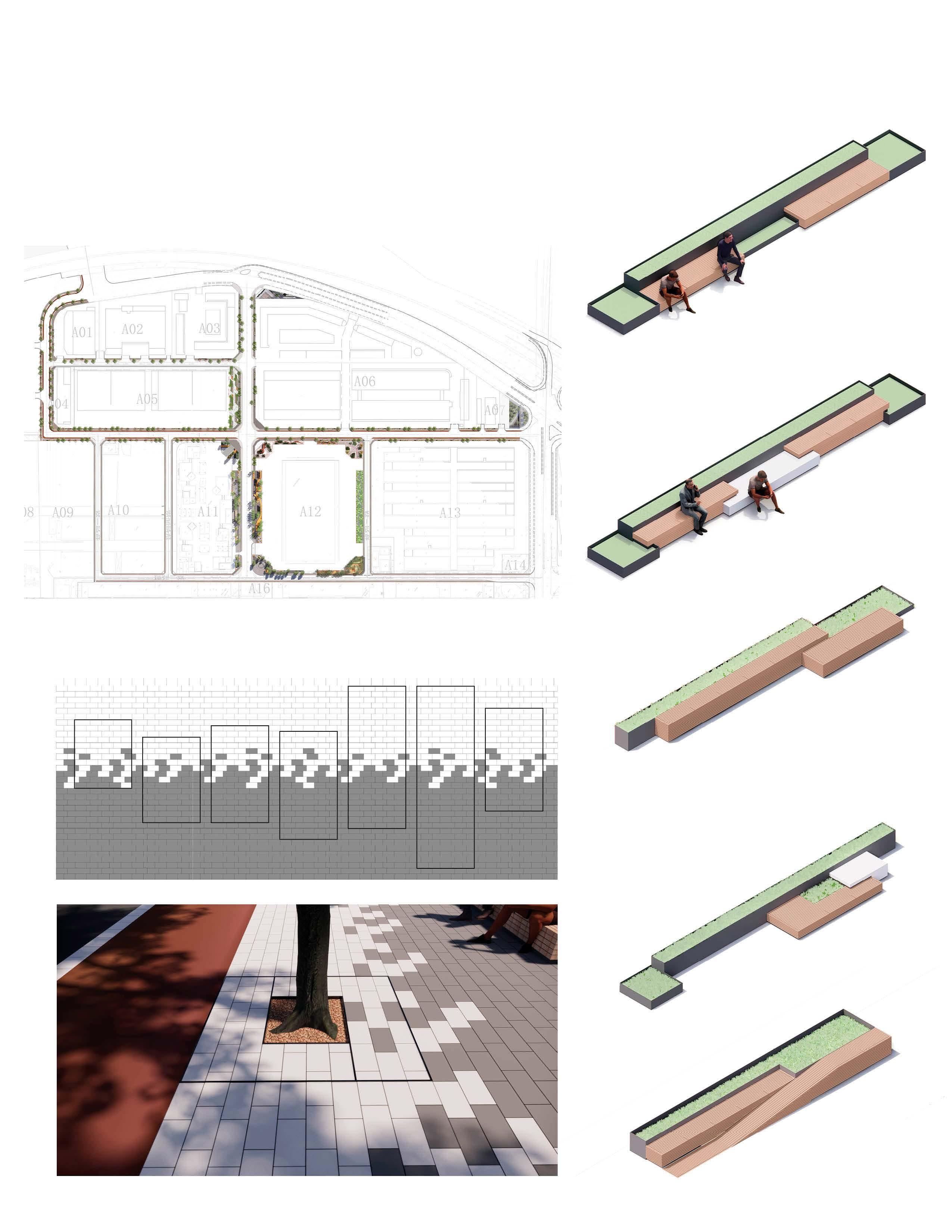
DESIGN TECH & CONSTRUCTION DOCUMENTATION
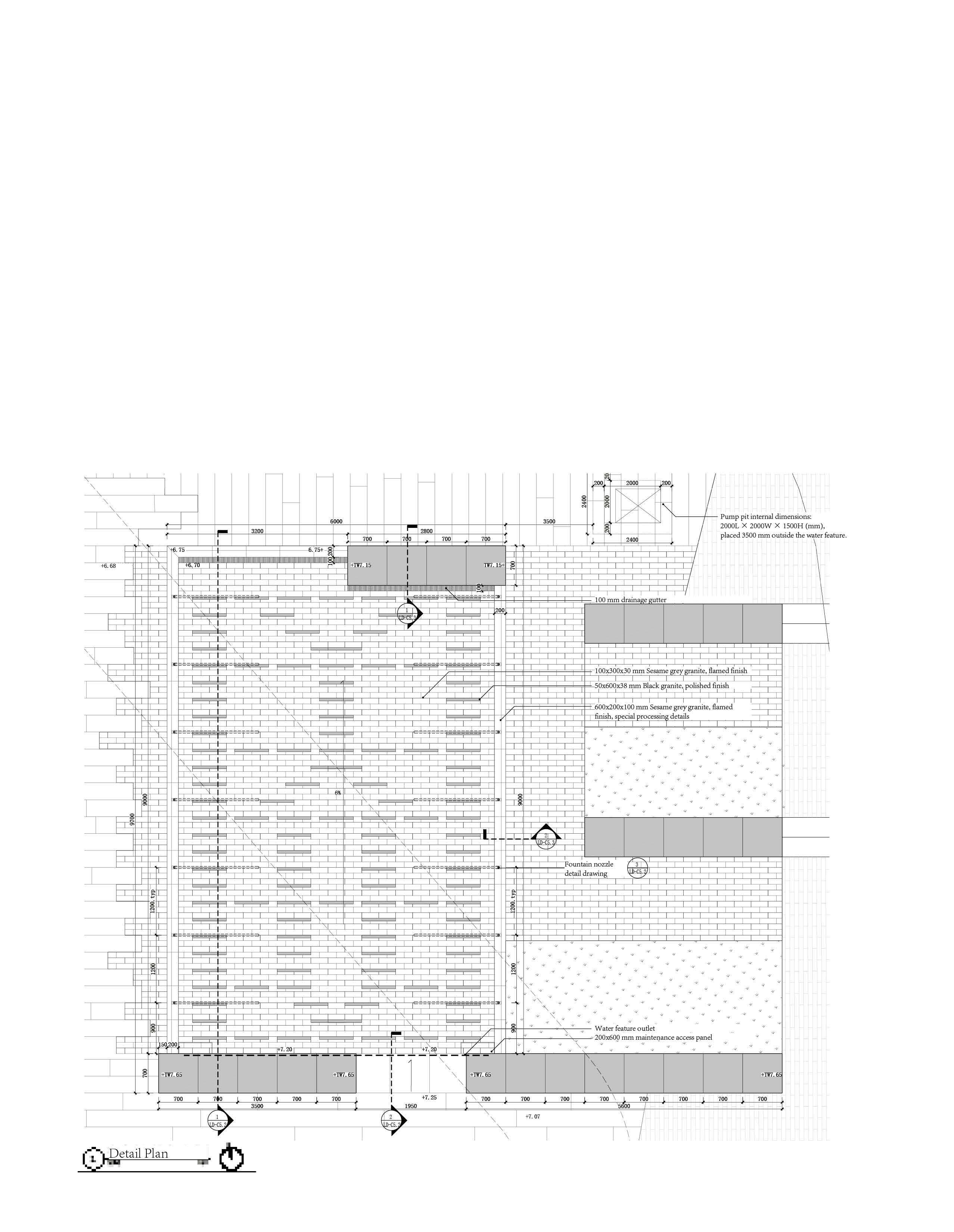
Landscape Details
Professional Work at Z+T
2019
Professional Work at Z+T
Landscape
Architect
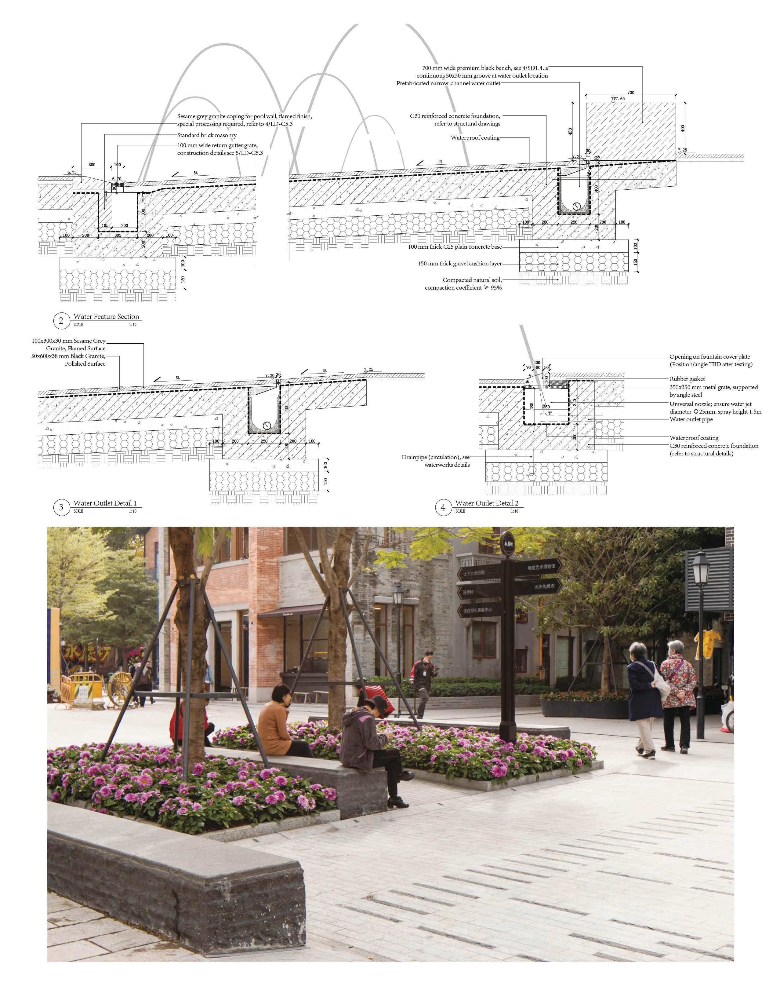
Water Feature with patterned bricks
Design: Yongqin Zhao, Siyuan Lou
Dawing: Yongqin Zhao, Siyuan Lou
Supervisor: Hua Zhao
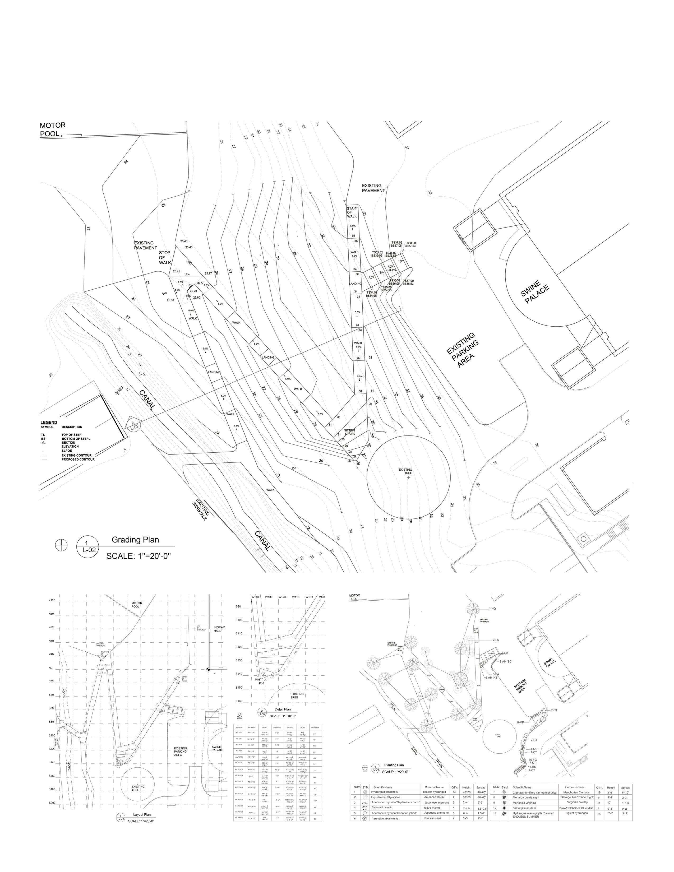
Grading Design
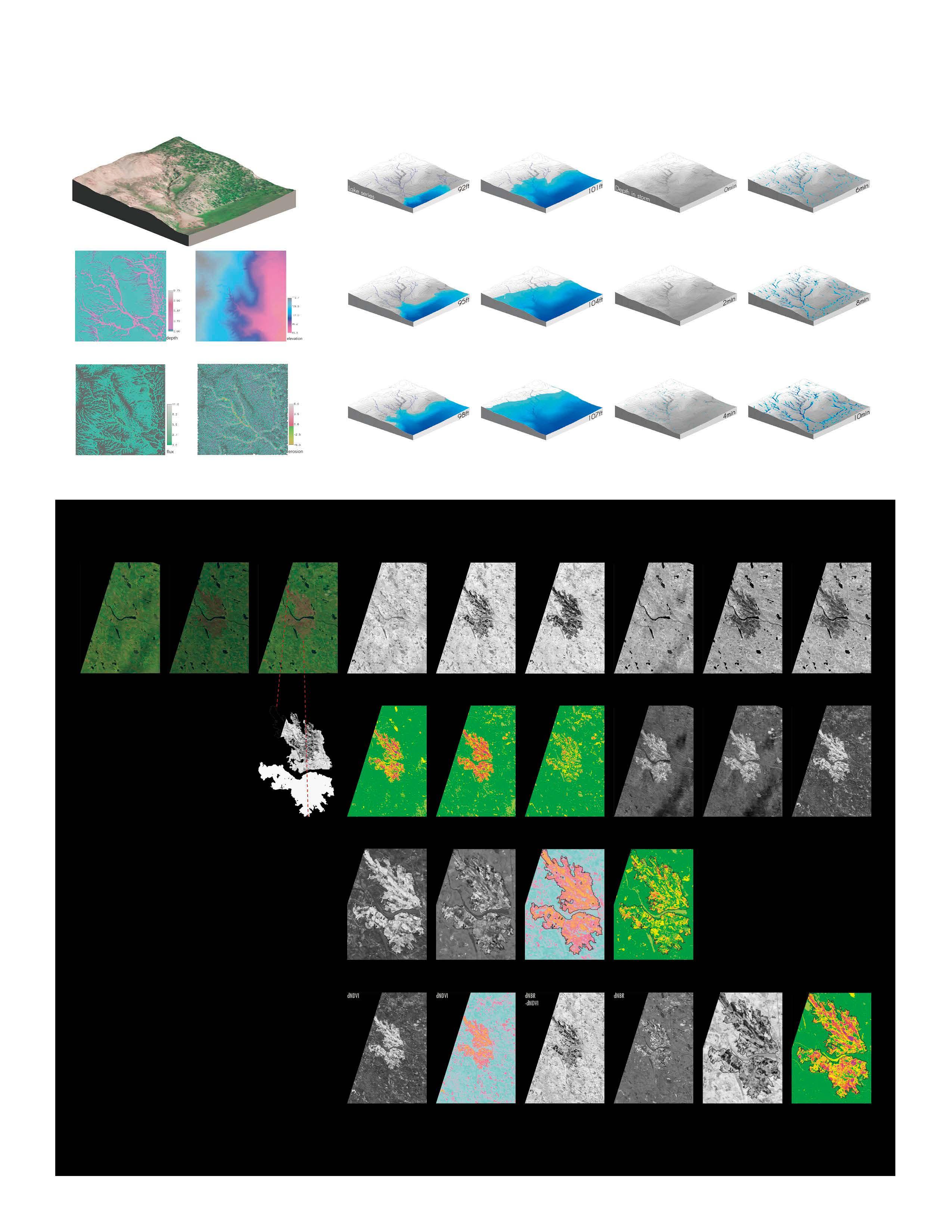
GIS
Remote Sensing in Landscape
Landsat 8 level-1 OLI
Methodology
Based on Landsat 8 data of prefire, post-fire, and 1-year postfire, two vegetation index were introduced to get NBR (Normalized Burn Ratio) and NDVI (Normalized Difference Vegetation Ratio) to compare different method of study forest fire. More info
Conclusion and Discussion
-Data dispersion (histgram)
-NBR can distinguish better and show more sensivity. Especially between the moderate‐extreme classes
-NBR and dNBR are more suitable for detecting different severity levels.
-Suspected similarity between dNBR-dNDVI (right post-fire and 1-year post-fire) and dNBR (pre-fire
Media: ERDAS Imagine, QGIS with SCP plugin and DOS1 atmospheric correction. https://issuu.com/zyq3/docs/yongqin_zhao_project
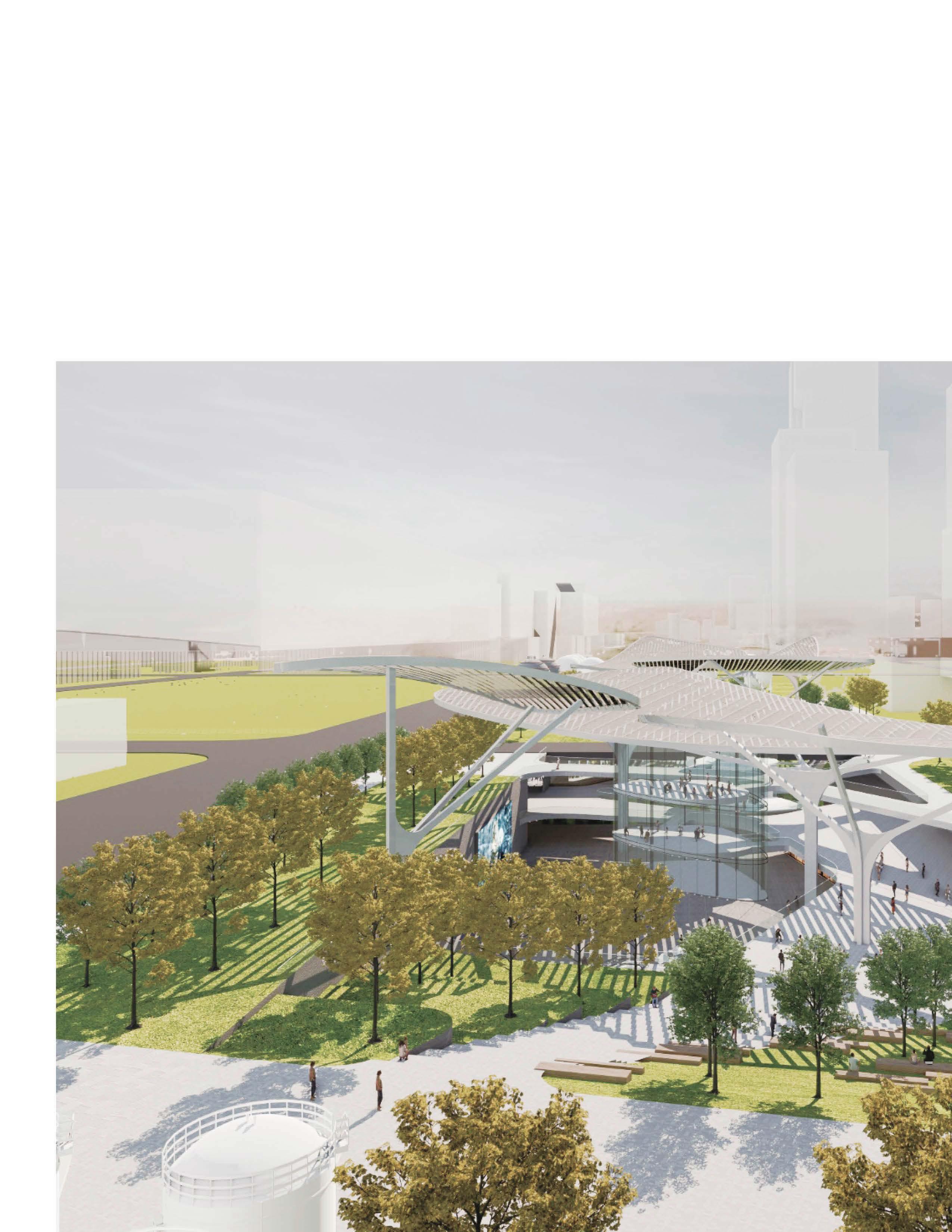
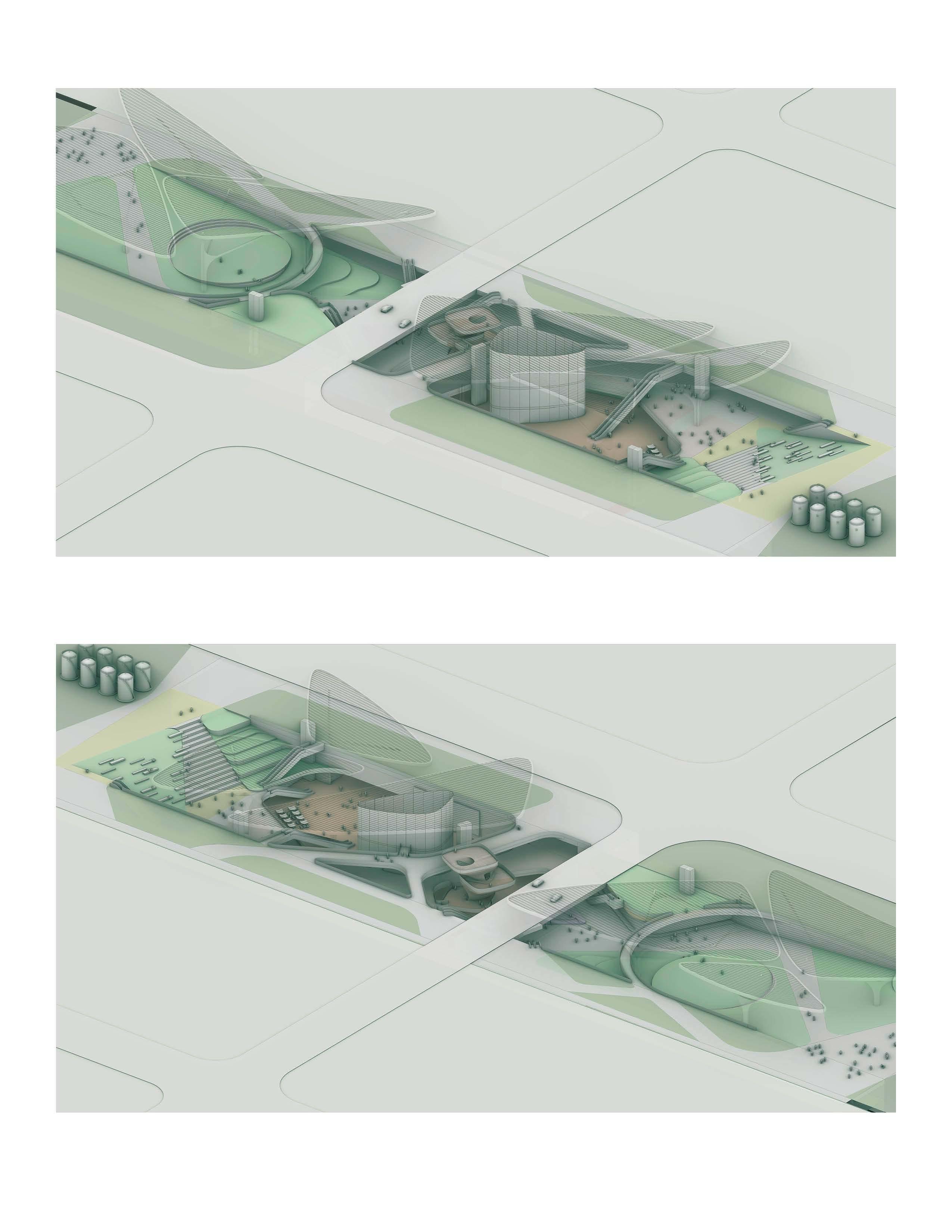
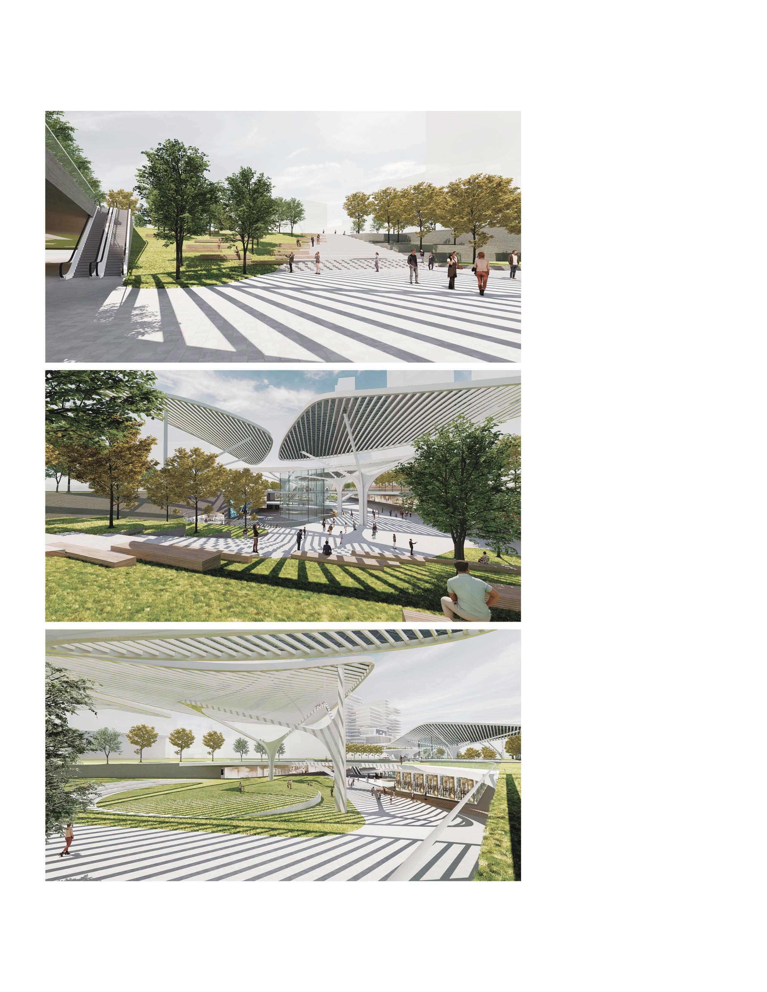
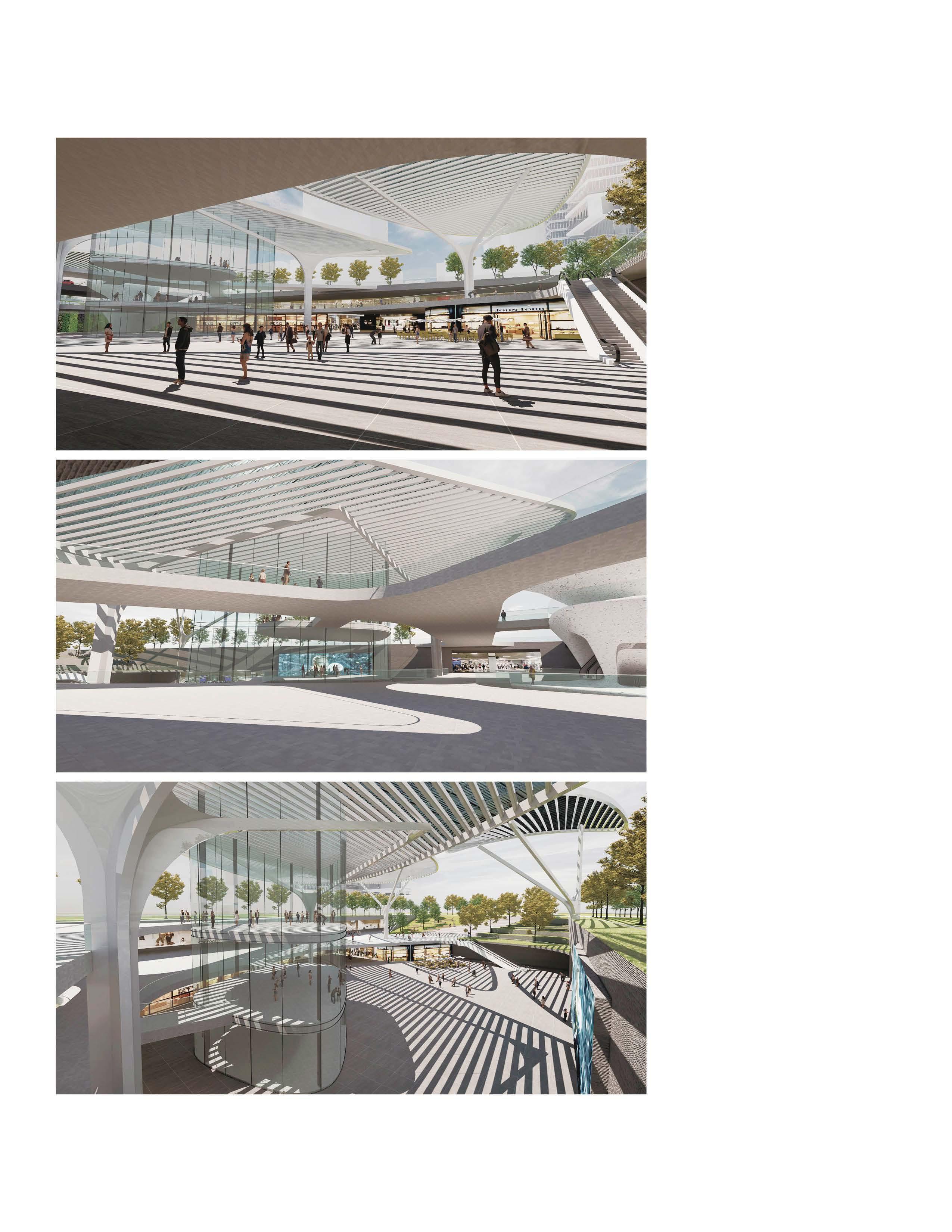
PARK ABOVE THE TRACKS
Park Above the Tracks: Revitalizing an Underground Hub into a Thriving Public Space through TOD Design
2022, Tianhua Urban Design Lab
Concept Design, Master Planning and Site Design
Design: Yongqin Zhao
Render: Yongqin Zhao
Supervisor: Jie Bao
Typology
Transit Station, Transit-Oriented Development
Location
Shanghai, CN
Responsibility
Landscape Design based on Underground Development & Subway Entrance from Architect and Engineers
Narrative
Could a subway station become a vibrant urban park? Leveraging the exceptional connectivity provided by the intersection of three subway lines and the surrounding urban context, including underground office spaces, this design opens up the traditionally enclosed subway station to create a dynamic public space.
Circulation through different level
Ground Level
B1 Level
Pedestrain Bridge a
Ramp (ADA)
Stairs
Escalator
Elevator
Subway Entrance
Subway Hall
Retail
Ground Level (+4.58m)
Ground to B1 Stairs + Ramp + Escalator
Ground to B2 Escalator
B2 Level
B1 Level (-1.91m)
B1 to B2 Escalator
B2 Level (-7.41m)
Axon Diagram
Axon from NorthWest to SouthEast
Axon from SouthEast to NorthWest
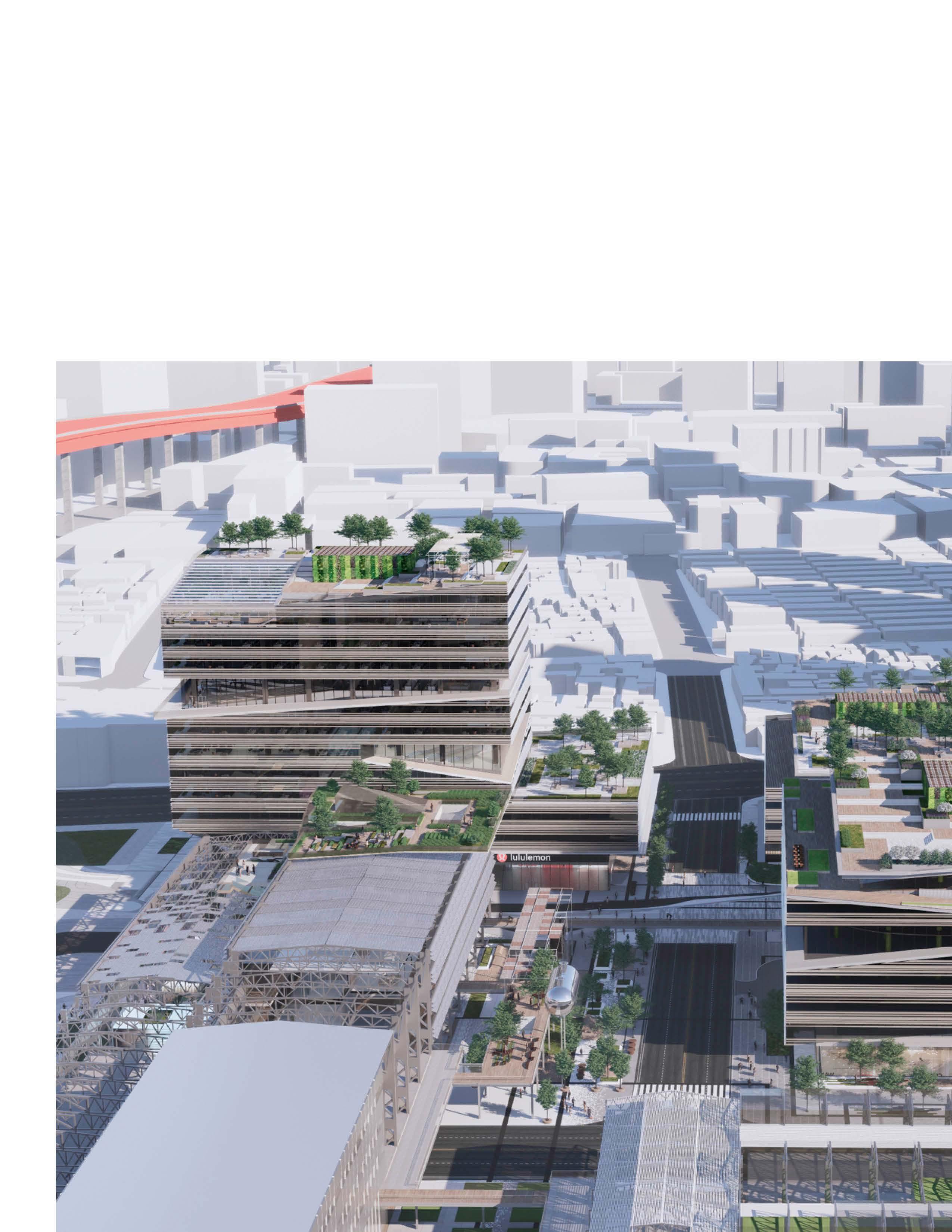
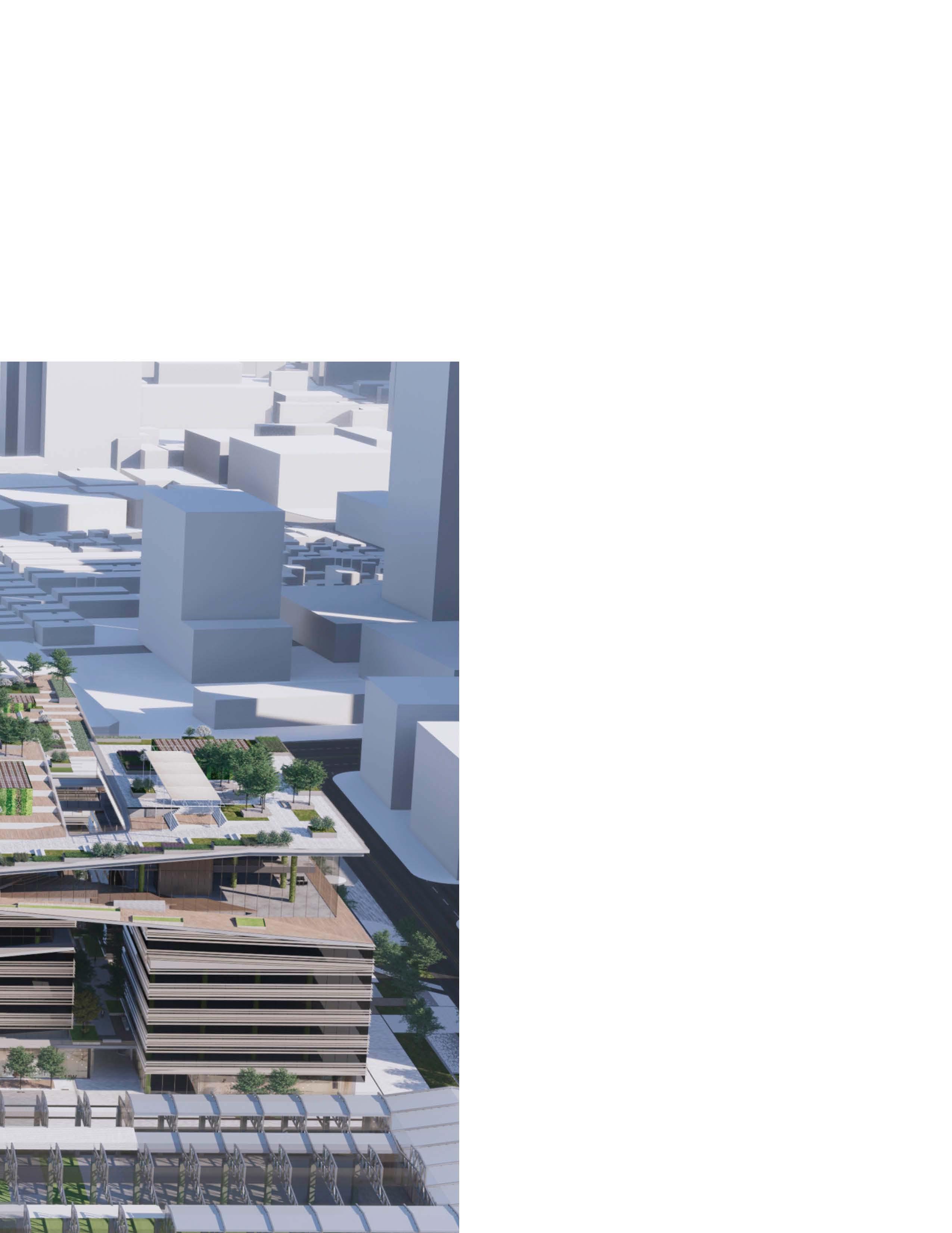
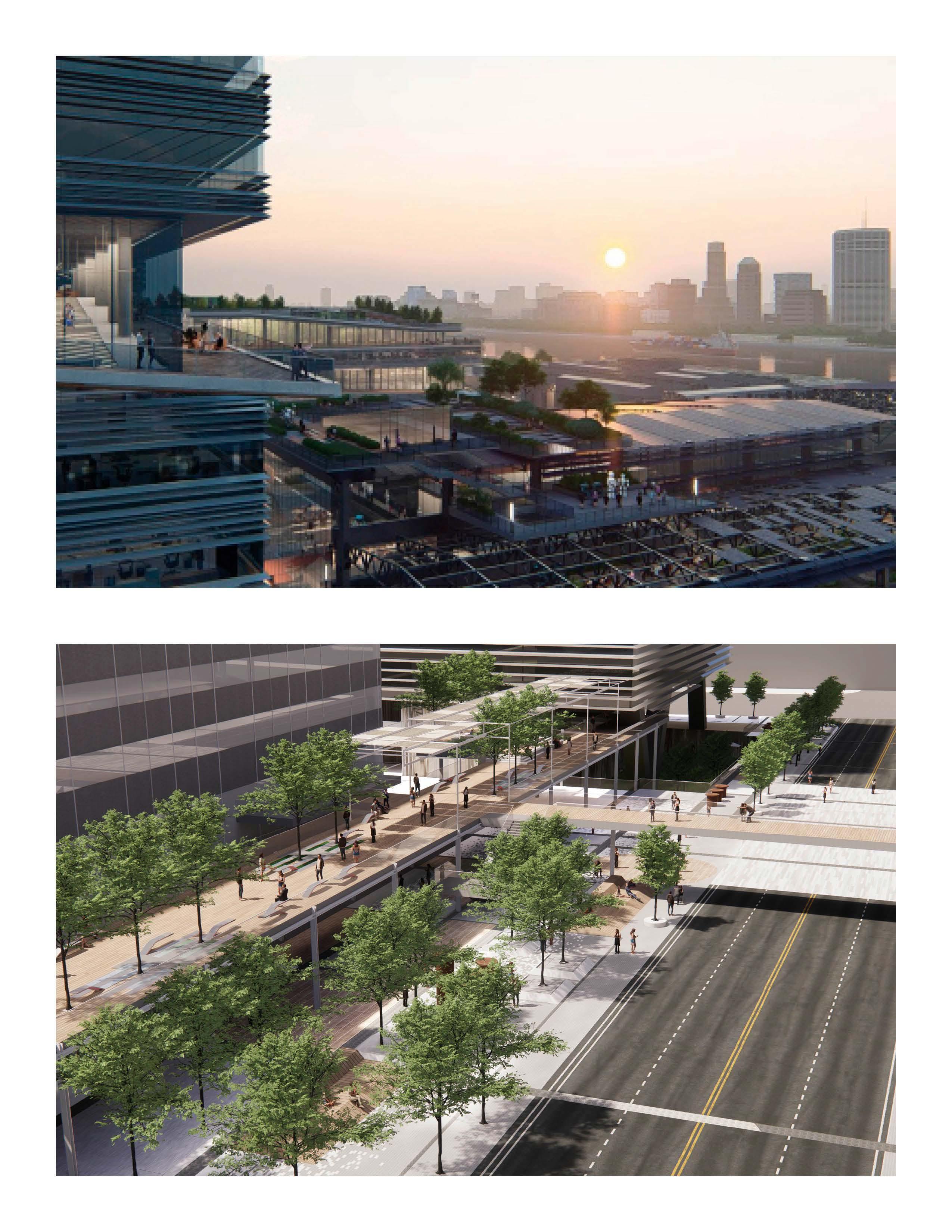
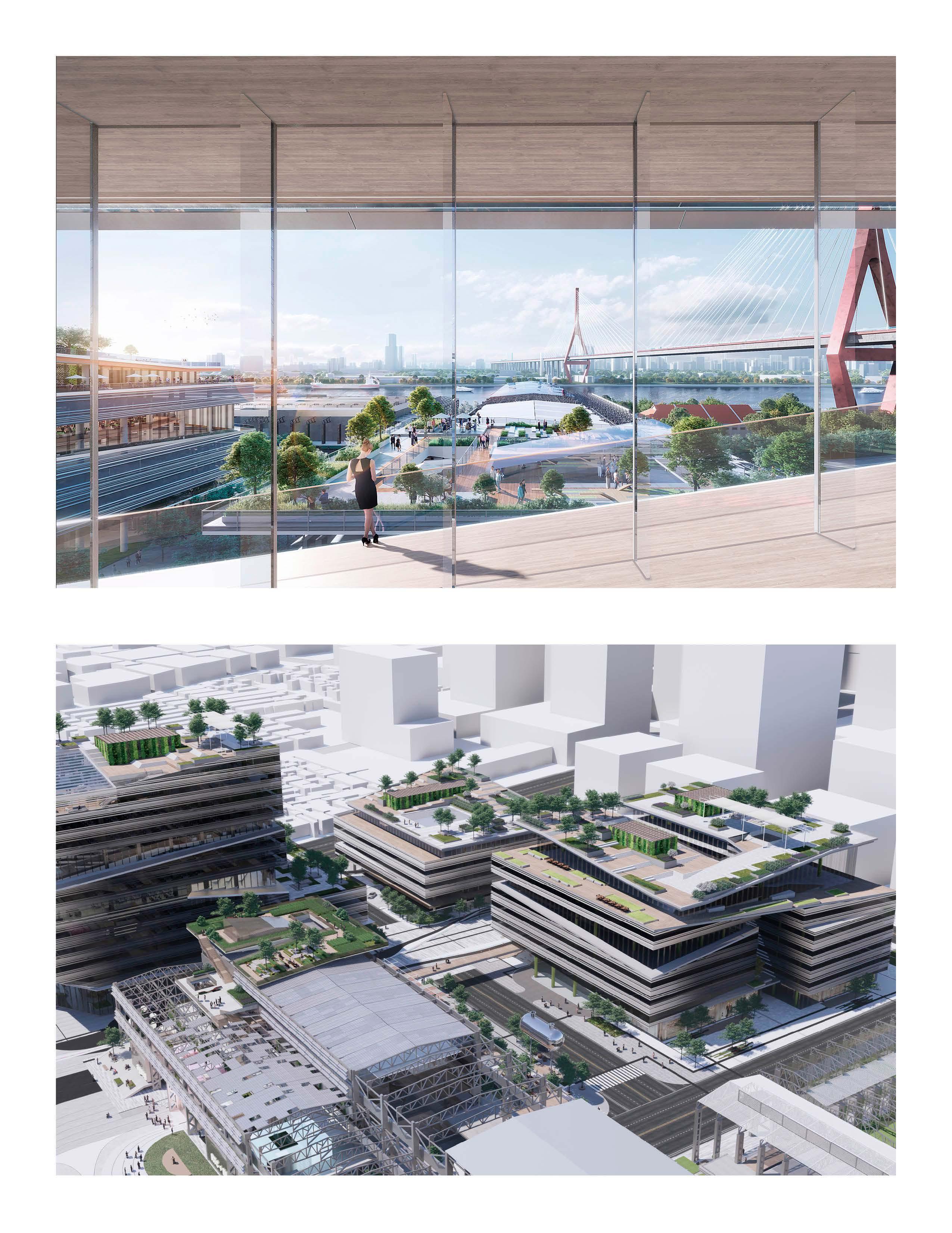
OASIS CAMPUS
Oasis Campus:
Injecting Landscape and Pedestrain Circulation with Office Towers through Roof Garden, Terrace, Pedestrain Bridge, and Park
2022, Tianhua Urban Design Lab
Concept Design
Design: Yongqin Zhao + Exterior Rendershop
Render: Yongqin Zhao
Supervisor: Jie Bao
Typology
Office
Location
Shanghai, CN
Responsibility
Rooftop Garden Design; Ground Level Design, including pavement, furniture, planting
Narrative
Can landscape design transform isolated office towers into a connected urban experience?
By collaborating with architects, this project weaves together ground-level parks, elevated bridges, terraces, and rooftop gardens to create a continuous, accessible pedestrian network. These layered green spaces foster interaction, improve circulation, and inject vitality into a dense office environment.
P3
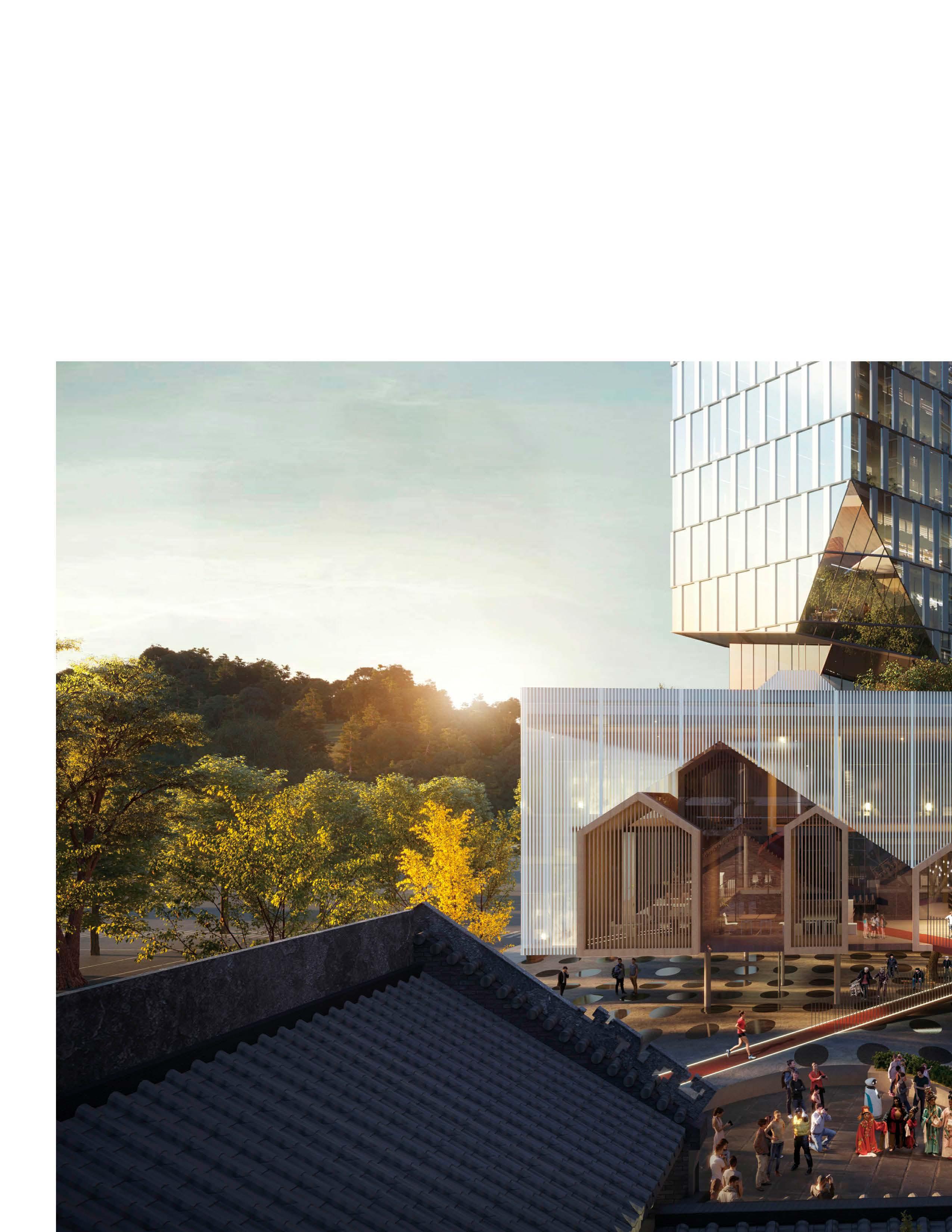
Heritage
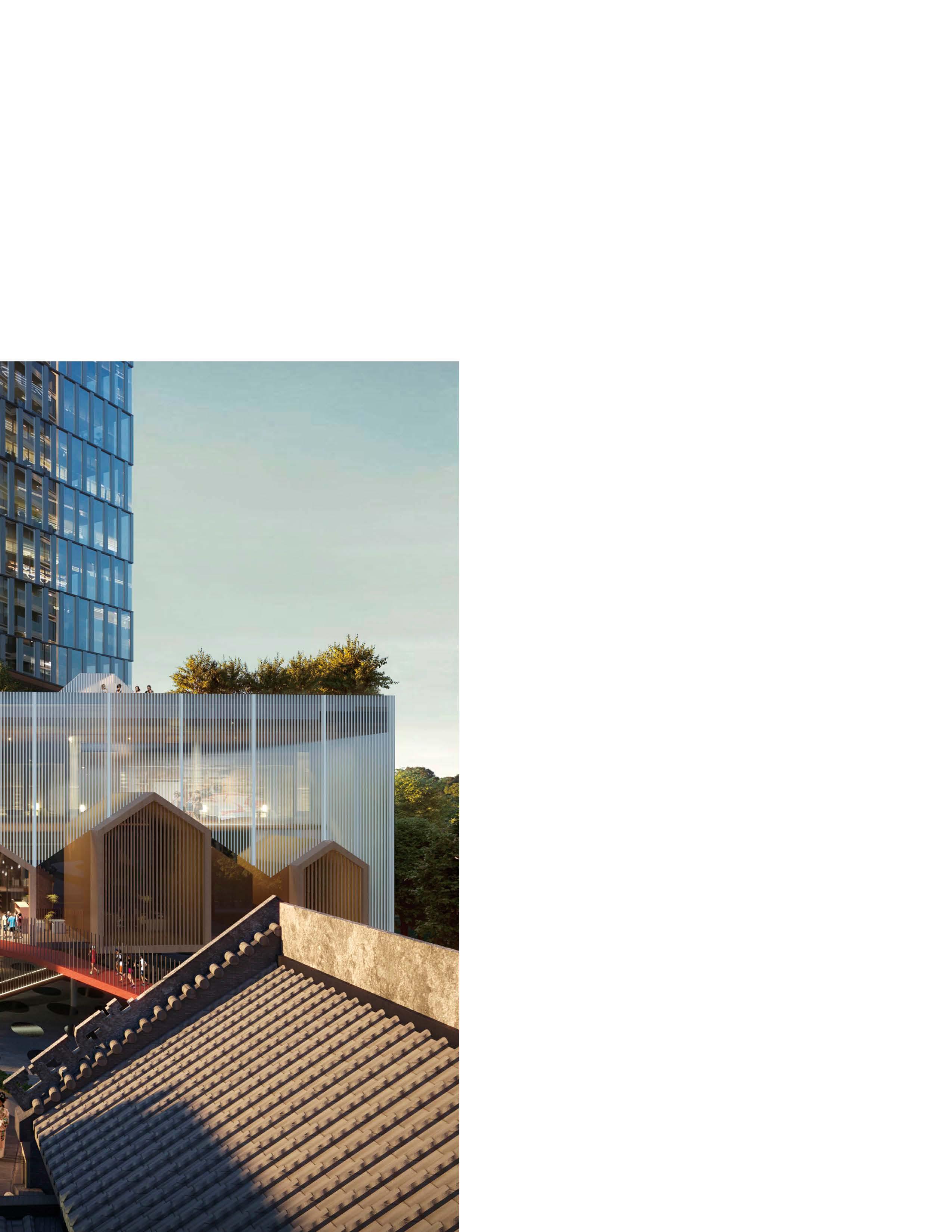
Reconnected:
Harmonizing Ancestral Heritage with Contemporary Community Hubs and Public Spaces
2021, Tianhua Urban Design Lab
Concept Design, Civic Community Center Design: Yongqin Zhao Supervisor: Jie Bao
Typology
Civic
Location
Guangzhou, CN
Responsibility
Architecture Design
Narrative
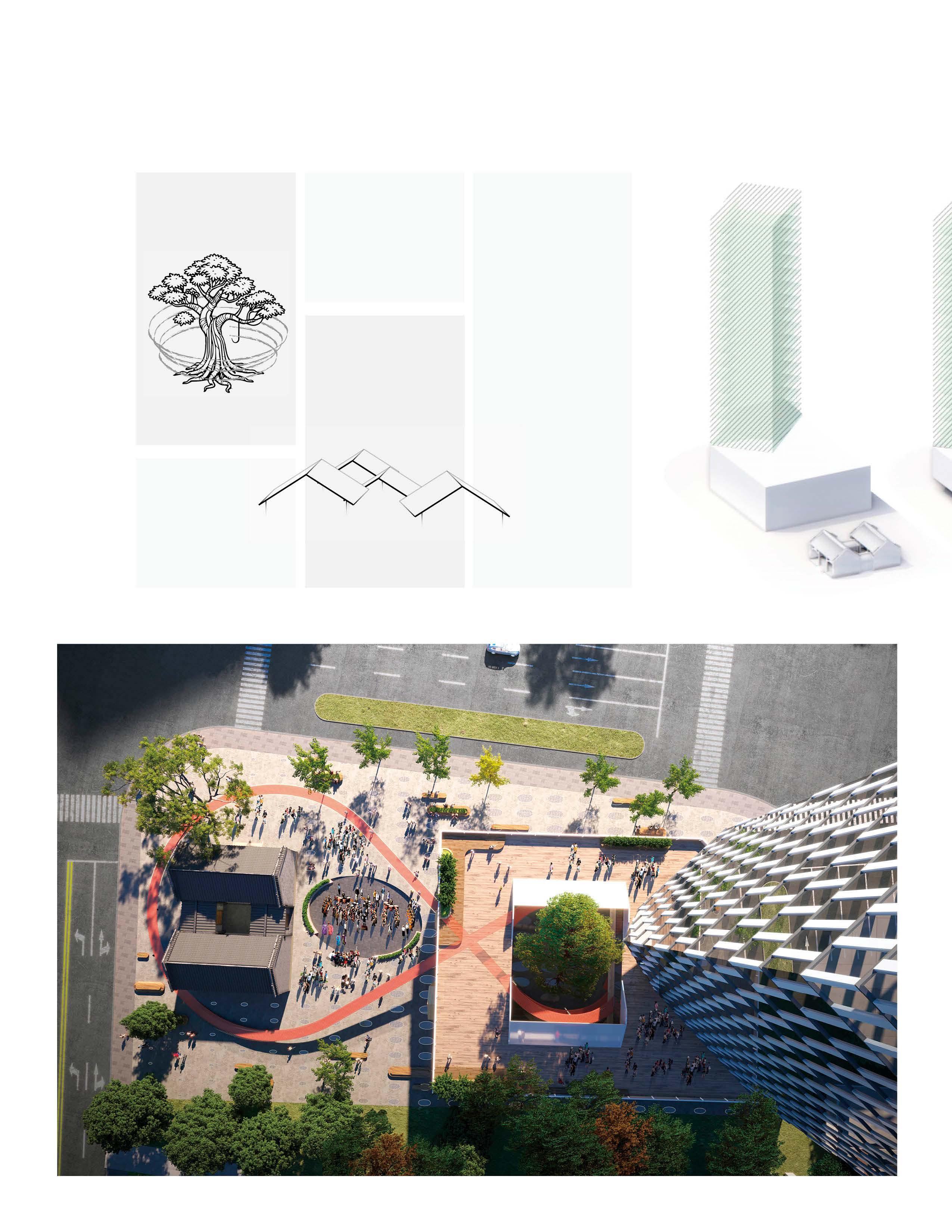
Cantonese communities maintain strong connections, symbolically anchored by ancestral halls and banyan trees.
A modern community center is designed adjacent to the ancestral hall, connecting both structures through similarities in form, spatial arrangement, and circulation patterns.
Design Generation
Perspectives
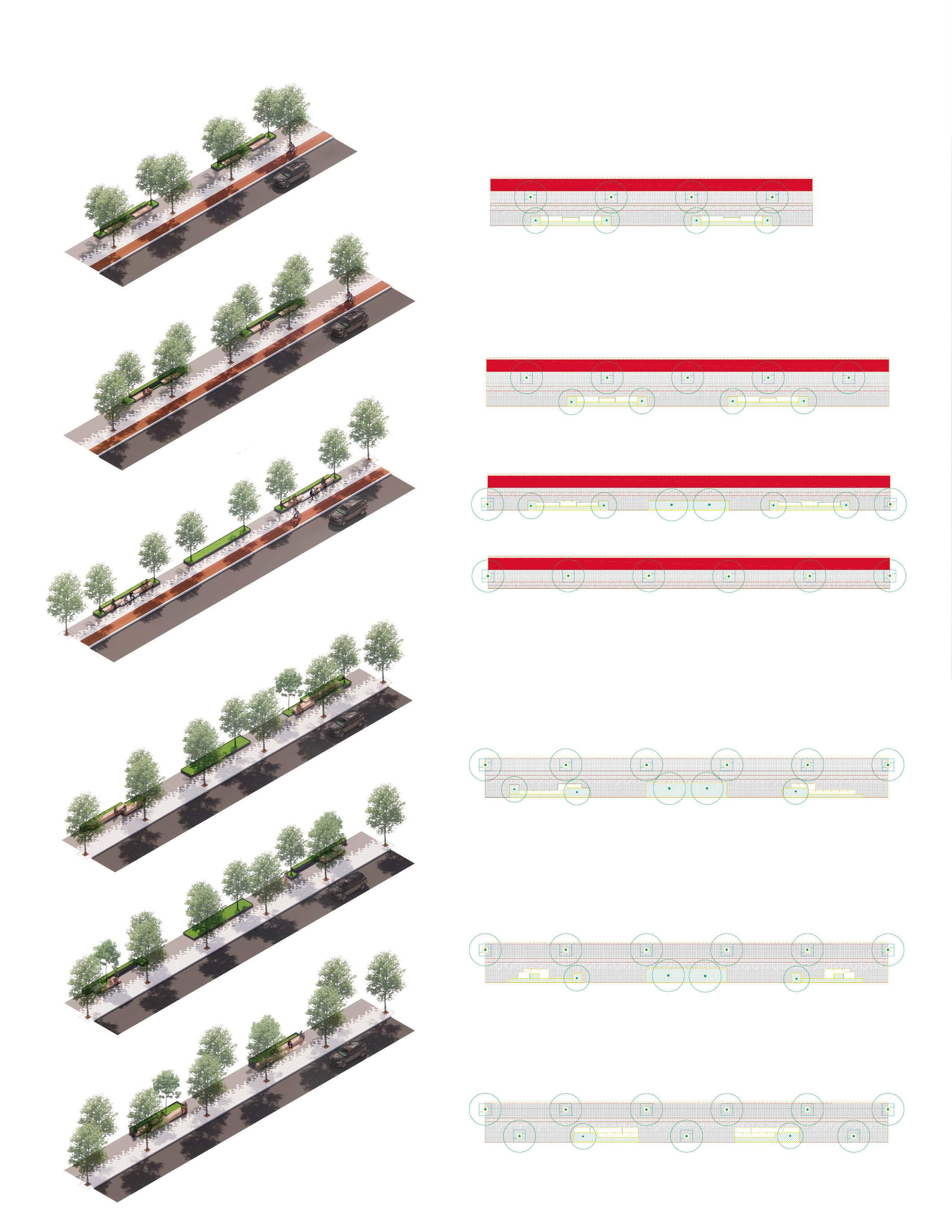
Detailing & Computational Design
Systematic Design of Urban Streetscape & Optimization for Computational Geometry
Typology
Civic
Responsibility
Landscape Design, from Conceptual Design, Schematic Design, to Design Development
Narrative
Cantonese communities maintain strong connections, symbolically anchored by ancestral halls and banyan trees.
A modern community center is designed adjacent to the ancestral hall, connecting both structures through similarities in form, spatial arrangement, and circulation patterns.
Design: Yongqin Zhao, Jiayan Bao Grasshopper & Detail: Yongqin Zhao
Render: Yongqin Zhao, Jiayan Bao
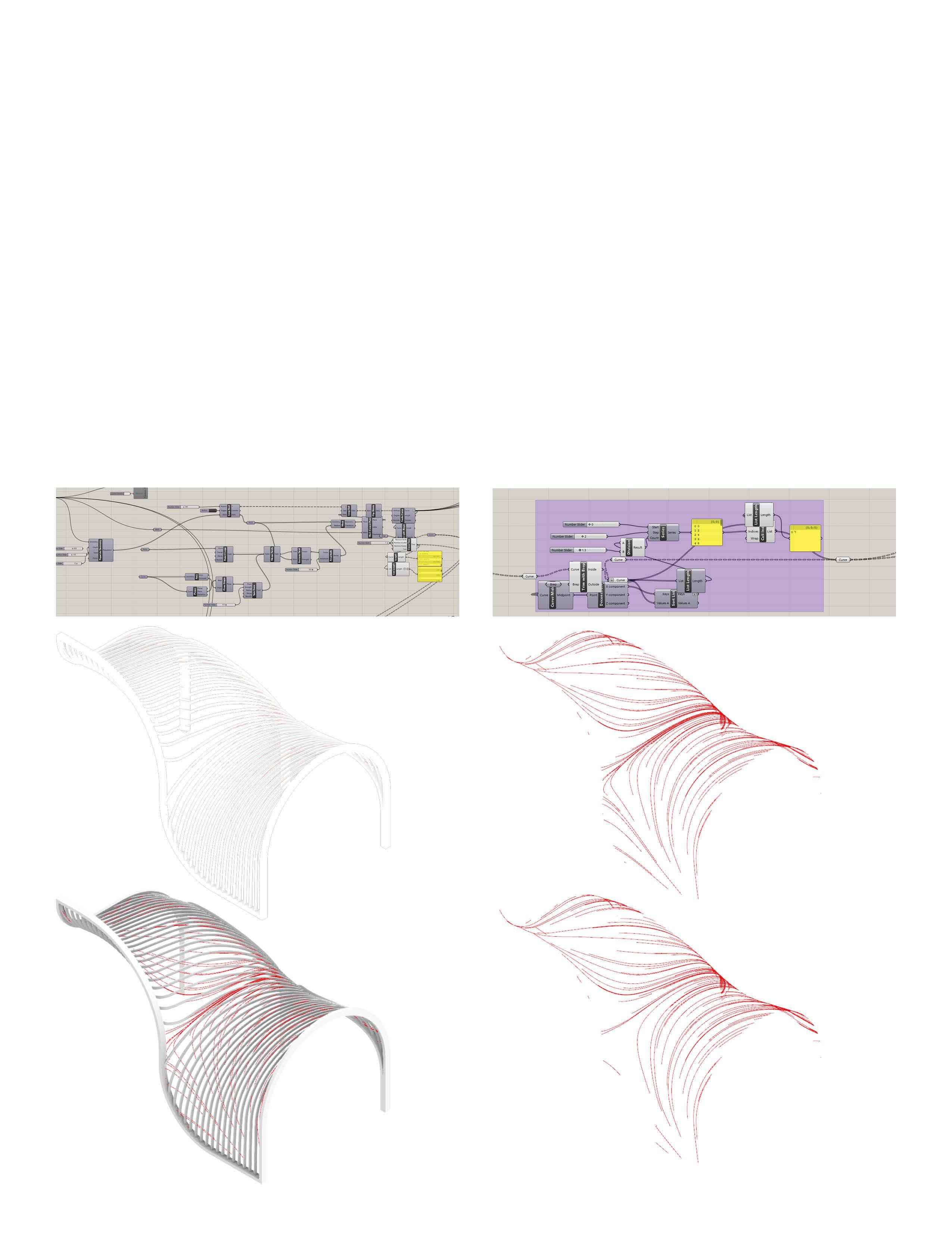
A free form geometry is reconfigured into a more buildable form by applying a process that imposes finite constraints, ensuring the design maintains its original organic intent while being optimized for construction.
01.Set Magnetic field
Generate magnetic lines of induction along the surface of the pavilion.
02.Filter Magnetic lines
Remove part of the magnetic field lines in the high-density area according to the frequency distribution in the x direction
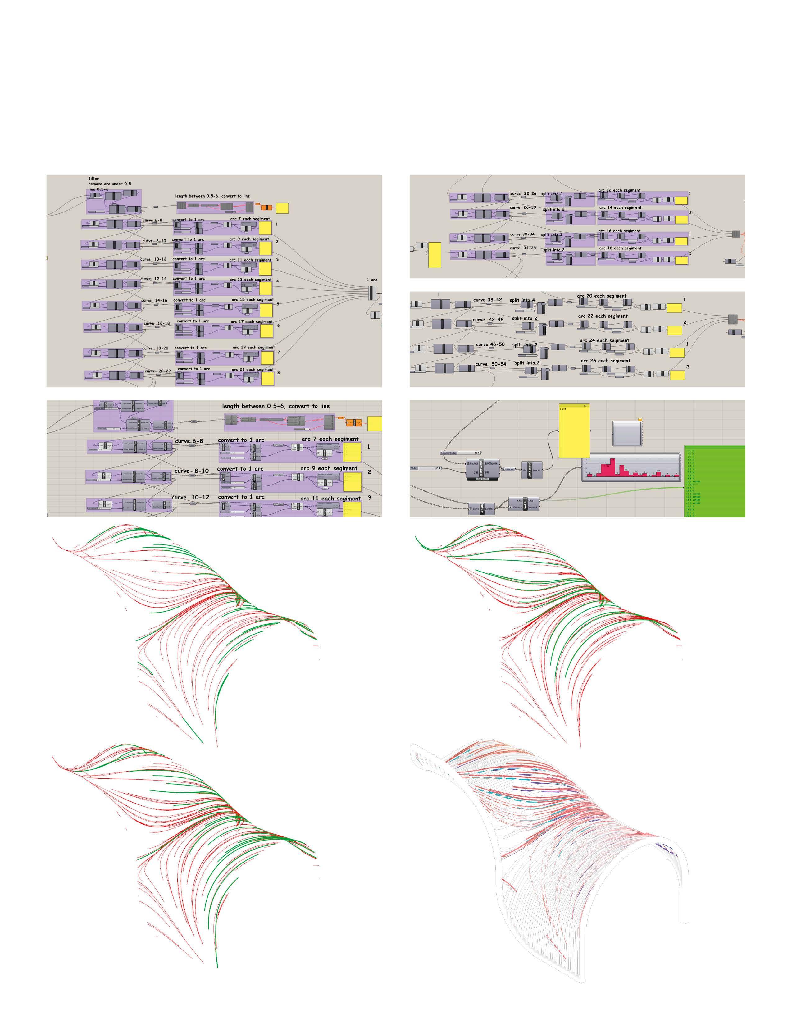
03.Classify & Regularize lines
Classify lines of magnetic induction into 3 types according to their length, and convert them into 2, 4, and 6 arcs.
Screen out arcs with appropriate lengths. The arcs are again grouped into intervals by length. Normalize the length of arc again in each interval.
04.Classify & Extrude
The distribution of the final arc lengths is shown below. Based on the angular proximity between the arc and the surface of the pavilion frame, 4 different sizes of section depth are set.
Under standardized segment scale, the design seamlessly integrates the furniture system, street trees, lighting fixtures, and paving to create a unified and cohesive streetscape.
Sidewalk Planning
Paving Design
Planter Bench & Paving Detail
Comb
Built Enviornment and Mobility:
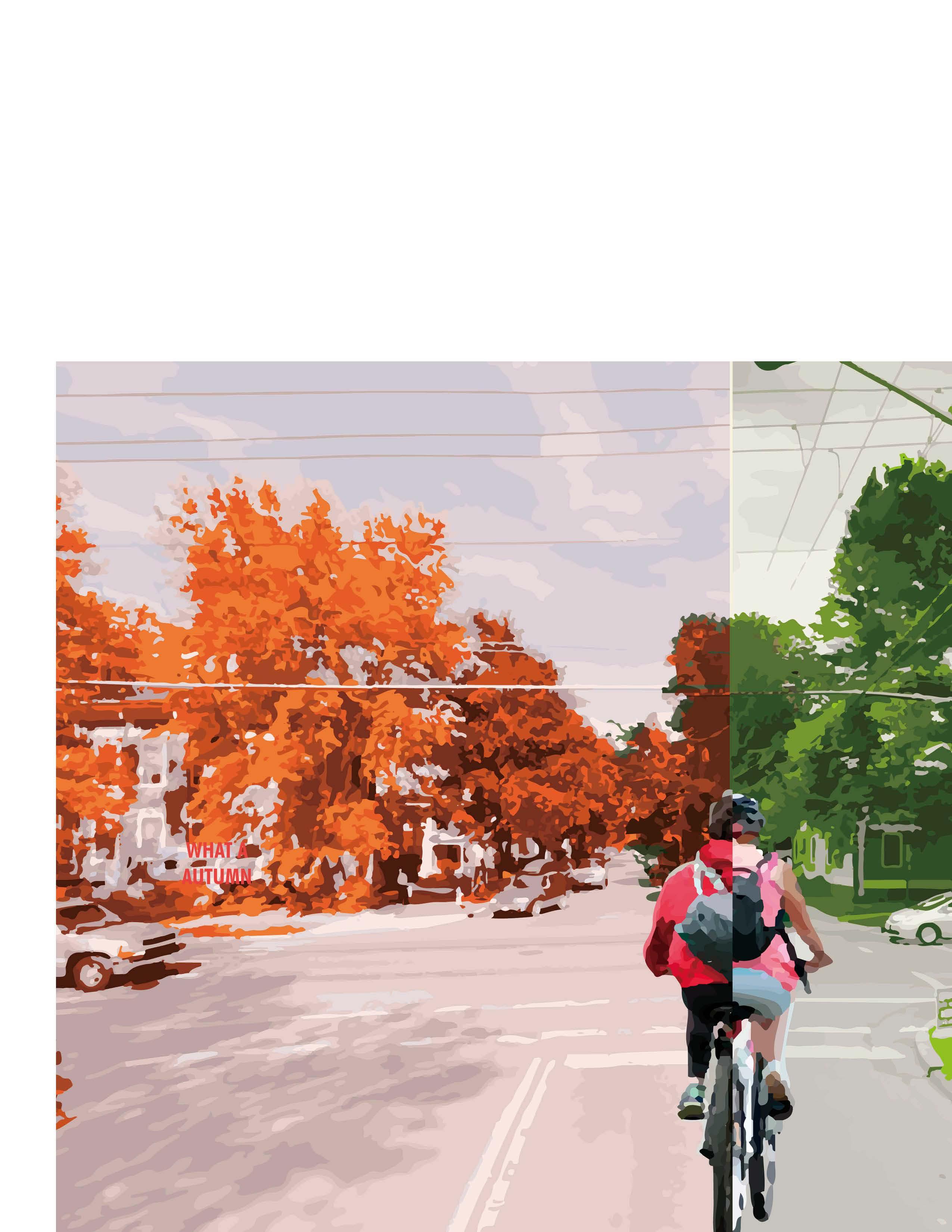
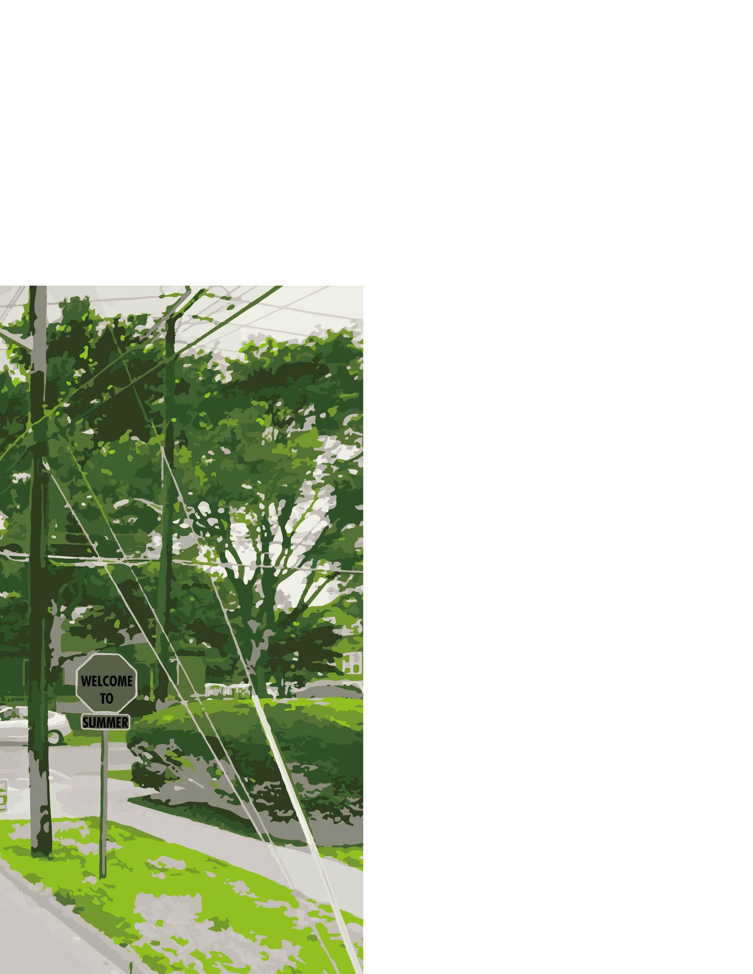
Measuring the seasonal variations of associations between streetscape and dockless bikeshare trip volume in Ithaca, NY
2023 - Ongoing
Team Leader of 5
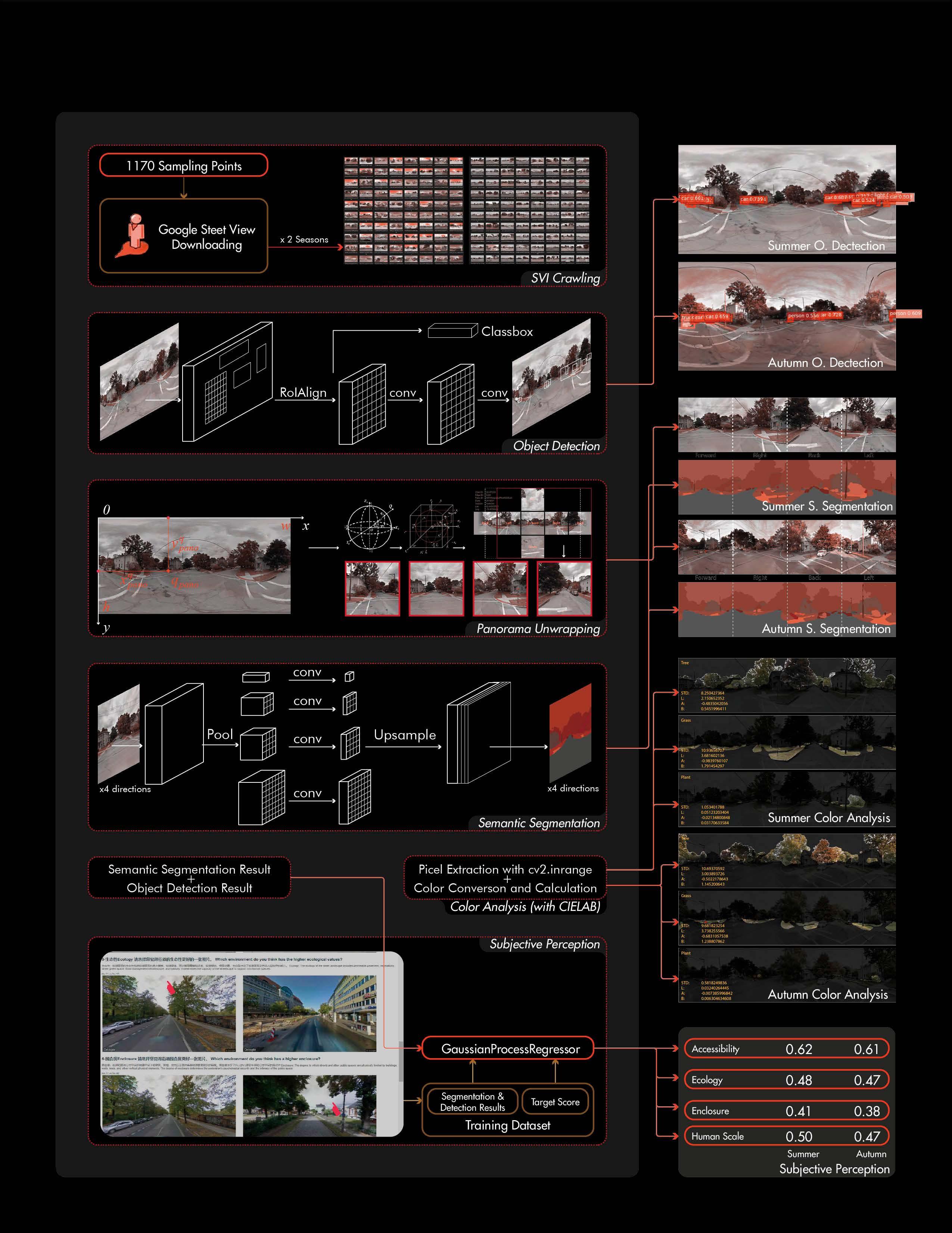
Tool & Task
Computer Vision (MaskRCNN, Color Analysis), Model Building (OLS, SFE, SLX), Analysis & Writing, Visualization (Mapbox)
Streetscape plays a significant role in the cycling experience and the impact varies across different seasons. Most prior studies of streetscape ignored the temporal dynamic of it. And for studies of urban public mobility route choices, there has not been much focus on variables within a seasonal scale. In this paper, using a large amount of GPS bike trajectory data collected from LIME, a DBS system in Ithaca USA, we study the correlation between dockless bike sharing and streetscape, plus spatial elements in different seasons. Ordinary Least Squares Model (OLS), Spatial Fix Effect Model (SFE), and Spatial Lag Model (SLX) are built respectively.
The results show that seasonal streetscape factors, such as road, car, sidewalk, grass deviation, tree lab color, and tree color deviation, have significant impacts on the DBS trip volume. But how significantly these seasonal factors influence SWR varies across summer and autumn models. Non-seasonal factors, such as land use mixed score, station, school, street network connectivity, etc., are significant for both summer and autumn models. Some non-seasonal factors only impact the DBS trip volume of one season. Seasonal subjective perception, when added in models of both seasons, helps improve the explanatory significantly. But the improvement is very slight.
The study provides a valuable reference to policymakers, urban planners, and operating companies to jointly cooperate towards a sustainable cycling-friendly city.
Factors influencing cycling activities can be categorized into these domains: (1) demography. (2) the integration of bike sharing and public transportation. (3) land use and point of interest(POI). (4)built environment. Built environment factors have shown significant explanatory power in understanding travel choices (Cervero, 2002). Eye-level greenness has a positive association with cycling occurrence(Lu et al., 2019), and aquatic areas have a similar effect (Krenn et al., 2014). However, few studies specifically focus on DBS behaviors.
Seasonality in climate, affecting the natural environment and human comfort, would have an impact on outdoor activities and behavior (Ahas et al., 2007; Guan et al., 2021; Hadwen et al., 2011). However, there is a dearth of studies focusing on how seasonal change in the urban built environment, influences cycling behavior.
Focus on landscape elements that are sensitive to seasonality and essential for the cycling experience is valuable but not receiving too much attention. Which specific built environment factors have a temporal impact on bike sharing usage? Is this impact positive or negative in a particular season, and how huge is this impact? What is the difference in this impact in different seasons? These are the problems few studies have answered yet. In this paper, we are looking at the temporal change of streetscape at a seasonal scale.
SVI, CV, and ML for measuring street built environment
1.3 1.4
Research gap and contribution
The rapid development of Machine Learning methods like Computer Vision (CV) offers many emerging and state-of-art methods to process SVI in large batches automatically (Ito & Biljecki, 2021). The integration of SVI and CV is giving researchers increasing power to access and understand urban environments computationally.
The characteristics of the human perceived environment can be measured objectively using SVIs. Perception is a subjective measure of the environment that describes a “sense of place” (Kang et al., 2021). However, the impacts of subjective street quality perception on cycling behavior need more in-depth understanding.
To conclude, there are observed research gaps in the seasonal study of DBS: (1) dockless bike sharing (DBS) has received far less research attention compared with docked bike sharing. (2) most precedent studies are based on the geolocation where a trip starts and ends, and thus less on the cycling experience itself during the trip. (3) little has been done to investigate how the seasonality of streetscape elements would influence DBS. This study contributes to the literature in these following points: (1) a quantitative study of DBS that focuses on perceived environmental elements along the trip. (2) seasonality of the streetscape elements on DBS usage at a fine spatial scale. (3) Previously ignored seasonal environmental features are taken into consideration, like vegetation color and its spatial temporal change. (4) seasonal subjective perceptions of streetscape.
1.5
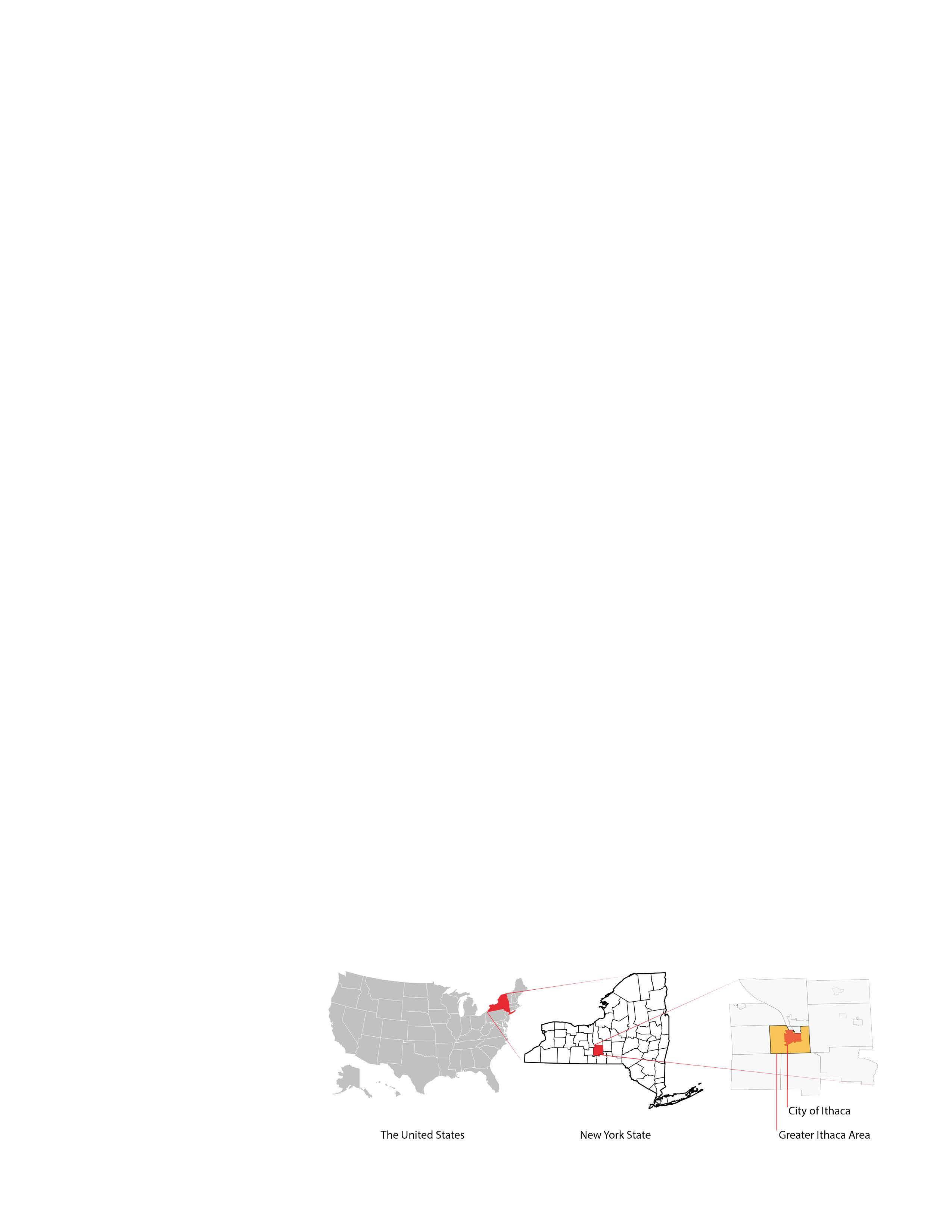
Study area Fig.1. Study area
The study area - Greater Ithaca -includes several adjacent neighborhoods around the Town of Ithaca. The city of Ithaca is the seat of Tompkins County in New York State, its area is 5.39 mile² (2010). As of 2019 when the bike sharing data was collected, the population of the City of Ithaca is 30,837, of which 49.9% were female, 68.4% were white (U.S. Census Bureau QuickFacts, n.d.), and 87.8% were US citizens. With a student population of more than 20,000, Ithaca is home to Cornell University.
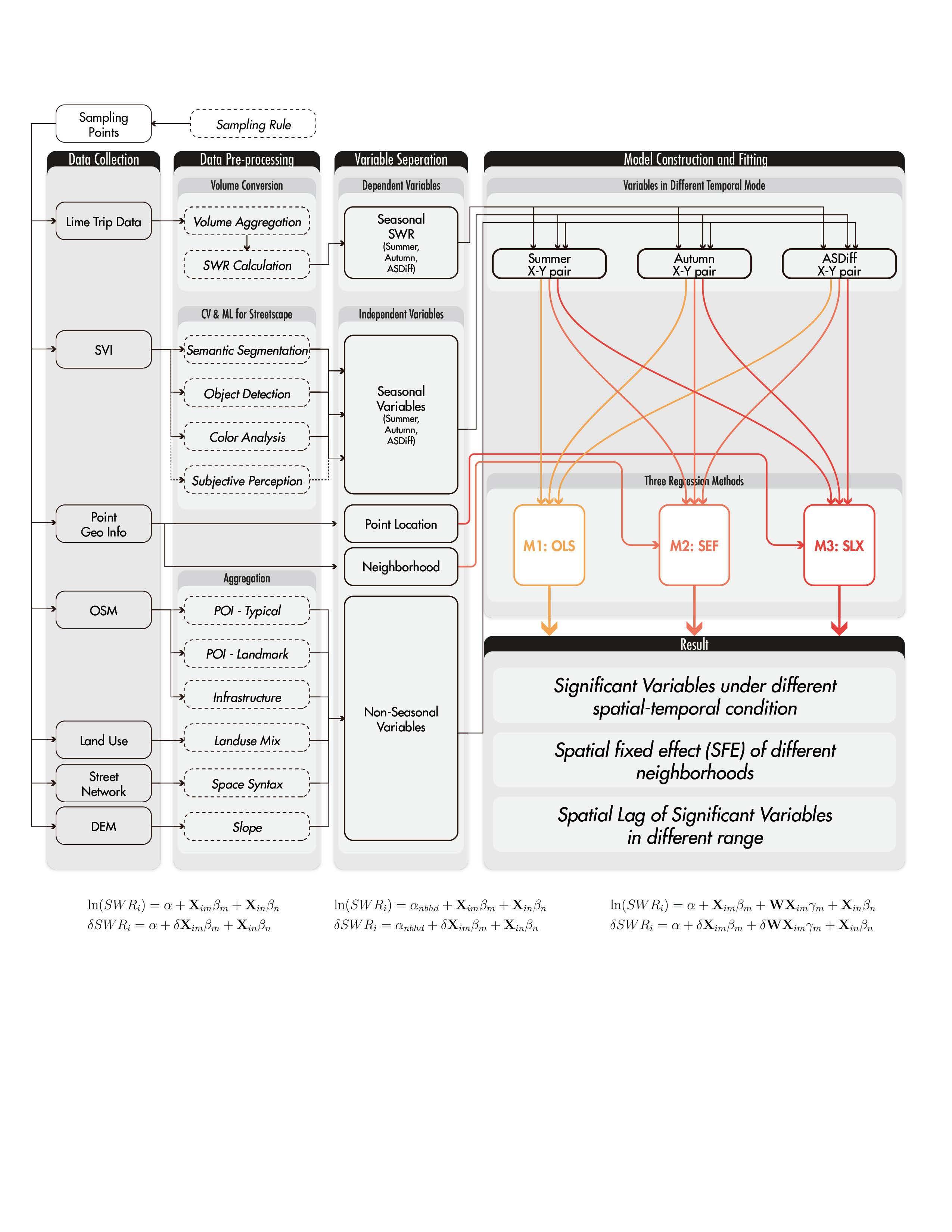
Research Framework
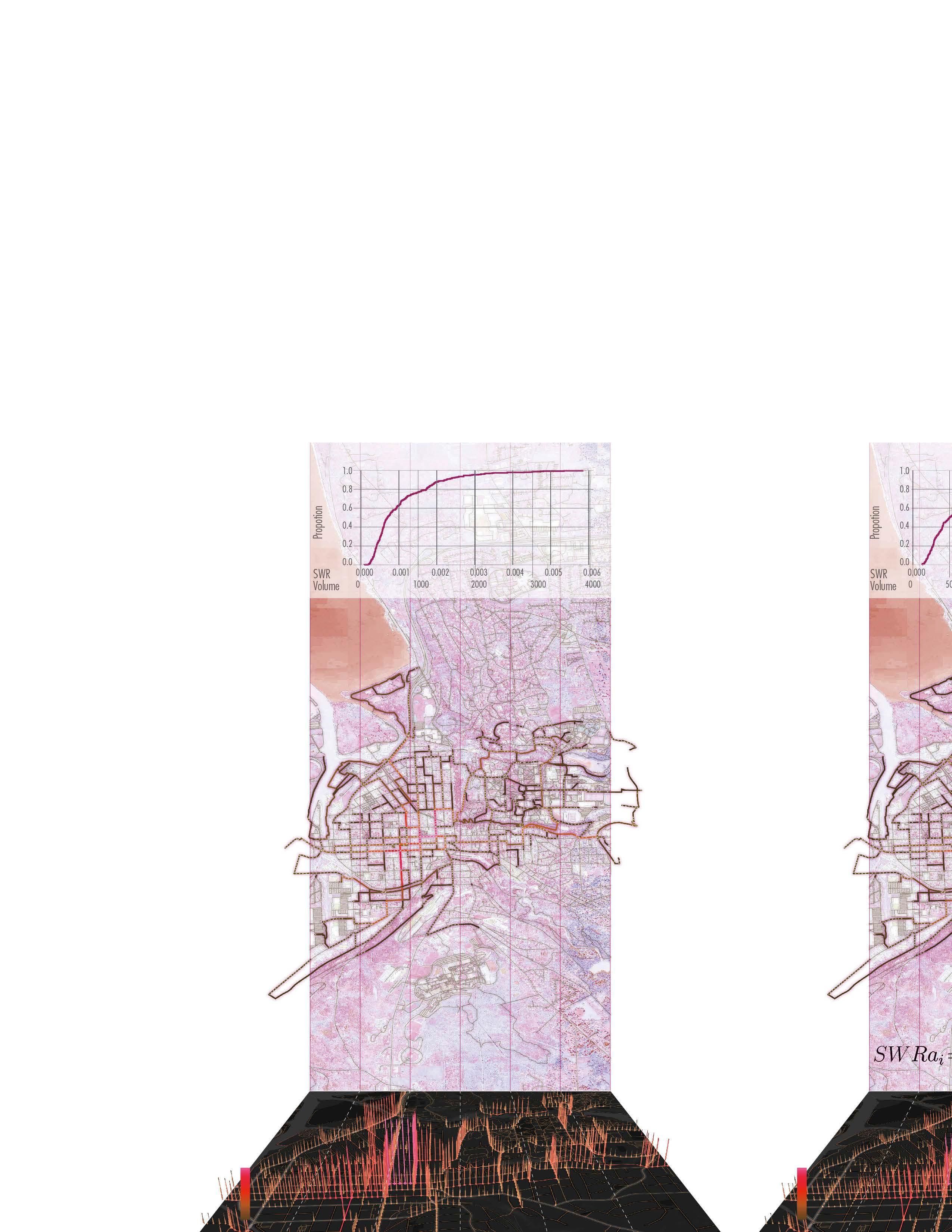
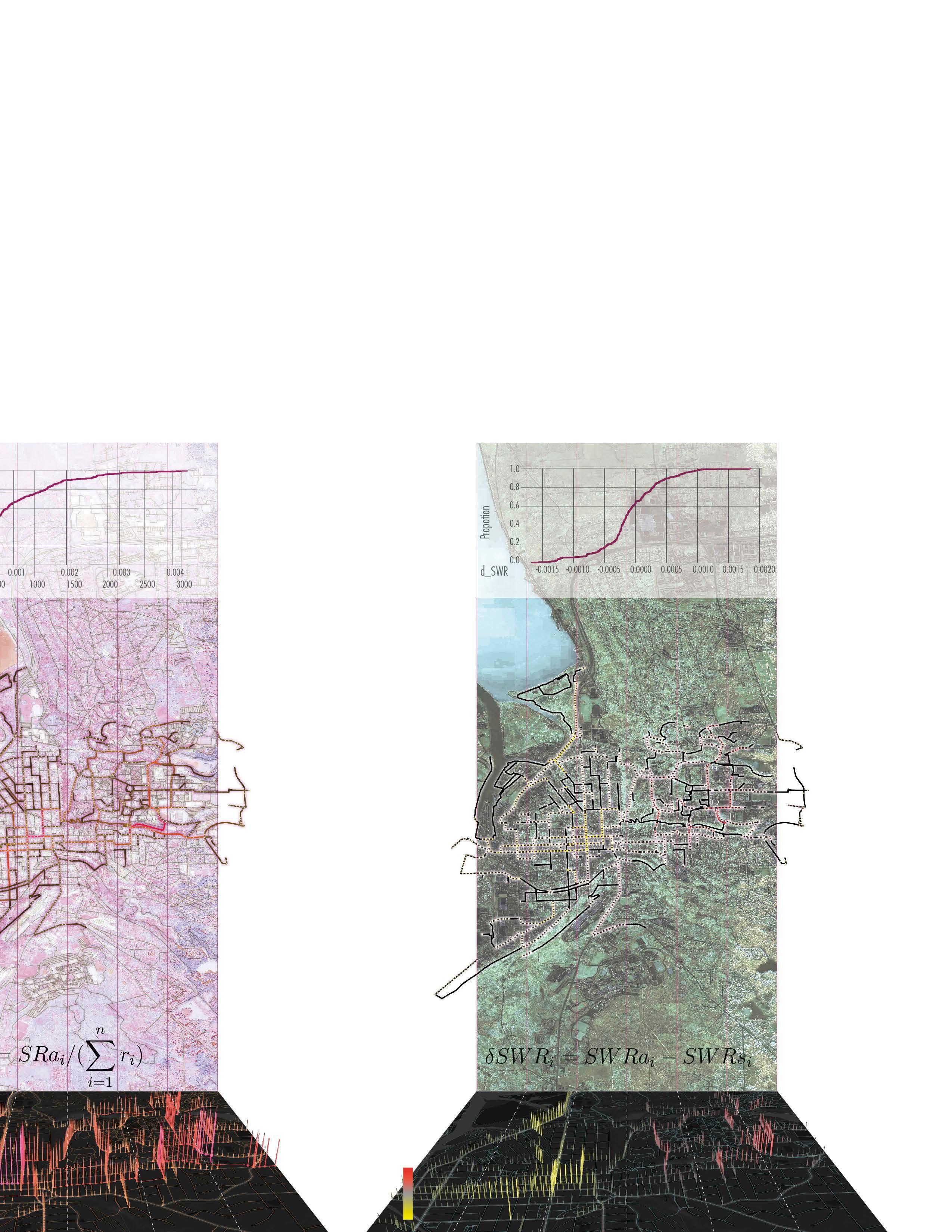
(1) Seasonal Weighted Rides (SWR) is calculated from the proportion of aggregated volume in a specific season on one road segment in total volume of all segments in this season.
For Summer and Autumn models, dependent variables are ln(SWR), the natural log of corresponding SWR; dependent variables are the combination of seasonal variables in corresponding season and non-seasonal variables.
For Autumn-Summer-Difference(ASDiff) model, dependent variables are the remainder of autumn ln(SWR) minus that of summer; dependent variables are the combination of remainder of autumn seasonal variables minus that of summer, and non-seasonal variables.
Ordinary Least Square(OLS) model does not consider spatial relationship (assuming variables as i.i.d.)
Spatial Fixed Effect(SFE) gives unique constant to points within a same neighborhood.
Spatial Lag of X (SLX) helps describe how other points in a set nearest range (the spatial weighted matrix is calculated with KNN) would affect current point.
Fig.2. Analytical framework
Data and Methodology
Dependent variable:
Seasonal Weighted Rides (SWR)
Data Validation
The DBS trips data in this research is provided by Lime. The dataset was collected from mobile phones with enabled AUTO-GPS function through the Lime app. A validation process went through to remove the following raw records: (1) trips that started or end outside the Greater Ithaca area, (2) trips whose distances were shorter than the length of a city block in Ithaca(0.05mi or 264ft) , (3) trips with too short or long duration. Finally, 102,178 trip records were left.
Then, based on the method developed by Qiu & Chang, 2021, road central lines were deconstructed into several road segments interrupted by any kind of intersection of roads or routes.
Points Sampling
Segments are selected:
Total Volume ≥ 500; and Length ≥ 25m
Points are sampled:
8m offset from vertex; and 25m sampling distance
1170 Points on 452 Segments
1170 Points
452 Segments
CDF Plot
CDF Plot
Points on Segments
SWR Conversion
Seasonal Weighted Rides captures how popular a segment is in this season.
Seasonal Difference Calculation
For single season models, X in CDF plot is SWR/Aggregated Volume of DBS ridership in that season. For Seasonal Difference model, X in CDF plot is (autumn SWR - summer SWR) Similar for other seasonal variables in the seasonal difference mode, including SWR as dependent variable, streetscape segmentation and object detection result in the independent variables.
CDF Plot
Cumulative Distribution Function is the probabilities that volume of a random segment is less than or equal to X (reveals the distribution of volume on road segments.)
1170 Points on 452 Segments
SWR Conversion
CDF Plot
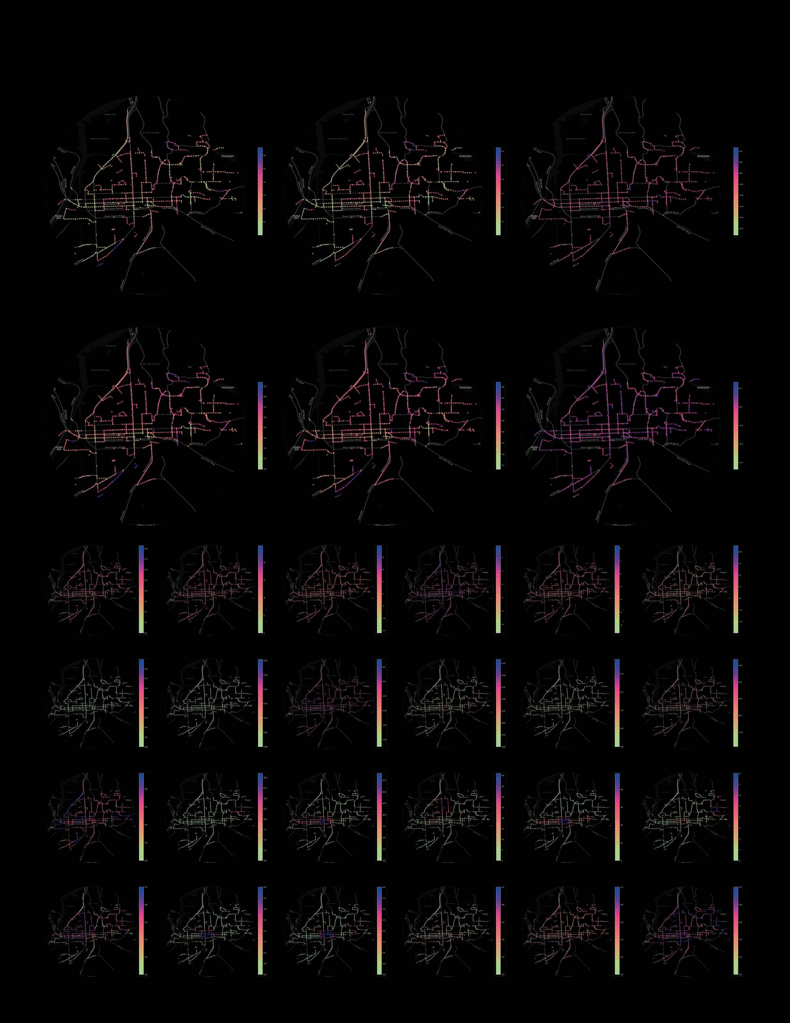
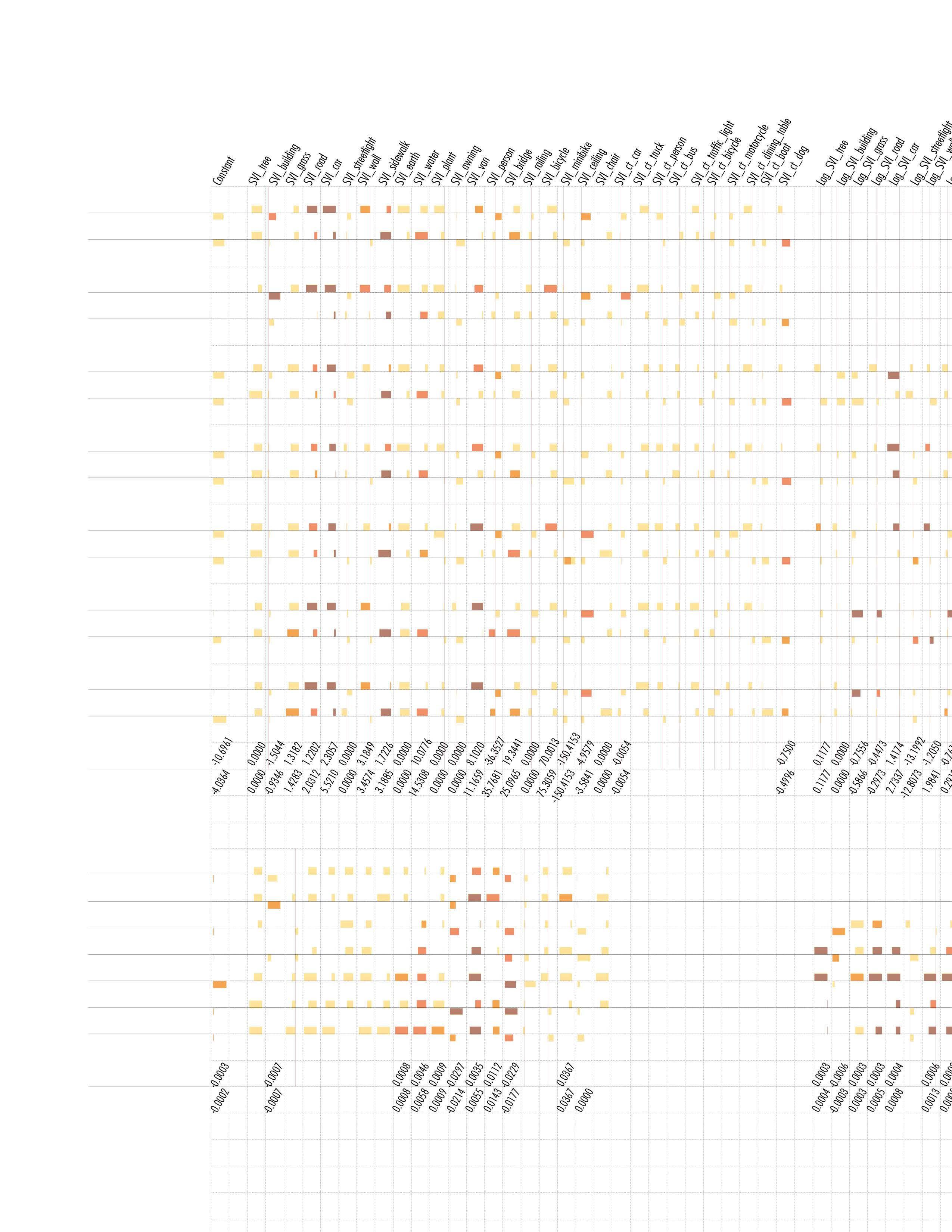
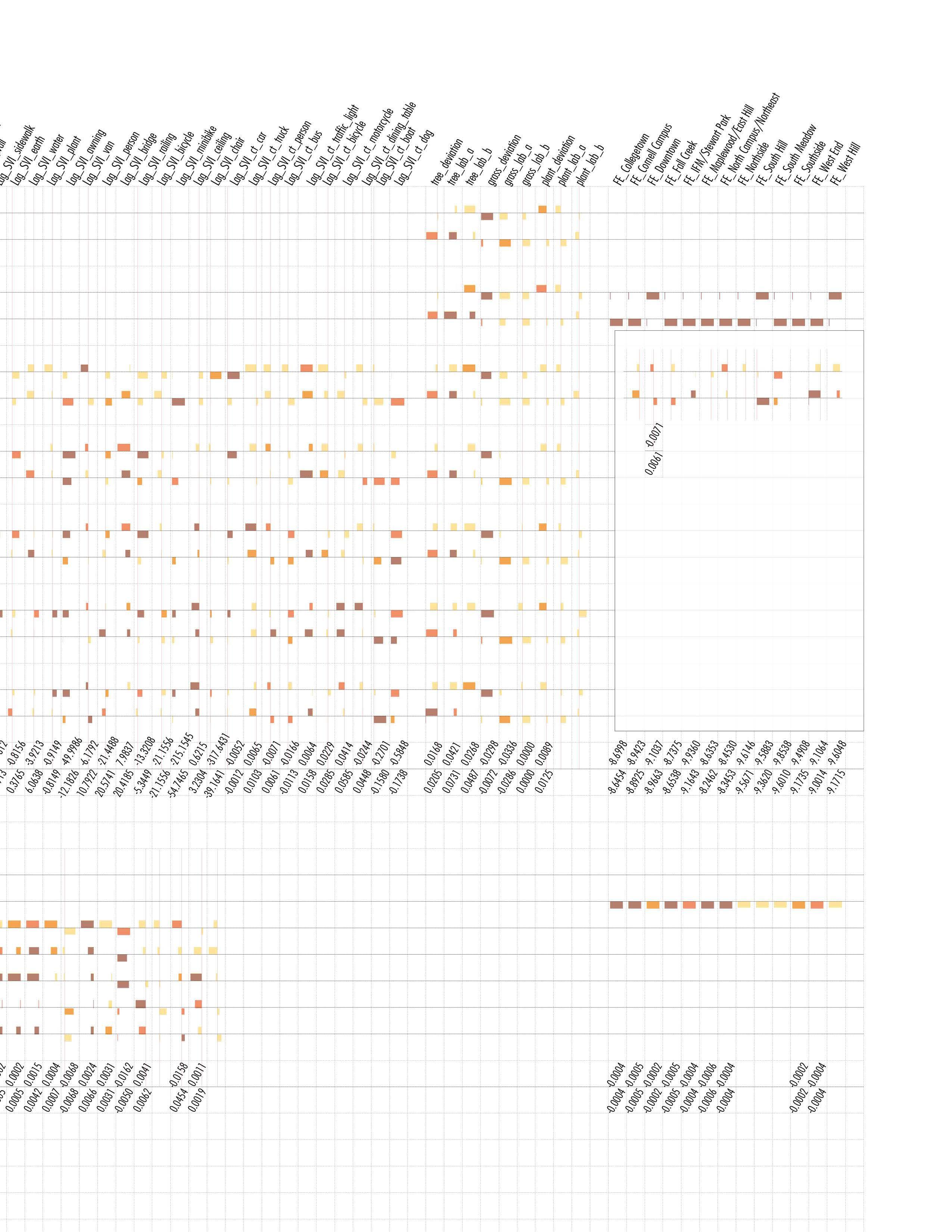
Modeling and Result
Notes & Label
a: 0.01
b: 0.05
c: 0.1≥
d: p≥0.1
Magnitude
Results * P value Sign
e: Positive Coeff.
f: Negative Coeff.
g: Same variable has different sign in temporal mode
h: Maxium Coeff. in all temporal mode
i: Minimum Coeff. in all temporal mode
j: Width of cell is normalized magnitude in Coeff. range
Variables in different spatial modes
Certain variables are significant in one season across all spatial modes, like sidewalk and water in autumn; Certain variables are inconsistently significant in one season, like wall and ceiling in summer; Most variables are consistent at their sign of coeff.; SLX models shows the change of effective influence range of elements, which applies to bridge, ceiling, etc.
Variables in different temporal modes
ASDiff show that variables significant in single season models might not effective enough to make seasonal change, while some not significant in neither single season models actually influence seasonal behavior change.