Architecture and Landscape Architecture


Architecture and Landscape Architecture
Selected Works - 2015-2024
Radhika Maheshwari
Masters in Landscape Architecture
Bartlett School of Architecture, UCL, London
Bachelor of Architecture
SMEF’s Brick School of Architecture, Pune University, India
Reclaiming Wetlands for a resilient New Forest
MLA, Bartlett School Of Architecture, Year 2 Final Design project
A Phytoremediation project for Convoy’s wharf
MLA, Bartlett School Of Architecture, Year 2 Design project
Tracing the Social, Cultural, and Ecological Pathways of Mature Tree Translocation
MLA, Bartlett School Of Architecture, Masters Thesis
Retrofitting Hampstead High Street
MLA, Bartlett School Of Architecture, Year 01 Final Design Project
A Community realm for crafts and culture
Undergraduation Architecture, Pune University, Year 3 Design Project
Imagining the future of living
Undergraduation Architecture, Pune University, Final Thesis Design Project
Cadence Architect, Bangalore, India, Architecture Intern Compartment S4, Ahmedabad, India, Junior Architect
MLA, Bartlett School Of Architecture
Year 2 Design Project, Term 02
Site Location - New Forest National Park, England, United Kingdom
Studio Tutors - Gunther Galligioni
Christina Leigh Geros
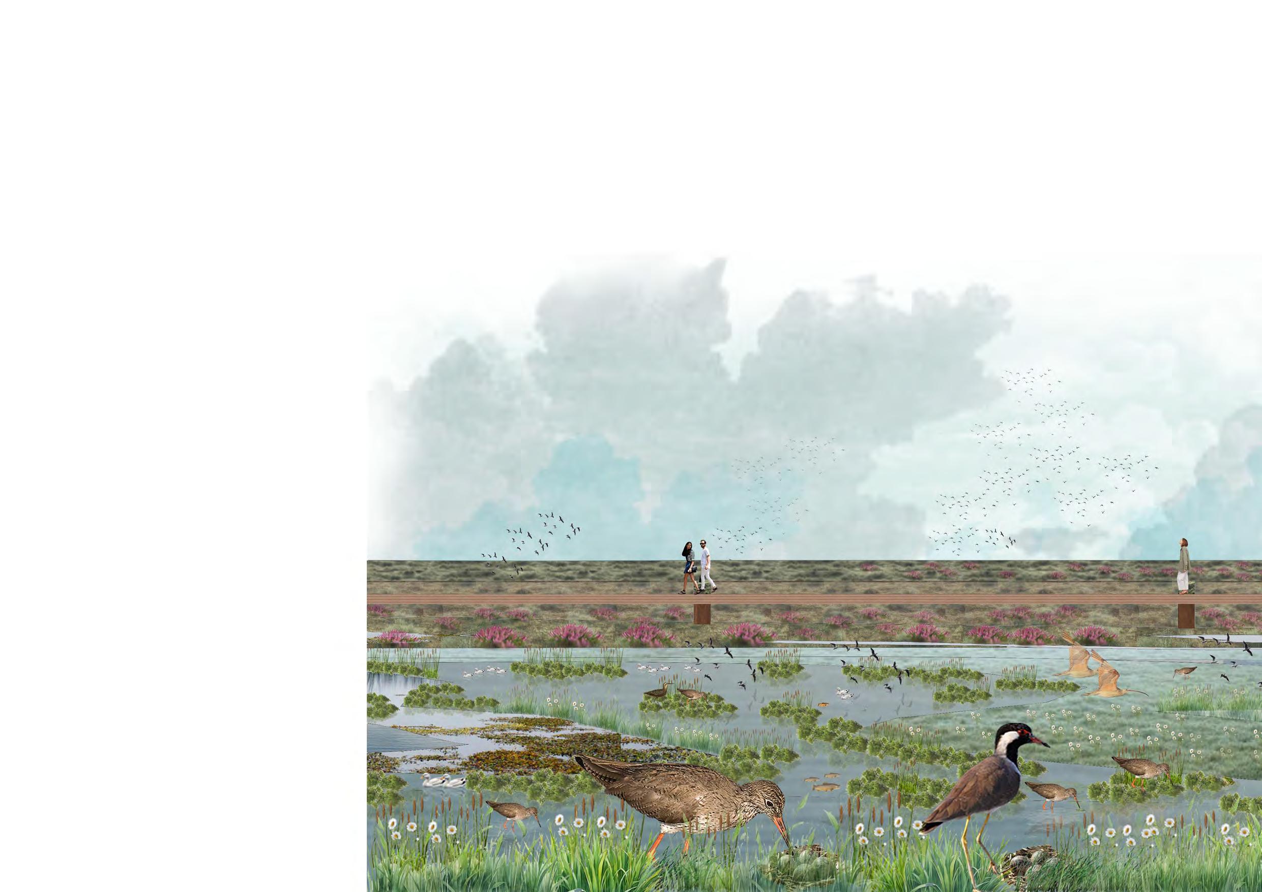
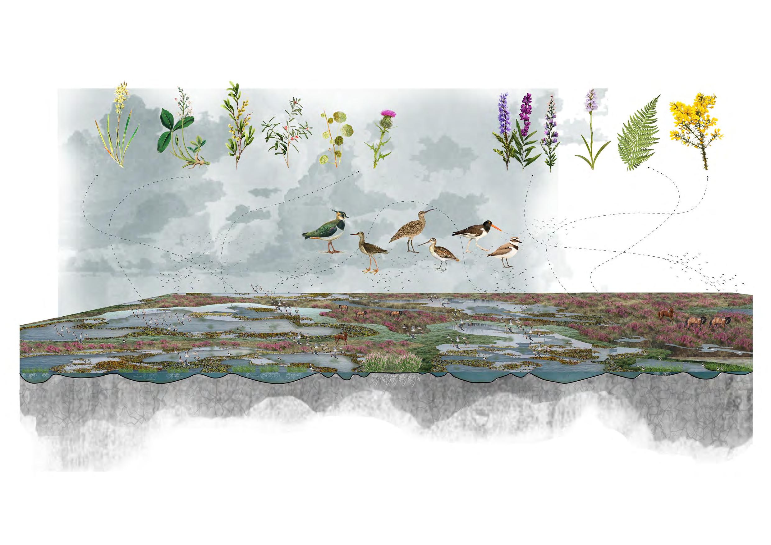
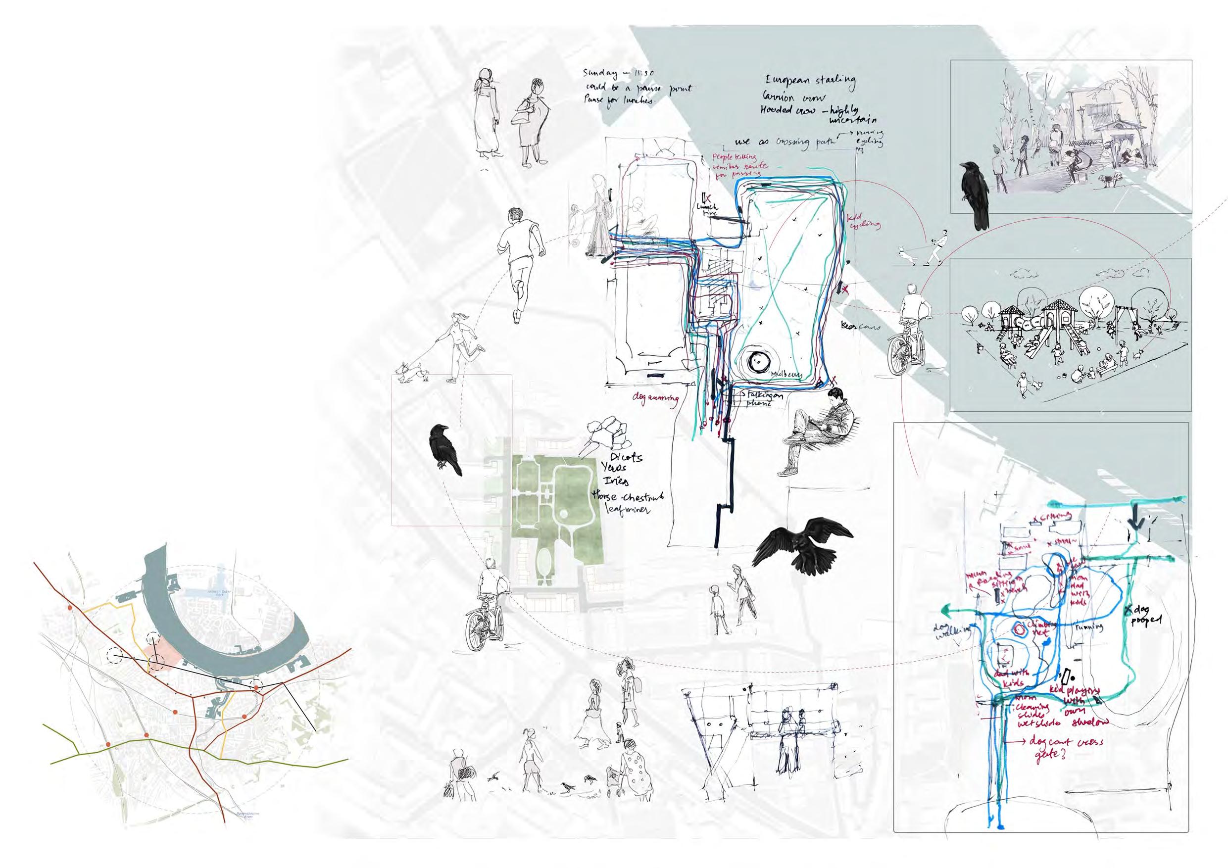
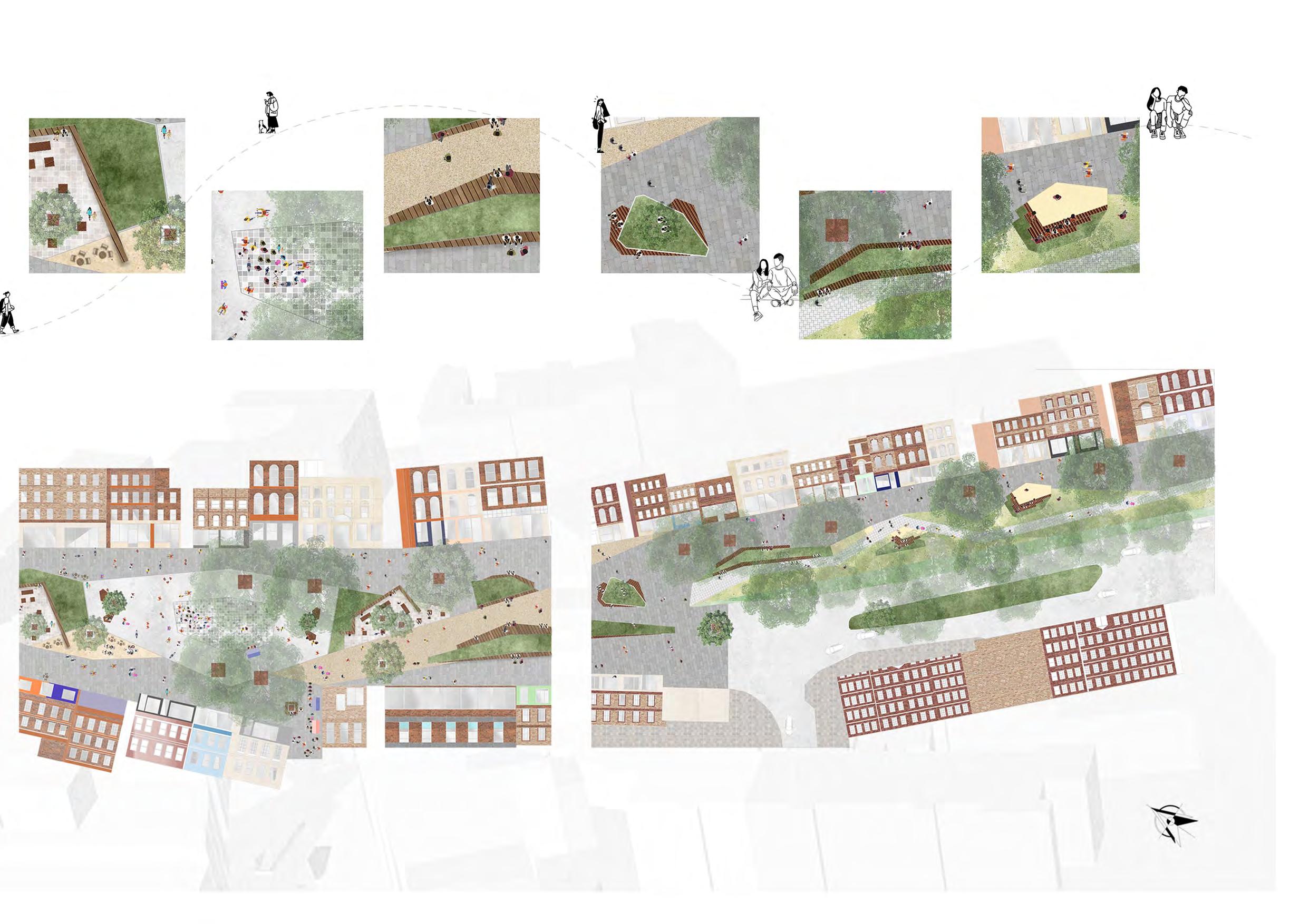
The project, “Treading Waters,” is set in the New Forest National Park, southern England, where agricultural drainage and climate change have degraded vital wetlands, threatening the biodiversity of the area. Breeding waders like lapwings and curlews have been particularly affected, with declining populations due to habitat loss and recreational disturbances. This project focuses on two key objectives: restoring wetlands and creating disturbance-resilient habitats. Restoration efforts aim to enhance water retention in mires and bogs, supporting wetland survival and reducing wildfire risks. Additionally, the project proposes “bog islands,” specialized habitats that integrate human presence while providing safe breeding grounds for waders. These islands balance wildlife needs with controlled human access, ensuring that wader populations can thrive. Overall, the project seeks to revitalize wetland ecosystems and protect breeding waders, contributing to the long-term resilience of the New Forest.
Link to the full project portfoliohttps://issuu.com/97radhika/docs/mla_year_2_final_design_project
Link to the technical reporthttps://issuu.com/97radhika/docs/radhika_maheshwari_studio_07_treading_ waters_
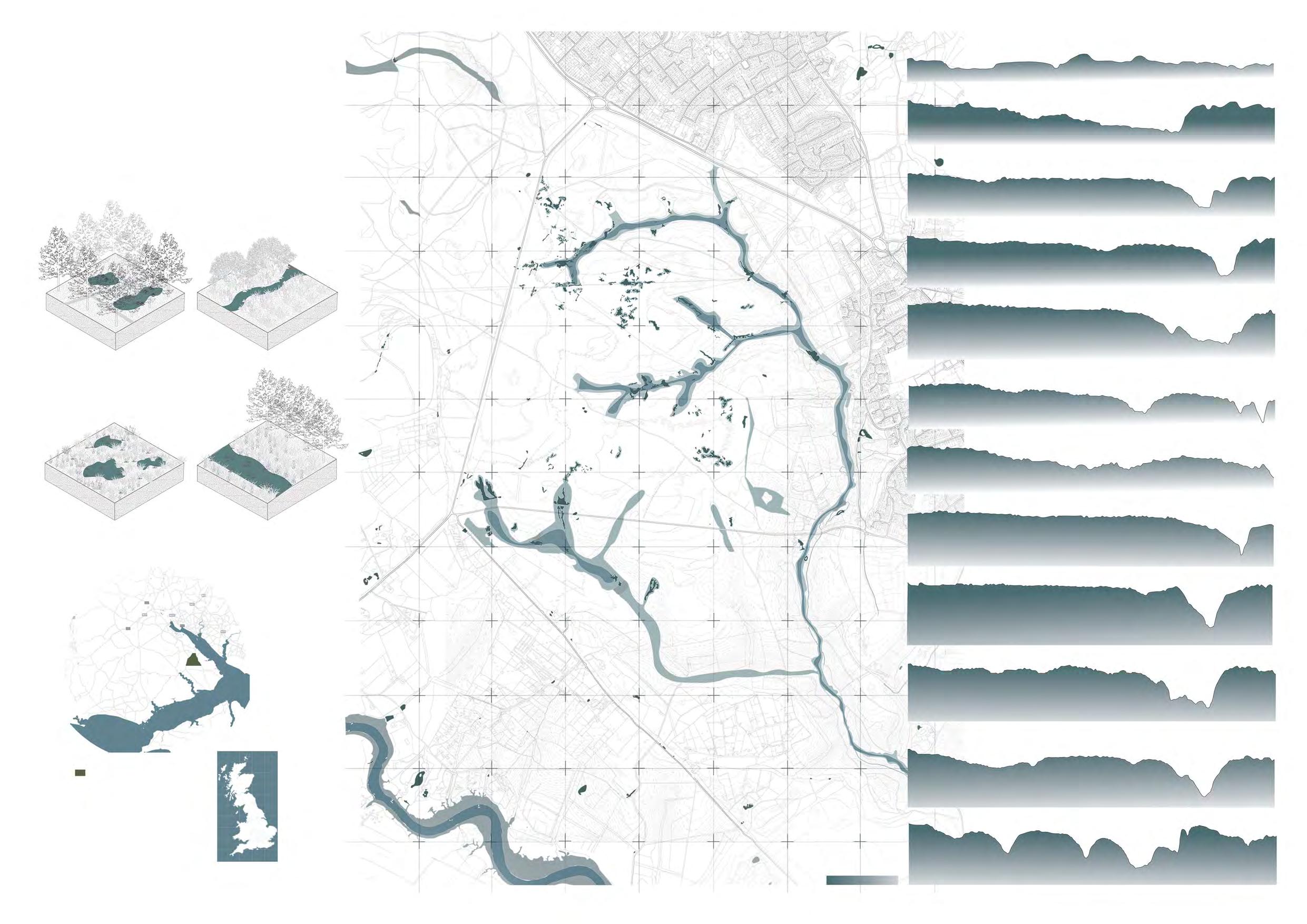
The project centres on the New Forest’s wetland systems, a vital part of its open habitats. Known for its intact network of mires, bogs, ponds, rivers, and streams, the New Forest is one of Western Europe’s most significant wetland regions, contributing to its national park status.
Shallow water (usually 30 cm and deep) and muddy areas are crucial for feeding and nesting.
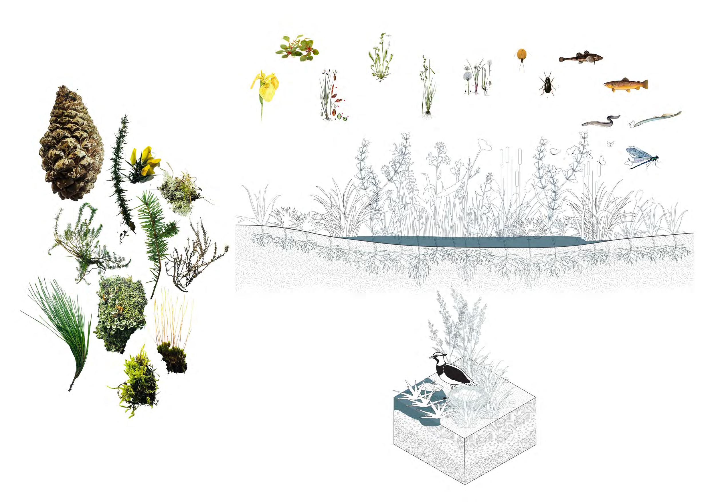
Waders prefer low vegetation or bare ground for visibility and predator avoidance. Sward height to be maintained between 5-15cm to create appropriate breeding habitat.
The nesting sites are often chosen for their ability to camouflage the eggs, which are typically speckled or colored to blend in with the surroundings.
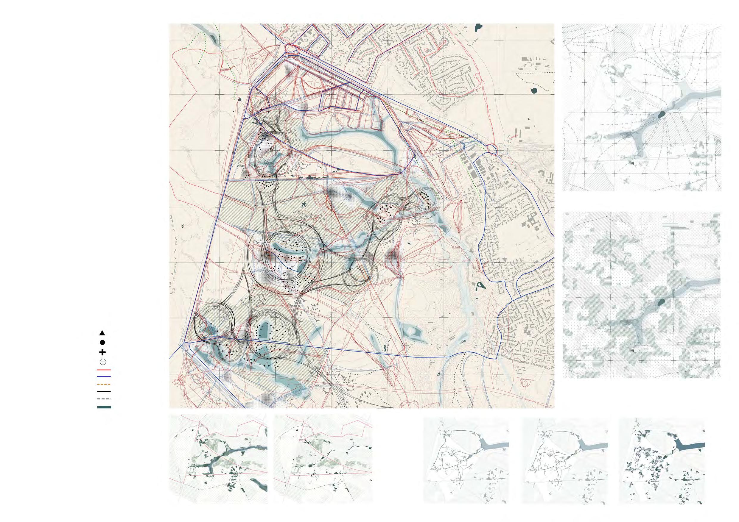
I developed a disturbance map that overlays macro and micro disturbances, highlighting zones of influence for breeding waders. This map identifies intersections where disturbances overlap, pinpointing areas that may adversely affect waders. Understanding these overlaps allows the design to target disturbance mitigation and create safer spaces within the habitat to support successful breeding and reduce stress on wader populations.
This information guided strategies to minimize disturbances by identifying impact zones and placing bog islands within them. These islands provide safe breeding habitats, act as natural fire breaks, and store water to manage dry conditions.
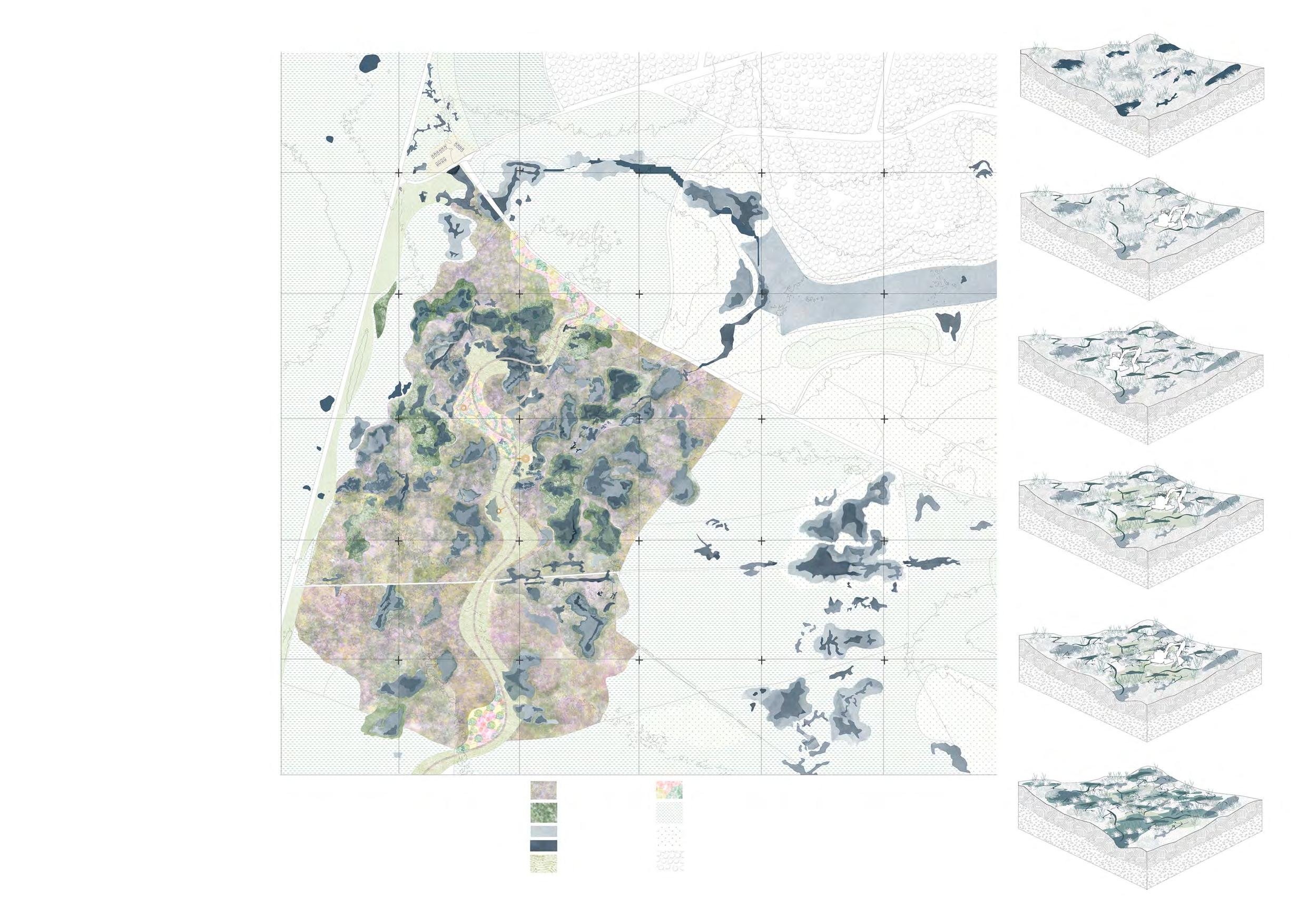
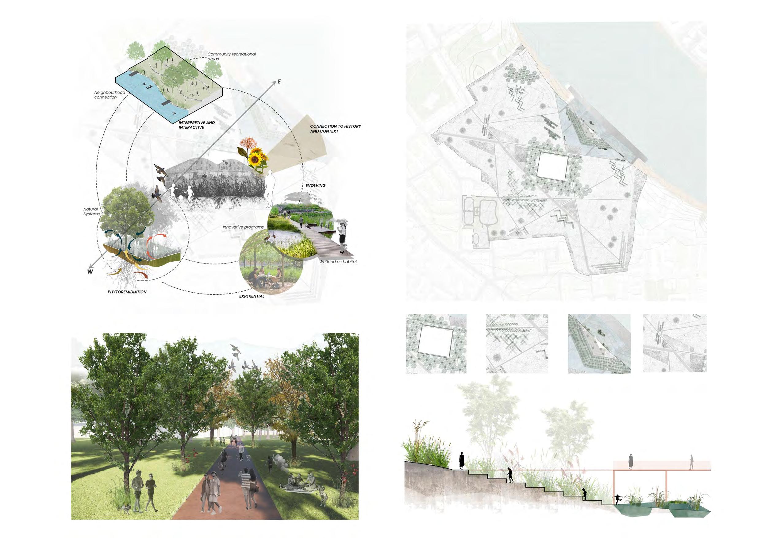
The final master plan for the design project focuses on long-term planning to transform the forest into a more open habitat. The plan divides the area into distinct sections: heathlands, wetlands, and grasslands, each designed to create suitable environments for breeding waders and to attract a diverse range of wildlife to the site.
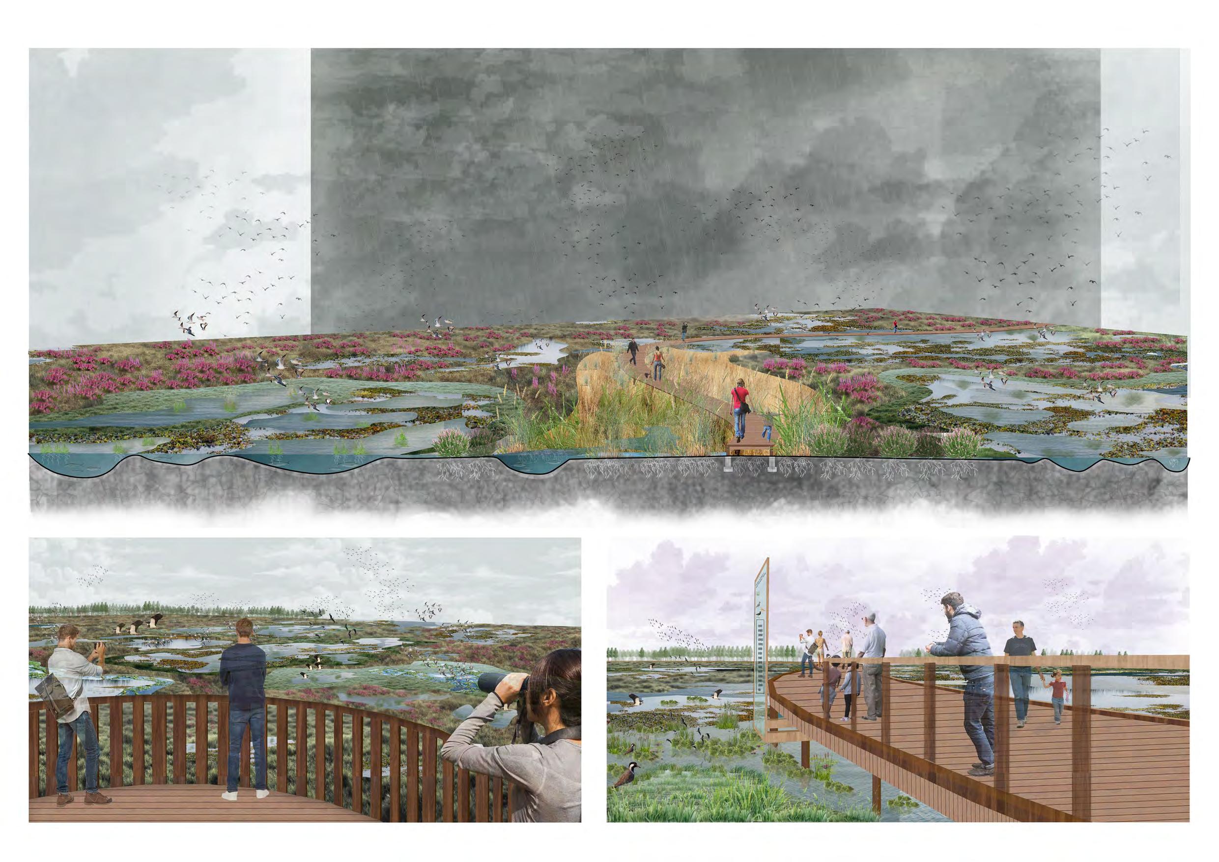
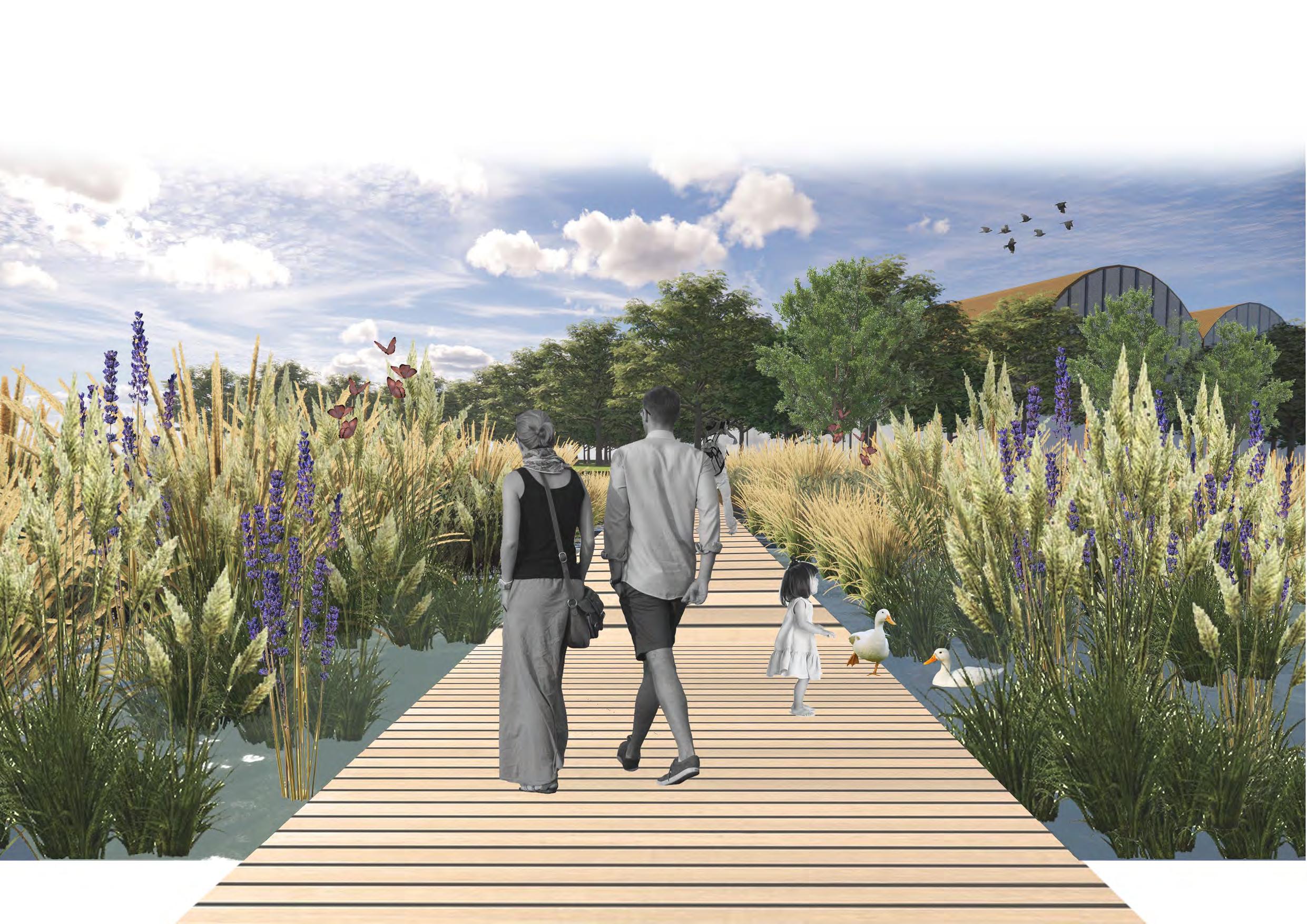
The boardwalk, seamlessly connected to the existing pathway, weaves through the site, offering various vantage points for birdwatching while minimizing human impact. This design not only provides a safe haven for birds but also creates experiential spaces, including wildflower gardens, birdwatching platforms, and decks. As the boardwalk flows through diverse habitats— such as wetlands, heathlands, reedbed buffers, and wildflower gardens—visitors can immerse themselves in the site’s rich wildlife. Additionally, the journey fosters an educational experience, enhancing understanding of the flora and fauna of the new forest.
The
provides safer habitat for wading birds to breed on wet grasslands and wetlands. These habitats are visioned to reduce disturbances from other activities.
Controlled grazing to maintain sward(grass) heigh in wet grasslands for appropriate habitat for wading birds to breed.
MLA, Bartlett School Of Architecture
Year 2 Design Project, Term 01
Site Location - Deptford, London, UK
The project aims to restore the cultural heritage of Deptford’s Convoy’s Wharf, while addressing climate change by using phytoremediation to cleanse the site’s industrial contaminants. Situated near the historically significant Sayes Court, the design seeks to reconnect the site with its cultural past and the upcoming redevelopment. By identifying and mitigating toxic materials through strategic planting, the project will create new user experiences that educate visitors about the site’s history and encourage environmental stewardship. The design also explores experimental, phased approaches to address future climate challenges.
Only a portion of Sayes Court Park still exists: the remains of the manor house, the site of John Evelyn’s garden and the rest of the former Park now lie within the boundary of Convoys Wharf. The park is lushed with tall and dense trees.
The approaching development plans bring the opportunity to reclaim this land for the public, to create an experimental 21st Century garden and a cutting edge building to act as a centre of research, education and enterprise.
The sayes court is used as more of a transition space rather than a buffer midst urban fabric. With my observations I have analysed that the historical and cultural value of sayes court is declining as many people doesnt know history about the garden and how it used to be a very important site in history. The redevelopment proposal can be integrated with revisioning of sayes curt by involving local communities to take part into design process and reconnect with regional significance of the site.
MLA, Bartlett School Of Architecture
Landscape Thesis
Tutors - Guy Mannes-Abbott, Danielle Hewitt
This thesis critically examines the growing practice of translocating fully-grown trees from their original habitats to urban settings, a trend that has become increasingly prevalent in landscape architecture. As urban populations are projected to rise to 66% by 2050, the need to enhance urban green infrastructure has led to the translocation of mature trees as a perceived sustainable solution. This practice aligns with broader global efforts to combat deforestation and promote afforestation, contributing to the greening of cities and the preservation of cultural landscapes. However, the study questions whether this approach truly supports the long-term sustainability of these translocated trees or if it inadvertently disrupts their ecological integrity and cultural significance.
The research begins by tracing the historical origins of tree translocation, exploring how this practice has evolved from its roots in traditional landscaping to its current use in modern urban planning. It presents a critical analysis of the claimed environmental and aesthetic benefits of translocating mature trees, juxtaposed with the actual impacts on the trees’ health and the ecosystems from which they are removed. The thesis delves into the complexities surrounding this practice, investigating the intricate relationships between trees and their natural environments, and how these relationships are altered or severed by translocation.
Key case studies, such as the Stavros Niarchos Foundation Cultural Centre (SNFCC) in Athens, highlight the challenges and consequences of relocating mature trees. The research also draws on visual narratives, including Salome Jashi’s documentary film “Taming the Garden,” which portrays the cultural and environmental implications of uprooting significant trees for private gardens, and Yan Wang Preston’s photography project “Forest,” which documents the relocation of ancient trees in China due to dam construction. These case studies illustrate the broader themes of power, heritage, and environmental exploitation that underpin the practice of tree translocation.
Further, the thesis explores the theoretical frameworks of resource extraction and political ecology, emphasizing how the translocation of trees reflects broader socio-political dynamics. It examines the role of trees in their native ecosystems, particularly their connections to indigenous communities and other non-human agents, highlighting the loss of these connections as trees are removed from their original contexts. By investigating these dynamics on both small and large scales, the research provides a comprehensive understanding of the implications of tree translocation.
The final chapter of the thesis focuses on the intersection of ecological resilience, cultural heritage, and the adaptive management of translocation practices. It discusses contemporary initiatives like “forest cities” and the role of afforestation in combating climate change, advocating for a holistic approach to urban sustainability that respects natural processes and recognizes landscapes as active participants in ecological systems. Ultimately, the thesis aims to develop more adaptive and inclusive strategies for tree translocation that balance ecological and cultural considerations.
MLA, Bartlett School Of Architecture
Year 1 Design Project
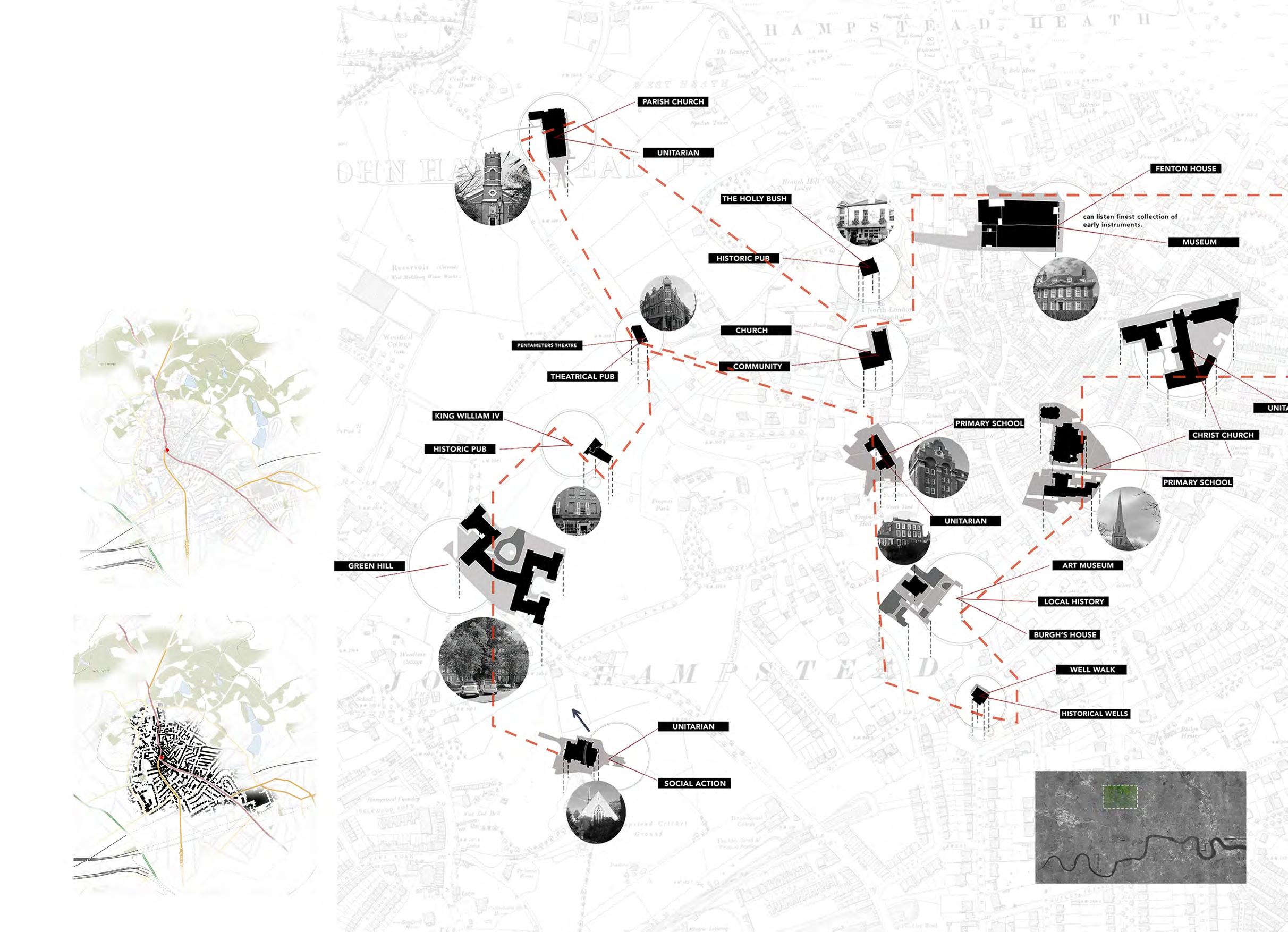
Site Location - Hampstead high street, London
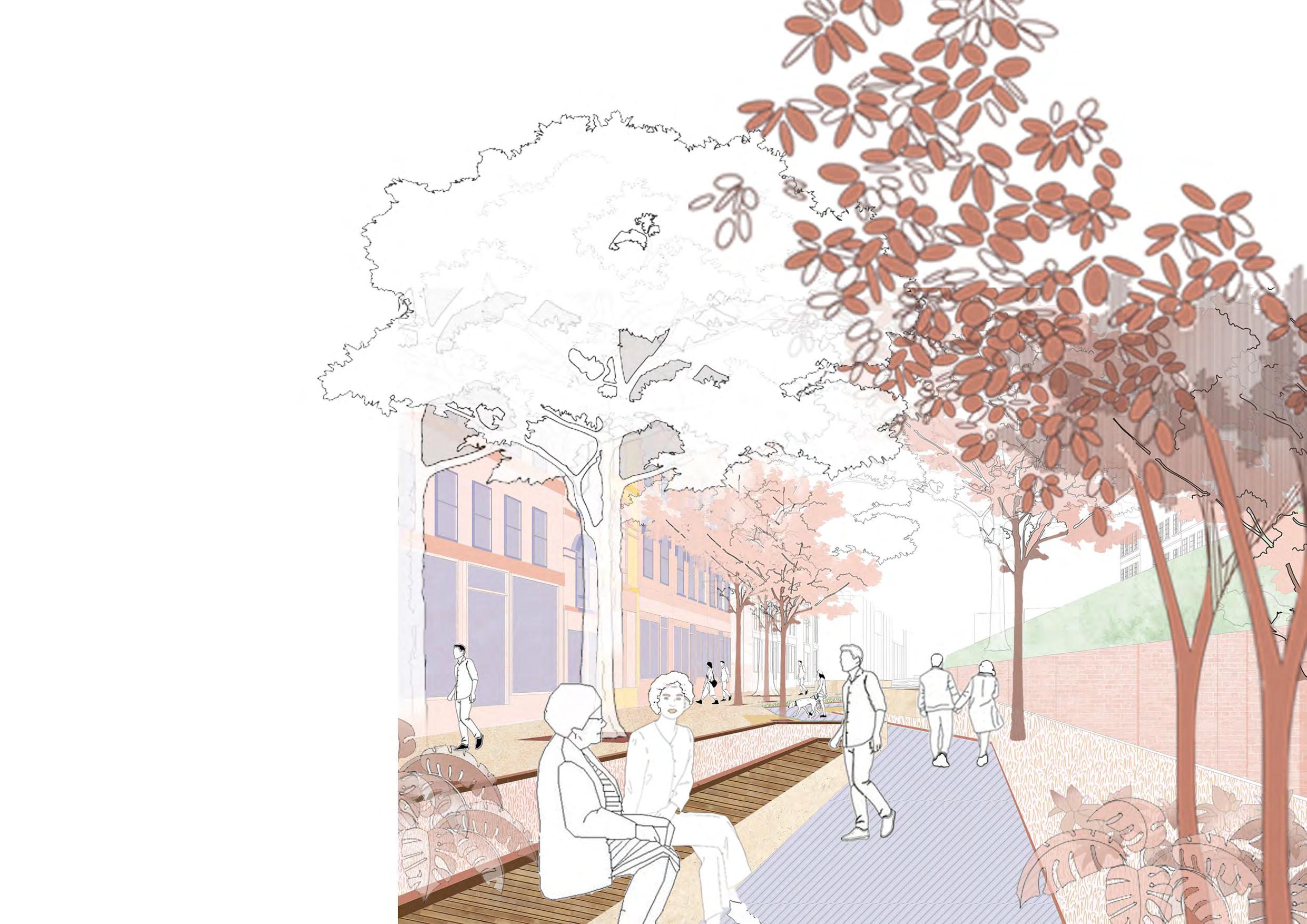
This project focuses on retrofitting Hampstead’s cultural and historical character into its urban landscape, particularly along Hampstead High Street. Known for its intellectual and literary history, Hampstead has long been a cultural hub in London. The project aims to transform the high street into a biophilic, creative corridor that reflects the area’s rich heritage while addressing contemporary urban challenges like rising temperatures and climate change. By applying landscape urbanism principles, the design seeks to create inviting public spaces that offer moments of pause and strategic connections, enhancing the overall experience of moving through the area. The phased transformation ensures that the project is responsive to community needs, fostering a vibrant public space that prioritizes well-being while preserving Hampstead’s historical charm. Ultimately, this initiative aims to integrate Hampstead’s unique cultural essence into the broader urban fabric of London, enriching both the local environment and the community’s quality of life.
The area of development is the hampstead high street, located in northwest part of London. The area is composed by narrow alleyways and small courtyards which gives the neighbourhood village like character. The area has long been home to writers, artists, and other creative types, and it has a rich cultural legacy. The brief was to choose three different routes from station and analyze the urban fabric and its character to retrofit in the context.
There is a cultural richness to the context of the site. From lush green hampstead heath, village like settlements, narrow passages to different museums of great artists who lived in Hampstead, It is one of the vibrant part of London which attracts people by its character.
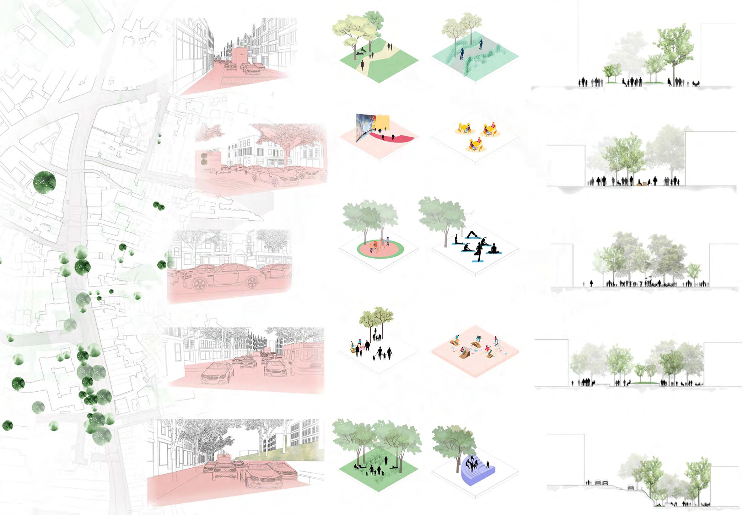
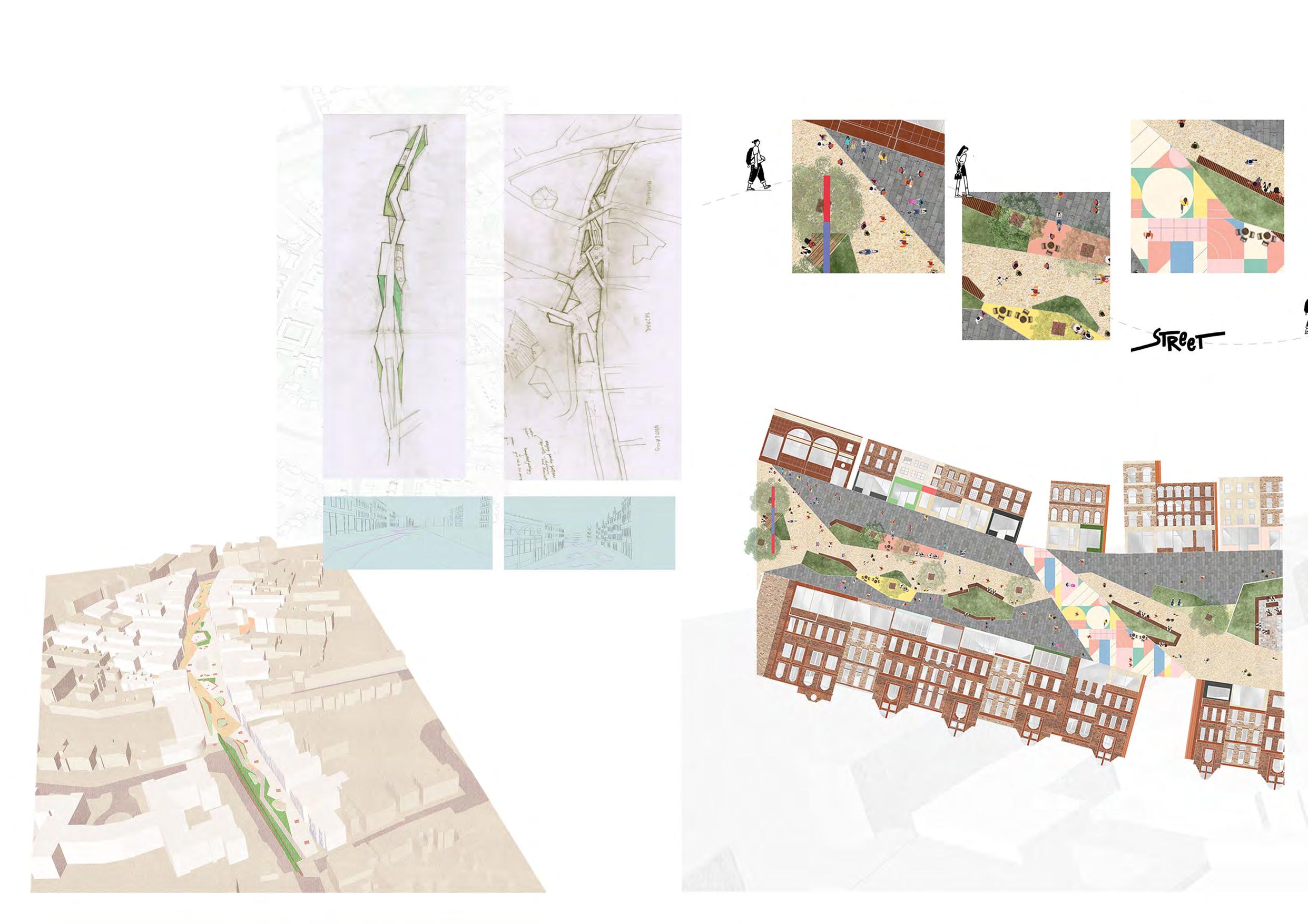
The space of intervention is divided into three partsThe promenade, The pop-up bazaars and The gardens. The division is done after analyzing the current character and conditions of the site.
The promenade- This section of the street is designed to accomodate more of daily activities goes on the street. The spill-out spaces and more of seating area is designed after understanding the active and passive use of the street at ground level.
The pop-up bazaars- This section of the street accomodates more of street performing activities, the local markets, exhibitions and slightly bigger gathering space. The width of the street allows more number of people to be accomodated.
The gardens - This section of the street exhibits more relaxed and intimate experience to the users. As this section of the site is surrounded by mature trees, it allows to create more intimate and flexible spaces to allow people to have more community interaction. Division of
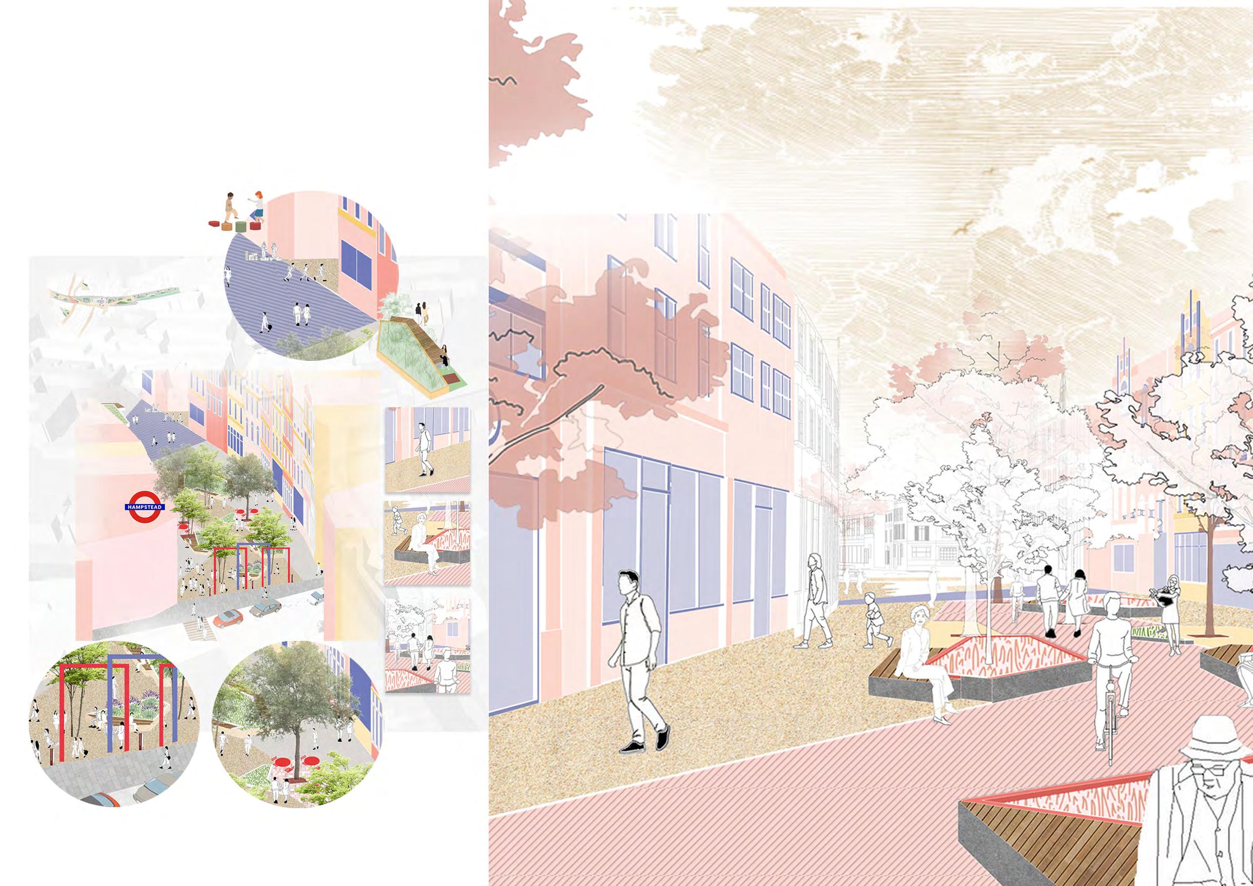
The promenade is the starting point of the creative corridor. This section is designed specifically for pedestrians to experience moment of pauses in their journey through ths street.
The area also opens up to narrow street branches and creating gateways to the street, thus the spillover spaces are designed for users to have ample of space to interact and enhance community buiding.
The seating is designed inward looking towards inner circulation of the street. People could watch both side of the streets without any restrictve view.
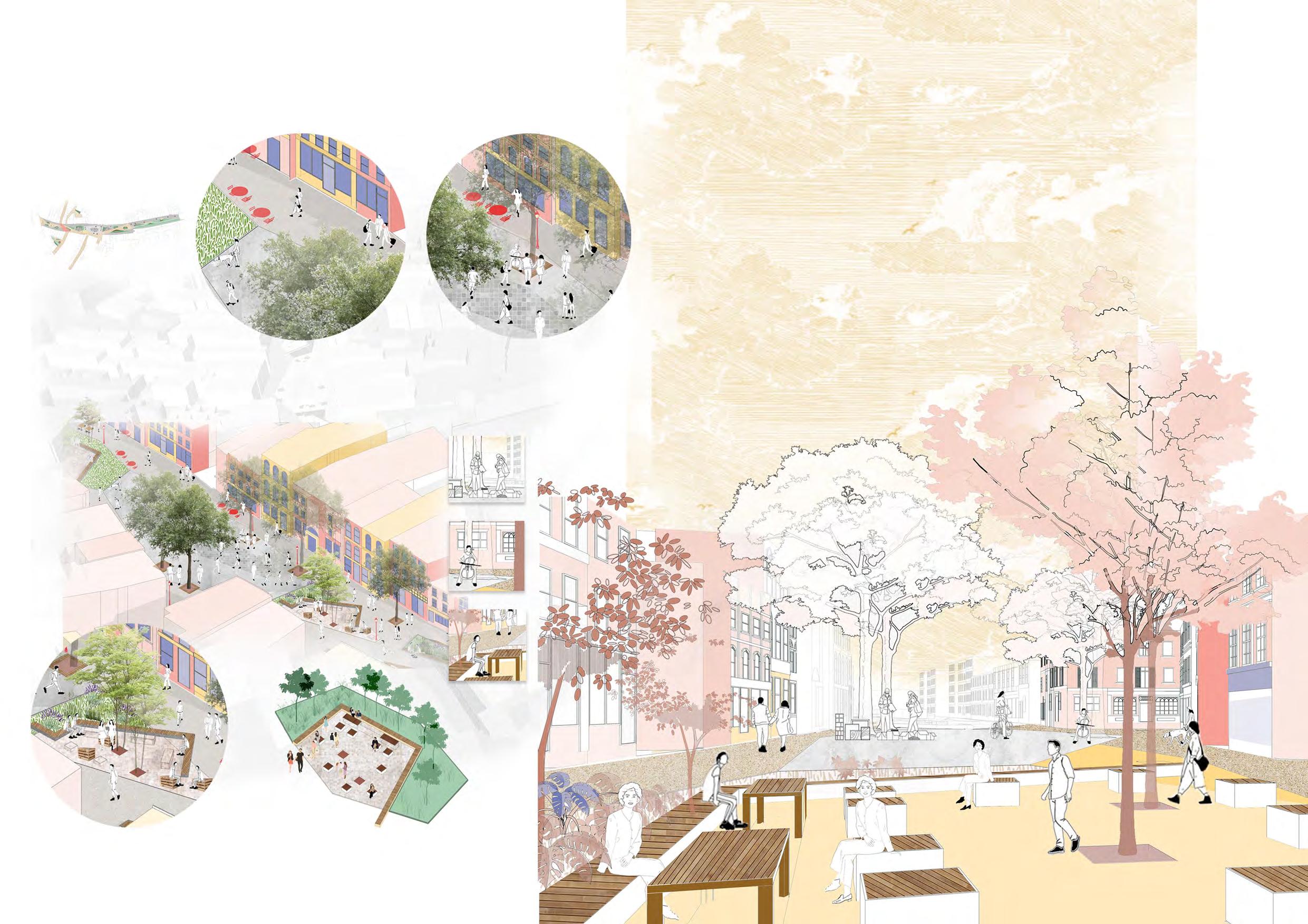
The pop -up Barzaar is the middle section of the creative corridor. This section is designed specifically for pedestrians to experience variety of activities in their journey through the street.
This part of the street acts as multipurpose area for various permanent and temporary activities. The width of the street allows small performances, Local markets and festivals to be held here.
B.Arch, SMEF’s Brick School Of Architecture
Year 3 Design Project
Site Location - Maheshwar, India
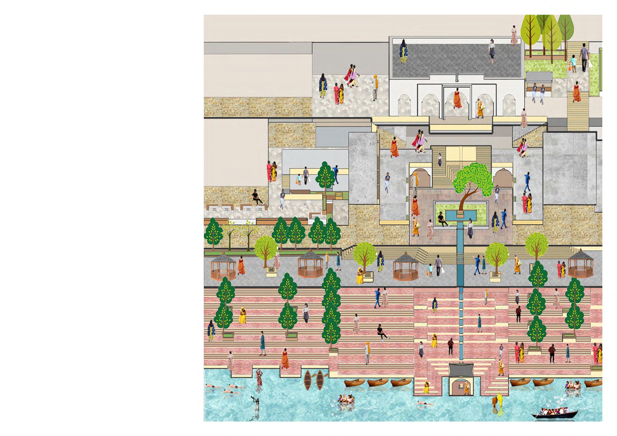
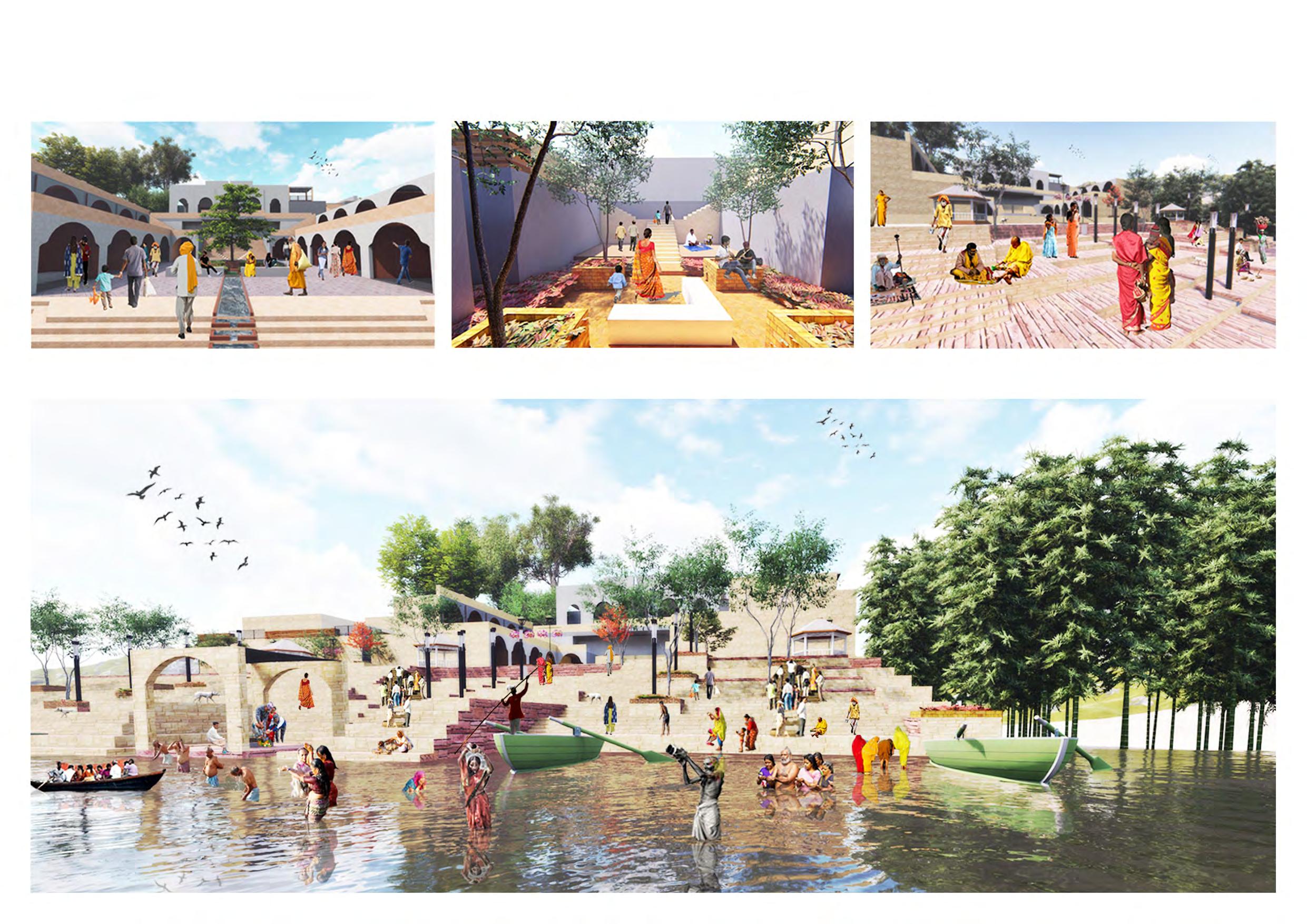
Rewa Haat
As part of the settlement study, two quick studies were carried out in the town of Maheswar: individual observation of local architecture and measurements of elements along the Narmada ghaat. We also visited two centers that train and engage crafts persons in the traditional hand-weaving technique unique to this region. Based on discussions we opted to develop a program that would cater to needs of the weaver community as well as provide a public interface for them to showcase their craft.Subsequently, a site was identified to locate the proposed project.
BArch, SMEF’s Brick School Of Architecture
Final Thesis Design project
Site Location- BDD Chawls, Mumbai, India
Design Supervisor - Girija Indulkar
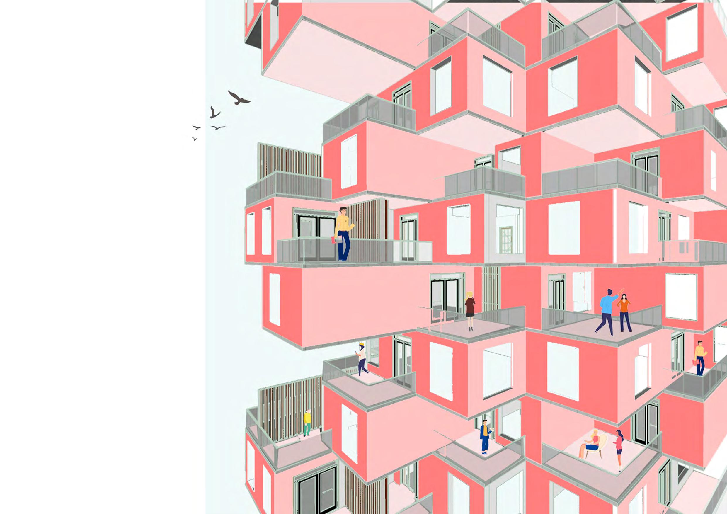
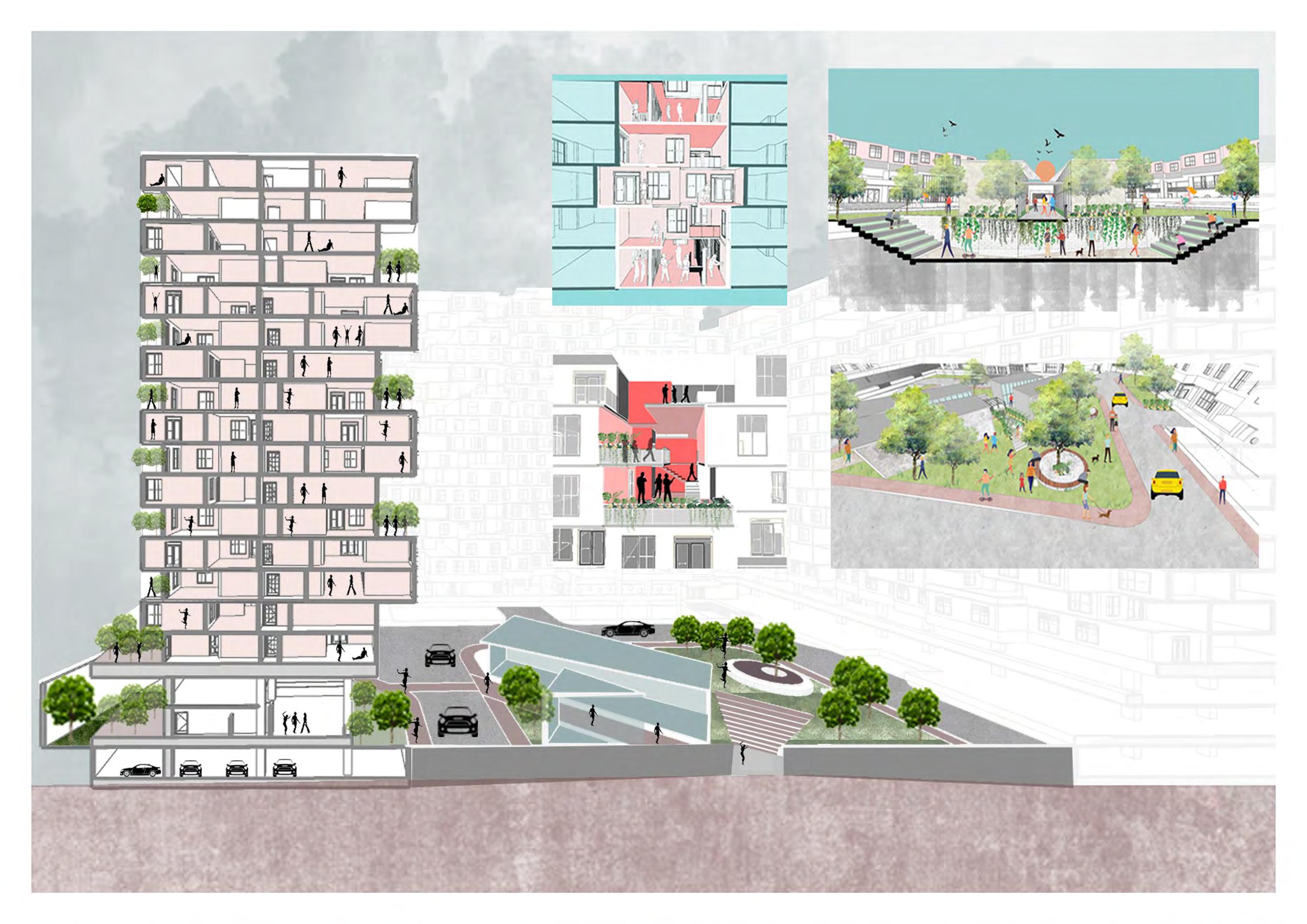
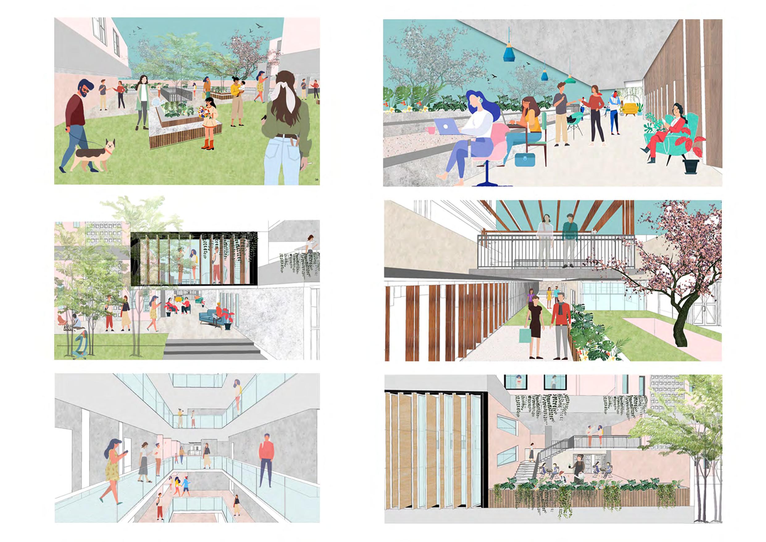
The project looks at re-thinking housing design in the city with rapid urbanization where people are living in very compact area with poor quality of living and less resources. This problem is mainly faced by people who are migrating due to studies or jobs.They cannot afford high rents in the city. Neighbourhoods are very important part in creating social and cultural communities as evident from chawls communities of Mumbai which demonstrates a quality of community living. Due to rapid urbanization, concept of co-living is arising for growth in housing and in creating intentional communities.This project focuses on amalgamation of two different groups i.e. chawl and millenials and creating an intentional community by designing housing for both of them. The intention is to bridge the gap between both the cultures and make them live together so as to benefit each other in terms of learning from each other and also feel sense of belonging to the people who are newly migrated in the city.
For about three hundred years from early 1700s to the late 1900s, the chawls remained the urban housing type for Mumbai—initially housing the traders and the trade workers and later built for the industrial workers.It had become a popular housing type for all strata of the middle classes.
The chawls have people from various cultures hence there are religious spaces for all kinds. People in chawls have made their woking area at their home only thus utilising spaces in different ways. Due to the arrangement of apartments in chawls interaction amongst residents is always growing.
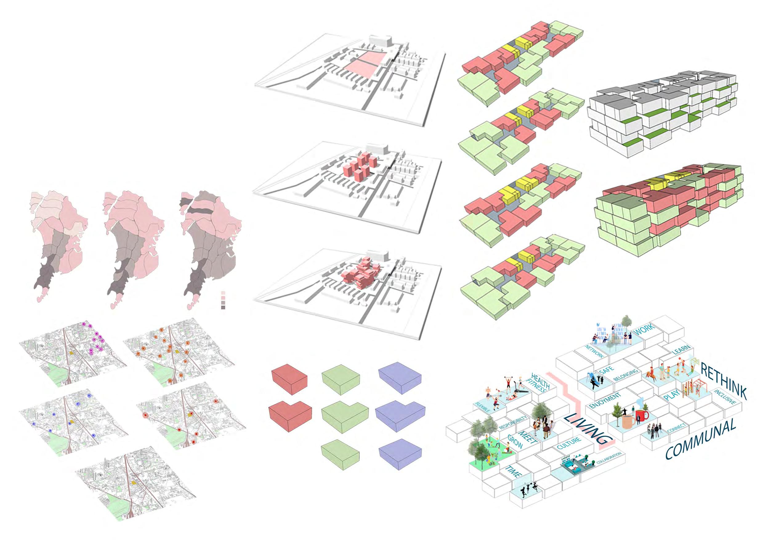
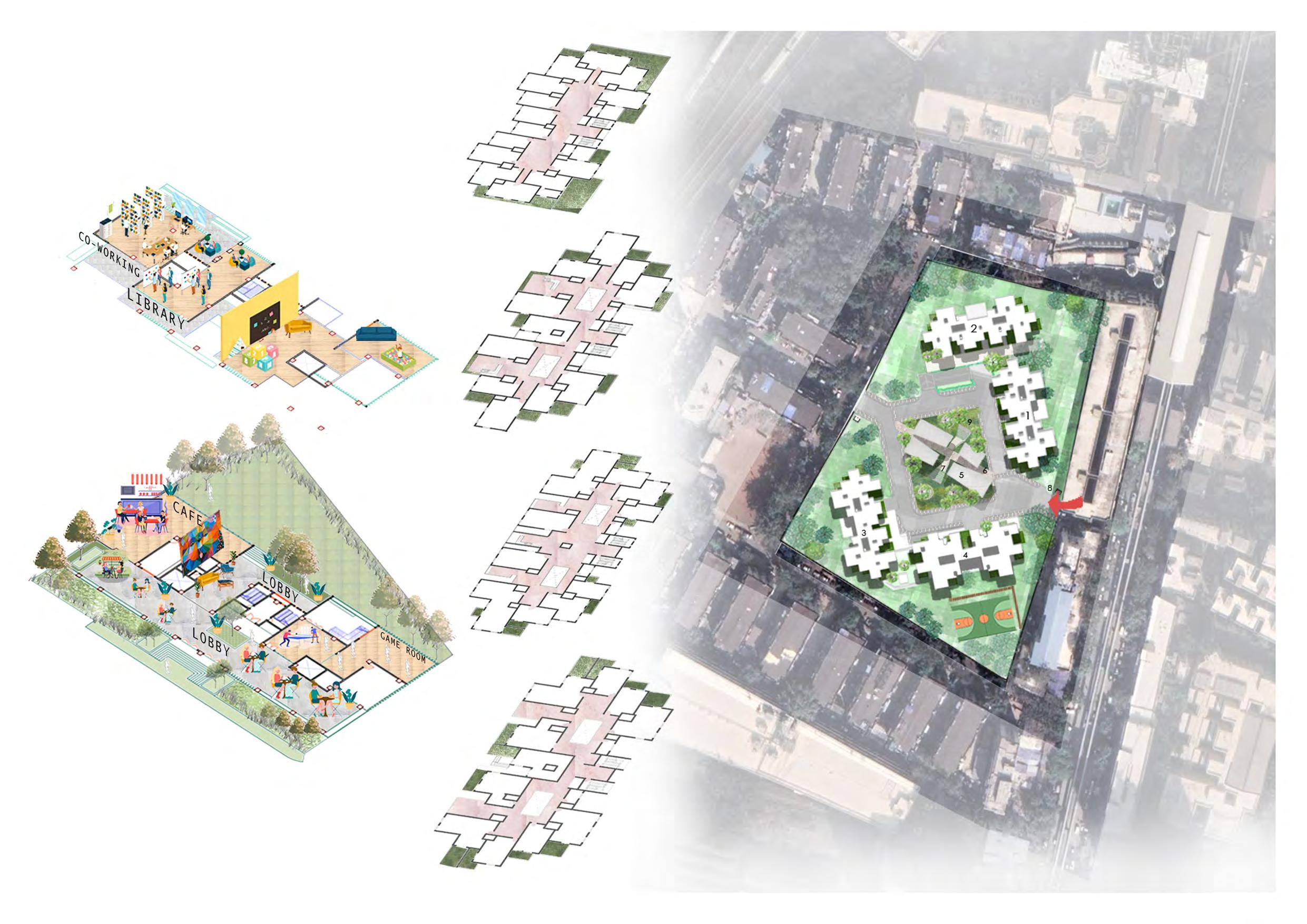
Due to rapid growth in cities,there are compact space s and hence the newly constructed buildings are mostly high rise.The planning is done in such a way so that each apartment has terrace and the spatial arrangement of apartments are done in such a way that there is vertical interaction with each other hence forming concept of vertical neighbourhood. The common spaces like communal areas,activity rooms etc. are given on lower floors having connectivity to the main communal open space and the residential part is on above floors.The retail commercial front is given in the centre of communal garden so that it can be accessible to the chawls surrounding the site and hence increasing interactions outside the society.
Proffesional Work, Internship Design Firm - Cadence Architects, Bangalore, India
Worked on concept, section and elevation drawings and also on woking drawings and site sections.
Proffesional Work, Architectural Designer Design Firm - Compartment S4, Ahmedabad, India
Worked from conceptual level to final execution - preparing working darwings, 3D visualization, site implemenation and visits.
The brief was to design a Punjabi restaurant within a time frame of a month and also to include the vibrant culture of punjab. Hence here, we tried playing with colors and patterns. These vbrance in texture gives differentexperience to the customer .

The circular seating in the center captures your eye instantly and brings out the curiosity in the space. In the elevation we have used picolo tiles which gives a whole lot different vibe to the restaurant.
Thank you