Prostor m space, room; (površina) area; (zona) tract; (prostranstvo) extent, expanse; (za kretanje/ manevriranje) elbow-room, playroom, leeway, scope; (prostorije, smještaj) premises, accomodation | životni ~ living space; stambeni ~ housing; školski ~ school space; poslovni ~ office space/premises; za noge legroom; prema raspoloživom ~u on a space available basis; fig pružati ~za offer/give scope for; posvetiti (pokloniti) ~ (u novinama) devote (give) space to; zbog pomanjkanja ~a because of limited space; radi uštede na ~u to save space; povreda zraËnog ~a violation of airspace, aerosp; istraživanje ~a space exploration Željko Bujas (1999.), Veliki hrvatsko-engleski rjeËnik | Croatian-English dictionary, Nakladni zavod Globus, Zagreb
Publisher copyright policies & self-archiving is also described at Sherpa organisation web (RoMEO service).
All received manuscripts are subject to routine disclosure of similarity with existing literature (plagiarism and self-plagiarism) through PlagScan program. In the case of suspected plagiarism and redundancy, the editorial board will act in accordance with the recommendations of the Committee on Publication Ethics (COPE).
The journal PROSTOR publishes scientific papers from all branches of architecture and urban planning as well as texts from other fields of science (art history, archaeology, ethnology, sociology, geography, civil engineering, geodesy, forestry, design...) if their content relates to architectural issues.
• The journal PROSTOR is registered with the Ministry of Science and Technology, RC (now Ministry of Science and Education), as a primary scientific publication in the area of technical sciences: scientific field: architecture & urban planning.
• The journal PROSTOR is registered as a periodical publication with the Ministry of Information, RC (now the Ministry of Culture, RC) under the entry number 38 (Registration of a Periodical Publ. Certif. from May 12, 1992, class 104, Reg. No. 523-021/92-847/38).
• PROSTOR is a half-yearly publication (two issues a year). In vol. 1 (1993) and 2 (1994) the journal was published quartarly.
PROSTOR is a primary scientific journal and accepts only previously unpublished papers which cannot be simultaneously offered in the same form to another publisher. In addition to scientific contributions, which are subject to evaluation by reviewers, decimal classification and categorisation (original scientific papers, preliminary communications, reviews, conference papers), professional papers of analytical character will be published exceptionally. In accordance with the above, design projects will not be published in PROSTOR, except in cases that display a highly expert or applied scientific solution for a particular issue or problem within a project, unless the content is presented in a scientific manner (a conceptual, technical, technological or methodological problem, but not a project or a building itself).
Contributions for current theme section include reviews of books, journals, and scientific conference proceedings or books of abstracts as well as summaries of defended doctoral dissertations on the Faculty of architecture, University of Zagreb.
• By delivering his / her signed paper, the author guarantees that he is the sole copyright holder of his work and grants his consent to its publishing in hardcopy or electronic edition (Prostor online) as well as to its abstracting / indexing in secondary data bases.
• Typescripts of accepted papers are not returned.
• The author does not receive any payment.
• Responsibility for scientific attitudes and opinions presented in the paper, the accuracy of data and the right to publish the text(s) and illustrations rests with the author(s).
• Copyright of any published article in PROSTOR rests with the author/s. Author/s grant the journal PROSTOR the commercial right to publish a printed version of the journal and to sell it to libraries and natural persons. Author/s grant the third person free use of the published article only if its original author can be identified including the citations belonging to this author/s.
Subscription / Price per issue:
Croatia: 120 HRK (without delivery, issues may be picked up at Faculty of Architecture’s Study archives)
Croatia: 140 HRK (with delivery)
Overseas: 225 HRK (with delivery)
Ordering info: prostor@arhitekt.hr
Free On-line Access to Internet Edition
All published articles in previous issues are available in PDF format.
EISSN 1333-9117
www.prostor.hr https://hrcak.srce.hr/prostor
• The published articles and other published materials are distributed under the Creative Commons Attribution 4.0 license (CC BY).
No. 62 of Prostor was financially supported by the Ministry of Science and Education of Republic of Croatia.
PROSTOR
Founder & Publisher
University of Zagreb, Faculty of Architecture
Sveučilište u Zagrebu, Arhitektonski fakultet HR - 10000 Zagreb, Kačićeva 26 www.arhitekt.hr
For the Publisher
prof. Bojan Baletić, Ph.D., Dean of the Faculty
Editorial Team
Editor in Chief
assist. prof. Ana Mrđa, Ph.D., MBA University of Zagreb, Faculty of Architecture
Managing Editor
prof. Ariana Štulhofer, Ph.D.
University of Zagreb, Faculty of Architecture
Associate Managing Editor
Tajana Jaklenec, lecturer University of Zagreb, Faculty of Architecture
Associate Editors
A SCHOLARLY JOURNAL OF ARCHITECTURE AND URBAN PLANNING
ZNANSTVENI »ASOPIS ZA ARHITEKTURU I URBANIZAM
Editor’s Office Address Adresa uredništva
PROSTOR
University of Zagreb, Faculty of Architecture
Sveučilište u Zagrebu, Arhitektonski fakultet HR - 10000 Zagreb, Kačićeva 26 Croatia | Hrvatska
Tel. +385/1 4639 315 Fax. +385/1 4828 079
E-mail: prostor@arhitekt.hr
Internet Editor assist. prof. Davor Andrić, Ph.D. University of Zagreb, Faculty of Architecture
Book Review Editor assist. prof. Marko Rukavina, Ph.D. University of Zagreb, Faculty of Architecture
Honorary Editors
prof. emeritus Mladen Obad Šćitaroci, Ph.D., F.C.A.
University of Zagreb, Faculty of Architecture
prof. emeritus Srečko Pegan, Ph.D. University of Zagreb, Faculty of Architecture
Editorial Board
prof. Bojana Bojanić Obad Šćitaroci, Ph.D. University of Zagreb, Faculty of Architecture
assoc. prof. Iva Muraj, Ph.D.
University of Zagreb, Faculty of Architecture
assoc. prof. Lea Petrović Krajnik, Ph.D.
University of Zagreb, Faculty of Architecture
assoc. prof. Mia Roth-Čerina, Ph.D.
University of Zagreb, Faculty of Architecture
prof. Karin Šerman, Ph.D.
University of Zagreb, Faculty of Architecture
prof. Feđa Vukić, Ph.D. University of Zagreb, Faculty of Architecture, School of Design
assist. prof. Borka Bobovec, Ph.D.
Croatian Museum of Architecture - Croatian Academy of Sciences and Arts
assist. prof. Jasenka Kranjčević, Ph.D.
Institute for Tourism
assist. prof. Ana Šverko, Ph.D.
Institute for Art History - Cvito Fisković Centre
assoc. prof. dr. techn. Thomas Dillinger TU Wien
assist. prof. Maria Tratsela, Ph.D. Aristotle University of Thessaloniki
prof. Rudolf Klein, Ph.D. Szent István University, Budapest
prof. Kiyoko Kanki, Ph.D.
Kyoto University, Kyoto, Katsura Campus
assist. prof. Alma Zavodnik Lamovšek, Ph.D. Univerza v Ljubljani, Fakulteta za gradbeništvo in geodezijo
prof. Ester Higueras García, Ph.D. Universidad Politécnica de Madrid
prof. emeritus Ákos Moravánszky, Ph.D. ETH Zurich
prof. Joan Busquets, Ph.D.
Harvard Graduate School of Design, Harvard University, Cambridge
prof. emeritus Nezar AlSayyad, Ph.D. University of California, Berkeley
assoc. prof. Sam Griffiths, Ph.D. UCL Bartlett School of Architecture
assoc. prof. art. Ivana Ergić assoc. prof. Mia Roth-Čerina, Ph.D. assist. prof. Melita Čavlović, Ph.D. assist. prof. Ana Mrđa, Ph.D., MBA
assist. prof. Marko Rukavina, Ph.D. (chairman)
Ivana Podnar, Ph.D., lecturer
Tajana Jaklenec, lecturer (vice chairman)
ISSN 1330-0652
https://doi.org/10.31522/p UDC 71/72
CODEN PORREV
29 [2021] 2 [62]
153-248
7-12 [2021]
PROSTOR is abstracted or indexed in:
• Academic Search Complete
• Art & Architecture Source
• Central & Eastern European Academic Source [CEEAS] EBSCO Information Services, Ipswich, MA, USA
• Architectural Publications Index [API]
Royal Institute of British Architects [RIBA], The British Architectural Library, London, UK
• Avery Architectural & Fine Arts Library Index Columbia University in the City of New York, New York, USA
• CAB Abstracts
Centre for Agriculture and Biosciences International [CABI], Wallingford, Oxfordshire, UK
• DOAJ
The Directory of Open Access Journals
• ERIH PLUS European reference index for the Humanities and Social Sciences
• Google Scholar
• Hrčak - Portal znanstvenih časopisa Republike Hrvatske Sveučilište u Zagrebu, Sveučilišni računski centar, Zagreb, Hrvatska
• Hrvatska bibliografija: niz B - prilozi u časopisima i zbornicima; niz C - serijske publikacije Nacionalna i sveučilišna knjižnica, Zagreb, Hrvatska
• Index Islamicus
School of Oriental and African Studies, London, United Kingdom Instituto de Lenguas y Culturas del Mediterráneo y Oriente Próximo, Madrid, Spain
• The Library of Congress, Washington D.C., USA
• VINITI Database RAS, All-Russian Institute for Scientific and Technical Information Institute for Scientific Information, Moscow, Russia
• Web of Science Core Collection - Arts & Humanities Citation Index [WoS-A&HCI] Clarivate Analytics, Philadelphia, PA, USA
Scopus has stopped coverage of Prostor after the last issue or published item from 2018. All previously indexed content will remain in the Scopus database.
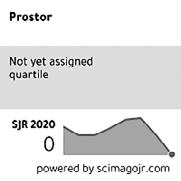
The SCImago Journal & Country Rank
Arts and Humanities: Visual Arts and Performing Arts [Q3]
Engineering: Architecture [Q3]
Social Sciences: Geography, Planning and Development [Q4]
Social Sciences: Urban Studies [Q4]
H-index: 5
SJR 2020: >0.109
Scientific Papers
original scientific PaPers
154-173 Mara Marić Franko ćorić Mladen obad Šćitaroci Marin duić
Projects for Ferme Ornée on the Island of Lokrum by Archduke Ferdinand Maximilian of Habsburg https://doi.org/10.31522/p.29.2(62).1
UDC 721 728.84 M.Habsburg (497.5 Lokrum) ”18”
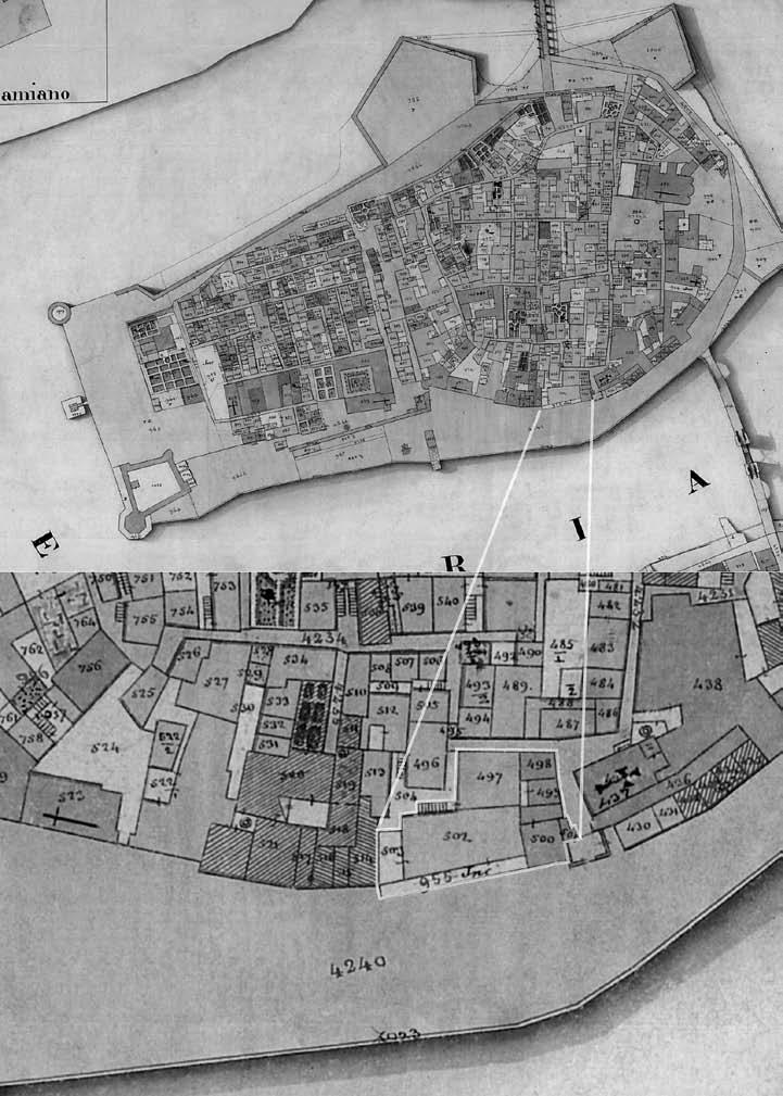
Attributing and Defining an Unbuilt 1859 Architectural Plan for the Site of Trogir’s Medieval Walls https://doi.org/10.31522/p.29.2(62).2
UDC 721 728 (497.5 Trogir) ”18”
An Alternative Approach to Geometric Harmonization of the Great Mosque in Córdoba https://doi.org/10.31522/p.29.2(62).3
UDC 514 726:28-523.42 (460.351.2)
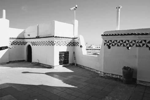
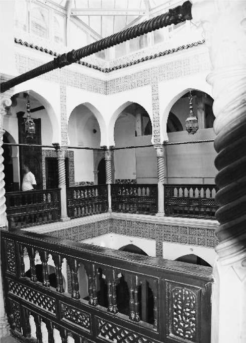
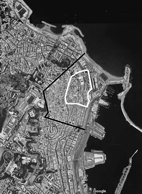
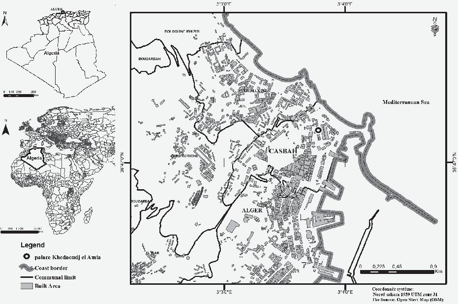
Decoding the Spatial Configuration of the Ottoman Palace “Khdewedj El Amia” in Algiers (Algeria) through Space Syntax https://doi.org/10.31522/p.29.2(62).4
UDC 7.033.39 72.012 (652.11) ”15”
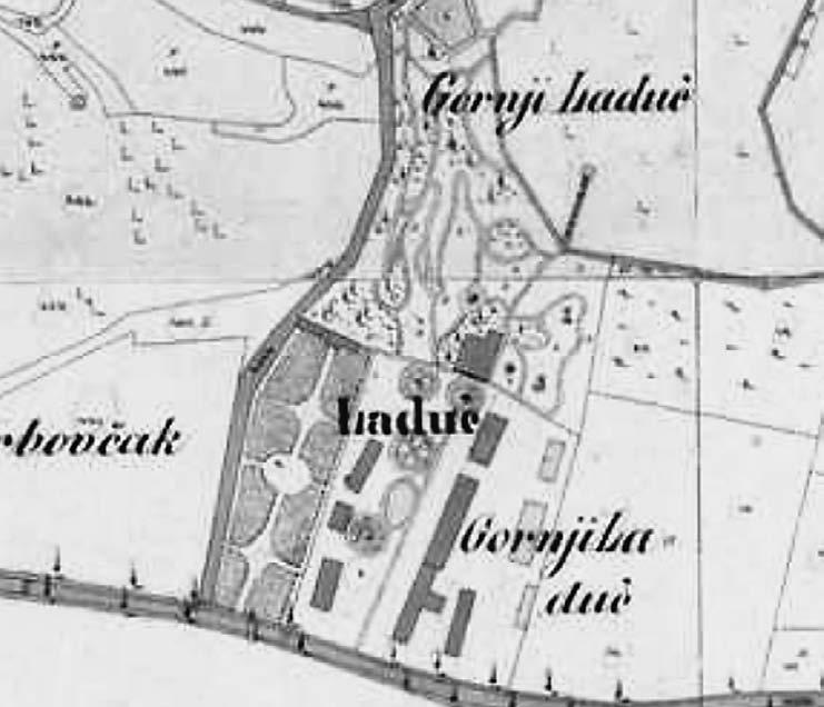
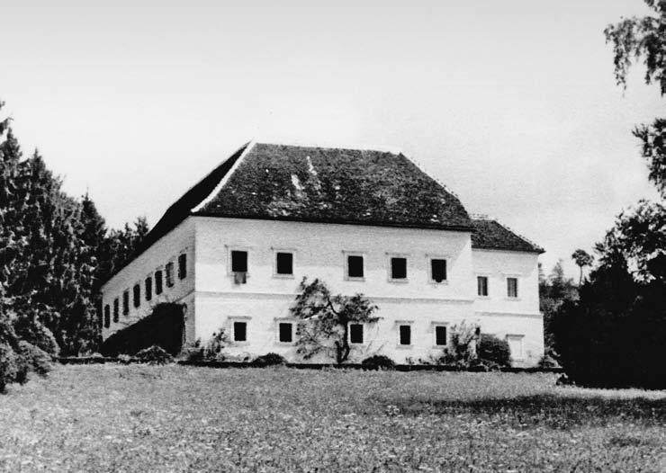
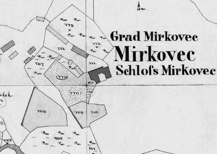
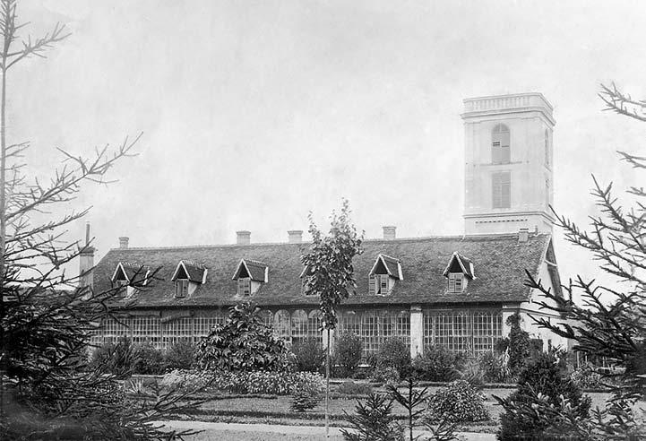
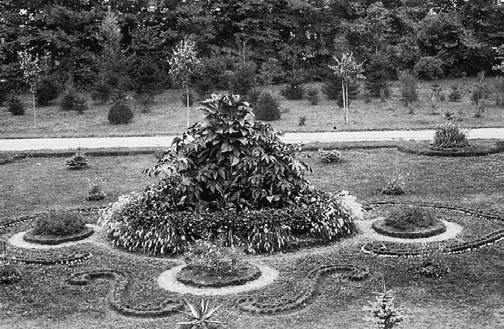
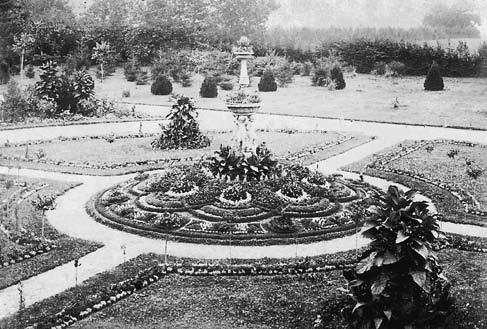
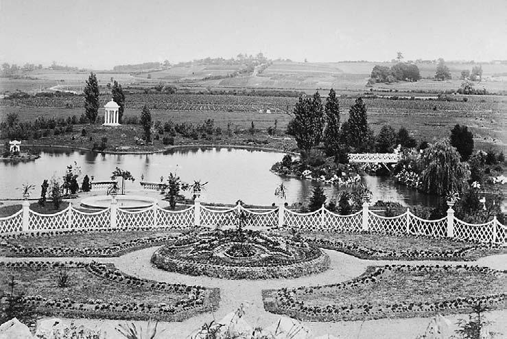
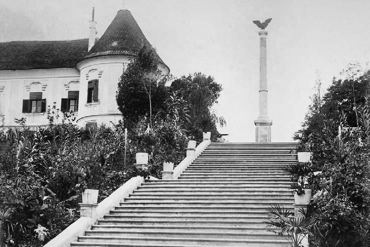
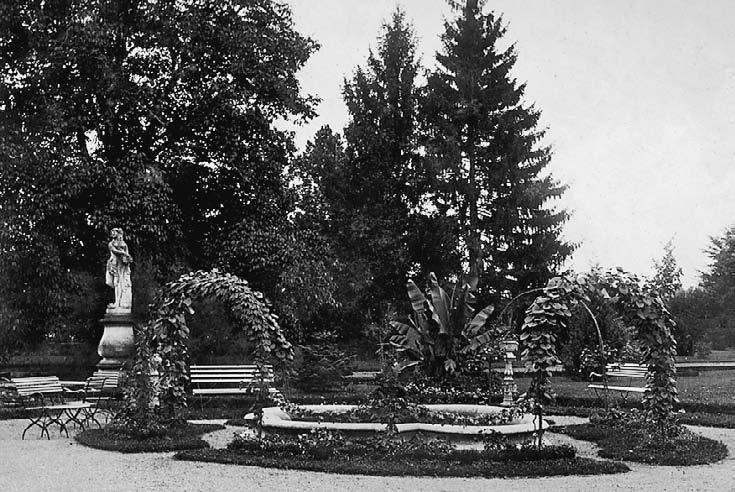
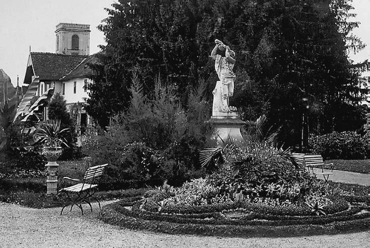
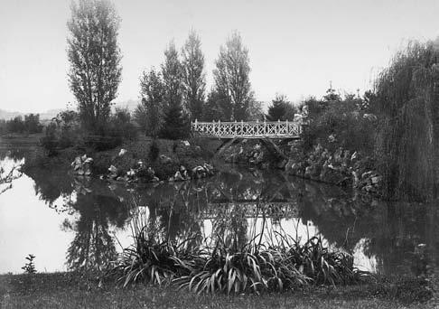
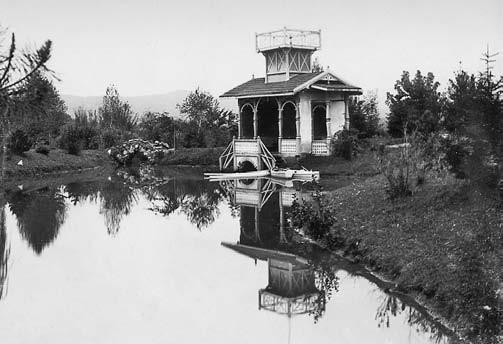
Gardens of Vranyczany’s Manor Houses in Hrvatsko Zagorje in the Age of Historicism
https://doi.org/10.31522/p.29.2(62).5
UDC 712.26 Vranyczany (497.522) ”18/19”
Resort Architecture in Regional Perceptions
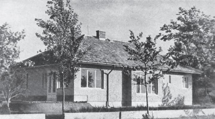
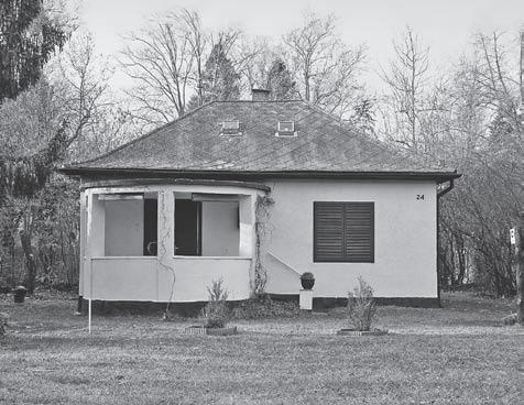
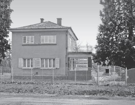
Multiple Aspects of a Region in Iván Kotsis’ Design Method for Balaton Lakeshore https://doi.org/10.31522/p.29.2(62).6
UDC 712.3 711.455 I.Kotsis (439 Balaton) ”19”
Design Factor in the Renewal and Modern Development of the City Dizajn kao čimbenik obnove i suvremenog razvoja grada
241 Maroje MrduljaŠ She 2 Art Project, a Monograph Monografija umjetničkog projekta She 2 Ivana Tutek, Bernarda Lukač, Stanislav Habjan
242 sanja GaŠparović
243 silva kalčić
244 tajana jaklenec
Doctoral Dissertations
245-247 Doctoral Dissertations
Instructions for authors
249
Rijeka Within the Reach of the City Urban Ideas about the Sava in Zagreb
Rijeka nadohvat grada
Urbanističke ideje o Savi u Zagrebu
Irena Matković
Zagreb Calling: Emergence of a Post-socialist City
Kako Zagreb izranja iz sna: Stvaranje postsocijalističkog grada
Tomislav Pletenac
The Routledge Companion to Digital Humanities and Art History Routhledge - priručnik za digitalnu humanistiku i povijest umjetnosti
The Editorial Board provides at least two independent reviews by prominent Croatian or foreign scholars for all the scientific contributions published in the journal PROSTOR.
Scientific Papers
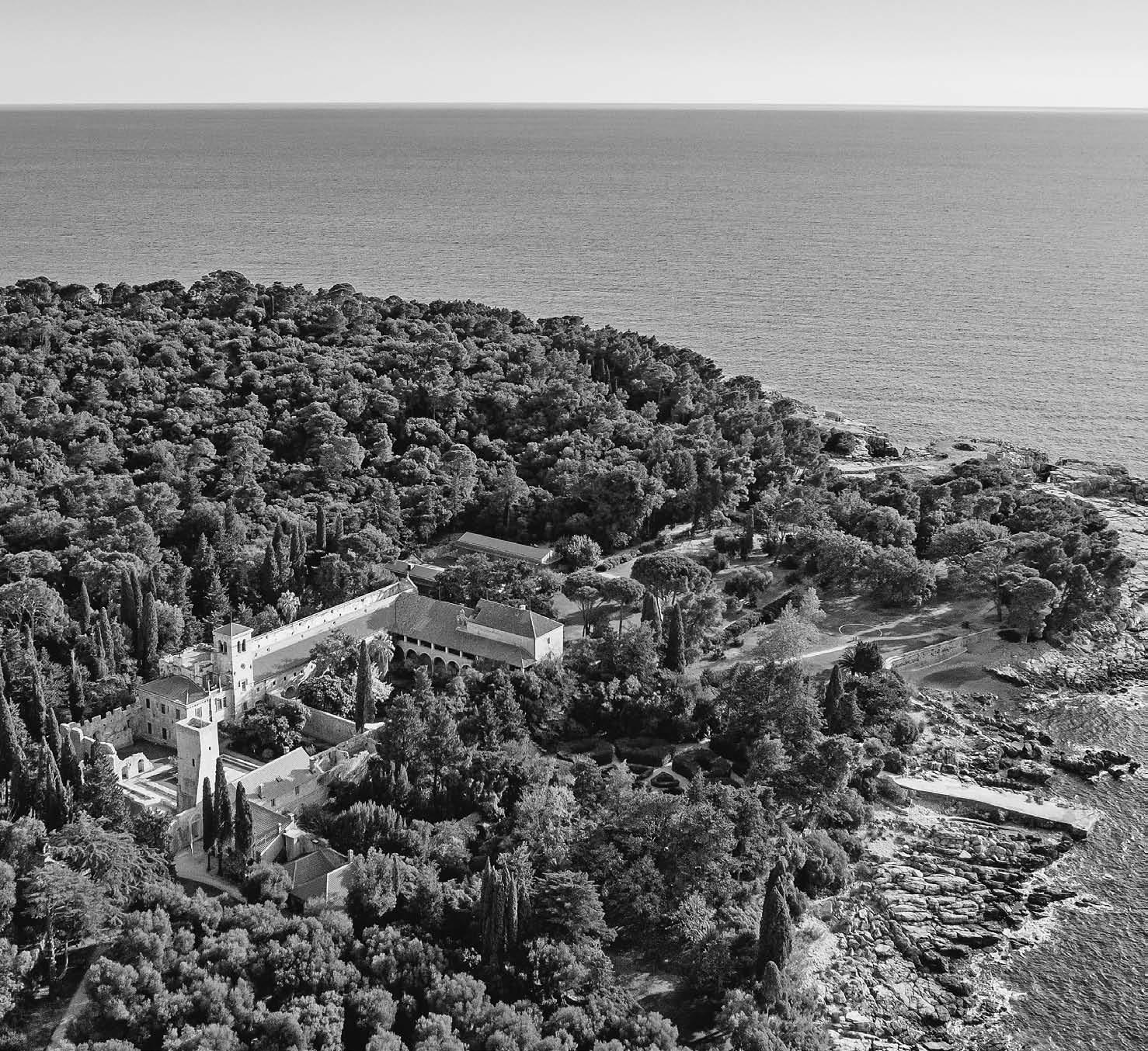
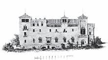
Fig. 1 Aerial view on the benedictine monastery and Maximilian’s residence from the northwest
Mara Marić1, Franko Ćorić2, Mladen Obad Šćitaroci3, Marin Duić4
1 University of Dubrovnik, Marka Marojice 4, HR-20000 Dubrovnik
ORCID 0000-0003-2896-9844
2 Faculty of Humanities and Social Sciences, University of Zagreb, Ivana Lučića 3, HR-10 000 Zagreb ORCID 0000-0003-3585-8843
3 Faculty of Architecture, University of Zagreb, Fra Andrije Kačića Miošića 26, HR-10000 Zagreb ORCID 0000-0003-0656-386X
4 Faculty of Architecture, University of Zagreb, Fra Andrije Kačića Miošića 26, HR-10000 Zagreb ORCID 0000-0003-1217-2443
Projects for Ferme Ornée on the Island of Lokrum by Archduke Ferdinand Maximilian
of Habsburg
Archduke Maximilian I of Habsburg Dubrovnik ferme ornée Lokrum
Romantic Historicism
This research deals with projects for a residence on the island of Lokrum by Archduke Maximilian I of Habsburg (1832-1867). In the short period of owning the island (1859-1867), Maximilian ordered three different designs for Lokrum. The subject of research in this paper is the first phase of the project, dating from 1860 to 1866, when the general plan of the island, Maximilian’s residence, farm building and court chapel were designed. The research is based on an analysis of primary archival sources while the contemporary models for the project have been found through literature review. Twenty archival drafts have been described textually and graphically published. Maximilian
actively participated in the planning and design process, but the author of the projects was Thomas Friedrich. After the general plan of the island from 1860 came sixteen preserved plans of Maximilian’s residence, which are with this research dated to the period from 1862 to 1864. The drafts for the farm building, court chapel and altar date back to the period from 1864 to 1866. Although in terms of architecture it was only partially built (only the landscape part of the project was executed), the Lokrum project from 1860 to 1866 shows Maximilian’s original idea of the island before the later grandiose plans of transformation into an imperial residence.
Theisland of Lokrum, historically named Lacroma, is located only 680 meters away from Dubrovnik. As a natural pre-fortress of Dubrovnik and an important observation post from which Dubrovnik defended itself from the sea, Lokrum was a strategically prominent place in the history of the City.
This research deals with projects for a residence on the island of Lokrum by Archduke Maximilian I of Habsburg (1832-1867; Fig. 1). In the short period of Maximilian’s rule of the Lokrum island, since its purchase in 1859 until Maximilian’s death in 1867, he commissioned three design solutions for Lokrum. The subject of research in this paper is the first phase of the project, dating from 1860 to 1866, when the general plan of the island, Maximilian’s residence, the farm building and court chapel were designed.
The research aims to show Maximilian’s idea of fitting the residence within the existing Benedictine monastery and the organization of the entire island based on the concept of ferme orné, more precisely the “agrarian park”. The project drafts have so far been mostly unpublished, and there has been relatively little research on the park. The project will be described and dated, analysed with regard to comparative examples, and shall present the current knowledge on the authorship of the project. The research is part of a larger multi-year study of the construction and landscaping of the island. Projects for
the residence on Lokrum by Franz Xaver Segenschmid and Julius Hofmann made between 1865 and 1867 are the subject of another paper.
• Context - Maximilian, as the supreme commander of the Austrian navy and a person of cosmopolitan spirit, traveled frequently. He was especially impressed by the Mediterranean landscapes, architecture, and climate. The Dubrovnik climate presented to him an ideal location for a country residence. He visited Lokrum for the first time in May 1859 after the tragedy of the warship Triton right next to the island (Foretić, 2007: 349).1 After the visit to the island, the original idea was to buy a smaller country villa with a park in the Boninovo area, modeled on the Sicilian Villa Butera (Massimiliano d’Asburgo, 1987: 73-74).
The decision to buy Lokrum matured during the summer of 1859 when Maximilian and his wife, Belgian Princess Charlotte (1840-1927), stayed in Dubrovnik to celebrate the completion of the Austrian two-year Novara world research expedition (1857-1859) (Scherzer, 1863: 452-453). Numerous new, exotic specimens of plants and their seeds collected on the expedition were to be planted or sown in a climatically suitable environment. Miramar Park was not appropriate due to the harsh continental climate in winter (Pozzeto, 1986: 8), unlike Lokrum, which was considered a favorable choice in both climatic and vegetation contexts (Visiani, 1863: 9). Gardens on the Lokrum island were not planned “only” for aesthetic enjoyment. Maximilian planned to establish an income-generating farm, trying to test plants that were new or unknown to the European context. Evidence that the exotic plant material, collected during Novara’s twoyear expedition around the world, was the reason for buying Lokrum so it could acclimatize to it, can be explicitly found in the renowned Austrian botanical journal Österreichische Botanische Zeitschriftfrom 1859 (Skofitz, 1859:
1 Maximilian’s first arrival in Dubrovnik was with his younger brother, Archduke Charles Louis (1833-1896), in the autumn of 1850, on his return from a trip to Turkey (Maximilian I, Emperor of Mexico, 1868: 311-334).
2 The catalogue presents parts of the projects for Lokrum; a perspective view from 1867 by the architect Franz Xaver Segenschmid (1839-1888) and a general plan of the imperial residence from 1867 by the architect Julius Hoffmann (1840-1896) that are not subject of this research.
3 Following researches from 1986 to 2019 studied all phases of the built heritage on Lokrum: Anđelko Badurina, Željka Čorak, Danko Zelić, Davorin Stepinac, Ivan Tenšek, Matko Vetma, Ivica Žile, Paola Kolić, Miljenko Mojaš, Ivana Galinović, Zvjezdana Tolja, Maris Kristović, Veronika Šulić, Ana Marinković, Igor Fisković, Ivan Viđen, Franko Ćorić, Petra Špilj, Nela Kovačević Bokarica, Domagoj Kristović, Claudia Pezzi, Tjaša Kolačko.
In the conservation analysis from 2019 the following drawings, which are the subject of this paper as well, were mentioned or textually described: general plan of the island from 1860, pencil sketches of the southern, eastern, and western facades; coloured drawings of the south, east, and west facades; ground floor plan, foundation
374-375). Maximilian’s wish was to grow Chinese sugar cane (Saccharum sinense Roxb.) on the island (Skofitz, 1859: 375).
In the context of time, it is important to mention that Maximilian had just resigned from the position of viceroy of the Kingdom of Lombardy-Venetia, so the island of Lokrum gave Maximilian the illusion of the continuity of “his own” territory and an escape from state failure. Charlotte bought Lokrum as a gift to Maximilian in October 1859 (Maximilian I. Emperor of Mexico, 1868: 286).
• Previous research - In previous research on this topic, the project documentation for Lokrum has been presented in fragments. It is important to highlight the catalogue published for the exhibition “Maximilian, from Trieste to Mexico” (Covre, 1986: 115) in 1986.2 In 2009, Ferdinand Anders published a book showing parts of the Lokrum project that Franz Xaver Segenschmid and Julius Hofmann made between 1865 and 1867 (Anders, 2009). In the works of Croatian researchers, there has been speculation about the names of the Lokrum project’s authors (Čorak, 1989: 207-211; Foretić, 2007: 353; Brailo, 2002: 87109; Ivanković, 2017: 175-215).
Research on the landscaping of the island based on primary archival sources began in 2017, and resulted in the publication of study documentation and several scientific articles (Marić, Ivušić, Marinović-Peričević, 2018; Marić, Medović, 2019; Marić, Obad Šćitaroci, 2018: 332-350; Marić, Obad Šćitaroci, 2019: 50-63; Marić, 2020: 267-276; Marić, Vitasović Kosić, 2020: 443-454). Unknown and unpublished drafts, the general plan of the island from 1860, as well as the situational plan of Maximilian’s residence and gardens in the area, were first published in 2018 (Marić, Obad Šćitaroci, 2018: 332-350).
Several conservation analyses have been made for the former Benedictine monastery
plan, first floor plan, second floor plan, section through both cloister, floor plan of residence and gardens, farm building plan, chapel adaptation plan, design of the main altar in the chapel.
Graphically presented were the following drawings: general plan of the island from 1860, pencil sketches of the southern, eastern, and western facades, coloured drawings of the southern, eastern, and western facades, ground floor plan, first floor plan, second floor plan, floor plan of residence and gardens (Arhita d.o.o.: 2019b: Knjiga I, Knjiga IV).
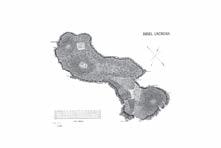
4 General plan of the Lokrum island, 1860, unknown author; Sign. ÖNB, sign. +079 KAR MAG. A plan was drawn in ink and painted in the watercolour technique, with defined zoning of the entire island. In the right corner of the plan is a wind rose on which the direction of the bora was particularly emphasised, which was important for the layout of the garden and production areas on the island. In the lower left corner is the draft scale in Austrian inches (zoll) (1 zoll = 2.63 cm), i.e., Klafters (1 Klafter = 1.89 m).
5 AST, Amministrazione Castello di Miramare (18511930), n. 30, f. 74 Documentazione contabile della cassa dell’ arciduchessa Carlotta, nn. 4-370, 1859-60
and the partially constructed Maximilian’s residence. The earliest is from 1987, in which Željka Čorak wrote about Maximilian’s residence, referring to data from the catalogue of the 1986 exhibition (Čorak, 1987: 79-115). In 2011, the conservation analysis “Benediktinski samostan i crkva sv. Marije na Lokrumu” was made (Arheo plan d.o.o., Arhita d.o.o.: 2011), and parts of the projects for Lokrum were partially published in the conservation analysis “Kompleks benediktinskog samostana i Maksimilijanove rezidencije: Otok Lokrum” from 2019 (Arhita d.o.o.: 2019b).3
• Research methods and sources - This research is based on an analysis of primary archival sources found in the Austrian National Library, the Austrian State Archive in Vienna, and the State Archive in Trieste. The paper graphically presents and textually describes the drafts of the first project of Maximilian’s residence on Lokrum. Contemporary models for the project have been found through literature review.
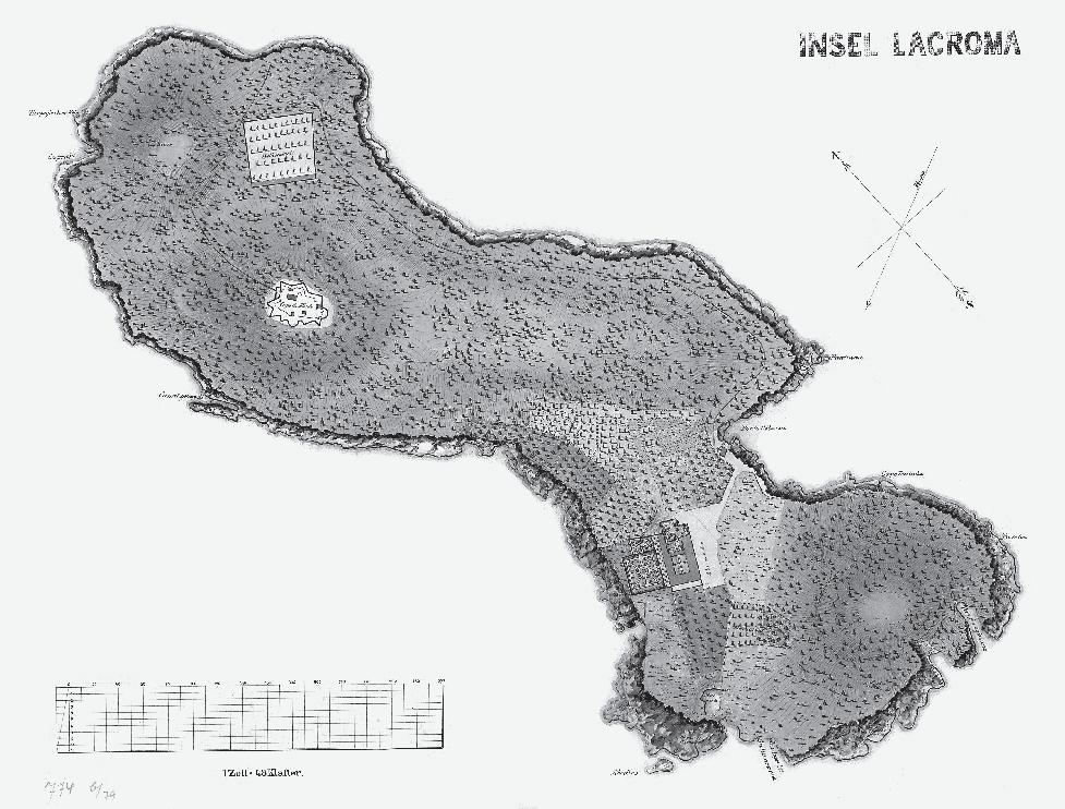
MaxiMilian’s General plan oF the island FroM 1860
The first known plan for Maximilian’s residence on Lokrum is the one covering the whole island, dated in 1860 (Fig. 2).4 The plan was based on Maximilian’s tour of Lokrum with associates in March 1860, on his return from the Brazilian Expedition (1859-60).5 Along with Maximilian, there were the court gardener Franz de Paula Maly (1823-91), the
Fig. 2 General plan of the Lokrum island, 1860, unknown author
botanist Heinrich Wawra (1831-81) and the painter Josef Selleny (1824-75), who had experience in planning and drawing garden plans (Koszteczky, 2007: 59; Basch-Ritter, 2008: 55).
Although the draft is not signed by its author, Maximilian, who was skilled in drawing plans for his residences (Knechtel, 1908: 39) is undoubtedly responsible for making this basic concept of the island, owing to the fact that some names of locations on the island are references to places he visited or with which he was acquainted during his education.6
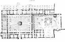
The plan shows several important starting points. First of all, Maximilian and his associates read the Lokrum context well and thus tried to retain the Benedictine heritage located on the island. The imperial residence was planned within the existing Benedictine monastery, and its entire surroundings, i.e., the central part of the island, have been cultivated according to the design.
The idea was to renovate the western wing, which housed the production area with the mill, and to upgrade only half of the former wing on the site of the eastern ruined wing of the older Romanesque monastery with the three-nave and three-apse church of St. Mary. Within the younger Gothic-Renaissance part of the monastery, the reconstruction of the ruined west wing is planned. The characteristic transformation of the complex, from a completely closed monastery to a representative residence of a secular ruler, is visible in the fact that near the residence and
in the east and west, ornamental gardens were planned in places where Benedictines had a simple farmland, pasture, and olive grove.7 To understand the context in which Maximilian’s residence was designed, it is important to emphasise that the Lokrum of Maximilian’s period was primarily a kind of experimental station for the introduction of exotic ornamental plants, together with numerous vegetable and fruit crops (Marić, Vitasović, 2020: 454).8 Therefore, this first plan of the residence shows a “thrifty” attitude towards valuable agricultural land, which was not abundant on the island. Quite certainly, this influenced the completely rational placement of the residence within the existing built and partially demolished Benedictine structures.
Maximilian deliberately planned to expand agricultural land in certain parts of the island. According to the plan from 1860, the northern and southern parts of the island were intended for afforestation, while the central part of the island, in the western and southwestern part, is intended for the expansion of agricultural areas found at the time of purchase: ol-
6 For example, the cape on the northeast side of Portoč Bay on Lokrum is named Pontinha after the coastal part of the town of Funchal which Maximilian visited in Madeira. The name Needles on the extreme southwestern part of the island was a reference to The Needles cliffs on the west side of the Isle of Wight in the English Channel, where Queen Victoria and Prince Albert had a country residence, and which was on Maximilian and Charlotte’s route (Arhita d.o.o. 2019b: Knjiga IV: 54-55).
7 Read from the document: Otok Lokrum na austrijskoj katastarskoj izmjeri iz 1837. DAZD, Uprava za katastarsku izmjeru (Azt-1823-1839) Croatia [HR-DAZD-382].
8 The study found that 220 taxa were planted on the island during the Maximilian period, including 190 species, 4 varieties, 8 hybrids, and 18 cultivars. There were 194 allochthonous taxa, most of them from Central and South America 66, Asian species 47, from Australia 21, from Africa 17 (18) and from the area of North America 13.
9 Read from the document: Otok Lokrum na austrijskoj katastarskoj izmjeri iz 1837. DAZD, Uprava za katastarsku izmjeru (Azt-1823-1839) Croatia [HR-DAZD-382].
10 For example, monkeys were brought to the island as early as 1860. According to archival data, the monkeys were fed bread by Maximilian’s gardener Laube, for which he spent an average of 3 fiorinas a month. In the same year, Maximilian delivered Malvasia vines from Madeira, for new vineyards on Lokrum (AST, Amministrazione Castello di Miramare (1851-1930), n. 30, f. 74 Documentazione contabile della cassa dell’ arciduchessa Carlotta, nn 4-370, 1859-60. Report on garden work in September 1860).
11 The concept of the ferme ornée is a compound word of the English landscape architect Stephen Switzer (16821745), who in his highly quoted work discusses the simultaneous “usefulness and comfort” of gardens, applying the Latin proverb Utile dulci. It is a concept that implies an establishment that has incorporated ornamental gardens with useful and income-generating gardens (Switzer, 1718: xvii).
12 At the Portuguese island of Madeira, Maximilian visited numerous so-called quinte, country farms on which usable land surrounded the residence and brought income. Descriptions of these farms can be found in: Maximilian I, Emperor of Mexico (1868), Vol. II.
13 The term agrarian park is used by Ana Šverko in her research of Garagnin’s gardens near Trogir (Šverko, 2011: 337-386).
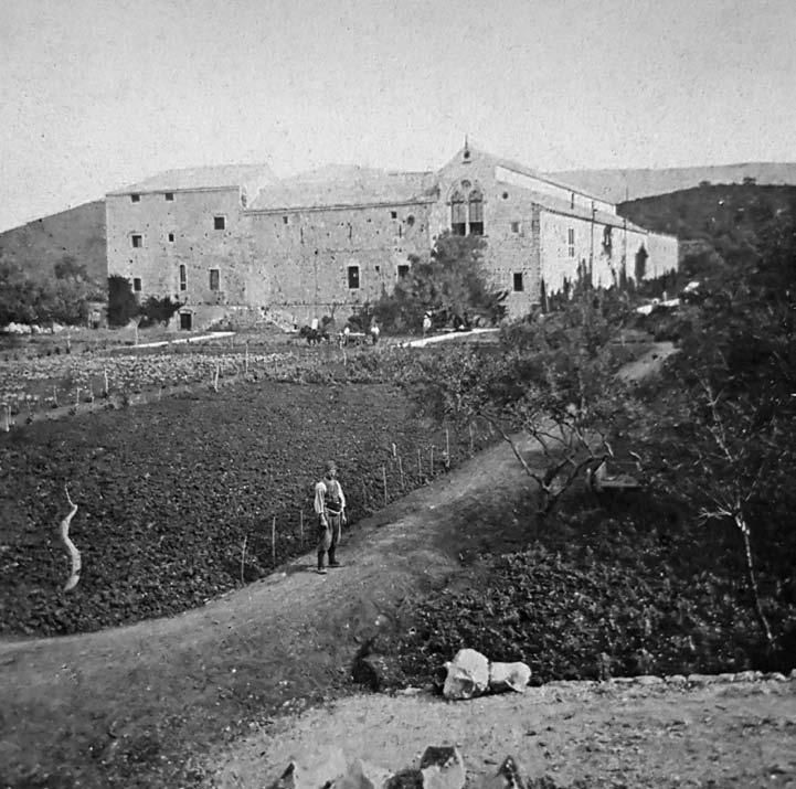
Fig. 3 View from the south on agricultural land in the vicinity of Maximilian’s residence - former Benedictine monastery, author Giuseppe Malovich, before 1864
ive groves, vineyards, orchards.9 As a result, after only a few years, the production of olive oil increased as well as the number of vine vines, many domestic animals were bred, but also many exotic ones as well.10 The areas where animals were kept, as well as the preserved and restored mill from the Benedictine period, were an integral part of the residence, as were in numerous Renaissance country-farm residences in the area of Dubrovnik and beyond.
It is no exaggeration to say that Maximilian sought to establish the concept of so-called ferme ornée11 or the “beautified establishment” on Lokrum (Šverko, 2009: 217-226; Biasoletto, 1841: 39-40; Božić-Bužančić, 1995: 245) as he had the opportunity to see it in many localities in the Mediterranean as well as in Madeira12, but also on one of his travels in Dalmatia, when he stopped at the Garagnin
14 This is evident from the financial projections of Maximilian’s manager Junga, who sought to balance the revenue and expenditure side of the Lokrum establishment (AST, Miramare Castle Administration (1851-1930), N48. f.95 Registry “Prima nota” 1857-67, „Calcolo approsssimativo degli introiti dell’Isola Lacroma per l’ anno 1867“).
15 Franz Xaver Segenschmid (1839-1888) is the author of the projects from 1865 and 1867 and Julius Hofmann (1840-96) of the 1867 project.
16 Juncker was born in Saubersdorf, Lower Austria. He studied at the Royal Polytechnic Institute for Civil Engineers. Juncker’s entire career was tied to water supply systems. In 1847 he participated in the construction of the Suez Canal. He built the Aurisina aqueduct in Trieste. He was also in charge of the construction of the aqueduct of the military arsenal in Pula (1860-61) as well as the water supply systems in Salzburg and Zagreb. In 1864 he worked on the Viennese water supply system of Emperor Francis Joseph I, for which he was awarded the order (Junker Karl, in: *** (1965), Österreichisches Biographisches Lexikon 1815-1950, Volume 3, Vienna: Verlag der Österreichischen Akademie der Wissenschaften, p. 153).
17 In 1860, Junker was awarded the Order of St. Gregory by Pope Pius IX. Historical reviews do not mention for the construction of which church Junker received the order, but it was most likely the construction of a new Catholic church on the site of Gretva in 1857, located on the site of the older church of St. Anton. Juncker actually lived in Bar in Montenegro in 1860, so it seems logical that he was engaged in the construction of the new cathedral (Junker Karl, in: *** (1965), Österreichisches Biographisches Lexikon 18151950, Volume 3, Vienna: Verlag der Österreichischen Akademie der Wissenschaften, p. 153; Rastoder, Š. et al. (2006) Historical Lexicon of Montenegro, Bar Archdiocese and Bar Archbishops, Podgorica: Daily Press).
family agrarian park13 near Trogir (BožićBužančić, 1995: 245). In the Dubrovnik area, the concept of (self) sustainability of the establishment was adopted in ancient times in the organization of Roman villa rustica and especially applied in the period of the Dubrovnik Republic. All the country estates brought income to the owner and at the same time served for the enjoyment of him and the family. This principle was reflected in a particular architectural type of both houses and gardens that would last until the fall of the Republic and later during the 19th century through the idea of physiocracy. Lokrum as an establishment that would be self-sustaining and generate income, was imperative to all managers from Maximilian’s time (Fig. 3).14
One of the first descriptions of Lokrum as an agrarian park is from 1863, in which it is stated that in the vicinity of the residence, there are skilfully combined groups of ornamental shrubs with fruit trees and large areas with planted potato (Winter, 1869: 30-31), which was in that time still poorly cultivated in the Dubrovnik area (Macan, 1961: 309).
projects For lokruM residence 1862-1864
Thomas Friedrich - auThor oF Lokrum ProjecTs unTiL 1866
The question of the authorship of the earliest projects for Maximilian’s Lokrum residence before the dated and signed Segenschmid and Hoffmann projects of 1865 and 186715 has remained unresolved in literature and among academics (Arhita d.o.o. 2019b: Knjiga IV 58). So far, several names have been speculated with in the literature. Chronologically, the first name mentioned as a possible author of the Lokrum project is that of Carl Juncker (1827-82)16, since in 1856 he was working on a project for Maximilian’s Miramar Castle near Trieste (Čorak, 1989: 207211). Junker was staying in the southern Adriatic at the time of making the first plan for Lokrum, but there are no indications of his involvement in the Lokrum projects.17
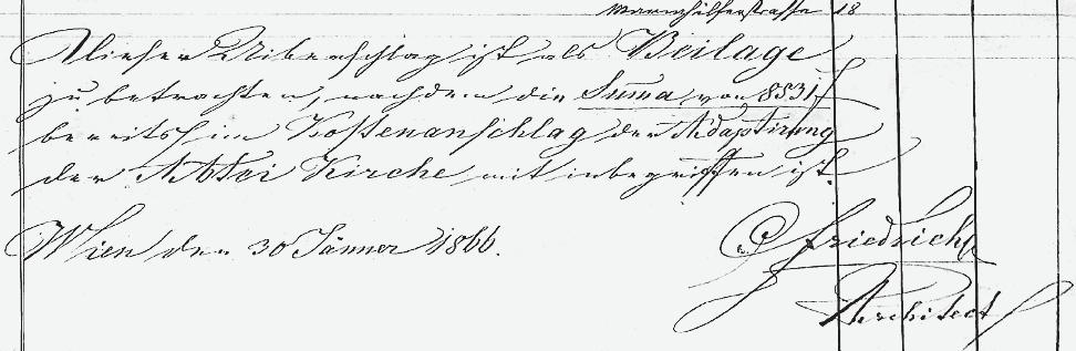
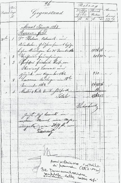
Fig. 5 Invoice submitted by “Professor Friedrich” for the journey from Vienna to Lokrum and back, December 1862 Fig. 4 Signature of the architect Thomas Friedrich dated 30 January 1866 on the bill of quantities for the adaptation of the former Benedictine chapel into a court chapel
The authorship of the first Lokrum project is incidentally indicated in the biography of the Austrian architect Franz Xaver Segenschmid (1839-88), the author of the second project of the residence on Lokrum in the period from 1865 to 1867. In his biography, in the Austrian lexicon of architects, it is stated that he worked on Lokrum, on the already started design solutions of architects Fröhlich and Rosenauer.18 However, the architects with these surnames, from the second half of the 19th century, still cannot be related to Lokrum.19
In her research, Željka Čorak stated that Maximilian hired “the German architect Friedrich” in 1863 to design a project of renewal of the Benedictine monastery on Lokrum (Čorak, 1989: 207-211)20, while Hrvoje Ivanković stated that the hired architect could be the German architect Georg Christian Friedrich Bürklein (1813-72), imperial architect of King Maximilian II of Bavaria (Ivanković, 2017: 192). In the archives of Maximilian’s treasurer
Jakov Kuhačević, a document was found showing that a certain “professor Friedrich”, hired in the new construction project, was paid for a trip from Vienna to Lokrum and back in December 1862 (Fig. 5).21 The same architect also travelled from Vienna to Miramar in 1863, when he was engaged in works for the interior of the Miramar residence, the costs of which were also signed by treasurer Kuhačević.22
The search for an architect with the surname Fridrich, i.e., Friedrich, in the usual places was not successful.23 Of additional interest was the fact that an architect named Friedrich
18 http://www.architektenlexikon.at/de/590.htm (accessed: January 2021)
19 The same lexicon does not mention any architect of the surname Rosenauer, who, according to the time of his birth, would fit to the time of design of Maximilian’s residence on Lokrum. Among the architects with the surname Fröhlich, whose working life coincided with the time of the design of Lokrum, only Franz Xaver Fröhlich (1823-89) stands out, but so far the evidence for this has not been substantiated (http://www.architektenlexikon.at/de/ 1068.htm /accessed: September 2021/). Thanks for the help of Dr. Monika Platzer from Architekturzentrum Wien.
20 In the article from 1989, the form of the name “Fridrich” is used (Čorak, 1989: 209), while in the conservation analysis from 1987, the form of the name “Friedrich” is written (Čorak, 1987: 110).
21 Transcription and translation by Mag. Karin Lackner from ZeitenReise, a company specializing in the transcription of archival documents (AST, Administration of the Castle of Miramare (1851-1930), N 32, f 74 Documentation of the account of the case of the archduchess Carlotta, nn 4-370, 1859-60).
22 The document entitled Miramar Instandhaltung, i.e., the maintenance of Miramar, indicates the amount of 111 fiorinas and 32 krajcars for professor Friedrich. In the same archival material, a train ticket to Grignan for professor Friedrich is located. Transcription and translation by Mag. Karin Lackner from ZeitenReise, a company specializing in the transcription of archival documents (AST, Administration of the Castle of Miramare (1851-1930), N 34, f 78 Documentation of the account of the case of arciduchi, nn 144-237, 1863).
23 Architektenlexikon Wien 1770-1945 (http://www.architektenlexikon.at/) and ANNO Historische Zeitungen und Zeitschriften (https://anno.onb.ac.at/) were searched. Thanks for the help to prof. dr. Matthias Noell. There was a suspicion that unknown architect could be Friedrich von Schmidt (1825-91), whom Maximilian had known since the competition for the construction of the Vienna Votive Church (Votivkirche), but it was unlikely that a professor at the Academy of Fine Arts in Vienna would be officially titled by name, not surname.
24 Thomas Friedrich (Poděbrady, CZ 1821.?-1866) studied at the Polytechnic Institute of Vienna in the academic year 1840/41. Prior to that, he studied in Prague for three years. He also used to work as a bricklayer. By the time he enrolled at the Vienna Polytechnic, his father had already died. From 1842 to 1846 he was an assistant of drawing at the preparatory school (Realschule) at the Polytechnic Institute, and from 1851 to 1864 was appointed as professor at the school of craft drawing (Gewerbs-Zeichenschule). He left his job at the school to lead the Lokrum project. He died of cholera on October 11, 1866 (TUWA, Hauptkatalog der technischen Abteilung für das Studienjahr 1840/41, Eintrag Friedrich, Thomas; TUWA, Personalakt Friedrich, Thomas; Programm für die ordentlichen und außerordentlichen Vorlesungen, welche am k.k. polytechnischen Institute in Wien im Studienjahr 1851/52 statt finden werden Wien 1851 and so on for each academic year until 1864). A special thank you to Dr. Paulus Ebner for assistance in getting this information.
Fig. 6 Ground plan of residences and gardens with the indicated remains of the Lokrum monastery (dark grey)
was indeed signed with a decorative, and therefore harder to read, initial, on the bill of quantities for the project of the court chapel in the Lokrum residence (Fig. 4).
The assumption that the architect Friedrich could have been a student at the Polytechnic Institute of Vienna resulted in an inquiry into the Archives of the Vienna University of Technology. Data was obtained that a certain Thomas Friedrich attended the Polytechnic Institute and later worked as a professor of drawing at the preparatory school for Poly-
technic.24 The connection of his name with the project of Lokrum residence has already been stated in recent Austrian literature (OttWodni, 2019: 82, 87). The publication didn’t publish Friedrich’s projects from the collection of the Austrian National Library brought by this article, but only stated significant differences between the two Segenschmid projects. Segenschmid was Friedrich’s assistant and co-worker who took over and continued Friedrich’s projects. Marlene Ott-Wodni’s research also shows that architect Thomas Friedrich was hired by Maximilian as early as
Fig. 7 Comparison of the three phases of the southern facade project
1860 on a project of the museum in Miramar (Ott-Wodni, 2019: 77).
Friedrich’s ProjecTs
For maximiLian’s residence: PLans and organizaTion oF sPace
Maximilian’s eclectic taste in architecture was a result of his travels, but also of the culture of the time, and he intended to apply that taste to the real Lokrum space. On Lokrum, Maximilian found the remains of the former monastery of St. Mary: from the southern, Renaissance cloister the southern and eastern wings were preserved, while the western wing was demolished (Fig. 3), and in the northern, Romanesque cloister, the western economic wing was preserved, while the eastern wing and the church in the north-
ern part were ruined (Arhita d.o.o., 2019b, Knjiga I: 11).25
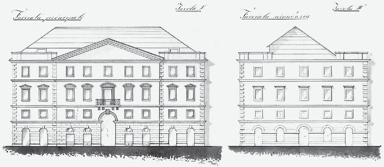
The pencil sketches of the southern, eastern and western facades of the “Lokrum Castle” dated between November 24 and 26, 1862,
25 The Lokrum monastery was first mentioned in 1023. During the 12th century, it experienced a strong rise when a new three-nave three-aisled church was built and flourished again in the second half of the 15th century when a new, Renaissance cloister, dormitory expansion, and probably a new church facade were built. It was destroyed in an earthquake in 1667, when the church and the west wing of the monastery were no longer in use, and when in the south wing, the former refectory of the monastery was transformed into a chapel. In 1707, the last abbot left the island, and the monastery was abolished in 1798 (Lučić, 1987).
26 In addition to the description, all three pencil drawings have a scale drawn. The pencil sketch of the south facade is dated 24 November 1862, and the sketch of the east facade is dated 25 November 1862. The most representative
Fig. 8 Comparison of the three phases of the eastern facade project
made by architect Thomas Friedrich, reveal Maximilian’s plans for his future residence.26
The architect is not signed on the sketches, but it is clearly indicated in the title of the draft that he made them on “the request and instructions of the Most Reverend Archduke
facade is the west facade dated 26 November 1862 (ÖNB, sign. 076 KAR MAG, 078 KAR MAG, 077 KAR MAG).
27 “…nach Anordnung und Angabe Seiner Kaiserlichen Hoheit des durchlauchtigsten Hern Erzherzog Ferdinand Maximilian”
28 The drafts are described, with a scale in Viennese Klafters (1 Viennese Klafter = 1,8965 m). View of the south, east and west facades, undated, unknown author, pen drawing (ÖNB, sign. 008 KAR MAG, 009 KAR MAG, 010 KAR MAG).
29 The designs are described, with a scale in Viennese Klafters (1 Viennese Klafter = 1,8965 m). View of the south, east and west facades, undated, unknown author, pen and watercolour drawing (ÖNB, sign. 084 KAR MAG, 082 KAR MAG, 088 KAR MAG).
Ferdinand Maximilian”.27 Maximilian, therefore, took an active part in the design of his residence.
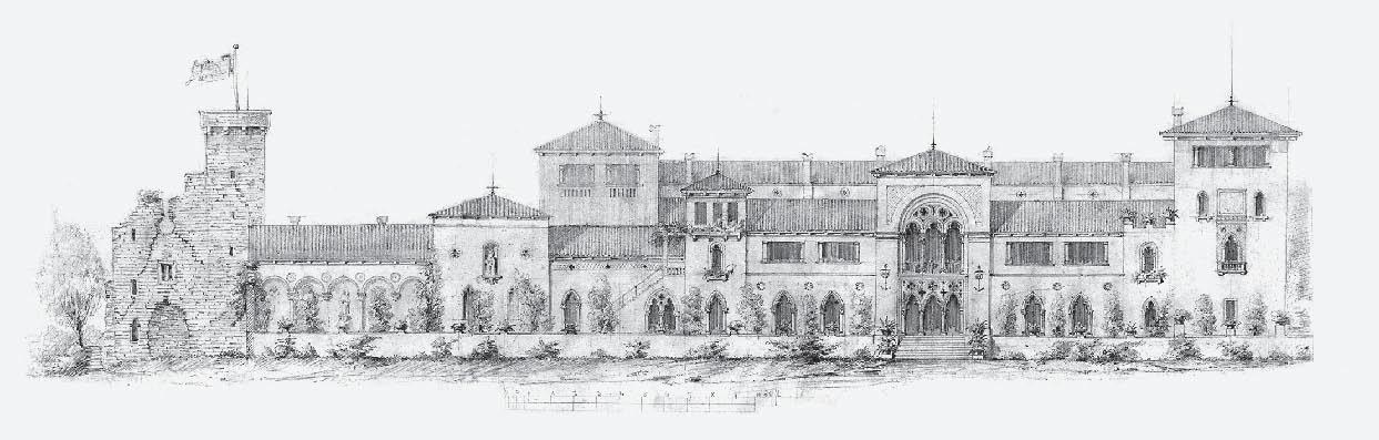
The project proposed raising the south and east wings by one floor and adding new portals, towers, and architectural decorations. The reconstruction of the west wing was planned and the ruins of the church and the remains of the Romanesque part of the monastery were to be consolidated and presented as a picturesque ruin in the spirit of Romanticism (Fig. 6).
Examining two more unsigned and undated blocks of drawings for the south, east, and west facades: three project-elaboration pen drawings28, and three final watercolour pen drawings, which are kept in the Austrian National Library29, we can notice minimal differ-
Fig. 9 Comparison of the three phases of the west facade project
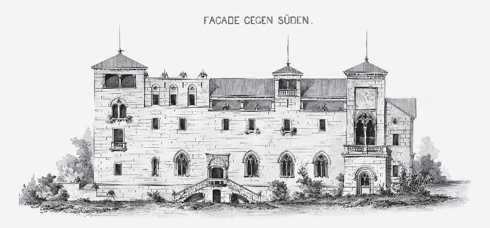
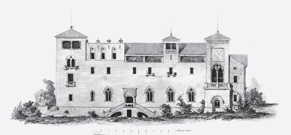
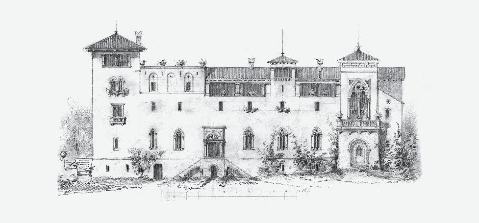
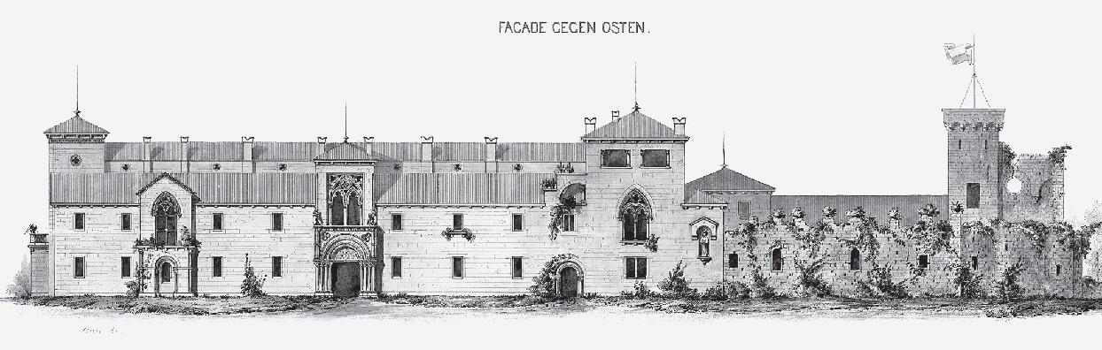
ences between the three phases of the project. Differences in the phases of the facade can be traced in Figures 7-9.30
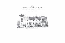
We can conclude that after the first sketches of the facade in November 1862, architect Friedrich, in agreement with Maximilian, made minor changes to the designs and completed them as representative watercolours. We take the end of 1864 as the terminus post quem non the drafts could have been made, since in January 1864 the costs show “costs for the new parts” (Neubauten). 31 That year, Maximilian went to Mexico (Lopez, 2002: 240), so most of the work was probably agreed with the future emperor.
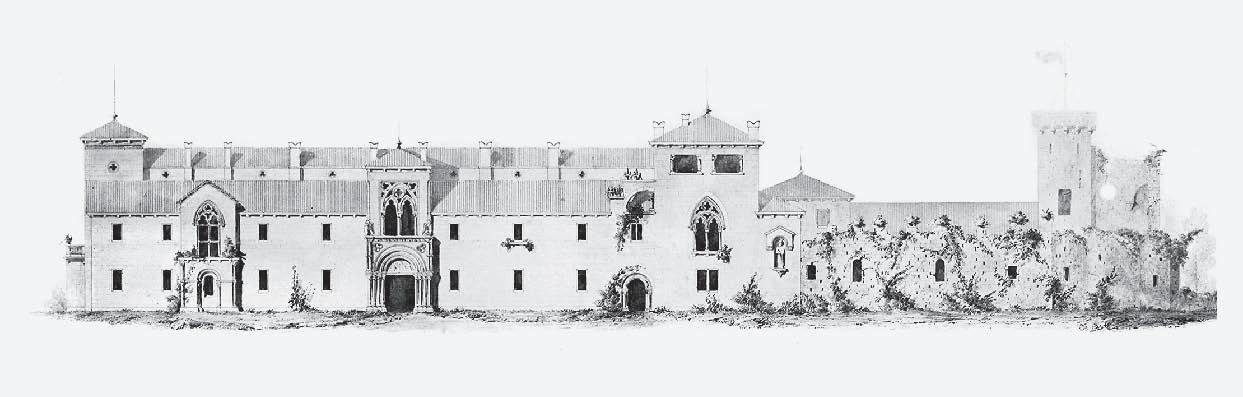
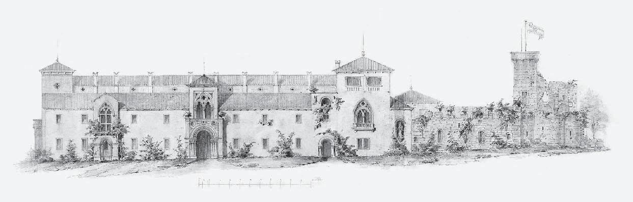
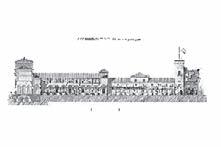
The design of the facade shows a dual character. The south and east facades were designed to be relatively closed, almost like a fortress, which is also contributed to by the numerous newly designed towers that also appeared on the west facade, which usually had the function of loggias and lookouts. Such an approach to the design of the southern and eastern facades is logical, given that these are the wings of the monastery found in situ and which, despite the aspiration for
30 On the south facade, the difference is in the change in the number of openings in the basement floor and in the fresco of an angel above the bifora, which is not shown in the original sketch (Fig. 7). On the eastern facade, the difference between the sketch and the other two drafts is in the addition of the lunette of the centrally placed entrance, in the sculptural elements of the sculpture of (assumed) St. Blaise and in the dimensions and shape of the northern annex (Fig. 8). The western facade was given a more monumental staircase in the further drafts after pencil sketches. The Renaissance medallions above the arcades in the northern part of the facade, present in pencil drawings, were erased in later elaboration (Fig. 9). On all the facades, the window openings are larger and more lavish than those in the sketches.
31 AST, Aministrazione Castello di Miramare (1851-1930), N 35, f 79, Documentazione contabile della cassa degli arciduchi, nn 238-306, 1863-64
32 St. Blaise is usually depicted as a bishop who, as the patron saint of Dubrovnik, holds a model of the city in his hand. In Renaissance painting, he is depicted as an old man with a grey beard holding an iron comb, a sign of martyrdom, and a lit candle, in memory of his wish to heal the sick (Badurina, 1979: 161).
33 Analysed from the ground floor plan, unsigned, undated (ÖNB, sign. 086 KAR MAG).
34 All of the plans have the title of drafts and the scale in Viennese Klafters. The plans in colour, font and style correspond to the final watercolour drafts of the facade and are also dated to the period from 1862 to 1864. The layout plan of residence and gardens, unsigned, undated (ÖNB, sign. 085 KAR MAG). Foundation plan, unsigned, undated (ÖNB, sign. 086 KAR MAG). Ground floor plan, unsigned,
Fig. 10 Ground floor plan, unsigned, undated
architectural adaptation, have their basic constructive logic.
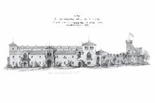
On the south facade, biforas on the ground floor and rectangular windows on the first floor are planned. The corner towers and the tower on the extended second floor contribute to the closed and defensive impression of the building. The eastern facade is rhythmically most uniform with a series of rectangular windows and a prominent central risalit with a Romanesque portal on the ground floor and Gothic biforas on the first floor, where two dragons hold shields. South of the central risalit is a smaller one with similar stylistic features, and in the northern part a tower with Gothic biforas is located on the first floor and a statue, probably St. Blaise, in the extreme northern part.32 The remains of the Romanesque part of the monastery and the church are shown in a typical gesture of that time, as if permeated by nature, and the monastery part of the ruins is accentuated by stylized merlons, which once again indicates the impression of a castle.
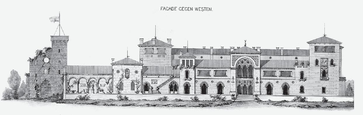
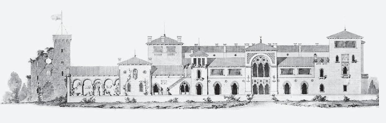
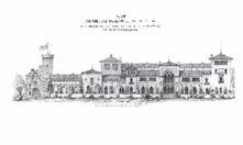
The aesthetics of the newly designed western facade best presents the features that Maximilian intended to achieve in his residence. The aspiration for the facade that opens towards the sea and the gardens in the west could have been realized here, since the project here envisages a newly built wing of the residence. What was once in the monastery time treated as a wall for protection from
undated (ÖNB, sign. 089 KAR MAG). First floor plan, unsigned, undated (ÖNB, sign. 083 KAR MAG). Second floor plan, unsigned, undated (ÖNB, sign. 087 KAR MAG). Project-elaboration ground floor plan, unsigned, undated (ÖNB, sign. 011 KAR MAG). There are no scales on the project-elaboration floor plan, but the functions of the rooms are described. Longitudinal section through both cloisters, unsigned, undated (ÖNB, sign. 081 KAR MAG).
35 Foundation plan, unsigned, undated (ÖNB, sign. 086 KAR MAG).
wind and salt, uninvited views, and possible invaders, has now become the highest quality wing of the whole complex with private spaces of Maximilian and Charlotte.33 Dualpitched and multi-pitched roofs covered in Monk and Nun style enclose volumes different in directions and heights. The facade is defined by a series of Gothic openings - individual on the ground floor and part of the first floor, a bifora under staircase and a monumental two-story trifora in the central axis of the new west wing. An important emphasis of this facade are the loggias (ducador) on the upper floor of the west wing and on the final floors of the north annex, as well as on the south wing of the monastery complex. In the northernmost part of the facade, Renaissance arcades were designed to serve as a peculiar lapidary. The project ensured that the former entrance facade of the demolished Romanesque church was consolidated and presented as a ruin.
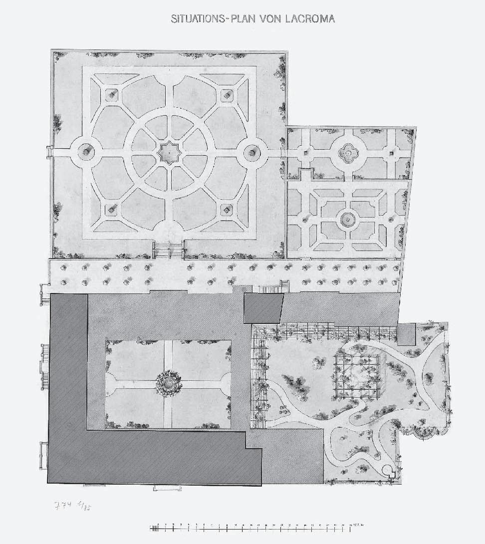
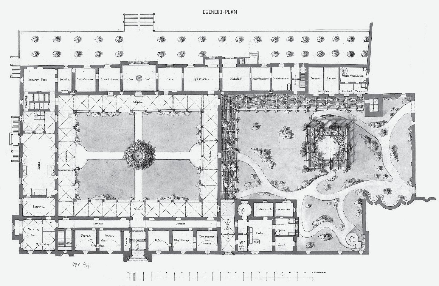
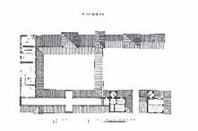
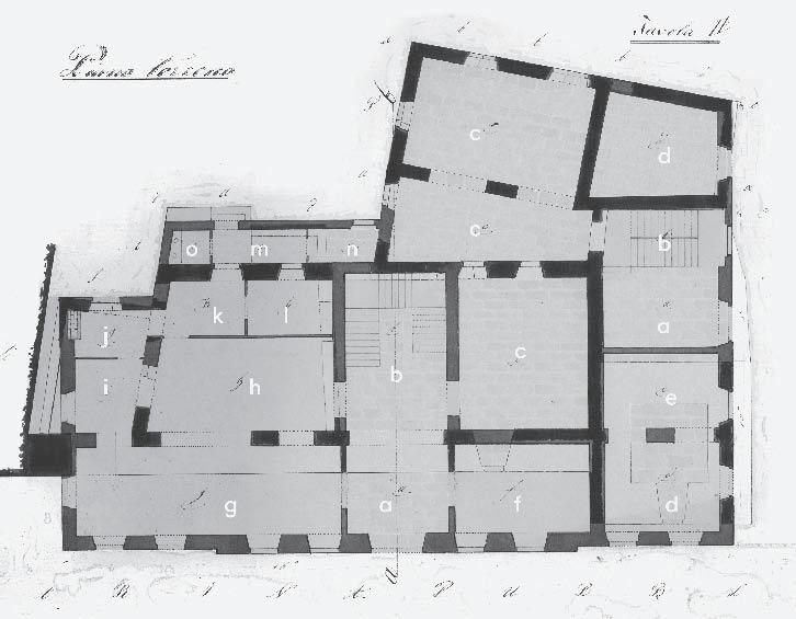
As visible on the general plan of the island from 1860 Maximilian opened the residence to the west but at the same time retained all the spatial conveniences of the monastery cloisters, planning gardens in them - in the northern cloister organic landscape design and in the southern cloister classical fourpart design (Fig. 11). We can follow this idea in the floor plans of the residence that have been preserved - the layout plan of the residence and gardens, foundation plan, ground, first and second floor plan, longitudinal section and a project-elaboration ground floor plan.34 The floor plans are logically laid out, and the relationships between the various functions of the assembly are clear.
In the basement, there were storage rooms, icebox, cistern, and a crypt (with the functions of a warehouse and a tomb), which had to be accessed directly from the outside space.35 On the ground floor plan (Fig. 10), in
Fig. 11 Longitudinal section through both cloisters, unsigned, undated
the southern cloister, the connection between the outer and inner space is visible through a centrally located eastern and western entrance, which ends on the west side with a large terrace with a monumental staircase. The southern cloister, once an introverted space, was to become a place of passage and communication, and the northern cloister a backdrop for a romantic park in which even a “monkey house” is located.36
From the functional zoning of the ground floor, a certain level of respect for the existing monastery is clear.37 The ground floor of the south wing, as in the monastery after the earthquake, was to be reserved for sacral functions. The new, west wing was to be connected by an enfilade, and the living and sleeping areas of the couple were to be located there. In the northern part of the west wing, with a separate entrance, rooms for gardeners were provided. In the east wing, on the ground floor, there were to be two guard rooms, a hunter’s room, a bathroom, and a telegram room, and in the extension, storage, kitchen, pantry, dishwasher and “female kitchen staff” rooms.
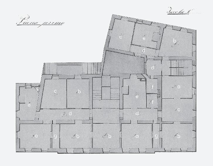
On the first-floor plan, we notice that the former monastery cells in the east wing were retained. Guest rooms, maids’ rooms and doctors’ rooms are being designed there, while servants ‘and maids’ rooms were planned in the northern annex. In the south wing of the first floor, there were to be service rooms, and in the west wing a large lounge, a smoking room, and a billiard room.38
The second floor is visible only on the north annex of the east wing where the cashier’s apartment was planned, and on the floor above, terraces were designed, while on the second floor of the south wing, in the attic, there were storage spaces for furniture, carpets and shutters.39
undaTed draFTs oF chaPeL and Farm buiLding
In addition to the project of the residence itself, three undated and unsigned drafts related to Lokrum were found. The drafts are mutually akin in graphics and handwriting. However, they differ in relation to the drafts of the residence and also to the drafts by Franz Xaver Segenschmid, dated to the period from 1865 to 1867. It is likely that someone else is the author of these three undated and unsigned drafts, possibly another Friedrich’s assistant. Drafts are by analysis dated to the period from 1864 to 1866.
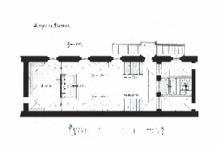
The first draft is a floor plan for the adaptation of the chapel, the pre-earthquake refectory, in the south wing of the monastery, into a court chapel with the visible main and two side altars and benches.40 The second draft shows the view of the main altar in the chapel
interior.41 The third draft shows the farm building design similar to residence (Fig. 12).42 The bill of quantities for the interior decoration of the chapel was signed by architect T. Friedrich on January 30, 1866 (Fig. 4).43
Given that, the identity and role of architects Fröhlich and Rosenauer in the projects for Lokrum have not yet been established, the possibility should be left that they also drew and/or designed Lokrum projects.
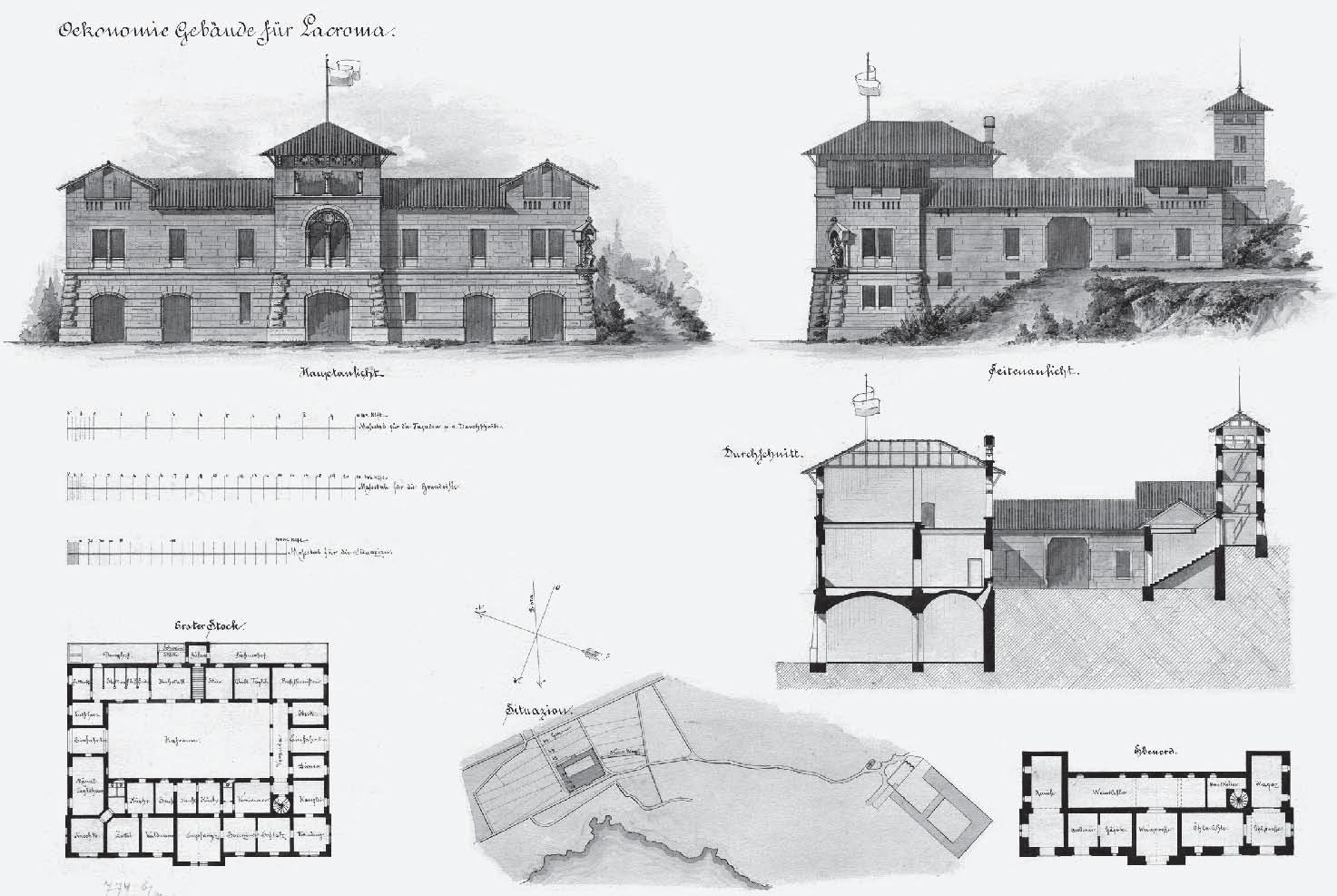
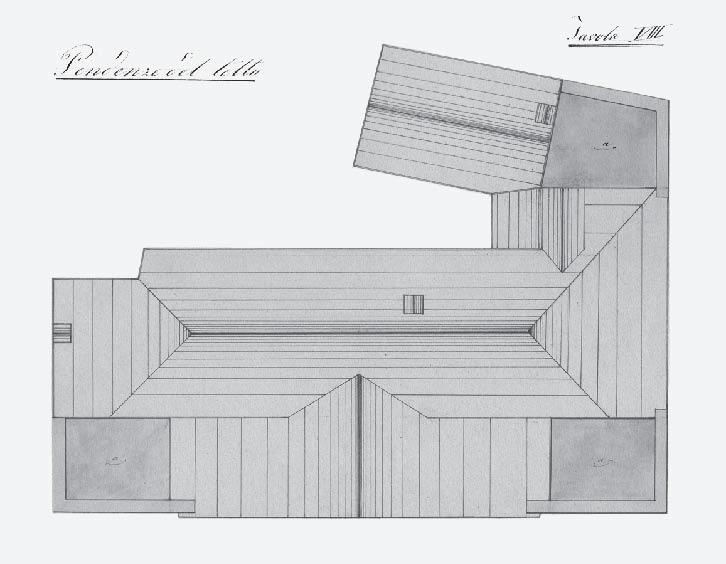
The importance of Lokrum as a sustainable, modern establishment, is also visible in the excellence of the solution for a new farm building. The building is positioned west of the planned Maximilian’s residence, on steep terrain, just below a large reservoir into which water is collected through straight lines of promenades from the highest elevation point on the island - the Fort Royal (Fig. 12). Promenades drawn in the plan between the residence and the non-constructed farm building were mostly built because they still exist today. The cross-section of the building shows that it follows the layers of terrain, and in the layout it is organized around the inner courtyard. On the ground floor, an oil mill, a wine cellar and a brewery were planned. They could be accessed directly from the outside. The first floor, i.e. due to the slope of the terrain, the ground floor of the northern part of the building, is divided into two parts; in the northern part, there are spaces for animals, and in the southern part, service rooms with accompany-
36 In the center of the northern cloister, there was a cistern that was put back into operation (ÖNB, sign. 089 KAR MAG).
38 First floor plan, unsigned, undated (ÖNB, sign. 083 KAR MAG).
39 Second floor plan, unsigned, undated (ÖNB, sign. 087 KAR MAG).
40 The ground plan of the chapel in the south wing of the residence, unsigned, undated (ÖNB, sign. 091 KAR MAG).
The draft is described and has a scale in Viennese Klafters. It is consistent with the ground plan of the chapel, visible in the ground floor plan of the residence in everything except in the lack of openings in the north wall and the lack of one passage to the sacristy.
41 View towards the main altar, unsigned, undated (ÖNB, sign. 090 KAR MAG).
42 Farm building on Lokrum, unsigned, undated (ÖNB, sign. 080 KAR MAG). The same sheet shows the situation, the ground floor plan, the first floor plan, the cross-section, the main and side facades. The plans are described, the names of the rooms are written, and the scales are expressed in Viennese Klafters
43 ÖNB, Kartensammlung, the bill of quantities is among the documents attached to the map with an old signature KAT 774b.
44 Due to too little level of detail, similar as in the project of the residence, the iconographic features of the sculpture are not visible. The miter and pluvial can be seen, which, with regard to Lokrum and Dubrovnik area, points to the identification of the sculpture as Saint Blaise.
45 Analysed by overlapping Segenschmid’s project of the eastern facade and the architectural survey of the Lokrum monastery, i.e., Maximilian’s residence (ÖNB, sign. 006 KAR MAG; Arhita, 2019a).
ing kitchen and dining rooms. On the southeast corner of the facade, facing Maximilian's residence, a sculpture was planned.44
The main, south facade is symmetrical, with smooth-faced rustification on the facade, with quoins on the ground floor. On the ground floor, in addition to rectangular openings, openings with segmental lintels were planned, while in the central axis of the first floor a Renaissance bifora was designed. The corner towers and the central northern and southern risalit, similar as on the residence, contribute to the impression of a castle, but are also conceived as loggias/lookouts.
ProjecT consTrucTion
Maximilian’s residence and farm building were not built according to the project from the 1862 to 1864 period. This project served as the basis for the later project by Franz Xaver Segenschmid. Despite Maximilian’s ambitious plans, the only part of the residence built, out of all commissioned projects, was the northern annex of the eastern wing of the monastery, completed according to the proj-
ect of Franz Xaver Segenschmid in 1866, after the death of architect Friedrich (Ott-Wodni, 2019: 86; Fig. 3).45
discussion
Harmonizing historical fragments into a newer construction, such as turning the Benedictine monastery on the island of Lokrum into an imperial residence, gave investors a sense of continuity, but also a sense of a connection to historical figures and glorious past periods (Arhita d. o. o., 2019b: Knjiga IV, 53; Ćorić, 2021.). The propensity for creative research of history, and application, merging and crossing historical references without indications of stylistic unity that occurred only in high historicism since the mid-19th century, are also visible in Maximilian’s Lokrum project combing historical elements of the Romanesque, Gothic and Renaissance style.
The location of the former medieval monastery on the Lokrum island was the perfect place to develop architectural ideas of Romanticism, framed by carefully designed gardens, parks, and exotic plants.
Fig. 12 Farm building on Lokrum, unsigned, undated
Table I First phase of projects for Lokrum
(description)
1. General plan of the Lokrum island (Insel Lacroma)
sign. 079
2. South facade (Skizze zur südlichen Facade vom Schlosse zu Lacroma nach Anordnung und Angabe Seiner Kaiserlichen Hoheit des durchlauchtigsten Herrn Erzherzog Ferdinand Maximilian) ÖNB, sign. 078 KAR MAG
3. East facade (Skizze zur oestlichen Facade vom Schlosse zu Lacroma nach Anordnung und Angabe Seiner Kaiserlichen Hoheit des durchlauchtigsten Herrn Erzherzog Ferdinand Maximilian)
4. West facade (Skizze zur westlichen Facade vom Schlosse zu Lacroma nach Anordnung und Angabe Seiner Kaiserlichen Hoheit des durchlauchtigsten Hern Erzherzog Ferdinand Maximilian)
South facade (Facade gegen Süden)
South facade (Facade gegen Süden)
7. Project-elaboration East facade (Facade gegen Osten)
9.
West facade (Facade gegen Westen)
plan of residences and gardens (Situations-plan von Lacroma)
sign. 077 KAR MAG unsigned November 25 1862 November 25 1862
facade
facade
sign. 076 KAR
Title (description) Archival signature Signed Dated (on the draft) Dated (according to analysis) Shown drafts Photography
12. Foundation plan (Fundament-Plan) ÖNB, sign. 086 KAR MAG unsigned undated 1862-1864 Foundation plan
13. Ground floor plan (Ebenerd-Plan) ÖNB, sign. 089 KAR MAG unsigned undated 1862-1864 ground floor plan
14. First floor plan (Erster Stock-Plan) ÖNB, sign. 083 KAR MAG unsigned undated 1862-1864 first floor plan
15. Second floor plan (Zweiter Stock Plan) ÖNB, sign. 087 KAR MAG unsigned undated 1862-1864 second floor plan
16. Project-elaboration ground floor plan (Ebenerd-Plan)
ÖNB, sign. 011 KAR MAG unsigned undated 1862-1864 ground floor plan
17. Longitudinal section through both cloisters (Längendurchschnitt durch die beiden Schlosshöfe)
ÖNB, sign. 081 KAR MAG unsigned undated 1862-1864 longitudinal section
18. Ground plan of the court chapel in the south wing of the residence (Kirche zu Lacroma. Grundriss) ÖNB, sign. 091 KAR MAG unsigned undated 1864-1866 ground plan of the chapel
19. View on the main altar (Ansicht des Hauptaltars) ÖNB, sign. 090 KAR MAG unsigned undated 1866 view on the main altar
20. Farm building (Oekonomie Gebäude für Lacroma) ÖNB, sign. 080 KAR MAG unsigned undated 1864-1866 main facade, side facade, section, ground, situation plan, floor plan, first floor plan
The Romanticism of the first half of the 19th century tends to explore nature and historical periods, which necessarily results in the restoration of historical buildings. In 1853, the Central Commission for the Research and Maintenance of Historical Buildings (CentralCommission zur Erforschung und Erhaltung der Baudenkmale) was established in the Monarchy, which provided the institutional framework for dealing with architectural heritage (Sisa, 2002: 172).
With its Romanesque, Gothic and Renaissance references, Maximilian’s Lokrum project should be viewed within four contexts. The first is the context of the investor himself, Archduke Maximilian, for whom the Lokrum residence is one in a series of projects of his own residences, which he himself led and in which he participated with his plans. At the villa and park in Maxing from 1850, design solutions that are proposed vary from the Tyrolean style to references to the French Renaissance (Anders, 2009: 139-156), while at the Miramar Castle, built from 1856 to 1860, numerous design proposals appear, mostly neo-Gothic and Rundbogenstil solutions (Anders, 2009: 156-210). Maximilian usually hired architects or engineers from the Polytechnic, but he also often left the artistic design of buildings to himself, asking the architects only to realize his ideas. This is shown by the engagements of Johann Roman, August Schwedenwein, Carl Juncker, Giovanni Berlam, Thomas Friedrich and Franz Xaver Segenschmid (Barta, I., Ott-Wodni, M, Skrabanek, A., 2019: 21, 43, 82).
The second context in which the Lokrum project should be considered is the work of architects with whom Maximilian collaborated or with whose works he was acquainted, and who moved away from the classical tradition and began to explore other historical styles. Friedrich Hitzig (1811-81) worked on the project of the city palace in Trieste from 1853 (Perotti, 2003: 193), and is important for the Lokrum project because he independently, or as an associate, designed a number of neo-Gothic castles, among which Kittendorf (1848-53) and Kartlow Castle (1853-58) should be singled out (Perotti, 2003: 193).46 Certain links can be observed with the Lloyd Arsenal in Trieste by Hans Christian Hansen (1803-83), which has been designed since 1850 and is characterized by cubic volumes and an impression resembling a fortified castle (Perotti, 2003: 193-194).
The third context in which to consider Maximilian’s project of residence on Lokrum are Maximilian’s personal travel experiences during which he studied numerous examples of country architecture, but also the courts of the then ruling elite. During his trip to England in 1857, Maximilian visited the Windsor
Castle, which Jeffry Wyatville (1788-1840) rebuilt in the Gothic Revival style since 1824 (Perotti, 2003: 198). In Portugal, Maximilian visited the Pena Palace, built by Wilhelm Ludwig von Eschwege for King Ferdinand II of Portugal on the remains of a former monastery (Dorsi, 1986: 24). He also toured the Isle of Wight, where Thomas Cubitt designed the royal residence for Prince Albert and Queen Victoria from 1845 to 1851 (Macnayr, 2008: 203). The toponym Needles at the southwestern end of Lokrum is reminiscent of the latter tour.47 A whole series of Central European “new” buildings created by remodelling and extensions of historic buildings or by inserting parts of old buildings into new buildings should be added to this (Ćorić, 2021: 133-135). One of them is Franzensburg in Laxenburg, a summer residence of the Habsburgs that Maximilian knew very well. The mentioned residence projects did not focus exclusively on the construction of buildings, but, like the Lokrum project, also included the landscaping of the wider territory.
The fourth, last, but fundamental context, was the existing context of the former Benedictine monastery on Lokrum, where the ruins of the Romanesque, Gothic and Renaissance architectural traditions are intertwined, and Maximilian and Thomas Friedrich followed up on them. The existing Gothic bifora on the south facade is repeated on the east, the preserved rectangular windows are adapted to the rhythm of the facade, and the remains of the north cloister and the church are integrated into the romantic vision of the complex. Relations with Dubrovnik’s Renaissance countryside architecture are visible, for example, at the Stjepović-Skočibuha villa in Suđurađ on the island of Šipan, which, at the same time, unites the country, economic and defensive character (Marić, Mirošević, 2021). Details such as the statue of St. Blaise on the facades indicate respect for local traditions.
The project of Maximilian’s residence is one of the most ambitious examples of romantic historicism in Croatia. Maximilian established an establishment on Lokrum based on the concept of ferme ornée. He designed his residence carefully in relation to the existing conditions, and connected it with the gardens in the immediate vicinity. The farm building, the reservoir, and the general plan from 1860 show the intention for a holistic view of Lokrum as a “beautified establishment”. The first project for Lokrum, authored by Thomas Friedrich, shows contemporary Central European historicist experiences wo-
46 Friedrich Hitzig participated in the design on Neetzow Castle (1848-91), Kartlow Castle (1853-58) and Bredenfelde Castle (1854-55).
47 ÖNB, sign. 079 KAR MAG
ven into the local traditional context, from the organization of the residence to the subtle motifs on the facades, suggesting belonging to Dubrovnik’s architectural heritage. The first project for Lokrum, in which Maximilian participated both as an investor and as a (co) designer, due to the demonstrated spatial ambition and luxury and the uniqueness of the solution, extends well beyond the local Dubrovnik and Croatian context, and places Lokrum in the context of Central European Romanticism.
conclusion
This research deals with the project for Maximilian’s residence on Lokrum island in the period from 1860 to 1866 in which Maximilian’s idea of Lokrum as a “beautified establishment” was presented. Twenty archival drafts have been described textually, and graphically published.
Maximilian actively participated in the planning and design process, but the author of the projects was Thomas Friedrich. The general plan of the island from 1860 was followed by sixteen preserved plans of Maximilian’s residence, which are, by this research, dating to the period from 1862 to 1864. Three drafts for the farm building and court chapel are dated to the period from 1864 to 1866. In addition to Franz Xaver Segenschmid, who
was Thomas Friedrich’s assistant on the first Lokrum project, it is possible that some other architects participated in the design. The identity and role in the Lokrum projects by architects Fröhlich and Rosenauer, probably also their colleagues from the Polytechnic, has not yet been established.
Although Maximilian’s residence was not constructed by his first concept, most of the interventions in the landscape of the island of Lokrum were carried out just in accordance with this first concept. These interventions are still clearly “readable” in Lokrum’s landscape. When renovating the Lokrum gardens, this concept should be taken into account. Comprehensive approach to the conservation of the Benedictine monastery and Maximilian’s summer residence on Lokrum is needed with respect of all historical layers according to conservation-restauration methods with special attention to benedictine interventions in 17th and 18th centuries, the Segenschmid projects from 1865 to 1867 and the present condition of the buildings, which were not the subject of this research.
All of Maximilian’s concepts and projects of the arrangement of Lokrum should be interpreted in an appropriate way in the museum exhibition on the island of Lokrum.
[Translated by: Marin Duić]
Bibliography and sources
1. Anders, F. (2009) Von Schönbrunn und Miramar nach Mexiko : Leben und Wirken des Erzherzog-Kaisers Ferdinand Maximilian, Klosterneuburg: Akademische Druck- und Verlagsanstalt.
2. Badurina, A. (ed.) (1979) Leksikon ikonografije, liturgike i simbolike zapadnog kršćanstva, Zagreb: Sveučilišna naklada Liber.
3. Barta, I., Ott-Wodni, M. and Skrabanek, A. (2019) Repräsentation und (Ohn)Macht, Wien: Böhlau Verlag. https://doi.org/10.7767/97832 05200376
4. Basch-Ritter R. (2008) Die Weltumsegelung der Novara 1857-1859: Österreich auf allen Meeren, Graz: Akademische Druck- u. Verlagsanstalt.
5. Biasoletto, B. (1841) Relazione del viaggio fatto nella primavera dell’anno 1838 dalla maestà del re Federico Augusto di Sassonia nell’ Istria, Dalmazia e Montenegro. Trieste: Tipografia Weis
6. Božić-Bužančić, D. (1995) Južna Hrvatska u europskom fiziokratskom pokretu. Pokret za obnovu gospodarstva, gospodarske akademije, ogledni vrtovi i poljodjelske škole druge polovice XVIII. i početka XIX. stoljeća. Split: Književni krug u Splitu, biblioteka znanstvenih djela, 76.
7. Brailo N. (2002) ‘Vrtovi u sklopu Maksimilijanovog ljetnikovca na otoku Lokrumu’, Agronomski glasnik, 64(1-2), pp. 87-109.
8. Covre, P. (1986) ‘Breve cenno sulle monete e sulle medaglie del Messico’, in: Loseri, L.R. (ed.) Massimiliano da Trieste a Mesico, Catalogo. Trieste: Mostra Promossa dalla Provincia di Trieste, Edizioni Lint Trieste, pp. 111-152.
9. Čorak, Ž. (1989) ‘Lokrum u srednjoj Europi’, in: Meštrov, M. (ed.) Otok Lokrum: Zbornik radova sa Simpozija održanog od 8-11.9.1987. u Dubrovniku, Zagreb: Hrvatsko ekološko društvo, pp. 207-211.
10. Ćorić, F. (2021) ‘Historicistički asamblaži: autentični fragmenti u novom kontekstu’, in: Materijalnost umjetničkog djela. Zbornik Dana Cvita Fiskovića VIII, Marković, P. (ed.) Zagreb: FFPress, pp. 127-139.
11. Dorsi, P. (1986) ‘La nascita del Parco di Miramare nelle Relazioni inedite di Anton Jelinek’, in: Un giardino in riva al mare Il parco di Miramare ieri e domani: vicende storiche e prospettive culturali, Cucchi, F., Pirrone, G. (ed.), Trieste: Edizioni Dedolibri, pp. 21-54.
12. Foretić, M. (2007) ‘Maksimilijan Habsburški i Dubrovnik’, in: Kisić, A., Macan, T., Obad, S. (ed.) Zbornik odabranih radova o Dubrovniku u povijesnim i kulturnim mijenama, Dubrovnik: Ogranak MH u Dubrovniku, pp. 344-368.
13. Ivanković, H. (2017) ‘Tjeskobno blaženstvo Maksimilijanova raja’, Časopis Dubrovnik, 4, pp. 175-215.
14. Knechtel, W. (1908) Handschriftliche Aufzeichnungen meiner persönlichen Eindrücke und Erlebnisse in Mexico in den Jahren 1864-1867, Prague: Druck Von Karl Bellman
15. Koszteczky, G. (2007) Die Geschichte der Wiener Grünflächen im Zusammenhang mit dem sozialen Wandel ihrer BenützerInnen, Dissertation, Vienna: Historisch-Kulturwissenschaftliche Fakultät. DOI: 10.25365/thesis.371.
16. Lopez, M.B. (2002) ‘Los conservadores y los indios: Anselmo de la Portilla’, in: Muñoz, F.M. (ed.) La imagen del México decimonónico de los visitantes extranjeros: un Estado-Nación o un mosaico plurinacional? Mexico: Universidad Nacional Autonoma de Mexico, pp. 237-260.
17. Lučić, J. (1989) ‘Prošlost otoka Lokrumu’, in: Meštrov, M. (ed.) Otok Lokrum: Zbornik radova sa Simpozija održanog od 8-11.9.1987. u Dubrovniku, Zagreb: Hrvatsko ekološko društvo, pp. 183-197.
18. Macan, T. (1961) ‘Jaroslav Čermak u Župi dubrovačkoj’, Prilozi povijesti umjetnosti u Dalmaciji, 13(1), pp. 307-321.
19. Macnayr, L. (2008) Situating Charlotte: Reading Politics in Portraits of Belgian Princess Charlotte, Vicereine of Lombardy-Venetia, Empress of Mexico, Ph.D. thesis, Ontario: Queen’s University Kingston.
20. Marić, M. (2020) ‘Erzherzog Maximilians Traum von einem Garten auf der Insel Lokrum bei Dubrovnik. Arbeiten im Garten zu Zeiten des Gärtners Josef Laube’, Die Gartenkunst, 32, pp. 267-276.
21. Marić, M. and Mirošević, D. (2021) ‘Utjecaj obitelji Stjepović-Skočibuha na strukturiranje naselja Suđurađ na otoku Šipanu’, Povijesni prilozi, 40 (60), pp. 257-291. https://doi.org/ 10.22586/pp.v40i60.11829
22. Marić, M. and Obad Šćitaroci, M. (2018) ‘Gardens of the Mexican Emperor Ferdinand Maximilian Joseph I of Habsburg on the Island of Lokrum near Dubrovnik - accomplished ideas and projects’, Studies in the history of gardens & designed landscapes, 39, 4; pp. 332-350. https:// doi.org/10.1080/14601176.2018.1546489
23. Marić, M. and Obad Šćitaroci, M. (2019) ‘Lokrum Walkway - Alameda’, Prostor, 27, 1, pp. 5063. https://doi.org/10.31522/p.27.1(57).4
24. Marić, M. and Vitasović Kosić, I. (2020) ‘Horticultural species of the Island of Lokrum in the Period of Archduke Maximilian of Habsburg (1859-1869) and their current state’, Šumarski list, 144, 9-10, pp. 443-454. https://doi.org/10. 31298/sl.144.9-10.1
25. Massimiliano d’Asburgo M. (1987) Mia cara, adorata Charlotte : lettere 1856-1859 dell’Arciduca Massimiliano d’Absburgo alla moglie Carlotta del Belgio, Trieste: Marino Bolaffio
26. Maximilian I. Emperor of Mexico, (1868), On The Wing, London: Sonuders Outley and Co.
27. Ott-Wodni, M. (2019), ‘Das weiße Schloss am Meer. Miramar in Triest’, in: Barta, I., Ott-Wodni, M., Skrabanek, A. (eds.), Repräsentation und (Ohn)Macht : Die Wohnkultur der habsburgischen Prinzen im 19. Jahrhundert - Kaiser Maximilian von Mexiko, Kronprinz Rudolf, Erzherzog Franz Ferdinand und ihre Schlösser, Band 038, Köln, Weimar, Vienna: Böhlau Verlag, pp. 43-81.
28. Ott-Wodni, M. (2019) ‘”Die Immergrüne Feeninsel” Lacroma in Dalmatien’, in: Barta, I., OttWodni, M., Skrabanek, A. (eds.), Repräsentation und (Ohn)Macht : Die Wohnkultur der habsburgischen Prinzen im 19. JahrhundertKaiser Maximilian von Mexiko, Kronprinz Rudolf, Erzherzog Franz Ferdinand und ihre Schlösser, Band 038, Köln, Weimar, Vienna: Böhlau Verlag, pp. 81-89.
29. Perotti, E. (2003) ‘Preussen an der Adria: Einflüsse Schinkels und der Schinkelschule auf die habsburgische Bautätigkeit in Triest nach der Mitte des 19. Jahrhunderts’, in: Jahrbuch. Stiftung Preussische Schlösser und Gärten Berlin-Brandenburg, Bd. 5, Berlin: Akademie Verlag, 2005, pp. 191-202.
30. Pozzetto, M. (1986) ‘Il Parco di Miramar ieri e domani, storia, idee, ipotesi’, in: Cucchi, F., Pirrone, G. (ed.) Un giardino in riva al mare Il parco di Miramare ieri e domani: vicende storiche e prospettive culturali, Trieste: Edizioni Dedolibri, pp. 1-19.
31. Scherzer, K. (1863), Narrative of the Circumnavigation of the Globe by the Austrian frigate Novara (Commodore B. von Wullerstorf-Urbair,), Undertaken by order of the imperial government, in the years l857, 1858, & 1859, Under the immediate Auspices of His I. and R. Highness the Archduke Ferdinand Maximilian, Commander-in-Chief of the Austrian Navy, Vol. III., London: Saunders and Otley.
32. Sisa, J. (2002) ‘Neo-Gothic Architecture and Restoration of Historic Buildings in Central Europe: Friedrich Schmidt and His School’, Journal of the Society of Architectural Historians, Vol. 61, No. 2 (Jun. 2002), pp. 170-187. https://doi. org/10.2307/991838
33. Skofitz, A. (ed.) (1859), Vereine. Gesellschaften. Anstalten, Österreichische Botanische Zeitschrift, 9(11), pp. 374-375. https://doi.org/ 10.1007/BF01962444
34. Switzer, S. (1718.) Ichnographia rustica; or The nobleman, gentleman, and gardener’s recreation. London: D. Browne. https://doi.org/10. 5962/bhl.title.24939
35. Šverko, A. (2009) ‘Ferme Ornée Garagninovih u Divuljama kod Trogira’, Radovi Instituta za povijest umjetnosti, 33(1), pp. 217-226.
36. Šverko, A. (2011) ‘Selvin casinetto u agrarnom parku Luke Garagnina’, Prilozi povijesti umjetnosti u Dalmaciji, 42, pp. 337-386.
37. Visiani, R. (1863) Sulla vegetazione e sul dima dell’isola di Lacroma in Dalmazia, Trieste: Coen.
38. Winter, B. (1869) Meine Erste See-Reise durch Dalmatien nach Corfu im Jahre 1863, Vienna: Mechitaristen
Document sources
1. Arheo plan d.o.o., Arhita d.o.o. (2011) Benediktinski samostan i crkva sv. Marije na Lokrumu, Conservation Analysis, Dubrovnik: Arheo plan, Arhita.
2. Arhita d.o.o. (2019a) Architectural survey of the former Benedictine monastery on the Lokrum island, Dubrovnik.
3. Arhita d.o.o. (2019b) Kompleks benediktinskog samostana i Maksimilijanove rezidencije : Otok Lokrum, Conservation Analysis, Dubrovnik: Arhita d.o.o.
4. Čorak, Ž. (1987) ‘Maksimilijanov dvorac’, in: Badurina A. (ed.), Benediktinski samostan na Lokrumu : povijesni razvoj i analiza prostora : prijedlog smjernica za zaštitu. Conservation documentation, Zagreb: Centar za povijesne znanosti, Odsjek za povijest umjetnosti, pp. 79-115.
5. Državna geodetska uprava, Područni ured za katastar Dubrovnik (1988), Site plan survey of the Lokrum island.
6. Marić, M., Ivušić, N. and Marinović-Peričević, M. (2018) Vrtna studija, Vrtovi Benediktinskog samostana i Maksimilijanovog ljetnikovca na otoku Lokrumu, Zavod za obnovu Dubrovnika, Dubrovnik: Sveučilište u Dubrovniku, Zavod za mediteranske kulture.
7. Marić, M. and Medović, M. (2019) Vrtna studija, Pristupne šetnice Benediktinskom samostanu i Maksimilijanovu ljetnikovcu na otoku Lokrumu, Zavod za obnovu Dubrovnika, Dubrovnik: Sveučilište u Dubrovniku, Zavod za mediteranske kulture.
Archival sources
1. Austrian National Library(Österreichische Nationalbibliothek) [ÖNB]
2. Austrian State Archives in Vienna (Österreichisches StaatsarchivHaus-, Hof- und Staatsarchiv (Abteilung)) [AT-OeStA/HHStA]
3. State Archives in Trieste (Archivio di Stato di Trieste) [AST]
4. The State Archives in Zadar [DAZD]
5. Technical University Vienna (TU Wien) [TUWA]
Internet sources
1. www.architektenlexikon.at/de/590.htm
2. www. deutsche-biographie.de
3. ANNO Historische Zeitungen und Zeitschriften (https://anno.onb.ac.at/)
Illustration sources
Fig. 1 Photo: Boris Jović, 2021
Fig. 2 ÖNB, sign. 079 KAR MAG
Fig. 3 Austrian State Archives in Vienna, sign. Ke34-01 Lacroma Bd.04
Fig. 4 ÖNB, Kartensammlung, document in the cover attached to the map with old signature (new sing. 080 KAR MAG)
Fig. 5 AST, Amministrazione Castello di Miramare (1851-1930), n. 32, f. 74 Documentazionecontabiledellacassa dell’arciduchessa Carlotta, nn 4-370, 1859-60
Fig. 6 ÖNB, sign. 085 KAR MAG
Fig. 7 below - pencil sketch, 24 November 1862. ÖNB, sign. 078 KAR MAG; middle - projectelaboration draft ÖNB, sign. 008 KAR MAG; above - final pen and watercolour drawing ÖNB, sign. 084 KAR MAG
Fig. 8 below - pencil sketch, 25 November 1862. ÖNB, sign. 077 KAR MAG, middle - projectelaboration draft ÖNB, sign. 009 KAR MAG, above - final pen and watercolour drawing ÖNB, sign. 082 KAR MAG
Fig. 9 ÖNB, sign. 076 KAR MAG, middle - projectelaboration draft ÖNB, sign. 010 KAR MAG, above - final pen and watercolour drawing ÖNB, sign. 088 KAR MAG
Fig. 10 ÖNB, sign. 089 KAR MAG
Fig. 11 ÖNB, sign. 081 KAR MAG
Fig. 12 ÖNB, sign. 080 KAR MAG
Authors’ biographies and contributions
Mara Marić, Ph.D., MLA. Scientific and professional interest is in the field of historical gardens and landscapes and principles of their restoration. Franko ćorić, Ph. D., Associate professor. His scientific interests are the historical and contemporary theories of conservation and connections with the German-speaking area.
Mladen obad Šćitaroci, Ph.D., F.C.A., is a professor emeritus at the Faculty of Architecture University of Zagreb. His area of scientific interest includes restoration of cultural heritage, history of landscape architecture and urban heritage. [www.scitaroci.hr] Marin duić is an architect and a graduate student in history of art currently enrolled in doctoral studies at the Faculty of Architecture, University of Zagreb.
Conceptualization: M.M., M.O.Š.; methodology: M.O.Š.; formal analysis: M.D.; investigation: M.M., F.Ć.; resources: M.M.; data curation: M.M.; writing - original draft preparation: M.M., M.D., F.Ć.; writing - review and editing: M.M., M.D., F.Ć.; supervision: M.O.Š. All authors have read and agreed to the published version of the manuscript.
Fig. 1 Josip Slade (attributed to): Tenement house for Antonio Fanfogna beside the southern town gate in Trogir from the year 1859, southern façade
Institute of Art History, Ulica Grada Vukovara 68/III, 10000 Zagreb orcid.org/0000-0001-6282-9285
asverko@ipu.hr
Original Scientific Paper
https://doi.org/10.31522/p.29.2(62).2
UDC 721 728 (497.5 Trogir) ”18”
Technical Sciences / Architecture and Urban Planning
2.01.04. - History and Theory of Architecture and Preservation of the Built Heritage
Attributing and Defining an Unbuilt 1859 Architectural Plan for the Site of Trogir’s Medieval Walls
Fanfogna-Garagnin, Antonio Slade, Josip
tenement housing town walls
Trogir
This paper discusses the attribution of an anonymous and unbuilt 1859 plan for a four-storey apartment building with commercial spaces on the ground floor, located on the site of the old town walls in Trogir. It proposes Josip Slade as the architect of the plan, interpreting Slade’s architectural language and the development of his approach to architectural heritage. An analysis of the project in a historical socio-political and spatial context, moreover, supports the conclusion that this was intended as rental property, and this paper therefore offers insights into the first known example of the tenement housing building typology in the nineteenth-century Trogir.
Thearchives of the Garagnin-Fanfogna family, kept in what was once the residence of this Dalmatian family of Venetian background and is today the Trogir City Museum, contain a plan for a residential building with a café and shops on the ground floor. The plan is dated to 1st of October 18591, and is unsigned; the title page contains only this date, the name of the project’s backer, the type of construction expected, and the location: Progetto di riffabbrica ed ampliamento d’uno stabile di proprietá del Conte Antonio de Fanfogna - Garagnin, sito sulla strada di circonvallazione della Cittá di Traú, e precisamente a destra della porta detta della Marina (Fig. 1).
Count Antonio Fanfogna-Garagnin (18181893), who commissioned the project, was an influential investor and a member of a wealthy merchant family. One year earlier, he had become the mayor of Trogir (Babić, 2016: 143-145). The identity of the backer, and the intention to reconstruct and enlarge a building in one of the most prominent locations in Trogir - on the site of the medieval town walls and directly beside the southern gates of the town, which were Mannerist in styleare intriguing facts that suggest the need for a multi-layered study of this plan.2
It was first necessary to research the history of the site, and then consider the attribution of the project in the context of the architects active in Trogir at the time. Although there is
no direct evidence in the archives, given the style and method of architectural expression, it is possible to assume that the plans were designed by the most prominent of these architects, the Trogir-born Josip Slade (18281911).3 After completing his studies in Padua in 1853, Slade worked in the region stretching from Dalmatia to Montenegro.4 Slade is known to have done work for Antonio Fanfona-Garagnin, despite the fact that politically Fanfona-Garagnin was a prominent Autonomist who believed in preserving the autonomy of the Kingdom of Dalmatia, while Slade was from the People’s Party, which argued for the unification of Dalmatia with Croatia and Slavonia (Celio-Cega, Šverko, 2013: 201206). In 1901, Slade became the mayor of Trogir. Further support for the attribution of this design to Slade lies in the handwriting and style of drawing, which have been identified as Slade’s on the basis of other projects that are known to have been his.
The next research level focused on determining the programme and organisation of the building (in which a particularly important role was played by the investor’s identity), which suggests that this was a rental property featuring a total of nine housing units on three levels, and commercial and hospitality facilities on the ground floor. In order to confirm that Slade was the architect of this project, further research was carried out, and was based on determining the style and disposition of the spatial implementation of the building programme, as well as the architectural and urbanistic characteristics of the building. In addition, it was necessary to determine their connection to Slade’s architectural style and approach in a historical context.
The most delicate research level was based on the fact that the building was designed for the site of Trogir’s medieval fortifications, beside the town’s monumental southern entrance (Fig. 2). From a modern perspective, the town walls are unquestionably the building’s superior, a historical, architectural, and urban authority that the new building completely ignores. It is entirely likely that Slade’s approach was hereby influenced by the ruling spirit of the age: across Europe,
1 Trogir City Museum - Garagnin-Fanfogna Library, sign. VI f. Folder containing 8 sheets. Dimensions: 32´23.3 cm.
2 For more on Trogir’s historical town walls see, see: Babić, 2016: 158-186.
3 For more on Slade’s work and the archival materials kept in the State Archives in Split, see: Fisković, 1987.
4 For more on Slade’s work in Montenegro, see: Mitrović, 2020.
5 On the spatial development of Trogir, see Babić, 2016: 9-38.
6 In terms of demographics, the early nineteenth-century in Dalmatia was marked by famine and drought (18023), Napoleon’s Russian campaign in 1812, famine and plague (1815-6), cholera (1848-9), and a food shortage in
and in Trogir and Dalmatia on a more modest scale, cities were transformed by the demolition of city walls and the formation of new types of buildings and public spaces in keeping with new social values.
the urban history oF the site throuGhout the First halF oF the nineteenth century
Trogir’s historical centre is located on a small island between the mainland and the island of Čiovo. Since ancient times, its shape and boundaries have been in constant flux, changing in accordance with the town’s fortifications.5 In order to recognise the influence of the social and economic changes of the first half of the nineteenth century on the architecture of Trogir’s historical centre, at a time when European city fortifications were irrevocably losing their function, it is necessary to briefly note the relevant key characteristics of this period in Dalmatia.
After the fall of Venice and the short-lived French administration (1806-1813), the whole of Dalmatia, including Trogir, became part of the Austrian Empire, where it would remain until the fall of the Austro-Hungarian Empire in 1918. In 1844, Trogir and its outskirts had a population of 3029; 1020 of these were farmers, and others were members of the aristocracy, clergy, officers, tradesmen, fishermen, and craftsmen, while the population of the town itself was 1843 in the year 1857.6 The revolutions of 1848-9 also had an impact on Trogir (Piplović, 1996: 35; Babić, 2016: 140145). As in other parts of Croatia of the time, these events marked the beginning of the transformation into a modern civil society. Changes on the European level were felt in Trogir, with greater attention being paid to the quality of public space in the town (Babić, 2016: 146-150). The key interventions are related to the improvement of sanitation. Long epidemics were primarily blamed on the narrow streets within the town walls, shallow waters full of built-up material, and inadequate bridges towards the mainland and Čiovo, as they blocked the necessary sea currents from flowing. In terms of construction, the munici-
1849. According to a census on the 31st of October 1857, the population of Dalmatia was 415,628. See: Omašić, 1988: 856; Kozličić, Bralić, 2012: 249.
7 He completed his primary and secondary education in his native Zadar in 1834. Katarina and Antonio had five children: Ruđer, Kolan, Dijamanta, Ivan Dominik, and Ivan Luka.
8 A reliable source of information on the urban structure of the nineteenth-century Trogir is Francis I’ cadastre, which has been studied in detail by I. Benyovsky. The plots beside the southern town gate that were affected by the building plan, and which were not owned by the Garagnins, were numbers 498, 499, 500, 501 (Benyovsky, 2005: 31-102).
pal government’s response to these obstacles to the town’s development was directed towards further demolition of the town walls, which had begun under the French administration, towards the reconstruction and adaptation of the bridges, and the renovation of the harbour and waterfront. These urban projects were initiated in precisely the period that Antonio Fanfogna-Garagnin was mayor of Trogir (Piplović, 1996: 49).
The Garagnins had been Venetian merchants who came to Trogir in the late sixteenth century. They quickly amassed a fortune and established connections with prominent Trogir families through marriage. They became landowners, intellectuals, and aristocrats. When the family’s last descendant, Katarina, married the Zadar aristocrat Antonio Fanfogna in 1840, the family adopted the surname Garagnin-Fanfogna. Upon arriving in Trogir, Antonio entered the public life of the town as a prominent Autonomist, first as the commander of the National Guard, and then, as has already been mentioned, as the mayor of Trogir from 1858 onwards. He remained in this position (with only one short break in 1864), until the People’s Party came to power in 1886.7
Throughout the 17th and 18th centuries, the Garagnins purchased abandoned and dilapidated buildings in the town as the basis for their building campaigns (Celio-Cega, 19992000: 348-353; Šverko, 2008: 375-436). In addition to the family’s palace complex located next to Trogir’s northern gate, they were the majority owners of groups of plots on the island itself, located directly beside the southern town gate, the future location of the building that is the focus of this paper.8 The Porta Marina, as it is described in the description of the location of this building, is the impressive southern, so-called Sea Gate, built in 1593. The project we are analysing
Fig. 2 Franz Thiard de Laforest: View of Trogir from Čiovo. Cega Palace and the Tower of St Nicholas are highlighted.
was to take up part of the Tower of St Nicholas located to the west of the gate, as well as the area beyond, including the Romanesque Cega Palace, which at that time was owned by the Garagnin family. Its southern façade was the medieval town wall with its battlements and Romanesque windows, as well as the palace that was built up against the wall (Fig. 3).
The Garagnin family had planned to build on this site as early as the beginning of the nineteenth century (Šverko, 2008: 423-430). The family’s archives contain two such plans, thanks to which we are able to determine the state that the site was in at the time. The plan by Giovanni Miotto, a surveyor employed by the Garagnins, contains a record of the current state of the site, which is particularly valuable due to its depiction of the appearance of the town’s ramparts, which simultaneously form the building’s southern façade. It is clear that the fortification aspect overpowered the façade aspect, because at that time it contained only a few windows, and the battlements were preserved. Both of the de-
signs proposed for the reconstruction of the building on that site (one of which is attributed to the Roman architect Basilio Mazzoli) cover only those plots that were owned by the Garagnins at the time. Consequently, they preserve the existing floor plans, with only minor changes on the western and eastern ends.9 Both proposals preserve the medieval ramparts, but they are completely shrouded in an almost sterile neoclassical façade. Neither of these designs were ever built, just as the plan we are studying here was never built.10
The 1859 design encompasses significant amounts of land not in the ownership of the Garagnin-Fanfogna family. Not only does it take up the Tower of St Nicholas, which was owned by the Benedictine monastery, but its southern façade also extends into the harbour (marked on the floor plan as Marina Pubblica), even further than the tower’s exterior outline, thus demolishing an entire portion of the fortifications that are within the project’s building lines.11
From a modern perspective, this is a truly savage plan; but it is necessary to consider it within its historical context. Old fortifications prevented expansion, sanitation improvements, and the establishment of transport connections in city areas, and the consequent demolition of such fortifications begun in Dalmatia under the French administration. Cultural heritage protection services, meanwhile, were still in their infancy.12 One famous example from this time period of a building project that was similar in its relationship with historical architecture to that planned by Mayor Garagnin-Fanfogna was the detailed reconstruction of the Renaissance palace that was home to the famous historian Ivan Lucić (Fisković, 1969: 45-60). This palace was located on the site of the town walls, a little to the west of the location we are dealing with, and featured an integrated medieval tower adapted for residence. It was purchased by the Demichelis, a family of merchants, in 1850. The Demichelis transformed it into a massive four-storey building that almost entirely erased the palace’s appearance, without creating any new architectural or urban value. Such approaches, however,
9 Šverko, 2008: 423-430. The architect preserves the Romanesque portal and the stairway on the western side of the complex. He closes off a part of the ancillary communication with a door, transforming it into a courtyard, and he connects the plot on the western side of the building, alongside the defensive walls, to the rest of the building.
10 Photographic evidence, meanwhile, reveals that despite numerous plans, this site in the twentieth century got a façade that was almost identical to the one that had been recorded a century earlier on the surveyor Miotto’s plan.
11 See note 9.
12 The origins of monument protection in Dalmatia are tied to the architect Vicko Andrić, with whom Slade col-
Fig. 3 Antonio Putti: Cadastre map of Trogir from the year 1830
were not the object of criticism at the timejust the opposite, in fact. As Cvito Fisković notes, the famous Victorian architect Thomas Graham Jackson saw this project as a modernisation of Lucić’s old palace, and V. Brunelli maintained that even after the adaptation it retained its “noble appearance” (Fisković, 1969: 50; Piplović, 1996: 35-36).
At the time that Antonio Garagnin-Fanfogna was mayor, issues relating to urban planning, building regulations, and public utilities were under the jurisdiction of the municipal government.13 These issues all came together at this precise location. It belongs to a length of the town walls that was being taken apart piece by piece; it runs along Trogir’s harbour, which was in the process of being renovated; and it was close to the Čiovo bridge, which was under the process of reconstruction. But this plan is not only an example of a new coastal façade on the site of the former town walls, in some new style and shape. The organisation of the floor plan, which will be discussed in the following section, can be connected directly to the planned works on the bridge, harbour, and waterfront, which demanded the arrival of builders and architects from outside Trogir. And the promise of new jobs brought with it the need for a new range of living spaces to rent.
orGanisation and typoloGy - a Four-storey MultidWellinG buildinG With coMMercial Facilities on the Ground Floor
Even if we were to forget for a moment that we were studying a building that is insensitive to the existing urban fabric, an analysis of the organisation of the floor plan would be enough to demonstrate that the goal of this building was the maximal use of space according to a new concept in the residential sector.
The shape of the floor plan makes maximal use of the space, which results in an indented northern façade. The southern façade crosses the building line towards the south, and is in line with the small loggia east of the gate.14 The eastern façade’s openings suggest that a part of the town walls, with their gate, can be
preserved. Even in the design, this façade is depicted as a strictly symmetrical street façade (Fig. 4). In fact, had these building plans been carried out, the only part of the town walls to be spared demolition would have been the part against which the small loggia had been built (Babić, 2016: 146). The western and northern façades frame the floor plan with no other ambition than the introduction of regularity into the indented floor plan, as much as possible, while still following the boundary lines of the plot for maximal use of space.
Behind the southern façade, the ground floor is divided into two parts. The building is entered via a central portal, through an atrium that contains an office - a kind of reception or control point, and offers the possibility of further movement through the stairway space (alongside which is a large storage) towards the upper floors, or entry westward to the café with its billiards room. Behind the space for the café’s guests, which runs along the southern façade, is the billiards room, beside which are service areas. On the northern façade, there is an auxiliary exit that leads to a small yard containing the sanitary facilities. The eastern part of the ground floor, meanwhile, is occupied by two separate shops with their own storage areas and closets, and a separate atrium with a stairway (Fig. 5).
The floor plans of the three residential floors above are the same, suggesting flexibility, although they undoubtedly originate in the organisation of the three flats by storey (with separate entrances connected by the stairwell), but suggests the possibility of a different layout, and even the possibility of connecting the spaces into a single unit. In essence, this is a floor plan featuring two flats connected with each of the two stairwells. Each floor includes three antechambers, toilets, kitchens with fireplaces and sinks, parlours, and five bedrooms, which along with the two stairwells suggests a clear original division into two three-bedroom flats and one two-bedroom flat, with the possibility of flexibility in the way that the rooms were grouped. The stairwells lead to the roof, which features access to three corner terraces (Figs. 6-7).
13 Activities were regulated by the Temporary Internal Ordinances. They were eventually replaced by the Building Ordinances, which were passed in Vienna on the 15th of February 1886 (Piplović, 1996: 49-50; Radić, 2000: 70-71).
14 The loggia was owned by the municipal government (Benyovsky, 2005: 56; Piplović, 1996: 33).
15 According to the regulations in use in Vienna and Budapest at the time, the heights of the mezzanine and uppermost storey are substandard; see: Lélek, 2019.
Although the floor plans of all the residential floors are the same, there is a hierarchy in terms of the quality of life (as well as a need to make use of the space as much as possible). This can be seen in the height of each storey, which is regulated in such a way that the height of the cornice is levelled with the wall of the Tower of St Nicholas. The mezzanine is squeezed into just 2.20 metres, the ground floor and piano nobile are about 3.70 metres high, and the uppermost floor is 2.50 metres high.15 There is an avant-corps on the laborated. From 1853 onwards, Andrić served as an honorary conservator for the Split and Zadar regions (Fisković, 1987: 11). For more on monument protection in the 19thcentury Trogir, see Radić, 2000: 66-96.
Fig. 4 Josip Slade (attributed to): Tenement house for Antonio Fanfogna beside the southern town gate in Trogir from the year 1859, southern and eastern façade
Fig. 5 Josip Slade (attributed to): Tenement house for Antonio Fanfogna beside the southern town gate in Trogir from the year 1859, floor plan of the ground floor. Legend: Use of premises / a.a. Atrium / b.b. Stairs / c.c.c. Storerooms / d.d. Shops / e. Storage / f. Studio / g. Café / h. Billiards Room / i. Larder / j. Kitchen / k. Entrance Hall / l. Cloakroom / m. Courtyard / n. Workroom / o. Toilet
Fig. 6 Josip Slade (attributed to): Tenement house for Antonio Fanfogna beside the southern town gate in Trogir from the year 1859, floor plan of the first floor. Legend: Use of premises / a.a.a. Parlours / b.b.b.b.b. Bedrooms / c.c.c. Dining Rooms / d.d.d. Antichambers / e.e.e. Kitchens / f.f.f. Toilets / g.g. Retiring Rooms
Fig. 7 Josip Slade (attributed to): Tenement house for Antonio Fanfogna beside the southern town gate in Trogir from the year 1859, floor plan of the roof
central part of the façade, and the positioning of a balcony on the piano nobile highlights what is potentially the best apartment in the building.
This is a building in an excellent location, with a commercial ground floor and 9 apartments of middling quality (they lack bathrooms and a servant’s room, which were hallmarks of a higher living standard in this period). This is undoubtedly a new type of building for Trogir, which suggests some new architectural values. The organisation of the floor plan - the number and type of apartments - is convincing evidence that this is a modern rental property. There are no known buildings in Trogir of a similar type from this era, and there has yet to be a detailed study of residential building typologies in the nineteenth-century Dalmatia. We must therefore rely on the general classification criteria and examples of similar building types in Zagreb from the second half of the nineteenth century, which was begun by Ivo Maroević, as a guide in categorising this building.16 The floor plans of this building in Trogir are comparable to examples from Zagreb of rental properties featuring two flats connected to a flight of stairs (Maroević, 1987: 178-181). In terms of the building’s users, we are probably dealing with a middle-class building created as an extension and renovation of an existing structure. Based on its intended purpose, it falls into the category of combined residential and commercial rental properties (although the possibility of the owner living in the highest-quality apartment on the piano nobile is not to be excluded), featuring shops and hospitality facilities on the ground floor (Maroević, 1987: 176).
We should wonder whom this building was intended for. One possible answer to this question might be found in the progressive
priorities for the urban development of the town that were conceived and initiated by Antonio Fanfogna-Garagnin. On the 10th of August 1859, the citizens of Trogir, prompted by the visit of Archduke Ferdinand Maximilian, took on the problem of the moveable bridge that connected Trogir and Čiovo. Josip Slade would be entrusted with the task of creating a design for this massive communal project (Fisković, 1987: 13; Piplović, 1990: 43-46). In 1863, when the reconstruction project was approved and work had begun, Slade supervised the construction of a temporary wooden bridge that was to ensure uninterrupted travel between the islands while the main bridge was under construction. During the six years that Antonio Fanfogna served as mayor, the renovation of the harbour and waterfront was initiated in addition to the work on the bridge. Experts working on these projects would therefore spend significant periods of time in Trogir, and they would consequently require apartments to rent, just as it is to be expected that the planned increase in harbour traffic would also increase the demand for apartments to rent, which were in line with keeping with the alternative plan of transforming Trogir’s harbour into an important maritime base.17
Josip Slade himself mentions his work on these projects, in an appeal to the Ministry of Construction dated (and approved) in 1865, in which he requests approval to work as a civil engineer: “Amongst these many important works that have been entrusted to me during my public service, I shall mention one
16 Maroević, 1987: 165-185. Maroević’s research into these building types in Zagreb was continued by Zlatko Jurić, Darko Kahle, Irena Kraševac, Dragan Damjanović, and others. See also: Lélek, 2019.
17 Piplović, 1996: 46. According to the cadastre of Francis I, in the 1830s in Trogir there were a total of 98 rental
more, the digging of the harbour and construction of the moveable bridge in Trogir, which will allow seagoing vessels to pass. The bridge is already under construction, and of all the maritime works that have already been completed or are under construction in Dalmatia, this is the most important and exceptional one” (Fisković, 1987: 13). We shall now turn to the arguments for attributing the design of the building in Trogir, located in the harbour and directly beside the Čiovo bridge, to Slade.
arGuMents For attribution: slade’s proFessional journey and the developMent oF his approach to the spatial context
The initial attribution of this plan to Slade is based on the unquestionable identification of his handwriting, and the manner in which this project was drawn. This design was compared to one signed by Slade, for the extension of Puović House, which is kept in Slade’s archive (Fisković, 1987: Fig. 3). However, the argument for attributing this design to Slade is also supported by an analysis of this project in the context of Slade’s architectural opus.
Slade did not just adapt his architectural language to the task and context of his projects (Mitrović, 2020: 219); rather, his architectural language changed over time in keeping with his architectural approach. It is therefore important to know whether we are dealing with one of his earlier works, or one of his later ones. It is possible to draw a connection between the profoundly insensitive approach towards architectural heritage that this design displays and Slade’s earlier works. In order to demonstrate that the demolition of the medieval town walls to make way for a new building was an entirely natural intervention in the context of Slade’s work in the mid-19th century, I will discuss an extreme example of a similar architectural approach. Not long after completing his studies, Slade drew up a plan for paving Trogir’s cathedral with multicoloured terracotta titles, placed in an ornamental pattern, which would completely cover the original floor. Cvito Fisković suggests that Slade, carried away with a romantic passion for medieval architecture, even thought about creating a new, NeoGothic mausoleum of St. John of Trogir in the cathedral. These are ideas that are unthinkable today, and in the words of Cvito Fisković,
buildings: 6 one-storey buildings, 28 two-storey buildings, 54 three-storey buildings, and 10 four-storey buildings, The existence of only one café has been recorded, in a building directly to the west of the building that Antonio Fanfogna-Garagnin planned to build on Trogir’s waterfront (Benyovsky, 2005: 17, 163).
Trogir Cathedral was saved from them only by “poverty and privation, which frequently saved Dalmatian monuments from destructive reconstructions” (Fisković, 1987: 15, 30).
Slade’s eclecticism, and in particular his impulse to bring new architectural ideas to his birthplace, can likewise be seen in one of the 1860 designs for the extension and expansion of the Puović House, which was located next to the bridge on Čiovo, opposite Cega Palace (Fisković, 1987: 29-30). Alongside the simple, symmetrical façade of the three-storey house he adds a lavishly decorated Neo-Gothic extension that appears like an independent building. This extension draws on the NeoGothic Pedroncino cake shop, a distinctive part of the famous Pedrocchi Café in Padua, which was designed to appear like a fragment of the Venetian Gothic mounted onto the building (Mazza Boccazzi, 1999: 19-39).18 It should be noted that the first-floor windows on Slade’s plan for Puović House are identical to those on the lateral façade of the building commissioned by Antonio Fanfogna for the area beside the southern town gate (Fig. 8).
The influence of Paduan architecture on Slade’s work, which can be clearly seen in the design for Puović House, can also be seen in the building that he designed for Antonio Fanfogna beside the southern city gate. Its main, neo-Renaissance façade is inspired by the Italian palaces of the sixteenth century, featuring arched openings on the ground floor and windows with triangular and segmental pediments. We find a similar kind of composition on the Palazzo Bo, the building of the Paduan academy where Slade studied, which is located right near the Pedrocchi Café. In two unbuilt plans created for Trogir at about the same time, on either side of the new bridge, we thus find references to two of the most important buildings for Paduan students, whose ranks included Slade19 (Fig. 9). This all supports the assumption that in his projects, Slade obviously wished to bring something of the contemporary spirit of the city in which he studied to his homeland.
Amongst Slade’s designs for neo-Renaissance buildings, there is one that was eventually constructed, and its main façade can be directly linked to the building intended for the area beside the southern town gate. The building in question is Moretti House on Čiovo, close to Puović House (Fisković, 1987: 31-32, Fig. 26). If we compare these two buildings, we can see that the manner in which the neo-Renaissance language is used in these clean and symmetrical compositions is the same. In both cases, Slade uses similar shapes and proportions; a similar logic for the gradations in the shapes of openings, and the simple cornices and corbels decorat-
18 However, Slade draws on local Gothic architecture for inspiration. Cvito Fiksović has noted that there is a connection between Slade’s work on Puović House and the layout of the Gothic trifora above the portal of Cipiko Palace on the main square of Trogir (Fisković, 1987: 30).
19 A notebook of Slade’s that has been preserved includes a drawing of the Pedrocchi Café, which shaped the social life of Padua in the nineteenth century, see Fisković, 1987: 8. The prominent open ground floor of the building
Fig. 9 ‘Pedrocchino’ and Palazzo Bo in Padua
Fig. 10 Josip Slade: Moretti House on Čiovo (highlighted)
Fig. 8 Josip Slade: Plans for the extension of Puović House from the year 1860
ed with rosettes. In addition to this, Slade also focused on designing geometric fence patterns in iron and stone, as evidenced by drawings from his archives, and a stone fence on his house in Trogir (Fisković, 1987: 35-36, Fig. 27). The fences for the balconies of both Moretti House and the building beside the southern town gate are designed using Slade’s recognisable style (Figs. 10-11).
We can conclude that the architectural language and the design of details on Moretti House are clearly connected with Slade’s newly attributed project. This project is also characterised by Slade’s own style of simple spatial organisation, largely conceived around a three-level stairway at the back of the building.20 All of these characteristics are also present in Slade’s design for the adaptation of the Fanfogna-Garagnin family house in Kaštel Stari, which is again evidence of Slade’s work on other projects commissioned by the Fanfogna-Garagnin family (Celio-Cega, Šverko, 2013: 201-206). The identification of Slade’s handwriting and style of drawing on the design for the house by the southern town gate is therefore supported by his other, attributed projects.
Slade’s later, 1898 projects for a girl’s school and the district courthouse, on the other hand, display a different vision of Trogir’s southern shore (Fisković, 1987: 27-28). Both of these projects are restrained in their design, and there is a more obvious consideration of the context. Slade’s plan for the wider area is evidence of this; here, he adds a range of buildings in front of the old part of the town (Fisković, 1987: Fig. 8). With these two-storey structures, along with three other buildings, Slade created a continuous line along the shore in front of the south-western part of the town walls, the demolition of which had begun in the mid-nineteenth century. We can assume that these other buildings were also intended to be similar in design and size to the school and courthouse, suggesting that Slade imagined a new, uniform façade for Trogir’s waterfront, a feature which many other Dalmatian cities received in the nineteenth century, including Split and Zadar. Slade’s vision, however, was adapted to the small scale of the medieval town. Judging by his plan for the wider area, by this point the idea of construction on the site of Cega Palace had been abandoned (Fig. 12).
on the site of the southern town gate, behind which is a café, likewise evokes the open ground floor of the Pedrocchi Café (known for offering “coffee without doors”, because its doors remained open 24 hours a day, from its construction in 1831 up until the year 1916. For more on the Pedrocchio Café see Mazza Boccazzi, 1999.
20 We find such designs in many plans, irrespective of the type of structure - from the harbour offices building, to the school or the courthouse (Fisković, 1987: Figs. 11-12, 19).
Slade’s approach reveals a transition in his architectural ideas: from the need for strong spatial interventions, to ideas that were architecturally lacklustre but much more appropriate in an urban sense. Eventually, however, not even these proposals of Slade’s ever became a reality.
Instead, the early twentieth century would see the construction of massive structuresthe school and courthouse - according to the Neo-Gothic designs of Ćiril Metod Iveković, whose style is closer to Slade’s earlier works.
Fig. 11 Josip Slade: One of the drawings kept in Slade’s archive for an iron railing, and detail of the balcony fence on the building for Antonio Fanfogna beside the southern town gate in Trogir
Fig. 12 Josip Slade: Plan of the southern part of Trogir with proposed new buildings, including the school and a plan for its façade, from 1898
conclusion
From antiquity to the present, Trogir’s long history can in large part be traced through the transformation of the town walls. This is true even in the nineteenth century, which was characterised by the demolition of these walls. When such defensive structures disappeared throughout history, they were usually transformed into lines of buildings or into streets, thus remaining a feature on the city map, and the island expanded through the infilling of the seabed between the fortresses and the most prominent points of the defensive bastions.21
Although there has yet to be an all-encompassing typological analysis of nineteenth century residential architecture in Trogir, the scale of this town is so small that every building bears a much greater meaning than it would in a larger urban system. A building, even one that was never built, can therefore be analysed as an example of the relationship with the town walls, as well as a unique example of the tenement housing building typology in the nineteenth-century Trogir.
As a rule, architectural projects and morphological transformations of cities outlive generations of users, and remain witnesses to the aesthetics and ethics of a particular period, offering us the opportunity of understanding both the positive and negative consequences of the ruling spirit of a particular age. But the history of architecture always contains, to a greater or lesser extent, an expressed ideal-
ism, which usually remains in the sphere of unbuilt projects. This idealism does not, however, necessarily result in universal values. Slade’s plan, as well as his other unbuilt designs from the mid-nineteenth century - including the interventions in Trogir Cathedral itself - can be understood as the desire of a young architect to introduce a contemporary spirit to the town of his birth, using powerful gestures, and at any cost, to the detriment of the town’s architectural heritage. Although it was never realised, Slade’s project for a rental property on the site of the town walls, from a modern perspective marks an important stage in the continuity of European city-building. It attests to an age in which monuments and heritage were sacrificed for the sake of improving sanitation and forming grandiose public spaces on the one hand, and space being exploited on the other, with residential buildings which were frequently not built for the investor’s own needs, but rather as investments that made maximal use of every inch of space, primarily for the sake of profit (Ball, 1981: 145-177).
[Proofread by: Sarah Ann Rengel]
21 The relationship between Trogir’s fortifications, urbanism, and the form of the island upon which the town is located is one of the themes of the project “Fortifications of the City of Trogir: Visualizing changes from 220BCE until 1900CE” by A. Plosnić Škarić and A. Šverko, which began as part of the Advanced Topics in Digital Art History: 3D and (Geo)Spatial Networks 2018-19 workshop.
Bibliography and sources
1. Babić, I. (2016) Trogir. Grad i spomenici, Split: Muzej hrvatskih arheoloških spomenika u Splitu - Književni krug Split.
2. Ball, M. (1981) ‘The development of capitalism in housing provision’, International Journal of Urban and Regional Research, 5(2), June, pp. 145-177 [online]. Available at: https://doi.org/ 10.1111/j.1468-2427.1981.tb00549.x [Accessed: 30 August 2021].
3. Benyovsky, I. (2005) Trogir u katastru Franje I., Zagreb-Split: Hrvatski institut za povijest, Državni arhiv u Splitu.
4. Celio Cega, F. (1999) ‘Manji graditeljski zahvati i preinake na kućama obitelji Garagnin u Trogiru tijekom XVIII. stoljeća’, Prilozi povijesti umjetnosti u Dalmaciji, 38(1), pp. 339-363 [online]. Available at: https://hrcak.srce.hr/145655 [Accessed: 30 August 2021].
5. Celio-Cega, F., Šverko, A. (2013) ‘Kuća obitelji Garagnin u Kaštel Starom’, in: Žmegač, A. (ed.) Zbornik 3. kongresa hrvatskih povjesničara umjetnosti. Zagreb: Institut za povijest umjetnosti, pp. 201-206.
6. Fisković, C. (1969) ‘Lučićeva rodna kuća’, Zbornik Odsjeka za povijesne znanosti Zavoda za povijesne i društvene znanosti Hrvatske akademije znanosti i umjetnosti, 6, pp. 45-60 [online]. Available at: https://hrcak.srce.hr/83618 [Accessed: 30 August 2021].
7. Fisković, C. (1987) Arhitekt Josip Slade, Trogir: Muzej grada Trogira.
8. Kozličić, M., Bralić, A. (2012) Stanovništvo Kraljevine Dalmacije prema službenim izračunima i popisima 1828.-1857. godine, Zadar, Sveučilište u Zadru.
9. Lélek, V.É. (2019) ‘The origins of the 19th century residential building typology in Budapest and Vienna’. THE GLOBAL CITY - The urban condition as a pervasive phenomenon. 11-14 September 2019 - IX AISU CONGRESS [online]. Available at: https://publik.tuwien.ac.at/files/publik_284112.pdf [Accessed: 30 August 2021].
10. Maroević, I. (1987) ‘Prijedlog za tipologiju stambene arhitekture u Zagrebu u drugoj polovici 19. stoljeća’, Radovi Instituta za povijest umjetnosti, 11, pp. 165-185 [online]. Available at: https://hrcak.srce.hr/224919 [Accessed: 30 August 2021].
11. Mazza Boccazzi, B. (1999.) Il Caffč Pedrocchi di Padova - Nuova guida storica. Padova: Signum.
12. Mitrović, S. (2019-2020) Arhitekt Josip Slade Šilović; Graditeljska djela u Knjaževini Crnoj Gori 1877.-1900. Zagreb-Podgorica: Nacionalna zajednica Crnogoraca Hrvatske, Ministarstvo održivog razvoja i turizma Crne Gore, Skaner studio.
13. Omašić, V. (1988) ‘Prilog poznavanju društvenih i političkih prilika u Trogiru u vrijeme borbe za narodni preporod’, Mogućnosti 9-10, pp. 852-864.
14. Piplović, S. (1996) Graditeljstvo Trogira u 19. stoljeću, Split: Književni krug Split.
15. Radić, D. (2000) ‘Zaštita spomenika u Trogiru tijekom XIX. stoljeća’, Muzeologija, 37, pp. 6696 [online]. Available at: https://hrcak.srce. hr/87451 [Accessed: 30 August 2021].
16. Šverko, A. (2008) ‘Prilozi trogirskoj klasicističkoj arhitekturi’, Prilozi povijesti umjetnosti u Dalmaciji, 41(1), pp. 375-436 [online]. Available at: https://hrcak.srce.hr/109692 [Accessed: 30 August 2021].
Illustration sources
Fig. 1 Trogir City Museum, Garagnin-Fanfogna Library, sign. VI f
Fig. 2 Trogir City Museum, Album Von Dalmatien, 1898
Fig. 3 Antonio Putti, Cadastre map of Trogir from the year 1830. The State Archives in Split, DAS-AMID-659. The Garagnins owned plots nos. 497, 502, 503.
Fig. 4-7 Trogir City Museum, Garagnin-Fanfogna Library, sign. VI f
Fig. 11 The State Archives in Split, HR-DAST-379; Trogir City Museum, Garagnin-Fanfogna Library, sign. VI f
Fig. 12 The State Archives in Split, HR-DAST-379
Author’s biography
ana Šverko, Ph.D., MUD, Dipl.Eng.Arch., Senior Research Associate at the Institute of Art HistoryCvito Fisković Center. She received her Master Degree in 2002 from UC Berkeley and her Ph.D. in 2011 from the Faculty of Architecture in Zagreb. She works part-time at the University of Split as a lecturer in the Architecture and Urban Planning graduate programme. She writes about history of architecture and urban planning with a focus on the Eastern Adriatic.
The author prepared the whole work.
Acknowledgments
This paper was created within the research project of the Institute of Art History in Zagreb: Fortifications of the city of Trogir: visualization of changing structures from 220 BC Cr. until 1900.
Fig. 1 Córdoba, Great Mosque, dome over third extension entrance (962-5) [author’s photo (2007)]
Senad Nanić
University of Zagreb, Faculty of Architecture, Fra Andrije Kačića Miošića 26, 10000 Zagreb, Croatia orcid.org/0000-0002-1170-7269
senad.nanic@zg.t-com.hr
Preliminary Communication
https://doi.org/10.31522/p.29.2(62).3
UDC 514 726:28-523.42 (460.351.2)
Technical Sciences / Architecture and Urban Planning
2.01.03. - Architectural Structures, Building Physics, Materials and Building Technology
An Alternative Approach to Geometric Harmonization of the Great Mosque in Córdoba
algebraic expression
geometric harmonization
geometric sequence
golden section
Great Mosque, Córdoba, Spain
Islamic architecture
This research constitutes an alternative to proportional composition studies of the original Great Mosque and its four extensions in Córdoba, based on diagonals of a square and rectangles in ratio 1:√2 and 1:√3 (Fernández-Puertas, 2000, 2008). The method for this alternative research consists of graphic analyses by iteration of hypothetical products of the golden section in AutoCAD 2D software conducted on architectural drawings of the original Great Mosque and its four extensions, in reconstruction, according to measurements from the relevant literature. The alternative method insists on geometric harmonization derived from only one starting length in all drawings of same scale. It
resulted in the production of a single harmonization pattern based on the golden section, with an additional sequence of a√2/Φn, successively developed for the original monument and its four extensions. It also includes otherwise excluded basic composition elements (minarets) and reveals otherwise hidden proportional qualities. The alternative approach enabled a deduction of algebraic expressions having only one variable for all drawings of the same scale. Their arithmetic values and deviations from real dimensions are calculated. Geometric harmonization by golden section with another starting length is applied to the drawing of the elevation at a different scale.
Explanation of subject matter1 - The subject matter is conceived as congruent to the dominant historical and essentialist discourse in research on Islamic architecture. Geometrically elaborate Islamic architecture inevitably spurs a quest for geometric principles as the basis of recognizable unity actualized from composition to structure and decoration, not only on a particular monument, but within a particular style and even its entirety. Architectural drawings of monuments, once subjected to graphic analyses, based on the iteration of hypothesized geometric principles, create the possibility for objective interpretation and contextualization of the architectural value of particular work.
Architectural design is not governed by proportions of specific parts. Rather, it tends to a comprehensive and consistent geometric system that harmoniously governs the dimensions of all essential building elements. The more applicable the system is to design requirements, i.e., the requirements of dimensioning a structure’s elements, the more harmonious the result. Hence the term geometric harmonization.
The research is particularly focused on proportional compositions based on the golden section (dividing a line at a point so that the ratio of the line and the larger segment, denoted as Φ, equals the ratio of the larger and smaller segments, known in classic Greek and Islamic tradition as the division of a line
into mean and extreme ratio). The research serves as an alternative to the proportional compositional study of the Great Mosque in Córdoba, based on the diagonals of a square and rectangles in 1:√2 and 1:√3 ratio (Fernández-Puertas, 2000, 2008). It is the only proportional study of the Great Mosque in Córdoba available and one of the best and most influential studies of its kind.
Significance of the Great Mosque in Córdoba - Besides its exceptional architectural value, the Great Mosque of Córdoba is noteworthy as a monumental vestige of almost three hundred years of flourishing Muslim rule in Iberia by the Umayyad dynasty, i.e., the Emirate/Caliphate of Córdoba (756-1031). Despite its extensions, the Great Mosque in Córdoba is one of the few monuments of the first two centuries of Islamic architecture with significant parts of the original structure. Moreover, the latter, specifically the preserved original two-story arcades, are monumental in character and innovative in structure.
All four extensions of the Great Mosque, excluding the Gothic cathedral’s insertion, respect the basic spatial and structural concept. This has been achieved by repetition of the spans, height and structure of the original two-story arcades in the extended covered parts of the Mosque (Fig. 2ii; 2iv; 2v). The layout position of the original minaret, alongside the outer wall of the Mosque’s yard, is followed by the second extension's new minaret position and preserved by the later extension of the yard (Fig. 2i; 2iii; 2v).
Research methodology and hypothesis - The research method consists primarily of deductive graphic analysis via iteration of hypothetic geometric principles, applied to architectural drawings of an extant building. In the approximate analyses, not presented here, the templates are digitized and analyzed in AutoCAD 2D software. Architectural drawings of the Great Mosque in Córdoba, published with proportional analyses based on diagonals of a square and rectangles in 1:√2 and 1:√3 ratio (Fernández-Puertas, 2000, 2008), are hereby subjected to alternative hypothetic geometric analyses based on the golden section. The research hypothesis is that the alternative geometric harmonization of the original Great Mosque in Córdoba and its four extensions is a product of the golden section. The subject of the detailed analyses is deduced from those approximate analyses that have their architectural drawing dimensions
1 This research was conducted as a component of work on the undefended doctoral dissertation entitled Geometric Harmonization in Islamic Architecture, supervised by Prof. Zlatko Karač, Ph.D., and Assist. Prof. Marija Šimić Horvath, Ph.D., at the University of Zagreb, Faculty of Architecture.
published in the literature, in a manner that enabled graphic reconstruction of layouts and one elevation in AutoCAD 2D software, with or without negligible deviations. Unlike the proportional analyses by FernándezPuertas (2000, 2008), these analyses insist on the geometric harmonization method based on only one starting length in all drawings of the same scale, and another applied to a drawing of the elevation at a different scale. This methodological rigor resulted in the deduction of algebraic expressions with only one variable for all drawings of the same scale for the entire monument.
revieW oF the literature
The only published scientific book dedicated exclusively to the geometric harmonization in Islamic architecture, albeit with regional limitations, is Bulatov (1988). Its pioneering presentation of the aesthetic and mathematical sources of the Islamic theory of architecture gives it additional value. Based on the detailed analyses of 47 Central Asian monuments dating from the 9th century onward, Bulatov demonstrated “a systematic evolution of architectural form from elementary, based on squares and equilateral triangles, to more complex, based on half-squares and the division of lines into mean and extreme ratio [i.e., golden section]” (Bulatov, 1988: 301). Geometric harmonizations based on the golden section are demonstrated in detail on single monuments by Boussora and Mazouz (2004) and Azizova (2015). Initial geometric harmonizations of two monuments based on the golden section are done by Hejazi (2005).
Geometric harmonization based on diagonals of a square and rectangles in 1:√2 and 1:√3 ratio has been demonstrated in detail in the
Great Mosque of Córdoba by FernándezPuertas (2000, 2008). Fundamental usage of equilateral triangles in geometric harmonization has been demonstrated in detail on two monuments in Maghrib by Ewert (1986), and without detailed analyses by Arnold (2017). Geometric harmonizations based on the diagonal of the square are demonstrated in detail on single monuments by Ewert (1986) and Tabbaa (2008), and without detailed analyses by Creswell (n.d.). Proportions based on modular nets are demonstrated on single monuments with no detailed analyses by Klingelhofer (1988), Tabbaa (1988), Begley and Desai (1989), Blasi (1997), and in detail by Balasubramaniam (2009).
A series of initial geometric harmonizations based on arithmetic ratios without detailed analyses were done by Tuncer (1986). A review of studies of integer and irrational ratios in the proportions of Ottoman monuments is provided by Sağdiç (2015). Six initial geometric harmonizations, based on grid-patterns originating from the division of a circle without detailed analyses, are done by El-Said and Parman (1976). Initial geometric harmonizations based on square division and a combination of different symmetries on single monuments with no detailed analyses are done by Critchlow (2011), Mir (1996), Pour Ahmadi (2012) and Burckhardt (2009). A geometric harmonization of the northern dome chamber of the Juma Mosque in Esfahan, based on products of a rectangular triangle that has its longest side equal to the sum of its shortest side and its height, is done in detail by Özdural (2015).
The variety of geometric methods for the construction of 2D patterns is best presented by Bulatov (1988), Crtichlow (2011), El-Said and Parman (1976), Pūrnādarī (2000/1) and Lor-
Fig. 2 building, construction dates: Córdoba, Great Mosque, 785, 848, 951/2-8, 962, 988 construction phases: original form (i) and four extensions (ii-v) content and drawings: proportion analyses of layouts, according to Fernández-Puertas, 2000: 220 (2), 227 (5); 232 (7); 236 (10); 242 (14)
3 building, construction date: Córdoba, Great Mosque, 785
construction phase: original form
content and drawing: proportion analyses of arcade northeastern elevation, according to Fernández-Puertas, 2008: 342 (11), 343 (12, 13), 344 (14)
zādeh (1995/6). El-Said (1993) supplemented his method primarily by producing approximate integers for irrational values of geometric 2D patterns without any reference to architectural proportions.2 A review of basic methods is given by Dabbour (2012), without any reference to architectural proportions. Pentagonal symmetry and the golden section based 2D patterns in particular are studied in articles by Lu and Steinhardt (2007), Makovicky (1992), Fleurent (1992), Chorbachi and Loeb (1992) and Sarhangi (2012). Multilayered patterns are studied by Bier (2012). The pattern based on a rectangular triangle that has its longest side equal to the sum of its shortest side and its height is studied by Özdural (1995, 2000, 2015).
The general literature on proportioning in the arts and architecture, in particular Padovan (1999) and March (1998), demonstrate a great variety of methods, excluding those in Islamic arts and architecture. Comprehensive and insightful research into the application of the golden section in the arts and architecture, excluding Islamic, is done by Pejaković (2000). The general literature on Islamic architecture hardly ever mentions geometric harmonization, but does offer an abundance of recorded and contextualized morphological concepts and architectural drawings suitable for approximate analyses, in particular Hillenbrand (1994), Ettinghausen, Grabar and Jenkins-Madina (2001), Creswell (1932, 1940), Michell (ed., 1991), Frishman and Khan (ed., 1994), Bentley Ševčenko (ed., 1988) and the journals Ars Orientalis, Muqarnas and Nexus Network Journal. The most comprehensive and coherent critical historical research into social and theoretical contexts can be found in Necipoğlu (1995). The best theoretical work using the essentialist approach is Burckhardt (2009).
The variety of geometric methods for the construction of patterns in Islamic arts is well studied in literature. However, only occassionally is it coupled with research into the geometry applied in Islamic architectural compositions. Moreover, only a few of such studies are detailed enough to corroborate their initial hypothetical geometric compositions.
proportion analyses
oF the Great Mosque in córdoba by Fernández-puertas
Fernández-Puertas demonstrated proportioning of the fourfold extended layout of the Great Mosque in Córdoba (Fig. 2) “based on the side of a square (=1), its diagonal (=√2), and the successive proportional rectangles that are formed with the diagonal of the previous rectangle... √2 rectangle and √3 rectangle” (Fernández-Puertas, 2000: 217).3 The
original mosque dates to 785 (FernándezPuertas, 2000: 223). It was expanded the first time in 833-48 (Yetkin, 1965: 35), the second time in 951/2-8 (Fernández-Puertas, 2000: 231), the third time in 962-5 (Fernández-Puertas, 2000: 235), which included the innovative segmented domes and arches, and the fourth time in 988 (Fernández-Puertas, 2000: 243).4 Fernández-Puertas demonstrates the enlargement of the mosque’s original square layout (Fig. 2i) by the first extension (Fig. 2ii) by taking the side of the square as “length unit (=1)” and rotation of “the square diagonal (=√2)”, thus “obtaining the rectangular √2 layout” (Fernández-Puertas, 2000: 226). He demonstrates the second extension (Fig. 2iii) by “rotating the diagonal of the rectangle √2, with a value of √3 on the longitudinal sides, so a new extension is constructed with rectangular √3 layout” (Fernández-Puertas, 2000: 231). For the third extension (Fig. 2iv), he took “the mosque’s width (=1) as the longitudinal length of a rectangle √3 on a smaller scale, with a 30° angle applied” (Fernández-Puertas, 2000: 235). If we express it with unit length (=1), this means that he demonstrated the layout of the third extension as equal to a rectangle with sides 1 and 1/√3, thus obtaining √3+1/√3 for the total length of the mosque. He demonstrated the fourth extension (Fig. 2v) as “adding two rectangles √3” (Fernández-Puertas, 2000: 243). If expressed with unit length (=1), he in fact obtained the extension by a rectangle with a longer √3+1/√3 and shorter side (√3+1/√3)/(2√3).
The lines as part of the architectural drawings used by Fernández-Puertas in his analyses provided sufficient dimensions to reconstruct the drawings in AutoCAD 2D software (Fig. 2). However, he neither declared the unit’s dimensions, i.e., the starting length, designated here as aF, nor is it deducible from his drawings, except approximately since the square side lengths, both net and gross, differ.
Fernández-Puertas defines the axle span of the longitudinal central nave of the original mosque by rotation of the shorter sides of the mosque’s covered half, that is, half of the starting square, centered in the outer corners producing, in fact, two equilateral triangles constructed on half of the initial length,
2 The sole copy of the 2001 edition is otherwise available in the National Library of Denmark / Royal Library in Copenhagen, but has been out on loan since 2019.
3 The finding was first published with no drawings by Fernández-Puertas, 1994: 101-104, 110.
4 Ettinghausen, Grabar and Jenkins-Madina exclude the second extension from, as they see them, the three major extensions as they only associate it with the construction of a new minaret in 951/2 (Ettinghausen, Grabar and Jenkins-Madina, 2001: 84-85). Fernández-Puertas sees it as a major extension, since it included extension of the layout with a new outer wall (Fernández-Puertas, 2000: 231).
Fig.
while he defines the remaining five naves both to the left and right of the central nave by division of the line into five equal segments [Fernández-Puertas, 2008: 337, 339 (5), 340 (6)].
By applying the sum of the heights of the square and equilateral triangle constructed on the axle arch span of the original arcade (=1), Fernández-Puertas defines the net height in the lower arch vertex (Fig. 3), designated here by the algebraic expression (1+√3/2), while he defines the gross height of the upper arch vertex by the addition of the equilateral triangle’s equal height (1+√3) and the net height of the room by three halves of the starting length and two equilateral triangle heights (3/2+√3) [Fernández-Puertas, 2008: 345, 344 (14)]. By rotating half of the starting square diagonal (Fig. 3), he defines a height (1/2+√2/2), which when rotated defines the height of a column with capital, the latter being rotated there upon to define the height of the arch spring [Fernández-Puertas, 2008: 344, 343 (12)]. He defines the gross height in the lower arch vertex by the height of the equilateral triangle (Fig. 3) based on height 1/2+√2/2 [FernándezPuertas, 2008: 344, 343 (13)].
analyses
Methodology - Five analyses (A:1 - A:5) have been conducted, corresponding to the original form and the four extensions on six architectural drawings (Figs. 4-9). Each analysis is introduced by providing basic information on the building and construction phase with the source of the graphic reconstruction of the architectural drawings. Geometrical analyses begin by defining only one starting length for all layouts and the other for the arcade section (Fig. 4) as a result of numerous iterations not presented here. Geometric analyses are marked by dashed and dotted black lines drawn on grayscale architectural drawings with light gray dimension lines and parts of the building demolished by a later reconstruction phase. The geometric definition of architectural elements is then translated into algebraic expression. The geometric harmonization of an extension phase is additionally marked in a drawing by respective algebraic expressions on dimension lines. The specific and innovative values of applied harmonization in a respective case, accompanied by comparison with the harmonization demonstrated by Fernández-Puertas, are stated.
In cases where more than one graphic reconstruction was possible, the chosen reconstruction based on the iteration process was the one that last deviated from the dimensions specified in the architectural drawings by Fernández-Puertas. In cases where differ-
ences between the graphic reconstruction and declared dimensions appear (Figs. 6-9), these are declared at the respective dimension line, firstly by its graphic size, and secondly by its positive or negative deviation from the declared dimensions. The declared dimensions were applied in the arithmetic calculations of algebraic equations. Building elements with unpublished dimensions were reconstructed approximately, based on the published template, but I neither declared their sizes nor applied them in the arithmetic calculations of algebraic expressions of geometric harmonization analyses. Since minor deviations appear among the declared dimensions of the sides of the square, which was undoubtedly conceived as the starting square, the arithmetic quantities were calculated for those two perpendicular dimensions which produce the smallest difference, that is, the maximum net width in the qibla wall, designated at, and minimum net length, designated al. The presented geometric harmonization is drawn on the variable producing the smallest deviations, that is, al=7429 cm. All dimensions, either declared or deduced, are declared at the dimension lines. Their arithmetic values are calculated from algebraic
Analysis 1a (A:1a; Fig. 4)
building, construction date: Great Mosque in Córdoba, 785
construction phase: original form
content: geometric harmonization of arcade northeastern elevation architectural drawing: arcade northeastern elevation according to Fernández-Puertas, 2008: 342 (11)
Analysis 1 (A:1; Fig. 5)
building, construction date: Great Mosque in Córdoba, 785
construction phase: original form
content: geometric harmonization of layout
architectural drawing: layout, according to Fernández-Puertas, 2000: 220 (2)
Analysis 2 (A:2; Fig. 6)
building, construction date: Great Mosque in Córdoba, 848
construction phase: first extension
content: geometric harmonization of layout
architectural drawing: layout, according to Fernández-Puertas, 2000: 227 (5)
expressions of geometric harmonization via introduction of the starting length as variable, designated a, and listed as theoretical values coupled with calculated deviations from real dimensions (Table I). Deviations are expressed in percentages. Deviations less than 1% are interpreted as negligible, those up to 5% as small, up to 10% as significant and over 10% as large. If calculated alternatively, smaller deviations are taken as the conclusive result for the respective building element.
Fernández-Puertas successfully demonstrated the harmonization of the original form, constructed during the reign of Emir Abd alRahmān I (756-788), and the four extensions based on diagonals of the square and rectangles in 1:√2 and 1:√3 ratios (Fig. 2) [Fernández-Puertas, 2000: 220 (2), 227 (5), 232 (7), 236 (10), 242 (14)]. However, the layout posi-
tion and size of the original minaret point to the additional principle of harmonization. Namely, the southern façade of the minaret intersects the starting net square width at the point of its division into a/Φ and a/Φ2 segments (Fig. 5), a fact otherwise neglected by Fernández-Puertas in his own work in the form of its arithmetic variance. The gross square side of the minaret equals a√2/Φ6, a quantity produced by the diagonal of the square with sides a/Φ6 (Fig. 5).
Besides Fernández-Puertas’ harmonization based on the axle arch span with the square, equilateral triangle and √3 rectangle applied (Fig. 3) [Fernández-Puertas, 2008: 342 (11), 343 (12, 13), 344 (14)], the original arcade elevation can be analyzed alternatively by using the net arch span as starting length b (Fig. 4). The height of the lower arch spring is then bΦ. The net height of the lower arch equals
b√2/Φ2 and its radius is b√2/Φ2-b/Φ5. The column width is 2b/Φ5 and column height with capital is b/Φ-b/Φ5. The thickness of the lower arch is b/Φ3. The radius of the upper arch is b/2 with its center at the vertex of the lower arch. The vertex height of the upper arch, decorative frieze included, is bΦ+b√2/Φ2+b. The total net room height is 2bΦ+b√2/Φ2 . The starting length for geometric analyses of all four extensions is the side of the layout grid square of the original building, according to analysis A:1 (Fig. 5).
Fernández-Puertas demonstrated the first extension, constructed during the reign of Emir Abd al-Rahmān II (833-52), as an increase in the original length to measure aF√2 (Fig. 2ii). However, it can be alternatively interpreted as an increase in the length to measure a+a/ Φ2 (Fig. 6).
Fernández-Puertas demonstrated the second extension, constructed during the reign of Caliph Abd al-Rahmān III (912-61), as an increase of the extant length from aF√2 to aF√3 to new outer wall (Fig. 2iii). Since this extension included the construction of a new minaret as the most accentuated element of its composition, the geometric harmonization of the second extension can be alternatively demonstrated as an increase in the extant length from a+a/Φ2 to aΦ to the inner façade of the new minaret as located on the inside of the new outer wall (Fig. 7). The northern façade of the new minarets oriented to the main central axis is defined by the expression a/Φ-a/Φ5, that is, a/Φ2+a/Φ5. The side of the new minaret layout square is 2a/Φ6, so that the total length of the building is aΦ+2a/Φ6 The extant length of the mosque yard of a/2 is increased by the addition of a/Φ3 to the inner façade of the new minaret, so that the total length of the yard up to the new outer wall is a/2+a/Φ3+2a/Φ6
Fernández-Puertas demonstrated the third extension, constructed during reign of Caliph Al-H ˙ akam II (961-76), at starting length bF equal to the extension’s length (Fig. 2iv), so that he actually attributed a value of bF√3 to the width of the extant building. The hypotenuse of rectangular triangle so constructed with shorter sides bF and bF√3, cartabón in Spanish5, is bF√4, or 2bF. However, geometric harmonization of the third extension can be alternatively demonstrated by adding a value of a/Φ, defined by original construction to
5 Fernández-Puertas shows how a diagonal cuts a square into two rectangular triangles called escuadra with a hypotenuse equal to √2, shorter sides equal to 1 and angles of 45° and 45°, while the diagonal of a rectangle in a 1:√3 ratio cuts it into two rectangular triangles called cartabón with a hypotenuse equal to √4=2, shorter sides equal to 1 and √3, angles of 30° and 60° [Fernández-Puertas, 2000: 218 (1), 219].
the extant length of the building to the minaret, resulting in the expression aΦ+a/Φ, which is equal to a√5 (Fig. 8). The net length of the third extension is a/2. The gross length of the mihrab room with inner pilasters is a√2/Φ5 .
Fernández-Puertas demonstrated the fourth extension, constructed during the reign of Caliph Hishām II (976-1013), with starting length cF equal to the extension’s width (Fig. 2v), so that he actually attributed a value of 2cF√3 to the length of the extant building. However, geometric harmonization of the fourth extension can be alternatively demonstrated as an extension of the width of the extant mosque yard to a size double that of its extant length (Fig. 9), i.e., 2(a/2+a/Φ3+2a/Φ6).
Results of geometric analyses - The layout position of the original minaret defined by the first term of the a/Φn geometric sequence is a further example of the practice of placing the minaret outside of the starting square and demonstrates the impossibility of harmonization based exclusively on the a√n geometric sequence. Geometric sequence a√2/Φn ,
Analysis 3 (A:3; Fig. 7)
building, construction date: Great Mosque in Córdoba, 951/2-8
construction phase: second extension
content: geometric harmonization of layout
architectural drawing: layout, according to Fernández-Puertas, 2000: 232 (7)
Analysis 4 (A:4; Fig. 8)
building, construction date: Great Mosque in Córdoba, 962
construction phase: third extension
content: geometric harmonization of layout
architectural drawing: layout, according to Fernández-Puertas, 2000: 236 (10)
supplemental to the golden section, is applied in the definition of the original minaret layout square size and the height of the lower arch of the original arcade elevation.
The extension series, interpreted by Fernández-Puertas as harmonized by rectangles in 1:√2 and 1:√3 ratios with different starting lengths, are demonstrated here as based on the a/Φn geometric sequence with only one starting length, namely, the side of the net square layout of the original building (A:1). The key extension is the second one (A:3), where the new layout assumed the form of a golden rectangle with a shorter side equal to
the starting length, and the longer side, equal to aΦ, defined by the inner façade of the new minaret while its outer façade defined the new outer wall. The third extension produced a harmonization value of a√5 by adding a length of a/Φ to extant length aΦ (A:4). Harmonization of the original arcade elevation is demonstrated by the golden section with the net arch span as the starting length (A:1a).
Results of arithmetic calculation of algebraic expressions of geometric harmonization - Geometric harmonization is demonstrated with four negligible and three minor deviations. The negligible deviations appear in the primary compositional elements of all extensions. The minor deviations appear in the detailed compositional elements, such as the layout size of the minarets and net length of the third extension. One negligible, six minor and one significant deviation have been confirmed in the original arcade elevation analysis.
An increase in deviation values appears in the more detailed aspects of the composition. This can be interpreted as an expected increase due to the adjustments in construction dictated by technical conditions, including the standard building measurements. The share of negligible and minor deviations in the results of detailed analyses is surprisingly high. However, the mere fact that differences appear among the measured dimensions that are undoubtedly conceived as the same, i.e., the sides of starting square, proves that deviations from the measured dimensions which appear in the theoretical values of algebraic expressions of geometric harmonization cannot stand as conclusive proof of demonstrated geometric harmonization.
conclusion
Unlike Fernández-Puertas’ proportion studies of the Great Mosque in Córdoba based on the a√n geometric sequence, this study has demonstrated an alternative geometric harmonization based on the golden section (a/ Φn sequence), supplemented by the a√2/Φn sequence. Also, unlike the aforementioned proportion studies, all elements of this alternative geometric harmonization are products of only one starting length applied in the layouts of all construction phases.
The clear advantage of this alternative method is the inclusion of otherwise excluded basic composition elements, i.e., minarets, into a single harmonization pattern for the entire monument and all of its construction phases. This alternative method revealed otherwise hidden proportional qualities, in particular the definition of third extension layout rectangle a:a√5 produced by the ini-
tial square coupled by two smaller golden rectangles (A:4), i.e., a:(aΦ+a/Φ), and the definition of mosque’s net height in the original arcade (A:1a) produced by the arch span’s net height coupled by one golden rectangle beneath and another above, i.e., b:(2bΦ+b√2/Φ2).
Moreover, this alternative approach points to the possibility of a composition based on the combination of two different geometric sequences, namely, a√n, as applied by Fernández-Puertas, and a/Φn, as applied by this alternative method. It may well be that the very layout position and size of the second extension’s new minaret producing golden rectangle a:aΦ, by its inner façade (A:3, Fig. 5) and rectangle a:a√3, by the mosque’s outer wall (Fig. 2iii), were designed to combine the two sequences in one composition as an objective of harmonization.
The proximity of deviations in the whole composition thus constitutes a possibility for research and findings of alternative patterns of geometric harmonization applied to Islamic architectural monuments studied in the literature by other methods and geometric sequences.
Applying the same geometry of harmonization with one and the same starting length in the original structure and all extensions proves respect for the original form by the extension designs not only in terms of space and structure, but also in geometric harmonization. This opens the additional possibility of proof stabilization in the design of architectural structures when reconstructing monuments that underwent multiple subsequent expansions and those that are preserved in their original form.
[Translated by Edward Bosnar, Apostrof d.o.o., Zagreb]
Analysis 5 (A:5; Fig. 9)
building, construction date: Great Mosque in Córdoba, 988
construction phase: fourth extension
content: geometric harmonization of layout
architectural drawing: layout, according to Fernández-Puertas, 2000: 242 (14)
Table I
between southern façade of original minaret and northern façade of original building a/Φ - unknown
side of layout square of original minaret
building length after 2nd extension (including new qibla wall) to inner façade of new minaret
side
(yard)
net arch span of original arcade
(at)
(al) 593
height of upper arch vertex with decorative frieze
axle span (bax); capital width (w1); column width (w2); net radius of upper arch (r); height of upper capital (h1); height of lower capital (h2); gross height of lower arch (h3); net height of upper arch (h4)
Bibliography
1. Arnold, F. (2017) Islamic Palace Architecture in the Western Mediterranean. 1st ed. Oxford: Oxford University Press. https://doi.org/10.1093/ acprof:oso/9780190624552.001.0001
2. Azizova, B.M. (2015) ‘Architectural Harmonization & Proportioning of Juma Mosque in Khiva City, Uzbekistan’, Young Scientists USA, 3[online]. Available at: http://www.youngscientistsusa.com/archive/3/287 [Accessed: 30 December 2015].
3. Balasubramaniam, R. (2009) ‘New insights on the modular planning of the Taj Mahal’, Current Science, 97 (1), pp. 42-49.
4. Begley, W.E. and Desai, Z.A. (1989) Taj Mahal, The Illumined Tomb: An Anthology of Seventeenth-Century Mughal and European Documentary Sources. 1st ed. Cambridge, MA: The Aga Khan Program for Islamic Architecture, Harvard University and Massachusetts Institute of Technology.
5. Bentley Ševčenko, M. (ed.) (1988) Theories and Principles of Design in the Architecture of Islamic Societies. 1st ed. Cambridge, MA: The Aga Khan Program for Islamic Architecture at Harvard University and MIT.
6. Bier, C. (2012) ‘The Decagonal Tomb Tower at Maragha and Its Architectural Context: Lines of Mathematical Thought’, Nexus Network Journal, 14 (2), pp. 251-273. https://doi.org/10.1007/ s00004-012-0108-6
7. Blasi, C. (1997) Restoration of Ottoman Domes and Bridges in Mostar. In: Studies in Ancient Structures: Proceedings of the International Conference, July 14-18, 1997, İstanbul, Turkey. İstanbul: Yıldız Technical University, Faculty of Architecture Publication, pp. 605-613.
8. Boussora, K. and Mazouz, S. (2004) ‘The Use of the Golden Section in the Great Mosque at Kairouan’, Nexus Network Journal, 6 (1), pp. 7-16. https://doi.org/10.1007/s00004-004-0002-y
10. Burckhardt, T. (2009) Art of Islam: Language and Meaning. 2nd ed. Bloomington: World Wisdom.
11. Chorbachi, W. and Loeb, A.L. (1992) ‘An Islamic Pentagonal Seal, From Scientific Manuscripsts of the Geometry of Design’ in Hargittai, I. (ed.) Fivefold Symmetry. 1st ed. Singapore: World Scientific Publishing Co. Ptc. Ltd., pp. 283-305. https://doi.org/10.1142/9789814439497_0018
12. Creswell, K.A.C. (1932, 1940) Early Muslim Architecture, I-II. 1st ed. Oxford: University Press.
13. Creswell, K.A.C. (n.d., 1st ed. 1958) A Short Account of Early Muslim Architecture. 2nd ed. Harmondsworth. Middlesex: Penguin Books.
14. Critchlow, K. (2011) Islamic Patterns: An Analytical and Cosmological Approach. 3rd ed. London: Thames & Hudson.
15. Dabbour, L. (2012) ‘Geometric proportions: The underlying structure of design process for Islamic geometric patterns’, Frontiers of Architec-
tural Research, 1, pp. 380-391, https://doi.org /10.1016/j.foar.2012.08.005.
16. El-Said, I. and Parman, A. (1976) Geometric Concepts in Islamic Art. 1st ed. London: World of Islam Festival Publishing Company.
17. El-Said, I. (1993) Islamic Art and Architecture: The Systems of Geometric Design. 1st ed. Reading: Garnet Publishing Ltd.
18. Ettinghausen, R., Grabar, O. and Jenkins-Madina, M. (2001) Islamic Art and Architecture 650-1250. 1st ed. New Haven and London: Yale University Press and Pelican History of Art.
19. Ewert, Ch. (1986) The Mosque of Tinmal (Morocco) and Some New Aspects of Islamic Architectural Typology. In: Mortimer Wheeler Archeological Lecture, Proceedings of the British Academy, lxxii1986. London: British Academy, pp. 115-148.
20. Fernández-Puertas, A. (1994) ‘Spain and North Africa’, in: Frishman, M. and Khan, H. U. (eds.) The Mosque. 1st ed. London: Thames and Hudson, pp. 101-117.
21. Fernández-Puertas, A. (2000), ‘I. Mezquita de Córdoba. Trazado proporcional de su planta general (siglos VIII-X)’, Archivo Español de Arte, LXXIII (291), pp. 217-291. https://doi.org/10.39 89/aearte.2000.v73.i291.829
22. Fernández-Puertas, A. (2008) ‘II.Mezquita de Córdoba. ‘Abd al-Rahmān I (169/785-786). El trazado proporcional de la planta y alzado de las arquerías del oratorio. La qibla y el mihrāb del siglio VIII’, Archivo Español de Arte, LXXXI (324), pp. 333-356, https://doi.org/10.3989/ aearte.2008.v81.i324.127
23. Fleurent, G.M. (1992) ‘Pentagon and Decagon Designs in Islamic Art’ in: Hargittai, I. (ed.) Fivefold Symmetry. 1st ed. Singapore: World Scientific Publishing Co. Ptc. Ltd., pp. 263-281. https: //doi.org/10.1142/9789814439497_0017
24. Frishman, M. and Khan, H.U. (eds.) (1994) The Mosque. 1st ed. London: Thames and Hudson.
25. Hejazi, M. (2005) ‘Geometry in nature and Persian architecture’, Building and Environment, 40 (10), pp. 1413-1427. https://doi.org/10.1016 /j.buildenv.2004.11.007
26. Hillenbrand, R. (1994) Islamic Architecture. 1st ed. New York: Columbia University Press.
27. Klingelhofer, W. G. (1988) ‘The Jahangiri Mahal of the Agra Fort: Expression and Experience in Early Mughal Architecture’, Muqarnas, 5, pp. 153-169. https://doi.org/10.2307/1523115
29. Lu, P.J. and Steinhardt, P.J. (2007) ‘Decagonal and Quasi-Crystalline Tilings in Medieval Islamic Architecture’, Science, 315 (5815) [online], pp. 1106-1110. Available at: https://doi.org/10.1126/ science.1135491 [Accessed: 10 Novemeber 2021].
30. Makovicky, E. (1992) ‘800-Year-Old Pentagonal Tiling from Marāgha, Iran, and the New Varieties of Aperiodic Tiling It Inspired’ in Hargittai, I. (ed.) Fivefold Symmetry. 1st ed. Singapore: World Scientific Publishing Co. Ptc. Ltd., pp. 67-86. https: //doi.org/10.1142/9789814439497_0004
31. March, L. (1998) Architectonics of Humanism: Essays on Number in Architecture. 1st ed. Chichester: Academy Editions.
32. Michell, G. (ed.) (1991) Architecture of the Islamic World. 2nd ed. London: Thames and Hudson.
33. Mir, M.N. (1996) ‘Shalamar Garden, Lahore: The Other Side of the Square’ in: Hussain, M. et al. (eds.) The Mughal Garden. 1st ed. Lahore: Ferozsons (Pvt.) Ltd., pp. 173-179.
34. Necipoğlu, G. (1995) TheTopkapi Scroll: Geometry and Ornament in Islamic Architecture. 1st ed. Santa Monica: The Getty Center for the History of Art and the Humanities.
35. Özdural, A. (1995) ‘Omar Khayyam, Mathematicians, and Conversazioni with Artisans’, Journal of the Society of Architectural Historians, 54 (1), pp. 54-71. https://doi.org/10.2307/991025
36. Özdural, A. (2000) ‘Mathematics and Arts: Connections between Theory and Practice in the Medieval Islamic World’, Historia Mathematica, 27 (2), pp. 171-201. https://doi.org/ 10.1006/hmat.1999.2274
37. Özdural, A. (2015) ‘The Use of Cubic Equations in Islamic Art and Architecture’ in: Williams, K. and Ostwald, M.J. (eds.) Architecture and Mathematics from Antiquity to the Future, Volume I: Antiquity to the 1500s. 1st ed. Switzerland: Springer International Publishing. pp. 467-481. https://doi.org/10.1007/978-3-319-00137-1_32
38. Padovan, R. (1999) Proportion: Science, Philosophy, Architecture. 1st ed. London: Taylor & Francis Routledge. https://doi.org/10.4324/97 80203477465
39. Pejaković, M. (2000) Zlatni rez. 1st ed. Zagreb: Art studio Azinović d.o.o.
40. Pour Ahmadi, M. (2012) ‘A Geometrical Analysis of the Mausoleum of Sheikh Zāhed-e Gīlāni’, Nexus Network Journal, 14 (2), pp. 391-406. https://doi.org/10.1007/s00004-012-0114-8
41. Pūrnādarī, H. (2000/1) Sha‘rbaf wa āthārash: Garah wa kārbandī. 1st ed. Tehran: Sāzamān mīrāt farhangī kashwar.
42. Sağdiç, Z. (2015) ‘Ottoman Architecture: Relationships between Architectural Design and Mathematics in Sinan’s Works’ in Williams, K. and Ostwald, M.J. (eds.) Architecture and Mathematics from Antiquity to the Future, Volume II: The 1500s to the Future. 1st ed. Switzerland: Springer International Publishing. pp. 95-106. https://doi.org/10.1007/978-3-319-00143-2_6
43. Sarhangi, R. (2012) ‘Interlocking Star Polygons in Persian Architecture: The Special Case of the Decagram in Mosaic Designs’, Nexus Network Journal, 14 (2), pp. 345-372. https://doi.org/ 10.1007/s00004-012-0117-5
44. Tabbaa, Y. (1988) ‘Geometry and Memory in the Design of the Madrasat al-Firdows in Allepo’ in: Bentley Ševčenko, M. (ed.) Theories and Principles of Design in the Architecture of Islamic Societies. 1st ed. Cambridge, MA: The Aga Khan Program for Islamic Architecture at Harvard University and MIT, pp. 23-34.
45. Tabbaa, Y. (2008) ‘Andalusian Roots and Abbasid Homage in the Qubbat al-Barudiyyinin Marrakech’, Muqarnas, 25 (1), pp. 133-146. https:// doi.org/10.1163/22118993_02501006
46. Tuncer, O.C. (1986) Anadolu Selçuklu mimarisi ve Moğollar. 1st ed. Ankara: Türkiye vakıflar bankası.
47. Yetkin, S.K. (1965) İslâm Mimarisi. 1st ed. Ankara: Ankara Üniversitesi Türk ve İslâm Sanatları Enstitüsü.
Author’s biography
senad nanić, BA architecture (1993), MA philosophy of science (1996), is a Ph.D. candidate at the Faculty of Architecture in Zagreb. He has designed over 100 projects, of which over 60 have been developed, including reconstructions of monuments. He has written approximately 80 papers on the philosophy of science, Islamic architecture theory and social phenomenology. He has published three books and contributed four chapters to edited books.
The author prepared the whole work.
Fig. 1 Some illustrations showing the different interior spaces of the palace
Sqifa2
Stairs
Courtyard 1
Gallery of superior floor Room
Terrace 2
Lamia Benyahia1, Abida Hamouda2, Narimene Moffok3
1 Institute of Architecture and Urbanism, LEMPAU laboratory, University Batna Hadj Lakhder Algeria orcid.org/0000-0002-1652-4699
2 Institute of Architecture and Urbanism, LEVE laboratory, University Batna1 Hadj Lakhdar Algeria orcid.org/0000-0002-2705-7547
3 National School of Architecture of Versailles (ENSA-v), France orcid.org/0000-0002-0456-4159
Technical Sciences / Architecture and Urban Planning
2.01.04. - History and Theory of Architecture and Preservation of the Built Heritage Article Received / Accepted: 23. 11. 2021. / 17. 12. 2021.
Decoding the
Spatial
Configuration of the Ottoman Palace “Khdewedj El Amia” in Algiers (Algeria) through
Space Syntax
architectural heritage
Ottoman palace “Khdewedj El Amia”, Algiers, Algeria
spatial integration
space perception
visibility graph analysis
Palaces of the Ottoman era, the Golden age of Islamic civilization, bear witness to a prestigious know-how, drawing its rules from a way of life governed by the Islamic Sharia, the socio-cultural context of the Berber-Arab population and the climate-physical environment. The palace of Khdewedj El Amia is one of the majestic palaces located at the Casbah of Algiers and constitutes the subject of this article whose objective is to decode its genome in order to understand the social logic of a space inhabited and designed by a princess who lost her sight. Hence the name El Amia, which means blind in Arabic. The
decoding of this building used the space syntax approach via a visibility graph analysis (VGA) performed by the Depthmap tool and a quantitative analysis of the graph justified by the Agraph tool. It is about taking into account the way in which vernacular architecture can stimulate the direct perception of space and participate in the construction of the user’s path. It was found that the palace is made up of two entities; one is of public order highlighting the resident/alien interface, and another intended for the private apartments, the harem of the princess, isolated from the outside world.
Ottomanarchitecture in Algeria features a great diversity, essentially composed of three typologies: religious, military, and civil architecture, including the palaces which are architectural masterpieces. The Casbah of Algiers is an illustrative example of the presence of these three types of architecture that remain a living lesson in the vernacular architecture dating from medieval times. The palaces and residences of Algiers from the Ottoman era, considered to be architectural gems, can be found amidst the ruins of the Casbah, but are unfortunately disused and converted into museums or administrative headquarters. These palaces served as residences of notables or as high places of the exercise of political power during the Ottoman regency.1
Dar Khdewedj El Amia is one of them. It is a 16th-century house built in 1575 by a naval officer, Rais Yahia, on a disused zaouia of Sidi Ahmed Abdellah ez-zouaoui.2 In 1789, Hassan, then Khaznadji (Minister of Finance) of the Dey Mohamed Ben Othmane, acquired it to house his blind daughter Khdaoudj, a princess who lost her sight. Hence, the name El Amia, which means blind in Arabic. After the French invasion in 1830, the palace was assigned to the deputy director of the interior and the attorney general. In 1909, it became the private hotel of the first president of the Court of Appeal. Since the independence (1962), the Palace has been the museum of popular arts and traditions.
This architectural heritage, formed by three centuries of Ottoman rule, received little attention from the colonial authorities. Neglected and little considered in the heritage directories of the French period3 or independent Algeria, it has been insufficiently studied and evaluated (Cherif, 2015). Vernacular space has long been characterized as residual, it sits on the spatial and temporal margins of human settlements, it is not clearly appropriate and does not have a character of permanence. In fact, the vestiges inherited from ancient civilizations should not remain static, dead and locked in tradition (Besse, 2003). A place of the moment, of duration, of rooting and of feeling, this architecture expresses messages, the ways that individuals and groups distinguish themselves, express their identity and their most common ways of hidden thinking (Chiva, 1987).
Nevertheless, this heritage has aroused the interest of several researchers, who have all emphasized its architectural and urban richness (Cherif, 2009; Hadjilah, 2020; Piaton, 2018; Kameche, 2013; Golvin, 1988; Boutabba, 2018), but did not address the social logic behind the design and spatial arrangement of this palace designed for the attention of a person who has lost her sight. From this perspective, we wonder if the building has been rearranged vis-à-vis this infirmity to provide an intelligible space, which is easily identifiable by a blind person so that the spaces used by the blind are in the most integrated parts of the palace.
The visual memory of space helps in the recognition of space, but this fact is possible only for sighted people. For the blind, the perception of space requires other sensory dimensions such as smell, hearing, and touch. Knowing the particular modes of the path of a specific person is a heuristic way of approaching the complexity of space and the conduct of accessing it (Deac & Ticala, 2017). Yvette Hatwell has concluded that the spatial knowledge acquired by the blind is exactly the same as that of the sighted. Blindness can cause a delay in the acquisition of spatial skills, but the errors observed and the order in which the acquisitions are made are exactly the same in the blind and the sighted. The cognitive space of the blind is therefore no different from that of the sighted (Hatwell, 2017).
Recent research has focused on the apprehension of space through perception, which consists of organizing and associating infor-
1 Under the Ottoman Regency (1516-1830) the medieval city of Algiers went from being a simple village to an urban center.
2 Religious school where students are accommodated who receive teaching in doctrine and grammar given by master Sidi Ahmed Abdellah ez-zouaoui.
mation drawn from the place that mobilizes the body and the user’s sensory acuity through the sensory system. It is about considering the way in which vernacular architecture can stimulate the direct perception of space and participate in the construction of the user’s path (Thomas, 1999; Simonnet, 2004; Mouzoune, 2005).
Properly diagnosing and studying this palace quickly placed us at the intersection of perceptual, social and spatial senses. This has led us to systematically use the analysis protocol developed by the “space syntax” approach. We pay spatial attention to the social context within the perceptual in order to offer a theoretical platform that can be relied on to make rational decisions about how the heritage space was designed for any category of people suffering from any disability. The spatial organization and morphology reflect a form of society organization, as well as the representations and values that operate in this society (Besse, 2003).
Material and Method
“Space syntax” is a set of theories and tools used to analyse spaces in the built environment. Its aim is based on the fact that spatial morphology influences the distribution of the use of spaces, and that the resulting dynamics in turn condition the social interactions, uses and occupations that develop there. The first publications by Bill Hillier and Julienne Hanson (1984) bring together the basic notions of this theory. The theory has enabled many researchers to develop and broaden the field of its use (Jiang, Claramunt & Klaqvist, 2000). This model directly enters the characterization of historic buildings and the field of archaeology. The work of Quentin Letesson (2009) applies it to the study of Minoan cities of the Bronze Age, Hamouda et al. (2021) apply it to Domus in north Africa, Peter Eeckhout (2013) applies it to the complexes of the cities of the pre-Hispanic Andes, and Eric Duprè-Moretti (2019) extends the concept onto a more global notion, which is that of the anthropization of a mountain according to the movement or dynamic response to the rules emanating from a community.
In terms of architecture, it is a matter of creating a justified graph that can be created by Agraph and which brings out the existence of zones of occupation and of hierarchical movement effects between them. This hierar-
3 From 1830 to 1962, when Algeria gained independence.
4 Distributivity index = (a+b) / (c+d). Symmetry index = (a+d) / (b+c). The values a, b, c and d correspond to the number of spaces of type-a, -b, -c and -d in the system. Low distributivity index indicates a distributed system, high index indicates a non-distributed system. Low symmetry index refers to asymmetry, high index refers to symmetry.
chy refers to control, freedom, tightness or permeability between different kinds of users. The method can be approached by VGA (visibility graph analysis) that is “the analysis of the set of isovists of a spatial system” (Turner, Doxa, O’Sullivan & Penn, 2000), which has had its source in the work of Benedikt (1979). Through Depthmap, this analysis allows (Turner, 2004) to calculate several configurational properties (connectivity, integration, depth, and control…) and presents the different components of the space on a plan, with shades of colours ranging from blue for low values to red for high values. The strong point of this analysis is the possibility of correlating the visual access of an environment with human preferences in reality (Hillier, 2007) by transforming them into numerical values that make it possible to deduce the social representations of the spaces studied (Hillier & Vaughan, 2007). The configurational properties provide various measures which provide information on the degree of intelligibility of the spaces studied, in order to properly orient and guide the user in his movement in an urban or inhabited space according to these morphological and spatial characteristics (Turner & Penn, 2002).
Integration is a static aggregate measure that measures the ease of reaching that space from any other space in the overall spatial arrangement. It is also an indicator of co-presence which promotes social interactions. From then on, integrated spatial systems generate evolution in social relations by allowing new encounters, while segregated systems are used in conservative modes responsible for structuring and reproducing pre-existing social statuses (Arab & Mazouz, 2018).
Connectivity is a static local metric that indicates the number of connections a space has in relation to other surrounding spaces (Jiang & Claramunt, 2002).
Control is a measure allowing the evaluation of the spatial control potential that a cell exerts locally over the surrounding spaces (Letesson, 2009).
Mean depth provides information on the depth or shallowness of each cell by counting how many steps separate it from the initial space. It is used to calculate the number of steps in the space system (Assassi & Mebarki, 2021).
The basic models of a justified graph refer to the symmetry/asymmetry variables relating to the form of integration, and to the distributivity/non-distributivity variables relating to the form of control.4 The shape of the graph varies according to the four types of representation to highlight a circulation system in the studied set and to identify the distribution and symmetry, or non-distribution and
asymmetry, of the structures or cells contained in this set: a-type: single bond or dead-end-space; b-type: multiple links serving type a, which denotes a strong round trip flow control through the same point; c-type: multiple links on a single ringy path with therefore a different choice of return path; dtype: multiple links comprising at least two rings indicating a less controlled flow with a large choice of outward or return routes and the topological depth of the different elements (Duprey-Moretti, 2019).
Space syntax theory makes the connection between the physical form of space and its social significance through two parameters: perception and action, which are the basis of human behaviour, and especially in the social aspect, environmental and cognitive.
case study
The palace of Khdewedj El Amia is located in the centre of the city of Algiers (capital of Algeria) in the district of the lower Kasbah (Figs. 2-3).
The first space to be introduced upon entering in this palace is the space locally called “sqifa” (Fig. 1), decorated with a fountain once used for ablutions of guests. This entrance is majestic with its marbled, twisted columns, decorated with an acanthus leaf and opening onto a second “sqifa”, bordered by a series of benches. “This is where people waited before being introduced to the Dey.” We also notice a huge silo, “the mekhzen”, where wheat and grains were stored at the time. The floors open onto the sun-drenched patio “waste’dar”. Marbled and twisted col-
umns, walls covered with earthenware in the colours of ochre yellow, emerald green and Egyptian blue. Stairs lead to the different floors with four bedrooms each, where we discover the ballroom, the most spacious in the palace. Under colonial administration, the space underwent transformation such as the laying of parquet floors, the installation of French windows and a fireplace. The stucco lace ceiling and openwork domes covered with glass roofs are additions (Mouffok, 2018).
The plan is formed by two wings (Fig. 4), each organized around a patio, probably revealing that the palace is the result of the twinning of two contiguous buildings and that the two entities have undergone several transformations to give the current form.
results
The spatial organization of buildings is strongly correlated with the model of use and occupation of different spaces. It directs the flow of movement and orientation of individuals within a physical environment (Cuisenier, 1991; Hillier et al, 1993; Turner & Penn, 2006). The simulation results of the spatial analysis made on the basis of the modelled plans of the palace, using DEPTHMAP and AGRAPH, shall be studied according to the degree of depth of connectivity, integration and control.
VisuaL anaLysis
• Visual integration - The syntactic map of integration of the ground floor of the Kh-
Fig. 3 Location map of the palace “Khdewedj El Amia”
Fig. 2 Location of the Casbah of Algiers and of the study site the Khdewedj El Amia palace
Fig. 4 Graphic maps of the different levels of the palace
Location of the Khdewedj El Amia palace
Location of the Casbah of Algiers and the study site
Structure of the building
Section AA
Section BB
Section CC
dewedj El Amia palace shows maximum values of integration at the level of the gallery and the “Sqifa”, which is a static functional space. The degree of integration is clearly repeated at two levels (Fig. 5), going towards the extension that the original palate underwent. The gallery which connects these spaces seems to be strategic because it both allows having a distant view from the entrance and gives access to many important spaces. The spaces that exhibit the most segregated values of integration are located at all the ends of the palace and correspond with the interior of the rooms as well as the storage spaces. For the second level, a single room offers a considerable degree of integration in its heart. This space is clearly a privileged room (living space) as its dimensions are larger than the rest of the rooms and its spatial characteristics allow the visibility only once inside.
The integration map obtained from the third level VGA analysis shows two considerable integration peaks occupying the two sides of the room transformed into the ballroom during the French occupation. It was the living space of the first floor. This space seems to be remarkably strategic by: the absence of physical obstacles and its opening onto the gallery which opens onto the patio on the lower level, as well as by the dimensions of this room in relation to the rest. At the same time, other spaces with an additional function are segregated and they are characterized by the impermeability responding to their social character of intimacy.
• Visual connectivity - Through the reading of the visual connectivity map corresponding to the VGA analysis, a strong correspondence between the maximum results obtained in the integration map of the first level, peaks in the degree of connectivity scattered over the gallery considered to be the main space (Fig. 6). The spaces that represent the highest connectivity values are the open spaces located on the lateral sides of the patios, as well as the terrace of the second floor which does not observe any obstacles and therefore has one of the best connectivity in the plan. The second level connectivity map shows values that do not have the same distribution of integration values, the most connected space coincides with the first gallery which welcomes upon the arrival of a person rising from the stairs. The more you move from the patio to the surrounding rooms, the more the connectivity of the spaces decreases. For the third level, the ballroom is the most connected space. The value is also important at the level of the gallery which borders this same clearly privileged space. As for the two other floors, the less connected spaces are the deepest ones, which puts them in hiding in relation to the visual field of the users. Spaces with the highest connectivity values are expected to be more accessible from different directions and may offer more possibility of orientation choice for users, so these spaces are expected to be used more often than others.
• Visual control - The palace control chart presents results very similar to those ob-
Fig. 5 Maps of the visual integration of the Khdewedj El Amia palace
Fig. 6 Visual connectivity maps of Khdewedj El Amia Palace
First floor
Second floor
Third floor
Fourth floor
First floor
Second Floor
Third floor
Fourth floor
tained in the two previous analyses (Fig. 7). The most integrated spaces of the building's spatial system are most connected and at the same time those with the highest values of control. These spaces are clearly located at the level of sqifas, circulation spaces, and at the intersections of passages. For the assimilation of the degree of control, we wish to underline that for the three floors the spaces which have the highest values are the spaces controlling the spatial system. These are in parallel the most integrated and visually connected with respect to the other spaces having minimal degrees of controls. These characteristics mean that each locally connected space can be globally integrated into the entire spatial system, which means that these spaces are most passed through, travelled, chosen, and used by users, and are meant to be the places that facilitate all tasks relating to orientation.
QuanTiTaTiVe anaLysis
To refine the analysis, Agraph software was used to give more detailed results for each convex space constituting the system. Each level was translated into a justified graph from which the numerical values of the depth, integration and control of each space were highlighted.
The justified graph is more complex compared to those of other levels, it is an amalgamation of tree and ring configurations; symmetric, asymmetric, distributed and non-distributed with a distributive index of (0.91) and a symmetry index of (1.1). These are very low values and the asymmetric non-distributed configuration wins out.
Two access points inside, probably a main entrance and a secondary service entrance offering quite a lot of flexibility in terms of traffic and consequently losing control potential. From the main entrance, a sequence of b-type spaces (sqifas) is deployed in a distributed asymmetric system attesting to the existence of a subtle and complex management of circulation to differentiate the interface between residents and between residents and visitors. The distribution is local and manifests itself at the level of the bedrooms and the kitchen with a local effect and accentuating the segregation of these spaces.
External ringy configuration is an annularity that only exists with regard to the relationship between interior and exterior and is often considered a powerful interpretive vector, especially with regard to the relationships between residents and visitors. This ring is notably made up of sqifas (first space of access to the interior in the Arab Muslim culture) and galleries as spaces of transitions and they are the most important spaces in terms of the me-
diation between the two internal and external spheres and it is an important pivot of circulation within the building (Hillier & Hanson: 1984, Letesson: 2009). An annular system can have two essential functions overall: it can offer various choices of movement to people living there, but it is also used to ‘’register within the building the different circulation models of the different user groups (Hanson, 1998). The service access is controlled by the sqifa while the main access is controlled by the succession of two elbow-shaped sqifas, emphasizing the desire to establish a clear line between the inside and outside and an enormous concern for control. From the first sqifa to the second gallery, the control value increases exponentially (Fig. 8 and Table I).
The gallery 1 is the most integrated space and illustrates the concept of spatial solidarity, it articulates the circulation to the other rooms and by its layout offers a framework particularly suited to meetings between residents, but especially to the reception of visitors who are much more controlled by gallery 2, which shows the highest control rate of (4.36) and serves the upper levels probably occupied by the blind princess.
The second level displays a tree-justified, non-distributed and symmetric graph at each depth level with a very high distributive index of around 17 and a very low symmetry index of around 1.42. B-type spaces exert a certain potential for control; first are the stairs, then the gallery on a global scale and then the rooms on a local scale (Table II).
Fig. 7 Visual control maps of Khdewedj El Amia palace
First floor
Second floor
Third floor
Fourth floor
The symmetrical tree structure means that there is a tendency to integrate social categories which target the relationship between residents and non-distribution indicates a trend towards a super-ordered unitary control. It is the domain of the inhabitants with very strong sanctions against the penetration of visitors. Within such a structure the circulation options are minimal.
Access to this level is via the stairs which display the highest control value followed by the
gallery (Fig. 9). This transition space, being a generator of symmetry, helps to isolate the cells constituting the floor, without blocking communication between them by being a pole of convergence. Four main rooms are served by the gallery, each occupies one side of the square, three of which have a succession of spaces in a “Russian doll” type model, which allows extraordinary mastery of the degree of control authorized in each room of the palace and thus master the connectivity desired for each type of visitor.
Fig. 8 Evaluation of the syntactic values for each space of the first level of the palace. In the first level, galleries, sqifas and courtyards display the highest degree of integration (i) and control (CV) and lowest degree of depth (MDn), compared to rooms and other additional spaces.
Table I Numerical data of the first floor of Khdewedj El Amia palace
Table II Numerical data and justified graph of the second floor of Khdewedj El Amia palace
The third level of the palace has less spaces and displays a non-distributed asymmetric justified graph with a tree structure at the fourth level of depth (Table III), showing a symmetry whose pole of convergence is the gallery which overlooks the central courtyard and which has the highest control value (Fig. 10). Generator of symmetry, this space helps to isolate certain activities from one another, but by being a powerful vector of circulation. The global configuration can immediately be referred to through the concept of trans spatial solidarity, i.e. a form of solidarity achieved through the control of categories in isolation rather than the interpenetration of categories through spatial contiguity and random movement (Hillier & Hanson, 1984). The rooms
evolve asymmetrically just like the second level with the presence of a trivial ring with local effect connecting two rooms between them.
According to Fig. 10, the circulation spaces are the best integrated ones in the system and ensure the highest controllability effect, while other spaces display balanced degrees of depth integration and control, forming occupancy spaces with local movements according to the configuration of the space giving a more private aspect to these spaces.
The terrace, on the fourth level, as an openair space, has a privileged location in the spatial distribution of the palace, at its level, it is superficial, very well integrated and exerts strong control over the movements that lend
Fig. 9 Evaluation of the syntactic values for each space of the second level of the palace: Degree of integration (i) and control (CV) and the lowest degree of depth (MDn)
themselves to it (Fig. 11). The justified graph (Table IV) is strongly asymmetric and nondistributed. Cell organization with simple linear sequencing of b-type spaces is a way of configuring a building for the sake of maintaining a certain distance from the outside world and compared to other levels of the palace.
discussion
According to the justified graphs of different floors, the one on the ground floor stands out from the others by its annular configuration which is used to give the user the choice of movement and the possibility of a freer exploration of the interior of the building (Han-
son: 1998). Namely, an annular system is a distributed system, that is to say, it is a set of spaces through which the visitor can pass, subject to more or less extensive control (Hillier & Hanson: 1984). This gives it the public character of the fact that it favours the residents / visitors interface. At the higher levels, the privacy prevails and is illustrated by the asymmetric tree configuration of the justified graphs and the sequential movement which refers more directly to the sphere of relations between residents (Hanson: 1998) and the strict control of movement.
The first observation relates to the role that intimacy and the social framework play in the spatial configuration and the characterization
Table III Numerical data and justified graph of the third floor of Khdewedj El Amia palace
Fig. 10 Evaluation of the syntactic values for each space of the third level of the palace: Degree of integration (i) and control (CV) and lowest degree of depth (MDn)
of its integrative properties. The spatial configuration of the terraces rejects it to integrate with the rest of the house, but all very well controlled from the inside of the building. For the bedrooms, the result in relation to this space mainly relates to the role that the transparency of the gallery overlooking the patio of the palace plays in improving the configurational properties of the space. The situation of a hardly visible space, and little connected, integrated or more controlled by the rest, gives a hidden spatial image. In the background it can be intended for a function requiring these needs for depth and intimacy.
According to Rachel Thomas, locomotion without vision follows the following modes of movement: crossing, avoiding obstacles, entering or leaving a space, ensuring its positioning and the straightness of movement. In
this sense, it should be understood that the tree-like organization, strongly adopted from the second level, is a relatively elementary way of configuring a building for the sake of maintaining a certain distance from the external world, as well as for the sake of establishing a clear architectural framework, easy to read and less ambiguous to use, especially for the blind. In the case of the tree like system, the poles of convergence are generally formed by a symmetrical arrangement of subordinate cells with an occupational character of a-type to b-type pivot space (gallery; Letesson, 2009). Being of public use the first level, the annular configurations of the first level multiply and highlight the resident-visitor interface. The resident of the palace, in this case Khdewedj El Amia, should probably use the upper floors which are easily understood, compared to the first level which is used by the staff working in the palace.
Fig. 11 Evaluation of the syntactic values for each space of the fourth level of the palace: Degree of integration (i) and control (CV) and lowest degree of depth (MDn)
conclusion
This study was carried out with the main objective of revealing the sensitive dimension of the palace architecture dating from the 16th century and intended for a blind person in order to compensate for this lack through a pleasant space to live in. Another objective was to show how an ordinary perception reveals the vernacular space in its constructed and sensitive qualities.
Indeed, all you have to do is put your foot in it to confirm the feeling of a real living space providing total pleasure, preventing a sighted or blind user from falling into a feeling of insecurity or disorientation. The way in which the spaces were distributed according to the social logic of the era affected the human sensory as well as bodily experience. The succession of the baffled “sqifa” spaces facilitates the gradual control of movement within the palace, by allowing visitors to enter the space while preventing them from going further inside and reaching the private spaces. The transparency of the courtyard ensures the second degree of control. In fact, the galleries which surround it are very well connected to the private spaces with the right angles and affecting a bedroom at each side of the square of the patio. The bedrooms themselves exercise the third degree of control over the niches: spaces annexed to the bedrooms which should have more intimate functions.
The methodological process adopted is an approach that seems most appropriate and that has quickly made it possible to extract the configurational characteristics of a building with a specific destination. The syntactic analysis with Depthmap and Agraph gave the opportunity to know the tendencies of a user in terms of movement in a space and the choice of route in relation to the spatial connectivity offered to him. The characteristics and properties of static spaces with a degree of control, integration, and high connectivity, must be exploited to provide a space that is easy to decipher and less ambiguous to use.
1. Araba, M. and Mazouz, S. (2018) ‘Apports de la syntaxe spatiale à la vérification de l’intégration d’un quartier d’habitat spontané dans le système urbain’, Bulletin de la Société Royale des Sciences de Liège, Vol. 87, pp. 121-135 [online]. Available at: https://popups.uliege.be/00379565/index.php?id=8234 [Accessed: 2 July 2021].
2. Assassi, A. and Mebarki, A. (2021) ‘Spatial configuration analysis via digital tools of the archeological roman town Timgad, Algeria’, Mediterranean Archaeology and Archaeometry, Vol. 21(1), pp. 117-130, DOI: 10.5281/zenodo.4284429
3. Benedikt, M.L. (1979) ‘To take hold of space: isovists and isovist fields’, Environment and planning B: planning and design, 6(1), pp. 4665, https://doi.org/10.1068/b060047
4. Besse, J.M. (2003) ‘Le paysage, entre le politique et le vernaculaire. Reflexions a partir de John Brinckerho Jackson’, ARCHES, Association Roumaine des Chercheurs Francophones en Sciences Humaines, Vol. 6, pp. 9-27.
5. Cherif, N. (2009) ‘The medieval and Ottoman hammams of Algeria: elements of historical study of baths architecture in north Africa’, ArchNet-IJAR, 3(1), pp. 157-170.
6. Cherif, N. (2015) L’inventaire du patrimoine architectural de la période ottomane en Algérie : du recensement à l’étude. Book : Patrimoines du Maghreb et inventaires, Edition : Hermann et en. Open source in: https://patmagh.hypotheses.org/174
7. Cuisenier, J. (1991) La maison rustique : logique sociale et composition architecturale. Presses universitaires de France, Paris, pp. 29-63.
8. Deac, A. and Ticala, A. (2017) La perception de l’espace public par les personnes aveugles, Le Cresson enseigne (Hypothèses.org) [Online] http://lcv.hypotheses.org/875 [Accessed : 18 July 2021]
9. Duprè-Moretti, E. (2019) ‘Contribution à l’histoire rurale des Pyrénées basques : en pays de cize, anthropisation et dynamique spatiale des environnements humains sur le massif d’urkuluorion (saint-michel, basse-navarre, iparralde), le quartier d’etxolak de pekoelurzaro’, IKUSKA nouvelle collection, 2(42). pp. 19-43.
10. Golvin, L. (1988) Palais et demeures d’Alger. Edisud, Paris, p. 140.
11. Hadjillah, A. and Cherif, N. (2020) ‘Transformation between 1833 and 1859: Expropriation, Concession, and Plot Remodeling’, Journal of Urban History, 46(4), pp. 889-907, https://doi. org/10.1177/0096144219835158
12. Hamouda, A. (2018) ‘Syntaxe spatiale comme outil d’analyse de l’espace architectural’, International Journal of Innovative Technical and Applied Sciences, Vol. 2(1), pp. 022-030.
13. Hamouda, A., Benyahia, L. and Brinis, N. (2021) ‘Decoding spatial framework of romanafrican domus, case of cuicul (Djemila) Algeria’, Mediterranean Archaeology and Archaeometry, Vol. 21(3), pp. 35-50 [online], DOI: 10.5281/zenodo.5545713 [Accessed: 11 October 2021]
14. Hatwell, Y. (2006) ‘Appréhender l’espace pour un enfant aveugle’, Enfances et psy, 4(33), pp. 69-79. Online Cairn.info the 01/01/2007 https: //doi.org/10.3917/ep.033.0069 [Accessed : 1 August 2021]
15. Hillier, B. and Hanson, J. (1984) The social logic of space, Cambridge University Press, UK. https://doi.org/10.1017/CBO9780511597237
16. Hillier, B., Penn, A., Hanson, J., Grajewski, T. and Xu, J. (1993) ‘Natural movement: or, configuration and attraction in urban pedestrian movement’, Environment & Planning B, Planning & Design, 20, pp. 29-66, https://doi.org /10.1068/b200029
17. Hillier, B. and Vaughan, L. (2007) ‘The city as one thing’, Progress in Planning, Vol. 67(3). pp. 205-230, https://doi.org/10.1016/j.progress. 2007.03.001
18. Hillier, B. (2007) Space is the machine: A configurational theory of architecture, Electronic edition published by: Space Syntax, London E1 5LN, United Kingdom, www.spacesyntax.com [Accessed: 2 July 2021]
19. Jiang, B. and Claramunt, C. (2002) ‘Integration of space syntax into GIS: new perspectives for urban morphology’, Transactions in GIS 6, pp. 295309. https://doi.org/10.1111/1467-9671.00112
20. Jiang, B., Claramunt, C. and Klarqvist, B. (2000) ‘An integration of space syntax into GIS for modelling urban spaces’, International Journal of Applied Earth Observation and Geoinformation, 2, pp. 161-171, https://doi.org/10.1016/ S0303-2434(00)85010-2
21. Kameche, D. (2013) ‘Les aqueducs à souterazi de la régence d’Alger’, Journal of the history of
technology, 2(ll-2), pp. 73-84, https://doi.org/ 10.4000/ephaistos.7388
22. Mouffok, N. (2018) La Maison Traditionnelle Algéroise entre Mise en Valeur et Reconversion, Dar Khdawedj El Amia, master thesis, Batna University.
23. Mouzoune, K. (2005) ‘Cécité, perceptions spatiales et mode de déplacement en ville’, Le globe, revue genevoise de géographie, 145, Frontières, pp. 95-108; https://doi.org/10.3406 /globe.2005.1503. https://www.persee.fr/doc/ globe_0398 [Accessed : 20 July 2021]
24. Piaton, C. (2018) ‘Des ensembles composites : appropriation et transformation des demeures ottomanes suburbaines d’Alger aux XIXe et XXe siècles’, ABE Journal [Enlínea], 13, URL: http:// journals.openedition.org/abe/4291 ; https:// doi.org/10.4000/abe.4291 [Accessed : 20 July 2021]
25. Simonnet, M. (2004) La construction d’une représentation spatiale non visuelle, une étude sur la régatesonore des marins non-voyants, thesis of “études appliquées”, Bretagne occidentale University.
26. Thomas, R. (1999) Cheminer l’espace en aveugle, Alinéa, Association Trapèze, Université Pierre Mendès France, Grenoble, pp. 9-24, Fhalshs-00143190f
27. Turner, A. (2004) Depthmap 4 - A Researcher's Handbook, London, Bartlett School of Graduate Studies, UCL.
28. Turner, A., Doxa, M., O’Sullivan, D. and Penn, A. (2001) ‘From isovists to visibility graphs: a methodology for the analysis of architectural space’, Environment and Planning B: Planning and Design, Vol. 28(1), pp. 103-121, https://doi. org/10.1068/b2684
29. Turner, A. and Penn, A. (2002) ‘Encoding Natural Movement as an Agent-Based System: An Investigation into Human Pedestrian Behaviour in the Built Environment’, Environment and Planning B: Planning and Design, Vol. 29 (4), pp. 473-490, https://doi.org/10.1068/b12850
30. Turner, A. and Penn, A. (2006) Making isovists syntactic: Isovist integration analysis, Proceedings of Space Syntax and Spatial Cognition Workshop, 24th September, University of Bremen, Germany.
Authors’ biographies and contributions
laMia benyahia, Ph.D., a lecturer at the Institute of Architecture, temporarily seconded to the Department of Urban Sociology. Her current research focuses on the urban development of cities, town planning problems and the legal aspect of urban planning.
abida haMouda, Ph.D., a lecturer since 1998. Her early research focused on vernacular architecture, environment, and space syntax.
MoFFok nariMene is a doctoral architect at the National School of Architecture of Versailles (ENSA-v), a former student of the Polytechnic School of Architecture and Urbanism of Algiers (EPAU). Her field of study spreads over the question of functional reconversion in the heritage context.
Conceptualization, L.B., A.H. and N.M.; methodology, L.B., A.H. and N.M.; software, A.H.; validation, L.B., A.H. and N.M.; formal analysis, L.B., A.H. and N.M.; investigation, N.M.; resources, N.M.; data curation, N.M.; writing - original draft preparation, A.H. and L.B.; writing - review and editing, A.H. and L.B.; visualization, L.B. and A.H.; supervision, L.B. and A.H; project administration, L.B.
All authors have read and agreed to the published version of the manuscript.
a -
b - Cadastral
A - Garden entrance,
B - Parterre Garden,
C - Manor house,
D - Romantic Garden,
E - Lake,
F - Orangery/Winter Garden)
Fig. 1 Vranyczany-Dobrinović manor house Oroslavje Gornje:
Gardens of Vranyczany’s Manor Houses in Hrvatsko Zagorje in the Age of Historicism
Croatian Zagorje / Hrvatsko zagorje
Historicist gardens
Manor house gardens
Oroslavje manor
Vranyczany-Dobrinović family
The Vranyczany-Dobrinović family (short: Vranyczany) is an aristocratic family that rose to power in Croatia in the second half of the 19th century. Members of the family possessed five manor houses surrounded by gardens with historicist features from the late 19th and early 20th century. All five are located in the hilly region of Hrvatsko Zagorje, which boasts the highest density of castles and manor houses in Croatia, built in continuity from the 17th until the beginning of the 20th century. The aim is to determine the features of the gardens of the explored castles, on the basis of photographs from the beginning of
the 20th century as well as cartographic sources. A wealth of photographic documents from the beginning of the 20th century shows carefully landscaped and kept gardens and parks, with a full life flourishing in them. Vranyczany’s manor houses’ gardens are based on the Biedermeier and romantic tradition of garden culture. Towards the end of the 19th century, many gardeners trained in Vienna, Prague and other Central European cities, lived in Zagreb and the surrounding area. They passed down ideas related to the historicist garden culture and competed in artistic and horticultural gardening.
Themanor houses portrayed in this article are located in Hrvatsko zagorje, a region in north-western Croatia, north of Zagreb, the capital. Hrvatsko zagorje is a region with the continuity of human settlement since the Neanderthal times. Before Romans, it was inhabited by Celts, who left traces just like Romans did. Burgs (castles) were built in the Middle Ages. Manors were built between the beginning of 17th and 20th century. Hrvatsko zagorje is a region with the highest density of manors in Croatia. It is a sort of an example of late Renaissance, early Baroque, Baroque, with classicist, romantic and historicist features.
The Vranyczany-Dobrinović family (hereinafter: Vranyczany) was a noble family that rose to power in Croatia in the second half of the 19th century. They were great patriots and patrons of Croatian culture and art.1 Members of the family possessed five manor houses north of Zagreb (Fig. 2). These manor houses were surrounded by gardens with historicist features from the turn of the 19th century. The motivation for this article came from old family photo albums which document the condition of the gardens and parks at the beginning of the 20th century.
This article illustrates the level of garden and landscape culture of Croatia as part of Central Europe and Habsburg Monarchy. Gardens of Vranyczany’s manor houses were chosen for the research and publication as prime examples of gardens from late histori-
cism. The manor house’s gardens landscaping began at the second half of the 19th century, but they were at their best in the years preceding the First World War. After the war ended, that is, after 1918, they were no longer as kept up as before and their glory began to fade. The Second World War brought an end to the continuity of life in the manor houses as they were confiscated from their owners and began to decay. A large majority of manor houses has not been satisfactorily renovated to the present day.2
Four out of five Vranyczany’s manor houses have been preserved. All gardens have been preserved at least in part. They are all in need of thorough renovation and this article might stimulate such a comprehensive renovation, just like the exhibition on the Vranyczany family, held in Zagreb in 2016, did.3
This article shows five manors in Hrvatsko Zagorje. The sixth manor, which is not shown, is located in Slavonia, in Stražeman, near Požega. This manor was bought at the end of the 19th century by countess Clotilda Buratti, born baroness Vranyczany-Dobrinovic. The castle had a large landscape park (26 hectares) of which only a few old trees remain (Obad Šćitaroci, Bojanić Obad Šćitaroci, 2001: 274-277).
1 The first mention of the Vranyczany family dates back to the 13th century. They were awarded nobility in 1391, which was re-confirmed in 1822, and in 1862 the five Vranyczany brothers were given the hereditary HungarianCroatian barony. Their motto was Fratrum concordia Members of the family distinguished themselves in the second half of the 19th and the beginning of the 20th century in economy and politics. The most prominent role in the 19th century Croatian social life was held by Ambroz (1801-1870) the first Croatian finance minister, who financially supported the founding of the national Academy of Sciences and Arts, the national theatre and other national institutions. Ljudevit-Lujo (1840-1922) stood out in political struggle for Croatian independence, and he was also known as a patron of many artists. By the end of the 20th century, a prominent role in public life was held by Janko (1920-2015) the minister of tourism (1990-1991) for the first Government of the Republic of Croatia, and later the first Croatian ambassador in the Kingdom of Belgium, the EU and NATO (Obad Šćitaroci, 2005: 134-135).
2 After the First World War maintenance funds were gone, so it became difficult to sustain the manor house life. No one knew what the second half of the 20th century would bring. The tragedy that struck Croatian manors in 1945 (after the Second World War and the rise of socialism) came unexpected, at least for their owners, who continued the long tradition of manor culture in Croatia and Europe. Today, we think about the manors with nostalgia, pondering about the times they were lived in, worked in, socialized in, when they were centers of economic and cultural life of smaller milieus. Out of two hundred manors and castles in northern Croatia, half is in a bad or derelict state, and about a quarter of them have a permanent function that ensures their future existence. Only a handful of manor houses have successors of old aristocratic families living in them. All manors of the Vranyczany family today have a purpose and an owner which is a prerequisite for their preservation.
3 The Magnificent Vranyczanys - artistic, historic and political framework of an aristocratic family - is the name of the exhibition held at the Museum of Arts and Crafts in Zagreb, 14 May - 21 August 2016. The exhibition only
Methods
The main source for research was a photo album of the garden of the Oroslavje Gornje manor from the beginning of the 20th century.4 Most of the photos from the album have not been published. Other photographs collected from various sources and cadastral maps were also used. The original designs of the garden have not been preserved.
While a number of papers have been published on manors5, the gardens have been less researched due to a lack of historical sources, which remains a problem, and any new research contributes limited results.
The main goal of the research is to determine the common features of the manor gardens that belonged to members of the Vranyczany family. The research was conducted in three steps: 1. determining the essential features of each garden because each of them has some peculiarities; 2. a description of the garden next to the Oroslavje Gornje manor, based on a photo album and 3. recognition of common features since they all underwent renovation and new landscaping at the end of the 19th century. The first step was done as a concise interpretation of previous research. The second step is a new interpretation and description of the garden of the Oroslavje Gornje manor based on a photo album. On the basis of this, in the third step, the gardens of Vranyczany manors were seen in the context of the landscape architecture of the late 19th and early 20th century when numerous gardens of villas, summer houses and manors were created, as well as public parks in Zagreb and other Central European cities.
briefly mentions the parks and gardens, illustrating them with a handful of photographs, without a more thorough representation. A large catalogue was published, under the same name (ISBN 978-953-7641-35-1, Muzej za umjetnost i obrt).
4 Baron Janko Vranyczany-Dobrinović (1920-2015), the owner of the photo album, made it possible to copy and use the photographs.
5 More details about manors and their owners in Hrvatsko zagorje in: Obad Šćitaroci, 1992, 2005; Obad Šćitaroci, Bojanić Obad Šćitaroci, 2015; Obad Šćitaroci, Bojanić Obad Šćitaroci 2016 a, b, c.
6 Towards the end of the 19th century, five members of the Vranyczany family bought five manor houses with accompanying estates: Ljudevit-Lujo bought Gornje Oroslavje, Janko bought Sv. Križ Začretje, Viktor bought Gornja Bedekovčina, Ernest bought Mirkovec and Vladimir became the owner of Laduč. In Zagreb, the family members had several palaces built. Ljudevit-Lujo built the largest palace (today the Croatian Academy of Sciences and Arts) with a view of the Nikola Šubić Zrinski Square. Ambroz and his daughter Klotilda, married as countess Buratti (18381912), owned the palace Dverce in Gornji grad / Upper Town in Zagreb (Klotilda donated the palace to the city of Zagreb). Dragan built a palace at Zrinjevac, which today houses the Archaeological Museum. Other members of the family built several other palaces in Zagreb.
vranyczany’s Manor houses and Gardens
At the end of the 19th century, members of the Vranyczany family bought baroque manors and curias in northwestern Croatia, redecorated and modernized them, and restored and enlarged the gardens. They revived old manors creating an ambience pleasant for country life, combining baroque buildings with romantic-historicist architectural elements (Botica, 2016). The Vranyczanys did not build manor houses - they bought old manor houses and reconstructed them only slightly. These were manor houses built in the 17th and 18th century, with the exception of Laduč which was built in the 19th century as a large extension of an old building. Vranyczany’s manor houses belong to the model of north Croatian manor houses which combined several main functions - an estate, permanent residence and country-house living (temporary residence). Manor houses were seats of their respective estates; each estate was run from its manor house; each manor house had many outbuildings nearby and each employed a lot of people.6
Just like each manor house is characterized by different historical and architectural features, so is each garden different. Any difference in garden appearance was primarily conditioned by the terrain configuration and the state of an earlier garden-park, if there had been one from the first half of the 19th century (Obad Šćitaroci, 1992, 2005: 21-29). Plans for the gardens have not been preserved and we do not know who their authors were, even the gardeners are unknown. Only some remains in situ are left, as well as photographs documenting traces of their ideas and realizations.
Oroslavje Gornje (Fig. 1) - Vranyczany owned the manor Oroslavje Gornje, one of the two manors in settlement Oroslavje. On the site of an old curiae / old building, a Baroque manor house was erected in the first half of the 17th century. The manor house had a square ground plan with an inner courtyard and round towers at the corners. It was burned down by a fire in 1949. The manor house as such does not exist nowadays, only some remnants of the walls of one tower. The garden from the Vranyczany’s time was partially preserved (Obad Šćitaroci, 1992, 2005: 216-223; Žmegač, Vojtić, 2013: 247-254; Obad Šćitaroci, Bojanić Obad Šćitaroci, 2015). The present-day garden dates from the early 20th century, the time of Lujo Vranyczany. Prior to that, there were remains of the garden from the late 18th and early 19th century of which we know little. According to an old cadastral map from 1907, there was a 200-meter-long treelined path (alley), leading from the street
Fig. 2 Position of Vranyczany’s manors in Hrvatsko zagorje
entrance portal to the main, western facade, with a garden of 1.3 ha on either side of the path. Behind the eastern facade lay a park of 4.4 hectares. Lujo Vranyczany introduced large changes to the park. He had the neglected garden re-landscaped, giving it historicist features. Between the two world wars the garden was maintained, but not as well as before. During the second half of the 20th century, it was devastated and abandoned. Its restoration began in 2008 and has still not been finished. A more detailed description of the garden based on the photo album is presented in the next chapter.
Sv. Križ Začretje (Fig. 3) - The manor house is located on a hill in the middle of the village, its main south-eastern facade overlooking the valley and access roads. It was built in several stages during the 18th century. Its V-
shaped floor plan is very rare. In 1887 Janko Vranyczany bought it (Obad Šćitaroci, 1992, 2005; Flögl, 2010; Obad Šćitaroci, Bojanić Obad Šćitaroci, 2016 c). At the end of the 18th century, when the construction of the manor house was completed, only small parterre gardens in front of the entrance to the manor house seem to have existed, along with a large vegetable garden (Gemüsegarten). The romantic garden was landscaped after 1860. It was then that the terraces of the manor houses were built offering the views, a descent to the garden and a path to the lake. The large vegetable garden in the vicinity of the manor house was very attractive, and although utilitarian (for growing vegetables), flowers and decorative shrubbery were also grown there. This type of a garden was very common for Croatian manor houses.
Fig. 4 Vranyczany-Dobrinović manor house
Bedekovčina Gornja: a - Manor, watercolor beginning of the 20th century; b - Cadastral map, 1897
Fig. 3 Vranyczany-Dobrinović manor house Sveti Križ
Začretje: a - Manor and lake, photo beginning of the 20th century; b - Cadastral map, 1860
Bedekovčina Gornja (Fig. 4) - The manor house is located on a prominent hill above the village of Bedekovčina with views of the surrounding landscape. It was built between 1740 and 1750. Viktor Vranyczany purchased the manor house in 1887 (Obad Šćitaroci, 1992, 2005; Obad Šćitaroci, Bojanić Obad Šćitaroci, 2016 a). Three development stages/phases of the garden, located on the slope of the hill, are noticeable. For the oldest, Baroque stage (second half of the 18th century) we do not have any data. The second stage was documented on a cadastral map from 1897, when the park stretched on 4.7 hectares. It was a landscape-romantic garden with three small lakes, two utilitarian gardens and a small decorative flower garden in front of the entrance to the manor. A 540-metre-long driveway led to the manor
house atop the hill. In the early 20th century (third stage) a pavilion, a bowling alley and a tennis court were added to the garden and a new access road lined with wild chestnut (Aesculus hippocastanum) was built. A classicist winter garden was built as well, most likely in the first half of the 19th century, today significantly modified with respect to its original state.
Laduč (Fig. 5) - Laduč manor house was built in the late 19th century on the foundations of an older manor house / curiae from the Renaissance. It was built according to a design by architect Kuno Waidman, commissioned by the new owner, Vladimir Vranyczany. His family lived in the manor house until the end of the Second World War (Obad Šćitaroci, 1992, 2005; Obad Šćitaroci, Bojanić Obad
Fig. 6 Vranyczany-Dobrinović manor house Mirkovec: a - Manor, photo 1936; b - Cadastral map, 1860
Fig. 5 Vranyczany-Dobrinović manor house Laduč: a - Manor, gouache, 1918; b - Cadastral map, 1862
Šćitaroci, 2016 b). The fully formed landscape-romantic garden existed already by the old manor house, before the building of the current manor house from the late 19th century, which is visible on the old cadastral map from 1862. Its surface area amounted to about four hectares. The garden consisted of two spatially and compositionally different parts: a decorative parterre garden in front of the south (entrance) facade and a landscaped garden north of the manor house on hilly terrain. All around were vineyards. With the construction of the new manor house the garden was transformed as well, especially the parterre part as a representative access to the manor house, renovated in the 1980s.
Mirkovec (Fig. 6) - This manor house was built by extending an old curia in the 17th century, with two more wings added in the 18th
century, whereby the manor house assumed a U-shaped ground floor plan. Ernest Vranyczany bought it in 1892. (Obad Šćitaroci, 1992, 2005; Obad Šćitaroci, Bojanić Obad Šćitaroci, 2016 b). The landscape-romantic park was landscaped towards the late 19th century, at the time of the Vranyczanys. It was built on the site of a former orchard and a pasture land, which was concluded on the basis of a cadastral map from 1860. The garden lies on the wavy hill slopes, atop which lies the manor house, twenty meters above the valley. To date, preserved some exotic trees, planted in the gardens in the second half of the 19th century.
vranyczany’s
Manor Garden oroslavje Gornje
Next to all the manors of the Vranyczany family, there were gardens. Lujo Vranyczany’s garden in Oroslavje Gornje was the special one. Thanks to the preserved photo album, it is possible to explore and describe it in more detail. It was the most complete historicist garden. Since it had been photographically documented in the beginning of the 20th century, it serves as a good example for illustrating historicist attributes - not only those seen in Vranyczany's gardens but also in other contemporary manor gardens in Croatia. Oroslavje Gornje was “… by the end of the 19th century, at an international level of style and taste of that period (late Napoleon III, Ringstrassen-epoche crossing over to Jugendstil), inspired by parterres of Schönbrunn and Laxenburg”.7 The garden was designed as a completely new garden, and the financial prowess of its owner, Lujo Vranyczany, allowed for the work of numerous gardeners who maintained and cultivated it daily. There were also several hotbeds (greenhouses) and a large orangery (winter garden) for growing plants, especially those from warmer climates (Fig. 7). The garden entrance and the manor house driveway are marked with a grand portal (Fig. 8).
The garden in Oroslavje Gornje demonstrates the following properties, all regarded as factors of identity: Neo-Baroque parterre garden in front of the main façade, the romantic landscape garden on the hilly terrain behind the manor house, a wide variety of flower gardens (horticultural artistry of artistic gardeners), variety and great number of trees along with numerous exotic varieties, lots of buildings on the edge of the garden (winter garden / orangery, greenhouse, farm buildings), diversity and an abundance of garden structures (the entry portal, pavilions, bridges, stairs, a
Fig. 7 Orangery (Winter Garden), Oroslavje Gornje, beginning of the 20th century
Fig. 8 Garden entrance, Oroslavje Gornje, beginning of the 20th century
7 Quote from a letter written by baron Janko Vranyczany, from 29 June 1989.
nymphaeum, gazebos, enclosures, sculptures, ceramic and stone flowerpots, ceramic and stone flowerpot pedestals, benches and garden chairs). The gardens are typified by events during which they were regarded as the center stage and enchanting scenery.
The parterre garden demonstrates horticultural artistry and a great love for garden architecture. Lots of flowers and topiaries (Fig. 10), sculptures, fountains, a barrow/mound with an urn, benches with lion and sphinx motifs, ceramic flowerpots - scenery that fascinated each guest at the driveway of the manor house (Fig. 9). Symmetrically placed in regard to the manor's main façade, stood Baroque stone sculptures of Flora and Satyr (Fig. 13). The orangery constituted the northern façade of the parterre garden (Fig. 7).
The romantic landscape garden on the east from the back of the manor house was not visible from the entrance. Entering this park, picturesque vistas of the park and the surrounding landscape revealed themselves (Figs. 11, 14). The landscape garden was filled with a romantic ambiance and historicist scenery, such as: a lake with an islet, a swan dwelling, fisherman’s cottage, the temple of goddess Flora, a round pavilion called Tempietto (Fig. 15), a small bridge leading to the islet on the lake, etc. Terraces were built in the vicinity of the manor house, situated on the highest
point of the terrain, a tall column with a sculpture of an eagle was placed on the northern terrace, and also, a wide stone stairway was built leading to the lake (Fig. 12), below the staircase a cave/nymphaeum, and on the coast of the lake - a stone pier (Fig. 16).
The garden, which was designed as theatre scenery, rich with elements and various scenes, was ideal for events and meetings. The July Garden parties celebrating the birthday of Lujo Vranyczany were famous. Numerous guests from Zagreb and its vicinity came to celebrate in the garden, as evidenced by numerous family photographs.
coMMon Features oF vranyczany’s Manor Gardens
For the researched gardens, as well as for the vast majority of gardens in Croatia, there is no archival material that would clarify the many unknowns. Old photographs and various cadastral maps are the only sources of data because there are no original drawings, cost estimates, job descriptions, construction bills, names of designers and gardeners, etc. Despite limited sources, the research provided new insights into the context of garden architecture in northwestern Croatia and manor culture. The available historical material was uneven for the five manors surveyed.
Fig. 10 Flowers and topiaries in the garden, Oroslavje Gornje, beginning of the 20th century
Fig. 9 Parterre Garden in front of the manor house, Oroslavje Gornje, beginning of the 20th century
Only for the garden of the Oroslavje Gornje manor is there a preserved entire photo album with depictions of the garden. For the rest, only a few photographs have been preserved where the garden is an incidental theme as an ambient background.
• The location:
The manors and parks are part of the settlement’s fabric in Oroslavje, Bedekovčina and Sv. Križ Začretje, while in Laduč and Mirkovac they are located in a landscape without urban tradition.
All gardens are located on hilly terrain so there are large height differences.
• Relation to the economic part of the property - A comparison of the garden and the production structure of the manor revealed the following:
in Sv. Križ Začretje and Bedekovčina, the manor and the garden are accessed by an alley that does not pass through the farmyard; in Laduč, the manor is accessed by a parterre garden, which is bordered on two sides by outbuildings;
in Oroslavje, the manor is accessed by a large parterre garden, and the economic complex of the manor is separate and cannot be seen from the garden;
in Mirkovac, the manor and the garden are accessed through a farm without a parterre garden;
only in Mirkovac is the vegetable garden located next to the manor, while in the other four manors a vegetable garden is visually and functionally distinct.
• Stylistic features - All parks have historicist features. The following recognizable areas were observed:
the historicist parterre garden next to the manor, on flat terrain, in front of the main facade of the manor with topiary and flower plants (Oroslavje, Laduč);
in some manor parterre gardens are very small or reduced to smaller flower beds (Bedekovčina, Mirkovec);
the landscape neo-romantic garden is found in all manors, often "behind" the castle, on undulating terrain with height differences.
Fig. 13 Baroque stone sculptures Flora and Satyr in parterre garden, Oroslavje Gornje, beginning of the 20th century
Fig. 11 Romantic Garden on the east of the manor house, view from the menor, Oroslavje Gornje, beginning of the 20th century
Fig. 12 Stone stairway from the manor to the lake, column with a sculpture of an eagle, Oroslavje Gornje, beginning of the 20th century
• Buildings in the park:
Orangery (winter garden) with a noticeable appearance, located in a prominent place in the garden, can be found in Oroslavje and Bedekovčina. They all had a nursery (greenhouse), simple functional buildings.
Until the end of the 20th century, there was a Tempietto pavilion in Oroslavje (Fig. 15). The cadastral map of Laduč indicates a garden pavilion, probably a lookout (Fig. 5).
Old photographs indicate the existence of pedestrian bridges in Oroslavje and Sv. Križ Začretje (Figs. 11, 14).
Large wide stairs with balustrades existed in Oroslavje (Fig. 12) and Sv. Križ Začretje.
• Garden entrance - The entrance in the parterre garden in Oroslavje is the largest and the most picturesque (Fig. 8). Smaller portals also existed in other Vranyczany manors. They are partially preserved in Laduč, Bedekovčina and Sv. Križ Začretje.
• Water in the park - Water is present in several ways:
decorative lakes which are also fishponds (Oroslavje, Sv. Križ Začretje; Figs. 3, 11, 14, 16);
small decorative pools, often circular or elliptical in shape (Bedekovčina, Laduč; Figs. 4, 5);
small fountains and nymphs - are known only in Oroslavje; fishponds that were primarily used for fish farming (Mirkovec).
• Sculptures - The stone sculptures have been preserved in only two parks, although they are not in their original place today:
Baroque sculptures Flora and Satyr, Oroslavje Gornje (Fig. 13), today in the garden of the manor Vojković, Oroslavje Donje; sculpture of an eagle on a high pillar, Oroslavje Gornje (Fig. 12), today on the square in Oroslavje;
historicist sculptures from 19th century in Laduč, personifications of the seasons, today in the Museum in Brdovec.
• Garden equipment:
Numerous and diverse garden equipment and contents that we find in the photographs of the manor in Oroslavje Gornje have not been recorded in other gardens according to the sources available so far. However, some of the garden equipment from the beginning of the 20th century undoubtedly existed (benches, stands with ceramic and stone flower pots, etc.).
The remains of the original benches from the beginning of the 20th century, with concrete parts with the motif of lion heads have been preserved in Oroslavje, and the same were in Sv. Križ Začretje.
Benches made of metal and wood have been preserved only in photographs, as well as tables and garden chairs (Oroslavje, Laduč).
The nymphaeum was recorded only in photographs in Oroslavje.
Fig. 14 Romantic Garden ambient, Oroslavje Gornje, beginning of the 20th century
Fig. 16 Pier on the lake with a view of the manor house, Oroslavje Gornje, beginning of the 20th century
vranyczany’s Gardens in the context oF Garden architecture at the end oF the 19TH century
The garden architecture of Vranyczany’s manor houses is based on the Biedermeier and the romantic tradition of garden culture of the first half and mid-19th century in Zagreb and its vicinity (Bojanić Obad Šćitaroci, Obad Šćitaroci, 2004; Obad Šćitaroci, Bojanić Obad Šćitaroci and Dundović, 2013). Great inspiration was drawn from the episcopal garden Ribnjak in Zagreb (1830), public park Maksimir in Zagreb 1830s and 1840s (Obad Šćitaroci, 1994), the park of Trakošćan castle around 1860 in the vicinity of Vranyczany’s manor houses (Obad Šćitaroci, Bojanić Obad Šćitaroci, 2010) and numerous 19th century gardens surrounding villas and summer residences on the northern hilly edge of Zagreb. (Meštrović, Obad Šćitaroci, 2014).
In the historicist period, towards the end of the 19th century, numerous gardeners educated in Vienna, Prague and other parts of the Habsburg Monarchy, resided in Zagreb and its vicinity. They spread ideas of historicist garden culture and competed in artistic and horticultural gardening. Such a climate made it easy for the barons Vranyczany to find gardeners for their manors’ gardens. Vranyczany’s gardens indicate a high garden culture and the recognition of role-models in Vienna, Prague, Budapest and Zagreb. In such a large country (Austrian/Habsburg Monarchy, from 1867 Austro-Hungarian Monarchy) there were no boundaries in spreading ideas, skills and the exchange of experts. Members of the Vranyczany family often resided in Vienna and in manors across the Monarchy, so they were familiar with current architectural and landscape design trends.
The Vranyczany family moved to Zagreb and Hrvatsko Zagorje towards the end of the 19th century and arrived into an ambiance of distinctive Central European urban, country, and garden high culture. Zagreb fulfilled the urban planning concept of Donji grad in accordance with the master plans from 1865 and 1889. From 1870s onward, historicist garden squares inspired by the Viennese are built in Zagreb, often with the participation of Austrian artistic gardeners. A string of garden squares soon came to be, known under the name the ‘Green Horsehoe’ (Knežević, 1996). In Croatia, the influences of the gardening tradition and the fashion of botanical collections were predominant in shaping city promenades, public parks and villa gardens. The historicist garden design has undoubtedly influenced the shaping of Vranyczany’s gardens (Obad Šćitaroci, Bojanić Obad Šćitaroci, 2014)
Within the Austrian Monarchy, all cities and spas had gardens and promenades built in the first half and the mid-19th century, so that by the end of the century there were numerous gardens which made a patterned effect and influenced the manor house garden design. In the year when Lujo Vranyczany purchased Gornje Oroslavje (1885), there was a historicist redesigning of Városligeta, the largest public park in Budapest (Hungary), and the Türkenschanzpark was built in Vienna (1885-1888). Numerous other public parks in Vienna and across the Monarchy were already built or redesigned mid-19th century, e.g. Stadtpark, Volksgarten and Rathauspark in Vienna; Margaret Island and Népliget in Budapest; and spa gardens in Salzburg and Bad Ischl (Hajós 2007).
In the Austro-Hungarian Monarchy the turn of the 20th century was marked by building a monument to the Empress and Queen Elisabeth Habsburg (Sissy). After her assassination in 1898, numerous city parks and promenades were immediately designed, while the existing parks were renovated and decorated with sculptures of her. These parks’ colorful historicist flowery compositions have significantly influenced all contemporary parks and gardens - the private ones beside manor houses and villas, and also public parks in cities and spas.8 This influence can be observed in parks and gardens of manor houses too. In the beginning of the 20th century, there were less new parks, the influence of Art Nouveau was very weak, and experimenting with garden design ceased. All the way to the end of the First World War, garden design followed the beaten paths of neoclassicism, neo-romanticism and late historicism. Such a state also remains in manor house garden design. The end of the 19th century brought forth the fashion of historicist annexes to contemporary manor houses spreading across Central Europe, the rest of Europe, and Croatia as well. Neo-Gothic annexes to manor houses are common for the period, and they were often followed by historicist garden design surrounding the manor houses, whereas the larger part of the parks had romantic features (Dundović, Obad Šćitaroci, Bojanić Obad Šćitaroci, 2012).
8 In the last decade of the 19th century in Croatia, numerous new historicist parks and gardens were built, the influence of which can be recognized in Vranyczany gardens as well: Sakuntala (today the Preradović promenade) in Osijek, the town park in Pula (dedicated to the Emperor and King Franz Joseph I), Valeria park in Pula, the town park in Šibenik (today the Robert Visiani park), the park of the Grand Duke Joseph Hotel (later known under the name Therapia) in Crikvenica, Nikola Host park in Rijeka, Vrbanić park in Karlovac and many others. Seaside promenades in Opatija and Mali Lošinj were renovated, and the spa gardens in Stubičke Toplice and Lipik were given their final appearance (more: Bojanić Obad Šćitaroci, Obad Šćitaroci, 2004)
discussion
The aim was to identify the historicist features of the Vranyczany family manor gardens, to look at them in the context of 19th century garden culture in order to make the restoration of the gardens more credible in the future. This was accomplished as much as possible given the limited historical sources.
Four out of five manor houses presented in this article have been preserved, while one is long gone. The preserved manor houses are in use, which allows them to continue. All five gardens are partially preserved so all of them require renovation and far greater care than the one they are currently receiving. There are two reasons for the exploration of historical parks and gardens. The first one speaks of exploring the creation and the development of the garden in the context of its time and garden architecture in Croatia and Europe. In that process, factors of identity are explored - those common characteristics of the period, but also special attributes which give the garden its distinguishing quality. The second reason speaks of recognizing the starting points for establishing models and criteria for renovation and revitalization. Parks and gardens, as well as cultural heritage, are not a historically finished tale. They exist or may exist today and, in the future, in an authentic way or by adapting to current or future necessities and possibilities. But, in doing so, they must not lose their identity traits, which make them what they are.
The research presented in this paper sets the starting points for a quality renovation, in accordance with the criteria for renovating the historical garden architecture. Old photographic documentation allows for an authentic renovation. Even though the original plans have not been preserved, there are plans of vegetation dating from the second half of the 20th century. Also, there are historic remains at the site. The current state of the gardens points to changes and plant growth as evidence that parks and gardens are living organisms and that we cannot preserve them as depicted in old photographs.
The greatest potential for a comprehensive renovation of historicist gardens is possessed by Gornje Oroslavje, despite the fact that the manor house is no longer there. This is exactly what allows it to take over the role of a public garden, as the owner Lujo Vranyczany originally intended, since he used to open the garden to all interested visitors. It would repay him as well as all previous owners. The garden is the most attractive example of historicist garden architecture in Croatia, but also an excellent example of overall garden archaeology. Most of the buildings
are preserved, at least in their foundations, and with the help of photographs, an excellent restoration is possible, and also a partial, acceptable reconstruction.
Due to their current state, the remains at the site, and archival data, a quality renovation of all Vranyczany’s gardens is possible. In some places, there are problems with ownership; often the current purpose is also a problem, as well as the inability to establish a permanent function for them, combined with a lack of preservation funds. However, these are general issues encountered by all dealing with preservation of historic parks and gardens, as well as cultural heritage. This makes exploration of gardens and heritage history all the simpler, if for no other reason, than to document their existence and to record that their limited duration contributed to the enrichment of the cultural landscape of an area, a community, and an age.
Today we think about the ways to ensure a different life and a new purpose for manor houses and historic buildings, one that is different from its original function, and which could contribute in a modern way to the economic and socio-cultural life and development of areas where they are located. And they are most commonly located in villages and small towns. The manor houses could become modern epicenters of these areas, away from large cities, in a cultural landscape that confirms the possibility of coexistence of man and nature.
conclusion
The research showed that there are limited sources for studying Croatian historical gardens. Thanks to a photo album that was purposefully made to document the condition of the garden in Oroslavje soon after the opening at the beginning of the 20th century, it was possible to conduct an analysis and determine the original condition and characteristics of the garden. In addition to old photographs, a valuable source for research and conclusions are the old cadastral maps from which we conclude about the layout of the garden, as well as the position and forms of architectural and horticultural contents and elements.
Among the five explored gardens belonging to the Vranyczany family, the garden in Oroslavje is unique in relation to other Vranyczany manors in terms of area, number and size of garden buildings and the variety of architectural equipment and plants. Such a conclusion stems from the fact that this garden is better documented than the others. The second reason is that Lujo VranyczanyDobrinović, the owner of Oroslavje Gornje,
had great financial opportunities, but also a special preference for garden architecture. Although all Vranyczany parks have common basic features, mostly historicist and neo-romantic, each of the five gardens possesses peculiarities arising from the accommodation and spatial context. In Oroslavje and Laduč, you enter a large parterre garden which approaches the manor (the impression of representativeness), and “behind” the manor, there is a hidden garden (giardino segreto) with a romantic landscape atmosphere. The garden in Sv. Križ Začretje is small in area, on a slope in front of the manor, but the borrowed landscape seen and experienced from the manor, as well as the view of the manor from the garden, leave a recognizable scenography impression.
The garden in Bedekovčina located on a hilltype hill (burg position) hides a relatively small manor. The garden is like an exhibition with a variety of horticultural and architectural content that creates an artificial atmosphere significantly different from its surroundings. The garden in Mirkovac is recognizable by its mimicry landscape features because it was created from an autochthonous forest in which new exotic tree species were introduced, with few artificial elements.
Members of the Vranyczany family showed great interest and sensibility for garden architecture. We have concluded that on the basis of a wealth of photographic documents from the beginning of the 20th century, which testify to carefully landscaped and kept gardens and parks as well as a very full life in them. During the time of the family’s greatest prominence, at the turn of the 19th century, Vranyczany’s manor houses and gardens reflected not only the financial and economic strength of their owners but also the central European taste of the time.
The original historical appearance has only been partially preserved, so the results of the research are important for the restoration. Although the article does not compare the gardens of the Vranyczany family manors with the gardens of other manors in Hrvatsko zagorje, the findings so far suggest that Vranyczany gardens at the beginning of the 20th century were among the best arranged and maintained gardens in Croatia, close to reaching the Central European level.
1. Bojanić Obad Šćitaroci, B. and Obad Šćitaroci, M. (2004) Gradski perivoji Hrvatske u 19. stoljeću - javna perivojna arhitektura hrvatskih gradova u europskom kontekstu [Public Parks and Gardens of Croatian Towns in 19th Century in European context]. Zagreb: Šćitaroci and Faculty of Architecture University of Zagreb. ISBN 953-97121-3-0
2. Botica, D. (2016) ‘Dvorci Vranyczanyjevihplemstvo modernog doba u ambijentima baroka’ in: Bagarić, M. (ed.) Veličanstveni Vranyczanyjevi / The Magnificent Vranyczanys. Zagreb: Muzej za umjetnost i obrt, pp. 124-145. ISBN 978-953-7641-35-1
3. Dundović, B., Obad Šćitaroci, M. and Bojanić Obad Šćitaroci, B. (2012) ‘Prolegomenon to the Comparison of Stylistic Features of Hungarian and Croatian Manor Houses in Historicism’, Prostor, 20(44), pp. 352-367.
4. Flögl, M. (2010), Dvor Sveti Križ Začretje. Sv. Križ Začretje: Biblioteka Jankovdvor. ISBN 978953-55333-0-6
5. Hajós, G. (ed.) (2007) Stadtparks in der Österreichischen Monarchie 1765-1918 [Public Parks in Austrian Monarchie 1765-1918]. Wien-Köln-Weimar: Böhlau Verlag. ISBN 978-3-205-77638-3
6. Knežević, S. (1996) Zagrebačka zelena potkova [Zagreb’s Green Horseshoe]. Zagreb: Školska knjiga.
7. Meštrović, M. and Obad Šćitaroci, M. (2014) ‘Zagrebački ljetnikovci - nastajanje i obilježja’ [Villas in Zagreb - Origin and Features], Prostor, 22(47), pp. 2-15.
8. Obad Šćitaroci, M. (1992, 2005) Manors and Gardens of Hrvatsko Zagorje. Zagreb: Školska knjiga. ISBN 953-0-60525-0
9. Obad Šćitaroci, M. (1994) ‘Maksimir: a Romantic episcopal Park in Zagreb - Croatia’, Journal of Garden History, 14(2), pp. 119-132., https:// doi.org/10.1080/01445170.1994.10412501
10. Obad Šćitaroci, M. and Bojanić Obad Šćitaroci, B. (2001) Manors and Gardens in Croatia - Slavonia from Zagreb to Vukovar. Zagreb: Šćitaroci. ISBN 953-97121-1-4
11. Obad Šćitaroci, M. and Bojanić Obad Šćitaroci, B. (2010) ‘A Romantic manor park: Trakošćan, Croatia’, Studies in the History of Gardens & Designed Landscapes, 30(2), pp. 115-123. https://doi.org/10.1080/14601170903010085
12. Obad Šćitaroci, M. and Bojanić Obad Šćitaroci, M. (2014) ‘Public Parks in Croatia in the 19th Century within a European Context’, Annales, 24(1), pp. 95-112.
13. Obad Šćitaroci, M. and Bojanić Obad Šćitaroci, B. (2015) ‘Dva dvorca u Oroslavjubarokna baština bez baštinika’, Zagreb moj grad, 9(55), pp. 86-96.
14. Obad Šćitaroci, M. and Bojanić Obad Šćitaroci, B. (2016a) ‘Dvorac Gornja Bedekovčinamodel zagorskoga maloga dvorca’, Zagreb moj grad, 10(57), pp. 66-71.
15. Obad Šćitaroci, M. and Bojanić Obad Šćitaroci, B. (2016b) ‘Laduč i Mirkovec - dva dvorca obitelji Vranyczany-Dobrinović’, Zagreb moj grad, 10(58), pp. 42-47.
16. Obad Šćitaroci, M. and Bojanić Obad Šćitaroci, B. (2016c) ‘Dvorac Sv. Križ Začretje - od Keglevića i Sermagea do Vranyczany-Dobrinovića’, Zagreb moj grad, 10(60), pp. 84-88.
17. Obad Šćitaroci, M., Bojanić Obad Šćitaroci, B. and Dundović, B. (2013) ‘Manors and Gardens in Northern Croatia in the Age of Historicism’, Centropa, 13(2), pp. 175-186.
18. Žmegač, A. and Vojtić, M. (2013) ‘Dvorac Gornje Oroslavje’, Peristil, 56, pp. 247-254. https:// doi.org/10.17685/Peristil.56.22
Illustration sources
Figs. 1a, 3a, 4a, 7, 9-14, 16 Archiv of Authors, reproductions from family photo-albums Oroslavje Gornje, with the permission of the owner baron Janko Vranyczany-Dobrinović
Figs. 5a, 6a Ministry of Culture of the Republic of Croatia, Fototeka, Zagreb
Fig. 8 Vienac, vol. 34, 1902, n. 9
Fig. 15 Archiv of Authors
Illustrations preparation: Ana Sopina, mag.ing.arch.
Authors’ biographies and contributions
Mladen obad Šćitaroci, PhD, professor emeritus, University of Zagreb, Faculty of Architecture. Area of scientific interest: cultural heritage, revitalisation of heritage, history of urbanism, history of landscape architecture. www.scitaroci.hr bojana bojanić obad Šćitaroci, Ph.D, full professor, University of Zagreb, Faculty of Architecture. Area of scientific interest: cultural heritage, landscape architecture, cultural landscape, space syntax. www.scitaroci.hr
Conceptualization, BBOŠ; methodology, MOŠ; formal analysis, MOŠ; investigation, MOŠ and BBOŠ; resources, BBOŠ; writing - original draft preparation, MOŠ; writing - review and editing, BBOŠ.
Acknowledgments
This article is dedicated to baron Janko VranyczanyDobrinović (1920-2015), who followed our work on the exploration of Croatian manor houses for years and helped us find archival records/sources spread across the world in the family archives belonging to previous owners. He permitted us to reproduce his old family albums and allowed us to use them in our publications.
The article was created as part of research projects of the University of Zagreb, Faculty of Architecture - Spatial Improvement Models of Burgs and Manor Houses, and Urbanscape Emanation - Restoration of Multi-Layered City Values.
Fig. 1 Limnological Research Institute, Tihany, 1926-27
Domonkos Wettstein
Department of Urban Planning and Design Faculty of Architecture Budapest University of Technology and Economics (BME) 1111 Budapest, Muegyetem rkp. 3. K. II/93
Budapesti Műszaki és Gazdaságtudományi Egyetem (BME) Építészmérnöki Kar, Urbanisztika Tanszék, 1111 Budapest, Műegyetem rkp. 3. K. II/93
orcid.org/0000-0002-2507-7966
wettstein.domonkos@gmail.com
Scientific Subject Review
https://doi.org/10.31522/p.29.2(62).6
UDC 712.3 711.455 I.Kotsis (439 Balaton) ”19”
Technical Sciences / Architecture and Urban Planning
2.01.04. - History and Theory of Architecture and Preservation of the Built Heritage
Multiple Aspects of a Region in Iván Kotsis’ Design Method for
Balaton Lakeshore
interwar period
Kotsis, Iván
Lake Balaton, Hungary
landscape modernization
regional architecture
resort design
The regional aspirations of resort architecture give specific perspectives on the history of regionalism. The development of the shores of Lake Balaton, the largest lake in Central Europe, was determined by this particular regional aspiration. Iván Kotsis was a defining figure of Hungarian architecture between the world wars, and had a significant impact on the period - not only with his work as an architect, but also as a university professor and a public activist. This paper examines his activity around Lake Balaton on different scales, since it represented a peculiar perspective within the history of regional ideas. The
research concludes that Kotsis’ regional perspective focused on resort architecture was an independent conception separated from both modern and local interpretations. Based on his university work and the knowledge transfer resulting from his international relations, he developed an integrated perspective on the region from an academic position. Reflecting on the problems of holiday resorts, he formed an autonomous method with which he experimented, to mediate between the universal modern approach and the local features of the landscape.
introduction: reGionalisM in a Multi-scale perspective
Theinterpretation of “regional architecture” is one of the recent focuses of architectural theory (Canizaro, 2007; Lefaivre and Tzonis, 2012). In particular, the style pluralism of the interwar period highlights complex issues in historical perspectives (Meganck, Van Santvoort and De Maeyer, 2012). Within this, the regional aspirations of the resorts that emerged in the era of the double squeeze of intensive modernization and the protection of local traditions and values refer to an autonomous phenomenon. But what was the real goal of the resorts’ regional aspirations? Research often projects concepts of defensive perceptions of regional architecture on the phenomenon (Pavlides, 1991: 305-321), however, it would be worthwhile to examine the issue in the dual context of modernization and local conditions - as a mediation tool between the “dialectical oppositions“ (Canizaro, 2000, 21-23). Investigating Iván Kotsis’s (1889-1980) work in the Balaton region provides an opportunity to draw the special position of the regional architecture of resorts.
The paper examines regional activity in a multi-scale analysis model. This prism-like resolution provides an opportunity to look at the complex regional concept in different aspects, and to critically examine the specific features and internal contradictions of the idea system. In the scope of the analysis, the external global idea of modernity and the in-
ternal local vernacular aspirations provide starting points. What follows is the positional question of the regional mediating idea, emerging between the two points of view which provide the analysis’ focus.
The concept of regional architecture has a diverse interpretation in the history of Hungarian architecture, and this problem was already present between the two world wars (Ferkai, 1998: 275-303).1
The shore of Lake Balaton with its leisure functions has always been a special region, which is also reflected in the architecture of the area (Wettstein, 2018: 18-21). As a university professor, Iván Kotsis (1889-1980) had a great impact not only on the formations of Hungarian architecture between the two world wars, but also on the regional architecture of Lake Balaton with his local attachment (Kotsis, 2010: 64-83). It is worth looking into the question: what do local and modern perspectives mean in the history of architecture of this region? How can the regional position of the university professor Iván Kotsis be defined in this period? The paper deals with the conceptual interpretation, using the method of historical analysis based on archive sources, and focuses on a historical reconstruction in a broader context.2
The legacy of Iván Kotsis does not only consist of drawings and buildings, but it also consists of his thoughts in publications, university notes and recollections, another important starting point of this research altogether.
1 The question of the architectural perceptions of the Hungarian countryside was constantly present in the twentieth-century architectural history. Different interpretations have emerged in relation to modernization, landscape features and local architectural traditions.
2 The legacy of Iván Kotsis is preserved in the Hungarian Museum of Architecture and Monument Protection Documentation Centre (MÉM MDK), also processed within the framework of this research. The research is based on the architectural processing of the interwar period (Pamer, 2001), the Balaton region (Wettstein, 2018), and the processing of the oeuvre of Iván Kotsis (Szontagh, 2003; Kotsis, 2010). His own memoirs were edited by Endre Prakfalvi.
3 Within Iván Kotsis’s family we found numerous architects. His father Lajos Kotsis (1854-1922) obtained his architectural qualification at the Technical University in Munich, and then at the Academy of Fine Arts in Vienna. His brother, Endre Kotsis designed buildings with a similar approach, putting great emphasis on materials and structures. Iván Kotsis himself studied at the Budapest University of Technology and Economics between 1907 and 1911. Among his teachers, we found Alajos Hauszmann, Samu Pecz and Frigyes Schulek (Szontagh, 2003: 7-11; Kotsis, 2010: 13-25).
4 In 1911 he joined the Department of Historical Architecture of the Modern Age (In Hungarian: Újkori Építészet Tanszék) at Budapest University of Technology. During this period, design education took place in the history departments. As a teaching assistant he then made longer study trips to Italy, Germany and Austria (Szontagh, 2003: 12). Besides teaching, he also undertook independent design work and participated in several competitions. In 1918, after the First World War, he obtained his doctorate in engineering, and in 1920 he qualified as a private teacher
position analysis: acadeMic approach and international knoWledGe transFer
The regional conceptualization of local architecture in Hungary has developed primarily in academic workshops as an external perspective, and not in local regional communities and movements. Ivan Kotsis had a decisive role in this work, and had an autonomous position within Hungarian architecture between the two world wars.3 His integrative personality is perfectly demonstrated by the fact that he had an extensive personal network both domestically and internationally. In addition to his design work, he actively participated in public life as a university professor, taking positions in professional organizations and performing awareness-raising activities.4 He participated in the editing of the Perspektíva journal5, which was published to serve as a platform for alternative regional trends. In the editors’ introductory article, they critically reviewed modern architecture and “the aesthetics of new objectivity turning into dogma” (Möller et al., 1935; Pamer, 2001: 109).
During his professional career as a teacher and as an architect, he was committed to the ideas of transition and continuity between historical and modern architecture (Fig. 1). In this endeavour, international relations had a great impact on his career. Therefore, it is worth examining the European effects of regional perceptions on Kotsis’s thinking. At the beginning of his career (1918-1930), he designed in Neo-Baroque style; and then his work was influenced by the Italian Novecento
in Italian architecture. From 1922 he taught at the Department of Architectural Design (In Hungarian: Épülettervezési Tanszék), where education in historical forms was gradually abandoned and the department started to open to modern trends. In 1945 he became a corresponding member of the Hungarian Academy of Sciences (Kotsis, 2010: 169-191). In 1949, he was retired and expelled from the university. From 1955 to 1966 he worked for the Public Building Design Office.
5 Perspektíva (Perspective) was published as an appendix to the journal Vállalkozás-Építkezés (EnterpriseBuilding) from 1935. The editor-in-chief was Károly Möller and his colleagues Károly Weichinger, Lajos Kozma, Iván Kotsis.
6 The influence of the Stuttgart School appeared in Hungarian architecture through Pál Virágh. Although Virágh had previously attended the 1929 CIAM Congress in Frankfurt and was a member of CIRPAC, he spent a year at the university with Schmitthenner in 1930-31, after having received the Humboldt Fellowship (Virágh, 1983: 6). Like Kotsis, Pál Virágh also took an active part in shaping the regional architecture of the shores of Lake Balaton. In his Balaton buildings, he mainly used natural building materials, like raw natural stones, bricks, tiles, wood and shingles. These motifs can be discovered in the Kanyó and Garsó houses in Balatonrendes and the Asbóth villa in Balatonakarattya (Pamer, 2001: 105-106).
7 They mutually recognized each other’s work, and Bonatz taught Kotsis’ work at university. The transformation of Hungarian architectural education (Karácsony and Vukoszávlyev, 2019: 42-53) was a significant task for Kotsis, for whom the practical approach of the Stuttgart School was an inspiring example.
in the early 1930s. Although he later opened up to the ideals of modernity, he was also influenced by contemporary alternative regional trends. He primarily followed the SouthGerman Stuttgart School in developing his own regional set of instruments, attentive to local circumstances.6 The focus of his approach was on the problem of ‘objectivity’, which he reconciled with the interpretation of appropriateness. Among the outstanding personalities of the school, we can find Paul Bonatz and Paul Schmitthenner (Bonatz, 1950: 104-105).
Kotsis developed personal relationships and an intensive knowledge transfer with Schmitthenner and Bonatz, which had an impact not only on his career but also on his teaching methodology.7 The Hungarian professor wrote a review of South German architecture in his later years, highlighting its role in his own life path (Kotsis, 1974: 50-53). “Searching for the middle course” appears as a central concept that can also present a possible direction for modern architecture. He highlighted the “aesthetic discipline”, which keeps both Romanticism and “technical stiffness without a soul” away (Kotsis, 1974: 53). All this meant a local referential set of instruments for the adaptation of modern functions.
Kotsis’s professional role could be considered as that of a mediator, which is also true regarding his positions in institutions and his vision of architectural design. Throughout his career he was influenced by various trends, but he was not fully committed to any of them. In the beginning, his work was characterized by stylistic pluralism. Although Kotsis’s approach aspired to create connections between historical forms and the refined functional spatial formation, his adaptive conception came into conflict several times, when he intended to establish the ‘harmony’ between the different architectural styles in an urban context (Kotsis, 2010, 127-135). In this perspective, his designing work on the freshly developed shores of Lake Balaton appeared as an especially free territory for architectural experiments. He could design his buildings without complex constraints, adapting them to the environment.
the reGion as a neW scale: the probleM oF landscape Modernization
The region as a conceptualization scale level appeared in close connection with the modernization problems between the two wars (Magyari and Kiss, 1939; Ferkai, 2011: 308313; Wettstein, 2018: 34). In Kotsis’s thinking, the unity of Lake Balaton did not yet mean regional planning, but a directive that appeared in an architectural scale and forms,
and was developed at the regional level. For him, in the diversity of stylistic pluralism of the era, the regional character raised the question of new cohesion.
Resorts on the shore of Lake Balaton, which developed rapidly at the time, showed a very heterogeneous overall picture (Wettstein, 2017: 159). The phenomenon was closely related to the ambivalent modernization of the country. Hungarian architecture was characterized by pluralization from a political, ideological and artistic point of view between the world wars, especially after the years of the economic crisis (Ferkai, 1998: 275-303). In his publications, Kotsis dealt with style pluralism as a problem of modernization, primarily examining the issue presenting the shores of Lake Balaton as an example. The problem was only exacerbated by the fact that a significant portion of the buildings were built by unskilled masons and craftsmen who applied the trends of the era in a naive manner (Fig. 2; Wettstein, 2017: 140-145).
Due to his academic position, Kotsis examined style pluralism in a broader context and viewed the processes with criticism, although the effects of changing style trends can also be observed in his own previous work (Kotsis, 1931: 8-10). According to him, style pluralism stems from a diverse cultural organization of a complex society. In the free territory of Lake Balaton, these effects are intensified even more. At freshly parcelled resorts, different trends appeared next to each other; historicism, folk architecture and national aspirations coexisting in a confusing overall picture (Medgyaszay, 1931: 27-28; Toroczkai Wigand, 1927: 1-38).8 In parallel with conservative perceptions, modern architecture had an increasingly definite impact (Molnár, 1931: 297-298). Although Kotsis, as previously analysed, was reluctant to adopt the dogmatic way of modern architecture, he ap-
plied the technological and spatial results of modern architecture in a moderated tone. His intention was to harmonize the ‘objectivity’ of modern architecture with local conditions and thus establish a global-local connection (Kotsis, 1931, 8-10), even if his design was controversial when looking at his buildings. Besides regional adaptation, influences of Italian and German alternative trends were also outlined in his work, which point to the problem of interpreting local modernity. However, the concepts of modern architecture and modernization did not necessarily overlap in his case. He just slowly and gradually adopted the principles of modern architecture and was not a participant of the Hungarian group of CIAM, but in the meantime he was actively involved in modernizing the institutionalization of architecture at both the national and regional levels. These two levels of modernization scale are presented below.
At the national scale, modernization efforts were reflected in standardization. Movements were organized to increase architectural quality at both national and regional levels, in which Iván Kotsis participated actively. During the economic crisis, the art and public construction departments of the Association of Hungarian Engineers and Architects9 “launched a propaganda movement to boost construction activities“, in which the education of building promoters was also an important point (Nyíri, 1932: 169). The movement had its greater influence on the building promoters by their series of exhibitions called “How to Build?”, where they presented building materials and structures alongside plans, and provided professional advice. The exhibition, where Kotsis also reported on the problems of contemporary housing construction, featured billboards gained from the CIRPAC exhibition, and several lectures on modern architecture, including by Farkas Molnár and Virgil Bierbauer (Bierbauer and Kende, 1932: 97-103). A special event was organized for the construction projects at Lake Balaton during the exhibitions, which also contributed to the spread of modern forms and new structures in the Lake Balaton area (Nemes, 1935: 69-77).
8 Historical architecture had representative monuments in the Lake Balaton region (Dundović et al, 2012: 363).
9 In Hungarian: Magyar Mérnök- és Építész-Egylet. The organization was an important professional forum for Hungarian engineers and architects between the two wars, holding a number of conferences and promotional events.
10 In Hungarian: Balatoni Intéző Bizottság (BIB). The aim of the organization was to settle the cultural and architectural issues of the shores of Lake Balaton. The organization aimed at the unified development of the region, although its scope was limited to coastal settlements.
11 Architecture was an important area of the Commission’s work, as shown by the technical committee, which
Fig. 2 New plots on the southern shore of Lake Balaton, 1920
At the regional scale the modernization of Balaton is also reflected in the establishment of the regional institutional system. The Balaton Management Committee10 was established in 1929 in the Balaton region with special administrative and cultural organizational powers (Wettstein, 2018: 22-23). Among its broad range of activities, constructions became a priority due to the heterogeneous view of the lakeshore (SML X.208; VeML XIV.28).11 Iván Kotsis had a major role in the operation of the organization (Kotsis, 1931: 8-10). He promoted the principles of modern holiday home design in his publications, organized exhibitions and holiday home design contests, and participated in determining the authority powers of the regional organization.12 Furthermore, we should emphasize Kotsis’ active personal presence: he undertook face-to-face consultations and provided further training for local builders in his leisure time during the summer. Due to his pedagogical character, his aim was primarily to create a community framework for architecture, although in the meantime he also necessarily propagated his own vision of design. Instead of the vernacular cultural landscape, in line with the modern idea, he mostly sought the connection with natural landscape features. In this connection, the glob-
also has an independent branch office in Siófok. Its president was Adolf Czakó, a professor at Technical University Budapest, his deputy chairman was Iván Kotsis and the head of the branch was Dezső Kaáli Nagy.
12 Special building rules and regional control were developed at Lake Balaton for the first time in the countryside of Hungary. In 1937, Ferenc Harrer introduced the urban planning regulation, which was passed as Act VI in 1937 (Pamer, 2001: 202-210).
13 In Hungarian: A Magyar Ház Barátai. The aim of the group was to study the vernacular architecture of rural landscapes. The results of their research have been published in thematic publications since the mid-1930s.
al-local tension inherent in the theory of regionalism is plasticized.
As we have seen, the regional scale in the context of modernization primarily appeared in institutionalization. The phenomenon was in parallel with international processes. During this period, the issue of regional management of landscape units also appeared at the 5th Congress of CIAM, especially with regard to the modernization of holiday landscapes (CIAM, 1938). This regional perspective did not focus on the protection of local traditions, but aimed at adapting new functional and technological results from the top down (Mumford, 2000: 104).
local conditions: the interpretation question oF vernacular patterns
Contrary to the universality of modern architecture, the local attachment of architecture became one of the defining issues of the 1930s in Europe. In Hungary, more and more skilled architects discussed the architectural problems of the countryside since the mid1930s. In contrast to modern architecture, the variety of vernacular architecture was presented, and the new kind of architecture focusing on landscape would have been based on regional traditions as ‘regionalism’ (Ferkai, 1998: 302). This approach was represented by Jenő Padányi Gulyás, Dezső Antal, László Miskolczy, Miklós Nászay and Kálmán Tóth. They founded the Friends of Hungarian House13 initiative in 1935 (Pamer, 2001: 189). The goal of the movement was to process the decaying vernacular architectural heritage of the regions (Tamáska, 2013: 49-52). Their first work was written on the vernacular architecture of the Balaton region in 1936, and then processed other regions in the country (Tóth, 1936: 2-3).
An alternative tendency tried to adapt the achievements of modernity to local condi-
Fig. 4 Tihany, student hostel, 1931
Fig. 3 Balatonboglár, Catholic church, 1931-32
Committee, published an essay competition to settle the debate, which got increased publicity. It shows that the problem was not primarily a practical issue, but rather an ideological debate designed to clarify the identity of the resort landscape and the character of holiday homes. The title of the competition “Can the Elements of Hungarian Vernacular Architecture in Transdanubia Be Applied in the Modern Design of Holiday Homes along Lake Balaton?” shows Kotsis’ critical attitude. In the end, 9 applications were received for the competition, however it was not possible to build a regional theoretical framework on the basis of these, which could have established a later design competition for sample plans. Nevertheless, this competition can be considered one of the first attempts to develop a regional theory in the architectural history of Lake Balaton. The value of the initiative is shown by the community aspect, as it was not intended to be developed on the basis of an individual concept but on the basis of a discourse.
tions, and the autonomous search for forms by Iván Kotsis was close to this trend. The socalled ‘peakers’ meant a special path between the modern and the vernacular tendencies, which was named after Farkas Molnár’s critique of the “Flaters and Peakers” (Pamer, 2001: 92). Their international references can be found mainly among the regional architectural trends in Central Europe.14 In Hungary, the method of regional adaptation appeared as an alternative to modern formation, looking for a middle ground between conservative and avant-garde perceptions. The correct functional, structural and contextual approaches were the main guidelines of the design. They considered building promoters’ needs, as well as the climatic and economic conditions.
Different interpretations of regional architecture at Lake Balaton led to a debate in the second half of the 1930s. The Friends of Hungarian House movement took a stand in favour of holiday homes using vernacular architectural forms, which would fit the character of the region. This was against Kotsis’s approach, as he believed that the cumbersome vernacular forms were too far removed from the modern leisure. Kotsis, as an organizing member of the Balaton Management
The debate pointed out the different perspectives and interpretations of regional architecture in Hungary. Based on the traditions of the region, approaches seeking continuity emphasized local attachment, while the approach focusing on the functional, structural achievements of modern architecture emphasized global progression. The interpretation of place and the protection of values are very different in several approaches. This is also in line with international regionalisms between the two wars of the time (Meganck, Van Santvoort and De Maeyer, 2012; Missinne, 2012: 150-159). While conservative tendencies propagated a defensive region conception and suggested the use of vernacular forms for new functions as well, mediating regionalisms sought interaction and dialogue between global and local trends (Pavlides, 1991: 305-321). This more open conception was characteristic of the work of
14 In Italy Giuseppe Pagano wrote a book on vernacular architecture in 1936, in which he presented rich variations of Italian farmhouses (Pagano and Daniel, 1936: 6). He put emphasis on the functional and aesthetical connection of each region.
15 Both the concepts of Iván Kotsis and Kálmán Tóth had an impact on the architecture of Lake Balaton in the 1960s. The problem of resort architecture and vernacular architecture remained present in the post-war period. As a university professor, Kotsis had a great influence on the Balaton chief architect Tibor Farkas, and the BIB chief engineer Károly Polónyi. Kálmán Tóth worked as a BIB member in his time (Wettstein, 2018: 92).
16 This regional approach would have been reinforced by the resort chapel planned for the nearby Jankovich site, which was eventually not built (MÉM A-XII/170; Kotsis, 1945: 76-77).
17 The holiday lifestyle on Lake Balaton defined its buildings (Sebestyén, 2016: 32-36). Not all hotel plans were finally built: the hotel designs in Boglár and Tihany were ultimately not implemented (Kotsis, 1945: 129-131).
Fig. 5 Balatonkenese, holiday house, 1934
Iván Kotsis and his circle, although the concept necessarily resulted in more uncertain formal contours in the regional path-finding.15
the autonoMy oF resort architecture - a reGional desiGn Method
The perception of the regional character appears most plastically in the individual works of Iván Kotsis. The question is, how did he interpret the dialogue between pragmatic functional principles and local conditions? The shores of Lake Balaton meant an experimental territory for Kotsis for the application of his regional architectural concept. In 1923, Kotsis built his holiday home in Balatonboglár, and experienced the problems of constructions at Lake Balaton up close (MÉM A-III/80; Kotsis, 1926: 20-23; Kotsis, 1942a: 4-7). His originally classicist-style holiday home in Boglár was expanded several times and adapted to his holiday lifestyle. During the design process of his own house he developed the principles that he later applied to his other lakeside constructions.
In the freshly parcelled resort area on the shores of Lake Balaton, he was able to experiment with the creation of a new regional formal language without any restrictions. Af-
ter having designed his own holiday home, he got major works in the region. In 1924-25 the holiday castle of Archduke József was built on the Tihany peninsula based on his plans, and for the adjacent parcel he was commissioned to design a biological research centre three years later (MÉM A-III/82; MÉM A-V/102; Kotsis, 1928b: 143-162). The historicizing buildings followed the characteristics of neo-Renaissance garden palaces (Fig. 1). Due to its climatic similarities and holiday lifestyle, the Italian influence was considered an appropriate starting point for the experimentation of his architecture at Lake Balaton. In the early 1930s, the Catholic church in Balatonboglár was already influenced by the new Italian trend of Novecento (Fig. 3). Near the church in Boglár he also created the plans for the parish house and the community centre (MÉM A-XVII/174; Kotsis, 1933: 107-110; Kotsis, 1942b: 61). These houses show the more plastic formation of the South German Stuttgart School.16 In addition to community constructions, the new type of building at Lake Balaton in the era was large hotels. He took an active part in the elaboration of the Balaton typology. The student hostel in ÚjTihany (Fig. 4) and the gendarmerie resort in Füred are characteristic examples of the functional building type (Kotsis, 1930: 189-190).17
Fig. 6 Holiday house, Balatonszemes, 1942-43
Fig. 7 Holiday house, Balatonújhely, 1937
This new task necessarily led to the achievements of modernization as well. He combined modern technology and local conditions in the functional design of the hotels. While he was working on the plans of public buildings, he also paid close attention to the proper design of smaller holiday homes (Kotsis, 1928a: 3-4). The early influence of Italian historic architecture could be observed in the holiday home for Sándor Sámy in 1928 (MÉM A-VII/115; Kotsis, 2010: 83). In his later plans, the Stuttgart School approach prevailed, although its formulation was much clearer. His regional perception was most clearly reflected in the two-storey holiday home for Károly Kresz built in Kenese in 1933. In the refined form of the building, the modern and local character appeared in undeniable unity (Fig. 5; MÉM A-X/164). Publication by the German journal Baumeister enabled the international recognition of its particular design approach (Kotsis, 1935: 110-111). Following this approach, Kotsis designed Erich Mátyásfalvy’s one-storey holiday home in Balatonszemes in a similar way during the war years (Fig. 6; MÉM A-XVIII/249). In addition to family holiday homes, he created plans for minimal cottages that meet simple, almost modern structural and functional requirements. An example of this is Marianne Vizy’s one-room home in Balatonújhely, finished in 1937 (Fig. 7; MÉM A-XIII/199). The practical layout of the building completely undressed the historical influences. His holiday home plans also include a series of sample plans prepared as part of his civic engagement (Kotsis, 1934: 102-106). He made the plans for lower mid-
dle-class people, as many couldn’t afford to hire an architect because of the economic crisis between the two world wars. His general “Balaton sample plans” show a great correlation with his holiday homes specially designed for individual locations (Fig. 8). Some of the samples were created on the basis of existing buildings, while he adapted his own samples in his later realized works. The applicability of his “sample plans” is also shown by the widespread use of this approach. Kotsis found it important to shape the perception of society. In addition to his university work, he wrote his wide-range publications not only for architects but for building promoters and constructing masters. In the summer, he provided further training for master builders in Balatonboglár (Kotsis, 2010: 64-83). It was a voluntary leisure activity, but it provided an interesting opportunity for free professional experimentation. In this period, the majority of buildings in the countryside were designed and constructed by unskilled builders and masons, so that the elaboration of simple design principles was tailored carefully in line with their level of qualification. The effectiveness of the approach can be recognized in the holiday resorts of the southern coast built in the 1930s, especially the settlements around Boglár (Lelle, Szemes, Őszöd, Szárszó), though these buildings were not designed by him but mostly by masons from Boglár (Fig. 9).
Based on the examined works of Iván Kotsis, his design approach could be summarized in a regional design method. His resort architec-
Fig. 8a Sample plan collection of Iván Kotsis, 1934
ture was primarily influenced by simplicity and practicality, as he intended to develop principles that could be followed by the sample plans for people with limited financial resources (Kotsis, 2010: 64-83). His aim was not only to have one individual building of “artistic quality”, but also to make the overall picture of buildings following similar ‘objective’ principles harmonious (Kotsis, 1931: 8-10). In the design process, the local conditions were the starting point: he considered the climate of the region, as well as the seasonal lifestyle and the economic power of the vacationers. Due to the strong southerly wind, he proposed a low-sloping roof and a simple mass, while with the purpose of adapting to the summer lifestyle, he promoted a practical layout and a garden-connected veranda. The facades were designed in a simple way without historic articulations, in pastel colours. He also had to use low pitched roofs due to the constraints pertaining to the local construction industry: local master builders could not make flat roofs professionally and reliably back then. While designing the resorts, he did not use the traits of vernacular architecture consciously. As he stressed, the modern lifestyle of leisure required a light, functional design. These principles, which reflect new functionality, were novel in the era compared to the cumbersome historical villa architecture. His pragmatic approach and designs striving for simplicity reflected an alternative concept of modernization; however, formally it prevailed in a more plastic, moderate tone. His method was a sort of a mediation tool, creating a connection between modernity and local traits, while also keeping a distance from both dogmatic modernity and the adoption of vernacular forms. In this perspective, resort architecture produced an autonomous formal language.
conclusion
Iván Kotsis’ work provides a complex interpretation of the question of regional architecture. The different aspects that emerge from his regional activities can be systematized in a multi-scale perspective. This method can also be placed in the space of the global-local tension in the discussion of regional theories (Pavlides, 1991: 305-321). As in the Introduction mentioned Vincent B. Canizaro pointed out, although regional strategies are too close to either modernization or defensive locality, mediating dialogue would actually be their task (Canizaro, 2007: 21-23). Similar to this interpretation is the conception of Iván Kotsis, although with his autonomous method for resorts it also opens up a new possibility of interpretation. Resort regionalism identifies a functional aspect of regionalisms
and an independent set of issues for further research.
In terms of architectural design, this particular concept was primarily not based on the local vernacular culture but on the phenomenon of leisure on a general regional scale. Although the new functional aspects of the seasonal lifestyle were an inspiration, the concepts of modernization and modern architecture must be distinguished in Kotsis’ perspective. The autonomous position also means that, although Kotsis’ work is often mentioned as a regional adaptation of modern architecture, it cannot be considered as a local application of the dogmatic idea. For him, the archetypal villa devoid of layers of ideological meanings gave way to “objective formation”, keeping a distance from the universal influences of modern architecture. At the same time, due to this archetypal form search, the autonomous mediating role of the strategy is more controversial in relation to historical traditions. Although it keeps its
Fig. 9 Balatonszemes, holiday houses by unskilled local builders following the sample plan of Ivan Kotsis in the second half of the 1930s
Fig. 8b Sample plan collection of Iván Kotsis, 1934
distance from vernacularity, it is already more open to historical references and foreign influences.
The community aspect of the method is also reflected in its free applicability. Kotsis’ design concept not only provided guidance for his own individual buildings, but also kept adaptability in mind when developing it. The simplicity of the toolbox adapts simultaneously to the finite possibilities of a society weighed by the economic crises and the skills of local builders. The aim was to improve the confusing overall picture with houses that add to each other in an additive way, following common principles, even though the forms strongly reflected his personal architectural taste. The strategy was closely linked to the bottomup view of the region as a community.
All these aspects were in line with his professional positions: as an architect with a metropolitan and academic status he participated in international knowledge transfers, while as a seasonal resort resident and voluntary organizer he was also aware of local conditions and construction opportunities. However, not only his architectural forms but also his personal character and attitude give a method for the community participation of the architect. Both in the aspects of architectural design and community organizational life, he tried to keep distance between both unilaterally global and defensive local ideas, while his regional perception emerged as a pragmatic mediation tool between horizons of different scales.
[Translated by: Villam Language Services Ltd]
Bibliography and sources
1. Bierbauer, V. and Kende, F. (1932) „Hogyan építsünk?” - Az első magyar építési propagandakiállítás miértje és hogyanja. Tér és Forma, 5(4), 97-103.
2. Bonatz, P. (1950) Leben und Bauen. Stuttgart: Engelhorn Verlag Adolf Spemann.
3. Canizaro, V.B. (ed.) (2007) Architectural Regionalism. Collected Writings on Place, Identity, Modernity, and Tradition. New York: Princeton Architectural Press.
4. CIAM (1938) Logis et loisirs: 5e congres CIAM, Paris, 1937. Boulogne-sur-Seine: Éditions de l’architecture d’aujourd’hui.
5. Dundović, B., Obad Šćitaroci, M. and Bojanić Obad Šćitaroci, B. (2012) ‘Prolegomenon to the Comparison of Stylistic Features of Hungarian and Croatian Manor Houses in Historicism’. Prostor, 20(2), pp. 352-367.
6. Ferkai, A. (1998) ‘Építészet a két világháború között’, in: Sisa, J. and Wiebenson, D. (eds.) Magyarország építészetének története. Budapest: Vince Kiadó, pp. 275-303.
7. Ferkai, A. (2011) Molnár Farkas. Budapest: Terc.
8. Karácsony, R. and Vukoszávlyev, Z. (2019) “Conservative Progression”: The influence of the Modern Movement on Hungarian architectural education during the interwar period. Architecturae et Artibus, 41(3), pp. 42-53. Available at: DOI 10.24427/aea-2019-vol11-no3-03 [Accessed: 25 August 2021]
9. Kotsis, I. (1926) Nyaraló, Balatonboglár. Magyar Építőművészet, 26(1), pp. 20-23.
10. Kotsis, I. (1928a) Családi házak és nyaralók. Budapest: Németh József.
11. Kotsis, I. (1928b) A tihanyi magyar biológiai kutató intézet. Magyar Mérnök és Építész Egylet Közleménye, (62), pp. 143-162.
12. Kotsis, I. (1930) Üdülőház és szállodaterv, Balatonfüred. Tér és Forma, 3(3), pp. 389-390.
13. Kotsis, I. (1931) ‘Művészet a balatoni építkezésekben’, in: Antal, D. (ed.) Balaton (A Magyar Mérnök és Építész Egylet értekezletsorozatának anyaga). Budapest: Tér és Forma Kiadó, pp. 8-10.
14. Kotsis, I. (1933) ‘A balatonboglári templom’. Tér és Forma, 6(5), pp. 107-110.
15. Kotsis, I. (1934) ‘A nyaralók építéséről’. Magyar Mérnök és Építész Egylet Közlönye, 68(17-18), pp. 102-106.
16. Kotsis, I. (1935) ‘Ein Ländliches Wohnhaus am Plattensee’. Baumeister (3), pp. 110-111.
17. Kotsis, I. (1942a) ‘Balatonboglári nyaraló’. Magyar Építőművészet, 34(1), pp. 4-7.
18. Kotsis, I. (1942b) ‘Római Katolikus Plébánia Balatonbogláron’. Magyar Építőművészet, 41(3), p. 61.
19. Kotsis, I. (1945) Épületek és tervek. Budapest: Pósa.
20. Kotsis, I. (1974) ‘A dél-németországi építőművészet a két világháború között’. Magyar Építőművészet, 23(2), 50-53.
21. Kotsis, I. (2010) Életrajzom (Prakfalvi, E. ed.). Budapest: HAP Tervezőiroda Kft. and Magyar Építészeti Múzeum.
22. Lefaivre, L. and Tzonis, A. (2012) Architectural Regionalism in the Age of Globalization. London / New York: Routledge, https://doi.org/10.4324 /9780203720806
23. Magyari, Z. and Kiss, I. (1939) A közigazgatás és az emberek. Ténymegállapító tanulmány a tatai járás közigazgatásáról. Budapest: Magyar Közigazgatástudományi Intézet.
24. Medgyaszay, I. (1931) ‘A Balaton kultusza és népművészete’, in: Antal, D. (ed.) Balaton (A Magyar Mérnök és Építész Egylet értekezletsorozatának anyaga). Budapest: Tér és Forma Kiadó, pp. 27-28.
25. Meganck, L., Van Santvoort, L. and De Maeyer, J. (eds.) (2012) Regionalism and Modernity. Architecture in Western Europe, 1914-1940. Leuven: Leuven University Press.
26. Missinne, L. (2012) ‘Regionalism and a European View? Gerard Walschap on the „Heimatroman“‘, in: Meganck, L; Van Santvoort, L; De Maeyer, J. (eds.) Regionalism and Modernity. Architecture in Western Europe, 1914-1940. Leuven: Leuven University Press, pp. 150-159.
27. Möller, K., Kotsis I., Kozma, L. and Weichinger, K. (1935) ‘A korszerű építészet revíziója’. Perspektíva, 1(1), pp. 1-20.
28. Molnár, J. (1931) ‘Vasvázas hétvégi házak a Balaton Lidón’. Tér és Forma, 4(9), pp. 297-298.
29. Mumford, E.P. (2000) The CIAM Discourse on Urbanism, 1928-1960. Cambridge / London: The MIT Press.
30. Nemes, Á. (1935) ‘Nemes Árpád: Hogyan építsünk a Balatonpartján?’ Tér és Forma, (8)3, pp. 69-77.
31. Nyíri, L. (1932) ‘A MMÉE „Hogyan építsünk” építési propagandamozgalmának első ciklusáról’, Magyar Mérnök és Építész Egylet Közlönye, 66(7), p. 169.
32. Pamer, N. (2001) Magyar építészet a két világháború között. Budapest: Terc.
33. Pavlides, E. (1991) ‘Four Approaches to Regionalism in Architecture Critical Regionalism’, in: Amourgis, S. (ed) The Pomona Meetings Proceedings. College of Environmental Design. Pomona: California State Polytechnic University, pp. 305-321.
34. Sebestyén, Á.A. (2016) ‘Korszerű nyaralásKotsis Iván és a Balaton-parti nyaralás építészeti keretei az 1930-as években'. Artmagazin, (97), pp. 32-36.
35. Szontagh, P. (2003) Kotsis Iván. Budapest: Országos Pedagógiai Könyvtár és Múzeum.
36. Tamáska, M. (2013) Falvak az uradalmak helyén. Budapest: Martin Opitz Kiadó.
37. Toroczkai Wigand, E. (1927) Hogyan építsünk a Balaton partján? Budapest: Táltos.
38. Tóth, K. (1936) A Balaton vidék népének építészete. Budapest: Balatoni Intéző Bizottság.
39. Wettstein, D. (2017) ‘Regionális törekvések a Balaton-parti üdülőterületek építéstörténetében a két világháború között’. Építés-Építészettudomány, 45 (1-2), pp. 139-171. Available at: https://doi.org/10.1556/096.2017.45.1-2.3. [Accessed: 25 August 2021]
40. Wettstein, D. (2018) Regionális stratégiaalkotás a Balaton-part rekreációs célú építészetében. PhD Dissertation. BME Budapest University of Technology and Economics.
Archive sources
1. MÉM A-VII/115. Holiday home, Tihany, Documentation. Hungarian Museum of Architecture and Monument Protection Documentation Centre, Budapest (MÉM MDK)
11. VeML XIV.28. The legacy of Lajos Tóth, head of the Balaton Management Committee (BIB) Secretariat. Veszprém Megyei Levéltár, Veszprém.
Illustration sources
Fig. 1 Fortepan 24167 / Somlai Tibor
Fig. 2 Fortepan 183568 / Magyar Műszaki és Közlekedési Múzeum / BAHART Archívum
Fig. 3 Kotsis, 1945: 78
Fig. 4 Kotsis, 1945: 125
Fig. 5 Kotsis, 1945: 23
Fig. 6 Kotsis, 1945: 24-25
Fig. 7 Kotsis, 1945: 26
Fig. 8 Kotsis, 1934: 102-106
Fig. 9 Photo: author
Author’s biography
doMonkos Wettstein, Ph.D., is an architect and researcher, his research topic is the regional architecture of recreational areas in the 20th century. In 2013-14 he was a visiting scholar at the Institute GTA (Institute for the History and Theory of Architecture) of ETH Zurich. He defended his doctoral dissertation at BME Budapest in 2019. As a deputy head of department, he is also actively involved in architecture education.
The author prepared the whole work.
Acknowledgments
Supported by the ÚNKP-21-4 New National Excellence Program of the Ministry for Innovation and Technology from the source of the National Research, Development and Innovation Fund.
Book reviews
Summaries of doctoral dissertations
Iva Kostešić
Design Factor in the Renewal and Modern Development of the City
Dizajn kao čimbenik
obnove i suvremenog
razvoja grada
The publication “Design Factor in the Renewal and Modern Development of the City” is a preliminary report of a group of researchers from the School of Design’s Section of Industrial Design at the Faculty of Architecture, University of Zagreb. The research for this report was carried out within the umbrella project “Constitutive Elements of Architecture, Urbanism and Design” headed by the Faculty of Architecture during 2020, the year when two major earthquakes caused significant damage with human casualties in several towns and cities in the central region of Croatia, leaving behind a devastated nation and shattered landscape. Coupled with the global COVID-19 pandemic, these events had an unprecedented impact on the lives of citizens and their security in the recent past. With a mission to recover from the crisis caused by the earthquakes, various professionals in disciplines concerned with the material and immaterial aspects of the built environment quickly rose to the challenge - the renewal and reconstruction of the damaged urban and rural areas. The publication “Design Factor in the Renewal and Modern Development of the City” gives relevant insights into the matter from the viewpoint of design.
As noted in the introductory text of the publication: “Stay Home - Get Out” by Sanja Bencetić, which tackles the contradictory situation caused by the twofold COVID-earthquake crisis, the described challenge imposed questioning the state of preparedness of all structures of urban life for risk and crisis situations and the role of design in three distinct stages: preparedness in the case of a crisis, the reaction and protocol during the crisis, as well as recovery activities after the crisis. In doing so, the researchers set themselves a dual aim: the first, to detect and define the problems which need to be and can be resolved by design, and the second, to determine the potentials through which design can and should establish new values. Since the framework for the research was determined in the context of a crisis situation and risk management, the second chapter “Modern Society and Risks - Sociological Aspect” authored by Anka Mišetić, provides an
overview of sociological theories that are concerned with risk as a structural phenomenon of post-industrial society, which is characterised by creating politics of fear and politics of prevention. The chapter then deals with risk and recovery from a crisis and/or catastrophe in a contemporary society, relating it to resilience, sustainability and community participation as factors that contribute to crisis prevention or a faster recovery rate in the aftermath of a catastrophe, natural or technological.
The next chapter gives a clear and summarised description of the used methods of research, including creating an archive of existing reference projects in the field of product design and relevant interdisciplinary projects. The information gathered from the archive was structured and categorized by area, theme and guidelines for further research and design projects. Additionally, a questioner was carried out in order to test students’ sensibility to the crisis caused by the earthquake, the results of which were used in the selection of students and their level of participation in further research and projects.
The bulk of the publication is devoted to reference projects in a chapter divided into several topics from ten contributing authors. Zlatko Kapetanović and Nika Pavlinek give an insight into “Examples from the History of Industrial Design”, concentrating on projects and discourse that focus on design as a means of raising the quality of life on the one hand, and the efforts in formulating the social role of design on the other, in both local and international context. Ivana Fabrio and Nina Bačun deal with “Contemporary and Current Examples” in design practice, which shift from the old and superficial notion of design as formgiving, and bring forth practices and projects that nurture socially responsible design which aims to improve the quality of life. The authors also highlight the importance of transdisciplinary approach and participative methods that are essential for establishing a sustainable society in which design focuses on matters of care in regards to community, life and the environment. This
Publishers: Faculty of Architecture and the School of Design, University of Zagreb, Zagreb, 2021
48 pages, Croatian [colour, PDF]
Editor: Sanja Bencetić
Authors: Zlatko Kapetanović, Mladen Orešić, Anka Mišetić, Sanja Bencetić, Ivana Fabrio, Andrea Hercog, Robert Šimetin, Ivana Knez, Nina Bačun, Nika Pavlinek
Proofreading: Dunja Aleraj Lončarić
Design and Layout: Marin Nižić
ISBN 978-953-8042-68-3
is followed by “Examples in Inclusive Design” by Sanja Bencetić. The author provides key concepts from the field of inclusive design giving an in-depth overview and description of the users that make the focus of every inclusive design project - extreme and marginalized groups - which are most vulnerable in crisis situations. Through extensive research of existing practices, the author states that inclusive design has mostly failed in its aim to provide solutions for the most threatened groups in crisis situations, which in turn opens an opportunity to devise guidelines for future research and projects based on co-design, interdisciplinary activities, and methods from inclusive, social and speculative design. Andrea Hercog and Mladen Orešić supplement the publication with six projects designed by students from the School of Design, which is a testament to their interest and readiness to meaningfully react to the needs of the most vulnerable users. From here, the stage for design intervention is shifted to the urban environment where students where encouraged to document and analyse characteristic architectonic elements in Zagreb, the results of which were published by Robert Šimetin. Ivana Knez contributes to the publication with a theme on temporary interventions as instruments for urban renewal, and as tools for empowering and connecting communities in their joint effort to recover from crisis events. The last text in this section written by Anka Mišetić brings students’ analyses of the found conditions and quality of the sociocultural environment of their choosing, which led to the defining of specific design activities for raising the quality of the analysed environment. The final two chapters conclude with concise research results and specific guidelines for further research.
The publication “Design Factor in the Renewal and Modern Development of the City” enriches our understanding of the role of design in tackling “wicked problems” prior to, during and in the aftermath of a crisis, and as such is a valuable source to both past and present practices and theories in regards to preparedness and reactions to crisis situations.
Maroje Mrduljaš
She 2 Art Project, a Monograph
Monografija umjetničkog projekta She 2
Ivana Tutek, Bernarda Lukač, Stanislav Habjan
Architectural realization, especially if it is ambitious, always calls for further critical interpretation, but can also be a basis and a starting point for reflection and development of architectural culture conducted by the authors themselves. Such is the case with Poljana Square in Šibenik, which is the subject of a publication and two exhibitions held in Dubrovnik, at the Lazareti Art Workshop and at the ACO company in Zagreb. At the exhibition and in the monograph, architects Ivana Tutek and Bernarda Lukač represent the architectural project of the square, while Stanislav Habjan narrates the idea of the visual identity of the square, and expands it at exhibitions with performances by his group Car je gol. The subtitle of the exhibition and the monograph itself tell a lot about the author’s intentions and about the phenomena that the exhibition and the publication try to show: “between the past and the future; abstractions and realities; of life and art.”
As it is well known, eliminating differences between different domains of art, and especially between architecture, design, and the visual arts, was one of the central programmatic demands of the historical avant-garde of the first half of the 20th century. Stanislav Habjan’s collaboration on the “visual identity” (or, in fact, on some kind of urban identity upgrading) of the square with the authors of the architectural project Poljana Square in Šibenik, is based on recognizing the common ambition of writing good intentions in urban space, the empathy for the past and the future of the city. That is why this collaboration does not deal with decorations, but with the performance of urban space.
Stanislav Habjan may seem like an unusual choice for the design of the visual identity of the square. He originates from a specific milieu of urban culture in Zagreb of the 1980s, in which conceptual and post-conceptual approaches, acceptance of narration and especially referencing as a method are intertwined. Only recently have we seen more clearly the contributions of New Europe, the Imitation of Life Study, the multi / inter-media project Cathedral or the works of the Greiner and Kropilak duo (the latter is Stan-
islav Habjan) and with much delay we are beginning to think about the potential of connecting these artistic pieces of research with urban space. Poljana Square in Šibenik is designed by the team of authors: Ivana Tutek, Paula Šimetin, Iva Dubovečak and Izvor Simonović Majcan, and the design group Numen / ForUse.
The Poljana Square project was a complex task. It is urban space on the edge of the historical core marked by a rich history and extremely important urban artifacts, but without a clearly defined physiognomy. Formally, the most dominant is the former Dom JNA, today the City Library of the architect Ivan Vitić, a crystal glass volume integrated into the reconstructed city wall. In the cultural and identity sense, the building of the Theatre, which turns its side towards the square, is of crucial importance. Two strong roads run along the perimeter of the square, and the urban matrix is becoming looser, so the square does not have a firmly defined facade. In a city with an impressive network of public spaces, a square was to be formed that would create the preconditions for the development of diverse events and encourage new urban narratives. It was necessary to design the very area of the square, but also a large underground garage, and articulate a series of clasps and interspaces, which were to simultaneously network the surrounding urban layers and affirm and present the historical ones.
The authors of the architectural project start from the analysis of existing urban flows and relations and include new scenarios of use and inhabitation of space within. The project treats the square in three dimensions: the ground floor is folded and detached from the horizontal at the points of infrastructural connections with the underground garage. This is how slopes/fans are created, which are, at the same time, urban tribunes and stages, and simultaneously correspond to the geometry of Vitić’s building. Numen / ForUse follows the compositional approach of architects, and when designing canopies, small steel clouds, they too use the design method of bending triangular shapes. Two systems that are in mutual displacement are superim-
Publisher: Art radionica Lazareti, Dubrovnik, June 2021
100 pages, project, biographies [15´15 cm, colour, Croatian/English]
Editor: Ivana Tutek
Translation: T. Trška, J. Kovačević, D. Čakalo, M. Schumann
Proofreading: Maja Trinajstić
Design: Bernarda Lukač, Ivana Tutek, Stanislav Habjan
Print: Cerovski d.o.o., Zagreb
Promotion: 30.9.2021., ACO showroom
ISBN 978-953-7089-23-8
CIP 581146059 [NSK Zagreb]
posed on the system of folded surfaces, which continue to the existing urban matrices. One is a network of points that serve as infrastructure connections, and the other is a network of paving that regulates subtle changes in the treatment of stone texture. Thus, the design method is based on two different types of diagrams. The diagram that regulates infrastructure and tiling is a proper raster and corresponds to history and the physical context. The diagram that regulates the three-dimensional form and functional relationships derives from the choreography of the event and it does not have a predefined geometric structure. These diagrams anticipate and approximate the future.
Stanislav Habjan joins the project at a later stage. Instead of literally taking over the design methods and patterns represented in architecture, he inscribes a new layer that lies somewhere between the “historical diagram” and the “diagram of the future” of the architectural project. Habjan develops the idea of the continuous development of ludic visual identity and its integration into everyday life. Habjan’s decades-long pursuit of mail art has also influenced an unusual, “shifted”, open approach to design that regularly extends beyond the project task itself and is linked to his multiple artistic lives. Instead of defining only fixed visual elements, Habjan dedicates himself to sketching scenarios of activities and events related to Poljana Square. The protagonists of this scenario are two “endemic” giraffes in the colours of Šibenik who comment on the events in the square and in the city via the newsletter She. An integral part of the visual identity and further life of the square continues with Habjan’s concerts and performances, i.e. his band Car je gol, not only in Šibenik but also elsewhere. These actions, especially those in the square itself, can also be seen as a means of direct, empirical research and agitation, as an indication of the potentials latently contained in a complex architectural project. The life has already inhabited the square, and citizens are discovering its performance, which may be completely unexpected for its authors.
[Translated by Jasna Kovačević]
Sanja Gašparović
Rijeka Within the Reach of the City
Urban Ideas about the Sava in Zagreb
Rijeka nadohvat grada
Urbanističke ideje o Savi u Zagrebu
Irena Matković
The book “Rijeka within the Reach of the City - Urban Ideas about the Sava in Zagreb” by Irena Matković, Ph.D., deals with the relationship between the city and the Sava River - one of the most important urban issues in Zagreb in the 20th century. From the beginning of river regulations until today, in numerous urban competitions, plans, studies, analyses and projects, urban planners have been permanently preoccupied with rethinking the city - river relationship and the development concepts for its littoral. The incompleteness of the research of the proposals for the development the Sava area, their insufficient professional and scientific processing, as well as evaluation in the context of spatial and urban planning, were the main stimuli of the author's research. It refers to reflections on the area of the Sava River and its banks in the period from 1889 to 2017, within the administrative boundaries of the City of Zagreb, which stretches along 30 km of river flow. Most of the book brings the findings of comprehensive scientific research conducted during 2010 and 2011 at the Faculty of Architecture in Zagreb1, subsequently supplemented by the most important studies and projects for the period until 2017. Based on the available written, cartographic and graphic material, professional literature and press, the historical development of Zagreb on the Sava bank was investigated, with special reference to regulatory works that enabled the settlement of the Sava lowland, construction of bridges over the Sava in Zagreb and historical reflections on navigability and the construction of the port. The author points to
constant changes in the professional conception of the Zagreb Sava area, analyses the relationship of previous proposals to urban fabric, architecture, traffic and landscape, and thus creates a basis for future evaluations and planning of the development of Zagreb on the Sava banks.
The book is richly illustrated, contains 220 pages and 16 chapters, and can be divided into two basic parts. In the first part, the author introduces us to the historical development of Zagreb in the coastal area, natural features and water management basics. Based on the records of numerous proposals for design and development of the river area, it compares proposals and connects them with the time and social context, analysing them in several categories: proposals for design and use of inundation belts, proposals for the Sava coast, landscape features of the proposed solutions, recreational aspects of coastal use. Instead of the conclusion of the first part of the book, Irena Matković singles out the challenges of arranging the Sava in Zagreb and makes recommendations for future procedural and formal-legal regulations of the Sava coastal planning process in Zagreb.
A special contribution is the second part of the book, which occupies more than half of its volume, in the form of a catalogue of chronologically arranged proposals for the arrangement of the Sava River and the coast. The proposals are classified into categories according to the type and degree of elaboration: strategic spatial planning documents, spatial planning implementation documents, urban, urban-architectural or architectural projects,
Publishers: UPI-2M Plus, and the Faculty of Architecture, University of Zagreb, Zagreb, 2021
220 pages, Croatian, Summary in English [26´21 cm, colour, paperback]
tender works, conceptual studies / expertise and ideas / directions. The proposals recorded in the overview table are placed in the context of significant events and / or documents related to the Sava River in Zagreb. Each of the 117 catalogued proposals were classified into an appropriate category, elaborated with a graphic presentation and a brief description, authors and sources and literature. In this way, the catalogue provides an insight into various ideas on arranging the banks of the Sava or its part in Zagreb, and together with an exhaustive list of literature and represented authors, the catalogue contributes to the knowledge about the urban issue of the Sava in Zagreb as a whole and on the experts who worked on them in the span of 110 years. The book is intended primarily for experts, scholars and students in the field of architecture, urbanism, spatial planning and landscape architecture, but also for the general public as a source of relevant data on the reflections of the Sava and the city over 110 years - from the first decision on the river regulations in 1899, questioning newly planned interventions. It is particularly important in the context of ongoing doubts and the absence of an interdisciplinary consensus on the most acceptable scenario for the future development of the city along the river. Therefore, it represents a significant contribution to the establishment of the necessary transdisciplinary approach that should ensure the sustainable coexistence of the city and the river in the future, with respect to the ecological-landscape and urban values of this sensitive interrelationship.
1 The master’s thesis “Proposals for Arranging the Sava River with the Coast in the Area of Zagreb from 1899 to 2010, Urban, Architectural, Landscape and Hydrotechnical Features” was prepared under the mentorship of academician Mladen Obad Šćitaroci and defended at the Faculty of Architecture, University of Zagreb in May 2011. The research was created as a part of the research project “Urban and Landscape Heritage of Croatia as part of European Culture, led by prof.dr.sc. Mladen Obad Šćitaroci, which was implemented with the support of the Ministry of Science, Education and Sports of the Republic of Croatia in the period 2007-2013.
Silva Kalčić
Zagreb Calling: Emergence of a Post-socialist City
Kako Zagreb izranja iz sna: Stvaranje postsocijalističkog grada
Tomislav Pletenac
Tomislav Pletenac wrote a book on the postsocialist, post-transitional and finally, postearthquake Zagreb from the position of an ethnologist and cultural anthropologist exploring state/political strategies within Foucault’s concept of bio-power (1994). He is interested in how they directly impact the formation of the city. The book is an overview of the current state of Zagreb’s architectural heritage, issues of interpolation and contrasting interpolations, the phenomenon of “abolition” of urbanism as a legacy of the 19th century. The author’s intention is to critically evaluate the book’s subject, but also to raise awareness and educate the public, especially professionals, thus expanding the public’s perceptive horizon and critical awareness in the current era of extreme physical distancing and social isolation.
The author systematically combined research, analytical and scientific-synthetic procedures. Classification as an analytical and interpretive strategy organizes structures by defining individual units, and determining whether there are relations between them. Interpretation, on the other hand, investigates how the relations established between defined entities function and whether they constitute a consistent, non-contradictory system.
Spatial performances of the city of Zagreb as a kind of discourse with various socio-cultural meaning, a networking of economic, social and political issues of various cultural and urban policies, are discussed in this book. One example is the Museum of Contemporary Art (MSU, Igor Franić, 2009), built in the new modernist Zagreb. It was a kind of exception in the field of cultural policy concentrated in the center of the capital, with national political power. Although parkour was already included in the project of the Museum of Modern and Contemporary Art in Barcelona (MACBA, Richard Meier) in 1995 and this subculture is an important part of the museum’s branding, in MSU Zagreb it is banned by a large inscription, the first sign noticed by museum visitor (skaters still gather in front of another, the Mimara Museum). MSU is a kind of open-air museum of post-socialism, a si-
lent testament to social ambivalence. It is also, already, a kind of a ruin of post-socialism (like some transitional shopping malls, Kaptol Center and West Gate), and its program is self-directed, becoming an end in itself in the context of modernist mass housing on the southern outskirts of the city. MSU is not a place where participatory social life would take place, regardless of a collection or exhibition in place. The ascent to the entrance of such a building is like a cleared space of a fortification - with a strategical purpose, and National University Library (Velimir Neidhardt, Davor Mance, Zvonimir Krznarić and Marijan Hržić, 1995) is similar previous example: it can be reached by a large staircase, and then, by entering the building visitor finds himself in a huge space where they feel insignificant in front of its imposing form, but invisible content. Pletenac takes some other buildings as well, as an example of the intertwining of physical space with social context, such as the Esplanade Hotel, and by its form it “strongly wants to get rid of Balkan mud, dreaming about Paris, London or Berlin.”
The Croatian Homeland Monument was recently built on the “Monumental Transversal” - Pletenac introduces that term quoting Derrida’s warning in his book The Fever of Archives: repetition already contains a trace of destruction. Namely, the repetition of monuments is produced by the discomfort of oblivion. Behind the idea of so many monuments, there is the same fear of the war that brought cultural trauma in the 1990s, it is an effort to inscribe the victim in public discourse as if, when there were no fear, the victims would be forgotten. Aleida Assmann compares the function of cultural memory in social relationships with the relationship of individual memory and awareness (consciousness), defining divided societies as the ones with divided memory.
“Earthquake instead of conclusion” is the last chapter of the book. The title dawned on the author immediately after the earthquake in Zagreb on March 22, 2020, while he was standing with his neighbors in front of the building on an early Sunday morning, in fear
of the second quake. From the events that followed, the author drew a conclusion that society does not really exist. Museums in Zagreb’s center were almost all damaged in the earthquake and evicted, as well as schools, which should change the dynamics of the city, and with it the sense of belonging and community. The process is explained by Lacanian psychoanalysis by the disintegration of the seam, or “point de capiton”, and Renata Salecl notes that in post-socialist countries there is a lack of a new hub point or “master of the signifier”. Since traditional structures of society have been dissolved in socialism, in post-socialism religious and nationalist discourses are installed in their place.
According to the political will Zagreb should recover without the assistance of the rest of the state and the EU, which is a clear consequence of the logic of deterritorialization of the capital of Croatia, but also of metropolization, which includes gentrification and mass internal migration. For Zagreb to be able to “exist” again, it is not that important what will be re-built, but what new maps will open, concludes the author of the book. In the State Production of Space (Lefebvre), architecture plays the role of a technical setting of the ideological image in space.
The title of the book in Croatian is a reference to a song (released in 1981 on the LP record) by “Azra”, about dawns in Zagreb, when trams start their morning rides and nights out end. It seems that the society of spectacle, which Guy Debord called the “peak of man’s inner separation from himself” in the 1960s, has entered a new phase, the one in which it takes on its material manifestation. It is also an opportunity to seek answers to the already asked question - is there a relationship between natural disasters and the disclosure of social and political anomalies, on the example of the City of Zagreb? Pletenac’s book, in which he leads us through the personal topography of urban space, is going to be for Zagreb, as was Manhattan Transfer by Dos Passos in 1925 in New York: an actual and live overview of the state of the city.
Tajana Jaklenec
The Routledge Companion to Digital Humanities and Art
History
Routhledge - priručnik za digitalnu humanistiku i povijest umjetnosti
Digital humanities is a field of scholarly activity that is rapidly developing at the intersection of humanities’ disciplines and digital technologies. It involves the systematic use of digital resources in the humanities and the analysis of their application. Although it has its roots in the field of humanities computing from the 1940s and 1950s, the term digital humanities gained acceptance in 2004. As the field continues to grow and change, the definition is constantly undergoing reformulation by scholars and practitioners. Therefore, the digital humanities can also be defined as new ways of conducting computational, collaborative, and transdisciplinary research, publishing, and teaching. It incorporates both digitized and born-digital materials and combines the methodologies from traditional humanities disciplines and social sciences, with tools provided by computing and digital publishing. Ultimately, the field of digital humanities simultaneously employs technology in the pursuit of humanities research and exposes technology to humanistic interrogation.
The interest of art historians in computational methods was manifested as early as the end of the 1960s. In the 1980s and early 1990s, when linguistics made a significant advancement in that area, art history lagged. Not because of its innate conservativism and distrust in technology, but because the ideas of how computing could be used in its disciplinary practices, largely exceeded available technological and software solutions. The past two decades have been quite different and a few milestones have followed. Digital technologies offer an array of new application opportunities and digital methods changed the way research is conducted. “Digitized art history” began to differ from “digital art history”. In 2014, in Munich, The International Journal for Digital Art History was founded. In the same year, the ARTNET project was established - a project based on digital tools and developed by the Croatian Institute of Art History. In 2016, the symposium Art History in Digital Dimensions was held at the University of Maryland and developed future steps for digital art history. In 2019, the U.S.-based Digital Art History
Society and the European Digital Art History Network announced their existence. Practically in a few years, digital art history became a growing field that cannot be ignored.
The book, edited by Kathryn Brown, is a natural sequence of a blooming rise of digital art history. It is a practical manual with an important up-to-date collection of current research that will be useful for establishing new research - understanding current positions, reach, opportunities. Divided into five parts, the book covers a wide range of topics from the infrastructural needs of digital projects, data modeling, digital mapping, image analysis, the relationship between quantitative and qualitative methods, the use of digital tools in education to the decolonization of digital art history and digital humanities. It gathers a wide array of scientists and practitioners from the fields of art history and visual culture, computer science, digital media studies and informatics, mathematics, engineering, design, software development, heritage, information services, pedagogy, museology, and curating. Besides the focuses on new computational tools that have been developed for the study of artworks and their histories, the manual also debates the disciplinary opportunities and challenges that have emerged in response to the use of digital resources and methodologies.
The first part, Histories and Critical Debates, overviews a range of important debates that have shaped the intersections of art history with digital methods of analysis. Contributors deal with how technology is transforming the discipline of art history but also how such innovations are connected to existing methodologies and approaches. The second part, Archives, Networks, and Maps, explores some of the cornerstones of digital humanities research and considers a range of practical and ethical issues that arise in the production and use of such digital tools. The most important lesson of this section is the understanding of how to manage quantitative and qualitative data, which are central to re-evaluating and rewriting familiar art-historical narratives. A particularly notable contribution covers qualitative approaches to
Publisher: Routledge, New York, 2020
Introduction, 5 chapters, list of figures, list of tables, list of contributors, index
Hardcover, black and white, 524 pages
Editor: Kathryn Brown
ISBN 9781138585584
network analysis in the art history of Sanja Sekelj - a researcher who deals with Croatian artists’ networks and art associations of the 1990s and 2000s and uses the ARTNET’s base Croatian Artists Networks Information System, developed at the Institute of Art History by Ljiljana Kolešnik, Ph.D. The potential of using new tools, as Sekelj used, brings underrepresented artistic groups and their career trajectories to light. Or highlights the role of those actors whom traditional art history has not included in the art-historical canon. The third part, Museums: Real, Virtual, and Augmented, turns to ways in which new technologies are impacting museums’ experience and curatorial strategies. The chapter shows that museums can no longer be understood as single “sites”, but rather as visual, discursive, and virtual environments supported by a range of digital platforms. Computational Techniques for Analyzing Artworks, a fourth part, contains practical guidance for readers interested in using or developing computer techniques for analyzing artworks. Chapters in this section are specifically concerned with the use and implementation of computational tools, including the mapping of surface, 3D, and other types of modeling, the use of metadata, image processing, and computer vision. The last part, Digital Resources, Publications, and Educations, summaries practical case studies that are about to develop further research. All parts contain methodological guidance, ranging from how to use and maximize the potential of particular technologies to the identification of traps when implementing such approaches.
The book The Routledge Companion to Digital Humanities and Art History - a methodological extension of art history, will be of interest to scholars in art history, historical theory, method and historiography, and research methods in education. Digital methodologies in art history have the potential to reshape the social nature of research and introduce collaborative working models and knowledge exchange. With the recognition of the field’s growing importance, it becomes apparent that digital art history might become more than just an additional method.
Zehra Laznibat
Integrated Protection Models of Archaeological Heritage in Dubrovnik’s Historic Area
Modeli integralne zaštite arheološkog naslijeđa u dubrovačkoj povijesnoj cjelini
Doctoral dissertation [Summary]
Exemplified by archaeological sites in Dubrovnik, the dissertation examines integrated protection models, i.e. conceptual approaches demonstrating many specialized issues regarding preservation, presentation and revitalization of archaeological heritage within historical urban landscapes. The archaeological heritage of Dubrovnik was addressed as a valuable testimony from the past, relevant not only for scientific research, but having other related benefits as well; such as its contribution to the cultural and educational dimension of the society, its key role in shaping identity and raising awareness about the shared history of smaller and larger communities, and also a resource for development in terms of improving the city.
Doctoral research was grounded in the (unsustainable) current condition of archaeological sites, which remain isolated, separated from their surroundings, or left to decay, despite their implications and significance in reviving the urban history of Dubrovnik. The research problem was identified on two complementary levels, in relation to: 1) the deterioration of archaeological sites, altering the perception of heritage (an irreversible process in terms of historical materials losing their quality); and 2) a lack of planned measures, the isolation of archaeological sites from their urban surroundings (in practice, protection is usually introduced in a point pattern, encompassing the area of individually protected archaeological properties).
The goal was to re-examine the theoretical basis for integrated protection, using empirical research of twelve archaeological sites within the historical ensemble of Dubrovnik, while verifying the identified principles against selected reference examples, abroad and on the eastern Adriatic coast.
The research into integrated protection models was built upon relevant examples from reference literature, historical models (until the end of the 20th century) and contemporary models (from the beginning of the 21st century). In terms of implementation, a model represents a comprehensive and methodological approach to a professional issue, one that can be grasped at the conceptual level, but cannot be directly copied. This is
mainly because archaeological heritage may take a different form each time, while a model is continuously determined by the principles in relation to structural characteristics (identity factors), its constant determinants relevant for design and verification. Based on the particularities of locations and the typological disposition of sites, four conceptual approaches to determining the integrated protection models were identified: archaeological park; archaeological heritage in public use; archaeological heritage in public space; and archaeological heritage within buildings/underground museum floors.
The integrated approach to protection, as a prerequisite for designing the models, comprises the analysis of the investigated archaeological sites’ condition, their typological classification and characterization and valorization of heritage with regard to requirements for its protection and preservation. The added assessment of the potential for presentation contributes to professional valorization, seeing that it can highlight the constitutive relationship between archaeological sites and the city, while acknowledging the contribution of each identity factor/ characteristic to the formation of a particular spatial/functional unit. The dissertation establishes a direct correlation between valorization and types of interventions on archaeological sites, by systemizing the wide range of values with regard to two main criteria supporting the fundamental requirements for the preservation and improvement of archaeological heritage (social perception, visibility and preservation of historical materials).
The comprehensive overview of the preservation and improvement of archaeological heritage, presented through the structure of integrated protection models, was based on an interdisciplinary and participatory planning approach. This took place on two complementary levels, namely: 1) the integrated protection models in relation to the archaeological heritage; and 2) models in relation to the planning approach and the theoretical principles of integrated protection.
At the primary level, the integrated protection models were determined in relation to
Zehra Laznibat (Kotor, 1964) graduated from the Faculty of Architecture, University of Sarajevo. She is employed at the Ministry of Culture and Media, Conservation Department in Dubrovnik.
the dual classification of archaeological heritage values. The starting point were the consolidation models, examined in relation to characteristic (intrinsic) values and comprising a series of procedures to preserve and improve the readability of historical material, without altering the overall nature of materials and the many meanings they imply (conservation, restoration, reconstruction, anastylosis and reburial). This was followed by revitalization models using cultural and social content, with a focus on presenting and improving the investigated archaeological sites. Such procedures were designed to highlight the importance of locations and values derived from the social perception of a site (aesthetic, historical, social values). The established concepts of integrated protection were acknowledged, and the interventions on archaeological heritage were defined at the morphological level, according to the scope and complexity of each procedure.
At the secondary level, the integrated protection models represent a professional response to numerous challenges and a range of events that alter the approach to the preservation and management of archaeological heritage (integration models; participation models; activation models) in a fundamental manner. The achieved integrated approach to protection confirmed the conceptualization of archaeological sites and urban landscape, while considering stakeholder value and the complex social context allowing archaeological heritage to be considered public good. The conducted research confirmed the identified hypotheses and demonstrated that an integrated approach to protection has the potential to improve the condition of the investigated archaeological sites. The challenges of protecting and managing archaeological heritage stem not only from the properties of particular sites, but also from the wider social and environmental context. Therefore, the presented integrated protection models, examined as a comprehensive approach to protection and management, with evenly represented cultural and social subjects, are a prerequisite for long-term sustainability of archaeological heritage.
Vladi Bralić
The Cultural Landscape of Goli Otok
Kulturni krajolik Golog otoka
Doctoral dissertation [Summary]
Despite the fact that the island of Goli Otok is located in the northern part of the Adriatic Sea - the Kvarner region, where the first human settlements appeared at the end of the most recent glacial period, it had been devoid of any human history until the 20th century. In a relatively short seven-year period, from 1949 to 1956 (after the announcement of the Informbiro Resolution in 1948), the country of Yugoslavia transformed the intact natural landscape of an uninhabited island with a unique Mediterranean geographic type (desolate rocky terrain, karst landscape, a complete lack of water, sparse aeolian vegetation) and a specific climate (island’s exposure to summer insolation and cold „bora” winds during winter), into the largest secret political prison camp in the country - for the purpose of ideological re-education.
On carefully selected locations, amidst rocky valleys formed by the erosion of the landscape by ephemeral streams channeling into the Tatinja, Vela Draga and Vela Senjska bays, as well as the abandoned (antropogenic) mining pits located on the Domalovica plateau, a total of four political camps were established (first camp „Stara žica”, second camp „Velika žica”, third camp „Ženski logor” - Women’s Camp, and the fourth camp „Petrova rupa”). They consisted of prisoners’ barracks contained within barbed wire enclosures or tall stone walls.
The buildings for the accommodation of inmates (wooden barracks or stone built pavillions) of the first, second and third campwhich were generally positioned on terraced platforms following the natural slope of the valleys - held some 115 to 200 prisoners in very cramped conditions. In the fourth camp, the building was sited at the bottom of an abandoned mining pit. The camp structures were gradually expanded throughout the island, beyond the limits of fenced-off areas: the camp administration buildings, areas for forced labour, quarries, manufacturing facilities and the first forested areas, as well as roads, paths and other infrastructure (docks, warehouses, rainwater cisterns, electrical substations, the fortification system, cemeteries), so that the contours of built struc-
tures and their archaeological layers are recognized, while their spatial organization, their function and their architectural framework can be surmised.
The shaping of the cultural landscape of the island, during the existence of the political camps, was greatly affected by the availability of natural limestone reserves, as well as the availabilty of prison labor; but also the intention of the camp administration, to create a secret isolated location hidden from public view, in which the process of forced ideological re-education could take place.
The prison complex which was established later (between 1956 and 1988) had continuted the process of transforming of the natural landscape by erecting contemporary structures and manufacturing facilities, and continuing the afforestation of the island with the goal of improving the quality of accomodation, as well as the resocialization of criminal inmates. The preserved anthropogenic remains of the structures and areas of both the political camp and the more recent prison have been shaping substantially the presentday cultural landscape of the island and its ecosystem. Various anthropogenic structures have adapted to the natural environment of the karst landscape and to its Mediterranean climate with some local peculiarities, but so did the chosen methods of forced ideological re-education of political prisoners.
Along with the anthropogenic and natural determinants of the landscape’s identity, there are also environmental factors of ”naturally attractive” and ”anthropogenically anxious” attributes with extraordinary panoramic views of the Kvarner-Velebit region, the prospects over the island’s landscape and its structures; as well as the sensory component of the perception of the landscape as a site of pain and suffering, and as a place associated with numerous artistic expressions (literary, theatrical, artistic, painting and film work) and art works created by political prisoners during their stay on the island or later, from memory. Despite its unique characteristics, the island of Goli Otok has not been recognized as a cultural landscape to this day, which is whywithin the scope of this dissertation - a sys-
Vladi Bralić (Rijeka, 1960) graduated from the Faculty of Architecture, University of Zagreb. He founded and works in the Architectural Construction Studio in Rijeka.
Supervisor: Prof. Damir Krajnik, Ph.D.
Members of the committee:
Assist. Prof. Ana Mrđa, Ph.D. (president)
Assist. Prof. Martin Previšić, Ph.D.
Prof. Ivan Mlinar, Ph.D.
Date of public defense: 14 October 2021
The dissertation has 457 pages, 10 chapters, 53 illustrations, 35 photographs, 47 figures, 16 tables, 4 contributions, 365 footnotes.
tem of valorization and categorization of the island’s cultural landscape has been inroduced, in accordance with the internationally and locally acclaimed methods and models. The chosen criteria for the valorization are based upon the determinants of identity, type and quality, while the landscape’s features of authenticity, rarity, distinctiveness, diversity, harmony, ambiental quality, historicality, coherency and the possibilities of the cultural/natural heritage have been evaluated; with which the categories of culturally-historic, naturally-environmental and socioeconomic significance for the public community overlap.
Upon the completion of the evaluation procedure, it was concluded that the island of Goli Otok could be categorized as a cultural landscape of exceptional value and great national significance, and - considering the landscape’s qualities and its highly rated historical value, its distinctiveness and the value of the elements of cultural and natural significance, in which a tragic historical event of human suffering, bound by various traumatic experiences, emotions and artistic inspirations, is firmly rooted - it can be classified with reasonable grounds into a category of associative (memorial) landscapes.
By analyzing the theoretical models of conservation and future use of the cultural landscape of the Goli Otok island, and comparing it to similar isolated sites associated with human suffering (Auschwitz - Birkenau, Gorée Island, Robben Island, Jasenovac, Buchenwald, San Sabba and Alcatraz), four cultural landscape models have been established: a memorial, scenic, manufactural and an integral (hybrid) model. Considering that the island of Goli Otok is transportationally connected and located inside a region attractive for tourism and recreation within the Croatian Adriatic area, as well as in the broader Mediterranean area, the suggested models could be supplemented with other complementary educational, recreational and tourism services and programs, in a manner which does not devaluate the primary function of the model and the qualities of the landscape as cultural heritage.
Gordana Rovčanin Premović
Models of Tourist Facilities and Impact on the Natural and Cultural Heritage on the Example of Budva, Bar and Ulcinj Riviera (1945-1991)
Modeli turističke izgradnje i njihov utjecaj
na prirodno i kulturno naslijeđe na primjeru Budvanske, Barske i Ulcinjske rivijere (1945.-1991.)
The doctoral dissertation is concerned with tourist facilities development on the Budva, Bar, and Ulcinj Riviera, in the Montenegrin coast. This part of the Adriatic coast was selected as a particular spatial area based on geographical and spatial-physical criteria, specificities, and differences between this part of the Montenegrin coast and the Bay of Kotor. These three rivieras are located on the coast of a more open type towards the Adriatic Sea, in contrast to the bay, which is characterized by closedness. Depending on the spatial-geographical and morphological factors of the Southern Coast of Montenegro, different types and architectural and urban models of tourist facilities have been developed. The research focuses on the study of the period from 1945 to 1991, as an era of dominantly socially organized tourist construction in the 20th century. Tourism development was largely conditioned by social and economic conditions in the then Socialist Federal Republic of Yugoslavia. In the period after the Second World War, industry developed when social enterprises were opened, and the working class became the most dominant social class in the country at the time. In such conditions, tourism acquired a distinctly social character, and mass tourism emerged. During this period, Montenegrin coastal cities experienced a major change in physical and functional terms. Tourism development brought tourist facilities that impacted the transformation of the natural Mediterranean landscape of the Adriatic coast and the inherited urban structures.
The research in the thesis is directed towards recognition, mapping, evaluation, preservation, and valorization of tourist facilities, with the aim of defining criteria for new urban-architectural interventions and future sustainable development. This research tends to show that tourist heritage needs to be improved and adapted to the new functions of the contemporary age and provide conditions for sustainable development with active use, preserving original values and recognizable identity. Results of the research include: defining types of tourist facilities, establishing architectural and urban models
of tourist facilities, establishing the relationship models of tourist facilities to natural and cultural heritage, defining mutual influences of tourist facilities architecture with characteristic examples from the environment, recording the state of tourist facilities and improvement, establishing criteria for evaluation and new interventions, and defining models for the preservation and sustainable development of tourism facilities. The classification of tourist facilities is presented in detail, and it was made on the basis of a thorough analysis of laws and regulations on the classification and categorization of tourist facilities in Montenegro, pertaining to the second half of the 20th and the beginning of the 21st century. The main original research is presented through the establishment of tourist facilities models in the Budva, Bar, and Ulcinj Riviera.
The research is the result of the processing of the collected material, application of research methods, detailed analysis, and synthesis, which result from the catalogue analysis of the processed material. The characteristic architectural and urban models of tourist facilities are established through the analysis of architectural-urban concepts, as well as models of tourist facilities in relation to the natural context and models, with regard to historical structures and settlements. The impact of architectural heritage and traditional architecture on the creation of tourist facility concepts is of great importance for the research. Special attention in the research is paid to the interrelationship between the researched examples of tourist facilities and characteristic examples and concepts in the environment, especially from Croatia and Slovenia. The research also presents the current state of tourist facilities, the preservation, and the changes over time with their impact and guidelines for sustainability. This part of the research highlights the impact that the tourist facilities in question have on natural environment and cultural heritage and presents guidelines for sustainability and improvement.
The Tourist Facilities Catalogue is of particular importance to this research. The Cata-
Gordana Rovčanin Premović (Bijelo Polje, Crna Gora, 1987) graduated from the Faculty of Architecture in Podgorica, University of Montenegro. She is an employee of the Faculty of Architecture in Podgorica
Supervisor: Prof. Zlatko Karač, Ph.D.
Members of the committee:
Assist. Prof. Ana Mrđa, Ph.D. (president) Prof. Krunoslav Šmit, Ph.D.
Assist. Prof. Jasenka Kranjčević, Ph.D.
Date of public defense: 21 October 2021
The dissertation has 450 pages, 11 chapters, 17 tables, 69 illustrations, 44 catalog units, 337 footnotes, 173 bibliographic units, 35 archival sources, 23 documentation sources, 57 internet sources.
logue presents the basic textual and illustrative material, supported by sources from relevant literature and technical documentation of researched examples of tourist facilities from archive sources, which were used for the first time in this study. Depending on the area that is the subject of the research, the Catalogue is divided into three parts: A. Budva Riviera (A.1-22), B. Bar Riviera (B.1-10), and C. Ulcinj Riviera (C. 1-12). All catalogue units, totalling 44, contain detailed data on individual tourist facilities, complexes, and settlements, such as: general data, descriptive data (history review, location, and position, concept, functional organization, architectural composition), an overview of the situation until 2020, presentation of the impact on natural and cultural heritage and guidelines for protection and future interventions. The catalogue also presents a method of comparing the past and present state of tourist facilities, factors for defining tourist facilities types and models, factors influencing tourist facilities on natural and cultural heritage, and factors for defining evaluation and improvement criteria.
As a result of this research, the criteria for evaluating the heritage of tourist facilities and the criteria for new interventions in the research area are established. Models for the preservation and sustainable development of the heritage of tourist facilities are presented. The conclusion presents the results of the research with the possibility of valorisation and sustainable future development of tourist facilities. The findings open new dilemmas and fields of future research on this or similar topics related to the activation and preservation of the heritage of tourist facilities. The contribution of the research includes the theoretical and practical contribution in the field of architecture and urbanism of tourist facilities. The results of the research contribute to the theoretical expansion of knowledge in the scientific and methodological field, and the applicability of established models and criteria in architectural and urban practice.
[Translated by Mia Laušević]
PROSTOR
SCHOLARLY JOURNAL OF ARCHITECTURE AND URBAN PLANNING
instructions For authors
Information about the general concept of the journal PROSTOR next to the Impressum is an integral part of these notes. Authors are asked to conform to the following notes.
Submission for Authors
• Editorial Board accepts only previously unpublished texts. The journal publishes articles in English.
• Contributions (text with illustrations) should be submitted to the Editorial Board via Open Journal System (OJS). Before submission all authors should register in OJS. We recommend registration in ORCID too. During submission author(s) suggest(s) paper category.
• Contributions should include:
- Integral text of the contribution with inserted figures in a single .doc/docx file (MS Word) prepared according to the Article template;
- Cover page with information about authors in a single .doc/docx file (MS Word) prepared according to the Article template;
- Figures should submit as separate files (min. 300 dpi in tiff or jpg format). Tables and graphs are submitted as .doc/.docx (Word) or .xls/xlsx (Excel). Each contribution should be complemented with caption, credit and copyright.
• All contributions will be subjected to a double-blind peer-review process. All identifying information should be removed from the manuscript. This also includes references to the institution or the project to which the manuscript is associated.
• All other descriptions (scientific field, DOI, UDC designation, dates of admission, acceptance of the contribution, etc.) are entered by the Editorial Staff.
• By submitting the manuscript, the author confirms and guarantees that it is his/her original work and that he/she did not use any other sources except those referred to in the paper.
• By submitting the manuscripts, the author agrees to a routine disclosure of similarity with existing literature (plagiarism and self-plagiarism) through PlagScan softver.
• In the case of suspected plagiarism and redundancy, the editorial board will act in accordance with the recommendations of the Committee on Publication Ethics (COPE).
Reviews
• All scientific papers are subjected to a double-blind peer-review process.
• The final decision concerning the category of papers is made by the Editorial Board, taking into account the reviewers’ opinions.
• All contributions positively reviewed and accepted by the Editorial Board will be published. The order of their publication is subject to the Editorial Board’s decision regarding the content and concept of each particular issue of PROSTOR
• Authors will be informed about the review procedure, assigned category of the article, and possible additions or corrections required from the authors before the article’s final acceptance.
• Authors must follow the reviewers’ instructions and suggestions and submit the revised manuscript within 30 days in the same form and following the same procedure as when they first submitted their paper.
• In case authors fail to submit the revised manuscript within 30 days, the manuscript will not be considered for publication. It is possible to submit the revised manuscript as a new contribution, which will again be subjected to the standard editorial procedure.
Editing
• Papers are written and published in English.
• For submitted papers, the authors themselves provide high-quality English translation by an officially registered translator and proof-reader and submit his/her info.
• Editorial Board reserves the right to make minor corrections, changes of titles, language editing and text editing to adapt the article to publishing requirements of the journal.
• The author is entitled to one free copy of the journal.
Contributions for Current Theme Section
• Reviews of books, journals, and scientific conference proceedings or books of abstracts present Croatian and international publications published in the last two years. It should be accompanied by general information from impressum (publisher, reviewers, proofreading, design, ISBN, etc.). The length of the contribution should not exceed 6500 characters with spaces. It should be written in English only.
• Review on Doctoral Dissertation defended in the current year should be accompanied by the title, supervisor and committee in charge, as well as brief biography of the author. The length of the contribution should not exceed 6500 characters with spaces. It should be written in English only.
Article processing charge (APC)
Due to a substantially reduced budget for the journal PROSTOR, we hereby inform you, that in order to maintain quality and ensure continuous publication of scientific papers, the Faculty of Architecture Council, along with the PROSTOR Editorial Board, has decided to introduce the obligatory Publication Fee. It means that from 1st January 2013, acceptance and publication of manuscripts shall be conducted as follows.
The publication fee is paid per article. If the manuscript is positively reviewed, i.e., upon two positive blind peer-reviews and after corrections are made by the author(s) in accordance with the reviewers’ suggestions, the author(s) or his/her/ their institution, or their research funder shall pay the € 600.00 publication fee (25% VAT included), or the equivalent amount in Croatian kuna. The editorial shall e-mail the author(s) a pre-invoice according to information provided on the Cover page. The author(s) should then e-mail the certificate of payment to the Editorial Board: prostor@arhitekt.hr or via OJS. Following that the manuscript can be prepared for editing and printing.
Waiver policy:
• University of Zagreb, Faculty of Architecture employees, retirees, students and Ph.D. students - 100% waiver on the actual APC
• Authors who publish with a co-author from University of Zagreb, Faculty of Architecture - 50% waiver on the actual APC
• Reviewers who reviewed for Prostor in the last three years - 10% waiver on the actual APC
• Lower-middle-income economies (classification by income) - 50% waiver on the actual APC
• Low-income economies (classification by income) - 100% waiver on the actual APC
The fee as mentioned above is to be paid solely based on the pre-invoice of the Faculty of Architecture, NOT BEFORE, due to the procedure of determining a tax liability which depends on the status of the institution/author who pays the fee (on Cover page give us first name and the last name, institution, address, VAT).
The Faculty of Architecture will pay all additional expenses that are not covered by the fee, as mentioned above.
After the payment is made, an invoice will be sent to the author(s).
We thank you for your understanding and hope to continue our successful collaboration.
PROSTOR Editorial Board
prepared
The issue was closed on 17 December 2021.
Graphic prepress and printing was concluded on 24 December 2021.
Basic typography: Meta Paper: 115 gr
Offset printing b/w
Nr. 62 of Prostor was editorially
and executed by Ariana Štulhofer, Ph.D.
Scientific Papers
Mara Marić Projects for Ferme Ornée on the Island of Lokrum
Franko Ćorić by Archduke Ferdinand Maximilian of Habsburg
Mladen Obad Šćitaroci
Marin Duić
Ana Šverko
Senad Nanić
Attributing and Defining an Unbuilt 1859 Architectural Plan for the Site of Trogir’s Medieval Walls
An Alternative Approach to Geometric Harmonization of the Great Mosque in Córdoba
Lamia Benyahia Decoding the Spatial Configuration of the Ottoman Palace
Abida Hamouda “Khdewedj El Amia” in Algiers (Algeria) through Space Syntax
Narimene Moffok
Mladen Obad Šćitaroci Gardens of Vranyczany’s Manor Houses in Hrvatsko Zagorje
Bojana Bojanić Obad in the Age of Historicism
Šćitaroci
Domonkos Wettstein
Resort Architecture in Regional Perceptions
Multiple Aspects of a Region in Iván Kotsis’ Design Method for Balaton Lakeshore