THE URBAN GREEN COMMONS
Integrated Spatial Framework : Post Olympics Scenario Motera, Ahmedabad
Anjhana M | PUD21042
CEPT University

Integrated Spatial Framework : Post Olympics Scenario Motera, Ahmedabad
Anjhana M | PUD21042
CEPT University
The goal of this project is to comprehend and develop the design principles that enable the Olympic legacy to improve the living environment in the host city through urban regeneration. More information is acquired during the process to better understand the concept of mega-event planning and design, the processes involved in the Olympic legacy, and how it contributes to urban development, as well as the interrelationship between each of these subjects inorder to formulate an integrated spatial framework.
The project was approached in phases, with the following key milestones: site selection, analysis and understanding of the scale and planning approach through case studies, preparation of a game plan, finalisation of the permanent structures retained from the gameplan for the legacy, and the spatial framework for the envisioned Olympic legacy.
01 02 03 04 05
Site Selection & Contextulaisation
Case Studies
Preparation of Olympic Gameplan
(Group of 11)
Finalisation of Permanent Legacy structures
Preparation of Legacy Masterplan
(Division of 3 sites) Individual Legacy Plans
Disclaimer : The information provided in this report has been studied and compiled by the author as a part of the studio. All the figures are copyright of the author unless otherwise stated. Any omissions and errors are truly regretted.
The narrative of a neighborhood in perpetual flux and growth
The spatial expansion and urban growth of the city of Ahmedabad, over the years has resulted in peri urban occupancies that further spurred development of the suburbs to become residential communities. There are multiple factors that contribute to the sprawl : administrative and policy level decisions, spatial planning, improved infrastructure, and economical growth.
This chapter of the report, introduces the study area, its fundamental facts, geographical setting, and the background of its transitional character.


Motera is a neighbourhood located in the northern fringes of the city, midway between Ahmedabad and Gandhinagar. Motera’s neighbourhood grew in patches, each characterised by its own time and needs.
The project site is located in between the Gandhi nagar and Ahmedabad city centers, along the pe riphery and also is in close proximity to the nar endra modi stadium, sabarmati riverfront phase 2, and job centers like GIFT city, Gandhinagar, Kalol. It is well connected to BRTS, MRTS and AMTS Road Networks and also close proximity of 6km to Sabar mati Railway station, upcoming Bullet train terminal, and 6km from the Ahmedabad airport. Overall Site is very well connected providing choices and op tions for accessibility.

City-level Connectivity and Proximity to Transit Stations and Job-centres.


The urban local body’s numerous administrative and infrastructure initiatives have played a significant role in changing Motera from a periurban, agriculture based area to a hotspot urban residential area. Since being included inside the AMC zone in 2008, the area has gone through many stages of expansion and infrastructure development throughout the years. Institutional and industrial advancements acted as drivers for the initial phase of settlement growth.

1.2
The site under study
-Ahmedabad Patan Highway
StateHighways
Motera StadiumRoadx Metro
Sardar Patel Ring Road
Proposed Rivefront Road

AhmedabadGandhinagar Highway
The site is at the amalgamation of very interesting ecological and built assets like the Sabarmati River and the Narendra Modi Cricket stadium (World’s largest Cricket Stadium), well connected by a strong network of AMTS , metro phase II and SRDF phase II. The site’s proximity to the major transit stations - Sabarmati Railway station, Hansol Airport, and prominant job centres - GIFT city, Kalol,etc.
Site is primarily connected by major roads like sp ring road, 2 state highways and the developed riverfront road on the southern part of the site. The location also provides multiple access points to important transit routes such as airport road, motera road.
There are no town planning schemes announced or implemented for the site extent , this being a special case . AUDA has also officially announced that 7 villages around the motera sports enclave namely chandkheda, Motera, Zundal,Bhat, Koteshwar, sughad and koba will be prohibited from sale or lease of their land as they will be used for sports related activities. This gets announced with AUDA’s report for hosting the Asiad and olympic games in the city.
Upon discussion with the officials at the AMC Office, it is notable that the site is resevred for special event purpose, and the land is restricted from sale.
This hints the opportunity seen for the site, to potentially be the hoting venue site in the city of Ahmedabad factoring in the presence of the Narendra Modi stadium bearing the tagline of the world’s largest stadium .
Image showing the absence of TP Scheme at the site
Source : https://tpvd.openprp.in/
There are no town planning schemes announced or implemented for the site extent , this being a special case . AUDA has also officially announced that 7 villages around the motera sports enclave namely chandkheda, Motera, Zundal,Bhat, Koteshwar, sughad and koba will be prohibited from sale or lease of their land as they will be used for sports related activities. This gets announced with AUDA’s report for hosting the Asiad and olympic games in the city.

Upon discussion with the officials at the AMC Office, it is notable that the site is resevred for special event purpose, and the land is restricted from sale.

The majority of the site falls under a single watershed implying that it collects all the storm water falling in that area. The streams (major and minor) direct water to the nearest catchment area, with the water ultimately flowing into the river. The new riverfront development will signficantly alter these natural water flows, but there is an opportunity to avoid flooding by retaining the major streams and maintaining an outlet into the river.


Summing up site contextualisation

Extension of transit connectivity and upcoming TOD Zone along the riverfront
View points to and from the site
Increasing demand for community living and hence potential for development of other townships & amenities
Prosopis Juliflora within the site – long process required to be carried for ecological regeneration
Ash Pond within the site – restricted land which acts as a waste dumping site
Lack of Visibility
Poor
Riverfront Phase II
Sabarmati River Motera Stadium Backdrop
WetlandDump + Ashpond
Degrading Ecology SITE
Lack of access/ safety
Motera Neighborhood
 Site Photograph showing the ecological setting of the site
Organising large-scale urban events, like the Olympics, have become part of urban strategies by governments to improve the urban structure, to promote the city’s image in an international showcase and create economic growth.
This chapter gives an overview to the Olympic Games and how it can contribute to a host city’s urban development. It briefly explains, the working process of the Games with respect to city developments, IOC’s amendments, etc. It also presents a game plan which was an output of the basic learnings from global sceanrios, and the assumptions made inorder to prepare the game plan. This chapter ends with the definition of the problem statement which forms the base for the formulation of a vision, followed by a set of goals.
 The Mega Event Strategy

Olympics as a driver for Urban Regeneration
“The Games can function as an opportunity for job creation, the development and operation of leisure and recreation service opportunities, the upgrading of open spaces, and improved levels of public health and participation in sport. The existing literature is deeply inadequate when it comes to relating social development to spatial planning or urban renewal” (Chen, 2012, p.13)
City development describes the initiatives that are needed to achieve the overall goal of mega-event planning and the possible influence it has over time. For the Olympic Games, it is stated that there are several types of Olympic-related constructions that may be classified into three levels: the Olympic park and venues, transportation infrastructure, and supporting structures.
The image branding and identity of the Olympic Games, changed over the years, from a modest sport celebration with minor urban impact, to a enormous festival, aiming for large scale sustainable development. However, the overall image the Olympic Games want to promote, is the idea of Olympism, of sport as a mean to global social development.
The relation between Olympic legacy and urban regeneration lies in the possibility of the defined legacies to resolve issues related to economic, physical, social and environmental condition.
2.3
Key pointers considered for envisioning the Olympic Game Plan
To overcome the issue of speculating on future infrastructural advancements,owing to the event being held in 2036, the following assumptions were made before envisioning a game plan :
1. The land chosen as the site for Olympics has been acquired from AMC and is a single ownership property under a developer.
2. The Olympic games are taking place in 2022 (and not in 2036) and the legacy plan will be developed for the years following that.
3. The Riverfront Phase II has been completed, the riverfront road is constructed and the site is leveled to the road before the Olympic games take place.
4. The ongoing metro phase construction is completed before the Olympic games take place.
5. The existing Narendra Modi Stadium will be utilized as one of the permanent venues in the Olympic Game Plan.
Evolution of the Game Plan
“To develop an Olympic park that is ecologically sensitive with an accessible public realm that interconnects the city to its communities.”


Connect to the context.
Create multiple assets and focal points on site.

Respond to the existing natural systems
Create multiple entry points for better accessibility and connectivity. Articulating an inviting entry for Olympic Park using landscape design.
Creating a central integrated spine that connects all the elements on site. Create an iconic stadium with a ceremonial path which acts as an asset to Olympic park.
Develop a water streamline which creates a foreground for the public realm around the facilities.
Rejuvenate the Wetland Olympic and its Impact
The design of the event plan evolved as a way to connect to the existing surrounding and create articulated entryways into the olympic park that will be celebrated. A single continuous spine is designed to connect the two extreme ends of the site connecting to the various larger stadiums and will also accommodate the public transit route that goes through the site and connects to the existing route forming a loop. The various natural elements are rejuvenated to act as a foreground for the planned public realm. A singular ceremonial path is designed as a way to connect the stadiums around the redesigned stream.

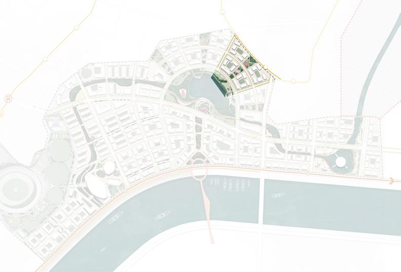
The entire olympic event site is divided into 3 parts of areas 1.1 sq.km, 1.1 sq.km and 1.6 sq.km respectively with varying natural assets and permanent structures retained like the olympic village, aquatics center, hockey stadium, iconic tower, football stadium, media village to cater to the neighborhood and their needs.


The Olympic urban fabric is built in an area of amalgamation of very interesting landscape conditions surrounding it. Defined by the rich natural and cultural setup , the region is now a prime public area that has multitude of functions and architecturally rich built structures of the Olympics remaining.

However, the neighborhood remains partially disconnected due to the lack of diverse ecological green and blue networks. Post Olympic scenarios is often left with abundant with characterless and unused spaces that can be termed as urban voids. The paved plazas, large infrastructure, abandoned structures, etc in these spaces heat up the unbuilt spaces and create hotter environments. This, with the changing climate also poses a risk of disasters like waterlogging, flooding, heat islands, factoring in the flood plain nature of the subsite.These Urban voids are not designed for ecology and resilience to the changing climate.

Post Olympic Scenarios despite its long term infrastructural benefits, creates characterless abandoned large Urban Voids in the city. These voids, put together with the giant infrastructures and built environment causes hotter living environment and when not managed poses a risk of heat islands, waterlogging, flooding, etc factoring in the flood plain nature of the subsite.
What
The Mega event- Olympic Games provides an opportunity to create sustainable cities that include commons. Vacant built-up area persisting in the form of abandoned wastelands, dumpyards, or spaces between large buildings have a tremendous potential for reconstruction and reuse by integrating them into the public realm, as well as for creating attractive environments by emphasizing their distinct character. Urban green spaces could be developed as ecological functional areas that coexist to serve the human functions of recreation, aesthetics, leisure activities, and conservation of environmental values.
This chapter putsforth the relevant takeaways from precedents to proceed towards formulating a spatial framework and introduces the envisioned strategic framework for the Olympic subsite transformation

To strike a balace between the Olympic driven legacy development, and the ecological assets of the neighbourhood, high ambitions for the utilization of the potential found on the site and the creative re-use of its legacy built structures as anchor points for a far-reaching development process, is paramount.
Transformation of the Olympic site into a healthy neighborhood, capturing the value of the rejuvenated land and ecology, to activate and connect the strategic site of Motera and the Sabarmati Riverfront, and re-establish the position of the neighborhood within the city by leveraging the cultural and built assets offered by the Olympic event.
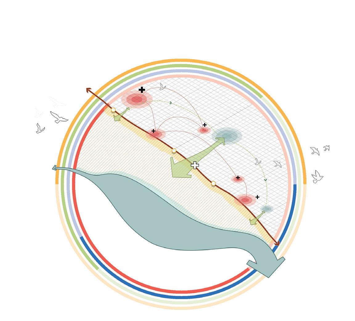
The conceptual framework proposed three strategic goals that would help the city, plan and implement the post Olympic legacy development in an integrated manner. The goals addresses themes that are significant in bringing about a holistic approach towards achieving the envisioned transformation
The drive for connectedness emphasises how the resilience of open public space systems encourages the improvement of communal, ecological, and cultural aspects.

The ambition for health asserts that ecological systems and resilience go together with quality spaces for activities and recreation.


The ambition for fostering culture and identity emphasizes creativity in the use of green assets , as the foundation for spaces and programmes that ideate its context and people’s relationship to it.
Framework for Envisioned Transformation
Strategic Goals
Goal 1 : Facilitating Connectedness
Goal 2 : Nurturing Health & Resilience
Goal 3 : Fostering Culture & Identity
Ecology
Accessibility
Recreation
Overarching Principles
The Masterplan is a strategic result of 4 steps: Integration of mobility network with the exisitng networs in place; programming of green open spaces that knits the whole system together, generation of urban form with a few anchors through design drivers that intends to induce culture and identity through interventions.
This chapter explains in detail these 4 steps and further heads towards the forumation of the overall framework.
Delayering of the strategic components
Robust connectivity is achieved by a series of strategic actions, which inlcudes integration with the exisiting regional and local mobility network, site- river-lake-neighborhood integration through new supporting network, a system of community trail which has the scope to be integrated with the larger network. AMTS connection is taken along the central spine (legacy asset) and feeder transit stops are connected using secondary and tertiary network.
An overall sense of connectedness is brought in by a trail system (NMT) that connects all scales of public spaces and encourages healthy, sustainable mobility.
Recreational places are integrated into ecological restoration, and the environment is perceived as a partner. This is accomplished by programming retentive landscapes, mounds and other plazas and squares that doubles its function of acting as a public space and also holds water during monsoon, factoring in the floodplain nature of the site.
Some strategic actions in the framework that aids in developing a network of meaningful open spaces include : central green link between the river and the lake, a green trail that is programmed with smaller water detention areas, and other neighborhood level open spaces.


To embrace the region’s natural identity, the riverfront, and the sporting cultural identity that the olympic has imbibed in the neighborhood, a set of anchoring spaces/ builtforms are created integrating them with the exisitng anchor, thus making the whole system well accessible. An elevated pedestrian bridge, that aids in N-S connection across the river also acts a spot to enjoy the scenic skyline created by the aquatics centre, central plaza, lake, and the spiritual centre. The trail is programmed with functions that carries memories of the olympics and celebrates culture.
Character zones are formed strategically based on the exisitng, retained and created built and natural assets. Mixed use zone is along the riverfront road, commercial and public amenities along the 30 m central spine, while the residential zones are located based on the integration with the green trail.
Sport- based development + Institutional + Residential Central plaza Commercial + Mixed Residential Lake facing Residential Residential away from chaos. (Stream and Spiritual centre as olympic assets.


The envisioned framework, through its multiple interactions and inter-relationships within and with the surrounding context removes the visual and physical access barriers that existed in the site. The new legacy neighborhood is a livable space: inhabitants’ physical and mental health is catered for through sporting facilities and the abundance of green and blue, and the spaces are spaces that belong to the people.
The design approach was to transform the regenerated water body into an eco-sensible public space complete with retention basins, micro wetlands, and floodable arenas for effective water management. The dedicated cycle and pedestrian network that runs alongside the green trail and through the lake park ensures seamless last-mile connectivity.


The envisioned ‘Urban Green Commons’
Narendra Modi Stadium
Existing stadium is treated as an asset and is integrated with the proposed sports hub and green trail for the sense of connectedness.

Institution Campus
Schools/Colleges are strategically located at transit nodes and at close proximity to the exisitng fabric
Aquatics Center + Sports Hub
Sports hub integrated with the Aquatics centre retained from the Olympics
The Green Trail
The green trail is interwoven through the development to create a strong sense of community
Mixed Use
Mixed-use office buildings and premium residences are lined along the riverfront road capitalising the waterfront.
Retail Corridor
The central plaza is flanked by commercial buildings on both the sides creating an open mall effect
Lake Park
The lake park created from the regenerated waterbody serves as a regional public space.
Central Plaza and Elevated walkway
The central retail plaza, is treated as a celebration park, with interactive displays commemorating the Olympic Games.
Spiritual Centre
Serene residential community surrounds the retained spiritual centre faciltiy and the stream


Identifying integrated systems
Multiple layers of the masterplan gives a structure to the entire masterplan and sums up to become a holistic integrated framework where the workability of each layer, in relation to the other layers becomes important.

Private Open space : 26 %
Public Open space : 36%
Hardscape/ Plaza
Hardscape/ Footpaths
The green trail forms a major part of the shared greenspace in the entire development, which is softscape in nature. The hardscaped plaza areas are seen along the central plaza and major public facilities catering to achieve active and porous edges.
Primary : 30m
Secondary : 24, 18m
Tertiary : 15, 12, 9m
The main 30m spine retained from the Olympics acts as the main thoroughfare, integrated with the AMTS network. The secondary road forms the main mobility route as it conencts through important vehicular routes and pedestrian network. Feeder transit is integrated with the secondary road network.

Built : 38 %
Open : 62%
The map highlights the pattern of varying grain sizes in the planned developement and marks the landmark iconic built structures and the meaningful unbuilt spaces.


With diversity in built-uses, the proximity to multiple services is minimal and it aids in achieving a live work play environment within the site
Residential : 56%
Commercial : 18%
Mixed- Residential : 12%
Amenities : 03%
Institutional : 05%
Recreational : 06%
Attractive living environments around the public hotspots
The structural vision makes the neighborhood an attractive area for working, living and recreation – a central environment that doubles the scope of the current CBD along the riverfront. Major interventions are planned at strategic locations to increase the quality of stay. The focus is on the connecting axes between the existing urban fabric and the city’s celebrated public space, riverfront promenade and the proposed regional public space the lakepark, through a trail of attractive public hotspots.
This chapter unveils the everyday life experience in the envisioned development and looks at the density, form and urban character imagined.
Towards a Healthy, Resilient Living
The lakefront community works under concept of “Nurturing Nature,” with the idea that when cities’ environmental health is restored, it improves our individual well-being. A ring road around the lake with radials connecting to the existing network, and the central park serves as a visual and physical link between the neighbourhood and the lake, and thereby the river. With rich retail experiences leveraging the waterfront and the neighborhood’s central community space progammed with senior citizen park, play areas, skating rink, OAT, multi purpose courts and a public park that is accessible from the abutting road, the neighbourhood provides dynamic experiences to the users.

Additonally, park’s retentive landsacpes, rain gardens, sunken plazas, aid in water management during monsoon rains.

 Sunken Plaza
Community Hub
Stalls
Neighborhood Greenspace
Skating Rink
Ground Floor Retail
Public Park
Kids Play Area Courts
Lake Overlook
Private Greenspace
Sunken Plaza
Community Hub
Stalls
Neighborhood Greenspace
Skating Rink
Ground Floor Retail
Public Park
Kids Play Area Courts
Lake Overlook
Private Greenspace
The block gets primary access from the 24m ring road that surrounds the lake and 18 m radials form the secondary access roads, 15 m inner road subdivides the parcel into walkable neighborhoods. All roads are facilitated with bi-cycle track.


The block is distributed with large central private green open spaces, of 30% of the parcel land. The neighborhood park are the green fingers, radiating from the central green lung.
The builtform consists of perimeter blocks , with G+7 mixed residential buildings fronting the lakeside street edge and the inner blocks - G+6 purely residential built, aligned with the airport authority building height rules.
Mid - density residential towers with a central green space and amenities in the lower levels along the park edge. The lakeside street edge is activated by retail ground floor use.
The ROW of the lakeside street is distributed with : extended pedestrian plaza with shaded walkway, onstreet parking, carriageway, cycle track on the lake-side, multi utility zone with seating and stalls, a lush green buffer. The lake edge is protected with a transparent barrier such that the
- 100 % built to line to be maintained along the lakefront road
- Collonade to have clear height of 4 m
- Sectionally inclined columns are to be avoided.


- Retail storefront Diversity - Individual retail sales and service entities shall occupy no more than 75’of ground floor frontage legth.
- Columns to be planned at a min off 6m interval
- Minimum of 30 % of each parcel shall have a central open space
- No street parking for motorised transport shall be given adjoining the neighborhood green space

- Maximum height of the building to be 24m to align with the airport authority regulations.
- Facade to be articulated with balconies as projecting elements, to break into small scaled portions as well as to overlook the park.
- Setback of 3M to be given from the park’s pedestrian path to the development
Lake-side Street View
Retail experiences leveraging the waterfront, help in creating a dynamic rich experience for the residents and visitors. The ROW of the lakeside street is distributed with : extended pedestrian plaza with shaded walkway, onstreet parking, cycle track on the lake-side, multi utility zone with seating and stalls, a lush green buffer. The lake edge is protected with a transparent barrier such that the visbility is not lost.

Lake-side street with a holistic waterfront experience

Multi-purpose Court
Bi-cycle track
Neighborhood Character
 Median Green
Pop-up Markets / Vendor Kiosks
Lush green lake edge - natual barrier
Lake- Lookout
Median Green
Pop-up Markets / Vendor Kiosks
Lush green lake edge - natual barrier
Lake- Lookout
Neighborhood level Open Space
The neighborhood park progammed with three typology of open spaces : senior citizen park, play areas including skating rink, multi purpose courts and a public park that is accessible from the road abutting the site boundary. The park functions as a community asset with a commuinity hub and sunken plaza, which also acts as retentive ponds during monsoon rains.

 Community/
 Community Hub
Skating Rink
Bicycle Track
Art stalls/market
Multi-purpose Court
Community Hub
Skating Rink
Bicycle Track
Art stalls/market
Multi-purpose Court
People’s movement adds energy to city life, and the city provides a series of places where people can move safely and comfortably. The central idea is to incorporate a small city system into this trail and transform it into an urban common as an extension of urban life. The green trail is interwoven through the development to create a strong sense of community. The trail ideates with the context and people’s relationship with it.
The green trail strengthens the links between the city’s Celebrated public space the riverfront and the neighbourhood of Motera. The more than 1kmlong shopping, pedestrian and cycle zone forms a central axis running through the neighbrohood centre and is designed largely as shared space.

Keyplan
The emphasis , on creating a rich pedestrian experience for the community, by retaining an organic character of the green and contrasting it with the simple and functional architecture of the buildings straddling it.

The sport trail, which begins at the aquatic center, is programmed with an unobstructed marathon track, a pedestrian pathway, a cycle track, and plaza seating amidst the landscape mounds.


The central retail plaza, connects the regional level public space, the lake park to the city level public space, riverfront and is progammed with interactive displays and exhibits of sculptures of atheletes/ eminent events/ acitivites, commemorating the Olympic Games,. A pedestrian-only and cycling trail extends outside the park in both directions, linking major streets directly to the park’s walkways. The mounds and sunken plazas acts as retentive landscapes and aid in water management during monsoon.

At the confluence of two great public spaces
 An iconic Structure of Olympic Memory
Elevated Pedestrian Walkway
Sculpture Garden
An iconic Structure of Olympic Memory
Elevated Pedestrian Walkway
Sculpture Garden

The central retail plaza, connects the regional level public space, the lake park to the city level public space, riverfront and is progammed with interactive displays and exhibits of sculptures of atheletes/ eminent events/ acitivites, commemorating the Olympic Games,. A pedestrian-only and cycling trail extends outside the park in both directions, linking major streets directly to the park’s walkways. The mounds and sunken plazas acts as retentive landscapes and aid in water management during monsoon.

For some exciting art, interactive sculptures experience and Retail therapy!
 Masterplan Studio 2022
Games Pavilion
Hologram Sculpture of Olympic Atheletes
Landscape Mounds
Pedestrian Trail
Wayfinding Signage
Masterplan Studio 2022
Games Pavilion
Hologram Sculpture of Olympic Atheletes
Landscape Mounds
Pedestrian Trail
Wayfinding Signage
Dendura, M. (2019). Olympic Infrastructure—Global Problems of Local Communities on the Example of Rio 2016.
https://www.researchgate.net/publication/338145686_Olympic_Infrastructure-Global_Problems_of_ Local_Communities_on_the_Example_of_Rio_2016_PyeongChang_2018_and_Krakow_2023
Newman, H. K. (1999). Neighborhood impacts of Atlanta’s Olympic Games. Community Development Journal, 34(2), 151–159.
http://www.jstor.org/stable/44257467
Thanjavur Ramakrishnan, R., Marimuthu, BN., Balasubramanian, P., Ramaiah Perumalsamy, GB., Lahoti, R., Vijaykumar, M., Gogri, Y., (2021) ‘LOOPS AS LEVERAGE- Spatial Framework for Circular NeighborhoodsCase of Koundampalayam, Coimbatore.’
https://issuu.com/radoffice/docs/loops_as_leverage
Ijzerman, O. (2018). ‘Towards an Olympic legacy for all: Regeneration oriented design principles for Olympic legacy enhancing the social sustainability of Rotterdam South’
https://repository.tudelft.nl/islandora/object/uuid:6841cb43-c831-44e9-8d95-831e87210ba4?collection=education
(2018). Chengdu Tianfu Olympic Sports City. Sasaki.
https://www.sasaki.com/projects/chengdu-tianfu-olympic-sports-city/