

GRAND BOULEVARD STREETSCAPE PLAN
THE COMMUNITY’S
VISION
2/21/12


City of Kansas City, Missouri | A companion piece to the Greater Downtown Area Plan
EXECUTIVE SUMMARY
2. THE PLAN 12
a. Crown Center District
b. Crossroads District
c. Within the Loop District
d. River Market District
3. APPENDIX 35
a. Process
b. Analysis
c. Citizen Feedback
d. Streetscape Theme Cultural / International Streetscape Trend
e. Implementation Strategy
f. Cost Estimate
g. Example Bikeway Projects
h. Potential Public Funding Sources
CHAPTER 01:
EXECUTIVE SUMMARY
As documented in the 2005 Downtown Streetscape Plan (Adopted by City Council), Grand Boulevard is the only “Image Street” in the downtown loop. As described by that plan, Grand is an important street because of its “civic image and heroic scale.” Street amenities suggested along Grand included double head street lights, tree uplighting, larger planters with naturalistic plantings/grasses, colored/textured paving, benches with wood seating, and enhanced bus shelters.
A grass root effort was started in 2010 to complete this corridor as a “game changing” catalyst sustainable project for Kansas City, connect the River Market, Downtown, Crossroads and Crown Center together through an iconic streetscape project, and help its competitive position compared to similar cities. Using the Greater Downtown Area Plan for the basis of the project, corporate leaders, Mid-American Regional Council and others interested in sustainability and a stronger downtown have come together to discuss the need for this project. This
Grand Boulevard Streetscape Plan documents the vision for a revitalized Grand Boulevard. The principles developed by the community during the planning phase include:
• Define the community’s vision for Grand Boulevard
• Redevelop an economically robust commercial corridor with new at grade retail, mixed-use, office and housing development
• Develop Grand as a livable downtown (complete with pedestrian, bicycle, vehicular, and transit movements)
• Promote livable, safe and attractive neighborhoods
• Create a framework for the consistent application of streetscape elements (paving, street furniture, landscaping, and lighting)
• Develop Grand Boulevard as an model for future urban streets
* As the adopted vision for Grand Boulevard, this plan documents the community’s Vision and the official City policy for the corridor that shall be a decision making guide for the Greater Downtown Area Plan.
As described in the implementation strategy section of this document, additional work is neccessary to bring this vision of the community to fruition including:
• Review the new Public Works traffic model and complete a Traffic Analysis
• Documentation of Streetscape Standards
• Topography Survey and Utility Investigation
• Inventory of Vaults
• Construction Documents
• Etc
The vision for the Grand Boulevard Streetscape Plan is to build a:


COMPLETE
The first overall concept for the corridor is Complete. A complete street works for all users (including pedestrian, bikes, autos and mass transit). It accommodates essential functions such as service and delivery, but more importantly, it accommodates the most vulnerable (children and the elderly, those of all physical abilities). This requires a rethinking of our current street priorities.
For Grand, complete street designs vary by whether they fall into the Mobility or Destination emphasis zones. Mobility zones are a conduit to move through. A Mobility emphasis reduces “friction,” maximizes capacity and minimizes conflict. A Destination emphasis street is more focused on arrival rather than movement. In these environments we encourage “friction,” tolerate congestion, and reduce vehicle speeds. Area stakeholders and community members helped determine whether the emphasis per block was on Mobility or Destination. There was a clear desire for a combination of both street types along the corridor.
PEDESTRIAN
Design of Complete Streets create safe environments for the most vulnerable. Complete streets include more that just sidewalks for pedestrians, they include a variety of zones and layers for movement, activity, buffers, places to sit and view, as well as providing visibility into shops. Short street crossing distances with a pedestrian-friendly tight corner radius can express a sense that the walkway is unbroken. Wide sidewalks at 14’ are encouraged throughout the corridor as a unifying element.
BICYCLE
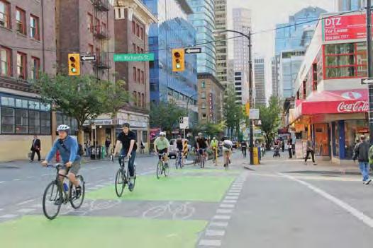
Bicycle movement is the second component of complete streets. Bicycles are a means of transportation in addition to a recreation and physical fitness vehicle. The recommended concept for Grand Boulevard integrates a protected bikeway located between the pedestrian sidewalks and parked cars to provide a safe buffer from traffic. This will encourage user of all ages and skill abilities to ride the corridor with reduced fear of being hit by vehicles. This concept is not new and is currently being incorporated in Lincoln, Nebraska and many other larger cities.
Protected Bikeways
A protected bikeways links Penn Valley Park to the River Market and Heritage Trail. Protected bikeways are the safest type of bicycle facility and have the potential to attract the greatest number of cyclists of all needs and abilities.
National surveys have indicated that the #1 deterrent to cycling is a fear of riding in traffic with automobiles. Protected bikeways are the only proven bicycle facility that effectively addresses this concern. Where these facilities have been implemented bike trips have been significantly increased. Second, because the corridor is so long, (2.7 miles) and has some topographic constraints, it is generally beyond convenient walking distances (5 minute walk/ 1/4 mile distance) for most residents, employees or visitors to access downtown. Bicycles can lengthen trips (5 minute bike ride/ 1 mile distance) that might otherwise be taken by a motorized vehicle in the downtown.


Installed in Missoula, Montana, protected bike lanes are located behind curb lines for enhanced safety and intersection crossing are painted cyan for additional clarity of theme.
The diagram show the major connections and vision for the corridor.


The protected bikeway first and foremost provides a safe and direct access within downtown that links the numerous districts along the corridor. Above are different examples of protected and bi-directional bikeways.


Bi-directional Bikeways
A bikeway design is where both directional routes are located next to each other. An unobstructed bi-directional bikeway (2 opposing lanes) needs to be a minimum of ten feet wide. The preferred bikeway width is 12 feet. A minimum 3’ ‘door zone’ sidewalk must be provided where curbside parking is adjacent to the bikeway. This zone is provided to allow for car door openings, parking meters, street lights, etc. that do not obstruct the adjacent bikeway lane. Combined, the 15’ is the preferred width. This type of bicycle facility allows riders to pass easily and share lanes when traffic is low.
Protected Bikeways provide safer routes of travel. Above are images of typical conflicts with mixed travel bike lanes.
AUTOMOBILE
For automobiles, the Average Daily Trips (ADT) along Grand Boulevard are within the 5,000 to 15,000 ADT threshold as provided by the traffic counts. For a destination zone, the ADT should remain within this range. Anything more is an auto dominated street and anything less is a quiet street, both of which will not be able to support increased retail development. Thus, the traffic volumes should be maintained at this level to support new at grade retail development along the corridor, without adding additional lanes. Where present, on-street parking should be encouraged, specifically within areas identified with at-grade retail. It has been documented that each on-street parking stall is worth $20,000 per year to adjacent merchants.
TRANSIT
Mass transit is the fourth component of complete streets. To be successful the corridor should incorporate well designed bus facilities. Bus parking areas should be 11-12’ wide. Bus and bicycle conflicts at shelters need to be minimized. Our concept shows a bidirectional bike route on the east side which creates safer protected bicycle movement, but also places the bikes behind bus shelters, reducing potential conflicts.
GREEN CORRIDOR
Cities regularly compete against each other. A bold idea is required to stimulate excitement and transform the urban environment. Grand Boulevard could be Kansas City’s next bold idea. We believe the streetscape should be thought of as an urban park or green corridor that links Penn Valley Park to Berkley Riverfront Park. Similar to the Las Ramblas in Barcelona, Grand Boulevard could have a focus on trees, landscaping, pocket parks, new parks and green stormwater management solutions. In addition to enhancing the walking and driving experience, landscaping and trees add market value to adjacent properties encouraging visitors and residents to linger under the shade canopy, spending more time and money. This has been document by various sources including:
• Kathleen Wolf writes in her book Grow for the Gold , on average consumers are willing to pay 12% higher for products in districts with trees.
• Beyond the beauty of a tree lined boulevard and improved quality of life, each tree is worth approximately $12,000 per year in front of retail establishments.

LIVABLE CORRIDOR
Similar to the Greater Downtown Area Plan, the Grand Boulevard Corridor needs to emphasize environments where people want to live, work and play. Beautiful or otherwise defined as Livable includes concepts such as comfortable, safe, and active. This vision seeks to improve the quality of life within the urban core by sharing and promoting smart growth principles, promoting development/redevelopment, and supporting projects focued on sustainable land uses including transportation, housing, and conservation of open green space and natural resources.
Similar to game changing projects across the United States, the vision for the corridor identifies public actions (such as this catalyst project) that will produce a sustained and widespread private market reaction. This vision shall inspire the development community to want to participate in creation of this environment that promotes a livable downtown environment (and results in millions of dollars of investment in publicly accessible infrastructure). We have an opportunity to make the Grand Boulevard Streetscape project more than a beautification effort. It can be a seed for change. The design
for this corridor shall create an authentic place, designed for people, while respecting natural ecosystems. The vision includes concepts for sustained and improved neighborhoods, strategical investment in public spaces, and stewardship for the public realm. As you consider this streetscape concept, notice the efforts to ensure the streets are for people, establish consistency, allow flexibility within the four districts, maximize streetscape value, and consider maintenance requirements, as well as encourage buildings built-to sidewalk, with ground floor active uses.

Project Objectives
Make Grand “Grand”
To make Grand “Grand,” a grassroots community effort was started and later enlarged with community participants and a steering committee to create the following project objectives:
• Safe, livable and walkable downtown
• Make Grand a healthy mixed-use corridor stimulating investment in retail and housing.
• Incorporate complete streets concepts, including strong focus on transit and new bike facilities
• Enrich the pedestrian experience by maximizing connections, minimizing intersection crossing distances, improved crosswalks and enhanced sidewalk activity
• Create additional parks and greenspace along the corridor
• “Program” the street & public realm to function BUT be the “Signature Address”
• Integrate sustainability best practices into the design, specifically stormwater management
• Complement Main Street and future streetcar
• Develop Grand Boulevard as a model for future urban Boulevards
• Incorporate Kansas City vernacular

The CONCEPT
This diagram shows the conceptual vision for Grand Boulevard. Grand becomes a Livable, Green, and Complete Street Corridor. By removing a lane of traffic, the corridor can be transitioned into a tree lined corridor connecting Penn Valley Park to Berkley Riverfront Park with a series of interconnected park and urban spaces while still maintaining the Average Daily Trips (ADT). Substantially more landscaping and stormwater best management practices encourage a better quality of life for residents and visitors.
Meeting the objectives of the project to connect to the adjacent neighborhoods, the yellow arrows represent critical east/west connections.
Movement north and south is encourage with the various complete street concepts linking connectors to the different neighborhoods and employment areas. Protected and bidirectional bike lanes promote additional transportation options, specifically designed for the most vulnerable. Wide sidewalks with cafes and other at-grade retail, shortened pedestrian crossings and enhanced crosswalks are incorporated throughout to improve the pedestrian experience.
Infill areas and proposed additional park land is incorporated throughout the corridor improving the vitality of the area. Areas currently occupied with surface parking lots and areas adjacent to existing destinations zones are being recommended for early phase development. Special plaza zones are located within Crown Center, Sprint Center, 10th Street, and River Market areas.
In summary, the BIG IDEAS for this plan as an extension of the 2005 Streetscape Master Plan includes
• Supporting the GDAP goals - Create a Walkable Downtown, Double the Population, Increase Employment, Retain and Promote Safe, Authentic Neighborhoods and Promote Sustainability
• Widen Sidewalks on the East Side (Asymmetrical Design)
• Protected, Bi-directional Bikeway
• Connections to Adjacent Neighborhoods
• Substantially More Landscaping and Sustainable Stormwater Systems
• Enhanced Amenities
The diagram show the major connections and vision for the corridor.

This is a perspective of the traditional redeveloped vision for Grand Boulevard. It includes an offset centerline creating addition pedestrian amenity zone on the east side of Grand. Within this zone is a bidirectional bike facility. Three lanes are proposed throughout the corridor. An additional fourth lane is commonly added for the block preceding the highway bridges.

Typical Streetscape Section: This section shows the proposed widths throughout the typical 100 foot Right-of-Way. The western curb line will stay in the same location minimizing disturbance of existing underground vaults. On-street parking is allowed to occur throughout the corridor. Landscaping and green stormwater solutions are added between parking stalls to add additional vegetation. Additional parks and urban spaces are encourage between buildings to enhance the pedestrian experience. The orange area represents the bikeway. The 15 foot dimension includes a 12 feet wide bikeway facility and 3’ door zone. When adjacent to landscape bed (foreground) the width can be reduced to 12 feet.
BEFORE AFTER
Proposed concept and layout for Grand Boulevard Streetsape Plan - The proposed system along Grand Boulevard incorporates a Protected and Bi-directional Bicycle Route. The bicycle system is recommended on the east side of the boulevard and provides a viable alternative to auto travel and to significantly increase bike ridership.


CHAPTER 02:
THE PLAN
River Market DistrictThe Loop District


The Plan documents the revitalized vision for the Grand Boulevard Streetscape. The central concept represented by the asymmetrical corridor with 3 lanes of vehicular movement, on-street parking, enhanced sidewalks, bidirectional bicycle facility, additional trees and green stormwater concepts tie the River Market, Downtown, Crossroads and Crown Center together though one “Grand” project that will serve as an icon for Kansas City. The revitalized Grand Boulevard vision will also serve as model for other streets to follow, reinforcing the community’s vision of the development / redevelopment of a healthy commercial corridor, promoting strong neighborhoods, sidewalk activity, economic vitality and a framework for urban development (including edges, nodes, landscaping, lighting, etc).
The completed project will attract new residents and businesses to the area and reinforce the City of Kansas City’s commitment to complete, sustainable and walkable streets. The Plan describes the vision for the corridor through four districts:
• Crown Center District
• Crossroads District
• The Loop District
• River Market District


18th 20th


Crown Center District
Existing Character
Crown Center is a destination area offering three levels of shopping and dining complemented by two hotels, office buildings, and a residential community. It is the home of Hallmark Cards, Inc. headquarters and includes many familyoriented activities including Legoland and the aquarium. The central plaza is used year-round. There are some underdeveloped lots south of the high rise buildings.
Proposed Improvements
The street environment moves from a mobility emphasis south of the Crown Center Shops to a destination zone within the plaza area and then back to a mobility emphasis north of Pershing Road. Within the destination emphasis area (plaza zone), there is an opportunity to reduce the presence of the vehicle which is currently separating the plaza. East of Washington Park, the park setting would be extended to the east side of the road for the perception of driving through the park (or this larger green environment). Future infill should be encourage north of Washington Park to activate the park for 18-hour uses.


Existing view north looking towards Crown Center. This zone has a mobility emphasis and is quite wide with low average daily vehicle trips (ADT).
View looking north from Pershing Road
View looking south towards 2600 Grand Office Tower

TYPICAL GRAND STREET SECTION
(See Section 2.1)
URBAN PLAZA STREET SECTION

TYPICAL GRAND STREET SECTION

Section 2.1: This image shows the transformation of Grand Boulevard from the underutilized roadway (with excessively wide lanes in some location and low ADT) to an active street environment.
Crown Center District
The Crown Center District represents the southern terminus of the Grand Boulevard corridor culminating in the Crown Plaza. The Crown Center plaza space is divided by Grand Boulevard. In addition the concrete island requires repair, but more importantly does not fit the boulevard concept absent of vegetation or amenities. The plaza could be reinvisioned to extend the pedestrian space, especially for special events, but also for every day movement. The vehicular movement could be underplayed by raising the pavement to sidewalk elevation or removing the 6” vertical curbs. Removing the concrete island will shorten the crossing movement and create additional space for trees and urban amenities. An enhanced plaza space with less emphasis on the vehicle would encourage pedestrians to enjoy the space for longer periods of time.

view of plaza / vehicular space within Crown Center. The
median should be removed.

Existing
concrete
Example project that showcases a curbless plaza and vehicular path with stormwater best management practice for stormwater filtration.
North of Pershing road to 20th Street, Grand Boulevard is considered a mobility emphasis zone with inactive street edges. The Kansas City Parks and Recreation Department plans to redevelop Washington Park as a better utilized civic space. Tree canopy within the park will need to be thinned and pedestrian connections improved to encourage more use of the park. A large area of parking at the railroad track elevation has negatively affected Washington Park. As the concept shows, this area should be considered for redevelopment, raised to the elevation of the park and developed with housing and other 18-hour uses to activate the park. By integrating the asymmetrical streetscape concept with additional tree cover along the boulevard and a wider amenity zone on the east side, users will feel as though they are moving through the park, further increasing visability into the Park.
The current walk along the east side of Grand is robust with concrete walls and raised plaza spaces. Active storefront and pedestrian circulation would help activate the park and encourage better pedestrian movement.

View looking north from Washington Park Concept for a revitalize Washington Park Area
Crossroads District
Existing Character
The Crossroad District is the mixed- use area located south of the downtown loop and I-670 highway and highlighted by art galleries, small businesses, local restaurants, and apartments side-byside with light industrial uses. There are many single and two-story buildings within the corridor. Taller residential towers are located on the south side of the district (south of 20th Street). Two large areas are currently used as surface parking lots (near 16th and 20th Streets).
Proposed Improvements
The three lane concept with larger amenity zone is proposed through most of the corridor. The block from the I-670 bridge to 15th Street will be 4 lanes wide providing additional turning movements for the bridge and on-ramp to the interstate highway.
The excessive amount of open building lots along this stretch of Grand Boulevard both necessitates new building development in order to define urban space, improve the pedestrian experience, and promote increased inhabitation density. The development of new commercial use programs, big box retail or a grocery store could be accommodated along this corridor and support addition pedestrian movement and housing development. The intended feel and the character of the boulevard in this zone is one of significant linear park spaces dominated by continuous tree canopy and vibrant sidewalk life.


Image looking NW near 16th Street
Image Looking North near Railroad Bridge
Image looking north at 20th Street
AZA TION

TYPICAL GRAND STREET SECTION GREEN BRIDGE
The Crossroads District section of Grand Boulevard, located at 16th to 17th Street and 18th to 20th Street, has the potential to become significant development areas.
The surface parking lot between 16th to 17th Street is currently being used by Kansas City Star employees, but appears to be underutilized. Future development should support the current development just north of this block, and could include a larger block retail establishment or grocery store.
The area between 18th to 20th Street is envisioned as a destination emphasis zone. This area is one of the sites being strongly considered for the pilot project (described in the AppendixImplementation Strategy). A housing tower could be considered at this location. Combined with the current housing stock, mixed-use development and improvements along 20th Street, this site can generate substantial development, green space and public amenities.


Crossroads District
The drawing on the right shows the typical design within the northern section of the Crossroads District. Shown is the mobility emphasis concept from 16th to 18th streets. This mobility zone connects the Sprint Center with the destination emphasis zone concentrated around 20th street.
Within this zone there are also two large infill sites whose development is very important for the definition and completion of urban space in that portion of the boulevard. The intended feel and character of the boulevard in this zone is one of a significant linear park space defined by a by continuous tree canopy, protected bikeway, and enlarged sidewalks which promote pedestrian circulation and increased retail development.
Parallel Parking Stalls
Proposed Infill Development
Bike Box
Bikeway Crossing Planter Zone
Proposed Infill Development


Landscaped Stall
Bidirectional Protected Bikeway Tree Zone
Two Lanes Bidirectional with Center Turn Lane
Proposed Pocket Park
Proposed Infill Development


Pedestrian Crosswalk

Perspective 2.2: Concept through the Crossroads District - Maintains two through lanes, a left turn lane, a protected bidirectional bicycle route and an enhanced pedestrian zone on the east side.
Section 2.2: Shows the typical dimension for areas within the Crossroads District with a 100’ Right of Way.
The Loop District
Existing Character
This district include the Central Business District. Grand Boulevard moves through the edge of the Financial and Government Districts as described within the Downtown Master Plan. Downtown Streetscape Guidelines describe the amenities within the loop area including landscape material, curbs, and lighting. Sprint Center and the Power and Light District are located on the southern edge. Around 13th and 11th Streets, two entire blocks are used as surface parking lots. The area between 9th and 10th Street represents the high point of the area with views north toward the Missouri River and south toward Crown Center. Throughout this district there are many opportunities for development and redevelopment, including north of 9th Street toward the I-70 Bridge.
Proposed Improvements
Starting from south to north, the I-670 bridge should be replaced or enhanced with pedestrian amenities/landscaping to extend the current Sprint Center plaza toward the south. This concept to widen the bridge is smaller than the KCMO Lid project, but similar in that it will require the bridge to be replaced. A concept similar to the adjacent page could encourage better pedestrian movement into the Crossroads District. The plaza in front of the Sprint Center and Power and Light District should be redeveloped as and urban plaza encouraging additional pedestrian movement (similar to the Crown Center plaza). Surface parking lots at 13th and 11th Street should be removed and developed with retail space on the ground floor. At 10th street, a public plaza with art should be created. This is near the high point along Grand with good views north and south. The corridor north from 9th Street could include a new dog park with additional housing development.


Image looking at 13th Street Parking
Image looking at 11th Street Parking
Image Looking North across I-670 Bridge

TYPICAL GRAND STREET SECTION
12th 10th
The concept for the Sprint Center special area is conceived as a major public zone without sidewalk curbs that can be turned into a continuous pedestrian plaza during major events. An example of this would be the Big 12 basketball tournament when that portion of Grand Boulevard is closed to traffic. In addition to the plaza space, the deck of the bridge over I-670 would be extended in the western direction creating additional green and public space that complements and supports the functions of the Sprint Center plaza and encourages safe pedestrian flow into the Crossroads District. It is expected that this bridge cannot be modified or expanded in its current design, so a redesigned bridge would be necessary. (The Kansas City I-670 Lid project will be able to provide additional information on the necessity to expand to the south and replace this bridge.)
URBAN CORE STREET SECTION

URBAN PLAZA STREET SECTION

Within the Loop District

This is a concept for a High Point Plaza. Located at the apex point along Grand Boulevard, this proposed urban park and associated art competition separates the corridor into two powerful viewsheds looking north and south. This is currently an unrecognized condition, and the plan recommends a plaza that celebrates these views.

View looking south toward existing limestone outcropping

The concept for a new urban park with dog park and overlook is envisioned at the location of the existing limestone outcropping. This elevated location takes advantage of the existing terrain slope and the shift in the Boulevard direction that affords an open view to the River Market area. This area also creates an opportunity for a spontaneous green and public space.
Within the Loop

Perspective 2.3: A typical solution for major bus stops along the corridor - At important bus stop locations, far side 12’ wide bus lanes allow buses to move out of the travel lanes, and easily enter back in with the traffic lights.

Section 2.3: Shows the streetscape within the loop (View toward art competition at 10th Street)
High Point Plaza (Proposed Art Competition Site)
Parallel Parking Stalls
Landscaped Stall
Planter Zone
Bus Shelter Bus Lane
Bikeway Crossing Bus Stop
Pedestrian Crosswalk
Planter Zone
Bidirectional Protected Bikeway
Two Lanes Bidirectional with Center Turn Lane
Within the loop the character of Grand Boulevard changes from being a linear park to one of a more pronounced urban feel with fewer trees to accommodate a stronger architectural presence. Though primarily conceived as a mobility emphasis zone, this segment of Grand Boulevard embodies prominent elevation points that provide opportunities for significant views across the city and the landscape.
River Market District
Existing Character
The River Market (formerly known as Westport Landing) is a riverfront neighborhood that comprises the first and oldest incorporated district in Kansas City. Within the River Market is the Steamboat of Arabia Museum and City Market, which is one of the largest public farmers’ markets in the Midwest. The large riverfront warehouses have become increasingly developed into residential lofts, restaurants, bars, shops, cafes, and ethnic markets.
The road section through the River Market maintains a tighter Rightof-Way width of 60 Feet. Currently, this allows for two directional auto movement without turning lanes, except near the I-70 bridge, where the road widens allowing for 3 and 4 lane traffic. The section from 3rd to 5th Street is currently developed as surface parking for the Steamboat Arabia Museum. This section of Grand Boulevard has been identified by the Alternatives Analysis Study for the new streetcar.
Proposed Improvements
The tighter road width will require on-street parking to be removed to allow the streetcar and bicycle route to move through the corridor. There is an opportunity to develop an urban plaza on the east side of the Steamboat of Arabia Museum. The plaza would provide additional transit movement through the area. The transit mall and streetcar maintenance facility is expected at 3rd Street. The design needs to encourage pedestrian, bicycle , and transit movement into Berkley Riverfront Park and its associated development.


View looking south through River Market
View looking south from 3rd Street
View existing I-70 bridge
The inconsistent urban fabric on either side of I-70, including the bridge over I-70 represent a major disruption in the continuity and coherency of Grand Boulevard. Should funds become available or the bridge can easily be modified, the I-70 bridge deck should be expanded 5’ to the east side. This would allow the streetscape concept to move across the bridge including bidirectional bike paths, generous sidewalks, and green screen and landscaping. Because the bridge is quite wide and a percentage of the paved surface is stripped to reduce vehicular movement, the bridge would not need to be widening to accomplish many of the project goals. (Additional coordination needs to occur with MoDOT.)
Bidirectional Protected Bikeway Green Wall / Overhead Structure Landscape
Four Lanes of Traffic


Concept for over I-70 Bridge - Maintains four travel lanes, a protected bidirectional bicycle route, and a green wall to filter views and noise from the highway.
Pedestrian Crosswalk
River Market District

The concept for the River Market and the associated roadway section of Grand Boulevard differs significantly from the rest of the corridor because of roadway width. The right-of-way width is only 60’ wide compared to the larger widths found south of the I-70 bridge. In addition, the building stock is composed of much smaller building structures. The typical boulevard section is maintained thought this thinner corridor preserving the bidirectional bike paths and mobility character of the overall design.
“The design of the Grand Boulevard that includes multiple modes a variety of adjacent land use is analogous to a Swiss Watch that includes multiple intricate and complex and moving parts. Like a Swiss watch, if well crafted, not only do you get a street that functions well, but one that is elegant and beautiful.”
Bikeway Crossing Plaza Zone Planter Zone
Light Rail Track
Pedestrian Crosswalk Bus Shelter Bus Stop
Two Lanes Bidirectional
Parallel Parking Stalls
Bidirectional Protected Bikeway
The River Market section of Grand Boulevard between 3rd and 5th streets creates a northern counterpoint to Crown Center as a major public space and its second terminus. This area is a special plaza zone without sidewalk curbs and is open to pedestrians. The combination of various destination points, River Market, bus terminal, streetcar end station, and access to Berkley Riverfront Park will make this area a major civic zone and a strong urban node.


Perspective 2.4: Concept within the River Market - The thin 60’ Right-of-Way maintains 2 through traffic lanes, a protected bicycle route on the east side and enhanced pedestrian zones.
Section 2.4: Shows the streetscape through the River Market District
CHAPTER 03:
APPENDIX
A. The Process
The Grand Boulevard Streetscape Plan followed a 5-month timeline and was completed within the following three phases.
During the first phase, discovery and assessment , the planning team listened to the public, interviewed key stakeholders, and gathered existing data. The planning team informed the public about complete street concepts and the community expressed their vision for the future of the corridor and offered ideas for how to accomplish that vision.
In the conceptual planning and testing phase, the planning team created three unique concepts and evaluated each using a matrix of the community’s objectives. Three conceptual design options their opportunities, directions, and strategies for the future development of the corridor were presented at the second community meeting. Public feedback was received through electronic ballot and evaluated using the project objectives and complete street criteria to narrow down the concepts into a preferred alternative.
During the documentation phase, the planning team refined the selected concept and crafted this report adding maps, diagrams and graphics to illustrate the planning recommendations.
The City Parks and Recreation Board adopted the plan on March __, 2012.
Many people were involved in crafting the streetscape plan. The following groups play a vital role in the formulation of the streetscape plan.
A. Steering Committee
The steering committee was made up of diverse leaders from within and outside City government. Over the course of the streetscape plan the steering committee met to provide a sounding board for many items and were charged with providing constructive, informed feedback to guide the plan recommendations.
B. Stakeholder Meetings
Stakeholder meetings were held in August and in November to dig deeper into specific site issues and discuss implementation ideas. Beyond adoption, the responsibility of this group will also continue, and is essential to achieve successful implementation.


C. Community Meetings
At the first community meeting, approximately 75 attendees reviewed and supplemented the project objectives and provided additional guidance. Working in teams, community members responded to questions about the objectives for the corridor, provided valuable input about the corridor and feedback about the complete street concepts.
Attendees were asked to “Identify Top Issues for the Corridor in three categories: Land Use (Housing, Retail, Parks/Open Space), Transportation, and Green Streets (stormwater , landscape, materials)
In addition, attendees were asked “What is more important in the corridor?” Mobility Emphasis, Destination Emphasis or a Combination. Only 11% thought the corridor should be a mobility only emphasis with 62% responding that the corridor should be a Combination of both types. One attended noted: “Grand Must function as a street, but should be a ‘signature address’ to attract development. Which creates a healthy tax base.”
At the second community meeting, attendees divided into the four districts and responded to the four concepts within their district. Question discussed included:
1. What is the unique character of your district as it relates to Grand Boulevard?
2. What scenario best accommodates that unique district?
3. What are the special design areas in your district and how can Grand Boulevard enhance these areas?
4. What are your ideas to improve the connections and bridges between the districts?
A majority of the attendees responded with interest for the 3 lane offset concept (described in the Chapter 2 - The Plan)
At the third community meeting, attendees reviewed the a preferred corridor-wide concept along with refined typical streetscape concepts for each district. Attendees also provided input concerning streetscape amenity themes.
Some of the input from the first community meeting:
• Plan must be a “road map” to guide development land uses along Grand
• Provide a Vision that the community and stakeholders buy into that stimulates private reinvestment in mixed use development that supports the objectives
• River Market: Create/Strengthen connections to River, Columbus Park Neighborhood, West Bottoms and Downtown Loop
• Within the Loop: Provide a park (even Oppenstein Park is an acceptable size)
• Transportation: Lack of bike lanes, lack of rapid transit
• Green Streets: Crumbling sidewalks, lack of greenspace
• Design should accommodate stormwater management e.g. stormwater runoff directed to filtration and infiltration planters. Also include pervious pavement where possible
• Need legitimate activity with friendly eyes on the street to promote (sense of) security and safety to attract people to choose corridor
• Eliminate surface parking lots along corridor
• Retain the concept of the Grand Boulevard of the Americas and build on the theme
At the second community meeting, the attendees were asked to use the electronic voters to respond to the following questions. The attendees responded overwhelmingly that the proposed concept represented the following:
• Does the big idea (Green, Complete, Beautiful) accurately represent the concept developed at our first meeting?
• Would you be excited about a design that accomplishes the big idea for Grand (Green, Complete, Beautiful)?
• Do you support taking a lane of traffic and repurposing it to support the big idea (green, complete, beautiful)?
D. Online Participants
www.GrandBlvdKC.com
1,525 unique visitors to grandblvd.com
4,224 page views on grandblvd.com
54 active users on ideas.grandblvd.com
17 original ideas
18 comments
325 votes cast
This website served as a 24-hour a day public forum and allowed for important community participation, and meaningful conversation in a short timeframe.


Project Website
B. Analysis
During the Analysis phase of the project, the BNIM team completed baseline data collection efforts to better understand the corridor. During the stakeholder meetings, the BNIM team met with appropriate City staff, area neighborhoods, businesses and institutions to become familiar with existing conditions and future proposals within the area.
An existing conditions survey was developed to provide a “snapshot” of the existing and planned project area conditions to understand how the area is used today. Using the available City GIS data and site tours, the team reviewed the following:
• Edge Conditions (ground-floor uses, i.e. retail, parking lot, and active-edge openings)
• Street Pavement and Right-of-way Location
• Curbs and Sidewalks
• Curbside Parking
• Topography
• Lighting
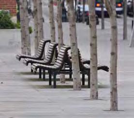
• Existing streetscape elements such as benches, litter receptacles, specialty features, etc.
An analysis of historic streetscape conditions and previous planning efforts within the study area was conducted. The BNIM team:
• Reviewed the Boulevard and Parkway Standards of Kansas City, Missouri as it relates to Grand Boulevard.
• Reviewed the Greater Downtown Area Plan (GDAP) as it relates to public realm recommendations.
• Looked to examples of applicable local streetscape plans and those from other communities
• Worked with KCATA and MARC to evaluate the streetcar on Main and Grand Boulevard
• Worked with KCATA to understand the existing bus transit on Grand Boulevard
Review of the Greater Downtown Area Plan and its recommendations for Grand are included below.
GREATER DOWNTOWN AREA PLAN (GDAP)
The corridor was identified as a catalyst project within the GDAP. The planning efforts of this study support the GDAP and its five overall goals to:
• Create a Walkable Downtown
• Double the Population Downtown
• Increase Employment Downtown
• Retain and Promote Safe, Authentic Neighborhood
• Promote Sustainability
Grand Boulevard and other streets within the downtown area were identified for potential road narrowing, bicycle routes, and trails. The following graphics are from the GDAP and reference opportunities within the corridor.
POTENTIAL ROAD DIETS AND LANE NARROWING
Road diet as described by the GDAP includes the removal of a lane. Road narrowing includes the changing of lane widths from larger widths of 17+ feet wide to widths more consistent throughout the corridor. The vision for the corridor maintains three 11-12 feet wide lanes. An additional fourth lane is commonly added for the block preceding the highway bridges.


BICYCLE LANES AND TRAILS


BOULEVARD SYSTEM
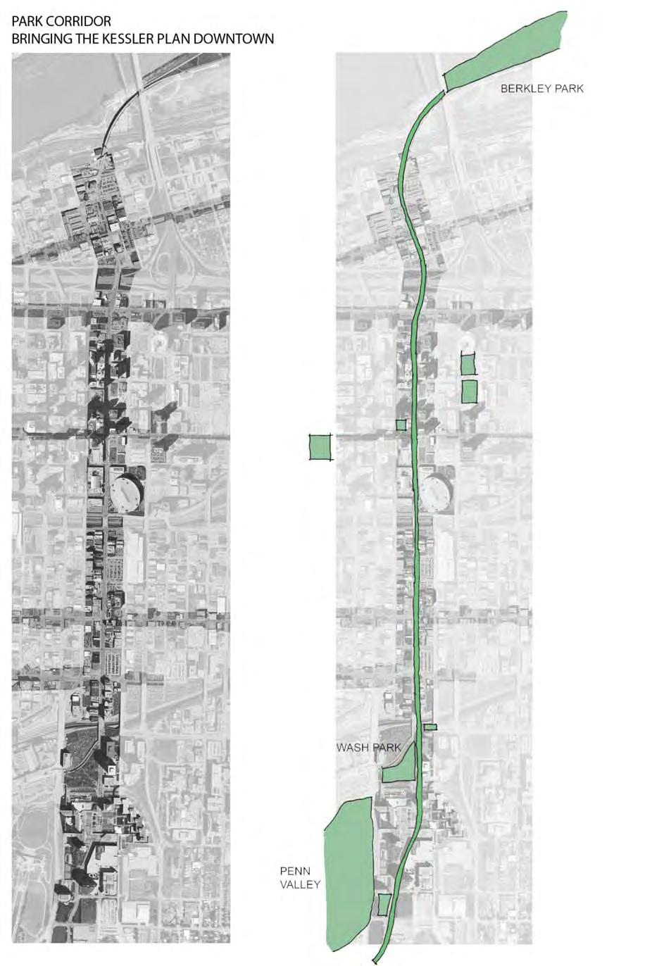
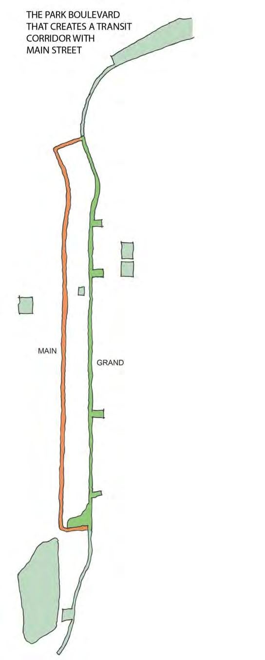
Grand Boulevard is a boulevard of the KCMO Parks and Recreation Department. The boulevards were planned in the early 20th Century as an important community asset to link parks together. Grand Boulevard connects Penn Valley Park to Berkley Riverfront Park through the urban core.
Grand Boulevard represents a unique opportunity to build on the spirit of the Kessler’s plan and connect North and South parts of the downtown into an ordered and coherent urban whole.
George Kessler Boulevard Plan, 1917
Current Parks and Recreation Boulevard Plan
Missouri River
Respecting and Building Upon KCMO History
Grand Boulevard can become a linear park with park-like features that adds badly needed green space to the downtown area and provides a major urban feature that can redefine and improve the character of the area. The boulevard replicates the green features typically found in a historic Kessler Boulevard but in an urban downtown setting while addressing the essential needs of a complete street.
Grand Boulevard is one of the most important streets in the downtown. Beyond the fact that it is the only street that connects downtown to the River, as one of the only image streets in the downtown, provides much needed hierarchal presence which is lacking throughout the urban grid. GDAP and the Downtown Streetscape identify this corridor as the image street needing the highest level of importance, lighting, and streetscape amenities.
The streetscape incorporates best practices for streetscapes/ complete streets found around the world. However, in the end it will only be timeless and memorable if responds to the values, history and physical context of Kansas City.
The Grand Boulevard Streetscape Plan is not simply a beautification project but rather a development strategy. During the analysis stage, the team reviewed the properties along either side of the corridor to determine if the were “stable” or “soft” projects. Soft parcels can be defined as areas that are either surface parking lots or underutilized building structures. Stable structures appeared to have active and shriving uses. This analysis was used as a tools to determine the opportunities for downtown revitalization.
‘SOFT’ PARCEL AREA1 million square feet
This is based on the site area within one block of Grand Boulevard (as indicated in Red).
BUILD-OUT SUMMARY:
Residential Units: 6,000 Units
Ground Floor Commercial: 700,000 sf Office:2,900,000 sf
In order to bring cohesion to Grand Boulevard, critical infill zones, specifically associated with the surface lots, were identified and are important locations for development. A conservative development strategy for the soft parcel areas could equate to the above level of new development within one block of Grand. Additional development within the corridor on adjacent blocks could also complement this important north/south corridor.


‘Soft’
‘Stable’
Missouri River
Image of a development strategy for the soft parcel area owned by the KC Port Authority Plan along the Missouri River and adjacent to Berkley Riverfront Park.
River Market
The Loop Crossroads
Crown Center
DESTINATION
ZONE
MOBILITY ZONE
DESTINATION
ZONE
SPECIAL INTEREST ZONE
DESTINATION
ZONE
MOBILITY
ZONE

The planned street car development on the Main Street is important to the north/ south transit movement to the City. In conjunction with the Main Street, Grand Boulevard will serve existing and new commuter destination points as well as parallel, alternative pedestrian, bicycle, and bus circulation system that will intensify use of the entire urban area. Improvements on both streets will complement each other as well as greatly improve the overall character of this important north/south corridor.
COMPLETE STREET
The fundamental streetscape framework is based largely on a complete streets notion of destination and mobility emphasis zones (along with special interest zones). The community agreed that both destination and emphasis zones were needed.
The components of a streetscape, similar to a recipe, like the right ingredients at the right amounts. Throughout the Grand Boulevard corridor, different sections should be developed with a destination emphasis while the other blocks with a mobility emphasis.
C. Citizen Feedback
This streetscape plan incorporates ideas from the community, City staff, stakeholders and the steering committee.
The participation on this innovative crowd-sourcing site was successful and impactful in directing streetscape plan projects. Quotes from the website are sprinkled throughout the Appendix and many of the ideas firmly imprinted on the recommendations.
From Grandblvdkc.com
There is ample room on Grand’s existing sidewalks for bike sharing kiosks. It’s a natural fit!
DaveKCMO

Produce low-fenced vest pocket parks with weeping birch and other cover-providing trees, good & pretty paving and tables and chairs (and cisterns to keep water available for plant) flanking the street, providing momentary repose with about 8-12 feet of space back from Grand, disguising the street parking but still allowing it.

From Grandblvdkc.com
Patti
Trees will be the root to success, no pun intended. Increase walkability, improve aesthetics, reduce crime.... not to mention the number of environmental benefits.
Sarah Patterson
Public art, fountains & spaces that welcome & are scaled to people instead of optimizing cars or even bikes. Shade trees, sidewalk seating, inviting business fronts all show people are the priority.
Nikki
From Grandblvdkc.com
From Grandblvdkc.com
D. Streetscape Theme Cultural / International Streetscape Trend
The following concepts represent the streetscape trend for materials within the corridor. Each district is expected to have some individual components, but the overall theme continues the “Grand Boulevard of the Americas” with a cultural / international unifying trend.
LANDSCAPE
Uniform rows of upright, manicured, deciduous trees create ‘outdoor rooms’ by comfortably enclosing streets with green walls and ceilings. Understory landscape beds and groundcover occur at key locations. Color within plantings is important. The plan should emphasize native plantings typically found in Kansas City that are colorful and lush. Plants and landscape concepts will improve and filter runoff from paved areas. Low maintenance plant materials will require minimal irrigation and fertilization.


Plantings for Stormwater Management Systems
Elevated Planting Beds with Trees and Annuals
Hanging Baskets
Water Loving Native Grasses and Shrubs in Depressed Planting Areas in Curb Extensions and Along Streets
Street trees such as the Pacific Sunset and Swamp White Oak Chosen for Superior Urban Performance
FURNITURE
Highly ornamental cast iron or black painted elements are distinctive and delicate. Whimsical one-of-a-kind benches and other elements establish a memorable and unique signature.
Stainless steel, glass canopies, shelters, and other accent elements should be timeless.


Wood and Metal Street Furniture
Ornamental Signage
Glass Shelters and Other Accent Elements
Silver or Stainless Street Furnishings
MATERIALS / PAVEMENT
Richly textured, interestingly patterned, and well-crafted paving creates ‘carpets’ on which street furniture and buildings are placed. The plan incorporates neutral color on horizontal and vertical surfaces. Low walls within the pedestrian zones could double as seating. Forms, shadows, and shapes create variety and interest; contrast with deep green and bold blocks of color in the landscape. Preference shall be given to natural materials over stamped and colored concrete. All materials and site amenities shall be accessible.


Stone Benches
Precast Concrete Pavers (could be pervious pavement systems)
Sand- and Mortar-Set Brick
Limestone
Mixed Concrete Pavers
Board-Formed Concrete Walls
Concrete Walks with V Groove Jointing
LIGHTING
Whimsical one-of-a-kind lighting reflects cultural and international themes consistent with the Grand Boulevard of Americas theme. Lighting of sculptural elements provides an interesting nightime experience (encouraging 18-hour uses). During the day, poles match the silver and black finishes of the furniture, while at night transform the environments. LED technology is used for all streetscape lights.


Pedestrian Scale Lighting
E. Implementation Strategy
The following Implementation Strategy seeks to build upon the momentum of the completed Grand Boulevard planning process, and clearly define the next steps that lead to project construction. The key components of the Implementation Strategy are:
1) Develop a ‘business case’ for the Grand Boulevard project.
2) Develop a streetscape handbook or standards that document the design for the corridor.
3) Create an attractive and informative marketing product- a brochure and slide show that can be used by project advocates to inform and solicit potential investors.
4) Identify an initial pilot demonstration project as part of a phasing plan and complete construction drawings.
DETAILED IMPLEMENTATION STRATEGY
1. ‘Business
Case’
John DeBauche with the City Planning and Development Department has been documenting the economic successes of streetscape projects on adjacent private redevelopment. Combined with John’s data, a ‘good business’ proposal illustrating a compelling rationale to spend money on the corridor streetscape improvements, additional design, planning and stakeholder engagement work is needed to identify the types of uses and quantities of development that these improvements would stimulate.
2. Streetscape Handbook / Standards
A document will be developed to identify the standards necessary for development of a successful new corridor. Design guidelines will integrate land use and circulation concepts with design requirements and details to provide a consistent, high-quality theme that creates a distinctive identity throughout the corridor while allowing for flexibility within each of the four districts. The design guidelines will be used by the City and developers to ensure a uniform urban design for the streetscape. General requirements will identify the preferred location and dimensions of several essential elements including streets, parking, loading, transit, bicycle and pedestrian facilities, and stormwater facilities. Design elements will be described in more detail including scoring patterns, curb extension design, location of light poles, benches and other amenities.
3. Project Marketing
A convincing case must made that Grand Boulevard improvements are essential to improve the investment environment and not merely a beautification project.
It is anticipated that project advocates will meet with numerous groups and individuals that may be interested in funding a portion of the project or simply providing support. These advocates are likely to meet with a skeptical community that needs to be convinced that: 1) the vision for Grand is bold enough to warrant investment, 2) a funding strategy exists that is realistic and beneficial for both individuals and the overall community, 3) there is well defined time line for moving the project forward, and 4) commitment exists for implementation from both the public and private sectors for its construction. Project marketing materials need to be prepared for project advocates to address and answer these questions. Project market materials would consist of a summary ‘leave-behind’ brochure that is informative along with a notated slide show presentation. Additional display boards, fact sheets, or other marketing pieces may also be helpful.
An optional visual that we strongly suggest considering would be a “fly-through” visual simulation for both Grand Boulevard and Main Street that would illustrate the project at build-out.
4. Pilot Project and Project Phasing
Not all segments and project components are equal within the corridor. Some sections may be easier to implement immediately because they may face fewer implementation obstacles, may have stakeholder and community support, and may be driven by adjacent parcels that are ripe for redevelopment and reinvestment while others may be more challenging and may benefit from being part of a later phase.
The project phasing plan should include a schedule for design and construction along with other considerations such as funding. Responsibilities should be identified, where possible. The project schedule should include key milestones. We suggest that immediate (100 days), short term (1 year), midterm (2-3 years), and long term (more than 3 years) project phases be identified.
The most essential task will be the identification of a pilot project. It will serve as a ‘beta’ test for the entire corridor. The number and the location of proposed blocks is a critical consideration. This demonstration project should be located where there is stakeholder support; it can function well as a ‘stand-alone project’ and can illustrate how future phases can stimulate adjacent development. Its construction should be triggered by availability of funding. Other implementation considerations might be development commitment of adjacent parcels by owners or developers. The pilot project should be large enough to demonstrate the feasibility, function, character, and benefits of the streetscape improvements. Subsequent phases can be refined and improved as a result of the testing and findings of this initial phase. Additional design detail, engineering, transportation analysis, and cost estimating will be provided for the pilot project.
F. Cost Estimate
The following cost opinion reflects the concepts identified within this streetscape plan. This should be used as a guide to seek funding from private and public sources for implementation of the community’s vision. This estimate is based on summer 2012 expected construction costs. (It is anticipated that construction cost will continue to rise.)
The summary is for a typical block within the Crossroads District, but shares similar cost parameters with most of the corridor. To determine the entire corridor cost divide the cost per linear foot and multiple by the linear length of the corridor. At 11,500 linear feet of streetscape, the cost is about $2,700 per linear foot for a total of $31,500,000
Three bridges within the corridor should be improved to include landscaping, wider sidewalks, protected bicycle lanes, shade and other urban elements. The cost of bridge adjustments could be minimal on the I-70 bridge and railroad bridge estimated at $200,000 - $500,000 per bridge to more substantial modifications including a new bridge and plaza over I-670 estimated at over a $1,000,000.
In addition, 4 special plaza zones are discussed within the streetscape plan (River Market, 10th Street, Sprint Center, Crown Center). Each enhanced or new plaza zone is estimated at $750,000 each for a total of $3,000,000.
* Traffic control modifications with modified mast arms and specific bicycle signage will also need to be considered.
1,536,200
G. Example Bikeway Projects
SAN FRANCISCO
Physically separated bike lanes offer increased protection of people on bikes, by offering designated space within the streetscape for bicycles with the use of a physical barrier, typically a curb. Cities around the world and the US are installing these kinds of facilities to increase safety. In a survey to San Francisco Bicycle Coalition members in 2010, 9 out of 10 respondents said they feel safer when traveling in the bike lanes on Market Street that are separated from motor vehicles, and these kinds of bike lanes have been proven to encourage more people to ride bikes.
In 2010, the San Francisco Bicycle Coalition is leading the charge to install physically-separated bike lanes on many streets in San Francisco including Market Street, JFK Drive in Golden Gate Park, San Jose Avenue, Townsend Street, and the Embarcadero.
DENVER
Bidirectional bike lanes are becoming more prevalent than unidirectional lanes in Montreal. They appear to treat bicycles as a true transportation mode worthy of its own system rather than something accommodated if there’s enough room within the right-of-way without inconveniencing the motor vehicle system too much.
In 2010, the Downtown Denver Partnership asked the City to study the possibility of a bidirectional bike lane system on 15th Street in Downtown to connect Civic Center with LoDo. The updated bicycle and pedestrian master plans can be viewed on Denver Moves. For more info, visit: www. denvermoves.org
Additional good examples of bi-directional bikeways are located in Vancouver, B.C., Chicago and New York.


Example of Bike Facility through a retail area in City of Redmond, Washington
Example of a bike facility in Missoula, Montana


Design of Bi-directional Bike Facility in Lincoln, Nebraska (Demonstration Project Opens in 2012)
Proposed
Model of Proposed improvements
H. Potential Public Funding Sources
There is no singular design prescription or economic development blueprint for Complete Streets; each one is unique and responds to its community context-The Grand Street Project is no exception. A complete street may include: sidewalks, bike lanes (or wide paved shoulders), special bus lanes, comfortable and accessible public transportation stops, frequent and safe crossing opportunities, median islands, accessible pedestrian signals, curb extensions, narrower travel lanes, roundabouts, and more. From an economic development standpoint how can these changes stimulate and promote positive economic development? When it comes to federal, state, and municipal funding for complete streets, the combination of choices of funding is a function of how the street is actually developed. In many cases, funding for infrastructure projects could be used to leverage private sector or developer driven dollars. As such, it is our recommendation that the Grand Street project be developed in a public-private partnership format.
PUBLIC PRIVATE PARTNERSHIP
For Grand Street to be successfully developed, it is important to note that even in the best of times, governments at all levels are challenged to keep pace with the demands of their constituencies. During periods of slow growth, government revenues are often not sufficient to meet spending demands, necessitating painful spending cuts or even tax increases. A successful public/private partnership can provide a continued or improved level of service, at reduced costs to effectively develop Grand Street. Equally important, these partnerships can also provide the capital needed for construction of a wide cross section of development interest. By developing partnerships with private-sector entities, governments can maintain quality services despite budget limitations. As a result, a funding strategy must be created that is realistic and beneficial for both individuals and the overall community.
FEDERAL FUNDING
This year, Representative John Mica, chairman of the House Transportation and Infrastructure Committee, introduced a proposal that would eliminate all dedicated funding for bicycling and walking – programs such as transportation enhancements, recreational trails and safe routes to schools program – these are programs that have made up significant sources of funding for complete street projects across the country. It is recommended that once an entity is created to coordinate, manage, and implement the recommendations in this report that they aggressively pursue funding for the sources outlined in the attached charts.
Additionally, from an economic development standpoint, most federal resources that could be applicable to a broader complete streets economic development scheme are now housed in a central database called Grants.gov. Generally speaking, a federal grant is an award of financial assistance from a federal agency to a recipient to carry out a public purpose of support or stimulation authorized by a law of the United States. Federal grants are not federal assistance or loans to individuals. It is important to note, a federal grant may not be used to acquire property or services for the federal government’s direct benefit. More than 1,000 grant programs are offered by the 26 federal grant-making agencies, and these programs fall into 21 categories.
The Department of Health and Human Services is the Grants. gov program’s managing partner, and allows access to the 26 federal grant-making agencies available through the E-Government initiative. Below is a listing of those agencies. Also below are brief synopses of the agencies that may, depending on the development mix could be used to promote a wide cross-section of development interest along Grand Street.
Corporation for National and Community Service: The Corporation for National and Community Service is the nation’s largest grant-maker supporting service and volunteering. Through Senior Corps, AmeriCorps and Learn and Serve America programs, the Corporation is a catalyst for change and offers every American a chance to contribute through service and volunteering.
Department of Agriculture: The Department of Agriculture serves all Americans through anti-hunger efforts, stewardship of nearly 200 million acres of national forest and rangelands, and through product safety and conservation efforts. The USDA opens markets for American farmers and ranchers and provides food for needy people around the world.
Department of Commerce: The Department of Commerce fosters and promotes the nation’s economic development and technological advancement through vigilance in international trade policy, domestic business policy and growth, and promoting economic progress at all levels.
Department of Education: The Department of Education ensures equal access to education and promotes educational excellence through coordination, management and accountability in federal education programs. The Department works to supplement and complement educational efforts on all levels, encouraging increased involvement by the public, parents and students.
Department of Energy: The Department of Energy’s goal is to advance national, economic and energy security in the U.S.; to promote scientific and technological innovation in support of that goal; and to ensure environmental cleanup of the national nuclear weapons complex.
Department of Health and Human Services: The Department of Health and Human Services is the federal government’s principal agency for protecting the health of all Americans and providing essential human services, especially to those who are least able to help themselves.
Department of Homeland Security: The Department of Homeland Security has three primary missions: Prevent terrorist attacks within the United States, reduce America’s vulnerability to terrorism and minimize the damage from potential attacks and natural disasters.
Department of Housing and Urban Development: The Department of Housing and Urban Development’s mission is to increase homeownership, support community development and increase access to affordable housing free from discrimination. HUD fulfills this mission through high ethical standards, management and accountability, and by forming partnerships with community organizations.
Department of the Interior: The Department of the Interior protects and provides access to the Nation’s natural and cultural heritage, including responsibilities to Indian tribes and island communities. Departmental goals include resource protection and usage, overseeing recreational opportunities, serving communities and excellence in management.
Department of Justice: The Department of Justice enforces the law and defends the interest of the United States, ensuring public safety against threats foreign and domestic; providing federal leadership in preventing and controlling crime; seeking just punishment for those guilty of unlawful pursuits; and ensuring fair and impartial administration of justice for all Americans.
Department of Labor: The Department of Labor fosters and promotes the welfare of job seekers, wage earners and retirees by improving their working conditions, advancing their opportunities, protecting their retirement and health benefits and generally protecting worker rights and monitoring national economic measures.
Department of Transportation: The Department of Transportation’s mission is to ensure fast, safe, efficient, accessible and convenient transportation that meets vital national interests and enhances the quality of life of the American people, today and into the future.
Environmental Protection Agency: The mission of the Environmental Protection Agency is to protect human health and the environment. Since 1970, EPA has been working for a cleaner, healthier environment for the American people.
National Endowment for the Arts: The National Endowment for the Arts is a public agency dedicated to supporting excellence in the arts; bringing the arts to all Americans and providing leadership in arts education. The Endowment is the largest national source of funds for the arts.
National Endowment for the Humanities: The National Endowment for the Humanities is an independent grantmaking agency of the United States government dedicated to supporting research, education, preservation and public programs in the humanities.
National Science Foundation: The National Science Foundation is an independent federal agency created to promote the progress of science, to advance the national health, prosperity, and welfare and to secure the national defense. The NSF annually funds approximately 20 percent of basic, federally-supported college and university research.
Small Business Administration: The Small Business Administration maintains and strengthens the nation’s economy by aiding, counseling, assisting and protecting the interests of small businesses and by helping families and businesses recover from national disasters.
STATE FUNDING
Like the federal government, the State of Missouri has gone to a mostly web-based economic development funding portal. Because of the range of uses outlined in Complete Streets concept, we have elected to include the broadest compilation of potential funding sources of funds at the state level. This allows for flexibility of uses and combinations that may ultimately be pursued to (re) develop Grand Street into a Complete Street. Below is a comprehensive list of potential Missouri Department of Economic Development sources of funds that may be used to support the development along Grand Street. The broad categories are as follows:
Business Development
Action Fund Loan (CDBG)
Business Facility Tax Credit
BUILD Development Tax Credit
Enhanced Enterprise Zone Enterprise Zone
Industrial Development, Infrastructure, and Other Revenue Bonds
Industrial Infrastructure Grant (CDBG)
Infrastructure Tax Credits (Contribution Tax Credit)
Missouri Infrastructure Development Opportunities Commission (MIDOC)
Missouri Quality Jobs
New Markets Tax Credit
Private Activity Bond Allocation
Qualified Energy Conservation Bond
Recovery Zone Bonds
Sales Tax Exemption, Personal Property, Chapter 100
Small Business Incubator
Urban Enterprise Loan
Workforce Training
Community College Job Retention Training
Community College New Jobs Training
Customized Training
Dislocated Worker Program
Work Opportunity Tax Credit
Small Business Entrepreneurship
Missouri Small Business Loan Program
Grow Missouri Loan Program
Missouri Technology Center
Small Business Incubator
Rebuilding Communities
Urban Enterprise Loan
Infrastructure (CDBG) and Site Development
Action Fund Loan
Community Facility
Interim Financing Loan
Revolving Loan/Microenterprise Loan
Speculative Industrial Building Loan
Housing Development
Neighborhood Preservation
Private Activity Bond
Low Income Housing Tax Credits
Affordable Housing Assistance
Redevelopment
Brownfield Redevelopment
Chapter 353 Tax Abatement
Historic Preservation Tax Credit
Land Assemblage Tax Credit
State Supplemental Tax Increment Financing
Community Development
Americorps
Community Development Block Grants (CDBG)
Missouri Community Planning and Assessment Process
Neighborhood Assistance Program
Youth Opportunities Program
How these programs are used individually or in conjunction with one another is a function of how Grand Street is ultimately coordinated, managed and developed. How the site is ultimately developed is a function of who develops the site and how the partnership is structured.
MUNICPAL FUNDING
Like the federal government and the State of Missouri, the City and its quasi-governmental economic development entity the Economic Development Corporation (EDC) have gone to a mostly web-based economic development portal. The City of Kansas City, Missouri contracts with the EDC to perform economic development services. The EDC also staffs the Tax Increment Financing Commission, the Downtown Economic Stimulus Authority, the Land Clearance for Redevelopment Authority, the Enhanced Enterprise Zone Boards, the Port Authority and the EDC Loan Corporation. Because of the range of uses outlined in the Grand Street Plan, we have elected to include the specific categories offered by the Economic Development Corporation of Kansas City that could support the development along Grand.
Below is a comprehensive list of potential city sources of funds that may be used to support development along Grand. The broad categories are as follows:
Tax Credits: Tax Credits are available through the following programs for eligible businesses: Enhanced Enterprise Zone (EEZ) Tax Credits, Federal New Market Tax Credits (NMTC), Historic Tax Credits, Missouri Development Finance Board Tax Credits for Contribution, Rebuilding Communities Tax Credit Programs, and the Quality Jobs Program.
Tax Abatement: Enhanced Enterprise Zone (EEZ) Local Property Tax Abatement, Chapter 353 Tax Abatement, and Land Clearance for Redevelopment Authority (LCRA) Property Tax Abatement.
Project Financing: The EDC Loan Corporation provides direct financing through the Small Business Administration (SBA) 504 loan program, EDC Revolving Loan Program, Brownfield’s Cleanup Revolving Loan Fund, River Market Loan Fund, Neighborhood Commercial Revolving Loan Fund, and bond programs.
Workforce Programs: Reimbursements for training costs are available to some businesses through the Missouri Customized Training Program and the New Jobs Training Program.
Tax Redirection: The Downtown Economic Stimulus Authority (DESA) and Tax Increment Financing (TIF) Commission offer tax redirection for qualifying projects.
Sales Tax Exemption: Sales and use tax exemptions are available to some businesses for industrial machinery and equipment, industrial fuels and raw materials, and pollutioncontrol equipment.
Enhanced Enterprise Zone Tax Credit: EEZ incentives are designed to encourage job creation and investment by providing tax credits and local property tax abatement to new or expanding businesses located in an Enhanced Enterprise Zone (EEZ).
Federal New Markets Tax Credits (NMTC): Federal New Markets Tax Credits (NMTC) are available through two locally based community development entities (CDEs) to provide nontraditional financing for capital investments made by businesses (both for-profit and not-for-profit) as well as for the development of mixed-use, commercial, industrial and housing projects.
Historic Tax Credits: A 25% state investment tax credit for the “certified rehabilitation “of a “certified historic structure” used for commercial or residential purposes may be available. State historic investment tax credits may be carried forward for up to 10 years. A 20% federal investment tax credit, which may be carried forward up to 5 years, may also be available for the same project. Both the state and federal tax credits may be sold.
Missouri Development Finance Board (MDFB) Tax Credit for Contribution: A donor may receive a 50% state tax credit for contributions for eligible local projects. In cooperation with the City, the donor makes a contribution to the MDFB, which, in turn, issues a state tax credit certificate to the donor for 50% of the amount of the contribution. MDFB typically grants the contribution to the City, which, in turn, typically uses the contribution for a project benefiting the original donor.
Quality Jobs Program: Most businesses are eligible if the average wages of new jobs created exceeds the average county wage and the company provides insurance benefits. The benefits of the program are retaining the state withholding tax of the new jobs, and tax credits (fully refundable or sellable). The amount of the benefit is based on a formula.
Rebuilding Communities Tax Credit Program: This program provides tax incentives for an existing, new or relocating (moving from outside an eligible area into an eligible area) business. The business may choose between a 40% income credit or a 40% specialized equipment credit, plus obtain a 1.5% employee credit.
Enhanced Enterprise Zone Local Property Tax Abatement: EEZ incentives are designed to encourage job creation and investment by providing tax credits and local property tax abatement to new or expanding businesses located in an Enhanced Enterprise Zone (EEZ). Eligible businesses may receive standard abatement of 50% property tax abatement for improvements made to real property for 10 years.
Chapter 353 Tax Abatement/Planned Industrial Expansion Authority: A 100% abatement of new property taxes resulting from new construction or rehabilitation may be available for 10 years, with 50% abatement available during the following 15 years.
LCRA Property Tax Abatement: Land Clearance for Redevelopment Authority (LCRA) incentives are designed to encourage investment and assist in the removal of blight and blighting conditions within urban renewal areas. The program provides up to 100% real property tax abatement freeze on property improvements for up to 10 years.
EDC AGENCIES
The following affiliated agencies, established by statute, ordinance or contract, operate under the EDC’s management and facilities and may be helpful in the development of the Municipal Farm site.
Downtown Economic Stimulus Authority: DESA allocates new state revenue to be redirected for projects and revitalizes the urban core to provide a stimulus for the Missouri economy.
Enhanced Enterprise Zone Boards: EEZ provide incentives such as state tax credits and local tax abatement to businesses that locate or grow their operations within a defined geographical area.
Land Clearance for Redevelopment Authority: LCRA removes blight and encourages redevelopment within designated urban renewal areas by providing property tax abatements, issuing bonds and assisting with land assembly.
Tax Increment Financing Commission: TIF is a development tool that allows both future real property taxes and economic activity taxes to pay for projects that could not be developed without TIF assistance.
EDC AFFILIATE AGENCIES
Industrial Development Authority: IDA issues tax-exempt Industrial Revenue Bonds to finance new or expanded manufacturing facilities.
Planned Industrial Expansion Authority: PIEA fosters commercial and industrial development in specifically designated redevelopment areas.
Acknowledgment
CITY COUNCIL
Scott Wagner
Dick Davis
Ed Ford
Russ Johnson
Melba Curls
Jermaine Reed
Jim Glover
Jan Marcason
Cindy Circo
Michael Brooks
Scott Taylor
John Sharp
MAYOR
The Honorable Sly James
CITY MANAGER
Troy Shulte
BOARD OF PARKS AND RECREATION COMMISSIONERS
Jean Paul Chaurand
McClain Bryant
Allen Dillingham
Aimee Gromowsky
David Mecklenburg
Mark McHenry, Director
CONSULTING TEAM
BNIM
Crandall Arambula
Olsson Associates
Taliaferro & Browne
Zimmer Real Estate Services
STEERING COMMITTEE
Mariner Kemper, UMB Bank
Mark McHenry, Director, Parks & Rec
Heather Runkel, Parks & Rec, Project Manager
Kristin Riott, Bridging the Gap
Malenda Shahane, UMB Bank
Forest Decker, Parks & Rec
John Debauche, City Planning and Dev
David Warm, MARC
Tom Jacobs, MARC
Ron Achelpol, MARC
Sherri McIntyre, Public Works
Patti Hilderbrand, Public Works
Tony Nasseri, Public Works
Deb Ridgeway, Public Works
Wei Sun, Public Works
Rick Usher, City Manager’s Office
Bob Kipp, Crown Center
Deb Smith, WSD
Dick Jarrold, KCATA
Danny O’Connor, KCATA
Bill Dietrich, DTC
David Doyle, EPA
Amanda Halstead, EPA
Jason Swords, Sunflower Redevelopment LLC
David Johnson, Crossroads
Eric Rogers, BikeWalk KC
BOOK DESIGN
BNIM
Photographic Credits
SiteWorks LLC:
Page 2, top image
Crandall Arambula:
Page 3, left image
Page 4, both images
Page 12, bottom image
Page 42, insert
Page 44,45,46 inserts
Civitas: Page 40, insert