
Menno Ninja Academ Kiwa
Floor
Dennis Jacoba Thais 2024 Rachel StijnShadyAcademy of Jana Wout
Floor Bas
Daiki Nathalie
C
Co
ve
Graduation Projects
Projects 2023-2024
Anna Bern
Suzanne Brugmans
Stijn Dries
Daniël van Eck
Bob Hartman
Dennis Koek
Roosje Rodenburg
Ellis Soepenberg
Merle Soeters
Ianthe Tang
Menno Ubink
Miks Berzins
Jelle Engelchor
Saskia Kleij
Nathalie Koren
Roelof Koudenburg
Daiki Mabuchi
Marija Satibaldijeva
Bas Tiben
Rachel Borovska
Max Daalhuizen
Marleen van Egmond
Sofie Ghys
Sander Gijsen
Floor Hendrickx
Jacoba Instel-Slooten
Jana van Hummel
Krijn Nutger
Wouter Sibum
Renan Dijkinga
Maro Lange
Vincent Lulzac
Dovilė Šeduikytė
Loretta So-Johnson
Martijn van Wijk
Shady Zenaldin
Arthur van Der Laaken
Minnari Lee
Iaroslava Nesterenko
Kiwa van Riel
Wout Velthof
Thais Gazzillo Zuchetti
Ninja Zurheide
Just societies
Just societies
Just societies
Just societies
Just societies
Just societies
Just societies
Just societies
Just societies
Just societies
Just societies
Liveable cities
Liveable cities
Liveable cities
Liveable cities
Liveable cities
Liveable cities
Liveable cities
Liveable cities
Synchronising with nature
Synchronising with nature
Synchronising with nature
Synchronising with nature
Synchronising with nature
Synchronising with nature
Synchronising with nature
Synchronising with nature
Synchronising with nature
Synchronising with nature
Memory of a place
Memory of a place
Memory of a place
Memory of a place
Memory of a place
Memory of a place
Memory of a place
Changing habits
Changing habits
Changing habits
Changing habits
Changing habits
Changing habits
Changing habits
Collective
This year, we’re celebrating the collective. As you have already experienced, neither studying nor working is something that you do alone. Every project requires collaboration between diverse specialists and a collective effort. We need each other, we learn from each other and only together can we create a bigger impact in our design professions. During the graduation weekend of 2024, we’re giving an equal platform to all 42 graduates. This exhibition showcases a group of designers with unique voices who are shaping a better future together. It is important to celebrate the autonomy of each project and at the same time to look for common ground. We aim to uncover shared values that unite this generation.
There is a sensitivity to the way in which this year’s graduates question how to act in a world full of fragmented collectives, where the needs of humans, animals and plants are often dismissed. They seek to establish a dialogue and common ground between animals and people, forgotten crafts and students, colonial past and river. Instead of fighting against diverse actors of collectives, they align with them, demonstrating empathy with the varied needs of both human and non-human communities. The graduation exhibition provides a moment to connect with the broader collective. This year’s graduates follow in the footsteps of previous generations and build on their legacy. This exhibition places a special focus on this rich, intergenerational community and examines how the discourse of our profession has changed over time. Where are we heading to in the future? We invite the graduates to enter a dialogue with the past generations and reflect together on our collective future.
Justyna Chmielewska, Curator
Anna Zań, Curator
Madeleine Maaskant, Director
Janna Bystrykh,
Head of Architecture
Anna Gasco,
Head of Urbanism
Joost Emmerik,
Head of Landscape Architecture
Just Societies
These graduates focus on social equality, societal awareness and justice in society. They tackle societal justice by spotlighting vulnerable groups of people in need of support and acknowledgement, not only by the society, but also by designers. They explore the role that they can play through placing focus on these vulnerable groups of people. These graduation projects strive for social justice and equality. They are sensitive to human needs. Through methods such as participation, they engage with communities, invite them to the table, start a dialogue and relegate themselves to the background, empowering people who are often unseen or unheard. These are socially engaged designers. They tackle the current social issues and give a voice to marginalised communities.
28
Discipline Architecture
Date exam
10.10.2023
Committee
Alexey Boev (mentor)
Daira Naugolnova
Peer Glandorff
Additional members
Micha de Haas
Ana Rocha
Anna Bern
Life in the children’s hospice
Introduction: I cared for my relative Anastasia, who passed away from cancer when she was eight years old. Afterwards, I volunteered at the ‘Lighthouse’ children’s hospice, where she spent her final month. Observation (problem): While volunteering, I found out that, according to the statistics, only 1 in 9 children are dying in a children’s hopsice and the rest are living in remission. So, a hospice is about life, not death. Every single hospice worker suffers burnout, on average within three years of working there. Almost every parent is prescribed antidepressants.
Solution: Provide a space that makes all inhabitants of the hospice feel mentally and physically healthier. The target groups are children, parents and all hospice workers.
Research in brief: Children in hospices face physical limitations, resulting in low-quality lives with limited socialising, experiences and intellectual growth. Adults suffer health impacts from the demanding physical and emotional workload. Parents, spending up to 90% of their time with their children, often quit their jobs. This, combined with negative prognoses and lack of emotional support, leaves nearly 95% of parents on antidepressants. Hospice workers suffer burnout from constant exposure to death, staff shortages and outdated facilities. While architecture can’t solve these deep-rooted issues, it can help individual doctors with their mental state to prevent burnout.
Concept in brief: Build a programme for each target group to give them a choice of space according to their mental state. Design a circular ‘space in a space’-shaped building to provide an endless loop for higher mobility in wheelchairs, freedom and new daily experiences. Having an explicit floor division: -1 floor is technical spaces, morgue + parking, 0 floor is public for daily visitors with maximum transparency, 1 floor is private for families living there permanently, with a garden. Place all spaces and rooms according to daily routing, but with the opportunity to discover new alternatives. Sustainability as a core task for design. Analysing life-cycle assessment phases and using CLT as main construction.


Life in the

the children’s the children’s hospice


Suzanne Brugmans 32
Discipline
Landscape Architecture
Date exam
27.08.2024
Committee
Maike van Stiphout (mentor)
Remco Rolvink
Jandirk Hoekstra † Additional members
Kim Kool
Roel Wolters
The route to Umu
Working together towards Kawongo’s resilient future
Throughout history, many people have settled near the rivers of Kenya because the fertile soils offered great opportunities for agriculture. However, this opportunity is now turning into adversity due to climate change and growing populations. Climate change is affecting different areas of the world disproportionately, with developing countries already feeling the extreme effects and having no means to counter them.
As a landscape architect, I want to contribute to finding ways to create more climate resilience in affected areas. With this project, I hope to inspire and empower the community of Kawongo, Kenya, to create a sustainable and resilient future for generations to come. This involves tackling the main environmental challenges they face and changing the way they work with the landscape through a step-by-step approach that still allows people to sustain their livelihoods.
The project focuses on creating a resilient landscape system centred around the local landmark of Umu Hill. In the plan, Umu Hill symbolises the historic roots of the community and the area of Kawongo. But Umu Hill also represents the way forward, showing that with a change in land use, the rest of the area can work towards becoming like the green, biodiverse hotspot Umu Hill is now. The problems identified during interviews and site analysis are addressed in a community-driven landscape strategy consisting of large and small-scale interventions, their optimal locations and contributors.
Seeing the community’s eagerness to think about climate change and their future has been truly inspiring. I have learned a lot from these people in the short time I’ve known them. Even with limited resources, their determination to tackle climate issues is clear.
This project highlights how important it is for us to work together and prioritise sustainable practices, both locally and globally. If we don’t act now, the future for these areas could be devastating.
I hope this project can serve as a wake-up call for people here and be an inspiration for other areas that are affected by climate change in the same way as Kawongo. Let’s make a positive impact on the world together!

Brugmans The route


route to Umu


Stijn Dries 36
Discipline Architecture
Date exam
06.05.2024
Committee
Laura Álvarez (mentor)
Peter Kuenzli
Niels Groeneveld
Additional members
Bastiaan Jongerius
Machiel Spaan
Housing the precariat
Two thirds of the houses in The Netherlands are built for what a household is in the popular imagination: two parents and two point four children. In fact, two thirds of households in the Netherlands are comprised of one or two people. There is a massive mismatch between supply and demand. Neither the market, nor the government, is creating what people need: affordable and suitable housing for one of two inhabitants.
Resident-owned co-housing is emerging as part of the solution to the unfolding housing crisis. As with any emerging concept, the word ‘co-housing’ carries an aura of vagueness and ambiguity. Co-housing is a typology to create affordable, and suitable, housing for the contemporary working class (precariat). It can play a pivotal part in guiding us to a system where co-ownership is a viable and desirable option in the popular imagination.
This thesis offers a concept for co-housing and positions it as a typology that can help us to create affordable, and suitable, housing for the contemporary working-class: the precariat.

Housing


Housing the precariat


Daniel van Eck 40
Discipline
Urbanism
Date exam
23.05.2024
Committee Tess Broekmans (mentor)
Marie-Laure
Hoedemakers
Martin Aarts
Additional members
Hein Coumou
Sander Maurits
Zaanse Wind
A strategy for the housing shortage
Zaanstad borders Amsterdam, the largest city in the Netherlands. It is a municipality with a fascinating history and lots of opportunities for urban renewal. In addition, it is part of the Amsterdam Metropolitan Area (Metropool Regio Amsterdam, MRA), a region facing the major challenge of rectifying the overheated housing market. The national government is trying to regain control over the situation, while the market is demanding to be left alone. As a result, the process of area development is stalling and the building target of 900,000 homes by 2030 is slipping further and further away. This design proposal highlights the opportunities that exist for the densification of Zaanstad.
The municipalities are the parties that are responsible for the implementation of the housing goals that have been set. This is therefore where the key to finding the solution lies. Zaanstad is a municipality with abundant spatial opportunities. By linking these to the urban challenges, such as creating a future-proof peat landscape, an economically robust city and a socially strong city, the housing challenge can be leveraged.
For this reason, I advocate a proactive stance from municipalities in my design. By taking control themselves, they can maintain a grip on the housing challenge, thus turning it into an opportunity for the city, rather than a threat.
In my design, I demonstrate the opportunities presented by the housing challenge. Around the train station, I transform a decaying industrial area into a compact urban district with a Zaanse mix of functions. Connected to the site’s history, with attention paid to the existing landscape, the goal is to create a neighbourhood where both current Zaanstad residents and new city inhabitants feel at home. Part of the design is the developed Zaanse building block. This is a concrete translation of the urban challenges combined with the site’s opportunities, shaped into an attractive and flexible urban building block.
The design is a response to a threat that I see Dutch cities are facing. Under the immense pressure of the housing challenge, many plans have been realised with a single goal: building as many homes as possible. My design shows that building lots of homes does not necessarily mean that there is no room for broader urban challenges. The Zaanse Wind of the housing challenge offers the city these opportunities.


Discipline Urbanism
Date exam
14.11.2023
Committee Martin Aarts (mentor)
Bram Jansen
Hans van der Made
Additional members
Hein Coumou
Ania Sosin
Bob Hartman
A city with status
How the housing of status holders in the existing urban structure can contribute to their integration and acceptance.
Last year, the asylum crisis dominated the news, with around 400 people sleeping outside at its worst. This crisis is caused partly by the fact that some 15,000 residence permit holders (‘statushouders’, or status holders) are still living in asylum seeker centres (AZCs) due to the lack of available (social) housing. These status holders need to be accommodated elsewhere in the country. Countless examples, like the asylum hotel in Albergen and elsewhere in the country, demonstrate that the current method of ‘spreading’ does not offer a solution. For this reason, I have designated regions that are promising for the reception of status holders, using several criteria. Accommodating them within cities is an absolute must.
With my graduation project, I want to demonstrate that accommodating status holders in cities contributes to better integration and acceptance. For this purpose, it is crucial to unmix status holders on the basis of age, family composition or sexual orientation. These different groups are then excellent to mix with local residents. For instance, single young persons mix well with students, single-person households, first-time buyers and families. As a result, besides housing for status holders, I also add housing and facilities for the locals of Eindhoven. This makes the alternative accommodation location of added value not only for the status holders, but also for Eindhoven.
I then designed an urban plan for a site in Eindhoven, showing how the various residential areas fully match the needs of the relevant target groups, providing every opportunity for optimal integration and acceptance. With my graduation project, I want to show that the asylum crisis in the Netherlands is a spatial challenge and that, as an urbanist, I can contribute to the discussion on alternative ways of accommodating people.

A city with


with status


Discipline Architecture
Date exam
22.01.2024
Committee Jarrik Ouburg (mentor)
Wouter Kroeze
Krijn de Koning
Additional members
Paul Kuipers
Txell Blanco Diaz
Dennis Koek
Modus Vivendi Monument of social integration
Modus Vivendi stands as the monument of social integration, serving as an ode to the social encounter and flexibility that we have lost in our polarised, intercultural society, yet so desperately need. The monument is a socio-architectural sculpture that honours, facilitates, and stimulates social exploration, discovery, and interaction in our intercultural co-existence.
Contemporary society is diverse and multifaceted. However, we primarily coexist passively alongside one another, seldom actively engaging with each other. Biased perceptions and assumptions stemming from the in-group / out-group theory, often in a mostly imaginary, intangible space, lead to segregation and polarisation among various societal groups.
The research question in this project revolves around the role architecture should play in the social integration of intercultural society. Public architecture assumes a crucial role in physically bringing together these diverse groups and subgroups. Architecture with a public function should thus be designed less from conventional guidelines such as pragmatic, economic, historical, or habitual perspectives, but predominantly from a social standpoint, where the social usage of space and spatial social awareness of oneself and others always remain central.
The meaning of ‘Modus Vivendi’ is a way of living or a way of dealing with differences, of continuing what binds us together, even if we do not share the same values and norms: a co-existence. Philosopher Eberhard Scheiffele’s quote, “making the familiar strange by studying the unknown”, thus serves as the guiding principle in the research, development, and realisation of the socio-architectural project Modus Vivendi.
The social monument Modus Vivendi stands as the public, physical space to honour, facilitate, and stimulate this social exploration, discovery, and interaction. True to its nature as a monument, this architectural sculpture of mass and counter-mass serves as both a homage to and a catalyst for our social flexibility.
The research, the developed theories, and the realisation of the socio-architectural project Modus Vivendi are based on scientific theoretical studies from sociology and environmental psychology. This has resulted in an architectural design of the social monument, which also serves as a manifesto for a shift in mentality regarding the social aspect of design in public architecture.


Vivendi Vivendi


1 Axonometry Monument of Social Integration
2 Situation
3 Sociospaces
4 Visualisations
5 Sections 6 Pouring layers of concrete
7 Visualisations
8 Sections Building Physics 9 Visualisations


Discipline Architecture
Date exam
09.07.2024
Committee
Ira Koers (mentor)
Arjen Oosterman
Peter Defesche
Additional members
Bart Bulter
Arna Mačkić
Roosje Rodenburg
For GERRiT
Beyond ‘building is business’, repurposing the Bowling – Amsterdam-Noord
When Gerrit unsuspectingly gets up one May morning in 2015 to start his day at the Bowling on the Buikslotermeerplein in Amsterdam-Noord, he finds an unpleasant surprise on the doormat: he must vacate the Bowling within 24 hours, as the building is to be demolished immediately. Just a month before this sudden decision, Gerrit had conversations with the municipality indicating that he could use the Bowling for another five years to bowl with mentally disabled people and host bingo nights with the neighbourhood. It is a painful and distressing decision, affecting not only his heart, but also his wallet. Gerrit and his wife had just taken out a loan of 160,000 euros for renovations to the Bowling, but without the Bowling, there is no business model to recoup the investment and they end up in debt relief.
As a young designer, I walk around the Buikslotermeerplein, which will be the starting point for an attempt to work differently than ‘building is business’. It is not for nothing that I choose this location, where the pressure of construction takes its toll, and the identity of the area and its current users are slowly being pushed out by a new generation of ‘Noorderlingen’ (residents of Amsterdam-Noord). Demolition and new construction take precedence over reuse. A certain level of care is missing that ensures the preservation of irreplaceable values – both the physical and social values. Why are so many buildings being thoughtlessly demolished and why does the construction of new neighbourhoods come at the expense of the current inhabitants? Is there a way for the old and new to coexist or will there always be friction? And where is that friction actually desirable?
It quickly becomes clear to me: the Bowling needs to be stripped down, so that the monumental values of the building become visible and should be repurposed as a clubhouse for the neighbourhood and a place for Gerrit where he can organise activities for disabled people and the neighbourhood.

Rodenburg For GERRiT


GERRiT


Discipline Urbanism
Date exam
25.06.2024
Committee Martin Probst (mentor)
Ania Sosin
Arjen Oosterman
Additional members
Martin Aarts
Andrew Kitching
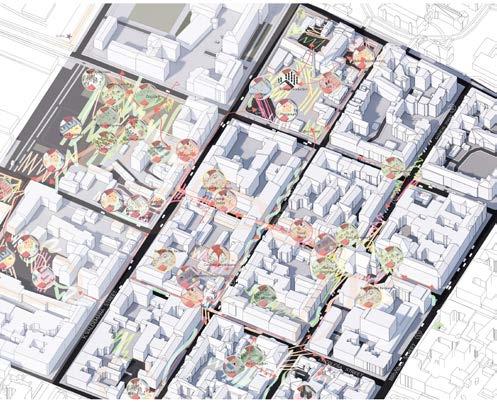
Ellis Soepenberg
Groeten Uit
Do It Together Urbanism
What if a marginalized neighbourhood could invite designers to strengthen their community through design?
In the past year, I have researched how I could put people centre stage in the redevelopment of post-war neighbourhoods in the Netherlands. Post-war neighbourhoods are the textbook example of a ‘problem neighbourhood’ in the Netherlands. There are countless different challenges that are being tackled by all different types of professionals. Big data has resulted in these communities becoming branded as ‘a problem’.
I have developed a method through working with the community of Poelenburg in Zaandam, known as the first Dutch problem neighbourhood. ‘Do It Together Urbanism’ (D.I.T. Urbanism) could be a method with which designers could help empower people, so they can become a client in the redevelopment of their neighbourhood. With this method, I am trying to bridge the gap between the social and spatial realms within these neighbourhoods. There is a lot of effort and time being put into participating with people. Through my research, I have found that how we participate needs to match the capacity of the community. I wanted to be invited into the community, to learn what the community sees as an opportunity that we could work on in the design I am inviting you to join the journey of being invited into neighbourhoods.


1 Story design of Poelenburg, Zaandam. Conclusive drawing of 100 stories collected during my time in Poelenburg.
2 You can’t do urbanism alone, even though there are many personal lessons that I’ve learned, doing it together is what creates an empowered community.
3 Poelenburg is isolated in Zaandam.
4 Timeline of the neighbourhood Poelenburg
5 Personal journey with ups and downs in Poelenburg
6 Do It Together Urbanism. Outlining the three steps of Do It Together Urbanism.
7 Example of one Story Design and how to create a Bridge of Empowerment.
8 Sections of Poelenburg, during the day and at night, showcasing the difference of perception lighting makes.
9 Organogram of all the parties working in Poelenburg. Showcasing that people in the neighbourhood are not the client of the forces in these big area developments
10 Working together and creating a way of personalising the process of urbanism can create an empowered community.
11 In order for people to participate in their neighbourhood, they will have to have their basic needs met. If this is not the case, we should help empower people to get to this level.
12 Spatial analysis of Poelenburg

SPATIAL ANALYSIS


Discipline Architecture
Date exam
11.07.2024
Committee
Pnina Avidar (mentor)
Bart van der Salm
Peter Dautzenberg
Additional members
Jo Barnett
Jochem Heijmans
Merle Soeters
Designing a Future for the Past Architectural exploration on how to reduce inequality for children
The goal of my graduation project was to explore how architecture could contribute to reducing the inequality of opportunities for children. Based on my own experience as a tutor teaching in an underprivileged neighbourhood, the Bijlmer in Amsterdam, I decided to do so by designing a school.
However, not just a straightforward school. The building had to become a place that inspires, stimulates learning and interaction, feels safe and offers privacy, and plays a central multifunctional role in its neighbourhood and community.
It will not surprise you that the neighbourhood I chose was indeed the Bijlmer in Amsterdam. The exact location is the empty space that was left after the plane crash in 1992. The memory of this disaster has been represented in the facade and the building fills the gap of the initial urban plan.
The school itself is intended to facilitate movement, connection and interactive learning opportunities. This is achieved, in part, through the interaction of children with people in the community using the building and its public functions as well. Thus, the building is intended to facilitate blending and connection through its multifunctional spaces. The aim is to create a vibrant place within the neighbourhood, which is in line with the functions outlined for this area by the municipality.


Designing a Future for Designing a Future for the Past


Past


Discipline
Architecture
Date exam
13.05.2024
Committee
Jan Peter Wingender (mentor)
Gus Tielens
Ira Koers
Additional members
Jolijn Valk
Geurt Holdijk
Ianthe Tang
From vulnerable to resilient
An innovative type of housing for closed youth care
“Locking up vulnerable people under the pretext of care has been one of the biggest mistakes that has been made.”
Nando, experiential expert secure youth care February 2022 and over 134,000 signatures later. After years, the many abuses have received the necessary and, above all, proper attention within politics and media, thus setting in motion the end of secure youth care. This is urgently needed, because the problems come at the expense of the care and development of hundreds of vulnerable, innocent young people; a process that still carries great social relevance today. This calls for the introduction of an alternative type of housing. That is why a city-centre, innovative type of housing was introduced for vulnerable young people who cannot grow up at home, where they can grow up and develop in connection with society in the most everyday way possible. From protected assisted living for young people between 12 and 18 to independent living in group form for young adults up to 27 years old as part of the follow-up care. Moving on within the same building in an environment and network that is already familiar to them offers them longer-term housing prospects and enables the transition into society to be more gradual; a place that was designed, in essence, on the basis of the interests and needs of the young people. They step, with their vulnerable past, into a space where they are guided towards a resilient, independent future. The mega-residential palazzo functions as the supporting building typology in this regard. It is a modern version of a classical palazzo; a highly suitable form language due to the protected character without losing the connection with its environment. This is created through an integrated public-social care programme that borders the public neighbourhood street that runs straight through the building. The large scale at building level is a response to the robust character of the surrounding building blocks in the Kadijken neighbourhood, the location of the assignment. Within this palazzo there are also reduced palazzos at housing level to align with the desire for small-scale housing. In this way, the palazzo as a whole forms a village in itself. Based on the central orientation of the building typology, the shared space lies at its core, which gradually transitions to a smaller unit before finally reaching the individual private domain of the young person in the outer ring of the building; The place where the young person begins and closes their day with a view over the city.
Their future.


vulnerable to resilient


Discipline Architecture
Date exam
22.04.2024
Committee
Elsbeth Falk (mentor)
Ard Hoksbergen
Lorien Beijaert
Additional members
Jo Barnett
Patrick Roegiers
Menno Ubink
Leerhuis Banne Buiksloot
Appreciating the existing by building on the existing
The topic of choice for my graduation project is a revitalisation design of a secondary school in Amsterdam Banne Buiksloot. When I started this graduation project, I noted that in our current educational system, we allow school institutions to innovate their curriculum. The idea is to provide different types of education suitable for various individuals instead of one flavour for everyone sounds as a good thing. However, the so called ‘conceptscholen’ also stimulate separation and segregation in the physical domain.
With the rise of many innovative concept schools, such as Agora, Steve Jobs, and Kunskapsskolan schools, the landscape of our secondary school education system is undergoing significant changes. The emergence of these school concepts brings forth not only new challenges for policymakers, but also for neighbourhoods. These school concepts, born out of certain ideologies, will regularly inhabit existing school buildings in an existing context. Attracting a niche group, students may come from different parts of the metropolis rather than residing nearby. As a result, there is often a lack of connection between the school users and the local residents.
It is precisely here that I want to focus on during this thesis project. In addition to the challenges new school concepts present for the quality and unity of an educational system, I had a hunch that if we want to make a concept school succeed, it requires a functional building that suits the concept of the school, but more importantly will complement the existing community.

My role as an architect is to design and to convince with ideas as answers to questions that haven’t been asked yet. The complex segregation phenomenon is constantly changing in terms of its form. Therefore, it’s possible that multiple answers from different fields can be given to this question. However, the power of design, in my case interdisciplinary design, can only give so many answers and interpretations that it will trigger the start of a debate and make the impossible possible. With this graduation project, I dare to dream and will give an insight into how to apply my manifesto on school buildings.


Banne Buiksloot


Liveable Cities
Cities are where the human and the non-human needs collide. These are places that call for a redefinition of the ways of living together. How can we, as designers, create liveable, healthy and safe cities for all beings?
These graduate projects tackle the question of how we can live better, healthier and safer lives, with respect for the needs of both nature and people. These projects examine this complex duality. They are about how to live in a new and improved way within our vulnerable and constantly changing urban environments. The question is: how can we live together in the future with enhanced quality of life, while in harmony with our environment?
Discipline Urbanism
Date exam
12.10.2023
Committee Herman Zonderland (mentor)
Toms Kokins
Viesturs Celmiņš
Additional members
Iruma Rodriguez
Martin Probst
Miks Bērziņš
Riga,
liveable city
A snapshot of a dream
Analysis/Problem statement: Riga's city centre faces multiple challenges: it resembles a ‘doughnut city’, a drive-through city, and a parking city, with limited pedestrian areas, and struggling businesses, leading to a perception of it as undesirable for living. So, what’s missing? How can the city centre become desirable again?
Statement: A liveable Riga must use its spaces, rather than leaving them inaccessible in anticipation of a perfect plan. It should prioritise walkability, reduce car dependency and have ample room for communal activities. Permanent and temporary interventions, co-created by all stakeholders, are vital. The municipality's framework should empower both private owners and communities to participate in shaping the city.
Tools: Effective urban planning combines top-down strategies with bottom-up initiatives. Local traffic reorganisation and green space additions are feasible actions. Encouraging rules for landowners and activists can expedite the process of enhancing the urban fabric. Ģertrūdes superblock: The Void Function toolbox jumpstarts the design process by exploring varied scenarios for empty plots ranging from parks to cultural venues. Ģertrūdes Superblock exemplifies this approach – aiming to leave a big impact by focusing on many smaller interventions around the central Ģertrūdes old church, without disrupting major streets. The size of the project area allows for sensitive implementation of functions, leveraging existing neighbourhood energy.
Conclusion: The city needs to live for it to be lived in. This project aims to build enthusiasm and explore the possible outcomes of acting now. Instead of waiting for monumental changes, let’s try making it more liveable today. Collaboration between the city and landowners is essential in fostering a liveable and diverse city centre.
Moreover, not all plots need development; spaces for ‘permanent temporarity’ – open spaces in the urban fabric – offer a welcome break from the busy city life. Riga's transformation hinges on collective efforts to create a vibrant, inclusive city centre.


Riga, live


liveable city


1 Riga, liveable city – a snapshot of a dream.
2 Urban sprawl/Central voids in the urban fabric.
3 Void Function toolbox.
4 Placing functions in a sensitive way.
5 Ģertrūdes superblock.
6 Ģertūdes old church – the green heart of the neighbourhood.
7 Market, playgrounds, community gardens and cafés.
8 Cultural centre of the neighbourhood.


Discipline
Landscape Architecture
Date exam
21.05.2024
Committee
Thijs de Zeeuw (mentor)
Fiona de Bell
Remco van der Togt
Additional members
Marieke Timmermans
Charlotte van der Woude
Jelle Engelchor
All Philippine
Searching for a new role for landscape architects
*and myself
At the beginning of my graduation route, I asked myself which type of landscape architect I wanted to be. My social way of working in previous projects provided an opportunity for participation that could be utilised in the long graduation period. This was something that rarely arose at the Academy, but which I believed that a landscape architect should be familiar with. That is why I decided not to take the traditional approach of imposing a master plan, but opted for an approach aimed at the needs and wishes of ‘ordinary people’. I chose to focus on the village of Philippine in the Zeeuws-Vlaanderen region, a small place without clear spatial challenges. What caught my attention were the silence, and the unique scenes and challenges of rural border regions.
With participation as the guiding principle, I tried to understand the crucial needs of the village inhabitants. During a seven-day visit, I observed the local community, listened to their perspectives and I drew initial conclusions about what was on people’s minds in Philippine. Conversations with the inhabitants revealed various themes, such as the needs of farmers, senior citizens and young people, and the impact of policy that had transformed the village into a commuter community. A second visit, including a brainstorming session with several inhabitants, led to a story that focused on the role of water in the community in light of the historical connection between the village and the Westerschelde estuary, and the current problems with water management.
The result of the participation is a water system that connects Philippine with the Flemish hinterland and the Westerschelde. This system makes forgotten qualities visible and adds new functions. The design not only made water palpable and sustainably available for agriculture, but also initiated other developments in the village. The most important intervention in the plan is the diversion of a watercourse, in which water from Flanders is directed via a canal to a storage reservoir. A new canal directs water to a natural depression where it can be sustainable stored and managed. This canal is flexible in use, with opportunities for the local population to let in or close off water. The canal also has a recreational function and helps the historical fortifications surrounding the village visible. The bastions are used for developments aimed at senior citizens and young people, while the canal contributes to the redevelopment of the city centre around the old harbour.


Discipline Urbanism
Date exam
20.11.2023
Committee Hans van der Made (mentor)
Ruwan Aluvihare
Marco Roos
Additional members
Léa Soret
Huub Juurlink
Saskia Kleij
The Living City
Over the past few thousand years, humans have used nature for their own needs, causing enormous environmental damage. Human actions have led to climate change and the extinction of many plant and animal species. This is not only harmful to nature, it is also self-destructive. The effects of climate change make areas uninhabitable and lead to increasing shortages of food and drinking water. If we continue on this path, the outlook for humanity is bleak.
To survive, we must adapt our way of life. We need to critically examine how we relate to nature. Instead of just taking, we must give something back, also in cities. With the construction of cities, we have created stone landscapes focused on human convenience and efficiency. However, these cities simultaneously disrupt natural processes and landscapes. The effects of climate change emphasise that this urban design is ultimately unsustainable. We need to find a balance between humans and nature.
In this graduation project, I explore how cities can be transformed into resilient cities where the needs of plants, animals, and humans are seen as equal. Using a new design methodology, I transform the neighbourhood of Overvecht in Utrecht into a nature-inclusive and resilient part of the city. Humans are no longer at the centre; instead, an integral approach to urban design is the base of the project. This way, we live more harmoniously with nature, give space to nature, and ensure a


Living City


1
2


Overvecht through the eyes of plants, animals, and humans.
Design tools.
Biotope map new situation.
Plan drawing Overvecht.
Through the eyes of a climbing plant.
Through the eyes of a bee.
Through the eyes of a bird.
Through the eyes of a human.
Collage research topic soil.
Nathalie Koren 96
Discipline Urbanism
Date exam
10.07.2024
Committee Jaap Brouwer (mentor)
Rob van Dijk
Frank Suurenbroek
Additional members
Sebastian van Berkel
Marijke Bruinsma
A Sensitive City
A new layer in the design of the city
During the design of the city, there is a strong emphasis, on the one hand, on spaces, routes, movement and activity. On the other hand, the design is very much focused on what we see, because this is our most developed sense. Apart from what we see, sensory stimuli that we receive from hearing, smelling, feeling and tasting are the effect of what we are designing, rather than something we actually take into account in the design.
This research shows that the city has a lot more to offer than that which we can perceive with our eyes; something we are still insufficiently aware of as designers and for which we barely have any design tools. By making sound, smell, touch and other sensory experiences fully-fledged components of the whole design process, we can design cities that are not only functional, but also feel pleasant, smell good and have pleasing acoustics, all of which have a major impact on our behaviour and well-being.
The results of the research into sensitive design were tested at a location that could do with some sensitivity: the Alexanderknoop area in Rotterdam. This is a dynamic spot at a strategic hub that plays an important role in the structure of the city. In spite of its prime location, it is not pleasant to live and stay in and around the Alexanderknoop. The heavy infrastructures produce a lot of negative noises, smells and vibrations, and the human dimension is sorely lacking.
The results of the research consist of interesting findings and guidelines for sensitive design. It highlights design based on a sensitive and social profile, interventions at district level that have a sensitive effect on a smaller scale and the need for ‘luwteplekken’: quiet places offering refuge from the hustle and bustle of the city. The smallest possible scale is sought in this research and in that way, we become more aware of the importance of sensitive design.
Sensitive design is not an end in itself, but should be an obvious topic in relation to all other spatial aspects involved in urban design. It is only this way that we can rid ourselves of the idea that a good city is only visually stimulating. It is ultimately about human well-being in a sensitive, attractive urban environment.
A Sensitive

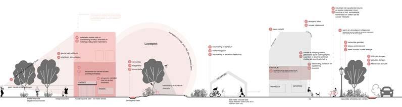

Sensitive Citystream City


1 Overstimulation in the urban environment.
2 The sensitive profile.
3 Perception of the Alexanderplein.
4 ‘Luwte’.
5 A tranquil basis.
6 Experience route from the Rotte river to the Hollandse IJssel river.
7 A sensitive Alexanderknoop.
8 The ‘luwteplek’.
9 The Alexanderpark.
10 Profile of the city centre.


Roelof Koudenburg 100
Discipline
Urbanism
Date exam
27.05.2024
Committee Martin Aarts (mentor)
Henk van Blerck
Marieke van der Heide
Additional members
Koen Hezemans
Huub Juurlink
Where city, loam and stream merge
An alternative for Assen
In recent decades, insufficient attention has been devoted to the opportunities, threats and support of soil, water and nature (structures) when planning cities. This has often resulted in developments that have a parasitic or suboptimal relationship with the landscape, pay scant regard to soil, and exacerbate drought or flooding In addition, the urban expansion lobby remains undiminished. That often leads to the loss of scenic beauty and ecosystem services. At odds with this is the knowledge that investing in the existing city provides a qualitative boost to urban facilities, increases support for public transport and improves the quality of life.
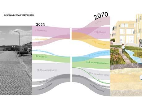
Assen is continuing to develop towards 100,000 inhabitants and is therefore faced with a fundamental choice: will it opt for the familiar practice of expansion under increasingly intense (political) pressure or will it choose the radical option of infill development and transformation? This research demonstrates the advantages of such a radical shift in thinking about the future of the city. The starting points are the preservation of the green character around and in the city, as well as investing in the existing city through densification and transformation. However, the soil-water system play a decisive role in this urbanisation strategy. As a result of this, the urban area will become better able to withstand climate change and increased pressure on biodiversity.
The graduation project begins by defining the identity of Assen. This research develops a development strategy for this that is both rooted in the historical landscape while also taking the new reality into account, namely the formulated challenges and opportunities heading towards 2070. When considering the future prospects, it is crucial to base this on water, soil and nature in order to subsequently show the spatial consequences for the economy, society and energy.
The future prospects provide the starting points for a development strategy at the urban level in which it is specified which type of infill development and transformation is possible and where. Moreover, an adaptive trajectory of densification and transformation in Assen is drawn up that offers a sustainable alternative to the current policy.
The aim of this graduation project is to demonstrate the need for a radical shift in the way cities, in this case Assen, can and must be developed. But above all it shows how the city can make better use of its growth by developing a symbiotic relationship with soil and water, thus making the city more liveable and future-proof. A city where stream, loam and city merge!
Koudenburg

Where


city, loam and stream


1 Poem dedicated to the Drentsche Aa.
2 Analysing the local water system in the Stadsbedrijvenpark Assen.
3 The current practice demands an alternative.
4 Not a tabula rasa, but layers of potency.
5 Thinking in terms of stream and loam actually enhances the existing city!
6 View – inviting prospect.
7 Core concept.
8 The stream valley in the Stadsbedrijvenpark
9 View of the heathland in the Stadsbedrijvenpark.
10 Stream and loam have an impact down to the smallest scale.
11 Bird's eye view of current situation.
12 Inviting prospect 2070.


Daiki Mabuchi 104
Discipline Landscape Architecture
Date exam
16.11.2023
Committee
Marieke Timmermans (mentor)
Yttje Feddes
Hiroki Matsuura
Yuka Yoshida (expert)
Additional members
Jana Crepon
Philippe Allignet
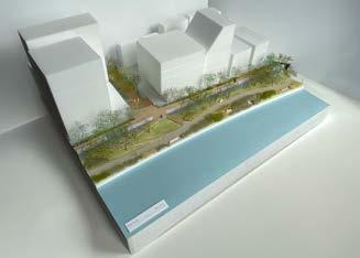
Reverse Transformation of Urban River Public Space in Tokyo
While the Tokyo metropolitan government has made efforts to improve the river space environment since 1980, such as creating a river terrace or transforming the flood wall into dike-type protection, these measures have limitations regarding the construction conditions. Even now, many river spaces remain underutilised due to the flood wall. In the near future, I think Tokyo’s high-density urban environment will require a new method of flood protection that offers the quality of public spaces.
The main goal of this project is to reconnect people to the river by enhancing the accessibility and quality of the river space. The project consists of three different approaches. The first approach is connecting the city fabric to the river through walkable streets, allowing people to reach the river space from the inner city more smoothly. The second approach is integrating important public spaces into the river space, such as parks or major spots around the river. The third approach is creating new river spaces as continuous public spaces along the river with identities considering the surrounding urban context and the river landscape.
Based on the Sumida River, these designs seamlessly connect and form a new urban public spaces network that makes the river a focal point of the city again. Those new river spaces contribute to enhancing the quality of life in Tokyo by providing essential elements such as fresh air, panoramic views, greenery, and relief from urban heat. Eventually, they serve as a refuge from the hectic urban lifestyle in Tokyo.


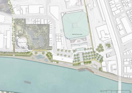


1 Three design methods.
2 Impression: Residential Pedestrian Street.
3 Plan drawing: Flood protection Sumida Park.
4 Impression: Flood protection Sumida Park.
5 Plan drawing: Ryogoku square.
6 Section drawing: Sedimentation Wetland.
7 Impression: Sedimentation Wetland.
8 Plan drawing: Sedimentation Wetland, River Forest.
9 Model (scale 1:100).
Sedimentation wetland ecotone
Sedimentation wetland


Discipline Urbanism
Date exam
11.07.2024
Committee Martin Probst (mentor)
Johan De Wachter
Māra Liepa-Zemeša
Additional members
Markus Appenzeller
Hiroki Matsuura
Marija Satibaldijeva
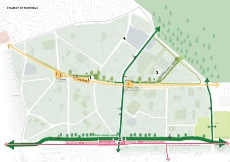
The Future of Riga’s Microrayons
Growing up in Latvia, like many, I lived in a Soviet-era apartment building in a neighbourhood called a ‘microrayon’. These areas remain a significant part of life in Latvia today, but many are stuck in the past, losing touch with their original principles and ideologies.
Now, the challenge is clear: these microrayons need a reboot. They need to adapt to today’s issues and fit in with how people live now.
In Latvia’s capital, Riga, the condition of apartments and microrayons has been shaped by events following the Soviet Union’s collapse. These neighbourhoods often have a negative reputation. With my graduation project, I aimed to shift that perspective by emphasising their potential and figuring out how to prepare them for the future.
Why microrayons of Riga? The city faces more significant challenges with microrayons. Ownership changes and the larger size of these areas make it more challenging to get everyone on the same page compared to smaller places in Latvia. In those areas, it’s easier to renovate, because they’re smaller and there are fewer people to agree on things.
Instead of tearing everything down, let’s work with what we have. Improve the buildings and neighbourhoods – it’s like giving them a makeover. This isn’t just about aesthetics; it’s a crucial aspect of ensuring our city grows in a thoughtful and sustainable way.
So, how can these microrayons contribute to a climate-friendly future for Riga?
In my project, I discovered qualities of microrayons, and I developed strategies that are about accepting the situation – embracing qualities of Riga and it’s microrayons; strategies that can be applied in all Riga’s microrayons and together can contribute to a climate-positive Riga.

With my project, I wanted to inspire the people of Riga and all over Latvia. Living in these neighbourhoods can be part of making our future more sustainable.
Satibaldijeva
The Future


Future of Riga’s Microrayons


1 Timeline of Latvia.
2 Summary of microrayons.
3 Lungs of Riga – vision.
4 Strategy of micrroayons.
5 Strategy of Purvciems.
6 Land ownership situation in Purvciems.
7 Master plan.
8 Principle of ‘creating mobility hubs in microrayons’ in Purvciems.
9 New Swamp park in Purvciems to strengthen identity.
10 Improved main street of Purvciems.
11 A view towards improved courtyard in Purvciems.
12 Maquette.
Microrayons


Bas Tiben 112
Discipline Urbanism
Date exam
28.08.2024
Committee Eric Frijters (mentor)
Wouter Pocornie
Maike van Stiphout
Additional members
Ad de Bont
Liza van Alphen
The ring of connection
Ring canal as natural heritage in the Bijlmermeer polder
The Bijlmer was originally designed as a futuristic neighbourhood intended for families, but it is now primarily known as the first deprived area in the Netherlands. This reputation arose due to various factors, leading to Amsterdam families opting not to live there.
The Bijlmermeer polder already had problems before the residential district was built. As a result of repeated flooding and rising saline groundwater, the polder was unsuitable for agriculture. To make housing construction possible, the polder was therefore raised with sand, which destroyed its original quality. Even after the neighbourhood was built, social problems led to repeated interventions that eroded the original design concept. Today, while the Bijlmer no longer looks like a disadvantaged area, it lacks a clear identity, and urban green spaces seem to be disappearing due to spatial developments.
My fascination with combining nature and urban development inspired my graduation project. The central question of the project is: “How can sustainable densification in Amsterdam Zuidoost (Amsterdam Southeast) be effectively achieved, with specific attention to strengthening the local character and ecosystem, where urban and nature development coexist to create a place-specific biotope where humans and animals live together in a reciprocal relationship?”
The project’s main intervention is the creation of an ecological canal around the current Bijlmermeer polder, which now includes a larger polder system than the original one. This canal forms an ecological and recreational network through Amsterdam Zuidoost and acts as a spatial framework for various developments. The elevated location of the canal enables a freshwater connection between the Holendrecht and the Gein rivers, thus establishing a green-blue corridor between the Diemerscheg and the Amstelscheg.
Through specific developments in Brassapark and the D-neighbourhood, this project demonstrates how the Bijlmer can be densified in a site-specific way, respecting its history while integrating contemporary urban ideas. Additionally, the project shows that nature and urban development can reinforce each other, thereby enhancing the original concept of living within a landscape.


The ring


ring of connection


1 Intervention: Ecological ring canal from Amstelscheg to Diemerscheg.
2 Masterplan Greater Bijlmermeerpolder.
3 Landscape modifications for the realisation of the ring canal.
4 Standard dike profile: 58m wide park as a continuous ribbon through Southeast.
5 Urban planning scheme for D-Neighbourhood.
6 Axonometry D-Neighbourhood: Dike and pumping station as landscape elements.
7 Axonometry D-Neighbourhood: Varied building heights create an urban biotope.
8 Section D-Neighbourhood.
9 Visualization Bijlmer Ring Dike in D-Neighbourhood.
10 Visualization inner courtyard in D-Neighbourhood. 11 Visualization central square in D-Neighbourhood.

Model of D-Neighbourhood.
Synchronising with Nature
This category focuses on finding ways to live in better alignment with nature. It is about adapting to it and becoming resilient. Instead of fighting it, we should adapt to our environments by gaining a better understanding of landscape dynamics: natural rhythms, wind flows, vegetational succession, river flows, etc. These projects focus on coexistence with other-than-human life, radically changing our human-centred perspective. We are all one with the planet. These projects understand the natural systems and work with their forces. Just like in Judo, you don’t fight, you utilise the strength from surrounding forces to your advantage.
Nature
Rachel Borovská 130
Discipline
Landscape
Architecture
Date exam
28.02.2024
Committee
Gert-Jan Wisse (mentor)
Nikol Dietz
René van der Velde
Additional members
Marit Janse
Ziega van den Berk
Wind Woven
Ecological restoration of Breda’s urban fabric through wind
Urban heat islands pose a significant challenge in today’s cities, and the need for cooling and preserving biodiversity are pressing issues. While efforts to combat urban heat islands often revolve around interventions like depaving, greenifying and reclaiming space for green-blue networks, the impact of ventilation on cooling is frequently overlooked in design. Stemming from a deep fascination with the thermodynamic performance of wind, this project aims to rectify this oversight by focusing on understanding wind behaviour and patterns in our everyday environment, using weather, climate and atmosphere as design mediums.
Through delving into multiple scales, this research-by-design project is dedicated to uncovering the conditions necessary to enhance the cooling capacity of wind, starting from two primary wind directions. In the Netherlands, the southwesterly winds typically bring strong cold winds, peaking from autumn to spring. Conversely, during summer, warm air from the east can exacerbate the urban heat effect if it’s unable to surpass urban obstacles, such as closed streets, or densely built or planted areas, which has a negative impact on human comfort and contributes to the loss of ecological habitats.
Wind patterns are explored as a design tool along the eight-kilometre-long railway corridor site of Breda, stretching from east to west. Railway corridors play a crucial role in ventilating urban environments due to their expansive linear profiles and open surfaces, making them essential in shaping the local climate. They also serve as crucial ecological corridors providing extensive linear migration routes for various wildlife and generate airborne trails for seeds. Paired with the ventilating capacity of the railway, the areas surrounding this eight kilometre stretch transform into an ideal testing ground for landscape architecture and urbanism to investigate and implement various landscape interventions and cooling compositions.
Rather than treating these design areas as blank slates, they are seen as integral elements contributing to ventilation, (airborne) ecology and cooling principles. They are infused with wind as a medium, composing a green wedge that weaves through the existing context and structures, connecting neighbourhoods through a biodiverse, ecological network. A park-like necklace woven by wind alongside the railway strip of Breda.


1 A park-like necklace woven by wind alongside the railway strip of Breda.
2 Wind rose. In the Netherlands, southwesterly winds typically bring strong cold winds peaking from autumn to spring. Conversely, during summer, warm air comes from the east.
3 Exploded axo. Wind patterns are explored as a design tool along the eight-kilometre-long railway corridor site of Breda, stretching from east to west. This railway corridor cuts through the most vulnerable climatopes which pose the biggest risk in the accumulation of heat during warm periods and contribute to the worsening of the heat island effect. Railway corridors are crucial in ventilating urban environments due to their expansive linear profiles and open surfaces, making them essential in shaping the local climate.
4 Matrix.
5 Matrix 2. Wind patterns in various street orientations, configurations and typologies are collected in a matrix.
6 Plan West A0. The west area of Breda’s wind stream is the most exposed to prevailing southwestern winds. Building upon the existing tree framework, houtwallen originally established as protective lines for the protection of fields and filtering wind streams, the plan further elaborates on the composition of outdoor rooms, carefully shaped by the placement of new trees and enhancing the existing tree structure.
7 West blue grasslands. Impressions of a “wind room” in summer. Topography is raised along the edges of the new tree structure. Slight variation in topography creates sheltered areas for informal paths and ensuring that the main recreational areas are shielded from strong gusts. At the planted edges they create shelter for smaller insects and pollinators.
8 West beehive autumn. Impressions of a “wind room” in autumn. Strong autumn wind streams are filtered and slowed down through the branches of the trees and shrubbery. Spiders balloon their way through the air and travel long distances with the help of the wind breezes.
9 Plan East. The east stream is essential for welcoming summer’s warm winds. It plays a crucial role in funneling and continuously channeling the winds with as little interruptins as possible, while also cooling them down through the shadows catsed by the tree canopies and glide over water surfaces with no roughness.
10 Wind disperser. The center of the stream is an industrial climatope, an area undergoing transformation called ‘t Zoet. The potential of this area as a disperser was explored through its extended green-blue network to the west of the river Mark and built area composition. The composition and ratio of water, built and planted areas allows the “cooling”wind streams to disperse into (and cool) the surrounding climatopes.
11 Wind woven axonometries. The combination of topography, water surface, vegetation type and roughness have a significant impact on wind pattterns and create a wide range of microclimates in an area.


Discipline
Landscape Architecture
Date exam
18.03.2024
Committee
Hanneke Kijne (mentor)
Willemijn van Manen
Anna Maria Fink
Additional members
Ruwan Aluvihare
Jacques Abelman
Max Daalhuizen
Botanical Rebellion
The city is a beautiful exchange between humans and nature. Despite strict management rules and guidelines, flora and fauna thrive and survive in nooks and crannies, where ownership and responsibilities are unclear. These inspiring natural processes, which are in direct opposition to plans and policies, formed the main source of inspiration for my graduation project.
In this interaction, a new nature emerges in the urban environment, featuring plants and habitats for animals, made possible by the rich variety of conditions and soil types collected by the city’s residents. These are places such as vacant lots, guerrilla and rooftop gardens, flowerpots on sidewalks, and windowsills.
These unique places are at risk due to rigid and systematic planning that allows no room for natural processes, seeking to achieve a final image immediately. Plans that do not consider the specific context, resulting in the disappearance of the quality and beauty of natural processes in the city. It is about time that the unique quality and beauty of natural processes in the city receive more attention.
Botanical Rebellion is a call to create more space for natural processes in the city. In Botanical Rebellion, these natural and social values take centre stage. Sensitivity is developed to recognise such places, and conditions are created for the emergence of new nature and social initiatives in the city, where there is significant pressure on public spaces. The focus lies on an active exchange between humans and nature.
As a designer, I create space for humans and nature in this way, encouraging city dwellers to take care of their environment by recognising the value of every stage in natural processes.


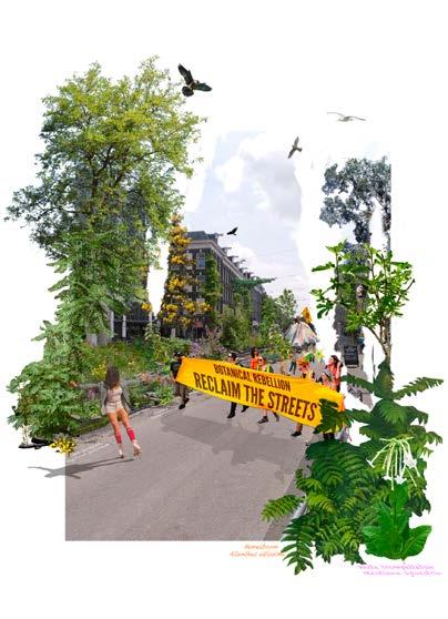


Botanical Rebellion Botanical Rebellion


Zoning map botanical rebellion.
Botanical Rebellion: Marineterrein’s beauties.
Pavement collage.
Reclaim the Streets.
Canal collage.
Dead wood collage.
Botanical Rebellion: An urban network.
Botanical Rebellion: Reclaim the Streets
Botanical Rebellion: Reclaim the canals.
Botanical Rebellion: Amsterdam’s Archaeo-
Beauties.
Botanical Rebellion: Green Invaders Festival
Eating The Invasive.
Botanical Rebellion: Dead wood: an
Discipline Landscape Architecture
Date exam
13.05.2024
Committee
Saline Verhoeven (mentor)
Marit Janse
Jandirk Hoekstra †
Hanneke Kijne
Additional members
Thijs de Zeeuw
Willemijn van Manen
Marleen van Egmond
Het deinen van de duinen
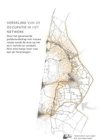
“Deinen” refers to a rhythmic, swaying, or gently rolling movement, often associated with the sea, wind, or other natural elements.
A poetic vision for a resilient and future-proof landscape system in and around the Schoorl Dunes.
“Het deinen van de duinen” provides insight into the close relationship between dune and polder, and how they are inextricably linked through the water and soil systems. By activating the polder landscape with new landscape experiences, both ecological and recreational pressures on the dunes are relieved.
Over 150 years ago, this landscape in North Holland consisted only of shifting sand, where no plant dared to grow. The inhabitants of the villages pleaded for a solution to the drifting sand. Countless efforts to plant marram grass and pine trees eventually anchored the dunes. The landscape transformed from a harsh and wild area into a sanctuary for humans and animals. Landowners invited artists to the area, who admired and captured the striking contrasts between the high dunes and flat polders.
Today, this landscape has become a recreational hotspot, known for its campsites and holiday homes. However, pressure on the dunes continues to rise. It’s not just recreational activities that are stressing the landscape, but also climate threats such as the nitrogen crisis, which is causing grass encroachment in the dunes. Rising sea levels threaten the width of the dunes, and the pine forest contributes to soil acidification. Summer droughts cause groundwater levels to drop, drying out the dunes and leading to potential drinking water shortages. Monocultures in vegetation, agriculture, and bulb cultivation have led to a significant decline in biodiversity. While agriculture once coexisted with nature, it is now a separate system serving primarily functional purposes.
What was once a dynamic system is now set in stone. The landscape is unable to adapt and lacks future value. The natural logic of the landscape is lost, and a new, ecologically based vision is needed. This graduation project explores the ecological foundation and how the landscape can regain its natural dynamism. The goal is to make the landscape future-proof and resilient, capable of facing upcoming challenges. Like the artists of the past, this project offers a renewed landscape experience between dune and polder.

Egmond

Het deinen


dein deinen van de duinen


1 Poetic reimagination of the landscape.
2 Masterplan.
3 The eight systems of the landscape.
4 Habitat type cross-section of the landscape.
5 Design principles.
6 Problem analysis.
7 Close-up masterplan Philistine polder.
8 Habitat types water corridors.
9 Close-up masterplan dunes.
10 Visualisation of the drifting dunes.
11 Occupation of the network.
12 Visualisation of the network.


Discipline Architecture
Date exam
29.08.2024
Committee
Lisette Plouvier (mentor)
Jo Barnett
Yttje Feddes
Additional members
Susana Constantino
Marten Kuijpers
Sofie Ghys
Rooms of water
A future drinking water treatment plant for Antwerp
Nestled along the right bank of the Scheldt River near the city of Antwerp in Belgium lies the former historic Sint-Filips Fortress. In a lush natural landscape in the middle of the Antwerp harbour, a harmonious interplay of water and land unfolds. The design of the building honours the dynamic tidal movement of the river’s fluctuating presence. The Scheldt River is not a static object but a living system that constantly changes. Almost twice a day, the site undergoes a transformation between ebb and flood, a rhythm that is mirrored in the architecture. Time become fourth dimension here, offering a different experience with each visit.
The building hosts a future drinking water treatment plant that taps into brackish river water. This place invites people to wander within its treatment halls, frames views along the river, and celebrates this unique place. Inside, the building consists of spaces filled with water and light, offering a glimpse into the treatment process. Here, water can be experienced in all its different forms, from its source to its transformation into drinkable water and even refreshing swimwater. A series of outdoor swimming pools fulfil the joy of living next to one of the busiest rivers in Europe, each embracing the lingering warmth born from the purification process. By integrating utility function with recreational functions, this project not only serves a functional purpose but also emphasises the critical role of freshwater as a precious resource for the future.


of water


1 FROM ESTUARY TO SITE
To understand the characteristics of the location, the conditions of the river were analysed from the macro scale of the estuary to the micro scale of the site.
2 THE OUTSKIRTS OF THE CITY OF ANTWERP
The project location is nestled between sea and city, industry and landscape, surrounded by industrial grandeur, bustling port activities, small remnants of polder villages and the ever-changing Scheldt River.
3 EMBRACING THE RIVER’S TOUCH
Through time and tide, the façade will reveal the dynamic character of the river. The brackish waters of the Scheldt will continuously deposit new layers on the surfaces, with green deposits gradually overtaking the horizontal lines of the formwork.
4 INVITING PUBLIC INTO THE PROCESS
This project redefines the traditional concept of a drinking water facility by making it accessible to the public. Like a museum, the building creates a space that educates and inspires, a space that blends architecture with infrastructure.
5 THE JOURNEY OF TREATING RIVER WATER INTO DRINKING WATER
6 WATER COURTYARD
A water courtyard symbolizes the water reservoir below, which remains the only part that will not be visible to the public.
7 ENTRANCE HALL
8 BETWEEN INFRASTRUCTURE AND ATMOSPHERE
The public spaces are positioned above the treatment areas, offering views into the halls below and allowing the technical spaces to function independently from the public areas.
9 NESTLED ALONG THE SCHELDT RIVER
The project is situated on the inner bend of the Scheldt River, in relation to the former location of the Fortress of Sint-Filips.
10 TIME AS A FOURTH DIMENSION
The interaction between water and land is ever-changing. Day and night, ebb and flow, continuously reshape the landscape, with each moment bringing subtle transformations.
11 A BUILDING THAT FLIRTS WITH THE WATERLINE
In the building, the rising water level flirts with the structure through windows that interact with the changing tides. Each visit, or even within a single visit, the shifting river conditions influence the experience of the architectural space.
12 LIGHT AS AN INTUITIVE GUIDE
The public circulation spaces meander between the treatment halls, illuminated with soft lighting, while the halls themselves feature industrial lighting. The contrast between dark and light areas guides visitors from hall to hall.


Discipline
Architecture
Date exam
28.08.2024
Committee Rob Hootsmans (mentor)
Kamiel Klaasse
Jana Crepon
Additional members
Machiel Spaan
Donna van Milligen Bielke
Sander Gijsen
Vernieuwd Bouwzicht
A farm with a future and a representation of a renewed relationship between humans and nature
Since the radical reclamation of ‘s-Graveland in the 17th century, when sand was extracted as building material for the expansion of Amsterdam, the reclaimed landscape has been shaped in various ways. The subsequent spatial development of the various country estates, with Gooilust as the ultimate example, indirectly reflects the constantly changing relationship between humans and nature. This dynamic relationship is expressed in both landscape architecture and architecture and fits within the broader development of Western culture. Think of the staging of 15th-century Italian villas in their landscapes, 16th-century French and English gardens, and modern parks such as Parc de la Villette in Paris.
Meanwhile, humans and technology have exhausted nature. Human influence is causing the climate to change rapidly, forcing us to rethink our relationship with nature and how we interact with it. As with any change, (political) tensions increase, and the contrasts between countryside and city are magnified. To address the current nature and climate crisis, the livestock population must be reduced. This will lead to the disappearance of farms unless new revenue models and a farming system are developed that are in balance with nature. This project envisions a renewed relationship between humans and nature by transforming a dairy farm into a place where building materials are grown and harvested. With the farmer as innovator, the aim is to contribute to improving nature and climate by cultivating natural and renewable resources. Through sustainable forest management and the cultivation of bio-based materials, the landscape of Gooilust can supply materials for sustainable housing, while offering farmers a new business model.
The core of this transformation lies in the redesign of the Bouwzicht farmstead and the surrounding landscape, adding a new layer of time to the Gooilust estate. Architecture and landscape come together here, symbolising the new relationship with nature. The transformation calls for a new interpretation of the farmstead and landscape, building on the tradition of self-sufficiency and circularity. Existing buildings are reused and transformed with the addition of harvested materials from the landscape. In this way, the Vernieuwd (Renewed) Bouwzicht farmstead is united with the landscape, becoming an exhibition of historical layers and a representation of a new relationship with nature.


Vernieuwd Bouwzicht


1 Analysis of the development of the Gooilust estate, which serves as a basis for continuing change and envisioning a new relationship between humans and nature within the framework of the estate as an experimental garden.
2 The cultivation, harvest, and application of natural building materials with the renewed (production) landscape in the foreground and the transformed farmhouse in the background.
3 Site plan and accompanying visualisations of a walkable route along the new crops from two different years.
4 Context model (1:200) and floor plan drawing of the transformed farmhouse.
5 Fragment of the home extension and patio between the house and the workshop.
6 View of the front facade of the renovated house. Interior image of the transition from inside to outside through the added dining room space.
7 Visualisation of the new dining table with a view over the landscape and the yard.
8 Image of the yard with the open barn on the left and the workshop on the right.
View of the workshop in the original stable.
9 Image of the storage warehouse where the harvest is stored and dried.
10 Calculation of the CO2 balance of the storage shed and visualisation of the structural construction in detail.
11 Foto fragment maquette nog aan te leveren / Photo of model fragment still to be provided.
Calculation of the CO2 balance of the home extension and fragment model of the extension.
12 Visualisation of the farm seen from the existing forest, symbolizing the union of nature and agriculture.


150
Discipline Landscape Architecture
Date exam
11.07.2024
Committee
Jorryt Braaksma (mentor)
Jean-Francois
Gauthier
Marlies Vermeulen
Additional members
Berdie Olthof
Kim Kool
Floor Hendrickx
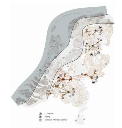
The Future is FOREST
We are becoming increasingly aware of the size and impacts of climate change.
The construction industry still has a long way to go when it comes to reducing CO2 emissions. For example, 11% of global CO2 emissions are caused by the production of building materials, such as concrete, steel and glass. One of the serious alternatives in order to reduce CO2 emissions in this regard is to build with wood more often.
Using this as the starting point in my graduation project, I investigated what the Dutch landscape would look like if we were to produce our own wood in a sustainable way for timber construction. The graduation project examines what sustainable forestry is, which wood is needed for modern timber construction (e.g. CLT), and how and where we can best produce that in the Netherlands. In addition, forests can also offer us a lot more, such as biodiversity, cooling (climate mitigation), CO2 capture, regulation of a healthy water regime, valuable recreational areas, etc. These are all functions that are included in the plan.
Using the design, I subsequently researched what forestry might look like in a stream valley in the sandy soil of North Brabant, as this is one of the landscapes in the Netherlands that is potentially very suitable for forestry. In addition to working with the landscape system, I also researched which economic and social strategies could drive this change in the landscape, so that the plan can be supported by the local community. Finally, forests also have their own sociocultural significance. The shift towards a (production) forest landscape has a great impact and in spite of the sometimes industrial scale of this undertaking, this design seeks space for experience, education, recreation and adventure.
With this graduation project, I want to show the potential of this multifunctional landscape, both productively, socially and for the climate.


Future is Forest


1 Building with wood helps us to reduce the amount of CO₂.
2 Layered production with pioneer species for faster and more diverse forest development.
3 The basis of sustainable timber production is to ensure diversity and the correct scale.
4 The potential Dutch production forest based on water, soil and wind.
5 Setting up the entire production chain on a regional scale.
6 Three guiding principles as strategy for the transformation of the area.
7 Borders of the new sustainable production forest. 8 Recreation in the production forest.
9 Under the trees; making stratification in a production forest visible.

Walk past a dry spot in the forest.
Walk through a young production forest.
Jacoba Istel-Slooten 154
Discipline Architecture
Date exam
21.11.2023
Committee
Jolijn Valk (mentor)
Dingeman Deijs
Dirk Sijmons
Additional members
Jeroen van Mechelen
Rogier van den Brink
WilderNes
An ecocentric school
My graduation project, ‘WilderNes’, is a school designed based on the natural processes of its location, the Polder de Nes. Polder de Nes is an outer-dike polder located north of Amsterdam on the border of the Markermeer and the peat meadow landscape of Waterland. Here, children will learn directly and indirectly about the impact of human actions on our natural environment. Moreover, to make human influence visible and enhance the natural value of the place, the school is part of a landscape design that returns a portion of the cultural landscape of the polder to nature, allowing it to become wild again.
Through this symbiosis of landscape and architecture, children in WilderNes learn to view their natural environment from a new perspective— one in which they, too, are part of the ecosystem.
As a Montessori school, WilderNes believes in helping children to discover and understand things for themselves. To achieve this, I used locally sourced materials in the construction, visible and tangible for the children to interact with, as well as showcasing their lifecycle. Additionally, the school interacts with its surroundings in various ways. Towards the vulnerable peat meadow landscape, the school becomes more integrated with the dike, forming an entrance in the shape of a bird-watching wall. The classrooms on the other side, facing the Markermeer, interact with indentations and protrusions, connecting it to the wilderness of the Markermeer. Some classrooms are elevated on stilts, while others float. In some cases, the buildings even contribute to the development of natural banks by creating protected areas from wind and waves.
Through an analysis of the cultural-historical environment, I discovered a unique typology in the historic village of Marken. Due to the harsh weather conditions on the former island, the buildings are closely situated, forming small squares and intermediate spaces. These spaces — the small alleyways and open areas between houses — are both protected from the weather elements, facilitate social interactions, and direct your view between buildings to the surrounding landscape. This typology serves as the basis for the architecture of the school, alongside the landscape conditions, and helps children experience and understand nature and their relationship with it.
Istel-Slooten
WilderNes


View entrance school along bird-watching wall.
Exploded diagram building structure in relation to landscape.
Floorplan ecocentric Montessori school.
View library between garden and polder.
158
Discipline
Landscape Architecture
Date exam
11.06.2024
Committee Roel van Gerwen (mentor)
Saline Verhoeven
Lieke Jildou de Jong
Additional members
Remco van der Togt
Ronald Boer
Jana van Hummel
Edible Island
A landscape design for Texel as a plea for the food transition
What we eat and how we grow food has always largely determined what our landscapes look like. During my development as a landscape architect, I’ve become increasingly aware of the reality of food landscapes. They no longer constitute a healthy and sustainable system.
Edible Island is an agenda-setting design as a plea for the food transition. I hope my design helps people imagine what our future landscapes might look like, when their design is guided by social values. After all, our landscape is a social good on which our health, safety and happiness depend. Farmers should not be held solely responsible for this – the transition is a responsibility for all of us.
Edible Island shows what this means for Texel. The vast majority of the land surface here is used for agriculture, mainly for the production of animal products, fodder, flower bulbs and potatoes for the mainland. Current farming practices have damaged ecosystems and biodiversity. The island also faces challenges, such as freshwater availability and salinisation, and is looking for ways to become more sustainable and self-sufficient. How do we reconnect with Texel’s farmland for local food, in balance with Wadden nature? I explored what the agroecological perspective can mean for the farmer, the consumer, the soil and biodiversity.
In the first part, I focus on an island-wide vision of the future, with strategic choices for changes in the landscape system. The main points are increasing landscape gradients, increasing scarce freshwater resources and working with natural dynamics.
In the second part, I show in a spatial design for the northern head of the island what this means for the most damaged areas: Polder Eijerland and Polder Het Noorden. The monocultural arable land makes way for healthy and productive ecosystems: food forests, saline agriculture, brackish reed beds and a tidal salt marsh with aquacultures. By adapting the water system and utilising natural processes, landscapes are created that are valuable for nature, farmers and visitors. The result is a diversity of perceptible food landscapes with year-round island-specific products: an Edible Island.


Island


1 Species greatly reduced or which have disappeared since 1850 due to changing land use and scaled-up landscapes.
2 Texel as a generic efficient ‘food’ machine, especially for animal products, fodder and flower bulbs for the mainland.
3 Island-wide vision for building productive ecosystems with regenerative economy.
4 Design for the northern head of the island.
5 Gradient of ecosystems: food forest, mixed saline agriculture, brackish reed beds and salt marsh.
6 Picking hedges, consisting of locally occurring species that are edible for humans and animals, provide scale reduction, cooling and windbreak.
7 Polder Het Noorden: per salt marsh phase the food and ecology opportunities grow.
8 Polder Eijerland: ecosystem restoration by creating green-blue framework and changing land use.
9 From narrow, polluted drainage ditches to wide buffer ditches surrounded by life.
10 From endless monocultural fields with no human or animal in sight, to smaller-scale farms with varied crops and meeting places.
11 From barren rotational fields fighting salinisation to rich brackish reed beds for production, natural values and recreation.
12 From rotational fields that requires a reset and a lot of chemical input every year to a growing salt marsh system, rich in aquacultures and ecology.


Discipline
Landscape Architecture
Date exam
19.03.2024
Committee
Lodewijk van Nieuwenhuijze (mentor)
Bruno Doedens
Alexander Sverdlov
Additional members
Kim Kool
Roel van Gerwen
Krijn Nugter
Once there were dykes
A study of how Māori philosophy can be an inspiration for climate adaptation strategies
Climate change challenges us to consider landscape adaptation strategies. For delta regions like the Netherlands, sea level rise poses a challenge, while the country has historically been protected from water threats through technological innovations. The latest climate predictions from the IPCC indicate that in the longer term (2300), sea levels could rise by 17 metres. This places technological innovations in a different context than the usual predictions focusing on 2100. Indigenous knowledge can provide insights into how collaboration can be sought with natural dynamics, rather than seeing them as a threat. This research explores how Māori philosophy can be an inspiration for new types of adaptation strategies. To test this, an agricultural polder area in New Zealand has been used as a case study, and is transformed into a landscape that is mostly shaped by nature with the use of natural dynamics.
The project has been both qualitatively as quantitatively researched. Unlike typical landscape architectural projects, this project area was initially studied through anthropological fieldwork. Various interviews with (local) Māori, scientists, rangers or officials determined the significance and value of the area. It is noticeable that there is societal tension over land use and ownership that stems from the colonial history.
Inspired by Māori philosophy, three guiding principles have been formulated concerning the functioning of the natural system, the carrying capacity of the landscape and the cultural-historical value of the landscape. From there, an adaptive planning strategy has been developed, which guides the transformation of the project area, emphasising collaboration with natural dynamics and a restrained use of human interventions. This results in a cyclical planning process where planning uncertainties are part of the strategy. The plan therefore has no fixed final image. Not only the natural dynamics are reintroduced, but also culturally and historically valuable Māori sites.
This project illustrates how an agricultural area can transform into a ‘Māori landscape’. The outcome is a restart of the natural process of reclamation in this area and thus the ability to adapt to sea level rise. Natural vegetation processes and the original landscape slowly return, along with Māori culture and values.


Once there


there were dikes


Discipline
Landscape Architecture
Date exam
15.07.2024
Committee
Yttje Feddes (mentor)
Sjef Jansen
Ziega van den Berk
Additional members
Saline Verhoeven
Remco van der Togt
Wouter Sibum
Flowing connections
A natural connection between the Veluwe and the Zuidelijke IJsselmeerpolder, intertwined through streams of water, animals and people
Flevoland is known in the Netherlands and beyond as the largest land reclamation project in the world. We are therefore extremely proud of this piece of land that was reclaimed from the water by humans. But how sustainable is the landscape actually? The Zuidelijke IJsselmeerpolder (ZIJP) consists of separate compartments of nature, forestry, agriculture and residential nuclei that were designed with little or no relationship to their surroundings. There is also little relationship, on a larger scale, between the polder, the border lakes and the Veluwe. All the water that enters the ZIJP due to rain or seepage needs to be pumped out of it. The question is how long we can continue to drain the polder, while we know that more and more water is coming. And how can we meet the many challenges in terms of nature management and housebuilding?
In Flowing Connections, a new way of thinking is proposed that disregards our most recent perspective and our own pride about this region, and which connects the future of this landscape to the much older history of the Flevopolder, far before the existence of the Zuiderzee. By creating a connection between the Veluwe and Flevoland, a centuries-old waterway can be used as a basis to free up routes and space for humans and animals. The Nijkerkernauw and Nuldernauw lakes provide scope to bridge the relatively minor difference in height.
The new stream that leads from the Noord-Veluwe region to the Oostvaardersplassen offers enough space for different water levels, which will result in diverse vegetation. The stream will also provide a new wildlife route from the Veluwe to the Oostvaardersplassen, and will create a wider food supply for the various grazers in the region. Moreover, different landscapes will be created along the water that can be use for residential and recreational purposes. In this way, a more natural stream of water will help to support various functions in a fluidly-connected and future-proof landscape.

Flowing connections


Flowing connections


1 Timeline from 1300 BC – 2200 AC revealing long aeras of freshwater at the location of the, in the current narrative ever present, former Zuiderzee.
2 Concept for Flowing Connections; streams of Water, Wildlife and Habitation (of humans) form an intertwined connection between the higher lands of the Veluwe to lower lands of the Oostvaardersplassen in the Southern IJsselmeerpolder.
3 Creating a connection at the smallest ‘randmeren’, the Nijkerer- and Nuldernauw. Considering the area of the ‘old land’ and the ‘new land’ as one location.
4 New watermap with a new watersystem that flows from the Veluwe down to the Oostvaardersplassen with no outlet to the Markermeer. On both sides larger polderunits (in pink and orange) that have their own seperate outlets to the Markermeer.
5 Inspirational map of the Oereem kreek and brooke system that lays on the gradient of high and low lands on the project location. This former watersystem is the base for choosing the location for a new watersystem.
6 Sketches of wetland situation with plant communities.
7 By digging the route of the new stream, the excavated clay can be used for new reliefs creating wet and dry clay conditions.
8 Section of the recreational area at a former farm on the edge of a wildlife route
9 Charcoal and computer drawing of the new brook stream and wildlife route
10 Section of a forest neighbourhood on a former 1700 x 500m farm plot.
11 Charcoal and computer drawing of the forest neighborhood on the edge of the brook stream.


Memory of a Place
This collective of graduation projects lets the memory of a place speak. These projects celebrate hidden layers of time. They acknowledge the importance of heritage in making us feel connected to the place. Through reconnecting with the past, we can feel we belong. All places are reflections of past generations that left traces behind them; be it landscape forces or recent human use. Our designs should acknowledge they are part of a long timeline of events. In order to understand what is the next step to take in the transformation of a place, we first need to understand the forces that shaped it. Every place is in a state of becoming, so we need to allow time to speak. Through revealing hidden layers of the past, these graduation projects reconnect people with the space. In order to make a step towards the future, we need to learn from what was.
Renan Dijkinga 180
Discipline
Landscape Architecture
Date exam
29.08.2024
Committee
Jana Crepon (mentor)
Jacques Abelman
Raul Corrêa-Smith
Additional members
Berdie Olthof
Marieke Timmermans
(Be)Coming Home
(Be)coming Home focuses on the Campos Gerais region and the Devonian Scarp in southern Brazil, my home. This area’s identity is shaped by a rich tapestry of geological, natural and cultural-historical layers. However, without intentional efforts to bridge these dynamics, alongside the rise of extensive monocultures, exotic species forestry, and unregulated tourism exploiting the landscape, the region risks becoming inhospitable, threatening both its environment and the communities that depend on it.
(Be)coming Home envisions a future where people reconnect with the land, blending traditional practices with the strengths of natural systems. The project introduces new methods for locals to engage with the landscape, transforming land use to generate opportunities for landowners and residents. These initiatives aim to provide alternative livelihoods, regenerate the environment, attract new economic activities, and help communities rediscover the beauty of their surroundings.
Central to this vision is the creation of a network of natural and cultural tourism sites, weaving together local properties through regenerative land use. These interventions not only generate income for communities but also support native flora and fauna, protecting the biodiversity of the region. Redesigned pathways strengthen the connection between people and the land, focusing on healing damaged areas and fostering a deeper sense of identity and stewardship.

One of the essential roles of landscape architecture is to highlight, preserve, and strengthen the local identity of the landscape. A key aspect of this approach is using the tourist potential of the region, with the primary focus on local residents. By encouraging locals to appreciate and engage with their landscape through more diverse land uses and activities, tourism becomes a tool for fostering pride in their environment. Tourists, while important, are secondary in this vision. This new implementation of diverse land uses and activities creates opportunities for locals to experience and live within their landscape, while regenerating and supporting their home. Combined with benefiting local communities, this approach will help preserve both the cultural and environmental heritage of the region. This strategy is vital to preventing the disruption and potential disappearance of one of Brazil’s most valuable natural areas.
Ultimately, (Be)coming Home invites the creation of a sustainable environment where nature and humanity thrive together. Whether people choose to stay or simply pass through, they will find a place to belong within this regenerative landscape.
Dijkinga (Be)Coming


(Be)Coming Home


1 Landscapes of Belonging: Home for All | collage.
2 Elements of Home: personal collection + family archive | photograph.
3 Geological Dynamics | collage.
4 Biodiversity Dynamics | collage.
5 Cultural Dynamics | collage.
6 (Be)coming Home: Hopeful Vision for the Future. | collage.
7 Proposal applied in the city of Carambeí, BR. | Masterplan | 1:12500.
8 Zoom In: New land uses and activities in the landscape. | Plan Drawing | 1:1000.
9 New Dynamics Section: new proposal for the land uses, new activities and the collaborations within the layers to support year other. | Section | 1:250.
10 Plan drawing of the node, showing its recreation function, besides the reparation aspect of erosion control in the area. The planting scheme, composed by native edible species, was conceived so the visitor can also help spreading seeds of the fruit collected, along the pathways.
11 Detail of the Node.
12 Illustration of the new potentials to reconnect with the landscape.
13 Legends of the Masterplan was sent separated, maybe it’s easier for the layout, in case needed.

Maro Lange 184
Discipline Architecture
Date exam
20.12.2023
Committee
Bart Bulter (mentor)
Hannah Schubert
Machiel Spaan
Additional members
Ricky Rijkenberg
Stephan Verkuijlen
Theatre of Transformation
The city decor of Almere
My project, Theatre of Transformation, is an alternative plan for Almere Castle. It is a transformation in which the poetry of the ruin is taken as a design starting point. A transformation designed with the remaining building materials, so that hardly any new materials are needed. A transformation that is not driven by commerce, but which incorporates a cultural function that the city of Almere so desperately needs. A spontaneous place like this is a rarity in the otherwise meticulously planned city of Almere. This in itself already results in a certain quality. Additionally, the mystical appearance of the place has been firmly engraved in the collective memory of the citizens of Almere. This spontaneous and mystical character is an important quality to maintain. However, this quality is currently only experienced by a handful of people: the people and animals who actually use the place. And a bit for people like me, who have a fascination for the place and fly over with drones. The place needs a function so that more people can experience this quality, but this function must not undermine the existing quality of the area.
The area is a potential location for housing. This would turn the potentially most valuable place in the city into yet another new residential area: there is no shortage of building land in Almere, but there is a shortage of unique places that appeal to the imagination and inspire.
My task lies somewhere between letting go and intervening: doing too little means that the area will most likely end in a commercially driven redevelopment; a major intervention would detract from the area’s mystique. That’s why I want a function that merges with the area. A function that can take root, but doesn’t dominate. And a function that, fitting with the character of the area, returns spontaneity and surprise to the growing city of Almere.


Theatre of Transformation


The Ruïnetheater.
The Ruïnetheater.
The Ruïnetheater.
The Riettheater.
The Riettheater.
The Bostheater.
The Bostheater.
The Steentheater.
Re-use.


Vincent Lulzac 188
Discipline
Landscape Architecture
Date exam
16.04.2024
Committee
Thijs de Zeeuw
Lada Hršak
Erik A. de Jong
Additional members
Berdie Olthof
Justyna Chmielewska
Echoes of home
Rediscovering Nantes’ landscape through movement
‘Echoes of Home: Rediscovering Nantes’ landscape through movement’ is a cultural garden project in which visitors are invited to interact and connect with the geological, hydrological and anthropological forces that lay the foundations of the city of Nantes. The seven hectare project site lies at the crossing of a 300-kilometre-high geological fault and the 1000-kilometre-long horizontal Loire river, dividing the greater landscape of Nantes. These landscapes include river plateaux, wine-growing plateaux, marshlands and the riverbed. Unfortunately, the richness of these landscapes can hardly be appreciated from the city. Due to its strategic position, Nantes played a significant role in the transatlantic slave trade, leading to rapid urbanisation during the ‘Golden Age’ and subsequent industrialisation at crane distance from the river; influencing the city’s landscape, as well as the city’s image; with a shift toward exotic products and imageries. In the 20th century, the maritime industry shifted closer to the sea, leaving behind empty quays and an industrial wasteland. To maintain the city’s attractiveness and dynamism, a strategic decision was made to channel investments into cultural initiatives, taking advantage of the rich tapestry of colonial heritage to its fullest potential. However, the consequence of this approach is evident today – a city that thrives on nostalgic aspirations yet struggles to anchor itself deeply within its local ethos.
In response to this heritage, the project seeks to emancipate itself from extractive practices, both in its narrative and execution. Rooted in a personal quest to decolonise the practice of landscape architecture, this project tries to reclaim Nantes’ cultural and natural heritage, while encouraging a deeper connection between visitors and the land. By suggesting movement, visitors are invited to engage with the space, not only visually, but also physically. The design was approached like choreography, where the visitors and the elements are part of a dance.


home


1 The Creature over the horizon of IJmuiden.
2 North Sea Gas Extraction.
3 Floor plan of The Creature, IJmuiden.
4 Anatomy of The Creature, IJmuiden.
5 Chamber of Electricity, Axonometry.
6 Chamber of Electricity, Principle Plan.
7 Chamber of Freshwater, Principle Section.
8 The Creature on the North Sea.
9 Decolonising landscape architecture, result of the research based on the site as a study case, toolbox.


Discipline Architecture
Date exam
27.08.2024
Committee Jo Barnett (mentor)
Machiel Spaan
Rogier van den Brink
Additional members
Saša Rađenović
Tatjana Djordjevic
Dovilė Šeduikytė
The Forest Garden Cultural Centre for Traditional Crafts and Knowledge in Vilnius, Lithuania
The Forest Garden Cultural Centre for Traditional Crafts and Knowledge is a place where everyone can learn from experts of ethnographic Lithuanian culture and celebrate it. The Centre encompasses traditional Baltic values and draws inspiration from vernacular architecture, as well as traditional art.
Lithuanians have a long history of a close, even spiritual, relationship with the forest. The visitors feel a connection with the Markuciai forest in the Cultural Centre, due to its open nature. The platform lets you overlook the crowns of the trees, where events can take place, people can work individually or in small groups or just relax. The Forest Garden provides a plethora of different environments. There are open and sheltered areas, closed and heated spaces. Different levels of comfort encourage the visitors to be as close to the forest as possible.
The building is composed of reused elements from neglected vernacular dwellings and what the forest gave us. We harvested from four sources and constructed temporary pavilions on the journey to the site to act as material storage, as well as bringing interest to the area. Students and locals helped deconstruct and document neglected log houses, harvest and prepare the timber and reed, as well as fire bricks made from the clay on the site. They also designed and constructed the pavilions.
The available materials, inclination of the site and the layout of the trees were the three driving forces behind the design. The brick core has a minimal footprint and a more permanent nature to act as vertical circulation and fireplace, which hold significant importance in Baltic tradition. The layout of the timber platform was determined by the trees on the site, as the leftover stumps from harvesting were used as foundations for the platform structure. The different sizes of the platform modules inspired by an art form called Straw Gardens allowed me to ‘climb up’ the hill Their design was guided by the available timber logs and reused rafters. These modules also make it easy to carry out repairs, replacements or grow, as well as diminish the Forest Garden with time.

The Forest


Forest Garden


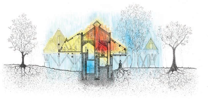


Loretta So-Johnson 196
Discipline Architecture
Date exam
06.03.2024
Committee
Judith Korpershoek (mentor)
Peter Defesche
Marlies Boterman
Additional members
Jo Barnett
Patrick Roegiers
The
Culture of Paper
Asia papermaking creative retreat in the Veluwe
I propose a working creative retreat based on the 8 processes of Asian papermaking that layer working with active rest in the beautiful landscape of the Veluwe with its rich history of paper production. Artists are invited to live and stay at this retreat to experience the process and also the landscape in the hope that this will also influence their creative process
My upbringing of growing up in a Chinese household in Britain and now living in The Netherlands is the start of my story. This intersection and fusion of these three identities provide a richness that informs my own architecture and creativity. Personal cultural exchange for me is defined by learning new methods of working that influence my creativity. Therefore, the theme of cultural exchange through process and making is key to my story.
Papermaking is the backbone of my story because of paper’s cultural significance and its Chinese roots. It is an iterative, explorative and communal process that established a rhythmic process that inspires me as a maker. Paper has touched all continents and in the 16th-17th century, a series of 171 paper mills emerged between Zwolle and Appeldoorn that formed the heart of papermaking in The Netherlands. The Ruitermolen, which became my location, was one of these original paper mills. Built in 1606 as a paper mill, it sadly no longer produces paper and therefore my assignment of a creative papermaking retreat found its home.
This project weaves the eight Chinese intentional steps of making paper with the beautiful Ruitermolen in its surrounding landscape. The resulting architectural language is a careful and precise curation of contrasts in light and dark, functional and expressive, introverted workshops vs light ateliers for the artists, through which subtleties in the material palette are all harmoniously woven together. This retreat marries the right elements from different cultures and this creative retreat is a sum of its parts and also the sum of my identities.
So-Johnson
The Culture


Culture of Paper


1 Paper experiment from own paper pulp. 2 The site plan of weaving paper making retreat of four buildings into the Dutch landscape. 3 Birdseye view, 1:200 model. 4 ‘Earth’ building section.
Paper making workshops - steps 1 - 4. 6 ‘Water’ building section.
7 Intersection between walkway, in-between space, workshop, atelier and stream, 1:20 model.
8 ‘Air’ building section. 9 Papermaking workshops – steps 5, 7 and 8.


Discipline Architecture
Date exam
12.12.2023
Committee
Machiel Spaan (mentor)
Marlies Boterman
Jarrik Ouburg
Additional members
Ira Koers
Elsbeth Falk
Martijn van Wijk
Island encounters
An unraveling of Uilenburg, revealing hidden layers and connecting past and present through design
During walks through the city, I found myself on Uilenburg, an island in the heart of Amsterdam. An eclectic collection of buildings from various time periods draws my attention. I later learned that this location indeed has a turbulent history and has undergone significant changes over time. This led me to wonder: how does my intuitive sense of the place relate to its actual history? What methods can I use to capture this? And how can I translate it into a design?
By capturing my observations of the place through photography and establishing connections between archival materials, cartography, art, and images from others, I uncover findings that reveal hidden layers and singularity of the place, and enrich my intuition during the design process.
These collected findings serve as the basis for landscape, urban and architectural interventions. Together, they weave a layered and intimate narrative that I try to order in a certain continuity. I add, I overlap, I connect, I reveal, I rotate, I anchor. This creates encounters between the existing and the new, between the visible and the invisible, between land and water, inside and outside.
In this way, through an intuitive exploration of specific locations, I aim to express the unique character and story of the island while inviting future passers-by to engage with the space in a new way.


Wijk Island encounters


1 Island Encounters: Catching the last sun rays.
2 Island Encounters: Overlapping site plans spanning multiple centuries.
3 Island Encounters: Model 1:100.
4 Island Encounters: Sections new situation.
5 Island Encounters: Model fragment 1:100.
6 Island Encounters: View of the canal (top) / New building over the water (bottom).
7 Island Encounters: Model fragment 1:100.
8 Island Encounters: Site plan highlighting land expansion over time.
9


Island Encounters: View over a public square.
10 Island Encounters: Model 1:100 (top) / Street elevation (bottom).
11 Island Encounters: Windows as paintings.
12 Island Encounters: Street view (top) / Courtyard (bottom).
204
Discipline Architecture
Date exam
08.04.2024
Committee
Jeroen van Mechelen (mentor)
Hanneke Kijne
Sasa Radenovic
Additional members
Lada Hrsak
Quita Schabracq
Shady Zenaldin
A village reincarnated Breathing new life into a basalt village as a sustainable community hub
‘A Village Reincarnated’ is a design project nestled in the village of Al-Mushannaf, situated atop Jabal al-Druze mountain in southern Syria. The story traces back approximately 12,000 years to when the Al-Safa volcano was active, giving birth to the region’s characteristic basalt landscape. This ancient eruption has made basalt an essential element of the area’s cultural fabric. Local inhabitants have used this volcanic material extensively, particularly in architecture, employing it in everything from homes and temples to monuments, streets, water canals and theatres, making basalt a cornerstone in shaping the built environment.
The ancient section of the village, constructed from basalt, reflects the rich historical tapestry of the area, despite being destroyed and rebuilt multiple times. Tragically, these old houses have remained abandoned since the 1970s. Furthermore, since the onset of the Syrian conflict in 2011, the village and its surrounding landscape have suffered extensively, resulting in significant consequences for both the community and the natural environment.
The primary objective of this project is to delve into the architectural heritage of the old village and its landscape, seeking to address a pivotal question: How can architecture contribute to the healing of both the community and the landscape in such a setting? The project involves an in-depth study of the ancient village, coupled with the design of structures that draw inspiration from the narrative of basalt, the harmony between the houses and the landscape, and the historical context of the area. The project emphasises the use of natural, locally sourced materials and traditional construction techniques, with minimal change to the existing fabric. The aim is to establish a community centre that is conceived and constructed by the locals for their collective use, offering a facility that can support their psychological, social and financial recovery, thereby fostering a process of communal and environmental rejuvenation.


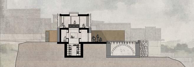
village reincarnated
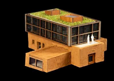


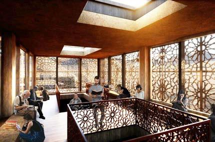


Changing Habits
Re-thinking the ways we live, eat, work and learn is the central point of these graduation projects. These brave and experimental projects tackle the current issues, such as energy transformation, food production, education. They dare to question the status quo of what we are used to. They are futuristic, imaginative, speculative. Curiosity followed by the discovery and creativity seems to be central here. These projects re-define the role of a designer, who through visualising an almost unthinkable futures, questions the way we live, breaking the established norms. These graduates are not only changing habits, but also habitats. They find new, undiscovered spaces and adapt them to be suited for human habitats; be it moon, industrial areas or sea. These visualised imaginary futures have the power to encourage the societal change. How will life look like in the future? These graduates help us make this inevitable transition. They give us glimpse into the future.
218
Discipline Urbanism
Date exam
19.02.2024
Committee
Martin Probst (mentor)
Tess Broekmans
Merten Nefs
Additional members
Pieter Jannink
Andreas Mulder
Arthur van der
RE-Industrial City
Scenario for a post-fossil industrial society
The relationship between heavy industry and the living environment in the Netherlands is problematic. The future of the industry is under increasing pressure here due to growing societal concerns about health and climate. However, we cannot do without industry either; the essential goods and jobs are an integral part of our society.
In my research project, I researched how industry in the Netherlands can play a fully-fledged role. I based this on a post-fossil future where we will have less energy and raw materials available than now. In the plan, employment, economic activity, wellbeing and ecology are not competing forces, but rather collaborative forces that reinforce each other. Existing industrial complexes often provide unique and attractive opportunities to reunite the city and industry. In my plan, a post-fossil industrial city has its own logic and yields a totally new urban typology and morphology: the RE-Industrial City.
This post-fossil industrial city forms a local biotope of collaborative processes. There are less direct relationships with the other side of the world, but there is greater interconnectedness within the region. In the RE-Industrial City, distances are restricted to a minimum, within which the envisaged objects are accessible on foot or by bike. Goods are moved within the city by microtransit. Existing building structures will be used as the basis as much as possible in order to save raw materials and strengthen the identity. Moreover, original ecological and landscape structures will be restored as much as possible and adopted as a starting point.
The RE-Industrial City is not based on economic growth, but the circulation of goods and services. I have translated the principles of a circular economy to 4 spatial building blocks for the city: Creative, Service, Construct and Material (raw materials and energy). Using the building blocks and guiding principles for a RE-Industrial City, I have made an urban plan for Tata Steel and Velsen-Noord. In this plan, the recycling of steel gives rise to the development of a vibrant industrial city where work, living and recreation take place in a new cohesion.

der Laaken RE-Industrial


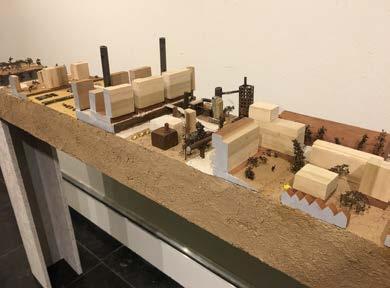

RE-Industrial City


222
Discipline Architecture
Date exam
29.01.2024
Committee
Jeroen van Mechelen (mentor)
Jandirk Hoekstra †
Marten Kuijpers
Additional members
Geurt Holdijk
Susana Constantino
Minnari Lee
The Creature
The North Sea has long been an imaginary space for mankind. This project is a future archive from the year 2200 in IJmuiden, imagining a new form of offshore infrastructure: a floating entity that serves as an ‘indeterminate interface’, intertwining ‘hard’ technological systems with ‘soft’ biophysical processes. This entity can be seen as a regenerative farmer of the North Sea: growing seaweed and fish, desalinating seawater into freshwater, harvesting energy using waves and carrying these sea products to nearby cities, such as IJmuiden. People live in close proximity to it. They engage in its construction, operation, and maintenance in return for ‘harvest’. It aims to redefine our – somewhat forgotten – relationship with our resources, landscape, non-humans and natural elements. Ultimately, it seeks to replace the way conventional infrastructure operates in our current environment. This is also a criticism of the latter, which involves brutal removal of unwanted – mostly natural – elements for its efficient operation and for the benefit of humans. This project establishes the theoretical concepts, which is confined to the realm of abstraction and presents a concrete model through a more tangible practice. The ideas are communicated through diverse formats, such as moving images, paintings and a sculpture. In this way, the project slowly materialises on the horizon of the North Sea, in the form of ‘The Creature’.

The Creature


Creature


1
3
5
The Creature over the horizon of IJmuiden.
North Sea Gas Extraction.
Floor plan of The Creature, IJmuiden.
Anatomy of The Creature, IJmuiden.
Chamber of Electricity, Axonometry.
Chamber of Electricity, Principle Plan.
Chamber of Freshwater, Principle Section.
The Creature on the North Sea.


Discipline Urbanism
Date exam
25.03.2024
Committee
Jerryt Krombeen (Mentor)
Jandirk Hoekstra †
Hiroki Matsuura
Additional members
Marijke Bruinsma
Martin Hopman
Iaroslava Nesterenko
Low-Tech Haven
Redefining Urban Life Through Energy Transition
My thesis ‘Groningen. Low-Tech Haven’ explores how the energy transition will impact the cities we live in, how to design living environments and what we as urban designers can do to preserve quality of life within current shifts. It delves into the intersection of urban design, sustainable low-tech energy practices from the past and the well-being of urban communities.
From Russia to the Netherlands, I’ve witnessed contrasting approaches to energy — from abundance to austerity, from centralised supply to decentralised innovations. This dichotomy shapes my research, influencing my perspective on energy transition as a crucial societal and spatial endeavour.
The layers of the Dutch landscape — shaped over centuries by various energy sources — now await the integration of renewables. How will this new layer change the urban environment of the Dutch context?
My thesis seeks to redefine energy, not merely as a resource, but as a fundamental aspect of urban life, shaping both cultural and spatial dynamics. It proposes that prioritising energy conservation over production is crucial for developing sustainable policies and urban designs. Through a personal narrative that reflects on energy consumption habits, this work emphasises the urgent need to reassess how we use and distribute energy, taking into account the inefficiencies of current technologies.
‘Groningen. Low-Tech Haven’ explores effective ways to make cities more robust, accessible and community-friendly using straightforward, traditional methods. This approach focuses on reducing energy consumption and lessening reliance on high-cost technologies. Initiatives include fostering urban agriculture, enhancing low-carbon transportation and implementing community-driven waste management.
I am developing a toolkit of these practical low-tech solutions to manage various urban resources. This toolkit will be demonstrated in the urban setting of Groningen to show how cities can benefit from these principles. The plan covers urban green-blue network, natural climate control through methods like solar envelopes and wind management, and boosting the efficiency of cargo transport, mobility and food distribution. This is my invitation: to join a discourse on crafting futures where energy efficiency resonates with every stratum of urban life — pragmatic, sustainable, and above all, human-centric.

Nesterenko


Low-Tech Haven


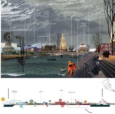

1 Illustrative plan. My design transformed the area into a place with four green parks and four lively neighbourhoods.
2 The low-tech city streets will prioritise cyclists and incorporate visible utilities, enhancing greenery and allowing water to enrich the soil.
3 Urban greenery in a low-lying area acts as a natural reservoir to prevent flooding and provides a recreational space.
4 The ‘Student Haven’ integrates climate control, using natural geography and innovative architecture to create a low-tech, eco-friendly neighbourhood.
5 The Agrihood’ is a community-oriented development centred around shared agricultural spaces.
6 Material Haven, low-tech neighbourhood by repurposing materials.
7 Food Haven.
8 Energy Compass. The infographic gives a clear split of energy consumption by human activities, providing insights into potential focal points for urban design interventions. SOURCE: Sijmons. (2014). Landscape and energy: Designing transition, nai010.
9 Structural plan.
10 Urban schemes.
12 Full axonometry: My design transformed the area into a place with four green parks and four lively neighbourhoods.


Kiwa van Riel 230
Discipline Landscape Architecture
Date exam
28.05.2024
Committee
Pnina Avidar (mentor)
Elsbeth Falk
Yukiko Nezu
Additional members
Gus Tielens
Micha de Haas
Hiking Trail
An elementary school for movement and connection
Hiking Trail is a primary school where movement and interaction are encouraged. In 2024, there are about 620 pupils enrolled, supported by about 50 teachers and staff members. The new design proposal is approximately 6,800 m2 and implements parts of western educational methods whilst respecting Japanese culture and values.
Concept: Children learn by interacting with each other, and by moving around or exploring. By introducing an endless hiking route, the children are encouraged to move around. In Japan, it is customary to change your outdoor shoes for indoor shoes when you enter a school building. To keep the outdoor exploring spirit alive (whilst being indoor), in the new proposal the shoes are kept on and only taken off when entering the classroom.
Traditional Japanese classes consist of homogeneous age groups. By creating mixed age groups, children can learn from and teach each other. Conventional teaching methods also involve a lot of sitting in one clasroom for prolonged periods of time. By providing small, flexible working spaces outside of the classrooms, children can work independently and optionally connect with other groups.
Organisation: The building consists of an inner ring and an outer ring. The route starts with the inner ring (with the younger groups) that goes upwards. At the top, it flows into the outer ring (with older groups) and goes back down. Both rings contain a ‘learning street’ with study nooks. As a result of the hexagonal shape of the building, ‘learning squares’ emerge in the corners where learning streets come together.
The younger children’s learning spaces overlook the inner courtyard, which creates a safe playing environment with plants and trees for the younger children. The older children’s learning spaces overlook the school grounds and surrounding neighbourhood, which is the more adventurous outside world.
Goal: In Japan, there is a rising demand for schools with alternative ways of learning. This project aims to inspire by implementing western educational and architectural elements into a Japanese learning environment, whilst respecting and preserving the existing culture and values. Hopefully, it will stir up the discussion and enable more people to dream.


Trail


1 Scale model: the building sits in a low-rise residential environment.
2 Diagram: the endless hiking route goes upwards in a loop and down in a loop.
3 Scale model: the slope allows for an uninterrupted route throughout the building.
4 Diagram: the inner loop is for younger kids, the outer loop for older kids.
5 Floor plan: ground floor.
6 Section: on multiple locations the floors have different height levels.
7 Section: through small windows, there is a visual connection between different hiking routes.
8 Impression: main entrance to the school grounds.
9 Impression: the bouldering pit is an inviting place to relieve excess energy.
10 Impression: flexible working spaces outside of the classroom.
11 Impression: a ramp connects the classrooms with the inner courtyard.
12 Impression: the facade is clad with vegetation that hides the sitting nooks.


234
Discipline Urbanism
Date exam
29.05.2024
Committee
Hein Coumou (mentor)
Bernardina Borra
Jan Maarten van Hemert
Additional members
Marco Broekman
Tess Broekmans
Wout Velthof
Work District
A new narrative for industrial areas
Many industrial areas have anonymous buildings and low-quality public spaces. These areas are often isolated on the outskirts of cities and are mostly accessible by car only.
In the past, work and living were closely connected, but over time, due to growth and pollution, we have separated them. This has led to industrial areas becoming more distant from society. As a result, people don’t feel connected to these areas. In short, industrial areas are no longer part of the city, and you only go there if you have to.
Due to limited space within cities, industrial areas are often seen as good locations for housing. This causes businesses to be pushed out or disappear entirely. However, we underestimate the importance of industry for a healthy economy. Industry is essential for economic diversity, providing jobs and producing our daily needs. To prepare our cities for the future, we need to retain space for industry, and even expand and renew it. We need to integrate industry back into society and create new economic and social value.
I believe we should design industrial areas as Work Districts to make them part of the city again. In this graduation project, I focus on the industrial areas De Spaanse Polder, ‘s Gravelandsepolder, and Bedrijvenpark Noord-West, located north of Rotterdam and Schiedam.
In a future perspective, I show how this location can transform into a lively Work District. The main principles are densifying, enlivening and connecting. The Work District will have different ecosystems with unique identities and economic activities. By greening public spaces, adding public functions, creating good connections with the surroundings, and encouraging cooperation, the Work District will become a place where employees, residents and visitors enjoy coming. It will be a place that promotes interaction


District


Thais Zuchetti 238
Discipline Architecture
Date exam
29.01.2024
Committee
Stephan Verkuijlen (mentor)
Bernard Foing
Natalie Dixon
Additional members
Raul Corrêa-Smith
Rachel Keeton
Lunar Lessons:
Habitat for interplanetary living
Lunar Lessons is the design of a planetary habitat aimed at knowledge transfer between the Moon and Earth. The idea is to learn from the Moon what it takes to live in an unliveable place, so that we could perhaps apply such lessons to an alien Earth in the future. On the other hand, the lessons from Earth are a direct alternative to the coming space exploration settlements, which are often envisioned and developed to look as clinical and cramped as possible, and provide just the bare minimum for astronauts. Through the process, it became clear the fact that ‘cramped’ and ‘bare minimum’ conditions for the inhabitants are not exclusive characteristics of lunar habitats; the lessons from the Moon are closer to home than what we expect. ‘Lunar Lessons: Habitat for planetary living’ is, in fact, a project about the people (regardless of which planet they are on). Thinking of the people, the Moon base is designed from the perspective of the wellbeing of the crew, incorporating conceptual architectural techniques from Earth to simulate not only the variety of spaces and atmospheres we are used to on our planet, but also the interactions between people and the rituals from home.


Lessons


242
Discipline
Architecture
Date exam
14.05.2024
Committee
Machiel Spaan (mentor)
Ira Koers
Vibeke Gieskes
Additional members
Marlies Boterman
Marten Kuijpers
Ninja Zurheide
The Beauty of Things
A Personal Journey in Creating Architecture
Architects are, in a sense, a kind of director: with architecture, you can highlight certain aspects, but how the visitor ultimately experiences the space is different for everyone. Alvar Aalto expresses it beautifully in my opinion: architecture elevates something.
My graduation project is a personal quest to discover what architecture means to me and how I apply that understanding in the design process. For a long time, I thought I was purely an intuitive designer, but my graduation research taught me that there are indeed underlying reasons behind my choices.
My location is situated on the edge of Bergen, at the transition from wooded dunes to meadows. The site became a kind of research laboratory for me. I visited the place in different seasons and at various times of the day. I documented my observations through numerous photos, sketches, texts, and models.
My graduation project is not about an end result in the form of a fully designed building. This research has become a starting point for me, showing how I want architecture to be viewed—not just as fulfilling a perfect program of requirements (PVE) and adhering to regulations, but also acknowledging all the other factors that influence architecture.
There will be rain, shadows, or wind falling on a window or wall. The way a wall, space, or material is positioned is crucial to the spatial effect. With “experience maps,” I show that materials, landscape, climatic phenomena, and nature are all part of the spatial experience. By translating these aspects into architecture, you can truly design for the experience of the visitor.


There will be rain tapping against a window, while on the other side, there won’t. The way a wall, space, or material is positioned is crucial to the spatial effect it will have. . With “experience maps,” I show that materials, landscape, climatic phenomena, and nature are all part of the spatial experience. By translating these aspects into architecture and situating it within the location, you can truly design for the experience someone may have.
The majority of it happened in my imagination. I found language and notation methods to make this visible. In my imagination and with my senses, I explored the location and envisioned multiple scenarios. Models, photographs, sketches, and texts reveal a series of architectural interventions that help to grasp the essence of what architecture is.
Finally, I came to the conclusion that the phrase “architecture elevates something” doesn’t fully capture it. Rather, by elevating through architecture, you make the beauty of things visible.


The Beauty


Beauty of Things


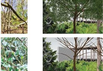


1 Location.
2 Here, you see a tree at the edge of the location, photographed at the same moment but from the opposite direction. For me, this illustrates the importance of direction in relation to time. With this, I studied the positioning of walls, openings, or spaces, as well as the direction from which something is approached.
3 Direction and distance.
4 Imagination map: the trees on the location tell, through each season, everything about what architecture deals with and what can be further elevated. The structures, the side of the shadow, the way they get wet, and the canopy that changes, moves, or stands still, providing shelter or not, create open and closed spaces. I regularly walked through the location, each time taking a different route and imagining a different architecture.
5 The trunks with their various textures made me realise why I place so much importance on designing with different textures. A rough stone or smooth concrete in the right place can amplify an effect.
6 The diagram I made based on the texts I read about architecture and what inspired and was important to me. For each theme, its own diagram emerged, and with small models, I visualised the topics.
7 The “ingredients” you should at least take into account/add when making the design.
8 From inspiration to design.
9 Every location consists of different layers that you could summarise in different maps: the ground/the floor, the trunks/the walls, the canopies/the ceilings. Many more layers could be added, such as wind, shadows, seasons, rain, and the degree of wetness after a shower. A particular floor gives a sound, an opening provides a view, a ceiling gives an atmosphere.
10 Photo of the location model with several pavilions of different shapes and structures. The effects of the sun, wind, rain, temperature will have different influences depending on the place of a pavilion. When you move these, for example, from between the trees to the open meadow, the architecture will have a different effect on the visitor’s experience. The model allows for the study and visualisation of some effects.


Advisory board
Justyna Chmielewska
Anna Zań
Madeleine Maaskant
Janna Bystrykh
Anna Gasco
Joost Emmerik
David Keuning
Communication Mildred Zomerdijk
Editor Roos Bekkenkamp
Translations and proofreading: Richard Glass
Graphic design Mainstudio (Edwin van Gelder)
Printing Libertas Pascal
Publisher
Amsterdam Academy of Architecture
Waterlooplein 213 1011 PG Amsterdam The Netherlands +31(0)20 531 8218 avb-info@ahk.nl academyofarchitec ture.nl
© 2024 Amsterdam Academy of Architecture
All rights reserved. No part of this publication may be reproduced or transmitted in any form or by any means, electronic or mechanical, including photocopy or any storage and retrieval system, without permission in writing from the publisher. Whilst every effort has
been made to ensure accuracy, the Amsterdam Academy of Architecture does not accept responsibility for errors or omissions.
The Amsterdam Academy of Architecture has endeavoured to trace the copyright holders of all the illustrations. Anyone who claims entitlement to copyright should contact the publisher.
ISBN 9789083207452
3-2
Miks Bob Martijn Weekend Minnari
Loretta Max
Vincent Marleen
Jelle
Danië
Ellis WouterRoosje
Sander Sofie
Bob Graduation Weekend Maro
Arthur Max Krijn Vincent Amsterdam
Ianthe
Daniël Roelof
Roosje Marija
Suzanne
Sofie Renan