5 minute read
Important Open Spaces


Blaby DC has placed diffusion tubes around Glenfield to monitor nitrous oxide levels. The Parish Council will press for more monitoring to take place, One at Overdale Avenue has steadily risen from 19 parts in 2015 to 26 in 2018. Another at the corner of the Balk and Station Road also reads 26 as does one at Birch Lane but one down on Kirby Road within the area where heavy vehicles are not permitted reads 30. Of much more concern, one in the centre of Glenfield on Stamford Street has a mean annual count of just under 42. At a local level the Parish Council will encourage the planting of trees to capture some of this particulate matter and will support the endeavours of the Highways Agency in improving traffic flow along the motorway. The layout of Stamford Street however does not provide any possible location for such mitigation, although the Parish Council has planted some evergreen shrubs on the island itself.
Highways England has a published Strategy for the M1 to be upgraded to a smart motorway between Junction 19 and junction 23A including improvements to Junction 21. If and when this happens this should lead to smoother traffic flow which in turn leads to less pollution and less intrusive noise, another form of pollution. The issue of light pollution was considered but discarded as while some residents wanted to have dark skies also thought of benefit to wildlife, many residents also decried what they considered an inadequate regime of street lighting.
Advertisement
There are also discussions about a possible additional motorway junction to the south of that junction which would relieve the pressure on that exit point. An eastern distributor road around Leicester would also reduce traffic levels coming up the motorway, at least in the short term, although this looks an unlikely development.
POLICY ENV 2: AIR QUALITY - Planning decisions should take account of the impact on air quality in the Plan Area, supporting proposals which will result in the improvement of air quality or minimise reliance upon less sustainable forms of transport.
Creation of an environment for residents that provides as much open, green space as possible, with opportunities for outdoor recreation, sports, fresh air, and appreciation of the natural world and historic assets, is a priority for the community represented by Glenfield Parish Council. As far as possible, standards for the provision of such spaces in new development are required, with land acquired by the Council or otherwise secured for the community, and management designed to maintain the functions and benefits of individual open space sites.
The result is that there are (currently) 38 open spaces in Glenfield with the formal or effective status of Open Space, Sport & Recreation site. Their protection, either for their function and amenity, or as coherent green open spaces in particular locations relative to residential areas of the settlement, is provided in this policy at the highest appropriate level available in the planning system.
The policy is in conformity with and supported by NPPF (2021) paragraphs 92(c), 97 and 98, and Blaby District Council Local Plan Delivery DPD (updated and adopted 2019) Policy CS 15. The sites are classified under Blaby DC Open Space typologies (2015), and all those allocated to the natural
34
greenspace typology have demonstrable biodiversity significance and are the primary component of the parish’s strategy for biodiversity enhancement.
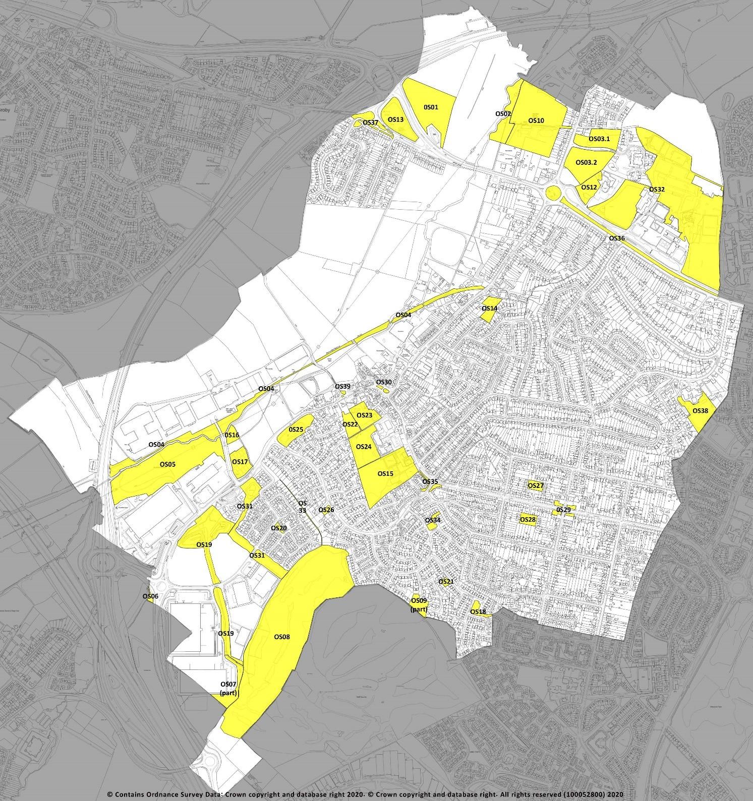
Figure 8: Important Open Spaces
POLICY ENV 3: IMPORTANT OPEN SPACES – The following open spaces in Glenfield (figure 8) are of high value for one or more of sport, recreation, beauty, amenity, tranquillity, and community-led biodiversity enhancement, or as green spaces within or close to residential areas. Development proposals that result in their loss, or have a significant adverse effect on them, will not be supported unless the open space is replaced by equivalent or better provision of its valued features in an equally suitable location, or unless the open space is no longer required by the community.
35
Brantings Wildlife Meadow and Jubilee Wood (Inventory reference OS 01) Glenfield Parish Council; Blaby DC Open Space typology natural greenspace Watersmeet Meadow and copse (OS 02) Glenfield Parish Council; natural greenspace Gynsill Wood (OS 03.1) Glenfield Parish Council; natural greenspace Gynsill Meadow (OS 03.2) Glenfield Parish Council; natural greenspace Ivanhoe Trail, Glenfield (OS 04), Leicestershire County Council; includes part of the Leicestershire long distance path and cycleway; accessible open space, natural greenspace Brookside Meadow (OS 05), Private ownership, permissive access, natural greenspace Clanfelde Hills (OS 06) (section in Plan Area only), private ownership, permissive access managed by Savills (UK) ltd for Wilson Bowden plc; natural greenspace Optimus Point Nature Area (OS 07) (section in Neighbourhood Plan Area only); private ownership, permissive access; natural greenspace managed by Savills (UK) ltd for Wilson Bowden plc Blackthorn Green* and Fishley Belt (OS 08), Glenfield Parish Council* and Leicester City Council; accessible open space, natural greenspace Peartree Green (OS 09); Glenfield Parish Council; accessible open space Glenfield Sports Ground (OS 10) Glenfield Parish Council OSSR; outdoor sports Glenfield Millennium Green (OS 11); Glenfield Parish Council, leased to Millennium Green Trust, managed by the Trust); outdoor sports, children’s play area (OS 13), parks & gardens, accessible open space, natural greenspace Gynsills Parkland (OS 12); private open space with unrestricted access; parks and gardens, children’s play area, accessible open space, natural greenspace Station Park (OS 14); Glenfield Parish Council; accessible open space Ellis Park (OS 15); Glenfield Parish Council; parks & gardens; outdoor sports; children’s play area; accessible open space Mill Lane dog exercise area (OS 16); Glenfield Parish Council; accessible open space Mill Lane allotments (OS 17); Glenfield Parish Council; allotment gardens Normandy Green (OS 18); Glenfield Parish Council; accessible open space Optimus Greenway and ponds (OS 19); Private ownership, managed by Savills (UK) Ltd for Wilson Bowden plc; accessible open space; natural greenspace Stanley Avenue open space (OS 20); private ownership, managed by Savills (UK) ltd for Wilson Bowden plc; accessible open space Wheatfield Close open space and pond (OS 21); Glenfield Parish Council; accessible open space, natural greenspace Glebe allotments (OS 22); Glenfield Parish Council; allotment gardens St Peter’s churchyard (OS 23); Parochial Church Council churchyards and burial grounds Glenfield Primary School grounds (OS 24; Leicestershire CC / Scholars Academy Trust; in Blaby DC OS Audit 2018 as playing pitch Elm Tree Avenue / Kirby Road attenuation basin and open space (OS 25); Private ownerships accessible open space Wollaton Green amenity open space (OS 26); Glenfield Parish Council; accessible open space Frith Close amenity open space (OS 27); Housing Association; accessible open space Lane Close amenity open space (OS 28); Housing Association; accessible open space Tournament crossroads open space (OS 29); accessible open space (Leicestershire County Council and Everards Brewery)
36


