12 minute read
3. Strategic and Legislative Context


This section provides an overview of State and local strategies, plans, policies and other legislation that is relevant to rural land in the Clarence Valley. It should be recognised that there is a significant number of documents that are relevant across a wide range of industries, activities and uses. Those captured in this section are the prominent to the overall Strategy process, whilst a range of more detailed documents that have informed this Report are also identified in Appendix C.
3.1 State planning
North Coast Regional Plan 2036
The NCRP 2036 directs councils to protect and enhance productive agricultural lands, grow agribusiness across the region and sustainably manage natural resources. Relevant directions include:
o Direction 6: Develop successful centres of employment, including for food production and agribusiness o Direction 8: Promote the growth of tourism o Direction 11: Protect and enhance productive agricultural lands o Direction 12: Grow agribusiness across the region o Direction 13: Sustainably manage natural resources
How and when these directions are relevant are further explored in the relevant parts of the Report.
The development of the Rural Lands Strategy is part of a suite of strategies that form Clarence Valley’s Local Growth Management Strategy. This Strategy then responds to the NCRP 2036 directions outlined above. It is also noted the NCRP 2036 is in the early stages of a review that is expected to culminate in a new Regional Plan in mid2022.
Right to Farm Act 2019 & Right to Farm Policy
The NSW Right to Farm Policy was introduced in 2015, with the Right to Farm Act introduced in August 2019 and provides for matters relating to farm trespass and the right of commercial enterprises. The Act allows farmers to carry out their lawful business activities, shielding them from nuisance complaints, claims and legal action from their neighbours and other third parties. The Right to Farm Policy that accompanies the Act provides a series of principles and actions on a state-wide approach to deal with the issue of ‘right to farm’.
It is noted that the NSW Agricultural Commissioner has undertaken a review of the Right to Farm Policy, that was released in December 2020. The recommendations of this review, and subsequent documents that have since been released (see below for example), are considered herein and further within the development of the Rural Lands Strategy.
Agricultural Commissioner’s Land Use Planning Reports
As mentioned above, the NSW Agricultural Commissioner has reviewed and developed recent paper and reports associated with the future of agricultural within the context of the land use planning system.
An Options Paper was released in December 2020 which outlined potential directions to address critical issues of loss of agricultural land, managing land use conflicts and supporting growth within agricultural industries.
A series of principles has been developed by DPI to guide councils in the preparation of a rural lands strategy. These will be incorporated into the Strategy and include the following:
o Productive agricultural land should be maintained for ongoing primary production o Land use planning should protect and prioritise productive agricultural land recognising its social, economic and strategic value (value which includes the dependency of secondary agricultural businesses and retailers on primary production) both immediately and intergenerationally o Such land use planning provisions should be proportionate to the quality and scarcity of the land o Strategic planning for rural land should consider and accommodate agricultural trends, market forces and the unique issues facing primary production businesses from time to time
o Non-agricultural land uses in rural areas should not detract from the long-term productive capacity of agricultural land and secondary industries, services and infrastructure that support agriculture. o Rural land use strategies should ensure non-agricultural land uses in rural areas maximise community benefit and minimise land use conflict and adverse impacts on agriculture o Rural land should not be further fragmented unless a lot size audit for the LGA has been undertaken demonstrating a strategic agricultural need for smaller rural lots.
In July 2021, a report entitled Improving the Prospects for Agriculture and Regional Australia in the NSW Planning System was released, which further details recommendations to the NSW Government for reforms in this area. The 12 recommendations of that report are summarised below:
1. Adoption of a State-wide policy on agricultural land use planning, including additional resources for councils to improve consistency in land use decisions on an around new
State-wide significant agricultural land mapping 2. State-wide review of the RU1 and RU2 zones to provide a clear determination of priority for agriculture 3. Development of a State Significant Agricultural Land map, which was exhibited in draft form from October to December 2021 4. Identify and promote “Identified Production Areas” to build on existing and future comparative advantages of different regions 5. DPI and DPIE work together to monitor rural zones changes and effectiveness of strategic planning to influence development decisions 6. Reduce red-tape for agricultural development through new and revised land use definitions and clarification of ancillary development 7. An “inland Code” be developed to enable a more accommodating approach to agriculture in non-coastal locations (likely to exclude the Clarence Valley)
8. Creating an online platform for farm development planning proposals 9. Creating a requirement for councils to consider buffer guidelines for agricultural operations in the development application process via an agent of change approach 10. Requiring concessional allotments and dwelling eligibilities to be phased out as Clarence Valley has already done 11. Implementing education programs for council planners, councillors and the public around agricultural land use planning needs 12. Establishing a Farm Practices Panel to assess and endorse industry codes of practice, including identification of “normal” conflicts that should be accepted 13. Establishing a Council Reference Group to bring together councils to share experiences of agricultural land use conflict.
The report also identifies four phases of implementation, including key responsibilities but no timeframes.
State Environmental Planning Policies
Several State Environmental Planning Policies (SEPPs) control and influence the management of rural land. These SEPPs deal with matters of State or regional significance, which generally prevail over local controls. SEPPs of particular relevance to Clarence Valley rural land include:
o SEPP Primary Production and Rural Development (2019) o SEPP Coastal Management (2018) o SEPP Koala Habitat Protection (2020) and (2021) o SEPP Exempt & Complying Development Codes (2008) o SEPP Hazardous & Offensive Development (No.33)
Ministerial Directions (issued under Section 9.1 of the Environmental Planning and Assessment Act 1979)
Ministerial Directions must be considered in the assessment of rezoning and other planning proposals. Strong justification is required for any planning proposal that fails to meet the objectives of relevant Directions. Those that are particularly relevant to rural lands in the Clarence Valley include:
o Direction 1.2 - Rural Zones o Direction 1.5 - Rural Lands o Direction 2.1 - Environmental Protection Zones
Other Ministerial Directions of more general relevance to rural land in the Clarence Valley include 2.3 Heritage Conservation, 2.5 Application of C2 and C3 Zones and Environmental Overlays in Far North Coast LEPs (albeit not technically applying to the Clarence Valley), 4.1 Acid Sulfate Soils, 4.3 Flood Prone Land and 4.4 Planning for Bushfire Protection.
Draft State Significant Agricultural Land Map
NSW DPI has recently exhibited the state-wide Significant Agricultural Land map. The mapping program has sought to recognise and value important agricultural land. The program supports the NSW DPIE regional planning targets that include actions to map important agricultural lands in NSW and has been further identified through the NSW Agricultural Commissioners recommendations.
In the Clarence Valley, the Far North Coast Farmland Mapping was the first to be conducted based on ‘catchments’ and the DPI have indicated that the current mapping is of some of the highest quality
across the State and therefore has high levels of accuracy having been reviewed in 2020.
The value of the existing mapping is also recognised in the July 2021, “Improving the Prospects for Agriculture and Regional Australia in the NSW Planning System” report prepared for the NSW Agricultural Commissioner. The Report found that the North Coast Important Farmland mapping was a good example of farmland management and has suggested this approach could be taken on a State-wide basis11 .
However, the exhibited State Significant Agricultural Land mapping is far more expansive that then existing mapping. The total area of land is almost 200,000 hectares, or more than a 300% increase over the existing mapping that had previously been endorsed and identified as being a good example of its kind. The exhibited draft mapping also covers large expanses of native vegetation which appear to be counter-intuitive to being significant farmland. Given this mapping is in draft form, and its extents are of debate, this Background Paper assumes the use of the existing adopted mapping only.
Other State and Federal legislation
The Environmental Planning and Assessment Act 1979 (EP&A Act) and associated Environmental Planning and Assessment Regulation 2000 (EP&A Regulation) provide the overarching legislation for land use planning in NSW.
Other legislation that generally applies to rural lands includes the Local Land Services Act 2013, Rural Fires Act 1997 (and associated NSW
11 As identified in the frequently asked questions of the State Significant Agricultural Land mapping (https://nswdpi.mysocialpinpoint.com/ssal accessed 15.11.2021) Strategic Guide to Planning for Natural Hazards (draft)), Biodiversity Conservation Act 2016, Environment Protection and Biodiversity Conservation Act (Cth) 1999, Heritage Act 1977, Water Management Act 2000, National Parks and Wildlife Act 1974 (particularly with reference to Aboriginal heritage) and Aboriginal Land Rights Act 1983, Native Title Act (Cth)1993.
Further detail of specific legislation is made where required in this paper.
3.2 Local planning
Clarence Valley Local Strategic Planning Statement
The Clarence Valley Local Strategic Planning Statement (LSPS) includes a project priority to ‘Support and grow the agricultural sector - Protect important agricultural land and facilitate improvements in the supply chain to support economic growth, food security primary producers and the agri-food sector.’ There is a clear intent from the LSPS to support the growth of rural areas and agricultural activities, and to do this in ways that are sustainable and within the context of the character of the area.
The LSPS also establishes the need for further strategic planning in the Clarence Valley, with Planning Priority 1 and Action 1.1 being to ‘Prepare a Local Growth Management Strategy for the Clarence Valley (including Rural Lands Strategy)’ .
Other Planning Priorities of relevance to this Strategy include:
o Priority 13 – Support and grow the agricultural sector. - Action 13.3: Protect rural zoned land and productive agricultural land from urban and rural residential development by directing development to identified investigation areas and not adjacent to productive agricultural land, implement state government policy, such as the ‘right to farm’ legislation.
- Action 13.4: Implement the North Coast farmland mapping project undertaken by DPI and DPIE, supplemented with local studies. - Action 13.7: Identify opportunities to increase resilience of rural landscapes and promote regenerative agriculture, especially to increase carbon in soils to improve productive capacity, contribute to reducing atmospheric
CO2, increase water holding capacity of soil so reducing drought impact and significantly reducing the effects of runoff and soil erosion on roads, bridges and other infrastructure.
o Priority 11 - Strengthen the local economy and provide opportunities for local employment. - Action 11.1: Align the planning framework (zoning for business and employment land) to help achieve ecologically sustainable development and implementation of the Regional Economic Development Strategy.
These and other actions of the LSPS are identified as relevant throughout this Background Paper.
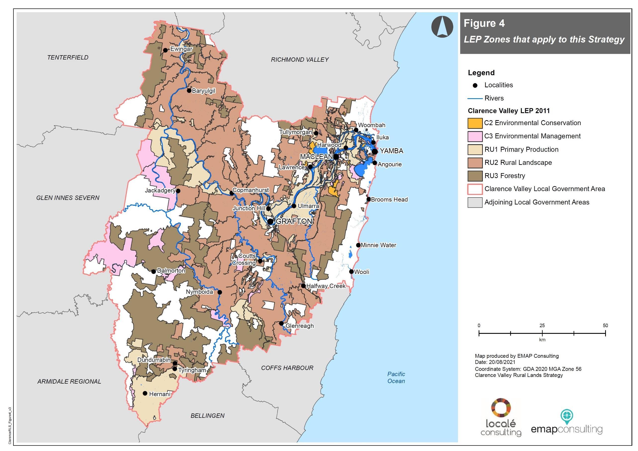
Clarence Valley Local Environmental Plan 2011
CVLEP 2011 provides the statutory framework for planning decisions for the Clarence Valley LGA and includes a land use table that lists the objectives of each zone type and permitted land use. The zones that comprise the area subject to the Rural Lands Strategy are:
o RU1 Primary Production o RU2 Rural Landscape o RU3 Forestry o C2 Environmental Conservation o C3 Environmental Management
Figure 10 on page 19 provides a visual overview of the distribution of these zones. Further discussion around the objectives and permitted uses for each relevant zone is also provided throughout this Background Paper.
Clarence Valley Rural Zones Development Control Plan 2011
The Clarence Valley Rural Zones Development Control Plan 2011 (Rural Zones DCP) complements the CVLEP 2011 by providing more detailed development controls for rural zones that address such matters as the protection of amenity, privacy and scenic values, flooding and tidal inundation, flora and fauna, development design along with operational requirements.
The Rural Zones DCP applies to land in the following zones that are subject to the Rural Lands Strategy: o RU1 Primary Production o RU2 Rural Landscape o RU3 Forestry
Clarence Valley Environmental Protection, Recreation and Special Use Zones Development Control Plan 2011
Clarence Valley Environmental Protection, Recreation and Special Use Zones Development Control Plan 2011 (Special Zones DCP) also supports and complements CVLEP 2011. It encourages development of land in ways that complements the character of a locality, is at an appropriate scale, minimises impacts on the environment and minimise land use conflicts.
The Special Zones DCP applies to land in the following zones that are subject to the Rural Lands Strategy: o C2 Environmental Conservation o C3 Environmental Management
Clarence Valley Contributions Plan 2011
Section 7.11 and Section 7.12 of the Environmental Planning and Assessment Act 1979 allows Clarence Valley Council to levy contributions towards the cost of providing local infrastructure. The Clarence Valley Contributions Plan 2011 sets out the local infrastructure required to meet the demand from new development.
Clarence Valley Settlement Strategy 1999
The Clarence Valley Settlement Strategy 1999 is Council’s existing strategic approach to future planning across the former council areas of Copmanhurst, Grafton, Maclean, Nymboida and Ulmarra. The Strategy outlines the vision of how the Clarence Valley would grow over a 20 year period, including references to the future planning of rural lands and rural issues on valley-wide basis.
Other Local Polices
Other applicable local policies and strategies that provide planning guidance for the rural lands in Clarence Valley include Community Strategic Plan – The Clarence 2027 and the Clarence Valley Regional Economic Development Strategy 2018 – 2022. It is noted that a new Community Strategic Plan will be adopted in 2022.
Further detail of specific Council policies and strategies, such as Council’s Biodiversity Strategy and various disaster recovery work is made where relevant throughout this document.
JACKADGERY
Figure 10: INSERT MAP OF LEP ZONES THAT APPLY TO THIS STRATEGY Figure 10: Rural lands area by zone