


DDear visitors,
welcome to the Municipality of the Sacred City of Messolonghi!
You are in the heart of Western Greece, in the Sacred City of Hellenism, the capital of Aetoloakarnania. Messolonghi, which is known for the Exodus of the Free Besieged, Aetoliko, also referred to as “the small Venice of Greece,” and Oiniades, with its great archaeological monuments and findings, are waiting for you to discover, explore, and uncover their secrets.
In our Municipality, which covers approximately 670 square kilometres, you will find many ancient and modern historical monuments, museums, churches, and monasteries. The area also boasts ancient theatres, castles, and shipsheds, along with stunning natural landscapes such as the famous lagoon, endless beaches, the estuary of the Acheloos River, wetlands with rare fauna, incomparable forests, unique mountain hiking trails, and much more. The tourist guide you hold will help you explore all these attractions.
In the four volumes, you’ll discover all the helpful information you need: a comprehensive tourist guide, an extensive list of local attractions and much more to assist you during your visit.
I am confident that once you become more familiar with our area, it will become a cherished travel destination for you.
I hope you enjoy your visit to the Municipality of the Sacred City of Messolonghi!
Spyridon V. Diamantopoulos
Mayor of the Sacred City of Messolonghi

The Municipality of the Sacred City of Messolonghi, situated in the southern part of the Regional Unit of Aetoloakarnania, is a vast ecological treasure and offers unforgettable travel experiences. It is an enchanting aquatic world next to a legendary city with a rich history that invites visitors to explore it.
The three municipal units Sacred City of Messolonghi, Aetoliko, and Oiniades form a unique entity with the water element as a backdrop. The rivers, Acheloos and Evinos, have played a pivotal role in shaping the municipality’s historical identity since ancient times. The region has numerous archaeological sites, such as Plevron, Calydon, Oiniades, and Alykirna. These sites provide evidence of the fertile land and water resources that early inhabitants used. The remnants of harbours, shipsheds (neosikoi), theatres and markets reflect the remarkable culture that has developed in the region over the years.
In this ancient Aetolian land, there are several sacred sites of significant importance that testify to the historical sequence. Among them are the Byzantine monuments of Agios Nikolaos (Saint Nicholas) Kremastos and the Episcopal Church of Mastro, along with the post-Byzantine churches of Panagia (Virgin Mary) Finikia and Lesiniotissa, Agios Panteleimonas (Saint Panteleimon) in Stamna and the Dormition of the Virgin Mary in Aetoliko. Other religious pilgrimages such as the Monastery of Agios Symeon (Ai-Symios), the Monastery of Panagia (Virgin Mary) Eleousa and Agia Triada (Holy Trinity) in Kleisoura have a remarkable story to share with the visitors.
Amidst the ancient towns and monasteries lies a natural landscape of unparalleled beauty, with the lagoon, the largest aquatic ecosystem in Greece, at its heart. This area is home to a diverse range of inhabitants, including people, fish, and birds. It is a natural workplace for fishermen and salt gatherers (alikarioi), a sanctuary for migratory birds, a breeding ground for many fish species and a field of research and observation for nature lovers and photographers. Due to its significance as a habitat, the area has been designated as an National Park, protected by the Ramsar Convention and is part of the Natura 2000 network.
The landscape is adorned with dunes, salt marshes, salt pans, reed beds and the magnificent Louros beach, creating a truly enchanting setting, complemented by traditional fish farms (ivaria), keel-less small boats (gaita), post-framed wooden houses (pelada) and historic islets. Dioni Beach is an ideal destination for


adventure seekers, offering activities like kite surfing.
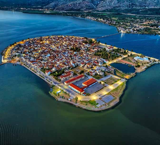
The nearby Sacred City of Messolonghi is closely linked to the lagoon and has a significant historical connection to the heroic Exodus during the Greek Revolution in 1821. It’s a city with a strong legacy of heroes and served as an inspiration for Lord Byron. The area has many tourist attractions, including the Garden of Heroes, the Xenokrateio Archaeological Museum, the Municipal Art Gallery, the Art and Literature Centre - Museum “DIEXODOS”, the Museum of the Trikoupis Family, and the Residence of Kostis Palamas.
Cycling along the path from the Sacred City of Messolonghi to Tourlida at sunset provides breathtaking scenery that will stay with you forever. You can also experience this picture-perfect beauty on a trip to Aetoliko, a small island in the heart of the lagoon connected to the mainland by two stone-arched bridges.

Where the mind’s journey stops, the taste experience begins as the palate is stimulated by new sensations, particularly with fish. Gilt-head bream, sea bass, eel, European bullhead, and various types of flathead grey mullet, prepared in various ways, salted or grilled, along with the finest Grey Mullet Roe, will undoubtedly leave a lasting impression. This seafood pairs perfectly with the local tsipouro and ouzo, delivering a delightful experience for the soul.
This location is where your senses will awaken, offering a fusion of visual beauty, flavours, and aromas that embody the region’s cultural identity. The traditional festivities include Ai-Symios and Agia-Agathi, which are listed in the National Inventory of Intangible Cultural Heritage. Additionally, there are festivities of Agia Paraskevi of Neochori, Agioi Asomatoi of Agios Ilias, and Ai-Giannis of Evinochori that feature armoured men and cavalrymen and along with the captivating melodies of traditional organ players accompanied by the sounds of davul (ntaouli) and zurna (zournas) preserve the customs and traditions of the area.
The Municipality of the Sacred City of Messolonghi boasts a rich cultural heritage and a history of global significance. With its spectacular natural environment, which is home to herons, flamingos, and grey herons, is ready to reveal its secrets.

Upon the lake, the island-studded, where the breeze of May, grown strong with sea-brine, stirs the seashore strewn with seaweed far away, the Fates cast me a little child thrice orphan.
‘Tis there the northwind battles mightily upon the southwind; and the high tide on the low; and far into the main’s abyss the dazzling coral of the sun is sinking.
There stands Varassova, the triple-headed; and from her heights, a lady from her tower, the moon bends o’er the waters lying still. [...]
(Kostis Palamas, “Fatherlands” poem collection)


The natural environment of the Municipality of the Sacred City of Messolonghi is genuinely enchanting, boasting a harmonious mix of natural beauty and a distinctive ecological system featuring diverse flora and fauna. The area includes a varied landscape with mountains, rivers, beautiful wetland complexes, lakes, stunning beaches, and islands.
In addition, the mountains are covered with pristine forests and lush vegetation, providing a habitat for many rare birds and mammals. The lowlands, interspersed with mountainous regions, enhance the unique natural environment. Its exceptional biodiversity offers visitors a unique natural environment to enjoy.
At the southwestern edge of Central Greece, where the Patraikos Gulf meets the Ionian Sea, Messolonghi’s captivating lagoon unfolds like a breathtaking movie scene. This captivating aquatic sanctuary never ceases to amaze from ancient times until today. It evolves harmoniously with the changing seasons and functions as a significant source of prosperity and creative inspiration for the local community.
The ancient Lake of Acarnania was formed through natural processes millions of years ago. Initially, it was a single body of water before developing into four distinct lakes due to geological shifts. Over time, geological shifts and the relentless forces of wind, rain, and sediment carried by the Acheloos and Evinos rivers have sculpted the basin into a diverse wetland ecosystem. It is characterized by a shallow lagoon where freshwater and seawater intermingle to create a harmonious and biodiverse environment.
The Messolonghi-Aetoliko lagoon is the largest in Greece and is part of the “National Park of Messolonghi-Aetoliko Lagoons, Downstream and Estuaries of Acheloos and Evinos Rivers, and the Echinades Islands.” It is one of the most diverse wetlands in Europe in terms of both species and population.
The National Park occupies a total area of 616.000 acres, which includes river and riparian areas, lagoon lakes, freshwater marshes, salt marshes, mudflats, shallow shores, hydrophilic forests, dunes, hills scattered throughout the wetland complex, gorges on Mount Arakynthos, and most of the Echinades islands west of the Acheloos estuary. The wetland is bordered by the Evinos River to the east and the Acheloos River to the west; to the north, the lakes Trichonida and Lysimachia, and to the south, it is connected to the Patraikos Gulf.

The net wetland area amounts to approximately 190,000 hectares.
The park includes:
1) The extensive wetland complex of the Messolonghi-Aetoliko lagoon and the estuaries of Evinos and Acheloos Rivers.
2) The inland part, which includes:
• Hills scattered throughout the wetland, most of which were previously part of the islands of the Echinades. The alluvial action of the Acheloos River incorporated them into the mainland.
2)
• Mount Varasova (Game Reserve) and part of Mount Arakynthos (SE and NW). In this area, there is a dense forest with deciduous broadleaf oak trees, Apennine anemones, crocuses, and more. It is also the habitat for forest birds like Eurasian blue tits, short-toed treecreepers, European robins, Eurasian chaffinches, and Common blackbirds. Additionally, there are Roe deers, wild boars, squirrels, and turtles.
• The Finikia-Ntolma and Ai-Nikolas marshes, along with other salt marshes, freshwater marshes, and mudflats.
• Dunes formed from sedimentary deposits of the rivers, which separate the lagoons from the open sea.
• The Kleisoura Gorge is designated as an area of outstanding natural beauty and the Paliorolakka Gorge.
•
• Καλλιεργούμενες εκτάσεις.
• Το νησιωτικό σύμπλεγμα των Εχινάδων (Οξιά, Πεταλάς, Μάκρη, Μακροπούλα, Βρώμονας, Προβάτι κ.ά.), που είναι άρρηκτα δεμένο με
του Άχελώου.
• Τις αλυκές Άσπρης και Τουρλίδας.
• Το νησάκι Τουρλίδα.
• Την αμμολουρίδα του Λούρου.
• Τα νησάκια Προκοπάνιστο, Σχoινιά, Κόμμα, Βασιλάδι.
• Τους όρμους/Λιμνοθάλασσες
• Την περιοχή Βαλτί.
• The Forest of South European Flowering Ashes is designated a “Protected Natural Monument”.
• Cultivated land.
• The island complex of Echinades (Oxia, Petalas, Makri, Makropoula, Vromonas, Provati, etc.), which is closely connected to the estuary system of the Acheloos River.
• The salt marshes of Aspri and Tourlida.
• The islet of Tourlida.
• The sandy strip of Louros.
• The islets Prokopanisto, Schinia, Komma, Vasiladi.
• The coves/lagoons of Dioni, Petala, and Skatzochiros.
• The Valti area.
The geological and ecological features of the area have been significantly influenced by human activities, resulting in the formation of a complex network of six lagoons, each with its unique and varied characteristics. Specifically, the lagoons are:
1) Lagoon of the North Channel of Kleisova.
2) Kleisova Lagoon: Within the mudflats of Kleisova, over 40 species of wading birds can be observed, including dunlins and Kentish plovers. Additionally, some less common species are present, such as the bar-tailed godwit and greater sand plover. In the sandy coastal areas, we can find interesting marine species such as sea daffodils and bird species like the Eurasian Thickknee and Eurasian Oystercatcher. Within the thickets, one can encounter the Rufous-tailed scrub robin. In spring, the unique in the world Centauria of Aetolia is in full blossom.
3) Central lagoon.
At the front of the central lagoon are the fish farms: Tourlida, Vasiladi, Schinias, and Prokopanistos.
4) Tholi Lagoon.
5) Paleopotamos Lagoon.
6) Aetoliko Lagoon (Aetoliko Canal). The Aetoliko Lagoon, located around the islet of the same name, was formed by an earthquake. It has a great depth that reaches 28 meters and contains fresh water. Due to this fact, it produces fish larger than those found in the neighbouring Messolonghi lagoon and is an equally large


κόσμο Κενταύρια της Άιτωλίας.
3) Κεντρική λιμνοθάλασσα. Στο μέτωπο της κεντρικής λιμνοθάλασσας
4) Λιμνοθάλασσα Θολής.
5) Λιμνοθάλασσα Παλαιοποτάμου.
6) Λιμνοθάλασσα Άιτωλικού (Κανάλι

and significant wetland.
The broader area of the wetland surrounding the lagoon of Messolonghi-Aetoliko is characterized by great biological, ecological, aesthetic, scientific, geomorphological and environmental value. This extensive Delta ecosystem is protected under the Ramsar Convention and is part of the Natura 2000 network, classified as a Special Area of Conservation and Special Protection Area for Birds.
The plant and animal life in the area displays unique characteristics due to the substantial prevalence of wetland species. The lagoon is home to numerous species, some permanent residents and others passing through on long migratory journeys.
The area is home to over 300 bird species, which comprise approximately 80% of Greece’s total bird species. Indicatively, during winter, there are populations of ducks and coots, as well as various species of herons, such as the Great Egret, Little Egret, and Grey Heron. Additionally,
Dalmatian pelicans, Eurasian spoonbills, birds from the Calidris genus, black-winged stilts, and cormorants are also present. An extraordinary sight is the flamingos that are present almost all year round in large populations from winter to spring enhancing the natural beauty of the surroundings with their presence.
The delta is also a resting place for many migratory species, such as terns, Little terns, collared pratincoles, white storks, and Spotted flycatchers. The wetland is a valuable nesting site for several bird species, including the Gull-billed tern, the Eurasian oystercatcher, the calandra lark, the short-toed snake eagle, the crested lark, the peregrine falcon, the Eurasian Kestrel, and the Western yellow wagtail.
Additionally, the wetland is home to at least 15 species of mammals, including the rare and highly protected Eurasian otter. There are also 28 species of reptiles, such as the loggerhead sea turtle (Caretta caretta), 11 species of lizards, and 9 species of snakes, including the sheltopusik, the four-lined snake, the viper, and the Balkan whip snake.
The diverse microclimate in this region creates the ideal environment for fish breeding, providing abundant food and optimal conditions for reproduction. Both freelance fishermen and natural fish farms in the area yield high-quality fish. Notable species include the Gilt-head bream, the European seabass, eels, the European bullhead, and various bullhead species. The region is wellknown for producing the highly-regarded Messolonghi Grey Mullet, also known as avgotaracho. This delicacy is exclusively obtained from the female mullet, commonly referred to as bafa and is the only Greek fish product with a Designation of Origin (PDO) so far.
In the lagoon, there are eight islets, most of which are mentioned in the history of the siege of Messolonghi during the Greek Revolution of 1821 as sites of heroism. These are Kleisova, Komma, Marmarou (which does not exist), Plostaina, Prokopanistos, and Schinias.
The distinctive landscape has significantly shaped human activity in the area. Pelades, the unique wooden houses of fishermen constructed on stilts in the water, create a striking image of emerging from the lagoon. The ivaria, which are post-framed net barriers used for controlling fish passage and fishing, naturally form fish
1.
2.
3.
4.
5.
6.
7.
8.
Tern
/ Flamingos
/ Little terns
/ Western yellow wagtail
/ Black-winged stilt
/ Dalmatian pelican
Little Egret
/ Storks


farms and add a distinct character to the vast wetland. The gaites further enrich this landscape, the boats specially designed for the shallow waters of the lake, navigating the ivaria for fishing purposes.
One can find a settlement with pelades in Tourlida and Tourlida islet that are named after a seabird species called the Eurasian curlew, known as tourlida in Greek, which used to live there. The settlement is accessible by road from Messolonghi. The beach at Tourlida is sandy and located where the lagoon meets the Ionian Sea. The route from Messolonghi to Tourlida is perfect for walking and cycling.
The waters of the lagoon are not only life-giving but also have healing properties. About halfway to Tourlida, a narrow strip of land provides access to the lagoon’s water. The combination of the clay seabed and the iodine-rich waters offers therapeutic benefits. In the background is the heroic chapel of Agia Triada.
The therapeutic clay has many beneficial properties for treating rheumatic diseases, chronic rheumatism, sciatica, back pains, and nervous system diseases. It is easily accessible and simple to use. Following a bath in warm, high-salinity water, the clay can be applied to the body and exposed to the sun. The mud can be removed by immersing in the sea or using available beach showers. Every summer, numerous individuals visit the area to harness the therapeutic benefits of the clay.
/ The small church of Agia Triada (Holy Trinity) 2.,
/ Pelades, the wooden houses of the fishermen
3.
/ The lighthouse at Agios Sostis
4.
/ The therapeutic benefits of using clay
5.
/ The island of Tourlida can be reached by boat. Alternatively, if you prefer to travel by car, there is a manual crossing system near the Messolonghi Marina


The Louros strip of land is a vital component of the Acheloos estuary system. It runs along the Ionian Sea’s coast in western Central Greece, including the Aetoliko and Kleisova lagoons to the north and the Evinos River estuary to the east. Together with the Messolonghi-Acheloos Delta wetland, it is considered a site of international importance and is protected by the Ramsar Convention due to its natural ecosystem.
The Louros beach, spanning approximately 17 kilometres and flanked by cedarwood, sea daffodils, and tamarisk trees, is complemented by the delta formed by the Acheloos River and Evinos estuary.
The area is a haven for various birds, such as pelicans, flamingos, and storks. Wild birds and horses proudly enjoy riding through the wilderness, while cows move at a leisurely pace across the street. The entire scene feels as if it is trapped in time, with the lagoon unwilling to let go of the moment. The salt marshes, mudflats, and dunes, with their aquatic plants, transition into oleander, myrtle, and autumn heather.
The beach is organized, but there are also numerous more secluded options, such as Skrofes or Paliopotamos. These are a series of small beaches with clear blue waters separated by rocks.


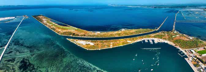
The beach Dioni of Oiniades is situated on the north side of the Acheloos estuary. It is a long sandy beach, with a unique geomorphology and location. The area includes the island of the same name, which has evolved over time into a peninsula, the shallow beach and the bay next to the hill, an extensive wetland, and the adjacent beach, “Tsimari.”
The beach experiences frequent changes due to the influence of the Ionian Sea and the Acheloos River. Therefore, certain parts of the beach may appear or disappear depending on the season. Dioni is part of the National Park of the Lagoon and features diverse vegetation, including dunes, tamarisks, cedars, bay trees, rushes, and more.
The area is protected under the Ramsar Convention and is part of the Natura 2000 network dedicated to conserving natural wildlife and plant species. It serves as a breeding ground for thousands of species, including the loggerhead sea turtle (Caretta caretta) and dolphins. To reach the area, one must travel through the plain of Katochi, where the historic Chapel of the Saviour is located, and Oiniades, covering a distance of about 16 km. The pathway through the wetlands highlights the area’s natural beauty and is sure to meet the expectations of even the most demanding visitors. With its unique energy, this place is an ideal destination for those who enjoy swimming on the sandy beach with the shallow waters.
In recent years, Dioni has become well-known for its two natural kite and windsurfing “tracks.” The favourable weather conditions, geomorphology, and shallow waters have contributed to its reputation as the best natural “track” in Greece and one of the best in the world.
The festival has established itself as an annual event, bringing international recognition to Dioni. Visitors from around the world come to tame the waves and wind, always mindful of nature and its distinctive features.


The Messolonghi salt marshes are vital to the region’s complex ecosystem. The lagoon’s shallow waters, natural mineral composition, and specific climatic conditions contribute to the gradual evaporation of water and the crystallisation of salt.
The warm and shallow waters of the lagoon are home to two salt pans - one in Tourlida, called ‘Black’ due to its impure salt production, and ‘White’ located between Messolonghi and Aetoliko in the Finikia site. The White salt marsh, the largest in Greece, spans 11,500 acres and has a production capacity of about 120,000 tons of salt annually. Τhere were two other operational salt marshes in Messolonghi until the early decades of the 20th century.
Artificial “basins” are created in the salt marshes. These basins are isolated areas in the sea that are interconnected through narrow passages known as “boukes.” The salt production process begins in March with the preparation of the entire area and is typically finished by October, depending on weather conditions. Sea water is pumped from the lagoon to supply the first basins and then flows into the rest of the basins. As the water evaporates and its density increases, it deposits various salts and gypsum on the seabed. Finally, the water is directed into the salt pans, also known as alatopigia, the last basins, where it is left to completely dry out, producing salt.
The salt is then collected using modern mechanical methods and stacked in large, all-white piles. After washing to remove impurities, it is transported to open-air warehouses by a conveyor belt, forming impressive salt piles 10-15 metres high. This spectacular sight captivates visitors to the area.
Before the salt is extracted from the pans, a thin crust forms around them. This crust, made of the first salt, is gradually carried by the wind and deposited on the banks of the pans as foam. These crystal flakes form the Fleur de sel, known as “afrina” in the region. Hand-harvested “Afrina” is considered to be the finest, superior, and tastiest salt.
The salt marshes area is part of the wetland. Some basins have plants that grow on the seabed and provide food for the aquatic birds.

(Salix alba),
The Raywood Ash Forest (Fraxinus oxycarpa) is situated near Lesini, west of the Acheloos River delta, and is a part of the National Park of Messolonghi - Aetoliko. Historically, the area and its environs were once the site of a swamp lake known as Kynia or Ginias. This extensive marsh, spanning 80,000 hectares, was drained for agricultural purposes, leaving only a small portion of the original forest intact, which is considered a unique vestige of the Acheloos riparian forests.
This remaining 500-hectare area constitutes one of Greece’s most significant forest ecosystems. It holds global scientific importance as a rare remnant of the Mediterranean indigenous plant community and is of particular botanical and aesthetic interest.
The Raywood Ash Forest (Fraxinus oxycarpa) is a diverse landscape with many plant species and trees. It was designated a “Monument of Nature” in 1985 due to its botanical and phytogeographic importance. The forest is known for its natural beauty and is mainly populated by impressive Fraxinus oxycarpa trees, which can grow up to 25 meters in height and have a diameter of up to 3 meters. Visitors can explore a 3.5-kilometre path through the forest, which is home to rare plant communities in the Balkans, including silver poplars (Populus alba), white willows (Salix alba), field elms (Ulmus minor), and bay trees (Laurus nobilis). The area is full of climbing plants, Alpine violets, cape lilies-ofthe-valley, and various species of bushes.
The wood of the Raywood Ash is hard and flexible. It has been used for various purposes since ancient times, including the production of tools, agricultural equipment, furniture construction, and, more recently, the manufacture of car steering wheels and modern sports equipment. Alexander the Great’s army used the wood from the Raywood Ashes in the riparian forest of Nestos to construct the Macedonian sarissa, which was used by the Macedonian phalanx. There are even reports of the wood having medicinal properties. Additionally, it is an ornamental species that has been used in parks and tree-lined areas.
The Raywood Ash forest is an ideal habitat for the Eurasian otter (Lutra lutra) as there are streams running around the forest. Additionally, there is a significant number of birds, reptiles, and amphibians in the area. The forest is protected by the international Ramsar Convention, and the area, including the Raywood Ash forest, is part of the NATURA 2000 network.

Acheloos is the second-longest river in Greece, spanning 220km from the Pindos mountains to the Ionian Sea. It flows through the prefectures of Trikala, Karditsa, Arta, Evritania, and Aetoloakarnania, receiving waters from several rivers, including Vasalaka, Lepenitsa, Xeroplatania, Kali Pigi, Kapralia, and Platanias.
The name “Aspropotamos” originates from the white, muddy colour of its waters, attributed to the presence of clay. Throughout its course, this river is bordered by lush riparian forests consisting of willows, poplars, plane trees, black alders, and maple trees, with fir forests dominating the higher elevations.
The Acheloos River is surrounded by the mountains Arakynthos, or Zygos, in the north, Petrota and the Kotsilaris in the west, and Varasova in the east. The presence of these mountains and hills gives the landscape a distinctive character, contributing to the diversity of ecosystems.
The entire river, especially the extensive delta formed by its estuary, constitutes ecosystems of significant ecological importance and aesthetic value. For this reason, Acheloos, like the Messolonghi-Aetoliko Lagoon, is protected by the International Ramsar Convention.
Arakynthos is a mountain located to the north of Messolonghi, situated between the Evinos and the Acheloos rivers. Its highest peak, Greveno, reaches an altitude of 983 meters, offering a wide range of hiking and cycling routes.
The mountain is adorned with dense forests of various oak and chestnut species and extensive Mediterranean maquis vegetation in some areas. It is also home to the endemic cliff plant Centaurea niederi Heldr.
Arakynthos is a nesting ground for numerous bird species, including arboreal birds like the Middle spotted woodpecker, the Lesser spotted woodpecker, and the short-toed treecreeper. Additionally, various raptors and vultures use Arakynthos as their hunting territory. The mountain is also inhabited by over 25 species of reptiles and amphibians, as well as a variety of mammals such as wild boars and roe deer.
Its western slopes are characterized by impressive gorges with vertical limestone cliffs, particularly Kremasti and Kleisoura, designated as an Area of Outstanding Natural Beauty and showcase a rich biodiversity.


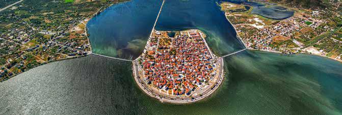
Aetoliko is a picturesque old maritime town with a rich historical character, known for its inhabitants’ heroic resistance against the Turks, especially during the second siege of Messolonghi. The city is situated on a small island in the middle of the Messolonghi-Aitoliko lagoon, and it is protected by the mountain ranges of Varasova and Zygos. Aetoliko is linked to the mainland on both the east and west sides by two stone arched bridges, each with an original length of approximately 300 meters, which have been designated as protected monuments.
According to popular belief, Aetoliko was originally a group of 4-5 small islands, uninhabited in ancient times because they were submerged by the lagoon’s waters during winter.
In 1153, the traveller Benjamin of Tudela documented a single island with permanent residents called “Natolikon”. This name likely comes from the island’s geographical position as the easternmost island of the Echinades islands. The name “Aetoliko” is believed to have emerged in the 18th century and has remained unchanged to the present day.
In 1848, Mayor Konstantinos I. Kourkoumelis envisioned an ambitious plan to connect the island with the mainland by building two stone-arched bridges. However, residents had to pay tolls when travelling to and from Aetoliko to reimburse the municipal loan utilized for the project.
In the following years, Aetoliko evolved into a prominent commercial hub within the broader region, serving as a significant port where inhabitants owned sailing


and powerboats. This progress continued until the Second World War; however, the island suffered irreparable damage in 1946 with the commencement of operations by the Rio-Antirrio Ferry.
Despite the commercial boom, embankments became necessary over the years. The foundations of the houses were in the water, especially in the northern part of the island, which resulted in the formation of channels, creating an appearance reminiscent of Venice, hence the term “Little Venice”. In 1969, the last embankment was carried out, resulting in the termination of this phenomenon and the subsequent alteration of the island’s formation, creating strips of land.
The town is known for its stone-built squares and alleys. The surrounding lagoon is a source of wealth and prosperity, home to over 250 different bird species, including many rare and endangered ones such as herons, flamingos, wild geese, and coots. To the west are the Katsas hill, the hills of Agia Paraskevi, and the communities of Agios Ilias, Stamna, and Chrysovergi, where grey partridges, Eurasian hoopoes, and common blackbirds are plentiful. It’s also the perfect place for swimming at Rebakia or the Stamna area.
1. O παραλιακός δρόμος του Αιτωλικού / The coastal road of Aetoliko
2. Αιτωλικό / Aetoliko
3. Η ιστορία αντηχεί
/ History echoes in every corner of Aetoliko
4. Παραδοσιακή αρχιτεκτονική / Traditional architecture
5. Προτομή του στρατηγού Γ. Λιακατά / Bust of General G. Liakatas
6. Προτομή
/ Bust of G. Karaiskakis


| Editorial - Artistic editing
| ELIAS KOUTOUMANOS
| Photography
| LOUKAS HAPSIS
PAPPA
| Texts
| Digital image processing
TZANOPOULOU
| Cover design - Layout - Artistic editing
| VICKY BORA


