COLTER SONNEVILLE PORTFOLIO
 Landscape architect
Urban designer
Arborist
Landscape architect
Urban designer
Arborist
Drawing
- David Rutlin
”
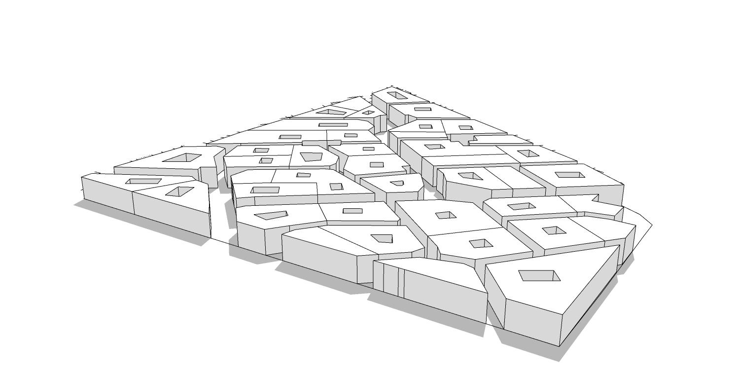
team began by reviewing and summarising relevant planning documents, as the London Plan, SDP, and Islington Local Needs Analysis, which provided insight as we geo spatially studied the site’s constraints and opportunities.
Through an iterative process of experimentation with typologies, heights, densities, solar exposure, defensible space concerns, ideal retail and institutional locations, and open space, the form of the masterplan took as we arrived at our final design solution.
Table of Contents
23
▼ Final masterplan
“
is an intensive way of looking

 Professional Work
Broadstone
Rooftop Pool and Lounge
Dripstone
Ecology Masterplan
Landa Park Masterplan
Tomochichi
Courthouse
Public building
Creek Show
Art Installation
Dallas Water Garden Masterplan
UCL Projects
Urban Design
Professional Work
Broadstone
Rooftop Pool and Lounge
Dripstone
Ecology Masterplan
Landa Park Masterplan
Tomochichi
Courthouse
Public building
Creek Show
Art Installation
Dallas Water Garden Masterplan
UCL Projects
Urban Design
Wind
UCL Thesis
Major Research Project
Art Pursuits
Academic Work
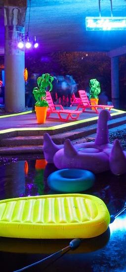
Creek Show
 Austin, TX | Asakura Robinson
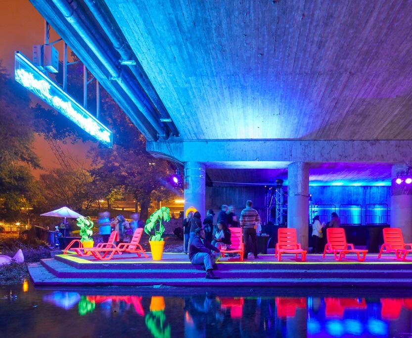
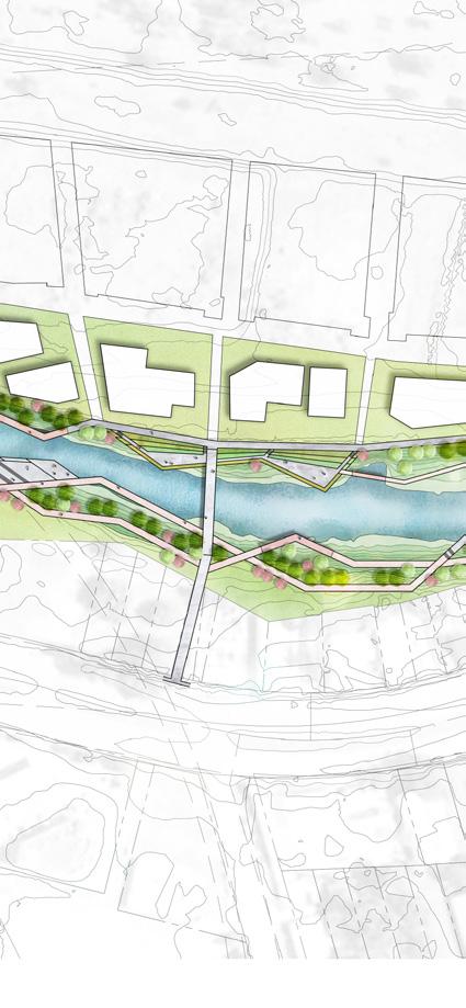
Creek Show is an annual 10-day festival of luminescent art installations along a stretch of Waller Creek in downtown Austin. The event raises the visibility of the planned Waller Creek Park District, an ambitious vision to revitalize both the creek and a chain of parks. Installations were selected by a jury of creek stakeholders.
My team’s submittal for the show comprised of common iconic poolside furniture treated with a DayGlo powder-coat finish, activated by high intensity LED black lights. A neon sign enticed and cautioned visitors: NO LIFEGUARD ON DUTY
The exhibit entertained more than 15,000 visitors, allowing them to experience an immersive and highly interactive cabana club on the creek.


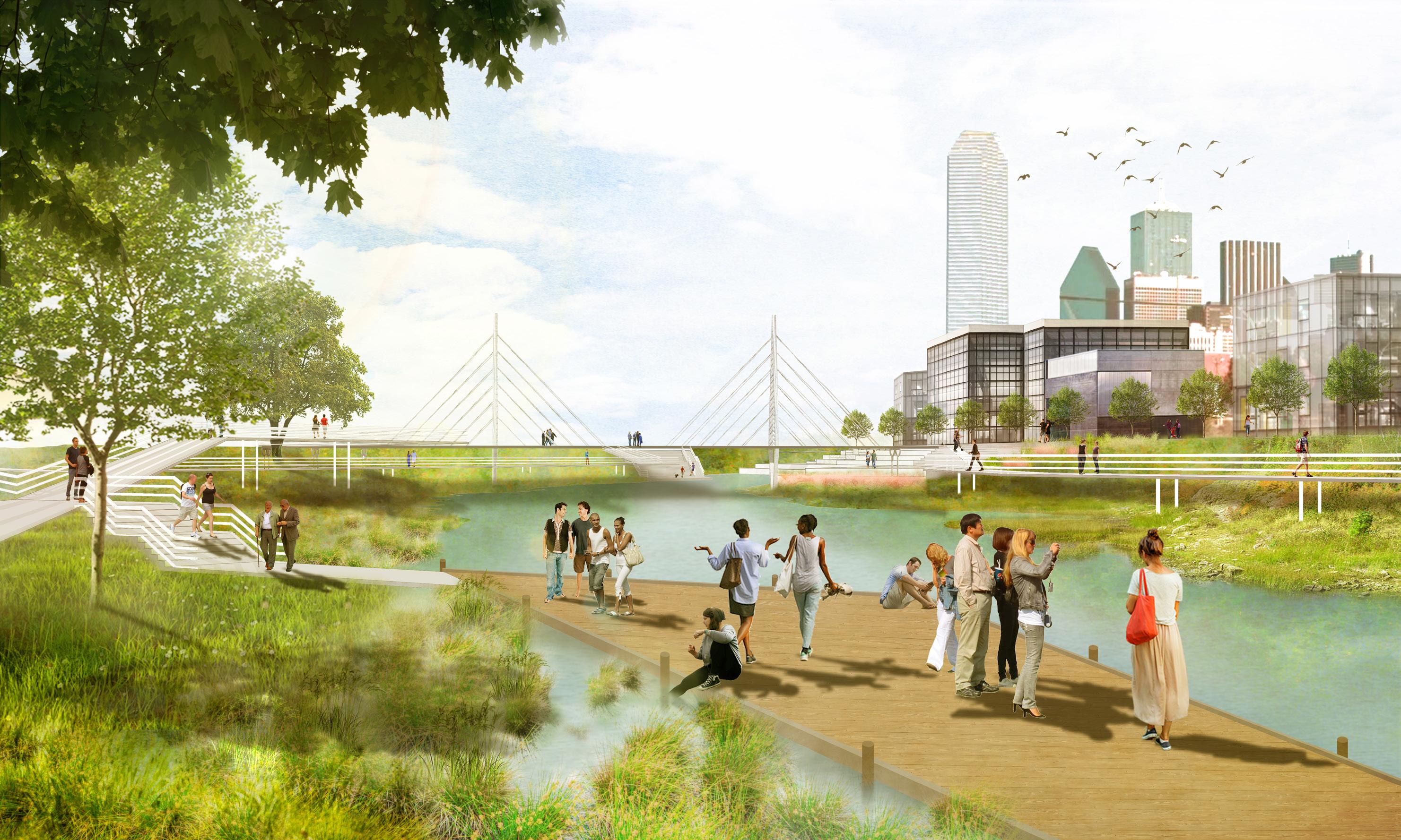
Dallas Water Gardens
Dallas, TX | Asakura Robinson

The Dallas Water Gardens is a proposed public-private partnership to create a vibrant public realm adjacent to the high speed rail station that is currently in development. Situated along the original meanders of the Trinity River, the project would also signifigantly improve the water quality , public access, and ecological function of existing neglected flood con trol ponds that were created by the Army Corps of Engineers. As project manager, I worked closely with Tetratech hydrologists and the NCTCOG to create a project that dreamed big, but was scientifically rigerous.


THE RIVERS/ HIGH SPEED RAIL ROAD NETWORK (APPROXIMATE)


CONCEPT DIAGRAM- POND 4


CADIZ ST CADIZ ST RIVERFRONT BLVD POND5 UNDERPASS CONNECTION TO POND 5 UNDERPASS CONNECTION TO WIER FOREST BUFFER BETWEEN LAND USES WATERFRONT AMPHITHEATER WATERFRONT AMPHITHEATER CABLE-STAYED PEDESTRIAN BRIDGE PROPERTY LINE FUTURE RIVERFRONT BLVD PEDESTRIAN CONNECTION CONCRETE PATH ELEVATED WALKWAY/DECK LEGEND WATERFRONT PLAZA WATER CASCADE PLAZA CADIZ ST ENTRY WATERFRONT PLAZA MULTI-USE PATH (10’) 100 YEAR FLOOD PLAIN FUTURE COMMERCIAL BUILDINGS ADJACENT TO PROMENADE PATIOS OPEN UP TO PROMENADE TREE-LINED SERVICE/ PEDESTRIAN DRIVES (15’)
CONVEY STORMWATER VIA GREEN INFRASTRUCTURE WETLAND RECREATION PLAZA FUTURE RIVERFRONT BLVD PEDESTRIAN CONNECTION DEARBORN ST 399 400 398 397 396 400 399 401 402 399 400 401 402 401 398 399 396 396 398 CHAINLINKFENCE CHAINLINKFENCE BARBWIREFENCE BARBWIREFENCE
DALLAS WATER GARDENS 0 80 160 320 MIXED USE/ COMMERICAL ZONE PROMENADE/ ACTIVITY HUB POND EDGE POND 4 POND 5 NATURAL POND EDGE SLOPE TERRACING OPPORTUNITY MINOR ENTRY WATER ACCESS POINT MINOR ENTRY/ SKYLINE OBSERVATION AREA MAJOR ENTRY/ OBSERVATION POINT MINOR ENTRY DEARBORN STREET ENTRY CASCADING TREATMENT TERRACES BRIDGE WATER ACCESS POINT
Scope note: Image above was created by an employee under my supervision
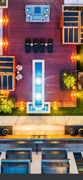
Broadstone Roof Deck
Fort Worth, TX |TBG Partners

Situated at the fringe of rapidly developing downtown Fort Worth, The Broadstone offer 345 housing units and extensive amenity spaces. This third story roof top deck has incredible views of the downtown skyline. There were many design challenges to overcome. Surrounded by four stories of dwelling units, which required shade studies and careful plant selection.

I took a lead role in designing the amenity space, including an elaborate pool with shade structures that doubled as water features.

During the schematic design process, I was careful to maximize views from all major programming areas, which resulted in clear viewsheds along an eastwest axis. In addition, I worked with the architect to design translucent safety panels to reinforce the deck’s relationship to the urban core.


Dripstone Master Plan
Concan, TX | TBG Partners
Site analysis kicked off this large scale master planning project with two full days of cave spelunking, hiking, and floating the crystal clear Frio River at this spectacular 1,900 acre cattle ranch in the Texas Hill Country.

The ranch is located over the Edwards Aquifer Recharge Zone, an environmentally sensitive area full of karst features such as caves and fissures.


My work included a comprehensive analysis of the environmental and development patterns influencing the property.

These opportunities and constraints led to a vision for a compelling, ecologically-based conservation destination built around respect for the incredible natural character of Dripstone.
 Frio River
Development Constraints
Land Suitable for Development


Land planning on an environmentally sensitive site often comes down to one thing, what do we value? For this project, we viewed constraints as strengths that would be off limits to any development:
• Viewsheds from the guest lodge- to ensure vistas would be free of obvious habitation
• Mountain Protection Zone- the highest and most prominent elevations remain wild and unmarred

• Floodplain and riparian areas- with the highest biodiversity, act as habitat corridors
• Steep slopes- to prevent erosion and protect rocky cliffs
• Cave & Streams- buffered to best protect these fragile aquatic resources

• Forest Protection Zone- protecting all clusters of old growth hardwood trees


VIEWSHED FROM MAIN HOUSE MOUNTAIN PROTECTION ZONE 100 YEAR FLOODPLAIN SLOPES OVER 10% CAVE & STREAM BUFFER FOREST PROTECTION ZONE
The Sotol plant, typical of dry slopes above the Frio
PROPOSED SITE PLAN
Landa Park Master Plan

New Braunfels, TX | Asakura Robinson
Situated at the source of Comal Springs (the largest in Texas), this park is the jewel of the New Braunfels park system. The park’s first visitors arrived by train, but the rise of automobile ownership in the 20th century dramatically fragmented the park’s layout.

The heart of the master plan includes strategies to decrease automobile traffic, reduce impervious cover, consolidate parking areas, and enhance the rich ecological heritage of the park, which includes several endangered species. Diverting thru- traffic and designing a bicycle and pedestrian oriented “festival street” are among my most important contributions to the plan.

MINI-ROUNDABOUT
The mini-roundabout proposed for the connection between Landa Park Drive and the bypass road is a traffic design that has proven to significantly reduce intersection crashes. Though not yet widely used in the United States, it is becoming more popular, and has been implemented successfully in numerous neighborhood locations in Austin. With its small footprint, the mini-roundabout can adapt to tight locations while still providing space for planting. Typical designs often include a raised curb or rumble strip at the edge of the
0’ 150’ 300’ 600’ LANDA STREET FREDERICKSBURG ROAD 12 11 10 13 14 18 18 15 15 17 16 16 19 20 16 18 21 7 29 28 7 2 30 31 30 31 18 22 23 18 18 24 24 24 18 25 26 2 27 29 15 33 32 7 8 7 6 5 2 4 3 2 1 9 1 2 3 4 5 6 7 8 9 10 11 12 13 14 15 16 17 18 19 20 21 22 23 24 25 26 27 28 29 30 31 32 33 LEGEND Landa Street Shared Lane Bikeway New Gateway Signage New Decorative Fencing Redesigned Parking and Pocket Green Refurbished Mini-Golf Facility New Off-Street Trail Redesigned Parking New Staff Parking Redesigned Train Depot and Plaza Restored Landa Haus New Staff Parking and Trash Enclosure Landa Lake Esplanade New Pavilion Redesigned Landa Park Drive New Stormwater Planting Feature Revegetated Slope Grow Zone Refurbished Boat House and New Dock New Promenade Refurbished Dance Slab Repaved Dropoff Area New Limited Access Drive New Traffic Circle and Bypass Drive New Consolidated Parking and Trailhead Reforestation New Trail under California Blvd. New Buffered Bikeway New Trailhead New Off-Street Trail New Playground Loop Promenade New Crosswalk New Parking New Train Hall New Nature Play Area
MASTER PLAN 4
Typical
Proposed mini-roundabout on Landa Park Drive looking south from the stone bridge.
mini-roundabout in a neighborhood context
Flexible/ Festival Street conceptual graphic
Roundabout conceptual graphic
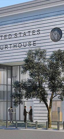
Tomochichi Federal Courthouse
Savannah, GA | Asakura Robinson
This modern courthouse annex is located on a civic trust lot designated by the 1733 Oglethorpe Plan of Savannah. The $27 million dollar building designed by Page Architects and Hoar Construction enhances security and provides modern work spaces for courthouse employees while respecting the community’s interest in preserving Savannah’s historical charm. As project manager, I worked with local architectural historians to re-use the site’s existing 1800s-era asphalt pavers and granite curbs in a new pervious paver streetscape design that bisects the trust lot. Storm water is directed towards rain gardens and the long term success of street trees is assured through the design of a silva cell system. In addition, I worked closely with the design team to improve pedestrian circulation on the site by locating a flush curb and security bollards at the building’s entry.

 Scope note: Image above was created by Page Architects
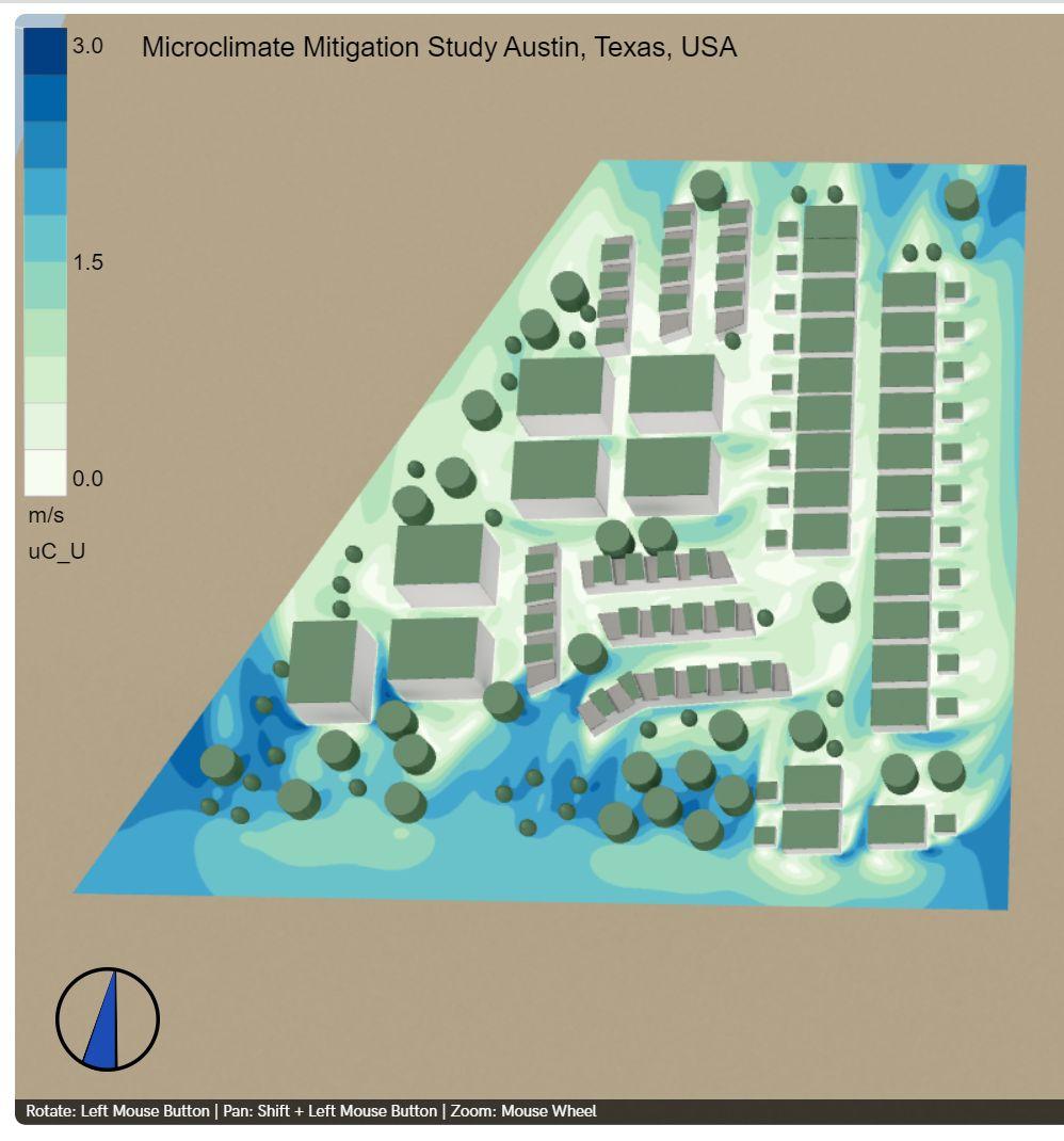
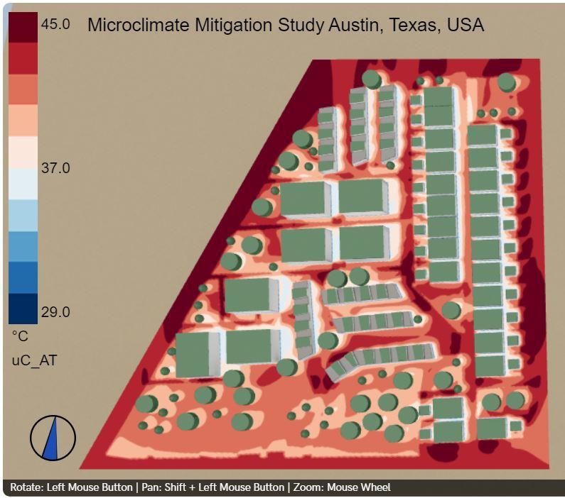
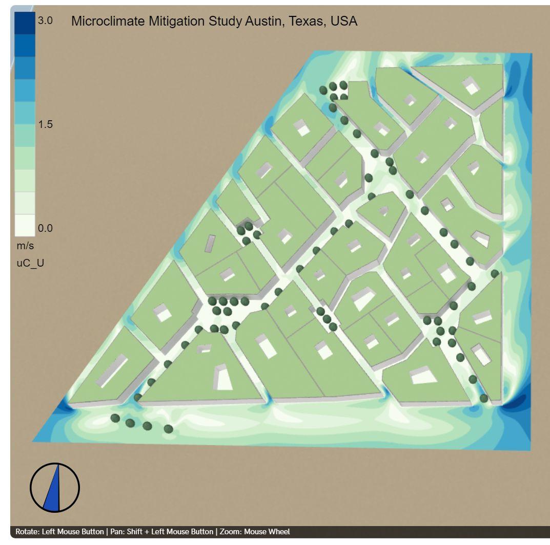
Mitigating Urban Heat Island Effect Through Climate-Sensitive Urban Design
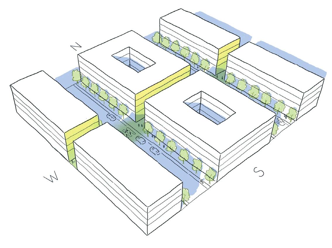
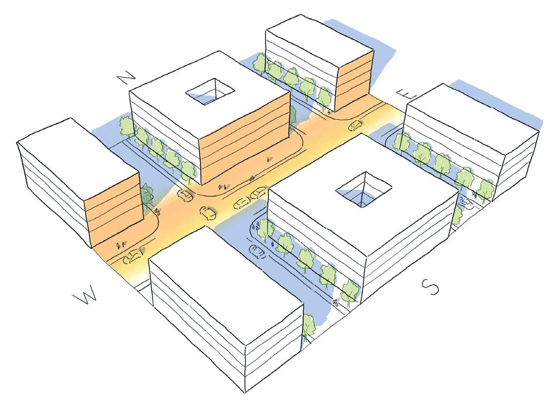
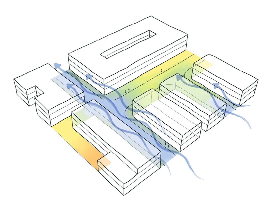
UCL Major Research Project
Exposure to excessive heat is responsible for thousands of deaths and emergency room visits annually in the United States. Due to climate change, Texas cities have been warming faster than the rest of the world. Within 25 years, the number of 100 F days is expected to double.
Adapting cities to this new climate reality is critical to ensure the vitality of public spaces and the health of urban dwellers. This major research project (MRP) evaluates the most effective means to reduce UHI at a neighborhood scale in a humid subtropical context. The MRP presents two massing frameworks and nine toolkit items that can be used by architects and urban designers to lower the air temperature and improve human thermal comfort.
TOOLKIT MECHANISMS
Street orientation (wind)
Prevailing summer wind
30°
Street length (wind)
Street orientation (solar)
Street orientation (solar)
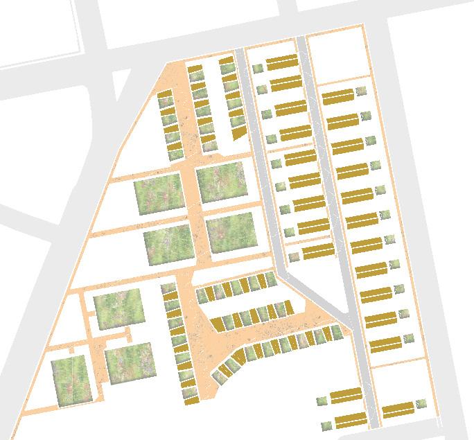
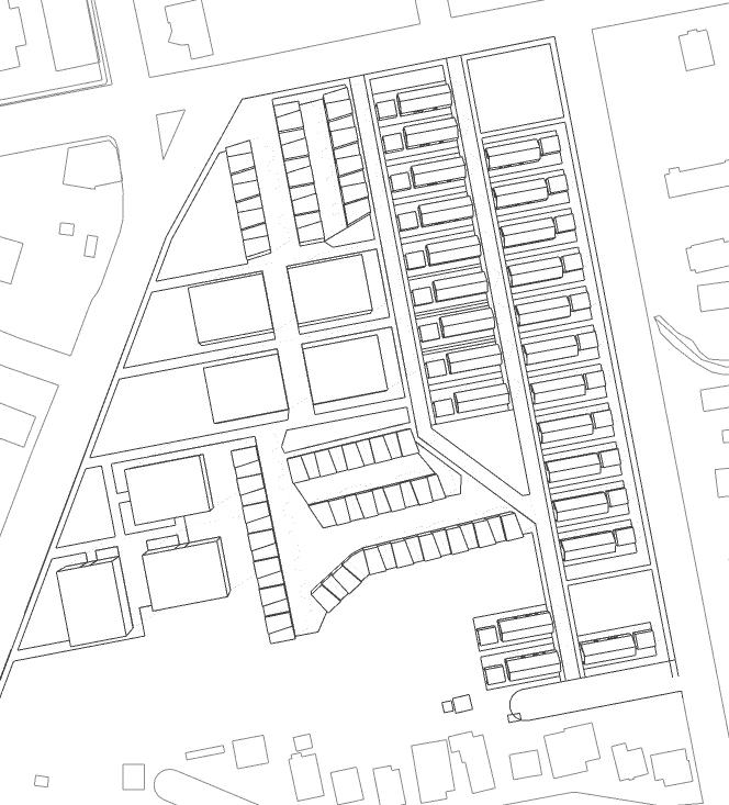
Which design mechanisms are proven to reduce UHI?
The literature review determined that three mechanisms reduce ambient air temperatures and UHI - urban form, materials, and trees & vegetation. Some of the tools are made up of overlapping mechanisms, as shown here.
URBAN FORM
Street orientation (wind)


Street length (wind)
Street orientation (solar)
Deep urban canyon
Materials
Cool pavements
Cool roof
Downhill cooling
Park cool islands Tree canopies
TREES & vegetation
.05 2.2
summer wind
Downhill cooling Park cooling
Prevailing
Green roof
Refined concept
MASSING FRAMEWORK - MEDINA SHADE CANYON

Applying the concept
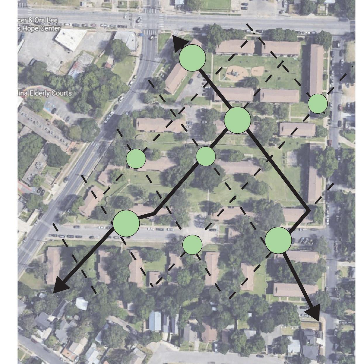
Civic streets Narrow canyon streets Sun plaza H/w 0.8 Short 20’ 25’ 30’ 30’ Medium H/w 1.0 H/w 2.2 Narrow 30’ 12.8’ H/w 1.0 Civic 30’ 30’ H/w Sun Umbrella H/w Typologies Medina H/w Typologies
URBAN FORM
Diagonal street grid for mutual solar shading

Narrow street. H/W 2.2
Civic street. H/W 1.0
Green roof at all buildings
Sun plazas with deciduous trees. Allows light in winter. Provides shade in summer
Long street length (civic) facilitates wind velocity
Streets aligned within 30 degrees of summer wind direction (south)


trees & vegetation
Standard pavement at narrow canyon streets (less solar radiation)
Cool pavements at civic streets
materials
Cool pavements at sun plazas (more solar radiation)
Note: cool roof not used. Interchangeable with green roof
Toolkit Breakdown
MASSING FRAMEWORK - SHADOW UMBRELLA

Applying the concept
Open space at center of block, NE & SW corners
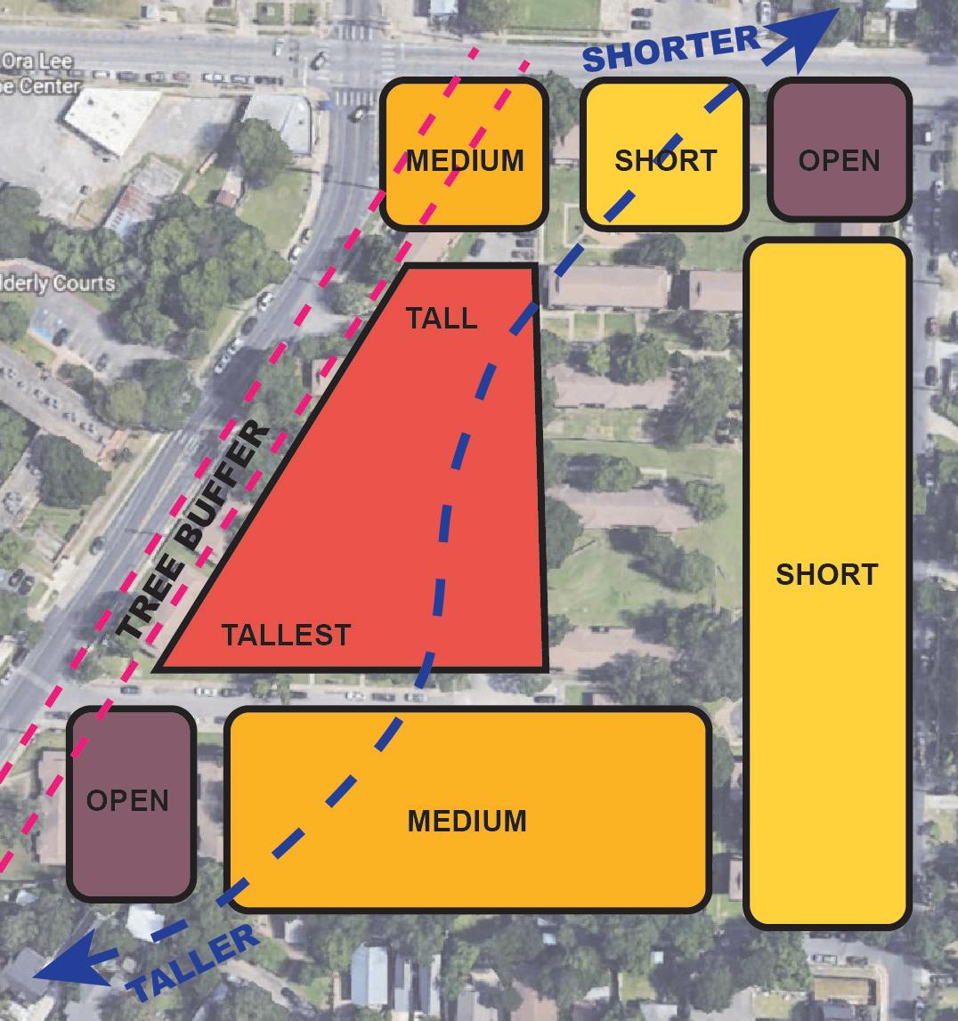
Shortest buildings on the east
Refined concept
Tall buildings on the west and south
Wide tree margin on the west
and arrows) east block,
SHORT OPEN OPEN MEDIUM MEDIUM TALL TALLEST CHICON ST 12TH ST Sun Umbrella H/w Typologies
Tree canopy. Most existing trees preserved
East-west oriented paths are narrow to reduce solar exposure
Additional trees at western edge for solar protection
Urban canyon. H/W 0.8 min
North-south oriented streets are cooler. No East-West streets
URBAN FORM
Cool pavement (roof terraces)
Streets aligned with summer wind direction (south)
Downhill cooling/ Park cooling islands preserved and enhanced
Green roof
Cool pavement (roads)
Cool pavement (walks)
New trees to fill canopy gaps
trees & vegetation
Cool roof at single family home
materials
Green roof at tall & medium buildings
Long street segments for wind orientation Toolkit Breakdown
THERMAL PERFORMANCE ANALYSIS UTCI
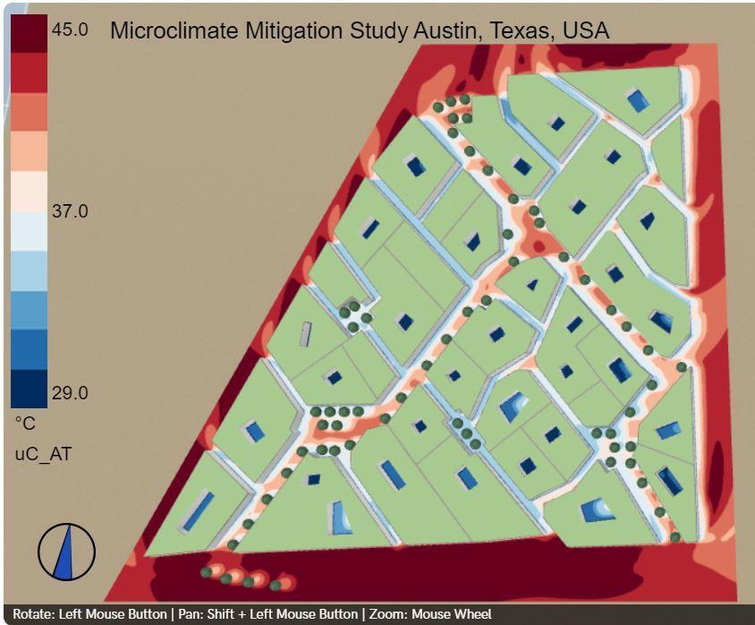
Universal Thermal Climate Index (UTCI)
 medina shade canyon shadow umbrella
Wind
Wind
shadow umbrella
medina shade canyon
Special thanks to…

Dissertation support by: Colin Hayes, Visiting Professor
UHI analysis by: https://rheologic.net/ office@rheologic.net

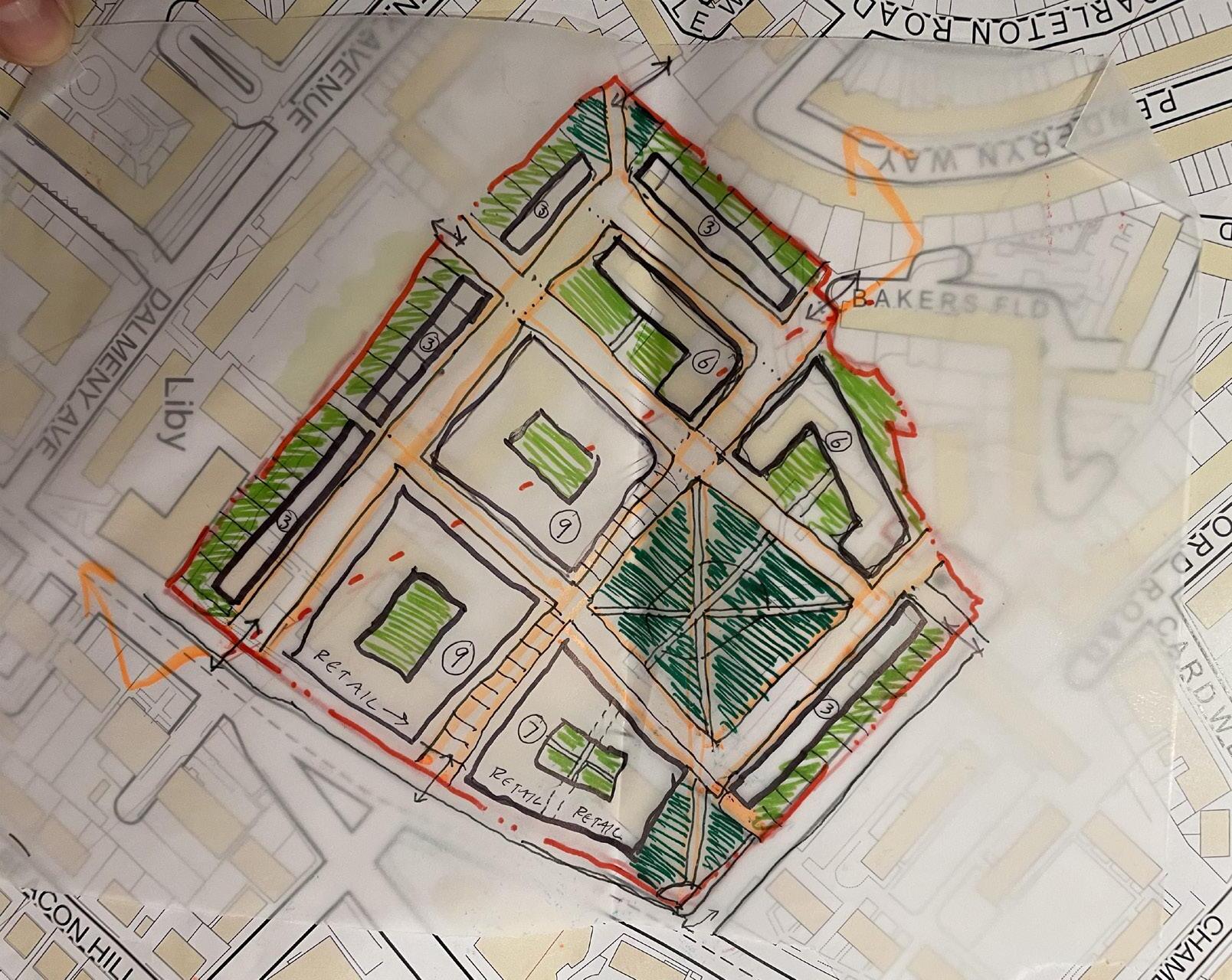
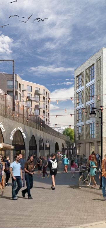
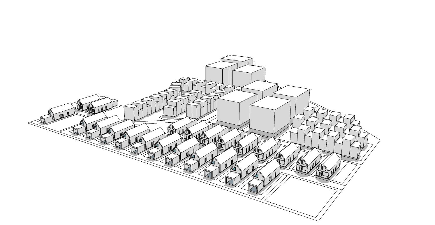
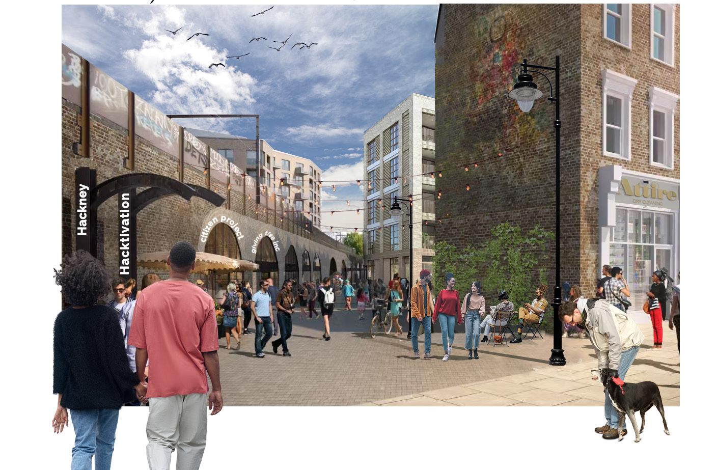
Morning Ln Community Collaboration


London, England | UCL
This graduate school group project aimed to imagine the development and social benefit potential of a single story Tesco grocery store next to a major town center, retail high street, and transportation hub. Through exploration, ideation, and collaboration witha grassroots community group, our team created a financially viable community oriented mixed use development that included 280 housing units ( 50% social housing), affordable retail space for small business, public spaces, and an extension of the adjacent and successful pedestrianized high street.
Site Context
PUBLIC REALM OPPORTUNITES
REIMAGINE THE BUS DEPOT

Plans call for the bus depot to be relocated out of the town center. Opportunity to provide additional housing at St John Square and additional small enterprise retail at Bohemia Place, making it an authentic Hackney Central destination.
THE NARROW WAY
ENHANCE LEGIBILITY AND CIRCULATION
Open up two railway arches to allow for better town center access , retail access, and commuter access to nearby rail station. The railway arches with smaller floor space are prioritized to reduce disruption to existing viable business
BOHEMIA PLACE IMPROVEMENTS
Ugrade street circulation while retaining day time blue collar trades, and promote night time entertainment
RAIL ARCH RETAIL EXPANSION
Activate rail arches south of the railroad, allowing retail spaces to spill out onto a new pedestrian walkway
MORNINGLANE NARROWWAYEXTENSION
NARROW WAY EXTENSION
The Narrow Way is the retail heartland of Hackney Central, rich in cultural assets and architectural identity. We can build on that vibrancy, and limit the amount of big box chain stores to hedge against displacement
LEGEND
EXISTING PEDESTRIAN ROUTE


POTENTIAL PEDESTRIAN ROUTE
POTENTIAL PEDESTRIAN IMPROVEMENT
HIGH STREET (EXISTING & POTENTIAL)
INCLUSIVE REGENERATION
URBAN FABRIC
FOOTPATH TO HACKNEY WALK
FOOTPATH TO ST JOHN SQUARE
MIDLAND BANK (GRADE II)
MARE STREET
AMHURST LANE
BOHEMIA PLACE
ST. AUGUSTINE’S TOWER (GRADE II)
CLAPTON BUS DEPOT
TESCO STORE
ELEVATED RAILROAD
DEVELOPMENT PROPOSAL
OVERVIEW DEVELOPMENT PROPOSAL
OVERVIEW
FAR: 2.2
Density: 206dwellings/ha
Groundcoverage: 51%
FAR: 2.2
Density: 206dwellings/ha
Groundcoverage: 51%
Averageunit size: 64sqm(Net Internal Area)
Total units: 280
Averageunit size: 64sqm(Net Internal Area) Total
280
A total of 280 units will be delivered of which 85% will be affordable housing (affordable rent and social rent) This development sets out to fulfill the needs of providing genuinely affordable housing for the community The development is designed to maximize tenure integration through tenure-blind allocation of affordable housing with market housing The development also has relatively lower density to create quality livable spaces with greenery for the community Development proposal overview
Housing
55
78
37
UNITS
UNITS
Housing
units:
No. % Private sale 42 15% Social rent 140 50% Affordable rent 98 35% Total 280 100% Tenurebreakdown 55 UNITS 78 UNITS 40 UNITS 107 UNITS 37
Railway arch activation
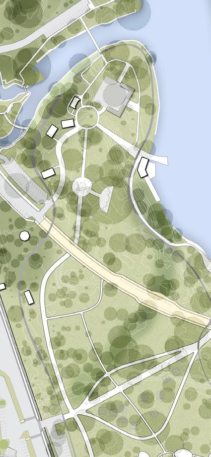
Holloway Prison
London, England | UCL
MASTERPLAN
Public Parks and Different Sports Amenities
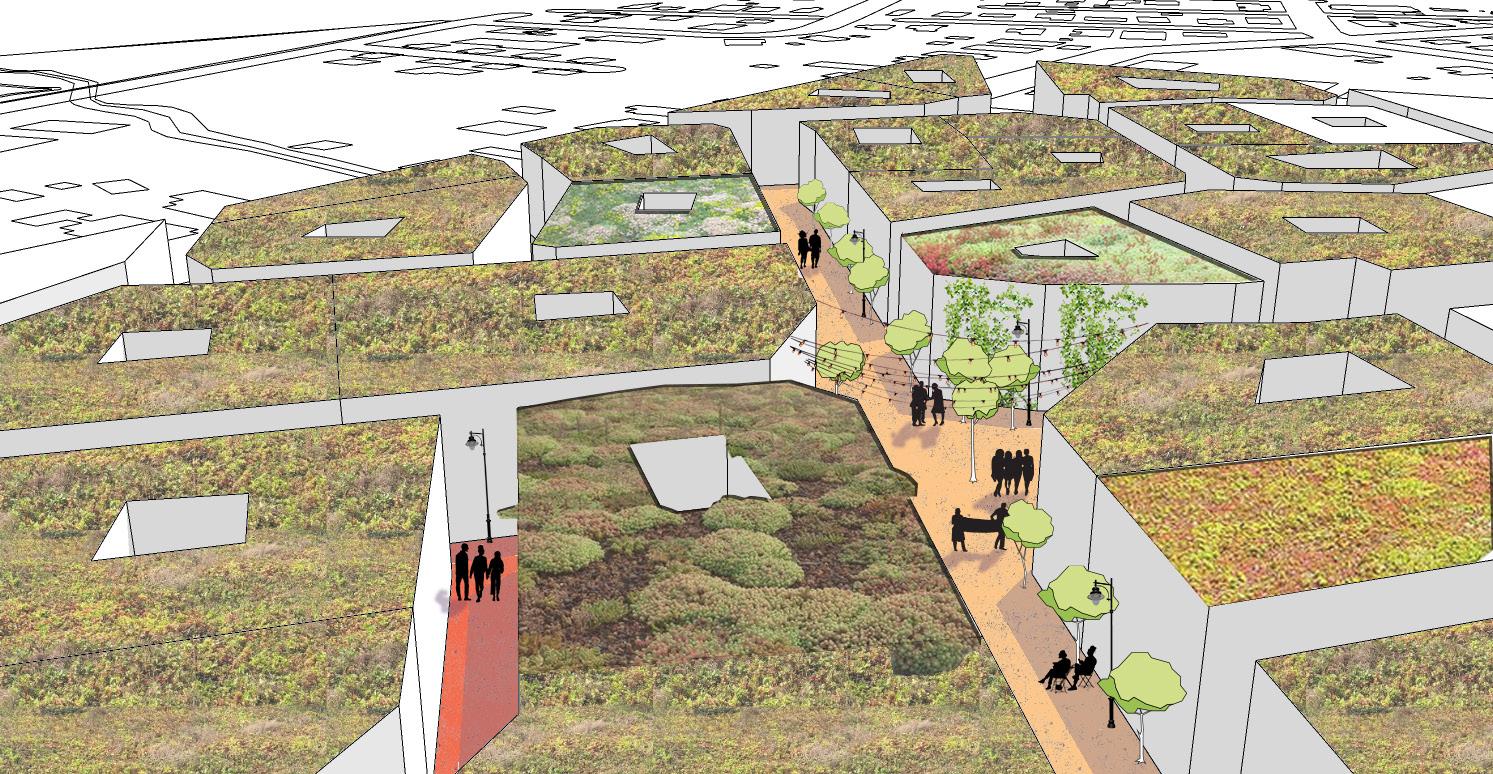
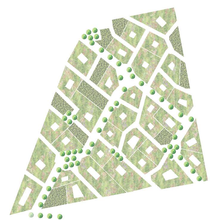
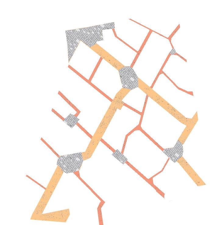
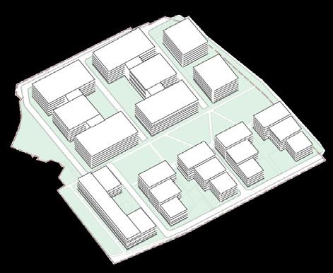
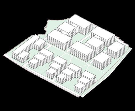
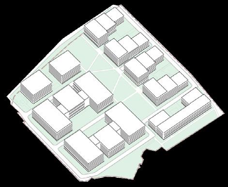
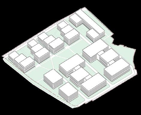
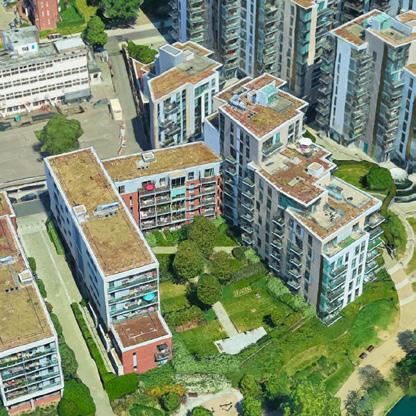
HMP Holloway Prison was operational from the early 1800s till 2016. Since then, developers, community groups, and Islington Council have suggested development options for this large urban infill site. This group project aims to create sustainably inclusive and engaging spaces while providing ~1000 residential units to help alleviate London’s housing crisis.
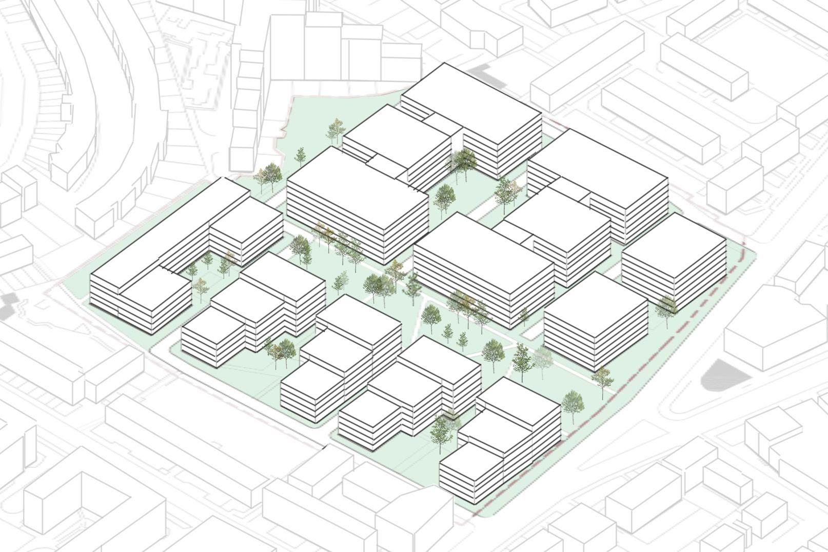
Dimensional Perspectives
Viewing from South
Pedestrian and Cycle Lanes with Parking Facilities
Encourage active transport with higher permeability
Provided in the centre of the site for recreational use of residents
Integrated Housing Development

Mixed tenure with provision of about 1,000 units ranging 1-5 bedroom flats
Pop-up Stalls
Located at the entrance to allow higher visibility and dynamics to local economy
Play Street
Situated between buildings to create space for leisure at specific time
Viewing from West
Communal Garden
Connecting the community with sustainable space

Rooftop Garden Green roofs act as a sustainable drainage measure and help create pleasant living environment
Preservation of the Protected View
Day Care Centre
Over 289 sq.m of centre area with private space for play space
Social Enterprise’s Workspace


Up to 663 sq.m of office space is located at the entrance where is the active frontage to create interaction with people
Women’s Centre
Combing two floors (1326 sq.m) to provide adequate space for women’s activities to continue the history
Retails
Up to 1,612 sq.m of ground floor area is provided for retailing services
Viewing from North
Active frontage of mixed development next to the main road
GP Surgery office
Over 476 sq.m of office space is located visibly and accessibly closed to main road

Viewing from East
10
LAND USES
Overview of Land Uses
Land Use Ground Floors

Institutional Land Uses
Community


Office space is provided for the social enterprises with active frontage to increase its connection with community


This proposal focuses on creating active frontages along the intersection of the site boulevard and Parkhurst Road, which connects to Holloway Road, by locating the retail space, offices, women’s centre and daycare centre. These land uses are more accessible to the main road and the community. The women’s and daycare centres are located on the inner side of the perimeter blocks so that the more semiprivate and private spaces can be used for events with increased privacy.


14
4 2 3 1
1
3
2
4 Women’s Centre Social Enterprise’s Workspace Day Care Centre GP Clinic
Preserving the Women’s Centre in the inner side of the blocks with more private space to facilitate users’ activities.
The centre provides childcare service with play space for children in the location with increased privacy and safety.
clinic is located at the frontage of the boulevard and easily accessible for residents to provide medical services.
0 50m 25m 100m
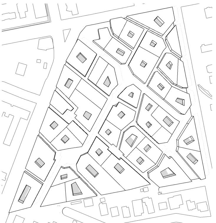
When we design urban housing we are designing cities. Designs for housing should begin as urban designs, driven in the first instance by our vision of a beautiful city.
- Peter Barber (Barber, 2018, 49)
The site is designed in accordance with London Plan goals, including creating green open spaces, providing places to relax and play, and reducing the dominance of cars by supporting active travel (transit, walking, and cycling). The site’s legibility is enhanced with a unifying tree-shaded central green space for active and passive recreation, a play street, a skate park, and community garden allotments.

Active frontages are provided at Parkhurst Road, with mixed use retail towers, a pop up retail centre for SMBs, a women’s centre, and medical offices.
Residential buildings have been oriented and “stacked” to maximize solar exposure and provide dual aspect units for better daylight and ventilation.
1.48


64,269
The 998 housing units are offered in a wide variety of bedroom configurations, including, and to ensure social diversity, 30% of units are reserved for families (3BD+).
Note: 50% of housing to be market rate. 50% to be social housing, distributed equally throughout.
11 0 50m 25m 100m G ROUND C
FA R
OVERAG E 31%
Unit type Unit Area (GIA) Units Total Area (m2) Residential 1b 1p 40 258 10,320 2b 3p 61 440 26,840 3b 5p 86 220 18,920 4b 6p 99 60 5,940 5b 7p 112 20 2,240 Retail Class A Retail 1612 Institutional Women's Center 1326 Social Office 1802 Daycare 289 TOTAL 998 64,260
A6 C4 C4 C5 A6 B5 B5 D4 D4 D4 D4 D5 D5 D5 D5 D6 D6 D6 D6 B6 B6 B7 B7 UNIT
Building key Building schedule POP. D E NSITY 173 units per ha Unit distribution Parkhurst Rd CamdenRd CamdenRd Bldg # of Bldgs Floor area Stories Total Area (Sq M) A6 2 806 6 9,672 B5 2 1927 5 9,635 B6 2 1152 6 6,912 B7 2 1927 7 26,978 C5 1 1096 5 5,480 C4 2 395 4 3,160 D6 4 476 6 11,424 D5 4 374 5 7,480 D4 4 289 4
20% NIA & non-residential
COUNT
4,624 TOTAL 85,365 Minus
uses
0 50m 25m 100m “ ”
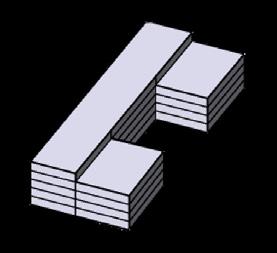
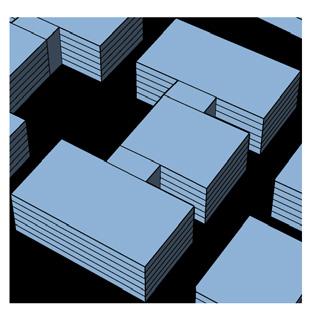
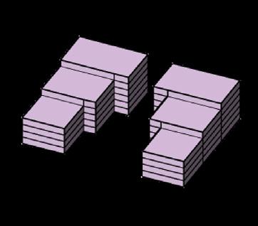
BUILDING TYPOLOGIES
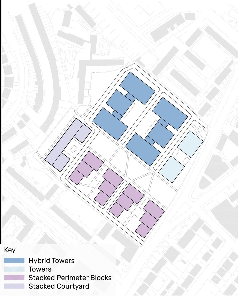
Stacked Courtyard
•
•
Stacked Perimeter Blocks

•
Hybrid Towers
•
•
•
•
12
Tower
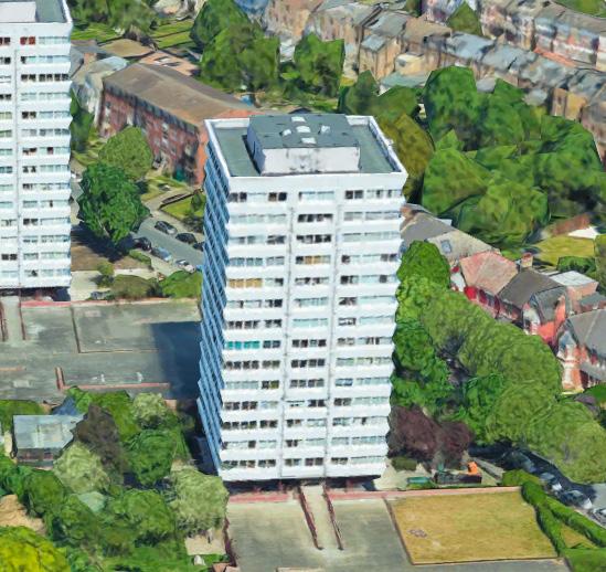
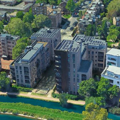
Residential Courtyards in Woodberry Down (Aqua & Waterside Apartments)
• 2 to 10 Storeys
121 Units
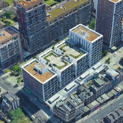
Residential Blocks with ground floor retail in Woodberry Down (Hythe House & Lake House)
4 to 8 Storeys
107 Units
Residential Tower in Woodberry Down (Lincoln Court)
15 Storeys
66 Units
Residential Towers with ground floor retail in Dalston (Ocean House, etc)
7 to 10 Storeys
1 1 2 2 3 4 3 4
138 Units
▼ Site-Adapted Typology ▼ Example of this typology:
▼ Example of this typology:
▼ Example of this typology: ▼ Site-Adapted Typology
0 50m 25m 100m
▼ Site-Adapted Typology ▼ Example of this typology: ▼ Site-Adapted Typology
Art Pursuits

It’s very important for me to have artistic pursuits outside of the workplace. I find that creating something that is physically tangible and hand made is very satisfying. When I lived in Chicago I discovered screen printing through a friend, and was intrigued by the laborious process of manually applying layers of ink to paper.
The two prints above were commissioned by the Logan Square Farmers Market, the city’s largest and most popular. The first edition of 30 prints were sold as a fundraiser. I was thrilled when they sold out and was asked for a second version, which uses a four-part CMYK screening process to approximate the tones of a photograph.
 Farmers 1.0
Farmers 2.0
Farmers 1.0
Farmers 2.0
 Covid street art project


