Catalogue edited by Daniel Crouch, Iona Fielding, Rose Grossel, Kate Hunter, Ellida Minelli, Mia Rocquemore, Nick Trimming and Arnie Anonuevo
Design by Ivone Chao and Nicky Valsamakis
Photography by Louie Fasciolo and Marco Maschiao
Cover: item 13
Terms and conditions: The condition of all books has been described. Each item may be assumed to be in good condition, unless otherwise stated. Dimensions are given height by width. All prices are net and do not include postage and packing. Invoices will be rendered in £ sterling. The title of goods does not pass to the purchaser until the invoice is paid in full.
Daniel Crouch Rare Books New York LLC PO Box 329 Larchmont NY 10538-2945, USA
Printed by Park Communications on FSC® certified paper. Park is an EMAS certified company and its Environmental Management System is certified to ISO14001. 100% of the inks used are vegetable oil based, 95% of press chemicals are recycled for further use and, on average 99% of any waste associated with this production will be recycled. This document is printed on Galerie Matt made of material from wellmanaged, FSC®-certified forests and other controlled sources. The pulp used in this product is bleached without the use of chlorine (ECF).
Tall is her body
The Dominica Collection of David Nabarro
The Commonwealth of Dominica. The Nature Island. Wai’tu kubuli, which, in the language of the indigenous Kalinago Indians, translates as ‘Tall is her body’.
This collection, assembled over two generations, portrays Dominica through one hundred maps, prints, books, manuscripts, and ephemera. It begins mere decades after Columbus’s first sighting in 1493, and leaves readers hanging with a wall calendar from 1991. Archives of grants, deeds, and letters reveal how families rose to prominence during changes of Empire. From early maps deliberately depicting Dominica as barren, to boasts of colonial control, to plagiarised inaccurate maps, this collection is a shining example of how biases influence claims to ‘truth’ in cartography.
Conflict is rife throughout the collection. Colonised islands are colour-coded, divvying up land according to European powers. Population statistics are divided by colour. An abolitionist sermon stands in contrast to the leisurely watercolour of a reverend without reverence for the rights of enslaved persons. Even the beautiful prints by Agostino Brunias, depicting everyday life in the West Indies, have been viewed with contention by both contemporary and modern readers.
In the eighteenth century, Dominica became the arena for territorial tension between the British and the French. Having agreed to leave the island to the local Kalinago Indians in 1660, the French nevertheless took control in 1727. This was lost in 1763, when Dominica was formally ceded to Great Britain in the Treaty of Paris. This led to the first survey of the island – a jewel in the collection, the Byres map of 1776 became the foundational document of all Dominican landholdings.
A flurry of invasions ensued over the remaining half century. The French retook Dominica in 1778 in a notable battle woven patriotically into their maps. However, the Treaty of Versailles in 1783 ended French rule, and Britain retained control despite retaliation.
This theme of vacillating conquest is captured enthusiastically within the collection. Battle scenes glorify both British and French victories at sea. Cartographers on both sides of the Channel shared information – not always consensually. The first European discovery of the Boiling Lake is recorded thrice, pitting the accounts of adventurers against each other in a race to claim the glory. Yet despite this slew of colonial quarrelling, the Nabarro collection also gives a voice to those advocating for peace.
The abolition of slavery in Britain in 1834 took some time to reach the remote outpost of Dominica; this collection offers a narration of this journey. Parliamentary papers reveal first-hand accounts of riots and revolts. Legal systems are re-examined, and governors challenged. Financial reports calculate the cost of emancipation to the crown - a debt paid off only within the last decade.
The Nabarro Collection serves as an academic, personal, and entertaining insight into the complex history of Dominica.
BORDONE, Benedetto di
Map of the Leeward Islands.
Publication [Venice, Nicolo Zoppino, 1534].
Description Woodcut map above letterpress text, two further woodcuts on verso.
Published just 41 years after Dominica was first sighted by Columbus. Chart of the Leeward Islands. The geographical relationships between the islands are inaccurate, and each island is shaped as a jigsaw piece. Including ‘S. Maria Rotonda’; ‘Moserato’ or Montserrat; ‘Buchima’ or Barbuda; ‘S. Maria Antica’ or Antigua; ‘Santa’ or St Kitts; and ‘C. Martino’ or St Martin. Dominica is the largest, and the only island to bear the same name as it does today.
Two additional vignette maps on the verso show the islands of Guadeloupe and ‘Matinina’ or Martinique. Each island is decorated with features that Bordone addresses in the text: Guadeloupe is covered with vegetation; Martinique sports numerous caves set into small hills; Dominica features only in partial outline.
Taken from the desirable second edition of Benedetto di Bordone’s ‘Isolario’, or Island Book. Bordone’s most famous publication, the ‘Isolario’ provided maps of islands inspired by nautical charts alongside information for travellers on their cultures, myths, climate, and history. Guiding his reader on a voyage through the Mediterranean, Atlantic, and Indian oceans, Bordone far exceeds the horizons of his predecessors, Cristoforo Buondelmonti and Bartolomeo dalli Sonetti, whose Isolarios were primarily concerned with the Aegean archipelago.
Benedetto di Bordone (c1460-1530) was a Paduan cartographer, woodcutter, and illuminator of manuscripts. In Venice, he gained a reputation as a prolific painter of miniatures for religious and classical texts, and official ducal documents for Venetian noblemen, dominating the style of book illumination there from the mid-1490s to the 1520s. On four separate occasions Bordone is recorded as having applied to the Venetian Senate for privileges to publish books or woodcuts.
de BRY, [Theodor]
[View of Alonso de Ojeda and crew].
Publication Frankfurt, [Mattheus Merian], 1655.
Description Engraving with full original hand-colour, letterpress text on recto and verso.
Dimensions 155 by 175mm (6 by 7 inches).
References Shirley [world], 41; Sabin 50.
View of Alonso Ojeda and crew, including Amerigo Vespucci, landing on Dominica in 1499 – only to meet with fierce resistance from the Kalinago Indians.
Taken from the second edition of ‘Historia Antipodum or New World and American Histories’, by Johann Ludwig Gottfried, first published in 1631. This book concerned “the nature and properties of that half of the earth called West India and its inhabitants and how all this was discovered through various shipping journeys”.
After describing Dominica’s healing springs and sulphurous volcanoes, Gottfried offers a thorough report of the domestic character, customs, idolatry, and “barbaric ignorance and unheard-of cruelty of most of these wild people”.
Alonso de Ojeda (1466-1516) was a Spanish navigator and conquistador. Ojeda travelled with Christopher Columbus on his second voyage in 1493 and partook in explorations of Guadalupe and Hispaniola. Years later he obtained permission to travel to the mainland following the route of Columbus’s third voyage. Ojeda set sail in 1499, accompanied by Amerigo Vespucci. In this view, Alonso de Ojeda and crew, including Vespucci, are seen landing on Dominica - the first Europeans to do so.
The Kalinago Caribs, reported in the accompanying text as being 400 strong, are waging a fierce battle of resistance against the conquistador and his crew. They are described as “naked but strong in body”, armed with arrows and spikes. They fought the Spaniards mightily, and were only deterred by the “thunder” of their rifle shots.
The engraver
Theodor de Bry (1528-1598) was an engraver, goldsmith, editor, and publisher, famous for his depictions of early European expeditions to the Americas.
The Spanish Inquisition forced Protestant de Bry to flee his native, Spanish-controlled Southern Netherlands, now modern Belgium. He moved around Europe, starting from his birth in the city of Liège in the Prince-Bishopric of Liège, then to Strasbourg, Antwerp, London, and Frankfurt, where he settled.
De Bry created a large number of engraved illustrations for his books. Most of his books were based on first-hand observations by explorers, even if de Bry himself, acting as a recorder of information, never visited the Americas.
DEL’ILLE, Guilleaume
Cartes Des Antilles Francoises Et Des Isles Voisines.
Publication Paris, l’Auteur sur le Quay de l’Horloge, Juillet 1717.
Description
Double-page engraved map, with fine original hand-colour in full.
Dimensions 680 by 475mm (26.75 by 18.75 inches).
References Hough, C8.
Before Dominica became French
A striking map in original hand-colour, showing the French-owned Antilles Islands before Dominica was colonized.
Stretching from Guadeloupe to Barbuda, with towns, bays, and islets labelled, particularly for Guadeloupe and Martinique. Settlement clusters with churches and buildings are shown in detail. Dominica is depicted only in outline, with a few rivers partially indicated. Next to a compass rose is a note explaining a variation in magnetic needle degrees, discovered during a voyage to Martinique in 1706.
At the time of publication, Dominica was not officially a colony. From 1635 onwards, French woodcutters from Martinique and Guadeloupe had begun to build permanent timber camps to supply the nearby islands with wood. A revolt in northern Martinique in 1715 led to an exodus of working-class Frenchmen migrating to southern Dominica. Simultaneously, French families from Guadeloupe settled in the north. The French formally took control of Dominica in 1727, when the land was divided into districts.
Guillaume Delisle (1675-1726) was a precocious cartographer. Delisle was admitted into the Académie Royale des Sciences in 1702, gaining full membership in 1718. He was appointed chief royal geographer, a title created especially for him. Delisle had access to news of the latest discoveries through his membership of the Academy, and issued several maps of France’s colonial possessions in America. His ‘Carte du Canada ou de la Nouvelle France’ was the first map to show the latitude and longitude of Canada correctly.
WEIGEL, Christopher
Insulae Antillae Francicae
Superiores cum vicinis insulis ex commentariis manuscriptis et variis navigantium observationibus descriptae a Petito Geometra Regio.
The top half shows the Greater Antilles, including Guadeloupe, Dominica, and Martinique. The lower half is dedicated to the Lesser Antilles, including St Lucia, Barbados, and St Vincent. A compass rose with a fleur-de-lys is accompanied with a description of a French expedition to Martinique in 1706. Interestingly, Grenada is depicted upside-down, with Fort George shown on the northeast end of the island.
Although towns, churches, camps, hotels, and mountains are shown in detail on other islands, Dominica is uncharted. It has no named towns, bays, or settlements. Rivers are half-heartedly shown as short black lines.
Christopher Columbus had first sighted the island in 1493, but the Spanish were too daunted by the fierce resistance from the Caribs and lack of gold to settle. The French claimed Dominica in 1635, and began to establish permanent timber camps to supply the nearby French islands with wood, coffee, sugar, and slaves. Rival resource harvesting between the English and the French had commenced by the start of the eighteenth century.
With the Treaty of Aix-la-Chapelle in 1748, Britain and France agreed to treat the island as neutral ground and leave it to the Caribs. However, French planters continued to settle in Dominica. Britain then captured the island in 1759, and from that time until 1805, Dominica went back and forth between France and Britain.
The mapmaker
Taken from ‘Atlas Scholasticus et Itinerarius’ by Christoph Weigel, published in Nuremberg in 1718. Christoph Weigel the Elder (1654-1725) was a German engraver and publisher who learned the art of copperplate engraving in Augsburg. After various positions, including in Vienna and Frankfurt am Main, he acquired Nuremberg citizenship in 1698. He published 70 books and some series of engravings during his lifetime, including the ‘Atlas Scholasticus’ in 1718 and ‘Descriptio Orbis Antiquus’ in 1720.
In Nuremberg, he worked closely with imperial geographer and cartographer Johann Baptist Homann to create his maps. All Weigel’s maps were hand-coloured immediately after they had been printed.
OTTENS, Reiner
Tabula Novissima atque
Accuratissima Caraibicarum
Insularum sive Cannibalum quae
etiam Antille Gallicae Dicuntur
Item Insulae Supraventum, et in Archipelago Mexicano sitae sunt, ac detectae a Christ. Columbo Ad. M CCCC LXXXXIII.
Publication
Amsterdam, Wed. I. Ottens, [1745].
Description
Double-page engraved map, hand-coloured in outline.
Dimensions 615 by 515mm (24.25 by 20.25 inches).
“The most warlike cannibals”
Map of the French Antilles, including a large inset map of Martinique. The title describes the Caribbean as the “Islands or Cannibals” (trans.), otherwise known as the French Antilles. Stretching from Guadeloupe to Grenada, with a compass rose bearing a fleur-de-lys. Towns are highlighted in red, with churches visible in the large inset of Martinique. Mountains and trees are drawn on the islands, and a volcano is visible to the west of Martinique.
Dominica bears no settlements, only a note which translates: “Dominica, inhabited by the Barbarians of the whole of America, the most warlike cannibals”.
In the early colonial period, the Kalinago Carib tribe had a reputation as warriors who raided neighbouring islands. According to the Spanish conquistadors, the Kalinago were cannibals who regularly ate roasted human flesh, although this is considered by the modern community, who still live in Dominica, to be a myth without evidence.
The French had claimed Dominica in 1635, setting the scene for both French and British settlers to compete for the island’s timber and sugar by the turn of the eighteenth century. Depicting Dominica as an uncharted land of savages would have been an outdated view by this point.
The mapmakers
Joachim Ottens (1663-1719) was a Dutch engraver who established a multi-generational family business. The Ottens firm, founded in 1711, was a publishing and printing business, selling books, maps, and views. His sons, Joshua and Reinier Ottens, continued the firm after their father’s death in 1719, changing its name in 1726 to R & I Ottens. They won great success with their huge and magnificently coloured composite atlases, entitled the ‘Atlas Major’, which were comprised of maps by earlier or contemporary German, French, and Dutch cartographers. Some examples of these volumes, all of which were made to order and tailored to the specific customer’s requests, contain over 800 separately issued maps.
On the death of Reinier I in 1750, his son Reinier II continued his work, but with reversed order of names, as Joshua & Reinier Ottens, until Joshua’s death in 1765. The Ottens family specialized in the reprinting of others’ work, especially Frederick de Wit, Guillaume Delisle, and Nicolaes Visscher.
HOUELCHE, Laurent and Nicolas; Martial Lawrence WELCH; and Edward Barre Roberts WELCH
The Birmingham Hill Estate, Saint Peter Parish, Dominica.
Publication 1747.
Description 24 items (various formats and sizes). 57 leaves, original autograph and holograph manuscripts, letterpress documents with manuscript additions, some plans, most folding, some in the original bundles.
References
Layng, ‘Dominica an island in need of an historian’, 1973; Murdoch, ‘Land Policy in the Eighteenth-Century British Empire: The Sale of Crown Lands in the Ceded Islands, 1763-1783’, 1984.
From smallholding to sugar plantation
A small, but significant, archive of grants, deeds, and other documents, related to the gradual acquisition and accumulation, over the course of more than 100, by a single family, of the Dublanc Estate, later (from 1833) known as the Birmingham Hill Estate, on the island of Dominica in the West Indies. Together, these documents vividly illustrate the colonial history of Dominica: from glimpses of the interdependent and interwoven lives of the first French settlers of the seventeenth century, in one of the most remote outposts of the world; through their experience as collateral to the struggles of Empire of the eighteenth century, and multiple changes of administration; to the managers of a nineteenth-century mega-corporation, supplying candy to the masses.
The Birmingham Hill Estate had its origins in a smallholding between the Dublanc River and the sea, when in July of 1747, Laurent Houelche purchased a small dwelling from Jacques Riviere. He already owned an adjacent patch of land. The other boundaries were the sea, the “Ance Masire” [Masire Bay/Cove], land owned by Allain Bersege, who would become, or was already, his father-in-law, and “Le Moine de Lespagnol”, or “the Spanish Monk”. Over the next more than 100 years he, and his descendants, transformed a remote part of the Caribbean into a more than 300-acre estate, with an international trading profile. The date of this, the earliest document in the archive, which records the transaction is significant, because in 1748 the Treaty of Aix-la-Chapelle established an accord between France and Britain, declaring the island “neutral”. Later, in 1753, the local “Capt. Royal”, a Monsieur De Beautemps, records the next, and more complicated transaction, in which Houelche, his son (not named), and Elizabeth Berteges [sic, but Bersege], acquire land owned by “Les Dames Doyon”, and another parcel owned by “B. Riviere”.
In May of 1756, growing hostilities between France and Britain spilt over into open warfare. The naval Battle of Minorca, the opening sea battle of the Seven Years’ War, was a victory for France. Officialdom descended on Dominica, Joseph de Villiers surveyed the island for the French, and was given permission by the “Monsieur Le General”, to settle all outstanding boundary disputes. On the 20th of July, 1756, an official document is drawn up confirming that Nicolas Houelche is the rightful owner of land purchased from Allain Bersege in July of 1747, in the “Lance Madise”. Nicolas is, presumably, Laurent’s son, and the land referred to, that same piece of land originally purchased by Laurent.
In 1759, the British secured Guadeloupe, and vessels from the Royal Navy seemed to have sheltered from action in Prince Rupert Bay, but Dominica was not properly captured by the British until 1761, bureaucracy was still French, and Nicolas Houelche’s ambitions were undaunted. In 1760, Jean-Baptiste Riviere, navigator of Guadeloupe, attested to the provenance of a small parcel of land, of ten or 12 acres, in the “Lance Dublanc” that was eventually inherited by La Veuve Riviere, from Madelaine Josse Pitre, who
had inherited it from the Veuve Doyon. La Veuve Riviere sold that land, on behalf of her only son Nicolas, to Nicolas Houelche.
At the Treaty of Paris in 1763, that ended the Seven Years’ War, Dominica officially became a British possession, being at first administered as part of the Leeward Islands. The French settlers in “Grenada were guaranteed possession of their property by the terms of their capitulation at the island’s capture in 1762, and of the peace in 1763. Those in Dominica and St Vincent (there was none in Tobago), since they were held to be there in defiance of the Franco-British neutrality agreement, had no such right and their lands, together with any ungranted in all of the islands, had simply become the property of the Crown” (Murdoch). Therefore, “Lawrence” Houelche and Nicolas Houelche had to apply to the Crown to keep their lands, but as Leaseholders, rather than Freeholders. Those original deeds, dated March 4th, 1766, were bundled together in 1801 as support for their descendant Martial Houelche’s successful claim for the same land to be granted to him by the Crown.
In January of 1805, Martial applies for and receives more Crown land, and has his name Anglicized, to Martial Lawrence Welch. Much else changed in Dominica between 1766 and 1805 too: it became a separate colony in 1771, was captured by the French in 1778, restored to the British in 1784, the French made further, mainly futile, attempts to recapture the island in 1795 and 1805, thereafter it remained British. Presumably, it was this renewed stability which gave new impetus to Welch’s empire-building. Between March of 1806 and 1813, he acquired significant property, not only from several smallholders, but from the guardians of the children of Laurent Houelche too. In 1808, his inventory includes 71 named slaves.
Then all goes quiet, and presumably swimmingly, as sometime between 1808 and 1833, Welch acquires from Dr J. B. L. Birmingham, an estate, previously known as the Dublanc estate, on Dominica, which he combines with his existing holdings and calls the Birmingham Hill Estate. But, in 1833, things get a bit complicated: on the 27th of August, 1833, Martial Lawrence Welch, now of Wyndham Place in the parish of Saint Marylebone, takes out a Mortgage on the Estate, “Birmingham Hill... situated in the parish of Saint Peter in the Island of Dominica with all the buildings commonly called Sugar-Works and all other Buildings and Utensils whatsover for the making of sugar and Rum...”, ostensibly in his son, Edward Barre Roberts Welch’s, name. On August 28th, 1833, the ‘Act for the Abolition of Slavery throughout the British Colonies’ which outlawed British ownership of slaves, is passed. In 1834, Martial Lawrence Welch claimed £1000 in compensatory loans from the West Indian Relief Fund in the wake of the terrible hurricanes of 1831, 1832, and 1834. Again, in 1837, it is Martial who claimed compensation for 52 slaves on the Estate in Dominica, in the wake of the Abolition of Slavery
Act. In 1839, Edward repays the £550 owed to third parties on the 1833 mortgage, so that in 1840, the property, and the Relief loan, can be sold for five shillings to Edward. By 1844 the Birmingham Hill Estate was in arrears to the Crown, and by 1854, Parliament was discussing foreclosure. From those documents survives a thorough description of the Birmingham Hill Estate:
a “sugar plantation or estate, situate, lying and being in the parish of St. Peter, in the said Island of Dominica, heretofore called and well known by the name of Dublanc Estate, but now called or known by the name of Birmingham Hill Estate, containing some 300 acres of land, or thereabouts, and consisting of the several pieces or parcels of land after mentioned, and after particularly described, with other lands contiguous thereto, that is to say, one certain lot, piece or parcel situate, lying and being in the said parish of St. Peter, containing 30 acres, or thereabouts, bounding Northwesterly by the Ravine Amadi, Northeasterly on unappropriated land, Easterly on land granted to Jean Rocques, and Southwesterly on land reserved for public uses next the sea. One other lot, priced or parcel of land purchased by Gilbert Beautour, Southeasterly partly on the River Dublanc, partly on land possessed by Nicholas Houlche [sic], and partly on an impracticable precipice. One other piece or parcel of land, situate, lying and being in the said parish of St. Peter, containing 30 acres, or thereabouts, bounding South on the River Dublanc, Southeasterly on land granted to the said Gilbert Beautour, Northeasterly on land purchased by the said Gilbert Beautour, and Northwesterly on unappropriated land. Two other pieces or parcels situate, lying and being in the said parish of St. Peter, containing in the whole 60 acres, or thereabouts, bounding Northwesterly on Morne Hispaniole, Northerly on a Gullet, Southeasterly and Easterly on the high road bounding the estate of the said Gilbert Beautour, Southeasterly and Southwesterly on land the property of the said Jean Rocques, and Westerly on the King’s Three Chains, reserved for public uses, next the sea. One other piece or parcel situate, lying and being in the said parish of St. Peter, containing 50 acres, or therabouts, bounding Northerly on land granted to the heirs of Bryne, southerly on land of the said Jean Rocques, and Westerly on the sea; and one other piece or parcel situate, lying and being in the said parish of St. Peter, containing 9 acres, or thereabouts, being in the King’s Three Chains next the sea, bounding Northeasterly on land granted to Jean Pierre Gilbert Beautour, Southeasterly on Dublanc village, Southwesterly on the sea, and Northwesterly on a ravine at Amadis Creek,...”.
Eventually an agreement is reached between the parties, and by February 1858 Martial has paid into the West Indian Relief Fund the sum of £150. The letter of agreement, the Bank receipts, and acknowledgement that the debt has been cleared, are all present here. The rest is silence.
A
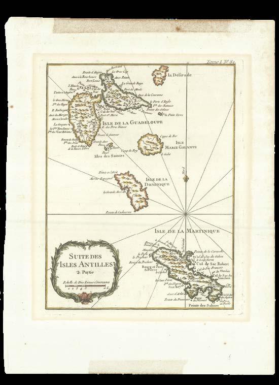
[BELLIN, Jacques-Nicolas]
Suite des Isles Antilles 2. Partie.
Publication [Paris, Jacques N. Bellin, 1764].
Description
Engraved map, hand-coloured in outline, discolouration to upper margin.
Printed the year after the Treaty of Paris, ceding an allegedly empty colony to the British.
Showing Guadeloupe, Maria Galante, Dominica, and Martinique. With an elaborate cartouche border, dotted rhumb lines, and a fleur-delys pointing north. Mountains, churches, and settlements are indicated. Guadeloupe and Martinique are labelled with ports, towns, and bays, such as “the point of the old inhabitants”. Dominica is sparse by comparison, with only an anchor symbol, one mountain, and two landmarks labelled.
Although there was a strong history of French settlement in Guadeloupe and Martinique, they did not claim Dominica until 1635. The establishment of permanent timber camps to supply wood, coffee, sugar, and slaves began to attract the attention of the British, who sent rival harvesters.
With the Treaty of Aix-la-Chapelle in 1748, Britain and France agreed to treat the island as neutral ground and leave it to the Caribs. However, French planters continued to settle in Dominica. Britain then captured the island in 1759. Soon after, the Treaty of Paris was signed in 1763, the year before this map was published, which formally ceded control of North America to the British.
The mapmaker
Jacques-Nicolas Bellin the Elder (1703-1772) was arguably the most influential publisher of charts in eighteenth-century France. Aged eighteen in 1721, he joined the newly formed Dépôt des Cartes et Plans de la Marine, more frequently known as the Dépôt de la Marine, created by Louis XIV to consolidate the loose network of naval archives of the French empire reporting to Paris and Versailles. He was appointed “Ingénieur hydrographe de la Marine” in 1741. Under his leadership, the functions of the Dépôt rapidly diversified from being a simple repository, to the centre of production of French maps, to which Louis XV finally granted a monopoly in 1773.
During his career, Bellin published a number of atlases, the most significant of which were Hydrographie Française (1753), Le Neptune François (1755), and Le Petit Atlas Français (1763), reissued as Le Petit Atlas Maritime in 1764, from which the present example is taken. Combined, these atlases show the coastlines of the known world, with a comprehensive depiction of the urban landscape too.
Bellin’s output was enormous, and his maps were copied throughout Europe for decades. He was a member of the Académie de Marine and of the Royal Society of London.
Trading,
but not for profit
WHITE, Samuel
A small archive of letters and documents retained by Samuel White of Marblehead, Massachusetts between 1767 and 1802.
Publication Dominica and Barbados, 1764-1802.
Description 23 items (various formats and sizes). 50 leaves, original autograph and holograph manuscripts, letterpress documents with manuscript additions, some plans, most folding.
References
Purdin, ‘The First Board of Selectmen’, in the ‘Marblehead Magazine’, 2007; Roads, ‘The Marblehead Manuel’, 1883.
Samuel White was a merchant living in Marblehead, Massachusetts, between, at least, 1764 and 1802, encompassing the time after the end of the French and Indian War, which reset colonial power-bases in the Americas and the West Indies, and the Revolutionary War, which shaped the United States. Following the end of the Seven Years’ War, Britain passed the Free Port Act of 1766, which created six British Free Ports, legitimizing trade with the colonies of their former enemies, France and Spain. However, White’s first trade, as recorded in this archive, happened in March of 1764, when he sold Rum in Bilbao, from the hold of Edward Bowen, in return for a delicious cargo of Lemons and Lisbon Wine, so proving that parliament was more than somewhat behind the times.
During the inter-war period, according to the evidence of this archive, White established a halting business exporting cod fish from Newfoundland to Barbados and Dominica in the West Indies, in return for boatloads of molasses and rum, which he sold back in Boston. That, however, was a bit like trying to sell coals to Newcastle. White’s main agents in Barbados, Phillips & Foster, frequently mentioned in their dismal account records, included in this archive, that as there was an abundance of local fresh fish, even near the “French Islands”, revenue was once again down, especially after they had paid all associated bills, and their commission.
The archive includes the names of all the sloops and schooners, their captains, and the names of the agents and private individuals who purchased White’s goods, at home in Boston, and abroad in the West Indies, and the names of the famous Bowen family of New England navigators appear on a few occasions. The ‘Journals of Ashley Bowen (1728-1813)’ for the year 1769 record him preparing much of the rigging for Samuel White’s schooner ‘First Attempt’. The Phillips Library at the Peabody Essex Museum holds a collection of 53 letters and documents similarly retained by White.
The first mention of the name “Marblehead” in colonial records occurs on 2nd July, 1633, “when James White and John Bennet were fined for public drunkenness” (Purdin). Captain White was probably the grandson of Resolved White (1646-1720) who arrived aboard the “Mayflower”. He is recorded as being one of the Selectmen of Marblehead for 1774. The “history of the Marblehead Board of Selectmen is the history of democracy in America. The debates, the compromises, the lines that were not crossed, the men and women, the changing community, the conflict of preservation and progress, the politics, the leadership, and the ultimate history and traditions that emerged, all make for a story that is not over yet, and one that gets better each time we bring it up to date... Records indicate that the first meeting of this group of then “seven men or selectmen” was held on Friday, December 22, 1648. That first board was the only Board in history, that is known, on which all members were brand new... But, while that
first year was probably not considered to be all that significant to the men who served, it determined much about the way the Board would conduct itself and how the Town would be governed for the next 350 years” (Purdin).
Provenance
From the Library of Quentin Keynes, his sale, Part IV, Christie’s, 22nd September, 2004, lot 75.
The genesis of the principle of international Free Trade
THE ENGLISH FREE PORT ACT OF 1766
An Act for opening and establishing certain ports in the Islands of Jamaica and Dominica, for the free importation and exportation of certain goods and merchandizes; for granting certain Duties to defray the Expences of opening, maintaining, securing, and improving, such Ports; for ascertaining the Duties to be paid upon the Importation of Goods from the said Island of Dominica into this Kingdom; and for securing the Duties upon Goods imported from the said Island into any other British Colony.
Publication London, Printed by Mark Baskett, Printer to the King’s most Excellent Majesty; and by the Assigns of Robert Baskett, 1766.
Description Quarto (295 by 180mm). 12 leaves, additional general title-page, pages 799811, disbound.
At the onset of the Seven Years’ War (1756-1763), between Britain and France, the British Parliament enabled the “Rule of 1756”, which established that Britain would not trade with any neutral country who also traded with their enemy. The particular intent of the Rule was to prevent France from trading with its colonies in the West Indies by way of neutral Spanish fleets. The Rule was also frequently invoked to justify the British seizure of ships of any nation, carrying cargo to or from France and her colonies.
A work-around to this Rule was soon found by which any vessel, including ones of British origin, would take French cargo to a neutral port, unload it, pay any duty and taxes owed, then reload the cargo with an ostensibly new neutral port of origin. These were the first Free Ports in the modern sense.
After the first Treaty of Paris of 1763, which ended the Seven Years’ War, Britain arguably gained the most ground, but lost control of a number of its territories in the West Indies. The Free Port Act of 1766 created six British Free Ports: Prince Rupert’s Bay and Roseau in Dominica were empowered to trade “live Cattle, and all manner of Goods and commodities, the Growth or Produce of any colony or Plantation in America not under the dominion of His Majesty, his Heirs, and Successors, except Tobacco,... from any Foreign colony or Plantation in America, in any Foreign Sloop, Schooner, or other vessel whatsoever,... “and Kingston, Savannah, La Mar, Montego Bay, and Santa Lucea in Jamaica, the same, “except Sugars, Coffee, Pimento, Ginger, Melasses, and Tobacco”. This enabled Britain to capture a share of this lucrative economy which the Rule of 1756 had inspired, as well as extend its territorial trading power in the vicinity of the lands lost. This is arguably the beginning of the principle of international Free Trade.
An extremely rare advert for colonialism
References HMSO 3369. 10
[JEFFERYS, Thomas]
Dominica.
Publication [London, Printed for Robert Sayer, in Fleetstreet; and Thomas Jefferys, at the corner of St Martin’s Lane in the Strand, 1768].
Description
Engraved map with inset, hand-coloured in full, in two sheets joined.
Dimensions 640 by 490mm. (25.25 by 19.25 inches).
An extremely rare and inaccurate map of Dominica, with instructions on both how to land and how to make use of the land.
With a compass rose bearing a fleur-de-lys, and an elaborately bordered inset of Prince Rupert’s Bay. Showing the topography of Dominica, including mountains, rivers, and lakes. The shape of the island is distorted, with Capuchin Head and Crab Point drawn as pointed tips. Parishes are colourcoded, although inaccurate. For example, the Couanary Quarter is bulging, whereas La Soye Quarter caves inwards.
In the bottom left-hand corner, observations are offered by David Ross for how to approach the island. Ross served as a Surgeon aboard the Montagu, Man of War, in 1760 and 1761. Two years later, Dominica was liberated from French control by an attack led by Lord Rollo, and returned to British possession in 1763. In the present example, Ross helpfully instructs navigators to choose the calmest approach from the south, as the wind from Capuchin Head might blow one’s course too close to the shore of Prince Rupert’s Bay.
Additional comments in the bottom right-hand corner advertise the “very excellent land” Dominica boasts, watered by many rivers. It is ideal for stocking cattle, horses, and mules. Timber is described as plentiful, to be used for constructing mills and store houses for sugar. Stone quarries and warm temperatures offer additional enticements. Trade is discouraged on the Windward side of the island, but the Leeward coast is free from tempestuous weather and is therefore “extremely convenient for Trade”.
This map was plagiarised eleven years later by the French, who captured Dominica in 1778. Amusingly, both the text and cartographical mistakes are carried across almost identically.
Taken from Jefferys’s extremely rare ‘A General Topography of North America and the West Indies’, published in 1771. Intended initially as a compilation of Jefferys’s separately published American maps, it claims to be ‘a collection of all the maps, charts, plans and particular surveys that have been published of that part of the world’. It was published ‘for R. Sayer and T. Jefferys’, in the same year their partnership ended.
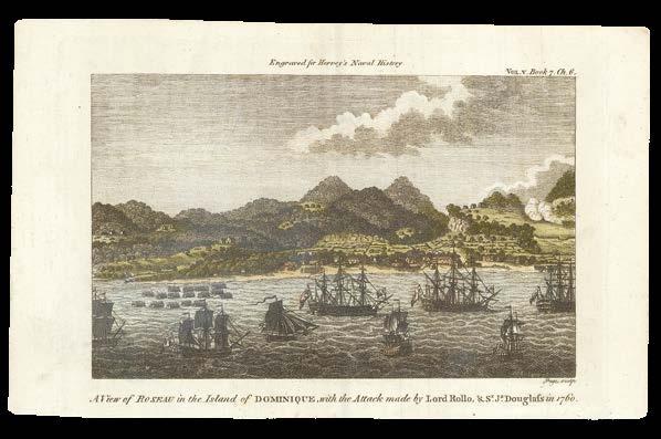
CAMPBELL, Archibald
A view of Roseau in the Island of Dominique with the Attack Made by Lord Rollo & Sr. James Douglass in 1760.
Publication London, John Bowles at No.13 in Cornhill... [c1770].
Description Engraving, one small margin tear, skilfully repaired, minute brown staining.
Dimensions 360 by 530mm (14.25 by 20.75 inches).
References National Maritime Museum, PX8849.
A coastal view of Roseau, Dominica, under attack by Lord Rollo and Sir Douglass amidst the Seven Years’ War.
In the foreground, eight three-mast ships sit on the coast, whilst a collection of smaller boats sit closer to the shore on the left. On the beach, a group of soldiers are seen marching, whilst another group are firing guns in the hills to the far right. The map key includes landing places of British divisions, French entrenchments, and flat-bottomed boats landing on the shore.
Andrew Rollo, 5th Lord Rollo (1703-1765) was a Scottish army commander in both Canada and Dominica. He led the attack on the French settlement of Roseau, Dominica, on June 6th, 1761.
Sir James Douglass, 1st Baronet (1703-1787) was a Scottish naval officer, and Commodore of Newfoundland. He was the commander of the squadron that captured Dominica from the French during the Seven Years’ war.
The artist
Sir Archibald Campbell KB (1739-1791) served as governor of Georgia, Jamaica, and Madras. Although he was a major Scottish politician who sat in the House of Commons between 1774 and 1791, Campbell was held as a prisoner of war in solitary confinement during the American Revolution, captured in 1776 and only released in 1778 when George Washington intervened.
Campbell ended the American Revolution as Lieutenant Governor and Major General in Jamaica (1779–1781). At this point in time, the British forces in America were faring ill: the French had joined the insurgents and threatened the British West India Islands, of which they captured Tobago, St Eustatius, St Kitts, Nevis, and Montserrat. Nevertheless, Campbell was indefatigable in raising enough native troops to deter French attacks on Jamaica.
Simultaneously, Campbell assisted British troops in America by sending information, reinforcements, and supplies. He lent a portion of his troops to Admiral Rodney for the Battle of the Saintes, which helped lead Britain to victory over François Joseph Paul de Grasse, and saved Jamaica from a French invasion.
This view was drawn on the spot by Campbell when he was a Lieutenant.
[JEFFERYS, Thomas]
Dominica from An Actual Survey compleated in the year 1773.
Double-page engraved map, hand-coloured in outline.
Dimensions 640 by 495mm (25.25 by 19.5 inches).
References cf. Sellers & Van Ee, 2030; cf. HMSO 2974.
Large-scale survey by London’s leading mapmaker
Large-scale map of Dominica, with its parishes colour-coded. Topographical details such as rivers, hot springs, and Carib landholdings are shown. Although Roseau is the capital of Dominica, the town seems almost dwarfed by the neat rows of salt pans in Portsmouth.
The author
Thomas Jefferys (1719-1771) was probably the most important English map-maker at a transitional point in European publishing. At the start of his career, creative English mapmaking lacked innovation, while European publishing was dominated by French mapmakers. At the end of his life, the British were ascendant, even if it took the next generation to establish that pre-eminence.
In 1746 he became Geographer to Frederick Prince of Wales and in 1757 to George Prince of Wales, and then Geographer in Ordinary to George III, when George became king. In 1754 Jefferys published some of the earliest maps on the Seven Years’ War, and thereafter served as quasiofficial mapmaker to the British government, with access to officiallyproduced manuscript materials. He was to publish many of the most important maps relating to the events of the war, whether in America, Europe, Africa, India, or on the High Seas. At the end of the war in 1763, Jefferys was the leading London mapmaker and publisher, clearly wealthy, and ambitious to do more.
Unfortunately for Jefferys, his commissioning of large-scale county maps was unprofitable. In 1766 he was declared bankrupt, and much of his stock-in-trade sold in a ten-day auction in February 1767. To continue in business, Jefferys entered into a short-lived partnership with Robert Sayer. When the partnership ended, in about 1768, Sayer retained much of the American materials, which became a turning point for Sayer as a map-publisher.
The atlas
The ‘West India Atlas’, from which the present work is taken, first published in 1778, was designed to aid the highly lucrative sugar trade, which by this point accounted for around one-fifth of all imports to Europe, 80 percent of which was supplied by French and British colonies in the West Indies. Unfortunately, Europe’s insatiable desire for sugar drove a viler – although no less lucrative – trade: that of the trafficking of slaves from the west coast of Africa to the Caribbean plantations. It is estimated that by the time the atlas was published, some 400,000 enslaved people were at work in the British Caribbean colonies.
Thomas Jefferys would not live to see the publication of his ‘West Indian Atlas’, and it was left to Robert Sayer who, in partnership with John Bennett, published the atlas posthumously under Jefferys’s name. The work was evidently a commercial success as there were five subsequent editions under the Sayer and Bennett imprint. In 1794 an expanded and modified version with 61 plates was published under Sayer’s sole imprint. In the same year Laurie & Whittle acquired Sayer’s plates, and they published a further version with the same title page, but with their imprint.
BYRES, John
Plan of the Island of Dominica laid down by actual survey under the Direction of the Honourable the Commissioners for the Sale of Lands in the Ceded Islands By John Byers Chief Surveyor 1776.
Publication London, S. Hooper, Nov. 1st, 1776.
Description Engraved map, fine original full-wash colour, on three large folio sheets joined.
Dimensions 1525 by 890mm (60 by 35 inches).
References
Sellers & Van Ee, 2032; Cat. National Maritime Museum, 453 (14-16).
Upon taking control of the island in 1763, Britain was faced with the task of the sale, distribution, and allocation of land on Dominica. A team of commissioners and surveyors was raised to organize the division of Dominica into lots and administer the sale of these lands in the name of the Crown. They were directed to sell the land by public auction to British subjects; an individual could not buy more than 100 acres if the land had been cleared or 300 acres if the land was forested.
The Chief Surveyor was John Byres and the map which he and his team produced laid the guidelines, coastal demarcation, and boundaries of all properties on the island until the aerial photographs of 1956 and the first accurate British DOS map was published two hundred years later in 1964 (Byres: 1776, DOS: 1964). The sale of Dominica raised a total of £313,666 19s 2¼d. It all went to the British Crown. The system and pattern of landholding, which it instituted in the eighteenth century, has determined the social patterns of Dominica to the present.
The present map divided the island into ten parishes and subdivided each parish into numerous lots no larger than 300 acres in size. These sections covered most of Dominica except for the extremely mountainous areas in the centre of the island. Even so, very little regard was given to the lay of the land and many of the lots were on the sides of precipitous slopes and deep valleys. Most were almost impossible to get to on foot, let alone establish estates and transport goods and the majority of these lots are still inaccessible today. To accompany his map of the island published 1776, Byres compiled a list of all the properties on the island. The list, complete with alphabetical index, shows the acreage of each lot with its original or present purchaser or lessee for each parish.
The map is rare. OCLC gives only seven institutional examples (BL, London; Clements Library, Univ. of Michigan, Ann Arbor, MI, USA; Harvard, MA, USA; Library of Congress, DC, USA; National Library of Scotland, Edinburgh; National Maritime Museum, Greenwich; University of London, Institute of Commonwealth Studies, Senate House Library, London). We know of one other example in private hands. Of the nine examples of which we are aware, only the present map and the map at Harvard have full colour.
BEVAN, Sylvanus
An Abstract of the several title Deeds and Writings – relating to Governor Whites Mortgage Security of £10,000 on Blancards Plantation in the Island of Dominica assigned by Mess.rs Mason and Jones until Sylvanus Bevan Esq.r and Balthazar Burman In Trust as to £5,000 part of thes.d Mortgage Debt for Bartlett Gurney Esq.r and £5,000 for Robert Hasell Esq.r and which writings are deposited in the hand of Mr. Bevan.
Publication [London], 27th Day of August, 1777.
Description
Original holograph document. Folio, single leaf folded to make 4 pages, written on 3, docketed on the fourth “A Mem.d of the Deeds in the hands of Mr. Bevan”.
Dimensions 340 by 200mm (13.5 by 7.75 inches).
This complicated document is a record of the Indentures of Lease, Release, Mortgage and Re-Mortgage, associated with the ownership of “Blancards” or “Picards” Plantation in Prince Rupert’s Bay, Dominica. The invested parties include the original owners of the Plantation, James Blancard and his wife Francoise Soullier, who appear to have sold the plantation to Michael White Esq.r Deputy Lieut.t Governor of the Island of Montserratt, who in turn had used the plantation as security against various mortgages totalling of 10,000 pounds, purchased from Samuel Greatheed, merchant of Lawrence Poultney Land in the City of London, Bartlett Gurney, and Robert Hassell. Sylvanus Bevan of Lombard Street, and Balthazar Berman of Lincoln’s Inn, appear to have purchased the original debt, and to have sold it on to Kender Mason and Arthur Jones, merchants of Crutched Friars London, and William Manning and Jonathan Price.
The Picard Plantation first appears on the maps of Dominica in 1765, by the River Picard, or Picart, named by the first owner Jacques Blanchard from Picardy. According to this document, not all of the plantation is mortgaged, and parts of it have been offered to Manning and Price, freehold, along with “Buildings Slaves Cattle and Utensils”.
Kender Mason (1722-1790) is known to have made a fortune from the slave trade. A Board of Trade document shows that in 1768 “Kender Mason & Co trading out of Dominica’s free port of Roseau, sold 3710 Africans in Dominica and another 1713 in Puerto Rico. In 1772 the firm sold 5,003 Africans in Dominica. In exchange for the slaves the company received coffee, cotton and other commodities which were taken back to Europe to be traded for high prices. In February 1763, by the Treaty of Paris which ended the Seven Years’ War, Spain ceded Florida to Britain ushering in 20 years of British rule in Florida. Britain also kept many of the West Indian islands they had gained during the war and most of the former French territories of North America. The British stationed 3000 militia at the Garrison of St. Augustine (the Spanish-built Fort Castillo de San Marcos) and at outposts in East Florida and these troops required feeding. Merchant Kender Mason, with his partner Arthur Jones, was contracted by the British government to supply provisions to the garrison and its outposts. This was not always an easy journey. Florida did not take part in the American War of Independence in 1775, but there were American ships and Privateers patrolling off the coast of Florida ready to capture British ships. This lucrative victualling contract lasted from 1764 to 1782 when the contracts were passed to their sons. It is thought that the final payment to Mason was over £40,000. This is equivalent to over £4million today and these supply ships ran concurrently with Mason’s ships bringing slaves from Africa. Between the American War of Independence (1776) and the signing of the Constitution (1787) Kender Mason and his cargoes were embroiled in a celebrated American legal case which in 1781 branded him “the enemy of America” by a court in Pennsylvania. America was
sensitive to any cargos from a British trader being brought into North America. At that time American law was still in its infancy and there was no clarity between the Federal Law and the Law of Nations. Kender Mason senior died in 1790 he divided his estate equally between them. His estate consisted of urban property in London and diverse plantations in Montserrat, Antigua, Dominica and elsewhere in the West Indies” (Amersham Museum online).
[after CAMPBELL, Archibald]
A Perspective View of Roseau in the Island of Dominica in the West Indies.
Publication [London, J. Cooke, 1778].
Description Hand-coloured engraving.
Dimensions 190 by 290mm (7.5 by 11.5 inches).
References Sabin, 48854.
A vibrant example of one of the most reproduced views of Dominica
A colourful example after Campbell’s coastal view of Roseau, under attack amidst the Seven Years’ War.
In the foreground, eight three-mast ships sit on the coast, whilst a collection of smaller boats sit closer to the shore on the left. On the beach, a group of soldiers are seen marching, whilst another group are firing guns in the hills to the far right. The map key includes landing places of British divisions, French entrenchments, and flat-bottomed boats landing on the shore.
In the present example, the colours of the ships’ flags are brightly painted in red, white, and blue, although the colours do not correspond exactly to the ensign flag of the British navy at the time.
Andrew Rollo, 5th Lord Rollo (1703-1765) was a Scottish army commander in both Canada and Dominica. He led the attack on the French settlement of Roseau, Dominica, on June 6th, 1761. Sir James Douglass, 1st Baronet (1703-1787) was a Scottish naval officer, and Commodore of Newfoundland. He was the commander of the squadron that captured Dominica from the French during the Seven Years’ war.
Taken from Charles Theodore Middleton’s ‘A New and Complete System of Geography’ (1778-1778), an ambitious attempt to bring the entire world’s natural and political geography, ethnography, zoology, and more into a single publication. It was issued in weekly parts, forming two volumes with 101 engraved illustrations by the final issue. It included a ‘New Discoveries’ section on Australasia, mostly based on Captain Cook’s first and second voyages. Renowned cartographer Thomas Bowen also contributed two folding world maps.
BOWEN, Tho[ma]s
A Map of the Island of Dominica taken from an actual survey also part of Martinico and Guadalupe, shewing their true bearing and distance from each other.
Publication [London, Gentleman’s Magazine and Historical Chronicle, December 1778].
Description Hand-coloured engraved map.
Dimensions 265 by 210mm (10.5 by 8.25 inches).
References Sellers & Van Ee, 2040.
A map of Dominica, showing its different parishes in addition to its coastal towns, rocks, ponds, and bays. The centre of the island is thick with trees and hills. Displayed only to indicate the distances between the islands, Guadeloupe and Martinique are shown only in partial outline. Two compass roses with fleur-de-lys stand out amongst the rhumb lines, and the title is housed in an elaborate cartouche.
Taken from the ‘Gentleman’s Magazine and Historical Chronicle’, a series that ran from 1731 until 1907.
For a full description of mapmaker Thomas Bowen, please see page 210.
PERRIER, [Francoise]; and [Ambrose] VERRIER
La Dominique prise par les Francois le 8 Septembre.
Large-scale map glorifying the French Invasion of Dominica.
The map closely resembles Phillipe Buache’s ‘Carte de la Dominique Prise par les François le 7 Septembre 1778’, except it lacks the insets of French military plans.
Showing rivers in orange, towns in red, and salt pans in blue. The smaller inset map shows the position of Dominica compared to the other islands of the Antilles. With a compass rose bearing a fleur-de-lys.
Early on 7th September 1778, French forces landed on the southeastern coast of the island. They rapidly took over some of the island’s defences, and eventually gained control of the high ground overlooking the island’s capital, Roseau. Lieutenant Governor William Stuart then surrendered the remaining forces. Dominica remained in French hands until the 1783 Treaty of Paris, when it was returned to British control.
The mapmakers
Ambrose Verrier (c1755-1784) and Francoise Perrier were apprentice engravers who succeeded their employer, Roch-Joseph Julien in his Paris map shop, located at the Hotel de Soubise in 1777.
Since the loss of the French colonies in America in 1763, French cartographers had relied on English maps for new information on North America. With the alliance formed between France and the American Revolutionists in 1778, Verrier and Perrier began to invest in producing French maps of North America. The present example is modelled off the map by French cartographer Philippe Buache (1770-1773), who in turn based his map on the ‘Plan of the Island of Dominica’ by the Englishman John Byres, published in 1776.
BUACHE, [Philippe]
Carte de la Dominique prise par les François, Le 7 Septembre 1778. Avec le Plan du Debarquement, et de l’Attaque des Forts et Batteries par les Troupes et les Fregates de Sa Majeste.
Publication Paris, Chez l’Auteur Rue des Noyers, 1778.
Description
Double-page hand-coloured engraved map, two inset maps.
Dimensions
635 by 500mm (25 by 19.75 inches).
References Sellers & Van Ee, 2041.
Large-scale map glorifying the French Invasion of Dominica.
Showing topographical details, such as mountains in brown, rivers in blue, and the towns and salt pans in red. The smaller inset map shows the position of Dominica compared to the other islands of the Antilles. The larger inset plan reveals the details of the French fleet attacking the coast. It records the numbers of batteries and forts, as well as depicting the positions of the ships surrounding Roseau and the nearby coast.
Early on 7th September 1778, French forces landed on the southeastern coast of the island. They quickly gained control of the island’s defences and the high ground overlooking Roseau, forcing Lieutenant Governor William Stuart to surrender the remaining troops. Dominica remained in French hands until the 1783 Treaty of Paris, when it was returned to British control.
Based on the ‘Plan of the Island of Dominica’ by John Byres, published in 1776. This survey for the sale of lands in the ‘Ceded Islands’, which the French had ceded to Britain in 1763.
Dedicated to Antoine Raymond Jean Gualbert Gabriel de Sartine, Comte d’Alby (1729-1801), a French statesman serving as Lieutenant General of Police of Paris during the reign of Louis XV and as Secretary of State for the Navy under King Louis XVI.
The cartographers
Taken from Guillaume Delisle and Philippe Buache’s ‘Atlas géographique et universal’, published by Jean-Claude Dezauche in 1781. Delisle and Buache were two of the most skilled mapmakers of the eighteenth century.
Guillaume Delisle (1675-1726) was a precocious cartographer. Delisle was admitted into the Académie Royale des Sciences in 1702, gaining full membership in 1718. He was appointed chief royal geographer, a title created especially for him. Delisle had access to news of the latest discoveries through his membership of the Academy, and issued several maps of France’s colonial possessions in America. His ‘Carte du Canada ou de la Nouvelle France’ was the first map to show the latitude and longitude of Canada correctly.
Philippe Buache (1700-1773) was a French geographer known for inventing a new system of geography that divided the world by seas and rivers. Buache was trained under Delisle, whose daughter he married, and whom he succeeded in the Académie Royale des Sciences in 1730. Buache was nominated first geographer of the king in 1729. The day
[ANONYMOUS]
L’Anglois Chassé de la Dominique.
Publication [Paris], Hotel Chien du Basset, [1778].
Description
Engraving, trimmed within plate-mark, just into lower part of engraved image.
Dimensions
270 by 335mm (10.75 by 13.25 inches).
Rare satirical print from a narrow window of French control
A rare satirical print mocking the English, published during a narrow window of French control of Dominica.
A caricature of an Englishman is seen to the right, flailing his arms in desperation as he sees his ships sinking in the background. A gentleman sporting an aggressively tall wig points smugly towards the hotel entrance, where various onlookers sneer at the English ships. The publisher’s address (“au chien Basset”) appears both as the innkeeper’s sign and over the entrance to the building.
A poem beneath the title translates: “Where can save me from a disastrous death! To the heavens, which pursue me, I hold out my arms in vain. I avoid the fury of the brave French, for it is only in fleeing them that one can save one’s life”.
In the eighteenth century, Dominica was the perpetual victim of territorial battles between the British and the French. The 1763 Treaty of Paris ended the Seven Years’ War, giving Britain possession of Dominica. In 1778, the year in which the present example was published, the French navy successfully invaded with the help of Dominica’s largely French population. The island was not returned to British control until the 1783 Treaty of Paris.
The French attempted to reclaim Dominica in 1795 and 1805, with both invasions resulting in damage but no conquest. Dominica remained a British colony until it gained independence in 1978.
Blandishing the British
[LE ROUGE, Georges-Louis]
Carte de L’Isle de la Dominique
Carte de L’Isle de la GrenadeCarte de L’Isle St. Vincent - Carte de L’Isle de la Jamaique.
Publication [Paris, Chez Le Rouge, 1778].
Description
Double-page hand-coloured engraved mapsheet incorporating four maps.
Dimensions 400 by 590mm (15.75 by 23.25 inches).
References Sabin 40141.
A rare set of maps of Dominica, Grenada, St Vincent, and Jamaica, with the latter’s caption flattering British land in French translation.
Each map containing a simple compass rose, with miniature insets explaining topographical details and dates for French or British control. Each island is labelled with towns, bays, and churches. Mountains are represented by relief in hachures, with rivers shown and dotted lines to mark parish boundaries.
Dominica is described as a long island with good harbours, high mountains, and several rivers. It is the only map with a key, indicating where the French army descended, where they made a false attack, and how many soldiers were involved in the recapturing of Dominica on 7th September 1778.
Translated from the maps produced by Thomas Jefferys, an English cartographer, to such a direct degree that the translation casts a more flattering light on the British than it does the French. The three Frenchcontrolled islands are described with dry topographical facts and the dates when the French took control. The only British-owned island, on the other hand, is presented favourably: Jamaica is one of the richest islands in America, and produces “everything that is necessary to life, the air is healthy, and greenery is all around”.
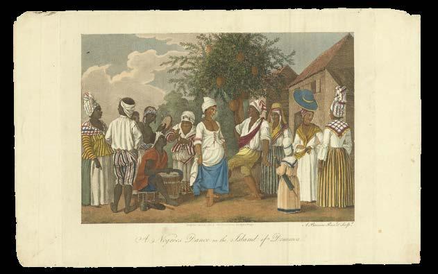
BRUNIAS, A[gostino]
This Plate (representing a Negroes Dance in the Island of Dominica), is humbly dedicated to the Hon. ble Charles O’Hara, Brigadier General of his Majestys Army in America, Col. of Foot & Lieut. Col. of the Coldstream Regiment of FootGuards.
Description Engraving with stipple and aquatint, printed in colours and finished by hand.
Dimensions 305 by 380mm (12 by 15 inches).
Rare first edition of Brunias’s celebrated “Negroes Dance”
Rare first edition of the celebrated “Negroes Dance”.
A group of Caribbean men and women, including a couple dancing below a coconut tree, with others playing a drum and tambourine and clapping, on the left, and a child carrying a parasol furled under her arm listening to women talking, on the right.
Towards the turn of the nineteenth century, the plantocracy had increasingly attempted to suppress African culture, fearing that it could lead to a newly forged common identity among the enslaved, and therefore form a rallying point for rebellion. Drums, for example, were prohibited in many plantation colonies as it was thought they might be used for covert communications. On the other hand, dancing was permitted as the plantation owners recognized no ritualistic elements.
Clothing worn in Dominica would have been a mixture of indigenous Kalinago, African, and European styles. A distinctive Creole style developed in the region as European fashions were integrated with African modes such as the head wrap, worn by nearly all women regardless of race or social status. The Dominican silhouette was wider and more rounded, as breasts were allowed to sit naturally and skirts were tied artfully at the hips instead of the natural waistline. Skirts on working women also averaged longer than the European styles.
Brunias seems to have enjoyed painting stripes and may have overrepresented striped textiles in this particular scene, whereas plain white cotton and linen were most likely worn to accommodate the hot climate.
For a full description of artist Agostino Brunias, please see page 210.
BRUNIAS, Agostino
The West India Washer-Women.
Publication London, No.7 Broad Street, Soho, July 1st 1779.
Description Engraving with stipple and aquatint, printed in colours and finished by hand.
Dimensions 285 by 185mm (11.25 by 7.25 inches).
References See Hough, 630.
A snapshot of colonial chores
Portraying three local women washing clothes.
A mixed-race woman is standing upright in the river, surrounded by dark-skinned women who are actively washing and carrying the clothing. One woman carries her child in a sling. The clothes worn and washed in this scene reflect the plain white cotton favoured by all Dominican inhabitants, regardless of class or race.
Dedicated to Sir John Frederick, 5th Baronet (1750-1825), a British politician who sat in the House of Commons between 1774 and 1807.
The French now sing in hatred to the one who conquered Dominica
LE ROUGE, [Georges-Louis]
La Dominique situee entre la Martinique et la Guadeloupe
Conquise par M. le M.is de Bouille, Marechal des Camps et Armees du Roi le 7. Septembre, 1778.
Publication Paris, Le Rouge, [1779].
Description
Double-page engraved map, hand-coloured in outline.
Dimensions 630 by 485mm (24.75 by 19 inches).
Large-scale map of Dominica, lauding the later-detested marquis mentioned in La Marseillaise.
Parishes along the coast are colour-coded, with the central forested terrain outlined in green. Towns are shown in red, with the large salt pans of Portsmouth left uncoloured.
In the eighteenth century, Dominica was constantly the victim of territorial battles between the British and the French. The present example highlights the rivalry, locating three major battle scenes and including a French-style compass rose.
The long title describes Dominica as conquered by François Claude Amour, marquis de Bouillé (1739-1800), governor of Guadeloupe and St Lucia. His best-known military exploits took place in the West Indies during the American War of Independence, where he was involved in the French capture of British territories such as Dominica. A committed Royalist during the French Revolution, he was a leading conspirator involved in the royal family’s unsuccessful escape from Paris in 1791. This failure forced Bouillé into exile. He is described in the French national anthem, ‘La Marseillaise’, as an “animal without pity” (trans.) in league with bloodthirsty despots.
For a full description of mapmaker Georges-Louis le Rouge, please see page 211.
[after CAMPBELL, Archibald]
A view of Roseau in the Island of Dominique, with the attack made by Lord Rollo & Sr. Js. Douglass in 1760.
Publication [London, William Adlard, Fleet Street, 1779].
Description Hand-coloured engraving.
Dimensions 120 by 180mm (4.75 by 7 inches).
References Sabin, 31604; see National Maritime Museum, PX8849.
“Designed to excite in the Breast of Britons… a noble Ardour” (Hervey)
A coastal view of Roseau, Dominica, under attack by Lord Rollo and Sir Douglass amidst the Seven Years’ War.
In the foreground, eight three-mast ships sit on the coast, whilst a collection of smaller boats sit closer to the shore on the left. On the beach, a group of soldiers are seen marching, whilst another group are firing guns in the hills to the far right. The map key includes landing places of British divisions, French entrenchments, and flat-bottomed boats landing onshore.
Andrew Rollo, 5th Lord Rollo (1703-1765) was a Scottish army commander in both Canada and Dominica. He led the attack on the French settlement of Roseau, Dominica, on June 6th, 1761.
Sir James Douglass, 1st Baronet (1703-1787) was a Scottish naval officer, and Commodore of Newfoundland. He was the commander of the squadron that captured Dominica from the French during the Seven Years’ war.
Taken from Frederick Hervey’s ‘Naval History of Great Britain’, a five-volume book describing the “Lives and actions of those illustrious commanders and navigators who have contributed to the spread of fame and increase of power of the British Empire, particularly designed to excite in the Breast of Britons… a noble Ardour”. The volume from which the present example is taken focuses on the progress of British power at sea through foreign conquests and the establishment of colonies.
Plagiarized map published in the thick of territorial tension
ANGLOIS, M.J.M.
L’Isle de la Dominique.
Publication
Paris, Lattré, Rue St Jacques, la Porte cochere vis-a-vis celle de la Parcheminerie, 1779.
Description
Double-page engraved map, hand-coloured in outline.
Dimensions
630 by 500mm (24.75 by 19.75 inches).
References
Sellers & Van Ee, 2031.
A wildly-inaccurate map of Dominica, plagiarized by the French during the battle with the British for control of the island.
Large-scale map of Dominica, with an inset of Prince Ruperts Bay. Showing the topography of Dominica, including mountains, rivers, and lakes. Settlements, churches, and anchor symbols are shown. Parish boundaries are outlined in colour, while the coast is shaded in green.
The shape of the island is distorted, with Capuchin Head and Crab Point drawn as pointed tips. Parishes are colour-coded, although inaccurate. For example, the Couanary Quarter is bulging, whereas La Soye Quarter caves inwards. The inaccuracy of the map betrays it as plagiarized from an earlier map by Thomas Jefferys from 1768, an Englishman.
Further evidence to suggest such poaching comes in the textual insets. Whilst the original map contains nautical instructions by David Ross, this present example includes a direct translation of these observations, even mentioning Ross by name, albeit in a separate inset. These observations included sailing directions for how best to approach the island.
Ross served as a Surgeon aboard the Montagu, Man of War, in 1760 and 1761. Two years later, Dominica was liberated from French control by an attack led by Lord Rollo, and returned to British possession in 1763. The present example was published in 1778, a year after French forces from Martinique had recaptured the island from the British.
Additional comments summarize the colonial sentiments of the 1768 Jefferys map. The observations advertise the “very excellent land” Dominica boasts, watered by many rivers. It is ideal for livestock and farming, there is a stone quarry, and the island abounds in timber. The only differences in this text from the Jefferys edition are the addition of fishing, and omission of sugar and trade.
The mapmakers
The map is attributed to an M.J.M. Anglois, or ‘Mr. English. This is either misapplied to John Mitchell (1711-1768) who published a large map of the English colonies in North America, or it is a covert nod to Thomas Jeffery (c1719-1771), the English author of the original map from which this was plagiarized.
Engraved by Jean Lattré, a Paris-based bookseller, engraver, globe maker, calligrapher, and map publisher active in the mid- to late-eighteenth century. He was engraver to the king and to the Duke of Orleans, Louis Philippe II, who supported the French Revolution.
As map piracy was common in eighteenth-century France, and the country would have wished to celebrate its recapturing of Dominica from the British the year prior, it seems a natural instinct for the Parisian Lattré to “capture” a British map of Dominica as well - even if his choice in cartographical accuracy was misguided.
BONNE, [Rigobert]
Supplement pour les Isles Antilles, Extrait des Cartes Anglois.
Publication [Paris, Jean-Leonard Pellet, 1780].
Description Hand-coloured engraved mapsheet incorporating nine maps, hand-coloured in outline.
Dimensions 340 by 225mm (13.5 by 8.75 inches).
References Sabin, 68081.
The Bonny Antilles
A map of the Antilles Islands, including Dominica, St Lucia, Barbados, and Grenada. Bays and towns are named, with hachures in relief indicating the mountainous terrain on each island.
The maps originally appeared as part of ‘Histoire Philosophique et Politique des Establissements et du Commerce des Europeens dans les Deux Indes’ by Guillaume-Thomas Raynal. First published in 1770, it was an immediate best-seller, gaining its reputation through its fierce attacks on slavery and colonial exploitation.
The 1780 edition, from which the present example is drawn, is prized for its inclusion of maps by Rigobert Bonne (1727-1795).
For a full description of Bonne, please see page 210.
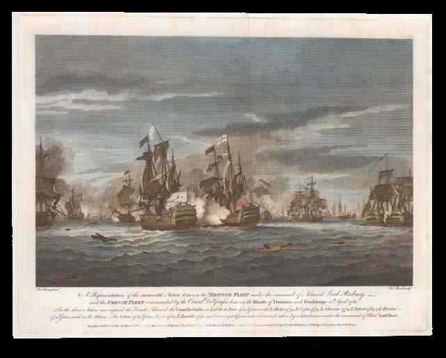
LUNY, Tho[mas]
A Representation of the memorable Action between the British Fleet under the command of Admiral Lord Rodney, and the French Fleet commanded by the Count De Grasse, between the Islands of Dominica and Guadeloupe 12 April 1782.
Publication London, W. Byrne, No.79 Titchfield Street, 1st October 1782.
Description Hand-coloured engraving.
Dimensions 340 by 450mm (13.5 by 17.75 inches).
References Royal Museums Greenwich, BHC0701.
Britain’s greatest victory over the French during the American Revolution
A striking action scene between the British and French fleets during the Battle of the Saintes.
A British ship in the foreground blasts gunfire at its neighbouring white-flagged ship. Fleets in the background sport tattered sails from cannon fire on both sides. One French mast has caught fire, and another ship sinks into the sea. A man clutches a floating piece of debris, and the air begins to grow dark with smoke. Beneath the title, a caption details the capture of French Admiral Count de Grasse, as well as the names of ships and number of guns taken.
The British victory of the Battle of the Saintes was considered their greatest over the French during the American Revolutionary War.
Thomas Luny (1759–1837), was an English artist who specialised in seascapes and battle paintings. He exhibited mainly at the Royal Academy between 1780 and 1793, after which he may have joined the navy to fight in the French Revolutionary Wars. Luny may have witnessed the Battle of the Saintes first-hand.
BEW, John
Map of the Islands, of Martinico, Dominico, Guadalupe, St.Christophers &c. showing the place of Adm.l Rodney’s late Victory over the French Fleet.
Publication
London, J. Bew, Pater Noster Row, 30th of June 1782.
Description
Hand-coloured engraved map, three skilfully-repaired tears to lower corner, together with accompanying letterpress text leaf (210 by 130mm).
Dimensions 285 by 310mm (11.25 by 12.25 inches).
References Sabin, 63784.
Battle of the Saintes
Map of the Leeward Islands celebrating British victory.
Stretching from Barbuda to Martinique. Ports, towns, and bays are labelled on each island. Mountains, rivers, sand banks, and trees are simplistically depicted. A coloured fleur-de-lys floats to the left of Dominica.
Accompanied by ‘The exact Situation on which the late glorious Battle was fought between the British and French Fleets, in the West Indies’, from ‘The Political Magazine and Parliamentary, Naval, Military, and Literary Journal. For July, 1782’, being pages 385 and 386, reprinting an extract from the ‘London Gazette, St. James’s, June 4’, news and poems in respect of His Majesty George III’s 44th birthday, and an early account of the Battles of the Saintes, on the 12th April 1782, “the last major action of the American Revolutionary War, fought near the islets called the Iles des Saintes, just north of Dominica in the West Indies. Admiral Sir George Rodney’s victory over the French fleet of the Comte de Grasse foiled the latter’s attempt to invade Jamaica and enabled Britain to secure her position in the West Indies by the treaty that ended the war in 1783, even though she lost her American colonies. The battle is also famous as the point of origin of the tactic of ‘breaking the line’, which was achieved with great, albeit accidental, effect by Rodney in seizing an advantage created by a shift of wind as the fleets began the action” (Royal Museums, Greenwich, online).
‘The Political Magazine and Parliamentary, Naval, Military, and Literary Journal’ was published by John Bew between 1780 and 1785, largely reporting on the Revolutionary War, and included some important maps by John Lodge.
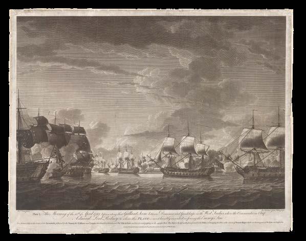
DODD, Rob[ert]
The Morning of the 12th of April 1782, Representing that Gallant Scene between Dominica and Guadeloupe in the West Indies, where the Commander in Chief Admiral Lord Rodney (to whom this Plate is humbly inscribed) is forcing the Enemy Line.
Publication London, R. Sayer and J. Bennett, No. 53 Fleet Street, 21st March 1783.
Description Engraving, laid down on card.
Dimensions 495 by 530mm (19.5 by 20.75 inches).
References See Hough, P8.
Exchanging fire with a knot of French ships
A print portraying the action of the Battle of the Saintes.
The sails on the ships to the left are torn from cannon-fire. Billows of gunpowder blasts can be seen between the ships in the background. Men on board are aiming rifles, giving commands, and running to gather equipment. Cannons at the ready are drawn with remarkable detail in the hulls of the battling ships. Beneath the title a caption names each British ship. The “Duke” is “exchanging her Fire with a knot of French Ships which are bearing out of the Line in confusion”.
The British victory of the Battle of the Saintes was considered their greatest over the French during the American Revolutionary War. “Admiral Sir George Rodney’s victory over the French fleet of the Comte de Grasse foiled the latter’s attempt to invade Jamaica and enabled Britain to secure her position in the West Indies by the treaty that ended the war in 1783, even though she lost her American colonies. The battle is also famous as the point of origin of the tactic of ‘breaking the line’, which was achieved with great, albeit accidental, effect by Rodney in seizing an advantage created by a shift of wind as the fleets began the action” (Royal Museums, Greenwich, online).
BONNE, [Rigobert]
Les Petites Antilles ou Les Isles du Vent, avec celles de sous le vent.
Publication [Paris, 1787].
Description Hand-coloured engraved map..
Dimensions
250 by 355mm (9.75 by 14 inches).
Beyond the neatline
Map of the Lesser Antilles, including the coast of South America.
Extending from the Dominican Republic and Puerto Rico, to Trinidad and Tobago, which juts past the neatline. Mountains are shown on each island, with one or two landmarks labelled. A scale-bar beneath the title records the differences between marine leagues of England, Castille, France, Holland, and Denmark.
A French mathematician and mapmaker, known for a clear cartographic style without the decoration favoured by some of his contemporaries, Rigobert Bonne (1727-1795) was appointed chief hydrographer at the Dépôt de la Marine in 1773. He succeeded Jacques-Nicolas Bellin as Royal Cartographer.
In 1762, he published what was arguably his most important work, the ‘Atlas Moderne, ou Collection cartes Sur Toutes Les Parties du Globe Terrestre’. He collaborated with Nicolas Desmarest (1725-1805) on the publication of the ‘Atlas Encylopédique’, from which the present example is taken, which included both historical and contemporary maps.
BONNE, [Rigobert]
Cartes du Supplement pour Les Isles Antilles.
Publication [Paris, Hôtel de Thou, 1788].
Description Hand-coloured engraved mapsheet incorporating nine maps.
Dimensions 245 by 360mm (9.75 by 14.25 inches).
References Shirley (BL), T-BONN-6a.
Antilles’ Heel
A map of the Virgin Islands, along with eight inset maps of St Christopher, Antigua, Dominica, St Lucia, Barbuda, St Vincent, Grenada, and Tobago.
Taken from the Atlas Encylopédique, published in 1788 in collaboration with Nicolas Desmarest (1725-1805), which became one of Bonne’s best-known works.
ORDE, Sir John Campbell; Edward KENDRICK; and Thomas DANIELL
No. 14. Dominica: The affidavit of Edward Kendrick Esq.
Publication Dominica, This 13th day of Sept.r 1791.
Description Original autograph document, in the hand of Thomas Daniell, and signed by him “Th.s Daniell”, additionally signed by the deponent “Edward Kendrick”. Folio, written on one side, docketed on the verso, which is further annotated in a later hand, “Justice of the Peace, St. John’s”.
Dimensions 375 by 255mm (14.75 by 10 inches).
References Orde for ODNB online.
In effect a character reference for “Sir” John Orde, the former Governor of Dominica (until 1789) who was awarded his baronetcy on the strength of his achievements on the island, which was being contested by some members of the Assembly of the island at the time. Edward Kendrick, Justice of the Peace for the island for more than 25 years, attests before Thomas Daniell, another Justice of the Peace, that “during that time [he] has resided in the said Island, and this Deponent saith he doth not believe his Excellency the said “Sir” John Orde hath received any other or greater Fees of office than such as usually and customarily were received by his Predecessors, and this Deponent never heard of any Complaint relative thereto until after the Departure of his Excellency from his Government in July 1789, when this Deponent understood that the House of assembly had proferd some Complaint against his Excellency. And this Deponent further saith that notwithstanding such complaint he hath never heard of any instance within his own knowledge of any Act of extortion of Fees by his said Excellency. And further this Deponent saith not”.
Sir John Campbell Orde (1751-1824) joined the Royal Navy at the age of 15. In 1775, at the outbreak of the American Revolutionary War, he sailed for America, and his career nearly ended there, when early in 1776 “he was captured and held for a short period during the evacuation of the governor of Virginia, the Earl of Dunmore, to Gwynn Island. At the time of his capture Orde had been leading an advance party under a flag of truce onto Gwynn Island to deliver a proclamation and negotiate a ceasefire and surrender” (Orde). However, he survived this, and many other battles, and returned to Britain in 1781.
Orde remained “first in the North Sea and then off the coast of France, until, in February 1783, he was appointed governor of Dominica, restored to Great Britain under the peace of Versailles. There his primary objectives were to develop the harbour in Prince Rupert’s Bay, restore law and order among the quarrelsome white, black, and Carib population, and retain the island for the British. In all this he was largely successful, so much so that he was rewarded with a baronetcy in 1790, though proceedings were later taken against him by the colonial assembly over his plans for funding improvements to the harbour and fortifications” (Orde), as witnessed by this deposition. The privy council dismissed the allegation as “frivolous”, and with the onset of the war with France in 1793, Orde returned to naval duties.
“the first general and historic account of Dominica” (O’Shaughnessy)
ATWOOD,
Thomas
The History of the Island of Dominica. Containing a description of its situation, extent, climate, mountains, rivers, natural productions, &c &c, together with An Account of the Civil Government, Trade, Laws, Customs, and Manners of the Different Inhabitants of that island. Its conquest by the French, and restoration to the British Dominions.
Publication London, Printed for J. Johnson, 1791.
Description First edition. Octavo (205 by 120mm). Twentieth century half tan calf, marbled paper boards, gilt.
References O’Shaughnessy for ODNB online; Sabin, 2343; Hough, 415.
Thomas Atwood (d1793) was, for a while, chief judge in Dominica and the Bahamas, and author of two books on Dominica, this one, and a pamphlet, ‘Observations on the true method of treatment and usage of the Negro slaves in the British West India Islands’ (1789). Otherwise, little is known of him, and his origins are a mystery, although his end is not: he died in the King’s Bench prison, where he was incarcerated probably because of debt. His ‘History of the Island of Dominica’ “became a standard source of reference for early Dominica that was used by later historians of the British West Indies such as Bryan Edwards and Captain Thomas Southey” (O’Shaughnessy), and his observations were acute: it is “greatly to be lamented, that although the island of Dominica is so very capable of being rendered one of the chief, if not the best, the English have in the West Indies; yet, from a want of knowledge of its importance, or inattention, it is at this time almost as much unsettled, as when it was ceded to Great Britain, near thirty years ago. This is the more remarkable, from the great consequence the possession of it is to the English, in case of a rupture with France, it being the key of the British dominions in that part of the world, and from its situation between the two principal settlements of the French, Martinique and Guadeloupe, it is the only place in the West Indies, by which there is a possibility for Great Britain to maintain the sovereignty of those seas. It has moreover many conveniences for the service of both an army and fleet, which few other West India islands can boast; and was it to be well settled with British subjects, would be of material assistance to our other possessions, by furnishing them with many articles of which they very often are greatly in need” (Introduction).
Provenance
With the ink stamps of the War Office, Intelligence Division, Library on the title-page.
EDWARDS, Bryan
Map of the Island of Dominica for the History of the West Indies.
Publication [London], J. Cooke, Mill Hill, [1794].
Description Hand-coloured engraved map.
Dimensions 350 by 200mm (13.75 by 7.75 inches).
References Sabin, 21905.
Precursor to the definitive American atlas of the Caribbean
Taken from the 1794 edition of Edwards’s ‘History, Civil and Commercial, of the British Colonies in the West Indies’, an illustrated work that reflected on the inhumane treatment of slaves within the colonies. It described the economies, histories, and governance of each island. The present map would later feature in what was considered the definitive American atlas of the Caribbean, published in 1806.
Bryan Edwards (1743-1800) was a politician, plantation-owner, and historian. The maps in his ‘New Atlas’, published 12 years later, represent the most up-to-date mapping of the Caribbean at the time, and was considered a masterpiece.
[JEFFERYS, Thomas]
Dominica from An Actual Survey compleated in the year 1773.
Publication London, Laurie and Whittle, No.53 Fleet Street, 12th May 1794.
Description Hand-coloured engraved map.
Dimensions 645 by 505mm (25.5 by 20 inches).
References Sellers & Van Ee, 2030; see HMSO, 2974.
Surveying the land of sugar and slaves
A later edition of Jefferys’s large-scale map of Dominica.
The atlas
The ‘West India Atlas’, from which the present work is taken, first published in 1778, was designed to aid the highly lucrative sugar trade, which by this point accounted for around one-fifth of all imports to Europe, 80 percent of which was supplied by French and British colonies in the West Indies. Unfortunately, Europe’s insatiable desire for sugar drove a viler – although no less lucrative – trade: that of the trafficking of slaves from the west coast of Africa to the Caribbean plantations. It is estimated that by the time the atlas was published, some 400,000 enslaved people were at work in the British Caribbean colonies.
Jefferys would not live to see the publication of his ‘West Indian Atlas’, and it was left to Robert Sayer who, in partnership with John Bennett, published the atlas posthumously under Jefferys’s name. The work was evidently a commercial success as there were five subsequent editions under the Sayer and Bennett imprint. In 1794 an expanded and modified version with 61 plates was published under Sayer’s sole imprint. In the same year Laurie & Whittle acquired Sayer’s plates, and they published a further version with the same title page, but with their imprint.
MATSON, John; and John MATSON, Junior
A small archive of manuscript Abstracts from Quarterly Accounts, Pay Lists, and Receipts, retained by His Honour John Matson, President of Dominica between 1796 and 1800, and his son.
Publication Dominica, 1st January 1794 - 27th June 1815.
Description 55 original manuscript documents, signed by government officials, military commanders, and local suppliers, various sizes and formats, all folding, some in the original bundles, some docketed on the versos.
References Colin Matson, ‘The Town Clerk of Sandwich, 1768-1785’, reprinted by the Kent Archaeological Society, 2017; Sugden for ODNB online.
The cost of colony
A glimpse into the complex affair of governing the Island of Dominica, at the very edge of the British Empire, from the year that John Matson was acting Governor of the Island after the death of Henry Hamilton in 1796, through the early years of Andrew James Cochrane-Johnstone’s (1767-1833) controversial governorship, until Matson’s retirement as President of the Council of Dominica, and return home to England, in 1800. From these seemingly lean documents, which record in excess of 20,000 pounds of expenditure over four years, can be gleaned the enormous cost of paying, feeding, and otherwise maintaining the troops and infrastructure of Government, in such a remote outpost.
In September of 1796, Henry Hamilton (c1734-1796), governor of Dominica from 1794, died. Spreading the news of his death is one of the earliest expenses recorded of John Matson’s acting governorship of the Island. In April of 1794 the British had invaded French-owned Guadeloupe, but after nine months of fighting, they were repelled in December. In return, in May of 1795, the French tried to invade Dominica from Guadeloupe, aware that the island was only defended by one small company of regular soldiers, something to which documents in this archive attest. The French were aided and abetted in their cause by a simultaneous uprising amongst sympathetic French settlers on the Island. Eventually Hamilton was victorious, but as a result, many of the expenses included in the archive reference the “distressed Emigrants of Guadeloupe”, who were presumably escaping French rule.
In 1797, Cochrane-Johnstone became governor of Dominica, colonel of the 8th West India regiment (January 1798), and brigadier of the Leeward Islands (April 1799). Many of the documents in this archive reference, as a separate expense, what appears to be his own personal bodyguard: a “Corps of Men commanded by the Hon.ble L.t Colonel Johnston, raised by this Colony for its Defence”. CochraneJohnstone was later “blamed by some for a mutiny among the black troops in 1802. The Dominican assembly petitioned for his recall, which occurred the same year. Major John Gordon, an officer of CochraneJohnstone’s regiment, accused his commander of using black soldiers as unpaid labour, wrongfully arresting citizens, and of corruption, but he was acquitted by a court martial in March 1805” (Sugden).
John Matson (1746-1805) was Chief Justice of Dominica from 1788. He arrived in Roseau in May of 1789. “In addition to this main appointment he was soon engaged as Judge of the Vice-Admiralty Court and as President of the Legislative Assembly. He was to hold these responsible positions during the following eleven years. The Chief Justice ranked next after the Governor in the rule and administration of the island; and twice during this period, each time for one whole year, John Matson was to undertake the senior duties and responsibilities—on the first occasion because of the illness and death of the Governor, and on the second during his
absence in England on long leave. Those years were momentous times for the Mother Country and her Colonies on account of the unsettled conditions due to the French Revolution and the subsequent state of war with France during the years 1793-1815... In 1792 John Matson spent a year in England for the recovery of his health, which had again been impaired by an intermittent fever, after which he resumed his station at Roseau with his usual ability and zeal. In July 1796 the Governor fell ill and died; and from that time until September of the following year the Chief Justice was the Acting Governor and Commander-in-Chief of the island. By his very able and upright administration of the affairs of the Colony, and particularly by the salutary and very striking reforms he introduced in the public expenditure, Mr. Matson obtained the fullest approbation of His Majesty’s Ministers at home, as well as the cordial esteem of all ranks of people in the Colony” (Matson).
The archive comprises:
- ten Abstracts of the ‘Quarterly Contingent Account of the Government of Dominica’. Folio, folded. 1796, 1797, 1799 and 1800. Each signed by John Matson, as President;
- two Abstracts of ‘Expenditure on Account of the Loyal Dominica Regiment and Royal Emigrants doing Duty in this Island and also for the distressed Emigrants of Guadeloupe’. Folio, folded. 1794, 1796. Signed by the then Company Commander of Provisions, George Metcalfe, or Anthony Defrayer;
- 38 receipts, signed by the recipients, witnessed by officials, and the charges similarly vouched for, for sums listed in the quarterly accounts, including:
- three Pay Lists ‘due to the Loyal Dominica Regiment’. Which included 1 Colonel, 3 or 4 Captains, 1 Adjutant, 1 Quarter Master, 1 Surgeon, 12 Sergeants, 12 or 14 Corporals, 12 Drummer & Piper, and between 188 and 199 Privates. 1796, and 1797. Signed by Patrick Mawe, Captain, Commander Loyal Dominica Regiment;
- nine Returns, Abstracts, Accounts, or Audits of ‘Provisions Received [and / or] Issued in the Island of Dominica to the distressed Emigrants from Guadeloupe’. Which included “Full Rations”, plus Flour, Beef, Fish, Sugar, “Pease”, Cocoa, Wine, and Rum. Folio, folded. 1796;
- and, 26 sundry receipts for anything from the: hiring of schooners to take the news, by dispatch, of the death of Henry Hamilton, Governor of Dominica from 1794-1796, to or from various of the other Leeward Islands; paying for a “Corps of Men commanded by the Honorable Lieut.
Colonel Johnstone raised by this Colony for its Defence”; taking provisions, mostly Hogsheads of Rum, to other parts of the Island; repairs to Government House and outbuildings, including materials, and “Negro hire”; the local printer S. Browne, for printing multiple copies of a proclamation “requiring His Majesty’s subjects to give information at the Gov.t House of all foreigners who may be residing in the Island without permission,... to command all foreigners who shall not obtain permission to continue & remain upon the Island, to depart from the same, within the space of five days from the date hereof - and, to make known that all persons harbouring & protecting foreigners not duly authorised to remain upon the Island, will be proceeded against with the utmost rigour of the law, French & English”, and another regulating “gold & silver coin”; paying the Secretarial Salary of President Matson’s son, John Matson Jr., which are the only receipts that have not been independently endorsed,...; sale of the Sloop ‘Acis’.
- three letters addressed to John Matson’s son, John Jr., by the West India Commissioners in 1815, relating to the execution of Matson’s Estate. This reveals that the West India Commissioners had raised “Queries which have arisen in the examination of the Accounts of the late Mr. President Matson” (West India Commissioners Office, 27th June, 1815).
- A draft letter (Dominica, 8th October, 1799), refers to “Accounts being forwarded to the Treasury”. It seems likely that following Matson’s retirement in 1800 his papers accompanied him to England but did not reach their official home.
Provenance
From the Library of Quentin Keynes, his sale, Part IV, Christie’s, 22nd September, 2004, lot 75.
POCOCK, N[icholas]
View of Prince Rupert’s Bay, Dominica.
Publication [London], Bunney & Gold, May 1, 1799.
Description Engraving with aquatint.
Dimensions 140 by 230mm (5.5 by 9 inches).
A stormy shipwreck scene
An aquatint view of a shipwreck and beached boat.
Three men are seen pulling the remnants of a wrecked boat, with another boat beached next to them. Two ships are at sea, one struggling against the wind.
The artist
Nicholas Pocock (1740-1821) was an English artist known for his many detailed paintings of naval battles during the age of sail. In 1778, Pocock’s employer, Richard Champion, became financially insolvent due to the effects of the American Revolutionary War on transatlantic trade. As a result, Pocock gave up the sea and devoted himself to painting. The first of his works were exhibited by the Royal Academy in 1782. Later that year, Pocock was commissioned to produce a series of paintings illustrating George Rodney’s victory at the Battle of the Saintes. In 1789, he moved to London, where his reputation continued to grow. He was appointed Marine Painter to King George III.
Pocock’s naval paintings incorporated extensive research, including interviewing eyewitnesses about weather and wind conditions as well as the positions, condition, and appearance of their ships, and drawing detailed plans of the battle and preliminary sketches of individual ships. In addition to his large-scale oil paintings depicting naval battles, Pocock also produced many watercolours of coastal and ship scenes.
[ANONYMOUS]
[Framed oval silhouette].
Publication [c1800].
Description
Silhouette cut-out on bronze paper, black cloth background, wooden picture frame, painted black, handwritten label, metal oval frame and hanging hook, corners bumped.
Dimensions 140 by 120mm (5.5 by 4.75 inches).
Lady Anne
A silhouette portrait of a lady.
The handwritten label on the back of the picture frame reads “Miss Anne Fitzgerold, Dominica”. The hanging hook is decorated as a bunch of grapes. The hairstyle and headscarf suggest that the silhouette may date from the Georgian period.
Cutting portraits in profile from black card became popular in the mid-eighteenth century, and continued to be so for over a century. They represented a cheap but effective alternative to portrait miniatures, and were therefore considered the “poor man’s portrait”.
If the commissioner of the portrait was only of modest means, this suggests they were only able to offer basic remuneration for the artist’s services. This lack of financial flourishing is reflected in the artist’s misspelling of the sitter’s surname, as access to formal education was reserved only for a select few in the wealthier capital. It was not until the turn of the nineteenth century that Roman Catholic and Methodist missionaries began to establish primary schools. Nuns in Roseau had set up a limited girls’ secondary school by 1850, but rural remoteness, combined with a concentration of resources in the capital, resulted in a lack of access to schooling. Only with the building of roads and schools throughout Dominica in the 1960s did access to secondary education improve.
The figure
No birth, marriage, or death certificate is recorded of Miss Anne Fitzgerold (or Fitzgerald) in Dominica.
The Fitzgerald family have been peers of Ireland since the thirteenth century, with several of its members serving as knights and claiming kinship with the Tudor family. However, by 1890, Fitzgerald had become the 36th most common surname in Ireland.
There is an entry for the probate of an Irish Robert Fitzgerald in Dominica in 1815, and there is record of a Richard Fitzgerald, who served military service between 1861 and 1866. Perhaps Miss Fitzgerald was a passing tourist or missionary, who served in Dominica with the Dominican Sisters before returning to Ireland. If so, the closest record is that of Anne Fitzgerald, who was baptized in 1806, married in 1833, and died in 1899, although it is likely that she did not leave Ireland.
POIRSON, J.B.
Carte des Iles Antilles.
Publication [Paris], Tardieu L’Aine, Rue de Sorbonne, 1802.
Description Engraved map, hand-coloured in outline.
Dimensions 395 by 480mm (15.5 by 19 inches).
The Caribbean’s colourful crescent
A French map of the Antilles Islands.
Detailed map showing Puerto Rico, Virgin Islands, Barbados, Antigua, St Martin, Martinique, St Vincent, Tobago, Trinidad, and part of the Dutch Antilles, all outlined in colour. A key to the left explains the colour-coding of each country: blue for the French, pink for the English, yellow for the Spanish, navy for the Danish, gold for the Dutch, and orange for the Swedes.
Jean-Baptiste Poirson (1761-1831) was a renowned French cartographer active between 1790 and 1830. A French engineer, globe-maker, and cartographer, Poirson joined a map publishing firm after completing his studies in mathematics. Having attained some recognition for correcting the work of earlier geographers, Poirson was called to produce several terrestrial globes, as well as the French edition of the maps in Alexander von Humboldt’s ‘Atlas Geographique et Physique de Rouyaume de la Nouvelle-Espagne’.
[PETERS, Rev., Charles]
[Two Sermons, Preached at Dominica on 11th and 13th April, 1800; and officially noticed by His Majesty’s Privy Council in that Island. To which is added, an Appendix, containing Minutes of three trials which occurred at Roseau in the Spring of the Preceding Year; together with Remarks and Strictures on the Issue of those Trials, as well as on the Slave-Trade, and the condition of slaves in general in our WestIndian Colonies].
Publication [London, Printed for John Hatchard, 190, Piccadilly, 1802].
Description Octavo (210 by 135mm). Lacking titlepage; modern tan calf backed marbled paper boards, gilt.
References Worthington Smith, ‘Slavery and Christianity in the British West Indies’, 1950.
“... of a nature and tendency the most alarming and dangerous, and such as to threaten the subversion and destruction of the Colony” (Matson)
The Rev., Charles Peters, Fellow of Queen’s College, Oxford, and late Rector of St George’s and Roseau, in the Island of Dominica, “preached a sermon on Easter Sunday, 1800, to his parishioners on the Island of Dominica urging them not to overwork slaves, and emphasizing that true religion required masters to consider the health and welfare of their slaves, he aroused such as storm that he was forced to resign and retire to England. Later to gain support for the movement to abolish the salve trade, Peters published the sermons [as here]” (Worthington Smith).
BROWN [after] [Agostino] BRUNIAS
The Linen Market at St Domingo.
Publication [London, John P. Thompson, 1804].
Description Engraving with stipple and aquatint, printed in sepia, stain at lower left corner, a couple of small skilfully repaired tears.
Dimensions 440 by 490mm (17.25 by 19.25 inches).
A lively linen market
A market scene in the colonized West Indies, inspired by Brunias’s earlier portrayal of Dominica.
Showing several figures from different socio-economic backgrounds, including one couple walking, a merchant offering her wares to another lady, and two children. The ‘market’ is a simple open shack, built with sticks and covered with rags to form a shaded tent.
Markets were dynamic sites of economic and social exchange where colourful textiles could be acquired. Well-to-do white people and free people of colour had greater access to the latest European fashions, although a variety of outfits and skin colours are included in the scene.
The wealthier white women are exposing a lower neckline, whereas the Carib women have more conservative, structured clothing. The child of the woman buying linen is playing happily with a drum set, while the other Carib child looks nervously at her mother, who is selling the cloth. The latter are wearing chequered headdresses.
The couple in the foreground are well-dressed Europeans, sporting elaborate headdresses. The man wears white stockings, a point of fashion and cleanliness in men for Caribbean fashion. In the far left, two women are sitting and picking up rocks from the ground. A man nearby smokes a pipe and rests on a stick; his lack of stockings indicate that he is from a more modest background than the gentleman with the buttoned jacket and ruffled cuffs.
The artists
The present example was inspired by an earlier painting by Brunias of a linen market scene in Dominica, c1880. Published by John Peter Thompson (1792-1819), an engraver, printer, and printseller who specialized in stipple engraved portraits.
COCHRANE-JOHNSTONE, Andrew
Defence of the Honourable Andrew Cochrane Johnstone; Including a view of the Evidence produced on his trial; with the Sentence and varies commentaries thereon, by the Judge Advocate General; and with a relative series of interesting letters previous and subsequent to the Prosecution: to which is prefixed, a letter to His Royal Highness the Duke of York, on the present Administration of Military Law.
Publication London, Printed by J. Barfield, WardourStreet, for J. Budd, at the Crown and Mitre, 100, Pall-Mall; where likewise may be had, The Trial of Major Gordon, and the Correspondence published in August, 1804, herin referred to., 1805.
Description First edition. Octavo (200 by 130mm). Contemporary half red morocco, marbled paper boards, gilt.
References Sugden for ODNB online.
“Cochrane-Johnstone lost his character many years ago” (Lord Napier)
Andrew Cochrane-Johnstone (1767-c1833) was very briefly governor of Dominica, from 1797 to 1802. As with most of the rest of his life, his governorship of Dominica was controversial. He was “blamed by some for a mutiny among the black troops in 1802. The Dominican assembly petitioned for his recall, which occurred the same year. Major John Gordon, an officer of Cochrane-Johnstone’s regiment, accused his commander of using black soldiers as unpaid labour, wrongfully arresting citizens, and of corruption, but he was acquitted by a court martial in March 1805. However, the commander-in-chief of the army, the duke of York, remained dissatisfied, and Cochrane-Johnstone was passed over for promotion and resigned his commission” (Sugden).
The fraud for which Cochrane-Johnstone is most famously remembered was the great Stock Exchange Fraud of 1814, instigated on February 21st, 1814 when Charles Random de Berenger, “in the guise of an aide to the British ambassador in Russia, travelled from Dover to London spreading news that the French had been defeated and Napoleon killed. Word drove up stocks of omnium on the London exchange, and among the principal beneficiaries were Cochrane-Johnstone, his nephew Lord Cochrane, and their stockbroker, arousing the suspicions of the stock exchange. According to a report published by the stock exchange Cochrane-Johnstone’s profits were £4931. On 22 March he told the house that he could establish his innocence of fraud, but at a trial at the court of king’s bench on 8–9 June 1814, which he did not attend, he and the other defendants were convicted. While Lord Cochrane remained to suffer imprisonment and protest his innocence, Cochrane-Johnstone fled. He never returned to Britain” (Sugden).
Provenance
With the contemporary ownership inscription of “Lyn Cook” at the head of the title-page.
EDWARDS, Bryan
Map of the Island of Dominica for the History of the West Indies.
Publication [Philadephia, James Humphries, 1806].
Description Engraved map.
Dimensions 260 by 200mm (10.25 by 7.75 inches).
References Not in Sabin.
From the earliest printed American atlas of the Caribbean
From the earliest printed, definitive American atlas of the Caribbean.
‘A New Atlas of the British West Indies’ was printed to accompany Edwards’s earlier text, ‘History, Civil and Commercial, of the British Colonies in the West Indies’, first published in 1792. This illuminated the callous conditions of slavery within the colonies.
The accompanying atlas from 1806, from which the present work was taken, was the earliest printed American atlas of the Caribbean, and was considered a categorical masterpiece.
Bryan Edwards (1743-1800) was a politician, plantation-owner, and historian. Edwards and his fellow planters engaged in debates and enacted legislation to protest against restrictions imposed on trade and shipping between the British West Indies and the United States. They supported reform of the Atlantic slave trade, but not its abolition.
[after BRUNIAS, Agostino]
A cudgelling match among the Negroes.
Publication [London], Richard Phillips, New Bridge St, 1806.
Description Woodcut, trimmed to title.
Dimensions
100 by 165mm (4 by 6.5 inches).
Depicting the stick fighting, or “Bwa” which was popular across the West Indies. Two slaves, “French” and “English” competitors fight in front of a crowd of slaves. The background features a slave house with a European figure in the doorway, thought to be the artist Agostino Brunias. Beyond lies a banana tree, originally imported to the Americas, like the slaves, from west Africa. Brunias dedicated his original 1779 engraving of the scene, from which the present example is inspired, to his patron Sir Ralph Payne, Governor of the Leeward Islands between 1771 and1776.
[after BRUNIAS, Agostino]
A Dance among the Negroes.
Publication [London], Richard Phillips, New Bridge St, 1806.
Description Woodcut, trimmed to title.
Dimensions
100 by 165mm (4 by 6.5 inches).
After Brunias’s famous print ‘A Dance Among the Negroes’, first published in 1779.
For a full description of the original print, please see item 21.
The
publisher
The offsetting of text on the versos suggest that both these prints were taken from a textbook published by Sir Richard Phillips (1767-1840), an English schoolteacher, author, publisher, and vegetarianism activist. Phillips built up a prominent fortune based on the speculative commission of newly revised textbooks and their publication, in a competitive market that had been freed by the House of Lords’s decision in 1777 to strike down the copyright asserted by a small group of London booksellers to standard introductory works. His Juvenile Library published in 1800–1803 provided the steady returns of all successful children’s books. By 1807 he served as Sheriff of London and was knighted the same year. Unfortunately, Phillips overextended himself, and was soon declared bankrupt.
Publication [London], J. Gold, 103 Shoe Lane Fleet Street, 31st Dec 1808.
Description Hand-coloured engraving with aquatint, trimmed to title.
Dimensions 140 by 230mm (5.5 by 9 inches).
References The Naval Chronicle, vol.20, pp472-473.
An aquatint view of Roseau looking onto the coast, engraved by William James Bennett after a painting by Nicholas Pocock.
Taken from volume 20 of ‘The Naval Chronicle’, a British periodical published between 1779 and 1818 containing news reports, histories, and essays on the Royal Navy. The text accompanying this plate details a brief history of Dominica, giving time to emphasize when the island was taken from the French, recaptured, and restored. It praises Roseau for its “remarkably favourable” trade, despite the negative impact of the American war on trading in the West Indies.
More excitingly, and characteristic of a military chronicle, the text then delves into the recent battle with the French in 1805, when the town of Roseau was set on fire and “compelled to capitulate”. The French summoned a surrender, but British General Prevost refused. After a month, the French then levied a contribution on Roseau and left the island. The Chronicle reports that 50 English regulars were killed, wounded, or made prisoners, excluding military. The following year, Roseau and the whole island experienced a “dreadful calamity” by hurricane, which killed nearly 150 people.
The artists
Nicholas Pocock (1740-1821) was an English artist known for his many detailed paintings of naval battles during the age of sail. In 1778, Pocock’s employer, Richard Champion, became financially insolvent due to the effects of the American Revolutionary War on transatlantic trade. As a result, Pocock gave up the sea and devoted himself to painting. The first of his works were exhibited by the Royal Academy in 1782. Later that year, Pocock was commissioned to produce a series of paintings illustrating George Rodney’s victory at the Battle of the Saintes. In 1789, he moved to London, where his reputation continued to grow. He was appointed Marine Painter to King George III.
Pocock’s naval paintings incorporated extensive research, including interviewing eyewitnesses about weather and wind conditions as well as the positions, condition, and appearance of their ships, and drawing detailed plans of the battle and preliminary sketches of individual ships. In addition to his large-scale oil paintings depicting naval battles, Pocock also produced many watercolours of coastal and ship scenes.
William James Bennett (1787−1844) was a British-born painter and engraver, active in the United States from 1816. He founded the Associated Artists in Watercolour in 1808, the publication year of the present print, and 12 years later was elected an Associate of the Water-Colour Society.
BRUNIAS, A[gostino]
Free Natives of Dominica.
Publication [London], Tho.s Palser, Surry Side Westm.r Bridge, April 20. 1810.
Description Engraving with stipple and aquatint, printed in colours and finished by hand.
Dimensions 315 by 230mm (12.5 by 9 inches).
Portraying three free native Dominicans.
Two women and one man are standing near a palm tree grove. These figures would have lived a life of relative leisure, but not enormous wealth. The clothing Brunias painted is similar to that worn in rural areas of Europe, rather than the silks and hoops of wealthy English women at the turn of the nineteenth century.
The textiles worn by Brunias’s subjects are rendered in fine detail and correspond with many firsthand European accounts. For example, the women are wearing pearl necklaces, earrings, and bracelets, which corroborates seventeenth-century Spanish accounts of Caribbean people of all classes wearing strands of pearls. All three subjects have ruffled cuffs. The man is wearing a white linen shirt and stockings, typically worn for both fashion and cleanliness.
Elements of Kalinago, African, and European styles of clothing are blended together. For instance, the headwrap on the woman on the right contrasts the European wide-brimmed hat of her companion. A headdress was an integral part of a woman’s outfit in Dominica, regardless of her position in society. Flowing skirts were worn high and in light colours, which fared well in the Caribbean heat.
BRUNIAS, A[gostino]
A Negroes Dance in the Island of Dominica.
Publication [London], Tho.s Palser, Surry Side Westm.r Bridge, April 20. 1810.
Description
Engraving with stipple and aquatint, printed in colours and finished by hand.
Dimensions 295 by 375mm (11.5 by 14.75 inches).
A later dance
A later, vibrant state of Brunias’s celebrated “Negroes Dance”. This example incorporates primal hand-colour, emphasising the greens, yellows, reds, and whites that feature in Dominica’s flag. A clean, well-presented print that testifies to Brunias’s continued popularity in depicting life in the West Indies.
WILSON, G[eorge] B[ridges]
Part of Colebrook Bay in the Island of Dominica.
Publication R.M. Academy, July 2nd 1811.
Description Manuscript map, coloured ink and wash.
Dimensions 210 by 260mm (8.25 by 10.25 inches).
Showing what is now the Grand Bay of Dominica, painted by an antiabolitionist rector.
The mountainous terrain is shown in hachures, with square red buildings indicating settlements. The “Stowe” and “Sugar Work” buildings are labelled, as is the nearby hamlet “De Buque”.
Reverend George Wilson Bridges (1788-1863) was an English writer, photographer, and Anglican cleric. After eloping with his wife, he left for Jamaica in 1816 at the invitation of the Governor of Jamaica, becoming a Rector of St Mark’s church in Mandeville. As a new settlement, the very first official building of Mandeville was the rector’s house. Bridges, with the approval of the vestry, let this house out as a tavern, and was allowed to retain £240 of the £300 annual rent. Bridges had arrived in Jamaica with no money, but by 1823 he was earning over £1000 a year.
Bridges spoke out against the abolition of slavery, and published works against William Wilberforce which resulted in his London publisher being found guilty of libel. An enemy of Methodist missionaries, there was a parliamentary enquiry into a flogging that Bridges had given to a slave as punishment for attending a Methodist meeting.
In February 1836, he received £87 9s 4d as compensation for the financial loss of three Jamaican slaves, as a result of the abolition of slavery in the British empire.
A peaceful view of Roseau taken from the coast. Taken from ‘A General Collection of the Best and Most Interesting Voyages and Travels in all Parts of the World’, first published in 1808-1814. This 17-volume compilation of travel narratives was assembled by Scottish historian and poet John Pinkerton (1758-1826). An acquaintance of historian Edward Gibbon and novelist Sir Walter Scott, Pinkerton was a celebrated master of the Edinburgh school of cartography, which lasted from roughly 1800 to 1830. Pinkerton, along with John Thomson and John Cary, redefined cartography by exchanging the elaborate cartouches and fantastical beasts of the eighteenth century for more accurate detail.
The artist George Esten Cooke (1793–1849) was an itinerant American painter specializing in portrait and landscape paintings. He was one of the South’s best-known painters of the mid-nineteenth century, with a gallery built by patron Daniel Pratt solely to house Cooke’s paintings. Between 1830 and 1840, Cooke travelled through the Southern United States, where he earned a living painting portraits of ordinary people. By the end of the decade, Cooke had achieved regional fame. His magnum opus, the ‘Interior to St Peter’s Rome’ painted in 1867, was considered the largest framed oil painting in the world at the time, and remains considered amongst the largest to this day.
From the largest published atlas in Scotland at the time
51 THOMSON, [John]
West India Islands.
Publication Edinburgh, Kirkwood & Sons, [1814].
Description
Double-page engraved map, hand-coloured in outline.
Dimensions 535 by 630mm (21 by 24.75 inches).
References HMSO, 2991.
Map of Martinique, with insets of its Cul de Sac Royal and Dominica. All three are labelled along the coastline with various towns, bays, and rivers. The central parts of the islands are decorated with tiny trees Martinique is the most detailed. The inset of the Cul de Sac Royal enlarges the cove to the southwest part of Martinique, showing details such as the hospital and islets.
Drawn and engraved for Thomson’s ‘New General Atlas’ The largest published in Scotland at the time, Thomson’s atlas included several maps devoted to the major islands of the West Indies, as well as detailed maps of the Arabian Peninsula, Japan, and Australia. It advertises itself as constructed “from the best systematic works, and the most authentic voyages and travels”.
John Thomson (1777-c1840) was one of the leading exponents of the Edinburgh school of cartography, which reached its zenith between 1800 and 1830. Thomson and his contemporaries, such as Pinkerton and Cary, redefined European cartography by abandoning eighteenth-century decorative elements in favour of detail and accuracy. Thomson’s ‘Atlas of Scotland’, a work of groundbreaking detail, would eventually bankrupt the Thomson firm, in 1830.
Robert Kirkwood (1774-1818) was a Scottish engraver who came from a family of engravers. Trained by his father James Kirkwood, the two published together as ‘Kirkwood & Son’ until 1814.
THOMSON, [John]
West India Islands.
Publication [Edinburgh, George Ramsay and Company, for John Thomson and Company, Edinburgh; Baldwin, Cradock, and Joy, London; and John Cumming, Dublin, 1817].
Description
Double-page engraved map, hand-coloured in outline.
Dimensions 535 by 650mm (21 by 25.5 inches).
References HMSO, 2991.
A later state of Thomson’s map of Martinique, with insets of its Cul de Sac Royal and Dominica.
Printed three years after Kirkwood and Sons published Thomson’s ‘New General Atlas’, from which the present example was first seen, during the final year of their father-son publishing business.
The present map was published by Thomson himself, along with three publishers spread across Edinburgh, London, and Dublin.
[ANONYMOUS]
Sketches of Headlands seen from HMS Spartan during a voyage of five months in 1819.
Publication April 8th [1819].
Description Three ink and wash sketches.
Dimensions 150 by 300mm (6 by 11.75 inches).
Painted onboard HMS Spartan
Three watercolour sketches of Dominica painted onboard.
The title is artistically written onto a rock surrounded by blue palm trees, with two locals rowing a boat beside the small island scene. The other two sheets show three perspective views, labelled: “St David’s Head”, “Scott’s Head”, and “Point Jaquet”. Each scene also details the direction and distance from which they were painted.
On 14th October 1819, Rear Admiral John Milligen Laws (1799-1859) accompanied Captain William Furlong Wise (1784-1844) on the frigate HMS Spartan to the West Indies and South America. The present watercolours were sketched whilst on board HMS Spartan during this five-month voyage.
After her tour of the Caribbean and North America in 1819 and 1820, HMS Spartan was broken up in 1822 - a fitting retirement for a 38-gun warship that had captured a number of American vessels during the Sixty Years’ War.
LANGLEY, James; and Captain [William] ELLIOT
A Survey of Prince Rupert’s Bay in the Island of Dominico by Mr James Langley Master R.N. 1818. Communicated by Capt. Wm. Elliott C.B. R.N.
Publication London, Capt. Hurd R.N. Hydrographer to the Admiralty, 26th Oct 1820.
Description Engraved map, stencil ink call number at lower left margin.
Dimensions 310 by 210mm (12.25 by 8.25 inches).
Prince Rupert’s Bay
Rare Admiralty chart of Prince Rupert’s Bay, Dominica.
With rhumb lines emanating from a simple compass rose. Hachures indicate three mountains, with blocks for buildings and crosses on the rocky shoreline for wrecked vessels. Descriptions such as “river of excellent water” and “very foul ground” offer advice for sailors, with Portsmouth, barracks, and “negro huts” singled out.
The survey was carried out by James Langley, Master R.N., aboard H.M.S. Scamander, captained by William Elliot.
John Walker, founding member of the Royal Geographical Society, was a leading mapmaker and engraver working in London in the first half of the nineteenth century. He is known to have produced numerous charts for James Horsburgh and the Admiralty.
[LUCAS, Fielding Jr.]
Geographical, Statistical and Historical Map of the Leeward Islands.
Publication [Philadelphia, H.C. Carey & I. Lea, 1822].
Description
Hand-coloured engraved map surrounded by letterpress text panels.
Dimensions 435 by 540mm (17.25 by 21.25 inches).
References Hough, C26.
Negro cottages not
Map of the Leeward Islands with statistics on slave populations.
Taken from the first edition of Carey and Lea’s ‘A Complete Historical, Chronological, and Geographical American Atlas, being a Guide to the History of North and South America, and the West Indies, to the Year 1822’, the most informative atlas of nineteenth-century America.
Extending from Anguilla in the north to Dominica in the south. With many towns and ports named, especially for Guadeloupe and Dominica. The surrounding text on the left describes geographical statistics for each island, such as the type of terrain, distances, and crops grown. On the right, a brief history is given. This includes the ways in which each island was discovered, how it derived its name, and its colonial settlements. For Anguilla, the entry reads “The history of this island is obscure and unimportant. It belongs at present to the British”.
Dominica’s square miles, number of rivers, and unextinguished volcanoes are introduced. Coffee is considered the greatest agricultural export, with 200 plantations producing three million pounds of coffee.
Populations are divided into ‘whites, free people of colour, and slaves’, of which Dominica is reported to have 1,594, 2,822, and 22,083 respectively. 500 houses are counted in Charlottetown (“formerly called Roseau”), although “negro cottages” are not counted.
First edition, first state map from one of America’s finest atlases
First edition, first state map from one of America’s finest atlases at the time. Showing bays, towns, and ports around the coast of Dominica. Hachures show the mountainous terrain in the centre of the island, and the salt pans by Portsmouth dwarf indications of other settlements.
Taken from ‘A General Atlas Containing Distinct Maps Of all the Known Countries in the World, Constructed from the Latest Authority’, the first edition and first state of Lucas’s best general atlas and the finest general atlas produced in the U.S. at that time.
For a full description of mapmaker Lucas Fielding Jr, please see page 211.
A stately pleasure Dom[e]inica?
[COLERIDGE, Henry Nelson]
Six Months in the West Indies in 1825.
Publication London, John Murray, 1826.
Description First edition. Octavo (195 by 120mm).
Publisher’s pink muslin backed grey paper boards, printed paper label on the spine, worn with a few pale stains.
References Durrant for ODNB online.
Nephew of Samuel Taylor Coleridge, and brilliant scholar, Henry Nelson Coleridge (1798-1843) met his first cousin, Sara, at a Christmas gathering in 1822, fell in love, became betrothed to her, and was promptly dispatched to the West Indies by his family to prevent matters going any further. One of his other cousins, William Hart Coleridge, was Bishop of Barbados. However, in 1826, Henry Coleridge’s account of his excursion, ‘Six Months in the West Indies’, was published anonymously and “not only upset some members of his family by its flippant tone and lively anecdotes but also included a thinly disguised reference to his love for Sara” (Durrant).
Henry and Sara did, ultimately, marry, with the blessing of their family, in September 1829.
DWARRIS, Sir Fortunatus William Lilley; and Henry MADDOCK
Second Report of the Commissioner of Inquiry into the Administration of Civil and Criminal Justice in the West Indies. St. Vincent - Dominica. Dated 6th March 1896.
Publication
Ordered, by the House of Commons, to be Printed, 18 April, 1826.
Description Quarto (335 by 210mm). Disbound.
References Courtney for ODNB online.
Examining the legal system in the West Indies
Sir Fortunatus Dwarris (1786-1860) was born on the Golden Grove Plantation in Jamaica. Through his connection with Jamaica, “and the patronage of the politician and plantation owner Henry Goulburn, Dwarris was appointed in 1822 as one of the commissioners to inquire into the state of the law in the colonies in the West Indies. The colonial secretary Henry Bathurst later stated that he would not have made the appointment had he known that Dwarris owned slave property. Dwarris arrived in Barbados at the end of 1822, and in a letter to Dr Parr discussed the question of the circumstances in which the evidence of a slave could be admissible as being the most important question for the commissioners to consider. Dwarris and his fellow commissioner Henry Maddock took evidence on the legal systems and their operation in Barbados, Tobago, Grenada, St Vincent, Dominica, Antigua, Montserrat, Nevis, St Christopher, and the Virgin Islands during 1823 before proceeding to Trinidad, where Dwarris was taken ill and from where he returned to England. Maddock died shortly afterwards, and Dwarris was sole signatory of the commission’s three reports, published in 1825 and 1826. He criticized the irregularity of legal proceedings on the islands, recommended reforms in the administration of justice including greater legal protections for slaves, making them subject to the same form of trial as free persons in criminal cases, while also contending that they were well treated by the planters” (Courtney).
NORIE, J[ohn] W[illiam]
The Island of Dominica.
Publication
London, J.W. Norie and co., at the Navigation Warehouse, no 157. Leadenhall Street, January 1st. 1827 [but 1828].
Description Engraved map, some offsetting.
Dimensions 670 by 480mm (26.5 by 19 inches).
References See Hough, C24.
“all necessary instruction for keeping a ship’s reckoning at sea” (Norie)
Large-scale chart of Dominica.
With rhumb lines and four simple compass roses. Mountain ranges are drawn from a perspective angle, with rivers clearly outlined. Dotted lines mark the boundaries between parishes. Anchor symbols are shown at points such as Woodbridge Bay and Mahaut Road. Water depths circumvent the coastline.
The mapmakers
John William Norie (1772-1843) was a mathematician, hydrographer, chart maker, and publisher of nautical books. His ‘Complete Set of Nautical Tables and Epitome of Practical Navigation’ was first published in 1805, and became the standard work on navigation.
Norie took over the Naval Academy and Naval Warehouse in Leadenhall Street, which provided navigational instruments, charts, and books. He founded his own company in 1813.
The present example is taken from the 1928 edition of the ‘Epitome’. Norie offers “all necessary instruction for keeping a ship’s reckoning at sea”, including lunar observations. A year previously, Norie had published the ‘West India Directory’, containing sailing instructions for navigating the Caribbean islands, including Dominica.
Engraved by John Stephenson (1790-1836), a British engraver known for his strong lines and decorative embellishment.
TWISS, Horace; and Thomas AMYOT
Slave. Return to an Address of the Honourable House of Commons, dated 11th March, 1829; - for, Abstract of the Slave Population in each of His Majesty’s Colonies; distinguishing the Sexes; as received in the Office of the Registrar of Colonial Slaves, since the date of the last Return, 18th July 1828. Ordered, by the House of Commons, to be Printed, 13 May 1829.
Publication [London], 1829.
Description Single sheet letterpress (335 by 210mm).
Slave Population
Thomas Amyot, Registrar of Colonial Slaves in Great Britain, produced a table recording the total number of slaves in Antigua, Berbice, Dominica (15,392), Grenada, Nevis, Tobago, and Mauritius, based on censuses taken between 1826 and 1828. 76,774 people were recorded.
The Slave Trade Act, of 1807, had banned the slave trade throughout the British Empire, but did not emancipate the enslaved. An Act for the Abolition of Slavery was passed in 1833, but made provision for gradual, rather than immediate, emancipation.
MURRAY-MACGREGOR, Sir Evan John; and Philip LYNE
[Part of an official decree].
Publication Dominica, [1830].
Description
Original holograph document, in a clerical hand, signed “EJ Murray Macgregor, Governor”, fragment with formal address, and government seal, docketed on the verso “Lyne v.us Thompson RB No. 159”.
Dimensions 140 by 195mm (5.5 by 7.75 inches).
Lyne versus Thompson
Probably part of an official ruling in the case of Lyne versus Thompson, in which Philip Lyne of Antigua had been appointed one of the attorneys commissioned to seek compensation for the various “owners” of a sugar mill on Antigua known as “The Villa”, on the death of the proprietor, who had bequeathed all his property to John Thompson. They took some years to settle, but compensation for the Villa estate in Antigua, and the River estate on Dominica, does seem to have been paid by 1830.
Murray-Macgregor, Viscount Goderich, arrived in Dominica in July of 1832, and was made Governor of Antigua, Montserrat and Barbuda, St Christopher, Nevis, Anguilla, and the Virgin Islands, administering all together as the British Leeward Islands. He assented to Early Grey’s Slavery Abolition Act of 1833, which provided for the gradual abolition of slavery in most parts of the British Empire over a six-year period, but brought this measure forward, abolishing “apprenticeships” in his jurisdiction as early as 1834, and granting freedom to all former slaves upon the Act becoming law.
The text reads: “By His Excellency Sir Evan John Murray Mc.Gregor [sic], Baronet,Companion of the most Honorable Military Order of the Bath, - Knight commander of the Royal Hanoverian Guelphic Order, - colonel in the Army and Aide de Camp to the King; Governor & Commander in chief in and over the said Island; - Chancellor, Vice Admiral and Ordinary of the same: - &c. &c. &c... ”, the rest is cut away.
MURRAY-MACGREGOR, Sir Evan John; and William Lennox BATHURST
Memorandum for a Royal Warrant, with instructions, for the commissioning of Sir Evan John Murray-Macgregor as Governor and Commander in Chief of Dominica.
Publication
At the Court of St. James’s, the 10th August, 1831.
Description
Original autograph document signed “Wm. L. Bathurst”. Folio, single leaf folded to make 4 pages, written on 3, docketed with the Royal seal upper left-hand corner of the first page, also numbered “101”, old stabmarks, old folds.
Dimensions 370 by 235mm (14.5 by 9.25 inches).
References Wm. L. Bathurst”.
Seeds of the Act for the Abolition of Slavery, 1833
A significant official memorandum, signed by Bathurst as clerk of the Privy Council, recording King George III’s assent to commissioning MurrayMacgregor as Governor of Dominica, to replace the outgoing William Nicolay (1771-1842). Murray-Macgregor, Viscount Goderich, and other members of Prime Minister Earl Grey’s reformist cabinet, present at this meeting, were supporters of the growing anti-slavery movement. Only a few months after this commission was signed, on 25th December 1831, a huge uprising of 60,000 slaves in Jamaica, led by local Baptist preacher Samuel Sharpe, became an 11-day revolt, and the largest rebellion of slaves in the British West Indies. Subsequently known variously as the Baptist War, Sam Sharpe’s Rebellion, the Christmas Rebellion, the Christmas Uprising, and the Great Jamaican Slave Revolt of 1831–1832, the insurrection was quickly and brutally suppressed by the Jamaican plantocracy. Back home, in Britain, disgust at the punishment metered out by colonial militias in the aftermath of the revolt led directly to an acceleration in the parliamentary process of emancipating slaves.
Those present at this auspicious meeting are recorded as: The King’s Most Excellent Majesty; Lord Chancellor, Visc.t Palmerston; Lord President, Visc.t Goderich; Lord Privy Seal, Visc.t Althorp; Duke of Richmond; Lord Auckland; Earl of Carlisle; Lord Holland; Earl Grey; Sir James Graham B.t; Visc.t Melbourne; and Mr. Charles Grant. The document is written and signed by William Lennox Bathurst, 5th Earl Bathurst (1791-1878), who, at the time of this memorandum, was Joint Secretary to the Board of Trade (1830-1847), and Joint Clerk of the Privy Council (1830-1860), after holding the positions of Deputy Teller of the Exchequer (1816-1830) and Commissioner for Victualling the Royal Navy (1825-1829).
The text reads:
“Whereas there was this day read at the Board a Letter from the Right Honorable Viscount Goderich one of His Majesty’s principal Secretaries of State to the Lord President of the Council transmitting the Draughts of a Commission and Instructions for Sir Evan John Murray Macgregor Bart. Governor and Commander in Chief of Dominica – His Majesty having taken the same into Consideration was pleased by and with the advice of His Privy Council to approve thereof and to order as it is hereby ordered that the Right Honorable Visc.t Goderich one of His Majesty’s principal Secretaries of State do cause a Warrant to be prepared for His Majesty’s Royal Signature for passing a Commission comfortably to the said Draught (which is hereunto annexed) under the Great Seal of Great Britain and that His Lordship do prepare the said Instructions (which are hereunto annexed) for His Majesty’s Royal Signature.
An
SOCIETY FOR THE DIFFUSION OF USEFUL KNOWLEDGE
The British Islands in the West Indies.
Publication
London, Baldwin & Cradock, 47 Paternoster Row, 1st March 1835.
Description
Lithographed map with 14 insets, minor tear to margin.
Dimensions 345 by 410mm (13.5 by 16.25 inches).
References Hough, C29b.
A map of the West Indies, including Dominica, Jamaica, Trinidad, the Leeward Islands, and the Virgin Islands.
A key underneath the title explains landmarks such as bays and churches, along with “Eng” for the English and ”Fr” for French. Each inset describes a date when the island was “settled”, “ceded”, for example by the French to the English, or “conquered”. Grand Cayman has no date, and is described as being “inhabited by Pilots and Fishermen”. Dominica is described as “alternately Fr. and Eng. finally ceded 1763”.
The Society for the Diffusion of Useful Knowledge (SDUK) ran from 1826 to 1846. It was founded in London at the instigation of Whig MP Henry Brougham, with the object of publishing information to people who were unable to obtain formal teaching or who preferred self-education. The Whiggish organization published inexpensive texts intended to adapt scientific material for the working and middle classes, at a time where reading was rapidly expanding in popularity and accessibility.
The engravers
J. & C. Walker were a family of engravers and printers, who produced highquality geographical maps and nautical charts. John Walker (1787-1873) was Hydrographer to the East India Company, a position also held by his father and namesake. John worked in partnership with his brothers, Charles and Alexander. The brothers published over 200 maps for the Society for the Diffusion of Useful Knowledge.
Description Lithographed map with 14 insets, colourprinted in outline.
Dimensions
350 by 430mm (13.75 by 17 inches).
References See Hough, C29b.
A later state of ‘The British Islands in the West Indies’. Barring the printed colour in outline, there are no differences from its predecessor, first published eleven years prior. For a full description of the map, please see item 63.
The finances of freedom
[ACT FOR THE ABOLITION OF SLAVERY]
Correspondence in Explanation of the Measures adopted by Her Majesty’s Government for Defraying such Expenses as may be incurred in providing for The Moral and Religious Instruction of the Emancipated Negro Population; and Returns, showing the Appropriation of the Sums voted by Parliament In the years 1835 and 1836, for the Promotion of Negro Education.
Publication [London, Colonial Department], Ordered to be printed 14th December 1837.
Description Folio (320 by 205mm). Self-wrappers, disbound.
This Parliamentary Paper provides a full financial analysis of the costs associated with the education of emancipated slaves for each of Britain’s colonies in the West Indies. It includes estimates of numbers of schoolhouses, teachers and pupils, detailed programs for expenditures, and names of cooperating agencies (including various missionary societies).
The ‘Act for the Abolition of Slavery throughout the British Colonies’ of August 1833 outlawed British trade in enslaved people. It stated that “all such persons should be manumitted [freed by their enslaver] and set free and that a reasonable Compensation should be made available to the Persons hitherto entitled to the Services of such Slaves”. After a long struggle for emancipation, the Act “made apprentice labourers of those aged over six who had been enslaved. These apprentices were to work without compensation as a transition to freedom. They remained tied to estates, but could buy release from this even against the will of their employer. The Act also set out some rights. Formerly enslaved people could not be removed from a colony, families could not be separated, and employers were to supply food, clothing, lodging and medicine. The period of apprenticeship ended in 1838, after which full emancipation was granted to all throughout the British Colonies” (The National Archives online).
[ACT FOR THE ABOLITION OF SLAVERY]
Papers relating to the Measures adopted by the Legislatures of Jamaica, British Guiana, Dominica, Grenada, and Tobago, for the Abolition of the System of Apprenticeship on the 1st August 1838.
Publication [London, Colonial Department], Ordered to be printed 16th August 1838.
Description Folio (320 by 205mm). Self-wrappers, disbound.
The ‘Act for the Abolition of Slavery throughout the British Colonies’, of August 1833 outlawed British trade in enslaved people. It stated that “all such persons should be manumitted [freed by their enslaver] and set free and that a reasonable Compensation should be made available to the Persons hitherto entitled to the Services of such Slaves”. After a long struggle for emancipation, the Act “made apprentice labourers of those aged over six who had been enslaved. These apprentices were to work without compensation as a transition to freedom. They remained tied to estates, but could buy release from this even against the will of their employer. The Act also set out some rights. Formerly enslaved people could not be removed from a colony, families could not be separated, and employers were to supply food, clothing, lodging and medicine. The period of apprenticeship ended in 1838, after which full emancipation was granted to all throughout the British Colonies” (The National Archives online).
FITZROY, Sir Charles; Lord Frederick Arthur STANLEY; and Benjamin HAWES
Dominica. Return to an Address of the Honourable the House of Commons, for, Copies or Extracts of Correspondence relative to the late Disturbances among the Negroes in the Island of Dominica. Ordered by the House of Commons to be Printed, 5th September, 1844.
Publication [London, 1844].
Description Octavo (325 by 205mm). Self-wrappers, disbound.
“details of a very serious outbreak”
On June 3rd, 1844, an attempt was made to conduct a census of the inhabitants of Dominica, which resulted in a “very serious outbreak among a large portion of the labourers... which, but for the prompt and vigorous proceedings of Mr. Laidlaw, would, I have no hesitation in saying, have led to an insurrection of the whole of the negro population”. The Government blamed seditious elements for the revolt, suggesting that “evil-disposed persons have been going about the island,... with the idea that the Government intended to reconvert them into slaves. Many of these persons are said to be refugees who have escaped from slavery in the French islands”.
As a consequence, martial law was declared, and one report stated that “more than 150 labourers had been arrested, tied together, and dragged to gaol, that three were killed, many more wounded, and in one case the head had been severed from the body, and raised on a high pole”.
[ANONYMOUS]
Sketches and Recollections of the West Indies by a Resident.
Publication London, Published by Smith, Elder, & Co., 1828 [but 1848].
Description
First edition. Octavo (200 by 125mm). Halftitle, bookseller’s catalogue of William Tegg & Co., dated 1848, at end; publisher’s grey paper boards, rebacked to style.
“I look to the gradual and safe abolition of slavery, in which not the individual should be set free, but the state itself should expire” (Canning).
Often, “Anonymous” is a woman, but the author of this pro-slavery travel account, in spite of the apparent sentiment of the quotation from Canning on the title-page, goes to great lengths to profess their manhood in the preface, by asserting in italics that these observations are “as he saw them, and judged them, for himself”. These include an account of the history of Dominica, as well as lengthy descriptions of the then current customs and manners.
Provenance
1. With the bookplate of the Reid Street Circulating Library, Bermuda, on the inside front cover;
2. With the bookplate of the Driscoll Piracy Collection of Whichta City Library, on the front free endpaper.
GREY, Sir George
West Indies. Return to an Address of the Honourable The House of Commons, dated 22 February 1855; - for, A “Copy of all Correspondence, since the 1st day of January 1854, by or between the Governors or LieutenantGovernors of any of the West India Colonies, the Treasury, the Colonial Office, or the Commissioners for the West India Relief Fund, relative to Estates in the West Indies indebted to Government for Advances made to them by reason of Losses sustained by them in the Hurricanes of 1831-32”. Ordered, by the House of Commons, to be Printed, 30 March 1855.
Publication [London], 1855.
Description Octavo (320 by 205mm). Self-wrappers, stabbed and sewn as issued.
The Hurricanes of 1831 and 1832
A series of terrible hurricanes swept through the West Indies in the first half of the 1830s. Destruction and death was widespread. Relief from the British government to their colonies was forthcoming, but ten years later the local economies were still struggling, and indebtedness widespread. In Dominica, the Act for the Abolition of Slavery, of 1833, had enabled the island to become the only British Caribbean colony to have a legislature controlled by black people in the nineteenth century. However, tensions arose between legislators, who were mostly small holders or merchants with diametrically opposed economic and social views to those of the small, wealthy English plantocracy. Planters were constantly lobbying the British Government for more direct support.
GOAD, Cha[rle]s E. Roseau Dominica, British Leeward Islands, West Indies.
Publication London, Chaz E. Goad, 53 New Broad Street, March 1857.
Description
Lithographed plan with three insets, colourprinted in part.
Dimensions 630 by 530mm (24.75 by 20.75 inches).
Insuring Dominica
Fire insurance plan of Dominica.
Including information relevant to fire insurance appraisal, such as size of building, number of floors, and usage (commercial, educational, residential), construction materials (concrete, brick, wood, glass), population, waterworks, and firefighting equipment.
Buildings are highlighted in yellow or pink, with the rivers indicated in blue. Comments in the bottom right-hand corner offer information on Dominica’s population, cultivated products, and weather. One of the two keys signifies if wooden dwellings are poor and uninsurable, ordinary, or “better class, well-built as a rule”.
The mapmaker
Charles E. Goad (1848-1910) was a noted cartographer and civil engineer. Having set up Charles E. Goad Ltd. in London in 1885, Goad published insurance plans for the most important towns and cities of the British Isles. These included 41 maps depicting 17 cities in the Caribbean, Mexico, and South America, between 1894 and 1909.
[after THOMSON, John]
Martinico to France, Dominica to Britain, Cul de Sac Royal.
Publication London, George Philip & Son, [1858].
Description Engraved map, hand-coloured in outline.
Dimensions 535 by 695mm (21 by 27.25 inches).
References See HMSO, 2991.
To whom are you loyal?
Martinique and Dominica, highlighting their respective loyalties to France and Britain.
Martinique, Dominica, and the Cul de Sac Royal are labelled along the coastline with various towns, bays, and rivers. The central parts of the islands are decorated with tiny trees and contour shading to represent the mountains, although the map of Martinique is the most detailed. One cartouche reads “Martinico, To France”; the other “Dominica, to Britain”. The inset of the Cul de Sac Royal enlarges the cove to the southwest part of Martinique, showing details such as the hospital and islets.
The mapmaker
Taken from George Philip’s ‘New General Atlas’, published in 1858. George Philip (1799-1882) was a London geographical publisher, globe maker, and founder of the firm George Philip & Son.
For a full description of the original map, please see item 51.
Chromolithographed print, binders blind stamp, three creases with discolouration.
Dimensions 185 by 265mm (7.25 by 10.5 inches).
Sisters of Our Lady of Orphans
A lithographed print of a church orphanage in Roseau, Dominica.
A caption beneath the title reads “I bear witness to the relief and filial affection of the nuns of the convent of the orphans of Mary for their good behaviour, Madame Poivier” (trans.).
The orphanage was run by the Sisters of the Faithful Virgin, originally from La Déliverance, the Diocese of Bayeux in France. The first seven sisters of the Congregation of the Faithful Virgin arrived in Dominica on December 8th, 1857, in response to a request made by their former chaplain Michel Vesque, the second Bishop of Roseau. These nuns were otherwise known as “the Sisters of Our Lady of Orphans”.
“Whilst attending to the material side of the Cathedral, Bishop Poirier (third Bishop of Roseau 1858-1878) did not lose sight of the moral needs of the parish. Various pious societies were established for men and women; schools were opened according to means. But there remained the waifs and strays, the poor orphans, who had nobody to care for them. Having at his disposal the Sisters of Our Lady of Orphans, he was determined to build an orphanage in Roseau in order that the poorest children, deprived of their parents and of all support, might find a shelter and material care” (Bishop Moris, ‘History of the Diocese of Roseau’).
In 1866, Queen Victoria consented to naming the building ‘Victoria Orphan Asylum’, although the sisters had started caring for the orphans long before the official opening. One commentator in 1860 wrote: “But where are the orphans? Their classroom is next to the free day-school of the sisters. There are 26 orphans, all are without shoes as the aristocracy alone in Dominica wears shoes”. In 1880, the attendance increased to 60 girls, most of them taken from among the Caribs.
Bishop René-Marie-Charles Poirier, whose wife is mentioned in the caption of this print, describes the financial difficulties of this ministry: “Unfortunately, in the West Indies and no doubt to some extent elsewhere also, at the outset everyone is afire and aflame for a good work and contributes lavishly; but gradually the fervour cools down, and pockets remain tightly closed. Such was the case with the orphanage when it was in working order. It is with great difficulty that we can, this year, feed and clothe these poor children. Their handiwork of sewing and broderie, which need some input of materials, does not sell very well. There is no wealth in Dominica” (Poirier, 1840).
The orphanage survived less than 30 years due to the dire economic conditions in Dominica. When a hurricane struck in 1883, Roseau’s church properties, convents, and schools suffered immense damage.
The site of the orphanage is now St Mary’s Academy, a Christian high school.
Mountain Crater
PEARSON
Mountain Crater, Dominica.
Publication [c1860-1890].
Description Woodcut view.
Dimensions
130 by 205mm (5 by 8 inches).
A view of a mountain crater half-filled with water, surrounded by tropical greenery. The mountain slopes in the background, with ferns, bushes, and trees framing the calm body of water.
“Pearson SC” is subtly engraved in the bottom left corner, hiding in the foliage. Little is known about this engraver, although he may have worked for the newspaper ‘The Graphic’ in 1870.
Morning Walk
PEARSON
Morning Walk, Dominica.
Publication [c1860-1890].
Description Woodcut view.
Dimensions 135 by 210mm (5.25 by 8.25 inches).
A view of a family travelling through Dominica, “The Nature Island”. In the foreground, a woman carrying a full basket on her head walks next to her child, as a man on horseback trots beside them. Another child has raced along the path ahead of his family. The background shows majestic mountains and verdant wildlife, the path along the cliff-edge lined with ferns and palm trees.
[ANDREWS, Captain W.S.; and Thomas Goldsworthy DUTTON]
Dominique. S. End.
Publication [London, Day & Sons, 6 Gate Street, Lincoln’s Inn Fields, 1861].
Description Hand-coloured lithograph.
Dimensions 105 by 330mm (4.25 by 13 inches).
References Sabin, 1517.
A perspective view of Dominica’s coast. Showing the town of Roseau and Scots Head. Various ships dot the coastline. The blue, white, and grey colour palette makes for a calming scene.
Taken from the second volume of ‘Andrew’s Illustrations of the West Indies’, published in 1861. It provided information on the individual islands that make up the West Indies, with the notes containing information on the island’s history, topography, governance, and principal manufactures.
W.S. Andrews was a captain in the Royal Navy, mathematician, and author. Andrews commanded three ships in the Royal West Indian Mail Company, during which time he authored the notes accompanying the views in his ‘Illustrations’. His additional published works include ‘Sailing Instructions for the Caribbean Sea’, and the preface to the ‘Labouring Population of Barbados’, published in 1860. Marine artist Thomas Goldsworthy Dutton (1820-1891) was responsible for most of the lithographs in the ‘Illustrations’.
SWANSTON, G[eorge] H[eriot]
The West Indies.
Publication Edinburgh, A. Fullarton & Co., [1862].
Description
Double-page engraved map, with original hand-colour in outline.
Dimensions
470 by 570mm (18.5 by 22.5 inches).
Swanning around the West Indies
Map of the West Indies and its colonies.
With two insets, one depicting Bermuda and the larger containing ‘The Most Important of the Lesser British Islands on an Enlarged Scale’. This is separated into the Virgin Islands, the Leeward Islands, and the Windward Islands.
The larger area of the map is devoted to the Greater Antilles. Great detail is shown in the topographical relief, as well as naming the small islets and reefs in the Bahamas. South America features at the bottom of the map.
Each island is labelled as “independent”, “British”, “French”, “Spanish”, “Dutch”, or “Danish”, according to its status as a colony.
George Heriot Swanston (1814-?) was a Scottish map engraver particularly noted for his engravings and vignettes illustrating Archibald Fullarton & Co’s ‘Royal Illustrated Atlas’ in the 1860s, from which the present example is taken.
Red light for the Mail Steamer
STANLEY, G[eorge]
Dominica Island – West Indies.
Publication London, the Admiralty, 16th June 1873.
Description
Two engraved admiralty charts, with a vignette view, dissected and mounted on linen, mapseller’s ticket, marbled paper to the inner cover and folded end section, handwritten title label.
Dimensions
500 by 685mm (19.75 by 27 inches).
Two admiralty charts showing Prince Rupert Bay and Woodbridge Bay. The charts label landmarks such as the hospital, telephone cable, cemetery, churches, and swamp. A “conspicuous row of palms” is indicated in the ‘Roseau Roads and Woodbridge Bay’ chart, and a helpful note informs the readers that a red light is shown at Fort Young when the Mail Steamer is expected. The chart of Prince Rupert Bay contains a perspective vignette view of Dominica as seen from the coast. A previous owner has pencilled four crosses over various mountain peaks, such as Morne au Diable and Morne Diablotin, as well as marking Stone Pier in yellow and red.
For a full description of mapmaker George Stanley, please see page 211.
[ANONYMOUS]
West Indian Settlements Minor Settlements in Africa & Adjoining Oceans - Minor Settlements in Europe - Minor Settlements in Asia.
Publication [London, Glasgow, and Edinburgh], William Collins, Sons & Co. Limited, [1876].
Description
Lithograph, printed in colours, skilfully repaired tear to margin.
Dimensions 260 by 335mm (10.25 by 13.25 inches).
A schoolboy’s map
A two-page section with four maps, including ‘West India Settlements’. The West India Settlement section contains ten insets, depicting Jamaica, Antigua, Trinidad, Barbuda, St Vincent, Dominica, Bermuda, Barbados, Tobago, and St Christopher. Each island shows towns, bays, and some simple topographical detail in relief. Jamaica and Trinidad are more heavily populated with annotations such as districts, lagoons, and swamps.
Taken from ‘The Collegiate Atlas’, published in 1876.
William Collins (1789-1853) was a Scottish schoolmaster, editor and publisher who founded William Collins, Sons & Co, now part of Harper Collins. Ordained as a church elder aged 25, Collins advocated for the abolition of African slavery, at a time when that cause was not so popular as it came to be at a later date. This brought him into contact and co-operation with William Wilberforce, Zachary Macaulay, and other champions of the emancipation of enslaved people. The fact that he took openly the side of the slaves, and that petitions for emancipation lay in his bookshop, alienated some of his customers interested in the West India trade.
STANLEY, G[eorge]
West Indies - Dominica.
Publication
London, The Admiralty, 20th Sept.r 1876.
Description Engraved map, laid on linen.
Dimensions 970 by 640mm (38.25 by 25.25 inches).
References HMSO, 3374.
A large-scale admiralty chart of Dominica. With five circular compass roses and a perspective vignette of Dominica as seen from the coast, with several mountain peaks named. Mountains, rivers, churches, and towns on the island are labelled. A key in the top right-hand corner details the types of terrain that can be found on Dominica, such as “coarse”, “dark”, and “shells”. The majority of the land is shaded in heavy contour, indicating the mountainous terrain in the centre of Dominica.
Although the chart was originally sold by J.D. Potter, “Agent for the sale of Admiralty Charts”, the manuscript title advertises Edward Stanford as the seller. Edward Stanford (1827-1904) was an English mapmaker and publisher, who built his firm to be the largest (and best) mapmakers and publishers in London by the end of the nineteenth century. In 1847 he worked for Trelawney William Saunders, becoming first a partner and then taking over the firm, founding “Stanford’s Geographical Establishment” in 1857. By 1873 the company had started to outgrow even its expanded premises and moved to 55 Charing Cross, the premises advertised on the present example’s ticket. By 1877, some 24 years after its establishment, the company was in a position to acquire the prestigious Staunton & Son, the official ‘Stationers to the Queen’.
The Stanfords were active publishers and mapsellers, creating and offering a wide range of maps for all purposes, notably Ordnance Survey publications and imported maps, which they sold as pocket maps, dissected and folded into covers. When Edward I retired in 1882, the firm passed to his son Edward II (1856-1917) and continues to this day, as Stanfords.
“It is doubtful if Dominica ever becomes an attractive place to those who travel merely for pleasure”
HARPER’S WEEKLY
The Boiling Lake of Dominica.
Publication [London], Harper’s Weekly, October 26, 1878.
Description Hand-coloured wood engraving, letterpress text above and below.
Dimensions 225 by 225mm (8.75 by 8.75 inches).
References Harper’s Weekly, October 26 1878, p861.
A description and depiction of the Boiling Lake in the year of its first recorded European sighting.
Recounting the geographical features of the volcanic crater and Dominica overall. The article draws on different sources, including Nicholl’s account of the discovery published in ‘The Graphic’ earlier in the year, as well as Thomas Atwood’s description of the water being “so very hot as to boil an egg”, published in ‘The History of the Island of Dominica’ in 1791.
Although Edmund Watt and Sir Henry Alfred Alford Nicholls are credited as being the first to discover the Boiling Lake, Harpers Weekly admits that the “correspondent” (most likely Nicholls) later realized that the lake had already been reported in 1791 by Dr Clark, a Fellow of the Royal Society, as being known to Dominica’s inhabitants.
The weather, nature, and history of Dominica are briefly recorded, as well as reference to its production of sugar and coffee. The writer informs us that land was sold at 16 dollars an acre after the 1763 Treaty of Paris ceded control over Dominica to the British.
The explorers
Edmund Watt and Henry Nicholls were mid-level colonial officials in the growing bureaucracy of the British Empire. Both avid readers of exploration narratives, and aware of the publicity value of the discovery, they recounted the “strenuous hike in the tones of dramatic Victorian adventure, similar to exploring the Congo or reaching the source of the Nile” (Honychurch, 1991).
[THE ILLUSTRATED LONDON NEWS]
The Boiling Lake of Dominica, West Indies.
Publication [London], The Illustrated London News, [23 March 1878].
Description Wood-engraving, letterpress text on verso.
Dimensions 195 by 295mm (7.75 by 11.5 inches).
References The Illustrated London News, Saturday 17th April 1875, p7. Ober, p336.
The first European discovery of the Boiling Lake
A view and report of the first European discovery of the Boiling Lake.
The text accompanying the view of the lake reports on the discovery of the lake in 1871 by Edmund Watt and Henry Nicholls, who are credited with the first recorded European sighting. With no mention of Nicholls in this correspondence, Watt reports to ‘The Illustrated London News’ that he suggested to Captain Stanley - possibly Staff Commander George Stanley, who was responsible for surveying Dominica in 1872 - that they walk the length of the island. They overcame “unexpected obstacles”, with dangerous precipices and “the gloom of the woods”.
In attempts to motivate his fellow adventurers, Watt aggravated them to the point of desertion. Wandering alone in the hopes of finding the coast, Watt found himself instead at the peak of a mountain. It was here that he first sighted the volcanic vapours. After he was eventually rescued by a nearby local the following day, Watt attempted to show his discovery to some friends. The four-day trek did not end well, and it was months before he was able to return with the sketchers for the present print.
The Illustrated London News ran from 1842 to 2002. It was the world’s first illustrated weekly news magazine, and continues today as Illustrated London News Ltd.
[OBER, Frederick]
The Boiling Lake at Dominica, West Indies.
Publication [London], The Graphic, April 19, 1879.
Description Wood engraving.
Dimensions 395 by 280mm (15.5 by 11 inches).
References
The Graphic, Saturday 19 April 1879, p14; Ober, p336.
The atmosphere is impregnated with sulphurous fumes for miles around
A newspaper clipping referencing the first European discovery of the Boiling Lake.
The view shows a man perched on a rock overlooking the expanse of Dominica’s Boiling Lake. Three unconnected portrait pictures above of, from left to right, Captain Francis Russell, Royal Engineers, Major Bailey, 4th Battalion Rifle Brigade, and Lieutenant Norman David Black, Natal Native Contingent.
‘The Graphic’ was a British weekly illustrated newspaper, running from 1896 to 1932. It boasted immense influence, reaching admirers such as Vincent van Gogh, and included Mary Ann Evans (pen name George Eliot) and Thomas Hardy among its writers. ‘The Graphic’ competed with the popular ‘Illustrated London News’, the paper in which the Boiling Lake was first mentioned the year before this present example was published.
The text intended to accompany the present view reports Nicholl’s account of the lake, describing its temperature, height above sea level, and constant state of ebullition. He describes the landscape as “of the wildest and most rugged character”, describing the volcanic vapour as too dense to see the entire extent of the lake. The water is of a dull slate colour, with the nearby stones a bright yellow from the sulphur. Nicholls paints the scene: “The atmosphere is impregnated with sulphurous fumes for miles around the district, and near the crater it is at times quite overpowering”.
Sir Henry Alfred Alford Nicholls CMG FLS (1851-1926) was a physician, disease specialist, horticulturist, zoologist, and legislator in, and publicist for Dominica for over 50 years. He published on a wide variety of topics and was awarded a knighthood for his services just before his death.
‘The Graphic’ gives credit to Frederick Ober (1849-1913) for the present engraving. An American naturalist and writer, Ober studied the birds of Dominica on behalf of the Smithsonian Institution. In this visit to the lake in 1879, Ober remarked how it “seems incredible that in an island with scarce one hundred miles of coast line, and containing only three hundred square miles, there could exist not only a lake of boiling water, detonating frequently with loud reports, but a large area of volcanic activity, without any human being aware of the fact through several centuries” (Ober).
[ANONYMOUS]
[A pair of sepia photographs].
Publication [c1880].
Description
Two photographs (each photograph: 155 by 105mm), laid on black card, handwritten captions in silver ink.
Dimensions 250 by 295mm (9.75 by 11.5 inches).
Te kais and Talipot palms
Two sepia photographs accompanied by handwritten captions.
The first is labelled “Talipot Palm, aged 54 years, Dominica”. The Talipot Palm (Corypha umbraculifera) is one of the largest palms, reaching heights of up to 25 metres, leaves of five metres in diameter, and inflorescence, or flowering stalks, of up to eight metres. Talipot Palms flower only once, which can take up to 80 years, then die shortly after.
The second photograph is captioned “Church Street, Dominica”, which continues to lie to this day in the French Quarter of Roseau. The photograph shows a forked pavement in a neighbourhood, with one man smoking a pipe and several figures of children walking and standing. A church can be seen faintly in the background, which might be the Cathedral of Our Lady of Fair Haven of Roseau, the burial place of painter Agostino Brunias.
Palm trees intersperse the “te kais”, or “boat houses”, the traditional wooden homes in Eastern Caribbean. Their timber construction, stone foundations, and galvanized roofing were built to survive hurricanes and the extreme weather to which Dominica is particularly prone.
STANLEY, G[eorge]
Antilles La Dominique d’apres les traxeau exécutés en 1872. Par le Commandant G. Stanley, de la Marine Royal Anglais.
Publication [Paris], Dépôt des cartes et plans de la marine, 1880.
Detailed large-scale chart of Dominica in fine hand-colour.
Hachures show extremely clear, detailed contours of the mountains. The towns of Roseau and Portsmouth are highlighted in red, and various mountains and rivers are labelled. The coast is outlined in a lighter green than the central part of the island, and various coastal water depths are shown.
Published by the Dépôt des Cartes et Plans de la Marine (1720-1886).
In 1699, Louis Phélypeaux, Secretary of State for the Navy, set up his own archive on the premises of the monastery of Les Petits-Pères in Paris. Many cartographic documents and ships’ logbooks were transferred there, but, forgotten as soon as they had been archived, they did not prove particularly useful.
This prompted the Conseil de la Marine (Naval Council) to create the Dépôt des Cartes, Plans et Journaux de la Marine in November 1720, absorbing Pontchartrain’s collection of sea charts, plans, logbooks, and nautical writings. An experienced officer was appointed its director and charged with examining the documents sent in by naval captains at the end of each voyage. This fresh material was initially stored with the rest of the naval archive at the monastery of Les Petits-Pères, in a separate room that was kept locked.
The cartographers of the Dépôt, charged with the consolidation of geographical information for naval and colonial purposes, worked to improve maps of continental interiors as well as coastlines and waterways. Philippe Buache and Jacques-Nicolas Bellin, two prominent cartographers, had successful careers in the Dépôt.
STANLEY, G[eorge]
Dominica Island – West Indies.
Publication London, the Admiralty, 20th Sept.r 1876 [but 1886].
Description
Engraved map, dissected and mounted on linen, marbled paper to the inner cover and folded end section, handwritten title label, two small pink stains.
Dimensions 990 by 680mm (39 by 26.75 inches).
References HMSO, 3374.
Later state of Stanley’s large-scale admiralty chart of Dominica.
The five compass roses have grown larger and gained an extra circular border of digits compared to the previous state. The relief is not as thickly shaded, but the key and perspective remain the same. A previous owner has marked a route in red, and highlighted the town of Roseau in yellow and red. A note in the bottom left corner that reads “small corrections” distinguishes the present example from the first state.
For the earlier state of this map, please see item 79.
GREY, William, Earl of Stamford
Dominica. Return. To an Address of the House of Lords, dated 30th June 1893, for Copies or Extracts from the Correspondence on the subject of the late Fatal Disturbances in the Island of Dominica. Ordered to be printed, 17th November, 1893.
Publication London, Printed for Her Majesty’s Stationery Office, by Eyre and Spottiswoode, Printers to the Queen’s Most Excellent Majesty, 1893.
Description Octavo (315 by 205mm). Self-wrappers, disbound.
Parliamentary papers related to the “Peasant Revolt”
Papers, introduced by the 9th Earl of Stamford, before Parliament, related to the “Peasant Revolt” that erupted in La Plaine, Dominica, in 1893, in direct response to a “house-tax”, but also many other grievances amongst the locals, exacerbated by the fact that colonial officials did not understand the regional patois. Shots were fired, and people were killed. In response, the appointment of a resident Lieutenant-Governor, tax reform, and better land management, were recommended.
Provenance
With an ink library stamp on the title-page.
HAMILTON, Sir Robert George Crookshank
Dominica. Report of the Royal Commission (Appointed in September, 1893) to inquire into the Condition and Affairs of the Island of Dominica and Correspondence relating thereto. Presented to both Houses of Parliament by Command of Her Majesty. August 1894.
Publication London, Printed for Her Majesty’s Stationery Office, by Eyre and Spottiswoode, printers to the Queen’s Most Excellent Majesty, 1894.
Description Quarto (340 by 220mm). Publisher’s blue printed paper wrappers, worn with loss to the backstrip.
The peasant revolt of 1893
Newly returned from a six-year term as Governor of Tasmania, Sir Robert Hamilton (1836-1895), was commissioned to look into the “Peasant Revolt” that erupted in La Plaine, Dominica, in 1893, in direct response to a “housetax”, but also many other grievances amongst the locals, exacerbated by the fact that colonial officials did not understand the regional patois. Shots were fired, and people were killed. Hamilton recommended the appointment of a resident Lieutenant-Governor, tax reform, and better land management.
Provenance
With the ink stamp of a library in the Hague on the front cover.
I moustache you a question about the Antilles...
THE CENTURY ATLAS
Porto Rico (Puerto Rico) and the Lesser Antilles.
Publication New York, Matthews-Northrup Co., 1898.
Description
Lithographed map, incorporating 9 maps, printed in colours.
Dimensions
410 by 300mm (16.25 by 11.75 inches).
Later state of a map showing Puerto Rico and the Lesser Antilles, including Guadeloupe, Martinique, and Dominica.
A note describes the Lesser Antilles as divided among European powers, namely the British and the French. The British possess Trinidad, Tobago, the Leeward Islands, and the Windward Islands.
A key underneath the title shows the capitals of colonies, steamship routes, submarine telegraph lines, battles, and lighthouses. Active volcanoes are also marked with a solid red dot. Dominica is labelled not only along the coastline, but with landmarks in the centre, such as the Sulphur Springs and Mosquito Mountain, also shown.
The Matthews-Northrup Company (c1895-1930) specialized in engraving and printing. They were most famous for redesigning the ‘National Geographic Magazine’ cover in 1910, with a format that didn’t change for 50 years. The partners of the company enforced the unusual rule that only officers could sport moustaches. The company also had its own private, male-only social club called ‘The Fellowcraft Club’.
... but I’ll shave it for later!
THE CENTURY ATLAS
Porto Rico (Puerto Rico) and the Lesser Antilles.
Publication New York, Matthews-Northrup Co., 1902.
Description
Lithographed map, incorporating 9 maps, printed in colours.
Dimensions
415 by 300mm (16.25 by 11.75 inches).
Later state of ‘Porto Rico and the Lesser Antilles’, the only difference being in the copyright year. For a full description of the map, please see item 88.
Six Special Tours
THE ROYAL MAIL STEAM PACKET COMPANY
Winter in the West Indies 65 Days’ Trip for £65.
Publication
London, Sir Joseph Causton & Sons, Designers & Printers, 1st October, 1898.
Description
Oblong quarto (180 by 245mm). Illustrated throughout from photographs; publisher’s cream pictorial cloth, gilt, worn with minor loss.
The “Company have arranged, at the above low rate, for Six Special Tours, which comprise visits to all the principal British West India Islands; to leave Southampton by their magnificent Mail Steamers on the 14th and 28th December, 1898, 11th and 25th January, 1899, and 8th and 22nd February, 1899”.
NAFTEL, C.O.
Colonial Reports - Miscellaneous. No. 9. Dominica. Report on the Agricultural Capabilities of Dominica,... Presented to both Houses of parliament by Command of Her Majesty, March, 1898.
Publication London, Printed for Her Majesty’s Stationery Office, by Darling & Son, Ltd, 1898.
Description Octavo (245 by 155mm). Folding lithographed map of Dominica. Selfwrappers, disbound.
“invest
in Dominica”
(Naftel).
A former shareholder in a Tea Plantation in Sri Lanka, then Ceylon, and Inspector of Estates there, C.O. Naftel spent nine weeks in Dominica in an official capacity, visiting many of the principal estates and forests. As a result, he wrote that he could “confidently advise any one with capital (which he can afford to invest without requiring an immediate return) and with knowledge of planting, or with confidence in some person whose services he can secure to plant for him, to invest in Dominica”.
Provenance
With the ink stamps of a library in the Hague on the title-page.
BIRGE, William Spoford
In Old Roseau: Reminiscences of Life as I Found It in the Island of Dominica, and among the Carib Indians.
Publication New York, Isaac H. Blanchard Co., Publisher, [1900].
Description
First edition. Octavo (180 by 120mm). Frontispiece portrait of Birge’s wife, and two further plates; publisher’s tan pictorial cloth, a bit worn.
“...dedicated with a feeling of respect and honest affection...” (Birge, to his wife)
Some parts of the book were previously published in a “guide-book of West Indian travel”, but Birge, who has dedicated the book so lovingly (!!) to his wife, makes “no pretensions of any literary effort, but ha[s] tried to make the book readable, and incite in the minds of its readers an interest in, and an admiration for, one of the most beautiful islands in the world” (Introduction).
BELL, Henry Hesketh
Colonial Reports - Miscellaneous. Dominica. Report on the Caribs of Dominica. Presented to both Houses of Parliament by Command of His Majesty.
Publication London, Printed for His Majesty’s Stationery Office, by Darling & son, Ltd, October, 1902.
Description Quarto (340 by 220mm). Full-page colour printed map; self-wrappers, stabbed and sewn as issued.
References Hulme, ‘The Rhetoric of Description: The Amerindians of the Caribbean within Modern European Discourse’, in ‘Caribbean Studies’, 1990.
“the last surviving remnant of these West Indian aborigines” (Bell)
By 1660 the surviving native inhabitants of the Caribbean - all in the Lesser Antilles - were universally referred to as “Charaibes”, or Caribs, “who heroically resisted every attempt at colonization on the part of European intruders, and preferred death to withering slavery” (Bell).
John Byers’s survey of Dominica, at the end of the Seven Years’ War, in 1764, divided the island into lots to be sold to potential settlers, with just 232 acres reserved for the Caribs on the north-east coast. This was a “symbolic location, because if Dominica is considered the most remote and inaccessible of Caribbean islands, and its north-east coast the point furthest from the two settlements of Roseau and Portsmouth, then the paltry acres reserved for the Caribs constituted one of the remotest spots in the British Empire” (Hulme).
Henry Hesketh Bell (1864-1952) was the administrator of Dominica responsible for the formal establishment of the Carib Reserve, of 3,700 acres on the north-eastern coast of Dominica in 1903, a direct result of this Parliamentary Paper.
Provenance
With ink library stamps of the Bibliotheque du Palaix de la Pais on the front cover.
Map of the Leeward Islands showing colonial possession. The map stretches from Puerto Rico to Dominica, each country with a different colour. A key beneath the title explains the colour coding: red for British, blue for French, brown for Dutch, yellow for Danish, and purple for Spanish controlled territories.
Taken from ‘The London Atlas of Universal Geography’, published in 1904 by the Stanford Company. Edward Stanford (1827-1904) was an English mapmaker and publisher, who built his firm to be the largest (and best) mapmakers and publishers in London by the end of the nineteenth century. In 1847 he worked for Trelawney William Saunders, becoming first a partner and then taking over the firm, founding “Stanford’s Geographical Establishment” in 1857. By 1873 the company had started to outgrow even its expanded premises and moved to 55 Charing Cross, the premises advertised on the present example’s ticket. By 1877, some 24 years after its establishment, the company was in a position to acquire the prestigious Staunton & Son, the official stationers to the Queen. The Stanfords were active publishers and mapsellers, creating and offering a wide range of maps for all purposes, notably Ordnance Survey publications and imported maps, which they sold as pocket maps, dissected and folded into covers. When Edward I retired in 1882, the firm passed to his son Edward II (1856-1917) and continues to this day, as Stanfords.
NICHOLLS, Dr. H.A. Alford; Jose ANJO; and W.A. MILLER
Dominica: with Views of the Island.
Publication Antigua, Jose Anjo, [after 1904].
Description
First edition. Oblong octavo (120 by 180mm). Colour printed map of Dominica laid down on inside front cover, illustrated throughout from photographs; publisher’s green cloth, gilt, worn with minor loss.
“The Loveliest and Grandest Island of the Caribbean Archipelago” (Nicholls)
Henry Alfred Alford Nicholls (1851-1926) was educated in Scotland, and London, before serving as Assistant Medical Officer to John Imray in Dominica, where he remained for the rest of his life. He succeeded Imray as Chief Medical Officer in 1904. Continuing Imray’s work on building up the island’s health service, “he also devoted time to agricultural enterprise. In 1892 he published a textbook of tropical agriculture and often sent seeds and plant material to Kew, suggesting their potential for introduction as crops elsewhere. He also sent live plants to Kew in Wardian cases, and was a keen supporter of the Dominica Botanic Garden. A one-time magistrate on the island, he was an active figure in Dominican politics and promoter of its natural history assets. In 1880 Nicholls guided the future British King George V and his brother, Prince Albert Victor, to the summit of Morne Diablotin. He was a Fellow of the Linnean Society and was knighted in the 1920s” (BM, Natural History Museum online).
Nicholls is also “credited with the discovery of the Boiling Lake in Dominica”, and he “has a mountain and a parrot named after him”. He is said to have been known as “The Uncrowned King of Dominica”” (Biodiversity Heritage Library online).
The photographs are by well-known Antiguan photographer, Jose Anjo (1870-1950).
Provenance
With the ink stamp of a library in Brussels on the title-page.
“I had seen more of Dominica in the time at my disposal than anyone who had previously visited the island” (Grieve)
GRIEVE, J. Symington
Notes upon the Island of Dominica (British West Indies): Containing Information for Settlers, Investors, Tourists, Naturalists, and Others. With statistics from the official returns also regulations regarding Crown Lands and import and export duties.
Publication
London, Adam & Charles Black, [1906].
Description
First edition. Octavo (185 by 125mm). Folding map of Dominica, and illustrated throughout from photographs; publisher’s scarlet cloth, gilt, a bit worn.
Symington Grieve (c1849-1932) was a Scottish naturalist, antiquarian, and archaeologist, most notable for his studies of Mesolithic and Vikingera burials on the Scottish islands. However, in 1905 he travelled to Dominica, ostensibly to study the flora and fauna, but was inveigled by the Edinburgh Chamber of Commerce to investigate the potential for British settlement, and capital investment.
Provenance
A presentation copy, inscribed by the author on the front free endpaper to “... Somerville, with the Author’s compliments and kind regards.
12/6/1908, S.G.”
RAGGIO, Antonio
Isla Dominica.
Publication [Buenos Aires], Antonio Raggio, 1939.
Description
Manuscript map and accompanying leaf of text, pen and ink watercolour wash, with elaborate floral border, one printed certificate.
Dimensions 330 by 215mm (13 by 8.5 inches).
A cartophile’s certificate
Manuscript watercoloured map with companion fact sheet on Dominica, written in Spanish.
Drawn by Antonio Raggio for the 11th Congreso de la Union Postal Universal (World Postal Congress) Exposition Filatelica Internacional, held in Buenos Aires, Argentina in 1939. An award was given to Raggio by La Sociedad Filatelica Argentina for his collection of maps drawn on cards for the event, the certificate for which is included in the present example and includes the printed signatures of the judges.
DIRECTORATE OF OVERSEAS SURVEYS
Dominica.
Publication [London], Directorate of Overseas Surveys D.O.S. 998, 1964.
Description
Chromolithographed map with inset.
Dimensions 505 by 375mm (20 by 14.75 inches).
References RSGC, G18:4.
Ancestor of the Ordnance Survey
A colourful precursor to the Ordnance Survey.
Showing the island of Dominica with detailed attention to scale, contours, and place names. Roads are outlined in red, with rivers in blue. A key details parish boundaries, power lines, and footpaths. An inset in the upper right-hand corner shows the Caribbean islands, stretching from Puerto Rico to South America. Dominica is highlighted in red. The juxtaposition of English and French names for towns and bays highlights the island’s history over the previous two centuries.
In 1946 the Directorate of Colonial Surveys (DCS) was established to provide a central survey and mapping organization for British colonies and protectorates, using the modern method of aerial photography. In 1957, with the imminent decolonization of many British territories, it was renamed the Directorate of Overseas Surveys (DOS). Its remit was expanded to include countries within and outside the Commonwealth, ultimately surveying 55 countries around the world. These included countries in Australasia and the Far East, Africa, the Caribbean, British Antarctic Territory, Indian Oceans, and the Mediterranean Sea. Aerial photography of each country was contracted from a variety of commercial survey firms. The DOS existed for 38 years before being merged with the Ordnance Survey in 1984.
STANLEY, G[eorge]
West Indies - Dominica.
Publication London, The Admiralty, 18th Dec 1914 [but 1979].
Description Engraved map.
Dimensions 1035 by 1420mm (40.75 by 56 inches).
References See HMSO, 3374.
A later edition of Stanley’s 1872 large-scale admiralty chart of Dominica, highlighting its enduring popularity.
Differing from previous states with three large compass roses instead of five, and relief shown as a goldilocks blend between the overly-strong contouring of item 77 and the lighter relief in item 79. The perspective remains the same. Roseau is indicated with two printed purple marks.
First published in 1873, the present example was published 65 years later - a testament to the popularity, accuracy, and beauty of Stanley’s cartography. Sixty five years strong
H. H. V. Whitchurch & Co. Limited [Wall Calendar].
Publication
Roseau, H.H.V. Whitchurch & Co. Ltd., [1990].
Description Wall calendar, two double-pages with four views, digitally-printed in full colour.
Dimensions 330 by 300mm (13 by 11.75 inchtes).
Hanging around
A promotional wall calendar with prints of Roseau.
Including the British attack and capture of Roseau by Lord Rollo in 1761; Roseau from the sea by Lieutenant Caddy in 1837; Roseau Bayfront in 1786; and Lennox Honychurch’s artistic impression of a proposed waterfront development from 1990.
H.H.V. Whitchurch & Company Limited was founded in Roseau in 1910 by Herbert Harry Vivian Whitchurch, an estate manager in Dominica. He is said to have laid out Dominica’s first and only nine-hole golf course. As the calendar advertises the slogan “Serving the nation in so many ways”, Whitchurch continues to support educational and historical programmes across Dominica to this day.
Rigobert Bonne
A French mathematician and mapmaker, known for a clear cartographic style without the decoration favoured by some of his contemporaries, Rigobert Bonne (1727-1795) was appointed chief hydrographer at the Dépot de la Marine in 1773. He succeeded Jacques-Nicolas Bellin as Royal Cartographer.
In 1762, he published what was arguably his most important work, the ‘Atlas Moderne, ou Collection cartes Sur Toutes Les Parties du Globe Terrestre’. He collaborated with Nicolas Desmarest (1725-1805) on the publication of the ‘Atlas Encylopédique’, which included both historical and contemporary maps.
Thomas Bowen
Thomas Bowen (c1732-1790) was the son of Emmanuel Bowen, who was geographer to George II, from about 1747, and possibly (according to Chubb), geographer to Louis XV of France. Thomas Bowen officially began to work for his father early in 1748, principally contributing to the periodical commissions.
After his father’s death, Thomas continued to work on their joint project of large-scale English maps in the ‘Atlas Anglicanus’, which was issued to subscribers in 1768. Overall, his output was not as extensive as his father’s, but during the 1770s he produced a number of significant maps, including ‘A new and correct map of the countries twenty miles round London’ (1770), contributions to British periodicals, three charts for Hawkesworth’s account of the first voyage of Captain James Cook, a ‘Map of the province of South Carolina’ (1773), and contributions to Speer’s ‘Chart of part of the West Indies’
Like his father before him, Thomas is thought to have died in penury, in a workhouse, in 1790.
Agostino Brunias
Agostino Brunias (1730-1796) was an Italian artist. He studied at the Academia di San Luca and was hired by the leading eighteenth-century architect Robert Adam to work with him in England.
In 1764 he accompanied Sir William Young to the Caribbean Islands as his personal artist, where he produced several paintings of Caribs in Dominica and St Vincent. Although he was primarily commissioned to paint various planter families, he also painted several scenes featuring free people of colour and cultural life in the West Indies. These have subsequently become important sources of information on the remnants of indigenous culture as it existed in the eighteenth century.
Brunias returned to England in about 1775, exhibiting at the Royal Academy exhibitions of 1777 and 1779 and subsequently returned to Dominica in 1788, dying in Roseau aged 66.
Historians have made disparate assessments of Brunias’s works; some praised his accurate depictions of West Indian culture, while others claimed it romanticized colonial life. His paintings of racially mixed scenes became a call to arms in Haiti. One craftsman turned some of the images into buttons, and the leader of the Haitian Revolution, Toussaint Louverture, wore on his waistcoat 18 buttons decorated with reproductions of Brunias’s paintings.
Lucas Fielding Jr
Lucas Fielding Jr (1781-1854) was an American cartographer, artist, and publisher of prominence during the early-nineteenth century. He is known as the earliest successful commercial map-publisher in Baltimore. The maps used in this atlas were mostly later states of the ones in the ‘American Atlas’ by Carey and Lea, published just a year earlier, which resulted in unfriendly competition between the two parties. However, the maps from Lucas’s Atlas are far superior in quality, detail, and colouring.
George Stanley
George Stanley (born 1836) was a British cartographer who served in the Royal Navy. Having been educated at the Greenwich Royal Hospital School, known for preparing boys for entry into the Navy, Stanley was admitted in 1837. He rose to become Staff Commander in 1856, a position just below Captaincy.
Assisted by navigating Lieutenants J.T. Hoskyn and W.B.P. Thompson, Stanley was responsible for surveying Dominica in 1872. The resulting map became extremely popular, with British and even French publishers continuing to model this map until late into the twentieth century.
Georges-Louis le Rouge
Georges-Louis le Rouge (c1707-c1790) was a French map publisher. Having assisted his architect father on designing large-scale plans, le Rouge graduated as a military and civil engineer to King Louis XV and Louis XVI. In 1740 he set up a publishing shop in Paris, partnering with the English cartographer John Rocque and re-engraving many of his maps for French use. During his career of 40 years, le Rouge published thousands of maps, military campaigns, and sea charts.
Select Bibliography
Burden, P. The Mapping of North America. Rickmansworth: Raleigh Publications, 2007.
Hough, S.J. and Hough, P.R.O. The Beinecke Lesser Antilles Collection at Hamilton College. New York: Clinton, 1994.
Hulme, P. ‘The Rhetoric of Description: The Amerindians of the Caribbean within Modern European Discourse’, in Caribbean Studies. Institute of Caribbean Studies, Rio Piedras Campus, 1990.
Gold, J. The Naval Chronicle, vol.20. London, 1808.
Layng, A. Dominica an island in need of an historian in Caribbean Quarterly, vol 19. No.4. Taylor & Francis Ltd, 1973.
Matson, C. The Town Clerk of Sandwich, 1768-1785. The Kent Archaeological Society, 2017.
Murdoch, D. Land Policy in the Eighteenth-Century British Empire: The Sale of Crown Lands in the Ceded Islands, 1763-1783. Cambridge University Press, 1984.
Ober, F.P. Our West Indian Neighbours. New York: James Pott & Co., 1904.
Oxford Dictionary of National Biography, online.
Penfold, P.A Maps and Plans in the Public Record Office. America and West Indies. London, Her Majesty’s Stationary Office, 1974.
Phillips, P.L. A list of geographical atlases in the Library of Congress. Washington, G.P.O., 1909-1974.
Purdin, B. The First Board of Select Men in Marblehead Magazine. Online, 2007.
Roads, S. The Marblehead Manuel. Marblehead Mass.: Statesman Publishing Company, 1883.
Royal Scottish Geographical Society, online.
Sabin, J. A Dictionary of Books relating to America. Amsterdam, Israel, 1962.
Sellers, J. and Van EE, P. Maps and Charts of North America and the West Indies, 1750-1789. Mansfield Centre: Marino, 1999.
Shirley, R. [BL] Maps in the Atlases of the British Library: A Descriptive Catalogue c.AD850-1800. London: British Library, 2004.
Shirley, R. [World] The Mapping of the World. London: Holland Press, 1987.
National Maritime Museum, online.
Worthington Smith, R. Slavery and Christianity in the British West Indies in Church History, Vol 19. Cambridge: Cambridge University Press, 1950.