Catalogue edited by Daniel Crouch, Kate Hunter, Isobel Lee, Ellida Minelli, Mia Rocquemore, Qi Sun and Nick Trimming Design by Ivone Chao
Photography by Louie Fasciolo and Marco Maschiao
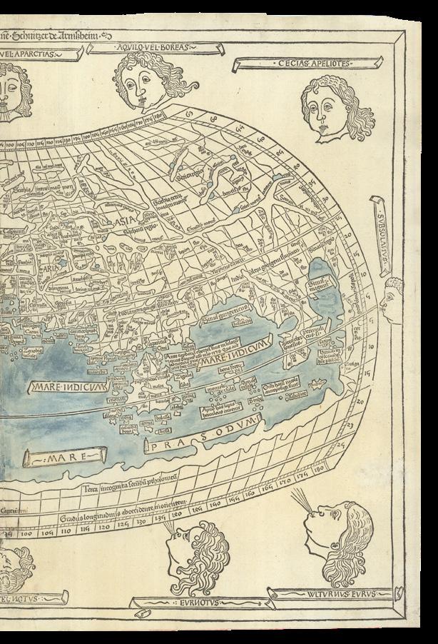
Cover: items 55, 56 and 77
Terms and conditions: The condition of all books has been described. Each item may be assumed to be in good condition, unless otherwise stated. Dimensions are given height by width. All prices are net and do not include postage and packing. Invoices will be rendered in £ sterling. The title of goods does not pass to the purchaser until the invoice is paid in full.
Daniel Crouch Rare Books New York LLC PO Box 329 Larchmont NY 10538-2945, USA
Printed by Park Communications on FSC® certified paper. Park is an EMAS certified company and its Environmental Management System is certified to ISO14001. 100% of the inks used are vegetable oil based, 95% of press chemicals are recycled for further use and, on average 99% of any waste associated with this production will be recycled. This document is printed on Galerie Matt made of material from wellmanaged, FSC®-certified forests and other controlled sources. The pulp used in this product is bleached without the use of chlorine (ECF).
Terra Australis Cognita
- The Robert Clancy Collection, part I
Terra Australis Cognita: maps recording the discovery of Australia from Ptolemy to Cook (1482-1792)
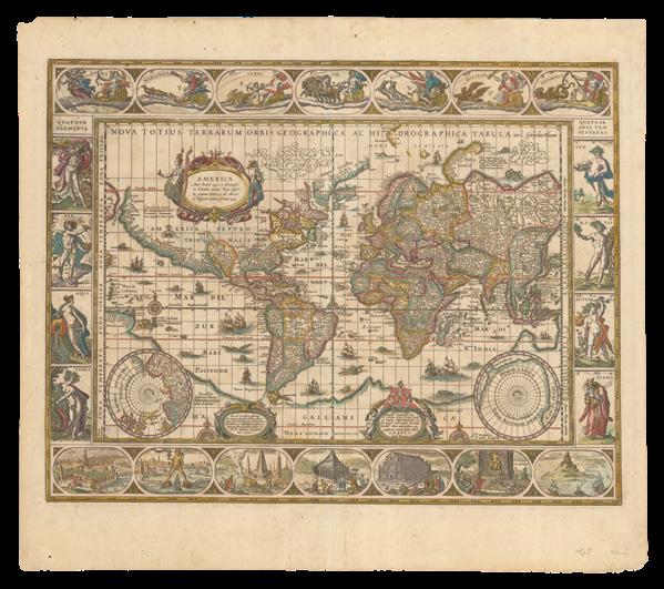
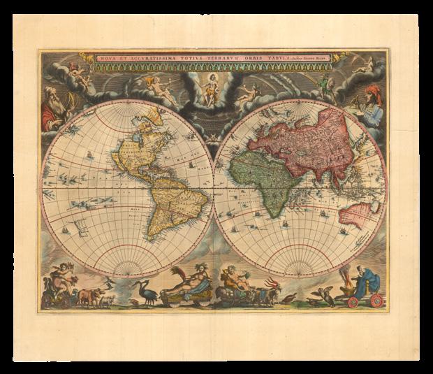
Maps are the textual record of discovery. Our collection reflects discovery and development of continental masses contained within the southern hemisphere over a period ranging from 1482 to 1960: from the time of the first printed map that showed a shift in Ptolemaic thinking about world order (Ulm Ptolemy, 1482), to the third edition of the map “Antarctica” 1:10 million (ANARE, 1960) recording completion of the Antarctic treaty (1959).
This year represents for us 50 years of map collecting, and the maps in this catalogue were acquired at the beginning of this period – a time when an itinerant immunologist on an academic salary could wander into any of several “map shops” no matter which city he was in and view a selection of pre-Cook maps relevant to Australian discovery. And even buy some. A luxury no longer possible.
When I worked at MacMaster University in Canada, I met Ken Kershaw – the prototype “unforgettable character” whose passion for antique maps became my contagion. Ken taught me about map auctions and introduced me to the dealers of the day in London and Amsterdam. The core maps of the collection came from Mr C. Broekema, a map dealer in Amsterdam (I never did know what the “C” stood for, but I became a regular visitor to 28 Titian Straat). The centre for antique maps shifted to London which became a spiritual home: Clive Burden, Doug Adams and Jonathon Potter became my early map mentors and of course sources of maps. I wrote “The Mapping of Terra Australis” to include the information I could not otherwise find as a neophyte searching for guidance in construction of an Australian collection (many of the maps in this catalogue are illustrated in that book).
Later IMCoS with its annual June Map Fair and International meetings, filled information voids while providing life-long friendships based on a mutual love of old maps.
Robert Clancy
COGNITA
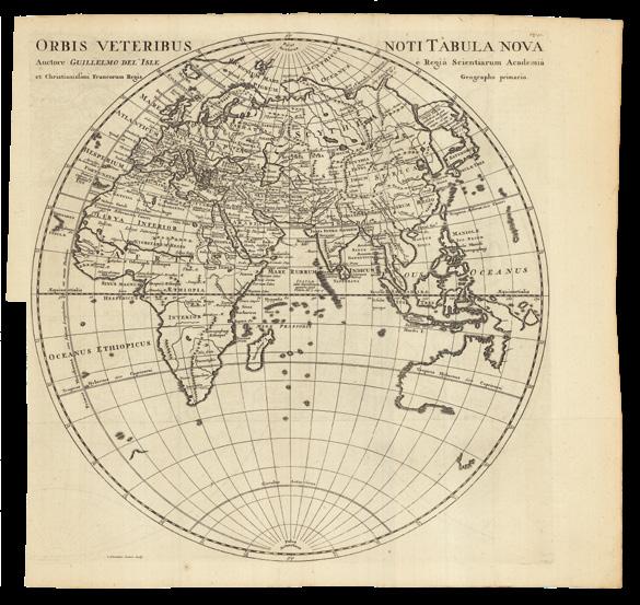
In antiquity, the earliest geographers and cartographers hypothesised a southern landmass to balance out the northern hemisphere, and when, in the second century, Ptolemy asserted that the Indian Ocean was bounded by land to the south, the legend of a terra australis incognita was born. This ‘unknown southern land’ appears on early maps in various imprecise forms, running along the complete lower border of Münster’s 1552 world map (item 2), the Ulm 1482 world map (item 3), and that in the Nuremberg Chronicles from 1493 (item 4).
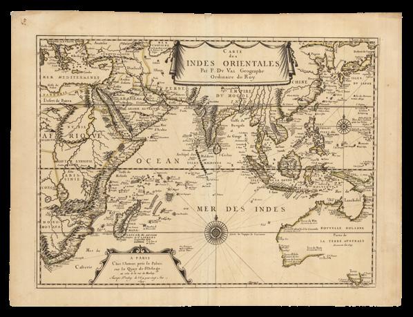
The great voyages of Columbus in 1492, de Gama in 1497, and Magellan in 1520 caused an important shift in the understanding of world geography, and thereby precipitated the modernisation of cartography, especially in the form of sea-charts. Münster’s ‘modern’ map of the world (item 6) is testament to the importance of these early exploration in updating and refining geographical knowledge. Such expeditions provided scant evidence about the fabled terra australis, however, and mapmakers were often forced to use toponyms sourced from the writings of travellers such as Marco Polo. Indeed, Mercator places his terms “Beach”, “Luchac” and “Maletur” on an improvised terra australis in his map of 1587 (item 22).
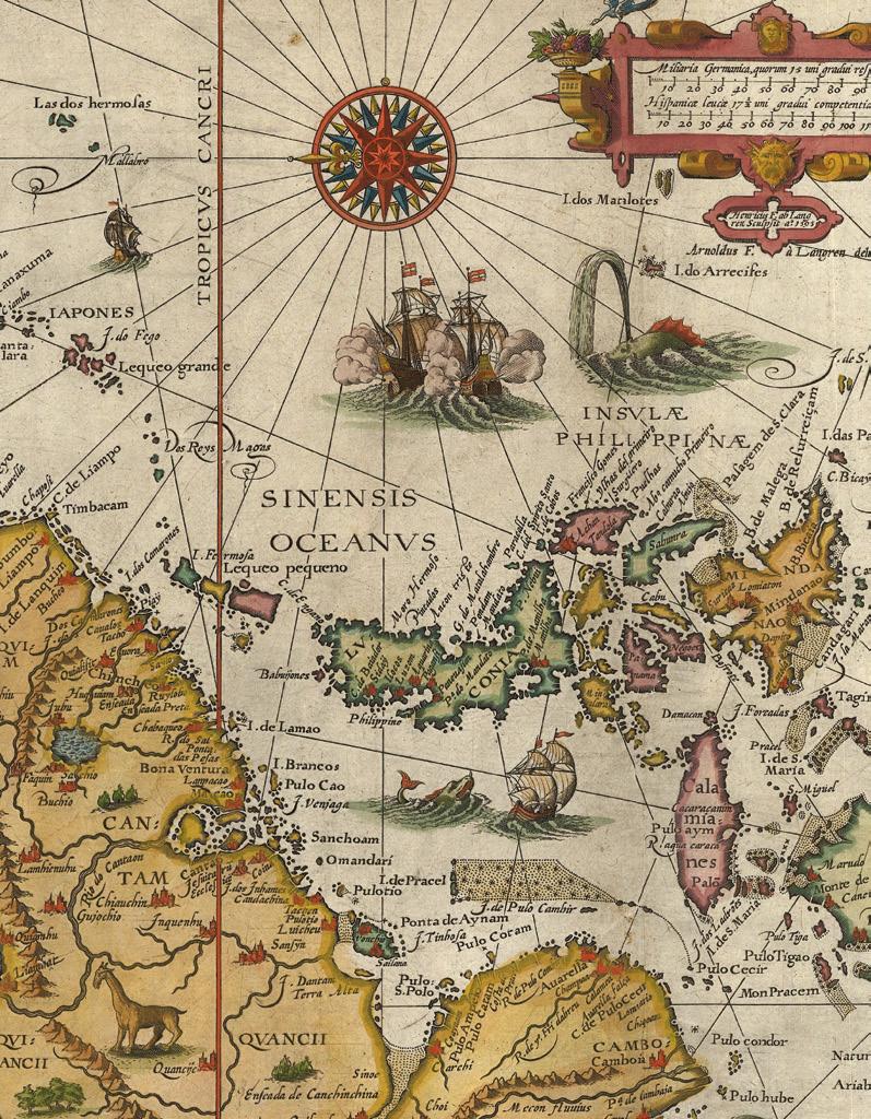
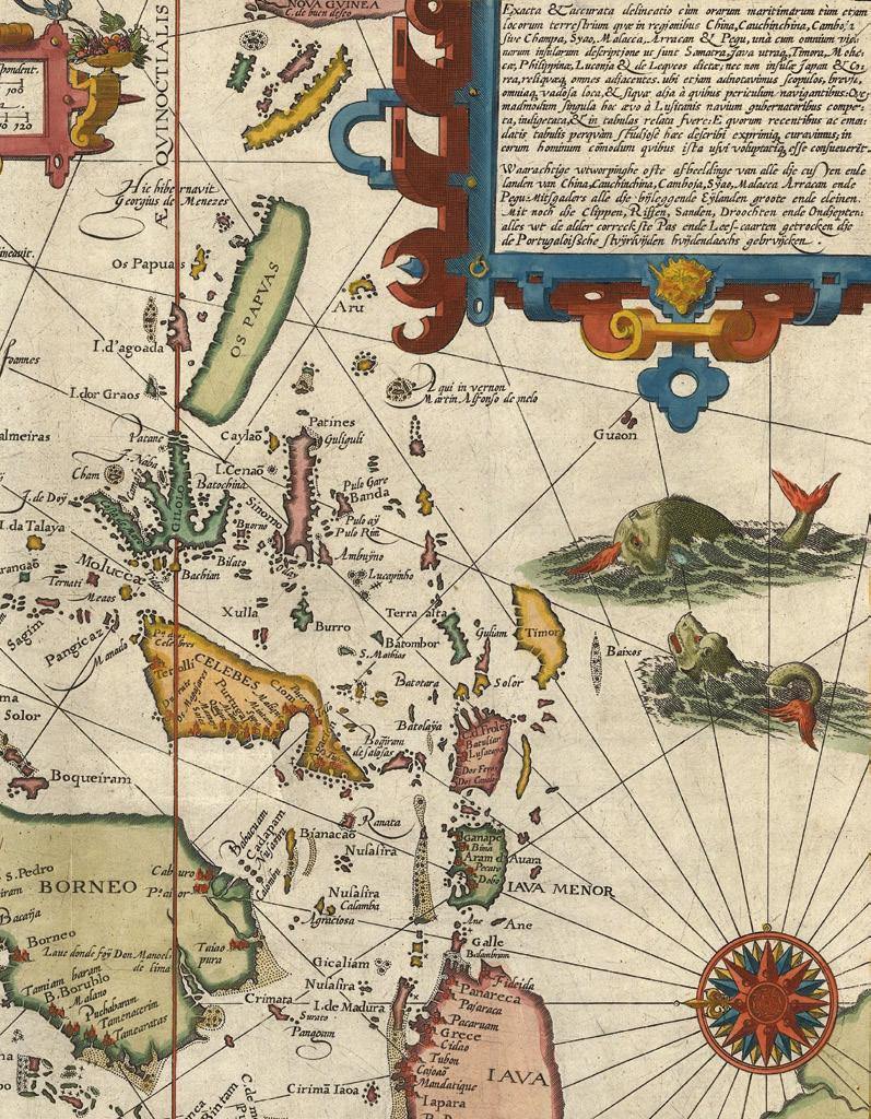
Around this time, there occurred three important Spanish voyages that helped begin to uncover the mystery of this unknown southern land. All three voyages left from Peru, the first two led by Alvaro Mendana in 1567 and 1595, and the third by Pedro de Queiros in 1605. During the first voyage, Mendana discovered the Solomon Islands (item 17), but during the second he lost his life along with two thirds of the would-be colonists he took with him. De Queiros, however, was more successful. Intent on discovering a vast continent for Spain, he left a major imprint on the Pacific region, where he discovered 13 coral islands, the Duff and Banks groups, the New Hebrides, and land at the eastern tip of New Guinea, and established a colony, Nova Jerusalem, on a large island that he mistook for the eastern edge of “Terra Australis”, or as he called it, “Australia del Esperito Santo”.
A storm then separated de Queiros from his second in command, Luis de Torres, who then sailed to the south of New Guinea, through a passage now known as Torres Strait, to Manilla. It remains unclear as to whether Torres saw the northern coast of Australia. The remarkable coincidence is that, in the very same year, while Torres passed through the Strait from the east, the Dutch Duyfken, sailing from the west, failed to find a way through, concluding that New Guinea was contiguous with Cape York, and that the Strait of Torres, was a large bay.
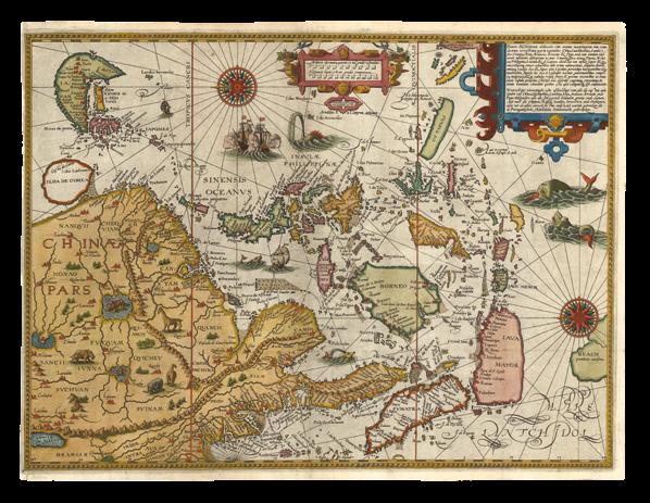
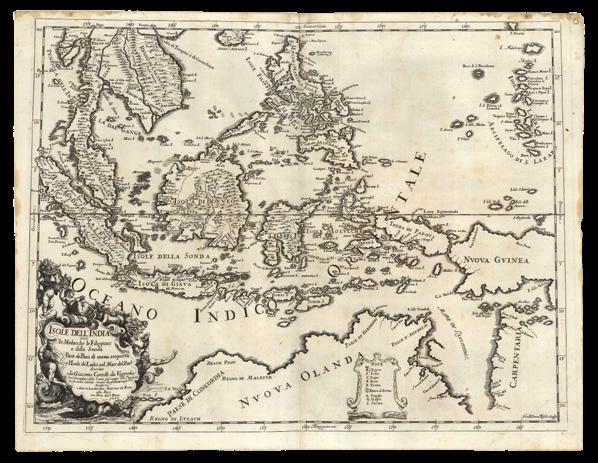
The Dutch, however, were by no means lagging behind when it came to exploration of the South East. Although preceded by the Portuguese and Spanish, whose presence in the region is captured by the 1622 ‘Descripcion’ of Antonio Herrera (items 62, 64, 65) and Claesz’s ‘Itinerario’ of 1596 (items 26-30), the VOC (Vereenigde Oostindische Compagnie, or Dutch East India Company) soon made its presence known in the East Indies, establishing many bases on the northern coast of Java during the early decades of the seventeenth century. They Dutch voyages that departed from
Java did much to develop the European understanding of the Pacific and Indian Oceans, as well as the western two thirds of continental Australia, which they named “New Holland”.
Among these expeditions was that of the Duyfken in 1606 which, despite its failure to find the desired route to Peru, made an arguably more important discovery: its captain, Willem Jansz, was the first recorded European to see and map the coastline of Australia. Such early Dutch discoveries were recorded in earnest by the mapmakers of Amsterdam, which was then the centre of cartography, including Janssonius, whose 1633 map of the East Indies (item 39) shows Cape York identified as “Duyfken’s Eylant”.
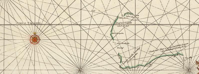
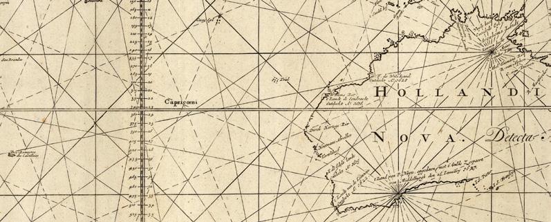
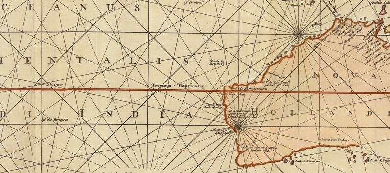
The western limits of Australia soon came to be defined by a series of navigational errors, including the accidental landing at Shark Bay, at what is now Dirk Hartog Island, by the Eendracht in 1616 after the ship was separated from the rest of the fleet heading from the Netherlands to the Dutch East Indies. The same mistake was repeated by a number of VOC Merchantmen; some were shipwrecked on the treacherous coast, but those who survived provided new and valuable information that allowed cartographers and navigators to join the dots to outline part of the western coastline.
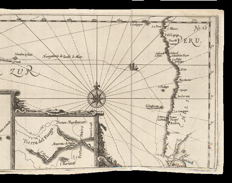
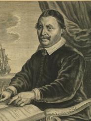
In 1622, an English ship, the Tryall, was wrecked on what came to be known as the Tryal Rocks, off the Montebellow Islands (item 80). This stimulated an immediate response from the Dutch - not out of any concern for the lives of the English sailors, but because of perceived threat to their monopoly on New Holland’s potential resources. Thus in 1623 Jan Carstensz (item 55) was commissioned to re-trace the route of the Duyfken in order to make an economic appraisal of the land. Carstensz achieved little in his ship, the Pera, other than extending the length of the known coastline, while his compatriot Willem Colster, sailing in the Arnhem, crossed the Gulf of Carpentaria, then sailed north along the east coast of Arnhem Land (item 40).
Perhaps best-known of the seventeenth century Dutch voyages were those of Abel Tasman in 1642 and 1644 (items 45-52). These foundational events in the histo-cartography of Australia provided a database of geographical and hydrographical knowledge utilised by around 20 Dutch mapmakers during the second half of the century. The first voyage sailed south of the southern coast, discovering Tasmania and New Zealand, before circumnavigating continental Australia. Tasman named the west coast of New Zealand “Staten Landt”, thinking it to be the western extension of the Great Southland described in the memorials of de Queiros (item 63), and Tasmania “Van Diemen’s Land” after the VOC Governor in Batavia who had commissioned his expedition. Along the way he also discovered the island groups of Samoa and Fiji. His second voyage across the north further joined the dots of earlier Dutch discoveries, completing a reasonable sketch of the western two thirds of the Australian continent.
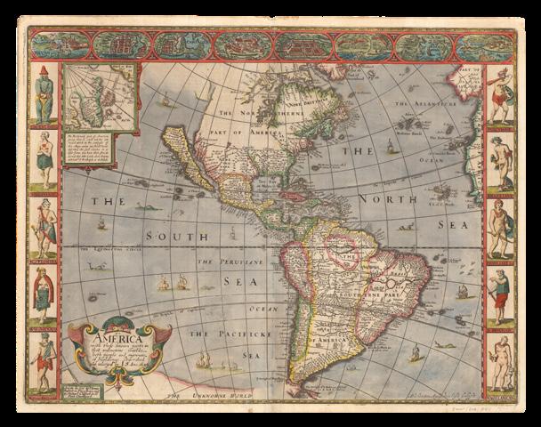
Around this time, Dutch dominance in cartography was complemented by the state’s independent and powerful emergence from both the Thirty Year War and the War of Dutch Independence, both of which concluded in 1648. The extent of the Dutch contribution to the discovery and mapping of terra australis is well represented by comparing the world maps of Willem Blaeu in 1606 and his son Joan in 1662. The early Blaeu map was initially sold as a separate sheet, but then included in his atlas “Nova Terrarum Orbis” between 1630 and 1658, while the latter was the signature map in the “Atlas Maior” between 1662 and 1672. In this later world map, gone was the hypothetical southern land mass of Mercator, replaced by continental Australia, lacking only an eastern coast, and empty seas.
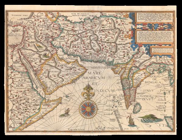
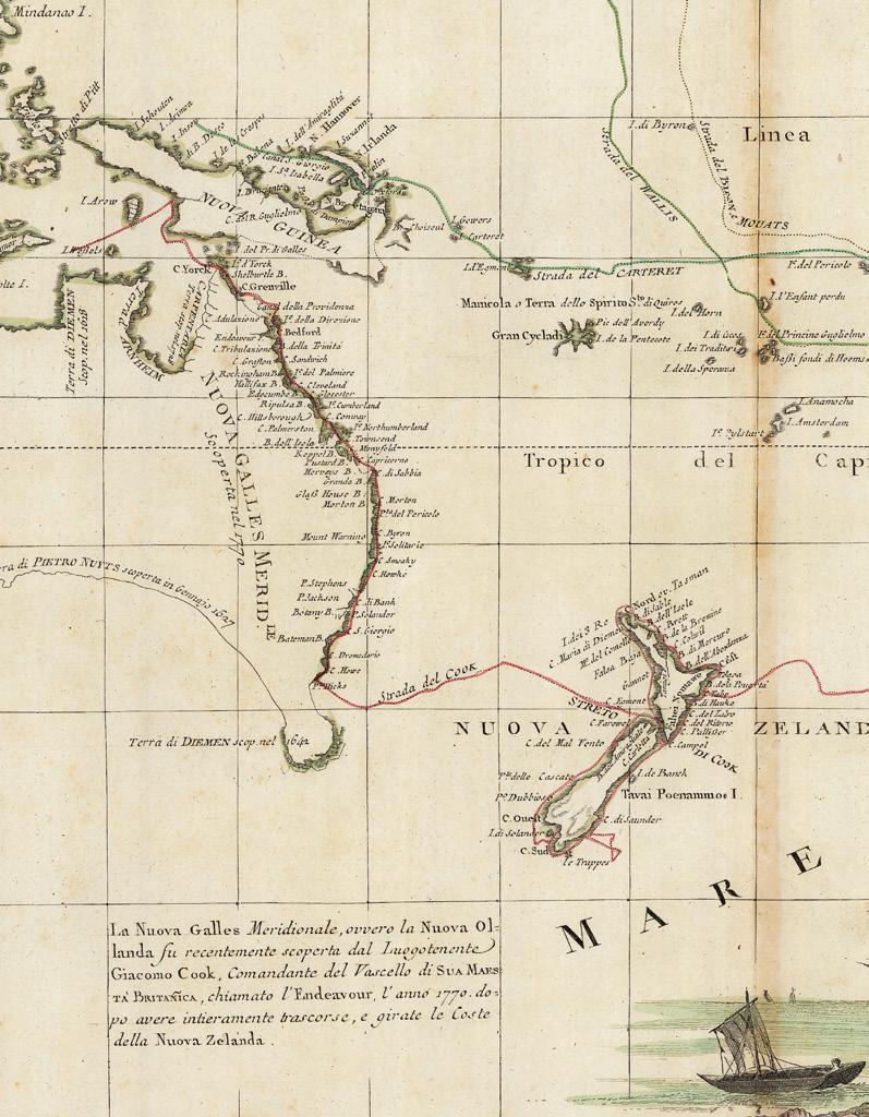
The Dutch hegemony over Southern Hemisphere discovery, which was motivated primarily by trade, was eventually unseated by a wave of scientific zeal during the Age of Enlightenment and the long eighteenth century (item 114). In 1768, the British Admiralty commissioned James Cook to command a scientific voyage to the Pacific, in order to record the transit of Venus across the Sun, with the ultimate purpose of determining the distance between the Earth and Sun. After mapping the complete coastline of New Zealand, with only minor errors, the HMS Endeavour sailed on to Australia, becoming the first recorded European expedition to encounter the continent’s eastern coastline in 1770. The voyage also included a week-long stay at Botany Bay, so named for the unique botanical specimens collected there by Joseph Banks and Daniel Solander.
Despite having charted almost the entire eastern coastline of Australia, and demonstrated its continental size, Cook’s contemporaries still insisted that there should exist another separate and massive southern continent, the true terra australis. Prominent among these was Alexander Dalrymple, who, as Examiner of Sea Journals for the English East India Company, had translated de Torres’s testimony concerning the northern coast of this unknown land. Dalrymple was thus inspired to publish the “Historical Collection of the Several Voyages and Discoveries in the South Pacific Ocean” in 1770–1771 (item 79), which prompted the British government to order Cook on a second expedition.
No landfall was achieved on Australia during this second expedition, which nonetheless contributed greatly to British knowledge of the southern hemisphere (item 113). During the expedition, Cook became the first recorded navigator to cross the Antarctic Circle, although he did not encounter the Antarctic mainland itself.
Decades later, discovery and exploration of the Antarctic would finally conclude the pursuit of the terra australis incognita that had spanned centuries. Nonetheless it was the great landmass uncovered gradually during the intrepid explorations of the sixteenth, seventeenth and eighteenth centuries that took its name from the cartographical legend, when in 1824 the Admiralty agreed that the land should be known officially as Australia.
Robert Clancy
AN IMPERIAL ROMAN WORLD VIEW
DANIEL CROUCH
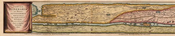
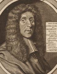
ORTELIUS, Abraham; Johannes JANSSONIUS; and Georgius HORNIUS
Tabula Itineraria ex illustri Peutingerorum Bibliotheca Que Augustae Vindelicorum Beneficio Marci Velseri Septem-viri Augustani in Lucem edita.
Publication Amsterdam, Prostant apud Joannem Janssonium, 1652.
Description
Eight engraved road maps on four mapsheets, with fine hand-colour in full
Dimensions each sheet: 470 by 585mm (18.5 by 23 inches).
References Koeman, ‘Atlantes Neerlandici’, 5 volumes, 1967-1971’, Ort 46; Shirley, ‘The mapping of the world: early printed world maps, 1472-1700’, 2001, 212 and 393; Suarez, for the Map & Atlas Museum of La Jolla.
Every journey begins with a single step…
The “’Terra Australis’ narrative of discovery begins with… the ‘Tabula Peutingeriana’, the earliest manuscript road map covering the extensive network of the Roman Empire” (Clancy), and extends from the British Isles to India and Sri Lanka.
The so-called “Peutinger Table”, is named for Konrad Peutinger (1465-1547) a German lawyer and antiquarian scholar, who owned the only surviving manuscript, now in the Osterreichische Nationalbibliotek, Vienna, believed to have been made at Colmar in 1265. The map, measuring more than twenty-two feet in length, came into Peutinger’s possession after the death of his friend Konrad Bickel, who was librarian to Maximilian of Austria. It was a medieval copy of a much older, and more extensive map, probably drawn in the fourth century, as it incorporates information regarding “the imperial roads and posts throughout the Roman Empire at about 250AD, with some later additions up to c500AD” (Shirley). That original, in turn, was probably an updated copy of one made in the first century AD, since it contains a few anachronisms, such as the inclusion of Pompeii, which was destroyed in 79 AD.
Roman settlements and their connecting roads are shown, with distances between them marked. “Most important of the cities are Rome, Constantinople (Istanbul), and Antioch (southern Turkey). A total of 70,000 miles of roads are recorded, with various features useful to the traveller marked. These include staging posts and the distances between them, forests, rivers, and spas. The long-distance traveller had to adjust to local units of measure. On most of the map, distances are recorded in Roman miles; but in Gaul they are in leagues, in Persia they are in parasangs, and in India they are in an Indian unit” (Suarez).
The map was first printed in 1591 by Johannes Moretus in Antwerp. It was then reduced and printed with two sections to a sheet in Balthasar Moretus’s 1624 edition of Abraham Ortelius’ ‘Parergon’; then again, as here, from 1652-1657, in Johannes Janssonius’ editions of Georgius Hornius’s ‘Accuratissima Orbis Antiqui Delineatio’, and again in 1677 and 1684 by Johannes Janssonius van Waesbergen. An edition was also published in England in 1641.
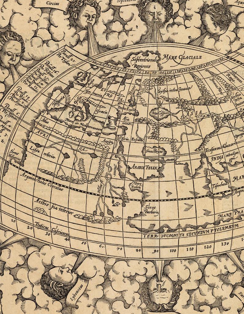
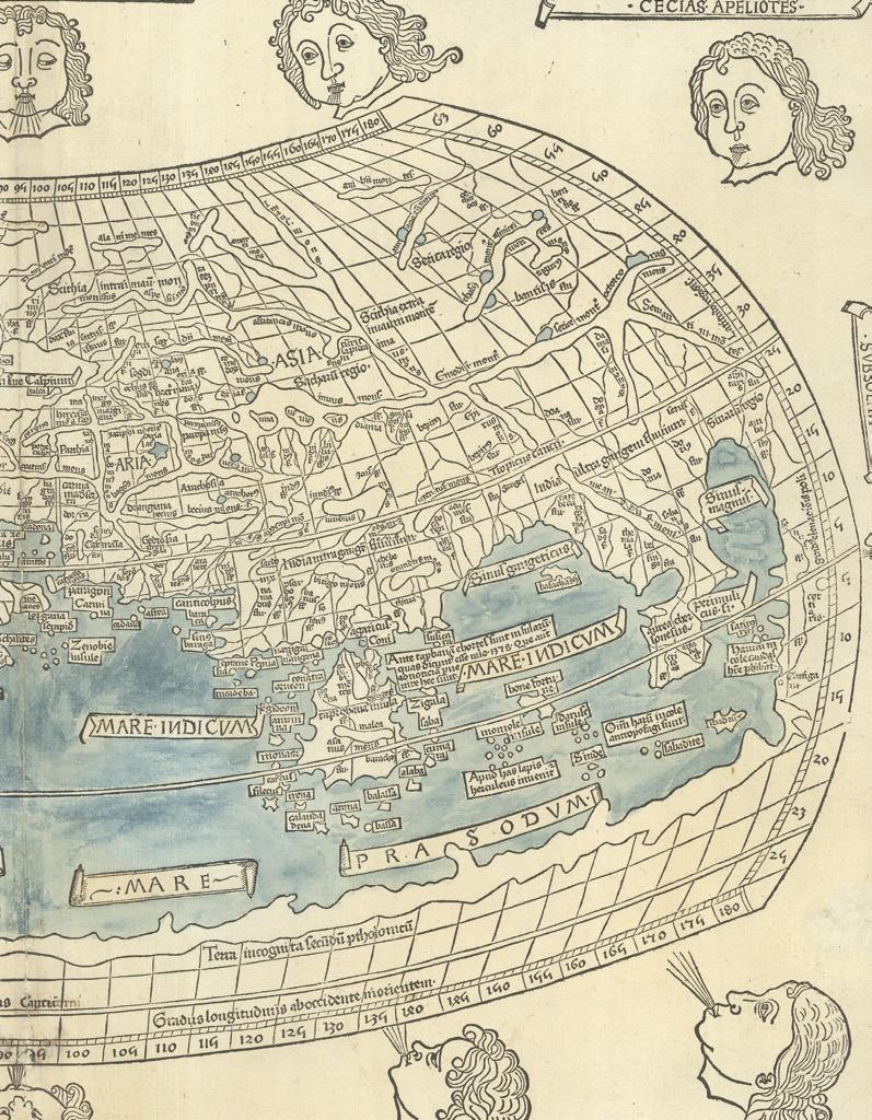
PTOLEMAEUS, Claudius; Johannes SCHNITZER OF ARMSZHEIM; and Nicolaus GERMANUS
[Untitled Map of the World].
Publication Ulm, Lienhart Holl, 1482.
Description
Double-page woodcut map, with fine hand-colour wash in full, small loss to lower margin renewed with manuscript facsimile to neatline and wind name, old central fold strengthened on verso.
Dimensions 415 by 575mm (16.25 by 22.75 inches).
References
Campbell, ‘The earliest printed maps, 179; Shirley, ‘Maps in the atlases of The British Library.
These “Lands were unknown to Ptolemy”
The first woodcut map of the world on a Ptolemaic projection, as it was understood by the Alexandrine ancients, showing what is in essence, the Roman Empire, but with a few “modern” departures. The mapmaker, Johannes Schnitzer (literally John the Woodcutter) of Armszheim, signed in the block by him along the top edge “Insculptum est per Johane Schnitzer de Armszheim”, has updated the Ptolemaic world picture by incorporating improvements that were probably based on a manuscript of the 1470s by Nicolaus Germanus (c1420-1490), a Benedictine monk of Reichenbach Abbey in Bavaria, who is depicted in the first illuminated letter of the complete atlas presenting his book to the dedicatee Pope Paul II.
While the map follows classical lines, this is the first printed world map to show land extending below the Tropic of Capricorn, and is also the earliest printed map to show the northernmost reaches of the Atlantic Ocean, inflaming the imaginations of travellers, and presaging the age of the grand voyages of discovery.
The map extends from Great Britain in the northwest, the Canary islands in the west, mid-China in the east, and northern Africa in the south; the Indian Ocean features a large island, Taprobana, now Sri Lanka; and a rudimentary Scandinavia within an extension of the map above the neatline. Although Africa is connected to Asia by a southern land-bridge, turning the Indian Ocean into a land-locked sea, there is a tantalising note, repeated on Africa, that these southern “Lands were unknown to Ptolemy”,… The whole surrounded by a broad decorative border including 12 windheads.
The text of Claudius Ptolemy’s ‘Cosmographia’ was translated into Latin from the original Greek by Jacobus Angelus and was first published, in Renaissance times, at Vicenza (1475, unillustrated), Bologna (1477) and Rome (1478). The sumptuous edition published at Ulm in 1482, however, far surpassed all earlier efforts and remains one of the most important publications in the history of cartography. This is the first redaction of the ‘Geography’ to be printed outside of Italy, the earliest atlas printed in Germany, the first to depart from the classical prototype to reflect post-antique discoveries, the first to be illustrated with woodcuts rather than engravings, and the first to contain hand-colored maps, the design and execution of which were ascribed to a named cartographer, Johannes Schnitzer of Armszheim, who, in trade-mark fashion has reversed every capital “N”, and inadvertently provided two Tropics of Cancer.
Though printed outside Italy, the paper this magnificent atlas was printed on was imported from Italy, and payment made in part by complete copies of the finished atlas.
Provenance
With the ink stamp on verso, of print dealer Leopold Langer.
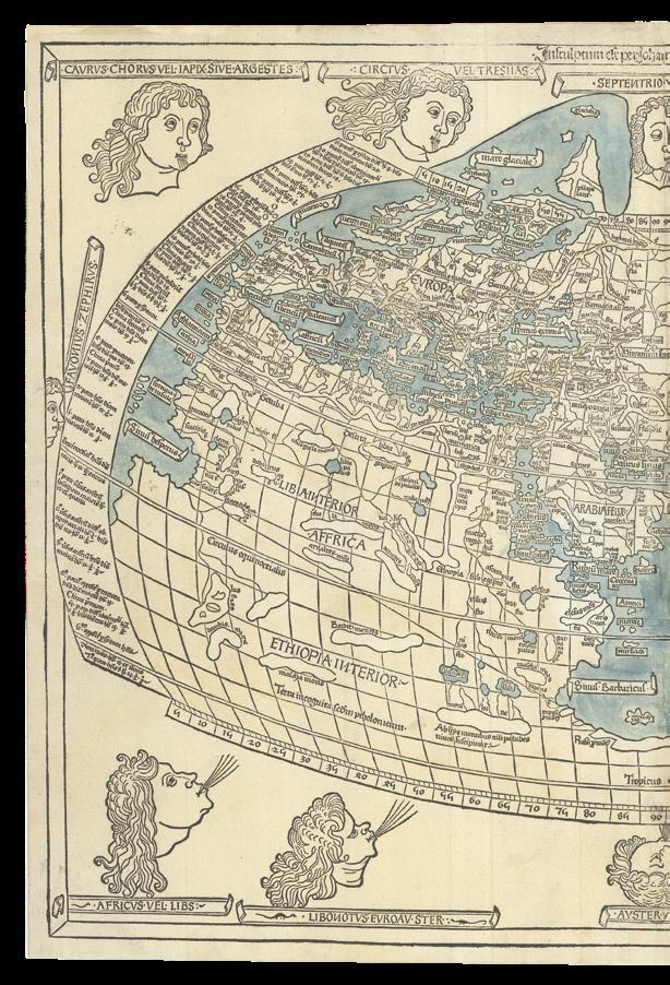
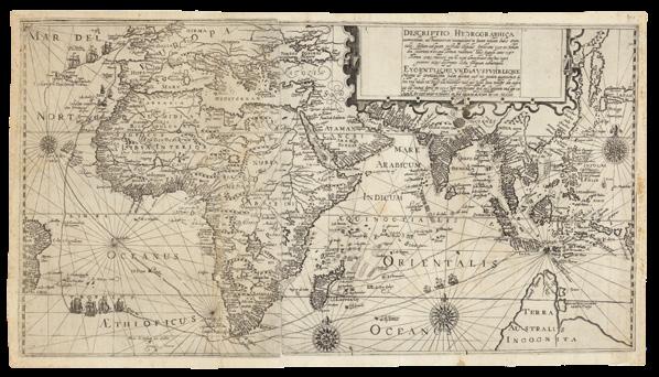
MÜNSTER, Sebastian
Ptolemaisch General Tafel begreifend die halbe Kugel der Welt.
Publication
Basel, Heinrich Petri, from 1588.
Description
Double-page woodcut map, diagram of winds and climate zones, and German text, on verso.
Dimensions 335 by 400mm (13.25 by 15.75 inches).
Munster’s, almost, strictly classical Ptolemaic map of the World
Like other world maps, based on a strictly classical Ptolemaic projection, Munster shows the world of the Roman Empire, and a belief that the Indian Ocean was landlocked, and could not, therefore, be traversed by sea from Europe. Asia, is divided, roughly along Ptolemaic principles, in which Southeast Asia appears as a peninsula, which could be construed to equate to Malaya and Indochina; and Sri Lanka appears as “Taprobana”. Also, following classical renderings, the cloak (or chlamys) shaped projection of the map, is surrounded by twelve classical windheads.
When Munster included this classical Ptolemaic map in his ‘Geographia’, as was traditional, it must have also been, at least in part, to make a point: illuminating the striking contrast of it to his maps of the “modern” world published as ‘Typus Cosmographicus Universalis’ (1532), and ‘Typus Orbis Universalis’ (1540). However, Munster could not help himself entirely, in the case of this ‘Ptolemaisch General…’ map of the world, and has adopted the “modern” view that the “Septentrional’ regions” of Scandinavia extend north of the Ptolemaic neatline.
Sebastian Munster issued his first world map on a classical Ptolemaic projection in his ‘Geographia’ (1540). Reprinted, from the same woodblock, for editions published in 1541, 1542, 1545, and 1552, a new one was cut, as here in 1588 for inclusion in Munster’s ‘Cosmographia’, appearing in subsequent editions to 1628.
DANIEL CROUCH RARE BOOKS
TERRA AUSTRALIS COGNITA
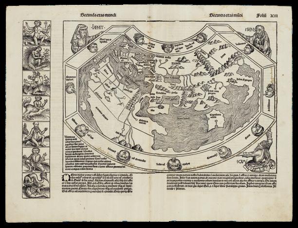
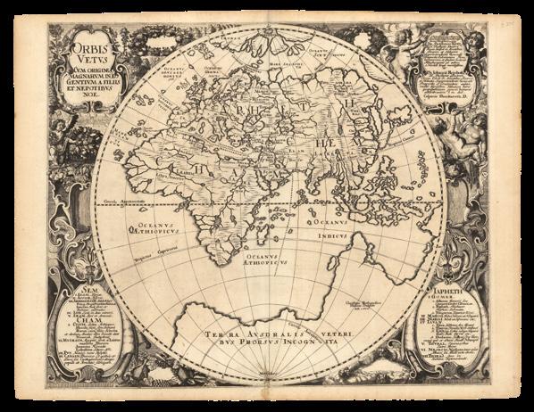
SCHEDEL, D. Hartman; and Hiernonymous MUNZER
Secunda Etas Mundi.
Publication Nuremberg, Anton Koberger, June, 1493.
Description Double-page woodcut map, Latin text on verso, pale waterstain along the top edge.
Dimensions 445 by 585mm (17.5 by 23 inches).
References Shirley World 19; Wilson, ‘The making of the Nuremberg Chronicle’ 1976, pages 98-122.
A distorted but clear depiction of the lands
of the Far East
The world map from the ‘Liber Chronicarum’, or the “Nuremberg Chronicle”, is a history of the world, published the year that Columbus returned to Europe after discovering America, while in search of Paradise, predicted by most medieval commentators to be in the farthest reaches of the earth, i.e. eastern Asia.
Geographically, the map is very similar to the small map added to a new edition of Pomponius Mela’s ‘Cosmographia’ (1482), published by Erhard Ratdolt. It “is a robust woodcut taken from Ptolemy… What gives the map its present-day interest and attraction are the panels representing the outlandish creatures and beings that were thought to inhabit the furthermost parts of the earth. There are seven such scenes to the left of the map and a further fourteen on its reverse… among the scenes are a six-armed man, possibly based on glimpses of a file of Hindu dancers so aligned that the front figure appears to have multiple arms” (Shirley). However, these images are balanced by more familiar and reassuring ones, as the map itself is dominated by the figures of Shem, Japhet and Ham, the sons of Noah whose descendants were believed to have re-populated the earth after the biblical Flood.
Generally, the map follows the classical belief of a landlocked Indian Ocean, with a distorted but clear depiction of the lands of the Far East, and the major innovation of the map is the inclusion of Portuguese discoveries on the west coast of Africa, accounting for the much longer coastline of the continent in comparison to previous Ptolemaic maps. In addition, this map also has a large unidentified island off the west of the continent, perhaps referencing Alvise Cadamosto’s discovery of the Cape Verde Islands in 1456.
DANIEL CROUCH RARE BOOKS
TERRA AUSTRALIS COGNITA
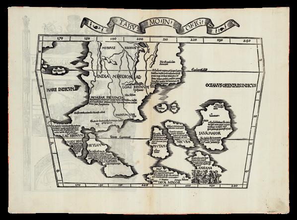
PTOLEMAEUS, Claudius; Laurent FRIES; and Johann GRÜNINGER
Tabula Moderna India Orientalis.
De Indorvm Moribvs & ritu in tabula decima & vndecima Asiae Ptholemaei abunde dictum est. tu igitur si placet vide.
Publication
Strassburg, Johannes Gruninger, 1522.
Description
Double-page woodcut map.
Dimensions
370 by 530mm (14.5 by 20.75 inches).
References Suarez, ‘Early Mapping of Southeast Asia’, 1999, pages 114-118.
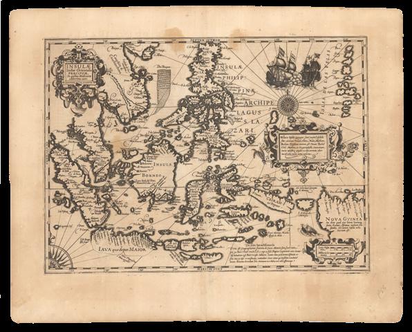
“The first printed map of European origin devoted to Southeast Asia and its islands” (Suarez)
First state of the map of Southeast Asia from Laurent Fries’s edition of Ptolemy’s ‘Geographia’. The woodblock was subsequently re-carved, removing the title and ribbon banner that appears along the upper edge. The map, which shows the Malay Peninsula, Indochina, and some of the islands of Indonesia, “is the first printed map of European origin devoted to Southeast Asia and its islands, and as such is a cartographical landmark, codifying the recognition of Southeast Asia as a distinct entity” (Suarez).
The map’s ancestor is Waldseemuller’s 1507 wall map of the world, in turn “descended from a common ancestor of the old Martellus model – the Southeast Asian subcontinent upon which Fries has mapped the various regions of Southeast Asia, and around which its various islands have been fitted, is simply the phantom vestige of the old Ptolemaic land bridge, the now-abandoned shores of Ptolemaic Malaya and Indochina are seen in the upper left corner” (Suarez).
However, the larger scale of Fries’s map, and his close reading of the accounts of the voyages of Marco Polo at the end of the thirteenth century, are not only reflected in the many placenames on the map, but also in the geography of several of the islands too: “Iava Maior” (i.e. Java), “Peutam” (i.e. Bantam), “Iava Minor” (i.e. Sumatra), are based on textual references rather than earlier maps. Unfortunately, Polo’s compass readings were occasionally lost in translation, so the location of Nicobar and the Andaman Islands, for example, is a bit off course.
DANIEL CROUCH RARE BOOKS
TERRA AUSTRALIS COGNITA
UN-LANDLOCKING THE INDIAN OCEAN
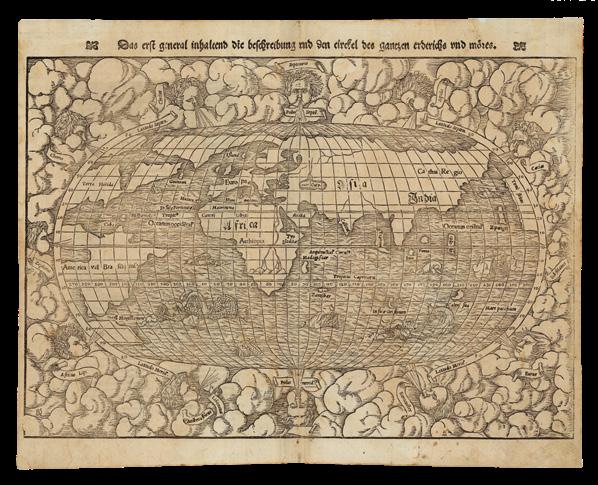
MUNSTER, Sebastian
Das erst general inhaltend die beschreibung und circtel des gantzen erdtreichs und mores.
Publication
Basel, Heinrich Petri, from 1550.
Description
Double-page woodcut map, with insets of metal type, German text and title within decorative woodcut border attributed to Hans Holbein.
Dimensions
310 by 390mm (12.25 by 15.25 inches).
References Shirley World 92.
The Pacific Ocean receives its name: “mare pacificum”
Sebastian Munster’s map of the “modern” world from his ‘Cosmographia’, here reprinting the second woodblock first used in 1550, with the initials of the woodcutter David Kandel appearing in the lower left-hand corner. The titles of the windheads are now in the banners and the east and west winds do not protrude inside the oval circumference. The continents are shown in rough outline only with the Americas taking on an unusual shape, ‘florida’ and ‘francisca’ are almost separated by a deep cleft of water and, further north, the ‘Terra nova sive de Bacalhos’ is part of a huge promontory extending as far as and joining onto Scandanavia. It would appear that Munster’s map is based on a combination of information derived from Verrazzano’s explorations of 1522-24, when the waters of the Chesapeake Bay were mistaken for the Indian Ocean, and reports of Cartier’s voyages of 1534-35 up the St. Lawrence seaway into the Great Lakes vainly searching for the north-west passage. The west coast of North America, hypothetically drawn, carries the name ‘Temistitan’, then generally used to denote Mexico. In Africa, the course of the Nile is prominent, with its twin sources teriminating in a range of mountains. Unidentified islands ‘Grisonum’ and ‘Calensuan’ are placed in the proximity of Australia, while for the first time on a printed map the Pacific Ocean (‘mare pacificum’) receives its name” (Shirley).
DANIEL CROUCH RARE BOOKS
TERRA AUSTRALIS COGNITA
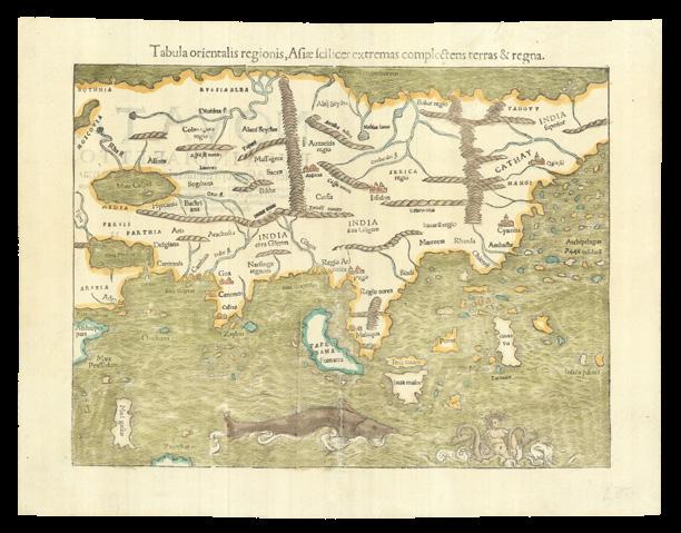
MÜNSTER, Sebastian
Tabula orientalis regionis, Asiae Scilicet extremas complectens terras & regna.
Publication Basel, Heinrich Petri, 1540.
Description
Double-page woodcut map, with insets of metal type, and fine hand-colour in full, Latin text on verso, small losses to old centrefold.
Dimensions 315 by 410mm (12.5 by 16.25 inches).
References Suarez, ‘Early Mapping of Southeast Asia’, 1999, pages 127-129.
“Asiae… extremas”: all of Asia beyond the Holy Land and the Middle-east
Sebastian Munster’s “rough but fearless” map of all of Asia, from his ‘Geographia universalis, vetus et nova complectens... Succedunt tabulae Ptolemaicae, opera Sebastiani Munsteri novo paratae modo’, the first Latin edition of Münster’s version of Ptolemy, which contained the first “set” of maps of the four continents. This is a Munster’s “modern” map of Asia, having previously provided a map for a 1538 edition of Solinus’s ‘Polyhistory’. It incorporates the latest Portuguese discoveries in the Indian Ocean, as well as Magellan’s crossing of the Pacific. When combined with Munster’s map of America for the same work, it creates one large map extending from the New World to the Far East.
The heading above the map: “Asiae... Extrema”, indicates that the map represents all of Asia beyond the Holy Land and the Middle-east, which here extends eastwards to halfway through the “archipelagous 7448”, or the more than seven thousand islands that Marco Polo thought constituted the Philippines, yet providing the first “cartographic glimpse of any member of the archipelago. “Puloan”, located due north of “Porne” (i.e. Borneo)” (Suarez). For the first time, Sumatra is correctly attributed, Borneo, as “Porne”, appears roughly in the right place and with the right shape, based on Munster’s reading of accounts of Magellan’s voyage. Munster depicts the Moluccas, Timor (“Timos”), Halmahera, and the Malay peninsula, far more clearly than had [Oronce] Fine in 1531, even though he is still hankering for the mythical lands of gold and silver, “Argyre” and “Chryse”. “Iava Minor” and “Iava maior” have been juggled, and there are other anomalies: the map includes a duplication, from its partner of America, of Guram and Rota, as “Insulae pdonu”, or Magellan’s “thieves islands”, and the nomenclature of India and Southeast Asia remains confused.
DANIEL CROUCH RARE BOOKS
TERRA AUSTRALIS COGNITA
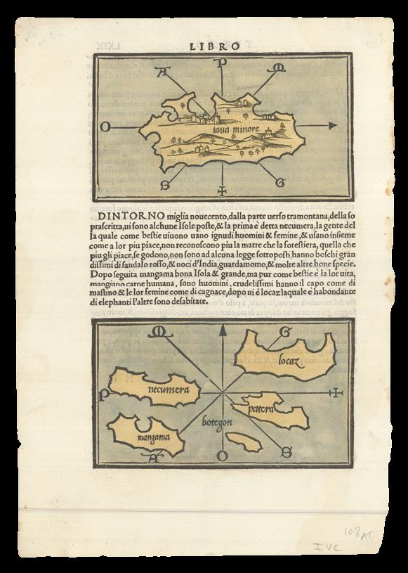
BORDONE, Benedetto di
Java minore [and] Locaz, Necumera, Patera, Botegon, and Mangama.
Publication
Venice, Nicol d’Aristotile detto Zoppino, 1528.
Description
Pair of vignette woodcut maps on a single page, with fine hand-colour in full, Italian text on verso.
Dimensions
Sheet size: 300 by 255mm (11.75 by 10 inches); each: 85 by 145mm.
The first separate European maps of Sumatra and Thailand: “a symbolic step in Southeast Asian cartography” (Suarez)
The uppermost woodcut depicts “Java minore” (i.e. Sumatra), oriented on a north-south axis, “probably following the Cantino model” (Suarez). The lower map depicts a group of named islands: Locaz (i.e. Thailand mistakenly as an island), Necumera, Patera, Botegon, and Mangama. The leaf is from the first Zoppino edition of Benedetto di Bordone’s ‘Isolario…’, the first book printed in Europe to illustrate individual maps of the Southeast Asian islands.
Although Bordone’s cartography of Southeast Asia is rooted in the Metellus framework, “the very fact that he devoted separate maps to the islands represents a symbolic step in Southeast Asian cartography” (Suarez).
Benedetto di Bordone’s ‘Isolario…’, or book of islands, was the first printed atlas of the whole world, combining conventional terrestrial and maritime cartography, the representation of settlements echo maps, and the coastlines are in the style of nautical charts. With a map of the world, it was also an illustrated guide to the islands and peninsulas of the western ocean, the African coastline and the New World, the Mediterranean and lands beyond, including the Aegean archipelago and the Levant, the Indian Ocean and the Far East, with five small maps of Southeast Asian islands. The only other printed isolario to precede it, was the little book of Bartolomeo dalli Sonetti (1485), which included only the Aegean islands.
The isolario, was a cartographic form introduced and developed in Italy during the fifteenth and sixteenth centuries. Like the portolano, or pilot-book, to which it was related, it had its origin in the Mediterranean as an illustrated guide for travellers in the Aegean archipelago and the Levant. Bordone’s ‘Isolario’ was the second isolario to be printed and the first to give prominence to the transatlantic discoveries.
DANIEL CROUCH
TERRA AUSTRALIS COGNITA
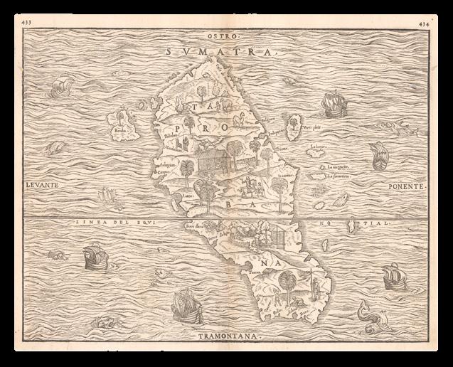
RAMUSIO, Giovanni Battista; and Giacomo GASTALDI
Sumatra.
Publication
Venice, Stamperia dei Giunta, from 1556.
Description
Double-page woodcut.
Dimensions
290 by 380mm (11.5 by 15 inches).
“The first separate map of any Southeast Asia island based on actual observation” (Suarez)
In an attempt to challenge the successes of Portuguese and Spanish voyages, the French sent several expeditions to the area. A successful expedition from Dieppe had reached the island of Diu in the northern Indian Ocean in 1527. In 1529, the Parmentier brothers Jean and Raoul, also out of Dieppe, ran the Portuguese blockade and reached the Maldive islands. They were able to continue east to the west Sumatran port of Ticon. However, both Parmentier brothers died of fever, and trade with Sumatra was difficult. Only one ship returned to Dieppe, “with far too little in bounty to encourage any further sacrifice of lives or resources” (Suarez) for the French to pursue their ambitions in the region further.
Giacomo Gastaldi’s map of Sumatra, also named Taprobana on the map, was published in the third volume of Giovanni Battista Ramusio’s compendium of voyages, ‘Delle Navigationi et Viaggi’, from 1556. Oriented with south at the top, the map illustrates Ramusio’s account of the Parmentier brothers’, expedition of 1529. Helen Wallis stated: this map as the key to linking transfer of Portuguese cartography school, based on similarity of iconography in their maps to that in this map of Sumatra (‘The Challenge that is an Australian Map’ in ‘The Globe’ 27, 1992, pages 4-9).
“The general contour of the island is remarkably good for its day, and the various islands lying off its western coast are shown in detail, as is Banca on the eastern coast. The port where the Parmentier brothers anchored, Ticon, is recorded, and the manner in which the island’s coast forms a promontory just to the northwest of Ticon is accurately mapped” (Suarez). This is a later issue of the map, with printed page numbers corrected to “433” and “434” (from “430” and “434”) appearing in the top left and top right-hand corners of the map, respectively.
DANIEL CROUCH RARE BOOKS
TERRA AUSTRALIS COGNITA
POTENTIALLY PORTUGUESE
DANIEL CROUCH
TERRA AUSTRALIS COGNITA
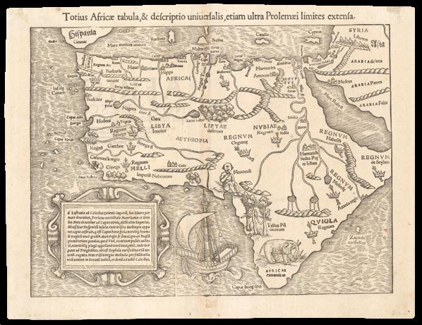
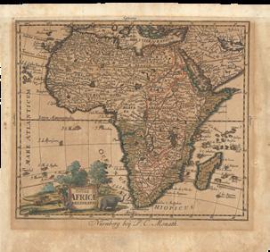
MÜNSTER, Sebastian
Totius Africae tabula, & descriptio universalis , etiam ultra Ptolemaei limites extensa.
Publication Basel, Heinrich Petri, 1540.
Description
Double-page woodcut map with insets of metal type, Latin text on verso.
Dimensions
300 by 95mm (11.75 by 3.75 inches).
References
Clancy and Richardson, ‘So they came South’, 1988, page 39; Delaney ‘To the Mountains of the Moon: Mapping African Exploration, 1541-1880’, 2007; Norwich, ‘Norwich’s maps of Africa: an illustrated and annotated carto-bibliography’, 1997, 2.
Describing a route from Portugal to India
Although Sebastian Münster’s map of the continent of Africa, is based on the Ptolemaic principles, it incorporates both Portuguese and Arabic sources, and parts of both countries appear at the extremities of the map.
Crucially, an informative caption appears lower left, “A’ Lisitania ad Calechut Orientis imperii, hoc itinere per mare devenitur…”, giving crucial instructions on how to sail from Lusitania, the Roman province approximating to much of modern Portugal and part of Spain, to Calechut (i.e. Calicut, India), mostly avoiding Africa. A large caravel, in which to make such a voyage, not unlike those sailed by the Portuguese, and Columbus, appears off the southwest coast. The Portuguese have named the Cape of Good Hope “Caput Bonespei”, and “Zaphala Aurifodina”, a group of islands associated with King Solomon’s mines. The Arabian kingdoms of “Quiola” and “Melinde” appear in eastern Africa, and “Hamarich”, the seat of Pester John, at the source of the Nile.
Other curious features of the map include: “a one-eyed giant seated over Nigeria and Cameroon, representing the mythical tribe of the “Monoculi”; a dense forest located in today’s Sahara Desert; and an elephant filling southern Africa. The Niger River begins and ends in lakes. The source of the Nile lies in two lakes fed by waters from the fabled Mountains of the Moon, graphically presented as small brown mounds. Several kingdoms are noted, including that of the legendary Prester John, as well as “Meroë,” the mythical tombs of the Nubian kings. Few coastal towns are noted, and there is no Madagascar yet… One of the intriguing aspects of this map is the loop of the Senegal River, which is shown entering the ocean in today’s Gulf of Guinea. Actually, this is the true route of the Niger River, but that fact will not be confirmed until the Lander brothers’ expedition in 1830. Strangely, this loop disappeared from subsequent maps of Africa for the next two hundred years[!!]” (Delaney).
Published in Munster’s ‘Geographia universalis, vetus et nova complectens... Succedunt tabulae Ptolemaicae, opera Sebastiani Munsteri novo paratae modo’, the first Latin edition of Münster’s version of Ptolemy, which contained the first “set” of maps of the four continents. For his map of Asia, see item 7.
DANIEL CROUCH
TERRA AUSTRALIS COGNITA
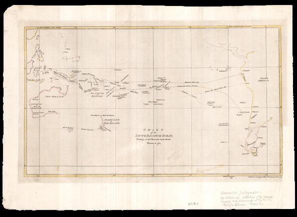
DALRYMPLE, Alexander
A Copy of Part of an Antient M.S. Map in the British Museum.
Publication London, London, Dalrymple, August 24th, 1787 [but 1790].
Description
Double-page engraved map, with fine handcolour in full, laid down.
Dimensions 530 by 630mm (20.75 by 24.75 inches).
References National Library of Australia, ‘Mapping our World: Terra Incognita to Australia’, 2014, page XX, 78-81.
The Harleian or Dauphin map
The original manuscript map, on which the current map is based, resides in the British Museum, formerly in the collections of the Harley family, Earls of Oxford, and of Joseph Banks. It was prepared during the reign of Francois I of France (1515-1547), possibly commissioned by, or for, his son, hence its appellation as “The Dauphin Map”. As Dalrymple’s note on the map states: “N.B. This Map has on It. The Arms of the Dauphin of France: and, although without date, appears to have been made early in the 16th Century; Because it has Japan, only vaguely expressed, at a remote distance from the Continent, under the name of Zipangri, from the report of Marco Polo: Whereas in the Map, published at Paris in 1575, in “la Cosmographie Universelle” by A. Thevet, Cosmographer to the King of France, the Japan Islands are represented as adjacent to the Continent, and circumstantially described, etc. 22nd February 1790”. The map “enticingly depicts a new world that awaited maritime enterprise at a moment when Normandy had become the centre of trade with Brazil and the East Indies. The Norman ports developed a flourishing trade in brazilwood to supply the cloth-dyers of Rouen, and Norman seafarers under Jean Parmentier had ventured as far as Sumatra, while in 1524 Italian navigator Giovanni da Verrazzano, leading a French expedition, thought he had found a northern sea passage from the Pacific to the Indies (shown on the map as “Gof anto Mer osto” – Gulf to the South Sea” (King).
Whether the map is indeed based on discovery or supposition remains a bone of contention. Dalrymple, long an ardent advocate for an English funded voyage to the Pacific to test his theories of the existence of a Great South Land, but whose place in history as the “discoverer” of Australia ultimately, and bitterly, fell to Captain James Cook, was certain that it does indeed present the findings of true venture,… not in the least because that would mean that his arch rival had not been the first European to “discover” Australia… In a memoir to this map, Dalrymple writes, with some schadenfreude: “The East Coast of New Holland as we name it, is expressed with some curious circumstances of correspondence to Captain Cook’s MS”.
Rare: no examples offered in available records; only two institutional example found, at the National Library of Australia, and at the State Library of New South Wales.
DANIEL CROUCH RARE BOOKS
TERRA AUSTRALIS COGNITA
Potential Portuguese discoveries along the northern coast of Australia
MONTANUS, Benedictus
Arias Pars Orbis… Benedict Arias Montanus Sacrae Geographiae
Tabulam ex antiquissimorum cultor familiis a Mose recensitis ... Aø. 1571.
Publication
Antwerp, Christopher Plantin, 1571.
Description
Double-page engraved map.
Dimensions
400 by 520mm (15.75 by 20.5 inches).
References
Clancy, ‘The Mapping of Terra Australis’, 1995, 5.7; Rudge, ‘The Catholic Encyclopedia’ online; Shirley World 125, plate 1.
This map holds a “special place in the early cartography of Australia” (Schilder). It was issued in the eighth volume of a polyglot Bible, which came to be known as the ‘Sacrae Regia’, printed by Christopher Plantin, and edited by Arias Benedictus Montanus between 1569 and 1572. The bible, with text in Hebrew, Greek, Latin, and Syriac, was dedicated to and largely paid for by King Philip II of Spain. Tragically, a large proportion of the entire printing of the final eighth volume was lost at sea on its way to Spain, so the first issue is very rare.
Based on the cartography of Giacomo Gastaldi, the map purports to show how Noah’s three sons repopulated the earth “apres le deluge”, but also includes a wonderful and mysterious anomaly: a landmass in the region and rough shape of northern Australia but not included in official Dutch records, until it was “sighted” during the voyage of the ‘Dufykin’ in 1606, therefore making a tantalizing claim for the “inclusion of Portuguese discoveries along the northern coastline, without any hypothetical southern land mass” (Clancy).
The current example is the second issue of this double-hemisphere map, with no text on the verso, and the word “Gentes” added to the panel of text lower left.
DANIEL CROUCH RARE BOOKS
TERRA AUSTRALIS COGNITA
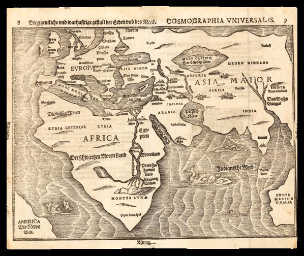
BUNTING, Heinrich
Die eigentliche und warhafftige gestalt der Erden und des MeersCosmographia Universalis.
Publication
Magdeburg, Heinrich Bunting, 1581.
Description
Double-page wood-engraved map.
Dimensions
310 by 375mm (12.25 by 14.75 inches).
References Clancy, ‘The Mapping of Terra Australis’, 1995, 5.8; National Library of Australia, Mawer for ‘Mapping our World: Terra Incognita to Australia’, page 87; Shirley, ‘The mapping of the world: early printed world maps, 1472-1700’, 2001, 143.
Pre-empting the discovery of Western Australia
Only the second published map to hint at early Portuguese discoveries of “Terra Australis”, the other being Benito Arias Montanus’s ‘Pars Orbis’ (1571) (see item 12).
Published in Heinrich Bunting’s ‘Itinerarium Sacrae Scriptura’, and when compared to Bunting’s world map on a clover-leaf projection from the same book, his ‘Die eigentliche…’, it seems far more realistic view of the world, even pre-empting the discovery of Australia. By incorporating a landmass lower right, that conforms to the coastline of Western Australia, as we now understand it, the map gives rise to “speculation that it reflects knowledge of an early discovery, perhaps by Portuguese navigators. The placement of Africa and India Meridionalis on the same parallel is remarkably accurate... [but] India Meridionalis is better explained as a survival from Ptolemy’s ‘Geography’” (Mawer).
DANIEL CROUCH RARE BOOKS
TERRA AUSTRALIS COGNITA
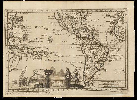
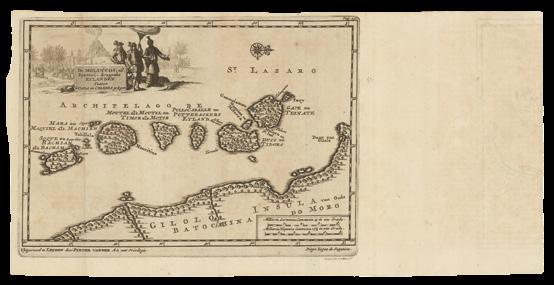
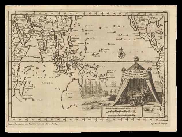
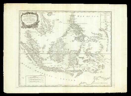
AA, Pieter van der
[Two maps that record the Portuguese contact in Southeast Asia]. Scheeps-Togt door Ferninand Magellaan [and] De Moluccos...
Publication
Uytgovoerd te Leyden, door Pieter Vander AA, met Privilegie, 1707.
Description
A pair of folding engraved maps.
Dimensions
175 by 245mm (7 by 9.75 inches) and 180 by 355mm (7.1 by 14 inches).
The arrival of the Portuguese in Southeast Asia
These two maps were published to illustrate Pieter van der Aa’s account of the voyage of Diogo Lopes de Sequeira to Malacca on the Malay peninsula in 1509. Malacca was to become the Portuguese stronghold in Southeast Asia from 1511 to 1641.
The first map, ‘Scheeps-Togt door Ferdinand Magellaan uit Kastilien gedaan na R. de la Plata en van daar door zyn Ontdekte Straat tot aan de Moluccas’, shows the route of Magellan, from San Lazar to Gilolo, with an updated geography that includes an anachronous outline of Australia and New Zealand, based on the discoveries of Abel Tasman.
The second, ‘De Moluccas, of Speceri-dragende Eilanden Tussen Gilolo en Celebes, gelengen’, of the Moluccas, based on the Jodocus Hondius / Willem Jansz. Blaeu chart (1633 onwards), includes a superb vignette of Lopes de Sequeira being shown around the lush nutmeg forest by Sultan Mahmud Shah, with the volcano of Gunung Api erupting ominously in the background presaging all the trouble, natural and manmade that was to come.
Both were printed with the ‘Ongemeene Scheeps-Togten en Manhafte Krygs-Bedryven te Water en Land, door Diego Lopez de Sequeira ... met IX Schepen derwaarts gedaan in’t Jaar 1518’, in his compendium of voyages, ‘Naaukeurige Versameling der Gedenk-Waardigste Zee en Land-Reysen’ (1707).
DANIEL CROUCH
TERRA AUSTRALIS COGNITA
AA, Pieter van der
Indien onder den Heer Lopo Vaz de Sampayo, als Gouverneur Generaal, tot aan Nieuw-Spanje in America en kusten van Peru en Chili bevaaren.
Publication
Uytgovoerd te Leyden, door Pieter Vander AA, met Privilegie, 1707.
Description
Folding engraved map.
Dimensions
180 by 245mm (7 by 9.75 inches).
Portuguese presence in Asia
In a magnificent vignette on this map, Lopo vaz de Sampaio, governor of Portuguese India from 1526-1529, appears to be shown en route to his new posting discussing plans for sharing the bounty of the Moluccas, with representatives of New Spain.
In 1526 tensions between Spain and Portugal were greatly reduced when Charles V of Spain married Isabella of Portugal, and signed a new treaty with Portugal, in Zaragoza in 1529. Its main outcome was the creation of an antimeridian line in the far east. Portugal “paid Spain 350,000 ducats for the Moluccas, and, to prevent further Spanish encroachment, the new line of demarcation was established almost three hundred leagues (or 17°) to the east of these islands. Portugal got control of all of the lands to the west of the line, including Asia, and Spain received most of the Pacific Ocean. Spain’s argument that the Treaty of Tordesillas divided the world into two equal hemispheres was not recognized in the Treaty of Saragossa: Portugal’s share was approximately 191°, whereas Spain’s was roughly 169°, with a variation of about ±4° owing to the uncertainty of the location of the Tordesillas line. Spanish interest in the Philippines, shown by the new treaty to be on the Portugal side of the line, would become an issue in the later decades of the sixteenth century” (Princeton University online).
The geography of the map is, however, based on Dutch discoveries in the seventeenth century, with Australia appearing as Abel Tasman cahrted it in 1644.
Pieter van der Aa’s map was first published to illustrate his ‘Staatsugtige Scheeps- Togten en Krygs- Bedryven Ter handhaving van der Portugysen Opper-Bestier in Oost- Indien Door Don Lopo vaz de Sampayo 1526’, from his compendium of voyages ‘Naaukeurige Versameling der GedenkWaardigste Zee en Land-Reysen’ (1707).
DANIEL CROUCH RARE
TERRA AUSTRALIS COGNITA
Publication
Description
Dimensions
References
“TERRA AUSTRALIS” AS VAST AND SEPARATE SOUTHERN LANDMASS
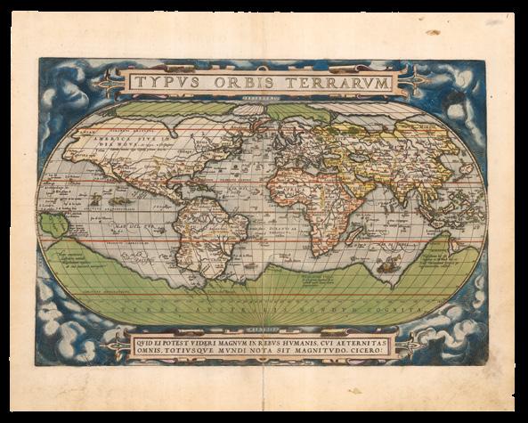
ORTELIUS, Abraham
Typus Orbis Terrarum.
Publication
Antwerp, Christopher Plantin, 1584.
Description
Double-page engraved map with contemporary hand-colour in full, Latin text on verso.
Dimensions
440 by 550mm (17.25 by 21.75 inches).
References
Clancy, ‘The Mapping of Terra Australis’, 1995, 5.9; Shirley World 158; Suarez, ‘Early Mapping of Southeast Asia’, 1999, page 160; Van den Broecke, ‘Ortelius Atlas Maps: An Illustrated Guide’, 2011, 1.1 1584L1.
“Who can consider human affairs to be great, when he comprehends the eternity and vastness of the entire world?” (Cicero, legend in the border)
One of many maps in Abraham Ortelius’s atlas that amalgamates the accumulating information about the nature of the lands of the East Indies, and shows a clear sea-passage from Europe to the region. A number of legends appear in the vast southern continent, “Terra Australis Nondum Cognita”, including: “Hanc continentem Australem, nonnulli Magellanicam regionem ab eius inuentore nuncupant”, which explains that this Southern continent is also known as Magellanica, after its discoverer; and “Noua Guinea nuper inuentaquæ an sit insulaan pars continentis Australis incertû est”, questions whether New Guinea is part of the Southern continent or an island. On this map, it appears as a promontory, but in later editions Ortelius corrects this, and shows it as an island.
“In the course of his ‘Theatrum’ he produced two different world and maps of America, those of 1570 and 1587, and in both cases was so undecided about the New Guinea question that he depicted it as an island on [his first] world map, and as part of Terra Australis on [his first map of] America. On all four maps he accompanied the region with a disclaimer stating that it was not known whether New Guinea was connected to Terra Australis or not. Yet only two years after the second set, he created a map which, despite focusing on the problem more than any map had, correctly shows it as an island, modified in shape, and with no legend qualifying his choice of insularity. Something had made him considerably more confident of its insularity in the two years that had elapsed since 1587” (Suarez).
Like Mercator before him, Ortelius includes the mythical coastal kingdom of “Beach” on a promontory, superficially similar to what would be known as Cape York on the northern coast of Australia, of the vast south land of “Terra Australis”. According to Suarez, the “error can be traced to the 1532 ‘Novus Orbis’ of Huttich, which was published in Paris with the map of Fine, and in Basle with the map of Münster/Holbein. This volume contained the text of Marco Polo’s journey, but it mistakenly corrupts Polo’s “LOchac” to “Boeach”, which in turn was shortened to “Beach””. An error Mercator duplicated on this on his large world map of 1569, and which persisted on maps well into the 1600s.
DANIEL CROUCH
TERRA AUSTRALIS COGNITA
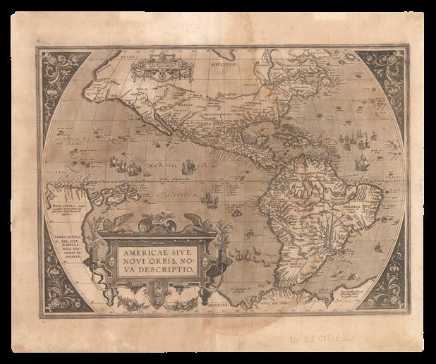
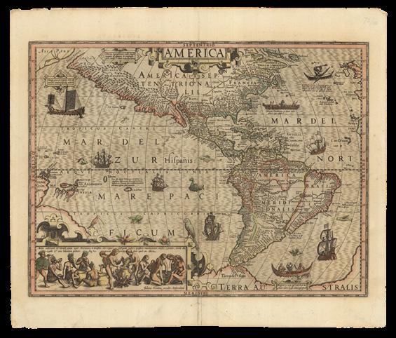
ORTELIUS, Abraham
Americae Sive Novi Orbis, Nova Descriptio.
Publication
Antwerp, Christopher Plantin, 1588.
Description
Double-page engraved map, Spanish text on verso, browned, waterstained.
Dimensions 440 by 435mm (17.25 by 17.25 inches).
References
Burden, ‘The Mapping of North America’, 1996, 64; Clancy, ‘The Mapping of Terra Australis’, 1995, 4.1; Imhof ‘The Production of Ortelius Atlases by Christopher Plantin’, in ‘Abraham Ortelius and the First Atlas: Essays Commemorating the Quadricentennial of his Death 1598-1998’, page 88; Van den Broecke, ‘Ortelius Atlas Maps: An Illustrated Guide’, 2011, 11.1, 1588S5.
Ortelius’s new map of New Worlds
Abraham Ortelius’s map of the Americas is based on Gerard Mercator’s revolutionary wall map of the world (1569) printed on 21 sheets. However, he has definitely asserted his own authorship for this masterly reduction by signing his name to it, as author, engraver and holder of the privilege for its publication for the next ten years, lower right: “Cum Privilegio decennali Ab. Ortelius delineab et excudeb. 1587”. This is only the third map that Ortelius would inscribe in such a way.
The map here is in its third and final state with the coastline of South America corrected. Of particular interest to us now is the addition of the Solomon Islands, discovered by Spanish navigator Álvaro de Mendaña y Neira (1542 – 1595) in February of 1568, for the first time on any published map; the appearance of “Terra Australis” as a vast and entirely separate southern landmass; proof of which has been provided by the discoveries of Magellan, which are recorded on the map, as “Fretum Magellanicum” – the Straits of Magellan – separating the tip of South America from “Terra Australis”. However, New Guinea is shown as a promontory, something which Ortelius would debate in his maps, and eventually correct, showing it as an island in subsequent issues.
DANIEL CROUCH RARE BOOKS
TERRA AUSTRALIS COGNITA
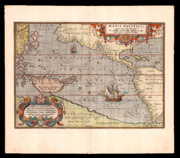
ORTELIUS, Abraham
Maris Pacifici, (quod vulgo Mar del Zur). Cum regionibus circumiacentibus, insulisque in eodem passim sparsis, novissima description.
Publication
Antwerp, Jan Baptist Vrients, 1609.
Description
Double-page engraved map, with contemporary hand-colour in full, Latin text on verso.
Dimensions
475 by 550mm (18.75 by 21.75 inches).
References
Burden, ‘The Mapping of North America’, 1996, 74; Van den Broecke, ‘Ortelius Atlas Maps: An Illustrated Guide’, 2011, 12.1 1609L6; Wagner, ‘Cartography of the northwest coast of America to the year 1800’, 1937.
“A very new description of the peaceful sea, commonly called South Sea with the regions lying around it, and its islands, scattered everywhere” (Ortelius)
This, the first printed map to focus on the Pacific Ocean, is the “most important sixteenth-century cartographic statement of the considerable Spanish contribution to exploration of the southern seas. Following the initial circumnavigation in 1519-22 by Magellan’s ship ‘Victoria’, Spaniards such as Mendana and Quiros sought the east coast of Terra Australis” (Clancy).
Indeed, the ‘Victoria’ features large in this beautiful map, and she has something to say, which appears in a caption beneath her portrait: “Prima ego velivovis ambivi cursibus Orbem, Magellane novo te duce ducta freto. Ambivi, meritoque vocor VICTORIA: sunt mî Vela, alæ; precium, gloria: pugna mare” - I was the first to sail around the world by means of sails, and carried you, Magellan, leader, first through the straits. I sailed around the world, therefore I am justly called Victoria (Victory), my sails were my wings, my prize was glory, my fight was with the sea.
As with his map of the Americas, Ortelius has ostentatiously signed his name to it, in a magnificent dedicatory cartouche to the honourable Lord Nicolaus Roccoxius, patrician of Antwerp, and senator of that city, lower left: “Abrahamus Ortelius Regiæ Mts. geographus sub. merito dedicabat. 1589” - Abraham Ortelius, geographer of his royal Majesty because of merit, has dedicated [this map] in 1589”. And proclaimed his privilege to publish it for ten years, lower right: “Cum privilegiis Imp. & Reg. Maiestatum, nec non Cancellariæ Brabantiæ, ad decennium” - with privileges of the imperial and royal Majesties, as well as of the Brabant council, for a period of ten years.
This is only the third map that Ortelius would inscribe in such a way. “Ortelius took pride in the practice of crediting his maps’ authors, whose names often appear in the dedicating cartouche. But here he credits only himself. The map is probably his own composite of data from various sources. Additional fuel to the mystery surrounding this map lies in its depiction of New Guinea. Although New Guinea had been discovered possibly as early as 1511, the question of whether it was an island or part of Terra Australis remained unanswered until Torres’s incredible voyage of 1605. As his discovery was concealed and officially forgotten, it remained an enigma until the first voyage of James Cook” (Suarez).
The present example is the first state of the map, first published by Christopher Plantin in 1589, in general, the map based upon Gerard Mercator’s world map of 1569, with details from 25 Portuguese manuscript maps of Bartolomeo de Lasso which Plancius obtained and later used for his own world map. Ortelius shows the Moluccas and the Philippines, already the site of considerable Dutch activity and a misshapen Japan. An odd ‘Isla de Plata’ appears above Japan, which appears in its ‘turtleshape’ configuration for the first time, derived from the 1568 manuscript of Vaz Dourado. Guam (’Isla de Ladrones’) is shown. The Solomons, or Melanesia, are located, as are some of the islands of Micronesia.
DANIEL CROUCH
TERRA AUSTRALIS COGNITA
“TERRA
AUSTRALIS” STANDARDISED
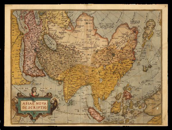
ORTELIUS, Abraham
Asiae Nova Descriptio.
Publication Antwerp, Christopher Plantin, 1580, or 1589.
Description
Double-page engraved map, with contemporary hand-colour in full, German text on verso, toned, small hole to “Nova Guinea”.
Dimensions
395 by 525mm (15.5 by 20.75 inches).
References
Clancy, ‘The Mapping of Terra Australis’, 1995, 1.2; Suarez, ‘Early Mapping of Southeast Asia’, 1999, pages 164 – 169; Van den Broecke, ‘Ortelius Atlas Maps: An Illustrated Guide’, 2011, Ort 7.1 1580/1589G3.
A map of Asia based on the ‘Taqwim Albudan’
Second state of Abraham Ortelius’s map of the whole of Asia, distinguished by the removal of “Cum priuilegio” in the lower left corner; “La farfana” replaces “La Farfana” in the upper right-hand corner in the sea near Japan; and the town “Ara” above “Aden” has vanished.
The map is a reduction of Ortelius’s own separately-published map of Asia (1567). In the 1567 map Ortelius explained that his map was based on the work of Giacomo Gastaldi, whose own work was in turn supposedly based on the Muslim scholar “Taqwim Albudan”, which was in reality the title of an archaic Arab geographic dictionary. He also benefited from information from the voyage of the Spanish explorer Miguel López de Legazpi, who reached the Philippines from Mexico in 1565. The island to the north of New Guinea, “La Barbuda”, was discovered by the expedition, who named the island in honour of the bearded men they found there. New Guinea in general has been improved, with a few islands off the coast called “Cainan”, which is West Papua.
This map and the map of southeast Asia in the ‘Theatrum’ were the first to definitely map Taiwan, labelled “I Fermosa”. Ortelius has improved upon the position of the Moluccas, possibly thanks to a letter he received on the subject from the French cartographer Guillaume Postel in 1567, who complained that Portuguese mapmakers had disseminated false coordinates for the islands. Japan, however, is drawn after Portuguese sources. Interestingly, what is shown of New Guinea appears as an island, quite distinct from the glimpse of “Terrae Australis” in the lower righthand corner.
DANIEL CROUCH RARE BOOKS
TERRA AUSTRALIS COGNITA
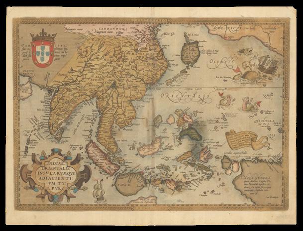
ORTELIUS, Abraham
Indiae Orientalis Insularumque
Adiacientium Typus.
Publication Antwerp, Christopher Plantin, 1587.
Description
Double-page engraved map, with contemporary hand-colour in full, German text on verso, browned, short tears with minor losses to oxidised patches.
Dimensions 397 by 535mm (15.75 by 21 inches).
References Clancy, ‘The Mapping of Terra Australis’, 1995; Suarez, ‘Early Mapping of Southeast Asia’, 1999, pages 164-167; Van den Broecke, ‘Ortelius Atlas Maps: An Illustrated Guide’, 2011, 166.1 1580/1589G84.
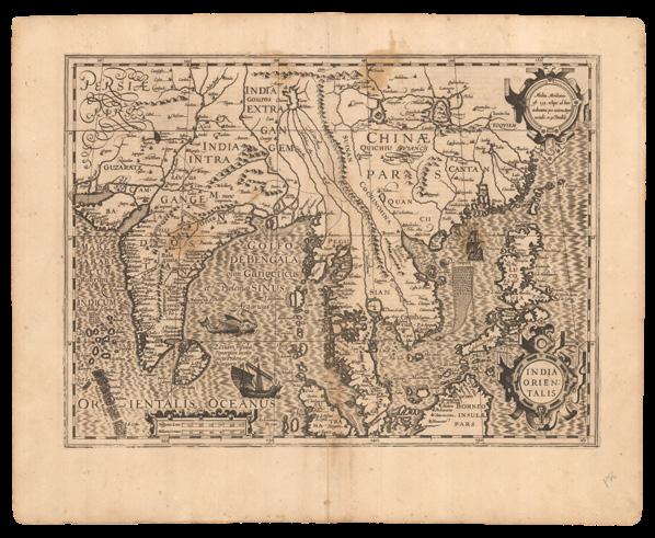
“… exporting all over the world a great abundance of fragrant spices” (caption)
Generally speaking, Abraham Ortelius’s map of Southeast Asia follows the geography of Gerard Mercator’s large wall-map of the world of 1569. Nevertheless, along with Ortelius’s companion map ‘Asiae Nova Descriptio’, it is the first published to definitely map Formosa, although as a group of islands, rather than one; and they both improve enormously on preceding Italian maps in regards to the highly sought after, and fiercely contested, Moluccas, or “Spice Islands”.
There are hundreds of islands in the group, but Ortelius depicts only a very select group, which feature in the more than two-hundred years of colonial strife that was the European spice trade, and even adds fuel to fire by literally waving a banner over them in his map: “Insulæ Moluccæ celbres ob maxima aromatum copiam, quam per totum terrarû orbem transferunt, 5.sunt, iuxta Gilolo nempe, Tarenate, Tidore, Motir, Machia et Bachia”
- Of the famous Moluccas islands there are next to Gilolo five, exporting all over the world a great abundance of fragrant spices, namely Tarenate, Tidore, Motir, Machia and Bachia”. Until the eighteenth century, these rain-forested islands were the only obtainable source of cloves, nutmeg, and mace.
Perhaps to counterbalance this open invitation, Ortelius has added a few visual caveats: to the east a galleon is under attack from two ferocious sea-monsters, in imminent danger of foundering; and, beneath them, two mermaids are preparing to lure any unwary survivors to a an uncertain fate.
In the bottom right-hand corner “Nova Guinea” makes an appearance, and since the inference is that it continues beyond the neatline, Ortelius nicely sidesteps the question of whether it is part of “Terra Australis”, or an island, and confuses things further, by adding a caption: “NOVA GVINEA quam Andreas Corsalis Ter:ram Piccinaculi appellare vi:detur. An insula sit, an pars continentis Australis incer:tum est” - New Guinea, which seems to be called Piccinaculusland by Andreas Corsalis. Whether this is an island or part of the South Land is uncertain.
Like Mercator before him, Ortelius includes a tantalizing glimpse of the mythical coastal kingdom of “Beach” on a promontory, superficially similar to what would be known as Cape York on the northern coast of Australia, of the vast south land of “Terra Australis”. According to Suarez, the “error can be traced to the 1532 ‘Novus Orbis’ of Huttich, which was published in Paris with the map of Fine, and in Basle with the map of Munster/Holbein. This volume contained the text of Marco Polo’s journey, but it mistakenly corrupts Polo’s “Lochac” to “Boeach”, which in turn was shortened to “Beach””. An error Mercator duplicated on this on his large world map of 1569, and which persisted on maps, well into the 1600s.
DANIEL CROUCH RARE BOOKS
TERRA AUSTRALIS COGNITA
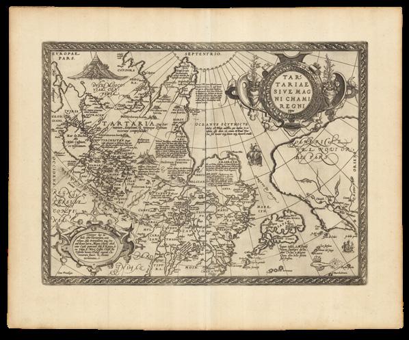
ORTELIUS, Abraham
Tartariae Sive Magni Chami Regni typus.
Publication Antwerp, Christopher Plantin, 1595.
Description
Double-page engraved map, Latin text to verso.
References
Literature: Van den Broecke, ‘Ortelius Atlas Maps: An Illustrated Guide’, 2011; Vn der Krogt: 8050:31.
“Oceanus Scythicus, dulcis est Plinio auctore, qui multas in eo insulas esse dicit, ut etiam M: Paul: Vene:tus : sed neuter neg’z situm neg’z numero tradit” (Ortelius)
Ostensibly, a map of Tartary, or the Realms of the Great Khan, from the 1570 Latin edition of Abraham Ortelius’s ‘Theatrum Orbis Terrarum’. The map is as resplendent as the Great Khan, “Magnus Cham… maximus Asie princeps”, himself, who appears crowned and enthroned before his tent. His territory borders Russia in the northwest, whose emperor is twice as large, and appears battle ready before his own even more splendid tent, daring the Khan to invade; and the lands of north of the Himalayas, encompassing the route of Marco Polo from Kashgar to Beijing, via Xanadu, the summer residence of Kublai Khan.
Incidentally, when first printed, this map was also the earliest obtainable to name California. The mythical Strait of Anian is shown between Asia and America, which contains a caption: “Oceanus Scythicus, dulcis est Plinio auctore, qui multas in eo insulas esse dicit, ut etiam M: Paul: Vene:tus : sed neuter neg’z situm neg’z numero tradit” – “The Scythian Ocean, is sweet, as Pliny wrote, with a multitude of islands, as he said, and as Marco Polo also says, but neither of them says where, or how many.
DANIEL CROUCH RARE BOOKS
TERRA AUSTRALIS COGNITA
A separately-published world map, issued prior to its inclusion in the first “atlas” to be so called
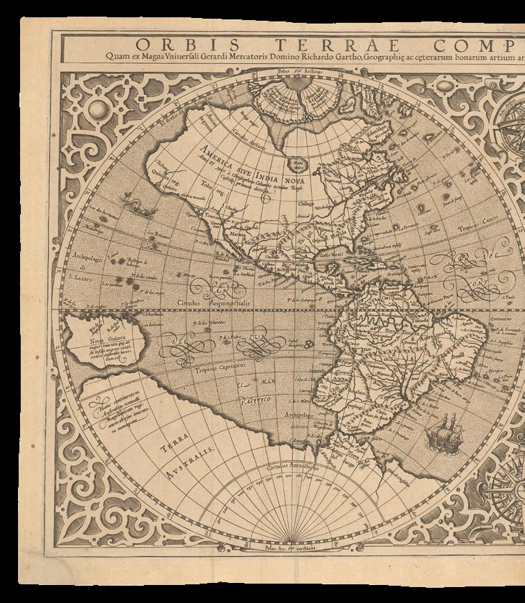
MERCATOR, Rumold
Orbis Terrae Compendiosa
Descriptio Quam ex Magna Universali Gerardi Mercatoris. Domino Richardo Gartho, Geographic ac ceterarum bonarum artium amatori ac fautori summo, in veteris amicitie ac familiaritatis memoria Rumoldus Mercator fieri curabat A.o M.D. Lxxxvii.
Publication Geneva, Eustathius Vignon, 1587.
Description
Double-page engraved map, lower left corner renewed with some manuscript facsimile to the neatline.
Dimensions
305 by 545mm (12 by 21.5 inches).
References
Clancy, ‘The Mapping of Terra Australis’, 1995, 5.11, and page 70; Shirley, ‘The mapping of the world: early printed world maps, 1472-1700’, 2001, 157.
This double-hemisphere map of the world is a reduced version of Gerard Mercator’s revolutionary wall map of the world (1569), and was first published in Strabo’s ‘…Geographicarum libr XVII’, with text beneath the map headed “Lectori S.P.”, and without text on the verso. It may have also been published separately, and in the final part of Mercator’s atlas, before being included in Rumold Mercator’s complete five part edition of the atlas from 1595. However, the Mercator family were beaten to the post, in popularizing (and capitalizing on) this modern world view, by Abraham Ortelius, who included it as a simplified single sheet map in his atlas of the world, ‘Theatrum Orbis Terrarum’ (1570).
California shown as part of the mainland, there is the distinctive bulge in South America, and the kingdoms of Beach, Lucach and Maletur are shown as part of the mythical southern continent “Terra Australis”, which is shown as an entirely separate landmass.
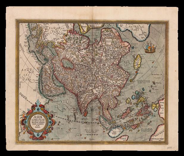
MERCATOR, Gerard; and Henricus HONDIUS
Asia ex magna orbis terre descriptione Gerardi Mercatoris desumpta studio et industria G.M. Iunioris.
Publication
Amsterdam, Henricus Hondius, [1609-1619].
Description
Double-page engraved map, with fine handcolour in full, French text on verso.
Dimensions 430 by 530mm (17 by 20.75 inches).
References Clancy, ‘The Mapping of Terra Australis’, 1995, 5.11, and page 70; Shirley, ‘The mapping of the world: early printed world maps, 1472-1700’, 2001, 157.
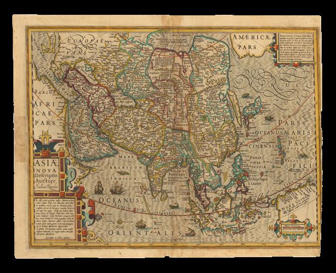
Mercator’s vision of Asia
The Mercator – Hondius map of all of Asia, first published in Gerard Mercator’s ‘Atlas’ of 1595, is derived from the northeastern sheets of Gerard Mercator’s large wall-map of the world, ‘Nova et Aucta Orbis Terrae Descriptio…’ (1569). It was included for the first time in the Mercator atlas of 1595, and the plate altered, when Jodocus Hondius acquired Mercator’s plates, and issued the atlas in 1606.
In the north, a Strait of Anian – “El streto de Anian” separates Asia and America, with the galleon at the mouth of the strait referring to the possibility of a trade route through the, as yet, still mythical northwest passage; to the left, there is a large and rather featureless Africa. Japan is shown as a kite-shaped archipelago, with a trailing string of small islands. To the south, there are two visible promontories of “Terra Australis Pars”, with no indication as to whether they are joined, and a speculative New Guinea.
The islands of Southeast Asia are all well delineated, and filled with toponyms. The all-important Spice Islands are highlighted in a caption: “Molucce vocantur 5 insule ordine posite iuxta Gilolo, quarum suprema, Tarenate, Sequentes deinceps Tidore Motir Machiam et insima Bachian” - The so-called Moluccas are 5 islands placed in order next to Gilolo, the most important of which is Tarenate, followed by Tidore, Motir, Machiam, and the least, Bachian. As are islands further north: “Barusse insule precipue sunt 5 iste Min.danao Calon Subut cum reliquis duabus Circium versus. Sinde autem 3 precipue Celebes Gilolo et Ambon”.
DANIEL CROUCH RARE BOOKS
TERRA AUSTRALIS COGNITA
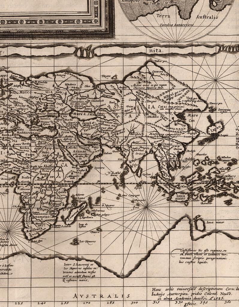
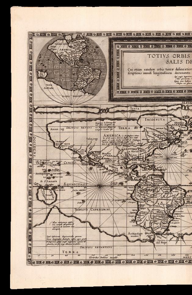
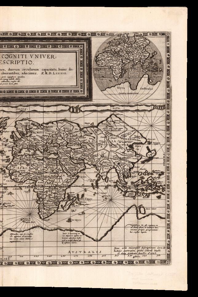
DE JODE, Gerard; and Cornelis DE JODE Totius Orbis
Cogniti Universalis Descriptio
Cui etiam eandem orbis terrae delineationem, duorum circulorum capacitate huius descriptionis mundi longitudinem documento admirantibus adiecimus anno MDLXXXIX.
Publication
Antwerp, Gerardus Iudeous exeudet,... Hanc orbis universal descriptioneni Corn: de Iudoejs Antwerpen pridie calend. noveb in alma Academia Duacesi Ao. 1589 pfecit [but 1593].
Description
Double-page engraved map on a rectangular projection, Latin text on verso.
Dimensions
420 by 555mm (16.5 by 21.75 inches).
References
Clancy, ‘The Mapping of Terra Australis’, 1995, 5.10; Shirley, ‘The mapping of the world: early printed world maps, 14721700’, 2001, 165.
The world on Mercator-like projection
This deceptively simple map shows two views of the world. The main chart is a world map on a rectangular projection, similar to Mercator’s projection (1569), but closer to that of Marinus of Tyre (c70-130), with two small hemispheric maps to either side of the title, which show the western and eastern hemispheres on Roger Bacon’s circular projection. In all three projections, “Terra Australis” appears as a single gigantic southern continent. New Guinea is an island, and the islands of Southeast Asia largely follow the configuration found in Ortelius’s first single sheet map of the world, published in his ‘Theatrum’ (1570). The South American continent is disproportionately wide. The Strait of Anian separates America and Asia.
The imprint at the lower edge states that the map was created by Cornelis de Jode in November 1589 at the Academy of Douai, and published or printed by his father Gerard de Jode, indicating that the map was ready before the completion and publication of the second edition of the de Jodes’s atlas ‘Speculum orbis terrae’ in 1593. Another theory suggests that the map was initially prepared by Gerard much earlier, hence some of the antiquated cartography, and completed by Cornelis, once Gerard was beyond the fine work needed to engrave a map like this.
The location of the principal parts of the world
TORNIELLO, Agostino
Situs Partium Praecipuarum Totius Orbis Terrarum.
Publication Milan, Agostino Torniello, 1609.
Description Double-page etched map, browned.
Dimensions 370 by 460mm (14.5 by 18 inches).
References Shirley World 267.
First issue of Agostino Torniello’s map of the world, based on that of Abraham Ortelius, published in his ‘Annales Sacri et Profani’, a history of the world from the Creation to the time of Christ, which first appeared in 1609 and was reissued the next year with additional engraved plates. Subsequent issues of the map include further toponyms.
DANIEL CROUCH RARE BOOKS
TERRA AUSTRALIS COGNITA
DUTCH INVASION
DANIEL CROUCH
TERRA AUSTRALIS COGNITA
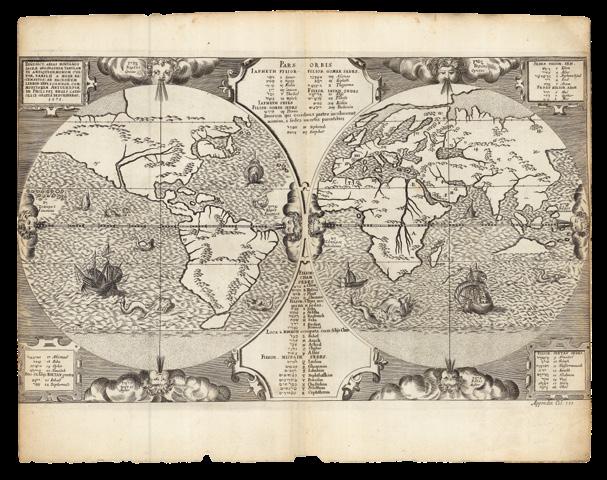
Plancius personifies “Terra Australis”
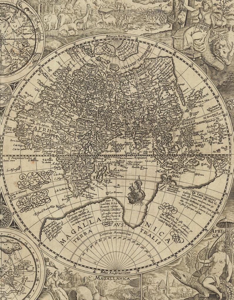
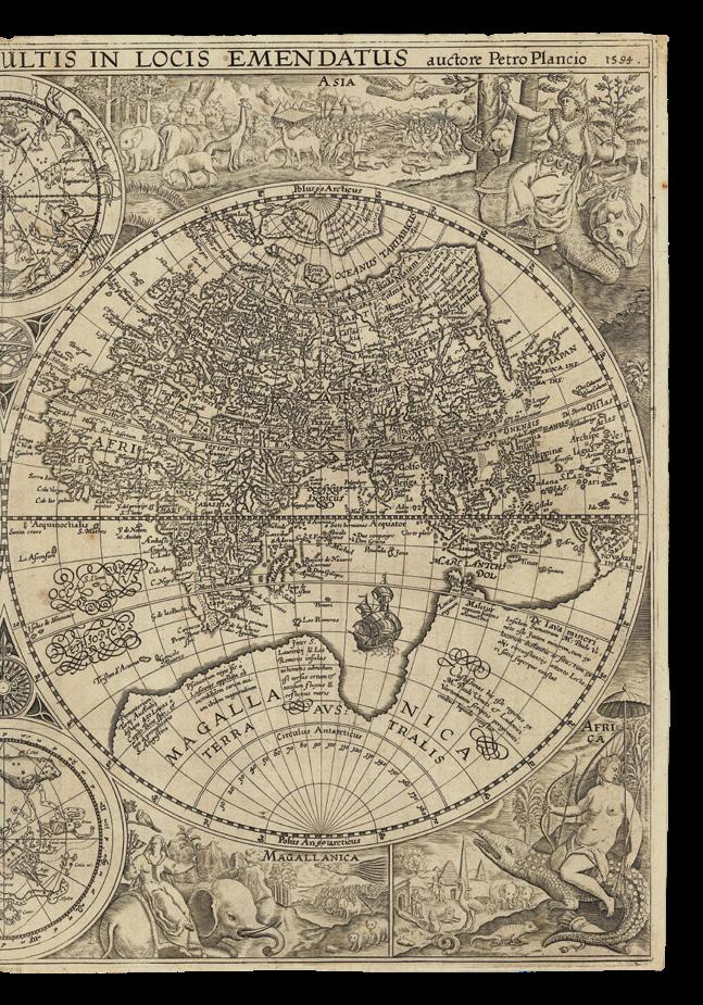
PLANCIUS, Petrus
Orbis Terrarum Typus de Integro Multis in Locis Emendatus. Auctore Petro Placio 1594.
Publication
Amsterdam, Petrus Plancius, 1594 [but 1599].
Description
Double-page and folding engraved map, on two joined sheets, old folds.
Dimensions
410 by 590mm (16.25 by 23.25 inches).
References
Clancy, ‘The Mapping of Terra Australis’, 1995, 5.12; Shirley, ‘Maps in the atlases of The British Library: a descriptive catalogue c.AD 850-1800’, 2004, 187; Suarez, ‘Early Mapping of Southeast Asia’, 1999, pages 177.
This magnificent double hemispheric map of the world, engraved by Jan van Doetecum (1551-1605), “Ioannes a à Duetecum iunior fecit”, was originally intended for Petrus Plancius’s first work, five maps for the Dutch Bible of 1590. Mysteriously, in the end, it was not included, but instead issued separately, before being included in Jan Huyghen van Linschoten’s (1563–1611) ‘Navigatio ac itinerarium Johannis Hugonis Linscotani in orientalem sive lusitanorum Indiam’ (1599), the Latin edition of the first printed work to include precise sailing instructions for the East Indies. The map shows the four possible sailing routes to the lucrative markets in Southeast Asia.
In the meantime, in 1592, Cornelis Claesz., had published a monumental version of Plancius’s map, engraved on twelve sheets, ‘Nova et exacta terrarum orbis tabula geograpbica ac hydro-graphica’, known only in two examples, one dated 1594 with a few corrections. Claesz was granted a privilege to publish the map for twenty years, and petitioned for a similar privilege to publish twenty-five additional maps which Plancius had obtained from Bartolomeo de Lasso, cosmographer to the King of Spain.
This windfall of previously secret information about sailing routes to the East and West Indies was augmented by a significant cache of Portuguese information and maps obtained, with Plancius’s encouragement, by the De Houtman brothers, Cornelius and Frederick, on a secret mission to Lisbon; and from accounts provided by Jan Huygen van Linschoten, who returned from Goa in September of 1592.
A Dutch venture to the East Indies was now possible, and this map, and Linschoten’s book, allowed Dutch merchants to circumvent the Portuguese stranglehold on trade to the East. It was of such economic utility that “it was given to each ship sailing from Holland to India” and soon became “the navigator’s vade mecum for the Eastern seas” (Penrose).
The spandrels in each corner of the map are filled with four female personifications of the four known continents: Europe, America, Asia, Africa, and a fifth - the woman to the lower left riding an elephant, Magallanica, represents the mythical southern continent “Terra Australis”, also called “Magallanica”. Magallanica was thought to be a tropical continent, hence the elephant and bird of paradise accompanying the woman; the map illustrates the contemporary belief that it joined with the archipelago “Tierra del Fuego” at the bottom of South America and spread over the southern pole. Although the Strait of Magellan, the passage between the Atlantic and Pacific Oceans, had been discovered in 1520, it was not until much later that navigators knew that the islands in Tierra del Fuego were not part of Terra Australis.
America is represented by two separate figures: Mexicana (North America), and Peruana (South America). Both are accompanied by the recently discovered animals of the New World: an armadillo, toucan,
monkey and parrot. Asia is represented upper right, and in this case the woman is seated upon a rhinoceros holding aloft the spices that are so abundant there.
In the cusps between the twin terrestrial hemispheres appear two celestial hemispheres: showing the night skies of the northern and southern hemispheres. It was not just navigational charts of the sea routes that voyages to the East Indies required, but also comprehensive, or reliable, charts of the southern stars to guide the sailors. Plancius had already produced a celestial globe in 1589, which had included a depiction of the Southern Cross, also shown here, but subsequent to the publication of this world map, Plancius was responsible for commissioning a pilot, Pieter Dirkz Keyser, to record the position of as many stars as he could on the first Dutch venture to the East Indies, the so-called “Eerste Schipvaart” — First Voyage. Although Keyser died at sea in 1596 before his return, he was able to record about one hundred and thirty stars alongside his colleague Frederick de Houtman, and the records reached Plancius when the surviving voyagers returned. Plancius took these new discoveries and divided the stars into twelve new southern constellations, which mostly referred to animals and subjects described in natural history books and travellers’ journals of his day. Nine years later, Plancius introduced eight more constellations on another celestial globe of 1612. Most of these constellations were not adopted by other cartographers or astronomers, but two of them survive in modern skies: Monoceros (the Unicorn), and Camelopardalis (Giraffe). Plancius can be attributed with the authorship of fifteen constellations, out of the eighty-eight that are now accepted by astronomers.
The exceptionally rare world map for the first edition of Linschoten’s ‘Itinerario,…’
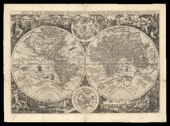
VRIENTS, Joannes Baptista
Orbis Terrae Compendiosa
Descriptio Ex peristissimorum totius orbis Gaegraphorum operibus desumta.
Publication
Antverpie, apud Joanem Baptistam Vrient, 1596.
Description
Double-page engraved map, no text on verso, laid down on archival paper, minor losses, old folds.
Dimensions
465 by 640mm (18.25 by 25.25 inches).
References Clancy, ‘The Mapping of Terra Australis’, 1995, pages 62 and 70; Shirley World 192; Zandvliet, ‘Mapping for Money: Maps, Plans and Topographic Paintings and Their role in Dutch Overseas Expansion During the 16th and 17th Centuries’, 1998, pages 42-47.
A close, but more elegant, copy of Petrus Plancius’s (1552-1622) ‘Orbis Terrarum Typus de Integro Multis in Locis Emendatus. Auctore Petro Placio 1594’ (see item 26), Joannes Baptista Vrients’s double-hemisphere map of the world, was engraved by Arnold and Henrik Floris van Langren, “Arnoldus, & Henricus Florentii a Langren fratres sculpserunt”. It “is even finer than that of the earlier map by their fellow-craftsman Jan van Doetecum” (Shirley). Prepared for the first, Dutch, edition of Jan Huyghen van Linschoten’s (1563–1611) ‘Itinerario, Voyage ofte Schipvaert van J.H. van Linschoten’, published by Cornelis Claesz., in 1596, it appeared three years before Plancius’s map was published in the Latin edition of 1599.
In 1592, Cornelis Claesz., had published a monumental version of Plancius’s map, engraved on twelve sheets, ‘Nova et exacta terrarum orbis tabula geograpbica ac hydro-graphica’, known only in two examples, one dated 1594 with a few corrections. Claesz., was granted a privilege to publish the map for twenty years, and petitioned for a similar privilege to publish twenty-five additional maps which Plancius had obtained from Bartolomeo de Lasso, cosmographer to the King of Spain.
This windfall of previously secret information about sailing routes to the East and West Indies was augmented by a significant cache of Portuguese information and maps obtained, with Plancius’s encouragement, by the De Houtman brothers, Cornelius and Frederick, on a secret mission to Lisbon; and from accounts provided by Jan Huygen van Linschoten, who returned from Goa in September of 1592. A Dutch venture to the East Indies was now possible, and this map, and Linschoten’s book, allowed Dutch merchants to circumvent the Portuguese stranglehold on trade to the East. It was of such economic utility that “it was given to each ship sailing from Holland to India” and soon became “the navigator’s vade mecum for the Eastern seas” (Penrose).
As Shirley reports: “Apart from the longer title, the 1596 map appears superficially the same as the earlier one of 1594. However, there are differences affecting the northern seas, and the pictorial scenes forming the outer border have been regrouped with even greater stylistic effect. Below the double hemispheres “Mexicana” and “Peruvana” have been combined to form a single America, and the fictional “Magellanica omitted in favour of a full-panel Africa”.
DANIEL CROUCH RARE BOOKS
TERRA AUSTRALIS COGNITA
LINSCHOTEN, Jan Huygen van; and Arnold Floris van LANGREN
Delineatio Orarum Maritimarum, Terrae vulgo Indigetatae Terra do Natal, item Sofalae, Mozambicae, & Melindae…
Publication
Amsterdam, Cornelis Claesz, 1596.
Description
Double-page engraved map, with fine handcolour in outline, some early closed tears, slightly age-toned.
Dimensions
405 by 570mm (16 by 22.5 inches).
References
Penrose, ‘Travel and discovery in the Renaissance, 1420-1620’, 1967; Schilder, ‘Monumenta Cartographica Neerlandici’, 2013, VII, pages 116-117.
“the starting point of Dutch knowledge with regard to navigation beyond Dutch waters” (Schilder)
This map of the western Indian Ocean, including Madagascar and the coast of East Africa as far north as modern-day Kenya, is “… the starting point of Dutch knowledge with regard to navigation beyond Dutch waters” (Schilder).
First published in Jan Huygen van Linschoten’s (1563–1611) ‘Itinerario, Voyage ofte Schipvaert van J.H. van Linschoten’, published by Cornelis Claesz., in 1596, the engraver, Arnold Floris van Langren, adapted this map from Petrus Plancius’s ‘Nova et exacta terrarum orbis tabula geograpbica ac hydro-graphica’ (1592-1594) map of the world. Cornelis Claesz., was granted a privilege to publish the map for twenty years, and petitioned for a similar privilege to publish twenty-five additional maps which Plancius had obtained from Bartolomeo de Lasso, cosmographer to the King of Spain.
This map describes how, using the so-called Monsoon Route from Portugal to East Indies (north with the Summer Monsoon, south with the Winter Monsoon), the Portuguese had successfully dominated trade in the Indian Ocean: Afonso de Albuquerque had captured Goa in 1510; the Strait of Malacca in 1511, blocking the entrance to the Red Sea and the Persian Gulf; built ports and forts in Mozambique to wait for the summer monsoon; reached the Spice Islands in 1513; and reached Canton in 1519.
A Dutch venture to the East Indies was now possible, and this map, and the others in Linschoten’s book, allowed Dutch merchants to circumvent the Portuguese stranglehold on trade to the East. It was of such economic utility that “it was given to each ship sailing from Holland to India” and soon became “the navigator’s vade mecum for the Eastern seas” (Penrose).
Tooley calls the eastern Africa map “the earliest and most decorative special map of the East Coast of Africa embracing the eastern Cape, Natal, the Portuguese East, and Kenya”. The western Nile source lake of Zaflan is shown, above which is the mythical Kingdom of Prester John, in Ethiopia. The cartouche to the right has the title in Latin and in Dutch with a description of the territories as follows: “Illustration of the coasts of the land called Terra do Natal, and likewise of all the coasts of Safala, Mozambique, Melinde, and the island of S. Lorenzo [Madagascar] ... likewise of the islands from Maldiva to the Island of Ceylon shown to the promontory of Cormorin, situated on the coast of India ... all very accurate, revised, and improved in accordance with the very best Indian maps”.
DANIEL CROUCH RARE BOOKS
TERRA AUSTRALIS COGNITA
LINSCHOTEN, Jan Huyghen; and Henrik Floris van LANGREN
Deliniantur in hac tabula, Orae maritimae Abexiae, freti Mecani al Maris Rubri Arabiae, ormi, Persiae, Supra Sindam usq, Fluminis Indi, Cambaiae Indiae & Malabaris, Insulae Ceylon, Choromandeliae, & Orixae, fluuij Gangis & Regni Bengale…
Publication
Amsterdam, Cornelis Claesz, 1596
Description
Double-page and folding engraved map, with hand-colour in outline, backed on Japan paper, minor losses, old folds reinforced.
Dimensions
410 by 540mm (16.25 by 21.25 inches).
References
Clancy, ‘The Mapping of Terra Australis’, 1995, 5.14; Penrose, ‘Travel and discovery in the Renaissance, 1420-1620’, 1967.
Linschoten’s important map of the northern Indian Ocean
Of the Indian Ocean and Asia, extending from the Middle East to India, and almost the East Indies, including the northwestern coastline of Sumatra, this map was first published in Jan Huygen van Linschoten’s (1563–1611) ‘Itinerario, Voyage ofte Schipvaert van J.H. van Linschoten’, published by Cornelis Claesz., in 1596, the first printed work to include precise sailing instructions for the East Indies.
This map, and the others in Linschoten’s book, allowed Dutch merchants to circumvent the Portuguese stranglehold on trade to the East. It was of such economic utility that “it was given to each ship sailing from Holland to India” and soon became “the navigator’s vade mecum for the Eastern seas” (Penrose), see item 27 for more information on the ‘Itinerario’.
DANIEL CROUCH RARE BOOKS
TERRA AUSTRALIS COGNITA
LINSCHOTEN, Jan Huyghen; and Henrik Floris van LANGREN
Exacta & accurata delineatio cum orarum maritimarum tum etjam locorum terrestrium quae in regionibus China, Cauchinchina, Camboja sive Champa, Syao, Malacca, Arracan & Pegu… - Waaractige wtworpinghe oste afbeeldinge van alle die custen ende landen van China, Cauchinchina, Camboja, Syao, Malacca Arracan ende Pegu.
Publication Amsterdam, Cornelis Claesz., 1596.
Description Double-page engraved maps, with fine hand-colour in full, old folds.
Dimensions 410 by 530mm (16.25 by 20.75 inches).
References Suarez, ‘Early Mapping of Southeast Asia’, 1999, page 178.
“From the most correct charts that the Portuguese pilots make use of” (Linschoten)
A map of the East Indies and the southern Pacific, showing China, Southeast Asia, the Philippines, Borneo, Korea (as an island), Japan, Java, and Beach, oriented to the west. First published in Jan Huygen van Linschoten’s (1563–1611) ‘Itinerario, Voyage ofte Schipvaert van J.H. van Linschoten’, published by Cornelis Claesz., in 1596. The coastal and navigational details are taken from the Portuguese portolans copied by Linschoten. It is exceptionally detailed; the first published map of the area to be prepared primarily from Portuguese sources, but also drawing on Petrus Plancius.
The map’s “representation of Japan and Southeast Asia, except for the Philippines, was based on the work of the Portuguese cartographer Fernao Vaz Dourado, while the depiction of China is taken from Barbuda. The Philippines appears to be a variant of the Lasso model, and is most obviously characterized by its peculiar east-west orientation for Palawin… Linschoten labels the island of Seram as “Os Papuas”. Reinforcing Plancius’s confusion of Seram with the newly-emerging land of New Guinea. His depiction of New Guinea, however, proved influential at a later date; Thomas Forrest, who explored New Guinea in the service of the East India Company in 1774-76, cited the Linschoten map as proof that the islands of New Britain discovered by William Dampier were one and the same archipelago as the Solomon Islands. He reproduced the New Guinea section from the Linschoten map and compared with that of Dampier: “It is to be regretted, that Dampier, who sailed to New Britain in the Roebuck 1699, had not seen Linschoten’s map. Such a guide might have induced him to put into harbours which he did not visit, not knowing they existed: for the least additional light to a discoverer may be productive of important consequences” (Suarez).
The map also records information from the travel accounts of Marco Polo, including the “beach provincia auriferain”, at roughly where the northwest coast of Australia would eventually be discovered.
From the first book of Jan Huygen van Linschoten’s ‘Itinerario’, the first printed work to include precise sailing instructions for the East Indies. It allowed Dutch merchants to circumvent the Portuguese stranglehold on trade to the East. It was of such economic utility that “it was given to each ship sailing from Holland to India” and soon became “the navigator’s vade mecum for the Eastern seas” (Penrose), see item 27 for more information on the ‘Itinerario’.
DANIEL CROUCH RARE BOOKS
TERRA AUSTRALIS COGNITA
BRY, Theodor de
Descriptio Hydrographica
accommodata ad Battavorum navagatione in Javam insulam Indie Orientalis… 1595 ... 1597 ... Eygentliche vnd avsfvhrliche Mappa de orientallischen Indien,…
Publication Frankfurt am Main, Matthaeus Becker and Wolffgang Richter, 1601.
Description
Double-page and folding engraved map on two joined sheets, small losses at old folds, laid down on archival tissue.
Dimensions 355 by 650mm (14 by 25.5 inches).
References Suarez, ‘Early Mapping of Southeast Asia’, 1999, page 180; Clancy, ‘The Mapping of Terra Australis’, 1995, 5.15.
The route of the first Dutch voyage to the East Indies, from Amsterdam to Batavia
“The dreams and labors of Plancius and Linschoten culminated in Cornelis de Houtman’s pioneering voyage to Southeast Asia of 1595-97, which initiated Dutch presence in the Indies” (Suarez)
This extremely important map of Africa and Asia, from the east coast of Brazil to Japan, was published in Theodore De Bry’s ‘Peregrinationum in Indiam Oriental et Indiam Occidentales. Petits Voyages’, part III: ‘Tertia Pars Indiae Orientalis’, shows the route of the first Dutch voyage to the East Indies, from Amsterdam to Batavia.
Portugal’s key to its stronghold on European trade with the Indies was its control of Malacca, which it had captured in 1511. As long as it held that important port on the southwest of the Malay Peninsula, it effectively controlled the Malacca Strait between Malaya and Sumatra --- and thus could cause enormous problems for any would-be European competitors attempting to reach the Indies by way of Africa.
By the 1590s, Spanish vessels had long been sharing in the profits to be made in the Indies by sailing west from Europe, traversing the Magellan Strait, and crossing the Pacific. But when Dutch commercial interests wanted to have some of the trade, they looked for a route around Africa that would avoid the Malacca Strait.
In 1592, a group of investors from Amsterdam sent Frederick de Houtman to Lisbon to learn what he could about the spice trade. In the same year, Jan Huyghen van Linschoten reached Lisbon en route home to Holland after having travelled to Goa with the Portuguese. When de Houtman returned to Holland two years later and began preparing for an exploratory commercial venture to the Indies, he and his backers followed Linschoten’s advice on the best market to acquire spices: Bantam, on the northwest coast of Java, just west of what is now Jakarta.
Frederik de Houtman accompanied his brother Cornelis, who commanded the first Dutch voyage to the Southeast Asia, between 1595 and 1597. As the map shows, they further heeded Linschoten’s advice, and entered the region by way of the Sunda Strait. “De Houtman, in fact, carried aboard a copy of Linschoten’s ‘Reysgheschift’ in manuscript and probably relied heavily on it for sailing directions. Though the financial returns of the voyage were meager, de Houtman nonetheless established trade with the great pepper port of Banten, near which the Dutch colony of Batavia (modern day Jakarta) would soon be founded. The façade of Portuguese invulnerability was quickly eroding; as the great English imperialist Hakluyt observed in 1599, ‘their strength is nothing so great as heretofore hath been supposed’. The de Houtman expedition gave Holland first-hand data about the Sunda Strait, the northern coast of Java, and the island of Bali” (Suarez).
DANIEL CROUCH RARE BOOKS
TERRA AUSTRALIS COGNITA
100 DANIEL CROUCH RARE BOOKS TERRA AUSTRALIS COGNITA
“Huc Franciscus Dra. Appulit”
HONDIUS, Jodocus I
Insulae Indiae Orientalis Praecipuae, in Quibus Moluccae Celeberrimae Sunt.
Publication
Amsterdam, Jodocus Hondius, [1609].
Description
Double-page engraved map, with French text on verso, evenly age-toned.
One of a few maps of the period to show any trace of Francis Drake’s voyage through Southeast Asia. “Huc Franciscus Dra. Appulit” appears beneath the sketched outline of the southern coast of Java, indicating a possible landing site during his circumnavigation of the globe in 1577-80.
Although the exact point at which Drake first made landfall in Asia is disputed, it is very likely that the island of Palau in Micronesia was the place. “From Micronesia he continued west to Mindanao, then sailed southeast in search of the Spiceries. He picked up two native fishermen in canoes in the sea somewhere northeast of Sulawesi, who guided him to the Moluccas. Leaving the Moluccas filled with spices and the precious spoils of earlier plunder in South America, Drake attempted to navigate the tricky waters leading to the clearer seas to the south, but ran aground on a steep reef off Sulawesi. Three tons of cloves, among other valuables, were dumped overboard to lessen their weight, but nothing seemed to help them from what appeared to be inescapable disaster until the strong winds reversed, freeing them from the reef ” (Suarez).
Jodocus Hondius’s map of the East Indies is one of thirty-seven new maps engraved for the ‘Gerardi Mercatoris Atlas Sive Cosmographicae’ in 1606, here from the French language edition published from 1609.
DANIEL CROUCH RARE BOOKS
TERRA AUSTRALIS COGNITA
HONDIUS, Jodocus I
Asiae Nova Descriptio Auctore Jodoco Hondio.
Publication
Amsterdam, Jodocus Hondius and Cornelis Claesz, [1611-12].
Description
Double-page engraved, no text on verso, lower left margin close trimmed, affecting the neatline, separation at foot of old central fold, and tear to left margin skilfully repaired.
Dimensions 405 by 510mm (16 by 20 inches).
References Suarez, ‘Early Mapping of Southeast Asia’, 1999, page 201.
Hondius updates Mercator
Jodocus Hondius redrew Gerard Mercator’s map of Asia for the 1606 edition of the Mercator-Hondius atlas, updating the geography and changing the cartouches. A text cartouche underneath the title cartouche describes the history of Asia, and another at the upper right corner discusses the Strait of Anian. There are two European vessels in the Indian Ocean, and an Asian vessel sailing towards Indonesia.
The map extends all the way from Saudi Arabia, to include Russia, India, China, Japan, Southeast Asia, and “Nova Guinea”. Korea is shown as an island, with a narrow strait between the island and the mainland. Japan is drawn after the Ortelius-Teixeira model, with three main islands, and surrounded by two sea monsters. Hondius has improved the outlines of Sri Lanka and Borneo, although in the north of India the Gulf of Khambhat is shown reaching too far inland. A note on New Guinea records that it is still unclear as to whether is part of the mythical southern continent Terra Australis.
DANIEL CROUCH RARE BOOKS
TERRA AUSTRALIS COGNITA
HONDIUS, Jodocus I
India Orientalis.
Publication
Amsterdam, Jodocus Hondius, [1609].
Description
Double-page engraved map, French text on verso, a few brown spots.
Dimensions
460 by 575mm (18 by 22.75 inches).
References
Clancy, ‘The Mapping of Terra Australis’, 1995, 2.3; Suarez, ‘Early Mapping of Southeast Asia’, 1999, page 193, fig 111; Van der Krogt: 8400:1A.
Jodocus Hondius’s map, centred on mainland Southeast Asia, is one of thirty-seven new maps engraved for the Mercator Hondius Atlas in 1606, here from the French language edition published from 1609.
The map covers the Indian Ocean region, taking in Persia, India, Ceylon, the Malaya peninsula, the Philippines and northern Sumatra and Borneo, largely following the Bartolomeo de Lasso model.
As Suarez reports, for its “artistic character and engraving style, [this] splendid map better represents the concluding chapter of the sixteenth century rather than the dawn of the seventeenth”.
DANIEL CROUCH RARE BOOKS
TERRA AUSTRALIS COGNITA
BLAEU, Willem Janszoon
Nova totius terrarum orbis geographica ac hydrographica tabula. Auct: Guiljelmo Blaeuw.
Publication
Amsterodami, Excudebat Gulielmus Blaeuw... sub signo solarii de aurati, 1635 [or later].
Description
Double-page engraved map, with contemporary hand-colour in full, Latin text on verso, browned.
Dimensions 510 by 590mm (20 by 23.25 inches).
References
Clancy, ‘The Mapping of Terra Australis’, 1995, 6.1; Shirley, ‘Maps in the atlases of The British Library: a descriptive catalogue c.AD 850-1800’, 2004, 255.
Blaeu’s expert reduction, and revision, of his own twenty-sheet wall map of the World
First published separately in 1606 as a reduced version of Blaeu’s large world map of 1605, this map’s clarity, detail and striking Classical ornamentation made it “one of the supreme examples of the map maker’s art” (Shirley).
This is the fourth state of Blaeu’s world map on a Mercator projection, with “Terra del Fuego” now an island, “Fretum le Maire” added, and the title now concludes “auct: Guiljelmo Blaeu”. Engraved by Josua Van den Ende, who had also engraved the larger wall map for Blaeu, the map is surrounded by a border of 22 vignettes containing allegorical representations of the sun, the moon, the five known planets, the four elements and the four seasons. Along the bottom are vignettes showing the seven wonders of the world: the Hanging Gardens of Babylon, the Colossus straddling the harbor at Rhodes, the Pyramids, the Mausoleum of Halicarnassus at Cairo, the Temple of Diana, the Statue of Jupiter and the lighthouse at Alexandria. Two small projections of the poles appear in each corner, there are three decorative allegorical cartouches, one concerning the discovery of North America, no fewer than five compass roses, several ships and sea-monsters.
The map is shown on Mercator’s projection with a massive Southern Continent, “Magallanica Terra Australis Incognita”, attached to New Guinea, with the coastal names of “Beach” and “Psittacorum region” noted from Marco Polo’s travel memoirs. North America has the westward bulge characteristic of the time, with the “Strait of Anian” noted. Korea is shown as an island and Japan is in a kite-like shape.
DANIEL CROUCH RARE BOOKS
TERRA AUSTRALIS COGNITA
BLAEU, Willem Janszoon
Moluccae insulae Celeberrimae.
Publication
Amstelodami, Guiljelmus Blaeuw excudit, 1644.
Description
Engraved chart, with contemporary handcolour in part, French text on verso.
Dimensions 495 by 590mm (19.5 by 23.25 inches).
References Suarez, ‘Early Mapping of Southeast Asia’, 1999, page 201.
The first printed large-scale chart of the Spice Islands
The first large-scale printed chart of the Moluccas, or Spice, Islands, oriented with west at the top, showing the west coast of Gilolo, presentday Halmahera, and the islands of Ternate, Tidore, Moti and Makian, with an inset chart of Bacan Island. There are, in fact, hundreds of islands in the group, but only a very select group feature in the more than two-hundred years of colonial strife that was the European spice trade. Until the eighteenth century, these rain-forested islands were the only obtainable source of cloves, nutmeg, and mace.
Arab traders “introduced cloves to Europeans around the fourth century but sought to keep their sources secret. Their monopoly was broken by the Portuguese after Vasco da Gama’s voyage to India around the Cape of Good Hope in 1497. The Portuguese strengthened their stranglehold on the spice trade during the sixteenth century, when they found the central locus of the spices to be these islands. One of the native traditions was to plant a clove tree when a child was born, linking the child symbolically to the life of the tree. When the Dutch took over control of the Moluccas in the seventeenth century, they eradicated the clove trees from all the islands except Amboina (and a few adjacent islands) in order to enforce the spice’s scarcity, keeping prices high. As a result, cloves were worth more than their weight in gold. But, as one might expect, the Dutch tactic also instilled hatred and fomented rebellion among the islanders. Gradually, the spice was cultivated in other places of the world, like Brazil, the West Indies, and Zanzibar, reducing prices and making the commodity more available” (Princeton University Library online).
This chart was originally engraved by Jodocus Hondius II: “By the 1620s, the family had published a number of loose-sheets, among them a detailed chart of the Moluccas which located all five principal members of the group with reasonably accuracy. Ternate, Tidore, Motir, and Makian are still a negligible bit too far south, while Bakin is shown by an inset map without coordinates identified. In 1629, Jodocus II died and these plates - roughly 40 in number - were sold to Blaeu, a transaction that the Hondius family quickly lamented. Blaeu changed the plates’ attribution from Hondius’s name to his own, and began publishing many of the maps, including that of the Moluccas [as here], in his ‘Atlantis Appendix’ (1630)” (Suarez).
DANIEL CROUCH RARE BOOKS
TERRA AUSTRALIS COGNITA
JANSSONIUS, Johannes
Insularum Moluccarum Nova descriptio.
Publication
Amstelodami, Apud Ioannem Ianssonium, [1639-49]
Description
Double-page engraved chart, original handcolour in outline, French text on verso.
Dimensions
490 by 575mm (19.25 by 22.75 inches).
References
Suarez, ‘Early Mapping of Southeast Asia’, 1999, page 201; Van der Krogt 8560:1.
A new chart of the Moluccas
This chart has an interesting history, bound up in the complex relationship between the great mapmaking rivals of the day - the houses of Hondius, Blaeu and Janssonius. Although they were fierce competitors, they also traded stocks of plates with one another. For instance, Blaeu’s ‘Appendix’ was in part facilitated by his purchase of about 40 plates for single-sheet maps from the stock of Jodocus Hondius II upon the latter’s death in 1629, including his chart of the Moluccas. The Hondius-Jansson family, needing to replace the plates to remain competitive, commissioned two engravers to prepare 36 new plates within 18 months. These were to be “Accurate and fine, yes, finer and better and not less in quality” than those they lost to the Blaeus. One of these new plates was the Moluccas chart [as here]” (Suarez).
Soon after these publications, Johannes Janssonius and Henricus Hondius took the decision to formalise their casual partnership, their first fully joint publication being the so-called “French Appendix” of 1633.
This large-scale chart of the Moluccas, or Spice, Islands, oriented with west at the top, shows the west coast of Gilolo, present-day Halmahera, and the islands of Ternate, Tidore, Moti, Makian and Bacan. There are, in fact, hundreds of islands in the group, but only a very select group feature in the more than two-hundred years of colonial strife that was the European spice trade. Until the eighteenth century, these rain-forested islands were the only obtainable source of cloves, nutmeg, and mace.
For more on the history of the Spice Trade please see item 36.
DANIEL CROUCH RARE BOOKS
TERRA AUSTRALIS COGNITA
THE FLIGHT OF THE LITTLE DOVE
DANIEL CROUCH
TERRA AUSTRALIS COGNITA
ECKEBRECHT, Philipp
Nova Orbis Terrarum Delineatio singulari ratione accommodate meridian Tabb, Rudolphi Astronomicarum.
Publication
Nuremberg, J.P. Walch, 1630, but after 1658.
Description
Double-page and folding copperplate engraved map, with fine hand-colour in part and in outline, margins extended, upper righthand corner renewed with some manuscript facsimile.
Dimensions
410 by 700mm (16.25 by 27.5 inches).
References
Clancy, ‘The Mapping of Terra Australis’, 1995, 6.4; Dictionary of Scientific Biography, vol. 8, p. 305; Nordenskiöld, ‘Periplus: the early history of charts and sailing directions’, 1897, page 158; Shirley, ‘Maps in the atlases of The British Library: a descriptive catalogue c.AD 8501800’, 2004, 335; Tooley, ‘Landmarks of Mapmaking’, 1976, pages 252-53; ‘Printing and the Mind of Man’, 112; Tooley, ‘Mapping of Australia’, 1979, 541.
The first map to equate time with degrees of longitude
For a long time Philipp Eckebrecht’s map was believed to be the first to show the Dutch discoveries in Australia, but this claim is now superseded by the Cornelis Danckerts, Melchior Tavernier double-hemisphere map of the world, ‘Charte Universelle De Tout Le Monde’ (1628). Nevertheless, this map published by Walch, combines the discoveries on the west coast of Australia, by Dirk Hartog (1616), Frederick de Houtman (1619), and those of Jan Cartensz., further north, in 1623. “New Guinea is erroneously linked to Australia. On the North American continent, Eckebrecht records the new colonies on the east coast — “Nova Britannia”, “Nova Anglia”, New South Wales (located south of Button’s or Hudson’s Bay) and “Nova Belgium”. Baffin’s Bay is also marked. In the west, California is an island with the lands beyond still recognised as “Nova Albion”” (Shirley).
First edition thus, with the elaborate border, of one of the most visually striking of all world maps, surmounted by the double-headed eagle of the Holy Roman Empire. “The design harks back to Braun’s inspiring wall map of 1574 which is also headed by the imperial doubleheaded eagle and has the continents in bifurcated form” (Shirley). Preceded by a “proof” example, without the border dedicated to the Emperor Leopold, bound into a 1629 edition of Kepler’s ‘Tabulæ Rudolphinæ’, now at the University of Kiel. All known surviving examples of the current map “must have been issued considerably later” than Walch’s inscribed date of 1630, “certainly after 1658, when the Emperor Leopold, to whom the map is dedicated, came to the throne” (Shirley).
Scientifically, it is the first published map to “equate one hour of time, astronomically determined, to 15 degrees of longitude” (Smithsonian). The map’s prime meridian is Uraniborg, Tycho Brahe’s observatory on the Swedish island of Ven, and the map’s arrangement of one bifurcated hemisphere on either side of a complete hemisphere facilitates the calculation of longitude using Kepler’s star tables, which were calibrated using Kepler’s discovery that the planets follow an elliptical orbit, rather than a circular one.
Provenance
With an early inscription on the verso: “Kluverij Geographia de Anno 1553...”
The first commercially available map to show the discoveries of the ‘Duyfken’
JANSSONIUS,
Johannes
Indiae Orientalis Nova Descriptio.
Publication
Amstelodami, Ioannes Janssonius excudebat, [1636]
Description
Double-page engraved map, with contemporary hand-colour in outline, German text on verso, closed tear strengthened on verso.
Dimensions
510 by 610mm (20 by 24 inches).
References
Clancy, ‘The Mapping of Terra Australis’, 1995, 6.6; Schilder, ‘Australia Unveiled’, 1976, 24; Woods, National Library of Australia, ‘Mapping our World: Terra Incognita to Australia’, 2014, pages 114-116.
Johannes Janssonius’s map of the East Indies was first published in his ‘Atlantis Majoris Appendix’ in 1630, when it was the “first commercially available map to show any of the discoveries made in the ‘Duyfken’ in any detail” (Woods). It is an undisputed landmark in the mapping of Australia. In 1606, Willem Janszoon, the captain of the ‘Duyfken’, sailed down the south coast of New Guinea and named a small piece of land “Duyfkens Eylant”, after which, just like that, he crossed Torres Strait, although he thought it a bay, and arrived on the west coast of Cape York peninsula, as far as the Arukun Wetlands, although he thought it still New Guinea.
Janszoon was probably the first European to chart any part of Australia, but the map does not show the entire route of the voyage of the ‘Duyfken’, “because it does not extend far enough south or east to include the ship’s path along the coast of the Gulf of Carpentaria. While this may have been a deliberate omission, it is more likely to be the result of cartographic convention: Janssonius’s map was framed according to an earlier map by Jodocus Hondius, ‘Insulae Indiae Orientalis’ – Islands of East India – of 1613” (Woods).
DANIEL CROUCH RARE BOOKS
TERRA AUSTRALIS COGNITA
The first commercially available map to show Dutch discoveries along the northern coastline of Australia
HONDIUS, Henricus
Nova Totius Terrarum Orbis Geographica Ac Hydrographica Tabula. Auct: Henri: Hondio.
Publication
Amsterdam, Henricus Hondius 1630, but from 1633.
Description
Double-page engraved map, with German text on verso, a bit brown.
Dimensions 410 by 565mm (16.25 by 22.25 inches).
References
Clancy, ‘The Mapping of Terra Australis’, 1995, 6.2; Clancy and Richardson, ‘So they came South’, 1988, pages 72-74; Shirley, World 336.
Faced with increasing competition from the large cartographic house of Blaeu, Johannes Janssonius and his business partner Henricus Hondius set about revising the Mercator – Hondius’ atlas, and in particular the world map, which had remained unrevised for 35 years long years of exploration and discovery.
This brand new, double-hemisphere map of the world was published in the ‘Gerardi Mercatoris et I. Hondii’ atlas from 1633 until 1658, and is the first dated map, “1630”, to show Dutch discoveries along the northern coastline of Australia.
It is, therefore, the first commercially available map to show the full extent of Willem Janszoon’s voyage in the ‘Duyfken’. In 1606, Willem Janszoon, the captain of the ‘Duyfken’, sailed down the south coast of New Guinea and named a small piece of land “Duyfkens Eylant”, sailed across the Torres Strait, down the west coast of Cape York peninsula, as far as the Arukun Wetlands, assuming that it was still part of New Guinea.
Unlike Johannes Janssonius map, ‘Indiae Orientalis Nova Descriptio’ (1630), which shows only the New Guinea portion of Janszoon’s discoveries, the current map includes the area the ‘Duyfken’ sailed along the west coast of the Cape York peninsula. It also adds the discoveries of Jan Carstensz in command of the ‘Pera’ during his voyage of 1623, which followed the route of the ‘Duyfken’, and continued into the Gulf of Carpentaria. However, it omits, probably intentionally, the discoveries of Willem Joosten van Colster, in the ‘Arnhem’, and Dutch discoveries of the western Australian coastline of 1616 - 1627. Instead Hondius retains the “Beach” of Marco Polo, and only a vague outline for “Terra Australis”, still a mythical southern continent.
The map is more often noted for the extravagance of its decoration. The two hemispheres are surrounded by a complex border combining astronomical and physical cycles in order to link the earth in the centre to wider ideas of balance within the cosmos. The sun and moon appear in the cusps between the hemispheres. At the bottom is a representation of the continents of Africa, India and the Americas offering tribute to the enthroned Europe. At the top there is a celestial globe garlanded with fruits and flowers. In each corner are portraits of well-known cartographers: Julius Caesar, Claudius Ptolemy, Jodocus Hondius, and Gerard Mercator. Hondius has pointedly left out his contemporary Abraham Ortelius in favour of Ortelius’s competitor Mercator, and his own father who republished Mercator’s work.
DANIEL CROUCH RARE BOOKS
TERRA AUSTRALIS COGNITA
BLAEU, Willem Janszoon
India quae Orientalis dicitur et Insulae Adiacentes.
Publication
Amsterdam, Willem and Joan Blaeu, 1634.
Description
Double-engraved map, with fine hand-colour wash in outline, German text on verso.
Dimensions 509 by 592mm (20 by 23.25 inches).
References Clancy, ‘The Mapping of Terra Australis’, 1995, 6.7 (later issue); Clancy and Richardson, ‘So they came South’, 1988, page 77-79; National Library of Australia, ‘Mapping our World: Terra Incognita to Australia’, 2014, page 116; Schilder, ‘Australia Unveiled’, 1976, 40; Tooley, ‘Mapping of Australia’, 1979, 222; Suarez, ‘Early Mapping of Southeast Asia’, 1999, pages 201-202; Van der Krogt: 8400:2, second proof with the title complete but the dedication cartouche blank.
Proof state of first commercially available map to show the extent of Willem Janszoon’s voyage in the ‘Duyfken’, and Dutch discoveries in Western Australia
This map of the East Indies was published in the first German edition of the Blaeu family atlas, ‘Theatrum orbis terrarium, sive Atlas Novus’, 1634-1635, it is an example of the second proof state, with cartouches, but without a dedication and some topographical details, such as mountain ranges and forests. The finished map, with dedication, appeared in Blaeu’s two-volume atlas from 1635 onward and was only revised in 1664.
Importantly, it is the second commercially available map to show the full extent of Willem Janszoon’s voyage in the ‘Duyfken’, preceded by the world map of Henricus Hondius of 1630 [1633] (see item 40), and the first to include details of the Dutch discoveries on the northern west coast of Australia. In 1606, Willem Janszoon, the captain of the ‘Duyfken’, sailed down the south coast of New Guinea and named a small piece of land “Duyfkens Eylant”, sailed across the Torres Strait, down the west coast of Cape York peninsula, as far as the Arukun Wetlands, assuming that it was still part of New Guinea.
Unlike Johannes Janssonius map, ‘Indiae Orientalis Nova Descriptio’ (1630), which shows only the New Guinea portion of Janszoon’s discoveries, the current map includes the area the ‘Duyfken’ sailed along the west coast of the Cape York peninsual. It also adds the discoveries of Jan Carstensz in command of the ‘Pera’ during his voyage of 1623, which followed the route of the ‘Duyfken’, and continued into the Gulf of Carpentaria. However, it omits, probably intentionally, the discoveries of Willem Joosten van Colster, in the ‘Arnhem’.
Nevertheless, at the centre of the lower edge of the map is the fragmented coastline of northern Western Australia: “G.F. de Wits landt”, named for Gerrit Fredericsz de Wit and his voyage of 1628; and “’t Landt van ‘D Eendracht’”, referencing Dirk Haartog’s first landfall in 1616 at Ashburton River. Other discoveries in southern Western Australia are omitted, probably only because they are beyond the range of map’s parameters.
As official cartographer to the VOC Willem Blaeu, from 1633, would have been privy to all this information almost as soon as it was known to the sailors, however, so stringent were the VOC’s secrecy laws, that he withheld his knowledge from the public for nearly twenty-five years, presumably until the Dutch had decided quite how little advantage the barren landscape would be to them. If only they had been able to scratch the surface!
DANIEL CROUCH RARE BOOKS
TERRA AUSTRALIS COGNITA
BLAEU, Willem Janszoon
India quae Orientalis dicitur et Insulae Adiacentes.
Publication Amsterdam, Willem and Joan Blaeu, [1643-50].
Description
Double-engraved map, with contemporary hand-colour in part and in outline, French text to verso.
Dimensions 510 by 590mm (20 by 23.25 inches).
References
Clancy, ‘The Mapping of Terra Australis’, 1995, 6.7; Clancy and Richardson, ‘So they came South’, 1988, page 77-79; National Library of Australia, ‘Mapping our World: Terra Incognita to Australia’, 2014, page 116; Schilder, ‘Australia Unveiled’, 1976, 40; Tooley, ‘Mapping of Australia’, 1979, 226; Suarez, ‘Early Mapping of Southeast Asia’, 1999, pages 201-202; Van der Krogt: 8400:2.
The first commercially available map to show the extent of Willem Janszoon’s voyage in the ‘Duyfken’, and Dutch discoveries in Western Australia
This map of the East Indies was first published in various proof states in the first German edition of the Blaeu family atlas, ‘Theatrum orbis terrarium, sive Atlas Novus’, 1634-1635. The finished map, with dedication, appeared in Blaeu’s two-volume atlas from 1635 onward and was only revised in 1664.
DANIEL CROUCH RARE BOOKS
TERRA AUSTRALIS COGNITA
COLOM, Jacob Aertsz
Nova Totius Terrarum Orbis Geographica Ac Hydrographica Tabula. Auct. Iacobus Colom.
Publication
Amsterdam, Jacob Colom, c1650.
Description
Double-page engraved map, lower margin repaired.
Dimensions
430 by 454mm (17 by 17.75 inches).
References Clancy, ‘The Mapping of Terra Australis’, 1995, 6.5; Shirley World 378 (plate 283 for Allard), 381 (Jacob Colom), 395 (Arnold Colom), 421 (de Wit); Suarez, ‘Early Mapping of Southeast Asia’, 1999, page 209.
Colom borrows from Allard and “improves” Hondius
This double-hemisphere map of the world presents as a bit of a conundrum. Shirley, giving it a dated of c1650, states “It is not certain when this world map was prepared but it seems to have been issued separately before being put aside and then used in some copies of his later sea atlas ‘Werelts-WaterDeal’ of 1663, where several of the charts are dated 1656”. The British Library example is given a tentative date of “1655?”
The map is very similar in style and geography to Henricus Hondius’s ‘Nova Totius Terrarum Orbis Geographica Ac Hydrographica Tabula. Auct: Henri: Hondio’ (see item 40) (1633, Shirley 336). However, Colom has also borrowed from Hugo Allard’s ‘Nova Totius Terrarum Orbis Geographica ac Hydrographica Tabula. Auct. Hugo Allart’ (c1650 Shirley 378): the discoveries of Willem Janszoon and Jan Carstensz in northern Australia are recorded, just as in Hondius’s map, but Colom has “improved” on Hondius by following Allard and adding a sketchy outline of Western Australia, with accounts of Dutch discoveries there, but not to the full extent of Abel Tasman’s voyages of 1642-1644. Colom then copies all the elements of Allard’s border and applies them to his own map. The spandrels in both maps are filled with portrait medallions of famous geographers and representations of classical deities, who also personify the four elements: Apollo (fire), Artemis (air), Gaia (earth) and a river god (water).
The cartography is then used by Jacob’s son Arnold for his world map, ‘Nova Delineato Totius Orbis Terrarum…’ (c1655, Shirley 395), but he has created a whole new border. Arnold’s map appears in his ‘ZeeAtlas’ from 1654 – 1658, and some examples of the ‘Werelts-Water-Deal’ of 1663.
At some point, “the map came into the hands of Frederick de Wit who reduced its size by re-engraving a new title ‘Nova Totius Terrarum Orbis Tabula’ below the original top border” (1660 Shirley 421). De Wit has borrowed some of the elements from the border of Hugo Allard and Jacob Colom’s map, with a similar sun within a zodiac circle between swags of fruit and foliage at the upper edge, but the overall effect is superior in every way to the earlier maps.
DANIEL CROUCH RARE BOOKS
TERRA AUSTRALIS COGNITA
MANESSON-MALLET, Allain Nouvelle
Guinee et Carpentarie.
Publication Paris, Chez Denis Thierry, Rue St Jacques, 1683.
Description
Full-page engraved map, with fine handcolour in full, French text on verso
Dimensions
210 by 140mm (8.25 by 5.5 inches).
Confusion surrounding the Torres Strait
Alain Manesson-Mallet’s map of the confused landscape of northern Australia and New Guinea, was drawn before the Torres Strait had been charted and was fully understood, even though Luís Vaz de Torres, a pilot who was second-in-command on the Spanish expedition led by navigator Pedro Fernandes de Queirós, had sailed through it in 1606. The text on the verso sums things up neatly: “Quelques-uns croyent que cette Terre des Papous est attachee au Continent Antarctique; d’autres veulent que ce foit la mesme que celle que l’on nomme premier Tere, dans la nouvelle Guinee; & quelques autres l’estiment separee de toutes parts”. And information about “De la Carpenterie” is scant,… “Un Capitaine Hollandois nomme Carpentier, a decouvert vers le Midy de la Terre des Papous, une Coste qu’il a nommee de son nom Carpenterie”…
The small map was published in his ‘Description de l’Univers Contenant Les Differents Systemes du Monde, les Cartes generales & particulieres de la Geographie Ancienne & Moderne: les Plan & les Profils del Principal Villes & des autres lieux plus considerables de la Terre; avec les Portraits des Souverains qui y commandent, leurs Blasons, Titres & Livrees: Et les Moeurs, Religions, Gouvernemens & divers habillements de chaque Nation’ (1683).
DANIEL CROUCH RARE BOOKS
TERRA AUSTRALIS COGNITA
DETECTA - the TASMAN EFFECT
DANIEL CROUCH
TERRA AUSTRALIS COGNITA
CAMPEN, Jacob van; and Jacob VENNEKOOL
De Grondt en Vloer vande Groote Burger Sael.
Publication
Amsterdam, Dancker Danckerts, 1661.
Description
Engraved panorama of a mosaic tile floor map, on three joined sheets, some offsetting, [with] engraved allegorical titlepage for the complete work.
Dimensions
445 by 765mm (17.5 by 30 inches).
References Forsyth, ‘Australian Dictionary of Biography’, online.
The first depiction of Abel Tasman’s discoveries, on a floor
This very early commemoration, in mosaic tile, of the discoveries of Abel Tasman was first laid on the floor of the Civic Hall in the Stadt Huys in Amsterdam in 1648, only four years after Tasman’s second voyage. It consists of the world in two hemispheres, either side of the northern night sky. Vennekool’s magnificent engraving was published in Jacob van Campen’s work on the Stadt Huys, ‘Afbeelding van’t Stadt Huys van Amsterdam’ (1661).
It was followed by a second depiction of Tasman’s discoveries on a floor at the entrance to the Mitchell Library in Sydney, Australia.
DANIEL CROUCH RARE BOOKS
TERRA AUSTRALIS COGNITA
CORONELLI, Vincenzo Maria
Nuova Zelandia, o Terra degli Stati, detta dagl’ Hollandesi het Niew Zelandt Scoperta dagli Medemi l’anno 1654.
Publication Napoli, Del P. Coronelli, …Con licenza de’ Superiori, 1706.
Description Engraved chart.
Dimensions 180 by 270mm (7 by 10.75 inches).
References Tooley, ‘Mapping of Australia’, 1979, cf353.
First separate chart of New Zealand
Vincenzo Coronelli’s chart of the partial western coast of New Zealand is based on the discoveries of Abel Tasman of 1642, although the information was not widely known until Willem Blaeu published his great wall map of 1663, ‘Archipelagus Orientalis, sive Asiaticus’. It is, therefore, probably safe to assume that Coronelli has misascribed the date of discovery in the title of his chart.
The image was first published as part of one of Coronelli’s globe gores, c1696, and then as a vignette, as here in his ‘Isolario’, part of a brilliant marketing strategy that reused the engraved plates originally prepared for the globes, in atlas format. However this iteration was included in volume II of his ‘Teatro della Guerra’ (1706).
VISSCHER, Nicolaes Janzsen
Indiae Orientalis, nec non insularum adiacentium Nova
Descriptio. Per Nicolaum Visscher cum privilegio Ordinum Hollandiae et Westfrisiae,
Publication
Amsterdam, Johannes Janssonius, from 1657.
Description
Double-page engraved map, with contemporary hand-colour in full, no text on verso.
Dimensions 525 by 620mm (20.75 by 24.5 inches).
References Tooley, ‘Mapping of Australia’, 1979, 1300.
Tasman’s discoveries along the northern coastline of Australia
Nicolaes Visscher’s beautiful map of Southeast Asia, is one of the earliest printed maps to show the discoveries of Abel Tasman along the northern Australia in 1644. It was first published in Johannes Janssonius’s ‘Atlas Novus’ of 1657.
VISSCHER, Nicolaes Janzsen
Orbis Terrarum Nova et Accuratissima Tabula. Auctore Nicolao Visscher.
Publication Amsterdam, Auctore Nicolao Visscher, from 1658.
Description
Double-page engraved map, with contemporary hand-colour in full, no text on verso, old folds.
Dimensions 530 by 600mm (20.75 by 23.5 inches).
References Clancy, ‘The Mapping of Terra Australis’, 1995, 6.11; cf. Schilder, ‘Australia Unveiled’, 1976, page 202; Shirley World 406; Tooley, ‘Mapping of Australia’, 1979, 792; Woods, National Library of Australia, ‘Mapping our World: Terra Incognita to Australia’, 2014, page 149.
“An elegant synthesis of science and art” (Woods)
Nicolaes Visscher’s map of the world is based mainly on Willem Janszoon Blaeu’s wall map of the world of 1648. The differences between the two are principally decorative, although Visscher has added two smaller hemispheres showing the earth from the two poles, reflecting contemporary demand for views of the world on different projections, based on Hondius’s prototypes.
The outlines of Australia and New Zealand, remain unfinished and are amongst the earliest on a world map to be based on the discoveries of Abel Tasman in 1642 and 1644. The coastlines of western America and eastern Asia and similarly open-ended, perhaps still allowing for the possibility that they are contiguous.
Terra Australis has been completely eradicated, and Vissher’s map was one of the first to dismiss the mythical southern continent so thoroughly: from both the main map, and the smaller south polar projection.
California is shown as an island, and Alaska and the lakes of Canada do not appear at all. The land of Anian appears in northwest America, first described by Marco Polo, the semi-mythical land was meant to be the first reached after traversing the Northwest Passage through the Arctic.
The map is significant for its magnificent border by Nicolaes Berchem, a painter of pastoral landscapes, and is amongst those early maps which set the precedent for the famously intricately decorated Dutch maps of the later seventeenth century. In the late 1600’s, a period of great geographical discovery, Amsterdam became an international center of the arts and of cartography, with engravers and printers produced magnificent maps and charts of every kind. The fields of artistic production and mapmaking were arguably more seamlessly united during this era than any period before or since, as the strong competition among publishers meant that maps not only had to be scrupulously accurate, but also visually appealing. In this milieu, a number of venerable firms, including those established by Blaeu, Jansson, Hondius, as well as Visscher, competed for the ever-expanding market for maps and atlases.
In the border of this map, Berchem weaves together classical mythology and the elements: the corners show the rape of Persephone (fire), Zeus enthroned (air), Demeter amongst the harvest (earth) and Neptune in his chariot (water). The whole is presided over by personifications of the elements supporting the two polar projections. The cycle also roughly corresponds to the passage of the seasons.
BLAEU, Johannes
Nova et Accuratissima Totius
Terrarum Orbis Tabula. Auctore Ioanne Blaeu.
Publication
Amsterdam, Johannes and Willem Blaeu, 1663.
Description
Double-page engraved map, with contemporary hand-colour in full, French text on verso, unevenly browned.
Dimensions
550 by 635mm (21.75 by 25 inches).
References
Shirley, ‘The mapping of the world: early printed world maps, 1472-1700’, 2001, 428.
The Blaeu family thoroughly updates their world map
The Blaeu family’s new world map, depicting it in two hemispheres, was first published by Johannes Blaeu for his new 11-volume ‘Atlas Maior’ of 1662, replacing their map on a rectangular projection that they had been issuing since 1630. This map would also remain in circulation for decades. Evidently the original engraved copperplate survived the fire that destroyed the Blaeu printing works in 1672, and was subsequently acquired by the Van Keulen dynasty of mapmakers, being included in some of their atlases between 1681 and 1685.
Mostly, the map is a great improvement, cartographically, on the previous one: Australia and New Zealand are shown with their postTasman coastlines, gone is the mythical great south land, “Terra Australis”; “Nova Albion”, “Pt. Sr. Franco Draco”, and part of “Anian” are apparent; however, letting the side down a bit, California still appears as an island…
In the firmament, the sun and planets are personified, with the sun firmly in the middle of a concentric orbiting system. Possibly the first representation of Copernicus’s heliocentric system of the universe to appear on a map.
“As with all productions of the firm of Blaeu, the engraving and layout and elegance of decoration are all of the highest standard. The map is invariably printed on thick paper of quality and often superbly hand-coloured. Outside the twin hemispheres at the top are celestial figures seated amid clouds: below are representations of the four seasons with each allegorical figure seated in an appropriate chariot quaintly drawn by pairs of beasts and birds” (Shirley).
DANIEL CROUCH RARE BOOKS
TERRA AUSTRALIS COGNITA
THEVENOT, Melchisedec; and Abel Janszoon TASMAN
Hollandia Nova detecta 1644 – Terre Australe decouverte l’an 1644.
Publication
Paris, Jacques Langlois, chez G. Meturas, S. Piget, E. Langlois, T. Joly & L. Billaine, 1663.
Description
Double-page engraved map, old folds.
Dimensions
395 by 545mm (15.5 by 21.5 inches).
References
Clancy, ‘The Mapping of Terra Australis’, 1995, 6.12; Clancy and Richardson, ‘So they came South’, 1988, page 132, 134135, 138; Forsyth, ‘Australian Dictionary of Biography’, online; Tooley, ‘Mapping of Australia’, 1979, 1247; Woods, ‘Mapping our World: Terra Incognita to Australia’, page 143.
One of the first printed records of Abel Tasman’s discoveries of the Australian coastline, published in the first edition of Melchisedec Thevenot’s ‘Relations de Divers Voyages Curieux qui n’ont point esté publiées, ou qui ont esté traduites d’Hacluyt, de Purchas et d’autres voyages Anglais, Hollandais, Portugais, Allemands, Espagnols, et de quelques Persans, Arabes et auteurs orientaux’ (1663). Based on Joan Blaeu’s wall map of Asia and Australia, ‘Archipelagus Orientalis, sive Asiaticus’ (1659), Australia’s “birth certificate”, and the progenitor of the shape of the nation for 100 years.
The ‘Relations…’, was a monumental collection of voyages and exploration, a continuation of the compilations of Hakluyt and Purchas, with the addition of accounts of exploration in the southern oceans, the East Indies, China and Arabia, and intended to help France achieve her colonial and international trade ambitions. Issued in five parts over more than thirty years, between 1663 and 1696. Part I included an account of one of the truly legendary voyages undertaken in perilously small open boats, Pelsaert’s voyage from the Abrolhos to Batavia in June and July of 1629, an extraordinary feat of endurance in extremis, and illustrated with the large folding map ‘Terre Avstrale decouverte l’an 1644’, as here.
‘Hollandia Nova, detecta 1644’ - New Holland, revealed 1644 –shows the western side of the continent, and a vast expanse between New Guinea, New Zealand and Van Dieman’s Land, is designated ‘Terre Australe, decouverte l’an 1644’ - Terra Australia, discovered 1644. Thevenot, expanding on Blaeu, divides the continent in two at longitude 135 E. The line “separating ‘Hollandia Nova’ and ‘Terre Australe’ correlated to the western limit of Spanish claims in the South Pacific arising from the Treaty of Tordesillas of 1494. Thevenot was essentially reusing the Spanish boundary to open up the land east of New Holland to French interests. In effect, he was signaling what many in the French administration were then advocating: that France should emulate the Dutch in ensuring that the fledgling French East India Company had access to foreign markets... when the British government drew up the boundaries of the colony of New South Wales in 1788, it set the western limit at the meridian of 135 degrees east of Greenwich, just as it appeared on Thevenot’s map” (Woods).
DANIEL CROUCH RARE BOOKS
TERRA AUSTRALIS COGNITA
THEVENOT, Melchisedec; and Abel Janszoon TASMAN
Hollandia Nova detecta 1644 – Terre Australe decouverte l’an 1644.
Publication Paris, chez André Cramoisy, 1672.
Description
Double-page engraved map, old folds, browned.
Dimensions
410 by 545mm (16.25 by 21.5 inches).
References
Clancy, ‘The Mapping of Terra Australis’, 1995, 6.12 (first issue); Clancy and Richardson, ‘So they came South’, 1988, page 132, 134-135, 138 (first issue); Forsyth, ‘Australian Dictionary of Biography’, online; Tooley, ‘Mapping of Australia’, 1979, 1247; Woods, ‘Mapping our World: Terra Incognita to Australia’, page 143.
Showing Tasman’s southern route
Fourth state, with rhumb lines and Abel Tasman’s route marked, of one of the first printed records of Tasman’s discoveries of the Australian coastline, published in a later issue of Melchisedec Thevenot’s ‘Relations de Divers Voyages Curieux’. For a discussion of the maps cartography please see the previous item.
BOWEN, Emanuel; and Abel Janszoon TASMAN
A Complete Map of the Southern Continent, Survey’d by Cap: Abel Tasman & Depicted by Order of the East India Company in Holland in the Stadt House at Amsterdam.
Publication
London, T. Woodward, A. Ward, S. Birt, [1744-1748]
Description Engraved map.
Dimensions
410 by 515mm (16.25 by 20.25 inches).
References
Clancy, ‘The Mapping of Terra Australis’, 1995, 6.25; Clancy and Richardson, ‘So they came South’, 1988, pages 136-138; Forsyth, ‘Australian Dictionary of Biography’, online.
The first map dedicated to Australia in English
Abel Tasman’s celebrated map of “Hollandia Nova – Terra Australis”, published in the second edition of John Harris’s ‘Navigantium atque Itinerantium Bibliotheca. Or, a Complete Collection of Voyages and Travels’, first published without Bowen’s maps in 1705. The first map dedicated to Australia in English, having first been published in Melchisedec Thevenot’s ‘Relations de Divers Voyages Curieux qui n’ont point esté publiées, ou qui ont esté traduites d’Hacluyt, de Purchas et d’autres voyages Anglais, Hollandais, Portugais, Allemands, Espagnols, et de quelques Persans, Arabes et auteurs orientaux’ (1663). Based on Joan Blaeu’s wall map of Asia and Australia, ‘Archipelagus Orientalis, sive Asiaticus’ (1659), Australia’s “birth certificate”, and the progenitor of the shape of the nation for 100 years.
ALLARD, Hugo
Nova Tabula India Orientalis.
Publication
Amsterdam, Hugo Allardt Excudit inde Kalverstraet inde Werrelt Caerte, after 1663
Description
Double-page engraved map, with contemporary hand-colour in part and in outline.
Dimensions
520 by 615mm (20.5 by 24.25 inches).
References
Tooley, ‘Mapping of Australia’, 1979, 40.
Australia in context
This is the first map to show a comprehensive coastline of Australia as part of the complete Asian arena, and therefore in a global context: here in the rare first issue.
One of the earliest commercially produced maps to show the discoveries of Abel Tasman’s two voyages of 1642 and 1644, based on information in Joan Blaeu’s ‘Archipelagus Orientalis, sive Asiaticus’ (1663), it also documents the discoveries of Jan Carstensz in command of the ‘Pera’ and Willem Joosten van Colster, in the ‘Arnhem’, during their voyage of 1623, which followed the route of the ‘Duyfken’ in 1606, but continued into the Gulf of Carpentaria.
Earlier Dutch discoveries in Western Australia are also shown: the voyage of the ‘Endracht’, “tLandt van d Eendracht 1616”, and “Dirck Hartogs ree”; the voyage of the ‘Vianen’, “G F de Wits landt detecta Anno 1628”, near what is now Port Hedland; the voyage of the ‘Dordrecht’ and the ‘Amsterdam’, “Houtman Abrolhas”, and “I. de Edels landt det 1619”; the voyage of the Leeuwin, “tLandt vande Leeuwin det 1622”; the voyage of the ‘Tortelduyf’, in 1624; the wreck of the Batavia on the Abrolhas in 1627, is not noted, but the voyage of the ‘Gulden Zeepaert’, under the command of Nuyts, along the southern coast in the same year, is. The Trial rocks are noted of the northwest coast, the site of the wreck of the ‘Trial’ commanded by Captain John Brookes, in 1622. The map was reissued in the 1690s by Hugo’s son, Carel Allard.
DANIEL CROUCH RARE BOOKS
TERRA AUSTRALIS COGNITA
MOXON, Joseph
Totius Orbis Terrarum Tabula, Ejusque Post Diluvium Divisio Inter Filios Noachi. Per J. Moxon, Hydrographum Regium in magna Britannia.
Publication
London, printed by Joseoph Moxon, and sold at his shop on Ludgate hill, at the signe of Atlas, 1671.
Description
Double-page and folding engraved map.
Dimensions
255 by 365mm (10 by 14.25 inches).
References Shirley, ‘The mapping of the world: early printed world maps, 1472-1700’, 2001, 458.
Apres le deluge!
Joseph’s Moxon’s strange map of the world, clearly ‘apres le deluge’, as the title cartouche includes a vignette of Noah’s Arc, and shows the fate of those left behind,… positions the Garden of Eden, at the very centre of the map, just south of the Caspian Sea. For this reason, California appears as an island in the far east. Other anomalies to the perceived wisdom, include, no Great Lakes in North America, and very clear northwest passage, and a probably northeast one too. However, Australia and New Zealand show the discoveries of Abel Tasman in 1642 and 1644. The map was published to illustrate Moxon’s ‘Sacred geographie. Or Scriptural mapps.
DANIEL CROUCH RARE BOOKS
TERRA AUSTRALIS COGNITA
A DONCKERED AUSTRALIA
DANIEL CROUCH
TERRA AUSTRALIS COGNITA
Doncker’s first and anomalous chart of Southeast Asia, without the discoveries of Abel Tasman
DONCKER, Hendrick
Oosterdeel van Oost Indien Nieulycks uytgegeven.
Publication
t’Amsterdam, by Hendrik Doncker Boeckverkooper en graadbooghmaker inde Nieubrugsteegh in‘t Stuurmans gereetschap, 1659.
Description
Double-page engraved chart, with contemporary hand-colour in outline.
Dimensions 620 by 540mm (24.5 by 21.25 inches).
References cf Clancy, ‘The Mapping of Terra Australis’, 1995, 6.9; Tooley, ‘Mapping of Australia’, 1979, 449.
First issue of Hendrick Doncker’s enigmatic chart of Southeast Asia and Australia, was published in his ‘t‘de Zeespiegel’ (1659), showing a postTasman region with a pre-Tasman Australia. Nevertheless, when joined with its partner, ‘‘t Wester Deel van Oost Indien ….’ (1659) it is one of the first charts of the entire Indian Ocean.
The chart does show the full extent of Willem Janszoon’s voyage in the ‘Duyfken’ (1606) down the south coast of New Guinea and along the west coast of the Cape York peninsula. It also adds the discoveries of Jan Carstensz in command of the ‘Pera’ during his voyage of 1623, which followed the route of the ‘Duyfken’, and continued into the Gulf of Carpentaria. However, it omits, probably intentionally, the discoveries of Willem Joosten van Colster, in the ‘Arnhem’. The tentative outline of the western coast of Australia is based on the charts of Hessel Gerritsz. The nomenclature is the same as for Johannes Janssonius’s map of 1650, but with the addition of “G.E. de Wit’s Landt ondect Anno 1628” in northern Western Australia.
The chart was first published by Arnold Colom in 1658, but then Doncker acquired the copperplate him, and replaced Colom’s name with his own in the title cartouche for publication in his issue of t‘de Zeespiegel’. The plate was published in at least seven different states, the last known being by Gerard van Keulen, who in turn engraved his name in the title cartouche.
DANIEL CROUCH RARE BOOKS
TERRA AUSTRALIS COGNITA
ROBIJN, Jacobus
Nieuwe wassende graet kaert van Oost Indien van d. C. d. Bona Esperanca tot t’Lant Eso.
Publication
T:Amsterdam, gedruckt by I. Robyn met Privilege, 1683.
Description
Double page engraved chart, small losses to the lower margin and centrefold, laid down on archival tissue.
Dimensions
535 by 610mm (21 by 24 inches).
References Clancy, ‘The Mapping of Terra Australis’, 1995, 6.18; Clancy and Richardson, ‘So they came South’, 1988, pages 93-95; Schilder, ‘Australia Unveiled’, 1976, page 202; Tooley, ‘Mapping of Australia’, 1979, 1008.
“A complete survey of Dutch expansion in the East Indies” (Schilder)
Jacobus Robijn’s very rare chart of the Indian Ocean, extending from the Cape of Good Hope to Japan, is known in only three other examples: the Tooley collection at the National Library of Australia, an example bound in an atlas at the BnF, strangely dated 1666, and in a private collection. Based on Pieter Goos’s chart of 1658, ‘Oost Indien WassendeGraade Paskaart’, Schilder notes that it is “a complete survey of Dutch expansion in the East Indies and takes into account Tasman’s two voyages of exploration”, naming all the Dutch discoveries in Australia, from Dirk Haartog’s first landfall of 1616 in northern Western Australia at now Ashburton River: “Willems Riv. t’Landt de Eendracht Ontdeckt A.o 1616” and culminating in Abel Tasman’s discoveries made in his two voyages of 1642 and 1644.
DANIEL CROUCH RARE BOOKS
TERRA AUSTRALIS COGNITA
GOOS, Pieter
Paskaerte Zynde t’Oosterdeel van Oost Indien met all de Eylandedn daer ontrendt geleegen van C. Comorin tot aen Iapan.
Publication t’Amsterdam, Pieter Goos, op’t Waeter in de Vergulde Zeespiegel, 1666.
Description Double-page engraved chart.
Dimensions 515 by 605mm (20.25 by 23.75 inches).
References Clancy, ‘The Mapping of Terra Australis’, 1995, 6.14; Schilder, ‘Australia Unveiled’, 1976, 204; Suarez, ‘Early Mapping of Southeast Asia’, 1999, page 209; Tooley, ‘Mapping of Australia’, 1979, 670.
Goos’s beautiful map of Southeast Asia and Australia
Oriented with east to the top, with galleons arriving from the direction of Africa, this chart, from Pieter Goos’s ‘De Zee-Atlas Ofte Water-World Water’ (1666). An unfinished Australia appearing to the left (marked “Nova Hollandia”) including the information gathered by Abel Tasman on his second voyage of 1644. This is the second of two contiguous charts which detail the sea route from Africa to the Far East taken by Dutch East India Company (VOC) vessels.
DANIEL CROUCH RARE BOOKS
TERRA AUSTRALIS COGNITA
WIT, Frederick de
Orientaliora Indiarum Orientalium cum Insulis Adjacentibus a Promontorio C. Comorin ad Iapan - Pascaert van t’Ooster gedeelte van Oost Indien van C. Comorin tot Iapan.
Publication Amsterdam, Frederick de Wit, 1675.
Description
Double-page engraved chart with contemporary hand-colour in full, small losses to oxidized areas, top margin stained.
Dimensions 535 by 625mm (21 by 24.5 inches).
References Clancy, ‘The Mapping of Terra Australis’, 1995, 6.13; Tooley, ‘Mapping of Australia’, 1979, 1369.
Australia without Tasmania
A magnificent chart of the Indian Ocean, Southeast Asia, and Australia, with east oriented to the top, the first state, without Tasmania, first published in Frederick de Wit’s ‘Orbis Maritimus ofte Zee Atlas’ (1675). Based on the eastern sheet of Hendrick Doncker’s, untitled, large two-sheet chart of the Indian Ocean (1660), the first printed chart to show the discoveries of Abel Tasman on his voyages of 1642 and 1644.
A highly decorative title cartouche fills the bottom left corner, depicting some peoples of the East, and their luxurious trading goods.
Frederick de Wit (c1630-1706) was a mapmaker and publisher. He moved to Amsterdam in 1648 and studied under Willem Janszoon Blaeu, and by 1654 he began his own business. He was already a wellestablished cartographic artist, engraving a plan of Haarlem around 1648 and providing city views for Antonius Sanderus’s ‘Flandria Illustrata’. He issued his own map of the world, ‘Nova Totius Terrarum Orbis Tabula’, as both a wall map and a folio in 1660. Two years later, he began to print atlases, which developed from small compositions mainly compiled of prints from bought stock to larger productions containing his own work. By the 1770s, de Wit was making atlases of over one hundred and fifty maps.
After marrying Maria van der Way, a native of Amsterdam, de Wit was granted the privileges of a citizen, and became a member of the city’s guild of St Luke in 1664. He published a lavish maritime atlas in 1675, ‘Orbis Maritimus ofte Zee Atlas’, known for its elaborate decoration. In 1695, he published a book of city views of the Netherlands, ‘Perfekte aftekeningen der steden van de XVII Nederlandsche provincien’; the plates were later bought by the Blaeu family and reused for their town books. After de Wit died his widow Maria continued the business until 1710. His son was a successful stockfish merchant and so did not follow his father into cartography.
DANIEL CROUCH
TERRA AUSTRALIS COGNITA
WIT, Frederick de
Orientaliora Indiarum Orientalium cum Insulis Adjacentibus a Promontorio C. Comorin ad Iapan - Pascaert van t’Ooster gedeelte van Oost Indien van C. Comorin tot Iapan.
Publication
Amsterdam, Frederick de Wit, 1675.
Description
Double-page engraved chart, laid down on linen.
Dimensions
490 by 590mm (19.25 by 23.25 inches).
References Clancy, ‘The Mapping of Terra Australis’, 1995, 6.13; Tooley, ‘Mapping of Australia’, 1979, 1369.
Australia without Tasmania
A magnificent chart of the Indian Ocean, Southeast Asia, and Australia, with east oriented to the top, the first state, without Tasmania, first published in Frederick de Wit’s ‘Orbis Maritimus ofte Zee Atlas’ (1675). Based on the eastern sheet of Hendrick Doncker’s, untitled, large twosheet chart of the Indian Ocean (1660), the first printed chart to show the discoveries of Abel Tasman on his voyages of 1642 and 1644.
A highly decorative title cartouche fills the bottom left corner, depicting some peoples of the East, and their luxurious trading goods.
DANIEL CROUCH RARE BOOKS
TERRA AUSTRALIS COGNITA
DONCKER, Hendrick
Oosterdeel van Oost Indien streckende van Cilon tot Iapon en tot de Landrones Ilanden.
Publication
T’Amsterdam, by Hendrik Doncker Boeckverkooper en Graadboeghmaker inde Nieubrugsteegh in ‘tStuurmans gereetschap, 1696.
Description
Double-page engraved chart, with fine hand-colour in full, browned, closed tear
Dimensions
610 by 545mm (24 by 21.5 inches).
References Tooley, ‘Mapping of Australia’, 1979, 452
Doncker’s chart of Southeast Asia, including the discoveries of Abel Tasman
This example of Hendrik Doncker’s chart of Southeast Asia and Australia, was published in his ‘Nieuwe Groote Vermerderde Zee-Atlas ofte WaterWerelt vertoonende all de Zee-Kusten desAerdtrycks’ (1696), and includes the coastline of Australia based on Abel Tasman’s discoveries of 1642 and 1644, but without Tasmania or New Zealand.
It is one of a series of charts that Doncker issued, which when joined with its partner, ‘‘t Wester Deel van Oost Indien ….’ , in 1659, was one of the first charts of the entire Indian Ocean, although in that iteration the discoveries of Abel Tasman were omitted.
DANIEL CROUCH RARE BOOKS
TERRA AUSTRALIS COGNITA
FIGHTING FOR THE PACIFIC
DANIEL CROUCH
TERRA AUSTRALIS
HONDIUS, Jodocus I.
America.
Publication
Amsterodami, Jodocus Hondius, 1616.
Description
Double-page engraved map, with contemporary hand-colour in outline, no text on verso, a bit toned.
Dimensions
470 by 550mm (18.5 by 21.75 inches).
References
Burden, ‘The Mapping of North America’, 1996, 150.
Hondius’s new map of the Americas: with an inset showing how to make beer
First French edition of Jodocus Hondius’s map of the Americas, first published in his ‘Gerardi Mercatoris Atlas Sive Cosmographicae’ (1606). “Produced on a sterographic projection, like more and more maps of the time, it is an amalgam of various sources” (Burden).
In Hondius’s map, the Strait of Magellan separates South America from “Tierra del fogo”, accompanied by a large depiction of native Americans using smoky fires in their canoes as navigational instruments, as described by Magellan. However, the discoveries of Jacob le Maire and Willem Schouten in 1615-1617 were not yet known. A very large mythical continent, “Terra Australis”, which may, or may not, be attached to “Novae Guin. Pars”. The Pacific is filled with islands: “Salomonis Insulae”, “Tuberones” - Shark Island; and “S. Petro”, which Magellan had called the “Unfortunate Islands”.
As Burden reports, the map “incorporates a more correct west coast of South America and narrows still further the longitudinal width of New Spain at the Tropic of Cancer, making it just 10 degrees, much closer to reality. However, like all cartography before, it still retains an enlarged North American continent. A Plancius type depiction of Newfoundland occurs alongside a typical period representation of the east coast, with a more protruding Virginia than usual. Various scenes taken from the earlier volumes of de Bry’s ‘Grand Voyages’ adorn the whole. Particularly notable is the native Brazilian scene illustrating the method used to make a local beverage, derived from Hans Staden’s voyage as recorded by de Bry. There are various galleons, kayaks and Indian canoes along with a pair of birds perched on the inset”.
DANIEL CROUCH RARE BOOKS
TERRA AUSTRALIS COGNITA
HERRERA Y TORDESILLAS, Antonio de
Descripcion de las Indias del Poniente. 14.
Publication Amsterdam, Michael Colijn, 1622.
Description
Double-page engraved chart, repairs to small losses at centrefold.
Dimensions 290 by 330mm (11.5 by 13 inches).
References Suarez, ‘Early Mapping of Southeast Asia’, 1999, page 163.
Spanish Southeast Asia
When it was first published in 1601, Spain controlled the Philippines (1565–1898) and Palau (1574–1899), and Herrera y Tordesilla’s chart of Southeast Asia was one of the earliest to show the region in any detail. It is based on Spanish sources, in particular manuscript charts by Juan López de Velasco. It shows the antimeridianal line agreed between Spain and Portugal at the Treaty of Saragosa in 1529.
The Treaty of Tordesillas (1494) had established a line of demarcation at 370 leagues west of the Cape Verde Islands, carving the world in two between Spain and Portugal, pole to pole. Spain had gained everything to the west, which was most of the Americas, except for the Brazilian bulge of South America (omitted from this chart); and Portugal, could claim lands to the east, including Africa.
But, where should the territories meet on the other side of the earth?
Charles V of Spain had a good idea: he married Isabella of Portugal in 1526, and signed a new treaty with Portugal, creating an antimerdianal line, in Zaragoza in 1529. Portugal “paid Spain 350,000 ducats for the Moluccas, and, to prevent further Spanish encroachment, the new line of demarcation was established almost three hundred leagues (or 17°) to the east of these islands. Portugal got control of all of the lands to the west of the line, including Asia, and Spain received most of the Pacific Ocean. Spain’s argument that the Treaty of Tordesillas divided the world into two equal hemispheres was not recognized in the Treaty of Saragossa: Portugal’s share was approximately 191°, whereas Spain’s was roughly 169°, with a variation of about ±4° owing to the uncertainty of the location of the Tordesillas line. Spanish interest in the Philippines, shown by the new treaty to be on the Portugal side of the line, would become an issue in the later decades of the sixteenth century” (Princeton University online).
The current chart was published in Herrera’s ‘Novus Orbis, sive Descriptio Indiae Occidentalis’ (1622), also printed in Dutch and French.
DANIEL CROUCH RARE BOOKS
TERRA AUSTRALIS COGNITA
“Fretum
SPILBERGEN, Joris van; and Jacob Le MAIRE
Untitled charts of the Pacific, New Guinea, and the Strait of Le Maire.
Publication Lugduni Batauorum, apud Nicolaum a à Geelkercken, 1619.
Description Folding engraved chart.
Dimensions
165 by 440mm (6.5 by 17.25 inches).
References Allen, ‘North American Exploration: A New World Disclosed’, 1997; Suarez, ‘Early Mapping of Southeast Asia’, 1999, pages 202-204; Zaide, ‘Philippine Political and Cultural History: The Philippines since preSpanish Times’, 1957.
A detailed chart of the route taken by Jacob Le Maire and Willem Schouten from Porto Desire across the Pacific to New Guinea, with insets of their route along the north coast of New Guinea, and through the strait that was named for him: “Fretum le Maire”, to the south of Tierra del Fuego.
Published in Joris van Spilbergen’s ‘Speculum orientalis occidentalisque Indiae navigationum’ (1619). In 1614 the VOC enjoined Spilbergen to sail with six vessels to the Moluccas via the Straits of Magellan. The five-year circumnavigation was the first carried out with the official support of the Dutch government. Although officially a trading mission, Spilbergen was authorised by the VOC to use force to disrupt the Spanish Pacific trade (Allen).
After the Seventeen Provinces had freed themselves from Spanish rule in 1581, they no longer had access to the Habsburg trading exmpire and needed to establish their own presence in the Pacific. Spilbergen himself believed that “the best and only means of reestablishing our affairs in the Indies and of making ourselves entirely masters of the Moluccas is, in my opinion, to dispatch a fleet and armada direct to the Philippines, in order to attack the Spaniards there, and to overpower all the places and strongholds it may be possible to conquer” (Zaide).
After various mutinies and even more numerous acts of piracy, Spilbergen sailed through the Straits, he and his fleet captured and occupied Acapulco for a week, and then commenced their voyage across the Pacific in November of 1615. En route they discovered a number of islands, eventually reaching the Ladrones or Mariana Islands, and finally the Philippines where they spent a month raiding Manila-bound shipping, and the Dutch East Indies. There Spilbergen met up with Le Maire, who had discovered a new passage to the Pacific and had explored the Tuamotou Archipelago. Le Maire’s voyages gave decisive evidence against the supposed existence of a massive southern continent and formed a catalyst to Tasman’s discovery of New Zealand and Australia.
Jacob Le Maire and Cornelis Schouten’s voyage from Texel in June, 1615, was a mission to find a new route to reach the Spices Islands which would break the trade monopoly of the VOC (which had been grant a monopoly trade through the Strait of Magellan). The pair succeeded by rounding South America south of the Straits of Magellan. The new cape was name “Horn” (or “Hoorn”) after Shouten’s ship which had been lost due to fire at the Patagonian port Desire. In doing so they also dispelled the myth of a great southern continent joined to South America.
Le Maire and Schouten would continue to sail across the Pacific, discovering numerous islands along the way, and sailing up the northern coast of New Guinea. By September 1616 Le Maire reached Ternate in the Moluccas, the headquarters of the VOC. Initially well received, they were soon accused of having encroached on the rights of the Company and were tried, found guilty and shipped home on Spilbergen’s ship which was completing its own trip around the world. Le Maire died on the return voyage and his journals were taken by the Company. Schouten and Spibergen published an abbreviated version of the journals; but it was not until 1622, after a long trial, that Isaac Le Maire was able to regain custody of his son’s journals and to publish them in full.
Breaking the monopoly of the VOC trade route through the Strait of Magellan
HERRERA Y TORDESILLAS, Antonio de; and Jacob Le MAIRE
Caerte van de zeylage van Iacob le Maire over de Zuydzee, vertonende de Eylanden ende Landen aldaer by hem ghesien ende aenghedaen.
Publication
Amsterdam, Michael Colijn, 1622.
Description
Folding engraved chart, on two joined sheets.
Dimensions 330 by 550mm (13 by 21.75 inches).
References Suarez, ‘Early Mapping of Southeast Asia’, 1999, pages 202-204.
Published in Herrera’s ‘Novus Orbis, sive Descriptio Indiae Occidentalis’ (1622), also printed in Dutch and French, to accompany ‘Ephemerides sive Descriptio navigationis Australis institutae Anno M.D.C.XV. ductu & moderamine fortissimi Viri Iacobi Le Maire, duarum navium, quarum una Concordia, altera Cornu dicta fuit, Praefecti’, an account of Jacob Le Maire and Cornelis Schouten’s voyage from Texel in June, 1615, on a mission to find a new route to reach the Spices Islands which would break the trade monopoly of the VOC (which had been granted a monopoly trade through the Strait of Magellan). The pair succeeded by rounding South America south of the Straits of Magellan. The new cape was name “Horn” (or “Hoorn”) after Shouten’s ship which had been lost due to fire at the Patagonian port Desire. In doing so they also dispelled the myth of a great southern continent joined to South America.
Le Maire and Schouten would continue to sail across the Pacific, discovering numerous islands along the way, and sailing up the northern coast of New Guinea. By September 1616 Le Maire reached Ternate in the Moluccas, the headquarters of the VOC. Initially well received, they were soon accused of having encroached on the rights of the Company and were tried, found guilty and shipped home on Spilbergen’s ship which was completing its own trip around the world. Le Maire died on the return voyage and his journals were taken by the Company. Schouten and Spibergen published an abbreviated version of the journals; but it was not until 1622, after a long trial, that Isaac Le Maire was able to regain custody of his son’s journals and to publish them in full.
HERRERA Y TORDESILLAS, Antonio de; and Jacob Le MAIRE
Carte vande Landen Papouas oste Nova Guinea nae de besijlinge en ondecking van Iacob le Maire gedaen in den Iare 1616.
Publication Amsterdam, Michael Colijn, 1622.
Description Engraved chart.
Dimensions 310 by 430mm (12.25 by 17 inches).
References Suarez, ‘Early Mapping of Southeast Asia’, 1999, page 163.
New Guinea
Large-scale chart of Jacob Le Maire’s and Cornelis Schouten’s route along the northern coastline of New Guinea, having entered, and then crossed, the Pacific Ocean via the strait now named for him, south of Tierra del Fuego. They discovered numerous islands along the way, and sailing up the northern coast of New Guinea. By September 1616 Le Maire reached Ternate in the Moluccas, the headquarters of the VOC. Initially well received, they were soon accused of having encroached on the rights of the Company and were tried, found guilty and shipped home on Spilbergen’s ship which was completing its own trip around the world. Le Maire died on the return voyage and his journals were taken by the Company. Schouten and Spibergen published an abbreviated version of the journals; but it was not until 1622, after a long trial, that Isaac Le Maire was able to regain custody of his son’s journals and to publish them in full.
Published in Herrera’s ‘Novus Orbis, sive Descriptio Indiae Occidentalis’ (1622), also printed in Dutch and French.
The mapmaker
Antonio de Herrera y Tordesillas (1559-1625), Spanish historian, secretary to Vespasiano Gonzaga, a brother of the Duke of Mantua, and Viceroy of Navarre and Valencia, who recommended him to Philip II. He became grand historiographer, “cronista mayor”, of America and Castile, to both Philip II and III. He is best remembered for his ‘Historia General de los Hechos de los Castellanos en las Islas y Tierra Firme del Mar Océano’ (1601), covering the years 1472 to 1554.
SPEED, John; and Abraham GOOS
America with those known parts in that unknowne world - both people and manner of buildings Discribed and inlarged by I.S. Ano. 1626.
Publication
London, are to be Sold by Thomas Bassett in Fleet Street, and by Richard Chiswell in St. Paul’s Churchyard. 1626, but 1676.
Description
Double-page engraved map of the Americas, with early hand-colour in outline and in part.
Dimensions
400 by 510mm (15.75 by 20 inches).
References
Burden, ‘The Mapping of North America’, 1996, 217; Clancy, ‘The Mapping of Terra Australis’, 1995, 7.6; McLaughlin, ‘The Mapping of California as an Island’, 1995, 3; Tooley, ‘The Mapping of America’, 1988, page 113, 5.
“The Unknowne World”
In his map of the Americas, Abraham Goos drew “on his engraving of North America in 1624, and the Briggs of 1625, to depict California as an island once more. He was the only Dutch cartographer to do so for some considerable time. There are five fewer place-names in California than the Briggs. He includes a similar faint northwest coastline and Strait of Anian. ‘Brasil’ and ‘Frisland’, remnants from the sixteenth century, make a stubborn appearance in the North Atlantic. The fledgling colonies of Plymouth in New England, and ‘Iames Citti’ in Virginia, are both recognised. Decorating the whole are three attractive borders. The two sides illustrated the natives of the continent, the left bears those of the north, and the right those of the south. Despite the map’s obvious attention to the English presence in North America, none of the eight towns represented in the third is from that part. This is owing to the lack of any contemporary views to draw on” (Burden).
“The Streight of le Maire was first found the yeer 1616 by Iacob le Maire” appears at the bottom of the map, separating “the Land of Fuego” from “the States Land”, and “THE UNKNOWNE WORLD” appears across most of the south-western edge, incorporating a “Beach”-like peninsula partially hidden beneath the map’s imprint.
DANIEL CROUCH RARE BOOKS
TERRA AUSTRALIS COGNITA
The endless possibility of the “poor” islands of the Pacific
GOOS, Pieter
Pascaerte Vande Zuyd-Zee tussche California, en Ilhas de Ladrones.
Publication
T’ Amsterdam, by Pieter Goos op’t Waater inde Vergulde Zeespiegel, Anno 1666.
Description
Double-page engraved chart with contemporary hand-colour in outline, heightened with gold, and the neatline outlined in red-lead, laminated.
Dimensions
550 by 650mm (21.75 by 25.5 inches).
References
Burden, ‘The Mapping of North America’, 1996, 388; Clancy, ‘The Mapping of Terra Australis’, 1995, 6.15; Suarez, ‘Early Mapping of Southeast Asia’, 1999, pages 229-230; Tooley, ‘Mapping of Australia’, 1979, 672.
A de-luxe example of Pieter Goos’s chart of the Pacific Ocean, with beautiful hand-colour heightened with gold, the neatline outlined in red, and printed on a double layer of heavy stock (laminated). First published in 1663, this is the second issue, published in Goos’s ‘Zee-Atlas’ (1666), which, although published primarily for the armchair traveller, nevertheless encouraged growing interest in trans-Pacific exploration, especially in Spain. To the north of the Australian and New Guinea coastlines there appears a small group of islands, the “Ladrones” of Micronesia.
Oriented with west to the top, the chart offers an interesting perspective on the possibilities of a thorough exploration of the Pacific. If sailing from Japan in the top right, there are partial coastlines of the Japanese island of Eso (now called Hokkaidō), and “Compagnies Island”, sailing east down the right side of the chart, California appears as an island with a glimpse of the northwest coast of North America; in the lower left is an elaborate cartouche, surrounded by busy cherubs and a mermaid completing the tasks of navigators. Sailing west, to the top of the chart, the west coast of New Zealand appears, then a partial coastline for Tasmania, with the western coast of the Cape of Good Hope and part of New Guinea in the centre of the top of the chart. Scattered across the middle of the chart are numerous islands.
Although the Spanish authorities in Manila and Madrid had “no serious thoughts of expansion to the mainland [Asia], the various archipelagoes of Micronesia were beginning to attract their attention. Micronesia was ideally situated as a way-station for the Mexico-Philippine voyage, and there was no serious contest for them from other Western powers. These islands, however, promised little in material gain, their only obvious commodity being heathen souls in need of redemption. Spanish encounters with the islands of the Marianas, Carolines, and Marshalls began with the first trans-Pacific Spanish voyages. Later, the English circumnavigations of Drake and Cavendish skimmed the islands, and by the early seventeenth century Dutch vessels approaching the Moluccas by way of the Pacific used Guam as a stopover to replenish supplies. They continued to provision galleons operating between Manila and Acapulco, but played only a minor part in Europe’s evolving image of Southeast Asia. The Mariana Islands were named after Mariana of Austria, who had sponsored Jesuit Diego Luis de Sanvitores’ endeavour to convert the natives to Christianity.
DANIEL CROUCH RARE BOOKS
TERRA AUSTRALIS COGNITA
DUDLEY, Robert
Carta terza Generale del’Asia .
Publication
Florence, Nella Stamperia di Francesco Onofri, 1647.
Description
Full-page engraved chart.
Dimensions
495 by 430mm (19.5 by 17 inches).
References
Clancy, ‘The Mapping of Terra Australis’, 1995, 7.10; Suarez, ‘Early Mapping of Southeast Asia’, 1999, page 178.
Islands of the Pacific Ocean
First issue of Robert Dudley’s chart of the islands of the Pacific Ocean. It extends from the edge of the island of Jezo (present-day Hokkaido) in the northwest, to an improbably close “Mendocino” on the west coast of North America in the east; then south to the north coast of New Guinea.
A lengthy note near New Guinea, “La Nuova Guinea ma quester Isole non sono le Isole di Salamonte se bene sono nominare Cosi nele Carreperrore di 1500 leghedi questa costa Dubiosa e Mair non la Vedde”, states that it is not the Solomon islands. Although New Guinea had been discovered possibly as early as 1511, “the question of whether it was an island or part of Terra Australis remained unanswered until Torres’s incredible voyage of 1605. As his discovery was concealed and officially forgotten, it remained an enigma until the first voyage of James Cook” (Suarez).
The first serious challenge to Dutch hegemony of chart-making came from Robert Dudley, and his ‘Dell’arcano del mare, one the “greatest atlases of the world” (Wardington). First published in 1646 when its author, Robert Dudley, was 73, it was not only the first sea atlas of the world, but also the first to use Mercator’s projection; the earliest to show magnetic deviation; the first to show currents and prevailing winds; the first to expound the advantages of ‘Great Circle Sailing’ – the shortest distance between two points on a globe; and “perhaps less importantly the first sea-atlas to be compiled by an Englishman, albeit abroad in Italy” (Wardington).
In his own words, as a young man, Dudley had yearned to travel to “India and other parts to which navigation should take him,... [however, Queen Elizabeth] “would not allow such a mere youth to break his maiden lance in an enterprise requiring so much knowledge of the world, in which many veteran Captains had fared so ill... Not being able to take the desired voyage to China,... [he] sent ships and men there under the command of Captain [Benjamin] Wood” who was ultimately shipwrecked off the Burmese coast.
In spite of Francis Drake’s successful circumnavigation at the end of the 1570s, “English voyages were generally disappointing” (Suarez). The English East India Company was chartered on the last day of 1600, and it was not long before the Company had established factories in Banten (Java), Ayuthaya, and Patani, and was conducting limited trade with Cambodia and Cochin-China. However, the “Massacre of Ambon” and other less tragic difficulties, precipitated the English withdrawal from the Southeast Asian arena, to concentrate on establishing their presence in India instead.
DANIEL CROUCH RARE BOOKS
TERRA AUSTRALIS COGNITA
JANSSONIUS, Johannes
Mar del Zur Hispanis Mare Pacificum.
Publication
Amsterdam, Joannem Janssonium, [1650-57].
Description
Double-page engraved chart, with contemporary hand-colour in outline, French text to verso.
Dimensions
500 by 585mm (19.75 by 23 inches).
References
Clancy, ‘The Mapping of Terra Australis’, 1995, 6.16.
The first chart of the Pacific region in a Dutch atlas
The first state of Johannes Janssonius’s chart of the Pacific Ocean, the first included in a Dutch atlas, was first published in his ‘Atlas Novus’ of 1650. It includes some interesting myths: a chain of islands across the centre of the map, a remnant of Gerard Mercator’s concept of “Terra Australis”; a large landmass labeled “Terra Incognita” along the top; and California is an island. The coastline of Australia extends to only the discoveries of Willem Janszoon’s voyage in the ‘Duyfken’ (1606) down the south coast of New Guinea and along the west coast of the Cape York peninsula, adding the discoveries of Jan Carstensz in command of the ‘Pera’ during his voyage of 1623, which followed the route of the ‘Duyfken’, and continued into the Gulf of Carpentaria.
DANIEL CROUCH RARE BOOKS
TERRA AUSTRALIS COGNITA
First
SELLER, John
A Chart of the South Sea. By John Seller Hydrogapher to the Kings most Excellent Majestie.
Publication
London, Printed by John Darby, for the Author, and are to be sold at his Shop at the Hermitage in Wapping, 1675.
Description
Double-page engraved map, with contemporary hand-colour in outline, laminated .
Dimensions
435 by 540mm (17.25 by 21.25 inches).
References
Burden, ‘The Mapping of North America’, 1996, 464, state 1; McLaughlin, ‘The Mapping of California as an Island’, 1995, 58; Tooley, ‘Mapping of Australia’, 1979, 1133 (later issue).
Published in John Seller’s ‘Atlas Maritimus’ (1675), the first English attempt to challenge the Dutch monopoly in printed sea atlases by the likes of Goos, Doncker, and Colom. Indeed, the current chart of the Pacific Ocean follows the model of Johannes Janssonius proposed in 1650 (see item 69). It retains the chain of mythical islands across the centre of the Pacific, justifying their placement: “Those Islands as affirmeth Hernand Galego who was sent by the King of Spain to discover those parts in Anno 1576 doe in a continued tract reach from New Guinea to the Straits of Magellan”, but Seller has done away with the northern landmass “Terra Incognita”.
Other persistent Pacific myths do, however, survive: California is an island, following the Foxe form, with a double bay northern coastline, and the coastline of Australia extends to only the discoveries of Willem Janszoon’s voyage in the ‘Duyfken’ (1606) down the south coast of New Guinea and along the west coast of the Cape York peninsula, adding the discoveries of Jan Carstensz in command of the ‘Pera’ during his voyage of 1623, which followed the route of the ‘Duyfken’, and Abel Tasman’s first voyage of 1642.
Surprisingly, as Burden notes: “English claims to the region are not pushed, “P Sir Francis Drake” is identified but “Nova Albion” is not”.
DANIEL CROUCH RARE BOOKS
TERRA AUSTRALIS COGNITA
Doncker’s exceptionally rare chart of the Pacific Ocean: only one other example known
DONCKER, Hendrick; after Arnold COLOM
Mar del Zur Hispanis Mare Pacificum.
Publication Amsterdam, Hendrick Doncker, 1676.
Description
Double-page engraved chart, with contemporary handcolour in outline, some marginal losses, affecting the neatline, repaired with manuscript facsimile, laid down on archival tissue
Dimensions
565 by 630mm (22.25 by 24.75 inches).
References
Literature: Burden, ‘The Mapping of North America’, 1996, 331, state 3; Clancy, ‘The Mapping of Terra Australis’, 1995, 6.17; Tooley, ‘Mapping of Australia’, 1979, 448
First published by Arnold Colom circa 1658, this chart of the Pacific Ocean is based on that by Johannes Janssonius of 1650, when it included a mythical chain of islands across the centre of the map, and a large landmass labeled “Terra Incognita” along the top. “Within a short time [Colom’s] atlas faced competition from those of van Alphen, Doncker, van Loon, and even his own father [Jacob]. It does not seem to have fared well, … By 1663 he owed a considerable amount of back rent to his landlord, none other than Nicolaas Visscher. To settle his debt Colom disposed of the plates for the atlas. Within five years he was dead… Quite possibly Jacob Colom helped his son out of debt and became the owner of some if not all of the plates to the ‘Zee-Atlas’. Following his own death in 1673 an auction disposed of his personal estate including copperplates. It seems probable that Hendrick Doncker acquired the plates at this time, and intended to include them in his forthcoming ‘Nieuwe Groote Vermeerderde Zeeatlas’ (1676)” (Burden).
The current chart is an example of Doncker’s first issue, with his imprint, and the coastlines engraved with a single line without shading, and is exceptionally rare, with only one other example known, in the National Library of Australia. Although the mythical island chain and the large northern “Terra Australis” have been removed from Doncker’s chart, it still perpetuates a number of Pacific myths: California is an island, and the coastline of Australia extends to only the discoveries of Willem Janszoon’s voyage in the ‘Duyfken’ (1606) down the south coast of New Guinea and along the west coast of the Cape York peninsula, adding the discoveries of Jan Carstensz in command of the ‘Pera’ during his voyage of 1623, which followed the route of the ‘Duyfken’, and continued into the Gulf of Carpentaria, even though the discoveries of Abel Tasman in 1642 and 1644 were by now well-known.
DANIEL CROUCH RARE BOOKS
TERRA AUSTRALIS COGNITA
DONCKER, Hendrick
Pas-caart van Zuyd-Zee tusschen California en Ilhas de Ladrones.
Publication
t’Amsterdam, By Hendrick Doncker, Boekverkooper en Graadbooghmaker inde Nieubrugsteegh in’t Stuurmans gereetschap,[after 1659].
Description
Double-page engraved chart, with fine hand-colour in outline, laminated, repaired tear to backing sheet
Dimensions 485 by 595mm (19 by 23.5 inches).
References Tooley, ‘Mapping of Australia’, 1979, 453
Doncker’s very rare chart of the emptiness of the Pacific Ocean
Hendrick Doncker’s very rare chart of the Pacific, depicts almost nothing, but the extremities of California; Japan; New Zealand, as “Staten Land”; and the western coast of the Gulf of Carpentaria in Australia as “Ant. van Diemens Lant”. It is based on Jacob Colom’s chart of the Pacific Ocean, ‘Zuyd-Zee’ (1652), but without the inset of Corea and Japan.
Interestingly, Doncker has oriented his chart with west to the top, offering us Doncker’s preferred perspective, seen in his maps that show a more complete post-Tasman Australian coastline, entering the map from an easterly direction, i.e. from the Dutch strongholds in Asia, and so placing the glimpses of Australia and New Zealand on their side. A very Dutch view of the possibilities of a thorough exploration of the Pacific.
To the north of the Australian and New Guinea coastlines there appears a small group of islands, the “Ladrones” of Micronesia, which were of great interest to Spain. Although the Spanish authorities in Manila and Madrid had “no serious thoughts of expansion to the mainland [Asia], the various archipelagoes of Micronesia were beginning to attract their attention. Micronesia was ideally situated as a way-station for the Mexico - Philippine voyage, and there was no serious contest for them from other Western powers. These islands, however, promised little in material gain, their only obvious commodity being heathen souls in need of redemption. Spanish encounters with the islands of the Marianas, Carolines, and Marshalls began with the first trans-Pacific Spanish voyages. Later, the English circumnavigations of Drake and Cavendish skimmed the islands, and by the early seventeenth century Dutch vessels approaching the Moluccas by way of the Pacific used Guam as a stopover to replenish supplies. They continued to provision galleons operating between Manila and Acapulco, but played only a minor part in Europe’s evolving image of Southeast Asia. The Mariana Islands were named after Mariana of Austria, who had sponsored Jesuit Diego Luis de Sanvitores’ endeavour to convert the natives to Christianity.
DANIEL CROUCH RARE BOOKS
TERRA AUSTRALIS COGNITA
WIT, Frederick de
Magnum Mare del Zur cum insula California.
Publication
Amsterdam, Gedruckt… by Frederick de Wit inde Calverstraet, 1680.
Description
Double-page engraved chart with contemporary hand-colour in full, browned and brittle, small losses strengthened on verso.
Dimensions
540 by 630mm (21.25 by 24.75 inches).
References Burden, ‘The Mapping of North America’, 1996, 469; Clancy, ‘The Mapping of Terra Australis’, 1995, 7.15; Tooley, ‘Mapping of Australia’, 1979, 1371.
Some very Pacific misconceptions
Second state of this magnificent sea chart of the Pacific, first published in Frederick de Wit’s ‘Orbis Maritimus ofte Zee Atlas’ (1675). Here with “I. de S. Andries” off the coast of California.
Although much of this chart is “empty”, it is filled with some of the most famous cartographic misconceptions. California is an island; the northern coastline of Australia is shown, with Tasmania a long way away from any known coastline; the partial coastline of New Zealand is marked; and to the north of Japan are both “Ezo” and “Compagnies lant”.
De Wit’s companion chart, ‘Orientaliora Indiarum Orientalium…’, is a bit more sensible, in that it completes the discoveries of Abel Tasman in Australia, and includes Southeast Asia and the eastern coast of India.
A highly decorative title cartouche fills the bottom right corner, depicting Neptune in a chariot and a medallion portrait of Magellan.
DANIEL CROUCH RARE BOOKS
TERRA AUSTRALIS COGNITA
KEULEN, Johannes van
Pascaert vande Zuyd Zee en een gedeelte van Brasil van Ilhas de Ladronos tot R. de la Plata.
Publication
Amsterdam, Ioannes van Keulen aen de Nieuwe brugh in de Gekroonde Lootsman, Met Priviligie vor 15 yaar, 1680.
Description
Double-page engraved chart.
Dimensions 540 by 610mm (21.25 by 24 inches).
References Clancy, ‘The Mapping of Terra Australis’, 1995, 7.4.
Visualising ousting Spain from the Pacific
The cartouche at the centre of this chart says it all. An allegorical scene shows the Dutch and the British liberating the lands of the Pacific arena, including rather ambitiously, the Americas, which take up nearly the whole of the eastern half of the chart, from the Spanish. To make the point further, the chart is filled with galleons firing canon at each other. At the time the Van Keulen family published this chart, Spain controlled the Philippines (1565–1898); Palau (1574–1899); the Marianas (1667–1898 or 1899); and had their sights set on the Carolines (1686–1899). Together with the Spanish West Indies, these islands were administered through the Viceroyalty of New Spain based in Mexico City.
DANIEL CROUCH RARE BOOKS
TERRA AUSTRALIS COGNITA
CORONELLI,
Vincenzo Maria
Mare del Sud, detto altrimenti
Mare Pacifico. Auctore, Il P.M. Coronelli M.C. Cosmografo della Serenissima Republica Divenetia dedicato All’ Ill.mo et Ecc.mo Signor, Il Signor Cavalier Giulio Giustinian Sauio Grande.
Publication Venice, Girolamo Albrizzi, 1696.
Description
Double-page engraved map, old folds.
Dimensions
490 by 710mm (19.25 by 28 inches).
References Clancy, ‘The Mapping of Terra Australis’, 1995, 6.20; Tooley, ‘Mapping of Australia’, 1979, 350.
Coronelli’s map of the Pacific
Published in Vincenzo Maria Coronelli’s magnificent atlas ‘Atlante Veneto, nel quale si contiene la descrittione... degl’ Imperii, Regni, Provincie, e Stati dell’ Universo’, Venice 1696.
Coronelli’s detailed chart of the Pacific Ocean, illustrates the route of the voyage of Jacob Le Maire (1615-1616) - around Tierra del Fuego to the East Indies. Although, Le Maire’s voyages gave decisive evidence against the supposed existence of a massive southern continent, Coronelli persists in showing a hazy diagonal line across the lower half of the chart, a remnant of the mythical island chain of Johannes Janssonius’s chart of 1650, labelled, “Piaggie non per anco conosciute” – beaches not yet known.
However, the coastline of Australia is accurate for the time, extending to include the discoveries of Willem Janszoon’s voyage in the ‘Duyfken’ (1606) down the south coast of New Guinea and along the west coast of the Cape York peninsula; adding the discoveries of Jan Carstensz in command of the ‘Pera’ during his voyage of 1623, which followed the route of the ‘Duyfken’, and continued into the Gulf of Carpentaria; as well as including some of the discoveries of Abel Tasman in 1642 and 1644 of the coastlines of New Zealand and Tasmania.
This way, Coronelli has avoided adding the note, found in the middle of his other depictions of Australia, that says that some think this land is Marco Polo’s “Lochac”, because Polo had reported that “it was on “terra firma” (i.e. continental), it was isolated, and because his text, particularly Ramusio’s edition, implied a southerly location” (Suarez), which Coronelli had been repeating on his maps and globe-gores since 1688.
DANIEL CROUCH RARE BOOKS
TERRA AUSTRALIS COGNITA
LOOTS, Johannes
Nieuwe Wassende Graadige
Paskaarte van Oost Indien
Verthoonende hem van C. de Bona Esperanca lot aan het Landt van Eso. Alles Naaukerigh oversien en van yeel Fouten gesuyvert - Nieuwe wassende graadige paskaarte vande Zuyt Zee.
Verthoonende hem van R. de la Plata tot aen het Lant van Eso.
Publication
T Amsterdam, by Joannes Loots. Boek Zeekaart Verkooper en Graadt boogmaker inde Nieuwebrug Steeg inde Ionge Lootsman, [c1705-1709].
Description
Together, a pair of double-page engraved chart, laminated, on two joined sheets.
Dimensions
Each sheet: 530 by 625mm (20.75 by 24.5 inches).
References Clancy, ‘The Mapping of Terra Australis’, 1995, 7.14; Tooley, ‘Mapping of Australia’, 1979, 873.
The Indian - Pacific
Together, a magnificent large-scale chart of the Indian and Pacific Oceans showing the complete route from the Cape of Good Hope across the Indian Ocean to Southeast Asia and Australia, the west coast of New Zealand, and across the Pacific to the Americas.
DANIEL CROUCH RARE
TERRA AUSTRALIS COGNITA
The Indian Ocean arena, as defined by Dutch discoveries
VALENTYN, François
Tabula Indiae Orientalis et Regnorum Adjacentium.
Publication
Amsterdam, J. van Braam en G. onder de Linden exc: Cum Privil:, [1724-1726].
Description
Double-page engraved map, with contemporary hand-colour in full, old folds.
Dimensions 560 by 755mm (22 by 29.75 inches).
References Tooley, ‘Mapping of Australia’, 1979, 1268.
A magnificent and large-scale map of the Indian Ocean arena, defined by the Dutch discoveries to date. Published in Valentyn’s ‘Oud en Nieuw Oost-Indien, vervattende een Naaukeurige en Uitvoerige Verhandelinge van Nederlands Mogentheyd in die Gewesten’, two volumes, an account of the history of the Dutch empire in Asia.
DANIEL CROUCH RARE BOOKS
TERRA AUSTRALIS COGNITA
Large-scale chart of the northern coast of Australia
VALENTYN,
François
Kaart van de Zuyd-Ooster
Eylanden van Banda.
Publication
Amsterdam, J. van Braam en G. onder Linden exc: Cum Privil., [1724-1726].
Description
Double-page engraved chart.
Dimensions
470 by 595mm (18.5 by 23.5 inches).
References
Schilder, ‘Sailing for the East’, 2010, page 52; Tooley, ‘Maps and Map-makers’, 1949, 1269.
A large-scale and detailed chart of the seas and islands surrounding the Banda Islands, Indonesia, extending south to northern Australia, east to Papua New Guinea and north to Ceram. Published in Valentyn’s ‘Oud en Nieuw Oost-Indien, vervattende een Naaukeurige en Uitvoerige Verhandelinge van Nederlands Mogentheyd in die Gewesten’, two volumes, an account of the history of the Dutch empire in Asia.
Information regarding the islands of Ambon, Seram and Banda was strictly controlled in order to protect the VOC’s effective monopoly on the trade in nutmeg and cloves. Lontor, Bandaneira, Run, Ai and Rozengain in the southern Moluccas “were the only producers of mace and nutmeg. It was on these islands that Jan Pietersz. Coen wreaked a gruesome havoc in 1621 and had nearly the entire indigenous population murdered or driven away. The rivalry with the English reached its peak in 1623 when, based on a rumor of a conspiracy against the Dutch, all of the Englishmen on the island of Run were put to death. The massacre was the source of much friction between the Netherlands and England for a long time after, but it did put an end to the English influence in the Moluccas. From that time onward, the two mighty forts of Belgica and Nassau protected the VOC’s mace and nutmeg monopoly. After the bloody conquest, the VOC established a plantation on the Banda islands.
“The policy of the VOC was directed at safeguarding the monopolies of Ambon and Banda islands. In order to achieve this goal, the Dutch had also established themselves in the northern Moluccas. The felling of the wild nutmeg and clove trees, for which the Dutch concluded contracts with the indigenous sovereigns, was overseen from Fort Oranje on Ternate” (Schilder).
DANIEL CROUCH RARE
TERRA AUSTRALIS COGNITA
DALRYMPLE, Alexander
Map of the South Pacific Ocean which shows the tracks of explorers prior to 1764.
Publication London, For the Author, 1770-1771.
Description
Double-page engraved chart, with contemporary hand-colour in outline, old folds.
Dimensions
300 by 500mm (11.75 by 19.75 inches).
Southern Pacific voyages 1595-1644
Alexander Dalrymple’s chart records the tracks of a number important voyages of discovery, funded by competing nations, in the South Pacific: Alvaro Mendana de Neyra, discoverer of the Solomon Islands, in 1595; Theodore Gerrards, who claimed to see mountains southwest of South America in 1599; Pedro Fernandes de Quiros and Louis Vaez de Torres in 1606, showing them traversing what is now known as Torres Strait, although the source of this assertion is not provided in the book. The evidence had in fact come from his study of original documents and charts of Torres taken by the British from the Spanish archives when they captured Manila in 1762; Jacob Le Maire and Willem Schouten’s discovery of the strait named after Le Maire, and crossing of the Pacific, in 1617; Jacob Roggeveen, who found Easter Island, in 1622; and Abel Tasman’s voyages of 1642 and 1644.
The plate was engraved for Dalrymple’s rare ‘An account of the discoveries made in the south Pacifick Ocean, previous to 1764’ (1767), but was more widely published in his ‘An Historical Collection of the Several Voyages and Discoveries in the South Pacific Ocean’ (1770-1771).
DANIEL CROUCH
TERRA AUSTRALIS COGNITA
DUTCH HEGEMONY CHALLENGED
THORNTON, John.
“Of the Tryal Rocks”.
Publication
London, John How for Samuel Thornton, and are to be sold at his Shop at the Sign of England, Scotland, and Ireland, in the Mineroties, 1711.
Description
Single leaf of text (pages 87 and 88) with vignette engraved chart.
Dimensions
Sheet size: 400 by 290mm (15.75 by 11.5 inches); image size: 100 by 250mm.
Australia’s first official shipwreck
On the 25th of May, 1622, a British East Indiaman, the ‘Tryall’, under the command of John Brooke, was ship-wrecked off the north-west coast of Western Australia. She was on her maiden voyage for Batavia, when having stopped to re-provision at Cape Town, Brooke learned of new Brouwer route to the Indies. This meant sailing south into the Roaring Forties, before heading east across the Indian Ocean, then turning northeast for Java,… but, without a fool-proof way of determining longitude… the result could be treacherous, as it was for the ‘Tryall’, and many others. Although Brooke and some of his men sailed on to Batavia in a skiff, the experience prevented the English from trying the Brouwer route again for another two decades.
Thornton’s text describes the islands: “There is some wilde Reports going in Batavia, that they have been seen for above 20 Leagues in length, but by most Labourious Inquiry, could never hear of any Person that ever saw them; It is therefore ad’judged false, or that they are farther to the Eastward than any Ship designing for the West end of Java will go, otherwise must have become familiar to the Dutch, who Yearly have some one or other of their Ships, that sail over it, if their accounts be good”.
The wreck was discovered in 1969 off the Pilbara coast.
DANIEL CROUCH
TERRA AUSTRALIS COGNITA
On the threshold of the headquarters of the
VOC
DUDLEY, Robert.
Carta prima Generale dell’Asia
Publication
Florence, Nella Stamperia di Francesco Onofri, 1647.
Description
Folding engraved chart on two joined sheets, a little spotted and few creases.
Dimensions
510 by 810mm (20 by 32 inches).
References
Clancy, ‘The Mapping of Terra Australis’, 1995, 2.4; Suarez, ‘Early Mapping of Southeast Asia’, 1999, pages 205-206.
A detailed chart showing the Persian Gulf and Indian Ocean, the surrounding countries from Saudi Arabia to Malaysia, “Sincapura”, and the Philippines. It shows the coast of China as far as present-day Hong Kong.
The first serious challenge to Dutch hegemony of chart-making came from Robert Dudley, and his ‘Dell’arcano del mare, di D. Ruberto Dudleo Ducadi Nortumbria e conte di vvarvich, libri sei ...’, one the “greatest atlases of the world” (Wardington). Published in 1646 when its author, Robert Dudley, was 73, it was not only the first sea atlas of the world, but also the first to use Mercator’s projection; the earliest to show magnetic deviation; the first to show currents and prevailing winds; the first to expound the advantages of ‘Great Circle Sailing’ – the shortest distance between two points on a globe; and “perhaps less importantly the first sea-atlas to be compiled by an Englishman, albeit abroad in Italy” (Wardington).
This very early chart, by an Englishman, shows the route to the heart of the Dutch empire, and the threshold of the headquarters of the VOC, since 1619. In his own words, as a young man, Dudley had yearned to travel to “India and other parts to which navigation should take him,... [however, Queen Elizabeth] “would not allow such a mere youth to break his maiden lance in an enterprise requiring so much knowledge of the world, in which many veteran Captains had fared so ill... Not being able to take the desired voyage to China,... [he] sent ships and men there under the command of Captain [Benjamin] Wood” who was ultimately shipwrecked off the Burmese coast.
In spite of Francis Drake’s successful circumnavigation at the end of the 1570s, “English voyages were generally disappointing” (Suarez).
The English East India Company was chartered on the last day of 1600, and it was not long before the Company had established factories in Banten (Java), Ayuthaya, and Patani, and was conducting limited trade with Cambodia and Cochin-China. However, the “Massacre of Ambon” and other less tragic difficulties, precipitated the English withdrawal from the Southeast Asian arena, to concentrate on establishing their presence in India instead.
DANIEL CROUCH
TERRA AUSTRALIS COGNITA
DANCKWERTH, Casper; and Johann MEYER
Orbis Vetus Cum Origine Magnarum in eo Gentium A Filiis et Nepotibus Noe.
Publication
Husum, Matthias et Nicolaus Petersen, Ano 1651.
Description
Double-page engraved map.
Dimensions 460 by 600mm (18 by 23.5 inches).
References Shirley, ‘The mapping of the world: early printed world maps, 1472-1700’, 2001, 388.
A very baroque view of the eastern hemisphere
A wonderfully baroque map of the eastern hemisphere, engraved by Christian Rothgiesser for Casper Danckwerth’s ‘Newe Landesbeschreibung der zweij Hertzogthumer Schleswig und Holstein’ (1651), an atlas of the province of Schleswig-Holstein.
The lower half of the map includes a very large “Terra Australis veteribus Prorsus Incognita”, featuring a “Beach”-like peninsula, and an ambiguous New Guinea-like lump that may, or may not, be part of the mythical south land. The islands of the Indian Ocean and Southeast Asia are not name, although everything else is.
The border of the map is spectacularly illustrated with cherubs enjoying the great natural bounty of the earth. Two cartouches list the descendants of Noah.
DANIEL CROUCH RARE BOOKS
TERRA AUSTRALIS COGNITA
DUDLEY, Robert
Carta particolare della costa Australe scoperta dall’Olandesi. La longitude.ne Comin:ca da l’Isola di Pico d’Asores d’Asia Carta XVIIII.
Publication
Florence, Giuseppe Cocchini, 1661.
Description
Full-page engraved chart of eastern Southeast Asia.
Dimensions 555 by 430mm (21.75 by 17 inches).
References Clancy, ‘The Mapping of Terra Australis’, 1995, 6.10; Clancy and Richardson, ‘So they came South’, 1988, pages 100-101; NLA 3967232, and cf 3706154; Suarez, ‘Early Mapping of Southeast Asia’, 1999, pages 205-206; Tooley, ‘Mapping of Australia’, 1979, 483.
The first appearance in an English atlas of any part of the Australian coastline
This, the first chart in an English atlas to show any part of the Australian coastline, includes one of the earliest representations of Cape York in Northern Australia, showing the western coastline of the Cape, as discovered and charted by the Dutch expedition led by Jan Carstensz. It is joined on the chart to New Guinea by the “Golfo Incognito” - Unknown Gulf. The current chart is an example of the second edition.
“In 1623 Dutch explorer Jan Carstensz with fellow explorer Van colster were assigned by Herman van Speult, Governor of Amroyna, to lead a voyage to New Guinea in the ships the ‘Pera’ and the ‘Arnhem’ to search for gold on the south coast of New Guinea and check the previous reports of the area made by Willem Janszoon in 1606. Thinking they were still sailing down New Guinea’s south coast, the expedition missed Torres Strait entering the Gulf of Carpentaria mistaking it still for New Guinea but actually landed on Cape York Peninsula.
“The placenames given by Carstensz are labelled as follows on the southeast corner of Dudley ‘s map:- ‘Hogelondre’ (high land), ‘R.Van Speult’, ‘R.Batavia’ and ‘Water Plaets’ (fresh water), and he named Cape York “Nova Guinea”. The captain and several crew from the Arnhem were later killed by natives further south and Arnhem Land is named after his ship” (NLA) See item 68 for more bibliographic detail on Robert Dudley.
DANIEL CROUCH
TERRA AUSTRALIS COGNITA
DUDLEY, Robert
Carta secon.a Generale del’Asia.
Publication Florence, Giuseppe Cocchini, 1661.
Description Full-page engraved chart.
Dimensions 555 by 430mm (21.75 by 17 inches).
References Clancy, ‘The Mapping of Terra Australis’, 1995, 7.7; NLA 3706154; Suarez, ‘Early Mapping of Southeast Asia’, 1999, pages 205-206.
The second appearance in an English atlas of any part of the Australian coastline
This clear, large-scale chart of eastern Southeast Asia also includes the very northernmost tip of Cape York Peninsula, extending into New Guinea, by a vague channel labeled “G. Incognito”. Only the second appearance in an English atlas of any part of the Australian continent, the current chart is an example of the second edition. “It details the tip of the Cape York Peninsula to 12 degrees south, showing the northern most discoveries made by [Jan] Carstensz along the west coast of Cape York Peninsula. Also charted is part of New Guinea which Dudley depicts with a passage between New Guinea and Australia marked “G. Incognito” [i.e. unknown gulf], but at the same time distinctly represented as a sea passage between the east and western parts of New Guinea. On this map eastern New Guinea is tentatively joined to Cape York Peninsula.
See item 68 for more bibliographic detail on Robert Dudley.
DANIEL CROUCH RARE BOOKS
TERRA AUSTRALIS COGNITA
DU VAL, Pierre
La Carte Generale du Monde, dressee sur les Relations les plus recentes. Par P. Du Val, Geogr.he Ord.re du Roy, 1682.
Publication
A Paris, Chez H: Jaillot, joignant les grands Augustins aux 2 Globes Avec Privilege du Roy, Pour Vingt ans., 1682.
Description
Double-page engraved map, with contemporary hand-colour in outline, marginal repair at foot of centrefold.
Dimensions
455 by 585mm (18 by 23 inches).
References
Shirley, ‘The mapping of the world: early printed world maps, 1472-1700’, 2001, 443.
Pierre Du Val’s world map, combining old and new concepts of the Southern Hemisphere
A later issue of Pierre Du Val’s double-hemisphere map of the world, first published in 1661, in conjunction with Nicolas Berey. The map references the discoveries in Australia and New Zealand of Abel Tasman, 1642 and 1644, but retains the shadow of the outline of Johannes Janssonius’s chain of islands across the Pacific, and a great south land, “Terres Australes et Inconnues dites Magellaniques”, with toponyms reminiscent of Marco Polo, including “Terre de Quire et des Perroquets…”
DANIEL CROUCH RARE BOOKS
TERRA AUSTRALIS COGNITA
DU VAL, Pierre
Carte des indes orientales. Par P. Du Val Geographe Ordinaire du Roy.
Publication A Paris, Chez l’Auteur, prés le Palais, sur le Quay de l’Orloge, au coin de la rue de Harlay. Avece Privilege du Roy, pour vingt Ans, 1677.
Description
Double-page engraved map.
Dimensions
465 by 630mm (18.25 by 24.75 inches).
References Clancy and Richardson, ‘So they came South’, 1988, 108; Perry & Prescott, ‘A guide to maps of Australia in books published 1780-1830’, 1996; Tooley, ‘Mapping of Australia’, 1979, 539.
The French set their sights on East
Pierre Du Val’s map of southeast Asia, was first published in 1665, and reissued in 1677 for the ‘Cartes de geographie les plus nouvelles’, as here. It shows the area at the very onset of French interest. The “Compagnie des Indes”, founded, firstly in 1664, with large contributions from the Royal Court at Versailles, was modelled after its Dutch counterpart, the VOC, at the very beginning of Louis XIV’s reign, and intended to compete head on with them and their English counterpart, the EIC.
Largely funded by the crown, the Compagnie went into its first decline after Louis XIV’s death in 1683. Its woes were compounded by the losses of the Franco-Dutch War (1672-8), and the rise in competitive French private ventures. Indeed, the first successful French embassy to China, de la Roque’s voyage in the Amphitrite, in 1698, was privately funded.
Soon, “Chinoiserie”, the imitation and/or evocation of Chinese, and other Asian inspired, motifs in Western art, was all the rage; nowhere more so than in the Rococo salons of eighteenth century France. Luxurious porcelain, silk and lacquerware, flowed into Europe from East Asia, from expeditions funded by both the “Compagnie” and increasingly profitable private enterprise.
This fierce competition, between “state” voyages and those of private entrepreneurs, is one reason why the second company, “La Compagnie perpétuelle des Indes”, diversified. A composition of both East and West Indies companies, it was soon distracted from trade with the east by the temptations of greater glory in the west,... ultimately falling victim to the ambitions of the infamous financier John Law. In spite of its inevitable bankruptcy, and fewer voyages to China, at its demise the Compagnie possessed territories in North America, Africa, and the Indian Ocean.
With an early outline of Australia, including the south coast of Tasmania, the west coast of Cape York and the coast of Arnhem Land, documenting the dates of discovery: is “one of the earliest French maps to depict Australia as defined by Tasman’s two voyages” (Perry). Du Val “follows van Alphen and Thevenot but translates “Vuyle hoeck” into “C. Wyle”. He adds “I Seuers” to Tasmania but omits “Marias”, “Tasmans”, and “Borcels” islands from Tasmania, and following van Alphen rather than Thevenot does not extend his map to include New Zealand” (Tooley).
Du Val relied on VOC charts for his portrayal of the East Indies. Korea (shown as a peninsula) and Japan are drawn after Melchisédech Thévenot, but the island to the north of Japan is here named “Matsumay”.
DANIEL CROUCH
TERRA AUSTRALIS COGNITA
DU VAL, Pierre; and MarieAngelique DU VAL
Le Grand Continent. Par P. Du Val Geographe Ordinaire du Roy, 1684.
Publication A Paris, Chez l’Auteur, en l’Isle du Palais, Sur le Quay de l’Orloge, proche le coin de la rue de Harlay. Avece Privilege du Roy, pour vingt Ans, c1684.
Description
Double-page engraved map, near contemporary manuscript annotations, lower lefthand corner torn with loss, small losses to old centrefold.
Dimensions 485 by 600mm (19 by 23.5 inches).
The French hoping for a northeast passage
Pierre Du Val’s map of the northern regions of the eastern hemisphere, was first published in 1677, for the ‘Cartes de geographie les plus nouvelles’. It shows a very congested sea route to the Southeast Asia and China, via the tradtional route from Africa across the Indian Ocean, contrasted with an apparently open sea-route across the top of the continents Europe and Africa. To make the point clear as crystal, a ship is shown sailing northeasterly towards Spitzbergen on the “Route par le Nort pour le Cathai et le Iapon”, which mysteriously ends in the lap of a mermaid blowing her horn in warning, while supporting a cartouche.
Attempts by European explorers to find a northeast passage to Asia, via Siberia, began in 1553-54, with the English adventurers, Sir Hugh Willoughby and Richard Chancellor. Their mission ultimately failed, but their progress and the nature of their reports convinced many in Amsterdam that such a passage could quite plausibly be opened, given another attempt. This torch was to be carried by Willem Barentsz, a Dutchman, who sensibly believed that the polar regions consisted of open waters above Siberia, due to the fact that they would be exposed to the sun 24 hours per day. In the last decade of the sixteenth century, he made three voyages to the North Polar regions. In June 1594, Barentsz led an expedition of three ships which sailed from Texel for the Kara Sea. On this voyage, the crew made the first ever encounter with a polar bear. Barentsz’s first voyage reached the west coast of Novaya Zemlya.
In 1595, Prince Maurice of Orange commissioned a second expedition in two squadrons, with one commanded by Barentsz.
The expedition made several noteworthy encounters with Samoyed “wilde men” and polar bears, but was forced to turn back when they encountered a frozen Kara Sea.
In 1596, the Town Council of Amsterdam sponsored another voyage of two ships. Barentsz was a pilot on this voyage which discovered Spitsbergen before reaching Bear Island on July 1, 1596 and Novaya Zembla on July 17, 1596. Shortly thereafter, Barentsz’s ship was stranded by ice and the sixteen-man crew was forced to winter there. After the spring thaw, the crew set out in two small boats on June 13; Barentsz died roughly seven days later. Seven weeks on, the remainder of the crew reached Kola and were rescued by a Russian merchant ship. The crew made it back to Amsterdam in November 1597.
Largely thanks to Barentz’s voyages, European ships soon developed trading routes to the Russian station of Mangaseja, but fearing encroachment from the British and French, the Russians banned sailing on the Kara Sea in 1620, and all western European ventures to the area virtually stopped for more than 200 years.
At the bottom of the map is a slice of northern Australia, labeled “Terre d’Arnems”.
DANIEL CROUCH RARE
TERRA AUSTRALIS COGNITA
DE ROSSI, Giovanni Giacomo; and Giacomo Cantelli Da VIGNOLA
Isole dell’Indie, cioe’ le Molucche le Filippine e della Sonda Parte de paesi di nuouva scoperta e l’Isole de Ladri nel Mare del Zud Descritte, da Giacomo Cantelli Da Vignola.
Publication
Rome, e data in luce Da Gio: Giacomo de Rossi alla Pace con Priv. de S. Pont:, 1683, but 1688.
Description
Double-page engraved map; top margin stained.
Dimensions
490 by 670mm (19.25 by 26.5 inches).
References Clancy, ‘The Mapping of Terra Australis’, 1995, 6.21; Suarez, ‘Early Mapping of Southeast Asia’, 1999, page 212.
Combining older and newer discoveries in northern Australia
Focused on the Malay Peninsula, the map delineates the individual sultanates, and shows “Sincapura” as an island. Irian Jaya, as “Terra di Papous”, appears as an island separate from New Guinea, “following an error which began in the 1590s which confused Irian Jaya and Seram, and continued in the seventeenth century owning to the uncertainty as to whether or not Irian Jaya was connected to the mainland of New Guinea (and whether New Guinea, in turn, was connected to Australia)” (Suarez).
A large swathe of northern Western Australia appears along the bottom edge of the map. While incorporating the discoveries of Willem Janszoon, Jan Carstensz., Abel Tasman, and the shipwreck at “Trials I”, it curiously retains the nomenclature of Marco Polo (perhaps honouring a fellow Italian?) with “Beach Prov”, “Regno di Maleteur”, and “Regno di Lucach” appearing in the most western region
This map, of Southeast Asia and northern Australia, was engraved by Franciscus Donia-Messis, originally drawn by Giacomo Cantelli da Vignola, and also used as a model by Coronelli for his map of the same area. It was published by Giovanni Giacomo de Rossi in his atlas ‘Mercurio Geografico overo Guida geografica in tutte le parti del mondo conforme le tavole di Giacomo Cantelli da Vignola’ (1688).
DANIEL CROUCH RARE BOOKS
TERRA AUSTRALIS COGNITA
CORONELLI, Vincenzo Maria
Asia Divisa nelle sue Parti secondo lo stato presente Descritta, e Dedicata Al P. R:mo Tirso Gonzalez Preposito Generale della Compagnia di Giesu, dal P.M. Coronelli M.C. Cosmografo della Ser:ma Repub: di Venezia.
Publication Venice, Girolamo Albrizzi, 1691.
Description
Large engraved map on two double-page sheets, with contemporary hand-colour in outline, browned at old centrefolds.
Dimensions
Each sheet: 685 by 480mm (27 by 19 inches).
References
Clancy, ‘The Mapping of Terra Australis’, 1995, 6.22; Suarez, ‘Early Mapping of Southeast Asia’, 1999, pages 160-161; Tooley, ‘Mapping of Australia’, 1979, 351.
Coronelli’s map of Asia identifying Australia with Marco Polo’s “Lochac”
Vincenzo Coronelli has dedicated his large and decorative map of Asia to the Jesuits, or the Society of Jesus, who first arrived in Asia when Francis Xavier (1506-1552) landed in Goa in May of 1542. Over the course of ten years, Xavier travelled across Asia, taking in much of India, as far as Sri Lanka, Malacca, the Molucca Islands, Japan and China. He died of a fever in 1552 on the island of Shang Chuan, while waiting for a boat to take him to mainland China. Thirty years later, Matteo Ricci an Italian Jesuit, began his mission in China, eventually spending 28 years there. The Jesuits were the first, and for many centuries, the only, to bring knowledge of the far east to the attention of Europeans.
This highly decorative, and detailed map, shows the results of Dutch discoveries in Australia, and those of Abel Tasman, in particular. However, some parts of Southeast Asia are still tangled with those of the northern coast of Australia, and in this map, Coronelli adds a note, in the middle of “Het Niew Hollandt”, that says that some think this land is Marco Polo’s “Lochac”, because Polo had reported that “it was on “terra firma” (i.e. continental), it was isolated, and because his text, particularly Ramusio’s edition, implied a southerly location” (Suarez). Coronelli had been repeating this information on his maps and globe-gores since 1688, when he was so convinced that he included an elephant in the middle of the “red centre”
Maarten de Vries’s exploration is shown in the shape of the north of Japan.
Published in Vincenzo Maria Coronelli’s magnificent atlas ‘Atlante Veneto, nel quale si contiene la descrittione... degl’ Imperii, Regni, Provincie, e Stati dell’ Universo’, Venice 1691, but also possibly issued separately earlier.
CORONELLI, Vincenzo Maria
Isole dell’Indie, divise in Filippine, Molucche e della Sonda Descritte, e Dedicate Dal P. Coronelli, Cosmografo della Serenissima Republica di Venetia, All’Ill.ano Sig, Abbate Daniele Gradenigo, Patritio Venete, Canonico di Padou’a etc.
Publication Venice, Girolamo Albrizzi, 1696.
Description
Double-page engraved map.
Dimensions 490 by 670mm (19.25 by 26.5 inches).
Coronelli’s map of Southeast Asia
An attractive map of Southeast Asia, including the Malay Peninsula, Cambodia, the Philippines and all of Indonesia and the Spice Islands, with part of the north coast of Australia. Published in Vincenzo Maria Coronelli’s ‘Isolario’, with a vignette globe gore of the Gulf of Bengal and the Malay Peninsula on the verso, and although not intended to be part of a globe itself, part of a brilliant marketing strategy that reused the engraved plates originally prepared for the globes, in atlas format.
DANIEL CROUCH RARE BOOKS
TERRA AUSTRALIS COGNITA
CORONELLI, Vincenzo Maria
Le Molucche, Dedicate Al Molto Reu Pre Maestro Carlo Tosi, Min Congia Provinceale.
Publication Venice, Girolamo Albrizzi, 1696.
Description Vignette engraved map.
Dimensions
Sheet size: 490 by 345mm (19.25 by 13.5 inches); image size: 220 by 310mm.
Coronelli’s map of the Moluccas
An attractive map of the Moluccas, or Spice Islands, with text related to Ternate beneath. In about 1512 the Moluccas were discovered by the Portuguese, who thereafter colonized them and established a trading centre on the island of Ternate. Volcanic in origin, the islands are lush and mountainous and important for being the origin of the spices nutmeg and cloves. During the following century, the islands reverted to Dutch control and, during the height of the VOC, a monopoly in the clove trade was established. The British gained a foothold twice in the islands, but they became official Dutch colonies, once again, during the first quarter of the nineteenth century.
Published in Vincenzo Maria Coronelli’s ‘Isolario’, with a vignette globe gore of the Gulf of Bengal and the Malay Peninsula on the verso, and although not intended to be part of a globe itself, part of a brilliant marketing strategy that reused the engraved plates originally prepared for the globes, in atlas format.
DANIEL CROUCH RARE BOOKS
TERRA AUSTRALIS COGNITA
CORONELLI, Vincenzo Maria
Planisfero del Mondo Vecchio, Descritto dal P. Coronelli, Cosmografo Publico.
Publication Venice, Girolamo Albrizzi, 1691.
Description Engraved double-page map.
Dimensions 685 by 480mm (27 by 19 inches).
References Tooley, ‘Mapping of Australia’, 1979, 348.
Coronelli’s map of the eastern hemisphere, with Australia separate from the islands of Southeast Asia
Published in Vincenzo Maria Coronelli’s magnificent atlas ‘Atlante Veneto, nel quale si contiene la descrittione... degl’ Imperii, Regni, Provincie, e Stati dell’ Universo’, Venice 1691, but also possibly issued separately earlier, with its twin of the western hemisphere.
A highly decorative map with the eastern hemisphere surrounded by a broad border of graduals, degrees of latitude and longitude, signs of the zodiac, estimates of the circumference of the earth according to the ancients, and dedicated to Signore Pietro Marcello Senatore Amplissimo, Fratello dell’e Excellentiss Sig.r Federico, Procuratore di S. Marco.
Australia appears lower right, and by slight of neatline, appears to be released from the entanglements of the islands of Southeast Asia. The cartography is based on the results of Dutch discoveries in Australia, and those of Abel Tasman, in particular.
DANIEL CROUCH RARE BOOKS
TERRA AUSTRALIS COGNITA
“Het Niew
CORONELLI,
Vincenzo Maria
[Untitled globe gore of the northern Australian coastline].
Engraved vignette globe gore, Italian text below, and on verso.
Dimensions 510 by 370mm. (20 by 14.5 inches).
References
Clancy, ‘The Mapping of Terra Australis’, 1995, 2.13; Clancy and Richardson, ‘So they came South’, 1988, page 93; National Library of Australia, ‘Mapping our World: Terra Incognita to Australia’, 2014, pages 175-177; Tooley, ‘Mapping of Australia’, 1979, 352.
This globe-gore was published in Vincenzo Maria Coronelli’s ‘Isolario’. This small, but powerful image, derives from a trio of gores printed for Coronelli’s second terrestrial globe of 1692-1693, and clearly follows a post-Tasman view of Australia, bearing some considerable similarity to the map of New Holland by Melchisedech Thevenot. Text notes the discoveries of the Dutch, “Terra di Pietro Nuyts Scoperta l’anno 1627, 26. Genaro”. The portion of Australia visible here, is named ‘Het Niew Hollandt’ and, largely as a result of the positioning of the platemark, completely free and clear of the parts of Southeast Asia that it is often shown tangled with. A note, near the top of the map says that “some think this land is Marco Polo’s “Lochac”, because Polo had reported that “it was on “terra firma” (i.e. continental), it was isolated, and because his text, particularly Ramusio’s edition, implied a southerly location” (Suarez). Coronelli had been repeating this information on his maps and globe-gores since 1688, when he was so convinced that he included an elephant in the middle of the “red centre”. Other vignettes further reveal the depth of Coronelli’s misunderstandings, and include deer and windswept palm trees.
The text beneath the image, is a brief description of, New Guinea, “Nouva Guinea”.
DANIEL CROUCH RARE BOOKS
TERRA AUSTRALIS COGNITA
BOWEN, Emanuel; and William DAMPIER
A Map of the Discoveries made by Capt.n Will.m Dampier in the Roebuck in 1699.
Publication
London, London: T. Woodward, A. Ward, S. Birt, [1744-1748].
Description
Double-page engraved chart.
Dimensions 255 by 410mm (10 by 16.25 inches).
References Preston & Preston, ‘A Pirate of Exquisite Mind: the life of William Dampier’, 2004.
The first Englishman to set foot on the Australian mainland
First published in the third volume of William Dampier’s accounts of his circumnavigations of the world, ‘A Voyage to New Holland, &c. In the Year, 1699’ (1703), during the course of which he became the first Englishman to visit the Australian mainland. Here, published in the second edition of John Harris’s ‘Navigantium atque Itinerantium Bibliotheca. Or, a Complete Collection of Voyages and Travels’, first published without Bowen’s maps in 1705.
A note on the maps states: “This discovery of Captain Dampier that the Country he named New Britain was an Island is of very great importance, since it lessens the Difficulties of settling a Colony in this part of the World,…”
DANIEL CROUCH RARE BOOKS
TERRA AUSTRALIS COGNITA
THE LONG EIGHTEENTH CENTURY
DANIEL CROUCH
TERRA AUSTRALIS COGNITA
An encyclopedic view of the world
CHATELAIN, Jean Baptiste
Claude
Nouvaux Mappemonde ou Globe
Terrestre avec des Tables et des Remarques pour Conduire a la Connoissance de la Geographie et de l’Histoire.
Publication
Amsterdam, Chez Les Freres Chatelain, 1705.
Description
Double-page and folding engraved map on two joined sheets, separations at old folds.
Dimensions 530 by 710mm (20.75 by 28 inches).
The Chatelain’s detailed double-hemisphere map of the world, complete with additional tables of information, includes the tracks of many of the most influential explorers of the Southern Hemisphere, including Abel Tasman’s. Indeed, the outline of Australia corresponds to his discoveries, and the mythical great south land appears as a mere shadow of itself, as a small lump southwest of the Cape of Good Hope, “Terre de Vue”.
Published in the first volume of the Châtelain family’s ‘Atlas historique, ou Nouvelle introduction à l’Histoire, à la Chronologie & à la Géographie Ancienne et Moderne…’, 1719, which eventually extended to seven volumes.
AA, Pieter van der Mappe monde, suivant les nouvelles observations de Messrs. del’Academie Royale des Sciences, etc. Augmentees de Nouveau.
Publication
A Leide, Chez Pierre Vander Aa, avec privilege, 1710.
Description
Double-page engraved map.
Dimensions
360 by 460mm (14.25 by 18 inches).
“il y a plusiours choses sur cette carte et sur les autres que j’ay mises au jour qui sont differentes de ce qui se trouve sur les cartes ”
Pieter van der Aa’s decorative double-hemisphere map of the world, first published in his ‘Atlas nouveau et curieux des plus celebres itineraires’ (1710), includes tracks of the voyages of discovery of Alvaro Mendena, Ferdinand Magellan, Jacob Le Maire, and Abel Tasman, amongst others. The accuracy of the map is attested to by van der Aa himself in a legend on the map: “Since there are many things on this map, and others, that I have discovered, that are different from what appears on previous maps, it is appropriate to point out that this not mere coincidence, and that I give reason for these changes in la Nouvelle Introduction a la Geographie”.
DELISLE, Guillaume
Orbis veteribus noti tabula nova.
Auctore Guillelmo Del ‘Isle e Regia Scientiarum Academia et Christianissimi Francorum Regis. Geographo primario.
Publication
Amsterdam, Apud Petrum de Coup, 1729.
Description
Folding engraved map.
Dimensions
420 by 435mm (16.5 by 17.25 inches).
An increasingly outdated view of the eastern hemisphere
Guillaume Delisle’s map of the eastern hemisphere was first published in 1714. The current example was included in a comprehensively illustrated edition of Philipp Cluver’s ‘…Introductionis in Universam Geographiam’ (1729), engraved by Jan Stemmers. It shows an unnamed outline of Australia, according to Abel Tasman’s discoveries of 1642 and 1644, but no New Zealand, and a very muddled New Guinea and surrounding islands. A remnant of the mythical great south land exists in the form of an unnamed hump to the southwest of the Cape of Good Hope.
DANIEL CROUCH RARE BOOKS
TERRA AUSTRALIS COGNITA
Until the 1770 voyage of James Cook, the eighteenth century was more about power juggling than geographical discovery. Dutch control of the East Indies continued, with maps by van der Aa, Renard, and Valentijn, while the firm of van Keulen replaced that of Blaeu as the “official” provider of regional maps for the VOC.
The separation of Tierra del Fuego from Antarctica followed the blighted voyage of Le Maire and Schouten in 1616, with the map of their southerly voyage published in Spillbergen’s “Mirror”, and by Herrera. An important but dated regional map by Celebi (1732) represents the first regional Ottoman map (albeit somewhat dated) of Australian discovery.
It was to be the French and English who would now control exploration and map production. French cartographers such as DeLisle, de Vaugondy and Bellin produced regional and maritime maps. Peculiar to the French was a propensity to “complete” maps of New Holland with a hypothetical eastern coast, best seen in the individual maps of New Holland by de Vaugondy (1756) and Bellin (1753).
Despite these anomalies, French charts in the southern hemisphere in mid eighteenth century became the most important representations of the Indian and Pacific Oceans. The best of these charts were published by Jacques Bellin as head of the Dépôt des cartes et plans de la Marine.
England was late in the piece, with major incursions into the Pacific beginning after the Seven Year War in the 1750’s. Dampier’s foray into the East Indies and the west coast of Australia awakened interest, reinforced by a copy of the Thevenot map in the 1744 edition of Harris’s ‘A Complete Collection of Voyages and Travels…’ with the prophetic words “It is impossible to conceive a Country that promises fairer from its Scituation…” [sic].
The wreck of the English ship “Traill” in 1622 on a reef off the coast of Western Australia as it followed the “fast” Dutch route to the East Indies described by Brouwer, was Australia’s first known shipwreck. The reef became known as the “Tryal Rocks” and featured in Thornton’s ‘English Pilot The Third Book’ (1711).
The great British voyages across the Pacific are summarised in the map following Cook’s discovery of the east coast of Australia in Hawkesworth’s ‘Account of the Voyages..’, which includes the tracks of Byron, Wallis, Carteret and Cook. This was the “moon landing” of the eighteenth century – Bonne re-published the maps included in Hawkesworth’s account related to Cook’s Australian discoveries, while cartographers across Europe such as Zatta, Frentzel, Weigel, and Djurberg were quick to include Cook’s discoveries in regional maps.
Throughout the eighteenth century world maps continued to provide important comment on the state of geographical knowledge: cartographers included De L’Isle, Chatelain, Monath, Santini and Julien.
Robert Clancy
“IT IS IMPOSSIBLE TO CONCEIVE A COUNTRY THAT PROMISES FAIRER FROM ITS SCITUATION…” [SIC] (HARRIS)
CELEBI, Katip
[New Guinea - Australia].
Publication
Istanbul, Ibrahim Muteferrika, 1732.
Description
Full-page engraved map, with contemporary hand-colour in full.
Dimensions
180 by 295mm (7 by 11.5 inches).
References
Ahmet T. Karamustafa, “Military, Administrative, and Scholarly Maps and Plans,” The History of Cartography. Vol. 2, Book 1, Cartography in the Traditional Islamic and South Asian Societies, edited by J.B. Harley, David Woodward et al. (Chicago, Lon- don: Chicago University Press, 1992), 209-27, pp209-228.
A map of New Guinea and Australia from the first printed Islamic atlas
Katip Celebi’s rare map of New Guinea and Australia, the first such to be printed in the Ottoman Empires was published in his posthumous atlas, the ‘Cihannüma’ - The mirror of the world (1732), with an introduction by the work’s eventual printer and publisher, Ibrahim Muteferrika.
Katip Celebi’s ‘Cihannuma’ was the first atlas to be printed at the first Islamic printing house in Constantinople. Published a century after its author’s death due to the Ottoman ban on printed materials, the atlas extends from Japan to the borders of the Ottoman Empire and includes a double-hemisphere map of the World, the World on an oval projection, Europe, Africa, Asia, America, the North and South Poles, Arabia, Japan and various other parts of Asia and Asia Minor. Synthesising European and Arabic cartographic sources, the atlas represents a “watershed in the Europeanisation of Ottoman geographical literature” (Karamustafa). The map of New Guinea and Australia represents the first such map to be printed in Ottoman Turkish.
DANIEL CROUCH RARE BOOKS
TERRA AUSTRALIS COGNITA
BELLIN, Jacques Nicolas
Carte Reduite de L’Ocean Oriental ou Mar des Indes. Seconde Edition Pour Servir aux Vaisseaux du Roy. Dresse au Peost des Cartes et Plans de la Marine. Par ordre de M. de Machaux Garde des Sceaux de France Ministre et Sectretaire d’Etat aiant le Departement de la Marine. Par M. Bellin Ingenieur de la marine et du Depost des Plans Censeur Royal de l’Academie de Marme et de la Societe Royale de Londres. MDCCLVII Paris, 1757.
Description
Double-page engraved chart, with contemporary hand-colour in outline.
Dimensions
640 by 935mm (25.25 by 36.75 inches).
References
Tooley, ‘Mapping of Australia’, 1979, 153; Gottman, ‘French-Asian Connections: the Compagnies des Indes, France’s Eastern Trade, and New Directions in Historical Scholarhip’, 2013; Woods, National Library of Australia, ‘Mapping our World: Terra Incognita to Australia’, 2014, page 131.
The “earliest preserved cartographical document of Australian history” (Schilder), is the ‘Indische Zee gelyckgradighe, van de Caep tot de Straet Sunda’, a chart drawn on vellum by Hessel Gerritsz., for the VOC in 1621. In essence, they are the same chart, although the Bellin chart provocatively lays bare all that the Gerritsz., chart held secret. The VOC issued their navigators, with variants of Gerritsz’s chart for 150 years. By the time Isaak de Graaf (1668-1743) was issuing the last iteration for the VOC in the late 1730s, the VOC were trading across much of Southeast Asia.
However, the influence of the VOC in the Indian Ocean arena was beginning to wane, and that of the English, who had established a trading post in Benkulen for the pepper trade, and the French, was beginning to rise in their wake.
Largely funded by the crown, the Compagnie went into its first decline after Louis XIV’s death in 1683. Its woes were compounded by the losses of the Franco-Dutch War (1672-8), and the rise in competitive French private ventures. Indeed, the first successful French embassy to China, de la Roque’s voyage in the Amphitrite, in 1698, was privately funded.
Soon, “Chinoiserie”, the imitation and/or evocation of Chinese, and other Asian inspired, motifs in Western art, was all the rage; nowhere more so than in the Rococo salons of eighteenth century France.
Luxurious porcelain, silk and lacquerware, flowed into Europe from East Asia, from expeditions funded by both the “Compagnie” and increasingly profitable private enterprise.
This fierce competition, between “state” voyages and those of private entrepreneurs, is one reason why the second company, “La Compagnie perp.tuelle des Indes”, diversified. A composition of both East and West Indies companies, it was soon distracted from trade with the east by the temptations of greater glory in the west,... ultimately falling victim to the ambitions of the infamous financier John Law. In spite of its inevitable bankruptcy, and fewer voyages to China, at its demise the Compagnie possessed territories in North America, Africa, and the Indian Ocean.
This chart was first published in 1740, then revised for this edition.
DANIEL CROUCH RARE BOOKS
TERRA AUSTRALIS COGNITA
LENGLET DU FRESNOY, N
Set of the World and Continents.
Publication Nuremberg, apud P.C. Monath, 1746.
Description
Five engraved maps with contemporary hand-colour in full, very browned, margins strengthened on verso.
Dimensions
300 by 330mm (11.75 by 13 inches).
References McLaughlin, ‘The Mapping of California as an Island’, 1995, 238.
A world for children
An attractive set of mid-eighteenth century maps of the world and continents by Peter Conrad Monath (1683-1747) for Lenglet du Fresnoy’s ‘Kinder Geographie’ (1746).
The double-hemisphere map of the world, includes an outline of Australia and New Zealand, that includes the discoveries of Abel Tasman, but New Zealand seems to be attached to the coastline of the great mythical south land, “Australis Regis Mondum Cognita”. The map of the Americas shows California as an island, many islands in the Pacific, and “Quiri Reg” roughly where New Guinea would be. The map of Asia includes a sliver of the northern coastline of “Nova Hollandia” and muddled coastlines related to New Guinea and the Cape York Peninsula.
DANIEL CROUCH RARE BOOKS
TERRA AUSTRALIS COGNITA
ROBERT DE VAUGONDY, Gilles
Archipel des Indes Orientales qui comprend les isles de la Sonde, Moluques et Philippines, tire ées des cartes du Neptune oriental par le Sr. Robert, Ge éographe ordinaire du Roy.
Publication Paris, Chez les auteurs, Boudet, [1753-1757].
Description
Double-page engraved map, with contemporary hand-colour in outline, spotted.
Dimensions 570 by 850mm (22.5 by 33.5 inches).
References Pedley, ‘New Light on an Old Atlas’, for Imago Mundi, 1984, volume 36, pages 4863; Swift, ‘Dutch Penetration of the London Market for Books c1690-1730’, 1990.
France flourishing in the East
A large-scale map of present-day Indonesia, the Philippines, Malayan peninsula, Indo-Chinese peninsula, and north-west coast of Australia, with an inset of the ‘Isles Marianes des Larons’. Published in Gilles and Didier Robert de Vaugondy’s ‘Atlas Universel’ (1753-1757), one of the great French eighteenth century cartographical publications. The current map is detailed and based on the latest information, composed at a time when the Compagnie des Indes was flourishing in the area, having vastly expanded its trade with both China and India and, despite setbacks during the War of the Austrian Succession (1740-8) entering into a phase of bitter rivalry with the English East India Company. After the defeat of the French in India, the Compagnie gradually lost influence in the east, and their monopoly on trade by 1769, and soon went into liquidation.
The
BOULANGER, Nicolas-Antoine
Nouvelle Mappe Monde dediee au progress de nos connoissances.
Publication
A Paris, Ches R.J. Julien a l’Hotel de Soubise; et a Nuremberg, au Bureau des heritiers d’Homann, 1753.
Description
Double-page engraved map, top righthand corner repaired with manuscript facsimile, minor losses at centrefold, laid down on archival tissue.
Dimensions
400 by 670mm. (15.75 by 26.5 inches).
References Sadrin and Giroud, ‘Nicolas-Antoine Boulander’, 1996.
First issue of this unusual double-hemisphere map of the world, on a polar Azimuthal projection in which the axis is tilted by 45 degrees. The author of the map is not identified, although there is no text block beneath the map, as is the case in the other few examples known of this issue. The decorative border of the map is assigned, “Les Ornaments faits par PP Choffard” (Pierre Philippe Choffard) as is the engraver, Guillaume de la Haye. Subsequent issues that identify the author appeared in 1760 and Venice, 1776.
The unusual projection allows the author to the world neatly into a largely southern “Hemisphere Maritime” on the left, and a mostly northern terrestrial one, “Hemisphere Terrestre” on the right. This is only possible when the prime meridian is through Paris. The text, which is normally printed beneath the map elaborates, on both themes, at length. The net result is that the lefthand, or maritime, hemisphere includes only the landmasses of Australia (after Tasman), Southeast Asia, and the tip of South America; everything else appears in the… terrestrial hemisphere.
The cartography of the map is most recently informed by the work of Joseph-Nicolas De L’Isle in Russia, and the reports of the voyage of Bouvet de Lozier (1738-9), but retains some interesting myths: the “Mar de L’Ouest” in the Pacific northwest; and a large “I. Nouvelle” near Kamchatka.
BOULANGER, Nicolas-Antoine
Nouvelle Mappe Monde dediee au progress de nos connoissances.
Publication
A Venice, Chez Francois Santini rue S.te Justine pres la dite Eglise, 1776.
Description
Double-page engraved map, with fine handcolour in full.
Dimensions 490 by 650mm (19.25 by 25.5 inches).
References Sadrin and Giroud, ‘Nicolas-Antoine Boulander’, 1996.
The world tilted and divided, in colour
Later issue of this unusual double-hemisphere map of the world, on a polar Azimuthal projection in which the axis is tilted by 45 degrees. First issued in 1753, neither the author, nor the artist, nor the engraver is acknowledged, but the map is accompanied by a lengthy textual explanation beneath.
For more information on the map please see item 102.
DANIEL CROUCH RARE BOOKS
TERRA AUSTRALIS COGNITA
JOINING THE DOTS
BELLIN, Jacques Nicolas; and Abbé Antoine François de PRÉVOST
Carte Reduite des Terres Australes: pour servir a l’Histoire des Voyages par Le Sr. Bellin Ing, de la Marine de la Societe Royale de Londres & ca. 1753.
Publication A Paris, Chez Didot, 1753.
Description Folding engraved map.
Dimensions
250 by 350mm (9.75 by 13.75 inches).
References Tooley, ‘Mapping of Australia’, 1979, 156.
“Je suppose que la terre de Diemen peut venir se joindre avec la terre du S. Esprit mais sans preuves”
An extremely influential and insightful map of Australia, in which an imaginary coastline connects the southernmost known point of the northern coastline of New Guinea, with the “Terre du St. Esprit” (Vanuatu), with “Tierre de van Diemen” (Tasmania), with “Terre de Nuits” in the west, with the discoveries of Abel Tasman.
Jacques Bellin admits the conjectural nature of all of this, adding a note “Je suppose que la Terre de Diemen peut venir se joinder avec la Terre du S. Esprit mais sans preuves” – “I suppose that it is possible that Van Diemen’s Land is connected to Terre du S. Esprit, but it is not proven”. “Terre du St. Esprit” was subsequently revealed to be the islands of Vanuatu, misinterpreted by their explorer Pedro Fernandes de Queiro ós, in 1606, as part of the mythical great south land. However, “Terre des Papos de la Nlle. Guinea” is correctly shown as a separate island.
ROBERT DE VAUGONDY, Didier
Carte Reduite de l’Australasie, pour servir a la lecture de l’Histoire des Terres Australes, Par le Sr. Robert de Vaugondy, Ge éog.e du Roi, de l’Academie Royale des Sciences et Belles Lettres de Nancy, 1756.
Publication
A Paris, Chez Durand, 1756.
Description
Folding engraved chart.
Dimensions
240 by 310mm (9.5 by 12.25 inches).
References
Pedley, ‘New Light on an Old Atlas’, for Imago Mundi, 1984, volume 36, pages 4863; Swift, ‘Dutch Penetration of the London Market for Books c1690-1730’, 1990; Tooley, ‘Mapping of Australia’, 1979, 1002.
“Cotes conjectures”
Didier Robert de Vaugondy was commissioned to draw this map, engraved by Guillaume de la Haye, by Charles de Brosses, of the Académie Royale Des Sciences, to accompany a series of lectures on European voyages to the Pacific, later published as ‘Histoire des Navigations aux Terres Australe’ (1756). It is based on a similar map by Jacques Bellin (1753), but with new information and corrections added, which were of great use to Captain James Cook during his first voyage of the Pacific on the ‘Endeavour’ (1768-1771).
The most obvious feature of the map is the proposal that “cotes conjectures” (Brosses) connect the tip of Cape York peninsula to the southern coast of Tasmania, via, the “Terre du St. Esprit”, which in turn joins up with “Terre of P. Nuyts” in the west.
“Terre du St. Esprit” was subsequently revealed to be the islands of Vanuatu, misinterpreted by their explorer Pedro Fernandes de Queiro ós, in 1606, as part of the mythical great south land. However, “Terre des Papos de la Nlle. Guinea” is correctly shown as a separate island.
BELLIN, Jacques Nicolas
Carte Reduite des Mers Comprises entre L’Asia et L’Amerique Apelées par les Navigateurs Mer du Sud ou Mer Pacifique Pour Servir aux Vaisseux du Roi. Dressée aux Depost des Cartes, Plans et Journaux de la Marine. Par Ordre de M. le Comte de Maurepas. 1742. Cette Carte a ete corrigee en 1756.
Publication Paris, 1756.
Description Double-page engraved chart, with contemporary hand-colour in outline; separation at centrefold.
Dimensions
600 by 875mm (23.5 by 34.5 inches).
References Tooley, ‘Mapping of Australia’, 1979, 153.
Carte blanche for a grande voyage
This sweeping chart of the Pacific Ocean, which but for the elaborate rococo title-cartouche, would be mostly blank, shows the vast expanse ripe for exploration. The western coastline of the Americas is now more, or less, accurate: California is finally a peninsula; and the tip of South America is reassuringly detailed. However, the islands of the Pacific, and the eastern coast of “Nouvelle Hollande”, are tantalizingly vague.
The chart is an updated version of that issued by the Dépôt de la marine in 1742, with improvements clearly designed to encourage voyages of discovery, including the addition of refined degrees of latitude and longitude, and a fine tuning of the charting of the tip of South America. Its reissue coincided with the publication of a series of lectures by Charles de Brosses, of the Académie Royale Des Sciences, on European voyages to the Pacific, as ‘Histoire des Navigations aux Terres Australe’ (1756), which endeavoured to encourage the idea of French colonisation of “Terres Australis”, but which were in the end, of great use to Captain James Cook, on his own ‘Endeavour’, during his first voyage to the Pacific, 1768-1771. It would take France ten years, including a Seven Years’ War, to mount the first of their “Grande Voyages” conducted on scientific principles. Louis Antoine Bougainville achieved the first official French navigation in the ‘Boudeuse’ and ‘Etoile’ between 1766 and 1769; and was soon followed by Marc-Joseph Marion du Fresne and Jean Francois de La Perouse,… but not before the English had sent their own explorers: John Byron, Samuel Wallis, and Philip Carteret.
DANIEL CROUCH RARE BOOKS
TERRA AUSTRALIS COGNITA
DANIEL CROUCH RARE
TERRA AUSTRALIS COGNITA COOKED
WHITCHURCH, William; Captain James COOK; and John HAWKESWORTH
Charte von einem Theile des Süd-Meeres, darinnen die verschiedenen Farthen und Entdeckungen angezeiget sind welche von nachstehenden Engl. Schiffen gemachte worden sind, der Delphin vom Comodore Byron unde die Tamar vom Cap.n Mouat, 1765, der Delphin vom Cap.n Wallis und die Swallow vom Cap.n Carteret, 1767, und der Endeavour vom Lieutenant Cook, 1769, comandirt.
Publication Berlin, Haude und Spener, 1774.
Description
Double-page engraved chartd, repairs to verso.
Dimensions
400 by 680mm (15.75 by 26.75 inches).
References Clancy, ‘The Mapping of Terra Australis’, 1995, 6.32Tooley, ‘Mapping of Australia’, 1979, 321, edition in English.
German edition of Whitchurch’s iconic map of the South Pacific
Published in the first German edition of Cook’s first voyage, ‘Geschichte der See-Reisen und Entdeckungen im Sud-Meer’, and a direct translation of William Whitchurch’s iconic chart, ‘Chart of part of the South Sea, shewing the tracts & discoveries made by His Majestys Ships Dolphin, Commodore Byron & Tamer, Capn. Mouat, 1765, Dolphin, Capn. Wallis, & Swallow, Capn. Carteret, 1767, and Endeavour, Lieutenant Cooke, 1769’ (1773).
The chart shows the tracks of John Byron “Foul-weather Jack” and Frederic J. Mouat, 1765; Philip Carteret, here as “Charteret”, 1767, who re-discovered the Solomon Islands, and Pitcairn Island (for the first time); Samuel Wallis 1767, who commanded HMS ‘Dolphin’ when it stopped at Tahiti for the first time; and of Lieutenant James Cook, in 1769, across the Pacific Ocean, to New Zealand, and up the east coast of Australia to Batavia.
The outline of Australia is shown as complete, with Tasmania still joined to the eastern and southern coastlines.
DANIEL CROUCH RARE BOOKS
TERRA AUSTRALIS COGNITA
ZATTA, Antonio
Nuove Scoperte Fatte nel 1765, 67, e 69 nel Mare del Sud.
Publication
Venezia, Presso Antonio Zatta, con Privilegio dell’ Ecc.mo Senato, 1776.
Description
Double-page engraved chart, with contemporary hand-colour in outline.
Dimensions
395 by 515mm (15.5 by 20.25 inches).
References Clancy, ‘Mapping of Terra Australis’, 1995, 6.41; Tooley, ‘Mapping of Australia’, 1979, 1432.
First Italian depiction of the discoveries of Cook’s first voyage
A beautiful chart, showing the tracks of John Byron “Foul-weather Jack”, 1765; Philip Carteret, 1767, who re-discovered the Solomon Islands, and Pitcairn Island (for the first time); Samuel Wallis 1767, who commanded HMS ‘Dolphin’ when it stopped at Tahiti for the first time; and of Lieutenant James Cook, in 1769, across the Pacific Ocean, to New Zealand, and up the east coast of Australia to New Guinea. Tasmania, as “Terra de Diemen” is shown, albeit tenuously, to the eastern and southern coastlines of Australia.
Published in Antonio Zatta’s world atlas, ‘Atlante Novissimo’ (1774-1782), one of the most beautifully produced of all eighteenth century atlases. Drawing on the rich decorative heritage of the baroque as well as garnering new information from contemporary explorers and hydrographers, Zatta created a uniquely beautiful ‘modern’ atlas. Zatta included information from the voyages of Cook, Bougainville, Byron and Wallis, and records their tracks on the two world charts.
However, the mammoth publishing task involved in producing the ‘Atlante Novissimo’, which involved engraving, printing and handcolouring over two hundred separate plates, took over eight years. During this lengthy process new hydrographic information was constantly becoming available, and thus some anomalies occur throughout the atlas where the earlier charts may show outdated information, whilst the later charts are up-to-date. Such is the case with the delineation of the east coast of Australia.
On the chart of the South Pacific printed in 1776, as here, all of Cook’s discoveries are shown in great detail, but on the two world charts, prepared in 1774, the east coast is shown in a distorted and quite primitive form, even though Cook’s tracks are included. This would indicate that the new information was simply added to the existing copper plates. Such inconsistencies provide the modern reader with a very real sense of the exciting times in which the atlas was being produced: the boundaries of geographical knowledge were constantly being extended, and cartographers and mapmakers struggled to keep abreast of the changes.
DANIEL CROUCH RARE BOOKS
TERRA AUSTRALIS COGNITA
ZATTA, Antonio
Nuova Guinea e Nuova Galles et Isole Adjacenti.
Publication
Venezia, Presso Antonio Zatta, con Privilegio dell’ Ecc.mo Senato, 1794.
Description
Double-page engraved chart, with contemporary hand-colour in outline.
Dimensions
350 by 460mm (13.75 by 18 inches).
References Clancy, ‘Mapping of Terra Australis’, 1995, 6.41, earlier edition; Tooley, ‘Mapping of Australia’, 1979, 1432, earlier edition.
Zatta’s depiction
of
the discoveries of Cook’s first voyage
A beautiful chart, showing the tracks of John Byron “Foul-weather Jack”, 1765; Philip Carteret, 1767, who re-discovered the Solomon Islands, and Pitcairn Island (for the first time); Samuel Wallis 1767, who commanded HMS ‘Dolphin’ when it stopped at Tahiti for the first time; and of Lieutenant James Cook, in 1769, across the Pacific Ocean, to New Zealand, and up the east coast of Australia to New Guinea. Tasmania, as “Terra de Diemen” is shown, albeit tenuously, to the eastern and southern coastlines of Australia.
The second edition of Antonio Zatta’s chart of Australia and surrounding islands, here with a new title, but without the lengthy legend lower left. Otherwise, the chart is unchanged. For a detailed discussion of Zatta’s atlas please see item 108.
COOK, Captain James; and Rigobert BONNE
Nlle. galles merid.le ou Cote orientale de la Nouvelle Hollande, Par M. Bonne, IngenieurHydrographe de la Marine.
Publication
Pardoue, Rigobert Bonne and Nicolas Desmarest, [1789-1790].
Description
Full-page engraved chart, apparently never bound.
Dimensions
430 by 315mm (17 by 12.5 inches).
References
Clancy, ‘The Mapping of Terra Australis’, 1995, 6.36; Tooley, ‘Mapping of Australia’, 1979, 233.
A compilation of charts, neatly summarizing Captain James Cook’s discoveries in Australia, during his first and second voyages. They were originally published separately in the first published accounts of Cook’s voyages. Showing sections of the eastern of the eastern coast of Australia, and New South Wales, with insets: ‘Partie de la Cote de la Novelle Galles Meridionale’; ‘Esquisse de la Terre Van-Diemen Par le Cap.ne Furneaux’; ‘Baie Botanique’; ‘Entrée de la Riviere Endeavour’.
The chart was published in the ‘Atlas encylopédique’, a French compilation of voyages, however, this example has apparently never been bound. Bonne collaborated with Nicolas Desmarest (1725-1805) on the publication of the ‘Atlas…’, which included both historical and contemporary maps.
FUNK, Christlieb Benedikt; and Georg Friedrich Jonas FRENTZEL
Sudliche Oberflaeche der Erde.
Publication Leipzig, Crusuis, 1781.
Description
Double page engraved chart, with contemporary hand-colour in outline.
Dimensions
430 by 560mm. (17 by 22 inches).
References
Christoph,“‘Such Visions of Earth are indeed not actual Spheres…”, Christlieb Benedict Funk’s Globe related Terrestrial and Celestial Models’, 2014; Clancy, ‘The Mapping of Terra Australis’, 1995, 7.16; Tooley, ‘Mapping of Australia’, 1979, 660.
A conical view of the southern hemisphere
Physicist Christlieb Funk drew on a seventeenth century tradition when he commissioned Georg Frentzel to engrave a fan-shaped chart of the southern hemisphere that, when cut, could be used to construct a conical shaped hemisphere, one half of a double-conical shaped globe, or “coniglobe”. The terrestrial cones were first published in Funk’s ‘Anweisung zum Gebrauch der Erdkegel und Erd- planisphären , oder einer Vorstellung der Erdoberfläche auf der äusern Flächey der vorher her- ausgegebnen Sternkegel’ (1781).
The chart shows the tracks of Cook’s first voyage, and gives a rough outline of his discoveries. Australia, labeled “Neu Holland”, is shown as a complete outline, with Tasmania attached to the mainland.
“The terrestrial cones fit on the exterior of the celestial cones, which had been published back in 1777, but it was also possible to position them on a new cone. Georg Friedrich Jonas Frentzel (1754-1799) created the copper engraving. The hour circle and the graduated scale of the equator were located on the edge. It was possible to transfer the hour circle to a support cone separately. The cartographic depiction was kept extremely simple and made an antiquated impression. The lines of larger rivers were drawn in and major mountain ranges were represented by graphically differentiated individual symbols. The coordinates and names of the towns shown had been derived from maps by Didier Robert de Vaugondy (1723-1786) and Georg Forster (1754-1794). Nowaja Semlja was already depicted in two parts, while Australia and Van Diemens Land were still shown as a single unit” (Christoph).
DANIEL CROUCH RARE BOOKS
TERRA AUSTRALIS COGNITA
DJURBERG, Daniel
Polynesien (Inselwelt) oder der fu ünfte Welttheil verfasst von Herrn Daniel Djurberg; neu herausgegeben von Herrn F.A. Schrambl, MDCCLXXXIX.
Publication
Vien, zu finden in eigenem Verlage, 1789.
Description
Double-page engraved chart, with fine hand-colour in outline.
Dimensions
610 by 815mm (24 by 32 inches).
References Clancy, ‘The Mapping of Terra Australis’, 1995, 6.38, 1780 edition; Hill, ‘The Hill Collection of Pacific Voyages’, 2004, 1481; Tooley, ‘Mapping of Australia’, 1979, 447.
“Ulimaroa” - big red land (maybe)
Map of Oceania showing Australia as “Ulimaroa”, was first used to name Australia by Daniel Djurberg in his earlier chart, ‘Karta över Polynesien eller femte delen af jordklotet’ (1780). It may, or may not, depending on which source you read, be derived from a Maori word, “Olhemaroa”, and may mean “Long Hand”, referring to Australia as “Grand Terre”, or “Big Red Land”.
The principal difference between the earlier chart and the current one, is that this chart shows the tracks of all major explorers to the area, from the second half of the sixteenth century onwards, culminating with Captain James Cook’s three voyages of discovery, and the other “grand voyages” of the eighteenth century: Jacob Roggerwien [Roggeveen], 1721-1722, discoverer of Easter Island, and the “last important Dutch explorer in Polynesia” (Hill); John Byron “Foul-weather Jack” 1765; Philip Carteret, here as “Charteret”, 1767, who re-discovered the Solomon Islands, and Pitcairn Island (for the first time); Samuel Wallis 1767, who commanded HMS ‘Dolphin’ when it stopped at Tahiti for the first time; Louis Antoine Bougainville, 1768, first official French circumnavigator; Jean-Francois de Surville, 1769, who so very nearly discovered the eastern coast of Australia; Charles Clerke, 1779, who commanded the ‘Discovery’ during the third voyage of Captain Cook, and then of the expedition after Cook’s death; and John Gore, who sailed with Byron, Wallis and Cook, and is most famous for being the first to shoot and kill a kangaroo. The outline of Australia is shown as complete, with Tasmania joined to the eastern and southern coastlines. Papua New Guinea is shown as two islands.
The map was first published, as here, in Vienna in 1789, as plate no. CXIV in P.J. Schalbacher’s ‘Allgemeiner Grosser Atlass’ (1786-1800).
DANIEL CROUCH RARE BOOKS
TERRA AUSTRALIS COGNITA
DUNN, Samuel.
A General Map of the World, or Terraqueous Globe: With All the New Discoveries, Containing the most Interesting Particulars in the Solar, Starry and Mundane System. By Sam. Dunn. Mathematician.
Publication London, Laurie & Whittle, May 12th, 1794.
Description Wall map on four sheets, joined to make two panels, with contemporary hand-colour in part and in outline.
Dimensions 1020 by 1225mm (40.25 by 48.25 inches).
References Perry & Prescott, ‘A guide to maps of Australia in books published 1780-1830’, 1996, 1799.03.
An embarassment of knowledge
Befitting the spirit of scientific inquiry of late eighteenth century England, this magnificent wall map is richly with illustrated with a wealth of information known to scientists in a multitude of disciplines.
The large double-hemispheres at the centre of the map, are surrounded by a dense border crammed with vignette projections of the “... the World according to Mercator’s Projection”, the solar system, latitude and longitude, the seasons, the Analemma, the northern and southern skies, the planets, and a superb depiction of the surface of the moon, after Father Riccoli. All other spare space is covered in didactic text, explaining everything from “Geographical Definitions”, “The Cause of Tides”, “The Art of Dialling by a Common Globe”, and “The Vicissitude of the Seasons explained”. However, “as the Space to which we are here confined for illustrating of this Universal Scale is very small we can only give a few Problems thereon in this Place,...”
The terrestrial hemispheres, reflect the period’s keen interest in grand voyages of discovery. Because of its large-scale format, the tracks of all three of Captain Cook’s voyages, which are also generously annotated, are very clear. The circumnavigations of Bougainville (1766-1769) and Ansen (1741-1744) are shown, and as well as those of other explorers. Alaska, the Pacific Northwest, the South Pacific, New Zealand and Australia were areas receiving important revisions at the time and can be seen on this map to be coming into focus. Laurie & Whittle have made great improvements to the cartography, largely as a result of Cook’s second and third voyages, and Hearne’s explorations in Canada. Australia is named both ‘New Holland’ and ‘Terra Australis’, with new place names noted along the eastern coast, including Port Jackson (now Sydney).
The map was first published in 1772 by Robert Sayer as ‘Scientia Terrarum et Coelorum: or, the Heavens and Earth Astronomically and Geographically Delineated and Display’d…’, and was updated and reissued several times, under the same title in 1781 and 1784, after which the title was changed to the current one, and issued for the first time in 1787.
DANIEL CROUCH RARE BOOKS
TERRA AUSTRALIS COGNITA
WEIGEL and SCHNEIDERSCHEN
Karte von
ustralien oder Polyne-sien, nach den Zeichnungen, Reisbeschriebungen und Tagebucher der vorzuglichsten See-fahrer bis 1789 entworffen im Jahr 1792.
Publication Nurnberg, in der Weigel und Schneiderschen Handlung, [1798].
Description
Double-page engraved chart, with contemporary hand-colour in outline, top margin close-cut, repaired tears to lower margin.
Dimensions
490 by 670mm (19.25 by 26.5 inches).
References Tooley, ‘Mapping of Australia’, 1979, 1131.
Early voyages of the First Fleet
This detailed chart of Oceania shows the tracks of all major explorers to the area during the eighteenth century, including the three voyages of Captain James Cook, and two voyages related to the First Fleet: John Byron “Foul-weather Jack” 1765; Philip Carteret, 1767, who re-discovered the Solomon Islands, and Pitcairn Island (for the first time); Samuel Wallis 1767, who commanded HMS ‘Dolphin’ when it stopped at Tahiti for the first time; Louis Antoine Bougainville, 1768, first official French circumnavigator; Jean-Francois de Surville, 1769, who so very nearly discovered the eastern coast of Australia; Tobias Furneaux, 1771, with James Cook; John Marshall, 1788, Captain of the First Fleet vessel, ‘Scarborough’; and Lieut., John Shortland, 1788, who had a terrible voyage in the ‘Alexander’ while returning to England from Port Jackson.
The outline of Australia is shown as complete, with Tasmania joined to the eastern and southern coastlines.
DANIEL CROUCH
TERRA AUSTRALIS COGNITA
Pieter van der Aa (1659-1733)
Pieter van der Aa was a Dutch publisher and printer. He entered the booksellers guild in Leiden in 1677, and started his first business there in 1683. By 1694 he was made printer to Leiden University, and by 1715, he was appointed the official printer to the town. He was best known for his cartographic work, but also produced a range of pirated copies of foreign bestsellers. He had a distinctive and elegant style, and his works were highly sought after. In spite of the plagiaries, Aa sustained beneficial working relationships with foreign booksellers like Thomas Bennet in England, who helped him sell stock. He produced a series of atlases and collections of voyages composed of plates acquired from other cartographers. His career culminated with the publication of his illustrated atlas of the world, the ‘Galerie Agreable du Monde’, the largest book of prints ever published. The ‘Galerie’ did not just cover geography, but also included more than three thousand plates of native peoples, architecture and historical events from around the world, and was issued in an astonishing 66 parts. Most of the plates were by other contemporary publishers, to which van der Aa added his signature broad decorative borders. A complete copy of the ‘Galerie’ cost the equivalent of a master craftsman’s annual salary.
Hugo Allard (died 1691)
It is a sad cliché, but very little is known about Hugo Allard, except that he worked in the Calverstraat op den Dam, Amsterdam, and his reputation is based on a handful of surprisingly important and decorative maps. He bequeathed his cartographical business to his son, Carel (1648-1709).
Even though Carel issued a number of atlases, the maps were mostly by others, and the actual output of maps by any of the Allard family is small. All are rare. On Carel’s death the business passed to the eldest of his two sons, Abraham.
Jacques-Nicolas Bellin (1703–1772)
Jacques-Nicolas Bellin the elder joined the “Dépôt des Cartes et Plans de la Marine” in 1721, at the age of 18, one year after it had been established, as the first “Ingénieur hydrographe de la Marine”, a post he held until his death in 1772.
Bellin’s output was enormous, and his maps were copied throughout Europe for decades. In addition to the maps included in the ‘Histoire des Voyages’, he produced, among other works, ‘Le Neptune Françoise’ (1755) and ‘Le Petit Atlas Français’ (1763), reissued as ‘Le Petit Atlas Maritime’ in 1764.
Willem Janszoon Blaeu (1571-1638)
Willem Janszoon Blaeu was the founder of a cartographic dynasty: the finest mapmakers of the Golden Age of Dutch cartography. He studied astronomy and instrument making under Tycho Brahe in his tower at Uranienborg in 1594, before moving to Amsterdam and eventually establishing a shop in 1605, close to his contemporaries and rivals Johannes Janssonius and Jacob Colom. He was granted a privilege to print a navigational guide in 1606. Two years later, he produced a set of large carte-à-figure wall maps of the four continents and published ‘Het Licht der Zeevaerdt’, a traditional oblong format pilot with coastal profiles to accompany the sailing instructions. The book was very popular, popular enough for Janssonius to publish a pirated version in 1620. Blaeu responded by issuing the ‘Zeespiegel’ in 1623, an enlarged and improved version of his earlier work. The ‘Zeespiegel’ also sold well, but Blaeu could not afford to rest on his laurels; Jacob Colom produced a cheap and accurate challenger, ‘De Vyerighe Colom’ (1632). Blaeu’s parting shot was the ‘Havenwyser van de oostersche’ in 1634, an amalgamation of his previous work, but it was prone to the same errors it singled out in its competitors.
Rigobert Bonne (1727-1789)
Rigobert Bonne was a French mathematician and mapmaker, known for a clear cartographic style without the decoration favoured by some of his contemporaries. He was appointed chief hydrographer at the Dépot de la Marine in 1773.
Nicolas-Antoine Boulanger (1722-1759)
Nothing much is known about Nicolas-Antoine Boulanger, except what Denis Diderot, for whose great ‘Encyclopedie’ he compiled entries, tells us: “His features were hardly good-looking; his flat head, more wide than long, his wide mouth, his short, squashed nose, the bottom of his narrow, protruding chin, gave him a resemblance to Socrates . . . which strikes me still. He was lean and his skinny legs made him appear taller than he actually was… I have scarcely met anyone who could retire into himself more suddenly when some new idea struck him...; the change which then took place in his eyes was so pronounced that one would have thought his soul was deserting him to hide in a recess of his brain”.
Benedetto di Bordone (1460-1539)
Benedetto di Bordone, an illuminator, cartographer and wood-engraver from Padua, worked in Venice. His Isolario (1528) was the first work to depict islands from outside of the Mediterranean. He has been suggested as the creator of “the first globe printed in Italy” (Almagia) from records of the now lost globe gores printed in 1508.
Emanuel Bowen (c1693-1767)
Eventually, geographer to George II, from about 1747, also possibly (according to Chubb), geographer to Louis XV of France, Emanuel Bowen was originally apprenticed to Charles Price in 1709. Price, a renowned globe and instrument maker, member of the Merchant Taylors Company, had in turn had been apprenticed to John Seller senior.
Amongst Bowen’s first work were maps for George Willdey’s ‘Atlas of the World’ (1717). There followed a period during which he engraved charts for some of the leading hydrographers of his day: Joseph Avery, Samuel Fearon and John Eyes, Nicholas Dobrée, and Murdoch Mackenzie. He also produced a prodigious number of maps for British periodicals. Significant maps that he subsequently published under his own name, include: ‘A new and accurate map of South Wales … delineated from an actual survey and admeasurement by Eman. Bowen’ (1729), a large six-sheet map, sold by subscription, mostly to local wealthy landowners.
In the early 1730s, Bowen took on two apprentices, Thomas Kitchin and Thomas Jefferys, both of whom would become pre-eminent map makers in their own right. There followed some large-scale maps of Norfolk and Huntingdonshire, ‘A new and accurate map of England and Wales’ (1734), maps for John Harris’s ‘Navigantium atque itinerantium bibliotheca’ (1744–8), as well as numerous atlases, including ‘Bowen’s Complete System of Geography’ (1744–7), and ‘Complete Atlas’ (1752).
Heinrich Bünting (1545-1606)
Having been twice dismissed from his ecclesiastic posts, German pastor Heinrich Bünting was far more successful as a cartographer than a priest. His religious geography, the ‘Itinerarium Sacrae Scripturae’, was an exceedingly popular work, running to ten editions in seven languages during the decades following its publication in 1581.
Kâtip Çelebi (1609 – 1657)
Kâtip Çelebi, Mustafa bin Abdullah, Haji Khalifa or Kalfa, was an Ottoman scholar, historian and geographer, who is regarded as one of the most productive authors of non-religious scientific literature in the seventeenth century Ottoman Empire. Celebi became an army clerk and took part in many campaigns in the east, meanwhile collecting material for his historical works. As a child he was taught the Qur’an and Arabic grammar and calligraphy, but his later education was irregular; he attended lectures between military campaigns. An inheritance allowed him to settle permanently in Constantinople, where, except for his duties as government clerk, he was able to devote all his time to collecting books, studying, and writing. He was an avid bibliophile, an industrious scholar, and a prolific and straightforward writer.
However, due to an ongoing ban on printing in the Ottoman Empire, Celebi’s atlas, the ‘Cihannüma’, was not published until nearly one hundred years after his death in 1732, when the first Islamic printing house in Constantinople published it. The initiative came from Said Efendi, son of the Ottoman Ambassador to Paris who accompanied his father on a diplomatic visit there in 1721. On his return to Istanbul he requested the support of the Grand Vizier in the setting up of a printing press. His chief collaborator was Ibrahim Müteferrika, a man with many interests including astronomy, history, philosophy and theology. Born in Hungary in 1674, he was probably a Christian who converted to Islam. The name ‘Müteferrika’ is derived from his employment as a bureaucrat and diplomat under Sultan Ahmed III. Together with Said Efendi he was granted permission to print books in Ottoman Turkish in Arabic script. The presses and type fonts were obtained from local Jewish and Christian printers and later imported from Europe. The first book, a dictionary, was printed in 1729. Religious texts were officially excluded as they continued to be copied in manuscript form only. There was a vested interest among the local scribes and calligraphers to prevent the growth of printing. The cursive design of Arabic script lent itself particularly well to manuscript production and the manuscript workshops presented a constant opposition to Müteferrika’s enterprise.
So, it is not surprising that the printing activities did not last, and came to an end in 1743, due to strong opposition of the local scribes to Müteferrika’s enterprise. He died in 1745, after printing works on grammar, geography, maths and above all, history; books from his press are often known as the ‘Turkish incunabula’. Eventually, the ban of printing religious texts was lifted and the first printed Qur’an texts appeared in the 1860s.
Zacharie Châtelain (d1723)
Zacharie Châtelain was the father of Henri Abraham (1684-1743) and Zacharie Jnr (1690-1754). They worked as a partnership, publishing the ‘Atlas historique’ under several different Châtelain imprints, depending on the Châtelain family partnerships at the time of publication.
Jacob Colom (1600-1673)
Jacob Colom, printer and cartographer, entered the map market during the Golden Age of Dutch cartography, and had to work hard to stand out amongst the other mapmakers of the day. He began to make globes in the early 1630s, producing three pairs which drew on the work of Jodocus Hondius. He seized his opportunity to enter the market while the houses of Blaeu and Jansson were competing to issue ever larger and more lavish atlases, seeing a niche for an effective working pilot guide. He therefore produced ‘De Vyerighe Colom’ (1632), or The Fiery Column, playing on his surname. It provocatively claimed to correct the errors found in Blaeu’s ‘Zeespiegel’.
In response Joan Blaeu issued his own folio pilot, the ‘Havenwyser’, in 1634, in which he accused Colom of plagiarism. The ‘Havenwyser’, however, was a hastily assembled collection of maps taken from Blaeu’s other works, and failed to curb Colom’s success. After the death of Willem in 1638, the house of Blaeu returned to their highly respected ‘Zeespeigel’, while ‘De Vyerighr Colom’ was translated into French and English and ran to thirty-four editions, with the English edition in particular proving immensely popular. He produced an oblong and enlarged version, before creating an entirely new work in 1662, ‘Atlas of Werelts-Water-Deel’. Unlike his pilot guide, the atlas covered the whole world and was evidently a response to the sea atlases produced by other Dutch mapmakers.
Jacob’s son, Arnold (1624–1668), followed his father into the business. His ‘Zee-atlas, ofte water-wereldt’ (1654–58), was one of the largest ever produced in Amsterdam, printed from oversized copperplates. The Zee-atlas was also unique in that the charts were produced specifically for the atlas rather than being repurposed from other sources, and were published as a coherent collection. It contained information from previously restricted charts of the route to the West Indies, and the first detailed map of the Atlantic coast of North America. The ‘Zee-atlas’ is now very scarce, and does not appear to have been as successful as the elder Colom’s works, perhaps because of its impractical size. Colom fell behind on his rent (his landlord was Nicolas Visscher II, another scion of a mapmaking dynasty) and he gave the plates for the atlas as security; he died without ever redeeming them.
Vincenzo Coronelli (1650-1718)
Vincenzo Coronelli was an Italian cartographer and globe maker. He was apprenticed to a woodcut printer at ten years old, but then entered the Franciscan Order as a novice at thirteen.
In 1701, he was made Father General of the Order, but was removed from office by the Pope three years later after complaints from fellow clerics. Coronelli mainly lived and worked in Venice, but an opportunity arose to make his name when an early commission for two globes for the Duke of Parma brought him to the attention of the Cardinal d’Estrées, who summoned him to Paris to create two huge globes for Louis XIV. They each had a diameter of fifteen feet, and were built with trapdoors so they could be worked on from the inside. He was made royal cartographer to Louis XIV in 1681 as a result, and worked in Paris for two years. He collaborated with Jean Baptiste Nolin, who went on to become the French publisher for all of Coronelli’s work.
On his return to Venice, Coronelli was made cosmographer to the Republic, and granted a stipend of 400 florins a year. He printed globe gores in the ‘Libri dei Globii’ as well as producing pocket globes, and his large globe over a metre in diameter was owned by royalty across Europe. He issued the ‘Atlante Veneto’ in 1691, which was intended to be an extension of Blaeu’s atlas in three parts, covering hydrography and ancient and modern geography. One of the volumes was an isolario.
Coronelli was known as a careful scholar, and his work across Europe gave him access to the latest information. For example, he produced the first widely published European map of settlements in New Mexico, ‘America Settentrionale’ (1688), after being given the information by a former governor of New Mexico, Diego de Peñalosa.
Coronelli also founded the world’s oldest surviving geographical society, the Accademia degli Argonauti, who produced a printed version of the Paris globes. They were named for Jason and the Argonauts, the adventurers who set out to find the golden fleece; their symbol was the globe surmounted by a ship in full sail. A list published in the ‘Epitome cosmografica’ in 1693 reveals that the society counted princes, ambassadors and cardinals amongst its members. They were to receive a minimum of six copper engravings a month, creating a guaranteed market for his productions. Before his death, he had managed to produce six volumes of what he hoped would be a comprehensive encyclopedia, the ‘Biblioteca universale sacro-profana’.
Alexander Dalrymple (1737-1808)
The first hydrographer to the British Admiralty, Alexander Dalrymple is best known for his researches regarding a great Southern Continent, as well as a proponent of the search for the Northwest Passage (thereby influencing Vancouver’s survey). Through family connections, Dalrymple was made a “writer” (the most junior position) for the East India Company and sent to Madras where he arrived in May 1753. He was afforded access to Robert Orme’s library and grew increasingly fascinated with the EIC’s activities in Burma, Indo-China and Borneo. He turned down a promotion so that he might undertake a voyage to the east of his own. “In February 1759, Pigot freighted the Cuddalore (Captain George Baker) for Dalrymple ‘to attempt to discover a new route to China through the Molucca Islands and New Guinea’. Dalrymple made three voyages between 1759 and 1764 to the Philippines, Borneo, and Sulu. In the first, based at Canton (Guangzhou), he reconnoitred Borneo, the Philippines, and the coast of Cochin-China. For the second, in the London in 1762, he had James Rennell as companion for a voyage to Sulu and Balambangan, where he had obtained for the company a grant of land. In Madras in 1763 he went through the formality of resignation, confident of reinstatement, to return to London to promote a trading settlement at Balambangan. En route to Canton for passage to England he became provisional deputy governor at Manila for a short period in April 1764, in the aftermath of the treaty of Paris, and he arrived in London in the summer of 1765 …” (ODNB)
William Dampier (1651-1715)
William Dampier “combined a swashbuckling life of adventure with pioneering scientific achievements” (Preston & Preston). His privateering career began with a stint in the Royal Navy, after which he joined a privateering expedition led by Captain Bartholomew Sharp in Jamaica. In 1685, he joined an expedition led by Captain John Cook which adventured along the east coast of Spanish America. The expedition met with Captain Charles Swan, a reluctant pirate whose crew had forced him to turn to privateering, and continued to write letters to the owners of his ship in London asking them for help throughout his raids. Dampier and Swan joined forces attacking Spanish shipping, and then set off to the East Indies on his first circumnavigation. The voyage was difficult, and Dampier writes that the mutinous crew were planning to kill the officers to eat them when supplies ran out. Swan “made a seasonable jape on the occasion of his hearing this. “Ah, Dampier,” he said, “you would have made them but a poor Meal”. Dampier explains that he was “as lean as the Captain was lusty and fleshy.”
Swan remained in the Indies but Dampier continued to New Holland (Australia, only recently known to Europeans). He noted the size of the landmass, and made a survey, becoming the first recorded Englishman to set foot on the Australian mainland. After being voluntarily marooned in the Nicobar Islands, Dampier eventually made his way back to England in 1691. His first travel account was published in 1697, and caught the attention of Admiralty, who commissioned Dampier to return to New Holland the following year.
The voyage was not a success. The crew were suspicious of their former pirate captain, and the ship, HMS ‘Roebuck’, was unsound. The first lieutenant, George Fisher, clashed with Dampier from the moment the ship left England, and Dampier eventually had him put ashore and imprisoned in Brazil. They reached New Holland successfully, and explored the area a little further, but the crew was hit by scurvy. The ‘Roebuck’ finally sank off the Ascension Islands, and the crew had to make their own passage back to England. When he returned in 1701, Dampier was court-martialled for his treatment of Fisher.
Guillaume Delisle (1675-1726)
Guillaume Delisle, or de l’Isle, was a precocious cartographer, drawing maps from a very young age, so that his family sent him to study under Jean-Dominique Cassini, director of the Paris observatory. He was the son of Claude Delisle, and historian, and the oldest of thirteen children. Of the five that survived, Simon-Claude (1676–1726) was an historian, Louis (1687–1741) was an astronomer who served in Russia and then died on Vitus Bering’s voyage to America, and Joseph-Nicolas (1688–1768), an astronomer who worked in Russia from 1726.
Delisle was admitted into the Académie Royale des Sciences in 1702. In 1718, he gained full membership of the Académie and was appointed geography tutor to the Dauphin, as well as being appointed chief royal geographer, a title created especially for him. Delisle had access to news of the latest discoveries through his membership of the Academy, and issued several maps of France’s colonial possessions in America. His ‘Carte du Canada ou de la Nouvelle France’ was the first map to show the latitude and longitude of Canada correctly. A later map, ‘Carte de la Louisiane et du Cours du Mississippi’ sparked an angry refutation from Herman Moll. Disputes between the French and English in the area were carried out through cartographic as well as military confrontations, with each side striving to show the validity of their claim.
Daniel Djurberg (1744-1834)
Daniel Djurberg “was a Swedish geographer and a member of the Cosmographical Society of Uppsala. He was one of the first to publish Capt. Cook’s discoveries in Sweden and the first to adopt the native name “Ulimaroa” for the Australian Continent” (Tooley).
Hendrick Doncker (c1626-1699)
An innovator among the first generation of Dutch mapmakers to publish the previously proprietary information of the VOC cartographers, Hendrick Doncker worked hard to produce up-to-date charts for a wide audience, which were prized for their accuracy and precision, reducing the lag between discovery and disclosure (Martin Woods).
For many years, from 1655, he collaborated with Pieter Goos (1616–1675) and Theunis (or Anthonie) Jacobsz Lootsman (c1606 – 1650), on their guide for navigators, ‘De Zeespiegel’, issuing examples of the atlas with his own imprint. From 1664 he published his own version of the atlas with an entirely new set of charts. However, his greatest work was his ‘Zee-Atlas’ of 1659. Surprisingly, the first edition is known in only one example, at the National Library in Australia. His introduction to the work illuminates the power of its success:
“Lovers of praiseworthy Sea-Navigation. Just as I have manufactured, and sold, graduated arcs, angle arcs, and Davis quadrants, and have on occasion satisfied a demand for sea-charts, this has motivated and moved me to create a Sea Atlas, or Water-World, in which is shown and noted all the Sea-Coasts of the known countries of the world. But after the sea-charts are used on board of ships and differences are observed regarding present-day conditions by skippers and navigators, I request that if someone has made observations that should be incorporated, or found mistakes that should be corrected in the next issue of the sea-chart, these to be handed to me or made known to me, in order to enable me to, should that be necessary, in service to all mariners”.
Doncker’s ‘Zee-Atlas’ was preceded by that of Arnold Colom, but surpassed it and another rival publication by Johannes Janssonius, in its scope and practicality to navigators. As a result, and as Koeman notes: “Doncker’s charts were the most up-to-date in the second half of the seventeenth century. Although there is some similarity to those charts published by Van Loon, Goos, Lootsman, and Doncker, the latter’s charts are original. More frequently than … [his] contemporaries, Hendrick Doncker corrected and improved his charts. He often replaced obsolete charts by new ones … This consciousness of the high demands of correctness is reflected by the development of Doncker’s sea atlas”.
The ‘Zee-Atlas ‘was immensely popular, and remained in print for fifty years. Doncker’s son, also Hendrick, took over the business after his father’s death, and was still publishing editions of his father’s atlas in the early 1700s.
Eventually his stock was sold to Johannes van Keulen.
Robert Dudley (1573–1649)
Robert Dudley was the son of the Earl of Leicester (the one time favourite of Elizabeth I) and Lady Douglas Sheffield, the widow of Lord Sheffield. Although born out of wedlock, Robert received the education and privileges of a Tudor nobleman. He seems to have been interested in naval matters from an early age, and in 1594, at the age of 21, he led an expedition to the Orinoco River and Guiana. His success upon the highseas was not matched, unfortunately, by his luck at court, and at the beginning of the seventeenth century he was forced to flee, along with his cousin Elizabeth Southwell, to Europe. Eventually he ended up in Florence at the court of Grand Duke Ferdinand I of Tuscany, where he not only married his cousin and converted to Catholicism, but also help Ferdinand wage war against the Mediterranean pirates. In his spare time he set about his great life’s work: the ‘Arcano del Mare’.
For the beautifully engraved charts, Dudley employed the services of Antonio Francesco Lucini. Lucini states in the atlases that the work took him 12 years to complete and required 5,000lbs of copper. The charts are by English and other pilots, and it is generally accepted that the work was both scientific and accurate for the time. It is assumed that Dudley used the original charts of Henry Hudson, and for the Pacific Coast of America used his brother in-law Thomas Cavendish’s observations.
Samuel Dunn (died 1794)
Samuel Dunn was a British mathematician and astronomer, and was at the forefront of developments in navigation and cartography over the eighteenth century. He was an authorised signatory for ship’s masters’ certificates, a consultant to the East India Company, and had instruments and publications accepted by the Board of Longitude.
He is best known for his ‘Universal Planispheres’, published after he had become master of an academy in Chelsea which specialised in “navigation and commerce”. Dunn produced a pamphlet on the subject in 1757, and expanded on it and reissued it as this work. The book provided “an economical method of teaching spherical geometry without the expense of purchasing actual globes”. The work contained several planispheres
- two dimensional maps of the terrestrial and celestial globes on what he called a ‘stereographic’ projection, mimicking the visual and mathematical properties of globes. Dunn was passionate about navigational education, and his work is an example of the fever gripping Britain as the longitude race continued. He was a proponent of the use of magnetic variation in order to ascertain longitude at sea, and he is mentioned several times in the minutes of the Board of Longitude between 1765 to 1772 (now housed at Cambridge University).
L’Abbé Antoine-Francois Prévost d’Exiles was a French novelist, perhaps best known as the author of Manon Lescaut, although, according to Diderot, his lifetime’s output amounted to some 200 volumes. The Encyclopedie relates the unusual manner of Prevost’s death: Prévost had been walking in the woods near his country house in Saint Firmin, near Chantilly when he suffered a sudden attack of apoplexy. Some locals found him and summoned the Gendarmerie who, in turn, summoned a doctor, who pronounced Prévost dead. As foul play was suspected, the doctor was asked to perform an autopsy on the spot. The doctor then plunged a scalpel into Prévost’s stomach, who, being still alive, let out a great cry and then expired, victim of the doctor’s stab wound! The success of the ‘Histoire des Voyages’ was such that it was copied and republished in French, in the Netherlands and, in one form or another, in German, Dutch, Italian, Danish, Russian, and Spanish, including copies of the maps by Bellin in those languages. The series was republished by J.F. La Harpe as ‘Histoire générale des voyages de M. l’abbé Prévost, abrégée et rédigée sur un nouveau plan’, 1780–1801 in a 32 volume, octavo version, and a 126 volume, duedecimo version.
Laurent Fries
Laurent Fries had studied medicine at the universities of Pavia, Piacenza, and Montpellier, before establishing himself as a physician in the Alsace region and Switzerland, and eventually settling in Strassburg, in about 1519. There he met the printer and publisher Johann Grüninger, who worked with the Saint-Dié group of scholars, which included Walter Lud, Martin Ringmann, and Martin Waldseemüller. Grüninger printed several maps prepared by Waldseemüller, and supervised the cutting of the woodblocks for his 1513 edition of Ptolemy’s ‘Geographia’.
Fries’s first venture into mapmaking was probably in 1520, when he assisted Petrus Apianus in publishing a reduced version of Martin
Waldseemüller’s wall-map of the world, first published in 1507. The engraver of the map was almost certainly Laurent Fries, whose initials appear on either side of the garland at the lower right corner. The map, ‘Tipus Orbis Universalis Iuxta Ptolomei Cosmographi Traditionem Et Americ Vespucii Aliorque Lustrationes A Petro Apiano Leysnico Elucubrat. An.o Dni MDXX’, was issued in an edition of Julius Caius Solinus’s ‘Polyhistor’, a third century compilation of history and geography, based largely on the works of Pliny and Pomponius Mela. It may also have been issued separately. Next, in 1522, Fries and Grüninger worked together on Fries’s own edition of Ptolemy’s ‘Geographia’, in which nearly all the maps were after those in Waldseemüller’s atlas. However, they added three new maps, of the world, of China and Japan, and Southeast Asia, as here.
Laurent Fries’s 1522 edition of Ptolemy’s ‘Geographia’ is exceedingly rare, suggesting that the work was not initially commercially successful. Grüninger reissued the geography in 1525.
Christlieb Benedikt Funk (1736-1786)
Christlieb Benedikt Funk, natural philosopher at the University of Leipzig from 1733.
Giacomo Gastaldi (c1500-1567)
A self-avowed “Piemontese”, Giacomo Gastaldi was born at the end of the fifteenth or the beginning of the sixteenth century. He does not appear in any records until 1539, when the Venetian Senate granted him a privilege for the printing of a perpetual calendar. By the time his first dated map, ‘Las Spana’, appears in 1544, he had become an accomplished engineer and cartographer: the ‘Germania’ that appears in the ‘Geographia’ of 1547/8 is dated 1542. Karrow has argued that Gastaldi’s early contact with the celebrated geographical editor, Giovanni Battista Ramusio, and his involvement with the latter’s work, ‘Navigationi et Viaggi’, prompted him to take to cartography as a full-time occupation. In any case Gastaldi was helped by Ramusio’s connections with the Senate, to which he was secretary, and the favourable attitude towards geography and geographers in Venice at the time: the senate gave him the notable title of “Cosmographer to the Republic of Venice”.
Abraham and Pieter Goos (1590–1643)
Abraham Goos was a well-respected engraver working in Amsterdam, who was employed by the major cartographic publishers of the day, including Hondius, Blaeu and most notably John Speed, for whom Goos engraved the maps for his world atlas, A Prospect of the Most Famous Parts of the World. Late in the seventeenth century his son Pieter Goos would become renowned for his sea atlases and pilot guides.
The Nieuw Nederlandtsch Caertboeck, was the one and only atlas that Abraham Goos published. He had received the privilegio for the work on 24th December 1615 and an honorarium payment of 120 guilders form the States General on 8th January 1616, after which he engraved all the maps with “cum privilegio”, the first edition being issued in the same year. Three subsequent editions were published: in 1619, 1625, and a re-issue by Hendrick Doncker in 1685.
Although Abraham’s son, Pieter Goos (1616–1675), was one of the best-known maritime booksellers of Amsterdam, responsible for publishing a number of different sea atlases, much of his work was derivative. In the case of the Zee-Atlas (1666), Goos copied nearly all the charts from Hendrick Doncker’s atlas of 1659.
Goos’s background was more as an engraver (following on from his father Abraham) and bookseller, rather than chartmaker. As a bookseller Pieter Goos wished to appeal as much to the library as to the galley, as can be seen by his explicit statement on the title-page of the Zee-Atlas: that the work will be as beneficial to “Heerenen Kooplieden” (gentlemen and merchants) as to “Schippers en Stuurllieden” (pilots and seamen). This bias towards the gentleman’s library is also evident in the minimal revision that the atlas and charts undergo throughout their publication history. Similarly, the number of charts is not increased from the 40 or 41 called for in the contents page.
Jodocus Hondius (1563–1612)
Jodocus Hondius I established the Hondius publishing house in Amsterdam, the center of cartographic production in the late sixteenth century. Between approximately 1584 to 1593 he lived and worked in London. Whilst there, he took a particular interest in Drake’s voyages and the man himself, with several engravings of the explorer attributed to him.
Henricus Hondius II (1597–1651)
After Jodocus Hondius I’s death in 1612, his widow, Jodocus Hondius II and his brother, Henricus Hondius II, continued publishing atlases under his name until 1620. Unfortunately, in 1621 Jodocus Hondius II split with his brother, creating a rival publishing house. Henricus continued his father’s business with his brother-in-law, Joannes Janssonius (1588–1664), who had married twenty-four-year-old Elizabeth Hondius in 1612. After 1619, the Atlas was published under the name of Henricus Hondius, Jodocus Hondius’s son, but by 1629, the Blaeu family were becoming serious rivals to the publishing partnership of Janssonius and Hondius.
Johannes Janssonius (1588-1664)
The son of an established printer — publisher Jan Jansz., Johannes Janssonius, was Willem Jansz. Blaeu’s main rival. In 1618, he set up his own cartographic publishing firm on the Damrak, the central canal and commercial hub of Amsterdam. In 1612, he married Elisabeth de Hondt, the daughter of Jodocus Hondius,… another of Blaeu’s competitors. “Theirs was a rivalry which soon grew to include accusations of plagiarism and theft of intellectual property, a state of affairs not helped by Blaeu’s use of the name “Jan Zoon” to sign his works” (Woods).
Although Janssonius’s first independent work was an edition of Blaeu’s ‘Licht der Zeervaert’ in 1620, he is first associated with the Mercator-Hondius atlas in 1633, when the French edition includes his name on the title-page. The Dutch editions of 1634, 1638 and 1647 were published by Janssonius alone; but the English edition, 1636, the Latin of 1638, were issued by both Janssonius and Hondius. After 1638 the name of the atlas changed to ‘Atlas Novus…’, and from 1649 Hondius’s name no longer appears on the title-page or preface. In time, Janssonius would add a fifth volume, the ‘Atlas Maritimus’ (1657), a significant sea-atlas; and eventually, a further five volumes including maps from every corner of the globe, by about one hundred credited authors and engravers. The final, eleventh volume, Andreas Cellarius’s celestial atlas, completed the ‘Atlas Major’ in 1660.
Gerard de Jode (1509-1591)
The ‘Speculum’ was first published in 1578 by Gerard de Jode with text by Daniel Cellarius. It was designed to compete with Abraham Ortelius’s atlas, ‘Theatrum Orbis Terrarum’, which had been published eight years earlier. Ortelius used his influence to disrupt de Jode’s application for a royal privilege. By the time this was finally granted, seven years after the publication of the ‘Theatrum’, Ortelius’ work had become so popular that de Jode’s atlas did not sell well, despite the accuracy and clarity of his maps.
His son Cornelis (1558-1600) continued his father’s publishing business after studying at Douai. He produced an enlarged edition of the ‘Speculum’ in 1593, which Gerard had been planning before his death. Either Cornelis or Gerard was the first person to make a globe following the geography of Mercator in the southern hemisphere; no copies of it survive to provide evidence.
Although sales of de Jode’s work were less than ideal, the atlas was evidently held in high regard, with several contemporaries citing its importance alongside the atlases of Mercator and Ortelius. Few examples of either edition of the ‘Speculum’ have survived, making the maps within a rarity.
Johannes van Keulen (1654-1715)
Johannes van Keulen established a bookselling and instrument making business in Amsterdam in 1678, and by 1680 he had obtained a privilege from Holland and West Friesland to print pilot guides and sea atlases. His first major production was the atlas ‘Nieuwe Lichtende ZeeFakkel’, illustrated by Jan Luyken and with maps by Claes Jansz Vooght. Five volumes were published between 1681 and 1684.
The van Keulen cartographic dynasty continued for nearly two centuries. Johannes’s son, Gerard (1678–1726), produced new editions of his father’s works and made numerous manuscript charts. He was appointed hydrographer to the Dutch East India Company (VOC) in 1706. His grandson, Jan II van Keulen (1704–1770) took over the business in 1726, and published a new edition of the Asian volume of the ‘Zee-Atlas’. He was appointed chartmaker to the VOC in 1743, setting an official seal on a well-established relationship that was to last until the company dissolved in 1799.
Jan Huyghen van Linschoten (1563–1611)
Jan Huyghen van Linschoten left the Netherlands for Spain in 1576 and secured passage to India in 1583 as secretary to Dominican Vicente da Fonseca, the newly-appointed Portuguese Archbishop of Goa, which gave him access to secret information, including the East Indies portolan charts guarded for over a century. With an impressive disregard for the trust placed in him, Linschoten began to copy these maps meticulously. On his return to the Netherlands, he wrote an account of his travels in 1595 with prints based on his own drawings and maps incorporating the information stolen from the Portuguese.
The first book is especially valuable for its eyewitness account of India, as one of the few Renaissance works on the East to be illustrated from life. Linschoten’s description of Goa is “one of the most original and reliable narratives prepared during the sixteenth century on life at the hub of Portugal’s Eastern empire and still is regarded as one of the best sources for Goa’s history at the peak of its glory”. The maps in the first book of the ‘Itinerario’ were engraved by Henricus van Langren, mainly using Portuguese maps owned by Cornelis Claesz, the original publisher of the ‘Itinerario’. They were mostly drawn by de Lasso, and originally acquired by the Houtman brothers between 1592-93, during their secret mission to Portugal at the suggestion of Petrus Plancius, the first official hydrographer of the VOC.
Johannes Loots (1665-1726)
Johannes Loots was originally a nautical instrument maker, who worked in the same street as Johannes van Keulen and Hendrick Doncker. In the 1680s he served as an apprentice to Doncker. He was accepted into the Guild of Booksellers in 1693 and began publishing charts and atlases under his own name, flourishing in the competitive sea chart trade of the late seventeenth and early eighteenth centuries. Loots published several sea atlases and separately issued charts.
The rise of the van Keulen firm who, by the start of the eighteenth century, dominated the Amsterdam chart business, probably led Loots to combine forces with Claes de Vries and Antoni de Winter to produce sea charts on a Mercator Projection, however the venture had foundered by 1707, with many of their plates being sold to van Keulen.
Alain Manesson-Mallet (1630-1706)
Alain Manesson-Mallet was a French cartographer and engineer. He started his career as a soldier in the army of Louis XIV, became a Sergeant-Major in the artillery and an Inspector of Fortifications. He also served under the King of Portugal, before returning to France, and his appointment to the court of Louis XIV. His military engineering and mathematical background led to his position teaching mathematics at court. His major publications were ‘Description de L’Univers’ (1683) in five volumes, and ‘Les Travaux de Mars ou l’Art de la Guerre’ (1684) in three volumes.
His ‘Description de L’Universe’ contained a wide variety of information, including star maps, maps of the ancient and modern world, and a synopsis of the customs, religion and government of the many nations included in his text. It has been suggested that his background as a teacher led to his being concerned with entertaining his readers. This concern manifested itself in the charming harbor scenes and rural landscapes that he included beneath his description of astronomical concepts and diagrams. ManessonMallet himself drew most of the figures that were engraved for this book.
Gerard Mercator (1512-1594)
Gerard Mercator would not begin his great ‘Atlas’ or Cosmography until relatively late in life. The impetus for this came when he was employed as cosmographer to Duke William IV of Kleve, in 1563. Mercator’s intention was to produce a work that consisted of five books and encompassed the whole world. The first book would cover the creation; the second the heavens; the third geography; the fourth history; and the fifth chronology. He intended to draw all the maps, write all the text and cut all the plates himself. Unsurprisingly, the ambitious project would require more time than he could afford to give it, and he was only able to complete a few of the parts: the creation; the maps for Ptolemy’s ‘Geographia’ — part of the geographical section — in 1578; and four of the modern parts. The first three were published together in 1585 and included France, the Low Countries, and Germany. The fourth part, of Italy, the Balkans, and Greece, appeared in 1589. Mercator died on December 2, 1594, leaving the responsibility for completion of the cosmography to his son Rumold. A number of maps still had to be engraved, and he employed various members of the Mercator family as engravers, including Gerard’s grandsons Gerard and Michel.
Mercator’s work is referred to as the first atlas, because he was the first to give a collection of curated maps this name, reflected in the famous engraved title-page showing King Atlas measuring the world with a pair
of dividers. It is often wrongly thought that the word“atlas” refers to the Titan of the same name, whose punishment for fighting against the Olympian gods was to hold the heavens on his shoulders. It is instead a reference to King Atlas of the mythical Mauritania, a mathematician and philosopher who supposedly made the first celestial globe.
There was one further edition in 1602 before the plates were acquired by Jodocus Hondius (1563–1612).
Benedictus Arias Montanus (1527-1598)
Benedictus Arias Montanus, a scholarly Orientalist, was commanded by King Philip II of Spain, in 1568, to supervise and edit a new polyglot edition of the Bible. Arias included parallel Hebrew text with a translation by Leon de Castro, a fellow professor of Oriental languages at Salamanca de Castro denounced Arias to the Spanish Inquisition for “having altered the Biblical text, making too liberal use of the rabbinical writings, in disregard of the decree of the Council of Trent concerning the authenticity of the Vulgate, and confirming the Jews in their beliefs by his Chaldaic paraphrases” (Rudge).
Arias was eventually freed of the charges in 1580, and thereafter mostly retired to his hermitage, but accepted the post of royal chaplain, looked after the Escorial library, and resumed his teaching of Oriental languages.
Joseph Moxon (1621-1691)
The son of an English printer, Joseph Moxon’s formative years were greatly influenced by the career of his father, who took him to the Low Countries to witness Bible production first-hand. This was undoubtedly an experience that led by Joseph and his brother James to become printers themselves, initially specialising in mathematical and scientific texts. Moxon was responsible for the first English language dictionary devoted to mathematics, and in 1678 became the first tradesman to be elected as a Fellow of the Royal Society. His expertise also extended to geography, and the quality of his maps and charts earned him the title of Hydrographer to Charles II following the Restoration. His theories about the Arctic, which he posited was actually free of ice, were displayed on the globes that he produced in addition to his many written works.
Among his eighty publications, several were authored by Moxon himself, including an influential book on carpentry and smithing, entitled ‘The Mechanick Exercises’, and a manual on printing that caused a stir within the industry by breaking the traditions of secrecy held by the Craft Guilds. In 1707, an English edition of the Bible, accompanied by the
Geneva notes, was published in either Amsterdam or London. The text, which includes both Old and New Testament, as well as ‘The Psalms of David in Meeter, Newly Translated, and diligently compared with the Original Text and former Translations’, is illustrated by six engraved maps by Moxon, five of which are drawn after Nicholas Visscher. These maps first appeared in Moxon’s ‘Sacred geographie or scriptural mapps’ of 1671, after he translated them from the original Dutch for the English market.
Sebastian Münster (1488–1552)
Sebastian Münster, cosmographer, humanist, theologian and linguist, was famous in his own age as a Hebraist, composing a Hebrew grammar and a list of Hebrew, Latin and Greek synonyms which were used widely by sixteenth-century humanists. A Franciscan friar from around 1506, Münster studied in Tübingen and taught in Basel and Heidelberg before leaving the order and moving to Basel in 1529, where he took up the chair in Hebrew. Whilst in Basel, Münster indulged in his other great love: that of cartography. The love affair had begun some years earlier in Tübingen, when under the tutelage of Johann Stöffler. Münster’s notebook of the time contains some 43 manuscript maps, most of which were based upon others’ work, except, that is, for his map of the Rhine from Basle to Neuss.
Münster would produce his first map in a printed broadsheet of 1525. The map, which covers Germany, also came with an explanatory text (only extant in the second edition of 1528), which lays out Münster’s vision for a new great survey of Germany. He readily conceded that the job was too great for one man and so called upon fellow academics to cooperate and supply detailed maps and text of their respective areas, with Münster working as the great synthesiser. Although the project would never get off the ground, much of its methodology and material would be used, with great success, in his ‘Cosmographia’.
Throughout the next decade he produced, and had a hand in, several important works that would cement his reputation as one of the leading cartographers of his day; these included, among others, Johann Honter’s celestial charts (1532), his own ‘Mappa Europae’ (1536), and Aegidius Tschudi’s map of Switzerland (1538). In 1540, he published his edition of Ptolemy’s ‘Geographia’, which contained not only new maps of Germany and the Low Countries, but also, for the first time, a set of maps of the four continents.
In 1544, Münster produced his greatest work, the ‘Cosmographia’. It was the culmination of a lifetime’s study, in which he distilled the geographical information he had gathered over the past 30 years.
Abraham Ortelius (1527-1598)
Abraham Ortelius took an active interest in cartography from an early age. He began his career as a “kaarten afzetter” (illuminator of maps) purchasing single (generally wall) maps from booksellers and colouring them for re-sale. He travelled extensively in his search for new material and was a well-known face at the Frankfurt bookfairs. It was whilst travelling that Ortelius built up his unrivalled web of contacts, which included many of the leading historians, scientists, and cartographer’s of the day.
These contacts would prove invaluable in the compiling and completion of his ‘Theatrum orbis Terrarum’ first published in 1570. The work was “the first true atlas” (van der Broecke): all the maps were of a uniform size and style, with an engraved title, accompanying text, and - hitherto unheard of in cartographic publications - a list of the source material. With its comprehensive scope, the atlas was a huge step forward compared with the contemporary “Lafreri” atlases, which were bound up to order and so reflected the whims of the customer. Even though it was the most expensive work published at the time, it proved an instant success with four versions of the first edition being printed in 1570 alone. The work would go on to be published for 42 years, with some 31 editions being produced.
Petrus Plancius (1552-1622)
Petrus Plancius, or Pieter Platevoet (Flatfoot), was deeply religious, a keen scientist, and a proselytizer of both disciplines, he was known to “frequently climb into the pulpit without having properly prepared [his] sermon,… switch then to subjects which have nothing to do with religion,… talk as a geographer about the Indies and the New World, or discuss the stars…” (Cunaeus of Leiden). Plancius was an avowed Protestant, and from 1576 followed the life of an itinerant preacher, but settled in Brussels in 1578, and became a recalcitrant Calvinist. In 1585, when Alexander Farnese, duke of Parma, took control of the city, Plancius, along with many other Protestants and intellectuals, was obliged to flee to Amsterdam, where he remained for the rest of his life.
Giovanni Battista Ramusio’s (1485-1557)
Giovanni Battista Ramusio’s ‘Delle Navigationi et Viaggi’ was first published in three volumes between 1550 and 1559, and followed by various subsequent editions, all of which had additions made to them. “This is one of the earliest and most important collections of voyages and travels and may be said to have opened a new era in the literary history of voyages and navigation. This work... was the first great systematic collection that had so far appeared” (Hill 1418). A fourth volume was planned but was never published. The preface to the third edition of the first volume (1563), and the introduction to the account of Peru in the third volume, both contain references to this proposed volume.
Jacobus Robijn (c1649-1707)
Jacobus Robijn first registered as a bookseller in Amsterdam on the 26th of January 1674. Self-described as “Afsetter, Kaert- en Kunstverkkooper, in de Nieuwebrughs Steegh, in de Stuurman” (1677); and “Konst Verkooper in de Nieuwe-Brug-Steeg, in de Stuurman” (1689, 1690), in Amsterdam, on the same street as his rival Hendrick Doncker. However, Robijn is best known for publishing lavish examples of other people’s works. The earliest of these include Willem Blaeu’s large and important chart of the Atlantic Ocean, the ‘West Indische Paskaert’, the plate of which he owned between 1674 and c1678.
In 1679, Robijn is briefly recorded as being in partnership with Johannes van Keulen to produce a new set of charts. However, the relationship foundered and van Keulen began to issue the ‘Zee-Fakkel’, solely under his own name, in 1680.
Robijn subsequently published editions of Pieter Goos’s ‘Zee-Atlas’ (1683); and Arent Roggeveen’s exceedingly rare sea pilot ‘Het Brandende Veen’ — The Burning Fen — (1687), presumably having bought the original plates from Pietfer Goos’s son, Henrik, in 1680; some of which he altered or completely re-engraved, adding some twenty new charts of his own. In 1686, Robijn acquired a privilegio for his charts, which he soon proudly added to his engravings.
John
Seller (1630–1697)
John Seller was one of the most important individuals in the early history of the atlas trade in England, yet his grand ambition – to rival the great atlas publishing houses of Blaeu, Janssonius, and Goos – would lead to bankruptcy and eventual failure.
Before entering the atlas market, Seller traded in nautical instruments from his shop ‘at the Sign of the Mariner’s Compass’ in Wapping – at the time the heart of the maritime trade. In 1669 he published ‘Paxis Nautica: Practical Navigation’, which established his credentials within the maritime community. His place was further strengthened when, in 1671, he was appointed hydrographer to Charles II.
That same year, Seller published his first sea atlas, the ‘English Pilot: The First Book’, covering the northern navigation. In the following few years, Seller would go on to publish the second, third, and fourth books of the ‘English Pilot’, covering the Southern, Oriental, and North American navigations; a ‘Coasting Pilot’ detailing the coasts of Britain the Low Countries; and a sea atlas, the ‘Atlas Maritimus’.
Although much of their contents were taken from Dutch works by the likes of Goos, Blaeu, and Janssonius, one has to admire Seller’s sheer industry. This industry, however, was not allied with enough business acumen, and by 1677 a consortium of map publisher’s – most notably William Fisher and John Thornton – had taken over his business. It would seem that the terms of the rescue were quite harsh, as when the consortium broke up in 1679, Fisher kept the publication rights to the ‘Atlas Maritimus’ and the ‘English Pilot the Southern Navigation’, and Thornton received some of Seller’s plates.
Abel Jansz. Tasman (c1603-1659)
Abel Jansz. Tasman, was the first European explorer to reach and map the coastlines of Tasmania and New Zealand. After a series of shipwrecks had revealed some of the western coast of Australia, he was chosen by Anthony van Diemen, governor-general of the Dutch East Indies, to lead a voyage of discovery to the south, in 1642. The intention was to find a sea route south of Nuyts land, and east across the Pacific to South America. In his ships, the ‘Heemskerck’ and ‘Zeehaen’, over a course of ten months, Tasman mapped the coast of southwest Tasmania, the west coast of New Zealand, and the island groups of Tonga and New Guinea. On a second voyage, in 1644, Tasman and crew surveyed the southwest coast of New Guinea, and much of Australia’s northern coastline, as shown here.
Although the longed for southern sea route was not found,… the easterly’s were too strong, Tasman was awarded the rank of commandeur on his return, and a pay rise was backdated to the beginning of his first voyage. Subsequently, Tasman was “appointed to the Council of Justice at Batavia. In mid-1647 he was sent on a mission to the King of Siam and was granted precedence over all Dutchmen in the kingdom. After that mission, he was given command of a fleet of eight vessels which sailed in May 1648 against the Spaniards. His conduct in this operation was unsatisfactory and, after his return in January 1649, proceedings were taken against him for having, when inflamed by liquor, treated one of his sailors in a barbarous way; as a result, he was removed from office during the governor-general’s pleasure. He was formally reinstated in January 1651, but not long afterwards retired from the service and became a merchant in Batavia. He died there in affluent circumstances in 1659” (Forsyth).
John Thornton
John Thornton was a leading English chart-maker, active between 1667 and 1708.
In 1677 when he entered into partnership with a group, including William Fisher, to assist John Seller in continuing his chart publishing business. When the partnership ended Thornton retained some of Seller’s materials, and the core of his business became chart publishing, the most important of his atlases being the ‘English Pilot’. ‘The English Pilot. The Third Book … the Oriental Navigation’, (1703), from which this chart comes, was the first printed sea atlas of southeast Asia and the East Indies. John was succeeded by his son Samuel (c1665-1712) on his death in 1708, but Samuel died shortly after, and the stock was acquired by Mount and Page.
Antonio de Herrera y Tordesillas (1559-1625)
Antonio de Herrera y Tordesillas, Spanish historian, secretary to Vespasiano Gonzaga, a brother of the Duke of Mantua, and Viceroy of Navarre and Valencia, who recommended him to Philip II. He became grand historiographer, “cronista mayor”, of America and Castile, to both Philip II and III. He is best remembered for his ‘Historia General de los Hechos de los Castellanos en las Islas y Tierra Firme del Mar Océano’ (1601), covering the years 1472 to 1554.
Gregorio Torniello
Born in Navarra in the mid-sixteenth century, Gregorio Torniello changed his name to Agostino when taking holy orders in 1569, after abandoning his fledgling career as a doctor.
Pierre du Val (1619-1683)
Pierre du Val was the nephew of the celebrated French cartographer Nicolas Sanson d’Abbeville (1600-1667), mapmaker to Louis XIV, King of France. Sanson was responsible for a renaissance in geographical endeavor in France, which paved the way for French domination in map production. The “French school of cartography”, unprecedented in its attention to precision and scientific detail, discarded much of the decorative embellishments of previous maps. When Du Val adopted his uncle’s geographical conceptions for his very rare folio atlas, ‘Cartes Geographiques’ in 1654, it was affirmation that the center of cartographic innovation had shifted from Holland to France. Du Val was also appointed ‘Geographe ordinaire’ to Louis XIV. When he died in 1683, the business passed to his widow and their two daughters, Marie-Angélique and Michelle. One, or both of the daughters, continued to publish maps until at least 1707 from “Chez Mlle. Duval” at their father’s former address. Marie-Angélique Du Val then married Guillaume Delisle, often considered the first scientific geographer, and one of France’s great cartographers. After Delisle’s death in 1726, MarieAngélique again took over the business, publishing her late-husband’s atlas until the firm could be passed to Delisle’s nephew, Philippe Buache.
Francois Valentyn, a minister who devoted most of his life to the employ of the VOC, is responsible for publishing a comprehensive cartography of Southeast Asia. As a young man, in 1685, he was sent by the VOC to Ambon as a Minister to the East Indies, where he remained for a decade. In 1705, the now married Valentyn, and father of five children, returned to the Indies with his family. The following year he was Army Chaplain on an expedition in eastern Java, but suffered health problems and requested permission to return to Holland. This was denied, however, and he remained in the East until 1714. Finally, back home, Valentyn composed his monumental work, ‘Oud en Nieuw Oost-Indien’, which was published between 1724 and 1726.
The ‘Oud en Nieuw Oost-Indien’ was created both from the voluminous journals Valentyn had amassed during his two stays in
Francois Valentyn (1666-1727)
Southeast Asia, as well as from his own research, correspondence, and from previously unpublished material secured from the VOC officials. The work contained an unprecedented selection of large-scale maps and views of the Indies, many of which were superior to previously available maps.
Gilles Robert de Vaugondy (1688-1766)
The Robert de Vaugondy family of cartographers, particularly Gilles and his son Didier (c1723- 1786), was “securely based on the stock in trade of the great Nicolas Sanson, inherited in 1730 by Didier’s father Gilles” (Swift). The Robert de Vaugondys were descendants of Nicolas Sanson, and their atlas is clearly a continuation of Sanson’s great work, ‘Cartes Generales de Toutes les Parties de Monde’ published in 1654 and later enhanced and enlarged by Hubert Jaillot. The maps of the East Indies, China, Japan; the maps of Africa and Egypt; and the maps of North America, Canada, Virginia & Maryland, Colonies Angloises are especially interesting as they represent the latest exploration.
Giacomo Cantelli da Vignola (1643-1695)
Giacomo Cantelli da Vignola was an Italian cartographer and engraver. He joined the retinue of Count Rinieri Marescotti, and whilst travelling with the Count, met the publisher Giovanni Giacomo de Rossi, who became his partner. He eventually became court geographer to Reggio Francesco II d’Este, Duke of Modena.
Founded in 1633, the de Rossi printing press was the most important and prolific in Rome during the seventeenth century. Just before the death of its founder, Giuseppe de Rossi (1570-1639), it was inherited by his son Giovanni Giacomo (1627-1691), under whom it produced some of its finest work. These included the etchings of several influential artists, such as Pietro Testa, Giovan Francesco Grimaldi and Giovanni Benedetto Castiglione, as well as a wealth of cartographic material.
Nicolaes Janzsen Visscher
The family firm was founded by Claes Jansz Visscher, whose grandfather had been a fisherman, as his name suggests, and fishermen are a recurring theme throughout Visscher’s engravings. He first emerged as a printmaker from number 8 Roomolenstteeg, Amsterdam. By 1605 he was working for Willem Jansz Blaeu on his monumental world map printed on twenty plates. Blaeu also published a number of Visscher’s individual etchings from designs by David Vinckboons, who may have trained Visscher in the art of etching and engraving. By 1608 Visscher was signing his name as the creator and publisher of his own works. In 1611, he acquired a house in the prestigious Kalverstraat, between Dam Square and the Stock Exchange, and from there built up an impressive stock of maps, city views and other topographical prints. “In due course, he became Amsterdam’s most productive and innovative print publisher. It is estimated that a thousand or so prints were produced in Visscher’s workshop and more than four thousand others were printed from bought in second-hand plates, making the print publisher one of the largest in Europe. Later the print publishers Jodocus Hondius I, Cornelis Danckerts, Hugo Allardt, Frederick de Wit, Justus Danckerts and Clement de Jonghe also set themselves up in Kalverstraat, creating a huge concentration of activity in print making and print dealing” (Leefland).
Despite his formidable output and stock, we know little about Claes Jansz Visscher the man. He married Neel Floris (1588-1638) in 1608 and they had ten children, five of whom reached adulthood. There is no surviving portrait of Visscher. As a strict Calvinist, he had burnished out all images of God from older plates he had purchased. Visscher’s career is a perfect example of the social mobility that was possible during the Golden Age. Alongside the print business, he and his family made a fortune buying property in the booming Amsterdam real estate. Claes Jansz’s son Nicolaes (1618-1679) joined the business, probably at an early age. After the death of his father in 1652, he continued the business until his own death, and was then followed by his son Nicolaes II until 1702, when his wife Elizabeth Verseyl successfully continued the business until her death in 1726. Thereafter the shop came into the possession of the publisher Andries de Leth.
The son of an established printer — publisher Jan Jansz., Johannes Janssonius (1588-1664), was Willem Jansz. Blaeu’s main rival. In 1618, he set up his own cartographic publishing firm on the Damrak, the central canal and commercial hub of Amsterdam. In 1612, he married Elisabeth de Hondt, the daughter of Jodocus Hondius,… another of Blaeu’s competitors. “Theirs was a rivalry which soon grew to include accusations of plagiarism and theft of intellectual property, a state of affairs not helped by Blaeu’s use of the name “Jan Zoon” to sign his works” (Woods).
Although Janssonius’s first independent work was an edition of Blaeu’s ‘Licht der Zeervaert’ in 1620, he is first associated with the MercatorHondius atlas in 1633, when the French edition includes his name on the title-page. The Dutch editions of 1634, 1638 and 1647 were published by Janssonius alone; but the English edition, 1636, the Latin of 1638, were issued by both Janssonius and Hondius. After 1638 the name of the atlas changed to ‘Atlas Novus…’, and from 1649 Hondius’s name no longer appears on the title-page or preface. In time, Janssonius would add a fifth volume, the ‘Atlas Maritimus’ (1657), a significant sea-atlas; and eventually, a further five volumes including maps from every corner of the globe, by about one hundred credited authors and engravers. The final, eleventh volume, Andreas Cellarius’s celestial atlas, completed the ‘Atlas Major’ in 1660.
Joannes Baptista Vrients (1552-1612)
Joannes Baptista Vrients, Dutch cartographer and publisher, with a close connection to Cornelis Claesz, “the dominant printer and merchant in the Dutch Republic for printed and hand-drawn maps, charts, rutters and atlases relating to overseas trade” (Zandfliet), for the period 1580-1610. Vrients is probably best known for acquiring the plates and stock printed by Christoffel Plantijn of Abraham Ortelius’s ‘Theatrum…’ Ortelius’s heirs in 1602. In spite of publishing some important and beautiful maps, and editions of the ‘Theatrum’, Vrients was bankrupt within ten years, and his stock was sold at auction in April 1612 when the PlantinMoretus family bought several hundred plates.
The
Schneider & Weige
The Schneider & Weigel firm of engravers and publishers was founded by Christoph Weigel (1654-1725) and his brother Johann (died 1746) in Nuremberg in 1698.
Frederick de Wit (c1630-1706)
Frederick de Wit was a mapmaker and publisher. He moved to Amsterdam in 1648 and studied under Willem Janszoon Blaeu, and by 1654 he began his own business. He was already a well-established cartographic artist, engraving a plan of Haarlem around 1648 and providing city views for Antonius Sanderus’s ‘Flandria Illustrata’. He issued his own map of the world, ‘Nova Totius Terrarum Orbis Tabula’, as both a wall map and a folio in 1660. Two years later, he began to print atlases, which developed from small compositions mainly compiled of prints from bought stock to larger productions containing his own work. By the 1770s, de Wit was making atlases of over one hundred and fifty maps.
After marrying Maria van der Way, a native of Amsterdam, de Wit was granted the privileges of a citizen, and became a member of the city’s guild of St Luke in 1664. He published a lavish maritime atlas in 1675, ‘Orbis Maritimus ofte Zee Atlas’, known for its elaborate decoration. In 1695, he published a book of city views of the Netherlands, ‘Perfekte aftekeningen der steden van de XVII Nederlandsche provincien’; the plates were later bought by the Blaeu family and reused for their town books. After de Wit died his widow Maria continued the business until 1710. His son was a successful stockfish merchant and so did not follow his father into cartography.
Antonio Zatta (1757-1797)
Antonio Zatta was an Italian printer and publisher, active in Venice.