
Trails Action Plan MOUNTAINS TO MAIN STREETS WWW.RUTHERFORDBOUND.COMCOPYRIGHT © 2022

Don Cason, Executive Director
Taylor Hardin, Staff
Elizabeth Randall, Staff
Board of Directors
Dave Long, Chair
Mary Jaeger-Gale, 1st Vice Chair
Jim Masek, 2nd Vice Chair
Jeff Geisler, Treasurer
Mia Chapman, Secretary
Kitty McCammon
Willard Whitson
Janet Mason
Dana Bradley
Margaret Annunziata
David Hunt, Ex-officio member
Paula Roach, Ex-officio member
Dana Bradley, Town of Lake Lure
Don Cason, Rutherford County TDA
Laura Doster, Chamber of Hickory Nut Gorge
Jeff Geisler, Rutherford County TDA
Max Howes, Conserving Carolina
Josh Huffstetler, Conserving Carolina
Jess Kerr, Rutherford Outdoor Coalition
James Ledgerwood, Chimney Rock State Park
Kitty McCammon, Rutherford County TDA
Jill Miracle, RHI Legacy Foundation
Mike Reardon, Carolina Climbers Coalition
Danny Searcy, Rutherford County
Jerry Stensland, Rutherford Outdoor Coalition
Brittany Watkins, Foothills Conservancy of NC
MAP
MAP
MAP
MAP


08
The Rutherford County Trails Plan is a companion to the Rutherford Bound Strategic Action Plan , which itself is an update and supplement to the original Rutherford Bound Tourism Infrastructure Master Plan . The Rutherford Bound Strategic Action Plan provides a targeted and goal-oriented approach for the development of tourism infrastructure projects throughout Rutherford County over a three-year timefra me.
The landscape of Rutherford County hosts a variety of trails in the Mountain, Main Street, and County-wide tourism regions that provide a number of different experiences for a variety of user groups. Trails serve as low-impact and low-cost outdoor recreation infrastructure that promote outdoor activity to residents and visitors. This trail plan focuses more closely on the County’s potential to further expand its recreational trail system, an important component of the overall tourism strategy for the area.
This section outlines the important work of the Rutherford County Trails Collaborative, a diverse collection of trail and tourism advocates, and highlights North Carolina’s 2023 “Year of the Trail” initiative.
THE RUTHERFORD COUNTY TRAILS COLLABORATIVE WAS CREATED BY THE RUTHERFORD COUNTY TOURISM DEVELOPMENT AUTHORITY IN THE FALL OF 2021 TO HELP GUIDE PRIORITIZATION FOR TRAIL INFRASTRUCTURE DEVELOPMENT PROJECTS IN RUTHERFORD COUNTY.
The Collaborative includes representatives from the Rutherford County Tourism Development Authority, Rutherford County, Chimney Rock State Park, Foothills Conservancy of North Carolina, Conserving Carolina, Rutherford Outdoor Coalition, Carolina Climbers Coalition, and RHI Legacy Foundation.
The Collaborative meets monthly to identify and discuss specific trail projects, explore grant funding sources, and create an annual action plan for trail development.
The development of this trail plan coincides with the 2023 kickoff of North Carolina’s “Year of the Trail” initiative. The Year of the Trail program commemorates the 50th anniversary of the NC Trails System Act and will involve extensive public awareness campaigns demonstrating the proven value that trails provide to the community. Trail systems throughout the state will be showcased, promoted, and celebrated for their ben efits to public health, transportation, tourism, economic development, and the environment. Rutherford County should capitalize on this opportune time and use its existing trail network and the projects exhibited in the Trails Plan to become the most significant Year of the Trail partner in North Carolina. 01: North Carolina Year of the Trail


The North Carolina Trails System Act (GS 143B135.90) defines a state trail as a linear corridor on land or water, separated from vehicular traffic, providing access for non-motorized recreation or transportation. All state trails must be authorized by the NC General Assembly, and as units of the NC State Parks System, they are distinguished from other regional and local trails.
While the NC Division of Parks and Recreation (NCDPR) is responsible for planning, coordination, and creation of a state trail, section sponsors build, maintain, and manage their sections of trail and include state and federal agencies, local governments, nonprofit organizations, and private landowners. Partnerships between NCDPR and section sponsors allow for comprehensive planning and efficient implementation and maintenance of trail sections.
Each state-designated trail has a lead partner that has signed an MOU with the State of North Carolina to assist with the administration of
state funding for trail development. This lead partner determines segment priorities with input from stakeholders. While the State of NC has assigned limited funding for all state trails, state funds can be leveraged with additional funding sources.
 Hickory
The Hickory Nut Gorge State Trail is located in Henderson, Rutherford, and Buncombe Counties and was authorized as a NC State Trail in 2017. It is approximately 75 miles in length and provides a connection between Chimney Rock State Park, Dittmer Watts Park, Lake Lure, Weedpatch Mountain, Buffalo Creek Park, and the Upper Hickory Nut Gorge including Bearwallow Mountain, Florence Nature Preserve, and Wildcat Rock. The Hickory Nut Gorge State Trail will also connect with the Wilderness Gateway Trail near Weedpatch Mountain and Buffalo Creek Park (See Exhibit 02, page right).
Within Rutherford County, approximately 50 miles of this trail are planned and 25 miles have been constructed. Segments within and along Chimney Rock State Park, Weedpatch Mountain,
Buffalo Creek Park, and Youngs Mountain are completed.
Conserving Carolina is the lead partner for this trail and section stakeholders include NC State Parks, Town of Lake Lure, Town of Chimney Rock, Rutherford Outdoor Coalition, and Rutherford County.

Authorization Date:
Planned Trail within Rutherford County:
Existing Trail:
Lead Partner: 2017 50 miles 25 miles Conserving Carolina
Approximately 25 miles of the 75 total miles planned for the Hickory Nut Gorge State Trail are completed in Rutherford County. (Source: NC Division of Parks and Recreation)


The Wilderness Gateway State Trail was authorized in 2019 and its 170 total miles meander along the border of Rutherford and McDowell Counties before passing through Burke and Catawba Counties. The trail will connect the Hickory Nut Gorge State Trail, Box Creek Wilderness Area, South Mountains State Park and Game Lands, the Town of Valdese and City of Hickory. Within Rutherford County, the trail connects the Hickory Nut Gorge State Trail near Weedpatch Mountain with privately conserved lands in the northwestern corner of the County. A short segment of the trail also passes through a portion of the Box Creek Wilderness before turning north into Burke County (See Exhibit 03, page right).
Approximately 18 miles of the trail are proposed in Rutherford County of which none have been constructed yet. The Foothills Conservancy of North Carolina continues to work with a conservation buyer to secure land within the planned corridor for trail implementation.
Foothills Conservancy of North Carolina is the lead partner for this trail and section stakeholders include NC State Parks, the Town of Lake Lure, Conserving Carolina, Rutherford Outdoor Coalition, and Rutherford County.

Authorization Date:
Planned Trail within Rutherford County:
Existing Trail: Lead Partner: 2019 18 miles 0 miles Foothills Conservancy of NC
The planned Wilderness Gateway State Trail stretches along the Rutherford and McDowell County boundaries for approximately 18 miles. (Source: NC Division of Parks and Recreation)

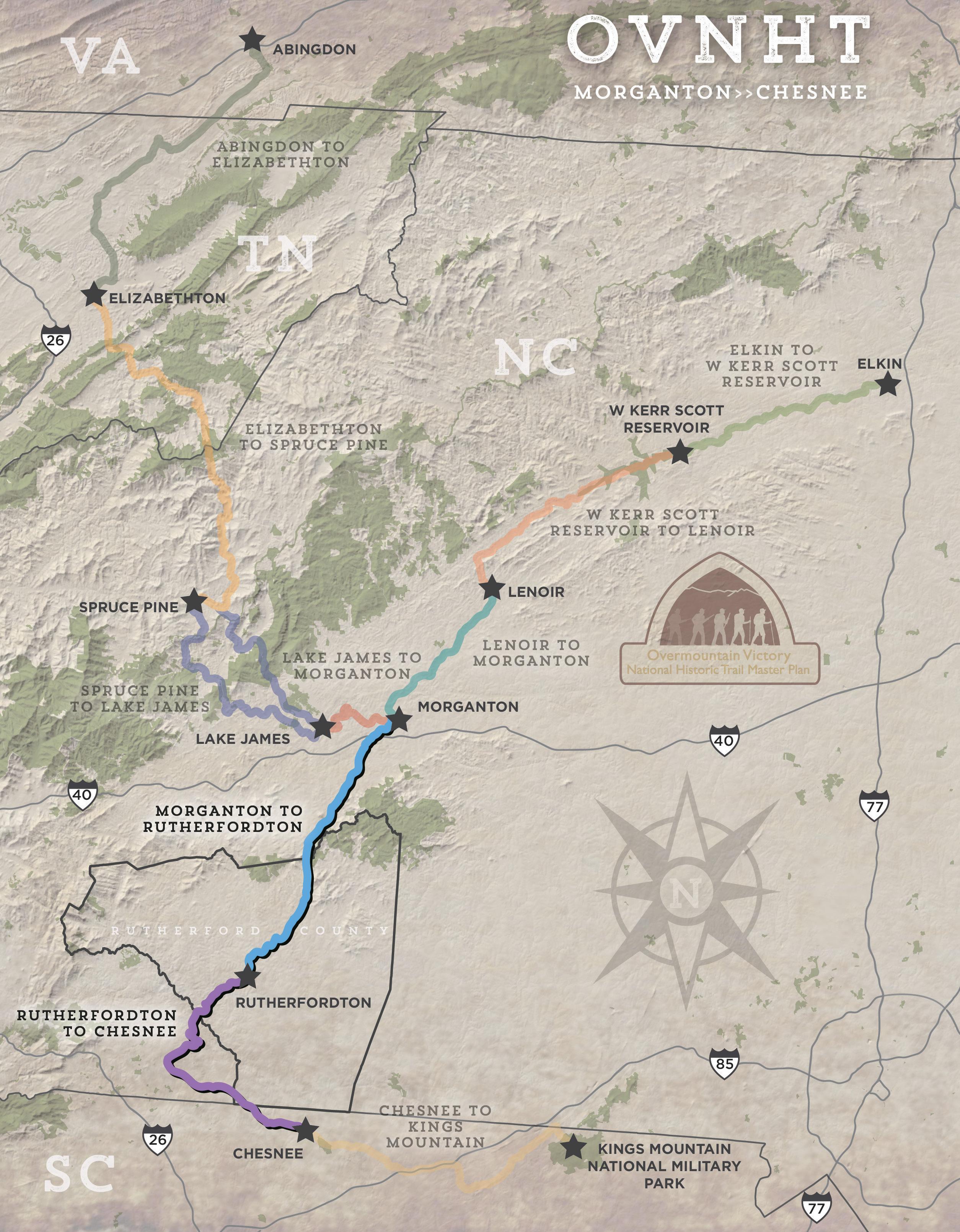
The planned Overmountain Victory National Historic and State Trail is approximately 330 miles in length and is located in portions of Virginia, Tennessee, North Carolina, and South Carolina (See Exhibit 04, page right). The section located in North Carolina was authorized as a State Trail in 2019. The trail commemorates the route the patriot militia marched as they mustered to fight and defeat the British-led loyalist army at the Battle of Kings Mountain on October 7, 1780.
The trail connects South Mountains Gamelands, Rutherfordton, Grays Road Broad River access, and Alexanders Ford at Bradley Nature Preserve in adjacent Polk County. Of the OVNHT route between Morganton and Polk County there are 2 existing miles and 25 planned miles within Rutherford County.
The Overmountain Victory State Trail North Carolina - Friends, the Overmountain Victory Trail Association, and National Park Service are the lead partners for this trail and section stakeholders include NC State Parks, Foothills Conservancy, Rutherford Outdoor Coalition, Town of Rutherfordton, and Rutherford County.
Authorization Date:
Planned Trail within Rutherford County:
Existing Trail: Lead Partner: 2019 25 miles 2 miles Overmountain Victory State Trail North Carolina - Friends

The planned Overmountain Victory National Historic and State Trail runs north to south through Rutherford County on its way from Morganton to Chesnee, SC. (Source: OVNHT: Morganton to Rutherfordton Master Plan)

Regional trail systems provide important connections between state-designated and local trail systems. While they may initially exist as disconnected trail segments, the intent of these extensive trail systems is to connect regional assets and communities. Local funding should be leveraged with funding offered by state and regional agencies and non-profits with a focus on recreation, community health, and environmental protection to implement tra il planning and construction. MAP

Local trails typically connect community assets and may provide alternative transportation routes in addition to recreational uses. These trails vary in length and may be purpose-built for specific user groups and experiences. Local trails may also serve as important connectors in the larger regional trail system. Local funding with a focus on recreation and community health is typically the best source to implement planning and c onstruction of local trails.
A NUMBER OF EXISTING AND PROPOSED LOCAL TRAILS ARE LOCATED IN RUTHERFORD COUNTY (SEE MAP 03, PAGE RIGHT):
Catheys
Chimney Rock Riverwalk
Chimney Rock State
Chimney Rock
Chimney Rock
Cleghorn Creek
Dittmer Watts
Forest City
Hollands Creek
Lake Lure
Lake Lure
Purple
Rutherfordton
Second
South
Spindale
Rutherford County has two rivers that are ideal for paddling by canoes and kayaks: the Broad and Second Broad. Safe, legal, and public access areas are critical for development of these natural and recreational assets.
TWO PROPOSED PADDLE TRAILS ARE LOCATED IN RUTHERFORD COUNTY (SEE MAP 04, PAGE RIGHT):
Both rivers feed into the existing Broad River Paddle Trail which also connects with the planned First Broad River Paddle Trail in Cleveland County where it continues further south to the Broad River Blueway in South Carolina.
The Broad River paddle trail extends approximately 41 miles from the Lake Lure Dam to the Rutherford/Cleveland County line. The trail currently supports use at informal and formal accesses within the County. Four formally developed official accesses are located at Grays
Road, Coxe Road, US 221, and US 221-A. Seven additional access areas are proposed at the following locations: Island Creek; Rock Springs Church Road; Clark Road; River Road; Poors Ford Road; Big Island Road; and Jack McKinny Road.
The Second Broad River paddle trail extends approximately 18 miles from Forest City to its confluence with the Broad River just south of US 221-A at Cliffside. The river has yet to be developed as a paddle trail due to multiple dams located along its reach. Five access areas are proposed: James F. Crowe Park, US 74 Business, US 221-A in Caroleen, Haynes Street, and US 221-A in Cliffside.
Proposed Paddle Trail: Existing Paddle Trail: Proposed River Accesses:
Existing River Accesses: 59 miles 8 miles 16 4


The Rutherford County Trails Collaborative initially completed a comprehensive inventory of all planned and existing trails in the County and identified needs for each tra il.
Trail needs are defined below.
Project requires additional planning and/or landowner outreach to secure trail corridors.
Project requires design and engineering before being “shovel re ady” for construction.
Project plans are complete and permits secured. The project is ready for construction .
Project exists and may have future maintenance and enhancement needs.
The group created a master list that outlined results from the trail inventory and needs assessment (See Trails Inventory Matrix, page 30). The trails inventory matrix identifies planned and existing trails with the four categories mentioned previously: state-designated, regional, local, and paddle trails. Each category has distinct funding opportunities from a variety of sources. Collaborative members also developed a comprehensive list of grant funding sources (See Grant Matrix, page 32).
Moving forward, the Collaborative will meet every month to update group members on trail projects in the County and develop an implementation action plan for each fiscal year. The action plan will identify specific trail infrastructure projects based on prioritization, needs, a nd potential grant funding sources.
In order to leverage funding and maximize benefits, trail implementation efforts should focus on areas where state trails co-align with other regional and local trails. Regional and local trails that make important community connections in the County should be identified and focus given to those that would have maximum impact, prioritizing planned trail segments within corridors that are secured and allow public access.

The RCTDA should focus on implementation of the following trail infrastructure projects over the next 0-3 years:
Planned sections of the trail that are located on public lands within Chimney Rock State Park and extensions to the existing Youngs Mountain Trail.
Planned sections that connect to the Hickory Nut Gorge State Trail and within the Box Creek Wilderness.
Landowner outreach for parcels along the Broad River that can be purchased or leased for river access areas.
Planned spurs and connectors to Bostic, Union Mills, Isothermal Community College, and the Rutherford County walking path.
An online interactive map will provide a resource for residents and visitors to use when seeking out specific trail experiences in Rutherford County. This resource should provide quality mapping for each proposed and planned trail in the County and provide sufficient information for trail users to make informed decisions about their adventure.
A recreational brand or logo for outdoor recreation infrastructure within Rutherford County will allow residents and visitors to visually and mentally connect the natural assets found in this diverse geographic area. This brand can be utilized at trailhead kiosks and with online and printed material, and it will consider current branding efforts by the RCTDA and partners.
Hickory Nut Gorge State Trail Natural x x x xHighHike
Wilderness Gateway State Trail Natural x x xHighHike
Overmountain Victory National Historic and State Trail Natural and Paved x x xMediumHike and Bike
Broad River Trail Natural and Paved x x xMediumHike and Bike
Thermal Belt Rail Trail and Extensions Natural x x x xHigh/MediumHike and Bike
Catheys Creek Greenway Natural and Paved x x xMedium/LowHike and Bike
Chimney Rock Riverwalk Natural x xHighHike
Chimney Rock State Park Trails Natural xLowHike
Chimney Rock Attraction Trails Natural xLowHike
Chimney Rock Local Trail Connectors Natural x x xMediumHike
Cleghorn Creek Greenway Natural and Paved x x xMedium/LowHike and Bike
Dittmer Watts Trails Paved xMediumHike
Forest City Local Trail Connectors Paved x x xMediumHike
Hollands Creek Greenway
Natural and Paved x x xMedium/LowHike and Bike
Lake Lure Open Space Trails Paved XMediumHike
Lake Lure Local Trail Connectors Natural X XMediumHike
Purple Martin Greenway
Natural and Paved x x x xHighHike and Bike
Rutherfordton Local Trail Connectors Paved xMediumHike
Second Broad River Greenway Natural and Paved x x xLowHike and Bike
South Mountains Game Lands Natural xMediumHike
Spindale Local Trail Connectors Paved xMediumHike
Broad River Water x x x XHighPaddle
Second Broad River Water x X XLowPaddle
RCTDA Varies Spring Don Cason
Projects that promote tourism and quality of lifeVaries
RHI Legacy Foundation Varies
rhilegacyfoundation.com/ grants Active living and healthy eatingN/A
Late Spring Early Summer Jill Miracle
Duke Energy Foundation $20,000 Craig DeBrew
Recreational Trails Program (RTP) $100,000
NC Water Resources Development Grant Varies
Vibrant economies; climate resiliency; and justice, equity, and inclusion N/A
www.duke-energy.com/ community/duke-energyfoundation/north-carolina
Recreational trails of all types25%
Summer Scott Crocker trails.nc.gov/trail-grants
NC Parks and Recreation Trust Fund (PARTF) $500,000
Late Summer Late Fall Amin Davis
deq.nc.gov/about/divisions/ water-resources/waterresources-grants/waterresources-developmentgrant-program
River access areas and trails within riparian corridors50%
The Trail Fund $15,000 Spring
REI Varies
Maintenance, research, and stewardship training projects N/A
www.americantrails.org/thetrail-fund
Late Spring Early Summer Judy Francis
www.ncparks.gov/moreabout-us/parks-recreationtrust-fund/parks-andrecreation-trust-fund
Park and recreation projects of all types including land acquisition 50%
Bree MillerAsheville REI Invitation onlyN/A
People for Bikes Community Grant $10,000 2X/year
www.peopleforbikes.org/ grant-guidelines Bicycle infrastructure>50%
Access Fund Climbing Conservation Grant
Varies Spring Summer Jenna Winkler
Must serve climbing areasN/A
www.accessfund.org/takeaction/apply-for-funding/ climbing-grant-application
American Alpine Club Cornerstone Conservation Grant $8,000
Hydra Flask Parks 4 all
Varies
T-Mobile Hometown Grants $50,000
AARP Community Challenge Grant
Land and Water Fund (formerly CWMTF)
Dogwood Health Trust
NC DOT - Various pots for bike-ped
Rutherford County - American Recovery Act funds
Varies
americanalpineclub.org/ cornerstone-conservationgrant Must serve climbing areasN/A
Varies
www.hydroflask.com/parksfor-all
Spring Summer Fall Winter
Varies Spring
www.t-mobile.com/brand/ hometown-grants
Projects to build, rebuild, or refresh community spaces that help foster local connections in your town
Small grants to fund quickaction projects that can help communities become more livable for people of all ages N/A
www.aarp.org/livablecommunities/communitychallenge/
Acquisition, restoration, innovative stormwater, planning, and donated property minigrants Varies
Early Winter nclwf.nc.gov/apply
Must be for transportation, not soley recreation. Greenways, sidewalks.


