Aerial photo of the Trans-Sumatra toll road under construction. (Image courtesy: Hutama Karya)
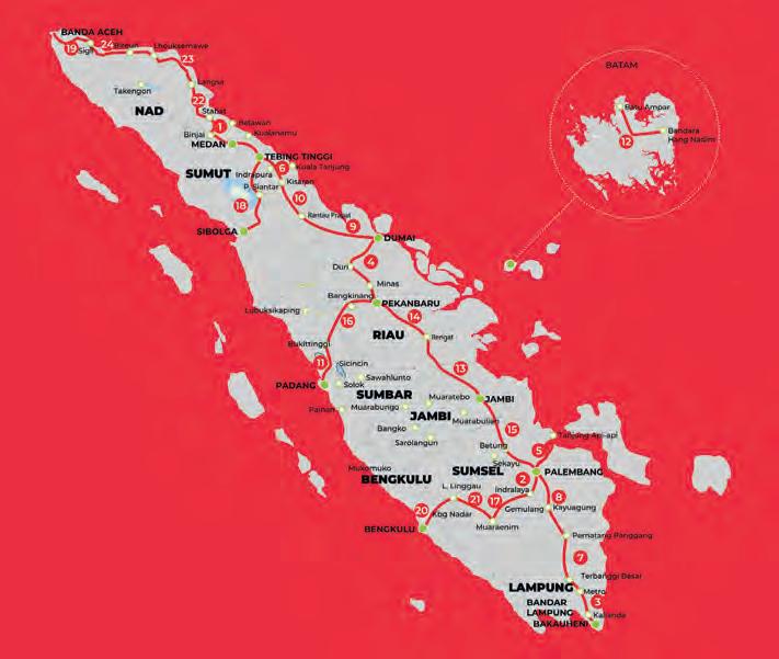
Because the toll road project mostly crosses through isolated non-populated areas, another challenge is posed by the condition of the existing roads. Due to poor accessibility, 4x4 cars are essential workhorses for the Lidar survey, and the route options required careful planning. The corridor mapping process was divided into 10km sections. In a best-case scenario this translated into 220 flight missions. The worst-case scenario plan – which took account of realistic threats due to factors such as poor weather conditions, potential damage to the UAV or sensors, and the need for repairs – envisaged 350 flight missions.
Challenges of mapping in the tropics The biggest challenge for the team while on data acquisition duty was the weather; poor conditions significantly hindered the Lidar acquisition process. On one occasion they could not fly for a full week because of bad weather. Additionally, the weather caused disruption on the local roads, such as landslides, falling trees or large holes, forcing the survey team to take time-consuming detours from their originally planned routes.
The corridor-mapping survey team. (Image courtesy: Quantum Systems)
It is standard procedure to closely observe the weather conditions for one or two days to identify the pattern of the local weather behaviour. Based on these observations, the team could plan the flights, taking into account the mission duration, the flight length and the exact time when potentially good weather conditions were forecast. Another project challenge was to meet the required LE90 accuracy of 0.25m for the 1:1,000 map scale (based on The Geospatial Information Agency Standard for Large-scale Maps). On the first three of the Lidar surveys for the sections Muara Enim to Bengkulu, Padang to Pekanbaru and Aceh to Sigli (611km), the team struggled to meet that accuracy tolerance for each of the survey points. To tackle these accuracy challenges, the project team conducted trial-and-error scenarios and practical research in-house, and exchanged knowledge with researchers and also with the YellowScan support team to discuss the acquisition, processing and postprocessing strategy. After much discussion back and forth, the team have now found a successful formula and are continuing to adapt it for the entire project.
A third challenge related to the hilly and forested terrain, especially around the areas of Muara Enim, Padang, Bengkulu and Pekanbaru. To overcome this, the project was flown at an altitude of 150m above ground level (AGL), even though YellowScan recommends a maximum flight altitude of 80m AGL for its Surveyor Ultra. This pushed the boundaries of the Lidar system, but was deemed necessary to avoid the risks of flying at a low altitude over such extreme terrain. In fact, in a local first, the project took advantage of the regulations in Indonesia to conduct beyond-visual-line-of-sight (BVLOS) flights in the area around Muara Enim over each 30km-long survey section. This 30km corridor mapping was performed from three take-off and landing points, using a Leica GPS base station on the ground. Although the dense tropical forest (palm trees) made it difficult to identify the initial ground control point (GCP), the team succeeded in meeting the accuracy requirements.
Recommendations for further improvement Now 18 months into this prestigious project, Hutama Karya has conducted 1,478km of corridor mapping with the UAV-Lidar system. In fact, this Lidar survey has become the
UAV-Lidar survey for the Aceh to Sigli section. (Image courtesy: Hutama Karya)
20 |
international | Issue 5 2021
19-20-21_featuresumatra.indd 20
13-07-21 15:20


