Feature |
Dylan Davis, Dani Buffa, Amy Wrobleski
Hydrological Algorithms Help to Uncover Sunken History
Automatic Shipwreck Detection in Bathymetry Data Archaeologists have long been interested in shipwrecks. These sites can tell us about ancient transportation and trading routes, technological innovations and cultural exchanges over thousands of years. Documenting shipwrecks can be a difficult task, however. With breakthroughs in remote sensing technology (specifically sonar and radar), researchers have been able to acquire highly resolved maps of ocean floors. Consequently, we can also locate cultural objects – like shipwrecks – sitting on the bottom of oceans, lakes and other bodies of water. Machine learning, AI and other computerized methods of analysing imagery have made incredible strides possible in many research areas. Algorithms have been devised to locate everything from buildings, roads and people to more specific objects like aeroplanes, ships and animals. Archaeologists, too, have begun using AI to locate ancient settlements. Recent
research shows how the use of such automated methods can help reveal a seascape of human history sunk at the bottom of the ocean.
Bathymetry and Shipwreck Archaeology Researchers have used bathymetric datasets to locate everything from ancient Roman and
Greek vessels to World War II aircraft carriers. Technical studies of specific bathymetric data types have shown that shipwrecks can be identified in high-resolution imagery, but smaller or highly damaged wrecks are not as easy to locate. While most shipwreck archaeology has used bathymetric datasets produced by sonar and radar instruments, which are collected from boats or submerged vessels, some researchers have utilized bathymetric datasets collected from the air, specifically Lidar. Lidar (light detection and ranging) data, collected using pulses of light to record 3D surfaces, has made headlines within archaeology for its ability to detect cities hidden under jungle and forest canopies. However, there are actually two kinds of Lidar data: topographic Lidar (which is used to locate features on land), and bathymetric Lidar (which can penetrate water and map shallow ocean floors). Archaeologists have used bathymetric Lidar to detect shipwrecks in shallow waters around the world. One limitation of Lidar, however, is that the water must be calm and clear for proper data collection.
The ‘Big Data’ Problem and Underwater Archaeology
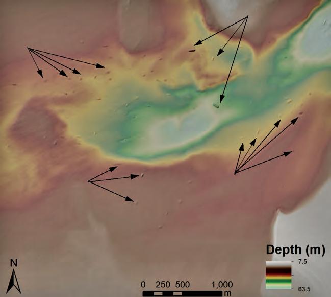
Figure 1: Shipwrecks visible in bathymetric data from the National Oceanic and Atmospheric Administration in the United States. Arrows highlight some of the larger visible shipwrecks. (Credit: Dylan Davis, Danielle Buffa & Amy Wrobleski (2020). Source: https://doi.org/10.3390/heritage3020022.)
The use of 3D data like bathymetry and topography has improved researchers’ ability to detect objects in image datasets. Shipwrecks, which appear as mounds at the ocean’s bottom, can therefore be identified based on their depth compared to the surrounding ocean floor.
10 | Is s u e 1 2021 | Hydro i nt e r nat i o na l
10-11-13_featuredavis.indd 10
18-03-21 14:26


