ISSUE 01
‘RESEPI – The Complete Lidar & RGB Payload Solution’ AN INERTIAL LABS CASE STUDY
Total Stations, UAS Lidar Systems and more!
COMPARE PRODUCTS
‘Scanning Gets Into the Game’ A TRIMBLE CASE STUDY
ce
n da
i gu . e s n hi urer c a t m fac d u an an g m n ni 00 o i 7 sit m o o p r g, ts f n i c ey odu v r r su 0 p r fo ,00 3 m r ft o han a t pl ore t uc m d ro with p e
Th 01_coverriegl.indd 1
06-09-21 11:43
02_Gexel_P4G_1-2021.indd 4
31-08-21 10:30
Contents P. 16 Welcome to the New Geospatial Teledyne Optech and Teledyne CARIS have united to form Teledyne The Geo-matching Buyers Guide is an independent international publication, released two times a year by Geomares. Please visit Geo-matching.com for more information.
Geospatial in response to the evolving marketplace needs. Under the Teledyne Imaging group, the harmony between the two business units was clear and the two teams were brought together.
P. 42 Scanning Gets into the Game
Director Strategy & Business Development: Durk Haarsma Financial Director: Meine van der Bijl Business Development Manager: Peter Tapken Content Manager: Daniël Haanskorf Production Manager: Daniël Haanskorf Copy Editor: Serena Lyon Design: ZeeDesign, www.zeedesign.nl Geomares, www.geomares-marketing.nl
In Spain, football stadiums are often as beloved as their local teams, so it pays to maintain and upgrade these significant sources of pride and revenue. One such stadium is the Carlos Tartiere in Oviedo.
P. 76 RESEPI – The Complete Lidar & RGB Payload Solution Inertial Labs has designed the Remote Sensing Payload Instrument, RESEPI, as a cost-effective solution for extremely accurate remote
Advertisements Information about advertising and deadlines is available. For more information, please contact our Business Development Manager Peter Tapken, peter.tapken@geomares.nl. Editorial Contributions All material submitted to the publisher (Geomares) and relating to Geo-matching will be treated as unconditionally assigned for publication under copyright subject to the Editor’s unrestricted right to edit and offer editorial comment. Geomares assumes no responsibility for unsolicited material or for the accuracy of information thus received. In addition, Geomares assumes no obligation for return postage of material if not explicitly requested. Contributions must be sent to the Business Development Manager Peter Tapken, peter.tapken@geomares.nl This is a publication of:
Geomares P.O. Box 112, 8530 AC Lemmer The Netherlands T: +31(0)514-561854 www.geo-matching.com www.geomares-marketing.com No material may be reproduced in whole or in part without written permission of Geomares. Copyright 2021, Geomares, The Netherlands. All rights reserved. ISSN: 2590-3470
Advertisers: RIEGL:
front cover
iXblue: 34
GEXCEL: 2
Trimble:
42, 43
Viametris: 4
Inertial Labs:
76, 77
Geo-matching: 6
Geomares :
Applanix: 7
GVI: 91
Teledyne:
eSurvey:
16, 17, 18
84
back cover
sensing applications.
P. 5 P. 8 P. 12 P. 13 P. 14 P. 19 P. 26 P. 30 P. 32 P. 35 P. 44 P. 51 P. 54 P. 58 P. 60 P. 64 P. 66 P. 68 P. 72 P. 78 P. 80 P. 85
Featured Products Airborne Laser Scanners CAD Software GIS Software Digital Aerial Cameras GNSS Receivers GNSS Antennas Ground Penetrating Radars Gimbals and Mounting Systems Inertial Navigation Systems Mobile Mappers Survey Software Mobile GIS Systems and Field Controllers Photogrammetric Imagery Processing Software Portable and Indoor Mobile Mappers Point Cloud Processing Software Radios and Modems Terrestrial Laser Scanners Total Stations UAS Cameras UAS For Mapping and 3D Modelling UAS Lidar Systems
Cover story Terrestrial Laser Scanning in Forestry To secure forests as energy suppliers, oxygen producers and CO2 stores, an ongoing inventory is necessary for efficient, economic and environmentally friendly forest management. The RIEGL VZ-400i provides rapid, precise, highly meaningful and objective measurement data for the calculation of beam height, breast height diameter, crown diameter and other properties, opening up new possibilities for foresters, climate researchers and biologists. Find more information on RIEGL’s VZ-400i on page 68.
ISSUE 01
‘RESEPI – The Complete Lidar & RGB Payload Solution’ AN INERTIAL LABS CASE STUDY
Total Stations, UAS Lidar Systems and more!
COMPARE PRODUCTS
‘Scanning Gets Into the Game’ A TRIMBLE CASE STUDY
ce
an id gu ne . hi rers ac tu m d ufac an g man in on 700 siti po from g, in ts ey uc rv prod r su 0 fo ,00 rm 3 fo an at th t pl ore uc m od ith e pr w
Th 01_coverriegl.indd 1
06-09-21 11:43
3
03_contents.indd 3
06-09-21 15:35
NEW MODEL 2022
BMS3D
Backpack mobile mapper for indoor/outdoor. Pedestrian or motorized usage. Combination of SLAM-IMU-GNSS technologies.
3D Mobile Mapping Systems
VMS3D Urban and road scanning
SOFTWARE
IMS3D
BMS3D
VMS3D
VMS3D-HD
contact@viametris.com
VMS3DHD Urban and road high density scanning
BMS3D Indoor/ outdoor scanning
Meet us
viametris.com PUB-GEOMATCHING.indd 1 04_Viametris_P4G_1-2021.indd 4
HALL 23 STAND B.34
27/08/2021 10:42 31-08-21 10:30
FEATURED PRODUCTS AT INTERGEO
AlphaAir450 UAS Lidar System
N3 IMU GNSS Receiver
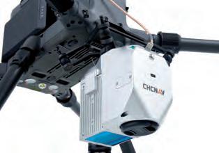
The AlphaAir 450 combines a highprecision IMU, industrialgrade GNSS, 3D Lidar scanner and RGB camera to provide an essential combination of long-range scanning and high-resolution imaging. The system achieves an absolute accuracy of 5-10cm and features advanced calibration and point cloud optimization for reduced range noise.
Featuring 1198 channels for full-constellation and full-frequency tracking, an enhanced internal UHF for a working range of up to 15km, an improved high precision IMU allowing for a 60° tilt, low power consumption and over 24 hours of working time, the N3 receiver helps saving energy and brings higher efficiency in conducting your survey tasks.
The AlphaAir 450’s Skyport connection allows direct interfacing with the DJI M300 and M200 V2. Weighing only 1kg, the AA450 can also be mounted on a wide range of multirotor and fixed-wing VTOL drones that can support its weight with dedicated mounts to attach it.
Partnered with SinoGNSS Survey Master field software, ComNav Technology provides you with a fluent and efficient workflow.
View product:
More information at ComNav’s digital Intergeo booth
DJI Phantom 4 RTK Phantom 4 RTK is a surveying drone for photogrammetry applications. It has a centimeter-level positioning system and a high-performance imaging system. It is portable and easy to use, and comprehensively improves the efficiency of aerial surveys. • Max flight time: 30 min • Max transmission range: up to 4.34 miles (7km) • 20 MP 1-inch CMOS Sensor • Built-in RTK module, support PPK • Accurate positioning data with TimeSync • Integrated flight planning with GS RTK app • Complete mapping solution when used with DJI Terra
Meet DJI at booth 20C.02, hall 20
RIEGL VQ-1560II-S Dual Channel Airborne Mapping System With increased laser power, the RIEGL VQ-1560 II-S offers superior performance and highest productivity based on a laser pulse repetition rate of 4MHz (2 x 2MHz) resulting in more than 2.66 million measurements per second on the ground. At typical operating flight altitudes between 500ft up to 12,800ft (ρ≥20%) an even point distribution can be achieved. In combination with different laser power levels, subtle optimization of acquisition parameters is possible which allows to meet specific project requirements in mapping ultra-wide areas, complex environments as well as in corridor mapping applications.
Meet RIEGL at booth 20C.22, hall 20
5
05-06_featuredproductsgedeelte.indd 5
06-09-21 13:46
FEATURED PRODUCTS AT INTERGEO eSurvey GNSS EAS301
Gexcel HERON MS Twin HERON MS Twin is an outstanding 3D mapping system for surveying, geospatial, digital twin activities, appreciated in demanding projects, extreme indoor environments, underground mines, tunnels, multilevel buildings and complex construction sites.
EAS301 is a new automatic steering system using an electric wheel. Based on GNSS technologies, the system is independently developed by eSurvey. Using a driving controller to carry out the steering strategy and controlling the steering wheel rotation axis to drive the agricultural steering wheel to automatically turn, the agricultural machine is controlled to run in AB straight lines and adaptive curves.
The portable hardware features a compact capture head, a rugged control unit and a robust backpack. The capture head hosts a double laser sensor and a 5K RGB hi-res panoramic camera. HERON is equipped with two advanced software to: • Create 3D point cloud models leveraging a unique patented SLAM algorithm. • Edit, filter, and georeference models. • Extract deliverables. • Export to third-party software like ReCap Pro or cloud platforms.
Meet eSurvey GNSS at booth 23C.35, Hall 20
Meet Gexcel at Booth 20E.22, hall 20
Your Product Platform for Surveying, Positioning and Machine Guidance
6
05-06_featuredproductsgedeelte.indd 6
06-09-21 13:47
Applanix Direct Georeferencing No Matter What You Fly! GNSS-inertial technology specifically designed for Direct Georeferencing airborne sensor data without base stations Applanix DG™ is used with cameras, LiDAR, and hyperspectral sensors for highly-efficient, automated mapping and surveying Experience the accuracy of POSPac MMS/POSPac UAV with Trimble CenterPoint® RTX™
Applanix Corporation 85 Leek Crescent, Richmond Hill, ON L4B 3B3 Canada T +1-905-709-4600, F +1-905-709-6027 info.applanix.com/airborne-video airborne@applanix.com
07_Applanix_P4G_1-2021.indd 4
06-09-21 16:59
AIRBORNE LASER SCANNING
LiteMapper 7800VQ2 The newest IGI LiteMapper-7800VQ2 with integrated 2MHz RIEGL VQ-780II Lidar is equipped with the IGI SMU-2 for data storage and management. Using the IGI SMU-2, installations in helicopters and cramped scenarios can be planned and executed very quickly! Designed as a rugged but compact and lightweight system, the IGI LiteMapper can be used in various aircraft.
LiteMapper 1560VQ Designed as a rugged but also compact and lightweight system, the IGI LiteMapper can be used in a variety of aircraft, from large aeroplanes and helicopters to ultra-light aeroplanes and gyroplanes or even remotely piloted aircraft systems (RPAS).
TerrainMapper-2
Leica Chiroptera 4X
The Leica TerrainMapper-2 is the latest linear-mode Lidar airborne sensor providing the highest performance for regional mapping projects. The gateless MPiA delivers outstanding accuracy, unmatched point density and even point distribution. The TerrainMapper is optimized for various applications, from narrow-swath corridors to high altitude projects. It includes a 2MHz Lidar, combined with 2 nadirs 150MP cameras in RGB and NIR.
The Leica Chiroptera 4X is a cost-effective, innovative Lidar system that simultaneously captures 140,000 points per second in the bathymetric channel, and up to 500,000 points per second in the topographic channel. The system is designed to collect high accuracy data for environmental monitoring and surveying of shallow water with survey depths down to 25m. The shoreline is captured seamlessly with the Leica RCD30 80 MPix camera to generate RGB point clouds.
Leica HawkEye 4X
VQ-1560II-S
The Leica HawkEye 4X offers unrivalled bathymetric point density and water penetration down to 50m depth with the highest accuracy, for turbid water performance, with increased sensitivity, offering a productivity gain of >50%. The system expands on the competence of Leica Chiroptera 4X by providing superior capability in deeper waters. Do you currently own a Leica Chiroptera 4X but need to expand into deeper waters? Just add the HawkEye 4X.
The new VQ-1560 II-S follows the successful concept of RIEGL’s proven dual channel laser scanner series. With increased laser power, the operational altitudes are extended up to 1,600m AGL at a pulse repetition rate of 4MHz, or up to 4,000m AGL at a pulse repetition rate of 540kHz (all values given for 20% target reflectance). These improved maximum ranges allow an increase of the system’s productivity by about 25% for a very attractive point density range.
8
08-09_productenairbornelaserscanning.indd 8
07-09-21 11:41
VQ-780II-S The RIEGL VQ-780 II-S is a high performance, rugged, lightweight, and compact airborne mapping sensor. This versatile system is designed for highly efficient data acquisition at low, mid, and high altitudes, covering a variety of different airborne laser scanning applications from high density to wide area mapping.
VQ-840-G The RIEGL VQ-840-G is a fully integrated compact airborne laser scanner for combined hydrographic and topographic surveying. The system can be offered optionally with an integrated and factorycalibrated IMU/GNSS system and with an optional camera or IR rangefinder on request. The VQ840-G is a compact and lightweight Lidar system to be installed on various platforms including UAVs.
VPX-1 The RIEGL VPX-1 is a lightweight and streamlined pod that carries a complete airborne laser scanning platform for easy and quick mounting on suitable support arms on helicopters.
CZMIL Supernova Supernova is the next generation topo/bathy Lidar system from Teledyne Geospatial, Equipped with the most powerful green laser on the market, Supernova provides maximum depth penetration, superior coverage in turbid waters, and up to 8 ppm2 point density in shallow water.
ALTM Galaxy PRIME
G2 Sensor System
The new Galaxy PRIME is the next evolution of the popular Galaxy wide-area/corridor Lidar mapping platform that includes the advanced and unique PulseTRAK and SwathTRAK productivity feature sets. An innovative ‘boost mode’ increases range performance, and an expanded range of motion for the dynamic FOV used by SwathTRAK ensures that the Galaxy PRIME is quite simply the most versatile, highest-performing, and most productive sensor on the market.
The G2 Sensor System offers a true 4MHz pulse frequency via two sensor heads installed in opposing directions. This enables the double pass over the ground and all targets and thus delivers high-resolution data products with minimal occlusion. The sensor heads can be pitched variably, either at 2.5° or 7° which allows for operations in pressurised aircraft in addition to superior vertical target detection and vegetation penetration.
9
08-09_productenairbornelaserscanning.indd 9
07-09-21 11:41
AIRBORNE LASER SCANNING COMPANY
PRODUCT NAME
IGI
Leica Geosystems Airborne Solutions
Leica Geosystems Airborne Solutions
RIEGL
LiteMapper 7800VQ2
Leica Chiroptera 4X
Leica HawkEye 4X
VQ-1560II-S
27 18-32VDC typ. 220W IGI AEROcontrol III 512Hz
160 1,000W Novatel Span with LCI100c IMU
250 2,800W Novatel Span with LCI100c IMU
60 20 - 32VDC typ. 370W •
• • 0,25
• • •
• • •
• • 0,17
Time-of-flight • 2,000,000 60 Practically unlimited •
Palmer scanner 150 500,000 40 User selectable 14
Palmer scanner 150 500,000 40 User selectable 14
Rotating polygon mirror • 4,000,000 58 45 •
Helicopter, Fixed-wing, Gyroplane • •
Fixed-wing
Fixed-wing
Helicopter, Fixed-wing
1,600 5
1,600 5
5,800 •
GENERAL
Total Weight [kg] Power requirements Type of GNSS/INS positioning system
LASER PULSE CHARACTERISTICS
Wavelength [nm] Standard pulse length [ns] Beam divergence [mrad]
MEASUREMENT CHARACTERISTICS
Scanning method Scan frequency [Hz] Max. pulse frequency [Hz] Max. field of view [deg] Max. number of recorded echoes per pulse Recording of intensity of return signal [bits]
OPERATION CHARACTERISTICS
Platform Max. flying height [m] Max. acquisition time [hr]
10
10-11_specsairbornelaserscanning.indd 10
06-09-21 13:35
RIEGL
RIEGL
Teledyne Geospatial
Teledyne Geospatial
COMPANY
VQ-780II-S
VPX-1
CZMIL Supernova
ALTM Galaxy PRIME
PRODUCT NAME
20 18-32V DC, 220W •
20 • Optional
287 85 A; 28 VDC Applanix POS AV V6
35 28V; 300W Applanix AP60
• • •
• • •
532 • 7
1,064 3,5 0,25
Rotating polygon mirror 2,000,000 2,000,000 60 14 •
Rotating scan mirror • 1,800,000 75 • •
Circular prism scanning 27 30,000 40 Full waveform 12
• 120 1,000,000 60 8 12
Helicopter, Fixed-wing
Helicopter
Helicopter, Fixed-wing
3,900 •
1,400 •
600 999
Helicopter, Fixed-wing, Gyroplane 6,000 •
GENERAL
Total Weight [kg] Power requirements Type of GNSS/INS positioning system
LASER PULSE CHARACTERISTICS
Wavelength [nm] Standard pulse length [ns] Beam divergence [mrad]
MEASUREMENT CHARACTERISTICS
Scanning method Scan frequency [Hz] Max. pulse frequency [Hz] Max. field of view [deg] Max. number of recorded echoes per pulse Recording of intensity of return signal [bits]
OPERATION CHARACTERISTICS
Platform Max. flying height [m] Max. acquisition time [hr]
11
10-11_specsairbornelaserscanning.indd 11
06-09-21 13:35
CAD SOFTWARE
TcpMDT Professional MDT is an application running on AutoCAD, BricsCAD, GStarCAD or ZWCAD, and has a wide range of easy-to-use tools. Its modular structure allows users to choose the most suitable options for their work. MDT Professional is suitable for all kinds of surveying projects for roads, urbanisations, quarries, etc. In addition to modelling the terrain, it has tools for designing alignments and sections, drawing of project profiles, area and volume reports, setting-out, virtual tour and many more.
MicroSurvey CAD MicroSurvey CAD offers a complete, cost-effective desktop survey and design program designed for surveyors. Perform standard surveying calculations, create high-quality 2D and 3D deliverables quicker and easier than those using more complex, non survey-centric applications. You can even work with point clouds, Lidar and photogrammetric data.
PIX4Dsurvey PIX4Dsurvey cuts out the steps between photogrammetry and CAD, allowing you to extract only the most critical vector data information from point clouds of any size. Offering TIN and breakline analysis, PIX4Dsurvey is ready to integrate your projects into any CAD or GIS software with the customizations that suit your work. Merge multiple point clouds in one project, using both Lidar and photogrammetry data.
VisionCivil Pro VisionCivil Pro is designed for land and infrastructure professionals. It integrates into AutoCAD, MicroStation, BricsCAD, PowerDraft, and Civil 3D. VisionCivil Pro use an external database to facilitate data sharing. Edit surfaces by adding breaklines and holes, work with 2D and 3D profile alignments, as well as handling Lidar Point Clouds.
embeddedCAD MicroSurvey embeddedCAD provides users with unencumbered survey drafting and calculation workflows in a familiar AutoCAD working environment, including COGO, point tools for gridline-based projects, traverse input and adjustment, misclosure reporting, common data collector support, 3D surface representation and computation, corridor design, and more.
Pythagoras Pythagoras is an all-in-one user-friendly, standalone CAD package that allows you to combine all data types including point clouds and web services. Indoor mapping, dredging, mining, UAV, Lidar and machine control users all benefit from the intelligent algorithms that convert your data into CAD deliverables.
12
12_productencadsoftware.indd 12
06-09-21 13:35
GIS SOFTWARE
imajview
imajnet Imajview is a photogrammetric software suite developed to extract GIS data from imajbox surveys. Imajview synchronizes field images with any map content. An integrated photogrammetric tool enables it to extract 3D coordinates and qualify objects with a customizable GIS data model.
MapSmart on Android MapSmart field data collection software is designed for anyone who needs to quickly and accurately map, measure or position anything. Easily integrate MapSmart with LTI lasers and mapping accessories to turn a laser into a complete total station solution.
MX software suite Trimble MX software is a powerful solution which allows managing mobile mapping content, extract features, perform measurements and collaborate with stakeholders, all within one platform. Maximize your return by letting Trimble MX software do the work.
Imajnet is a safe and powerful featured web service giving access to nationwide surveys for any entity within an organization. Flexible, imajnet is provided with plug-ins and SDKs to be integrated into any third party GIS web or desktop application.
Tierra Topcon Tierra is a powerful web application that enhances the control and visibility of your vehicles or machines with a set of specific reports about their status, maintenance, and remote diagnostics. You can easily avoid risks in terms of unauthorized use of assets, thefts, unscheduled jobs and unexpected movement. Our solution is made of a powerful device to provide localization features and data logger capabilities with worldwide coverage (GPRS, 3G, CDMA).
Trimble AllTrak Trimble AllTrak is a cloud-based service that allows everyone to track the location of any equipment that communicates with a data controller running Trimble Access software or any total station using an active Trimble L2P module.
13
13_productengissoftware.indd 13
06-09-21 13:36
DIGITAL AERIAL CAMERAS
AOS-P5
UrbanMapper-2 The AOS-P5 can be delivered with a complete GNSS/IMU system from Applanix, and we offer the well-established software bundle from Phase One, which consists of the iX Plan software for flight planning and the iX Flight software for flight operation.
CityMapper-2 The Leica CityMapper-2 provides high quality oblique imaging and Lidar from one flight, saving time and costs. It captures two nadir (RGB/NIR) and four oblique 150MP images. Together with a new generation 2MHz pulse rate Lidar it breaks all barriers of urban mapping. The newly developed optical system is equipped with Leica Geosystem’s unique mechanical forward-motion-compensation (FMC), which allows to capture high-quality imagery even in difficult lighting conditions.
PAS 880
Based on UrbanMapper, IGI's well-known large-format and oblique digital aerial camera, IGI introduces the all-new UrbanMapper-2. UrbanMapper-2 utilizes the new full-frame 150MP CMOS technology with backside-illuminated sensors to provide ultra-high-resolution images.
Airborne Video Recording Station With StreamPix you can mix and match capture from multiple cameras at different speed and resolution. Paved Surface Capture allows you to Capture from multiple cameras simultaneously. Georeference images from NMEA compatible GPS in a high resolution and high frame rate while the image capture rate is synchronized with the vehicle speed.
UltraCam Osprey 4.1 Phase One introduces its impressive PAS 880 Large Format Nadir and Oblique System. A 280MP nadir camera with four 150MP oblique cameras is integrated into a single pod to simultaneously capture photogrammetric 2D and 3D digital imagery.
The UltraCam Osprey introduces the 4th generation of UltraCam aerial imaging sensors. The highly versatile large-format aerial camera simultaneously collects photogrammetry grade nadir images (PAN, RGB and NIR) and oblique images (RGB) in four directions. Enabling unprecedented flight collection efficiency at superior radiometric and geometric quality, the UltraCam Osprey 4.1 sets a new standard in urban mapping and 3D city modelling.
14
14_productendigitalaerialcameras.indd 14
06-09-21 13:36
ATS
IGI
Leica Geosystems Airborne Solutions
Phase One
COMPANY
AOS-P5
UrbanMapper-2
CityMapper-2
PAS 880
PRODUCT NAME
45 IGI or Applanix
77,5 Integrated GNSS/IMU System (AEROcontrol)
57,5 Novatel SPAN OEM7 / class5 IMU, 500Hz, no export license required US ECCN 7A994
45 Integrated, Trimble Applanix AP+ , Applanix IMU91/IMU57
iX Flight, Phase One
IGIplan
Leica MissionPro
All established programs in the field of photogrammetry
IGI AEROoffice, IGI IPS (Image Processing Software)
Leica HxMap
Phase One Management Software •
5 1x Nadir camera 90 mm, 4x Oblique camera 110mm
8 RGB 90 & NIR 40
6 •
Number of lenses Lenses: focal lengths [mm]
Backside-illumination technology • • • 1/2500
CMOS
6 CityMapper-2S: 112mm Nadir, 146mm Oblique, 70mm Nadir NIR / CityMapper-2H: 146mm Nadir, 189mm Oblique, 70mm Nadir NIR •
•
Type CCD
52,9 14,100 129,72 1/2000
40 10,640 53,3 0,001
• • • •
CCD along track format [mm x mm] CCD along track format [pixel x pixel] CCD across track format [mm x mm] Max. shutter speed [s]
HARDWARE
Camera unit Weight [kg] Type of GNSS/ INS positioning system
SOFTWARE
Type of mission planning software Type of postprocessing software
SENSOR CHARACTERISTICS
OPERATION CHARACTERISTICS
15
15_specsdigitalaerialcameras.indd 15
06-09-21 13:36
Sponsored article
Teledyne Optech and Teledyne CARIS Merge to Form Teledyne Geospatial
Welcome to the New Geospatial Teledyne Optech and Teledyne CARIS have united to form Teledyne Geospatial in response to the evolving marketplace needs. Under the Teledyne Imaging group, the harmony between the two business units was clear and the two teams were brought together to offer added value to customers through solutions across hardware, software and workflows.
Andy Hoggarth, vice president of sales and marketing at Teledyne Geospatial, has been with Teledyne CARIS for almost 20 years. Having begun his geospatial career as a multibeam sonar processor using CARIS software at sea, he transitioned from working on the technical side of the business and is considered an expert in ocean mapping. Teledyne CARIS has carved out a solid niche within the marine sector, only to become broader via this new collaboration. For Hoggarth, the synergies were clear: fusing the two companies reflects the natural evolution of the geospatial industry.
New opportunities for customers “What’s new about this model is our ability to streamline and centralize our service provision, offering more to both new and existing customers across the spectrum of needs,” comments Hoggarth. “Having a single contact point across all requirements means efficiency gains in terms of workflow, saving time and ensuring our customers get what they need earlier. The needs of professionals are evolving to no longer focus solely on land or sea, and both geospatial and maritime enterprises are increasingly
expected to offer a more comprehensive suite of services. Bringing Optech and CARIS together enables leveraging the worldleading expertise of both companies, ensuring customers can take full advantage of their ability to provide targeted solutions for land, air and sea. We see new opportunities to connect existing hydrographic customers to the broader geospatial sector. We can offer solutions to a new spectrum of clients on the topographic mapping side through the latest geospatial workflow software including tools like artificial intelligence (AI).”
Teledyne Geospatial provides solutions and workflows for seamlessly mapping land and sea. (Image courtesy: Dave Somers, Ocean Surveys)
16
16-17-18_teledyne.indd 16
06-09-21 15:37
Hoggarth explains that he is most excited about the new possibilities the merger provides for Teledyne customers to gain a competitive advantage in terms of what they can deliver. “For example, processes will be further streamlined: customers can log their high-density, high-resolution Lidar data, store it in the CARIS cloud for immediate processing and analysis, and then move into downstream product creation workflow. This gives a clear operational advantage. This, in turn, enables our customers to offer added value to their own clients in terms of the breadth of services they’re able to provide.” Consequences of the merger for the teams Joining forces means the teams are gaining new skills across disciplines and ensures retention of the field-specific expertise they’re known for. The market is familiar with the strong customer service and support model, from engineering to sales, and that will not change. Teledyne’s arsenal includes hydrographers, physicists, surveyors and GIS professionals, as well as AI specialists, engineers and computer scientists. Going forward, as the market transitions to digital, the skills and expertise needed most in the field are at the intersection of traditional domain knowledge and the diverse aspects of computer science. “There is an evolution underway in industry, and enterprises that can recruit highly skilled teams with expertise across the geospatial spectrum will be the ones to engage with,” suggests Hoggarth. “Our teams are industry professionals who understand both hardware and software and we see this as an opportunity to develop holistic solutions for hydrographic and topographic mapping.” Delivering a competitive advantage Teledyne Geospatial will have access to the full range of sonar, Lidar and software solutions, enabling customers to gain full value from their Teledyne investment with the most advanced sensors in both ocean and land environments. “In that respect, we are unique,” notes Hoggarth. “Whilst some providers have topographic sensors with integrated software, even bathymetric Lidar, our software workflow goes much further; others are not involved in the final delivery of data, whereas we have end-to-end capability.
16-17-18_teledyne.indd 17
Ease of data collection through to final products is enhanced with efficiency-driving AI algorithms and real-time quality control. (Image courtesy: Mike Stecher)
This is a huge advantage for our customers who will be able to integrate workflows, create efficiencies and reduce silos. We will reduce the need for separate infrastructure for land and sea since we can support our customers on both. This is strategic for our customers at the business level but also makes life easier in challenging and extreme environments such as the Arctic, for example. This industry acumen means Teledyne Geospatial is the ideal partner for a full range of projects.” Helping surveyors to get ahead of the game The role of the surveyor is still evolving rapidly, which calls for a different set of skills – not least due to the transition to unmanned aerial vehicles (UAVs or ‘drones’). “For survey businesses to keep up, they must consider how many pilots they need, whether to hire a land surveyor and what the best Lidar investments might be,” comments Hoggarth. “Hiring a land surveyor will increasingly require knowledge of dronebased data collection, and our compact Lidar solutions will be particularly relevant for these customers, who would have conducted conventional land-based surveying in the past.” The theme of integration between land and sea continues to emerge: geospatial teams should be interested in the sea as well
as the land, covering both green and red lasers. “Why would we map a mountain range, but neglect the river that comes through it?” asks Hoggarth. “Armed with comprehensive data, we can help our customers deliver a broader range of insights on flood prediction, environmental impacts and other services.” Key emerging industry trends Teledyne Geospatial is anticipating the future of AI technologies with its newly-launched Mira AI Marketplace concept. AI can be leveraged to meet new challenges, enabling enterprises to shift from being productcentric to data-centric, introducing possibilities for enterprises to expand their product and service portfolios. This could contribute to business growth and greater client satisfaction due to a wider suite of service offerings and faster project delivery timeframes. “At Teledyne, we recognize the immense expertise within the field and aim to harness this, embedding AI, machine learning and deep learning within a range of our systems and solutions to capitalize particularly on the automatic and data processing benefits offered by AI,” states Hoggarth. There are ample other solutions that will be critical to solving the ever-more complex
17
06-09-21 15:37
Customers benefit from a competitive edge, mapping and delivering data products inside of one workflow. (Image courtesy: Chris Esposito)
problems faced by geospatial professionals, such as compact Lidar systems lightweight enough to be deployed on a drone. Survey-grade solutions developed for accuracy and quality will be increasingly essential, and integrated solutions that make life easier for surveyors are a must. Teledyne understands these challenges and has developed workflows that support this, considering key factors including where the data resides and accounting for asset management. “For example, Teledyne Geospatial provides AI for asset management and tracking via the cloud, bathymetric Lidar, building on the natural synergies between CARIS and Optech,” he continues. “The tools and technologies that are available to the hydrographic field are indeed transferable into topographic mapping systems, such as the Galaxy range of sensors that provide superior capability for complex terrain like forestry mapping, for example. These are compact, powerful and precise, even to the level of identifying tree species and differentiating canopies to understand forest floor/undergrowth.” What to expect from Teledyne Geospatial in the years to come Integrated solutions lie at the heart of Teledyne Geospatial. The offering will include
turnkey systems, Lidar, sonar, integrated workflows and a range of systems and solutions that support full, precision data collection. Teledyne Geospatial will also work closely with Teledyne Marine, in particular concerning sonar systems; both sonar and Lidar can be logged in CARIS’s recently launched Onboard360 acquisition software. “With Onboard360, our near-real-time and autonomous data acquisition and processing solution, it will become possible to create a common workflow using AI and cloud-native technology,” says Hoggarth. “For example, customers will be able to log data to the cloud with their hardware, streamlining their product timeline. A streamlined workflow for customers is a central, underpinning goal of Teledyne Geospatial.” New product developments in the short term Hoggarth regards software as a key differentiator in combination with customers’ hardware: “We will be releasing new software products in the coming months which will allow users to get the most out of their sensors. One example of this is the recently launched CZMIL SuperNova, which combines Optech’s powerful bathymetric Lidar with CARIS’s comprehensive processing software.” Terratec AS, a leading Norwegian
mapping company, has purchased and flown CZMIL SuperNova for airborne survey projects, collecting and processing marine coastal zone base maps and mapping arctic lakes. Working with the CZMIL SuperNova sensor and AI techniques, they conducted automatic discrimination and noise classification capitalizing on the system’s advanced capabilities and software workflow integration. The company will be presenting itself under the new Teledyne Geospatial banner and revealing CZMIL SuperNova – as well as discussing other upcoming combined solutions – at key industry events including InterGeo in September, Ocean Business in October and GEO Business in November.
Andy Hoggarth is vice president of sales and marketing at Teledyne Geospatial. andy.hoggarth@teledyne.com
18
16-17-18_teledyne.indd 18
06-09-21 15:37
GNSS RECEIVERS
107GS MiniPod
Bad Elf Flex
The 107GS MiniPod is a shock-mounted and ruggedized satellite transceiver / GNSS receiver designed for the relocation and positioning of subsea assets at the sea surface. The 107GS MiniPod automatically switches on at the sea surface to acquire satellite positions. This GNSS lock minimizes cold start times to provide auto-tracking. It is externally powered by a rechargeable battery pack.
GNSS Surveyor The Bad Elf GNSS Surveyor delivers a 1-meter positioning accuracy out of the box to the iPad for use in GIS, mapping, agriculture, and survey activities. The GNSS Surveyor can record raw data and produce RINEX through the Bad Elf application for your post-processing needs.
X1-6 RTK The X1-6 is a rugged highly integrated GNSS/INS receiver that adopts the absolute accuracy of GNSS positioning and the stability of an inertial measurement unit (IMU). Gyro and accelerometer measurements are tightly coupled to provide real-time navigation results such as centimetre position, velocity, and 3D attitude.
Bad Elf Flex democratizes GNSS and economizes field data collection. Our customers shared their needs for lower cost GNSS solutions that include full RTK rover workflow. Bad Elf Flex Standard delivers with 30-60cm accuracy. Bad Elf Extreme is capable of 1cm horizontal accuracy in RTK mode.
X2 The X2 by Bynav Technology is a lightweight and compact automotive-grade GNSS/INS receiver. Empowered with a deeply coupled GNSS/INS navigation engine, X2 fuses the IMU and RTK solution and observes pre-processing, providing real-time high-precision navigation data such as position, velocity and 3D attitude.
Carlson NR3 The Carlson NR3 is a compact GNSS smart antenna designed for Network Rover applications. The lightweight NR3 combines with a prism on a survey pole to make a very portable yet complete assembly to operate with GNSS and robotic total stations simultaneously using SurvCE/PC 6.0 with Hybrid+. In addition to being small and low weight, the Carlson NR3 leverages powerful satellite navigation technology for reliable RTK GNSS.
19
19-20-21-22_productengnssreceivers.indd 19
06-09-21 13:37
i73
i90
The i73 GNSS receiver removes barriers to portability without sacrificing performance. It features iStar technology and offers best-in-class GNSS signal tracking, even in a harsh environment, enabling GNSS surveying beyond the usual constraints. Integrating the latest innovations such as an inertial module providing automatic pole-tilt compensation in a very compact design, the i73 GNSS is a highly productive rover for surveying and stakeout in any topographic, mapping or construction site.
The i90 GNSS receiver offers integrated IMU-RTK technology to provide robust and accurate positioning, in all circumstances. Unlike the standard MEMS-based GNSS receivers, the i90 GNSS IMU-RTK combines a state-of-the-art GNSS RTK engine, a calibration-free high-end IMU sensor and advanced GNSS tracking capabilities to dramatically increase RTK availability and reliability.
N3
E500 The N3 GNSS receiver makes any survey task more efficient. The N3 features 1,198 channels of tracking all running and planned constellations, enhanced UHF for a working range of up to 15km, an improved high precision IMU and a working time for over 24 hours.
V200
E500 is a lightweight tilt-featured GNSS receiver by eSurvey GNSS. The durable IP67 design makes it possible to work in a variety of environments. Multi-constellation and frequency tracking always give a fixed solution for your job. Thanks to the small-size design, the E500 is suitable for different applications such as car and machine control.
PwrPak7-E2 The V200 GNSS RTK receiver brings superior performance and high efficiency to support your fieldwork with reliable solutions. Its deployment of the advanced RTK engine and new-generation IMU, guarantees a 25% performance improvement, even in the most demanding environments. You can count on Hi-Target V200 for better productivity.
The PwrPak7-E2 is an advanced OEM receiver that provides an all-constellation, multi-frequency positioning solution. The PwrPak7-E2 enclosure couples a reputable NovAtel OEM7700 receiver board with an advanced Epson G370N MEMS inertial measurement unit (IMU) to offer improved INS performance and higher data rate.
20
19-20-21-22_productengnssreceivers.indd 20
06-09-21 13:37
SL900
GCX3 The SL900 GNSS receiver includes a tilt compensator that saves up to 20% of the time compared to conventional surveying practices. This solution allows surveyors to focus on their surroundings conveniently while ensuring their safety and comfort.
The GCX3 is the ideal job site base/rover RTK (Real-Time Kinematic) system or network RTK rover and like all of Sokkia’s solutions, you can customize it to meet your needs and create your own workflows.
SP85
S990A
The Spectra Geospatial SP85 is a next-generation GNSS receiver that combines decades of GNSS RTK technology with revolutionary new GNSS processing. Featuring the new 600-channel ‘7G’ chipset combined with the patented Z-Blade technology, the SP85 system is optimized for tracking and processing signals from all GNSS constellations in challenging environments.
Stonex S990A is an 800 channels GNSS receiver characterized by a new feature that enhances the performances of field surveys. The new IMU system allows for tilted measurements of up to 60 degrees. This allows for quick initialization and fast and precise surveys. The S990A receiver is equipped with all important connectivity capabilities, such as Bluetooth, Wi-Fi, UHF radio and a 4G modem.
F100
HiPer VR
The SXblue F100 tracks multi-constellations and can maximize the acquisition and tracking process with all-in-view GNSS frequencies. Providing maximum performance for accuracy and real-time measurements, F100 also supports RTK correction services, including RTX service that can get cm level accuracy without a base station. The F100, with its advanced technology, ensures high performance even in harsh environments such as under heavy canopies.
The HiPer VR is compact, light and packed with the most advanced GNSS technology in a design built to withstand the harshest field environments. Using Topcon’s advanced GNSS chipset with universal tracking channels technology, the HiPer VR automatically tracks every satellite signal above, now and into the future.
21
19-20-21-22_productengnssreceivers.indd 21
06-09-21 13:37
HiPer HR The HiPer HR is smaller and lighter, but don't let its small size fool you. It's not only packed with the most advanced GNSS technology but it is also built to withstand the harshest field environments. The HiPer HR is built with a rugged aluminium-alloy housing, so it can take the punishment of the job site.
BX992 The Trimble BX992 module has been designed for applications requiring continuous centimetre accuracy in a compact package. By integrating inertial sensors on the same module, robust high-accuracy positions and orientations are produced in all environments. The dual-antenna enclosure is designed for rapid heading alignment and offers continuous positioning in GNSS-denied environments.
Trimble R12i
UB4B0M
The Trimble R12i is a high-performance solution for professional land surveyors. It incorporates inertial measurement unit (IMU)-based tilt compensation using Trimble TIP technology which enables points to be measured or staked out quickly and easily without levelling the survey pole. Powered by the ground-breaking Trimble ProPoint GNSS engine, surveyors can now collect data more accurately in challenging GNSS environments than previously possible.
Unicore UB4B0M is a compact high precision board supporting RTK positioning. Using the self-developed multi-system, multi-frequency and high-performance GNSS SoC Nebulas-II, the board features a low power consumption design and offers millimetre-level carrier phase observation values as well as centimetre-level RTK positioning, supporting chip-level multi-path mitigation. The leading instantaneous RTK technology is especially suitable for high-precision navigation and positioning applications.
UM482
LD900 The UM482 is the smallest high-precision positioning and heading module in the world. Based on Nebulas-II SoC, UM482 tracks all the key satellite signals, including BDS B1I/B2I, GPS L1/L2, Glonass L1/L2, Galileo E1/E5b and QZSS L1/L2. The module is designed for lightweight robots, GIS, intelligent driving, UAV, and more.
The LD900 is a quad-band GNSS receiver, capable of tracking GPS, Glonass, Beidou, Galileo and QZSS constellations to provide reliable and accurate positioning. Access to multiple GNSS signals allow for better satellite availability and reduce the impact of satellite masking or blockage, which can affect positioning.
22
19-20-21-22_productengnssreceivers.indd 22
06-09-21 13:37
Bad Elf
Bynav Technology
CHCNAV
ComNav Technology
COMPANY
Bad Elf Flex
X2
i73
N3
PRODUCT NAME
0,254 0,07 0,07 0,854
0,029 0,099 0,088 0,165
0,085 0,119 0,119 0,73
0,073 0,155 0,155 1,2
• •
32 4
• 4
28 1,7
800 • GPS, Glonbass, Beidou, Galileo, QZSS, IRNSS
• • GPS L1/L2/L5, GLO G1/G2. GAL E1/E5B, BDS B1/B2/B3, QZSS, IRNSS
624 • GPS: L1, L2, L5; Glonass: L1, L2; Galileo: E1, E5a, E5b; Beidou: B1, B2, B3; QZSS: L1, L2, L5
1,198 1,198 GPS L1/L2/L5, Beidou B1/B2/B3, Beidou Global B1C/B2a, Glonass L1/L2, Galileo E1/E5a/E5b, QZSS L1/ L2/L5, IRNSS
No. channels Max. simultaneous tracked channels Tracked satellite signals
15 ROX format, RTCM v2.3, RTCM v3.2, CMR, CMR+
• •
• •
1,5 Yes
reacquisition time [s] RTK Network Compatibility
0,3 •
• •
• •
0,4m 3D •
USB
Serial, CAN, Ethernet
•
1 serial port (7 pin Lemo), 1 TNC port
GENERAL
Height [m] Depth [m] Width [m] Total Weight [kg]
POWER
Operating power: max. [V] Typical consumption [W]
PERFORMANCE
HORIZONTAL UNCERTAINTY
code: DGNSS/RTC (constant part) [m] code: DGNSS/RTC (variable part) [ppm]
COMMUNICATION: GENERAL
Communication ports
23
23-24-25_specsgnssreceivers.indd 23
06-09-21 14:11
COMPANY
PRODUCT NAME
eSurvey GNSS
Hi-Target
NovAtel
SatLab
E500
V200
PwrPak7-E2
SL900
0,0745 0,148 0,148 1,06
• • • •
0,125 0,055 0,147 0,56
0,095 • 0,17 ≤1,2
• •
28 3,2
36 3,4
28 4,2
800 • GPS, Glonass, Beidou, Galileo, QZSS, SBAS, L-band, IRNSS
800 800 GPS: L1/L2/L5/L2C; BDS: B1/B2/B3/B1C/ B2a; Glonass: L1/L2/L3; Galileo: E1/E5 AltBOC/ E5a/E5b/E6; SBAS: L1/ L5; QZSS: L1/L2/L5/L6; IRNSS: L5
555 555 GPS (L1C/A, L1C, L2C, L2P, L5) Glonass (L1C/A, L2C, L2P, L3, L5) BeiDou (B1, B2, B3) Galileo (E1, E5AltBOC, E5a, E5b, E6)
<10
2
• • GPS L1 C/A, L1C, L2C, L2P, L5; Glonass2 L1 C/A, L2 C/A, L2P, L3, L5; Galileo3 E1, E5 AltBOC, E5a, E5b, E6; Beidou B1I, B1C, B2I, B2a, B2b, B3I; QZSS L1 C/A, L1C, L2C, L5, L6; NavIC (IRNSS) L5; L-Band up to 5 channels •
Fully compatible
Yes
Yes
Yes
0,25 •
0,025 1
• •
0,25 1
USB Type-C, 5-pin Lemo, TNC, SIM card
•
•
RS232 Serial Port, USB, NFC, Bluetooth: V2.1 + EDR, NFC
GENERAL
Height [m] Depth [m] Width [m] Total Weight [kg]
POWER
Operating power: max. [V] Typical consumption [W]
PERFORMANCE
No. channels Max. simultaneous tracked channels Tracked satellite signals
reacquisition time [s] RTK Network Compatibility
•
HORIZONTAL UNCERTAINTY
code: DGNSS/RTC (constant part) [m] code: DGNSS/RTC (variable part) [ppm]
COMMUNICATION: GENERAL
Communication ports
24
23-24-25_specsgnssreceivers.indd 24
06-09-21 14:11
Sokkia
Spectra Geospatial
Stonex
SXblue
COMPANY
GCX3
SP85
S990A
F100
PRODUCT NAME
0,197 0,047 0,047 0,44
0,075 0,194 0,222 1,17
0,0945 0,151 0,151 1,40
72 • 1,57 1,2
• •
28 4
21 •
• •
• • GPS L1 C.A, L1C, L2P, L2C. Glonass L1 C/A, L1P, L2 C/A, L2P. BeiDou B1, B2. Galileo E1. SBAS L1 C/A WAAS/MSAS/EGNOS/ GAGAN. QZSS L1 C/A, L1C, L2C.
600 600 GPS L1C/A, L1P(Y), L2C, L2P(Y), L5, Glonass L1C/A, L1P, L2C/A, L2P, L3, BeiDou (Phase III) B1, B2, Galileo E1, E5a, E5b, QZSS L1C/A, L1C, L2C, L5, IRNSS L5
800 • GPS: L1 C/A, L1C, L1P, L2C, L2P, L5 | Glonass: L1 C/A, L1P, L2 C/A, L2P, L3 | Beidou: B1, B2, B3, ACEBOC | Galileo: E1, E5a, E5b, ALTBOC, E6 | QZSS: L1 C/A, L1C, L2C, L5, L6 | IRNSS: L5
336 • GPS: L1 C/A, L2C, L2E, L5. Glonass: L1 C/A, L2C, L3. Beidou: B1, B2, B3. Galileo: E1, E5A, E5B, E5 AltBOC, E6. IRNSS: L5. QZSS: L1CA, L1C, L2C, L5. SBAS: L1, L5
No. channels Max. simultaneous tracked channels Tracked satellite signals
•
2
<1
1
reacquisition time [s]
Yes
Yes
Yes
Yes
RTK Network Compatibility
0,4 •
0,25 1
0,40 •
0,3 1
USB 2.0
RS232, USB/UART
5 pins Lemo, Type-C
5 Pin, 7 Pin
GENERAL
Height [m] Depth [m] Width [m] Total Weight [kg]
POWER
Operating power: max. [V] Typical consumption [W]
PERFORMANCE
HORIZONTAL UNCERTAINTY
code: DGNSS/RTC (constant part) [m] code: DGNSS/RTC (variable part) [ppm]
COMMUNICATION: GENERAL
Communication ports
25
23-24-25_specsgnssreceivers.indd 25
06-09-21 14:11
GNSS ANTENNAS
AT312
C220GR2 The AT312 is a versatile geodetic GNSS antenna designed to match the requirements of any land surveying, construction and engineering application. With advanced filtering and robust signal tracking capabilities, the AT312 provides a survey-grade GNSS signal to enhance your position accuracy performances.
AT360
The C220GR2 is a high-performance GNSS choke ring antenna optimized for reference station (CORS) and GNSS RTK network applications. The C220GR2 offers multi-constellation GNSS tracking, sub-millimetre phase centre accuracy, exceptional multipath rejection and high stability to ensure reliable GNSS performance over time.
EA35 The AT360 is a super performance GNSS antenna that can track GPS, Glonass, BDS, Galileo, L-Band and SBAS. Featuring high gain, low noise amplifier, high sensitivity and a strong tracking capability, AT360 is a good choice for users to develop systems or solutions for land survey, agriculture, construction and deformation monitoring.
AH-3232
The EA35 covers the reception of GNSS signals such as GPS, Glonass, BDS, Galileo, QZSS and L-Band. It has the superior performance of the antenna phase centre. Its small size and light weight make it easy to be carried and installed.
GAJT-710ML The antenna LNA features an excellent out-of-band rejection performance, which can suppress electromagnetic interference, providing stable and reliable GNSS signals. The dimension of AH-3232 is only 27.8mm*54.7mm with a weight of 18g, which makes it ideal to be placed on UAVs, USVs, AGVs and where high precision operations are needed.
NovAtel's GPS Anti-Jam Technology is available, commercial off-the-shelf (COTS), in versions suitable for land, sea, fixed installations, and smaller platforms such as UAVs. Military vehicles and platforms, networks and timing infrastructure can all benefit from the protection that GAJT gives. GAJT is a null-forming antenna system that ensures satellite signals necessary to compute position and time are always available.
26
26-27_productengnssantennas.indd 26
06-09-21 13:49
SA300
SA1800
This high precision micro-centred antenna with an integrated ground plane provides excellent tracking sensitivity and multipath rejection for all surveying and construction applications. The SA300 antenna supports L1/L2 frequencies from GPS and Glonass satellite constellations and can be paired with applicable Sokkia GNSS receivers to provide a high-performance dual-frequency RTK system.
The unique 3D choke ring design of the SA1800 ensures an excellent multipath reduction performance across all GNSS frequency bands including L-Band. It is ideal for applications of CORS stations, bridge and building deformation monitoring or geological monitoring due to its sub-millimetre phase centre stability.
PG-F1
AX940i
The PG-F1 antenna supports a wide range of GNSS constellations. Paired with any Topcon modular or handheld GNSS receiver, it provides a high-performance RTK system. Ready for even the toughest challenges, the PG-F1 offers a dust and water resistance rating of IP67, as well as a superior level of vibration and shock tolerance (IEC 60068-2).
Catalyst DA1 The DA1 is a digital antenna to accompany smart devices that enables users to use Trimble Catalyst. Catalyst is a revolutionary offering from Trimble that introduces a software-defined GNSS receiver that runs on select Android phones and tablets. It requires a specialized digital antenna (Catalyst DA1) that connects to the Android device via USB.
The Trimble AX940i is a compact and easy-to-install GNSS/INS smart antenna with built-in inertial sensors, and WiFi and Bluetooth connectivity. Taking advantage of Trimble’s expertise in both GNSS and Inertial technology the AX940i has been designed for applications requiring continuous centimeter accuracy in a compact package.
GAJT-710MS The VERIPOS GAJT-710MS is an anti-jamming antenna designed to mitigate intentional and unintentional jamming or interference in the most challenging offshore environments. There has been an increase in the number of incidents where jammers create excessive noise that overpowers the low power GPS signals, which degrades GPS position, navigation and time availability.
27
26-27_productengnssantennas.indd 27
06-09-21 13:49
GNSS ANTENNAS COMPANY
PRODUCT NAME
CHCNAV
ComNav Technology
eSurvey GNSS
Hi-Target
AT312
AT360
EA35
AH-3232
Land 0,450
Aerial, Land, Marine < 0,5
Land 0,5
Land 0,18
-40 85 95% non-condensing
-40 70 95% non-condensing
-40 85 95%
-40 85 95%
IP67
IP67
IP69K
IP67
NGS Calibration proof and survives a 2m (6.56ft) drop onto concrete
2m drop
Shock resistant
•
GPS, Glonass, Galileo, Beidou, SBAS L1, L2, L5 L1, L2, L3 E1, E2, E5, E6 B1, B2, B3 QZSS
GPS, Glonass, Galileo, Beidou, SBAS L1, L2, L5 L1, L2 E1, E5, E6 B1, B2, B3 WAAS, EGNOS, QZSS, Gagan, MSAS
GPS, Glonass, Galileo, Beidou, SBAS L1, L2, L5 L1, L2, L3 E1, E5 B1, B2, B3 WAAS, EGNOS, QZSS, Gagan, MSAS
GPS, Glonass, Galileo, Beidou, SBAS L1, L2 L1, L2 E1, E5 B1, B2, B3 •
• 2
Yes 2
No 2
• 1,5
GENERAL
Type Total Weight [kg]
ENVIRONMENT
Operating temperature: min. [°C] Operating temperature: max. [°C] Humidity resistance Water sand and dust proof
Shock and vibration proof
TRACKED SIGNALS
Tracked satellite signals Type of GPS measurements Type of GLONASS measurements Type of Galileo measurements Type of Beidou measurements Type of SBAS measurements
AMPLIFIER
Amplifier Noise figure [max dB]
28
28-29_specsgnssantennas.indd 28
06-09-21 14:19
Sokkia
Topcon
Trimble OEM GNSS
Veripos
COMPANY
SA300
PG-F1
AX940i
GAJT-710MS
PRODUCT NAME
Land, Marine 0,615
• 0,675
Aerial, Land, Marine 0,66
Marine 7,5
-50 85 •
-50 85 95%
IP67
IP67
-40 70 5% to 95% non-condensing IP67
IES 60068-2-34, Test FD. IES 60068-2-29, Test Ea.
IEC 60068-2-29 Text eB
Shock: +/-40g operating; Vibration: 9.8g RMS operating
-40 71 MIL-STD-810G(CH1) 507.6, Proc. II Water MIL-STD-810G, 512.5 IEC 60529 IPX6; Sand and Dust MILSTD-810, 510.5; Salt Fog MIL-STD-810G, 509.6 Vibration MIL-STD810G, 514.6; Shock MIL-STD-810G, 516.6
GPS, Glonass
GPS, Glonass, Galileo, Beidou, SBAS L1, L2, L5 • • B1, B2 WAAS, EGNOS, QZSS, Gagan, MSAS, OmniStar
GPS
Tracked satellite signals
L1, L2 L1, L2 • • •
GPS, Glonass, Galileo, Beidou, SBAS L1, L2 L1, L2, L3 E1, E2 B1, B2 •
L1, L2 • • • •
Type of GPS measurements Type of GLONASS measurements Type of Galileo measurements Type of Beidou measurements Type of SBAS measurements
Yes 1,5
• 1,5
• •
• 3
GENERAL
Type Total Weight [kg]
ENVIRONMENT
Operating temperature: min. [°C] Operating temperature: max. [°C] Humidity resistance Water sand and dust proof
Shock and vibration proof
TRACKED SIGNALS
AMPLIFIER
Amplifier Noise figure [max dB]
29
28-29_specsgnssantennas.indd 29
06-09-21 14:19
GROUND PENETRATING RADARS
GeoScope MkIV Step frequency GPR technology enables users to achieve the best possible resolution at each investigation depth. Penetration and high resolution are achieved using one ultra-wideband antenna array. No need to deploy different antennas to adapt to different depths.
Stream UP GPR Stream UP is an innovative GPR system able to operate in an urban environment without slowing down the traffic (up to 150km/h, with a suggested acquisition speed of 60km/h). The system can be carried even on the same vehicle used for the acquisition thanks to its compactness that increases its transportability.
Raptor 3D GPR Array The Raptor system by ImpulseRadar is a state-ofthe-art 450MHz or 800MHz 3D GPR array solution. Raptor 3D GPR arrays are based on real-time sampling (RTS) technology and the unique antenna design is a milestone in the evolution of GPR.
SPG-1700 The SPG-1700 is the first complete GPR system mounted on a drone. This ground breaking technology is available thanks to Geoscanners light and compact antennas together with a careful and meticulously planned system architecture.
RIS Hi-Pave As a ground penetrating radar solution designed for high speed road assessment surveys, RIS Hi-Pave is able to operate with several antennas at the same time. The system provides a complete assessment of road conditions, such as pavement thickness measurement, surface, base and sub-base road course assessment, detection of cavities, voids and delamination, location of cracks, detection of wet areas and airport runway condition assessments.
CrossOver CO4080 The CO4080 is the first in a series of CrossOver antennas that will enable quicker surveys with improved performance. It incorporates two channels with ultra-wide band frequencies centred around 400MHz and 800MHz, making it ideally suited for a range of common GPR applications. The extra-large bandwidth offers an exceptional dynamic range for maximum signal penetration, data clarity and quality.
30
30_productengroundpenetratingradars.indd 30
06-09-21 14:12
3D-RADAR
Geoscanners AB
IDS GeoRadar North America
ImpulseRadar
COMPANY
GeoScope MkIV
SPG-1700
Stream UP GPR
Raptor 3D GPR Array
PRODUCT NAME
Pipes & cables, concrete structure, road/Bridges inspection, archaelogical & environmental, mining & geology, object detection (search & rescue, bomb detection)
Pipes & cables, archaelogical & environmental, mining & geology, object detection (search & rescue, bomb detection)
Pipes & cables
Pipes & cables, concrete structure, road/bridges inspection, archaelogical & environmental, object detection (search & rescue, bomb detection)
Application Type
Carriage, vehicle-borne •
• •
Vehicle-borne 95
Carriage, vehicle-borne •
Mounting Total weight full configuration (including batteries, Control unit, datalogger, carrier) {kg}
• •
• 256
• •
See specific antenna 1,000
• • •
• • •
• • •
-20 50 3,6
• Step frequency • • 200MHz - 3GHz 13,000 A-scans per second
• • • • • •
• • • • • •
• Real time sampling Shielded • See specific antenna > 100km/h
Odometer, wheel, GPS, Total Station
•
•
Odometer, GPS, Total Station
GENERAL
CONTROL MODULE
Pulse Repetition Frequency (Hz) Samples Per Trace
DATALOGGER
Minimum Operating Temperature (Celsius) Maximum Operating Temperature (Celsius) Weight (kg)
ANTENNAE
Weight [kg] Antenna Technology Shielding Peak Frequency (MHz) Frequency Range Max acquisition speed (@ standard scan interval)
POSITIONING
Type
31
31_specsgroundpenetratingradars.indd 31
06-09-21 14:13
GIMBALS AND MOUNTING SYSTEMS
GSM 4000
OSM 4000
The GSM 4000 is a gyro stabilization mount for large format airborne sensor systems. Equipped with high-precision built-in sensors, the GSM 4000 is designed to detect vehicle movements to automatically compensate for roll, pitch and yaw motions in real-time. The mount ensures the payload remains in a levelled position for the best data acquisition quality.
The OSM 4000 is a two-axis gimbal for precise sensor stabilization in harsh marine and land environments. The gyro mount ensures high-quality data capturing and a stabilized field of view. With its hydraulic gimbal system, the OSM lifts an unprecedented payload of 160kg. The device can be used for mobile mapping and scanning, offshore surveys, coastal and harbour surveillance, anti-collision systems for USVs as well as offshore wind measurement systems and antenna stabilization.
CSM 40
P3 Payload
The compact stabilization mount (CSM) 40 is an extra small gyro stabilization mount for single medium format cameras and sensors. Equipped with high-precision built-in sensors, the CSM 40 is designed to detect vehicle movements to automatically compensate for roll, pitch and yaw motions in real-time. The mount ensures the payload remains in a leveled position for the best data acquisition quality.
The Phase One P3 Payload provides a customizable solution for all your inspection needs. Choose your drone, your camera, and your lens from our selection, to get all the finest details in one shot. Our iXM cameras are uniquely designed for UAVs and are fast, highly responsive, robust, and easily integrated with drones for diverse inspection and mapping missions.
UltraMount SteadyTrack LG
UltraMount GSM 3000
The UltraMount SteadyTrack LG dynamically counterbalances arbitrary rotational movements in aircraft and stabilizes the camera during the exposure for the best possible image quality.
The UltraMount product line dynamically stabilizes UltraCam systems in the aircraft allowing for blur-free, consistent and aligned exposures. The GSM 3000 offers a well-known technology that is suitable for cost-efficient entry-level applications.
32
32_productengimbalsandmountingsystems.indd 32
06-09-21 14:13
SOMAG AG Jena
SOMAG AG Jena
SOMAG AG Jena
Vexcel Imaging
COMPANY
GSM 4000
OSM 4000
CSM 40
UltraMount SteadyTrack LG
PRODUCT NAME
Hydraulic gimbal system
Hydraulic gimbal system
•
Stabilization System Type
RTCA DO-160-G, EUROCAE-14G, ISO 7137, 2006/42/EC Machinery Airborne
RTCA DO-160-G, EUROCAE-14G, ISO 7137, 2006/42/EC Machinery Land, Marine
Electromechanical gimbal system RTCA DO-160-G, EUROCAE-14G, ISO 7137, 2006/42/EC Machinery Airborne
•
Applied Standards
Airborne
Operation Area
615 530 175 29 120 Adaptable with every sensor. Downward compatible to GSM 3000.
• • 236,5 43 160 Adaptable with nearly every marine and land camera or sensor with a maximum weight of 160kg
290 275 121 5,2 15 Adaptable with nearly every small format sensor or camera.
685 520 150 25 90 •
≤±8,8 ≤±7,0 ±25,0
≤±10,0 ≤±13,0 No drift correction
≤±15,0 ≤±15,0 ≤±25,0
± 9,0 at 0 deg roll ± 11,65 at 0 deg roll ± 55
-20 60 15,240
-15 55 •
-15 55 15,240
0 70 •
GENERAL
MECHANICAL CHARACTERISTICS
Platform length [mm] Platform width [mm] Platform height [mm] Platform weight [kg] Payload weight (max) [kg] Sensor compatibility
PERFORMANCE
Pitch [°] Roll [°] Yaw/Drift / [°]
ENVIRONMENT
Min operating temp [°C] Max operating temp [°C] Max elevation [m]
33
33_specsgimbalsandmountingsystems.indd 33
06-09-21 14:22
Robust & accurate georeferencing. Anytime, anywhere. Atlans A7 INS Atlans A7 is a robust North-finding Inertial Navigation System that provides continuous data even in the most challenging environnements. Benefitting from the smart coupling of a FOG INS and a GNSS receiver, it offers highly accurate positioning in all conditions, including GNSS-denied environments.
Come and see us at INTERGEO Booth #23A.33
34_iXblue_P4G_1-2021.indd 4
31-08-21 10:31
INERTIAL NAVIGATION SYSTEMS
Atlans A7
Hydrins
Atlans A7 is a high-performance all-in-one position & orientation system for both land and air applications. It benefits from smart coupling techniques between iXblue INS based on FOG (Fiber-Optic Gyroscope) and embedded Septentrio GNSS receiver. Atlans A7 is a robust and costeffective north-finding inertial navigation solution that will provide continuous data even in the most challenging applications.
POS LVX
Hydrins is a high-performance inertial navigation system (INS) dedicated to hydrographic surveys. Compact and lightweight, it delivers highly accurate real-time position, heading, altitude and speed data.
Bynav M1
The Applanix POS LVX is a compact, fully integrated, turnkey position and orientation system, utilizing integrated inertial technology with a survey-grade GNSS to generate a stable, reliable and repeatable positioning solution for land-based mobile mapping and guidance applications. Easily integrated with many types of sensors including optical, infrared, and Lidar, the POS LVX delivers inertially-aided real-time kinematic (IARTK) positioning in a small and lightweight form factor.
iNav2
The Bynav M1 is a highly integrated automotivegrade IMU-enhanced GNSS receiver that features a deeply coupled GNSS and INS navigation engine. The M1 features a dual positioning and heading antenna to ensure high reliability and availability.
INS-D Based on the self-developed flexible tight/loose coupling algorithm, iNav is designed to provide precise and reliable positioning and heading results for autonomous vehicles. A compact, light-weight and rugged design ensures durability and stability, which conforms to the automotive grade requirements.
The Inertial Labs Dual Antenna GPS inertial navigation system "INS-D" is the new generation of fully-integrated, combined GPS, Glonass, Galileo, QZSS, Beidou and L-Band navigation and high-performance strapdown system, that determines position, velocity and absolute orientation (high precision heading, pitch and roll) for any device on which it is mounted. Horizontal and vertical position, velocity and orientation are determined with high accuracy for both motionless and dynamic applications.
35
35-36-37_producteninertialnavigationsystems.indd 35
06-09-21 14:22
Boreas
Certus
Boreas takes FOG technology to the next level with new patent-pending digital FOG (DFOG) technology. The revolutionary DFOG technology combines a specially designed closed-loop optical coil with advanced digital signal techniques that have been developed over the last 25 years. The result is a groundbreaking Inertial Navigation System (INS) that provides ultra-high accuracy navigation with the lowest size, weight, power, and cost on the market.
Certus is a rugged GNSS/INS that provides accurate position, velocity, acceleration and orientation under the most demanding conditions. It combines temperature calibrated accelerometers, gyroscopes, magnetometers and a pressure sensor with a dual antenna RTK GNSS receiver. These are coupled in a sophisticated fusion algorithm to deliver accurate and reliable navigation and orientation.
3DMGQ7-GNSS/INS
PwrPak7-E1
The 3DMGQ7-GNSS/INS is an all-in-one navigation solution featuring centimetre-level position accuracy. This RTK enabled INS is designed for outstanding performance, even in unpredictable conditions. It is equipped with dual multiband GNSS receivers, low noise and low drift MEMS inertial sensors, and a robust adaptive Kalman filter.
xNAV650
The PwrPak7-E1 contains an Epson G320 MEMS IMU to deliver world-class NovAtel SPAN technology in an integrated, single-box solution. It has a powerful OEM7 GNSS engine, integrated MEMS IMU, built-in Wi-Fi, onboard NTRIP client and server support, and 16GB of internal storage.
xOEMseries The xNAV650 is OxTS’ smallest (77 x 63 x 24mm) and lightest (130g) inertial navigation system (INS) yet. The device makes use of the latest cutting edge technology, to deliver the precision and reliability OxTS’ customers have come to expect. The xNAV650 provides surveyors with reliable and precise navigation data, even when budgets are limited.
The xOEM series of inertial navigation systems from OxTS is an OEM board set version of the popular xNAV systems. Combining survey-grade GNSS technology with high-performance miniature inertial sensors, all embedded on a single compact board set, the xOEM series delivers a complete navigation solution to system integrators.
36
35-36-37_producteninertialnavigationsystems.indd 36
06-09-21 14:22
POLYNAV 2000S
Navsight Land/Air
The Polynav 2000S is a superior, near FOG -performance GNSS aided MEMS-based inertial navigation system (INS) by PolyExplore. The system offers dual antennas for precision heading and a dual-frequency RTK support that provides centimetre-level accuracy with a fast conversion time and superior performance during GNSS signal outages through its tightly coupled GNSS and INS systems. The Polynav 2000S supports a fusion of odometer inputs as well as heave estimation for marine applications.
STIM318 IMU The STIM318 tactical grade inertial measurement unit provides greatly increased accelerometer performance to support demanding guidance and navigation applications. Especially developed for autonomous machine control offering an accurate contour guidance, it contains 3 highly accurate MEMS gyros and 3 high stability accelerometers. The IMU is factory calibrated and compensated over its entire operating temperature range. STIM318 is available from stock.
AP60 The Trimble AP60 GNSS-inertial OEM System is an embedded GNSS-inertial OEM board set plus inertial measurement unit (IMU) in a compact form factor. It is designed to give system integrators the ability to harness the best in GNSS multi-frequency positioning technology, with the superior capabilities of inertial data for continuous mobile positioning in poor signal environments, and for the orientation of imaging sensors.
Navsight Land/Air Solution consists of an inertial measurement unit available at two different performance levels and connected to Navsight, a rugged processing unit embedding the fusion intelligence and the GNSS receiver (option).
VN-310E Unprecedented performance at your fingertips. The tactical embedded features a tactical-grade IMU and multi-band GNSS receiver capable of RTK and PPK positioning, the tactical embedded delivers milliradian attitude accuracy and centimetre-level positioning in a package weighing only 15 grams.
MTi-680G The MTi-680G RTK-GNSS/INS rugged module includes a full-featured internal RTK receiver, that enables cm-level accurate positioning, sub 0,5deg orientation estimates, a rugged IP68 rated housing, as well as a very small form factor at an industry breaking price point.
37
35-36-37_producteninertialnavigationsystems.indd 37
06-09-21 14:22
INERTIAL NAVIGATION SYSTEMS COMPANY
PRODUCT NAME
Advanced Navigation
Applanix
Bynav Technology
Hi-Target
Boreas
POS LVX
Bynav M1
iNav2
140 160 115,5 2,5
• • • 0,66
4,3 30 40 0,009
• • • 0,42
• •
-55 85
-40 85
-40 85
•
•
2
•
• GPS, Glonass, Galileo, Beidou
• •
• •
• BDS: B1+B2, Glonass: G1+G2 GPS: L1+L2, Galileo: E1+E5B
120 50
• •
150 •
• •
10
•
1
2
7 0,001
• •
• •
• •
GENERAL
Height [mm] Width [mm] Length [mm] Weight [kg]
ENVIRONMENTAL
Min. operating temperature [°C] Max. operating temperature [°C]
GNSS POSITIONING SENSOR
Number of integrated GNSS receivers and antenna ports No. channels p receiver Tracked satellite signals
GNSS POSITIONAL ACCURACY
Horizontal Position Accuracy [ RMS in cm ] Horizontal Position Accuracy (SBAS) [ RMS in cm ] Horizontal Position Accuracy (RTK) [ RMS in cm ]
INERTIAL MEASUREMENT UNIT
Accelerometer bias [µ-g] gyro bias [deg/hr]
38
38-39-40-41_specsinertialnavigationsystems.indd 38
06-09-21 14:24
Inertial Labs
iXblue
iXblue
MicroStrain Sensors
COMPANY
INS-D
Atlans A7
Hydrins
3DMGQ7-GNSS/INS
PRODUCT NAME
• • • 0,32
113 160 160 2,9
162 180 180 5,4
13.31 68.58 68.58 78
-40 75
-20 55
-20 55
• •
2
•
•
2
555 GPS L1/L2/L5; Glonass L1/L2; Beidou B1/B2/ B3, QZSS L1/L2/L5; Galileo E1/E5
• GPS (L1, L2, L3, L5), Glonass (L1, L2, L3), Galileo (E1, E5a, E5b, AltBOC, E6), Beidou (B1, B2, B3), SBAS (EGNOS, WAAS, GAGAN, MSAS, SDCM) (L1, L5), IRNSS (L5), QZSS (L1, L2, L3, L5, L6)
• •
• •
100 60
• 120
120 60
2 0,05
1
1
0,6
0,1
5 1
• •
• •
• •
GENERAL
Height [mm] Width [mm] Length [mm] Weight [kg]
ENVIRONMENTAL
Min. operating temperature [°C] Max. operating temperature [°C]
GNSS POSITIONING SENSOR
Number of integrated GNSS receivers and antenna ports No. channels p receiver Tracked satellite signals
GNSS POSITIONAL ACCURACY
Horizontal Position Accuracy [ RMS in cm ] Horizontal Position Accuracy (SBAS) [ RMS in cm ] Horizontal Position Accuracy (RTK) [ RMS in cm ]
INERTIAL MEASUREMENT UNIT
Accelerometer bias [µ-g] gyro bias [deg/hr]
39
38-39-40-41_specsinertialnavigationsystems.indd 39
06-09-21 14:24
COMPANY
PRODUCT NAME
NovAtel
Oxford Technical Solutions - OxTS
PolyExplore
SBG Systems
PwrPak7-E1
xNAV650
POLYNAV 2000S
Navsight Land/Air
• • • 0,51
24 63 77 0,13
• • • 800
• • • 0,426
-40 90
-40 70
-40 65
-40 75
1
2
2
2
555 GPS L1, GPS L2, GPS L5, Glonass L1, Glonass L2, Glonass L3, Galileo E1, Galileo E5, Galileo E6, Beidou B1, Beidou B2, Beidou B3
• GPS L1, GPS L2, Glonass L1, Glonass L2, Beidou B1, Beidou B2, Galileo E1, Galileo E5
2 GPS L1/L2, Glonass FDMA, Beidou, Galleo
• •
120 60
40 •
80 20
• 120
1
2
2
1
0,1 3,5
80 5
0,03 0,3
10 0,5
GENERAL
Height [mm] Width [mm] Length [mm] Weight [kg]
ENVIRONMENTAL
Min. operating temperature [°C] Max. operating temperature [°C]
GNSS POSITIONING SENSOR
Number of integrated GNSS receivers and antenna ports No. channels p receiver Tracked satellite signals
GNSS POSITIONAL ACCURACY
Horizontal Position Accuracy [ RMS in cm ] Horizontal Position Accuracy (SBAS) [ RMS in cm ] Horizontal Position Accuracy (RTK) [ RMS in cm ]
INERTIAL MEASUREMENT UNIT
Accelerometer bias [µ-g] gyro bias [deg/hr]
40
38-39-40-41_specsinertialnavigationsystems.indd 40
06-09-21 14:24
Sensonor
VectorNav Technologies
Trimble
Xsens
COMPANY
STIM318 IMU
VN-310E
AP60
MTi-680G
PRODUCT NAME
• • • 0,057
11 31 31 0,014
• • • 0,28
• • • •
-40 85
-40 85
• •
-40 85
•
•
•
1
• •
184 GPS, Glonass, Galileo, Beidou, QZSS, SBAS
• GPS L1, GPS L2, GPS L5, Glonass L1, Glonass L2, Galileo E1, Galileo E5, Beidou B1, Beidou B2
• •
• •
100 •
150 •
100 •
•
1
2
5
50 0,3
10 1
• •
15 8
GENERAL
Height [mm] Width [mm] Length [mm] Weight [kg]
ENVIRONMENTAL
Min. operating temperature [°C] Max. operating temperature [°C]
GNSS POSITIONING SENSOR
Number of integrated GNSS receivers and antenna ports No. channels p receiver Tracked satellite signals
GNSS POSITIONAL ACCURACY
Horizontal Position Accuracy [ RMS in cm ] Horizontal Position Accuracy (SBAS) [ RMS in cm ] Horizontal Position Accuracy (RTK) [ RMS in cm ]
INERTIAL MEASUREMENT UNIT
Accelerometer bias [µ-g] gyro bias [deg/hr]
41
38-39-40-41_specsinertialnavigationsystems.indd 41
06-09-21 14:24
Trimble X7 Scanner
3D Imaging Proves its Worth in Preparing to Repair a Spanish Football Stadium
Scanning Gets Into the Game In Spain, football stadiums are often as beloved as their local teams, so it pays to maintain and upgrade these significant sources of pride and revenue. One such stadium is the Carlos Tartiere in Oviedo. With the city council aiming to repair it, a local architecture engineering firm’s use of laser scanning not only precisely identified structural wear, but also revealed previously unknown deformation.
Built in 2001, Oviedo’s Carlos Tartiere stadium is home to the city’s Real Oviedo football team, a second-division club that has been engaging fans for 95 years. As one of the most important clubs in Spain’s northern Asturias region, loyal supporters fill the 30,000-seat venue to near capacity on match days. And as they’ve watched the games, they’ve also witnessed the creeping deterioration of the stadium. Rectangular in construction, the Carlos Tartiere is made of reinforced concrete that stretches 180 metres long and 100 metres wide.
Standing at 40 metres high, the structure is topped by a partial, open-air roof comprised of reinforced steel beams covered by a sheet of metal. Over time, water has leaked through small holes around the screws affixing the roof, rusting beams and seats. The Oviedo city council, which owns the stadium, recognized that it could become a safety risk and issued a call to assess the damage. The council wanted to understand what assets were impacted, to what degree and what solutions they could use to resolve the problem.
Simetría Gestíon, a local architecture engineering firm that specializes in 3D modelling, saw this as a chance to show the public authority how laser scanning can be used to assess structural damage. In addition, the 3D imaging could inform a refurbishment plan and long-term maintenance programme. Getting Real Simetría engineers Víctor Nicieza and Eduardo Alonso took their Trimble X7 scanner to the stadium in November 2020 to capture one upper area that covers three-
42
42-43_trimblecasestudy.indd 42
06-09-21 14:24
seating sections where the structure had weathered significantly. Setting up the X7 for their first scan, they used Trimble Perspective field software to tie into three existing control points to correctly position the point cloud. They then scanned their way from the field to the upper seating rows to collect every visible feature of the structure. Each time they moved to a new position, the X7 automatically levelled and calibrated itself and the Perspective software automatically registered each scan, allowing the team to review each one in 3D before moving on. The team completed 44 set-ups in total, including 5 from a narrow platform just below the roof; in 5 hours they captured 753 individual roof beams and 80 million 3D points.
42-43_trimblecasestudy.indd 43
“Two of the biggest benefits of the X7 are its self-levelling and automatic scan registration,” said Nicieza. “The ability to set it down and start scanning in seconds, automatically register the scan and then check it right there saves us hours in the field. And, it ensures that we capture all the features we need the first time.” After refining and colouring the data in Perspective, they imported it into Trimble RealWorks software to create a point cloud accurate to 3mm. They then produced a 3D, colour-coded model of the structure, naming every single beam and matching the position of each to the point cloud. Through this exercise, they identified 140 roof beams that need some level of attention, be it painting or full replacement. They also discovered signs of deformation – an unwelcome surprise.
Nicieza and Alonso presented the point cloud, photos and model to the city council, showing precisely which beams are rusted and where they are, and pointing out the deformation. “With 3D laser scanning, we could show them exactly how much damage there is, which is measurable and calculable,” said Nicieza. “They understood how this information could help them develop a specific refurbishment plan based on only what needs to be repaired. That’s very valuable.” Based on the helpful information, the council is planning to develop a ‘digital twin’ of the stadium, which will require a precise as-built 3D model. Having proven the precision, speed and cost value of laser scanning, Simetría is waiting to ‘suit up’ for the survey.
43
06-09-21 14:24
MOBILE MAPPERS
TIMMS
ALPHA3D TIMMS provides both Lidar and spherical video, enabling the creation of accurate, real-life representations (maps, models) of interior spaces and all of its contents. Every object in the interior space, including desks, chairs, stairs, and doors appears in the plan.
LiMobile Standard GreenValley International's LiMobile Standard is one of the products in the LiMobile product family. The LiMobile Standard can be used to acquire high-quality ground and terrain data on both sides of the road as it is equipped with a high-resolution camera. The system is designed to be mounted on SUVs at a 45 degrees tilted angle.
imajbox 3 TX+ Imajbox is an all-in-one portable mobile mapping system designed for high speed and massive geo-referenced data collection along with transportation and linear networks. This versatile tool can be installed inside or outside, on any vehicle. The imajbox is compact, standalone, controlled by Wi-Fi and easy to use.
The Alpha3D is a high-performance 3D mobile mapping solution that combines a precision laser scanner with a 30 MP HDR panoramic camera and advanced GNSS and IMU technologies. It provides fully calibrated, low-noise, high-density point clouds for faster, higher quality data collection and increased productivity. The Alpha3D has two ports for additional laser scanners and a connector for a second GNSS antenna, allowing for further improvements in point cloud accuracy and density.
HiScan-C The HiScan-C is a fully integrated mobile mapping system with Hi-Targets advanced 3D laser and geo-referenced digital imagery that proofed to be a perfect solution when a massive amount of asset data needs to be collected in a short time. By combining leading-edge technology with a deep understanding of surveyors' workflows, data integration and maintenance across the lifecycle of projects, the HiScan-C enables surveyors to improve workflows for field data collection and productivity.
Paved Surface Capture With StreamPix you can mix and match captures from multiple cameras at different speeds and resolutions. Paved Surface Capture allows you to capture from multiple cameras simultaneously. Georeference images from NMEA compatible GPS in a high resolution and high frame rate while the image capture rate is synchronized with the vehicle speed using the DMI device.
44
44-45-46_productenmobilemappers.indd 44
07-09-21 11:43
POLYMAPPER HD The Polymapper HD is a complete system solution for mobile HD mapping. The solution includes a mm accuracy HD Lidar, tactical grade fibre optic (FOG) or MEMS-based precision GNSS/INS, industrial cameras with global shutters, and a wheel odometer. The Polymapper HD is fully assembled, factory calibrated, and ready for immediate use. The system also includes post-processing sensor fusion software.
VMY-2 The RIEGL VMY-2 is a compact, economically priced dual scanner mapping system, that is well suited for a variety of mobile mapping applications. The measuring head is equipped with two RIEGL miniVUX-Series Lidar sensors and mounted in the well-proven angled orientation as known from the RIEGL VMX mobile mapping systems.
SLS-1
Road-Scanner 4
SatLab SLS is a mobile laser scanning system solution using a fusion of sensors providing location, imagery and point cloud. It is configurable by accommodating available high-end sensors through a state-of-the-art sensor fusion module which controls and synchronizes data streams from the sensors. A tactical grade KVH 1750 IMU, ensures the highest accuracy in the harshest environmental conditions.
Road-Scanner 4 is the first-class mobile mapping and scanning system developed by Siteco. It comes from the consolidated technical competence of Siteco in the field of mapping and surveying applied to road inventories, infrastructure monitoring, as-built surveys, pavement management systems for roads and airports and any other service connected to engineering and constructions.
Beemobile B10
Lynx HS600-S
The Beemobile is a lightweight and compact mobile mapping system with an extremely user-friendly workflow. The Beemobile is compatible with FARO laser scanners, which offers a unique concept, where you can use one Lidar system on a tripod or as a mobile mapper. The in house developed software ‘Beeflex’, generates point clouds and exports as E57 or LAS.
The Lynx HS600-S is the single head version of the Lynx HS600 series. It is a premium single-head mobile solution for survey-grade projects on high-speed roads. At 600 scan lines per second, the Lynx HS600-S delivers high-resolution, evenly distributed data at high vehicle speeds.
45
44-45-46_productenmobilemappers.indd 45
07-09-21 11:43
IP-S3 HD1 The IP-S3 mobile mapping system offers high density, high precision point clouds combined with high-resolution panoramas from a system that is smaller, lighter and easier to handle. IP-S3’s positioning system is an integration of an inertial measurement unit, GNSS receiver and a vehicle odometer. It provides precise positioning and attitude in a dynamic environment.
Trimble MX50 The MX50 typically mounts on the roof of a vehicle and captures Lidar and panoramic imagery at highway speeds. The system employs accurate Lidar technology developed by Trimble. The MX50 utilizes Trimble's established mobile mapping and software workflows. Following data capture, integrated office software tools generate deliverables that can be published to an audience within or outside of your organization.
vMS3D
Merlin Merlin is the marine Lidar system developed specifically for cost-effective and safer coastal, offshore and inland waterway surveying. Extremely robust, portable, and well-engineered, Merlin provides eye-safe, long-range laser scanning that enables the capture, processing, and analysis of geospatial point cloud data quickly and accurately.
Trimble MX7 The Trimble MX7 mobile imaging solution allows you to capture environmental data for a complete job site or project area in a single site visit. Decisionmakers can then use the captured data to undertake analyses and drive decisions based on the extracted information, from their office location.
Fly&Drive The vMS3D vehicle mobile scanner integrates a 360 degree camera, a rotating Lidar, an internal navigation system with GNSS receiver and a second Lidar to make the device compatible with our 6DOF LiDAR-SLAM tech. More designorientated and compact, this second-generation version of the 3D mobile vehicle scanner has been fully redesigned.
The YellowScan Fly & Drive is a versatile land vehicle-mounted or UAV-mounted mobile mapping system. It combines high-resolution laser scanning and precise positioning to collect geo-referenced point clouds for a wide range of applications.
46
44-45-46_productenmobilemappers.indd 46
07-09-21 11:43
Applanix
CHCNAV
GreenValley International
Hi-Target
COMPANY
TIMMS
ALPHA3D
LiMobile Standard
HiScan-C
PRODUCT NAME
• -20 55
19,2 -10 40
4,66 -10 40
15 -10 45
Applanix POS LV
NovAtel
•
NovAtel OEM 617
GNSS receiver: Brand and model
1 •
2 GPS, Glonass, Beidou
• •
• ‘Tactical grade’ inertial system with tightly coupled GNSS integration accuracy
Number of antennas Tracked GNSS signals
Applanix.
Honeywell 4930
•
KVH 1750
IMU: Brand and model
Applanix
Ladybug5+
•
Ladybug5
Brand and model
6 2
1 •
• •
6 •
Number of cameras CCD size [.. x .. pixels]
Applanix
RIEGL
HESAI
•
Brand
1 • 130 •
1 235 420 1,000
2 0,05 120 1,280
• • • •
Number of laser scanners Min. Range [m] Max Range [m] Max. measurement rate [kHz]
DIMENSIONS & ENVIRONMENT
Weight [kg] Min. Operation temp. [°C] Max. Operation temp. [°C]
POSITIONING
CAMERA SYSTEM
LIDAR SENSOR
47
47-48-49-50_specsmobilemappers.indd 47
06-09-21 14:28
imajing
PolyExplore
RIEGL
SatLab
imajbox 3 TX+
POLYMAPPER HD
VMY-2
SLS-1
3 1 55
28 -25 40
14 -10 40
6.1 -10 45
Septentrio AsteRx - m2
POLYNAV 2000
•
NovAtel OEM 617
Number of antennas Tracked GNSS signals
1 •
2 GPS/Glonass/Beidou/ Galileo
• •
1 GPS, Glonass, Galileo, Beidou
IMU: Brand and model
DX4
•
•
KVH 1750
imajing imajbox 3TX+
•
Ladybug 5
1 4096 x 2160
4,6 •
RIEGL industrial camera, Nikon D850, FLIR Ladybug5+ 4 •
Brand
•
Teledyne CL-360 HD
Satlab SL-650
Number of laser scanners Min. Range [m] Max Range [m] Max. measurement rate [kHz]
• • • •
1,2 5 200 500
RIEGL miniVUX Series Lidar Sensor 2 2 280 400
COMPANY
PRODUCT NAME
DIMENSIONS & ENVIRONMENT
Weight [kg] Min. Operation temp. [°C] Max. Operation temp. [°C]
POSITIONING
GNSS receiver: Brand and model
CAMERA SYSTEM
Brand and model
Number of cameras CCD size [.. x .. pixels]
1 6 x 5MP
LIDAR SENSOR
1 1,5 650 500
48
47-48-49-50_specsmobilemappers.indd 48
06-09-21 14:28
Siteco Informatica
STORMBEE
Teledyne Geospatial
Topcon
COMPANY
Road-Scanner 4
Beemobile B10
Lynx HS600-S
IP-S3 HD1
PRODUCT NAME
50 -20 55
11 0 40
• -10 40
18 0 45
Trimble, Applanix or iXblue 2 •
Trimble Zephyr
Trimble, Applanix
Topcon
GNSS receiver: Brand and model
1 •
1 • •
Number of antennas Tracked GNSS signals
Applanix LV510 or iXblue
Applanix APX15
2 GPS L1, GPS L2, GPS L5, Glonass L1, Glonass L2, Galileo E1, Galileo E5, Beidou B1, Beidou B2 •
PointGrey LadyBug
No
Point Grey Ladybug
•
Brand and model
8 •
• •
6 2448 x 2048
6 8000 x 4000
Number of cameras CCD size [.. x .. pixels]
Various (Z+F, FARO, RIEGL) 3 • 800 •
FARO
Optech
•
Brand
• • • •
1 • 130 800
1 • 100 •
Number of laser scanners Min. Range [m] Max Range [m] Max. measurement rate [kHz]
DIMENSIONS & ENVIRONMENT
Weight [kg] Min. Operation temp. [°C] Max. Operation temp. [°C]
POSITIONING
IMU: Brand and model
CAMERA SYSTEM
LIDAR SENSOR
49
47-48-49-50_specsmobilemappers.indd 49
06-09-21 14:28
Carlson Software
Trimble
Trimble, Inc.
Viametris
Merlin
MX50
MX7
vMS3D
12.5 -10 50
23 0 40
11.3 0 35
9 • •
Optional
•
Trimble AP15
Number of antennas Tracked GNSS signals
• •
2 •
1 •
448 channels - L1/L2, B1/B2, E1/E5B, RAW 2 GPS+Glonass+ Beidou+Galileo
IMU: Brand and model
Optional
•
Applanix IN-Fusion
SBG-Systems Ellipse2-D
Optional
•
•
Panoramic 30MP FLIR Ladybug5+ camera
• •
1 •
1 •
1 •
Carlson
Trimble
•
VLP-16 Lidar sensor
1 0,5 250 •
2 0,6 80 500
• • • •
2 1 100 700
COMPANY
PRODUCT NAME
DIMENSIONS & ENVIRONMENT
Weight [kg] Min. Operation temp. [°C] Max. Operation temp. [°C]
POSITIONING
GNSS receiver: Brand and model
CAMERA SYSTEM
Brand and model
Number of cameras CCD size [.. x .. pixels]
LIDAR SENSOR
Brand Number of laser scanners Min. Range [m] Max Range [m] Max. measurement rate [kHz]
50
47-48-49-50_specsmobilemappers.indd 50
06-09-21 14:28
SURVEY SOFTWARE
3Dsurvey Viewer The 3Dsurvey Viewer app helps you take things even further in terms of convincing presentations and real-time collaboration. The interactive digital environment empowers you to easily explore and visualize your data, along with performing simple tasks, measurements and on-the-fly calculations. The app is fully compatible with any third-party sources, point clouds and 3D models, so just download it and confidently share your great work with your colleagues and clients.
SurvCE/SurvPC Work with almost anything with SurvCE/SurvPC, data collection software built by surveyors for surveyors and industry professionals. With SurvCE (for Windows Mobile) and SurvPC (for Windows) you are using the most flexible software on the market. Almost every surveying instrument from known manufacturers is supported.
CGO2
TcpGPS Android TcpGPS for Android allows the user to perform surveys and set out using a wide range of GNSS receivers, integrated into the data collector or connected via Bluetooth. The software has multiple options for surveying and stake out plots, terrains and linear works. You can use base maps as well as orthoimages, cartography and web map services.
LandStar7 LandStar7 is the latest field-proven survey software solution for any Android device and CHCNAV data controller. Designed for high-precision surveying and mapping tasks, LandStar7 provides seamless workflow management, an easy-to-learn, and an easy-to-use graphical user interface to complete all your projects efficiently. Comprehensive data import and export formats, multiple measurements, and stakeout methods ensure instant productivity.
Survey Master CHCNAV's CGO2 is all-in-one software to process GNSS data in static, PPK, and PPP algorithms. Edit surveyed features and use PPK post-processing results to correct field coordinates, stake out road elements, and compute corrected UAV track coordinates.
Survey Master is a professional software designed for strong functionality, high efficiency and reliability. Featuring multiple base/rover work modes, abundant import/export formats and complete survey methods, Survey Master will bring users an excellent experience.
51
51-52-53_productensurveysoftware.indd 51
06-09-21 14:45
SurPad 4.2 SurPad4.0 is a GNSS surveying and mapping software that integrates RTK control, GIS data collection and road design and layout into one place. The software has outstanding graphic interaction, powerful functions and is able to humanize the operation process.
HBC Software
Hi-Survey Road Software Hi-Survey Road is an Android software that is designed for all types of land survey and road engineering projects in the field. It is compatible with Hi-Target’s professional controllers, Android phones, tablets, and other third-party Android devices. It is a sleek and easy-to-use software that supports the operating of big data with built-in tools. With customized industrial application solutions, more possibilities are created for users.
STAR*NET
Hi-Target Business Center, HBC, the all-in-one post-processing desktop software, supports processing multi-sourced data from all kinds of surveying equipment, including RTK, total station, UAV, GIS, 3D laser and levels.
FieldGenius for Android FieldGenius for Android extends MicroSurvey’s mission to provide a brand-neutral solution, supporting the most common hardware available in the market today. FieldGenius for Android also supports hundreds of Android-based phones and tablets and supports over 150 GNSS surveying receivers.
Recognized worldwide as the best least squares adjustment software on the market, STAR*NET sets the standard as the easiest, most widely used and respected least squares software with the most understandable results. Let STAR*NET help you improve both the precision of your work and your confidence.
Satsurv Satsurv is a customized and easy-to-use Android software for field surveying tasks, such as detail Ssurvey, data stakeout, cadastral, surveying, road design and data management. It supports tilt survey, quasi-dynamic, PPK and static surveying modes. Equipped with built-in NFC, Bluetooth and FTP functions, Satsurv provides an industrial solution for efficient fieldwork.
52
51-52-53_productensurveysoftware.indd 52
06-09-21 14:45
GeoPro Office GeoPro Office offers the quickest and easiest way to process and use field measurements in the office. Easily clean up and process common field data entry errors. Items such as the height of the instrument, a forgotten backsight, or an erroneous point code entry can be easily corrected and then processed.
Cube-a
Origin Field Software Origin is a full feature software for every survey and GIS need, including data collection, calculation, mapping, storage, data management, and much more in one modern software package. Origin works on both Android and Windows operating systems and supports integrated surveys, so you can use GNSS and instrument data in the same job file. Origin is specifically designed to bring the latest technology to Spectra customers and increase your productivity.
MAGNET Construction Cube-a is the Stonex surveying and mapping software designed and developed for the Android platform. Thanks to the flexibility of the Android environment, we have been able to create a simple and intuitive user interface that makes surveyors ready for any job, saving time and increasing productivity.
Thanks to MAGNET Construction, getting the estimate and constructible model right, does not have to be a challenge. The software’s 3D constructible modelling capabilities help a contractor catch mistakes before they happen, minimize over-digging, and keeps machine control operators connected and always on point. Modelling can also be used for trenching, roading, corridors, and asphalt repaving design.
Trimble Business Center
Trimble Access
Trimble Business Center (TBC) is an office survey and construction CAD software that integrates data from multiple sensors, Trimble or third-party. Bring digital level, GNSS, total station, aerial, mobile, or terrestrial scanning, and other data sources into TBC's true geodetic coordinate system project environment and work within a single office software, from field to finish with confidence!
The Trimble Access software suite offers surveyors and geospatial professionals a range of specialized field applications designed to make fieldwork easier. With an easy-to-use interface, optimized workflows, and real-time data synchronization, the Trimble Access software suite enables you to accomplish more every day. Improve your competitive edge by selecting the applications that best suit the work that you do.
53
51-52-53_productensurveysoftware.indd 53
06-09-21 14:45
MOBILE GIS SYSTEMS AND FIELD CONTROLLERS
LT700H
P8
The LT700H RTK Android tablet is designed to increase the efficiency and productivity of the mobile field workforce in any application requiring centimetre to decimeter positioning accuracy. Portable, rugged and versatile, the LT700H enables precision GIS data collection, forensic mapping, construction site layout, environmental surveys, landscaping and earthmoving jobs.
P8II
With an 8 inch sunlight-readable screen, IP67, 4G, Wi-Fi, Bluetooth and Android 10 OS, the P8 Tablet provides an efficient experience for field users. The P8 Tablet is upgradeable to a high-precision version, better suited for GIS applications.
Qbox 20 The P8II is designed for anyone who works in harsh environments. The user can work fatigue-free, thanks to its ergonomic design. The battery easily handles a whole day’s work for different kinds of applications. The P8II is suitable for outdoor work such as surveying and GIS.
TruPulse 360R The TruPulse 360R provides full measurement capability with AZ, INC and SD, solves 3D missing line calculations between any two points and easily integrates with GPS and GIS data capture. The horizontal design and robust exterior are what make the TruPulse 360R stand out. With its rugged, waterproof housing and IP56 rating, the TruPulse 360R is ideal for extreme conditions.
The Qbox 20 is a wearable device that supports high-precision positioning, network transmission of positioning information, and is suitable for long-term outdoor operations. The removable 2,800 mAh battery offers an overall battery life of 8 hours. The Qbox 20 is also equipped with a charging stand that supports charging two batteries simultaneously.
T38P The T38 is a compact, rugged and affordable high accuracy data collector. It has a built-in full frequency helix antenna and a 4.5” TFT highresolution display and comes equipped with a Ublox F9P GNSS module. With the Android 11.0 operating system, it supports LTE 4G all network communication, Bluetooth, Wi-Fi and other communication links.
54
54-55_productenmobilegissystemsandfieldcontrollers.indd 54
06-09-21 15:10
SL86
SHC6000 The Satlab SL86 GNSS-enabled rugged tablet has an 8-inch display, an Intel Cherry Trail Z8350 processor and runs on the Windows 10 or Android 10 operating system. Its integrated U-Blox7 engine supports GPS/Glonass. The Satlab SL86 rugged tablet’s design is robust and tough, providing mobility and convenience when doing any fieldwork.
S70G
The Sokkia SHC6000 field computer is ideal for the land surveying and mapping professional, operating GeoPro Office and GeoPro Field platforms. The compact and rugged hand-held device offers a crisp display, even in bright sunlight conditions. An optional 4G LTE cellular modem enables direct communication with office staff and managers through the secure web service that allows for an instant file transfer from active project sites.
SXPad 1500 The S70G is a 4-constellation dual-frequency GNSS system for GIS and survey applications in a compact and portable form. The S70G allows for the collection of data and photos in the field, in an easy and fast way.
FC-6000
The SXPad 1500 rugged GPS data collector is a reliable and feature-packed data collector at an astounding price. The SXPad 1500 data collector is available with an Android or Windows Mobile 6.5 operating system for use in a variety of applications on the market.
TDC600 Handheld This handheld field computer arrives ready for harsh elements and eager to turn your large design files into reality. Its rugged and functional interfaces are designed to run total stations and GNSS receivers simultaneously, and software to increase productivity to empower the remote worker of the future.
The Trimble TDC600 handheld is an ultra-rugged, all-in-one smartphone and GNSS data collector for GIS applications. Featuring an Android 8.0 operating system, bright sunlight-readable display, and an all-day battery, the TDC600 is a fully integrated solution.
55
54-55_productenmobilegissystemsandfieldcontrollers.indd 55
06-09-21 15:11
MOBILE GIS SYSTEMS AND FIELD CONTROLLERS CHCNAV
eSurvey GNSS
Hi-Target
SatLab
LT700H R
P8II
Qbox 20
SL86
0,675 0,24 0,151 0,032 Yes
0,36 0,225 0,0145 0,078 Yes
0,12 0,1 0,06 0,025 No
0,715 0,145 0,228 0,0165 Yes
GNSS Systems Supported
•
•
GPS; Glonass; Beidou; Galileo; SBAS
GPS, Glonass, QZSS, SBAS
Number of Channels Integrated SBAS
• •
• •
184 Yes
56 Yes
Wireless Data Transfer Bluetooth Ports
• Yes •
• Yes USB Type-C
Network, Wi-Fi Yes USB Type-C
WiFi
Yes
Yes
Yes
Support Yes USB 2.0 TF Slot, HDMI 1.4a, Micro SIM Slot, 12pin Pogo Pin, DC Connector, 3.5 mm Standard Earphone Jack Yes
• • IP67
-20 60 IP67
-30 70 65
-10 50 67
COMPANY
PRODUCT NAME GENERAL
Total Weight [kg] Width [m] Height [m] Depth [m] Touchscreen
GNSS RECEIVER
CONNECTIVITY
OPERATION CHARACTERISTICS
Operating temperature: min. [°C] Operating temperature: max. [°C] Water and dust proof [IP]
56
56-57_specsmobilegissystemsandfieldcontrollers.indd 56
06-09-21 15:11
Sokkia
Stonex
Topcon
Trimble
COMPANY
SHC6000
S70G
FC-6000
TDC600 Handheld
PRODUCT NAME
• 0,137 0,035 0,215 Yes
0,598 0,146 0,235 0,013 Yes
680 0,137 0,035 0,215 •
0,38 0,093 0,196 0,017 Yes
•
GPS, Glonass, Beidou, Galileo
Topcon total station
GPS L1 C/A, Glonass, Beidou, Galileo, QZSS
GNSS Systems Supported
• •
184 •
• •
72 Yes
Number of Channels Integrated SBAS
• Yes USB 2.0
Yes Yes USB Type-C OTG connector for external antenna
• Yes USB Type-C, USB 3.1
Wi-Fi (802.11 a/b/g/n/ac) Yes USB 3.0 Type-C
Wireless Data Transfer Bluetooth Ports
Yes
Yes
Yes
Yes
WiFi
-20 50 IP68
-20 60 IP67
-20 50 •
-20 55 IP67
GENERAL
Total Weight [kg] Width [m] Height [m] Depth [m] Touchscreen
GNSS RECEIVER
CONNECTIVITY
OPERATION CHARACTERISTICS
Operating temperature: min. [°C] Operating temperature: max. [°C] Water and dust proof [IP]
57
56-57_specsmobilegissystemsandfieldcontrollers.indd 57
06-09-21 15:11
PHOTOGRAMMETRIC IMAGERY PROCESSING SOFTWARE
3Dsurvey Software 3Dsurvey is a photogrammetry software solution for land surveying professionals. It takes 2D images of any terrain or object, captured by any drone and any camera, and generates a dense 3D metric point cloud. Furthermore, it offers 3D data manipulation and on-the-fly 3D measuring, orthophoto generation, one-click volume calculation, fully textured 3D digital terrain modelling, professional survey map calculation, integrated reporting wizard, and export-ready results (any CAD or GIS software).
PhotoCapture Aerial surveying is rapidly becoming a vital part of any surveyor’s toolkit. Thousands of people use drone site flyovers every day to help boost efficiency and lower costs. PhotoCapture helps you track and share every metric about your site from anywhere in the world.
Leica HxMap With HxMap, Leica Geosystems offers a unified, high-performance multi-sensor workflow to process airborne images and Lidar data. The platform provides fast, intuitive, and efficient postprocessing, that enables you to produce all data products within one single interface. The software suite offers various modules to create orthophotos, oblique images, digital surface models, Lidar point clouds, building footprints and 3D city models.
TcpStereo This application allows stereoplotting in any CAD platform, using aerial photographs with previously defined orientations. It is especially useful for photogrammetric surveys with UAV’s and can be used by public administrations, and companies specialized in mining, earthworks, hydrology, environment, urban planning and many more.
DJI TERRA Capture, analyse and visualize your environment with DJI Terra, an easy to use mapping software developed to help industry professionals transform real-world scenarios into digital assets. Create efficient flight paths using predefined waypoint actions and adjustable parameters like altitude, speed, gimbal pitch angle, aircraft heading and more.
Streampix 8 Capture Software StreamPix 8 supports a wide selection of GigE Vision, USB3, CoaXpress and Camera Link cameras. StreamPix can capture from multiple synchronized cameras simultaneously along with computer time stamps, GPS coordinates, or IrigB and GPS timing.
58
58-59_productenphotogrammetricimageryprocessingsoftware.indd 58
06-09-21 15:11
PIX4Dmatic
PHOTOMOD UAS
PIX4Dmatic is the next-generation photogrammetry solution, ready to handle datasets of over 10,000 images. Ready for the future of surveying with the capability of BVLOS flights as well as specializations for corridor and large scale mapping. Unleash the potential for surveying with UAVs like never before.
PHOTOMOD UAS is a stand-alone full photogrammetric UAS-oriented software that allows the user to process UAS data and acquire all types of value-added photogrammetric products like DEM, 2D and 3D-vectors and orthomosaics.
Correlator3D
Cube-fly
SimActive’s Correlator3D software is a patented end-to-end photogrammetry solution for the generation of high-quality geospatial data from satellite and aerial imagery, including UAVs. Correlator3D performs aerial triangulation (AT) and produces dense digital surface models (DSM), digital terrain models (DTM), orthomosaics, 3D models and vectorized 3D features.
Stonex Cube-fly has been developed by Stonex and it allows to perform advanced UAV mission planning and to process photogrammetric calculations of digital images. Choosing one of the camera pre-sets and selecting the area for the mission, the software automatically calculates the path and info about the flight, such as speed, total time and the number of shots. Adjusting altitude, it is possible to have the GSD needed.
UASMaster
UltraMap
Generate imaging point clouds as a cost-effective alternative to laser scans, benefit from detailed images to acquire GIS data and transfer most of your survey work to the convenience of your office. Trimble UASMaster combines ease of use with the full power of a photogrammetric workstation.
The UltraMap photogrammetric software suite turns raw UltraCam data into high-value information delivering unrivalled point clouds, DSMs, DTMs, ortho imagery and 3D textured TINs. UltraMap provides a straightforward workflow and constantly updated feature sets.
59
58-59_productenphotogrammetricimageryprocessingsoftware.indd 59
06-09-21 15:11
PORTABLE AND INDOOR MOBILE MAPPERS
TIMMS
Hovermap HF1 TIMMS provides both Lidar and spherical video, enabling the creation of accurate, real-life representations (maps, models) of interior spaces and all of its contents. Every object in the interior space, including desks, chairs, stairs, and doors, appears in the plan.
HERON MS Twin
Hovermap is a plug-and-play payload that is easily integrated into a range of drones to provide them with advanced mapping and autonomy capabilities. This includes collision avoidance and GPS-denied flight, allowing drones to be flown safely underground, indoors or up close to structures to inspect and map them. Hovermap is a SLAM-based system, allowing accurate mobile Lidar mapping even when GPS is not available. It can also be used as a walking or backpack mapping system.
LiBackpack DGC50
HERON MS Twin is a very powerful real-time fast 3D mapping scanner featured with double Lidar sensors and a 5K resolution pano camera for very performing results. The unique compact case allows for easy transport and survey. The double Lidar sensor and 5K pano camera offer a new experience of fast 3D mobile mapping.
Telesto Telesto can be retro-fitted to boats, floating platforms, robotic crawler units, and other vehicles that can be pulled, pushed or propelled through linear infrastructures, such as sewers, culverts, storm drains, and tunnels. It collects both Lidar and HD video footage from multiple angles, which is then post-processed by Telesto software via a data platform. It is primarily used for condition assessment, profiling for design and rehabilitation, and for geolocation (line and level surveys).
LiBackpack DGC50 Lidar scanning system is the multi-sensor integrated version of the LiBackpack series, including a horizontal and vertical Lidar sensor, a high-resolution panoramic camera and a precise GNSS module.
Contour Kaarta Contour enables 3D modelling from input to output in real-time, condensing the workflow process by eliminating time and cost, and allowing decision-making at the point of work. Lightweight and battery-powered, Contour is hand-carried through an environment as it scans to generate a 3D map without additional infrastructure.
60
60-61_productenportableandindoormobilemappers.indd 60
06-09-21 15:11
HERON LITE
M6
Thanks to the 360 degree surrounding view, HERON LITE can satisfy the needs of fast 3D mapping activities by gathering real-time 3D Lidar data including distances and calibrated reflectivity measurements. The HERON LITE is the right handheld scanner for fast 3D mapping jobs. Perfect when no RGB information is needed for final results.
VLX
NavVis M6 is an indoor mobile mapping system on wheels that enables fast scanning with minimal disruption in commercial and industrial environments where every second of downtime counts.
F6 NavVis VLX is a wearable mobile mapping system that enables high quality reality capture in even the most complex buildings such as construction sites, staircases and technical rooms.
Scanfly XT Scanfly XT delivers extremely resolute and definite point clouds, making it the ideal choice for mapping at longer ranges and higher speeds. Scanfly XT is a payload Lidar that can also be mounted on land vehicles.
F6 is a 3D handheld scanner suitable for scanning complex scenes within seconds. The F6 can be used in forensics, cultural heritage, room scanning, modelling for CGI and much more.
Indoor Positioning Solution Extend high-precision positioning at the largest scale under various difficult environments. Using ultra-wideband (UWB) technology and an enhanced algorithm, Hi-Target’s indoor positioning solutions helps locate assets indoors, where GNSS signals cannot reach.
61
60-61_productenportableandindoormobilemappers.indd 61
06-09-21 15:12
PORTABLE AND INDOOR MOBILE MAPPERS COMPANY
PRODUCT NAME
GEXCEL
GreenValley International
Headlight AI
Kaarta
HERON MS Twin
LiBackpack DGC50
Telesto
Contour
Everywhere (indoors/ outdoors), especially underground mines, geospatial and digital twin applications, multi-level buildings, tunnels, cultural heritage sites, forensic, forestry, urban areas
Mining, forestry, powerline, underground surveying
Condition assessment, 3D profiling for design and rehabilitation, and geolocation (line and level surveys) of large diameter (>900mm) water and wastewater infrastructure
Indoor and outdoor
-10 45 11
-10 40 8,6
• • 20
0 50 2.78
Yes Yes
Yes •
Yes •
Yes Internal MEMS-based IMU
1 360 15
1 360 30
4 • •
2 • •
903 0,4 100 360 360 •
903 • 100 30 360 16
905 0.6 30 • • 30
905 0,1 30 190 190 40
GENERAL
Applications
Operating temperature: min. [°C] Operating temperature: max. [°C] Weight [kg]
POSITIONING SYSTEM
SLAM algorithm implemented IMUs type
CAMERA SYSTEM
Number of cameras FoV per camera [horizontal in deg] Maximum frames/sec. per camera
LASER SCANNER
Wavelength [nm] Min. Range [m] Max Range [m] Max. vertical field of view [deg] Max. horizontal field of view [deg] Scans per second
62
62-63_specsportableandindoormobilemappers.indd 62
06-09-21 15:12
GEXCEL
NavVis
NavVis
Stonex
COMPANY
HERON LITE
M6
VLX
F6
PRODUCT NAME
Everywhere (indoors/ outdoors), especially underground mines, cavities, stockpiles, tunnels, open pit mines, and when RGB information is not requested
Surveying, digital factory, construction monitoring, maps and navigation, BIM and CAD
Surveying, construction monitoring, maps and navigation, BIM and CAD, digital factory
Scanning of big objects and large areas from short to far ranges
Applications
-15 60 1,5
0 40 40
5 • •
-10 50 1
Operating temperature: min. [°C] Operating temperature: max. [°C] Weight [kg]
Yes Yes
Yes •
Yes •
• •
• • •
6 • •
4 • •
• • 8
903 0,4 100 360 360 •
635 • 100 0,25 270 300,000
903 • 100 360 360 300,000
• 0,5 4,5 54 68 640
GENERAL
POSITIONING SYSTEM
SLAM algorithm implemented IMUs type
CAMERA SYSTEM
Number of cameras FoV per camera [horizontal in deg] Maximum frames/sec. per camera
LASER SCANNER
Wavelength [nm] Min. Range [m] Max Range [m] Max. vertical field of view [deg] Max. horizontal field of view [deg] Scans per second
63
62-63_specsportableandindoormobilemappers.indd 63
06-09-21 15:12
POINT CLOUD PROCESSING SOFTWARE
TcpScancyr for Tunnels This powerful application calculates tunnel cross-sections for roads or railways, based on laser scanner data. Starting from the point cloud, cross-sections are calculated, which can be modified by a powerful editor. They can be displayed in 2D or 3D, showing the infra/overexcavation zones, and can also be exported to DXF, with multiple customization options.
VisionLidar VisionLidar is a complete desktop solution that gets indoor or outdoor point cloud data at your fingertips. Classify, analyse, vectorize and publish your data all in one desktop software that fits any industry. From BIM to virtual surveying or mobile mapping, VisionLidar is the most cost-effective tool that suits all your needs.
LiDAR360 V5.1 LiDAR360 is a comprehensive point cloud post-processing software that includes a variety of toolsets to efficiently visualize, manipulate and generate meaningful geospatial products from point cloud data. The LiDAR360 framework lays the foundation for the entire software suite.
GeoCassini GeoCassini is a full cloud solution in Saas mode, developed in APIRest to store, share, pool, update and manage all geolocated geographic data useful for the management of space, infrastructure and buildings. GeoCassini is based on the synchronization of the use of data from Lidar sensors (point clouds, panoramic photos), UAVs (point clouds, orthophotos), videos, GIS, CAD software and BIM objects. GeoCassini aims to reduce the costs of producing and operating this data.
Reconstructor Reconstructor is a multi-sensor and multi-resolution software worldwide appreciated for its performance and capabilities. It is composed of a core module and two add-ons for color or mining applications and one for HERON data processing. Reconstructor is also available in the educational version.
OxTS Georeferencer OxTS Georeferencer is a simple and powerful Lidar georeferencing software that combines OxTS INS data with the raw data from a wide range of Lidar scanners to output highly accurate 3D point clouds. OxTS Georeferencer supports integrations with sensors from Velodyne, Hesai and Ouster with other, new families of Lidar being added regularly.
64
64-65_productenpointcloudprocessingsoftware.indd 64
07-09-21 11:44
Pythagoras
RiPROCESS
Pythagoras is an all-in-one user-friendly, standalone CAD package that allows you to combine all data types including point clouds and web services. Indoor mapping, dredging, mining, UAV, Lidar and machine control users all benefit from the intelligent algorithms that convert your data into CAD deliverables.
RiPROCESS is the RIEGL software package for kinematic Lidar data processing. It is designed for managing, processing, analyzing, and visualizing data acquired with airborne laser scanning systems (ALS systems), unmanned laser scanning systems (ULS systems), and mobile laser scanning systems (MLS systems) based on RIEGL laser scanners.
Correlator3D
RS Web-Survey
SimActive’s Correlator3D software is a patented end-to-end photogrammetry solution for the generation of high-quality geospatial data from satellite and aerial imagery, including UAVs. Correlator3D performs aerial triangulation (AT) and produces dense digital surface models (DSM), digital terrain models (DTM), orthomosaics, 3D models and vectorized 3D features.
RS Web Survey is a web application developed by Siteco for the consultation, distribution, editing of the data surveyed with any mobile mapping system (Road-Scanner, RIEGL, Optech, Z&F, and so on) through the web, in streaming mode. Images and point clouds are stored in an organized and structured database and can be consulted and viewed in their mapping context through a WEBGIS portal.
BASE Editor
Clarity
Access the latest tools for working with bathymetric data from any sensor. Use BASE Editor to validate, analyze, and compile datasets in a variety of formats and from multiple new and historical sources. Integrate the latest high-resolution bathymetry and topography with historical data in a user-friendly environment. Generate products like smoothed contours, depth areas, and selected soundings for use in charting. Visualize the data with raster images and vector features in the 3D viewer.
Trimble Clarity is a secure, cloud-based system that enables surveyors to share views of their projects with non-professionals. Trimble Clarity can have a significant positive impact on workflows. The Trimble SX10 collects any combination of highdensity 3D scan data, enhanced Trimble VISION imaging and high-accuracy total station data.
65
64-65_productenpointcloudprocessingsoftware.indd 65
07-09-21 11:44
RADIOS AND MODEMS
DL8
CDL5
The DL8 is a UHF radio modem that provides reliable base-to-rover RTK GNSS corrections over long communication distances. The customizable parameter setting function allows operators to start the modem by pressing the corresponding control buttons easily. Commonly used frequency channels can be preset, and the output power can be adjusted from 5 to 28W according to the environmental constraints of the project.
TRU35
The CDL5 is a three-in-one RX/TX/Repeater UHF external radio with the entire range of 410-470MHz, designed for GNSS system applications. The high-power design will expand your RTK working range, and the rugged IP67 proof level can protect it from harsh environments.
SATEL-TR49 TRU35 is a high-power, small-size, half-duplex digital radio model that is designed using advanced 32-bit cortex M4 microcontroller technology, wireless transceiver RF technology, and digital communication technology. It uses high-quality RF components that help provide excellent EMC and EMI processing.
R4S-BT Turn minutes into miles with the new R4S-BT wireless UHF radio modem. If you find yourself without a network connection or a receiver that doesn’t have the internal range, this receiver provides the signal strength you’ll need to cover the largest construction and surveying sites. With the R4S-BT, you’ll now have the flexibility to extend your receiver into a scalable, modular solution without needing to buy a new GNSS system.
SATEL-TR49 is a small dual band and multimode transceiver. It uses the licensed 410-475MHz and licence-free 902-928MHz bands. This product belongs to the SATEL GO product family and it comes with revolutionary features SucLas two frequencies in compact design, practical interfaces, and easy integration.
R4T-BT R4T-BT is an innovative, external radio designed to offer superior RTK performance with GNSS receivers. This solution features integrated batteries and Bluetooth communication. It is an economical external UHF radio option for the HiPer GNSS receiver family product line.
66
66_productenradiosandmodems.indd 66
06-09-21 15:13
CHCNAV
ComNav Technology
eSurvey GNSS
SATEL
COMPANY
DL8
CDL5
TRU35
SATEL-TR49
PRODUCT NAME
0,065 0,14 0,175 2 All-weather, water and dustproof rugged IP67 rating
0,18 0,11 0,093 1,3 Aluminum-magnesium alloy
0,165 0,125 0,081 1,68 •
0,057 0,036 0,007 • Without housing, PCB format
• • -40 65
• • -40 75
• • -40 85
Yes Yes -40 70
• 410 470
10 410 470
8 410 470
• 410 928
• 48,00 bps, 9,600 bps and 19,200 bps •
• 38,400bps/115,200bps
Yes 9,600bps, 19,200bps
• •
Automatic detection of signals Link Rates [bps]
10,000
20,000
•
Maximum distance range of signals [m]
GENERAL
Height [m] Width [m] Depth [m] Total Weight [kg] Housing Material
ENVIRONMENT
ROHS compliance WEEE compliance Operating temperature: min. [°C] Operating temperature: max. [°C]
RADIO MODEM SPECIFICATIONS
Number of channels/frequency bands Operation frequency range min [MHz] Operation frequency range max [MHz]
OPERATION CHARACTERISTICS
67
67_specsradiosandmodems.indd 67
06-09-21 15:13
TERRESTRIAL LASER SCANNERS
C-ALS Gyro
FiX1
The Carlson C-ALS (cavity auto-scanning laser system) gyro is a unique specialist underground laser cavity monitoring system that enables the mapping of previously inaccessible parts of mines, safely and quickly. The C-ALS can be used in a wide range of applications, where an inaccessible void exists and accurate data is required to monitor excavations, assess risk or design solutions.
The fixed installation scanner (FiX1) from Carlson provides a simple, automated method for obtaining volumetric data of stockpiles in many different installation scenarios. The system can be scheduled to scan, process and deliver a result without any user intervention. With remote connectivity through cellular and Wi-Fi networks, the FiX1 can be permanently installed into inaccessible areas. It can be left to carry out volumetric scans that are triggered manually or by a user-defined schedule.
LiPod
VZ-400i LiPod by GreenValley International makes terrestrial 3D laser scanning (TLS) easier and more affordable than ever before. Its compact and lightweight design makes this high accuracy Lidar surveying solution easy to transport and operate. LiPod allows users to quickly survey large interior and exterior sites without the need for inserting registration targets.
VZ-6000 The high speed, high resolution terrestrial 3D laser scanner VZ-6000, offers an extremely long measurement range of more than 6,000 m for topographic (static) applications. Being the laser class 3B companion to the VZ-4000, it is, due to its laser wavelength, exceptionally well suited for measuring snowy and icy terrain in glacier mapping and monitoring applications in mountainous regions.
The RIEGL VZ-400i is a cutting-edge 3D laser scanning system offering high-speed data acquisition with up to 500,000 measurements/sec., a range up to 800 m, and 5 mm accuracy. The system enables simultaneous acquisition of scan data and image data as well as simultaneous geo-referencing in real-time.
X300 New Stonex X300 is a made in Italy 3D laser scanner designed to deliver effective results every day, on any project. The X300 has a dedicated line of accessories that allow for a more efficient workflow. You can control it with your smartphone or tablet. The fully sealed case allows working where others fail, regardless of dust, humidity, heat or bumps.
68
68-69_productenterrestriallaserscanners.indd 68
07-09-21 11:45
Polaris
GLS-2000
The Optech Polaris delivers accurate, precise data faster than ever before, bridging the gap between small, light-weight, short-range sensors and large, long-range, pulsed time-of-flight scanners. Built with surveyors in mind, the Polaris TLS has a user-friendly onboard operator interface with menu-driven operations, plus all the built-in features needed for quickly collecting and referencing data.
The user-selectable dual laser GLS-2000 can be utilised on any job site, switching between a Class 3R and Class 1 laser according to circumstances. Scanning over 350m, the GLS-2000’s stand-alone capability and rugged design provide technology that stands up to extreme sites.
TX8
TX6
The Trimble TX8 laser scanner sets new standards for performance and ease of use in the high-speed collection of 3D data. Using a state-of-the-art blend of speed, long-range and precision, the Trimble TX8 delivers high-quality results in industrial measurement, civil survey, engineering, construction, forensics and other applications that require high levels of accuracy and flexibility.
The Trimble TX6 laser scanner is a cost-effective solution for the high-speed collection of 3D data. It sets new standards for performance and ease of use. With its state-of-the-art blend of speed, range and precision, the Trimble TX6 delivers high-quality results in building MEP, BIM, engineering, construction and other applications that require high levels of accuracy and flexibility.
Z+F IMAGER 5016
Z+F IMAGER 5010C
The Z+F IMAGER 5016 is equipped with an integrated HDR camera, internal lighting as well as an indoor/outdoor positioning system for automatic, targetless registration, already proven from the Z+F IMAGER 5010X and Z+F IMAGER 5010C. It combines compact and lightweight design with state-of-the-art laser scanning technology, allowing the user to reach new levels.
The Z+F IMAGER 5010C is one of the most reliable and stable 3D laser scanners on the market. In addition to its high accuracy, the surveying system is characterized by its HDR camera, which captures high-resolution and parallax-free colour data.
69
68-69_productenterrestriallaserscanners.indd 69
07-09-21 11:45
TERRESTRIAL LASER SCANNERS COMPANY
PRODUCT NAME
Carlson Software
GreenValley International
RIEGL
RIEGL
C-ALS Gyro
LiPod
VZ-400i
VZ-6000
5,9
3,5
9,7
14,5
• Class 1 laser product
Pulse 1
Pulse 3B
0,5 150 • 2
Pulse Class 1 Eye-safe per IEC 60825-1:2007 & 2014 • 100 • •
0.5 800 5 0,35
5 6,000 15 0,12
90 360 •
15 360 •
•
600
100 360 Rotating polygon mirror, rotating head 1,200
60 360 Rotating/oscillating mirror, rotating head 300
-10 60 • IP67
• • • •
-20 40 80 64
-20 40 80 64
GENERAL
Total Weight [kg]
LASER RANGER
Range measurement principle Laser safety classification
Min. Range [m] Max. Range [m] Range uncertainty (constant part) [mm] Beam wdivergence [mrad]
SCANNING CHARACTERISTICS
Max. vertical field of view [deg] Max. horizontal field of view [deg] Beam deflection mechanism Max. measurement rate [kHz]
OPERATION CHARACTERISTICS
Operating temperature: min. [°C] Operating temperature: max. [°C] Humidity range [%] IP Rating
70
70-71_specsterrestriallaserscanners.indd 70
06-09-21 15:14
Stonex
Teledyne Optech
Topcon
Zoller + Fröhlich
COMPANY
X300 New
Polaris
GLS-2000
Z+F IMAGER 5016
PRODUCT NAME
7
11,2
10
6,5
Pulse Class 1 eye safe
Pulse 1
Phrase and pulse Selectable 1M or 3R
Phase Laser class 1
Range measurement principle Laser safety classification
1,6 300 3 0,5
1,5 2,000 5 0,3
1 350 3,5 •
0,3 365 1 0,3
Min. Range [m] Max. Range [m] Range uncertainty (constant part) [mm] Beam divergence [mrad]
90 360 Vertical rotating mirror, horizontal rotating base 60
120 360 Oscilatting mirror
320 360 Rotating mirror
Max. vertical field of view [deg] Max. horizontal field of view [deg] Beam deflection mechanism
500
270 360 Vertical rotating mirror, horizontal rotating base 120
1,100
Max. measurement rate [kHz]
• -10 50 IP65
-10 50 95 •
-5 45 • •
-10 45 • IP 54
GENERAL
Total Weight [kg]
LASER RANGER
SCANNING CHARACTERISTICS
OPERATION CHARACTERISTICS
Operating temperature: min. [°C] Operating temperature: max. [°C] Humidity range [%] IP Rating
71
70-71_specsterrestriallaserscanners.indd 71
06-09-21 15:14
TOTAL STATIONS
CTS-112R4 The CTS-112R4 total station is based on proven technologies and designed for users who need the most cost-effective survey solution. It has an angle accuracy of 2”. It integrates a high-efficiency EDM to provide a measurement range of 1,000m reflectorless and up to 5,000m using a single prism, with millimetre accuracy. Each replaceable battery provides 8 hours of continuous working time.
HTS-420R The Hi-Target HTS-420R is a dual-axis reflectorless total station that provides an efficient measurement experience. The absolute encoding disk ensures high accuracy, efficiency and stable performance. No need to initialize, start measuring the angle immediately as soon as the HTS-420R is turned on.
SLT Series The SLT Series total station has a fast and powerful reflectorless EDM (0.8 seconds) that is designed to provide advanced accuracy with an efficient workflow in a sleek body. In order to ensure long-term operation total station surveying in adverse weather conditions, various environmental tests by a robotic total station such as vibration, drop, temperature, and humidity were performed to achieve the highest quality.
E3 The E3 is a high-precision total station, providing customers with accurate angle and distance measurements. Built-in with commonly used measurement formulas, the fast, accurate and stable measurement definitely brings you new experiences.
TruPoint 300 The TruPoint 300's advanced technology leverages the latest in documenting and diagramming technology to create powerful, adaptable and intelligent mapping solutions that any investigator can add to their toolbox. This new all-in-one laser rangefinder includes an inclinometer with vertical and horizontal angle encoders. It produces survey-grade distance accuracy and costs less than conventional total stations.
FX Series The FX total station provides the advantage of an on-board Windows CE operating system and comes standard with MAGNET Field, a cloudbased application software for unmatched measurement ease and data security.
72
72-73_productentotalstations.indd 72
06-09-21 15:14
iM-100
Nikon XF
The iM-100 (intelligent measurement total station) incorporates all the features you need at a cost-efficient price. It will handle your most demanding survey layout or as-built project needs. You get fast, accurate, and powerful EDM technology, best-in-class accuracy up to 5,000m with a prism and up to 800m in reflectorless mode, and a battery life of up to 28 hours. The iM-100 is ready to be your hardest worker out in the field.
GT-1200/600 Built for job site mobility, the flagship GT Series ultrasonic robotic total station enables accurate and productive workflows for highly demanding survey and construction applications. Precisely set out or survey more points in less time and improve quality and consistency. Easy-to-use digital processes with repeatably accurate results mean less rework and better quality control. GT is one professional tool that does it all for layout, survey, and machine guidance.
Nikon XF mechanical total stations are packed with features that make survey work easier and faster. Nikon XF portfolio gives the opportunity to choose the electronic distance measuring (EDM) technology that works best for the type of work being performed.
SX12 The Trimble SX12 is the one instrument you need to handle any survey project by integrating surveying, imaging, and 3D scanning capabilities into your everyday workflow. With the Trimble SX12 scanning total station working harder has never been easier.
R80
R35/R35LR
The Stonex R80 is a Motorized Total Station for classic jobs of survey and stakeout. R80 adopts up to date automatic prism recognition and positioning technology and has a high accuracy of 0.5”-1”. This motorized Total Station runs the Windows CE 7.0 operating system and users can choose the software that best meets their needs. It supports also SDK and external control protocol for software development.
Stonex R35/R35LR series is the most customizable total station on the market. Depending on the user's needs, R35/R35LR comes with endless friction drives for continuous horizontal and vertical rotations, 2” accuracy and 600/1,000m reflectorless range. This advanced total station allows each user to choose the software that best suits their own needs.
73
72-73_productentotalstations.indd 73
06-09-21 15:14
TOTAL STATIONS COMPANY
PRODUCT NAME
CHCNAV
Hi-Target
Laser Tech
Sokkia
CTS-112R4
HTS-420R
TruPoint 300
FX Series
0,33 150 160 5,2
0,185 0,19 0,345 5,5
0,164 0,061 0,032 0,291
0,348 0,191 0,19 5,7
2 • 5,000 • •
2 • 3,000 • 6,000
• • • • •
2 1 5,000 2,500 6,000
400 • • •
3 2 • •
1 • 300 300
3 2 500 500
• •
• No
• •
• •
GENERAL
Height [m] Width [m] Depth [m] Weight [kg]
DISTANCE MEASUREMENT WITH PRISM
Standard deviation: variable part [ppm} Division [mm] Maximum range with 1 standard prism [m] Maximum range with 1 mini prism [m] Maximum range with combined prisms [m]
DISTANCE MEASUREMENT WITHOUT PRISM
Standard deviation: constant part [mm] Standard deviation: variable part [ppm] Maximum range on Kodak gray [m] Maximum range on Kodak white [m]
AUTOMATIC TRACKING AND LOCKING
Maximum Range [m] Tracking and recovery of moving prism
74
74-75_specstotalstations.indd 74
06-09-21 15:14
Spectra Geospatial
Topcon
Trimble
Stonex
COMPANY
Nikon XF
GT-1200/600
SX12
R80
PRODUCT NAME
0,318 0,206 0,169 4,3
0,355 0,212 0,172 5,8
• • • 7,5
0,38 0,2 0,225 7,9
2 0,1 5,000 • 5,000
• • • • 5,000
1,5 0,1 5,500 5,500 5,500
1 • 5 • •
3 2 400 800
• • • 1,000
2 1,5 450 800
3 2 1,000 •
• •
• •
800 No
1,000 Yes
GENERAL
Height [m] Width [m] Depth [m] Weight [kg]
DISTANCE MEASUREMENT WITH PRISM
Standard deviation: variable part [ppm} Division [mm] Maximum range with 1 standard prism [m] Maximum range with 1 mini prism [m] Maximum range with combined prisms [m]
DISTANCE MEASUREMENT WITHOUT PRISM
Standard deviation: constant part [mm] Standard deviation: variable part [ppm] Maximum range on Kodak gray [m] Maximum range on Kodak white [m]
AUTOMATIC TRACKING AND LOCKING
Maximum Range [m] Tracking and recovery of moving prism
75
74-75_specstotalstations.indd 75
06-09-21 15:14
Resepi
RESEPI – The Complete Lidar & RGB Payload Solution Inertial Labs has designed the Remote Sensing Payload Instrument – RESEPI – as a cost-effective solution for extremely accurate remote sensing applications. RESEPI utilizes a high-performance Inertial Labs GPS-aided Inertial Navigation System (INS) with NovAtel RTK/PPK dual antenna GNSS receiver, integrated with a Linuxbased processing platform. The processing platform enables data-logging to a USB thumb-drive and supports an external cellular/radio modem for receiving RTCM corrections. RESEPI can be used with commercially available Lidar scanners such as Velodyne, Quanergy, Ouster, RIEGL, Livox and Hesai. All components are mounted into one compact and lightweight enclosure and bore-sighted. Point cloud software is fully automated to provide optimized PPK results. Completely Modular A third-party GNSS receiver and Lidar can be used, while Inertial Labs provides everything else required for assembling, calibrating and bore-sighting RESEPI, including training. This allows clients to maintain existing relationships and meet local production requirements, while retaining full control for customization. A Complete Remote Sensing Solution Lidar, the required cables, mounting brackets, vibration isolator, Lidar calibration, bore-
A digital terrain model, a digital surface model, and a digital elevation model (from top to bottom).
sighting, post-processing (PPK) and point cloud software utilizing the Waypoint post-processing engine from Hexagon | NovAtel, are all available upon purchase of the RESEPI. In this way, clients and valueadded resellers can focus on growing their business rather than developing the payload product.
RESEPI Produces Georeferenced Lidar Point Clouds A Lidar point cloud is a collection of millions, or even billions, of points that are used to accurately map an environment in a way similar to how a pointillism painting creates a picture. Each of these points has a location in a known coordinate system (local or global),
Weight
0.370kg (w/o Lidar and Camera)
Power consumption
12W (w/ Velodyne VLP-16)
Position accuracy
0.5cm (PPK) / 1cm + 1ppm (RTK)
Attitude accuracy
< 0.01deg pitch & roll; < 0.05deg heading
Available Lidar scanners
Velodyne, Quanergy, Ouster, RIEGL, Livox, Hesai
Road construction point cloud.
76
76-77_inertiallabscasestudy.indd 76
06-09-21 15:15
along with a value for the intensity that quantifies the amount of light energy that is recorded by the scanner. A Lidar point cloud is the product of sensor fusion across a GPS-aided INS and a Lidar scanner. Each sensor plays a critical role in how the Lidar payload functions and the applicability of its point cloud output. How RESEPI Transforms Businesses For many applications, one of the first steps in the post-processing of any point cloud is to classify the points. Point classification is the process of identifying the type of object that the point is reflected from. For instance, if a laser pulse is reflected from a tree, the resultant point could be classified as vegetation. Point classification categories can be as broad as ground vs. non-ground, or as specific as the type of structure/feature that the laser pulse was reflected from. Using Lidar processing software such as the ROCK Cloud, users can easily classify points as a variety of features. Data Analysis The next step is data analysis. Point classification algorithms group points together based on their spatial-based and echo-based features. A Lidar point’s spatial features include the point’s environment, height features, eigenvalue features, local plane features, plane slope and more. Echo-based features such as terrain echo and vegetation echo are determined using the return pulse from the surface. The return number (first, second, last, etc.) also plays a role in determining a pulse’s echo-based features. One or both of these features are integral in the accurate automatic classification of vegetation, buildings and ground surfaces. Point classification provides the foundation to create models such as DTMs, DEMs and DSMs. It also makes it easy to obtain just the bare Earth data for DEMs and DTMs, while also allowing for DSMs to be created by including points from man-made and natural features. DTM, DSM and DEM A DTM provides a digital description of a surface with a set of heights over two-dimensional points on a reference
76-77_inertiallabscasestudy.indd 77
Vegetation point cloud.
surface. This reference surface can be an ellipsoidal, geoidal or mean sea level height or a geodetic datum. These unique heights are a set of approximate values between these points and a reference surface. DTMs are the only representative of the bare ground of the terrain and therefore do not measure heights of vegetation or man-made features. DTMs are often mathematically represented as 2D raster or matrix grids, irregularly distributed 2D points, 1D profiles, contours/lines of constant elevation and Fourier series. DTMs can be used to calculate derived values such as volumes, slopes, contours, drainage and gravitational attraction. Values such as these are instrumental in the planning of roads, railways, drainage, inundations and much more. A DSM, similarly to a DTM, is a collection of points with different height values. The main difference between a DSM and a DTM is that a DSM is composed of more than just bare Earth heights, as heights also come from natural and man-made features. This is especially useful in vegetation management applications as it is possible to see where and to what extent vegetation is encroaching on a structure such as a utility line. It is also useful in urban planning applications as DSMs can determine how proposed buildings would obstruct the view of city residents. A DEM is a raster grid of the bare Earth referenced to a vertical datum. DEMs only contain ground points and exclude man-made and natural structures. Formerly derived from topographic maps, DEMs are increasingly derived from high-resolution Lidar. Since DEMs are a collection of ground points with varying height values, they are especially prevalent in hydrology in the delineation of watersheds and calculation of flow direction and accumulation. DEMs are also helpful for analysing terrain stability in
Utility Station point cloud.
high slope areas. This can provide valuable information for users looking to build structures such as highways or buildings in these areas. The ROCK Cloud provides vegetation management on-demand. It takes 3D point clouds and rapidly analyses them to find locations and measurements of vegetation encroaching on power line assets. This data can be communicated as a classified LAS point cloud, map icons or SHP files. Conclusion Data collected by Lidar can provide valuable metrics for a wide variety of applications. From topographic mapping to asset inspection and site monitoring, the Inertial Labs RESEPI is a quick and efficient way to generate models of an environment. Beyond producing a nice-looking 3D model, Lidar can provide actionable data that is of immediate value to any inspection or mapping service. With the advances in modern Lidar data, data can be displayed in a way that is almost identical to how it appears in reality and provides comparable accuracy to field surveys. With the ability to perform customized analysis in line with the priorities and risks of an application, owners have the power of understanding what needs to be done. With custom options and a great price-performance ratio, Inertial Labs is working hard to provide high-quality solutions for a variety of applications at an affordable price.
Contact Information Inertial Labs, Inc. Address: 39959 Catoctin Ridge Street, Paeonian Springs, VA 20129 U.S.A. Phone: +1-703-880-4222 E-mail: info@inertiallabs.com Website: www.inertiallabs.com
77
06-09-21 15:15
UAS CAMERAS
Zenmuse P1 The New Benchmark for aerial surveying the Zenmuse P1 integrates a full-frame sensor with interchangeable fixed-focus lenses on a 3-axis stabilized gimbal. Designed for photogrammetry flight missions, it takes efficiency and accuracy to a whole new level.
iXM-MV150F Phase One’s full-frame, ultra-high-resolution machine vision cameras with 150MP and 100MP resolutions capture the finest details in every image.
RIY-DG4Pros RIY-DG4Pros is a full-frame oblique camera. Its core optical components are made by Rainpoo combining years of user feedback and the exploration results of oblique photography technology, fully independent research and design, and the technical level is ahead of similar products on the market.
iXM-RS150F | iXM-RS100F Phase One’s iXM-RS full frame 150MP and 100MP aerial cameras are available in RGB and achromatic models. An ultra-high-resolution, backsideilluminated CMOS sensor, fast capture speed, enhanced light sensitivity, and RS leaf shutter, enable increased productivity for a wide range of aerial image acquisition projects.
iXM-100 | iXM-50 The iXM 100MP and 50MP cameras incorporate medium format sensors with backside illumination (BSI) technology for improved high light sensitivity and dynamic range. Phase One iXM cameras are fast, highly responsive, and robust and are available with a range of high-resolution lenses from 35mm to 300mm. The iXM cameras are easily integrated with UAVs for diverse inspection and mapping applications.
senseFly S.O.D.A. The senseFly S.O.D.A. is the first camera to be designed for professional drone photogrammetry. It captures amazingly sharp aerial RGB images, across a range of light conditions, allowing you to produce detailed, vivid orthomosaics and highly precise digital surface models.
78
78_productsuascameras.indd 78
06-09-21 15:15
DJI ENTERPRISE
Phase One
Phase One
senseFly
COMPANY
Zenmuse P1
iXM-RS150F iXM-RS100F
iXM-MV150F
senseFly S.O.D.A.
PRODUCT NAME
• 19,8 16,6 12,9
Medium-format 9 9 9,1
Medium-format 9 9 7,3
• • • •
• • •
90 90 91
90 90 73
• • •
• • • •
Flash card Yes • •
• • • •
• • • •
• •
Yes 32, 40, 50, 70, 90, 110, 150, 180, 300
• •
• •
GENERAL
Camera Length [cm] Width [cm] Height [cm]
HARDWARE
Depth [mm] Height [mm] Width [mm]
DATA STORAGE
Type of storage Storage Replaceable Storage capacity Interfaces
LENSES AND SENSORS
Exchangeable lens Available lenses
79
79_specsuascameras.indd 79
06-09-21 15:16
UAS FOR MAPPING AND 3D MODELLING
Marlyn
Atlas ppX Marlyn is the latest fixed-wing VTOL mapping and surveying drone made by Atmos UAV, that combines helicopter's flexibility with fixed-wing performance. Taking the best of both an aeroplane and a helicopter, she will help you map more land in less time, with the accuracy you need.
BB4
The ATLAS ppX is currently the most compact member of the C-ASTRAL UAS family weighing only 2.3kg. Developed through a decade of exploitation experience by C-ASTRAL X-WORKS, this hand-launched system has a tactical heritage and can carry multiple modular sensors for precise PPK supported photogrammetry, multispectral and thermal remote sensing.
PHANTOM 4 RTK
The BB4 is a high-performance quadcopter unmanned aerial system for professional imaging applications. It can carry the CHCNAV Lidar scanners with DSRL cameras for high-accuracy 3D point cloud generation or oblique cameras for 3D photogrammetry. With a setup time of only two minutes, the versatile BB4 offers up to 55 minutes of flight time with a 1kg payload and up to 40 minutes with a 5kg payload. The drone is controlled with the DJI Lightbridge 2 flight controller and a 5km operating range.
Matrice 300 RTK The Matrice 300 RTK is DJI’s latest commercial drone platform that takes inspiration from modern aviation systems. Offering up to 55 minutes of flight time, advanced AI capabilities, a six directional sensing system and more, the M300 RTK sets a whole new standard by combining intelligence with high-performance and unrivalled reliability.
DJI has rethought its drone technology from the ground up, revolutionizing its systems to achieve a new standard for drone accuracy, offering Phantom 4 RTK customers centimetre-accurate data while requiring fewer ground control points. Upgrade your next mapping mission with the Phantom 4 RTK, the most compact and accurate low altitude mapping solution.
Drone Solution A fully integrated and powerful drone solution offering easy and safe aerial access to challenging areas, a larger surface coverage in a single flight, higher resolution images, and an opportunity to acquire aerial data with a cost-effective and efficient tool. Phase One’s Drone Solution combines state-of-the-art hardware and software components, including integration of either the iXM100MP and iXM50MP digital aerial camera and a choice of 4 RSM lenses.
80
80-81_productenuasformappingand3dmodelling.indd 80
06-09-21 15:16
RiCOPTER with VUX-SYS
SLL3
The RiCOPTER is a high-performance unmanned multi-rotor aircraft equipped with RIEGL’s VUX-SYS sensor system to offer a fully integrated turnkey solution for professional UAS surveying missions.
eBee X
Engineered to the highest quality standards, the SatLab SLL3 has a long flight time of up to 50 minutes and also provides a complete UAV solution for construction, mapping and surveying.
eBee Geo
The eBee X is the fixed-wing drone for all your mapping needs. It suits every job thanks to its range of groundbreaking cameras. These include the new senseFly S.O.D.A. 3D, for stunning 3D reconstructions of vertical environments such as urban centres, mines and coastlines, the best-inclass senseFly Aeria X RGB photogrammetry camera, and the senseFly Duet T for creating geo-accurate thermal maps.
SiRIUS PRO Go above and beyond with this highly accurate aerial mapping and modelling tool. Send a custom flight plan to the Sirius Pro with MAVinci software, then hand-launch the unmanned aircraft system (UAS).
eBee Geo is an affordable fixed-wing mapping drone designed to meet the highest demands of surveyors, civil engineers and GIS professionals worldwide. Designed to complement your surveying toolkit, eBee Geo comes with everything you need to get started, including professional drone camera technology and eMotion, senseFly’s proven flight planning software.
Astero Astero is the new groundbreaking fixed-wing drone with high durability and extraordinary long flight time. The Astero is made of the best high quality materials to work under the worst conditions.
81
80-81_productenuasformappingand3dmodelling.indd 81
06-09-21 15:16
UAS FOR MAPPING AND 3D MODELLING COMPANY
Atmos
C-ASTRAL
CHCNAV
DJI ENTERPRISE
PRODUCT NAME
Marlyn
Atlas ppX
BB4
PHANTOM 4 RTK
Aircraft 1 95 5,000
Aircraft 0,3 108 5,000
Copter 7,1 50,4 5,000
Copter • 58 6,000
160 •
155 2,3
• 10,9
• •
-10 40 12,5
-25 50 12
-10 40 13
0 40 •
•
Additional sensors
RGB Camera, Lidar, Additional sensors
RGB Camera
Yes •
No •
Yes CHC AlphaUniXXX series, CHC ASXXX series, 3rd party Lidars ≤7kg weight
Yes •
Flight planning software Photogrammetric software
Navigator Optional: Agisoft or PIX4D
DJI GS PRO CoPre
GS RTK DJI TERRA
Point cloud processing software
Optional: Agisoft or PIX4D
C3P PIX4D, Agisoft PhotoScan, 3Dsurvey, Correlator3D, Ensomosaic, PIEneering, Menci Software, Orbit PIX4D, Agisoft PhotoScan, 3Dsurvey, Correlator3D, Ensomosaic, PIEneering, Menci Software, Orbit
CoPre, CoProcess
•
PLATFORM
Platform Max. payload [kg] Max. speed [km/h] Max. height above sea level [m]
DIMENSIONS
ø / wingspan [cm] Weight [kg]
ENVIRONMENT
Min. operation temperature [°C] Max. operation temperature [°C] Max. wind speed [m/sec]
IMAGING/SCANNING DEVICES
Onboard imaging/scanning devices
Build-in Stablilsation Type of Lidar
INCLUDED SOFTWARE AND AUTOMATICALLY GENERATED
82
82-83_specsuasformappingand3dmodelling.indd 82
06-09-21 15:16
RIEGL
senseFly
Topcon
Nordic Wing
COMPANY
RiCOPTER with VUX-SYS
eBee X
SiRIUS PRO
Astero
PRODUCT NAME
Copter 14 60 •
Aircraft • 110 2,500
Aircraft 0,55 65 2,600
Aircraft 0,5 54 4,000
• 11
116 1,1
163 2,73
233 4
-5 40 8
-10 40 •
-20 45 13,9
-15 50 15
Lidar
RGB Camera, Additional sensors, Gimbal, NIR Camera Yes •
•
RGB Camera, Additional sensors
Onboard imaging/scanning devices
Yes •
No •
Build-in Stablilsation Type of Lidar
PLATFORM
Platform Max. payload [kg] Max. speed [km/h] Max. height above sea level [m]
DIMENSIONS
ø / wingspan [cm] Weight [kg]
ENVIRONMENT
Min. operation temperature [°C] Max. operation temperature [°C] Max. wind speed [m/sec]
IMAGING/SCANNING DEVICES
No RIEGL VUX-1UAV
INCLUDED SOFTWARE AND AUTOMATICALLY GENERATED
• •
senseFly eMotion 3.7 PIX4D Mapper or Photoscan Agisoft or Trimble Business Center
Mavinci desktop ImageMaster for UAV
Mission Planner Compatible with AgiSoft PhotoScan, PIX4D and others.
Flight planning software Photogrammetric software
RiPROCESS
•
ImageMaster for UAV
•
Point cloud processing software
83
82-83_specsuasformappingand3dmodelling.indd 83
06-09-21 15:16
The The upcoming upcoming edition edition of of the the Business Business Guide Guide is is packed to the brim with useful information. packed to the brim with useful information. Discover Discover market market analyses, analyses, company company profiles, profiles, interviews and much more! interviews and much more! The The Business Business Guide Guide will will continue continue to to be be your your source of information throughout 2022. source of information throughout 2022.
Read the Business Guide 2021 online. Read the Business Guide 2021 online.
For more information - contributions - mediaplanner | contact: Feline.van.hettema@geomares.nl For more information - contributions - mediaplanner | contact: Feline.van.hettema@geomares.nl 84_Geomares_P4G_1-2021.indd 4
01-09-21 16:45
UAS LIDAR SYSTEMS
Scanfly ULTRA Scanfly ULTRA is designed to exceed the demands of the most challenging real-world 3D mobile mapping applications, with a range of up to 200 meters. Scanfly has been designed to simplify the user experience, without any compromise in the measuring performance. Every detail, from the component selection to the graphical user interface, has been inspired by this philosophy.
AlphaAir450 The AlphaAir 450 (AA450) is a major breakthrough in 3D mobile mapping technology, allowing its use by non-professional users in geospatial reality capture applications and to those who have never been able to access such technology before. The AlphaAir 450 offers ease of use and high precision capabilities at an affordable price point.
Scanfly XT Scanfly XT delivers extremely resolute and definite point clouds, making it the ideal choice for mapping at longer ranges and higher speeds. Scanfly XT is the payload Lidar that is not only applicable to UAS. By increasing the longitudinal resolution at a higher speed, the XT is a perfect fit for land vehicle installation as well.
Zenmuse L1 The Zenmuse L1 integrates a Livox Lidar module, a high-accuracy IMU, and a camera with a 1-inch CMOS on a 3-axis stabilized gimbal. When used with Matrice 300 RTK and DJI Terra, the L1 forms a complete solution that gives you real-time 3D data throughout the day, efficiently capturing the details of complex structures and delivering highly accurate reconstructed models.
Hovermap HF1
True View 635/640
Hovermap is a plug-and-play payload that is easily integrated into a range of UAVs to provide them with advanced mapping and autonomy capabilities. This includes collision avoidance and GPS-denied flight, allowing drones to be flown safely underground, indoors or up close to structures to inspect and map them. Hovermap is a SLAM-based system, allowing accurate mobile Lidar mapping even when GPS is not available. It can also be used as a walking or backpack mapping system.
The True View 635/640 is a compact, survey-grade 3D Imaging Sensor (‘3DIS’) designed for small unmanned aerial systems (sUAS or drone). It comprises a survey-grade RIEGL laser scanner with dual photogrammetric cameras that have been carefully configured to provide a fused Lidar/ imagery field of view (FOV). The system includes full post-processing software that generates a ray-traced 3D colorized point cloud and geocoded images.
85
85-86-87_productenuaslidarsystems.indd 85
07-09-21 11:47
True View 410 The True View 410 3D imaging sensor (3DIS) is the first solution in the True View series. The True View 410 combines a Quanergy M8 Ultra laser scanner with dual mapping cameras, providing an integrated sensor platform for collecting 3D point clouds and color imagery in a single flight.
LiAir 220N This lightweight 3D surveying and mapping payload was designed with DJI’s Matrice 600 Pro & DJI M300 RTK series platforms. The LiAir 220 is our UAV-mounted system. The LiAir 220 integrates a 40-channel Hesai Pandar40P laser sensor with a 220-meter range making it a go-to solution for power line mapping.
Velodyne RESEPI Engineered for partners and resellers in the remote sensing industry, the Remote Sensing Payload Instrument, or RESEPI, is a combined dual antenna GNSS-aided inertial navigation system, datalogger, Lidar, camera and communications system that allows for the real-time and post-processed generation of point cloud solutions. The processing platform contains a Wi-Fi interface, embedded cellular modem to support RTCM corrections, data logging software and gigabit Ethernet.
LiAir V70 The LiAir V70 is a lightweight UAV- or sUASmounted Lidar survey instrument designed and produced by GreenValley International (GVI). With its high flexibility and powered by a Livox AVIA, LiAir V70 can provide a high-accuracy point cloud for users in various industries, e.g. surveying, forestry and powerline inspection.
Lidar Payload The HYPACK Lidar Payload is a complete Lidar surveying solution. This product is lightweight and portable, perfect for surveying. Our payload is platform agnostic and robust, with an IP67 rated enclosure, the payload is suited for use on marine vessels or in any surveying environment.
POLYSCANNER LM16/32 C The POLYSCANNER LM16/32C is a flexible, highly integrated aerial HD mapping system that includes Lidar, an HD camera, and precision GNSS/INS sensors. The system features dual-frequency PPK/ RTK centimeter-level GNSS/INS with, a high level of integration, compact, robust design, and survey-grade post-processing results.
86
85-86-87_productenuaslidarsystems.indd 86
07-09-21 11:47
VUX-120
miniVUX-3UAV
The new RIEGL VUX-120 is a lightweight and versatile airborne laser scanner offering a wide field of view of 100 degrees and an extremely fast data acquisition rate of up to 1.8MHz. Thus, it is perfectly suited for high point density corridor mapping applications. The measuring beam of the RIEGL VUX-120 is consecutively scanned in three different directions: it alternates from +10 degrees forward, to strictly nadir, and to -10 degrees backward.
The RIEGL miniVUX-3UAV is an extremely lightweight airborne laser scanner, designed specifically for integration with UAS/UAV and RPAS. The sister type of the proven RIEGL miniVUX-2UAV and RIEGL miniVUX-1UAV sensor offers a selectable 100kHz, 200kHz, and 300kHz laser pulse repetition rate (PRR). With 300kHz PRR, the sensor provides up to 100,000 measurements per second at 120° FoV.
CL-360
CL-90 The Optech CL-360 is a survey-grade 360-degree laser scanner enabling OEM hardware manufacturers and integrators to develop the next generation of best-in-class UAV, mobile, and terrestrial scanning solutions, surveying for mapping, engineering, transportation and utility applications.
Surveyor Ultra The Surveyor Ultra is suited for high-speed UAVs and long-range needs with its high-density specs. Its lightweight makes it also easy to mount on any UAV, including VTOLs. As all YellowScan Lidar Systems, the Surveyor Ultra is fitted for under vegetation 3D modelling and fast data processing.
Teledyne Geospatial is poised to make an impact in the UAV marketplace with its initial offering of UAV lidar sensors. Infused with innovation synonymous with the Teledyne Geospatial brand, users will benefit from sought after airborne lidar features now available for drone integration. This initial release marks the beginning of a dynamic journey into the UAV industry for Teledyne Geospatial with an upcoming suite of products to address every type of UAV-Lidar need with proven technology and quality data.
Mapper The YellowScan Mapper UAV Lidar system is equipped with a high-performance Livox Horizon laser scanner from Livox, a DJI-backed company. With a great point density, this Lidar sensor allows our Lidar system to fly easily at 70m AGL with a 120m swath. We recommend a balanced 10 m/s flight speed to benefit from mapper point density while having good productivity. For example, flying at 70m AGL, 10 m/s, you will be able to map 10 ha in 3 minutes.
87
85-86-87_productenuaslidarsystems.indd 87
07-09-21 11:47
UAS LIDAR SYSTEMS COMPANY
PRODUCT NAME
3D TARGET
CHCNAV
DJI ENTERPRISE
Emesent
Scanfly ULTRA
AlphaAir450
Zenmuse L1
Hovermap HF1
13 25 10 1,92 IP 55
• • • 1 •
15,2 11 16,9 0,9 IP44
• • • 1,8 •
Class 1
Class 1
Class 1
Class 1
• 200
• •
• •
• •
•
•
•
30 1,200,000 5 20 360
• • • • •
Repetitive line scan mode, non-repetitive petal scan mode 30 • • • •
•
infrastructure, asset inspections, volume calculations, cadastral & mapping, resources (water, forestry)
•
•
PHYSICAL PROPERTIES
Height [cm] Length [cm] Width [cm] Weight [kg] Water and dust proof
LASER PULSE CHARACTERISTICS
Laser Class Min. range of laser pulse [m] Max. range of laser pulse [m]
MEASUREMENT CHARACTERISTICS
Scanning method
Range accuracy [mm] Scanning Speed [measurements p second] Min. pulse frequency [Hz] Max. pulse frequency [Hz] Max. field of view [degrees]
• • • • 360
APPLICATION
Main applications
88
88-89-90_specsuaslidarsystems.indd 88
06-09-21 15:17
GeoCue Group
GeoCue Group
GreenValley International
Teledyne Geospatial
COMPANY
True View 635/640
True View 410
LiAir V70
CL-360
PRODUCT NAME
24,5 35,3 170 3,5 Resistant
17,5 30 16,7 2,25 Resistant
14 11,6 8,4 1,1 N/A
16 31 11,6 3,5 IP64
Class 1
•
Class 1
Class 1
Laser Class
3 160
3 150
• •
1,5 775
Min. range of laser pulse [m] Max. range of laser pulse [m]
Rotating mirror
360 rotating
•
•
Scanning method
15 100 100,000 200,000 120
20 430 430,000 430,000 120
20 • • • 70,4
10 • 50,000 500,000 360
Range accuracy [mm] Scanning Speed [measurements p second] Min. pulse frequency [Hz] Max. pulse frequency [Hz] Max. field of view [degrees]
Survey grade UAVbased topographic survey
General purpose UAV-based topographic survey
•
•
PHYSICAL PROPERTIES
Height [cm] Length [cm] Width [cm] Weight [kg] Water and dust proof
LASER PULSE CHARACTERISTICS
MEASUREMENT CHARACTERISTICS
APPLICATION
Main applications
89
88-89-90_specsuaslidarsystems.indd 89
06-09-21 15:17
COMPANY
PRODUCT NAME
HYPACK
YellowScan
RIEGL
RIEGL
Lidar Payload
Surveyor Ultra
VUX-120
miniVUX-3UAV
• • • 4,5 •
14 11,6 15 1,7 •
12,6 22,5 11,7 2 64
8,5 25,3 11,1 1,6 64
Class 1
Class 1
Class 1
Class 1
• •
• •
5 720
2 330
• • • • • •
• 100 • • • 360
Rotating polygon mirror 5 1,500,000 150,000 1,800,000 100
Rotating scan mirror 15 200,000 100,000 300,000 360
Volume estimations, shoreline and obstruction charting, bare earth analyses, stockpile calculations, beach erosion/replenishment studies
Recommanded for mining, powerlines and forestry
Corridor mapping: power line, railway track and pipeline inspection topography in opencast mining surveying of urban environments archaeology and cultural heritage documentation agriculture & forestry
Agriculture & forestry, glacier and snowfield, mapping archeology and cultural heritage documentation, construction site monitoring, landslide monitoring
PHYSICAL PROPERTIES
Height [cm] Length [cm] Width [cm] Weight [kg] Water and dust proof
LASER PULSE CHARACTERISTICS
Laser Class Min. range of laser pulse [m] Max. range of laser pulse [m]
MEASUREMENT CHARACTERISTICS
Scanning method Range accuracy [mm] Scanning Speed [measurements p second] Min. pulse frequency [Hz] Max. pulse frequency [Hz] Max. field of view [degrees]
APPLICATION
Main applications
90
88-89-90_specsuaslidarsystems.indd 90
06-09-21 15:17
_91_GreenValley_P4G_1-2021.indd 4
31-08-21 15:29
92_esurveybackcover_P4G_1-2021.indd 4
06-09-21 10:30