

KESSLER PARK WATER
KANSAS CITY DESIGN CENTER
STUDY 2021-2022
RE-IMAGINING
RESERVOIR
VISION
This publication documents the processes and findings of the Kessler Park Water Reservoir Visioning Study, occurring during the academic semesters of Fall 2021 and Spring 2022. This publication was written and designed by Rebecca Pedrosa Martínez, Aurora Wilson, and Matthew McGuire under the counsel of the Kansas City Design Center.
This publication cannot be sold, duplicated, or published electronically or otherwise, without the express written consent of the Kansas City Design Center. The purpose of this publication is academic in nature and is intended to showcase the research, scholarship, and design work of the students of the Kansas City Design Center.
Copyright 2022 ISBN 978-0-9893620-5-4
Printed by NextPage in Kansas City, Missouri
Kansas City Design Center
KCDC
TABLE OF CONTENTS
BACKGROUND
Acknowledgments III
Funding & Sponsors IV
INTERSECTION
Site Development 185 Spatial Development 195 Physical Design Elements 205
PROJECT INTRODUCTION
Foreword V Introduction 3
Project Imperatives 5 KCDC 2014-2015 Study 11 Planning Initiatives 13 Urban Land Institute 15 Studio Schedule 19 Site Analysis Context 25 Findings & Strategy 43 Immediate Site Context 51 Reservoir Analysis 61
RESEARCH & ANALYSIS
Master Plan 85 Transformative Schemes 93
PRESERVATION
MASTER PLAN Path Development 109 North Basin 119 South Basin 139 Amphitheater 159
Site Design 237 South Basin Elements 255 North Basin Elements 279
CONCLUSION
INTEGRATION Testimonies 293 Conclusion 294
ACKNOWLEDGEMENTS
ADVISORY COUNCIL
Without the participation and assistance of our advisory committee and professional reviewers our progress and the quality of our final design would not be possible. Their input, feedback and expertise allowed us to create a stronger final design.
Scott Overbay, KC Parks and Recreation
Tom Kimes, KCMO Water
Anna Marie Tutera, Kansas City Museum
Nate Hoylman, Pendleton Heights Neighborhood Association
Whitney Bernardo, Pendleton Heights Neighborhood Association
Owen Cox, Scarritt Renaissance Community Member
Todd Lieberman, Brinshore
Scott Wagner, Northeast Alliance Together
Bill Zahner, Zahner Metal
Cory Imig, Community Artist
Steve Huey, Wallace Engineering
James Martin, KCMO Public Art Administrator
Jack Lowe, Kansas City Disc Golf
STUDENTS FACULTY & STAFF
Becca Boles, Regional & Community Planning KSU
Lydia Carter, Architecture KSU
Donovan Douglas, Architecture KSU
Sloane Gleeson, Interior Architecture & Industrial Design KSU
Jonathan Ludwick, Architecture KSU
Matthew McGuire, Architecture KSU
Payton Monks, Architecture KSU
Raegan Orr, Interior Architecture & Industrial Design KSU
Jay Olson, Interior Architecture & Industrial Design KSU
Becca Pedrosa, Architecture KSU
Alexa Radley, Architecture KSU
Kris Snodgrass, Architecture KSU
Taryn Vogan, Architecture KSU
Braydn Vorhees, Architecture KSU
Madi Wieseler, Architecture KSU
Aurora Wilson, Architecture KSU
Vladimir Krstic, KCDC Academic Programs Director & KSU Professor
Mariah Randell, KCDC Director of Operations & Outreach
FUNDING & SPONSORS


The Kansas City Design Center’s mission, program, and projects are made possible by numerous generous philanthropic funders and professional sponsors outlined below.

The project summarized in this publication was supported by the National Endowment for the Arts through their Grants for Arts Program and the Kansas City Missouri, Parks & Recreation department.


The KCDC’s core mission is generously supported by grants from the Hall Family Foundation, the Regnier Family Foundation, and the McDonnell Family Foundation. Without this support, the KCDC would not be possible. Other funding, sponsorships, and in-kind donations are received from Kansas State University, HNTB, Newmark Grubb Zimmer, Hoerr Schaudt, DRAW Architecture, Garmin, KC STEM Alliance, and STRATA. We extend our continued recognition to the William T. Kemper Foundation for helping shape our program through their past funding and the KCDC board members that have contributed funds; Cindy Frewen, Bill Zahner, and Kate Bender. Our gratitude for all our funders and individuals that donated to the KCDC over the years is boundless, and we give our thanks.


BK IV
FOREWORD
The KCDC studio project presented in this publication documents a sequel to the first vision study for the repurposing of the abandoned water reservoir in Kessler Park which was undertaken in 2014/15 academic year. Much has changed since then. First of all, there was a significant forward development in the residential neighborhoods adjoining the water reservoir and the Kessler Park proper, as well the entire Northeast area of Kansas City, particularly in terms of community building, cultivation of the sense of identity and the pursuit of collective betterment integral to which was ascending aspiration of the community leaders to bring the repurposing of the water reservoir closer to implementable reality. Concurrently, as the next phase of the repurposing vision study was being prepared, we have been subjugated to the Covid pandemic and ensuing social unrest, bringing to the fore the underlying issues of social and racial injustice, inequity, and inequality. This has urged the question of shared public realm and the access to it as a critical dimension of collective health concerns as well an instrument of combating institutionalized inequity and inequality. The location of the abandoned water reservoir in the midst of the community which had historically been subjected to such adverse social and racial circumstances has made the possibility of its conversion into a functioning public space amenity ever more acute.
However, rather than pursuing an immediate and instinctive process of additive programming and the generation of functional utility drawn from the previous work, we have decided to reset the lenses
and start by examining the existing artifact in its most primary incarnation as a found object and space, and a topographical aberration with no definable contextual relationships. Absent of its extinct function and consumed by the agency of invasive nature and unsanctioned use, the reservoir was retraced and dissected seeking the line between preserving its found state and the possibility of creating [liberating?] new spatial and experiential conditions latently inherent in its structure, topological position, and vacationing of the original purpose. In doing so we have arrived at a zero degree of design proposition creating three distinct [re]configurations of the existing reservoir structure, each of which has allowed for different programmatic, functional, spatial, and formal investigations. While on one hand the aspiration of the project was to offer a viable strategy and a design method for repurposing the abandoned industrial infrastructure and its eventual conceptual understanding, more importantly the real hope of the project was to-- in working with the community and stakeholders-- create a series of tangible design visions they feel invested in and can empower them to make their own collective choice in pursuing implementation of the transformation of the reservoir into a shared communal amenity that can elevate the quality of the public life. This project would not have happened without the inspiring communal leadership of Whitney Bernardo, including the successful pursuit of the NEA Grant, and the community leaders and members of Pendleton Heights and Scarritt Renaissance neighborhoods, as well as collaboration of KCMO Parks and Recreation Department, and the
generous support of KCMO City Manager’s office. We are further heartened that this project finds its resonance in the ongoing master plan for Kessler Park and are thankful for the collaboration with the Hoxie Collective towards shared commitment to the implementation of communal betterment. The credit for the work presented in this publication belongs to the group of talented, hardworking, and dedicated students I was fortunate enough to work with at KCDC. This publication was entirely designed and produced by the studio graduates Rebecca Pedrosa, Aurora Wilson and Matthew McGuire. They invested countless hours in scrutinizing and thinking through project results and outcomes and finding the most compelling and meaningful way to present them. Both their studio colleagues and I owe them a debt of gratitude. Finally, I am particularly thankful to my colleague Mariah Randell for being a steady hand and a keen mind in helping guide the process of making this publication.
My sincere thanks to all for their hard work and inspiration.
Vladimir Krstic
BK VI


PI 2 PROJECT INTRODUCTION Introduction 3 Project Imperatives 5 KCDC 2014-15 Study 11 Planning Initiatives 13 Urban Land Institute 15 Studio Structure 19
INTRODUCTION
OVERVIEW
KCDC’s 2021-2022 academic project focusing on the Kessler Park reservoir, located in Kansas City Missouri, seeks to reintegrate a lost public relic – the Kessler Park water reservoir – as a public space for both the surrounding neighborhoods and the city at large. This project, spanning the full academic year, encouraged Kansas City Design Center students to work closely with the neighborhood and city communities surrounding Kessler park to develop design options that reintegrated the previously functional reservoir as a newly repurposed community space. Through research, analysis, and community discussion, the KCDC studio seeks to establish an inclusive design vision that helps provide a new public realm for Kansas City residents in a post-Covid world hungry for new, open, outdoor gathering spaces.
PURPOSE AND INTENT
The primary purpose of this project is to create a comprehensive and inclusive design that better utilizes the space left behind by the now abandoned, but still loved, Kessler park water reservoir. In 2014, previous KCDC students developed a similar project focused on the same program and site. We are now building off of their framework to deliver an updated version of the vision study that takes into account the neighborhood changes and the lessons we have learned from the pandemic and cultural developments over the past few
years.
The neighborhood that Kessler Park Reservoir is located in, Pendleton Heights, has reached out to us to look into potential developments for this park. Due to overgrowth and lack of surveillance, some neighborhood residents have become concerned about the reservoir’s continued neglect due to increasing crime.. However, it has also become a haven for nearby graffiti artists and is well loved by the community at large. Therefore, this design will seek to integrate the reservoir without destroying it.
As a community of people who have now learned to adapt and survive in a post-pandemic world, we have learned a few lessons. Our homes have now become more important than ever, online and remote presence is a rapidly growing concern, and the importance of open air, outdoor community space has made itself glaringly obvious. When outdoor space is the only place we have to commune with others, the presence of parks becomes integral to a healthy social life. For Kansas City residents, this need is controlled, almost exclusively, by the parks and boulevard system. This system of green space weaves through the entire city and residents would be hard pressed to drive anywhere outside of the highways without interacting with one of the nearly 220 parks or 135 miles of maintained boulevards.
Kessler park is one of these 220 parks. In fact,
it is one of the largest parks in the system and is also home to Cliff Drive, which is one of 5 State Scenic Byways within the State of Missouri. Nearby the east entrance to Cliff Drive, atop a hill that overlooks the Missouri River, sits the now abandoned Water Reservoir. This water reservoir was originally designed to provide water to the industrial factories below, however, shortly after its construction, it cracked and has remained empty ever since. Abandoned, and secluded by overgrowth, the reservoir has been left to decay and now fills neighborhood residents with a sense of uneasiness. This uneasiness extends, not only to the concrete shell of the water reservoir itself, but also the green space immediately surrounding it that serves as an open park space and disc golf course. In response to this, the KCDC students have spent the past year researching the park, meeting with community members, and designing a new vision for this park that reintegrates the reservoir and provides a new community space for residents to meet safely. This was done in a series of phases. First, research and analysis of not only the park, but the whole city surrounding it. This allowed students to better understand the importance of Kessler Park within the Parks system and, by extension, the importance of the reservoir. While looking at the history of the park, they also took into account the topography, amenities,
and surrounding demographics that could inform how the park would best serve the community around it. The next phase was discussion with the community. After completing technical research, the students met with the community to discuss their personal stories and ideas as well as affirm or disprove the students’ research. The last phase was design. Taking into account the ideas and thoughts of the community, the technical, and cultural needs of the site, and the societal importance of outdoor space in today’s world, the students came up with 3 visions. Each design featured varying levels of integration of the reservoir into the surrounding park; the least invasive proposed no change to the shell at all, while the most invasive proposed opening the shell with the least invasive not damaging the shell at all, to the most invasive, opening the shell of the reservoir up entirely to integrate it into the park. These designs which took place primarily over the course of the second semester of the year, were presented to the community and professionals and refined throughout the second half of the academic year to create the vision studies you will be presented in this book.
PI 4
PROJECT IMPERATIVES
PARK & BOULEVARDS SYSTEM HISTORY
Kansas has a unique history when it comes to its parks. It was one of the first cities in the United States to incorporate designed landscape and park systems into its city plan. The integration of landscaping into the city plan and street system is known as the “Parks and Boulevard system”. Funded by William Rockhill Nelson and August Meyer, and Designed by George E Kessler, the Kansas City Parks and Boulevard system set a new precedent for urban planning and design.
The Park Board hired landscape architect George E. Kessler to design a boulevard and park system master plan that would create a “city within a park.” He then not only used this plan to improve park access, but also used his parks and boulevard design to separate zoning areas such as residential, commercial, and industrial that weren’t yet controlled by an effective zoning plan.
In 1893, Kessler’s original plan was designed with just under 10 miles of boulevards and 323 acres of parks. By 1920, the system had grown to 151 miles of boulevards and over 3,400 acres of parkland. Today it is home to more than 135 miles of boulevards, 221 parks, 12,242 acres of parkland, 178 miles of trails and bikeways, 29 lakes, and 106 playgrounds.
Kessler’s plan was designed to discourage traffic congestion on boulevards,and help improve park access to neighborhoods via streets that were pedestrian friendly. The city was broken up into park districts, with each getting an equal share of the financial burden of park upkeep and development.
Once the original plan was drawn out, work on the boulevard system began in 1893 with the development of Independence and Gladstone Boulevards. North Terrace Park (now Kessler Park), West Terrace Park and later Penn Valley Park were among the first developments. Today the Parks and Boulevard’s system is home to many notable parks within the city such as Swope Park and Loose Park and has become integral to the design and organization of the city.

PI 6 1893 1900 1915 1940 1960 2014 Kessler Park and Boulevard System Development - 1893 Kessler Park New Development Existing Development Kessler Park Budd Park Mulkey Square Park Penn Valley Kessler Park and Boulevard System Development - 1900 Kessler Park New Development Existing Development Kessler Park Budd Park Mulkey Square Park Penn Valley Park Hyde Park Kessler Park and Boulevard System Development - 1915 Kessler Park New Development Existing Development Swope Park Kessler Park Budd Park Mulkey Square Park Penn Valley Park Hyde Park Kessler Park and Boulevard System Development - 1940 Kessler Park New Development Existing Development Brush Creek Swope Park Kessler Park Budd Park Mulkey Square Park Penn Valley Hyde Park Kessler Park and Boulevard System Development - 1960 Kessler Park New Development Existing Development Brush Creek Swope Park Kessler Park Budd Park Mulkey Square Park Penn Valley Park Hyde Park 1915 1940 19101893 1960 Kessler Park and Boulevard System Development - 1893 Kessler Park New Development Existing Development Kessler Park Budd Park Mulkey Square Park Penn Valley Kessler Park and Boulevard System Development - 1900 Kessler Park New Development Existing Development Kessler Park Budd Park Mulkey Square Park Penn Valley Park Hyde Park Kessler Park and Boulevard System Development - 1915 Kessler Park New Development Existing Development Swope Park Kessler Park Budd Park Mulkey Square Park Penn Valley Park Hyde Park Kessler Park and Boulevard System Development - 1940 Kessler Park New Development Existing Development Brush Creek Swope Park Kessler Park Budd Park Mulkey Square Park Penn Valley Hyde Park Kessler Park and Boulevard System Development - 1960 Kessler Park New Development Existing Development Brush Creek Swope Park Kessler Park Budd Park Mulkey Square Park Penn Valley Park Hyde Park 1915 1940 19101893 1960 and Boulevard System Development - 1893 Kessler Park New Development Existing Development Kessler Park Budd Park Mulkey Square Park Penn Valley Park Kessler Park and Boulevard System Development - 1900 Kessler Park New Development Existing Development Kessler Park Budd Park Mulkey Square Park Penn Valley Park Hyde Park Kessler Park and Boulevard System Development - 1915 Kessler Park New Development Existing Development Swope Park Kessler Park Budd Park Mulkey Square Park Penn Valley Park Hyde Park Kessler Park and Boulevard System Development - 1940 Kessler Park New Development Existing Development Brush Creek Swope Park Kessler Park Budd Park Mulkey Square Park Penn Valley Park Hyde Park Kessler Park and Boulevard System Development - 1960 Kessler Park New Development Existing Development Brush Creek Swope Park Kessler Park Budd Park Mulkey Square Park Penn Valley Park Hyde Park Mulkey Square Park 1915 1940 19101893 1960 Boulevard System Development - 1893 Kessler Park New Development Existing Development Kessler Park Budd Park Penn Valley Park Kessler Park and Boulevard System Development - 1900 Kessler Park New Development Existing Development Kessler Park Budd Park Mulkey Square Park Penn Valley Park Hyde Park Kessler Park and Boulevard System Development - 1915 Kessler Park New Development Existing Development Swope Park Kessler Park Budd Park Mulkey Square Park Penn Valley Park Hyde Park Kessler Park and Boulevard System Development - 1940 Kessler Park New Development Existing Development Brush Creek Swope Park Kessler Park Budd Park Mulkey Square Park Penn Valley Park Hyde Park Kessler Park and Boulevard System Development - 1960 Kessler Park New Development Existing Development Brush Creek Swope Park Kessler Park Budd Park Mulkey Square Park Penn Valley Park Hyde Park Mulkey Square Park Penn Park1915 1940 19101893 1960Kessler Parks and Boulevards Development Kessler Park New Development Existing Development Kessler Park and Boulevard System Development 1893 Existing Development Mulkey Square Kessler Park and Boulevard System Development - 1900 Existing Development Square Kessler Park and Boulevard System Development 1915 Existing Development Square Park Kessler Park and Boulevard System Development 1940 Mulkey Square Park Kessler Park and Boulevard System Development 1960 Park Kessler Park and Boulevard System Development - 2021 Kessler Park New Development Existing Development Brush Creek Swope Park Kessler Park Budd Park Mulkey Square Park Penn Valley Park Hyde Park 2021 1915 1940 19101893 1960
IMPERATIVE #1: FOUND INFRASTRUCTURE
While Kessler’s original intent for the park was to leave it largely untouched, there was one major piece of infrastructure that was added to Kessler Park, the reservoir. Completed in 1921, the reservoir was meant to provide water to local industries such as breweries and railway stations in the East Bottoms. After realizing pumping water from the Turkey Creek Pumping station to the Easty Bottoms was proving expensive, the Board of Fire and Water Commissions approved a plan to create a new reservoir closer to the East bottoms atop the Kessler Park hill. It was originally constructed to hold about 117 million gallons of water and sat at 590’ long by 230’ wide. Located atop the hill, it was meant to have a prominent, important place in the park. Once construction of the reservoir was completed, it didn’t take long to realize it was leaking. Unfortunately, soon after it was filled, cracks formed in the concrete due to the enormous pressure of the water. This was an issue not only because of its inability to complete the function it was designed for, but also because the leakage posed the threat that the reservoir “could burst and send its 16,000 gallons of water spilling into the East Bottoms”. The reservoir was drained, and the leakage was studied. While there was no conclusion as to where the leak was or the cause of, it was ultimately decided that the reservoir needed to be drained leaving the reservoir abandoned and the surrounding park without a purpose.

The reservoir was completely abandoned by 1931. Since then, there has been little effort to revitalize or monitor the abandoned space, resulting in a haven for unwanted activity, natural decay, and graffiti. While some residents see its dilapidated state as an important part of the park, others see it as an eye sore and draw for vandalism and crime. There have been a few ideas for revitalizing the space over the years, but no proposals were ever completed.

PI 8
IMPERATIVE #2: PARK HISTORY
Kessler park is a 303 acre park located in Kansas City Missouri.
Originally named North Terrace Park, it is a product of the parks and boulevard’s system laid out by George Kessler in his 1893 master plan for Kansas City. This master plan proposed multiple parks throughout the area, with Kessler Park being set aside to remain “wild and rugged, handsome, beautiful and picturesque”. The original intent of the park left it largely untouched by man aside from Cliff Drive which provided a wooded trail along the cliff side serving as a “recreational roadway”.
The land, which was originally homesteaded by Nathan Scarritt, was seen as “too rugged for a goat to climb” and as such was secured by the city through condemnation in 1899 when construction of North Terrace Park began. The most prominent feature in the park was to be Cliff Drive, which would create a car park for residents who visited to experience the views of the city below. Decades after its completion, Cliff Drive remained one of George Kessler’s greatest achievements and served as a major attraction for the city.
Kansas City Parks
Northeast Kansas City

Kessler Park’s rugged landscape and untouched vegetation, while beautiful, doesn’t create a welcoming park environment. Unfortunately, Kessler Park’s location and terrain has created a reputation of disconnect and vagrancy. Located on the bluff overlooking the East Bottoms, there isn’t a clearly marked or accessible entry. Access to the park from the north or south is blocked by the terrain coming from the north and constant street breaks and jogs at Independence Avenue coming from the south. While Independence Avenue is a feeder street for park goers, Kessler Park is not well advertised or
marked, making it difficult to find despite its location just a few blocks off of the main throughway. As a result, the park is primarily used by neighborhood residents or long-time city residents who also find it hard to access on a pedestrian level.
In summary, the park lacks both clearly marked and accessible vehicular entry and safe pedestrian access which feeds into its crime ridden reputation and lack of use.
PI 10 ISSUE
#3: KESSLER PARK’S DISCONNECT
KCDC 2014-15 VISION STUDY
After decades of laying dormant and abandoned, KCDC students began looking into potential uses for the abandoned reservoir as well as opportunities to integrate the park back into the city in 2014. They compiled research on the history, demographics, context, connectivity, and use of the park and developed two design concepts that they proposed as solutions for the abandoned space that is the reservoir. There were a few large scale changes that the
2014-2015 KCDC students proposed in both of their final design schemes. A few of these changes were the implementation of a”zipper”, or definite park boundary, the creation of a pedestrian bridge connecting the park to Scarritt point, and the development of “formal gates” that served as small park spaces at the entrance to Kessler.
Plan Proposal
Master
LIVING

DESIGN


The major concepts of this design seek to transform the abandoned reservoir into a community hub that promotes observation, interaction and identity. While creating more permanent elements within the site, these elements work with the existing conditions and needs of the community to allow for an ever-evolving environment. These elements be framed by the initial design concept while allowing for future uses within the reservoir.
Living Link (Scheme 1)


WATER/SKATE DESIGN


The final design of the water/skate scheme implemented 3 main elements; The bridge, the living machine, and the “Skatescape”. In this, the north side of the reservoir focuses on natural elements such as water collection, and the growth of foliage, while the south side focuses more on human elements such as the graffiti, skatescape, and amphitheater space.
PI 12
LINK
PROGRESSION phase
1 make reservoir publicovergrown phase 2 elevated pathway added phase 3 programmatic elements added
PROGRAMATIC
PROGRESSION
phase
1 make reservoir public
undiscovered
and overgrown phase 2 elevated
PLANNING INITIATIVES
Before looking into the park specifically, the studio focused on what is happening in the city around Kessler Park. They found ongoing initiatives such as the KC Riverfront project, Paseo Gateway plans, Greenline loop, and many others that could be incorporated into the park design, or would influence the park and surrounding neighborhood designs through new regulations and expectations.
AVE.
ST.
PROSPECT
MAIN
5 4 3 1 2
TRUMAN PLAZA PLAN
Promote Truman Plaza as the ethnic/cultural hub of KC Attract business and employment opportunities and create quality places to work and live Encourage a walkable layout of the community
PASEO GATEWAY
Revitalization of Choice Neighborhoods Restore Existing Streets with transportation access to amenities
GREENLINE LOOP
Offers recreation and outdoor amenities to greater KC area
Develop green landscape Connect existing trails in area
PROSPECTUS PLAN
Improvements of bus routes
Connect the community through alternative transportation Increase bus stops along new routes
KC RIVERFRONT
Multi-family housing development Extension of KC RideCar to new housing development Improvement of area to bring in a new type of resident and connect to the city
PI 14
2 1 3 4 5

URBAN LAND INSTITUTE
PURPOSE OF THE TECHNICAL ASSISTANCE
The Urban Land Institute is a global organization of trade professionals in every topic relating to land use, from Realtors to Urban Planners and Engineers. The urban land institute dedicates their expertise to the proper education for public land use implementations. From this, additional goals are to foster successful communities and create sustainable land use.
Kansas City’s rapid growth has not been sustainable for its park system.
With George Kessler’s original park system allowing for more access to parks, 8.5 persons per acre has changed to 2.4 persons per acre. This is extremely disproportionate growth when compared to Kansas City’s rapidly expanding metro area; growing from 59.8 Square miles to 318 square miles.
The park’s system continues to grow in scale, but funding has not increased to maintain it’s upkeep, which only increases every year. The resulting quality of outdoor space will continue to decline as green-space isn’t receiving its needed maintenance.
The Urban Land Institute’s presence and interest in Kansas City is important to the further development of the city as a whole. The ULI’s mission stands to shape the future of the urban fabric to deliver a transformative impact worldwide, and Kansas City’s contribution to that mission will be achieved through the use of public and private sectors.

“TheUrbanLandInstitute’spresenceandinterestinKansasCityis importanttothefurtherdevelopmentofthecityasawhole.”
PI 16
REPORT RECOMMENDATIONS
ESTABLISH A KANSAS CITY PARK CONSERVANCY
A conservancy would better unite the Kansas City parks and recreation system in term of their spending towards Kansas City’s parks as a whole. By exerting more of its efforts to highlight the Kessler system as its primary inspiration, more resources can be equitably shared with parks within this system that have received less attention than their counterparts.
ACTIVATE PARKS IN HIGH NEED AREAS
Combined with an established conservancy, Kansas City would have the opportunity to dedicate more of their efforts exclusively to neighborhoods that have less access to parks, economic growth, and amenities, as seen in the chart to the right.
UNITE THE PUBLIC SECTOR’S VISION FOR PARKS IN KANSAS CITY
The current parks and rec system does not have enough resources to achieve a cohesive goal for the Kessler parks and boulevards system within Kansas City. Redefining the collective goal to the public will create more interest.
USE THE PARKS & BOULEVARD SYSTEM TO ADDRESS INEQUALITY
The parks and boulevards system holds tremendous value to the communities within its sprawl. To take full advantage of these facilities and give them the funding they deserve would mean a complete overhaul of the current racially motivated jurisdictional divides.
Kansas City, MO Land Area & Population by Race White Other Ethnicity African American PI 18 “ThePark’sandBoulevard’ssystemproposalwouldnotonlyretainpropertyvaluesby placingboulevardsaroundeliteareas,butitwouldalsotargetblightedareasandcurb theexpansionofestablishedracialenclaves.[The]boardofparkcommissionersplaced ParkandBoulevardintheseareasthestoptheencroachmentofsurroundingslumsand maintainpreexistingracialenclaves.” -JamesR.Shortridge Square miles Population 300 350 250 200 150 100 50 0 1860 1870 1880 1890 1900 19101920193019401950 196019701980 19902000*** 2010 450,000 0 400,000 350,000 300,000 250,000 200,000 150,000 100,000 50,000
STUDIO SCHEDULE
Phase I: Inventory Mapping Phase II: Analytical Mapping
Phase III: Schematic Design
2021 FALL ACADEMIC SEMESTER
This design study takes place over the academic year of August - May. In that time, the students have determined a schedule for the project and design development. As shown in this diagram, the first semester is focused primarily on research and analysis with only the last two months of the semester looking into broad schematic design ideas.
KCDC Open House
2021
First Advisory Board Meeting
Second Advisory Board Meeting
Third Advisory Board Meeting
Project Commences First Public Meeting Second Public Meeting
AUGUSTSEPTEMBEROCTOBERNOVEMBER DECEMBER
Phase IV: Design Development
2022 SPRING ACADEMIC SEMESTER
The second semester however, is focused almost entirely on design development for the schemes determined in the first semester. The design development spans January - May and seeks to create vision studies that are fully coherent and detailed.
Scattered throughout the entire year are multiple community meetings, advisory meetings, and public events to maintain continual communication and get feedback from the community on the developing design schemes.
2022
Fourth Advisory Board Meeting
Fifth Advisory Board Meeting
KCDC Open House
Third Public Meeting Fourth Public Meeting
PI 20
JANUARY FEBRUARY MARCH APRIL MAY
COMMUNITY ENGAGEMENT
The students held five advisory meetings, four community meetings, two open houses, and participated in multiple public events such as Parking Day in Kansas City. Each of these events was used as an opportunity to gather valuable feedback from community members that could be organized and implemented in the designs. This feedback was gathered not only in presentation and conversation, but also through the use of activity boards that community members could vote on, public or online polls, and free printed plans and diagrams that community members themselves could design on.

Once feedback was gathered, it was sorted, tallied, or written out to share among the studio. Findings from online polls pulled in information such as “the community wants a regional draw to the area and are not afraid of drastic change, however, they are also adamant of maintaining a neighborhood feel” and “A primary concern is safety and proper usage of the park, therefore meaning that more users can reduce misuse”. This kind of feedback was essential to the development of the design.

The other forms of public feedback such as the mood boards allowed community members to vote on ideas that they felt would best fit the park, as well as comment on extra ideas that they felt weren’t included in the presented mood boards. This kind of polling brought in information that could be quantified and compared such as the diagram on the bottom left of this page

which shows that the polls found safety and proper use to be the most sought after quality in the park, while facilities and access to the pond were much less important to community members and professionals. Overall, the community engagement and professional advisement for this design study was essential to its development and success.

Integration 61.3% Preservation 32.3% Intersection 6.5% SAFETY AND PROPER USE REGIONAL DESTINATION/DRAW NEIGHBORHOOD USES ACCESS TO PARK PARKING WATERSHED FLEXIBLE SPACE OUTDOOR FACILITIES INCORPORATE POND/CLIFF DRIVE Advisory Meeting Preservation 32.3% Intersection 6.5% Integration 61.3%
Use of Space Preferences Fall 2021 Scheme PreferencesPublic Meeting PI 22


RESEARCH & ANALYSIS Site Analysis Context 25 Findings & Strategy 43 Immediate Site Context 51 Reservoir Analysis 61 R&A 24
 PhotographcourtesyofHoxiePlanningCollective
SITE ANALYSIS

CONTEXTUAL STUDY
For this portion of study, KCDC is looking at the context within which Kessler Park sits. This not only includes the park area itself, but is expanded to include the Northeast Neighborhoods, the East Bottoms, and the Parks and Boulevards system within Kansas City. This is done to further reintegrate Kessler Park into its original context of study so that we may analyze the Park’s significance, and lack thereof, as it currently sits.
R&A 26
SCALES
MULTIPLE FOCUS AREAS
To better understand the context in which Kessler Park sits, KCDC deemed it necessary to study its significance in four sequential metrics. These metrics are the basis on which each map, study, and design move has been made, and analyze Kessler Park’s location beginning with the most zoomed out map, the Regional scale. It Is vital for the studio to study Kessler Park at these different scales so that every level of interaction the park might face has been carefully executed in a way that best serves its context.
Regional
To grasp how the city was laid out, special attention was paid toward the Parks and Boulevards system and how this connects the city within the I-435 Loop.
Kessler Park Penn Valley Park Blue Valley Park Swope Park Secondary Park Anchor ParkNortheastNeighborhood AdjacentNeighborhoods
This scale was utilized to comprehend Kessler Park’s interactions with Residential and Industrial sectors while creating a topographical division and marking which roads were a straight connection to the park.
To highlight specific roads which provided access to Kessler Park near the reservoir site, a neighborhood scale has been employed. This scale also served to observe how the surrounding neighborhoods interact with the park.
This scale shed light on how Independence Avenue created a North-South break in the city’s street grid, thus deterring through-traffic. Additionally, this scale has been used to determine how the reservoir stands within Kessler Park.
ImmediateContext
This scale depicted how the reservoir was situated within its surrounding Kessler Park context, as well as how topography has been organized near the reservoir.
KesslerPark
R&A 28
TOPOGRAPHY
Represented in green, Kessler Park’s land mass is the lasting barrier between the industrial area of the East Bottoms to the north, and the residential sectors to the south with access to the park. This stark topographical contrast can not be seen anywhere else in Kansas City at this scale, and lends a hand to the significance of Kessler Park. While it is important to understand why this topography is positively unique, it is also worthwhile to discuss why it presents certain challenges, especially as a significant water runoff point which will be discussed later on.
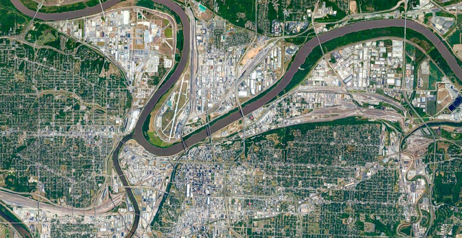
The steep terrain of the northern side of the park may protect it from flooding, but it does still pose issues with moving water that uses the cliff as a point of drainage down to the river and poses issues for any infrastructure along the cliff’s edge.

EDGE CONDITION
Kessler Park’s location is significant on more than one front, and stands as the literal capstone of the Parks and Boulevards system due to this topography. With its establishment, Kansas City has a greater context of its location in respects to the river which sits north of downtown and Kessler Park. While examining this edge condition, it is clear that Kessler Park is the largest area of green space that allows this relation to its surroundings to be seen.
By studying the terrain’s sudden dropoff situated north of KCDC’s site within Kessler Park, it is abundantly clear as to why Kessler Park’s geographical location is significant.
The entire park rides a very steep cliffside that has been used to divide the suburbs surrounding it. Because of this natural feature, George Kessler’s design for the park featured a byway now known as Cliff Drive, which stands as the only urban scenic bypass in the United States and makes incredible use of the existing dropoff. Following the establishment of the park, the East Bottoms and surrounding neighborhoods made quick use of this geographical feature by constructing a gravity-operated water reservoir at the top of Kessler Park
N-SEdgeConditionSections R&A 30
Kessler Park
TOPOGRAPHICAL RELATIONSHIPS
Within our immediate study area, there were several topographical relationships that were the subject of study. Specifically, these studies examine relationships between the reservoir and important nodes of activity or viewshed elsewhere in the park. These are identified as an existing basketball pad downhill from the reservoir, and a scenic overlook at the northwest edge of the park. An additional section was cut to understand where a major roadway bisects Kessler Park to connect the Northeast Neighborhoods to
the East Bottoms. By examining these relationships in section, the studio was able to identify topographical issues and opportunities for this vision study. Currently, this basketball pad is situated in an area that is prone to flooding, and therefore does not receive adequate or consistent use. The overlook condition, however, is an important viewshed that allows users within the park to orient themselves to several Kansas City landmarks such as the Buck O’neil Bridge, and the downtown Kansas City skyline.
RESERVOIR OVER LOOK RESERVOIRBASKETBALL PAD BasketballPadSection OverlookSectionFrom the Chestnut Trafficway section, it becomes clear just how large the difference in height is between the residential neighborhoods and the industrial area of the East Bottoms below. Kessler Park is a stark boundary between these two worlds and Chestnut Trafficway serves as an extremely important artery in this part of Kansas City.
KESSLER PARK NodeConditionSection ChestnutTrafficwaySection N-SEdgeConditionSectionsR&A 32
SECTIONAL SURVEY


Diving further into the sectional aspects of Kessler Park, the immediate site was then sliced into NorthSouth running segments to further understand what the topography does within the park. This combined with the next few pages of sectional studies help to create an analytical profile of the reservoir and its surrounding context while learning about nodes that can contribute to the site.

ThroughStreetLookingatReservoir ReservoirtoNorthTerraceLake ReservoirOverlook ReservoirtoChestnut ReservoirtoBasketballPad ReservoirtoCliffDrive LowspotsIdentified


1 16 1 2 3 4 5 6 7 8 10 11 12 13 14 15 16 9 R&A 34
VIEWSHEDS


From the reservoir, there are many viewsheds that can be seen. All of these lines of sight are important in allowing visitors to see how unique Kessler Park is from its vantage point. Standing at the Reservoir, visitors can gain clear views to the East Bottoms, Downtown Kansas City, Missouri, and other landmarks within Kessler Park. Despite being heavily vegetated along its borders, these lines of sight are especially clear from the Reservoir, which at its edges, are at the highest elevation in this part of Kessler Park. This is why it remains important to analyze the Reservoir’s location in the park.
 KCMuseumView DowntownKCView KesslerParkViews
RegionalViews
LocalViews
R&A 36
ACCESSIBILITY TO AMENITIES
Within Kansas City, transportation is a primary concern for the accessibility of anchor parks, specifically Kessler Park. Transit has been analyzed here by looking at car travel times at two different scales. These highlight both regional accessibility to Kessler Park, as well as neighborhood accessibility to and from Kessler Park. Currently, there is a disconnect between main arteries of transportation and the main entrances of Kessler Park, which contribute to its inaccessibility.
Along these roadways, there are a variety of districts which allow for amenities within the city. Currently, these areas of amenity are removed from Kessler Park and are situated in clusters geared toward populations living near downtown. The map to the right indicates this lack of amenities nearby Kessler Park at the regional scale, and show how this distribution of event space leaves the Northeast Neighborhood isolated from Kansas City’s activity.
Minutes 20
Minutes
15
MajorDestinationsinKC
District
Node
Destination
Kessler Park KC Museum Memorial Park WWI Museum Donald J. Hall Sculpture Park Nelson Atkins Museum of Art Mt Marty Park Rosedale Memorial Arch Mill Creek Park Vietnam Memorial Swope Park Thomas H. Swope MemorialRegionalCarTransitTimes I-70 I-70 I-29 I-35 I-35 10
5
Minutes
Minutes
Entertainment
Entertainment
Cultural
Rock Climbing
Parkwood Swimming Pool
Budd Park Pool
Jarboe Park Pool
Sequence Climb
Rock Climbing
Roeland Park Swimming Pool
Fairway Swimming Pool
Swope Park Pool
Marty Pool
Austin Harmon Park Pool
Kessler Park
Rosedale Park
Swope Park
Rock Climbing Disc Golf Skate Parks Swimming Pools
R&A 38 UniqueRecreations
Waterworks Park
Blue Valley Park
FESTIVALS & OTHER EVENTS
In addition to standard amenities in Kansas City, there are specialized events and event spaces that allow for additional cultural and seasonal festivals. Again, these areas of activity are relatively removed from the Northeast Neighborhoods and are located closer to Downtown Kansas City. There are a number of festivals that have been examined that may have success from a new venue, such as Kessler Park. By learning about the schedules and time frames for these events, the studio is able to better create a project that
demand that large-scale events hold. Currently within the Northeast Neighborhoods, there are a variety of small-scale event spaces that hold events very familiar to the locals. While a healthy majority of these events already exist in spaces within Kessler Park, it is important to understand where these events are being held so that we may continue to make space for these festivals annually.
BERKLEY RIVERFRONT
WEST BOTTOMS
BARTLE HALL
KAUFFMAN CENTER
CROSSROADS
UNION STATION
CROWN CENTER
POWER AND LIGHT
18TH AND VINE
HOSPITAL HILL
WESTPORT
NELSON-ATKINS
SOUTHMORELAND PARK PLAZA
RegionalFestivalsandSeasonalEvents
Physical Cultural Seasonal Other
Heim’s Electric Park
Northeast Athletic Fields
Budd Park
Kessler Park
Concourse
Maple Park
Independence Plaza Park
Lykins Square
Harmony Park
Prospect Plaza Park
9th & Van Brunt Athletic Fields
NeighborhoodAmenities
KANSAS CITY MUSEUM
DIA DE LOS MUERTOS POMP AND CEREMONY
COLONNADE
ROOTBEER FLOAT BLOCK ANNUAL FLEA MARKET CLIFF HANGER 5K / 10K
ST. JOHN COMMUNITY GARDEN
SUMMER DUSK CONCERTS
NORTHEAST NEIGHBORHOOD CHALK WALK
NeighborhoodFestivals&SeasonalEvents
5min
10min 20min
5 min
10 min
Services Education
Religious Institutions
Cultural Institutions
Walking Radius
Physical Cultural Seasonal Other
R&A 40
ACTIVITIES ANALYSIS
Additional analysis subsequently categorizes current amenities and activities available to the populations living in the Northeast Neighborhoods, and how far these amenities are currently from Kessler Park. Most services in this area are located along main roads that run East to West, such as Lexington Avenue and Independence Avenue. These streets serve as arteries that pull locals to amenities easily and quickly. This comes at a disadvantage to Kessler Park, which sits North of both of these streets, meaning there is not adequate traffic flow to and from Kessler Park through the lens of available ammenities in proximity to it. Additionally, most of the serviceable area directly adjacent to Kessler Park located in residential sectors, meaning there are plenty of people nearby who desire access to amenities in their own neighborhoods.
Amenities
Education Services Religious Institutions
Cultural Institutions
Main Trails
Connections
Marked Paths
Proposed Trails
INDEPENDENCE 12TH THE PASEO LEXINGTON AVE JOHN AVE MAPLE BLVD GLADSTONE BLVD CHOUTEAUTRFY I-70 I-670 9 HIGHWAY HARDESTY AVE BELMONT BLVD INDEPENDENCE AVE 12TH ST THE PASEO I-70 LEXINGTON AVE ST. JOHN AVE MAPLE BLVD GLADSTONE CHOUTEAUTRFY FRONT STREET GRANDMAIN STBROADWAY BLVD I-670 HIGHWAY169 HARDESTY AVE BELMONT BLVD
BusRoutes
Trails&WalkingTimes
At the Neighborhood Scale, most forms of entertainment, namely restaurants and eateries, are located along Independence Avenue. Other clusters of food-based amenities can be found along St. John Avenue, which leads directly to Kessler Park. Religious establishments were considered to be sparse in this area other than the existing handful.
Kessler Park has an opportunity to become an entertainment hub for these east neighborhoods. The studio’s investigation into walking times highlighted the proximity of Kessler Park to potential new businesses. This area stood to have an ideal capacity for much more commercial activity than what was currently seen making room for Kessler Park to become a major destination within the city.
AmenitiesConclusion
Education Services
Religious Institutions
Cultural Institutions
Walking Radius
R&A 42

FINDINGS AND STRATEGY
RESEARCH CONCLUSION
After collecting and considering all of the site analysis research, conclusions were drawn about the large-scale conceptual organization of the city in relation to Kessler Park. In this case, the large scale considerations take into account the research culminations of the regional scale findings and the Neighborhood scale findings. These dive into how Kessler Park currently connects to the amenities, activities, and public transportation grid of the surrounding city and neighborhoods to see how users could access the park and what was causing them to avoid it. This also helps to develop ideas for how best to reintegrate the disconnected park to the city and surrounding events. This, in turn, allows Kessler Park to better connect with the city experience as well as lending a hand in drawing users from outside the immediate site.

R&A 44
RESERVOIR AT THE REGIONAL & NEIGHBORHOOD SCALE
The findings developed based on the regional studies of activity, transportation, and amenities found that there is only one east-west collector street that feeds to two main north-south corridors that helped create a disconnect between the park and the city. Paseo Boulevard and Prospect Avenue act as the main north-south corridors to Kessler Park. Independence Avenue is a collector street for those North-South corridors along with Chestnut Avenue from the East Bottoms. However, Paseo Boulevard and Prospect Avenue have previously been treated as boundaries, separating the east and west sides of the city.
This creates a disconnection between destinations throughout the city by making them seem as though they are separate from one another.
Kessler Park has the opportunity to become a regional destination, which the East side of the city lacks. Instead of the North-South corridors of Paseo Boulevard and Prospect Avenue being disconnected streets, they can become collector streets for Kessler Park if it were to be considered a major destination in the city.
EAST BOTTOMS
ST. JOHN AMENITIES
INDEPENDENCE AVE. AMENITIES
NeighborhoodIntegration
Corridor
Connections Destination Hubs
EAST BOTTOMS
DOWNTOWN
18TH & VINE
MIDTOWN THE PLAZA
SWOPE PARK
Hubs
RegionalIntegration R&A 46
Corridor Connections
Destination
GOALS & OBJECTIVES
Once the park was fully analyzed at a multitude of scales and access to the city was determined to be possible, a series of goals and objectives were determined to provide a clear design vision for the project moving forward. The overarching mission of the project was concluded to be “To re-purpose the Kessler Park Reservoir and use it as a catalyst for the improvement of the area while enhancing the relevance of Kessler Park to the community”.
Three primary goals were then developed to best accomplish the mission and further the value of the vision study. The goals included creating a regional amenity, emphasizing the reservoir as an amenity to the local community, and ensuring the reservoir can function as a gathering location for the surrounding park.
Throughout the remainder of the academic year and the development of the individual design schemes, the studio mission was maintained in order to give the project a clear goal and purpose.

Mission
oftheareawhileenhancingtherelevanceofKesslerParktothecommunity”
Goals Objectives
Emphasize north/south corridors to Kessler Park
Repurpose the abandoned Kessler Park Reservoir to create a regional amenity in order to reintegrate Kessler Park into the order of the city.
Improve walking and biking connections to and from the park
Enhance public transportation options to the area Integrate/intersect/preserve the reservoir to provide program that can be integrated into the park
Emphasize the Kessler Park Reservoir as a significant amenity to the northeast community.
Ensure that the Kessler Park Reservoir can function as a primary gathering location for the park area.
Provide unique programs that are not available at any other significant parks at the regional scale
Preserve the functions of the current park in the reimangined vision Provide day-to-day uses outside of regional uses
R&A 48 “Tore-purposetheKesslerParkReservoiranduseasacatalystfortheimprovement
PROGRAMMING
The programmatic matrix was developed as a result of all our previous research and analysis to understand how we can better programmatically design the reservoir and the immediate surrounding site. It reflects the ways in which each of the different categories correspond to various aspects of the project. Each of the categories were studied through concepts, relevant maps, design concerns, goals and design
values. The graphic below depicts how various programmatic uses relate depending on fixed or flexible function. The reservoir and immediate surrounding context can utilize both fixed and flexible functions to better accompany different uses. The next graphic shows how various programmatic uses relate depending on daily or seasonal use. The reservoir and immediate
FIXED FLEXIBLE Pavilions FIXED FLEXIBLE
PAVILIONS
Water / Plant Gardens Restrooms
Open Lawn Public Stage
WATER / PLANT GARDENS RESTROOMS OPEN LAWN PUBLIC STAGE WALKING / BIKING TRAILS PARKING PLAYGROUNDS
SPORTING INFRASTRUCTURE
Walking / Biking Trails Parking Playground Sporting Infrastructure
DAILY USES
MARKET AREAS
WATCHING SPORTING EVENTS ART INSTALLATIONS
DRIVE IN MOVIES / MUSICALS ON-STREET EVENTS FESTIVALS LECTURES / WORKSHOPS HOLIDAY GATHERINGS WILDLIFE / BIRD WATCHING
Market Areas Watching Sporting Events Art Installations Drive In Movies / Musicals On-Street Events Festivals Lectures/Workshops Holiday Gatherings Wildlife / Bird Watching
STRONG CONNECTION CONNECTION
EVENT / SEASONAL USES
EVENT / SEASONAL USESDAILY USES
PICNICKING
Picnicking
PLAYING IN OPEN LAWN FISHING
Playing In Open Lawn Fishing Walking / Biking Trails
WALKING / BIKING TRAILS USING PLAYGROUNDS
Using Playgrounds
Enjoying Plant Gardens
ENJOYING PLANT GARDENS OBSERVING OVERLOOKS
Observing Overlooks
CREATING ART / GRAFFITI PLAYING SPORTS ACTIVITIES
Creating Art / Graffiti Playing Sports Activities
Attending Markets
ATTENDING MARKETS
Viewing Art Installations
VIEWING ART INSTALLATIONS
Playing Sports Competitions
PLAYING IN SPORTS COMPETITIONS
Watching Movies / Musicals
Enjoying Concerts
Enjoying Festivals Running / Bike Racing
WATCHING MOVIES / MUSICALS ENJOYING CONCERTS ENJOYING FESTIVALS RUNNING / BIKE RACING
Attending Holiday Gatherings Wildlife / Bird Watching
ATTENDING HOLIDAY GATHERINGS WILDLIFE / BIRD WATCHING
STRONG CONNECTION CONNECTION

IMMEDIATE SITE CONTEXT
FOCUS AREA STUDY
The immediate site context section discusses the area of Kessler Park directly adjacent to the reservoir. The boundary of this study area is Reservoir Drive, the road that forms a loop through this western section of Kessler Park. This portion of the park has proven important to our vision study due to its proximity to viewsheds, which offer views to downtown Kansas City, the East Bottoms, and the Kansas City Museum to the east of the reservoir.

R&A 52
ACTIVITIES
CLAIMED SPACE UNCLAIMED SPACE
The studio observed the activities, both positive and negative, that exist around the reservoir. The first move identified what spaces were being activated within our study area. This was dubbed claimed space, as these study areas are actively being used for one or more activities. Currently, park population is sparse and dumping prohibits further meaningful use of Kessler Park.
Alongside identified Claimed space exists Unclaimed space; a title reserved for areas within the park that are currently underutilized. Because of the existing topography and lack of maintenance, this puts much of the area north of the reservoir out of meaningful service. This area is known as Cliff Drive and is no longer accessible by vehicle.
ClaimedSpace UnclaimedSpace UtilizedAreas Walking/Biking Trails Underutilized
Areas
DESIRABLE ACTIVITIES
With respect toward the original intent of Kessler Park, current activities and uses for the vicinity that have a positive effect within the park have been preserved. Currently this distinction includes disc golf, walking and jogging, hiking, and biking.
UNDESIRABLE ACTIVITIES
Much of the Reservoir loop has been subjected to consistent trash dumping, lending a hand to the undesirable atmosphere along Reservoir Drive. This combined with the amount of unclaimed space contribute to a negative feedback loop that keeps Kessler Park and its reservoir from addressing their context.
DesirableUses
UndesirableUses
R&A 54
Walking/Biking Trails
Dog Walkers Burnouts Graffiti Dumping Parked Cars
ROOMS
When examining the foliage and topography surrounding the reservoir, it became clear there were boundaries and spaces created out of natural elements within Kessler Park. These ‘rooms’ orient themselves around the reservoir based on these natural elements and contain zones, which have been observed being used for different activities based on their location.
Three main rooms make up the area immediately surrounding the reservoir, which have been labeled using three different colors. The southeast or Purple room contains activities such as disc golf, and includes two grassy lawns bordered with trees which sit lower than the road. The northwest or Blue room contains two zones which are based on topography, and are the most open areas around the reservoir. The southwest or Yellow room includes a large portion of hilly topography that sits lower than the reservoir itself.
PurpleRoom BlueRoomYellowRoom
AxonometricView
OverallDefinition Zones PurpleRoom
R&A 56
OverallDefinition Zones BlueRooms
AxonometricView
AxonometricView
OverallDefinition Zones YellowRooms
R&A 58
DEMOGRAPHICS
To better grasp the populations this study will affect, the studio took special consideration when learning about the nearby neighborhoods, their demographics, income, history, and racial/ethnic profiles. This has been done in part with the findings of the Urban Land Institute’s national technical panel in Kansas City, and has provided KCDC with a well-rounded understanding of Kessler Park’s immediate context.
Over half of the current population in the area known as the Northeast Neighborhoods are people of color, making this area one of the most diverse regions in Kansas City proper. This collective of neighborhoods has been this diverse since their founding, and gives us a look into the social structures and values of the Northeast Neighborhoods.
1940s: 29,000 1950s: 35,000 1960s: 30,000 1970s: 23,500
1980s: 20,000 1990s: 17,500 2000s: 20,000 2010s: 19,000
NumberofPeople(1940-2010)
White: 45.3%
African American: 21.3%
Other Races: 18.7%
RaceandEthnicity
Asian: 8.9%
More than one race: 5%
Native American: 0.08%
PENDLETON HEIGHTS SCARRITT RENAISSANCE INDIAN MOUNDAdjacentNeighborhoods
PERCENT OF OCCUPIED UNITS BY ETHNICITY RENTED RENTED RENTEDOWNED OWNED OWNED AFRICAN AMERICANWHITE HISPANIC Kansas City TOTAL WHITE AFRICANAMERICAN HISPANIC ELDERLY SELECTED POPULATION GROUPS 100 80 60 40 20 0 50 40 30 20 10 0 R&A 60 AgeRange 0 3 6 9 12 15 UNDER5YEARS5TO9YEARS10TO14YEARS15TO19YEARS20TO24YEARS25TO34YEARS35TO44YEARS45TO54YEARS55TO64YEARS65TO74YEARS75YEARSOROLDER PERCENT PER AGE GROUP (%) OTO1010TO2020TO3030TO4040TO5050TO6060TO7575TO100100TO125125TO150150TO200 PERCENT PER AGE GROUP (%) 0 5 10 15 20 IncomeinThousandsofDollars OwnedorRentedunitsbyEthnicity SelectedGroupswithinPopulation
