
15 minute read
1 Introduction


NSW Government’s Manly Hydraulics Laboratory (MHL) was engaged by MidCoast Council (Council) to undertake a review of the Floodplain Risk Management Study and Plan (FRMSP) for Bulahdelah following the NSW Government’s Flood Prone Land Policy update and with financial support from the Biodiversity, Conservation and Science group (BCS) of the NSW Department of Planning Industry and Environment (DPIE), as well as technical support from DPIE and the NSW State Emergency Services
There have been various hydrologic and hydraulic studies undertaken for the Bulahdelah catchments. The most recent study was the Myall River Floodplain Risk Management Study and Plan (DIPNR, 2003). The 2003 FRMSP reported the flood behaviour across the catchment for a range of design flood events for existing topographic and development conditions.
The objective of the present study is to review the 2003 Myall River Floodplain Risk Management Study and Plan for Bulahdelah focusing on flooding from Myall River and its tributaries as local catchment flows have already been studied in the Bulahdelah Stormwater Management Plan (Cardno, 2020)
2 Background
2.1 Study area
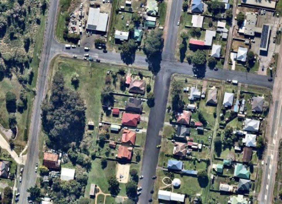
The focusof the present investigation isthe township of Bulahdelah and Frys Creekcatchment. The township of Bulahdelah is located approximately 70 km north-east of Newcastle, between the Pacific Highway and the Myall River near its confluence with the Crawford River.
The Myall River catchment upstream of Bulahdelah has a catchment area of approximately 370 km2 including its tributaries catchment areas of 125 km2 for the Crawford River and 18 km2 for Frys Creek. The catchment is steep upstream of Bulahdelah and flattens downstream of the township.
It is understood that the dominant flooding mechanism is the mainstream flooding from the Myall River and the Crawford River as no structures are protecting the township from floods. However, it is noted that the township can also be subject to local overland flooding. The flood behaviour has also been influenced by the construction of the new Pacific Highway in 2013. The study area is presented in Figure 2.1.
2.2 History of flooding and rainfall
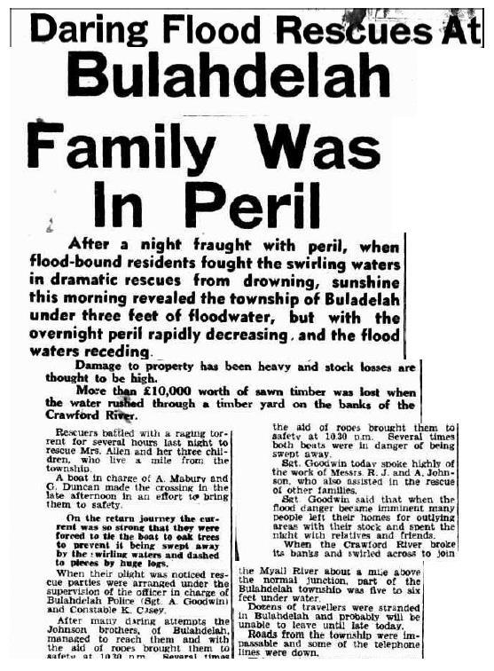
Several significant historical floods were reported in 1897 and 1927. Smaller floods occurred in 1947 and 1953, and less severe floods happened in 1985 and 1987
The largest flood at Bulahdelah was reported in 1897, reaching the level of 5.5 m AHD on the upstream side of the highway bridge (at the existing Myall River Bridge) with an estimated magnitude of 100 year Average Recurrence Interval / ARI (equivalent to 1% Annual Exceedance Probability / AEP) (Public Works, 1991) The next largest reported flood occurred in 1927 reaching a levelof 5.1 m AHD at the highway bridge (at the existing Myall River Bridge) with an estimated magnitude of 50 year ARI (2% AEP). A flood level of 6.4 m AHD was reported at the confluence of the Myall and Crawford Rivers approximately 500 m upstream. A flood level of 6.5 m AHD was reported near the water supply weir in the Crawford River for both the 1897 and 1927 floods (Public Works, 1991)
A peak flood level of 3.7 m was reported at the highway bridge in October 1985 and November 1987. However, the 1985 flood was higher upstream of the bridge (Public Works, 1991) The largest events recorded by the water level gauge in Bulahdelah (installed in November 1984) are March 2021, April 2015, March 2013 and January 2016 events with the corresponding peak flood level of 4.3 m, 4.1 m, 3.9 m and 3.8 m The March 2021 flood occurred during the development of this study and MHL’s project team undertook some post-event surveys as described in Section 4.8
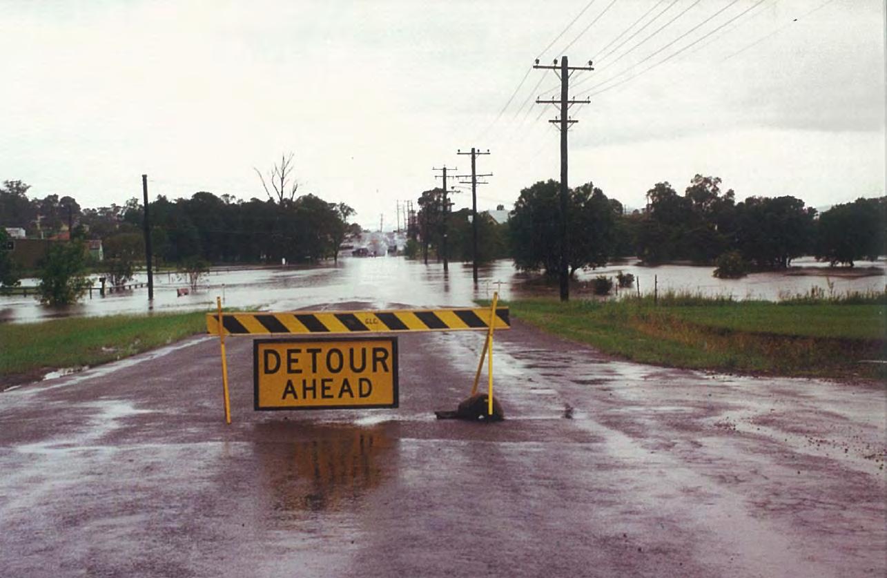
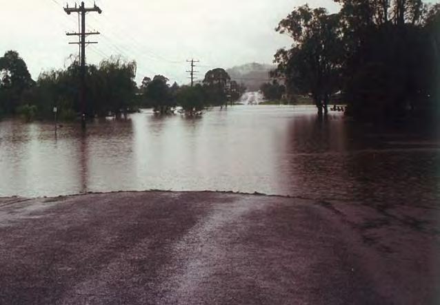
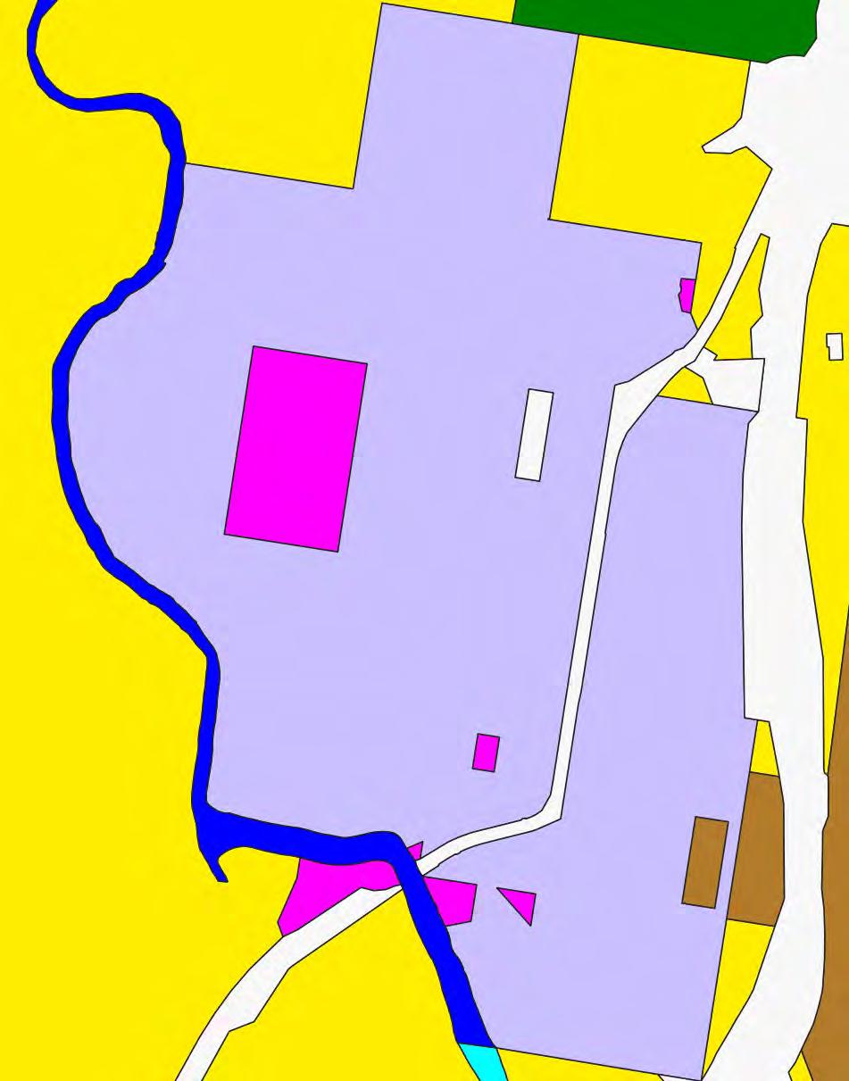
Some photographs of the past events have been provided by community members. The locations and orientation of the photographs are provided in Figure 2.2, and some examples are provided in Figure 2.3 to Figure 2.7.
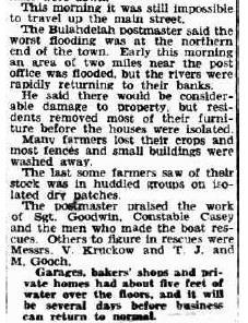
Historical newspaper articles describing flooding at Bulahdelah have been provided in Figure 2 8 and Figure 2 9

Photograph providedby community
Legend
Cadastre
Photographlocationand directionduringflood eventon: 8June2007 21April2015
ReportMHL2789
ReviewofBulahdelah FloodplainRisk ManagementStudy&Plan


2.3 Relevant policies, legislation and guidance
2.3.1 National provisions
2.3.1.1 AustralianRainfallandRunoff,2019
Australian Rainfall and Runoff (ARR) is a national guideline document, data and software suite that is used for the estimation of design flood characteristics in Australia. This is the 4th edition of ARR after the 1st edition was released by Engineers Australia in 1958. Geoscience Australia supports ARR as part of its role to provide authoritative, independent information and advice to the Australian Government and other stakeholders to support risk mitigation and community resilience.
ARR is pivotal to the safety and sustainability of Australian infrastructure, communities and the environment. It is an important component in the provision of reliable and robust estimates of flood risk. Consistent use of ARR ensures that development does not occur in high-risk areas and that infrastructure is appropriately designed.
2.3.1.2 BuildingCodeofAustralia
The 2016 edition of the Building Code of Australia (BCA) introduced new requirements related to building in Flood Hazard Areas (FHAs), which provide a minimum construction standard across Australia for specified building classifications in FHAs up to the Defined Flood Event (DFE).
The DFE is analogous to the planning flood event and is most commonly the 1% AEP flood. FHAs are defined in the BCA as encompassing land lower than the flood hazard level (FHL), which in turn is defined as ‘the flood level used to determine the height of floors in a building and represents the DFE plus the ‘freeboard’. Therefore, FHAs would typically be defined as those areas falling within the flood planning area.
Volume One, BP1.4, and Volume Two, P2.1.2 specify the Performance Requirements for the construction of buildings in FHAs. They only apply to buildings or parts of buildings of Classes 1, 2, 3, 4 (residential), 9a (health-care) and 9c (aged-care). These Performance Requirements require a building in an FHA to be designed and constructed to resist flotation, collapse and significant permanent movement resulting from flood actions during the DFE. The actions and requirements to be considered to satisfy this performance requirement include but are not limited to:
• Flood actions
• Elevation requirements
• Foundation and footing requirements
• Requirements for enclosures below the flood hazard level
• Requirements for structural connections
• Material requirements
• Requirements for utilities
• Requirements for occupant egress
The Deemed-to-Satisfy (DTS) provisions of Volume One, B1.6, and Volume Two, 3.10.3.0 require buildings in the classes described above and located in FHAs to comply with the Australian Building Code Board (ABCB)Standard for Construction of Buildings in Flood Hazard Areas 2012 (the ABCB Standard).
The ABCB Standard specifies detailed requirements for the construction of buildings to which the BCA requirements apply, including:
• Resistance in the DFE to flood actions including hydrostatic actions, hydrodynamic actions, debris actions, wave action and erosion and scour
• Floor height requirements, for example that the finished floor level of habitable rooms must be above the FHL
• The design of footing systems to prevent flotation, collapse or significant permanent movement
• The provision in any enclosures or openings to allow for automatic entry and exit of floodwater for all floods up to the FHL
• Ensuring that any attachments to the building are structurally adequate and do not reduce the structural capacity of the building during the DFE
• The use of flood-compatible structural materials below the FHL
• The siting of electrical switches above the FHL, and flood proofing of electrical conduits and cables installed below the FHL
• The design ofbalconiesetc. to allowa person in the building to be rescued byemergency services personnel, if rescue during a flood event up to the DFE is required
Building Circular BS13-004 (NSW Department of Planning and Infrastructure, 2013) summarises the scope of the BCA and how it relates to NSW planning arrangements. The scope of the ABCB Standard does not include parts of FHA that are subject to flow velocities exceeding 1.5 m/s or are subject to mudslide or landslide during periods of rainfall and runoff or are subject to storm surge or coastal wave action.
It is particularly noted that the Standard applies only up to the DFE, which typically will correspond to the level of the 1% AEP flood plus 0.5 m freeboard. The Building Circular emphasises that because of the possibility of rarer floods, the BCA provisions do not fully mitigate the risk to life from flooding.
The ABCB has also prepared an Information Handbook for the Construction of Buildings in Flood Hazard Areas. This Handbook provides additional information relating to the construction of buildings in FHA but is not mandatory or regulatory in nature.
In the NSW planning system, the BCA takes on importance for complying development under the State Environmental Planning Policy (Exempt and Complying Development Codes) 2008.
2.3.2 State provisions
2.3.2.1 EnvironmentalPlanningandAssessmentAct,1979 General
The NSW Environmental Planning and Assessment Act 1979 (EP&A Act) creates the mechanism for development assessment and determination by providing a legislative framework for development and protection of the environment from adverse impacts arising from development. The EP&A Act outlines the level of assessment required under State, regional and local planning legislation and identifies the responsible assessing authority.
Prior to development taking place in NSW a formal assessment and determination must be made of the proposed activity to ensure it complies with relevant planning controls and, according to its nature and scale, conforms with the principles of environmentally sustainable development.
Section 7.11 Development Contributions
Section 7.11 (previously Section 94) of the EP&A Act enables councils to collect contributions from developers for the provision of infrastructure that is necessary as a consequence of development. This can include roads, drainage, open space and community facilities. Each council must develop a Section 94 Contributions Plan which demonstrates a quantifiable link between the development intensification and the need for the additional infrastructure as well as a detailed costing of such infrastructure and formulae to be used to determine contributions from each type of development.
Section 9.1 Directions – Direction No. 4.3 (Flood Prone Land)
NSW flood-related planning requirements for local councils are set out in Ministerial Direction No. 4.3 Flood Prone Land, issued in 2007 under the then Section 117 (now Section 9.1) of the EP&A Act. It requires councils to ensure that development of flood prone land is consistent with the NSW Government’sFlood Prone Land Policy as set out in the Floodplain Development Manual (NSW Government, 2005). It requires provisions in a Local Environmental Plan on flood prone land to be commensurate with the flood hazard of that land. In particular, a planning proposal must not contain provisions that:
• Permit development in floodway areas
• Permit development that will result in significant flood impacts to other properties
• Permit a significant increase in the development of that land
• Are likely to result in a substantially increased requirement for government spending on flood mitigation measures, infrastructure or services
• Permit development to be carried out without development consent except for the purposes of agriculture, roads or exempt development
The Direction also requires that councils must not impose flood related development controls above the residential flood planning level (FPL, typically the 1% AEP flood plus 0.5m freeboard) for residential development on land, unless a relevant planning authority provides ‘adequate justification’ for those controls to the satisfaction of the Director-General. However, it is noted that some special flood considerations LEP clause now allows for flood planning levels above 1% AEP + 0.5 m.
Section 10.7 Planning Certificates
Planning certificates are a means of disclosing information about a parcel of land. Two types of information are provided in planning certificates: information under Section 10.7(2) and information under Section 10.7(5) of the EP&A Act. (Note that previously this clause was Section 149).
A planning certificate under Section 10.7(2) discloses matters relating to the land, including whether or not the land is affected by a policy that restricts the development of land. Those policies can be based on identified hazard risks (Environmental Planning and Assessment Regulation 2000, Clause 279 and Schedule 4 Clause 7), and whether development on the land is subject to flood-related development controls (EP&A Regulation, Schedule 4 Clause 7A). If no flood-related development controls apply to the land (such as for residential development in so-called ‘low’ risk areas above the FPL, unless ‘adequate justification’ has been satisfied), information describing the flood affectation of the land would not be indicated under Section 10.7(2). A lot that is a ‘flood control lot’ under the Codes SEPP is a prescribed matter for the purpose of a certificate under section 10.7(2).
A planning certificate may also include information under Section 10.7(5). This allows a council to provide advice on other relevant matters affecting land. This can include past, current or future issues.
Inclusion of a planning certificate containing information prescribed under section 10.7(2) is a mandatory part of the property conveyancing process in NSW. The conveyancing process does not mandate the inclusion of information under section 10.7(5) but any purchaser may request such information be provided, pending payment of a fee to the issuing council.
2.3.2.2
StateEnvironmentalPlanningPolicies(SEPPs)
SEPPs are the highest level of planning instrument and generally prevail over Local Environmental Plans.
SEPP (Housing for Seniors or People with a Disability) 2004
State Environmental Planning Policy (Housing for Seniors or People with a Disability) 2004 aims to encourage the provision of housing (including residential care facilities) that will increase the supply of residences that meet the needs of seniors or people with a disability. This is achieved by setting aside local planning controls that would prevent such development.
Clause 4(6) and Schedule 1 indicate that the policy does not apply to land identified in another environmental planning instrument as being, amongst other descriptors, a floodway or high flooding hazard.
SEPP
(Infrastructure) 2007
State Environmental Planning Policy (Infrastructure) 2007 aims to facilitate the effective delivery of infrastructure across the State by identifying development permissible without consent. SEPP (Infrastructure) 2007 allows Council to undertake stormwater and flood mitigation work without development consent.
SEPP (Exempt and
Complying Development Codes) 2008
A very important SEPP is State Environmental Planning Policy (Exempt and Complying Development Codes) 2008, which defines development which is exempt from obtaining development consent and other development which does not require development consent if it complies with certain criteria.
Clause 1.5 of this ‘Codes’ SEPP defines a ‘flood control lot’ as ‘a lot to which flood related development controls apply in respect of development for the purposes of dwelling houses, dual occupancies, multi dwelling housing or residential flat buildings (other than development for the purposes of group homes or seniors housing)’. These development controls may apply through a Local Environmental Plan (LEP) or DCP. Exempt development is not permitted on flood control lots but some complying development is permitted.
Clause 3.5 states that complying development is permitted on flood control lots where a Council or professional engineer can certify that the part of the lot proposed for development is not a flood storage area, floodway area, flow path, high hazard area or high-risk area. The Codes SEPP specifies various controls in relation to floor levels, flood compatible materials, structural stability (up to the PMF if on-site refuge is proposed), flood affectation, safe evacuation, car parking and driveways.
In addition, Clause 1.18(1)(c) of the Codes SEPP indicates that complying development must meet the relevant provisions of the Building Code of Australia.
SEPP
(Coastal Management) 2018
SEPP (Coastal Management) 2018 aims to promote an integrated and co-ordinated approach to land use planning in the coastal zone. For areas mapped as ‘coastal wetland and littoral rainforests’ – including sizeable areas in the study area near the three lakes – development consent is required for the clearing of native vegetation, and for earthworks, construction of a levee, draining the land and environmental protection works, and for any other development. For areas mapped as ‘coastal environment areas’ – covering much of the study area –development consent must not be granted unless the consent authority has considered whether the proposed development is likely to cause an adverse impact on “the integrity and resilience of the biophysical, hydrological (surface and groundwater) and ecological environment” amongst other factors. The development must be designed, sited and managed to either avoid, minimise or mitigate adverse impacts.
2.3.2.3 NSWFloodRelatedManuals Floodplain Development Manual, 2005
The Floodplain Development Manual 2005 (the Manual) was gazetted on 6 May 2005 and relates to the development of flood liable land. It incorporates the NSW Flood Prone Land Policy, which aims to reduce the impacts of flooding and flood liability on individual owners and occupiers of flood prone property and to reduce private and public losses resulting from floods, using ecologically positive methods wherever possible. To implement this policy and achieve these objectives, the Manual espouses a merit approach for development decisions in the floodplain, taking into account social, economic, ecological and flooding considerations. The Manual confirms that responsibility for management of flood risk remains with local government. It assists councils in their management ofthe use and development of flood prone land by providing guidance in the development and implementation of local floodplain risk management plans.
At the time of preparing this report, the Floodplain Development Manual is being updated.
Guideline on Development Controls on Low Flood Risk Areas, 2007
The Guideline on Development Controls on Low Flood Risk Areas – Floodplain Development Manual (the Guideline) was issued on 31 January 2007 as part of Planning Circular PS 07003 at the same time as the Section 117 (now Section 9.1) Directive described previously. The Guideline is intended to be read as part of the Floodplain Development Manual
It stipulates that unless there are exceptional circumstances, councils should adopt the 100year flood as the flood planning level (FPL) for residential development and that ‘unless there are exceptional circumstances, councils should not impose flood related development controls on residential development on land … that is above the residential FPL’.
An adequate freeboard should then be applied to the 100-year flood level to allow for potential inaccuracies in available data and limitation of the flood models.
Flood related development controls are not defined but would include any development standards relating to flooding applying to land, thatare a matter for consideration under Section 4.15 (previously Section 79C) of the EP&A Act.
The Guideline states that councils should not include a notation for residential development on Section 10.7 (previously Section 149) certificates for land above the residential FPL if no flood related development controls apply to the land. However, the Guideline does include the reminder that councils can include ‘such other relevant factors affecting the land that the council may be aware [of]’ under Section 10.7(5) of the EP&A Act.
In proposing a case for exceptional circumstances, a council would need to demonstrate that a different FPL was required for the management of residential development due to local flood behaviour, flood history, associated flood hazards or a particular historic flood. Justification for exceptional circumstances would need to be agreed by relevant State Government departments prior to exhibition of a draft local environmental plan or a draft development control plan that proposes to introduce flood related development controls on residential development above the default FPL.
At the time of preparing this report, the Guideline is being reviewed.
2.3.3 Local provision
In NSW, local government councils are responsible for managing flood risk within their Local Government Areas (LGAs). An LEP is used to establish what land uses are permissible and/or prohibited on land within the LGA and sets out high level flood planning objectives and requirements. A Development Control Plan (DCP) sets the standards, controls and regulations that apply when carrying out development or building work on land. This section briefly describes and reviews the flood-related controls within the MidCoast policies, with a view to flood behaviour in the Bulahdelah study area.
2.4 Land use
Land-use zoning in Bulahdelah is defined in the Great Lakes Local Environmental Plan (LEP) 2014, shown in Figure 2.10 The majority of the township itself is zoned as “RU5 Village” with a small area to the southwest and an area in the middle of the township zoned as “RE1 Public Recreation”. The Pacific Highway which connectsBulahdelah to neighbouring towns is located to the southeast of the town and zoned as “SP2 Infrastructure”. Figure 2.10 shows that an area zoned as “C1 National Parks and Nature Reserves” is located to the north of the town. The majorityof the floodplain west and north of Bulahdelah is zoned as “RU2 RuralLandscape” and downstream of Bulahdelah as “C2 – Environmental Conservation” or “C3 – Environmental Management”. The vegetated and elevated areas around the ridges of the catchment and Bombah Broadwater are zoned as either “C1 – National Parks and Nature Reserves” or “RU3 – Forestry”. Myall River itself is zoned as a “W2 Recreational Waterways” along and upstream of Bulahdelah and as “W1 – Natural Waterways” downstream of the township
2.5 Demographic overview
Understanding the social characteristics of the study area can help ensure appropriate risk management practices are adopted and shape the methods used for community engagement. House tenure and age distribution data obtained from census data can indicate the community’sexperience with recent flood events,and hence an indication of community’s flood awareness. As per The Bureau of Meteorology Flood Preparedness Manual, using the population census data and other information held by councils and state agencies can help to identify the potential number and location of people in an area with special needs or requiring additional support during floods (Australian Government (Attorney – General’s Department), 2009). The relevant information has been extracted from the 2016 Census for the town of Bulahdelah (and surrounds) and tabulated in Table 2.1
Classification: Release by consent
Landuse
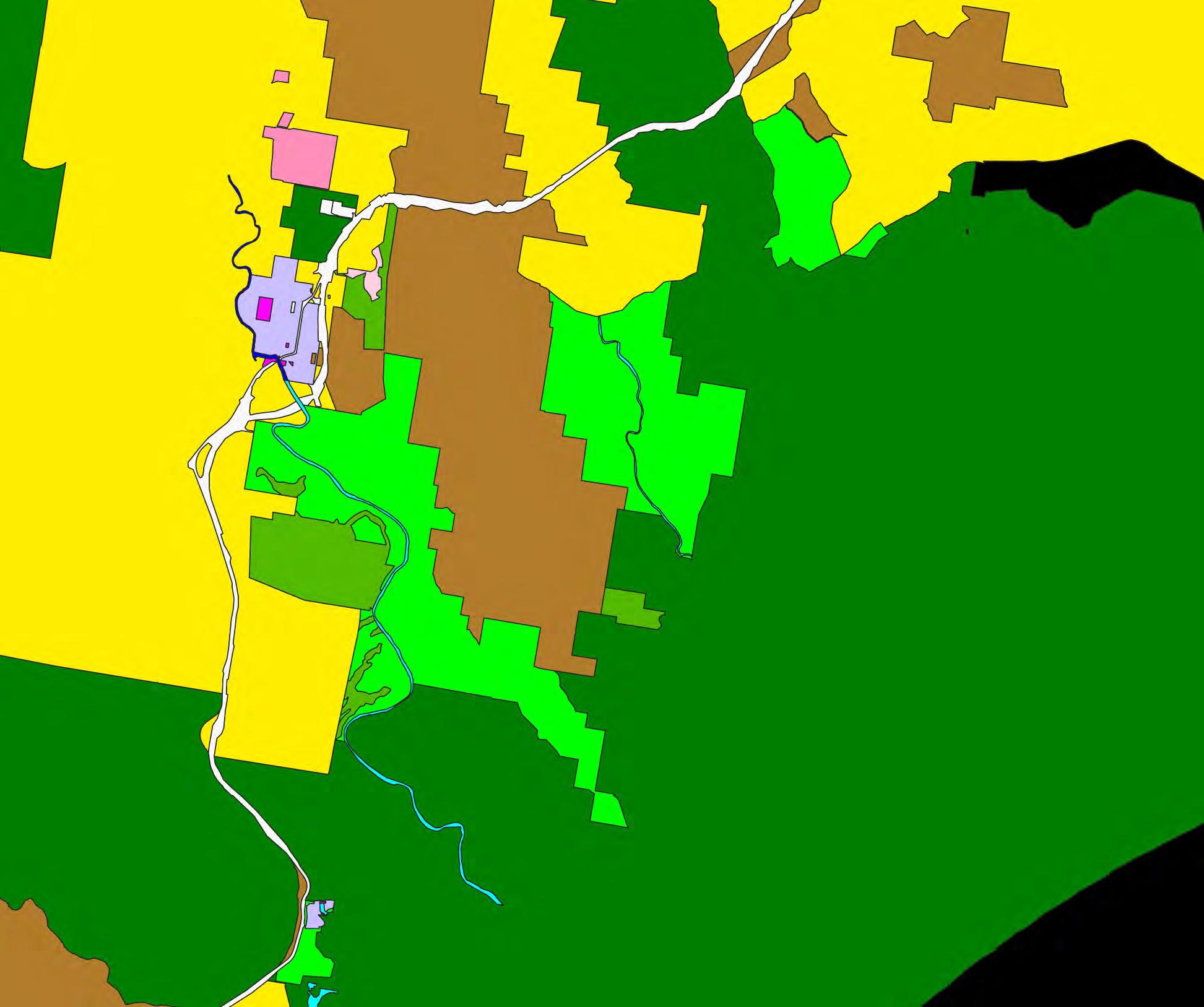
Legend
Studyarea
LandZoningCategory
C1-NationalParksand NatureReserves
C2-Environmental Conservation
C3-Environmental Management
R2-LowDensity Residential
R5-LargeLot
Residential
RE1-PublicRecreation
RU2-RuralLandscape
RU3-Forestry
RU5-Village
SP2-Infrastructure
W1-NaturalWaterways
W2-Recreational Waterways
ReportMHL2789
ReviewofBulahdelah FloodplainRisk ManagementStudyandPlan

Source: https://www.abs.gov.au/census/find-census-data/quickstats/2021/SAL10646

466 (75.2%, either outright or with a mortgage)
Language English only is spoken at home: 1393 (90.6%) A non-English language is spoken at home: 29 (4 7%)
Classification: Release by consent


