4 minute read
5 Community consultation


5.1 Consultation process
Consultation provides an opportunity for various stakeholders, including the community, to collaborate in developing the Bulahdelah FRMS&P. Engaging the community throughout the process provides opportunities to both garner useful feedback and ideas regarding potential floodplain management measures, and increase community acceptance of the floodplain risk management plan.
The consultation program for the FRMS&P has included the following activities:
• Inception and progress meetings between the consultant and Council
• Meetings of the Bulahdelah Floodplain Risk Management Working Group
• Consultation with agencies and stakeholders
• Website development
• Letter and questionnaire for property owners
These activities are described at greater length below.
5.2 Working group
The Floodplain Management Advisory Committee (the Committee) was formed by Council to provide a forum that brings together the diverse expertise and community knowledge that is needed to address technical, social, economic and ecological issues concerning floodplain risk management in the study area. The committee fulfills the functions of a Floodplain Risk Management Committee as described in the Floodplain Development Manual (NSW Government, 2005).
The committee comprises representatives from:
• The community and farming industry
• Appropriate officers from Council and MidCoast Council Floodplain Management Advisory Committee, including planners and engineers
• NSW Department of Planning Industry and Environment, Biodiversity, Conservation and Science division (BCS)
• The NSWState Emergency Servicesand/or NSWPolice Force (acting in lieu of the NSW State Emergency Services due to the lack of Bulahdelah-based SES representative). It is noted that the nearest SES unit is located in Stroud. The NSW Police Force may receive assistance from the Rural Fire Service if required and are the main point of contact as they are located in town.
5.3 Website
A website was developed to provide information about the study, general flooding information, and a link to the online questionnaire Some snapshots of the project website are presented in
5.4 Letter and questionnaires
5.4.1 General approach
In November 2020, over 800 letters were distributed to all properties in Bulahdelah. The community letter alerted the residents and businesses of the online survey that was available to complete. A copy of the letter is included in Appendix C of this report.
An online survey was made available until end of January seeking community input about historic flooding and ideas about floodplain management options in the study area. The survey is included in Appendix C . A hardcopy of the survey was mailed to Bulahdelah’s residents at the same time as the community letter.
The online survey has been using the SurveyMonkey platform.
5.4.2 Questionnaire results
A total of 59 responses were received. This represents a response rate in the order of 7%. A total of 17 responses were provided using the online questionnaire and 42 hard-copy responses were submitted. It is noted that the questionnaire was sent to all Bulahdelah residents which includes people that are in areas unlikely to be flood affected and who may be less likely to provide a response. Results of the survey are provided in Appendix C
The following key observation were made based on the community survey:
• The vast majority of respondents have a residential property (over 79.7%) 8.5% of the properties are farming/rural, 6.8% are vacant land and 3.4% are commercial.
• Over 84% of properties are owner occupied.
• Many residents have been living there for a long time (15.3% lived between 10-20 years, about 44.1% have lived there for over 20 years and 50.3% lived there for less than 5 years)
• About 50.8% of the respondent mentioned that their property was affected by flooding. It is important to note the personal interpretation of flood affectation (i.e. flooding of property vs. flooding of building).
• 25 respondents provided one or multiple example of flood events. The most commonly impacted part of the property included the ground (~41%), the garage/shed (~22%) and the access road (~19%). About 12% of the building were affected.
• Observed flood depths were typically described as over 0.3 m (~68% over 0.3 m, ~47% over 0.5 m, ~24% over 1 m and a couple of respondents mentioned depths greater than 3 m).
• Flooding durations range between less than 1 hour to several weeks with the majority (~76%) describing flooding as lasting for a number of hours up to 24 hours.
• The flood water was described primarily as having a running pace (~46%), followed by a walking pace (~34%) and then a stationary pace (~20%).
• The main sources of flooding were described as the water flowing from local drainage channel (~33%), floodwater rising from stream/river (~19%), water flowing down the roads (~19%) followed by overflow from neighbouring properties (~15%) and ponding of water on road (~11%).
• The expected response from the respondents during a future flood event would be to stay at the property (~64%), protect/raise/secure valuable and goods at risk (~24%), follow their flood management plan (~17%), evacuate early to official evacuation point (~12%) or move upstairs (~7%). About 12% of respondents were unsure of how they would react and ~7% did not specify any answer.
• The decision to evacuate or remain at the property will be made depending on if the house cannot be flooded/respondent can cope with isolation (~36%), family safety (~29%), availability of the access road (~25%), required access to medical facilities
(~20%), flood warnings (~17%), care for pets/animals (~14%) and discomfort/cost of being isolated by floodwaters (~7%).
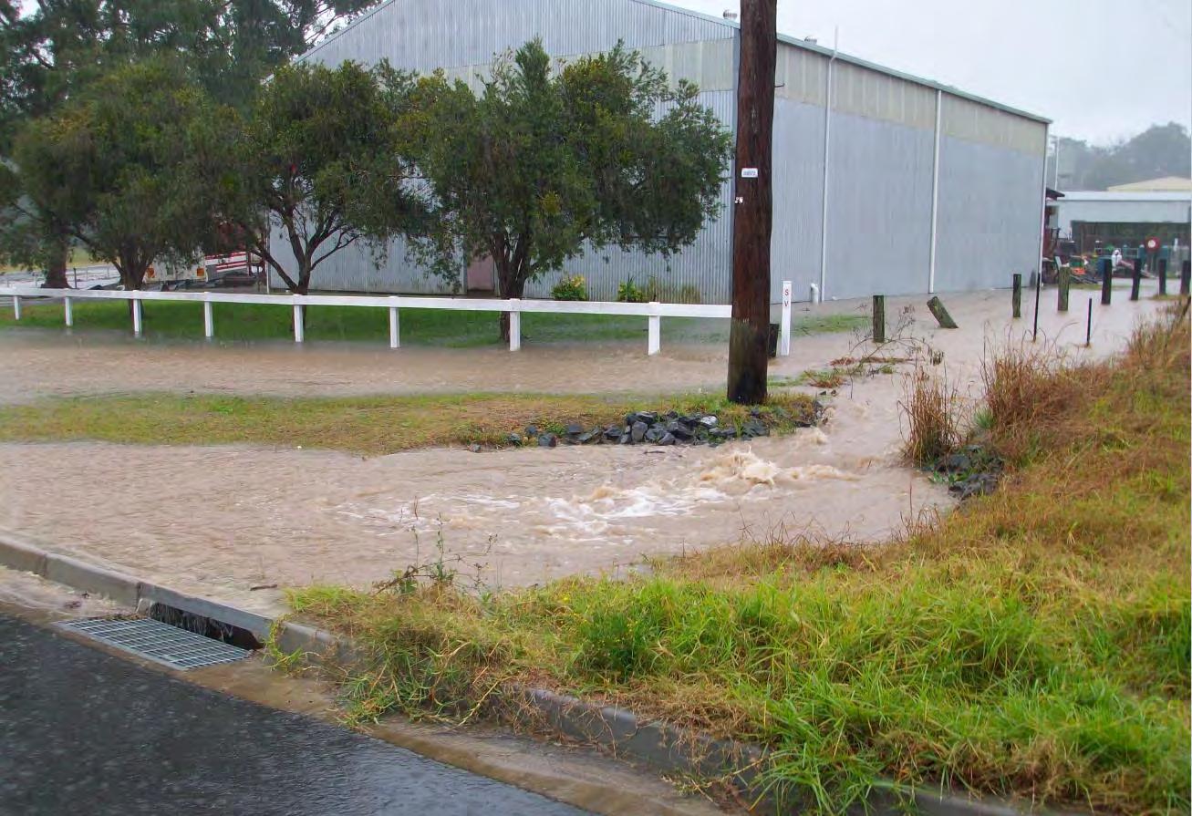
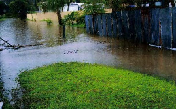
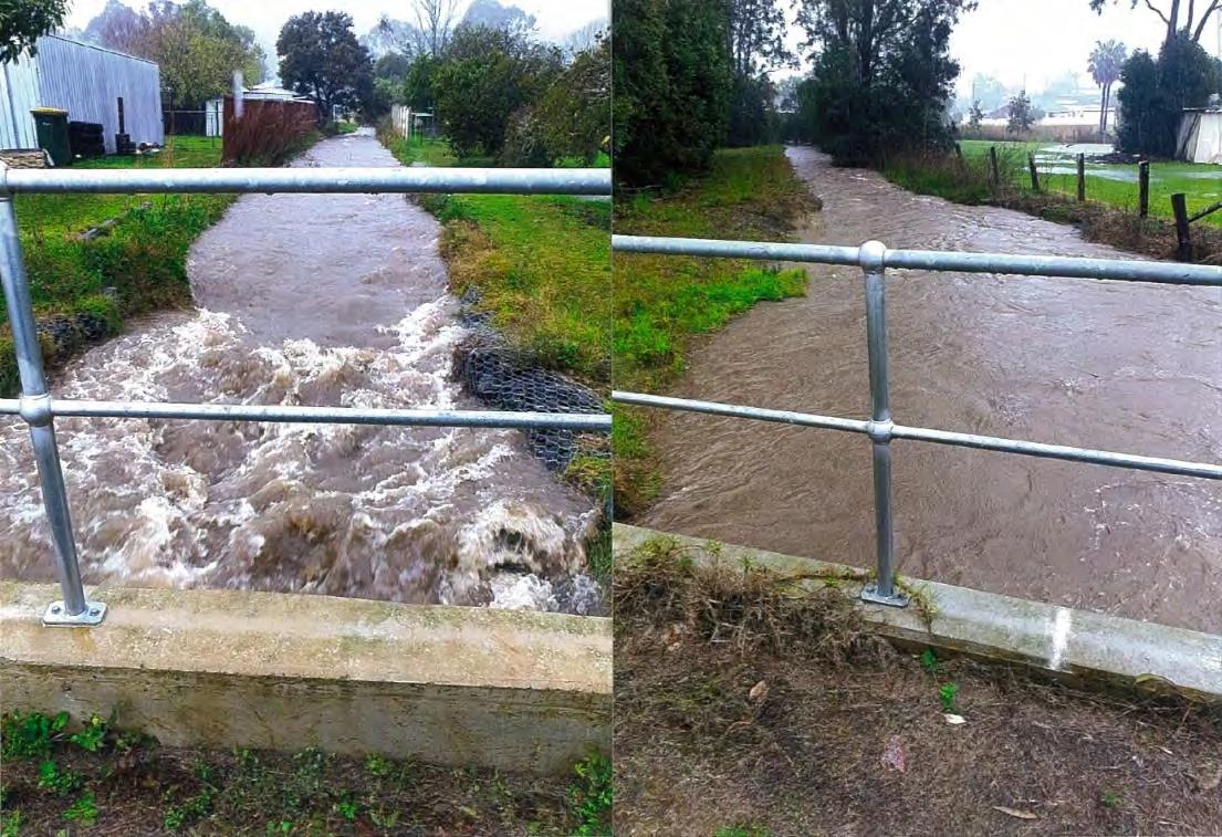
• A number of residents provided photographs as well as other flood information. Example of photographs are provided in Figure 5.2 and Figure 5.3. Some photographs received from local residents were used for validation of the model (Appendix E).
The main concerns and suggestions from the respondents regarding flooding included:
• Lack of drainage system maintenance and cleaning in the town (28 respondents)
• Requirement for upgraded drainage system (18 respondents)
• Channels and drainage system need to be cleared from vegetation (7 respondents)
• Impact from past development such as the Bulahdelah Bypass (3 respondents), the new caravan park (2 respondents) and local developments (2 respondents). NSW SES also noted that they attended local flash flooding in houses that had not previously been affected potentially due to some changes in local run off and drains flooding following the construction of the bypass.
• The need for kerb and gutter (2 respondents)
• Flooding from neighbouring properties (2 respondents)
• Weed control upgrade (2 respondents). A number of respondents suggested flood mitigations such as:
• Construction of a levee or filling land
• Flood zoning classification update
• Road surface upgrades
• Upgrade of the Richmond Street drain between Stroud Street and the river
• Deepening of drainage creeks
• Development control in flood affected areas such as Jackson Street
• Flood water diversion alongside Ann Street and Church Street directly to the river
• Piping of open drains
• Construction of swale or re-vegetation to slow down floodwater
• Excavation of silted Frys Creek near junction with Myall River


