
S PATIAL Autumn Edition 2024 #115
Magazine
WALKING INTO THE UNKNOWN TWIN IT TO WIN IT
HELPS TO PREDICT NATURAL HAZARDS AROUND THE WORLD
SURVEYING
INTERNATIONAL
AI

New Zealand survey and spatial professionals, as part of a nation of keen innovators, have adopted many international technologies and practices in the workplace as well as out in the field. In many cases, our country is leading the advancements that are changing the way that the survey and spatial industries work.
Overseas experience provides plenty of opportunity for New Zealanders to incorporate the insights they gain into the local experience, bringing fresh new perspectives to a rapidly evolving profession.
With new technologies taking centre stage in surveying and spatial industries around the world, it seems an opportune time to compare some of the experiences and advancements of our survey and spatial industries with colleagues abroad.
This edition we’ve focused on an international theme, looking at international capabilities and some of the innovations taking place in the survey and spatial industries.
In our feature story, Claire Buxton, Katie Anson, Emma Cook and Luke Robson examine survey practice and work culture in Canada from a New Zealand perspective. The Canadian experience has proved an interesting comparison for the Kiwi contingent, with different regulations, methods and even professional tools bringing new challenges.

Land surveyor Kevin Brockett gives an account of surveying in Aotearoa through the lens of an American as he travels the country learning about New Zealand’s land surveying history and practices.
Survey Solution’s Allan Hosking takes a look at virtual reality training solutions bridging the education gap in remote land survey learning and are being adapted by universities around the world.
In our legal column, following on from our recent AI theme, Stephanie Harris examines some of the challenges and opportunities of artificial intelligence in the survey and spatial industries. •


SURVEYING+SPATIAL ISSUE 114 SUMMER 2024
A publication of Survey and Spatial New Zealand, Tātai Whenua. ISSN 2382-1604
www.surveyspatialnz.org
EDITOR
Rachel Harris
surveyingspatial@gmail.com
All rights reserved. Abstracts and brief quotations may be made, providing reference is credited to Surveying +Spatial. Complete papers or large extracts of text may not be printed or reproduced without the permission of the editor.
Correspondence relating to literary items in Surveying+Spatial may be addressed to the editor. Papers, articles and letters to the editor, suitable for publication, are welcome. Papers published in Surveying+Spatial are not refereed. All correspondence relating to business aspects, including subscriptions, should be addressed to: The Chief Executive Survey and Spatial New Zealand PO Box 5304 Lambton Quay Wellington 6140 New Zealand
Phone: 04 471 1774
Fax: 04 471 1907
Web address: www.surveyspatialnz.org
Email: admin@surveyspatialnz.org Distributed free

WWith contributions from
Katie Anson, Emma Cook and Luke Robsonhen we walk into a new situation, we come in with all sorts of expectations. I expected to be navigating the snowy Canadian wilderness on a ski mobile, spending my days trying to focus on the job while my personal bear spotter kept watch for me from a high point nearby, and fighting off giant biting black flies. While that didn’t exactly happen every day, I have been lucky enough to venture into different corners of Canada and meet all sorts of weird animals and wonderful humans, and get myself into all sorts of places I never dreamt of. This is a story from the north from a girl from the south for those of you who have been, or have wanted to come, to Canada. In particular, British Columbia. There are some surprising differences between Canada and Aotearoa, New Zealand. More than I expected. Maybe you will take something from this and adapt your practice. Or perhaps you might just enjoy reading about surveying practice comparisons, stories of wildlife, lessons from Indigenous peoples, and curious colloquialisms.
I have to zoom in on cadastral surveying since that is what I like to do with all its detective-like analysis and treasure hunting. Given both jurisdictions are common law (apart from Quebec, which I’ll get to later), and that the two were colonised by the British Crown, some aspects in the cadastral system are similar. The hierarchy of evidence is the same so let me use that as a reference frame. Natural boundaries are rightfully at the top and navigable rivers are a key definition; where the tidal water boundary lies –now that varies between provinces and territories.
When it comes to monuments, the most commonly used marker is an iron post. Think of an iron tube but solid and square. This is great. Because they are metal posts, you can find them much easier than wooden pegs by using a metal detector. I have to admit I miss the old faithful peg bar for hitting in pegs and have had to firm up my sledgehammer swing over here.
There is often ancillary evidence placed next to the monument. This is a big difference from New Zealand. A guard stake is the most frequently placed. This is essentially the same as the white-topped wooden pegs but halved to be a triangular shape. The more exotic ancillary evidence comes in natural forms. These are in many shapes but some are pits and mounds (holes dug in perfect squares in a pattern around the boundary corner), stone mounds and bearing trees. The trees’ bark grows over and can be cut out years later to reveal the distance and bearing carving.


When it comes to wildfires, these boundary marking techniques are a resilient solution. Imagine coming up to this hole in the ground, expecting to find a wooden peg


On the hierarchy, occupation is in its third place as usual, following on from monuments. But the common practice in the British Columbia system is not to show occupation unless it is a building corner that couldn’t be pegged. The Canada Lands survey system on the other hand does require occupation to be shown on cadastral plans. In my opinion (which I have made known), this lack of occupation puts British Columbia’s cadastral system at risk for when the ‘big one’ hits. An earthquake is due any time and is expected to be intense. I just can't seem to escape them! New Zealand has been studied by Canadian and British Columbia governmental surveyors as an example of how to be prepared and I’m told they are getting their ducks in a row to prepare.
A quick note on titles and appellations. Title plans are not a product in British Columbia cadastral system and certificates of title do not show a graphical depiction. To add to the confusion, appellations are extremely long. They include a written link to the original survey. Here is one from a subdivision survey plan:
Field notes are a must here, so I’ve had to remind myself of good note-taking practice. They are expected by the majority of cadastral surveyors here and are an art form still. I’m no Charles Heaphy by any means but I have a newfound pleasure in making my diagrams something that Jim Bazsika would be proud of. Alongside the art of field notes, the craft of stamping capped posts (aka brass plaques) has been a new challenge for me.

The practice of cadastral surveying in British Columbia is more toward the art end of the ‘art-to-science continuum’ of cadastral surveying.
"I have come to have a great appreciation for how modernised NZ is"
– in one short month of working here (Emma Cook)
Emma is right, we were spoilt in New Zealand ‘growing up’ as cadastral surveyors with all the tools we had available to us. The process is heavily manual when creating cadastral plans in British Columbia to the point where a signing surveyor gets to choose what their north arrow looks like. From the software side, preferences vary. Despite the 12D Model sales team attempting to crack the market here, and, boy, I wish they had, the prominent software specific to cadastral surveying that I have seen used are Microsurvey (including StarNet), Civil3D, Trimble Business Centre, and Leica Infinity. Some companies have developed their own software.
From a remote sensing standpoint, I think Canada is on par with New Zealand, with mobile mapping being used alongside SLAM scanning, multispectral sensors and a wide adaptation of drones. This is especially the case with medium to large sized surveying and consulting companies. When it comes to smaller companies, these
technologies are further out of reach but terrestrial laser scanning is becoming more within reach. I wouldn’t say it is commonplace in smaller companies because the upfront costs and data storage challenges continue to exist.
Within surveying in Canada, there are quite a lot of sub-disciplines. Geomatics is the term given to cadastral surveying, geodetic surveying and spatial measurement. Geospatial is the term for the remote sensing side with front-line technology being this sub-discipline’s focus. This silo-culture flows through to the street level, literally, with every company owning their own company-branded tags that fit like a washer around a control nail.
I have even come across nails that have been removed, likely by other survey companies, and many corners in Vancouver with three control nails within metres of each other. A unique challenge with placing control nails for surveyors is that we have to consider freeze-thaw and make sure our marks don’t pop out of the ground over winter or get ripped up by the snowplough.
New Zealand’s geodetic network is something I often daydream about. Is that sad? Maybe, but I am OK with it. With the size of Canada, the network is a lot more sparse. This results in wider skill sets around surveying in remote locations. For example, the skill of setting up a base station and rover combination is more commonplace here than in New Zealand, bush surveying is a craft, and the use of the Precise Point Positioning (PPP) is very much standard practice.
Two-person survey crews are fairly standard here. In Vancouver at least, this is more of a safety and security concern. Safety-wise, many of us New Zealand surveyors are used to digging with no gloves (or maybe those of us who missed the safety talk that day). In Vancouver that does not fly because under the monument lids there are often used needles that have been poked through the holes. When I learnt that, I remember being like, what is this place? When it comes to remote work, having two-person crews is more of a survival concern (read wildlife passage below).
Once I got used to always having a second person to help, it did end up being quite efficient. Efficiency skyrockets when you get to wear the awesome survey vests that every surveyor has here. They are a wearable toolbelt with multiple pockets of differing sizes and shapes. A pocket for your mini-prism pole, one for your field book, little ones for your pencils and paint pens, one for your plumb bob (yes, they are still used), and most importantly, a pocket for your lunch.
The professional registration process is changing in Canada now that the government has realised a need to have foreign professionals help develop the economy. Based on my experience, the minimum time it takes for a licensed cadastral surveyor to get commissioned as a
land surveyor here is three years while working full time. That would be to get into the provincial system or into the Canada Lands cadastral system. The Canada Lands cadastral system is surveying on any Canada Lands that includes national parks, First Nation reserves, the territories and the offshore. The provincial system is any provincial crown lands and private lands. Quebec is different, though, and a very interesting jurisdiction. Quebec is under a civil code with a freckle of common law. Cadastral surveyors there have a heavier opinion-based, adjudication practice.
I was happy to see the Professional Land Development accreditation pass recently in New Zealand. This is not an area of practice for surveyors here in Canada. The profession is one of a honed, specific skillset around spatial measurement rather than the generalist surveyor that can operate as a land developer’s best friend. I have many ideas on why this is but that story is for another day.
As you may begin to see, the ways of working in Canada and New Zealand are more different than you might expect given our shared ancestry. In essence, I think this comes down to the big country versus small country. There is also some influence from the United States in Canada as well, given there is a land border between them.
Wildlife and time on the land
“The wildlife is definitely a new aspect to the outdoors and surveying outside of New Zealand. Whether it is seeing deer running wild in urban areas, moose on haul roads, or trying to identify if those prints are that of a cougar, you usually have some wildlife to consider with remote field jobs."
– Katie Anson
A story about Canada would not be complete without a tale of wildlife run-ins. And while the expectation was there, as I said at the start, the reality is that I have been more ‘wildlife-adjacent’ in most of my work. Sure, I have been lucky to see bears and elk but that is mostly during my personal, adventure time. Nonetheless, here are some snippets for you.
Eagles soared above my head and curious seals came up the river while working in Haida Gwaii in 2021. I wasn’t fast enough to capture that moment but I did capture some


snaps of a wild creepy crawly and a couple of ‘fun-guys’.
On a trip north of the Arctic Circle in 2022, I was joined by my own personal Inuk polar bear spotter from Arctic Bay who proudly shared his coming-of-age story of hunting a polar bear. Given that polar bears are incredibly intelligent predators that could have been hiding behind any little hump in the tundra, I was quite happy to hear that. Carrying his rifle in the vehicle and continually looking for any signs, he shared with me that polar bears have sometimes got a fox and raven pair of friends. The raven seeks out the seal from high up, then the fox sniffs out and chases the seal over the ice. Then the polar bear comes along and smashes through the ice to attack the seal.
On that same journey, I was joined by an Inuk environmental monitor who had a long list of traditional knowledge to share during our brief time together. His knowledge included which flowers the cariboo eat and the meaning of the Inukshuk (stone landmark) that we passed during our level loop. This particular one meant there were rabbits nearby, good for trapping.
I travelled to another island job last year and after all the logistics and safety planning were through, we managed to have quite the wildlife-free week. Eagles were flying through the trees at incredible speeds within tens of metres from me but no grizzly bears (they are the aggressive ones) and no wolves came to sniff us out. When we were leaving the island, though, as I stepped on to the water taxi, wolves started howling from the surrounding hills around the village. They must have been close to us

while we worked away in the bush.
It isn’t just the animals that bring excitement to surveying life in Canada. I visited the Yukon to help out up there once and while there I caught a glimpse of the northern lights late at night. It was enough to make me want to seek them out again one day. But then I got to see beavers up close and that made the trip! So wildlife trumps again.
A wise man1 once taught me that when you are looking to improve land tenure systems, you must ‘take a history’. Well, for the first almost-five years of my time here, that is what I have been doing. Beyond rebuilding after earthquakes, Canadians are often keeping an eye on New Zealand and many have told me they think New Zealand is ahead when it comes to Māori-Crown relations. While I tend to agree, the two countries are very different when it comes to this
1 The intelligent and kind man, Dr David Goodwin, RIP

relationship. With one Treaty and one Indigenous language versus many historical treaties, modern treaties, the reserve system, constitutionally protected Aboriginal Rights and Title, and more than 70 different languages, comparing the two is challenging. This is not my story to tell. Besides, that would take up the whole magazine. In essence, one thing becoming a Canada Lands surveyor has taught me is that there is never a direct yes or no answer. There are many ways to support an Indigenous community’s goals. You just have to listen first, and listen hard.
From the stories above with the two Inuit men and to more recent times, I have been lucky enough to work with Indigenous peoples of Turtle Island. Turtle Island is the term for the continent and is part of the creation story for many Indigenous peoples in this part of the world. In the face of adversity, land loss and attacks on their cultural survival, the Indigenous peoples of Turtle Island continue to demonstrate resilience and strength, often with a sense of humour that makes you feel right at home as a Kiwi. Acknowledging that there are so many distinct Indigenous communities in Canada, I have a lot more to learn but feel honoured to be a guest on their ancestral lands.
To finish on a light note, I have compiled a list of surveying-related terms that I find funny.
Bull prick = tiny peg bar
Turtle = turning point
Pin finder/sniffer = metal detector
Layout = setout
Party chief = lead field surveyor
Having the opportunity in life to see the northern lights, wildlife that can kill you, and the people that make this place colourful, I reflect on this career of mine as being a wonderful journey thus far. Let’s wrap this up with a bow then and say a very happy global surveyors’ day to you (as I write this on the March 21). What better way for me to celebrate than writing a story home and reflect on having my expectations reset. I hope this has been a pleasant reading experience. •


Global Survey have been named as the exclusive distribution partner for Kurloo monitoring solutions in New Zealand.
Kurloo is designed to detect movement in buildings, built structures and ground surfaces with millimetre precision.
The Kurloo solution consists of advanced Global Navigation Satellite System (GNSS), the Internet of Things (IoT) sensors and cloud
computing technology to deliver highly precise and accurate real-time insights to help manage risk.
“Kurloo is a brilliantly simple monitoring technology that leverages the power of GNSS to make autonomous and remote monitoring more widely accessible. Our team are excited about being able to offer Kurloo to our customers to enable data driven decision making on critical projects across New Zealand”. – Bruce Robinson, Director - Global Survey.
Kurloo sensors are designed to be a low-cost solution that are quick and easy to install. This makes them able to be deployed very quickly after extreme events, such as earthquakes, cyclones or heavy rain that's caused slips and settlement issues. They can be up and running faster than any other monitoring solution on the market, providing high-frequency data continuously and remotely to better inform the plan for remedial work.

Kurloo technology stands out as an autonomous solution, sensors are installed once and they then continuously collect data that can then be accessed and analysed remotely.
Kurloo units capture data with greater regularity and consistency than traditional monitoring methods. Under optimal observing conditions, Kurloo will deliver
measurements at least daily, with a precision of 3mm in X, Y & Z.
Once the data is collected remotely, the Kurloo Nest advanced cloud processing platform delivers post-processing in near-real time.
This intuitive online platform is easy to navigate and simple to use, the Kurloo Nest allows you to view, manage, adapt and export data –securely and on-demand.

Displacement monitoring is a measure of how much an object or surface has changed in position. In the field of monitoring, this is important to ensure that structures such as buildings, roads, bridges and embankments remain stable and safe.
Displacement is defined as the movement of a point or object relative to its surroundings. High precision data is crucial when measuring displacement.
In geotechnical engineering, displacement is commonly moni -
tored in order to assess the performance and stability of structures built on or within the ground, such as buildings, dams, bridges, and embankments.
The cause of displacement could be one of several factors, including settlement, soil consolidation, creep, thermal expansion/contraction and traffic loading. Weather, especially rainfall, can also affect the displacement of surfaces or structures and we have seen this over the last few years in New Zealand with significant damage

caused by flooding and major weather events such as Cyclone Gabrielle in early 2023 that wreaked havoc across the upper North Island and East Coast/Hawkes Bay region.
Displacement monitoring can help geotechnical Engineers and Surveyors identify potential problems early, before they cause serious damage or become a safety risk. It can also be used to track the progress of construction projects or to monitor how a structure is settling over time.
Displacement is a key indicator of how healthy an object or surface is, it tells us how much it has moved over time. It’s this powerful information about the behaviour in an asset lifecycle that can be used to cost effectively assess its stability and identify potential problems that require more detailed investigations.
For example, if the displacement of a building is increasing over time, this could be an indication that the foundation is settling or that the structure is becoming less stable. If the displacement of an embankment is increasing over time, this could be an indication of the risk of collapse. By monitoring displacement, you can identify potential problems early and take steps to prevent them from becoming bigger issues.

Queensland Rail Engineers used Kurloo positioning technology across the extent to the Toowomba ranges, stretching 15km.
The objective was to help monitor land movement following stability concerns after significant rainfall in early 2023.
"Kurloo enables us to remotely monitor progressive and accelerated embankment movement. We experienced some significant flood events early this year where we were unable to access the track. Kurloo
gave us confidence in the embankment stability at this site. In the shorter term, this technology enables us to monitor movement of our slope, overlaid by rainfall, to automatically alert of a heightened risk of failure. This informs when inspections are required and when we should be closing the track." - Kimberley Bracher, Senior Asset Maintenance Engineer, Queensland Rail Kurloo units include an integrated GNSS antenna, solar panel, battery system and GNSS chipset along with
ground distances sensor, humidity, pressure and accelerometer to understand tilt.
The smart sensors are remotely operated so they can be accessed 24 hours a day to check on health and configuration and ensure that it’s working optimally for the customer.
The data collected is analysed remotely and used to make critical decisions on the Toowoomba Slope Stabilisation Project, with the objective of ensuring the safety and reliability of the rail network.

An Australian made technology, Kurloo is revolutionising monitoring by making it more affordable and more accessible.
Key to the success of Kurloo in Australia is the low cost of entry from the Hardware as a Service (HaaS) model. Paying a low daily fixed cost per unit brings the cost down significantly and makes
monitoring much more accessible on projects.
With this solution, Geotechnical Engineers, Civil Engineers and Surveyors can now rely on accurate and continuous monitoring data during or after the construction of critical road / rail infrastructure and embankments or for remedial works.
Autonomous data collection delivers the ability to manage the risk of the collapse of unstable slopes and structures and a much lower cost than ever before.
To find out more information visit
www.globalsurvey.co.nz/kurloo

Real-time digital versions of the physical world have exciting potential as a tool in the climate fight – especially for involving communities in adaptation and emergency response planning. WSP digital advisory principal Kerri Gray explains.

The Australian state of Victoria is vast by global standards. Larger than many countries, it’s home to tens of thousands of native plants and animal species, a bevy of outstanding natural landscapes, over 6.7 million people, and dozens of city and regional areas.
Victoria has invested in state-wide 3D digital datasets about land and built form in a digital twin that citizens, government, and industry can use to explore solutions to environmental and social issues. Bringing together approximately three thousand local, state and national datasets, it’s been a huge benefit for authorities who work with communities to plan, manage, and build the future of the state.
Aotearoa New Zealand doesn’t yet have this kind of digital twin but could benefit from one. They’re extremely useful in helping plan and
prepare communities for the impacts of climate change and natural hazards – among other things.
Joining up screeds of data to create live digital versions of the real world, including natural environments, buildings, infrastructure assets, and transport networks, gives us the ability to model and communicate the effects of hazards such as floods, storms, droughts, and sea-level rise — simulating potential outcomes from the safety of a computer screen.
Victoria’s Department of Transport and Planning have previously used the state’s digital twin to model how a township might appear if it was developed in a certain way. The model included features like hospitals & schools & was used in a flooding scenario to see how lifeline utilities would be affected. They also mod-
elled the potential to invest in land to divert floodwaters away from critical infrastructure.
Representing information in digital twins opens a world of opportunity in engaging communities. A picture tells a thousand words; but a digital twin tells a thousand more. Crucially, Victoria’s digital twin has been used for public community engagement – including on West Melbourne’s Sunshine Precinct. Planners visualised in 3D how a proposed transport hub would sit in the context of the existing area and made this available to the public.
In essence, Victoria’s digital twin is being used in multiple ways to explore important planning scenarios and their consequences – harnessing technology to help with more informed, community-centered decision making.
“The sky's the limit, literally - but in New Zealand our ability to create real-time, 3D digital representations of objects and our ecosystem still isn't very advanced. There are examples of where organisations are taking great steps in this space; however, we’re largely reliant on 2D, static data to show where things are located and how they behave.”
New Zealand should follow their lead. How might that look in the climate adaptation realm? Well, coastal, land and weather-related datasets held by public sector agencies and other organisations could be included to 'virtually' predict significant climate impacts that might affect small and large communities.
As a predictor of potential outcomes, climate scenarios can be visualised and shared with community audiences to illustrate how their land and built environment could change and best be fortified. It's essential to analyse these scenarios from different perspectives, considering, for example, the impact on vulnerable residents, and local iwi
on the frontline of hazards; as well as civil, fire, and emergency or incident response teams.
In conveying how objects occupy three dimensions of space digital twins can reveal how far storm surge may penetrate or how deep floodwaters may get. That's no small thing for New Zealand, where almost 750,000 New Zealanders and 500,000 buildings worth $145 billion are exposed to flooding in the event of extreme weather events
The sky's the limit, literally - but in New Zealand our ability to create real-time, 3D digital representations


of objects and our ecosystem still isn't very advanced. There are examples of where organisations are taking great steps in this space; however, we’re largely reliant on 2D, static data to show where things are located and how they behave.
It's important for the benefit of communities that New Zealand’s public and private sector organisations better embrace the development of digital twins to analyse and model our places and spaces. Key to this is collaboration and a more open approach to data sharing.
There's no shortage of open data portals that anyone can access for free. It's a straightforward way to share data without requiring a lot of technical effort. Surprisingly, not many organisations are taking advantage of this opportunity, even though New Zealand has strong open data policies in place.
Encouraging the sharing of information through open data is highly beneficial. We are a risk averse nation, but we can take steps to make more of our data available for everyone to use and gain from. This will help quickly advance the development of digital twins that communities can use to make the best decisions for adapting to climate changes - decisions that are more important than ever for proactive protection in our shared climate future. •

Kevin Brockett, article first published in the ‘Pennsylvania Surveyor’.
US land surveyor Kevin Brockett recently satisfied his lifelong ambition of visiting the beautiful Pacific nation of New Zealand. While there, he enjoyed the distinct privilege of meeting several local land surveyors and learning about New Zealand’s land surveying history and practices.
His wonderful spouse also experienced many of these same things, although in her case, it was less by design and more as the result of circumstantial proximity to somebody with an excessive enthusiasm for the geospatial sciences.
Kevin and his wife Alice left the United States on November 23 on a direct flight to Auckland. After 15 uninterrupted hours in the air, they arrived on November 25, having never encountered November 24 due to the peculiarities of transit across the International Date Line. This time-travel adventure would later be balanced by the couple’s subjective experience of a December 12 that lasted for 42 continuous hours.
At their first hostel near downtown Auckland, the desk clerk suggested local points of interest worth visiting, including the nearby summit of
imposing Mt Eden, a dormant volcano overlooking the city. Kevin and Alice rose early the next morning and started walking across town with the sunrise.
Along the way, Kevin engaged in his customary habit of mumbling “survey nail” every time he noticed a survey monument or control point in the sidewalk. Alice encouraged this behaviour with her usual saintly patience. A few kilometres of strolling through the city’s streets brought them to Mt Eden, which they ascended via well-maintained pedestrian paths through public green spaces
A panoramic view of the Auckland region from the triangulation station atop Mt Eden.
and past blooming pōhutukawa trees.
Arriving at the peak, they were amazed by the beautiful 360-degree views of the entire verdant region, extending far into the distance.
As they relaxed and admired the surroundings, Kevin noticed an unusual structure at the highest point of the broad summit, thinking it looked a lot like an old geodetic triangulation station. Subsequent investigation would validate this suspicion, revealing that they had stumbled across the extant principal station employed by New Zealand’s early geodetic surveyors.
Alice and Kevin leisurely descended Mt Eden, sighting tui birds and a wild parrot as they returned to their hostel. They paused near the end of this trek at a survey marker vault that Kevin considered to be especially remarkable. Alice complied with his request to be photographed next to the vault, having long since become inured to her husband’s eccentricities. This photograph became one of Kevin’s favoured mementos of the trip.
The day after their encounter with the Mt Eden triangulation station, Kevin and Alice boarded a train on a
scenic railway that carried them from Auckland all the way to the capital city of Wellington at the southern end of the North Island. This 12-hour journey passed through stunning and seemingly endless landscapes that belied Kevin’s previous underestimation of the country’s vastness. Throughout the day, an audio commentary track provided passengers with historical background about the areas they passed. One particularly notable anecdote related the intriguing 19th-century history of the famed Raurimu Spiral, which owes its existence to the capabilities of a particularly impressive land surveyor.
In Wellington, Kevin and Alice explored some of the city’s fascinating heritage, including the national museum, Te Papa Tongarewa. Departing the harbourside Te Papa one morning, Kevin observed a survey crew setting up nearby. As the party chief stood casually by his instrument while the roadman busied himself with something in the distance, Kevin seized the opportunity to introduce himself as a fellow surveyor and strike up a conversation with the party chief. The friendly instrument operator stated that his firm’s usage of Leica
instrumentation was an outlier, given that most Wellington-area firms employed Trimble hardware.
Mentioning the preceding day’s strong winds, Kevin asked if such conditions were an impediment to working in the area. The party
chief replied that his crew regularly employed heavy sandbags to stabilise tripods when surveying around “windy Wellington” and that local surveyors knew to anticipate
 The author, demonstrating the enthusiasm that land surveyors commonly exhibit upon discovering survey markers in unexpected places.

“three-seasons-in-a-day” weather conditions.
He went on to explain that his present task related to a major survey of the entire wharf district, which would serve to inform the design of an illumination improvement scheme. He suggested that the impetus for this project derived from a recurrent issue with late-night revellers who drunkenly fall into the harbour and then attribute their consequent dampness to inadequate lighting along the water’s edge.
An interisland ferry ship transported Alice and Kevin from Wellington across the Cook Strait – so named for the famed navigator and surveyor, Captain James Cook – to the pleasant town of Picton on New Zealand’s South Island. As in any vibrant community, surveying has remained a vital activity in Picton. In front of his hostel on Auckland St, Kevin observed a surveyor using an R10 GNSS receiver to locate the curbing. An attempt to engage this gentleman in dialogue failed when the surveyor expressed his lack of interest in interrupting his work to exchange pleasantries with a bothersome tourist.
From Picton, Alice and Kevin travelled by rail and bus along the
South Island’s eastern coast until they arrived in the city of Dunedin, home to New Zealand’s oldest institution of higher learning, the University of Otago. Otago houses the country’s National School of Surveying. Kevin made an appointment to call on the faculty and was welcomed by several instructors who undoubtedly had more important demands on their time but nevertheless graciously received him and entertained his curiosity on a variety of subjects.
Dr Paul Denys spoke with Kevin at length about the school’s curriculum and courses, which incorporate the most modern geospatial technologies and methods. A bookshelf in Paul’s office showcases many of the intriguing research papers that his postgraduate students have completed over the years.
Professional Practice Fellow Richard Hemi shared a wide-ranging discussion with Kevin, through which Kevin learnt more about Landonline, which defies the insistent claim by some US surveyors that the term “GIS” really just means “Get It Surveyed”. They also discussed contemporary issues, such as potential approaches to addressing the problem of workforce development in the field of surveying, an


issue no less pressing in New Zealand than in the US.
Richard introduced Kevin to Emily Tidey, the school’s hydrographic surveying lecturer, who described her work and the school’s research into many aspects of hydrography. Her ability to clearly communicate the subtleties of her discipline to an ignorant landlubber (Kevin) demonstrated her mastery of a field that holds vital importance to a maritime nation surrounded by the Pacific Ocean.
After finally concluding this enlightening visit to the National School of Surveying with grateful thanks to the faculty members who had been so generous with their time, Kevin meandered through the busy streets back to his accommodations in central Dunedin. He passed a brass LINZ monument that was embedded in a sidewalk as a physical manifestation of the modern cadastral system.
Leaving Dunedin a few days later, the couple continued their travels through New Zealand by taking a bus to Queenstown, where Kevin enjoyed pointing out for Alice’s inspection several survey control stations associated with a pavement project that was progressing on their hostel’s street. A domestic flight from the Queenstown
The author and his travelling companion in “windy Wellington”. The National School of Surveying.airport then returned them to their point of beginning in Auckland.
Some months before travelling to the far side of the world, Kevin had connected with a stranger on the internet through the LinkedIn account for the professional society, Survey and Spatial New Zealand. Kevin and this stranger corresponded by email, discovering a common interest in surveying history, and when Kevin disclosed his travel plans with an invitation to meet for tea, the stranger replied with an offer to take Kevin and Alice on a guided personal tour of Auckland.
With wilful disregard for basic internet safety protocols, Kevin immediately accepted this offer. Alice’s response to Kevin’s announcement of a budding friendship with an unconfirmed surveyor from the internet was a conditional acquiescence along the lines of, “OK, sure, great, but if we don’t get murdered, then I want to go see Hobbiton before we leave New Zealand”. Kevin agreed, notwithstanding his suspicion that the world of JRR Tolkien had little to do with land surveying and was therefore likely to be dull.
Fortunately for all involved, it transpired that Kevin and Alice were not being catfished. Two mornings before their return to North America, the person who arrived to pick them up from their hostel was the gentleman he claimed to be: Mr Don McKay, a gregarious retired surveyor who had spent a productive career in private practice around Auckland.
Immediately following the in-person introduction, Don drove Kevin and Alice to the iconic Auckland Museum. There he introduced them to his colleague, Andrew Blackman, an active licensed cadastral surveyor whom Don had invited for the occasion. Andrew and Kevin quickly bonded over the copies of plats
(American term for plans) that Andrew had brought to demonstrate how survey drawings in the Auckland region have evolved over time, from the early 20th century until the present day.
The older plats bear a remarkable similarity to the highest-quality American exemplars from the same era, at least within the limits of the author’s personal experience. Even the units of measurement on older New Zealand plats are familiar to a US surveyor, which should not be surprising when one considers that both nations share a common surveying heritage and it was not until the 1970s that New Zealand succumbed to France’s neo-imperialist conspiracy of metrification.
Andrew’s fascinating overview of Auckland-area survey plats was of a regrettably brief duration due to his other commitments on that particular Sunday, but he cheerfully shared copies of his plat examples for Kevin to keep. Before Andrew’s departure, Alice captured a photograph of Kevin with Don and Andrew.
Don guided a whirlwind tour of the museum’s exhibits before leading
us outside to a small park, where he undertook to educate Kevin with a short dendrological seminar. This lesson imparted the knowledge of the native kauri tree’s superior characteristics as a source of carved survey pegs. It also disabused Kevin of the idea that the distinctive and ubiquitous Norfolk pine tree is native to New Zealand. (It isn’t.)
From the museum grounds, the trio left for an extended drive around the greater Auckland region in Don’s Honda. Over the next several hours, Don highlighted numerous local landmarks. These highlights included the most expensive residential street in Auckland, which is remarkable for the large trees growing through the roadway’s pavement and protected from removal by restrictive deed covenants. The tour paused long enough for lunch at Don’s house with his lovely wife, Bronwyn, who could not have been more welcoming to the two travel-bedraggled strangers whom her husband invited into her home.
Throughout the day’s tour, Kevin and Don conversed on a variety of survey matters. Among many
 “I’m not that bloody old,” said Don McKay, when asked to pose for a photograph in front of a dinosaur skeleton.

other things, Kevin learnt that the familiar rules of construction apply to surveying questions in New Zealand just as they do in the US, such as in the priority of an original survey monument over record measurements.
When at last the wide-ranging excursion with Don McKay drew to a close, Kevin could only offer a wholly inadequate expression of sincere gratitude for the older surveyor’s unbelievable cordiality and generosity toward two visitors from a foreign land.
Before catching a shuttle to the airport for their flight home, Alice
and Kevin spent their final morning in New Zealand searching for a geocache among the sprawling expanses of Auckland’s Western Park. Once Alice succeeded in locating the jar that had been hidden in a hollow tree, Kevin pulled from his pocket a few wooden tokens that he had carried from home. The tokens were printed with the logo of the National Society of Professional Surveyors and had been personalised with an ink pen to note one of Kevin’s professional surveyor licence numbers.
Before this last mini-adventure,
Alice did get a chance to channel her inner Bilbo Baggins on the day before the return flight, when she and Kevin finally went to Hobbiton, all the way there and back again. Kevin was forced to admit that he was quite impressed by the hobbits’ meticulously maintained homes, even if none of the resident halflings evinced an interest in the noble profession of land surveying.
Their trip to New Zealand far surpassed whatever expectations Kevin and Alice had harboured when they began planning their vacation. Beyond the memories of the amazing landscapes, food, travel experiences, and wildlife encounters which are all stories for another time, they cherish the unforgettable interactions with the exceedingly kind and hospitable people whom they met along the way. They can only hope for opportunities to pay forward the boundless goodwill with which they were showered by wonderful New Zealanders. •
Kevin Brockett is a licensed professional land surveyor residing in Morgantown, West Virginia. He is extremely fortunate to be married to someone who unfailingly encourages him to pursue his interests.
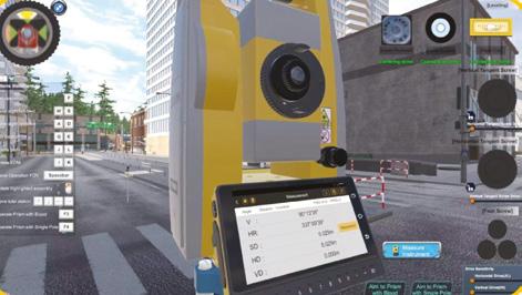
The author, depositing a few NSPS tokens into a geocache in an Auckland park.Virtual reality (VR) training has been in use for more than 20 years in various forms. My first contact with VR was in the oil/gas sector in the UK when I was working there for several years. In those days, offshore oil rigs were 3D laser scanned then a 3D model was generated. Animation software was then used with the 3D model to train oil rig workers onshore on where to turn off or on various valves and become familiar with the site before going out to the rig.
The Covid pandemic and the experiences of lockdown have been a
catalyst for educators to look at new ways of teaching and learning.
In land surveying the use of remote learning can often be challenging especially in the area of practical field exercises. The outdoor field exercises using levels, total stations, GNSS, drones and 3D laser scanners become challenging. In addition, there is the factor of inclement weather to consider which makes outdoor exercises difficult in some countries with extreme weather like the Middle East, Asia and the US.
To resolve some of these issues, several universities around the world
started to develop and implement VR solutions for land surveyors.
Pennsylvania State University (Penn State) in the US started to revolutionise its surveying engineering education through the integration of VR training in 2019. Recognising the potential of VR in enhancing practical skills for an immersive and interactive learning experience, the university’s Department of Surveying Engineering embarked on a journey to incorporate VR into its curriculum.
The department, jointly with the computer science department, developed a training module for levelling tailored to the needs of surveying engineering students. They used the Unity 3D gaming engine to build and customise the solution. Part of the campus was 3D scanned from the ground using a terrestrial laser scanner and from the air using a photogrammetry drone. The pointcloud data was then converted to a 3D CAD model and imported into Unity.

Finally, textures were applied within Unity to make the 3D scene more lifelike. Several researchers and developers were engaged fulltime over four months to complete the project and development.
The project focused on two scenarios: three closed-loop benchmark and a point-to-point levelling line. Both scenarios had an achievable accuracy of 1mm if good survey practices were followed.
The solution used VR headsets allowing the students to immerse themselves fully in lifelike environments and interact with virtual objects, enhancing their understanding of the process of levelling.
The Hong Kong Polytechnic University in 2023 also embraced VR training as a groundbreaking approach to enhance the education focusing on traversing techniques using total stations.
The traversing VR replicated real-world scenarios, including challenging terrain, varying weather conditions and complex topographies. Students could simulate traversing techniques with utmost realism and interactivity.
VR training provided students with a three-dimensional perspective of surveying landscapes, enabling them to better comprehend spatial relationships and terrain features crucial for traversing.
Virtual environments accurately mimicked real-world conditions, allowing students to practise traversing techniques in diverse scenarios without physical limitations. This realism facilitated practical skill development and confidence building.
VR technology enabled interactive learning experiences, where students could manipulate virtual instruments, take measurements, and adjust surveying parameters in real time, fostering active engagement and skill

refinement.
Traversing sometimes involves working in hazardous or inaccessible environments. VR training offered a safe and controlled setting for students to practise without exposure to physical risks, ensuring their safety while honing essential skills.
Traditional field training can incur significant expenses related to equipment, logistics and site access. VR training reduced these costs by providing a scalable and accessible alternative, allowing students to access virtual environments from anywhere at a fraction of the cost. VR simulations incorporated performance metrics and feedback mechanisms, enabling instructors to assess students' proficiency and provide targeted guidance for improvement, thereby enhancing learning outcomes.
SOUTH has manufactured a range of survey and spatial solutions for the past 35 years and produces a range of products including robotic total stations, GNSS, drones/UAV, 3D laser scanners (SLAM, tripod, drone), marine products and unmanned surface vehicles (USV). Recently it has developed virtual reality training for a range of its products suitable for the
educational sector.
SOUTH has recently developed VR training modules for the areas of levelling, total station traverse and drone/UAV. The advantage of the SOUTH solution is that it does not use VR headsets so is more suitable for larger classes of students.
The levelling module is designed for auto level survey training.
Fundamental knowledge is acquired through repeated practice in a gaming SIM environment. Features include benchmarks, change points, height difference calculation and checkpoints. All virtual-based staff readings are recorded in the field book of VR programs.
The total station traverse module is designed for total station traverse training.
Fundamental knowledge is acquired through repeated practice in a gaming SIM environment. Features such as line or path of travel, traverse point measurements, open/ closed/compound traverse with checkpoints are available. Procedures are reinforced to establish accurate survey control and conduct a topographical survey. The data is exported at the end of the exercise for office processing downstream.
The drone/UAV module is designed for repeated practice of drone operation with no risk of physical crashing. Features include aircraft assembly, drone settings, flight planning, mission control, and ground control points (GCP). All captured images are available to export for office processing.
Virtual reality training is much more than just moving through a 3D scene or digital twin. It’s about interacting with equipment and software in a 3D scene, taking measurements, then exporting the data for further office processing – a real-world workflow in a virtual environment.
One issue with the use of VR headsets is the feeling of nausea and disorientation but it varies greatly from student to student. This is a drawback for solutions that use VR headsets and limits the number of students suitable for this technique. Remember the good old days at Otago University with Major Hunt in the photogrammetry lab trying to look in stereo at two sets of images and, unfortunately, there was always
There is a common theme in the benefits of using VR training.
Enhanced learning experience: VR training provides students with hands-on experience in a risk-free virtual environment. By practising surveying techniques in diverse landscapes and challenging terrains, students gain confidence and proficiency in their skills.
Increased engagement: Traditional lectures can sometimes fail to fully engage students. However, VR training captivates students' attention through its interactive and immersive nature, fostering active participation and deeper learning.
Improved retention: Studies have shown that experiential learning significantly improves knowledge retention. By actively participating in VR simulations, students retain theoretical concepts more effectively and can apply them in practical scenarios.
Cost savings: Integrating VR training reduces the need for expensive field trips and equipment. Students can access virtual environments from anywhere, eliminating logistical challenges and reducing overall educational costs.
Real-world application: The skills acquired through VR training directly translate to real-world applications. Graduates equipped with VR experience are better prepared to tackle challenges in surveying engineering professions, contributing to their career readiness and employability.
a few students who physically could not see in stereo to float the dot over the terrain.
In addition to the use of virtual reality in education, there is the potential to use VR for marketing. For example, engaging with school students at career expos using a VR gaming environment is a great way to
connect with this young talent coming through. Career choice for these students is huge and competitive. VR is another tool available to entice these students into the exciting career of land surveying and the spatial industry. These students live and breathe technology so let’s speak their language and use virtual reality. •
In my last article, I wrote about artificial intelligence in the legal profession. AI has however permeated nearly every sector, and the survey and spatial industry is no exception, so I thought I’d spend a few column inches penning down some thoughts about opportunities and challenges with your industry in mind. From precise mapping to predictive analytics, AI is revolutionising the way we perceive, measure and manage our geographic spaces. For example:
Precision mapping: Traditional survey methods often rely on manual measurements and calculations, which can be time-consuming and prone to errors. AI-powered tools, however, can analyse vast amounts of geospatial data with unparalleled
precision, enabling surveyors to create highly accurate maps in a fraction of the time. This can then feed into the work of other professionals, creating a seamless end-to-end product with enormous gains in efficiency and economy.
Predictive analytics: AI algorithms can crunch historical and real-time data to predict future trends and patterns in land usage, environmental changes and infrastructure needs. This foresight is invaluable for urban planning, disaster preparedness and resource management.
Automation of routine tasks: Tasks such as image recognition, feature extraction and data classification, which once required hours of manual labour, can now be automated with AI algorithms. This frees up surveyors to
focus on more complex analysis and decision making.
While the potential of AI in the survey and spatial industry is vast, it's not without its hurdles. Regulatory frameworks must evolve to address concerns surrounding data privacy, algorithm bias and accountability. I touched on this with regard to the legal industry in my last article, and those observations equally apply in this sector.
Striking a balance between innovation and ethics is paramount, not only to ensure the responsible use of AI in this domain, but facilitate mass adoption and build trust in the technology.
Looking at some of these hurdles through a legal lens: Data privacy and security: AI relies

“The generation and use of geospatial data involve complex issues surrounding intellectual property rights. Questions arise regarding the ownership of data produced through surveys, satellite imaging and other spatial technologies.”
heavily on vast amounts of data, including sensitive geospatial information, raising significant privacy and security concerns. Unauthorised access, data breaches and misuse of personal or location data pose serious risks to individuals and organisations alike. Strengthening data protection measures, implementing robust encryption protocols and adhering to stringent privacy regulations are imperative to safeguard the integrity and confidentiality of spatial data in an AI-driven landscape.
Cross-border data governance: Developing on the first point, survey and spatial data often traverse national boundaries, presenting significant challenges for data governance. Issues such as data sovereignty, privacy and security become paramount when dealing with geospatial information that may have implications across multiple
jurisdictions. Harmonising regulatory frameworks to facilitate the smooth flow of data while safeguarding individual rights remains a formidable task for policymakers.
Intellectual property rights: The generation and use of geospatial data involve complex issues surrounding intellectual property rights. Questions arise regarding the ownership of data produced through surveys, satellite imaging and other spatial technologies. Disputes over copyright, licensing and the use of proprietary algorithms further complicate matters, necessitating clear legal frameworks to protect the interests of stakeholders and promote innovation.
Liability and accountability: As the reliance on spatial data for decision making increases, so does the need to address issues of liability and accountability. Who bears responsibility
in the event of inaccuracies or errors in survey data that lead to adverse consequences? Establishing standards of care, liability regimes and mechanisms for redress is crucial to ensure stakeholders are held accountable for their actions within the industry. It is of little use if we cannot rely on the accuracy and integrity of the end-product.
These are four examples where there are currently no practical solutions. That is unsurprising; the law is largely reactive – it seeks to cure a ‘mischief’. In this sense, innovation always precedes regulation. Again, the technology is of little use if over-regulated to such an extent that further innovation is stymied. However, responding to these hurdles in a way that addresses some of the aforementioned issues without hindering further progress is essential if AI is to simplify and innovate our lives or industries in a desirable way.
There is certainly much more to come in this space, and I am a big supporter of early adoption where possible; however, when navigating this new horizon, I would equally encourage being mindful of the challenges outlined above and how your organisation might respond to these voluntarily, rather than through regulatory changes, which will be many years away. •

As we deep dive into 2024, It's crucial to stay ahead of the curve on workplace trends. At 84 Recruitment we strive to be 3 steps ahead, so here is a snapshot of what's in store for this year, to help your business thrive:
Remote and hybrid work setups aren’t anything new, lockdowns in the past few years have forced us to work outside the office, and it’s here to stay. A recent article from NZ Herald, highlighted how hybrid working rose in the last year for many Kiwi workers - and why they’re more productive. ‘’More than half (51.3 per cent) said they were more productive at home, while 34.8 per cent said their productivity was about the same, and 13.9 per cent were less productive.”

2
1

AI is taking the world by storm and very quickly advancing. It’s important for workplaces to adapt and revolutionise workflows, not to replace work but instead, to harness its power together for innovation and efficiency. Look at small tasks that can often be time wasters and automate it, so your staff have more time to focus on key areas and priorities.
Employers get better results when their staff feel like they matter. If employees feel their wellbeing is looked after at work, they are usually more productive, healthier, and less stressed. Creating a healthy work environment is key in creating a mentally safe workplace environment. This means people feel safe enough to speak up at work and discuss their ideas and mistakes without fear.
3

By embracing these three tips, you can take your business to new heights and truly see your team grow, thrive and succeed!

Someone called into my office to see me the other day. She was quite frustrated. She knew I’d worked for an accounting firm in my past. She’s been a user of Abtrac for a long time. And she was in the neighbourhood. She’d had problems with some of the balances in her accounting system. She went to see her local accountant for help to sort things out.
The issue arose after a temp had been running the office while she was on maternity leave. The need was to process some journals to correct errors in opening balances, and sales tax payments and receipts.
The accountant appeared to not know what to do and instead advised the woman to change accounting systems from (shall we say) product Y to product X, giving assurances that such an issue wouldn’t be possible with product X.
Problem solved? Not at all!
Here’s someone in business struggling, wearing their heart on their sleeve looking for professional help. They’re wanting to do the right thing. And their trusted advisor has no more of a clue than they do. Or worse, perhaps they’re seizing in an opportunity to upsize their client and feather their own nest on top of charging a fee for the consultation.
What a fob off. What a crock. What a disgrace to the profession.
The woman left my office happier than when she arrived. She actually knew what to do but simply wanted to discuss her thoughts with someone, to verify she was processing the adjustments correctly.

Not being the first time I’d come across one of our clients receiving dubious advice from their advisor, I wondered how often bad advice is given? And worse, how often is it accepted and followed?
“Often managers and owners are doing everything on their own with an under-strength team and stretched funding lines. They struggle to cover all the areas that could really make the business fly. So, when someone turns up and makes a seemingly valid suggestion about how to do better, most people are grateful for the input.”
If you Google ‘dressed as the man from the prudential’, or ‘nobody ever got fired for buying IBM’ you’ll see how over recent decades certain types of businesses have promoted themselves as trustworthy.
It’s like, is anyone going to walk into your office and say “you shouldn’t trust me”. Yeah right that’d happen!
No doubt most advisors are well meaning, be they accountants or coaches or business growth specialists, or whatever. But how many today still rely on confidence alone in the minds of the recipients of their advice, like the man from prudential or those in the 80s who recommended IBM. How many simply get by, perhaps because “the less you know the more they know”. It’s got to be a worry.
How long would it take a new employee to learn their job in your business. In many cases the new employee will have been to university. But it might take months before you have confidence enough to let them do some aspects of their job unsupervised.
How long would it take someone to learn the ins and outs of the role of a senior manager, director or working owner of a business. There are levels of expertise one has to learn, and along with learning to manage others, and so many other internal and external matters and issues to understand.
A thought then, is how much should any third party know about your business before you follow their advice and theirs alone, without question.
Consider a sporting analogy. Is the score keeper in a game of footy the best one to coach the players? Highly unlikely. In sport, people understand the need for a team of coaches. The head coach has technical coaches, a fitness coach, a psychological coach, and more. To put together the dream team in sport, you need a team of coaches. The final score is the result of coaches and players all doing their bit, and not because the score keeper understands the value of points as they are accrued throughout the game.
Each coach has strengths. And each one is there to make up for the others’ weaknesses.
In business it’s exactly the same. Many SMEs struggle. Often managers and owners are doing everything on their own with an under-strength team and stretched funding
lines. They struggle to cover all the areas that could really make the business fly. So, when someone turns up and makes a seemingly valid suggestion about how to do better, most people are grateful for the input.
But my advice is don’t rely implicitly on any one advisor from outside of your business. If someone offers advice, spontaneously or on request, take it at face value. “Here’s someone with an assumed understanding of my issues, pains, and aspirations. I’ll put their advice into the mix. But I’ll bear in mind they’re unlikely to fully understand how the business itself works from one day to the next, nor what I do in it.”
Instead, surround yourself with a team of advisors. Ask any advisor to always present a minimum of two comparable options and to back up their advice with stories you can verify. And always insist they tell you the drawbacks of following either of the options they present. If they know what they’re talking about they should be able to give you the weaknesses and well as the strengths in any advice. And while they’re doing it, keep them on track. If it’s worth giving advice, they should be able to sell it ‘fuzz free’.
Finally, if it’s something they’re selling you from a third-party source, do some work of your own by contacting other parties directly.
The purpose is not to be ungrateful, nor to try to outsmart your advisor. It’s to validate their advice, most likely given in good faith, but nevertheless and no doubt, not perfect. They can walk away from their advice once they’ve dropped it on you.
You cannot.
So put them on the spot, including asking about any pecuniary or other interests they may have behind their advice being given. What’s in it for them. You may be surprised!
We all need a raft of people we can call on at various times, be they touted as advisors or otherwise. But in the end, it has to be your decision based on facts you’ve validated yourself.
Are you sure you’re always being given the right advice?
What do you think? •
University of Canterbury
AI techniques and satellite images are helping to identify communities at risk from flooding and extreme heat in a new University of Canterbury-led study.
Te Whare Wānanga o Waitaha | University of Canterbury (UC) Spatial Data Science Lecturer Dr Carolynne Hultquist is leading an international Group on Earth Observations (GEO) Microsoft-funded study using geospatial data to solve real-world problems. GEO is a global collaboration between governments, scientists and local communities with the goal of creating innovative solutions to challenges such as climate change.
Dr Hultquist, from UC’s School of Earth and Environment, says remote sensing data from satellites can be combined with artificial intelligence (AI) tools to improve models and help predict at risk locations for future flooding events.
“The models we’re developing will be open source and available to everyone who needs them, from governments to residents.
“We’re integrating data on populations derived from censuses, and remote-sensing imagery to help fill the gaps in our knowledge and develop better datasets on historical trends of hazard exposure. Better historical data prepares us to make better predictions of where flooding is likely to happen and hopefully prevent lives being lost.”
The research is also investigating areas where excessive heat is likely to occur. “We have huge growth in populations with vulnerable communities living in areas that are experiencing more extreme temperatures,” Dr Hultquist says. “Preliminary work indicates that 23 million people around the world are at risk of expo-
sure to more than 60 days of extreme heat and flooding; 59 million people are at risk of exposure to more than 30 days of these hazards; and 162 million people are living in areas at risk of exposure to more than a week of heatwave and flooding.”
Dr Hultquist is collaborating with computer scientists at the University of Canterbury (Senior Lecturer James Atlas, postgraduate student James Houghton) and Montana State University geographers (Assistant Professor Cascade Tuholske, postdoctoral researcher Dr Andy Zimmer) on the work which will be presented at the International Conference on Machine Intelligence for Geoanalytics and Remote Sensing (MIGARS) in Wellington in April.
“The main concept is being able to have more reliable input to base our flood modelling on and get a better idea of frequency,” Dr Hultquist says. “Back in the 1970s and 1980s there
was a lot less remote-sensing data available than there is now. So, we’re using AI to fill in those gaps in data for missing timeframes and learn more about the patterns and trends of these events over time. By learning about the past, we can make better predictions for the future.”
Dr Hultquist focuses on working with humanitarian organisations such as Red Cross in applied research aimed at making a positive difference to real-world problems. “My work supports decision-makers and disaster-relief organisations to have the most accurate information so they can alert people about the risks of building in certain areas and develop early warning systems to help residents evacuate quickly,” she says.
“I believe technological development should be closely connected to social good and impact, so we need to work closely with people and community groups who are doing this

work and find out what data they need, then develop technology to help meet those needs.”
Dr Hultquist says flood exposure in urban areas has increased due to building in flood-prone areas, the expansion of artificial surfaces such as pavements made from water-resistant materials, and removal of vegetation. Furthermore, climate change is increasing the frequency and intensity of flood events.
“A lot of communities are struggling to manage these sudden changes. The models we’re working on help us get a better understanding of what impact each of these factors is having on the overall risk.”
Dr Hultquist is Secretary of the American Geophysical Union (AGU) Natural Hazards section and co-chair of the Committee on Data (CODATA) Citizen-Generated Data for the Sustainable Development Goals (SDGs) task group of the International Science Council. •
Women in Spatial and Survey is pleased to announce our 2024 Mentorship Programme.
We've heard your feedback and we want to help connect women and minority communities in spatial and surveying across New Zealand. If you are interested in taking part in the inaugural WIS+S mentorship programme please complete this form
To successfully complete this programme you will complete five 20-minute meetups between June 1st and December 16th 2024. Spaces are limited, please note; completing the form above does not guarantee you a place. WIS+S will match together participants and provide a framework of themes and meetings to support the program. It is down to participants how they engage with their mentors (e.g. in person, over teams, over the phone).
The rough timeline for this program is:
• March 6th
Sign up form live.
• April 10th
12.30 pm Introduction to Mentorship Programme Webinar.
• April 30th
Sign up closes.
• May 27th
Mentor/ Mentee matches released.
• June 1st
First month – theme is introductions and goals.
• July (TBC)
Mid-Winter lightning talks, mentors and mentees encouraged to attend.
• August - November
Themes will be released though out the programme.
• December 16th
Christmas Quiz (In person Wellington and online) mentorship program ends, certificates awarded.
NIWA scientists leading Aotearoa New Zealand’s MethaneSAT agricultural emissions science programme are gearing up for the launch of its satellite in coming weeks.
MethaneSAT is a global initiative led by the US Environmental Defense Fund to track and reduce methane emissions around the world.
The US project is focused on methane leaks from oil and gas production, while the New Zealand-led agricultural programme is studying global emissions from agriculture, such as ruminant farming and rice production.
Science leader for the agricultural programme, NIWA’s Dr Sara Mikaloff-Fletcher, says the state-of-the-art satellite is unique, because it can measure over a large area and map methane at high spatial resolution and unprecedented precision.
“MethaneSAT will give us the type of data that we could never get from ground-based measurements. It will map methane over 200 by 200 kilometre regions, and it will be able to detect as few as two parts of methane per billion when averaged over a 1km spatial resolution.
“MethaneSAT will be the first satellite well suited to quantifying diffuse agricultural emissions, due to its high precision and spatial resolution. We have the opportunity to be the first team to develop and prove this capability worldwide,” says

Dr Mikaloff-Fletcher. New Zealand provides the perfect test ground for the MethaneSAT agricultural programme, because it has an unusual greenhouse gas profile and world class greenhouse gas measurement and modelling capability. While carbon dioxide (CO2) is the most important greenhouse gas for most developed countries, New Zealand’s biggest source of emissions is methane and the lion’s share of that comes from agriculture.
“If you are developing something very new, it is essential to prove it works. We will have a field campaign in New Zealand to measure methane emissions at the surface and from aircraft to test this capability,” says Dr Mikaloff-Fletcher.
Atmospheric researchers on the project have been laying the groundwork since 2021, developing and testing models that will help them make sense of the satellite data, preparing and testing instruments that will be used to validate satellite information on the ground, and identifying the best places for the satellite to measure agricultural emissions around the world. Post-launch, access to data from the satellite scanning the atmosphere will herald an exciting new stage in the research.
New Zealand has a long history of world class greenhouse gas measurements and modelling. For example, NIWA’s atmospheric observing site at Lauder is one of the two founding Total Column Carbon Observing Network sites, which are the gold standard for validating greenhouse gas observing satellites, including MethaneSAT.
“This capability positions us beautifully to ground truth our results. We will prove this capability in New Zealand, to demonstrate that measurements made at other locations around the world can be used with confidence,” says Dr Mikaloff-Fletcher.
The agricultural research programme is a collaboration between experts across New Zealand, including NIWA, Manaaki Whenua Landcare Research, University of Waikato, and Victoria University of Wellington, and the US based science team at Harvard University, EDF, and Smithsonian Astrophysical Observatory. The project is funded by the Ministry for Business, Innovation and Employment. Partners RocketLab and the University of Auckland’s Te Pūnaha Ātea-Auckland Space Institute are establishing and operating mission control for the satellite. •
Delegates attending the 135th Survey and Spatial New Zealand (S+SNZ) conference on Otago’s Dunedin campus made the most of additional events organised in celebration of 60 years of the School of Surveying Te Kura Kairūri.
Attended by 350 delegates in August, the conference linked to several activities planned by the School, including technology and computing workshops, an open day and an anniversary dinner.
Local S+SNZ Branch Chair and Professional Practice Fellow Fraser Jopson says the celebrations were very well attended. “Everyone took the opportunity of wandering down memory lane, but it was also exciting to look forward towards the next steps of the School’s and the profession’s journey.”
The theme of the conference, Marking the Journey, Hāpaia, referenced the journey that surveyors embark on through their careers, including the role of the School of Surveying in educating and preparing students for their subsequent professional careers.
Attendees included previous Dean of the School Emeritus Professor John Hannah (1993-2012), Senior Lecturer Allan Blaikie (1968-94) who taught many of the current School’s staff, and long-term administrator Huubje Hellendoorn (1975-97). Acknowledgement was also made of Emeritus Professor Basil Jones (Dean from 1977-93) who sadly died shortly after the conference.
Professional Practice Fellow Richard Hemi explained that because of the

connection between the School of Surveying and wider industry, many in the profession have remained closely linked to the School after graduating.
“We had a whole range of alumni from across many aspects of the School’s history in attendance, as well as staff and current students, so it was a great opportunity for everyone to come together and reminisce about their early years of learning here in Dunedin,” Hemi says.
As many conference delegates are ongoing employers of graduates of School of Surveying, they were also informed of the recent curriculum changes for students who commenced their degrees this year.
Current Dean of the School, Associate Professor Tony Moore says these changes have been implemented successfully and bring the curriculum into alignment with contemporary surveying practices.
“The changes bring together the many different fields that the School covers, from geospatial science (GIS and remote sensing) to land planning and development as well as surveying measurement. All these areas can be applied to societal challenges and opportunities, including the critical issues facing us today, such as climate change,” Associate Professor Moore says.
A silent auction was organised as an opportunity to clear some excess equipment and storage space in the School. Old surveying equipment including theodolites, range finders, and scales dating back to the 1970’s, went under the hammer and raised around $4,000. The proceeds will be split between Pūtea Taukoko Otago Student Relief Fund and the Kairūri Trust that was set up in 2017 to foster the future of the surveying and spatial community. Rounding off the three-day conference and event, lecturer Emily Tidey and Richard Hemi presented a summary of the School’s activities over 60 years that included snapshots of memorable events captured in black and white and colour photos, the formative annual field camps, current staff and student research and key successes of alumni across the decades.
Tidey says as the survey and spatial community in Aotearoa are a tight-knit group, and they commonly share a connection through their early days of learning at the School.
“The 60th anniversary and associated events have been a great way to reflect on our shared histories while recognising the importance of the School to the wider professional community. We’re really proud of what our alumni, staff and students have achieved, and excited to see what more is to come.” •
During a research trip to Antarctica earlier this year, PhD candidate Holly Still had the chance to test how well a low-cost global navigation satellite system (GNSS) receiver would stack up against survey-quality GNSS when observing ice flow speed.
It was a move that saw her winning the Postgraduate Student Award at the recent New Zealand Spatial Excellence Awards.
GNSS technology, more commonly known as GPS positioning, can be found everywhere, Holly, of the School of Surveying, says.
“It’s in your smart phone, it’s in your fitness watch, maybe it’s in your car.”
In the past, survey-grade GNSS technology was the only technology available to carry out high-precision glaciological fieldwork, and it’s really expensive, she says.
“It can cost more than $20,000 per instrument. So, it’s not very accessible; cost is a massive barrier to people who want to deploy lots of these instruments.”
She installed four low-cost GNSS receivers, which cost less than $1,000 each, on the surface of Priestley Glacier and left them to monitor the speed and tidal motion of the ice. She was pleased to discover that the technology worked “just as well” as the survey-grade GNSS in terms of precision and data quality.
It was exciting, she says, as the lowcost receivers had not been widely used in Antarctica before.
Surveying researcher Dr Robert Odolinski, of the School of Surveying,


has been conducting research on low-cost GNSS for the past decade, focusing on the theory of satellite positioning and how to improve its precision.
Holly says she was inspired by his work and willing to put it to the test.
Geology Department computing and numerical simulation technician Hamish Bowman – an “expert in building scientific instrumentation” also played a role in setting up the GNSS equipment, she says.
“We all put it together and it was ready to go for the Antarctic field season. Everything happens in a team, nothing is done alone down there if you want to collect interesting and useful datasets.”
Ice core samples had been taken from that same field site previously and observing the ice flow speed with GNSS positioning provided contextual information for those core samples. Ice flow speed is an important quantity to observe because it describes the rate at which Antarctic ice is transported towards the ocean. These types of observations are also used to ensure that models of glacier and ice-sheet flow accurately represent the present-day ice-flow conditions in Antarctica.
3 The goal of her PhD is to study the mechanics of the lateral shear margins of Priestley Glacier, a 100 km outlet glacier that flows into the Nansen Ice Shelf. Glacier margins provide resistance to ice flow and high-precision surveying datasets can provide unique information about ice properties and deformation.
Holly is no stranger to the frozen continent, having visited four times and spending a total of about five months there since she started her master’s degree, prior to her PhD.
On previous trips she has helped a team studying a subglacial water channel which flows beneath the Kamb Ice Stream, collecting a combination of high-precision surveying observations of ice flow and flexure, and radar observations to infer ice thickness.
She will return in January, this time to Windless Bight on the McMurdo Ice Shelf as part of a team of eight to test a hot water drilling system.
Holly isn’t worried about sleeping during the perpetual daylight, joking that 24 hours of sunlight would give them plenty of time for science.
In reality, after a whole day of field work, “you’re so exhausted you just fall asleep”. •
Akey piece of the network that will deliver more accurate and reliable GNSS positioning across New Zealand and Australia is fast taking shape near Invercargill.
Two 11-metre satellite dishes have just been hoisted into place at the uplink and ground control centre being constructed at Awarua, Southland.
The centre is one of two across the SouthPAN (Southern Positioning Augmentation Network) network being built for the New Zealand and Australian Governments. The first opened at Uralla, New South Wales, in December 2023. At least six high-tech jobs will be created in Southland to operate the Awarua centre, due for completion by mid-2024.
SouthPAN is a satellite-based augmentation system (SBAS). It uses a network of space-based and ground infrastructure to compare satellite data against precisely measured positions and identify and correct positioning
errors in global navigation satellite systems (GNSS) like GPS.
These corrections are sent to geostationary satellites and broadcast throughout New Zealand, Australia and our maritime zones.
SouthPAN will improve the accuracy of GPS from the current 5-10 metres down to as little as 10 centimetres, supporting businesses and industries that rely on precise location data.
The new infrastructure will improve the availability of the SouthPAN early open services offered since September 2022. The New Zealand and Australian sites will work in tandem to provide network resilience.
SouthPAN will support precision farming and improve safety in industries like construction where virtual barriers can help protect workers from heavy machinery.
Forestry operators are currently using SouthPAN for inventory mapping, harvesting and worker safety. It is helping crop sprayers with more accurate aerial application of fertiliser.
By 2028 when SouthPAN is expected to be fully operational, it will enable helicopters and planes to fly safely in poor weather they cannot fly in now.
SouthPAN is a partnership between Toitū Te Whenua Land Information New Zealand (LINZ) and Geoscience Australia. Economic benefits to New Zealand from SouthPAN are estimated at $864 million over 20 years. •
For more information, please email engagement@linz.govt.nz
