
HYDROGRAPHIC SURVEYING PROFILE
FERNTECH – DRONE SURVEY CERTIFICATION
ROB LONGLEY – 60 YRS A SURVEYOR


HYDROGRAPHIC SURVEYING PROFILE
FERNTECH – DRONE SURVEY CERTIFICATION
ROB LONGLEY – 60 YRS A SURVEYOR
In this winter edition, Surveying + Spatial is focusing on the official launch of the Survey and Spatial New Zealand Certification framework.
The new framework has been the result of the successful 2022 pilot programme and delivers a recognised professional pathway for S+SNZ members across all levels, ensuring mandatory continuing professional development.
We outline the criteria for the current certification programmes offered – including certified professional engineering surveyor, certified professional land development engineer and the pathway for hydrographic certification (co-sponsored with the Geospatial Council of Australia).
We take a look at what these competencies require and profile two recent participants of the pilot programme. They share their thoughts and recommendations from the certification process and discuss the new opportunities that have ensued from taking the certification path.
Also in this edition, the Ferntech team discusses the drone certification process and New Zealand’s Civil Aviation Authority requirements for safe and legal drone operation for professional surveyors.
We celebrate surveyor Rob Longley’s remarkable 64-year milestone in surveying. Now aged 83, Rob has had an


extensive and illustrious career in surveying over the years and, with no current plans for retirement, he is still proving to be a pivotal member of the Land Matters survey team in Ōtaki, enjoying the job he loves.
In our legal column this edition, following on from our certification framework theme, Glaister Ennor’s Anthea Coombe examines legislative frameworks in land developments in New Zealand.
Lastly, we are greatly saddened to announce the recent passing of former Survey + Spatial NZ chief executive, Hadyn Smith. As a tribute to Hadyn’s memory and his service to the survey and spatial professions, we include an obituary in this edition to celebrate his many achievements. •


SURVEYING+SPATIAL
ISSUE 116 WINTER 2024
A publication of Survey and Spatial New Zealand, Tātai Whenua. ISSN 2382-1604
www.surveyspatialnz.org
EDITOR
Rachel Harris
surveyingspatial@gmail.com
All rights reserved. Abstracts and brief quotations may be made, providing reference is credited to Surveying +Spatial. Complete papers or large extracts of text may not be printed or reproduced without the permission of the editor.
Correspondence relating to literary items in Surveying+Spatial may be addressed to the editor. Papers, articles and letters to the editor, suitable for publication, are welcome. Papers published in Surveying+Spatial are not refereed. All correspondence relating to business aspects, including subscriptions, should be addressed to:
The Chief Executive
Survey and Spatial New Zealand PO Box 5304
Lambton Quay Wellington 6140
New Zealand
Phone: 04 471 1774
Fax: 04 471 1907
Web address: www.surveyspatialnz.org
Email: admin@surveyspatialnz.org
Distributed free to members of S+SNZ. Published in March, June, September and December by S+SNZ.
DESIGN & PRINT MANAGEMENT
GOODHERE – www.goodhere.nz hello@goodhere.nz TO ADVERTISE
Email: admin@surveyspatialnz.org or contact Tara Ranchhod
+64 4 471 1774
At Survey and Spatial New Zealand, we are proud to offer three industry-leading certification programs designed to set the benchmark for excellence and maintain public confidence in our specialised fields.
Our certifications include:
Certified Professional Engineering Surveyor (CPES)
Certified Professional Land Development Engineer (CPLDE)
Hydrographic Certification (co-sponsored with the GeoSpatial Council of Australia)
These rigorous programs ensure that professionals are equipped with the highest standards of knowledge and expertise required to excel in their domains. Dive into the details of each certification below and discover how you can elevate your career to new heights with Survey and Spatial New Zealand.


The Certification of Professional Engineering Surveying Competence is formal recognition by Survey and Spatial NZ for those who have been assessed against a defined set of professional and technical competencies which meet standards and technical sign off criteria required by Private and Public Asset Owners, Territorial and Local Authorities and other similar entities.
The Annual Practising Certificate as a Survey and Spatial New Zealand Certified Professional Engineering Surveyor sets a quality benchmark for the industry to maintain public confidence in the areas of:
1 Earthworks, Erosion and Sediment Control
2 Access, Roading and Transportation
3 3 Waters, (Stormwater Management, Wastewater Management, Potable Water)
4 Utilities (Energy and Communication)
5 Construction (Residential, Infrastructure, Commercial)


The Certification of Professional Land Development Engineering Competence is formal recognition by Survey + Spatial New Zealand of those who have been assessed against a defined set of professional and technical competencies which meet the Civil Engineering standards and technical sign off criteria required by Private and Public Asset Owners, Territorial and Local Authorities and other Entities (as it relate to Land Development).
The Annual Practising Certificate as a Survey and Spatial New Zealand Certified Professional Land Development Engineer sets a benchmark for the industry to maintain public confidence across the following areas:
1 Earthworks, Erosion and Sediment Control
2 Access, Roading and Transportation
3 3 Waters, (Stormwater Management, Wastewater Management, Potable Water)
4 Utilities (Energy and Communication)

pecialist certification in hydrographic surveying is the official recognition that an individual possesses the necessary knowledge to perform hydrographic surveying tasks along with the demonstrated ability to apply that knowledge across various hydrographic disciplines.
The professional assessment and certification of hydrographic surveyors is conducted through the Australasian Hydrographic Surveyors Certification Panel (AHSCP), which is jointly sponsored by the Geospatial Council and Survey and Spatial New Zealand.
1 Gain a mark of excellence – certification establishes a level of professional hydrographic competence that the government and industry not only demand from professionals but which is also now expected.

2 Achieve recognition from employers and enhance your career opportunities.
3 Attain and extra measure of credibility, respect and recognition within and outside the professional community.
4 Enhance your professional standing and confidence by quantifying your hydrographic experience and demonstrating your commitment to professional development and continuous improvement. Being recognised as a certified hydrographic surveyor gives you a distinct competitive advantage.
5 As an employer – you can increase the confidence that your clients have in your company.
Certification is the pinnacle of recognition in the surveying sector, a testament to technical prowess and dedication. The journey towards certification is robust and demanding, requiring candidates to prove their knowledge, skills, and experience through written submissions and interactive assessments. But behind this rigorous process lies a team of talented and dedicated professionals—our assessors. They are committed to nurturing sector capability and ensuring a trusted technical program that can be relied upon by authorities and businesses through-
Michael Martin
Certified Professional Land Development Engineer –Registered Professional Surveyor
Greg Mohacsi
Certified Professional Engineering Surveyor
Bruce Walker
Certified Professional Engineering Surveyor
Michael Cutfield
Certified Professional Engineering SurveyorLicensed Cadastral Surveyor Rodney Pilbrow
Certified Professional Engineering Surveyor
Antony White
Certified Professional Land Development Engineer, Certified Professional Engineering Surveyor
out New Zealand. Let's meet some of these talented individuals.
Our team of assessors is the backbone of our certification program, rigorously examining candidate applications to uphold program integrity and ensure professionalism within the surveying sector.
While their work is often behind the scenes, their dedication shines through in every assessment they undertake.
Kerryn McPherson
Certified Professional Land Development Engineer –Registered Professional Surveyor
Carl Salmons
Certified Professional Land Development Engineer
Sam Williams
Certified Professional Engineering Surveyor
Craig Hurford
Certified Professional Engineering Surveyor, Certified Professional Land Development Engineer
Lee Scorrar
Certified Professional Engineering Surveyor
Craig Kenneally
Certified Professional Engineering Surveyor
Bryce Kilpatrick
Certified Professional Engineering Surveyor
Nick Taylor
Certified Professional Land Development Engineer –Registered Professional Surveyor, Licensed Cadastral Surveyor
Darrell Wymer
Certified Professional Engineering Surveyor
Interested in certification? Visit the Survey and Spatial NZ website to learn more about the process or contact our team at certification@surveyspatialnz.org . Take the first step towards recognition and excellence in the surveying and spatial sector with our trusted certification program.
Tim McDougall, TrueSouth Wanaka
What is your current role?
I am a land development engineer, surveyor, and co-branch manager of TrueSouth Wanaka, a company specialising in land development and surveying services. My role involves overseeing land development and surveying projects from the initial planning stages through to completion, ensuring that all developments are designed and executed to the highest standards. As a co-branch manager, I also manage business operations, client relationships and team co-ordination.
Why did you decide to go down the path of certification?
I pursued certification to formally recognise my expertise and skills in land development engineering. The Certified Professional Land Development Engineer (CPLDE) is a prestigious credential that signifies a high level of competence and professionalism in the field. Achieving this certification was a strategic move to enhance my credibil-

ity, improve our company’s reputation, and demonstrate a commitment to continuous professional development.
What stage of the certification process are you at?
I have completed the certification process and have been awarded the CPLDE certification.
How have you found the programme?
The certification programme was comprehensive and rigorous, covering a wide range of topics essential for land development engineering. It provided an in-depth framework to help participants prepare and equip themselves to handle the complexities of modern land development projects. The programme’s structure was well organised, with clear competency goals and practical applications.
What was challenging about your certification journey?
One of the most challenging aspects was balancing the demands of the certification process with my professional responsibilities. The programme required a significant investment of time and effort, particularly in areas that demanded a deep understanding of advanced engineering principles and regulatory requirements. Additionally, the assessments were thorough and required a high level of precision and accuracy.
How will the certification programme benefit your professional development?
The CPLDE certification has already had a positive impact on my professional development. It has enhanced my technical knowledge and problem-solving abilities, allowing me to deliver higher-quality outcomes for our clients.
The certification also provided new opportunities for career advancement and leadership roles within the industry. Furthermore, it positions TrueSouth as a trusted and expert provider in land development services.
are your thoughts on the programme?
I regard the certification programme highly for its rigorous standards and comprehensive curriculum. It not only tests theoretical knowledge but also emphasises practical application, which is crucial in our field. The programme’s focus on ethics and professional responsibility is particularly valuable, ensuring that certified professionals uphold the highest standards of practice. Overall, I believe the CPLDE certification is an extremely valuable asset for any land development engineer looking to excel in their career.
Would you recommend
any
tips to people who are thinking about becoming certified?
For those considering the CPLDE certification, my advice is to start preparing early and create a structured plan. Dedicate time each week to study and review the competencies within the S+SNZ guidance, and don’t hesitate to seek help from peers or mentors who have gone through the process. Practical experience is also crucial – seek to engage in projects that provide opportunity to develop knowledge and understanding of the various aspects of land development engineering covered in the certification. Be clear in your strengths and weaknesses and understand your limitations. Knowing when it’s time to outsource or seek assistance is a strength. Lastly, stay committed to the process; it will be challenging, but the rewards are well worth the effort. •
I am the Technology and Transition Manager at Ocean Infinity (Australia). My current role consists of trying to use technology to maximise efficiencies with the business and transition us from a traditional survey company into the Ocean Infinity goal of remote operations. I am a current AHSCP Level 1 hydrographic surveyor. I started my career in the RNZN in 1998 as an ordinary hydrographic assistant (OHA). This title always makes me laugh for some reason!
Why did you decide to go down the path of hydrographic certification?
I first obtained my Level 2 certification in 2006 on completion of my IHO Cat B course when I was in the RNZN after a chance meeting with the NZIS (S+S NZ) hydro rep at the time (Simon Ironside). My objective, once I felt comfortable in my ability, was to always reach the Level 1 certification. It was important to me professionally in advancing and challenging myself to ultimately being able to lead and sign off surveys. Being

either Cat A or Level 1 is generally a requirement when undertaking nautical charting surveys. Being recognised by the industry as a Level 1 surveyor meant a lot personally as we all know how tough it is to get.
programme?
The pathway to Level 1 was extremely challenging as it was intended to be. The industry is very small and professionally focused and has very high standards so obtaining both Level 1 and Level 2 is a big achievement. It’s a big thing to put yourself under the microscope. I would add, though, I was very lucky to have worked alongside and learnt from what is considered the best hydrographic surveyors and leaders in the industry. Some of which remain mentors to me even now.
Not having been to university before and the very limited educational pathways available at the time I left the RNZN, I was stuck at the Level 2 level for 10 years which was very frustrating as my IHO Cat B was not enough to meet the Level 1 educational requirements. In 2017-18, a new part online-part residential course was developed by the Marine Learning College in conjunction with the University of Plymouth. This was two years of study which allowed me to work and study, resulting in a Postgraduate Diploma in Advanced Hydrographic Surveying which met the Level 1 requirements. One big challenge I had during this time was learning to communicate in a university context – very different from the military and industry. The maths aspect was also very intense, not having done much since school. One positive from doing this is


meeting some amazing people who are surveying all over the world. Two of these people now work alongside me at Ocean Infinity.
How will the certification programme benefit your professional development?
Through the certification journey to Level 1, I found it opened more aspects of hydrographic surveying than just the physical surveying. The process, being so challenging, provides the confidence needed in leading and managing small teams, often operating in challenging and largely unsupported environments. It also opens you up to the other aspects of surveying such as the commercial side and technology side of things. I recently did a university micro credential course in cloud computing, for example.
Do you have any tips for people looking to apply for hydrographic certification?
Start the paperwork early and keep on top of it. Reach out to the industry for help; everyone is very keen to help. With Level 1, be patient in getting a good base knowledge and confidence in your ability before applying. Once you have this certification, there are very high expectations professionally.•
Hugh Wilson, Civil Engineering School, Unitec Institute of Technology
The New Zealand Diploma in Surveying (NZDS) is a level 6 programme designed to provide the surveying profession with trained people who are able to undertake routine field and office work. Graduates of this programme are typically employed as surveying technicians doing land development, engineering and cadastral surveying work.
The NZDS programme takes two years of full-time study but learners may choose to study part-time while working in the industry and this takes longer. The programme curriculum includes courses in levelling, total station, GPS, land administration, surveying drawing, communications skills land development, engineering surveys, geodetic surveys and geographic information systems with courses in cadastral surveying and advanced surveying technologies to be added in 2025.
This focus on developing industry relevant knowledge and skills means the NZDS graduates are work-ready and will quickly become a productive member of a land surveying team.
Delivery of the NZDS is currently provided by Toi Ohomai (Tauranga) and Unitec (Auckland) polytechnics. The two institutes are in the process of aligning curriculums so they will both deliver the same courses.
This means that learners can study individual courses at either polytechnic. The new curriculum has been designed to allow learners to study in conventional face-to face learning, remotely, or in work, or a combination of the three modes. Learners can use whichever mode or combination of modes best meets their requirements.
Unitec delivers the programme in a face-to face mode where learners spend two to three days at Unitec


over two 16-week semesters each year – most Unitec learners study full time although some study part-time while working in the industry.
Toi Ohomai provides a flexi-learn approach where formal classes are delivered online with much of the practical work being assessed through practice completed through the student’s workplace. This approach means most of the Toi Ohomai learners study part-time while working in the industry.
There are currently 39 learners enrolled at Unitec and 61 at Toi Ohomai. These numbers have dropped over the past few years due to the removal of the fees-free initiatives in 2021 and 2022, the high cost of being a student and a lack of promotion of the programme.
However, the common curriculum means the polytechnics are now able to focus on expanding industry contact, revising the curriculum to better address industry needs and start promoting the programme. It is planned to expand the programme to other polytechnics across New Zealand but this future development and expansion of the programme can only proceed with industry support and help.
Unitec and Toi Ohomai propose to establish a combined Industry advisory group which will help them to better align the programme with industry needs, provide technical and industry support for the programme and provide resources and opportunities for learners to better engage with surveyors in their areas. •
For more information, please email hwilson@unitec.ac.nz.
Yaman Becerikili, 84 Recruitment
Here's how to navigate AI powered CVs when looking to hire.
Recent study shows that a whopping 42 per cent of candidates thought OpenAI’s famous chatbot could make significant improvements to their CVs and help them stand out from the crowd. When does this become a problem for employers and how can you detect it?
Insight and advice from my recruitment perspective.
As a divisional leader of a recruitment agency, I personally think these developments are somewhat concerning. The sophisticated AI ability to alter details on candidate profiles challenges the traditional methods of screening talent.
The recruitment landscape is ever changing with new trends and

technologies. My advice here is to consider a balanced approach when using AI within your hiring process. It may be a good idea to start thinking about developing methods to detect AI enhanced CVs and even potentially consider more thorough interviews and skill assessments.
So, where to from here?
I have put together a few tips below that can help you filter CVs to identify the authentic applications.
1. Revisit your interview process and skills assessments
It’s probably time to emphasise the importance of thorough interviews and practical assessments. Perhaps, more behavioural interviews, case studies, skill-based assessments

should offer more reliable evaluation of candidate’s actual abilities and suitability for the position.
2. Implement more advanced screening tools
It’s fair to say AI is moving at such a speed that it’s hard to keep up with. As AI continues to advance, the tools for screening should also evolve. With a bit of research, you can identify a number of powerful screening
software programmes that will help you distinguish between human written and AI assisted content. That software helps focus on detecting AI patterns such as excessively polished language or skills that may appear mismatched with the candidate’s actual experience.
3. Promote a culture of authenticity
How about fostering a culture that prioritises genuine skills and authenticity rather than overly polished and possibly misleading profiles. If you can manage this shift in the culture, this can help deter candidates from relying heavily on AI to enhance their CVs.
4. Ethical and legal compliance
Let’s not forget about the creators of Generative AI, these are humans. Historical biases might sneak into the algorithms which can be concerning.
So, it’s extremely important to be aware of legal implications of AI in recruitment including potential biases and discrimination. My recommendation here is to stay ahead of the curve and take the necessary steps and time to ensure that your polices are up to date, fair and compliant.
84 strives to maintain three steps ahead and we want to continue to help employers be informed about staying ahead of the curve. •
If you would like to have a chat to any of the team to discuss the current market and how your business can take the lead, feel free to get in touch via email: info@84recruitment.co.nz or give us a call on 09 391 8484.
Ferntech
Drones have surged in popularity for commercial purposes in recent years, becoming a useful and often essential tool for many industries across New Zealand. From surveying and mapping to asset inspection and automated missions, this technology is reshaping
how we work, reducing the time, cost, and risk across all projects, big and small.
If you're a professional surveyor using drones, understanding New Zealand's Civil Aviation Authority (CAA) requirements is crucial for safe and legal drone operation. Fortunately, the process is not as daunting as it may seem. While there are some strict rules to follow, a lot of these are common sense and won’t limit your ability to safely and efficiently complete your aerial surveying projects.
One of the most common questions about New Zealand drone operation is whether a license is required – the short answer is no, but it does depend on the nature of your drone use. In essence, any surveyor adhering to Part 101 does not need a license, however advanced operators may need Part 102 certification under specific circumstances, such as beyond visual line of sight (BVLOS) or flying at night. So what is Part 101, and what do you need to do?

Part 101 of the Civil Aviation Rules covers the fundamental guidelines for operating drones without needing certification or a license. These rules aren’t overly restrictive, and can give surveyors plenty of freedom to perform high-precision surveys every day, with no drone certification required. Here's a summary of the key rules:
Line of Sight: You must always keep your drone within your visual line of sight. While this may seem limiting at first, it is entirely possible to survey large areas of land while maintaining line of sight with your drone.
Height Restrictions: Drones must not fly higher than 120 metres (400 feet) above ground level.
No-Fly Zones: Avoid flying in controlled airspace and near aerodromes, unless you have permission and follow set procedures (such as AirShare).
Privacy and Property: Do not fly over private property without the owner's consent.
Permission: Do not fly over people without prior permission.
So when do you need Part 102? You need to obtain a Part 102 certificate if you want to operate outside the realms of Part 101. For example, if you want to perform large land surveys that require flying over private property. Part 102 allows you to apply for the privilege to operate over private property without prior approval, which can be beneficial if you are surveying at scale. Bear in mind that even with Part 102 there will still be a procedure to follow, such as notifying the property owner before or after the flight with a flyer in their letterbox.
In addition, some surveyors have the privilege to fly over 400 feet high. As a general rule, the higher you can fly, the more efficiently you can cover and survey land. The downside to this approach is that your image resolution and GSD will decrease, but this can be mitigated using more advanced payload technology.
The biggest issue with getting Part 102 certified is the wait time of 6-18 months for CAA to approve your P102 exposition. If you are carrying out surveys where private property permission isn’t required, and you are flying below 400 feet, there is a nice middle ground we recommend. First, obtain the Part 101 Drone Pilot Certificate, which is a two-day course that covers airspace understanding and general aviation theory, followed by a practical drone flight test. Obtaining a Part 101 will teach

you how to classify airspace and understand how drone rules differ in each airspace. Having this certification allows you to fly within 4km of an aerodrome with prior approvals.
We have seen this approach successfully implemented for many New Zealand businesses and organisations, including surveyors, power and electricity providers, and local governments. Public interest in drones continues to grow, particularly around safety and privacy, so it is important for surveyors and other professionals to understand their legal obligations while flying drones. While navigating the certification framework for drone operation in New Zealand takes some getting used to, once that knowledge has been gained there is a lot of freedom for surveyors to use this technology across a wide range of projects.
In short, there are two main steps to ensure you’re flying safely and legally: familiarise yourself with the Part 101 rules, and determine what certification level your intended drone activities require. These rules, though comprehensive, are not overly restrictive, making them manageable for all drone operators, including surveyors. By following these guidelines, you can enjoy the benefits of drone technology while staying within the legal framework. •
NIWA
Antarctica is probably storing much more carbon than previously thought, according to NIWA.
Two rare surveys were conducted by NIWA in Antarctica’s Ross Sea region in 2021 and 2023, where they discovered vast amounts of seaweed.
Seaweed are macroalgae that absorb CO2 – a powerful greenhouse gas – from the atmosphere.
NIWA Marine Ecologist Dr Leigh Tait says that until now, global models predicted that Antarctic seaweed had a negligible impact on CO2 uptake.
“We thought that Antarctica wasn’t a suitable enough habitat for seaweed and therefore had little contribution to global CO2 levels. However, when we did our surveys, we discovered extensive seaweed coverage, and at much deeper depths than expected.
“We took these new observations, satellite data, and published photosynthesis rates to estimate how much carbon the seaweed was likely absorbing. We predict that Antarctic seaweed may contribute to up to nearly 3% of the global macroalgal carbon uptake,” said Dr Tait.
The research, conducted aboard NIWA’s research vessel Tangaroa, involved benthic surveys using towed and remote-operated camera systems at depths ranging from 40 to 250 metres.
The study focused on coastal regions of northern Victoria Land, Ross Sea, Antarctica, spanning Robertson Bay (west of Cape Adare) to Terra Nova Bay.


“We took these new observations, satellite data, and published photosynthesis rates to estimate how much carbon the seaweed was likely absorbing. We predict that Antarctic seaweed may contribute to up to nearly 3% of the global macroalgal carbon uptake,”
“A large amount of drift algae found across all survey areas suggests that vast quantities of carbon may be locked up at the seafloor. This makes these environments even more valuable, as they not only provide key habitats for other species and play vital roles in the food web, but also have potentially big impacts on the rates that global greenhouse gases are stored at the seafloor.”
“Unfortunately, they are also particularly vulnerable to climate change. We know that sea-ice coverage is changing dramatically around the Antarctic continent, and this has huge implications for carbon fixation by phytoplankton and macroalgae, so understanding and protecting these environments becomes more imperative than ever,” said Dr Tait.
Coastal surveys in the Ross Sea region are extremely rare, making NIWA’s voyages some of the most comprehensive shallow surveys ever done in the region. •
The study was published in the journal Nature
Ian Carson
Rob Longley has been working in the survey industry for more than 64 years, and there’s no sign of him easing up.
He spent the first four of those years ‘articled’ to a survey firm in Auckland, doing the equivalent of an apprenticeship before becoming a qualified surveyor in May 1964. His current employer, Land Matters, celebrated his 60 qualified years in May with a special morning tea at its Ōtaki offices.
Rob’s remarkable work achievement has included 10 years – from 1977-87 – when he taught engineering and survey technicians at the Central Institute of Technology (CIT) in Heretaunga, Upper Hutt.
Looking towards his 83rd birthday later this year, Rob has no thoughts of retiring.
“No, I’ve not thought about it,” he says enthusiastically. “It’s just not occurred to me. I love what I do, always have, and I’ll keep doing it as long as I feel I can.
“The idea of retirement has never really entered my head.”
His assertion is entirely believable. Belying his years with an energy that seems more applicable to one 20 years younger, Rob shows no signs of easing up as the birthdays keep ticking over – and Land Matters is happy to keep him on.


“Rob still actively contributes to our survey team and is an asset to have in the office with his experience, can-do attitude and ability to teach the young bucks some old tricks,” Land Matters director Sam Pritchard says.
Rob was born in Tasmania in 1941, the son of Kiwi parents who had gone to Australia so his civil engineering father could gain construction experience. The family lived in a camp while his father worked on the Clark Dam, built for the Butlers Gorge power station on the River Derwent. Four-and-a-half years later they returned to New Zealand and settled in Browns Bay, Auckland.
Rob went to Browns Bay School and Northcote College, where he says he was an average student, passing what was then University Entrance exams without particular distinction. However, survey work appealed to him.
“It required you to be outside, but you still had to get through subjects academically,” he says. “I loved that idea.”
He secured a junior position at Andrew Murray and Partners, where he was ‘articled’ to Trevor Browne and then Andrew Murray. It was 1959, and no degree or even diploma course in surveying existed. A job was the only way into the profession.
Rob’s new job gave him a good practical grounding in surveying work. However, just like an apprenticeship, there were still courses to be completed through the Technical Correspondence Institute.
Rob was also able to fulfil his goal of working much of the time away from the office in the outdoors.
One of his first assignments was helping to survey land for the Māori Affairs Department south of Lake Taupō. The work introduced him to hands-on survey work. He revelled in the work and proved to be a quick learner.
He sat his Survey Board exams and became a registered surveyor on May 28, 1964. He decided to extend his qualifications by attending Auckland University part-time, partially completing a Diploma in Town Planning.
Seeing his potential, Andrew Murray and Partners soon put him in charge of a branch office.
Still only in his early 20s, Rob went on his OE to England in late 1965 with four of his mates, with whom he had been involved in surf lifesaving. While away, he found employment with Hunting Surveys Ltd and was seconded to Shell Oil to work in places such as Oman on the Arabian Peninsula and Gabon on the West African coast. In Gabon, his survey work was used to set up a road alignment about 120 kilometres long, using the sun as a guide.
When he returned to New Zealand, he was briefly a city surveyor in Whangarei before moving to Wellington in 1969. A friend had heard Truebridge Callender Beach (TCB)
“It was the mid-1990s and I was their first in-house surveyor. My job was really a one-man band – I was their engineer, planner, draughtsman, surveyor. A bit of everything.”
was looking for staff, so he joined the firm.
There was plenty of work. In the late 1960s and early 1970s, huge land blocks were being developed throughout Wellington, especially in Wainuiomata and Whitby.
In 1977 Rob diverged somewhat in his career path, if only marginally. He became a tutor – but of course he taught surveying.
The boom times had hit a glitch and TCB began reluctantly letting people go.
“I have to say the principals at Truebridge Callender Beach were very good at looking after their staff,” Rob says. “They did what they could for the staff that they had to lay off. In my case I was told there was a vacancy at the CIT.
“They must have recognised my ability to teach way before I did.
He took the CIT job, but balks at the suggestion it might have been a diversion or an opportunity for stability in his work life at a challenging time for the industry.
“No, it was just something else I thought I could do,” he says. “It was great, I loved working with the young people – men and women – who were my students. I’d never taught before in my life, but it just seemed to come naturally to me.
“The only difference between me and my students was that I knew where to get the information before they did.”
He says he gradually adapted to the task of compiling lecture notes and the routine of teaching but acknowledges that much of what he taught was acquired experience.
“You do a lot of it from personal knowledge, which I think is the best way to teach. You can show in a practical way how things are done. The students who went on to do the degree course at Otago University did very well because they had that practical training.
“I felt it was a privilege to help them through that part of their life.”

Meantime he became secretary of the Wellington branch of the NZ Institute of Surveyors and later chair before being appointed to the NZIS council in November 1980. For just over a year, he was the first chair of the Legislation Committee, and later secretary. He retired from the committee in 1996.
After his time at CIT, and looking for a change, Rob and wife Kathleen moved to a lifestyle block in the small settlement of Ōhau, where they lived for 12 years until moving to Levin, where they live today.
Rob got a survey job for a couple of years with Foster and Co in Levin. The firm was doing some survey work in Ōtaki at the new Waitohu Country Estate being developed by the Ōtaki-based Pritchard Group. Rob met David Pritchard. The meeting was to be fortuitous for both.
In the 1980s and early 1990s, the company run by brothers David and Stuart Pritchard was involved in managing and operating several large orchards, berry fruit
farms and packhouses, and exporting the produce.
“David, being the wonderful entrepreneur that he was, could see that land development was going to be something big,” Rob says. “He asked me if I could be their surveyor, so I said, ‘Yeah, OK’.
“It was the mid-1990s and I was their first in-house surveyor. My job was really a one-man band – I was their engineer, planner, draughtsman, surveyor. A bit of everything.”
Rob has remained with the company since, experiencing the highs as it has evolved into two associated businesses – Land Matters and Pritchard Civil – and lows when David died in 2019. With Stuart running his own business, David’s sons, Sam and John, now run the operation at Addington Road, only a kilometre or so away from where their grandparents had a market garden in Ōtaki.
Rob offers no special reasons for his longevity in the industry, but he does say he recognises his limitations.
“I think I’m good at what I do, but I don’t like managing people, and I wouldn’t be a good boss. That’s just not me. I’ve always been happy as an employee, not an employer.”
A huge factor in his success, however, is that he clearly enjoys every day.
Asked if there have been days when he’s felt like he’s had enough, he says: “Honestly, no. I really can’t think of a situation when I’ve thought that things are dragging me down at work.
“I guess it’s because of the way I approach work and my attitude to life. I’m never negative about anything. There’s always a solution somewhere.
“If you like what you’re doing, it’s good for you.” •
Anthea Coombe, Glaister Ennor
Certification frameworks play a pivotal role in ensuring effective management and informed decision-making within land developments, particularly with regard to the increasing density of developments in New Zealand.
The Unit Titles Act 2010 plays a crucial role in governing unit title developments in New Zealand. Additionally, the recent Unit Titles (Strengthening Body Corporate Governance and Other Matters)
Amendment emphasises adequate planning for long-term maintenance projects and raising compliance standards.
The Incorporated Societies Act 2022 also plays a significant role in support-
ing certification frameworks, especially concerning land development. By supporting certification frameworks, both of these enactments promote effective management, informed decision-making and harmonious living within built-up communities. Both of these recent legislative changes are intended to support: Modern legal frameworks: Clarifying rights, obligations, and governance structures.
Accountability and transparency: With clear rules for administration, enhanced transparency and accountability. Certified bodies managing land development projects must adhere to these guidelines, ensuring proper financial management, decision-making and compliance with legal requirements.
Constitutional requirements: Clear rules, and governance procedures to promote consistency and professionalism in land development management.
Greater protection: Greater protection for current and prospective unit title owners or incorporated society members. As developments become denser, we need suitable legislative frameworks to ensure that we are properly able to safeguard individual interests within shared spaces.
Risk mitigation: To help mitigate risks associated with mismanagement, financial irregularities and legal disputes.
Decision-making: Informed decisions for maintenance and budgeting, and community welfare.
Amendments and disputes:
Providing mechanisms for resolution that can be navigated more effectively and allow some adaptations to meet the evolving needs of various developments.
In summary, these recent legislative changes are intended to strengthen the legal foundation for certification frameworks to promote responsible management, transparency and


informed decision-making, all of which are essential for effectively handling the challenges posed by increasing density in developments.
On May 9, 2024, the final amendments to the Unit Titles Act 2010 contained in the Unit Titles (Strengthening Body Corporate Governance and Other Matters) Amendment came into force, as did the Unit Title Amendment Regulations 2024 (the Amendment regulations). The purpose of these changes was to provide greater protection to anyone who is buying or owns a unit title property.
Some of the key changes contained in these amendments are:
The changes to the Act now require that any large unit title developments (10 or more units) must establish a LTMP that covers a period of 30 years from the date of the unit plans commencement or the last review. The LTMP must be reviewed every three years.
All body corporates must now establish and maintain an LTMP and there is no longer an ability for a body corporate to pass a special resolution allowing them not to establish and maintain one.
Body corporates are now required to take reasonable steps
to enable eligible voters to vote by electronic means either before or during a meeting. As part of this process, a body corporate must also take reasonable steps to verify the identify of any person casting a vote electronically.
All agreements that set out the terms of engagement for a body corporate manager must now included various prescribed terms including:
§ The requirement for managers to comply with the code of conduct set out in the Act
§ The grounds for termination of the agreement and the process for doing so
§ The requirement for a review

of the manager’s performance at specified intervals and the key performance targets and other measures by which a manager’s performance is to be judged.
The body corporate and body corporate managers are required to retain various prescribed documents for a period of at least three years in case they are requested by the regulator. The type of information required to be retained includes:
§ Bank statements for body corporate accounts
§ The body corporate financial statements and any audit reports relating to the financial statements
§ Any valuation reports relat-
ing to an assessment of the ownership interests for the development
§ A long-term maintenance plan
§ A register of all unit owners
§ Contact details of the body corporate chairperson
§ Contact details of the body corporate manager.
§ Remediation reports or any report about earthquake prone issues or other significant defects in the land
§ Any notices of designated resolutions
§ Any document that sets out any current warranties from third parties in respect of the common property, assets owned by the body corporate or building elements or infrastructure of the body corporate.
Now that the Incorporated Societies Act 2022 (2022 Act) has come into force, all existing incorporated societies registered under the Incorporated Societies 1908 that wish to continue operating are required to re-register under the 2022 Act before April 2026.
The 2022 Act contains a number of new requirements to be included in the constitutions when re-registration takes place, and it states which existing requirements must be included in a society’s constitution before re-registration.
Key changes that may affect existing incorporated societies include:
a requirement that all incorporated societies must have a committee comprising no less than three members. Committee members must be a natural person and are classed as “Officers” of the Soci-
ety. All Officers of a society must consent in writing to become an Officer and certify they are not disqualified from being an Officer of the society.
Officers will have six core duties. These are to:
§ act in good faith and in the best interests of the society
§ exercise powers for proper purposes only
§ comply with the 2022 Act and the society’s constitution
§ exercise reasonable care and diligence
§ not create a substantial risk of serious loss to creditors
§ not incur an obligation that the Officer does not reasonably believe the society can perform.
The need for an in-society disputes resolution process, including the procedure to be followed when making a complaint.
The method by which the constitution for the society may be amended.
The arrangements and requirements for general meetings, the interval between the meetings, the information that must be presented, the quorum and procedures, including voting procedures; and the arrangements and requirements for special general meetings.
The nomination of a not-for-profit entity or a class or description of not-for-profit entities in which any surplus assets of the society will be distributed to on liquidation or removal of a society.
With the re-registration period expiry in April 2026, we recommend existing societies start reviewing their constitutions sooner rather than later so any amendments to their constitution can be made before next year. •
Edward O’Leary, Abtrac
Business Management is all about knowing where you’re going and what’s going on right now. Are you tracking the business information you really need?
Pitching to a prospective Abtrac client, they told me with pride their profit was up significantly this year compared to the last. Therefore, they said, they’re obviously doing something right and probably don’t need Abtrac project management software after all.
Darn!! The last thing anyone needs, is to be told their sales pitch is going to be a waste of time. However, prospects often start by putting you
off your stride and these people had reconfirmed their meeting just that morning. So they must have wanted something.
After congratulating them on their good news, I asked them how they did so well last year. My point was, if they knew how they did it, they could do it again this year. The answer was they didn’t know. As far as the director was concerned, “We’re very pleased it happened, so right now we aren’t too worried about how it happened.”
Then he added, “And obviously we’re hoping for even better results this year.”
It sounded so impressive!!
Now here’s a question I was dying to ask them but didn’t. Was the information they were so chuffed to tell me about, that their profit was up significantly this year compared to the last, effectively useless if they had little idea of how it happened? I’d say, pretty much so.
In business, relying on luck and hoping for the best isn’t the way it’s done. Luck really helps. And for
business owners everywhere, hope is your best friend, and sometimes your only friend. But you need a lot more.
If you want to give your hope a big boost with confidence and be in a much better position to leverage luck to your advantage, you need to be orderly, systematic, and obsessive about planning and managing your business. It’s the only way to get to a better place.
Now I hear you say, “I thought all that stuff went out the window years ago and it’s now all about disruption and innovation and client centric?”
The answer is, damned right it’s all about disruption, innovation and client centric. Companies that are doing well, growing from nowhere and taking on the world are disruptive, innovative and client centric, and they do it by being orderly, systematic, and obsessive about planning and management to achieve their end goal.
They set a goal and maintain their company’s focus on working towards it obsessively. Everything is done to

The secret is simple. If you want to grow your business, keep it strong, and to see it succeed you need to know where you’re going and what’s going on. Only then can you successfully analyse and learn from what’s happened in the past to ensure you’re staying on track towards your desired future outcome.
achieve the goal. They do this with planning and management that is unwavering. They do this with people with systems to give them hard data measures and anecdotal measures from everywhere ASAP.
And they’re not scared to innovate. They pick up a piece of data, an idea or a response that others may overlook, and they try to leverage it to their advantage. They’ll try anything, knowing that whether it works or not, at least they’ve learnt something.
But that’s not new. Anyone who succeeds has to have been orderly,
systematic and innovative. Their attention and focus often resulted in a new way of doing something that others hadn’t tried. They’ve innovated and disrupted. Think of Hannibal with his elephants, Copernicus realising the earth revolves around the sun, Edison and his light bulbs, Einstein taking physics into a whole new world. And being patriotic, I have to mention Team New Zealand sailing designers replacing grinders with cyclists.
We aren’t talking people managing their businesses by the “seat of their pants” here. They were all

very structured, very analytical in their approach and highly focused managers of their own and everyone else’s time and efforts. Setting goals is only the half of it.
I could name a raft of local and international businesses who have adopted the same approach in their product development, in their marketing, in fact in everything they do, enabling them to go from strength to strength while others have watched in awe and at times, in fear.
The secret is simple. If you want to grow your business, keep it strong, and to see it succeed you need to know where you’re going and what’s going on. Only then can you successfully analyse and learn from what’s happened in the past to ensure you’re staying on track towards your desired future outcome.
Work so every person is thinking and being orderly, systematic, and obsessive about planning and management to achieve every goal. And start using a business information system that helps you do it all more easily. Good management software is essential.
Knowledge is power. If you want more, go after knowledge by being orderly, systematic, and obsessive about planning and management to achieve your end goal. You’ll be able to press the success buttons time and again rather than relying on luck. You’ll also have more time to contemplate and innovate. Try out new things. Try dumb things. Hit on successful things. Learn what works and what doesn’t, rather than blindly hoping for the good times to come. Success in business doesn’t rely simply on luck or hope. You have to make things happen because success won’t just drop down from above. I’m sure Sir Isaac Newton would agree. •

In the previous update on New Landonline to Survey and Spatial readers, Toitū Te Whenua Land Information New Zealand (LINZ) Consulting Surveyor Nick Stillwell reported that the modernising Landonline programme is focused on replacing all the remaining major pieces of external survey functionality by April 2025.
Nick told us he was delighted to say that work was progressing well, and he can now add some further detail to the expected dates for the delivery of each piece of functionality.
To support the rollout of these features in the new application, LINZ is hosting a webinar on June 21, 2024: Register here
sharing of information between professionals and clients.
Nick said the consultation would be broad and connect with all CSD user groups, particularly survey, legal and territorial authority professionals.
“Surveyors will be able to access the prototype from New Landonline – Survey. They can test this with colleagues and clients, then provide feedback on how user friendly the technology is,” Nick said.
As part of the development of New Landonline, LINZ will commence consultation with surveyors in July 2024 on a new digital viewer for cadastral survey datasets (CSDs). Consultation will run for three months.
The new viewer will provide surveyors with a digitally interactive view of a CSD as a replacement for the static tiff images currently used. A prototype of the interactive CSD viewer will support the consultation, enabling users to test its usability and how it affects their workflow – including the
July 2024: Sign and Submit and My messages released in new Landonline to all surveyors
October 2024: Sign and submit and requests removed from legacy Landonline for all surveyors
July 2024: Spatial search including export LandXML is available to surveyors
Early 2025: Plan generation functionality is expected to be released to all surveyors, with pilot releases to initial testing groups later this year.
Early 2025: My details and System maintenance (for trusted contacts) is expected to be released to all surveyors.

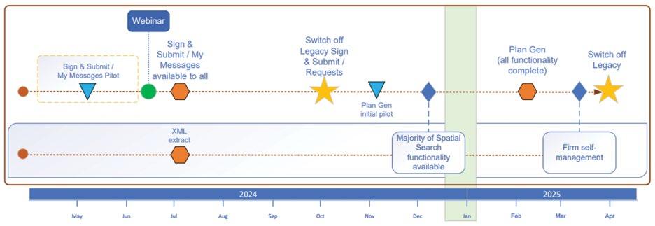
The transition of plan generation functionality into New Landonline will proceed in parallel with the consultation. Nick said: “If consultation proves that the CSD viewer prototype meets the needs of the tenure systems and customers, then we’ll start transitioning from plan generation to the CSD viewer. This means it’s important to not over-invest in plan generation in the short term.”
Over the past few years, LINZ has undertaken significant engagement with the survey profession to understand the major challenges in working with Landonline. Surveyors have advised that the biggest issues are:
Losing work on re-import of a LandXML file into Landonline
The quality/usability of plan generation tools, and plan outputs
The amount of manual effort required to recapture existing easements
Issues resulting from distortion caused by linking accurate survey positions to inaccurate DCDB positions
The time taken to approve survey datasets
Pre-validation results are difficult to understand.
The modernising Landonline team has undertaken analysis of these problems. While work to make significant progress on many of these issues will take several years, LINZ has identified a range of options for helping address the above issues.
LINZ has recently engaged with surveyors who use Landonline through a comprehensive survey to understand their perspective on the proposed improvements – specifically which developments would deliver the most value to them. This information will feed into the process for prioritising future improvements to the system.
Nick said he would update surveyors about this research at the upcoming Survey and Spatial 2024 conference in Napier. •

Nick Stillwell is the Lead Consultant Surveyor for Toitū Te Whenua Land Information New Zealand’s Modernising Landonline programme.
An innovative approach has helped an Otago team land first place in the Space for Planet Earth Challenge.
The challenge has two category winners – a university/startup level and a high school level – and is open to individuals and teams in New Zealand, Australia and the Pacific Islands. It aims to use space technologies to find new and innovative solutions to address climate change issues in Australasia.
Taking out the university/startup category for Otago was a team from the School of Computing and the School of Surveying led by PhD candidate Cristhian Camilo Delgado Fajardo and supported by Professor Peter Whigham, Associate Professor Grant Dick and Associate Professor Pascal Sirguey. Their project, "Satellite-based AI Emulators for
Efficient Monitoring of Agricultural Methane Emission", looked at how methane emission monitoring could be enhanced by using satellite data and artificial intelligence algorithms.
Cristhian, who is in the third year of his PhD, says the project fit well with his own research topic – Hybrid modeling: combining artificial intelligence with mechanistic models to improve greenhouse gases estimations from remote sensing data
“We saw the Space for Planet Earth Challenge as a unique opportunity to leverage space technologies for addressing environmental challenges, particularly in monitoring methane emissions from agricultural activities. This topic was perfectly aligned with my PhD, so we saw a valuable opportunity to get training, support and do networking.”


“I want to emphasise that the majority of the work, and the original motivation to compete in the challenge, was due to Cristhian. It was a remarkable effort and he showed tremendous leadership throughout.”
Cristhian’s primary supervisor Peter says the project was very much led and powered by Cristhian, who deserves the lion-share of credit for the win.
“I want to emphasise that the majority of the work, and the original motivation to compete in the challenge, was due to Cristhian. It was a remarkable effort and he showed tremendous leadership throughout.”
The team is “thrilled and honoured” to have won the award, which Cristhian says has motivated them to continue their work in addressing environmental
challenges through innovative research and technology.
“Our project won due to its innovative approach – combining advanced satellite technology with AI to tackle a pressing environmental issue. The judges appreciated our comprehensive methodology, the showcasing prototypes, and its potential impact. The fact that our initiative could be easily transferrable to newer satellites, like methaneSAT, makes it very attractive,” Cristhian says.
"Winning this award validates our research efforts and may open up new opportunities for collaboration and further advancements in environmental monitoring technologies."
The win comes with $25,000 and six months of mentorship from SpaceBase, which the team is utilising to enhance their project, focusing on refining their satellite-based AI emulators and expanding their capabilities in efficiently monitoring agricultural methane emissions.
They have also made “significant progress” in their collaboration discussions with representatives from NIWA, GHGSat, and MethaneSAT, and recently presented their groundbreaking work at the Machine Intelligence for GeoAnalytics and Remote Sensing (MIGARS) 2024 conference. •

25July1958–19April2024
Known for his warm and inviting nature, Hadyn had a gift for connecting with everyone he encountered. Whether he was sharing stories from his days in the police force or chatting about the latest rugby match, his genuine enthusiasm and kindness left a lasting impression on many.
Hadyn was CEO of Survey and Spatial NZ for 6 years from 2012 to 2018. Most recently, Hadyn was CEO of Crimestoppers NZ and the Honest Bunch Foundation charity.
Hadyn joined S+SNZ (then NZIS) on the cusp of implementing the hugely challenging new governance model developed in 2011-2012 titled ‘The Way Forward 2013’. The new organisational constitution and rules were successfully implemented under Hadyn’s watch.


Hadyn came to us from Land Search and Rescue New Zealand, bringing with him strong financial management, leadership and relationship building skills which he put to excellent use in building up the very successful commercial partnership programme. He was also instrumental in bringing together the NZ Spatial Excellence Awards (NZSEA) that have now been recognising and celebrating the very best of geospatial community for five years.
During his tenure, Hadyn showed a strong interest in not-for-profit community projects and was the Chair of the Alex Moore Park “Sportville” Development in Johnsonville, Wellington. This interest also came to the fore with launch of the Kairūri Community Trust - set up to help the next generation of surveying and spatial professionals where Hadyn was a key player in the Trust’s development and implementation. As an avid sports fan, particularly in rugby and softball, Hadyn has been deeply involved in developing New Zealand’s young softball talent.
Hadyn was a ‘larger than life’ character, who was interested in people and a very caring person. He will be sadly missed, and our deepest condolences go out to Hadyn’s family – his wife, Jan, daughters Rachel and Hannah and their husbands Dave and Ben and all Hadyn’s family. •