DATE: FEBRUARY 15, 2025


DATE: FEBRUARY 15, 2025


The Pierce County Comprehensive Plan is an adopted policy document that guides County decisions related to growth and development in unincorporated Pierce County. A living document that is updated at minimum every 10 years, the plan outlines existing conditions and a future vision for the County’s unincorporated areas. It contains goals and policies that are meant to direct growth and development in a way that will help the County achieve this vision.
Pierce County is the second most populous county in the state of Washington, behind King County. Formed out of Thurston County on December 22, 1852 by the legislature of Oregon Territory, it was named for U.S. President Franklin Pierce. As of the 2020 Census, the population was 921,130. The County seat is Tacoma, which is also the County's largest city, on Commencement Bay.
Major industries include aerospace, healthcare, technology, agriculture, timber products, and military installations. In addition to the City of Tacoma, Pierce County is home to several suburban cities, small towns, and rural communities, as well as forests and farmlands.
Pierce County offers a moderate climate with a contrasting geography of water and mountains, which includes miles of Puget Sound waterfront, the Cascade Mountain Range, and a number of fresh-water lakes and rivers. Pierce County has a wide diversity of watersheds, wetlands, and floodplains throughout the area. These are essential for mitigating impacts from climate change such as flooding and ensuring a diverse spectrum of ecosystem services for habitat, wildlife, and clean water for county residents.
According to the U.S. Census Bureau, the County has a total area of approximately 1,800 square miles, of which 1,670 square miles is land and 130 square miles (7.2%) is water. Pierce County is notable for being home to the volcano Mount Rainier, the tallest mountain in the Cascade Range. Mount Rainier National Park is the most visited attraction in Washington, and at 14,411 feet, is the tallest volcano in the lower 48 states
Figure 1-A: Pierce County Landscape
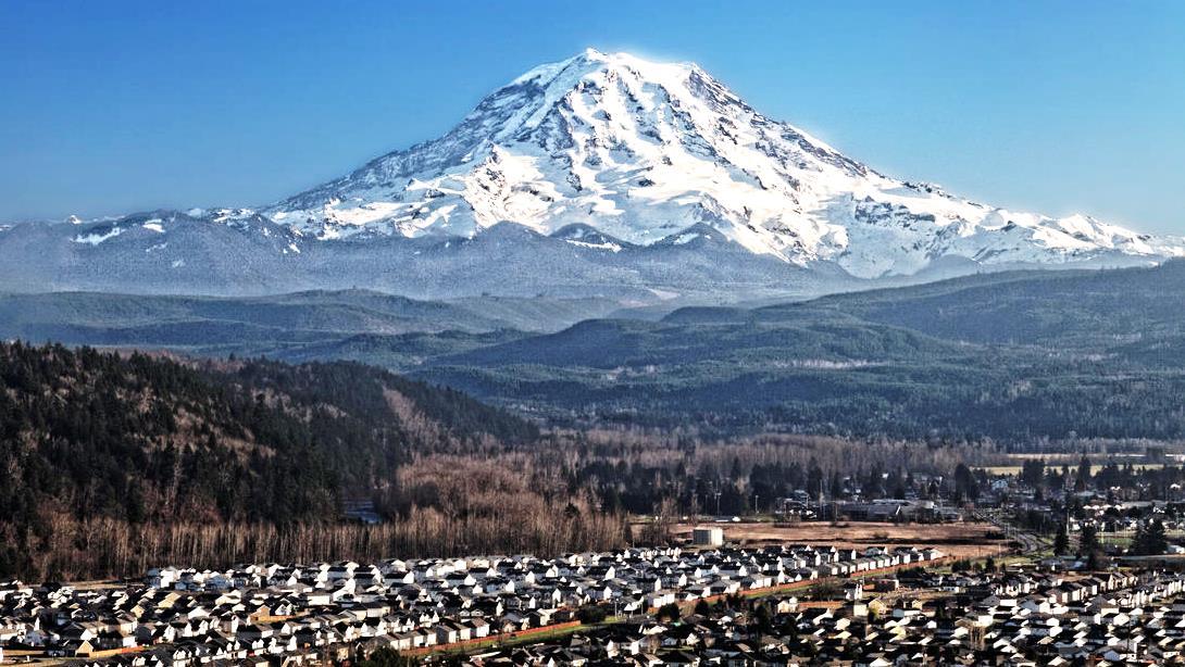
Source: USGS, Public Domain
Note: the Topography, Soils, and Government sections have been removed.
The first Pierce County Comprehensive Plan adopted after the establishment of the Growth Management Act (GMA) in the 1990s was drafted by the Pierce County Citizens' Advisory Group through a grassroots public process. The plan was adopted by the Pierce County Council on November 29, 1994, and became effective on January 1, 1995. It integrated residents' ideas, concerns, and preferences into statements of how the County should be developed, what development regulations should accomplish, what facilities and services levels are needed, and how publicly funded improvements should support these objectives over 20 years
As a living document which reflects its community, the plan is reviewed and updated regularly to address changes in conditions or the vision of the County's residents. Today’s Comprehensive Plan continues to articulate a vision of Pierce County guided by our key values. Since the first plan, policy focus has expanded to protect natural resources, enhance our quality of life through improved health and safety, and recognize the character of our communities. The nexus of community and environmental health is found in efforts to promote both climate change mitigation and adaptation. Extending the values of Pierce County residents, each element has been written with the awareness of how policies may impact equity and reduce barriers experienced by marginalized and underserved communities. Planning in Pierce County is also influenced by a hierarchy of planning authorities and must be consistent with other planning documents at the State, Regional, and Countywide levels.
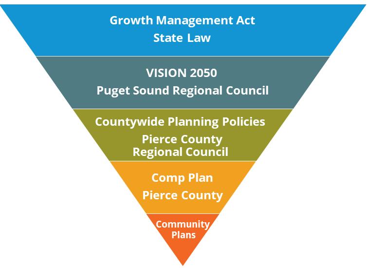
In 1990, the State Legislature enacted the Growth Management Act (GMA) which initiated and required the development of policies to manage growth in Washington State. All urban counties and their cities and towns were required to develop comprehensive plans and regulations to implement those plans. The plans include 15 mandatory elements, which must guide development and accommodate growth forecast over a 20-year period.
The GMA (RCW 36.70A) and Washington Administrative Code (WAC) (WAC 365-196) guide the development and outline the process for updating the Pierce County Comprehensive Plan. The Act outlines 15 goals for the development of a comprehensive plan, as set forth in RCW 36.70A.020. Each goal, viewed as equally important, must be furthered by the growth management strategies.
Figure 1-C: GMA Planning Goals 15 Goals of the Growth Management Act
Permits
Housing
Urban Growth
Reduce Sprawl
Transportation
Property Rights
Economic Development
Open Space and Recreation
Natural Resources Industries
Climate Change and Resiliency
Citizen Participation and Coordination
Public Facilities and Services
Historic Preservation
Environment
Shorelines
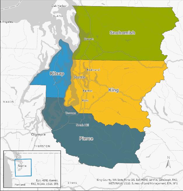
The GMA requires the development of Multicounty Planning Policies (MPPs) which provide consistency across the central Puget Sound region of King, Kitsap, Pierce, and Snohomish Counties
In 1992, the Puget Sound Regional Council (PSRC), a federally mandated Metropolitan Planning Organization (MPO) and Regional Transportation Planning Authority (RTPO), adopted MPP’s centered around transportation planning for the four-county region.
The MPP’s adopted in October of 2020, were developed as part of VISION 2050 and describe regional objectives for issues that cross jurisdictional boundaries
Pierce County’s efforts to implement the policies and regional growth strategy in VISION 2050 address region-wide issues with focus on collaboration, regional growth strategy, environment, climate change, health, equity, development patterns, housing, economy, transportation, and public services.
The Pierce County Regional Council (PCRC) was created to ensure that planning between Pierce County and its cities and towns was accomplished in a coordinated, consistent manner. The PCRC is a local regional body and comprised of elected officials from Pierce County, each of its 23 cities and towns, and the Port of Tacoma The primary responsibility of the PCRC is to ensure that the Growth Management Act requirements are coordinated within the County and the region. The PCRC makes recommendations on 20-year growth projections and Pierce County Countywide Planning Policies to the Pierce County Council to ensure growth is coordinated within the County. Additionally, PCRC distributes transportation funding and makes recommendations to PSRC on several funding programs.
Designation of urban growth areas (UGA) requires extensive coordination between the cities and towns and the County. Though UGAs remain under the County's authority, joint planning allows for land use to be coordinated in a manner which prepares areas outside municipal limits for future annexation.
The Pierce County Council passed Resolution No. R93-96, which supports a Joint Planning Framework recommended by the Pierce County Regional Council. The strategy encourages appropriate jurisdictions to enter into interlocal agreements to facilitate and accomplish joint planning in areas of mutual concern.
Pierce County conducts a Periodic Update to its Comprehensive Plan in intervals determined by the GMA, currently every 10 years. This process has a number of steps, which takes years to complete. Pierce County begins this process with a Buildable Lands Program Analysis conducted years before the adoption of the plan. The steps involve initiation of public engagement which continues throughout the process, review and analysis of the current plan, and policy research, before draft policies and reports can be written. Once complete, these drafts are shared with the public, County officials, and the Washington State Department of Commerce, for review and comment. The final stage involves amendments to the drafts based on gathered comments, with the final adoption of the Comprehensive Plan through the legislative process.
For the 2024 Periodic Update, the Buildable Lands Analysis report was published on November 11, 2022, and the final Comprehensive Plan was adopted by December 31, 2024. The update involved members of all applicable County departments, who reviewed the Comprehensive Plan with guidance from the scope of work provided by the Pierce County Council.

The Comprehensive Plan policies reflect the key values of the citizens of Pierce County:
• Protect the Character of Rural Lands
• Promote Open Space and Parks
• Preserve the Natural Environment
• Maintain Livable Neighborhoods
• Connect Motorized and Nonmotorized Transportation
• Promote a Diverse, Healthy, and Sustainable Economy
• Require Infrastructure and Services Concurrent with Actual Needs
• Preserve History in the Landscape
• Ensure Public Health and Safety
• Promote Climate Resiliency
• Support Equity
Each county that participates in the GMA’s comprehensive planning is required to ensure public participation, per RCW 36.70A.140. To provide an effective public participation program, efforts must be made to broadly disseminate the process for participation and seek early and continuous engagement. Pierce County initiated public involvement in their 2024 Comprehensive Plan Update in September of 2022.Throughout the Periodic Update process, Pierce County conducted multiple public engagement periods, each with a variety of outreach strategies. The engagement periods each focus on a different subject area of the update. A major engagement period was held in January and February 2024 to solicit input on all the draft documents.
The public involvement approach supported equitable engagement by identifying communities with barriers to participation, and designing a three-pronged approach:
1. Apply existing procedures with the general population to “cast a wide net.”
2. Implement in-person events built on the results of the equity analysis to tailor conversations to specific populations.
3. Disperse outreach to rural hubs to ensure stakeholders in more remote areas are also invited to provide input.
In addition to integrating the planning frameworks of state and regional agencies, and engaging the public to participate, Pierce County also welcomes the involvement of other governments and governmental agencies. When making changes to local planning policy, the County notifies the Port of Tacoma, Joint Base Lewis-McChord (JBLM), cities and towns, state and federal agencies, and special purpose districts in unincorporated Pierce County. The County also consults with Tribal governments, including the Muckleshoot, Nisqually, Puyallup, and Squaxin Island Tribes, regarding policy changes that may affect the tribal lands or resources. There are a number of avenues for these important partners to participate in updates to the comprehensive plan.
In alignment with the federal Executive Orders 12898 and 14008, Washington’s Healthy Environment for All (HEAL) Act, and updates to the Growth Management Act, the Pierce County Comprehensive Plan strives to reflect Pierce County's committed efforts towards racial and ethnic equity amongst its populace. The elements of the Comprehensive Plan contain policies that advance the County’s equity goals, particularly the Land Use, Environment and Climate Change, Economic Development, and Housing elements These policies address pertinent issues around environmental justice, anti-displacement, affordable housing, access to opportunity, education, cultural preservation, access to open space, and many other policy subjects.
The following policies support the empowerment of communities through the acknowledgement, consideration, and participation of those who previously were absent in planning processes.
See the Environment and Climate Change Element for Environmental Justice policies.
GOAL INT-1 Support access and inclusivity for all people, ensuring that planning policies and programs reflect Pierce County's dedication to equitable outcomes
INT-1.1 Acknowledge the needs of low-income, underserved, and minority communities in future investments and programs, including analysis of outcomes and impacts related to equity.
INT-1.2 Consider and seek to achieve social and racial equity throughout planning processes.
INT-1.3 Provide citizen engagement opportunities for low-income, underrepresented, and minority communities in planning by working towards the removal of barriers to equitable participation though targeted outreach that result in meaningful participation and feedback.
INT-1.3.1 Facilitate engagement with underserved communities through providing linguistically appropriate outreach and engagement
INT-1.4 Analyze equity when developing policy and codes and implementing them to account for health, safety, and disparate impacts on low-income communities, communities of color, and immigrant and refugee communities.
The Comprehensive Plan is organized into the following chapters:
1. INTRODUCTION. Presents community values and County profile. Outlines the planning process and provides further detail on the purpose and organization of the Comprehensive Plan.
2. LAND USE ELEMENT. Establishes land use designations and policies to guide development.
3. CAPITAL FACILITIES AND UTILITIES ELEMENT. Gives Capital Facilities and Utilities planning guidance and an inventory of existing facilities with reference to other supplemental plans.
4. CULTURAL RESOURCES ELEMENT. Encourages protection of cultural and historic resources.
5. DESIGN AND CHARACTER ELEMENT. Defines the character of the County and provides policy guidance for design standards.
6. ECONOMIC DEVELOPMENT ELEMENT. Provides guidance on supporting employment economies.
7. ENVIRONMENT AND CLIMATE CHANGE ELEMENT. Gives direction regarding critical areas, climate change, and other environmental concerns.
8. ESSENTIAL PUBLIC FACILITIES. Includes policy for identifying and siting essential public facilities.
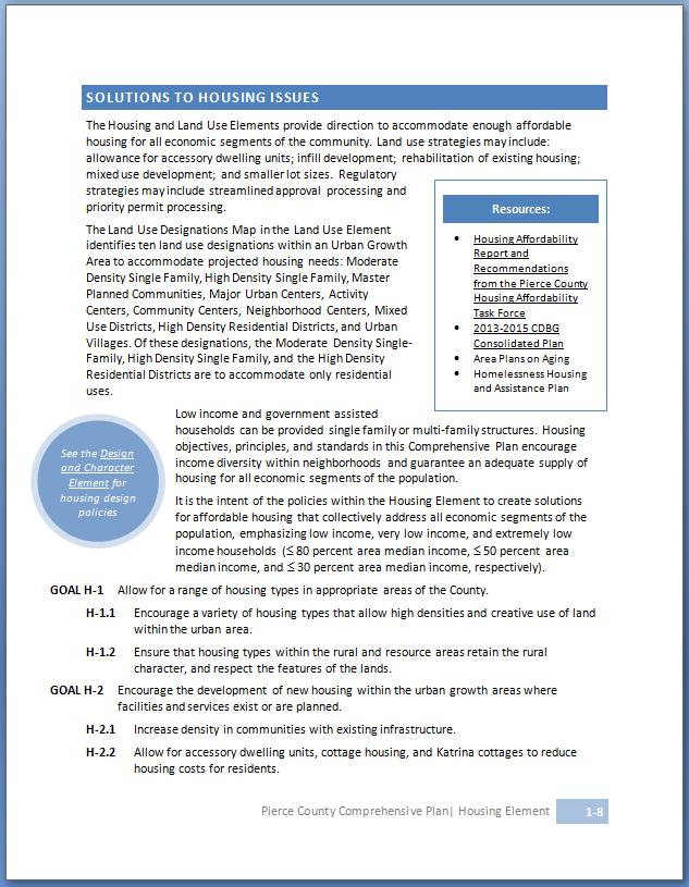
9. HOUSING ELEMENT. Provides solutions to housing issues with a focus on affordable housing.
10. OPEN SPACE ELEMENT. Describes the different types of open space and their further application throughout this plan.
11. PARKS AND RECREATION ELEMENT. Guides parks development and recreational opportunity.
12. TRANSPORTATION ELEMENT. Outlines transportation system development, concurrency, and policy guidance on all modes of transportation.
The Comprehensive Plan is intended for use by all who have a stake in the development of Pierce County. It is also a tool to assist County Councilmembers, Planning Commissioners, County staff, and others involved in making land use and public infrastructure decisions, providing the framework for the County’s Development Regulations. The plan is internally consistent even though some issues are addressed through multiple policies across elements, and other issues may receive detailed direction in community plans.
The policies contained within this Comprehensive Plan allow flexibility when it comes to implementation. Policies cannot be applied independently; rather, implementation of policies must be coordinated, addressing details such as how and when the policy is applied, or any relevant exceptions.
While the Comprehensive Plan’s narratives and maps frame key proposals, the essence of the plan is in the policies. These declarative statements set forth the County’s approach to achieving the goals that form the vision. Every effort has been made to provide clear policies However, there may be a need for interpretation, which the County has the authority to enact.
Goals are the broad overarching policy direction on a particular topic that direct subsequent policies. Policies provide further guidance in support of achieving the goals.
Within each element chapter, the policies are organized and presented in the following format:
LINKS TO OTHER ELEMENTS/SECTIONS
Buttons identify where there is overlap in policy with another element and provide a link to where they can be found.
A goal is a general statement to introduce the general idea of the following policies
A policy is a statement to guide decision making. Policies are intended be carried out by an implementation measure.

NARRATIVE INFORMATION
An introduction to each section, supplemental information, and data may be found in the narrative preceding policies.
Policy numbering corresponds with the chapter title. Policies subsequent to a larger policy issue are numbered in a hierarchical format.
CHAPTER AND PAGE NUMBERS
Page numbers are organized by chapter number and page; they also include the title of the chapter.
ADDITIONAL INFORMATION AND SIDEBARS
Text boxes and sidebars are used to provide more information, examples, and visuals that are associated with policies.
There are multiple sub-plans that implement the Comprehensive Plan, and other documents that are related to the plan. The following list is not comprehensive but provides supportive and related documents organized by element.
Element
Land Use
▪ Buildable Lands Report
▪ Joint Land Use Study
▪ Sustainability Plan
Capital Facilities and Utilities
Economic Development
Environment and Climate Change
Document
▪ PSRC Frederickson MI/C Plan Review Certification Report
▪ Capital Facilities Plan
▪ Pierce County Library 2030: Summary Report
▪ Unified Sewer Plan
▪ Pierce County Sewer Improvement Program 2019-2039
▪ 2016 Tacoma-Pierce County Solid Waste Management Plan Supplement
▪ 2021 Solid and Hazardous Waste Management Plan
▪ Coordinated Water System Plan
▪ Stormwater Management Program
▪ Basin Plans
▪ Clarks Creek Restoration Plan
▪ Flood Hazard Management Plan
▪ Spanaway Lake Watershed-Scale Stormwater Management Plan, 2017
▪ Spanaway Lake SMAP and Supplemental Plan 2022
▪ Swan Creek Watershed Characterization and Action Plan
▪ Comprehensive Floodplain Management Plan
▪ Stormwater Management and Site Development Manual
▪ Economic Development Strategic Plan
▪ PSRC Regional Economic Strategy
▪ Critical Areas Ordinance
▪ Transfer of Development Rights
▪ Climate Vulnerability Assessment | Pierce County, WA - Official Website (piercecountywa.gov)
▪ PSREA Regional GHG Inventory
▪ Pierce County’s Greenhouse Gas Reduction Plan
▪ Shoreline Master Program
▪ Pierce County’s Greenhouse Gas Reduction Plan
▪ Watershed Restoration and Enhancement Plans:
o Puyallup-White – WRIA 10
o Nisqually – WRIA 11
o Chambers-Clover – WRIA 12
o Key Peninsula, Gig Harbor and Islands (KGI) – Part of the Kitsap WRIA 15
▪ All-Hazard Mitigation Plan
Housing
▪ 2020-2024 CDBG Consolidated Plan
▪ Plan to End Homelessness
▪ Report and Recommendations from the Pierce County Housing Affordability Task Force
▪ Housing Affordability Taskforce
▪ Housing Element Background
▪ Final Housing Element Guidance(Department of Commerce)
▪ House Bill 1337 Eliminating Barriers to Accessory Dwelling Units
▪ House Bill 1220 Supporting Emergency Shelters and Housing (Department of Commerce)
Parks and Recreation
Transportation
▪ Parks, Recreation and Open Space (PROS) Plan
▪ Regional Trails Plan
▪ Six-Year Transportation Improvement Program & Fourteen-Year Ferry Program
▪ Commute Trip Reduction Plan
▪ Traffic Impact Fee Program
▪ Pierce County Ferry Planning Documents
▪ Annual Transportation Concurrency Management System Report
▪ WSDOT Planning Documents
▪ Pierce Transit Planning Documents
▪ Sound Transit Planning Documents
▪ PSRC Regional TDM Action Plan
▪ Tideflats Area Transportation Study (2015)
▪ Safe Routes to School Plan
▪ Vision Zero
The Land Use Element describes how the policies in the other plan elements will be implemented through land use policies and regulations. These land use policies shape land use decisions and strategies, affecting equity, health, and sustainability outcomes, thus Land Use is a key element of the Comprehensive Plan.
The Land Use Element was developed in accordance with Countywide Planning Policies, the Puget Sound Regional Council’s VISION 2050, and integrated with the other elements to ensure internal consistency throughout the Comprehensive Plan. The Land Use Element considers the general distribution and location of land uses, the appropriate intensity and density, the provision of public services, and environmental considerations.
The Land Use Element of the Pierce Comprehensive Plan meets the goals of the State Growth Management Act by providing policies and designating the general distribution, location, and extent of land use within the unincorporated Pierce County. The Land Use Element provides for a wide range of land uses including agriculture, timber production, housing, commerce, industry, recreation, open spaces, general aviation airports, public utilities and facilities.
The Land Use Element includes policies and guidance based on the existing population densities and estimates of future growth. The Land Use Element supports the foundational goal of the Growth Management Act by identifying and designating urban, rural and resource areas and directing higher intensity growth into the urban areas and lower intensity in rural and resource areas
The Land Use Element also includes policies that support communities that provide active transportation such as walking and biking to local services and transit. This urban design approach promotes increased physical activity within urban communities as encouraged by the Growth Management Act, Vision 2050, and the Countywide Planning Policies.
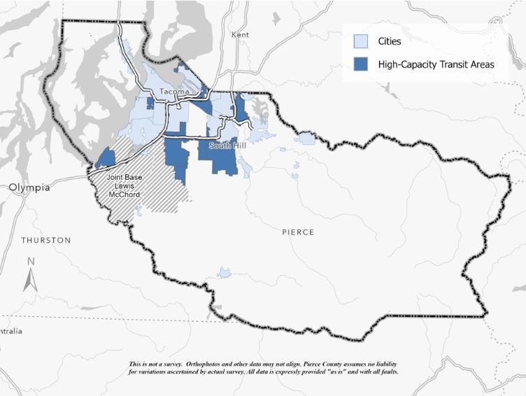
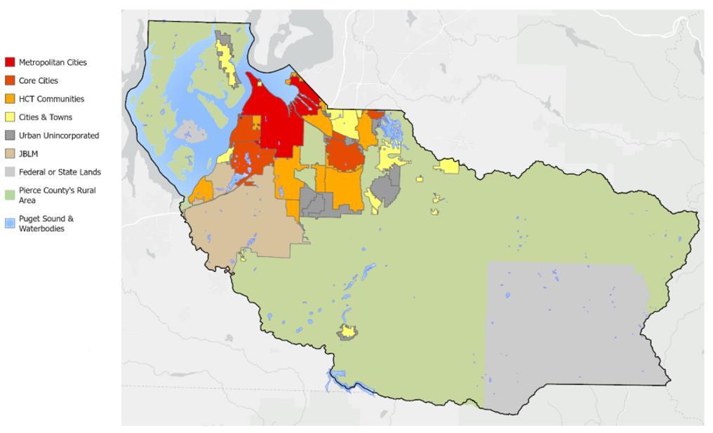
Pierce County’s implementation of the Vision 2050 Regional Growth Strategy (RGS) directs future growth to occur in distinct regional geographies and local centers within urban growth areas (UGA) The strategy focuses on concentrating this growth in the County’s high-capacity transit (HCT) areas, which will be served by frequent transit stops in the future.
In 2021, Pierce County adopted the Centers and Corridors designation to take initial steps for accommodating growth. The Centers and Corridors designated areas contained higher densities of residential and commercial development connected by public transportation capable of supporting a significant share of the community using it.
During the 2024 periodic update to Pierce County's Comprehensive Plan, the Centers and Corridors designated areas have been expanded to include land within 1/2 mile of the highcapacity transit (HCT) areas and redesignated as the Compact Urban designation. Prioritizing more intense land use and accommodating a majority of the County's projected growth in Compact Urban areas supports the establishment of walkable and transit-oriented communities. These areas will become the County’s high-density, mixed use, multi-modal core centered around transit-oriented development and a balanced supply of affordable housing and local jobs, with an emphasis on middle housing. Live and work opportunities will be complimented by pedestrian-friendly transportation infrastructure that reduces reliance on personal vehicles and collective vehicle miles traveled (VMT).
To promote the development of affordable housing for a range of income levels, the allowed density of residential development in Compact Urban areas has been increased. In addition, a new Middle Housing (MH) zone within the Compact Urban area has been created which allows a variety of housing types at moderate densities. Outside of HCT areas, urban lands in unincorporated Pierce County have been consolidated under a new Suburban Residential (SR) designation and zone which also allows for the development of a variety of housing types to support the development of middle housing at a lesser density than MH.
Focusing development in urban areas around existing infrastructure has been paired with efforts to reduce pressure from development on rural and resource lands throughout the County by reducing allowed densities in the rural area. Implementing this strategy contributes to the County’s climate objectives around greenhouse gas emissions through more efficient use of infrastructure and decreasing distances between urban amenities and services, while increasing open space and protecting critical areas.
Facilities and services are necessary for urban growth and economic development. They are essential for achieving high-quality, attractive communities. Since most growth will be encouraged in the UGA and low densities to be maintained in Rural and Resource Areas that require a lesser level of public facility needs, Pierce County is committed to using its limited public resources to concentrate on providing public services in Urban Areas. The County also can set different spending priorities within the UGAs to maximize the impact to attract certain kinds of growth to specific areas of the County, as found in the Transportation and Capital Facilities and Utilities Elements.
The GMA includes provisions for planning for physical activity. This supports community health, sustainability, and multi-modal transportation. The Pierce County Comprehensive Plan includes the following approaches to increase physical activity:
• Compact Communities, Transit-Oriented Corridors, and Prioritizing Transit-Oriented Development – The Comprehensive Plan provides policies for the development of compact communities or transit-oriented corridors that provide for pedestrian and bicycle connections to local services and transit, found in the Land Use Element: Compact Urban Communities.
• Complete Streets – The Comprehensive Plan provides policies for the development of streets that accommodate multiple users and enhance access and connectivity for pedestrians and bicyclists, found in the Transportation Element: Active Transportation.
• Employment Centers – The Comprehensive Plan provides policies that the location and design of employment centers should facilitate safe access and circulation by transit, pedestrians, bicyclists, and other alternative transportation modes, found in the Land Use Element: Employment Center.
As part of the 2024 Comprehensive Plan Update, Vision 2050 charges the County with integrating equitable and climate resilient planning practices into its policies and actions. Pierce County’s implementation of the Vision 2050 Regional Growth Strategy focuses growth in areas with access to services, transportation, and reduces per capita vehicle miles traveled (VMT). This reduces the sprawl of urban development, increasing the preservation of open spaces and reducing the emission of greenhouse gases.
Encouraging healthy communities means increasing residents’ access to safe and vibrant places to live, work, and play. Communities need parks, open space, clean air and water, and the ability to reach those amenities safely. The County fosters these communities through land use
policy, and also supports development of housing options for residents, which can be found in the Housing Element.
Pierce County is committed to inclusive community planning and engagement to ensure land use decisions do not negatively impact marginalized communities. This includes efforts to identify, analyze, and respond to physical, economic, and cultural risks of displacement.
To promote a healthy and resilient landscape throughout Pierce County, additional policy direction improves the County's ability to sustain the impacts of climate change. Efforts to protect the environment also contribute to community health by addressing climate hazards, conserving rural and resource lands, and expanding urban forestry.
Additional policies reflecting the County’s approach to equity can be found in the Introduction of the Comprehensive Plan.
The inventory presented in this Element provides information useful to the planning process. The data included here is not exhaustive but is intended to highlight the most relevant information in a concise format. Specific information about the demographic make-up of Pierce County can be found in the Housing and Economic Development Elements.
The Growth Management Act requires Pierce County to designate an urban growth area that is sufficient in size to accommodate the projected population growth for the 20-year planning period.
The basis for the County's urban population target is a countywide projection range generated by the Washington State Office of Financial Management (OFM). In coordination with its 23 cities and towns, Pierce County chose a medium range population growth target as shown in Table 2-A. This OFM medium range is consistent with Vison 2050’s Regional Growth Strategy, further described below.
Table 2-A: Pierce County 2044 Population Projections
Source: OFM Population Projection Series, 2022.
Pierce County Council adopted population targets in 2022 and revised them in 2023. 1 The targets determine areas within the County where growth should occur. The selection of these areas is influenced by Vision 2050’s Regional Growth Strategy.
1 Ordinance 2022-46s and Ordinance 2023-22s
The adopted countywide population target of 1,196,798, shown in Table 2-B, is just above the medium range of the 2022 population projections, shown in Table 2-A. The Washington State Office of Financial Management released its latest 20-year growth management planning population projections in December 2022
2-B: Total Population Targets for Pierce County
Source: Ord. 2022-46s
The Puget Sound Regional Council (PSRC) provided an estimated growth allocation which was based on Vision 2050 and the Regional Growth Strategy. The PSRC recommended modification of the housing estimates in order to reflect local development trends, which were adopted by ordinance by County Council2. Though the adopted estimate differs from the PSRC allocation, it meets the intentions of Vision 2050, producing a similar allocation among the regional geographies, as seen in Table 2-C. The relationship between regional geographies can be better understood through Figure 2-B.
Source: Pierce County Planning & Public Works
2 Ordinance 2022-46s and Ordinance 2023-22s
Source: PSRC Vision 2050 & Pierce County Planning & Public Works
Pursuant to RCW 36.70A.215, Pierce County and its cities and towns have established a review and evaluation program which aids the process for determining sufficient capacity or land supply to accommodate urban growth. To support the 10-year Comprehensive Plan Update cycle, this analysis of buildable lands must be completed three years before the Comprehensive Plan Update has been submitted for review. The Buildable Lands Program looks at how countywide planning policies and current comprehensive plans are performing in achieving their intended densities, through data that reveals actual development patterns for urban, rural, and resource lands. If growth has performed outside of the expectations of the plans and policies, the program identifies reasonable measures for resolving inconsistencies. The report findings and a methodology for estimating housing and employment capacity is detailed in the 2022 Pierce County Buildable Lands Report.
High-capacity transit (HCT) areas are urban communities within ½ mile of fixed-route transit corridors that have been identified in Vision 2050. These areas have the highest residential density in the unincorporated area and are where the majority of the County’s growth is focused. Urban unincorporated areas are urban communities in the County that are not part of a city or town. These areas are urban in character and have urban services being provided. Based on the 2044 projections, Pierce County has sufficient capacity for its projected growth in the high-capacity transit areas and urban unincorporated areas.
Source: Pierce County Buildable Lands report 2022, Ordinance 2022-46s, Ordinance 2023-22s
To ensure requirements are met by jurisdictions, the state requires an analysis of policy implementation under RCW 36.70A.070 (9). Following the adoption of the 2024 Comprehensive Plan Update, Pierce County and cities and towns must submit an Implementation Progress Report to the Department of Commerce every five years. This implementation report assesses the progress towards the affordability and availability of housing, permit processing timelines, and implementation of actions required for reductions of greenhouse gases and vehicle miles traveled.
The inventory shown in Table 2-E includes land use information about the unincorporated portions of Pierce County. The existing types of land uses can be used to gauge the proportion of total land area that the County will need to devote to each land use in the future. The existing land uses will be adjusted for expected shifts in needs or desires, and projections of future land uses will be derived.
Source: Pierce County Assessor n.d.; BERK 2023.
1. Excludes water and military lands 2. High-Capacity Transit Area
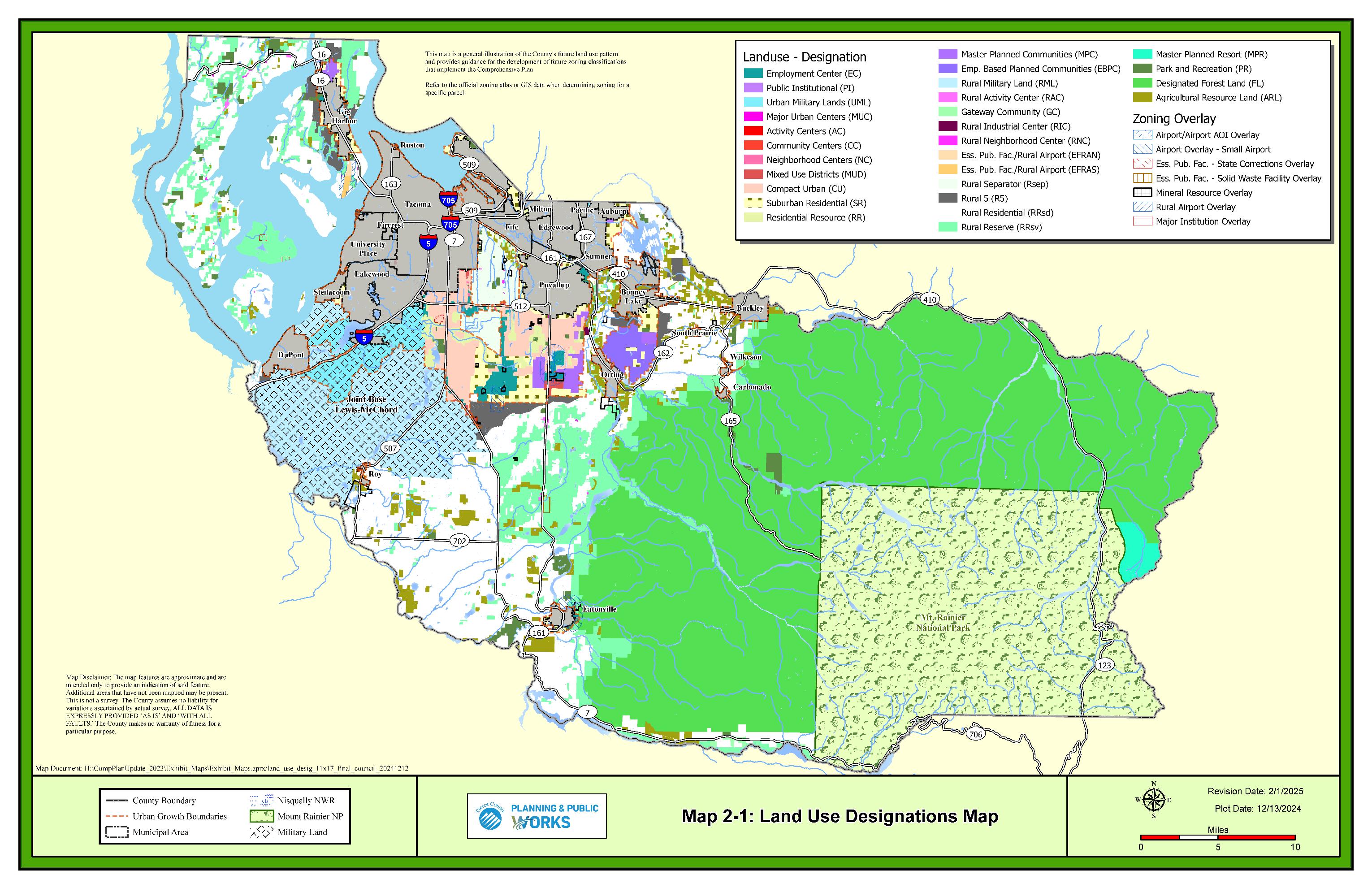
The distribution of land uses defines the general use of the land within unincorporated Pierce County. This accounts for the appropriate location for agriculture, timber production, housing, commerce, industry, recreation, open spaces, general aviation airports, public utilities, public facilities, and other land uses. Pierce County zoning regulations determine how that use is achieved under the land use designation, shown in Table 2-F.
Table 2-F: Unincorporated Pierce County Land Use Designation & Zoning
Rural Land Use Designations
The Growth Management Act (RCW 36.70A.070 (1)) requires that the Comprehensive Plan clearly show the general distribution of land The future land use map, Land Use Designations Map 2-1, also shows city boundaries and urban growth areas. This map is the representation of the goals and policies of the Comprehensive Plan for the organization and coordination of land uses.
The urban area is defined by the County’s urban growth area (UGA) boundary. Each city and town within the County must fall within an urban growth area. Additionally, urban lands in unincorporated portions of the County should be within an urban growth boundary. Consistent with the Growth Management Act (GMA), the Vision 2050 growth and development strategy directs future development to occur primarily within the UGA. The UGA surrounds incorporated cities and towns and includes the majority of Pierce County’s population and economic base. Further, Vision 2050 guides growth in certain regional geographies consistent with the GMA. The majority of new housing and jobs in unincorporated Pierce County are intended to locate within the UGA near high-capacity transit (HCT). The Centers and Corridors land use designation was created to support transit-oriented development near HCT areas, which will contain frequent transit stops.
Public spending for facilities, services, and open space is intended in compact urban communities, mixed use districts, and high density residential districts to promote efficient use of public improvements and services, and enhance community diversity, livability, and prosperity across all communities. Residential areas developed at a low to moderate density will serve as the principal land use for the remaining areas within the UGA. This distribution of growth reflects the Regional Growth Strategy of Vision 2050.
Pierce County has also established potential incorporation areas (PIAs), which identify areas of development which may become their own city. In contrast, potential annexation areas (PAAs) are urban areas of development which are designated to become a part of a neighboring city. PIAs are identified in the Urban Growth Areas and Potential Annexation Areas map below, Map 2-2, or may be designated through community plans.
The South Hill PIA designation includes an area of roughly 20 square miles, and a population of nearly 65,000 people, located just south of the city of Puyallup. Development within the area is centered along SR-161 Pierce County's Centers and Corridors development pattern supports a mix of residential and commercial development at medium to high levels of urban density. Growth around this strategy intends to utilize existing infrastructure efficiently. Modeled after local cities of similar size, analysis of the existing land use, levels of service, revenues, and future growth projections determined South Hill PIA's financial feasibility. Increased density and development are needed to sustain the South Hill PIAs fiscal resiliency.
In addition, the County has identified the employment based planned community (EBPC) of Tehaleh as a PIA. The Tehaleh PIA designation was based upon a variety of factors including: its size and projected population compared to other Pierce County cities; its designation and plan that distinguish it from other urban areas; its separate geographical identity; its mixture of urban densities and land uses needed for a complete city; a viable potential tax base; a unique identity and community; and the provision of planned urban services largely financed by its residents These factors, as well as the expressed views of current residents, make incorporation a strong potential.
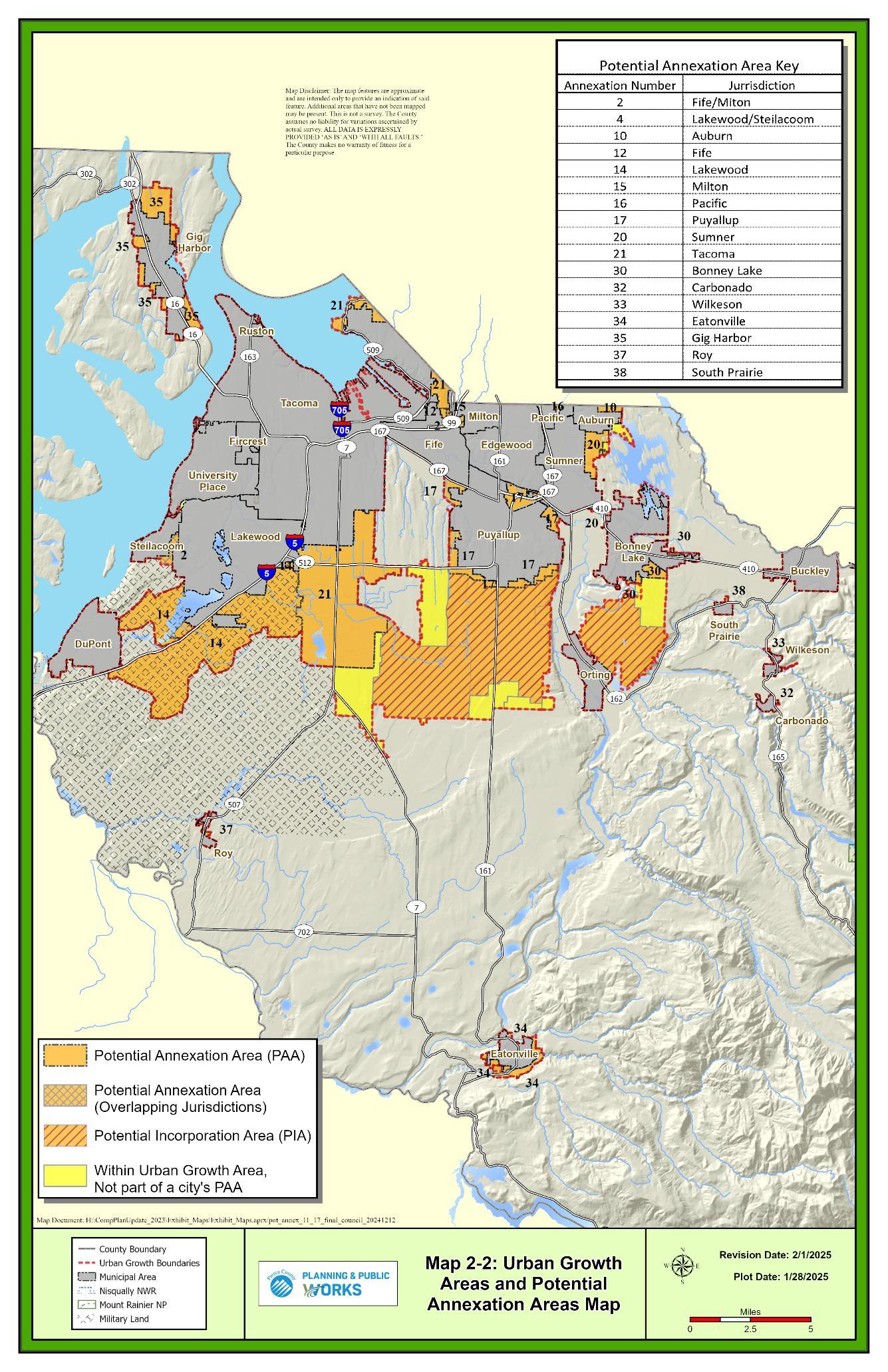
The individual cities and towns within the UGA, in collaboration with the County, have established potential annexation areas (PAAs). PAAs are associated with the adjacent city or town and indicate that portion of the UGA is reserved for its future annexation. These individual city and town PAAs, within the UGA, are incorporated as part of the County's Comprehensive Plan.
Although the County and the cities and towns within the UGA concur that individual PAAs may change as planning and implementation proceed, the affected municipalities and the County agree that PAA designations are provided under the terms of the Countywide Planning Policies and RCW 36.70A.110. Areas within the UGA, where requested individual potential annexation areas overlap one another, have been identified as overlap areas on the Urban Growth Area/Potential Annexation Area map, Map 2-2. The County should not designate UGAs or PAAs within these overlap areas until such time as the requesting jurisdictions resolve the overlap conflicts by agreement and/or further cooperation with the County. These designations are based upon the jurisdictions' commitment and ability to provide urban level services and facilities to these areas. Ultimately, the specific activities and land uses encouraged within these areas and the growth management system used will be identified through a joint planning process and subsequent negotiation and execution of interlocal agreements. However, until such agreements are in place, the County's land use designation and growth management system will govern development proposals within the unincorporated areas. The County's land use designations within these unincorporated UGAs are generally consistent with comprehensive plans of the affected jurisdictions.
The biannual plan amendment process, as authorized by RCW 36.70A.130(2) and PCC 19C.10, will be used to designate urban growth areas, as necessary, for cities and towns as the County's growth management abilities evolve. Likewise, it is expected that the plan amendment process will be critical in allowing necessary adjustments to the PAAs of jurisdictions within the UGA and making necessary and reciprocal modifications to the UGA itself.
GOAL LU-1 Facilitate the transformation of unincorporated urban areas into cities and towns through annexation.
LU-1.1 Promote annexation of potential annexation areas through outreach to residents, land owners, governing bodies, and other stakeholders.
LU-1.1.1 Support annexation proposals that are consistent with the Pierce County Countywide Planning Policies and the Washington State Growth Management Act, when the area proposed for annexation is wholly within the annexing city’s adopted potential annexation area (PAA).
LU-1.1.2 Prioritize annexation of unincorporated islands between cities and towns.
LU-1.1.3 Do not support annexation proposals that would: result in illogical service areas, create or lead to the potential creation of unincorporated islands, or focus solely on area of economic gain for the annexing city at the exclusion of other proximate areas that should be logically included.
LU-1.2 Work towards establishing joint planning agreements between the County and its cities and towns for potential annexation areas.
LU-1.2.1 Use the joint planning agreements as a mechanism where the County or a city can, prior to notice of annexation, identify potential objections and resolutions.
LU-1.2.2 Reference relevant community plans and consult with relevant land use advisory commissions and community members in the development and implementation of joint planning agreements.
LU-1.2.3 Explore the establishment of financial incentives and partnerships with cities and towns to encourage annexation of areas within designated potential annexation areas (PAA's).
LU-1.2.4 Establish a timeline for service transitions and for annexation.
LU-1.2.5 Ensure that the County’s land use designations and associated development regulations are consistent with a city or town’s land use plans within its respective potential annexation areas
GOAL LU-2 Ensure that unincorporated urban areas within the urban growth area are either affiliated with neighboring cities and towns as potential annexation areas (PAAs) or identified as potential incorporation areas (PIAs).
LU-2.1 Overlapping PAAs are not encouraged but may exist where two or more jurisdictions have mutual interest in an area.
LU-2.2 Prohibit modification to an established PAA that results in an unincorporated urban island that is not affiliated with any city or town.
LU-2.3 Affiliate unincorporated urban areas with neighboring cities or towns rather than being identified as a PIA.
LU-2.4 Establish a PIA designation where incorporation of an area is appropriate based upon: logical geographic boundaries; size; population; a potential tax base to support a City; a variety of uses needed for a City, including residential, businesses, civic and recreational; urban services and facilities provided other than by adjacent cities; a community identity; and other appropriate factors.
GOAL LU-3 Explore incorporation and annexation of identified areas.
LU-3.1 Establish stakeholder groups of local residents, service providers, businesses, and other interested parties to identify opportunities and challenges associated with the incorporation of identified areas.
LU-3.2 Explore the economic viability of incorporation through the completion of incorporation feasibility studies.
GOAL LU-4 Explore financial incentives for a city or town to annex areas associated with its respective Potential Annexation Area.
GOAL LU-5 Direct growth within the designated urban growth areas (UGA) where growth is economically viable, are served by frequent transit stops, and adequate public facilities exist or can be efficiently provided.
LU-5.1 Adopt measures through joint planning to ensure that growth is timed and phased consistently with the provision of adequate public facilities and services.
LU-5.2 Prior to expansion of a Potential Annexation Area (PAA), a joint planning agreement must be in place for all PAAs affiliated with the jurisdiction.
GOAL LU-6 Review residential, commercial, and industrial development capacity no later than three years prior to a mandated Comprehensive Plan update to determine whether adjustment of the UGA is appropriate.
LU-6.1 Include the capacity of lands within municipal limits and unincorporated urban Pierce County.
LU-6.2 Utilize the most recent information on population and development trends to augment the most recent capacity analysis when reviewing proposed new UGA or expansion of existing UGA
LU-6.3 Ensure that the methodologies used to determine the capacity of the UGAs and to calculate the allowable number of dwelling units for individual development proposals shall be consistent with each other.
LU-6.3.1 Consider regulations that affect the possible number of units for individual development proposals, including, but not limited to, critical areas, roads, and soil infiltration capacity for stormwater management when determining the capacity of the UGA.
GOAL LU-7 Support expansion of the urban growth area (UGA) boundary, consistent with the Regional Growth Strategy (RGS), to meet a jurisdiction's growth needs.
LU-7.1 Allow expansion in areas affiliated with a city or town where urban services can be provided.
LU-7.2 Avoid including lands with high concentrations of critical areas or designated as resource lands in UGA expansions. Such areas should be given the lowest priority for inclusion into the UGA and should be included only when participating in a compensatory program, such as the transfer of development rights.
LU-7.3 Allow expansion to include lands that are necessary to provide capacity for student population growth in those school districts that have completed a collaborative planning process with the County.
GOAL LU-8
Allow for the adjustment of urban growth areas to meet the projected growth needs of a city or town.
LU-8.1 Approve UGA expansions if the following criteria are met:
• A need is demonstrated for additional residential or employment capacity within the urban growth area affiliated with an individual jurisdiction and a demonstrated countywide need; or the expansion results in a no net gain of housing unit or employment capacity to the countywide UGA. The demonstration of need shall be shown though a comparison of the adopted housing unit or employment targets against the housing or employment capacity as documented in the most recent Buildable Lands Report
• The jurisdiction’s observed development densities are consistent with the planned density assumptions as documented in the most recently published Buildable Lands Report as required by RCW 36.70A.215.
• If the Buildable Lands Report identifies an inconsistency between the observed and assumed densities, the jurisdiction shall either demonstrate that reasonable measures were adopted to rectify the inconsistency, or document updated development data that indicates consistency.
• If a jurisdiction adopted reasonable measures, documentation shall be submitted that summarizes the monitoring results of the effectiveness of the measures in rectifying density inconsistencies.
• Documentation that adequate public facilities and services can be provided within the 20-year planning horizon is provided.
• Proposed UGA expansion areas shall be required to comply with the requirements of Pierce County’s TDR/PDR program.
• Proposed UGA expansion areas should be approved only if the proposing jurisdiction provides an analysis of:
o The underutilized lands, consistent with the Pierce County Buildable Lands program methodology, within its existing municipal boundaries and affiliated UGA, and evidence of implementation strategies in place or being pursed to densify the underdeveloped lands;
o Housing goals or policies in place to encourage housing for all economic segments of the community; and
o How the proposal is consistent and reasonable with the jurisdiction’s adopted comprehensive plan.
• Future UGA expansion areas should be approved only if it is demonstrated that the area has the capability and capacity to provide urban level services while maintaining a healthy natural ecosystem.
• Future UGA expansion areas should avoid the inclusion of designated agricultural lands and critical areas
• Adopted land use and design standards for proposed UGA expansion areas shall plan for design characteristics and infrastructure necessary to make transit a viable transportation alternative.
• Prohibit the expansion of the UGA into the 100-year floodplain of any river or river segment per RCW.
LU-8.2 Area(s) proposed to be removed from the UGA shall be rural in character and not have vested permits that will result in urban type development.
In 2021, Pierce County adopted the Centers and Corridors land use designation to take initial steps for accommodating higher densities of residential and commercial development along major transportation corridors. These changes aligned the County with Puget Sound Regional Council's (PSRC) Regional Growth Strategy, which was outlined in Vision 2040.
During the 2024 periodic update to Pierce County's Comprehensive Plan, this effort towards centering growth around walkable and transit-oriented communities was taken a step further. To align with the Multicounty Planning Policies (MPP) of PSRC's Vision 2050, the Centers and Corridors have been expanded to include land within a half-mile of high-capacity transit (HCT) areas. Renamed under the Compact Urban designation, these areas will become the county’s high-density, mixed use, multi-modal core, offering residents a balanced supply of affordable housing and local jobs, with an emphasis on middle housing types, such as row housing.
The PSRC Vision 2050 Policies and the Pierce County Countywide Planning Policies direct the development of compact urban communities that have diversity of housing, high connectivity, and provide for multi-modal transportation including pedestrian, bicycle, and transit. Many of the components associated with compact urban communities are similar to transit-oriented development (TOD). TOD is a land use strategy intended to promote efficient use of land and transportation infrastructure with places of relatively higher density, pedestrian-friendly development with a mix of land uses located within an easy walk of a bus or rail transit center.
A potential risk of focusing growth in regional growth centers near high-capacity transit (HCT) is the physical, economic, and cultural displacement of existing residents due to a rapid increase in property values and demand. To respond to these risks, policies in this section support strategies to monitor, analyze, and mitigate the risks of displacement. Pierce County's growth strategy is oriented around identified high-capacity transit (HCT) areas located along frequent transit stops.
High-Capacity Transit (HCT):
High-capacity transit areas are mixed use areas with higher densities of residential and commercial development connected by public transportation capable of supporting a significant share of the community using it.
The growth strategy accounts for increasing both the supply and types of housing near HCT areas, which serve residents with a variety of income levels. Efforts to reduce barriers to the development of vacant and underutilized parcels, incentivize mixed and reduced income projects, promote middle housing, and support suitable housing for the elderly and disabled, can be found in the Housing Element.
GOAL LU-9 Support the viability of existing neighborhoods and communities as land use change occurs.
LU-9.1 Support efforts to preserve the character and enhance the livability of neighborhoods by fostering reinvestment and redevelopment of existing housing and commercial development.
LU-9.1.1 Collaborate to understand the drivers of displacement in at-risk communities, through the involvement of local citizens groups, organizations, and institutions in the affected areas.
LU-9.1.2 Consider the risk of displacing low-income households and marginalized populations as a result of planning, public investment, private redevelopment, and market pressures, and utilize strategies to mitigate the impacts to the extent feasible.
LU-9.2 Support diversification of housing types and costs through the promotion of mixed-income neighborhoods and implementation of land use regulations, consistent with the policies established under Housing Element Goal HO-7.
See the Housing Element for further policies,
The UGA in central Pierce County presents opportunities for concentrating growth in centers and creating compact communities which best utilize supporting infrastructure. This area, designated as Compact Urban, is central to Pierce County's implementation of the Vision 2050 Regional Growth Strategy (RGS), which relies on efficient land use practices.
The Compact Urban designation contains high-capacity transit (HCT) areas with a concentration of frequent transit stops. Utilizing this infrastructure by supporting and incentivizing increases to housing, jobs, and services in centralized locations allows Pierce County to provide opportunities for focused growth. This strategy expands infrastructure for multiple modes of transportation, contributing to improvements in community health and the overall livability of neighborhoods.
These areas will develop as high-quality compact communities that impart a sense of place, preserve local character, provide for vertical mixed-use development, and a range of housing types. In addition to transit amenities, pedestrian-oriented design brings building fronts in closer proximity to the County right-of-way which includes wide sidewalks, landing strips, street landscaping, and other pedestrian amenities.
Compact Urban areas are implemented through a number of zoning types which contain land uses that shape the establishment of these communities.
• Towne Centers: Existing developed areas comprised of significant intersections or existing commercial/employment development that serve as a focus of a future compact urban community. These areas will be destinations with a draw that develop with a mix of housing, employment, retail and services, entertainment, and community
services. Centers are pedestrian-oriented and reduce the need for a car, allowing residents and visitors to park once and walk to multiple venues.
• Urban & Neighborhood Corridors: Located along major transportation corridors where existing development patterns provide the functions of a center, but in a linear form. Corridors are less intensive than Centers and are more accommodating for automobiles. These areas may be enhanced with transit and increased connectivity between transitoriented residential and commercial areas.
• Middle Housing: Areas of residential development which allow for a range of housing types that fall between single-family residences and mid-rise multi-family development, which includes multiplexes, townhomes, and cottage housing. These structures meet the needs of a range of income levels, such as first-time home buyers and seniors who are downsizing.
• High Density Residential: Residential development at a level of density that falls between Middle Housing and Corridors areas. This provides for middle and multi-family housing, civic uses, and is in proximity to transit infrastructure and services.
GOAL LU-10 Implement the Compact Urban designation within the central UGA to encourage the development of transit-oriented compact urban communities.
LU-10.1 Designate Compact Urban areas within or near a half mile of major transportation corridors.
LU-10.2 Ensure there is an intensity and density of land uses sufficient to support highcapacity transit while also encouraging an increase of transit ridership, which may reduce single-occupancy vehicle use especially during peak hours and commute times
LU-10.2.1 Encourage the development of vibrant and sustainable communities through the creation of mixed-use and commercial development which serves local communities, activates storefronts, facilitates pedestrian access, and minimizes land-intensive commercial space.
LU-10.2.2 Consider phased housing on small sites with existing development by allowing a minimum density exemption for infill on underutilized portions of the site until future development occurs on the full site.
LU-10.3 Incentivize the expansion of the Multifamily Tax Exemptions (MFTE) program within high-capacity transit areas as supported in the Housing Element
LU-10.4 Promote transit expansion and use, which contributes to cumulative reductions in greenhouse gas emissions and resilient communities.
LU-10.4.1 Coordinate with local transit providers to support high-interval transit service that provides access to services within the Towne Center and access to transit facilities that access regional centers of activity.
LU-10.5 Support the development of pedestrian and bicycle connections, pedestrian oriented land uses, and amenities
LU-10.6 Support urban design standards which reflect the local community and encourage housing diversity.
LU-10.7 Plan for sufficient public open spaces and recreational opportunities.
LU-10.8 Allow uses which provide both daytime and nighttime activities.
LU-10.9 Implement the Compact Urban land use designation through the following zone classifications: Towne Center (TCTR), Urban Corridor (UCOR), Neighborhood Corridor (NCOR), High Density Residential (HRD), Middle Housing (MH), Parks (PR), and Public Institution (PI).
LU-10.9.1 Towne Center (TCTR), Urban Corridor (UCOR), and Neighborhood Corridor (NCOR) zones shall only be established within or near a half mile of the following major transportation corridors:
• Pacific Avenue South and Mountain Highway (SR-7) south of 96th Street South and north of 208th Street East;
• Meridian Avenue (SR-161) south of 47th Avenue South East and north of 176th Street East;
• Canyon Road East south of SR-512 and north of 176th Street East;
• 112th Street East east of Park Avenue South and west of Pipeline Road East; and
• 176th Street East east of Pacific Avenue and Mountain Highway (SR-7) and west of Meridian Avenue (SR-161).
LU-10.9.2 Allow for a variety of pedestrian-oriented, high-density multifamily, offices, commercial, and civic uses in the Towne Center (TCTR) zone
LU-10.9.2.1 Consider Towne Centers as Centers of Local Importance for regional planning purposes.
LU-10.9.2.2 Design public buildings and public spaces that contribute to the unique sense of community and a sense of place.
LU-10.9.2.3 Design transportation projects and other infrastructure to achieve community development objectives of connectivity, walkability, bikability, and transit support.
LU-10.9.2.4 Promote context-sensitive design of transportation facilities, both for facilities to fit in the context of the communities in which they are located, as well as applying urban design principles for projects in Towne Centers and transit station areas.
LU-10.10 Allow for primarily neighborhood-scale, moderate to high-density residential use in the NCOR zone, supplemented by limited commercial, office, and civic uses.
LU-10.11 Allow high-density multifamily, office, commercial, and civic uses in the UCOR zone to supplement the Centers and connect with pedestrian-oriented design features.
LU-10.12 Allow Employment Corridor (ECOR) zoning within Compact Urban areas, within the Employment Center (EC) designation.
LU-10.13 Develop the High Density Residential (HRD) zone primarily with multifamily housing and single-family housing that is complemented by civic uses and allows for limited business and commercial uses
LU-10.13.1 Support affordable housing development which utilizes buildings ranging in scale and provides a variety of housing types, sizes, and costs.
LU-10.13.2 Provide neighborhood retail and service commercial activities of limited size at intervals to prevent development of commercial strips.
LU-10.13.3 Utilize site design techniques to create a smooth transition between uses and ensure compatibility with adjacent lower density single-family areas.
LU-10.13.4 Develop recreational open spaces within and between connecting developments, preserving their natural ability to sequester carbon.
LU-10.13.5 Locate the HRD zone along major arterials that are characterized by minimal commercial or industrial development.
LU-10.13.6 Ensure mitigation of any significant increase in traffic volume caused by high-density residential development on residential streets serving low to moderate density residential development.
LU-10.14 Implement the Middle Housing (MH) zone to encourage residential development that provides for a variety of housing types at a range of income levels, and is served by multi-modal transportation, facilities, and services.
LU-10.14.1 Support the development of medium-density single-family housing types which vary in size, type, and cost, including single-family attached and cottage housing.
LU-10.14.2 Support the development of limited multifamily housing.
LU-10.14.2.1 Develop recreational and open spaces amongst developments, preserving their natural ability to sequester carbon.
LU-10.14.3 Allow primarily residential uses in the Middle Housing zone complemented by limited civic and utility uses, while prohibiting commercial uses.
LU-10.14.4 Utilize site design techniques for transitioning between uses and ensuring compatibility with adjacent lower density residential areas.
The PSRC Vision 2050 Multicounty Planning Policies and the Pierce County Countywide Planning Policies direct transportation and economic development funds to be prioritized for Centers. The need to support development along transportation corridors intended to experience the most growth, along with significant factors such as the condition, functionality, and project phasing, guide the expansion of infrastructure in Compact Urban areas.
GOAL LU-11 Prioritize infrastructure funding to support the growth and development of Compact Urban designated areas.
LU-11.1 Prioritize infrastructure expansion as follows within Compact Urban designated areas:
See Capital Facilities and Utilities Element for further policies.
• Areas located along fully funded high-capacity transit routes are the highest priority.
• Areas located along planned frequent transit stops are the second highest priority.
• Compact Urban areas located away from high-capacity transit routes and frequent transit stops are the third highest priority.
LU-11.2 Public investment in infrastructure within Compact Urban areas should be further prioritized.
• Town Centers are the highest priority.
• Urban Corridors and Employment Corridors within the Employment Center designation are the second highest priority
• Neighborhood Corridors are the third highest priority.
Joint development occurs when a public agency partners with other agencies, typically a transit agency, and private developers to develop property that may be owned by the agency and is generally located near a transit station. Partnership may also include the funding or construction of major infrastructure components that facilitate a transit-oriented community or project even if property in owned privately.
GOAL LU-12 Support joint development and funding of infrastructure and amenities to support compact development.
GOAL LU-13 Work with transit agencies to identify opportunities for use of publicly owned lands for joint use projects that enhance access to transit, increase transit ridership, and further the development of compact communities.
GOAL LU-14 Work with private developers to create public-private projects where the joint action will create infrastructure improvements that will further the objectives of compact communities.
GOAL LU-15 Prioritize and locate publicly accessed public buildings within Compact Urban areas with the intent of adding services that are accessible by walking, biking, and transit, and furthering the objectives of compact communities.
Urban residential uses range from single family to multifamily and mixed use at a variety of densities. The minimum density within the urban growth area is four dwelling units per acre, and in limited circumstances may be less than four in recognition of unique environmental characteristics as noted in the policies below.
GOAL LU-16 Establish a minimum, base, and maximum density for all residential zones.
LU-16.1 Ensure additional criteria are met if a property is developed at a density higher than the base.
LU-16.2 Utilize a range of maximum densities to increase compatibility between neighboring residential zones.
LU-16.3 Provide density-based incentives.
Additional criteria include (LU-16.1):
• Site amenities
• Design features.
LU-16.4 Allow for two accessory dwelling units on a residential lot where a singlefamily dwelling exists.
LU-16.4.1 Accessory dwelling units within urban land use designations shall not be included in the calculation of residential densities.
GOAL LU-17 Encourage high-density single-family housing, expand the variety of housing types, and maximize the use of existing infrastructure within the UGA through the High Density Single-Family (HSF) zone.
LU-17.1 Allow for moderate to high urban density single-family developments.
LU-17.2 Allow for attached single-family development.
GOAL LU-18 Maintain the stability and integrity of residential neighborhoods through a variety of techniques.
LU-18.1 Encourage cluster development of residential lands to permanently protect sensitive features or reserve land for future urban development.
LU-18.2 Support densities that allow a range of housing types, designs, and costs.
LU-18.2.1 Encourage high density housing within commercial centers, and mixed use and multifamily districts.
LU-18.2.2 Encourage the integration of residential units within the same building(s) as commercial activity in mixed use designations.
GOAL LU-19 Calculate the allowable number of dwelling units within individual urban development proposals using net developable acreage.
LU-19.1 In determining net developable acreage, deductions shall be made for roads and environmentally constrained lands.
GOAL LU-20 Require the provision of urban level facilities and services prior to or concurrent with development for water, adequate sewage treatment, stormwater and surface water management, and roads
GOAL LU-21 Consider allowing platting for urban housing at an increased density if the lots are located in an area where sanitary sewer is planned, but not available, provided Health Department requirements are met.
LU-21.1 Utilize large on-site sewage systems for phasing urban density and discouraging individual on-site septic systems.
LU-21.1.1 Require owners of interim systems to connect to sanitary sewer when available.
GOAL LU-22 Encourage alternative sewage disposal methods approved by the Tacoma-Pierce County Health Department when minimum residential densities can be met or on legal lots of record recorded with the Pierce County Auditor before January 1, 1995
SUBURBAN RESIDENTIAL
See Environment & Climate Change Element for further policies
The Suburban Residential designation falls outside of a designated center or district and supports the establishment of low-density single-family neighborhood housing. The Suburban Residential designation provides for a variety of housing types and design standards Development within this designation should consider: housing types; costs and densities; pedestrian and vehicular access and circulation; transit strategies; and environmental constraints.
GOAL LU-23 Implement the Suburban Residential land use designation within unincorporated urban areas to encourage the development of single-family residential neighborhoods.
LU-23.1 Implement the Suburban Residential (SR) land use designation through the Suburban Residential (SR) zone.
LU-23.2 Prohibit commercial and industrial uses.
LU-23.3 Allow for limited civic use.
LU-23.4 Allow a variety of housing types that can be built at low densities.
RESIDENTIAL RESOURCE
The Residential Resource designation supports the establishment of low-density single-family housing in the urban growth area that have environmental constraints. This designation is often located in areas characterized by flood risk or adjacent to open space.
GOAL LU-24 Implement the Residential Resource (RR) designation to support the development of single-family residential uses compatible with unique landscapes and critical areas.
LU-24.1 Allow for uses that are compatible or integrated with areas of unique open space character and/or environmental sensitivity in the Residential Resource (RR) zone.
LU-24.1.1 Apply the RR zone in areas that have high value environmental features that are both complex in structure and function and large in scope.
LU-24.2 Allow for limited civic and utilities uses to support neighborhoods, and resource uses that are compatible with the unique character of the environment.
Pierce County intends to provide a predictable development atmosphere that emphasizes diversity in the range of goods and services provided, and ensures that as the economy changes, employment opportunities and associated land uses are balanced with a wide range of other uses.
GOAL LU-25 Encourage community facilities, retail trade, services, and multifamily development in Urban Commercial areas.
LU-25.1 Discourage detached single- and two-family residential, and auto-oriented commercial development.
LU-25.2 Discourage heavy industrial, manufacturing, or commercial development which is land intensive and includes a low number of employees per acre.
GOAL LU-26 Provide a predictable development atmosphere.
LU-26.1 Locate shopping, service, and leisure-time activities in commercial areas.
LU-26.1.1 Designate new commercial areas in response to growth or in underserved areas, only when a market analysis shows existing commercial areas are insufficient to meet local needs.
GOAL LU-27 Design or improve commercial sites to facilitate circulation by pedestrians, bicyclists, transit, and other alternative transportation modes, reducing VMT and greenhouse gas emissions.
LU-27.1 Retrofit commercial strip malls into pedestrian-oriented commercial nodes.
LU-27.2 Locate convenience and commercial services at transit centers to provide enhanced services and security to users of public transit facilities.
LU-27.3 Mix civic, recreational, residential, office, and open space uses within commercial areas to encourage walking and discourage driving for short trips.
LU-27.4 Promote safe, efficient commercial development along arterials and state routes.
LU-27.5 Develop vacant and underutilized properties as unified developments to provide multiple goods or services.
LU-27.6 Discourage commercial development in continuous strips along arterials.
LU-27.6.1 Prohibit the extension of existing commercial strips.
LU-27.6.2 Concentrate commercial areas and discourage strip-like development and the extension of existing commercial strips.
LU-27.7 Orient major traffic generators to the main transportation network, grouping these uses into planned areas to avoid impacting residential streets and neighborhoods and to eliminate strip development.
LU-27.8 Separate adult businesses from facilities oriented toward children, and from other adult businesses.
LU-27.9 Plan for electric vehicle (EV) charging in parking areas.
The Major Urban Center is a highly dense concentration of urban development with a commercial focus. A significant multi-family residential presence in the area is encouraged. Buildings should not have height restrictions. It is an area of regional attraction and a focus for both the local and regional transit systems. The geographic area around South Hill Mall is Pierce County's existing Major Urban Center. Commercial, office and multi-family development are encouraged within Major Urban Centers. Low density residential, businesses with a low number of employees per acre, and auto-oriented commercial uses should not be located in Major Urban Centers. Design standards should emphasize internal pedestrian circulation.
GOAL LU-28 Encourage development of Major Urban Centers to meet the needs of the region's economy, to provide employment, shopping, services, multi-family development and leisure-time activities in Urban Areas, and to transform Pierce County from a commuter economy to a jobs-based economy.
LU-28.1 Encourage retail trade, service, finance, insurance, real estate, multi-family housing, pedestrian and transit-oriented facilities development within the Major Urban Centers.
LU-28.2 Discourage detached single-family residential, two-family residential, and auto-oriented commercial development.
LU-28.3 Discourage industrial, manufacturing or commercial development which is land intensive and employs a low number of employees per acre.
LU-28.4 Require design standards that further the Major Urban Center objectives:
• Sidewalks, skywalks, boardwalks, bicycle paths, and other means of internal pedestrian and non-motorized circulation are a priority.
• Sites should be developed without front yards.
• Parking should be shared and parking management programs implemented.
• Control vehicular access.
• Landscaping, plazas, and other amenities should be required.
• Multi-level parking facilities are encouraged.
LU-28.5 Encourage community facilities to locate in Major Urban Centers.
LU-28.6 Allow major Urban Centers to be designated as receiving zones for transfer of development rights.
Mixed Use Districts (MUDs) are concentrations of commercial, office, and multifamily developments located along major arterials, state highways, and major transit routes
Commercial activity in Mixed Use Districts caters to a customer base beyond the surrounding neighborhoods or community due to its placement on a roadway used by residents of more than one community.
Auto-oriented commercial and land-intensive commercial with a low number of employees per acre should be the primary use within Mixed Use Districts. The individual commercial activities or developments in these districts are not of a size or character to be considered major activity or traffic-generating uses.
Multifamily and office uses are allowed within Mixed Use Districts to provide economic diversity and housing opportunities near transit routes and business activity. There will be a mix of size and type of development within the Mixed Use Districts. These districts will include design standards and placement criteria to ensure a compatible relationship with residential areas adjacent to the Mixed Use Districts.
GOAL LU-29 Encourage the reorientation of historically commercial strips to less congested, transit-compatible districts of mixed uses and intensities with the Mixed Use District (MUD) land use designation
LU-29.1 Locate MUDs along major transportation routes characterized by commercial development.
LU-29.2 Implement the Mixed Use District land use designation through the following zone classifications: Mixed Use District (MUD), Residential/Office-Civic (ROC), and Moderate-High Density Residential (MHR).
LU-29.3 Promote low impact development designs to reduce the amount of impervious area.
LU-29.4 Allow intensive commercial and office development.
LU-29.5 Apply performance standards for efficiency, functionality, and aesthetics.
Low impact development standards are (LU-29.3):
Land use management strategies that emphasize conservation, use of onsite natural features and site planning to minimize impervious surfaces, native vegetation loss, and stormwater runoff.
LU-29.6 Encourage developments to access side streets rather than access directly onto the corridor roadway to minimize traffic and improve safety
LU-29.7 Utilize common access points onto the roadway and allow access for employees, patrons, and residents of abutting developments.
LU-29.8 Define building heights in consideration of anticipated land uses, surrounding land uses, safety and emergency measures, transportation networks, and efficient use of land.
LU-29.9 Allow MUDs as receiving zones for transfer of development rights.
GOAL LU-30 Provide a transition between commercial areas and lower density residential land use designations with residential uses in MUDs.
LU-30.1 Encourage high density residential development.
LU-30.2 Utilize incentives for inclusion of a multifamily residential component in commercial developments.
An Activity Center (AC) has as its focus a recreational, cultural, or educational activity, around which develops a concentration of commercial, office, or high-density residential development. The attraction draws people from throughout the region to this area, not just surrounding neighborhoods or the community in which the activity is located, such as the Roy rodeo.
GOAL LU-31 Designate Activity Center in areas near recreational, cultural, and educational attractions, and design to meet the shopping, service, office, and multifamily housing needs of residents and visitors.
LU-31.1 Locate the Activity Center zone within or around any of the following uses: colleges and universities, regional public recreation complexes, regional commercial recreational complexes, or cultural complexes
LU-31.2 Properly size the Activity Center to encourage pedestrian movement throughout the center. Locate the Activity Center on major transit routes.
LU-31.3 Implement the Activity Center land use designation through the Activity Center zone classification.
The Community Center (CC) designation has as its focus a significant commercial traffic generator, around which develops a concentration of other commercial developments. The commercial activity within the center is directed to a customer base drawn from more than one neighborhood. Examples of development include large scale supermarkets that serve a wide customer base.
GOAL LU-32 Locate and design Community Centers to meet the shopping and service needs of the surrounding community.
LU-32.1 Properly size Community Centers to serve the needs of more than one neighborhood while remaining small enough to be compatible with surrounding residential areas.
LU-32.2 Designate Community Centers as receiving zones for transfer of development rights
LU-32.3 Implement the Community Center land use designation through the following zone classifications: Community Center (CC) and Residential/Office-Civic (ROC)
The Neighborhood Center (NC) designation is a concentrated mix of small-scale retail, service commercial, and office development that serves the daily needs of residents within the immediate neighborhood. Residential development at various densities may occur within the center, if appropriate to the individual neighborhood.
GOAL LU-33 Locate and design NCs to provide everyday shopping and services to a relatively small, nearby population.
LU-33.1 Limit the size to keep NCs small and compatible with surrounding residential areas.
LU-33.2 Implement the Neighborhood Center land use designation through the following zone classifications: Neighborhood Center (NC) and Residential/Office-Civic (ROC)
An Employment Center (EC) often contains office parks, manufacturing, other industrial development, or a combination of activities. It may also include commercial development as a part of the center, as long as the commercial development is incidental to the employment activities of the center. Designation of adequate areas for Employment Centers is one component of meeting the needs of a growing jobs-based economy. Master planning for Employment Centers is encouraged to ensure efficient access, facilitate timely provision of public services, and provide safety and design standards for location of uses.
GOAL LU-34 Implement the Employment Center land use designation through the following zone classifications: Employment Center (EC), Community Employment (CE), Public Institution (PI), and Employment Corridor (ECOR). Designate areas where one or more of these conditions apply:
LU-34.1 Where there is adequate land, public facilities and services, and street capacities available within the 20-year planning horizon;
LU-34.2 Adjacent to or in proximity to land designated EC;
LU-34.3 Within proximity to major transportation thoroughfares, including rail;
LU-34.4 Adjacent to or in proximity to adequate water, sanitary sewer, power and natural gas utilities capable of servicing commercial/industrial development;
LU-34.5 Near historical employment generating operations;
LU-34.6 On properties that are not constrained by significant critical areas such as wetlands, steep slopes or other environmental factors limiting development potential;
LU-34.7 Characterized by larger parcels, typically averaging more than five acres;
LU-34.8 Within urban growth areas;
LU-34.9 In a manner which attracts and retains businesses;
LU-34.10 Geographically dispersed throughout the County to meet the industrial and manufacturing needs of a growing jobs-based economy; and
LU-34.11 Only if there is a demonstrated need to provide for more land in the area based on shortages of developable land, and when the expansion is compatible with any applicable community plan.
GOAL LU-35 Designate the ECOR zone along major transportation corridors to support employment uses such as professional offices and industrial uses, new housing is prohibited.
LU-35.1 Limit the focus of the ECOR zone to areas within or near a half mile of the following major transportation corridors:
• Pacific Avenue South and Mountain Highway (SR-7) south of 96th Street South and north of 208th Street East;
• Meridian Avenue (SR-161) south of 47th Avenue South East and north of 176th Street East;
• Canyon Road East south of SR-512 and north of 176th Street East;
• 112th Street East east of Park Avenue South and west of Pipeline Road East; and
• 176th Street East east of Pacific Avenue and Mountain Highway (SR-7) and west of Meridian Avenue (SR-161).
GOAL LU-36 Promote the grouping of uses that will mutually benefit each other or provide needed services.
LU-36.1 Encourage planned developments of multiple buildings or uses which provide a mixture of low and moderate-intensity industrial, research, office, and supporting commercial uses.
LU-36.2 Encourage intensive manufacturing businesses to be clustered in industrial parks along major transportation links to minimize the impact on less intensive surrounding land uses.
GOAL LU-37 Provide a diverse range of goods and services to ensure that as the economy changes, employment opportunities are balanced with a wide range of other land uses.
LU-37.1 Ensure enough land is designated as industrial to meet employment targets.
LU-37.2 Establish distinct land use types and zoning classifications for industrial, research, and office development which accommodate a broad range of economic development activities in appropriate locations.
LU-37.3 Encourage development which provides a high number of jobs relative to the amount of land used, while limiting land intensive development that results in a low number of jobs.
LU-37.4 Ensure no net loss of land designated for industrial uses.
LU-37.5 Facilitate access and circulation by transit, car and van pools, pedestrians, bicyclists, and other alternative transportation modes through location and facility design
LU-37.6 Encourage developments to consider visibility and convenient access from major arterials and highways, proximity to environmentally sensitive lands, and the desired character of the industrial area.
See the Transportation Element for further policies.
LU-37.7 Allow commercial and residential uses that support and serve the daily needs of the workforce when the neighboring zone classifications do not allow for such uses.
LU-37.8 Prohibit new detached single-family residential in industrial areas with limited exceptions.
LU-37.9 Encourage master planning for industrial areas, including such features as open space, landscaping, integrated signage, traffic control, and overall management and maintenance through covenants or other property management techniques.
LU-37.10 Encourage large, contiguously owned properties to be developed as a unified whole.
LU-37.11 Provide sites with a variety of parcel sizes to accommodate both large and small businesses, and particularly those of sufficient size to permit development of large industrial facilities.
See the Economic Development Element for more policies regarding industry and the Frederickson M/IC
The Frederickson Regional Manufacturing/Industrial Center (M/IC) is located within the urban unincorporated area, southeast of Tacoma and south of Puyallup. The center contains the intersection of 176th St. E. and Canyon Road E., and goes as far south as 208th Street. The
boundaries are depicted in Map 2-3 , and are encompassed in the Frederickson Community Plan area.
The Employment Center in Frederickson was designated as a Regional Manufacturing/Industrial Center in 1995 in anticipation of future development. Employment is currently at 5,426, an increase from nearly 4,000 in 2014.
Since designation, the boundary has been adjusted to remove properties with environmental constraints, vested residential plats, parks, and open space to focus on properties that are conducive to industrial development.
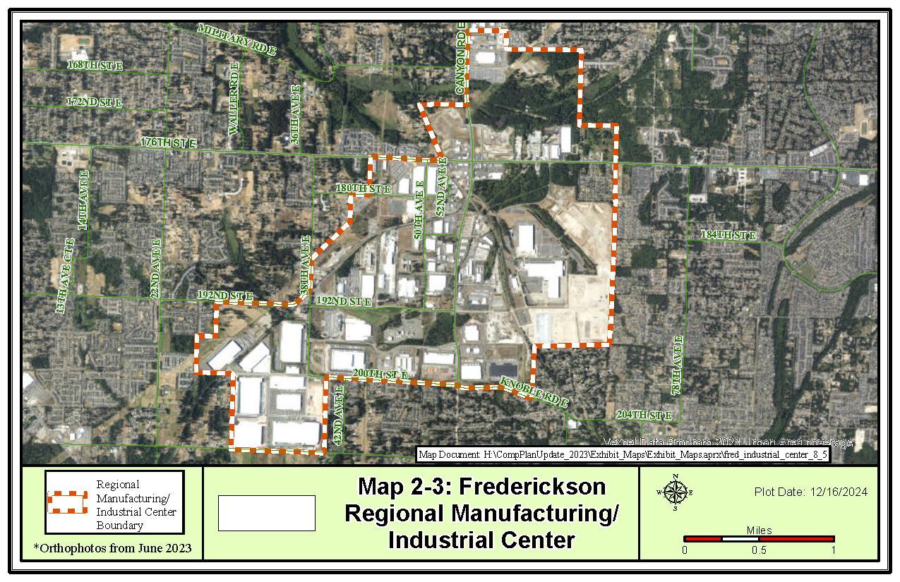
The Frederickson M/IC is considered medium sized in terms of total gross acreage (2,651 acres) and has a smaller number of jobs compared to other designated regional centers. The center contains mostly employment-oriented activity. Major industry sectors include Manufacturing (50%), Wholesale, Transportation, and Utilities (13%), Service (13%), and Suppressed/Other (24%). Of the total number of jobs, the vast majority are in goods producing industries that are typically appropriate for Regional Manufacturing/Industrial Centers. The two largest employers are The Boeing Company and Toray Composites (America), with significant employment by Pierce County and Amazon as well. The current employment density is 2.05 employees per acre. The target for the Frederickson M/IC is 10,000 total employment (5,000 additional) within the 20-year planning period. This target would create employment density of 5.6 employees per acre.
The M/IC includes critical areas associated with Clover Creek, which runs through the northern portion of the M/IC boundary. Policies in the Comprehensive Plan’s Environment and Climate Change Element and the Critical Area Regulations in Pierce County Code Title 18E address protection of critical areas. The area surrounding the M/IC includes critical areas primarily associated with Clover Creek and its associated streams and wetlands.

See the Environment and Climate Change Element for further policies
GOAL LU-38 Recognize the Frederickson Employment Center as a Regional Manufacturing/Industrial Center and focus employment growth to this area.
LU-38.1 Encourage the type of development that will focus a significant share of employment growth to the Frederickson M/IC.
LU-38.1.1 Emphasize efficient size and shape, planning for transportation facilities and services, planning for energy-efficient and low-carbon building energy solutions, urban design standards, and protection from incompatible land uses.
LU-38.1.2 Discourage developments with low employment rates that cover large expanses of land.
LU-38.1.3 Monitor land uses in the Manufacturing/Industrial Center to ensure primarily core industrial uses are developed and limit commercial uses, retaining a minimum of 50% industrial employment and at least 75% of industrial zoned land for core industrial use.
LU-38.1.4 Encourage limited development of accessory uses which serve the needs of the local workforce, such as food, health, and childcare services.
LU-38.2 Prioritize infrastructure funding for projects supporting the Frederickson Industrial Center.
LU-38.2.1 Identify and implement infrastructure improvements which enhance the viability and attractiveness of the Frederickson Industrial Center.
LU-38.2.2 Coordinate with stakeholders to provide critical infrastructure to encourage the concentration of urban manufacturing and industrial land uses in the Frederickson Industrial Center.
LU-38.2.3 Support transportation demand management strategies which result in a balanced mode split, providing non-motorized facilities, transit services, and other pedestrian oriented modes as alternatives to single occupancy vehicles, when both safe and feasible.
See the Transportation Element for further policies.
LU-38.3 Establish center-specific employment targets, transportation-mode split goals, a market analysis for the area, and information on public service improvement financing and projects beyond roads.
LU-38.3.1 Meet an employment target of 10,000 total jobs within the 20-year planning period.
LU-38.4 Promote employee health and wellness by supporting access to onsite fitness and recreational facilities.
GOAL LU-39 Encourage development of new, self-sufficient, planned communities that address the full range of needs of the residents, including housing, jobs, services, and recreation.
LU-39.1 Allow the Employment-Based Planned Community (EBPC) land use classification to allow for EBPC developments approved pursuant to the planned unit development or planned development district permit process.
LU-39.2 Develop EBPCs within the urban growth area if they meet the following criteria:
LU-39.2.1 EBPC development must be at least 320 acres or more in size;
LU-39.2.2 New infrastructure is provided for and impact fees are established consistent with the requirements of RCW 82.02.050;
LU-39.2.3 Transit-oriented site planning and traffic demand management programs are implemented;
LU-39.2.4 Buffers are provided between the EBPC and adjacent urban development;
LU-39.2.5 A mix of uses is provided to offer jobs, housing, and services to the residents of the EBPC;
LU-39.2.6 Affordable housing is provided within the EBPC for a broad range of income levels; and
LU-39.2.7 Environmental protection has been addressed and provided for.
LU-39.3 Require the proponent to submit an infrastructure and public facilities plan, including an analysis of financing options that conform to the proposed phasing plan and assure concurrency.
LU-39.4 Require that EBPCs be developed with an Employment Center in the first component of development.
LU-39.4.1 Do not allow residential as the exclusive use in the initial phases of an EBPC.
LU-39.4.2 Ensure that over the course of project development, the EBPC shall maintain an appropriate mix of jobs, services, recreation, and housing as established by the initial approval.
LU-39.5 Require EBPCs to provide their approved levels of employment in tandem with their residential development.
LU-39.5.1 Monitor this balance through the periodic review of the development’s traffic impacts as required by the Hearing Examiner.
GOAL LU-40 Encourage Master Planned Community (MPC) developments within an urban growth area as a way to achieve well-designed, compact urban development with a balance of uses, more efficient use of public facilities, and greater open space.
LU-40.1 Allow MPC developments provided that the approval includes a phasing plan to ensure that the various segments of the development are served by adequate public facilities and services.
LU-40.2 Require MPC developments to be at least 320 acres in size.
LU-40.3 Require MPC developments to consider the following:
• An appropriate mix of housing, services, and recreation;
• Neighborhoods with a variety of housing options, including affordable housing for a range of income levels, consistent with a jobs-housing balance;
• A phasing plan to ensure orderly urban growth and ability to respond to market demands for economic development and housing;
• An infrastructure and public facilities plan, including an analysis of a range of financing options, where appropriate, that conform to the proposed phasing plan;
• Site planning that encourages transit use and nonmotorized transportation, and a transportation demand management plan;
• Open space to promote both active and passive recreation, and centers for community activities and assembly; and
• Measures to protect critical areas and conserve resource lands.
GOAL LU-41 Recognize Pacific Lutheran University with a Major Institution Overlay for the existing campus located on 150 acres in the Parkland area, and other lands surrounding the university as a result of future Comprehensive Plan amendments.
LU-41.1 Implement the overlay with a Major Institution Master Plan (MIMP) approved by the Pierce County Hearing Examiner to establish allowed facilities and uses, including those facilities and uses typically associated with the university, and may include educational facilities, housing, commercial uses, and supporting infrastructure.
LU-41.2 Provide measures to ensure that the uses and activities associated with the university are compatible with the surrounding land uses and natural systems on adjacent lands.
Rural lands are lands located outside of an urban growth area (UGA). They are separate from those lands that are designated Resource Lands. While there are designated Resource lands outside the UGA, resource uses are allowed in all rural designations.
The context of rural areas is provided by the adjacent lands, such as designated forest land, and the land uses, such as designated agricultural land, that are interspersed within the rural areas. Rural areas in Pierce County are generally located between an urban growth boundary and forest lands utilized primarily for commercial timber production. Except for incorporated cities, all of the southern county, a part of the eastern county, the peninsulas, and most islands are characterized by rural settlement and activities. The presence of Fort Lewis exerts considerable influence on the southern part of the County. There are considerable local differences within the rural areas in terms of physical environment and settlement pattern. For example, a suburban development pattern exists in some limited areas such as the southern part of the Gig Harbor Peninsula. Diversity in the existing rural environment provides a unique local identity for each rural area.
Typically, rural areas have received their identity from a rural way of life rooted in history and resource-based industries such as commercial fishing, aquaculture, lumber milling, logging, dairying, daffodil or berry farming, horse ranching, and mining. More recently, recreation and other associated uses have come to dominate in areas with outstanding natural features and scenic beauty. Counties, small towns, and rural centers provide limited services to rural residents. Many people choose to reside in rural areas because of the desired quality of life and relative affordability.
Rural areas provide for rural uses incorporating existing as well as historic patterns of settlement and character. Rural areas can function as a buffer between urbanized areas and resource land. They can supply lands that may be added to an urban growth area over time.
Major components of the Rural section are as follows:
A. Encourage and support economic vitality of the County's rural area in ways that protect the rural way of life and are compatible with the rural environment. One of the means to accomplish this goal is to not allow urban-level service extensions including sewer lines into rural areas except to remedy groundwater contamination problems to
correct health hazards or when there is an existing formal binding agreement to serve an approved development.
B. Preserve the character of the rural landscape by allowing a range of rural densities. For residential development, encourage property owners and developers to set aside open space in order to conserve rural lands and mitigate impacts to critical areas
C. A mix of uses is directed to locate in Rural Centers which include Rural Activity Centers, Rural Neighborhood Centers, and Rural Gateway Communities. Rural Gateway Communities are located near major recreational facilities including the entrances to Mount Rainier National Park. The major functions of the Rural Centers are servicing the retail and other commercial and business needs of the local communities and providing employment opportunities including those related to tourism and natural resourcebased industries.
D. Respect the carrying capacity of the natural environment and protect important elements of the rural environment, including its scenic and historic resources, in order to preserve the basis of a rural way of life.
Rural areas are characterized by low densities with scattered residential sites and moderatesized to large open acreages for farm or forest use, often with an owner's home on such acreage. Commercial and non-commercial agricultural and forestry and other natural resourcebased practices are consistent with rural areas. Rural areas are characterized by having individual services (septic tanks, water wells) and/or by district services (some water districts, fire districts, etc.) and having minimal roads (except thoroughfares). Maintaining farm and forest lands by limiting development reduces the intensity of use on the lands and mitigates urban sprawl. This helps to preserve the land’s economic and recreational utility and improve the region’s resilience to climate hazards.
The Rural Area designations include areas meeting one or more of the following location criteria:
A. All lands outside of feasible or currently planned extension areas (i.e., an urban growth area) for public service facilities needed to support urban level development intensity.
B. All lands outside of long-term commercially significant forest resources.
C. All lands outside of long-term commercially significant agricultural resources.
D. Lands developed in rural uses on soils poorly suited to development at urban level densities with on-site disposal of sewage.
E. Lands where good opportunities exist for small-scale farming and forestry (large-scale farms and forested lands are designated as Resource Lands).
F. Lands where a Rural Area designation will help buffer nearby Resource Lands from conflicting urban uses.
The population growth projected for the rural areas is approximately 7,944 persons during the 20-year planning horizon.3
Rural areas are characterized by low densities with scattered residential sites and moderate to large-sized open acreages for farm or forest use. Agriculture, forestry, and other natural resource-based practices are consistent with rural areas. Rural areas are characterized by having individual services and/or by district services and having minimal roads.
Table
Type Land Use Designation
Residential
Commercial
Industrial
Other
Rural 5 (R5)
Rural Residential (RRsd)
Rural Reserve (RRsv)
Rural Separator (RSep)
Gateway Center (GC)
Rural Activity Center (RAC)
Rural Neighborhood Center (RNC)
Rural Industrial Center (RIC)
Master Planned Resort (MPR)
New Fully Contained Community (NFCC)*
GOAL LU-42 Rural Character is defined as:
• The natural landscape, native vegetation, wildlife habitat, and large areas of open space predominating over the built environment.
• An economy and lifestyle supported by agricultural and forestry activities, smallscale natural resource industries, cottage industries, and services that serve needs of local residents and tourists
• A visual character enhanced by scenic resources and territorial views.
• A landscape attuned with the use of the land and water by wildlife and fish.
• A land use pattern protected from conversion into uses that require urban level services except for extension of sewer to school facilities that meet Additional Rural Policies - Schools in Rural Areas Goal LU-60
LU-42.1 Rural services are public facilities and services historically and typically delivered at intensities usually found in rural areas, and may include:
3 Pierce County Buildable Lands Report
• Domestic water system;
• Fire and police protection;
• Transportation infrastructure;
• Public transportation;
• Public utilities, such as electrical, telecommunications and natural gas lines;
• Do not include sanitary sewers unless conditions are consistent with LU-43.2; and
• Civic uses necessary to serve the needs of rural residents.
• May provide varying levels of service dependent on need to serve the permitted densities and uses.
LU-42.2 Develop rural areas in a manner that preserves watercourses, aquifer recharge areas, and the natural hydrologic cycle.
LU-42.3 Protect undeveloped areas from inappropriate conversion by limiting commercial services and low-density residential development.
LU-42.4 Protect undeveloped areas from inappropriate conversion by allowing new civic uses to co-locate with other allowed civic uses.
GOAL LU-43 Ensure land uses and activities are consistent with and preserve rural character.
LU-43.1 Encourage and support economic vitality in ways that protect the rural way of life and are compatible with the rural environment.
LU-43.2 Prohibit urban level service extensions, including sewer lines, into rural areas, except:
LU-43.2.1 To remedy groundwater contamination problems to correct health hazards
LU-43.2.2 When there is an existing formal binding agreement to serve an approved development.
LU-43.2.3 For public facilities and utilities to serve a school sited in a rural area pursuant to Additional Rural Policies – Schools in Rural Areas GOAL LU60.
LU-43.3 Establish development standards for rural areas that would consider the differences between urban development requirements and rural development needs.
LU-43.4 Protect important scenic, cultural, and historic resources to preserve rural character.
LU-43.4.1 Encourage low-density residential and resource-based activity as primary uses.
LU-43.4.2 Allow for limited non-residential land uses that support rural densities and meet the needs of the rural population.
LU-43.4.3 Encourage home occupation or cottage industry as another means for non-residential uses.
LU-43.4.4 Allow agricultural sales involving products such as produce, dairy products, flowers, and handcrafted items in commercial areas.
LU-43.4.5 Locate commercial animal production, boarding, and slaughtering uses in rural and agricultural areas.
LU-43.4.6 Support the raising of crops in rural and agricultural areas.
LU-43.4.6.1 Crop processing facilities should be located in commercial, industrial, and agricultural areas.
LU-43.4.6.2 Limited processing activities may occur in rural areas.
See also the Open Space and Environment & Climate Change elements for further policies
GOAL LU-44 Acknowledge the important role open space and resource lands can play in maintaining a climate resilient landscape, retaining the ability to sequester carbon.
LU-44.1 Support programs which educate and inform rural property owners of actions they can take to positively impact local climate adaptation efforts.
Rural residential areas are planned at low densities that require rural levels of service. They are intended to contain housing opportunities through a mix of large lots Rural areas should provide for low residential densities and appropriate public improvements and services to provide for a rural lifestyle and protect rural character.
GOAL LU-45 Allow a variety of rural residential land uses and densities that are consistent with the rural lifestyle and protect rural character.
LU-45.1 Allow for one accessory dwelling unit on a residential lot where a single-family dwelling exists.
LU-45.2 Maintain and promote rural residential land uses that:
• Promote a low density rural land use pattern;
• Preserve rural character;
• Encourage resource-based activities; and
• Protect environmentally sensitive features.
GOAL LU-46 Encourage low-density development which utilizes rural levels of service and land uses that preserve the unique character of rural lands through the Rural Residential (RRsd) land use designation.
LU-46.1 Implement the Rural Residential (RRsd) land use designation through the Rural 10 (R10) zone classification.
GOAL LU-47 Provide areas for rural land uses that buffer between urban areas and other rural lands through the Rural 5 (R5) land use designation.
LU-47.1 Designate lands as Rural 5 (R5) in contiguous areas adjacent to, or within approximately one mile of, the urban growth area boundary and where lots sizes average approximately seven acres or less in size.
LU-47.2 Implement the Rural 5 (R5) land use designation through the Rural 5 (R5) zone classification.
LU-47.3 Prohibit rezones to Rural 5 (R5) land use designation from less intensive rural zones.
GOAL LU-48 Encourage low-density development and land uses which utilize rural levels of service, protect sensitive resources, and preserve the unique character of rural lands through the Rural Reserve (RRsv) land use designation.
LU-48.1 Implement the Rural Reserve (RRsv) land use designation through the following zone classifications: Rural 20 (R20), Rural 40 (R40), Rural Farm (RF), and Rural Sensitive Resource (RSR).
LU-48.2 Protect agricultural activities on lands that do not qualify as designated Agricultural Resource Lands of long-term commercial significance.
LU-48.2.1 Establish the Rural Farm zone based on current or historic agricultural use, including the following factors:
• The property shall be a minimum of one acre in size;
• The property is located outside a Rural Center or designated Resource lands ; and
• The property meets one of the following conditions:
o The property is currently enrolled in the Current Use Assessment program for productive farm and agriculture or has been designated as Open Space following reclassification from Farm & Agriculture; or
o The property owner requests parcel zoned as Rural Farm through an amendment process.
LU-48.2.2 Recognize agricultural properties that may or may not contain prime soils supporting the Agricultural Resource Land designation but are or have been used for agricultural activities to increase the agricultural base within the County.
LU-48.2.3 Provide all the protections to agricultural activities within the Rural Farm zone which are afforded to those activities in the Agricultural Resource Land designation.
LU-48.2.4 Allow a range of uses that would be permitted in the Agricultural Resource Land designation or Rural Residential designation
LU-48.2.5 Allow Rural Farm zones to be rezoned to an adjacent zone in the Rural Residential designation, if the property directly abuts one of these designations.
GOAL LU-49 Encourage low-density development which utilizes rural levels of service and land uses that preserve the unique character of rural lands, while acting as a buffer between rural and urban lands, through the Rural Residential (RRsd) land use designation.
LU-49.1 Implement the Rural Separator (RSep) land use designation through the Rural Separator (RSep) zone classification.
Rural centers include Rural Activity Centers (RACs), Rural Neighborhood Centers (RNCs), Rural Gateway Communities (GCs) and Rural Industrial Centers (RICs). Rural centers are intended to establish a mix of more intensive uses primarily commercial in nature which are supportive of the surrounding rural areas. The major functions of the rural center designations are servicing the retail and other commercial and business needs of the local rural communities. Rural center designations provide employment opportunities including those related to tourism and natural resource-based industries. Rural centers are intended to be limited in scope to prevent sprawl and ensure that rural character is not compromised.
Rural centers are allowed under the Growth Management Act (RCW 36.70A.070 (5)(d)) under the Limited Areas of More Intensive Rural Development or LAMIRD criteria. The LAMIRD criteria allow the establishment of rural centers based on the built environment as existed on July 1, 1990 and the establishment of a logical outer boundary of those built uses. The logical outer boundary defines the rural center and the area where intensive rural uses may be located
All County rural centers must be consistent with the LAMIRD criteria. Pierce County adopted policies requiring the evaluation of rural centers for LAMIRD consistency as part of the development of community plans. The boundaries for LAMIRD areas have been set within the County, ensuring consistency with RCW 36.70a.070(5)(d).
GOAL LU-50 The most intensive uses of rural land allowed in rural areas should be directed into rural centers.
LU-50.1 Rural centers serve the following purposes:
• To provide centers where rural residents and others can gather, work, shop, entertain and, where appropriate, reside;
• To provide a focus for the surrounding rural area that is appropriate in character and scale in rural environment;
• To provide an alternative to strip developments along arterials and state routes;
• To provide services to tourists and other visitors recreating in the major recreation facilities;
• To provide an opportunity to develop facilities that can function as a community center in those areas where an incorporated town does not serve that role for the surrounding area; and/or
• To provide services to rural residents and employees who work in the rural center.
LU-50.2 Establish standards and design guidelines to protect environmental quality, rural character, and significant natural and scenic amenities and features the communities value.
LU-50.3 Provide for accessory dwelling units, senior housing and group homes, within Rural Centers.
LU-50.4 Provide four categories of Rural Centers: Rural Activity Centers, Rural Neighborhood Centers, Rural Gateway Communities and Rural Industrial Center.
LU-50.5 Recognize isolated areas of non-residential development which had existing uses or areas of higher intensity use on July 1, 1990, and were not identified as an RNC in a community plan as of January 2012. The size of the area and determination of the logical outer boundary as defined by the LAMIRD criteria, should be established by a comprehensive plan amendment.
RCW 36.70A.070 (5)(d) Limited areas of more intensive rural development (LAMIRDs) criteria require that rural commercial centers are based on (LU-51):
• Lands that do not extend beyond the logical outer boundary of an existing area or use that was established as of July 1, 1990.
• Existing areas delineated by the built environment, but that may also include infill areas of undeveloped lands.
• The logical outer boundary addresses the need to preserve the character of existing natural neighborhoods and communities.
GOAL LU-51 Limit commercial uses to areas that support rural neighborhoods and rural tourist areas.
LU-51.1 Allow non residential uses of rural intensity that include industrial and commercial uses which:
• Support the daily needs of rural residents and tourists, or are dependent upon natural resources;
• Do not require an increase in the level of service; and
• Are new uses, or changes in use, that are compatible with the functional and visual character of the rural area.
GOAL LU-52 Establishment of any new rural center or the expansion of a rural center must be consistent with the LAMIRD criteria of RCW 36.70A.070 (5)(d).
The Rural Activity Center (RAC) designation creates areas where residents can gather, work, shop, and entertain; and tourists traveling to outlying recreation areas can obtain needed services. The most intensive uses of rural land allowed in rural areas should be allowed in Rural Activity Centers where adequate facilities and improvements exist or can be provided. Generally, RACs will provide for services for a larger rural area and include such uses as grocery stores, drug stores, restaurants, general retail, personal and business services, financial services, light industry, civic uses and automobile servicing, sales, and repair.
GOAL LU-53 Rural Activity Centers should provide for more intensive uses to provide employment, shopping, services, light industry, and housing opportunities that will reinforce these areas as rural centers, at a scale which is compatible with surrounding roads, utilities, and rural character.
LU-53.1 Ensure immediate access onto state routes or major arterials.
LU-53.2 Allow intensive uses where adequate capacity of public facilities and services
LU-53.3 Expansion should be compatible with rural character and other adjacent uses and avoid areas of natural hazards.
LU-53.4 Permit residential development consistent with the residential density allowed in the adjacent rural designations.
The Rural Neighborhood Center (RNC) designation is intended to serve the everyday needs of local rural residents. RNCs provide limited convenience shopping and services and retain a scale and intensity that is appropriate for maintaining rural character. Generally, RNCs will provide for services for a smaller rural area and include such uses as convenience stores, gas stations, personal services, small retail outlets and civic uses.
GOAL LU-54 Rural Neighborhood Centers should provide limited convenience shopping and services which meet the daily needs of residents of the surrounding rural area.
LU-54.1 Ensure immediate access onto state routes, or major or secondary arterials.
LU-54.2 Residential development should be permitted consistent with the residential density permitted in the adjacent rural designations.
LU-54.3 New development should exhibit a scale and intensity that is appropriate for maintaining rural character.
LU-54.4 Discourage commercial development in continuous strips.
LU-54.5 Promote coordinated and planned commercial developments.
LU-54.6 Recognize areas of commercial/business park development.
The Rural Gateway Community (GC) designation provides for a mix of commercial and higher density residential housing. The types of uses and activities allowed within the designation vary depending on the implementing zone.
The GC designation currently applies to four historical commercial nodes that have served as tourist areas approaching Mount Rainier National Park from either side. The Rural Gateway Communities include Greenwater and the Upper Nisqually Valley centers: Elbe, Ashford, and the National Park entrance.
The Greenwater Gateway Community is distinguished from the Upper Nisqually Centers in that it is a commercial center in its entirety and as such the boundaries must meet the LAMIRD criteria. In contrast the Upper Nisqually Gateway Community are a community plan structure that includes a mix of tourist commercial, village residential as well as larger rural residential parcels. Within the Upper Nisqually Gateway Communities, areas of more intensive use are designated with Tourist Commercial and Village Center designations. The boundaries of these commercial areas have been found to be consistent with LAMIRD criteria and may only be expanded if consistent with the LAMIRD criteria of RCW 36.70A.070 (5)(d).
GOAL LU-55 Rural Gateway Communities should provide commercial services to accommodate the needs of visitors and tourists.
LU-55.1 Locate near major recreational facilities and opportunities to provide facilities and services necessary to support tourism and the surrounding community:
• Housing accommodations for tourists, visitors, and workers and their families;
• Commercial uses serving tourists, visitors, and residents;
• Outdoor recreational facilities and uses;
• Facilities and services necessary to support tourism-related uses;
• Cultural facilities including theaters, galleries, arts and craft centers, interpretive centers; and
• Transportation facilities necessary to link tourism with surrounding recreational opportunities.
LU-55.2 Ensure immediate access onto state routes or major arterials.
LU-55.3 Discourage commercial development in continuous strips.
LU-55.4 Residential density may be higher than the surrounding rural area.
LU-55.4.1 Do not include land devoted to overnight lodging or commercial purposes in density calculations.
LU-55.5 Provide commercial services to meet everyday needs of the surrounding residents.
LU-55.6 Allow the boundaries of the Greenwater Rural Gateway Community and the Village Commercial and Tourist Commercial designated areas in the Upper Nisqually Rural Communities only to be expanded consistent with the LAMIRD criteria of RCW 36.70A.070 (5)(d).
LU-55.7 Encourage light industry in Gateway Communities to provide stable, yearround family wage employment for residents.
The Rural Industrial Center (RIC) designation allows light industrial uses that are related to food, agriculture, or intermediate manufacturing and final assembly. It does not allow heavier industrial uses that produce substantial waste byproducts, wastewater discharge, or noise impacts incompatible with a rural area. Currently, the only RIC is in the Alderton-McMillin Community Plan area.
GOAL LU-56 Reserve land in the RIC for manufacturing/light industrial uses.
LU-56.1 Limit the permitted uses to manufacturing/light industrial activity, preferably served by rail.
LU-56.2 Promote railway facilities including transfer facilities and laydown yards.
LU-56.3 Discourage heavy industrial, residential, and commercial services.
LU-56.4 Ensure that industrial activities do not require the expansion of urban services.
LU-56.5 Ensure that industrial uses do not negatively impact the environment or degrade water quality.
See the Design and Character Element for applicable design policies
LU-56.6 Minimize any impacts on the community and surrounding neighborhoods.
LU-56.7 Explore developing regulations that facilitate the relocation of existing cottage industries to the RIC when expansion of the cottage industry is desired and the use is consistent with permitted uses in the RIC.
GOAL LU-57 Minimize impacts to State Routes and the local road system from the Rural Industrial Center to the greatest extent possible.
LU-57.1 Incorporate local rail service into industrial developments as a means to reduce traffic.
LU-57.2 Encourage industries requiring rail service to locate within Rural Industrial Centers.
LU-57.3 Do not allow parcels within a Rural Industrial Center to have direct access to a state highway.
GOAL LU-58 Allow Master Planned Resorts (MPRs) where they can be developed with minimal impacts to the surrounding community.
LU-58.1 Ensure that services and facilities needed to support such development are provided by the developer on a fair-share basis.
LU-58.2 Ensure that on and off-site impacts and uses of the site are mitigated through site development standards and guidelines.
LU-58.2.1 Conduct site plan review of MPRs through the public hearing process.
LU-58.3 Review any proposed expansion or changes to any existing MPR using the same PUD review process as a new MPR.
Standards and guidelines include (LU-58.2):
Aesthetic, visual, and environmental considerations to incorporate and retain onsite features and aesthetic qualities of the surrounding rural community.
LU-58.4 Allow the overall residential density to be higher within a MPR than the surrounding rural area.
LU-58.5 Allow the density of overnight lodging within MPRs to be greater than the surrounding area.
LU-58.5.1 Ensure overnight lodging within MPRs cannot be utilized as full-time residential units.
LU-58.6 Ensure the focus of residential areas in a MPR is not short-term visitor accommodations.
LU-58.6.1 Allow other residential uses within its boundaries, but only if the residential uses are integrated into and support the on-site recreational nature of the resort.
LU-58.7 Apply the zone classification in place at the time of MPR designation approval shall control development of the land until a PUD permit is approved by the Hearing Examiner.
GOAL LU-59 Prohibit new fully contained communities outside of the designated urban growth area.
GOAL LU-60 Allow schools, institutions, and other community facilities to be located in rural areas.
LU-60.1 Encourage expansion of an existing site over the creation of a new site.
LU-60.2 Ensure the location and design of proposed facilities in the rural area are harmonious with the existing character of the area.
LU-60.3 Ensure coordination between the County and each school district siting schools in the rural area.
LU-60.3.1 Each school district siting schools in the rural area shall participate in the County’s periodic updates to its Comprehensive Plan as required by RCW 36.70A.130(1)(b) by:
• Coordinating its enrollment forecasts and projections with the County’s adopted population projections;
• Identifying school siting criteria with the County, cities, and regional transportation planning organizations;
• Identifying suitable school sites with the County and cities, with priority to siting urban-serving schools in existing cities and towns in locations where students can safely walk and bicycle to the school from their homes and that can effectively be served with transit; and
• Working with the County and cities to identify school costs and funding for the Capital Facilities Plan Element required by RCW36.70A.070(3).
LU-60.4 Allow extension of public facilities and utilities to serve a school sited in a rural area may be authorized by the County provided the following requirements are met:
• The applicable school district board of directors must adopt a policy addressing school service area and facility needs and educational program requirements;
• School districts must make a finding, with the concurrence of the County Council and the legislative authorities of any affected cities, that the district’s proposed site is suitable to site the school and any associated recreational facilities that the district has determined cannot reasonably be collocated on an existing school site, and the extent to which vacant or developable land within the growth area meets facility needs and educational program requirements; and
• The County and any affected cities that provide sewer service agree to the extension of public facilities and utilities to serve the school sited in a rural area that serves urban and rural students at the time of concurrence.
GOAL LU-61 Support and strengthen the local and regional agriculture-based economy and lifestyle.
LU-61.1 Conserve and enhance the agricultural land base.
LU-61.1.1 Maintain local, regional, state, and national agricultural reserves.
LU-61.2 Encourage agricultural activities as an appropriate land use throughout the rural area.
LU-61.2.1 Ensure adequate accessory uses are allowed.
LU-61.3 Facilitate the availability of locally grown, healthy food options for residents.
LU-61.4 Reduce barriers to agriculture.
See the Economic Development Element for further policies
LU-61.5 Allow production, sales, and marketing of farm and related products throughout agricultural lands.
LU-61.5.1 Allow direct farm marketing, U-pick, value-added product sales, wineries, nursery sales, and accessory uses such as sales of arts and crafts or antiques.
LU-61.5.2 Require discretionary land use review for farm activities that continue for more than 60 days and generate heavy traffic, excessive noise, or other significant impacts to the community.
LU-61.5.3 Encourage farm-related uses including value-added products or products used for farming or farm tourism.
LU-61.5.4 Allow the sale of agricultural supplies such as feed, grain, fertilizers, and small farming equipment.
LU-61.5.5 Locate large suppliers and equipment sales in Rural Neighborhood Centers, industrial areas, or nearby urban areas.
LU-61.5.6 Allow non-agritourism craft distilleries as defined in RCW 66.04.010(12) in rural areas, at an appropriate rural scale and consistent with community character and where at least half of the raw materials used in the production are grown in the State of Washington.
LU-61.6 Support efforts of local farms to subsidize income sources year-round with agricultural-related activities that are consistent with the agricultural and rural character of the area
Examples of farm-related uses (LU-61.5.3):
• Bakery sales
• Restaurants
• Microbreweries and wineries
• Sales of feed or farm equipment
• Recreational activities and educational tours
• Company picnics
• Birthday parties
• Weddings
• Food trucks
LU-61.7 Provide programs, policies, and other regulations to achieve agricultural conservation and support agricultural activities.
LU-61.7.1 Give high priority to agriculture in land acquisition programs.
LU-61.7.2 Support agencies and organizations that play a role in agricultural conservation.
LU-61.7.3 Preserve high-quality agricultural soils for future farming.
See the Open Space Element for further policies
LU-61.8 Protect agricultural operations from incompatible uses and ensure the vitality of the agricultural industry.
LU-61.8.1 Prohibit developments that impede farm management and operations.
LU-61.9 Recognize that some critical areas have been legally altered and continue to be used for agricultural activities, and that the responsible use and maintenance of such areas for agricultural activities may continue.
LU-61.10 Promote the importance of farm management plans.
LU-61.10.1 Work with agencies and advisory groups to develop informational materials and educational opportunities regarding best management practices for agricultural activities.
LU-61.10.2 Encourage the development of agriculture action plans, resiliency plans, and climate adaptation strategies which account for future climate change and associated impacts, while balancing needs of local and regional ecosystems.
GOAL LU-62 Recognize farmworker housing is an integral part of the agricultural economy of Pierce County.
LU-62.1 Balance the protection of agricultural lands with the need for farmworker housing.
Addressing the housing needs of migrant and seasonal farmworkers offers a measure of economic stability to growers grappling with an unstable workforce in the face of market pressures and improves the stability of regional food systems and the agricultural economy.
See Farmworker Housing under the Housing Element for more information.
See the Housing Element for further policies
The Resource Lands designation indicates areas where Pierce County’s land use plans, regulations, and incentives will promote long-term commercially significant resource use. These natural resources are an important part of the regional economy, providing jobs, tax revenue, valuable products, and raw materials for local use and export. Farmlands and forested lands also provide aesthetic, recreational, and environmental benefits to the public while contributing to the diverse character of Pierce County.
GOAL LU-63 Utilize resource lands at sustainable levels to provide raw materials, valueadded products, and jobs necessary for future generations.
LU-63.1 Conserve and preserve resource lands as a limited resource of both environmental and economic value.
LU-63.2 Encourage retention of properties of sufficient size to make resource industry economically feasible.
LU-63.3 Encourage the preservation of those tracts of land used for resource practices.
LU-63.4 Encourage climate resilient best management practices (BMPs).
LU-63.5 Encourage and facilitate the purchase or transfer of development rights from existing resource lands.
LU-63.6 Ensure that the use of resource lands takes priority over use of adjacent lands.
LU-63.7 Coordinate conservation policies with other agencies and their respective programs.
LU-63.8 Encourage and recognize the multiple uses and values of resource lands.
GOAL LU-64 Conserve rural resources, which also serve to sequester carbon.
LU-64.1 Preserve the land and water required for ecosystem services, including the protection of critical areas, natural wildlife, rural lifestyles, outdoor recreation, and other open spaces and protect air and water quality and availability.
LU-64.2 Minimize conversion of agricultural and forestry land by providing cluster development and buffer strips between these designated lands and residential developments.
LU-64.3 Protect important elements of rural character including its scenic and historic resources.
LU-64.3.1 Discourage billboards and off-site advertising on resource lands.
LU-64.4 Minimize the amount of impervious surface in development through lowimpact development techniques.
LU-64.4.1 Limit paved parking, widths, and lengths of paved access roads and driveways, and site coverage in general, allowing shared access roads and using permeable construction material for roads where feasible.
LU-64.5 Minimize the use of constructed drainage facilities and encourage alternative perpetually maintained methods of surface water management such as grass covered swales, on-site retention areas, retaining vegetative cover, etc.
LU-64.6 Encourage Best Management Practices regarding animal wastes or forestry practices affecting water quality downstream.
LU-64.6.1 Support expedited review and approval of livestock manure storage structures on rural properties when done as part of a Farm Plan with Pierce Conservation District.
LU-64.7 Develop new and expand adoption of existing incentives, such as tax reduction, to landowners who voluntarily provide public benefits such as protecting wildlife corridors, historic and cultural sites, and scenic amenities.
LU-64.7.1 Inform private forestland owners about local, state, and federal conservation programs which offer incentives to participate.
LU-64.8 Protect important land features such as ridgelines by discouraging their alteration.
GOAL LU-65 Allow for one accessory dwelling unit on a residential lot where a single-family dwelling exists.
Agricultural lands are distinct from rural lands and include lands that have been designated as having long-term commercial agricultural significance. In November 1991, Pierce County, on an interim basis, classified and designated agricultural lands of long-term commercial significance, which were located outside the urban growth areas. The criteria for designation were reviewed and the interim criteria became the final criteria for the adopted 1994 Comprehensive Plan. While the expression of planning goals in the GMA is linked to natural resource industries, including productive timber and fisheries, a separate policy for agricultural lands was proposed because of their unique importance in Pierce County and their relationship to urban growth area boundaries and policies. Although the GMA does not expressly require a countywide planning policy on agricultural lands, the requirement was added by the Interlocal Agreement: Framework Agreement for the Adoption of the Countywide Planning Policies (Pierce County Council Resolution No. R91-172, September 24, 1991).
In 2004, the County created the Agricultural Resource Lands (ARL) designation (Ordinance No. 2005-87s). At that time, the County established specific criteria for ARL designation and used the Natural Resource Conservation Service soil data base as a key criterion focused on prime farmland soils.
In 2018, the County reviewed the criteria for the designation of ARL lands. Revisions were made to the ARL criteria based on a study A Fresh Look at Pierce County Agriculture. This resulted in the creation of four Agricultural Production Districts. The individual districts reflect the unique agricultural characteristics of each area. Properties within each of the districts were
reviewed and designated using customized criteria for ARL designation that address the unique characteristics of each district. The four Agricultural Production Districts are shown in Map 2-4.
GOAL LU-66 Implement the Growth Management Act's planning goal related to maintaining and enhancing natural resource based industries by preserving and enhancing the agricultural land base which is being used for, or offers the greatest potential for, production of agricultural products.
LU-66.1 Conserve and enhance the County's agricultural land base which serves the following purposes:
• Supporting the local and regional economic base for agriculture;
• Maintaining local, regional, state and national agricultural reserves;
• Preserving the high-quality agricultural soils for future farming;
• Facilitating the availability of locally grown, healthy food options for residents;
• Retaining natural systems and natural processes;
• Alleviating some of the pressures to urbanize;
• Supporting the rural lifestyle;
• Providing environmental benefits, such as air quality and habitat; and
• Sequestering carbon from the atmosphere.
LU-66.2 Encourage agricultural activities as an appropriate land use throughout the rural area.
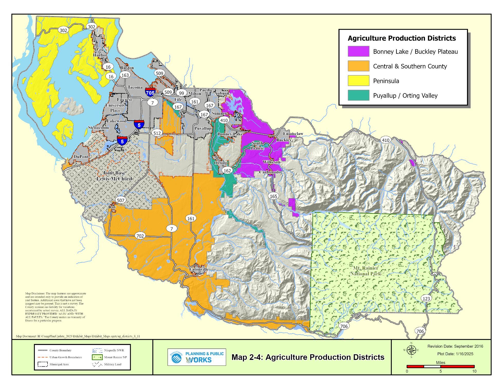
GOAL
LU-67 Designate Agricultural Resource Lands (ARL) based on the Minimum Guidelines of WAC 365-190-050.
LU-67.1 Consider excluding properties already characterized by urban growth or characterized by more intensive rural development, such as:
• Lands designated as rural centers;
• Lands rezoned to rural centers;
• Lands that are part of a preliminary plat approved prior to February 1, 2005, or a final plat recorded prior to February 1, 2005, including any associated open space or other non-buildable tracts identified on the face of the plat;
• Lands covered by a non-residential development permit for uses other than agriculture;
• Lands with mobile home parks;
• Properties owned by governmental agencies prior to the effective date of the 2015 Comprehensive Plan Update for public use as identified in a Capital Facilities Plan adopted as part of the Pierce County Comprehensive Plan or an adopted long-range planning document;
• Land that is irrevocably dedicated to non-farm use; and
• Designated forest and timber lands as identified by Pierce County, RCW 84.33, and RCW 84.34 shall be excluded.
LU-67.2 Removal of properties from the Agricultural Resource Lands designation must be evaluated against the same criteria as designation.
LU-67.3 Consider the following criteria when designating land as Agricultural Resource Land.
• Location in rural areas (outside the UGA).
• Parcel size on the effective date of Ordinance No. 2018-39.
• Amount of prime farmland soils.
• Larger parcels abutting the property.
• Property owner request for designation.
LU-67.4 Designate four Agricultural Production Districts to reflect the different agricultural characteristics of the County.
LU-67.4.1 Designate Agricultural Resource Lands by the following criteria in the four Agricultural Production Districts:
Located Outside Urban Growth Areas
Parcel Size on the effective date of Ordinance No. 2018-39
acres or greater
Amount of Prime Farmland Soils 50% or 20 acres
Abutting parcel size
50% of abutting parcels larger than 5 acres
Landowners may request designation
Yes
or greater
or 20 acres
50% of abutting parcels larger than 20 acres
Yes
acres or greater 10 acres or greater
or 20 acres
50% of abutting parcels larger than 5 acres
or 10 acres
50% of abutting parcels larger than 1 acre
GOAL LU-68 Manage Agricultural Resource Lands with development regulations that support and enhance farming.
LU-68.1 Allow for residential development which preserves the character of the landscape and agricultural viability, at a scale appropriate to the area’s development density.
LU-68.2 Allow uses that support the economic viability of farming and protect the farming operations from incompatible uses
LU-68.3 Ensure that allowed uses support agriculture, and are agriculture related.
GOAL LU-69 Provide programs, policies, and other regulations to achieve agricultural conservation and support agricultural activities.
LU-69.1 Maintain a Purchase of Development Rights program and transfer of development rights program
LU-69.2 Give high priority to agriculture in land acquisition programs sponsored by the County, such as Conservation Futures and purchase of development rights program.
See Land Conservation Plan for further policies
LU-69.2.1 Prioritize the Agricultural Resource Lands designated properties in the Alderton-McMillin community planning area because of the value of the agricultural soils in those areas.
LU-69.2.2 Prioritize the Agricultural Resource Lands designated adjacent to cities and towns because of the pressures to urbanize
LU-69.3 Lease development rights for a term of years.
LU-69.4 Enforce anti-nuisance right-to-farm rules that have been adopted by Pierce County
LU-69.5 Make preferential tax treatment available
LU-69.6 Continue support for the Pierce County stakeholders that play a role in agricultural conservation.
LU-69.7 Investigate other innovative techniques to achieve agricultural conservation.
LU-69.8 Coordinate with other jurisdictions, tribes, and special districts, and engaging in the joint planning of agricultural lands; .
LU-69.9 Coordinate agricultural land conservation policies with other Countywide Planning Policies.
LU-69.10 Develop a process for accepting donations of agricultural lands and develop a program for continuing agricultural operations on donated agricultural lands or County-owned agricultural lands
LU-69.11 Support local and regional direct marketing campaigns
LU-69.12 Implement ways to improve the permitting process for, and minimize costs associated with, construction of farm-related structures, and to minimize costs associated with permitting
LU-69.13 Expand the existing tax incentive programs to provide further benefits to farmers.
LU-69.14 Use existing publicly owned land to create a lease-back program to farmers.
LU-69.15 Make the purchase of locally grown produce a priority for the County's purchasing programs.
GOAL LU-70 Encourage the provision of an effective stewardship of the environment to conserve Agricultural Resource Lands and sustain agricultural activities.
LU-70.1 Address the effect of agricultural practices on non-point source pollution and groundwater impacts.
LU-70.2 Take measures to minimize any adverse impacts of agricultural activities utilizing best management practices.
GOAL LU-71 Protect agricultural operations from incompatible uses and ensure regulations are in places that maintain the vitality of the agricultural industry.
LU-71.1 Extend the agricultural policies to locations within or adjacent to agricultural activities throughout the County:
• Protect such areas from encroachment by incompatible uses;
• Protect related development such as farmers markets and roadside stands; and
• Protect smaller sized agricultural parcels which are not individually viable for production, but which taken cumulatively with other smaller sized parcels in the area, have long term significance for agricultural production.
LU-71.2 Minimize the conflict of incompatible uses in areas adjacent to Agricultural Resource Lands and other agricultural activities by using measures including, but not limited to:
• Setbacks and buffer strips; and
• Public education concerning resource activities.
• Provisions to require notification to residential properties within 500 feet of designated Agricultural Resource Land, that activities may occur on the ARL land that are not compatible with residential development.
LU-71.3 Encourage farming throughout the rural area.
LU-71.3.1 Do not allow homeowner covenants for new subdivisions and short subdivisions in the Rural Area which restrict farming;
LU-71.3.2 Recognize that management practices are not as public nuisances when carried on in compliance with applicable regulations, even though they may impact nearby residences; and
LU-71.3.3 Protect environmental quality, especially in relation to water and fisheries resources, without discouraging farming.
LU-71.4 Pierce County should use incentives to encourage farming, including, but not limited to:
• Tax incentives;
• Expedited permit review and/or permit exemptions for resource activities complying with "best management practices"; and
• Reduced or eliminated processing fees for subdivisions for the purpose of recombining substandard lots and "right to farm" provisions that would apply to all new development.
LU-71.5 Streamline permit processes to promote the continued viability and maintenance of agricultural lands without compromising environmental or public health safeguards.
LU-71.6 Support incentives to experiment with innovative farm technology.
LU-71.7 Encourage the development of a Farmland Conservation Strategy using available programs and services to fulfill the County’s commitment to the local agriculture sector including:
• The use of public funds to make strategic purchases of farmland for fostering agriculture and land conservation practices.
• Voters approved bond funds, backed by a property tax, to acquire development rights.
• Purchase of development rights through a farmland preservation program.
• Real Estate Excise Tax as allowed by Washington State law authorizing counties to levy a tax of up to 1 percent on real property transactions.
GOAL
LU-72 Limit development on designated Forest Resource Lands, which serve a key role in Pierce County's carbon sequestration efforts and promote forest practices that maximize carbon sequestration.
LU-72.1 Maintain the economic and environmental values of forestry, including early selective harvesting, or selective clearing to reduce fire hazard or to follow an approved forest management plan.
LU-72.2 Use incentives to encourage forestry.
See the Environment and Climate Change Element for further policies
LU-72.3 Remove land from the designation only when it has been demonstrated that the land no longer has long-term commercial significance for forest production.
LU-72.4 Recognize that the right to practice forestry is part of rural character
LU-72.5 Allow Christmas tree farms, the harvest of floral greens, and the direct marketing of forest products associated with the holiday season.
LU-72.6 Allow custom milling and forest product sales on sites that engage in forest practice operations.
LU-72.7 Wood chipping activities may occur on-site only during forest practice activities that occur on the site.
LU-72.8 Designate lands as forest resource lands of long-term commercial significance based on three factors consistent with WAC 365-190-060.
LU-72.8.1 The land is not already characterized by urban growth.
LU-72.8.2 The land is primarily devoted to growing trees for long-term commercial timber production.
LU-72.8.3 The land has long-term commercial significance which is defined as:
LU-72.8.3.1 The growing capacity, productivity, and soil composition of the land for long-term commercial production.
LU-72.8.3.2 Consideration of the land’s proximity to population areas, and the possibility of more intense uses of the land as indicated by the following criteria as applicable:
LU-72.8.3.2.1 The area should be located outside of the urban growth area (UGA) and have limited public services and facilities.
LU-72.8.3.2.2 Should be buffered from urban land use designations by compatible rural land use designations.
LU-72.8.3.2.3 Forest lands consist of predominantly large parcels that are at least 40 acres or greater in size.
LU-72.8.3.2.4 While landowner intent cannot be used as a rationale for dedesignation, it can be used as a criterion for inclusion when reflected by the tax status of the land (Chapter 84.33 RCWTimber and Forest Lands).
Pierce County used the population forecast for the 20-year planning period to estimate the quantity of gravel needed in the County area. The Washington State Department of Natural Resources (DNR) uses 11.3 tons/per person/per year as the estimate of volume. Given the large road projects projected for Pierce County, 15 tons/per person/per year were used to generate the estimate.
The population for each year was multiplied by 15 and summed up to arrive at the total tons of gravel needed during the 20-year planning period. This was then converted to cubic yards to compare with the amount of gravel available.
Washington State Department of Natural Resources (DNR) provides a database of currently permitted and active mining sites, as well as locations where gravel deposits are expected to exist. Developed sites, JBLM, and sites with incompatible uses and sizes were removed from the DNR database, and the acreages of these parcels were summed.
Industry standards suggest forty feet is a realistic average depth of excavation for gravel sources. The existing sites are not “full” of gravel, and many of the potential sites will not be economically viable to develop due to long haul routes and lack of road access. A range of gravel thickness from 5’ to 40’ was assumed based on the average depth of excavation for gravel source.
Given the above assumptions, through the 20-year timeframe to 2044, Pierce County will need 227,206,630 cubic yards of gravel. Assuming material thickness and considering only the DNR presently permitted active mining sites, there would be just 168,122,724 yards available However, if the potential mining sites are also considered at an assumed 25 feet thickness, there would be 1,696,036,553 cubic yards available. This is approximately five times more than is needed for the next 20 years. While it must be understood that excavating materials from this entire area is likely not realistic (due to difficulty and expense of development, accessibility, long haul-routes, future competing land uses and development, etc.) it does demonstrate that, if in demand, there does exist adequate expected gravel resources in Pierce County.
GOAL LU-73 Maintain and enhance mineral resource-based industries.
LU-73.1 Maintain, map, and classify known and potentially significant economically developable mineral deposits within Pierce County as identified by the Washington State Department of Natural Resources.
LU-73.2 Ensure excavated land has an ultimate economic use which will complement and preserve the value of adjoining land.
LU-73.3 Allow extractive industries to locate where prime natural resource deposits exist, provided these sites are separated by buffer strips from existing residential areas and restored for appropriate re-use after removing the resource material.
LU-73.4 If the demand for mineral resources is documented in the future, use the following criteria to designate Mineral Resource Overlay areas:
• The mineral deposit must contain at least one million cubic yards of extractable sand, gravel, or rock material;
• The size must be at least 40 acres;
• The new area must be outside the urban growth area; and
• Allow property owners to have a Mineral Resource Overlay (MRO) placed on their property.
The policies in this section govern a variety of land use designations and land use activities that may be found in any portion of the County.
The distribution of land designated Urban, Rural, and Resource is shown in Map 2-5.
GOAL LU-74 Protect private property rights.
LU-74.1 Ensure the property rights of landowners are protected from arbitrary and discriminatory actions.
LU-74.2 Private property shall not be taken for public use without just compensation having been made.
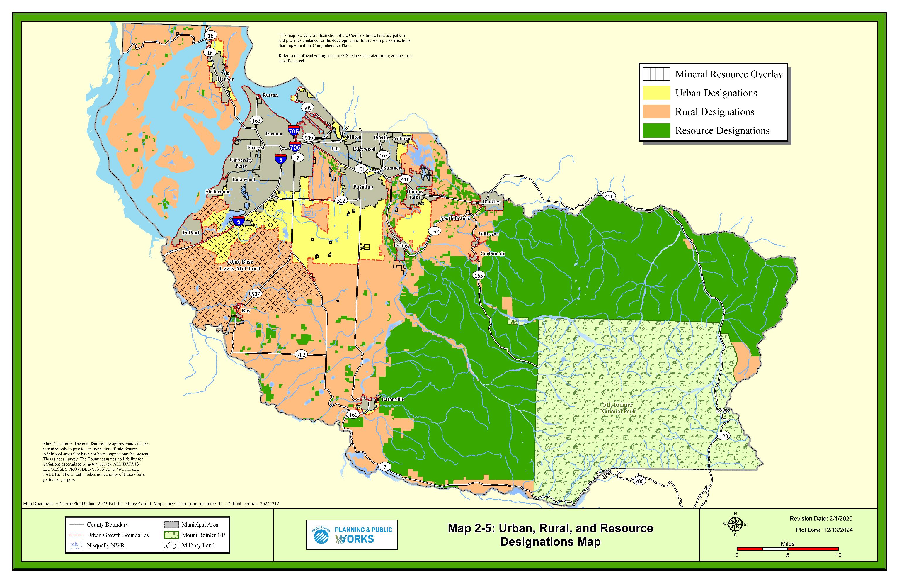
Pierce County is served by Seattle-Tacoma International Airport in south King County, two military base airports, and several smaller airports owned by the public and private sector. The largest airports located in the County are the military air facilities on Joint Base Lewis McChord (JBLM), McChord Field, and Gray Field. General aviation is served by the Tacoma Narrows Airport, Thun Field, and several other small private airports. Pierce County owns both the Tacoma Narrows and Thun Field airports. Other small public and private airports in the County include Shady Acres Airport in the Frederickson/Graham area, American Lake Seaplane Base in Lakewood, Swanson Field in the Eatonville area, and Ranger Creek State Airport near Crystal Mountain.
Tacoma Narrows Airport is a regional airport that is used for small business jet travel and general aviation. The airport runway measures 5,002 feet by 100 feet, and serves businesses, recreational flying, flight instruction, medical services, the media, the military, and law enforcement. There are approximately 93,000 operations at the airport each year. Pierce County purchased the airport from the City of Tacoma in 2008, and the County completed and adopted the Tacoma Narrows Airport Master Plan in 2016.
Pierce County also owns Pierce County Airport-Thun Field in Puyallup. Located in central Pierce County 21 miles southeast of Tacoma, Pierce County Airport/Thun Field functions as a key community transportation and emergency services facility. The runway at Thun Field, measuring 3,650 feet long by 60 feet wide, is capable of handling all general aviation aircraft, from light sport to small business jets.
In order to protect airport operations and surrounding land uses, the County has established the overlay zones including the Airport Overlay – Rural Airports Designation and Airport Overlay-Small Airports Designation. The Airport Overlay - Rural Airports Designation is assigned to the Tacoma Narrows Airport while the Airport Overlay - Small Airports Designation is assigned to all other airports.
GOAL LU-75 Utilize the Airport Overlay-Rural Airport designation on land adjacent to rural airports to protect the public’s health, safety, and welfare and to address incompatible uses with airport operations.
LU-75.1 Establish Rural Airport Overlay boundaries using each airport’s area of influence affected parties. See
LU-75.1.1 All properties located within 1,000 feet of the Essential Public FacilityRural Airport Designation outside the City of Gig Harbor's UGA shall be designated Rural Sensitive Resource or Rural 10 zoning with a Rural Airport Overlay.
LU-75.1.1.1 Residential density shall be limited to 1 dwelling unit per 10 acres for new subdivisions. A minimum lot size of 10 acres is required.
LU-75.2 Provide buffering between those more intense uses related to aviation activities and the rural uses authorized in the Rural Residential designations.
LU-75.2.1 Ensure that rural land uses are limited to low-density and low intensity uses including forestry uses, agricultural uses, walking and biking trails, golf courses, and single-family dwelling units.
LU-75.2.2 Density should reflect the surrounding rural residential density.
LU-75.2.3 Ensure that land use activities that are incompatible with general aviation airport uses are discouraged in the Rural Airport Overlay.
GOAL LU-76
Establish an Airport Overlay-Small Airport designation for small public use airports in unincorporated Pierce County to protect the airports from incompatible uses, consistent with the requirements of RCW 36.70A.510 and 36.70.547.
LU-76.1 Establish Small Airport Overlay boundaries using each small airport’s area of influence
LU-76.2 Coordinate with airports, the Aviation Division of the Washington State Department of Transportation, and other affected parties.
Pierce County intends to have the greatest impact on emissions reductions through promoting a dense, compact land use pattern with mixed uses inside the urban growth area that support walking, bicycling, and transit use with open space conservation. Compact land use patterns have great potential for reducing Greenhouse Gas (GHG) emissions related to vehicles and building energy use. The Land Use, Transportation, and Environment and Climate Change elements of the Comprehensive Plan set the stage for this vision by directing development to centers and arterial corridors served by transit, promoting a balanced multi-modal transportation system, and reducing the need to travel by car
The Comprehensive Plan also includes polices to ensure Pierce County's landscape is resilient to the impacts of climate change. Identifying, preserving, and maintaining the most resilient lands, whether private or public, is an important strategy. In urban areas, efforts have been made to increase tree canopy cover in urban forests and green spaces. In the rural areas, the County has promoted climate resilient agricultural and forest management practices.
2-69
The Wildland Urban Interface (WUI), where the built and natural landscapes meet, provides an opportunity to strengthen resiliency. Development along this edge is both at risk from and increases the likelihood of wildfire. Pierce County planning efforts in the WUI address wildfire risk by mitigating the impacts on property and communities and providing outreach to property owners around education and preparedness.
GOAL LU-77 Ensure Pierce County's landscape is resilient to the impacts of climate change.
LU-77.1 Support the use of land use planning tools for reducing and mitigating the risks to wildfire in Wildland Urban Interface (WUI) areas.
The nexus of climate, equity, and community health places an emphasis on environmental justice. The Land Use Element's goals and policies towards achieving environmental justice are guided by RCW 36.70A.070, and work towards eliminating environmental health disparities. Marginalized communities have experienced disparate impacts from the concentration of industrialized and highpolluting land uses. The County has identified communities that are experiencing disproportionately high rates of these impacts and will work to engage and empower them in planning actions.4 Policies to mitigate the impacts and their effect on these communities include increased access to green spaces, improved air, water, and soil qualities, and design strategies to buffer communities from noise and light pollution. These efforts support Pierce County’s strategy to achieve environmental justice through a range of policies applicable to land use, found in the Introduction, Capital Facilities, Cultural Resources, Environment and Climate Change, and Open Space elements.
Environmental Justice is the fair treatment and meaningful involvement of all people regardless of race, color, national origin, or income, with respect to the development, implementation, and enforcement of environmental laws, regulations, and policies. This includes addressing disproportionate environmental health impacts in all laws, rules, and policies with environmental impacts by prioritizing vulnerable populations and overburdened communities and the equitable distribution of resources and benefits.
GOAL LU-78 Promote sustainable land use development that achieves healthy environments in all Pierce County communities.
LU-78.1 Consider the over concentration of transportation and industrial uses in affected communities and develop solutions to reduce the adverse effects.
LU-78.2 Ensure that land use planning and development decisions minimize the exposure of residents and workers to the impacts of pollutant or hazardous substances.
4 Equity Index
The Current Use Open Space Taxation Act states that it is in the best interest of the State to maintain, preserve, conserve, and otherwise continue in existence adequate open space lands for the production of food, fiber and forest crops and to assure the use and enjoyment of natural resources and scenic beauty for the economic and social well-being of the state and its citizens. Upon removal of classification, an additional tax, interest, and penalty shall be due. The law provides for three classifications:
• Farm and Agricultural - Land primarily devoted to the production of livestock or agricultural commodities for commercial purposes.
• Timber - Land in any contiguous ownership of five acres or more, which is primarily devoted to the growth, and harvest of timber for commercial purposes.
• Open Space - Land retained in its natural state. Land that would enhance, protect or preserve natural areas, i.e. parks, sanctuaries, historic sites, scenic resources, streams, beaches.
GOAL LU-79 Foster partnerships between interest groups to promote participation in the Current Use Assessment program.
LU-79.1 Provide information on obtaining financial assistance.
LU-79.2 Educate on the uses and limitations of the Current Use Assessment (tax incentive) program.
GOAL LU-80 Allow home occupations, daycare facilities, and cottage industries.
LU-80.1 Recognize the importance of the home-based business sector.
LU-80.2 Encourage environmentally friendly home occupations and industries as a means of low impact employment and reduction of green-house gas emissions
LU-80.3 Promote local professional services so business owners don’t need to travel out of the area to purchase services.
LU-80.4 Explore options for flexibility, such as creating separate regulations for home occupations in different industry sectors.
LU-80.5 Ensure compatibility with the underlying land use designation.
LU-80.6 Ensure activities are maintained and carried out in accordance with the conditions of approval.
LU-80.7 Relocate to an appropriate area if the use grows beyond the limits of the underlying designation.
LU-80.8 Recognize short-term vacation rentals are important for homeowners and small property owners to earn supplemental income while providing adequate protections to nearby properties, the environment, and infrastructure such as ferries, parking, water supply, roadways and traffic, and on-site sewage disposal systems.
LU-80.8.1 Consider the unique needs and character of different Community Plan areas and neighborhoods when evaluating development regulations for short-term vacation rentals.
LU-80.8.2 Consider restrictions on the number of housing units that may be used as short-term rentals to preserve residential housing supplies while also protecting areas that rely on tourism activity for economic opportunities.
The local and regional tribes which have ancestral lands and resources in, or adjacent to, Pierce County are sovereign nations. Developing and maintaining relationships with tribal governments is essential to effectively coordinating a regional vision, and coordination in planning efforts fosters that relationship. These communities, their lands, and resources can be affected by Pierce County’s planning efforts. To protect tribal lands and resources from incompatible land uses along reservation boundaries, the County is committed to timely engagement, communication, and collaboration.
GOAL LU-81 Work with affected tribes in local and regional planning efforts, by sufficiently informing and coordinating with tribal governments.
LU-81.1 Encourage tribal participation and consultation in regional and local planning efforts early and often, while recognizing existing treaties and agreements.
LU-81.2 Protect affected tribal reservation lands from the impacts of incompatible land use and development within reservation boundaries, and parcels which abut reservation boundaries, under the guidance of the goals and policies found in the Cultural Resources Element.
LU-81.3 Recognize federally recognized tribes whose reservation or ceded lands lie within the County and collaborate in County planning processes.
See the Cultural Resources Element for further policies
Pierce County is engaged in a collaborative planning effort involving Joint Base Lewis McChord and local governments surrounding this military installation. The goal of this effort is to encourage compatible development and redevelopment in surrounding areas. The effort is
designed to balance sustaining the local military mission with long term community land use needs. The policies represent Pierce County’s commitment in support of this effort.
Two land use designations have been established to recognize federal and state military installations within unincorporated Pierce County. These designations are not intended as an attempt to govern land use activities, rather as a mechanism to recognize the presence of military lands within unincorporated Pierce County.
GOAL LU-82 Recognize the unique character of land uses associated with military operations and support structures.
LU-82.1 Designate the portions of Joint Base Lewis-McChord and Camp Murray that contain urban level of services and characteristics as Urban Military Lands.
LU-82.2 Designate the portions of Joint Base Lewis-McChord that lie outside the UGA as Rural Military Lands.
LU-82.3 The application of the Military Lands designations shall be consistent with official federal and state military installation master plans.
LU-82.4 Recognize Joint Base Lewis-McChord as a Major Military Installation in accordance with Vision 2050 Regional Centers Framework, in order to preserve, protect, and support this asset.
LU-82.4.1 Acknowledge that military installations may have considerable impacts to land use, housing, and transportation which affect both adjacent and local communities.
LU-82.4.2 Cooperate with Joint Base Lewis-McChord on programs which affect environments near or adjacent to military installations.
See the Environment and Climate Change Element for further policies
GOAL LU-83 Provide the military installations with opportunities to participate in the review and development of land use programs, policies, and decisions that affect them.
LU-83.1 Consider the military installations as an affected agency for land use planning decisions.
LU-83.2 Invite the military to participate as members on growth management committees.
LU-83.3 Provide opportunities for the military to participate in local and regional planning issues and programs
LU-83.4 Establish periodic meetings of elected local, state, and federal officials and military commanders on growth management issues of mutual concern.
LU-83.5 Environmental policies adopted by the military should continue to reinforce the environmental policies of surrounding jurisdictions
LU-83.6 Ensure that Comprehensive Plan policies pertaining to environmental issues are consistent with the environmental policies of the military installations.
GOAL LU-84 Recognize the possibility of military lands reverting back to Pierce County.
LU-84.1 Adopt interim regulations until a comprehensive plan amendment is adopted if military lands revert back to Pierce County.
LU-84.2 Coordinate with adjacent cities and towns to identify the desired character of the reverted property.
GOAL LU-85 Recognize aircraft noise as a health impact and an environmental constraint when developing land use classifications and regulations.
LU-85.1 Promote cooperation between Joint Base Lewis-McChord and Pierce County to address the reduction or mitigation of noise-generating uses.
LU-85.1.1 Establish a disclosure process advising property owners of possible noise impacts to property around JBLM.
GOAL LU-86 Recognize safety issues associated with training, artillery, and small-arms activities on Joint Base Lewis-McChord.
LU-86.1 Provide for fire protection for construction adjacent to the installation at Fort Lewis boundaries.
LU-86.2 Incorporate the Installation Compatible Use Zone Study (ICUZ) noise contour maps and the "Recommended Land Uses for Installation Compatible Use Zone (ICUZ) Program Noise Zones" for Noise Zone II.
LU-86.3 Prohibit the following land uses within Noise Zone II:
• New residential uses, unless the design of the structure and general site plan incorporate noise-reduction measures to meet the Department of Housing and Urban Development (HUD) standards;
• Public services and quasi-public services such as hospitals, public meeting rooms, libraries, and cultural, recreational, and entertainment land uses, unless the design of the structure and general site plan incorporate noisereduction measures to meet HUD standards; and
• Schools, daycare facilities, and other facilities which incorporate outside activities.
LU-86.4 Direct the following land uses away from property abutting the installation boundary:
• High density residential;
• Public buildings (such as schools, medical facilities, public meeting facilities, and churches); and
• Cultural facilities.
LU-86.5 Restrict development in the vicinity of a military installation that is incompatible with the installation’s ability to carry out its mission requirements.
LU-86.6 Cooperate with Joint Base Lewis-McChord and Camp Murray in developing plans for circulation improvements in and around the installations.
LU-86.6.1 Determine the viability of cross-base corridors (arterial or highway) on the basis of detailed studies of population projections, military mission, land availability, land use projections, and environmental analysis of alternative routes and corridors.
LU-86.7 Plan public services, transportation, land use, and other decisions on the ability of the public transportation network to meet access needs without depending on military roads.
LU-86.8 Cooperate in the development of mitigation plans for military road closures that affect public use.
The GMA requires that the designation, proposed general distribution and location of open space and recreational lands be identified in local comprehensive plans. Identification of areas suitable for open space corridors within and between urban growth areas (UGA) is also required. These open space areas provide diverse functions including: protecting environmentally sensitive lands, which are often ill-suited for commercial and residential development; separating incompatible land uses; linking communities and businesses; and creating corridors for wildlife migration and nonmotorized transportation routes.
Open space corridors serve as buffers within and between urban growth areas.
The Open Space Corridors map, Map 2-6, is not intended to have regulatory effect but rather provide general guidance for open space preservation efforts. The Open Space Corridors map may be refined in the future based on more detailed analysis through community planning, watershed basin planning, fish and wildlife habitat planning, and other open space planning efforts.
DESIGNATION OF AN OPEN SPACE NETWORK
See the Open Space Element for further policies
GOAL LU-87 Establish an open space network linking open space areas via greenbelt corridors throughout Pierce County, preserving carbon sequestering landscapes.
LU-87.1 Maintain an Open Space Corridors Map which is updated when detailed information becomes available through County plans or similar planning efforts. The Open Space Corridors Map contains the following general locations in Pierce County:
• Open space areas and corridors within and between urban growth areas.
• Green space areas within and between urban growth areas.
• Urban and community forests within urban growth areas.
LU-87.2 Consider additional areas for designation as open space including:
• Wooded areas that serve a functional purpose in mitigating climate hazards or vulnerabilities, noise, light, habitat, and pollution control.
• Environmentally or geologically unique areas, and scenic view points and scenic corridors.
• Lands that can provide for a separation between communities, thereby preserving character, preventing sprawl, and creating a buffer between urban and rural areas or other land uses.
• Lands in proximity, or connected to, existing parks, open space, and Greenspaces.
• Lands identified in other adopted plans, such as the Regional Open Space Conservation Plan or Pierce County’s Comprehensive Flood Hazard Management Plan.
LU-87.3 Incorporate landscaped greenbelt areas into the open space network.
LU-87.3.1 Establish and maintain greenbelts within the Plan area that provide multi-use functions such as buffers between incompatible uses, separation between communities and rural/urban areas, visual relief from the built environment, and passive open space recreation areas.
LU-87.3.2 Utilize greenbelts for pathways and integrate this system into the nonmotorized transportation network.
LU-87.3.3 Encourage the planting of native vegetation within greenbelt areas but recognize that other non-native species, such as turf, may be appropriate for the intended use.
LU-87.3.4 Integrate built structures such as children's play equipment, play areas, climbing rocks, water features, benches, trails, and picnic tables into greenbelt systems. Trails shall be made of permeable pavement or materials.
LU-87.3.5 Greenbelt areas should integrate or bridge critical areas, such as wetlands, fish and wildlife habitat areas, or designated open space areas, when possible.
LU-87.3.6 Coordinate the preservation and growth of open space with urban and community forests to promote the increase of tree canopy cover in urban areas.
GOAL LU-88 Recognize that open space is an integral part of an area's infrastructure and that it should be provided concurrent with development, and with minimum percentages of public open space required per development.
LU-88.1 Require that new residential developments set aside a percentage of total land area as open space in perpetuity.
LU-88.1.1 Ensure that the designated area best serves the purpose of open space (e.g., the area should match areas on the Open Space/Greenbelts Map) and can be linked to adjacent open space, green space, or community forest areas to provide greenbelts.
LU-88.1.2 Ensure that public easements are provided where linkages and greenbelts occur.
LU-88.1.3 Require the acquisition (or contribution towards acquisition) of nearby open space lands where land is not suitable for open space purposes and add them to the Open Space Corridors Map.
LU-88.1.4 Encourage the use of designated open space land in residential developments to protect and preserve significant and heritage trees.
LU-88.2 Maintain design standards for development within designated open space/greenbelt areas, including:
• Open space in urban areas should remain substantially undeveloped and exemplify the Pacific Northwest character (retention and replanting of native and regional vegetation).
• Open spaces should be located contiguous to other open space areas, creating the potential for open space corridors.
• Open space in urban areas should be readily accessible to residents where appropriate.
See the Open Space Element for further policies
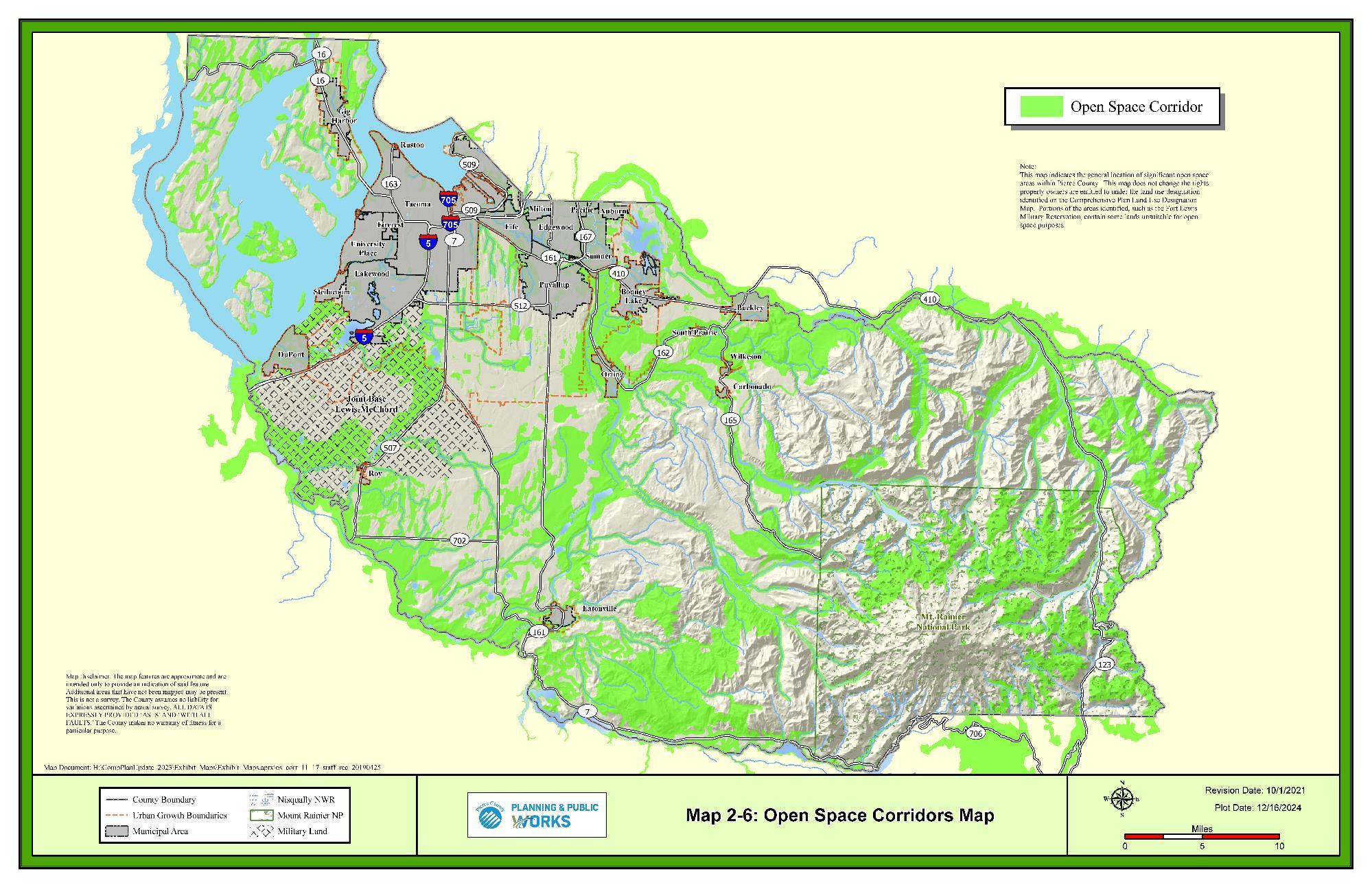
GOAL LU-89 Designate specific public lands and private parks, campgrounds, historical sites or tourist attractions for park and recreational purposes when identified through a city, community, or regional planning process.
LU-89.1 Include historical sites, tourist attractions, property improved with park or recreational facilities or unimproved lands for future regional park uses.
See the Cultural Resources Element for further policies.
LU-89.2 Include privately owned properties improved with park, campground, or other recreational amenities if open to the general public with or without a fee.
LU-89.3 Apply in Urban and Rural designations, but not Resource Lands.
LU-89.4 Permit passive or active recreation uses.
LU-89.5 Discourage the conversion of lands designated as Park and Recreation to other uses.
LU-89.6 Include publicly owned or managed land which is readily accessible via existing public roads or where roads can be reasonably extended to access the site should be considered for possible park and recreation sites
LU-89.7 Include land which includes significant historic, archaeological, scenic, cultural, or unique natural features.
For siting criteria see the Essential Public Facilities Element.
GOAL LU-90 Locate public facilities and utilities to maximize the efficiency of services provided, minimize costs, and minimize impacts upon the natural environment.
LU-90.1 Coordinate the orderly provision of public facilities and services with public and private development activities in a manner that is compatible with the fiscal resources of the County through the development and adoption of a Concurrency Management System.
LU-90.2 Locate public and community facilities in consideration of the following criteria:
• Public facilities should be designed around the service delivery standards with service levels appropriate to the people using each facility.
• Recreation facilities, schools, libraries, medical area facilities, sheriff and other community facilities, should be convenient to people using them.
• Community facilities should be located in centers or in areas with direct access to major thoroughfares.
• Public facilities should be located on sites which are economical to develop and reasonably level.
• Major parks, because of space needs, should be allocated by regional need.
• Schools, because of health and safety issues, should be protected from traffic.
• Cultural facilities, educational institutions, and spectator sports facilities, because of service areas, should be located central to their function or where complementary functions could be located.
• Branch government offices should be easily accessible and located in centers and/or in areas that are served by transit.
• Community facilities should be located on level or gradable land and avoid geologically hazardous areas.
• Community facilities should be located outside of floodplains, wetlands, riparian areas, or other critical areas, and constructed to protect major aquifers providing drinking water for the community.
• Community and public facilities which are associated with infrastructure corridors should be located with regard to such factors as terrain, the geological and hydrological conditions, the site's proximity to population concentrations and water supply, and the potential for supporting higher land uses.
• Community facilities and health and human services should be located near transit whenever possible to ensure convenient access to services for all.
GOAL LU-91 Recognize major parcels of land serving the cultural, educational, recreational, and public service needs of the community through the Public Institution designation.
LU-91.1 Apply the Public Institution designation to urban or rural institutions and facilities.
LU-91.2 Identify lands owned by governmental agencies for public use or benefit with the Public Institution designation or other land use designation that supports and protects these uses.
GOAL LU-92 Provide strict guidance and review criteria for rezones to ensure planning goals are properly implemented and resulting changes are compatible with the Vision 2050 Regional Growth Strategy and surrounding uses.
LU-92.1 Consider the availability of adequate potable water and other services when reviewing proposals for modifications to the land use designation or zoning classification.
LU-92.2 Consider critical areas in determining appropriate land use designations and zoning.
LU-92.3 Discourage redesignation of parcel land use designations which are not areawide or contiguous expansions.
LU-92.4 Allow redesignation of single parcels or single ownership in appropriate circumstances such as the recognition of public parks, schools, and other public institutions, or proposals involving Master Planned Communities, Master Planned Resorts, Employment Based Planned Communities, or New Fully Contained Communities.
LU-92.5 Allow redesignation of single parcels or single ownership when contiguous with an existing land use designation.
GOAL LU-93 Modify and expand transfer of development rights (TDR) and purchase of development rights (PDR) programs to provide the public benefit of permanently conserving resource and rural agricultural lands, recreational trails, open space, habitat areas, and preserving the landscape's ability to sequester carbon.
LU-93.1 Allow development rights to transfer to urban areas in exchange for permanent preservation of rural and resource lands through the TDR program.
LU-93.1.1 Allow sending sites from lands designated Rural Residential and Resource Lands when there is a significant public benefit.
LU-93.1.2 Maintain the Pierce County Development Rights Bank to sell transferrable development rights as defined in RCW 43.362
LU-93.2 Pursue a variety of methods for incentivizing the protection of resource and rural agricultural lands, recreational trails, open space, and habitat areas through updating the Pierce County transfer of development rights program.
LU-93.2.1 Consider additional criteria when determining TDR valuation methods and conversion ratios for sending and receiving sites, such as: proximity to the UGA boundary, resource land zoning, and classification as Current Use as defined in RCW 84.34.
LU-93.2.2 Maximize the benefits for sending sites through participation in the regional transfer of development rights program (RCW 43.362).
LU-93.3 Support landowners in certification of eligibility as sending sites to facilitate a public marketplace for transferrable development rights.
Community plans result from partnerships that unite the County and citizens of a planning area. The majority of unincorporated County population resides in community plan areas. Community plans describe how the general policies of the Comprehensive Plan apply in a specific community and address local issues that are not in the Comprehensive Plan elements. The purpose of the community planning process is to enhance community values and identify and assure sensible growth and development.
Community plans provide for a more refined scale and level of detail than can be attained under the broad guidelines of a comprehensive plan. Community plans augment and enhance the Comprehensive Plan so as to foster a community’s local identity. Because of the diversity in the character of various parts of the County, Comprehensive Plan policies may not address specific issues confronting individual communities. Conversely, due to the distinct nature of community plan areas, not all community plan policies should be applied countywide. The community plan area boundaries are shown in Map 2-7.
GOAL LU-94 Foster the autonomy of communities.
LU-94.1 Community plans shall be consistent with Vision 2050, Countywide Planning Policies, and the Comprehensive Plan.
LU-94.1.1 Apply the goals and policies of the Comprehensive Plan when there are conflicts or inconsistencies with the goals and policies of community plans.
LU-94.2 Use existing community councils and other groups to make recommendations on community plan policies.
GOAL LU-95 Foster community character.
LU-95.1 Apply best practices in the development of a community plan:
• Involve the people of the community in plan development and amendment.
• Community plans should articulate a vision for the community.
• Community plans should identify features and characteristics of communities to be retained, developed, preserved, enhanced, or corrected.
• Community plans should consider areas for commercial, industrial, residential, capital facilities, recreation, and other land uses.
• Community plans’ policies supplement and support the policies of the Comprehensive Plan.
• Community plans may identify design features which affect the character of a community.
GOAL LU-96 Support communities in the development of new community plans.
LU-96.1 Establish new community plan areas on the basis of the following priorities:
• Public health, safety, or welfare;
• Previous commitments by the County through legislative action to prepare a plan; and
• Evidence of community support.
LU-96.2 Establish boundaries of new community plan areas to meet the following criteria:
• Contains a Commercial Center, Mixed Use District, Employment Center, or Rural Center;
• Has a common association or identity as a town, center, or destination;
• Contiguous with other community plans or municipal boundaries or designated rural lands;
• Reflects school district or other service area boundaries; or
• Defined by topography and natural land features or manmade constructions, transportation arterials, road and rail, etc.
LU-96.3 Focus on policy choices and regulatory options that can be effectively implemented and shown to be beneficial and desirable for the community.
LU-96.4 Implement community plans through land use regulations and administrative decisions where possible, capital facilities provisions and other public programs, as applicable.
LU-96.5 Develop community plans in consultation with the following entities:
• Community groups;
• Governmental departments and agencies as applicable;
• Neighboring cities, towns, or communities;
• Affected Indian Tribes; and
• Utility and service providers.
LU-96.6 Use existing land use designations rather than creating new designations and zoning classifications.
LU-96.7 Amend community plans when changes to the Comprehensive Plan make community plan policies incompatible or inconsistent.
GOAL LU-97 Promote predictability and consistency in development regulations implementing community plans.
LU-97.1 Apply one set of development regulations countywide.
LU-97.1.1 Provide a range of alternatives that recognizes and provides for local uniqueness and character for communities to select from.
LU-97.1.2 Allow new zoning classifications consistent with land use designations identified in the Comprehensive Plan.
LU-97.1.3 Consider development regulations updates when beneficial and desirable for all communities.
LU-97.2 Eliminate and discourage redundant regulations, procedures, and inconsistent, unnecessary overlays in community plan areas.
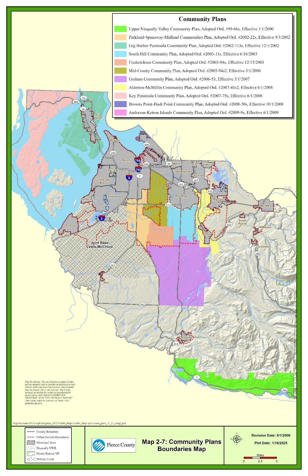
Table 2-I: Prime Agriculture Soil List
NRCS Soil
Survey Map Unit # Map Unit Name
WA653 1B
Alderwood gravelly sandy loam, 0 to 8 percent slopes
WA634 20 Belfast silt loam, 0 to 2 percent slopes
WA653 4A
Bellingham silty clay loam
WA653 5B Bow silt loam, 2 to 8 percent slopes
WA653 6A Briscot loam
WA653 7A Briscot loam, variant
WA653 8A Buckley gravelly silt loam, 0 to 3 percent slopes
WA653 9A Chehalis silt loam
WA653 12A Dupont muck
WA653 15A Greenwater loamy sand
WA634 69 Greenwater loamy sand, 0 to 8 percent slopes
WA653 16B Harstine gravelly ashy sandy loam, 0 to 6 percent slopes
WA653 18B Indianola loamy sand, 0 to 5 percent slopes
WA777 46 Indianola loamy sand, 0 to 5 percent slopes
WA653 19B Kapowsin gravelly ashy loam, 0 to 6 percent slopes
WA634 100 Kapowsin gravelly ashy loam, 6 to 15 percent slopes
WA653 19C Kapowsin gravelly ashy loam, 6 to 15 percent slopes
WA653 20B Kitsap silt loam, 2 to 8 percent slopes
WA634 106 Klaber silt loam, 0 to 8 percent slopes
WA634 107 Klaber-Cinebar silt loams, 0 to 8 percent slopes
WA634 119 Lemolo silt loam, 0 to 8 percent slopes
WA653 22A McKenna gravelly loam
WA634 149 National cindery sandy loam, 0 to 8 percent slopes
WA653 23A National gravelly sandy loam
WA777 73 Nisqually loamy fine sand, 0 to 3 percent slopes
WA653 25A Nisqually loamy sand
WA653 26A Norma fine sandy loam
WA634 158 Norma loam, 0 to 3 percent slopes
WA653 27A Orting fine sandy loam
WA653 28A Orting loam
WA653 29A Pilchuck fine sand
WA634 187 Pilchuck loamy fine sand, 0 to 3 percent slopes
WA777 84 Pilchuck loamy sand, 0 to 3 percent slopes
WA653 30A Puget silty clay loam
WA653 31A
Puyallup fine sandy loam
WA777 89 Puyallup silt loam, 0 to 3 percent slopes
WA653 32B Ragnar sandy loam, 0 to 6 percent slopes
WA653 33A Reed silty clay
WA653 37A Semiahmoo muck
WA653 104
WA777 104
WA653 1103
WA777 1103
Semiahmoo muck, 0 to 1 percent slopes
Semiahmoo muck, 0 to 1 percent slopes
Semiahmoo-Water complex, 0 to 1 percent slopes
Semiahmoo-Water complex, 0 to 1 percent slopes
WA653 38A Shalcar muck
WA634 235 Shalcar muck, 0 to 1 percent slopes
WA653 39A Snohomish silty clay loam
WA634 241 Snoqualmie loamy fine sand, 0 to 8 percent slopes
WA777 1106
Snoqualmie loamy fine sand, 2 to 8 percent slopes
WA653 40A Spana loam
WA653 3111
WA777 3111
Spana-Spanaway-Nisqually complex, 0 to 2 percent slopes
Spana-Spanaway-Nisqually complex, 0 to 2 percent slopes
WA653 41A Spanaway gravelly sandy loam
WA777 110 Spanaway gravelly sandy loam, 0 to 3 percent slopes
WA777 1100 Steilacoom-Yelm complex, 0 to 2 percent slopes
WA634 247 Sulsavar loam, 0 to 8 percent slopes
WA653 42A Sultan silt loam
WA634 248 Sultan silt loam, 0 to 2 percent slopes
WA653 44A Tanwax muck
WA653 45A Tisch silt
WA634 261 Tukwila muck, 0 to 1 percent slopes
WA634 278 Winston loam, 0 to 8 percent slopes
Capital facilities and utilities are services and facilities that support current residents, businesses, and tourists, and that are needed to serve future development or meet another community need. They generally have a long useful life and include systems owned by the County as well as those owned by other public agencies (e.g., school districts) or by private companies (e.g., telecommunications).
•General Administration
•Law Enforcement
•Emergency Management
•Transportation
•Parks
•Sewer
•Solid Waste Transfer Facilities
•Surface Water and River Management Facilities
•Fire
•Transit
•Libraries
•Schools
•Water
•Electricity
•Natural Gas
•Telecommunications
These facilities and services are significant projects for jurisdictions and providers to fund, build, operate, and maintain, and the sooner a jurisdiction plans for its needs the better they can meet their needs. Local governments planning under the Growth Management Act (GMA) must plan for capital facilities and utilities in their Comprehensive Plan in a manner that is coordinated with land use planning and growth expectations. A Capital Facilities Element and Utilities Element are required components of the Comprehensive Plan under GMA (RCW 36.70A.070(4)). The County has chosen to combine these into one element given their similar nature and function and because both County and non-County agencies provide services that would fall under the purview of either element.
The Capital Facilities and Utilities Element and associated Capital Facilities Plan (CFP) are required components of the Comprehensive Plan:
• The Capital Facilities and Utilities Element establishes policies to ensure adequate public facilities are available to serve existing and future development in the County in an efficient, effective, and equitable manner. The policies are designed to guide the actions of public
agencies, such as the County, as well as private decisions related to individual developments to support anticipated growth.
• The CFP contains consolidated capital facility inventory and capital funding analysis for each capital facility category. The CFP provides the detailed forecast of future needs and revenue based on the level of service (LOS) standards identified within the Capital Facilities and Utilities Element as well as cost projections necessary to meet GMA requirements for capital planning.
• The Capital Facilities and Utilities Element also summarizes three utilities owned and operated by other entities that are not included in the CFP electricity, natural gas, and telecommunications. Planning for privately managed utilities is recognized as the primary responsibility of the utility provider and the County coordinates with public and private utility companies consistent with GMA.
Together, these guide capital planning necessary to provide services to the community and serve as the financing plan and feasibility analysis for the overall Comprehensive Plan.
GMA requirements for both Capital Facilities and Utilities are addressed in this element. At a minimum, the GMA requires the Capital Facilities Element include water systems, sanitary sewer systems, stormwater facilities, reclaimed water facilities, schools, parks and recreational facilities, police, and fire protection facilities.5 The Utilities Element must consist “of the general location, proposed location, and capacity of all existing and proposed utilities, including, but not limited to, electrical lines, telecommunication lines, and natural gas lines.”6 Capital facilities needed to support other comprehensive plan elements such as transportation or parks and recreation—are addressed in separate elements of this Comprehensive Plan as required by state law.
The GMA establishes five requirements for the CFP:
(1) Provide an inventory of existing facilities;
(2) List a forecast of future needs;
(3) Show proposed general location and capacity of planned facilities;
(4) Provide a six-year financing plan for needed facilities; and
(5) Reassess the land use plan if planned facilities cannot be provided to the extent necessary to meet the LOS standards.7
5 WAC 365-196-415
6 RCW 36.70A.070(4)
7 RCW 36.70a.070(3)
The process of addressing these five requirements helps the County make wise use of County funds by organizing and prioritizing projects. The first four requirements are addressed in the CFP and summarized here. The fifth requirement is addressed in the policies of this element.
Part of the capital facilities planning process involves prioritizing funds available for capital spending. This involves making decisions about the LOS that will be provided and where investment will occur. It must take into consideration growth within unincorporated Pierce County. LOS standards for capital facilities are established to measure performance and help determine the level of investment needed to maintain or meet service standards as growth occurs. The County has adopted guidance and methodologies on how to measure LOS as part of the CFP process within Title 19E of the Pierce County Code (PCC). LOS standards may be defined by state law, recommended by national professional associations, or locally defined based on community preferences.
GOAL CFU-1 Ensure that adequate infrastructure is provided to accommodate growth.
CFU-1.1 Plan for public capital facilities necessary to support development based on adopted housing and employment growth targets.
CFU-1.2 Target areas of high growth for future infrastructure improvements, especially areas designated as manufacturing industrial centers and centers of local importance.
CFU-1.3 Direct infrastructure resources necessary for the support of industry or that support freight distribution to areas identified for planned industrial development.
CFU-1.4 Work with federal and state governments on revenue sharing, and pursue grant programs, low interest loans or similar programs for the financing of needed infrastructure.
CFU-1.5 Consider the use of recycled materials in the construction of facilities to support net zero emission construction practices
GOAL CFU-2 Construct needed capital improvements which: repair or replace obsolete or worn-out facilities, eliminate existing deficiencies, and meet the needs of future development and redevelopment caused by previously issued and new development permits.
GOAL CFU-3 Maintain a ranking system for possible planned public facilities and services using a priority system.
CFU-3.1 Allocate public services to sites that provide the greatest possible returns, unless private property owners assist with the costs involved in extending or providing service.
CFU-3.2 Give priority to the maintenance and improvement of public facilities in commercial areas and along major routes connecting commercial areas to residential neighborhoods.
CFU-3.3 Consider locating County buildings in areas that are served by transit.
CFU-3.4 Consider the dispersion of public facilities with similar impacts and services across the County to avoid disparities.
CFU-3.5 Consider equity in the siting process to avoid adding negative externalities or limiting access to services to overburdened or underinvested communities.
GOAL CFU-4 Use a realistic, financially feasible funding system based on revenue sources available according to applicable laws.
CFU-4.1 The estimated costs of all needed capital improvements shall not to exceed conservative estimates of revenues from sources that are available pursuant to current statutes, and not rejected by referendum, if required.
CFU-4.1.1 Conservative estimates cannot exceed the most likely estimate of revenues
CFU-4.2 Require both existing and future development to pay for the costs of needed improvements based on project impact cost and benefit considerations.
CFU-4.3 Finance enterprise and non-enterprise funds used for capital improvements with debt to be repaid by user fees, charges, connection or capacity fees, current assets, or a combination of debt and current assets.
CFU-4.4 Limit the use of debt financing to provide more capacity than is needed within the schedule of capital improvements for non-enterprise public facilities.
CFU-4.5 Consider the ability to pay for the subsequent operating and maintenance costs before providing a public facility or accepting a public facility provided by others.
CFU-4.6 Support initiatives that will provide funding for unmet infrastructure needs, including exploring funding sources such as changes to pricing, taxing, and expenditure practices, and other fiscal tools to meet infrastructure needs.
CFU-4.7 Allocate funding for public infrastructure to encourage development, infill, and redevelopment in line with the adopted growth targets
CFU-4.8 Use impact fees for schools, parks, and transportation
CFU-4.9 Reassess the Land Use Element or identify additional revenue sources if there is a probable funding shortfall in meeting existing service needs or growth expectations at adopted levels of service for facilities necessary to support development.
GOAL CFU-5 Coordinate with providers of water, sewer, power, natural gas, telecommunications, cable television, transportation systems, and other infrastructure to promote equitable and affordable access to the utilities and facilities to all County residents.
CFU-5.1 Coordinate infrastructure provision among jurisdictions to support the Regional Growth Strategy by addressing long-term needs
GOAL CFU-6 Approve development permits only when adequate capacity of facilities is reasonably available when concurrency is required.
CFU-6.1 Provide non-capital alternatives to achieve and maintain the adopted standard for level of service.
CFU-6.2 Condition development projects in a manner that guarantees public facilities will be in place or that adequate mitigation will be provided as the impacts of the development occur.
CFU-6.3 Annually review public facilities to determine if there is sufficient capacity to maintain acceptable levels of service for existing and approved development.
CFU-6.4 Identify the necessary facilities to maintain adopted levels of service to serve anticipated development and eliminate deficiencies.
CFU-6.5 Consider the impacts of development on public facilities.
CFU-6.6 Issue final development permits only when there is sufficient capacity of capital facilities and utilities are available to meet the adopted levels of service for existing and proposed development.
GOAL CFU-7 Support the cleanup and redevelopment of contaminated sites.
CFU-7.1 Explore strategies with tribal, port, local, State, and Federal governments as well as community groups to remediate brownfields and other environmentally contaminated sites.
A cleanup site is a place where toxic substances from current or historical site activities is harming or threatening humans or the environment. These sites can be potentially significant liabilities for property owners, who are responsible for clean-up; thus, creating a higher economic barrier for redevelopment. Across all of Pierce County, there are over 250 sites awaiting cleanup and over an additional 500 sites only partially cleaned up.
GOAL CFU-8 Integrate mitigation for potential hazards and impacts from climate change into the design, construction, maintenance, and management of capital facilities.
CFU-8.1 Plan and build facilities and utilities that will withstand flooding events based on reasonable projections for climate change impacts, including sea level rise forecasts, changing floodplain boundaries, and potentially increasing likelihood of 500-year flood events.
CFU-8.2 Site new public facility buildings after reviewing emergency management plans and potential climate hazards in the community to determine if a resilience hub is needed.
GOAL CFU-9 Evaluate distributed, small-scale renewable energy production and battery infrastructure at public facilities to provide emergency power and ensure continuity of operations of public facilities and essential businesses.
CFU-9.1 Consider need for resilience hub and emergency management purposes when planning for energy production and storage at public facilities.
Pierce County provides a number of services and utilities. The full list of facilities and services, providers, and applicable plans is summarized in Table 3-A. These providers and the applicable plans guide the County’s capital facility and utility planning efforts. The applicable plans, as amended, in Table 3-A are incorporated by reference as detailed in the CFP.
Table 3-A: County Provided Facilities, Services, and Functional Plan
Facility/Service
Department
General Administration Buildings Facilities Management
County-owned buildings and property management related to County-owned capital.
• Pierce County Biennial Budget, Capital Improvements Chapter
• Pierce County Facilities Management Deferred Maintenance Prioritization (2017)
Law Enforcement & Corrections
Courts Pierce County District Court, Superior Court, and Juvenile Court, Clerk of the Superior Court, Prosecuting Attorney’s Office
Provides facilities that support courtroom functions at all levels of the judicial system.
• Pierce County Biennial Budget, Capital Improvements Chapter
• Justice Center and Space Planning Study (2022)
• Pierce County Facilities
Facility/Service
Primary Department Description
Sheriff Pierce County Sheriff’s Department
Pierce County Corrections Bureau & Detention Center
Sheriff’s Corrections Bureau
Emergency Management Department of Emergency Management
Management Deferred Maintenance Prioritization
Provides facilities that support the provision of law enforcement services.
Direct supervision jail located in Tacoma, WA with capacity for 1,700 inmates and 300 correctional staff.
Provides emergency preparedness training, hazard mitigation, fire prevention activities, County radio communications, and administration of EMS throughout Pierce County.
• Pierce County Biennial Budget, Capital Improvements Chapter
• Pierce County Facilities Management Deferred Maintenance Prioritization
Transportation See also the Transportation Element
Road Buildings & Facilities OCE of Planning and Public Works
Active Transportation Traffic Division of PPW , Parks and Recreation
Airports M&O of PPW
Works in partnership with WSDOT and the FAA
Ferry System OCE of Planning and Public Works
Works in partnership with WSDOT
Parks & Recreation Parks and Recreation
Works in partnership with municipal park
Provides streets, sidewalks, traffic controls, and street lighting.
Provides planning framework and resources for nonmotorized and humanpowered forms of transportation.
Provides access to regional air transportation for both transportation and recreation.
Provides effective and efficient ferry services between Steilacoom, Anderson Island, and Ketron Island.
Parks, trails, recreation facilities.
• Transportation Improvement Plan
• Pierce County Transportation Improvement Program Plan
• Regional Trails Plan
• Tacoma Narrows Airport Master Plan
• Thun Field Master Plan
• Fourteen-Year Ferry Program Plan
• Parks, Recreation, and Open Space (PROS) Plan
Facility/Service
Department
departments and park districts. See also the Parks and Recreation and Open Space elements
Sewer Sewer Division of PPW
Solid Waste Management
Domestic and commercial wastewater systems using a combination of municipal sewers and onsite wastewater disposal.
Sustainable Resources Division of PPW Solid waste disposal, prevention, and recycling.
• Unified Sewer Plan
• Sewer Improvement Program
• Tacoma-Pierce County Solid and Hazardous Waste Management Plan (SHWMP)
• Pierce County Biennial Budget, Capital Improvements Chapter
Surface Water Management & River Improvement
Surface Water Management Division of PPW
Manages water quality and flood risks to reduce flooding, improve water quality, and preserve natural resources.
Note: All County provided facilities and services in this table are detailed in the CFP.
OCE - Office of the County Engineer, PPW -Planning and Public Works.
Sources: Pierce County, 2023; BERK, 2023.
• Surface Water Improvement Program
• Pierce County Stormwater and Site Development Manual
• Comprehensive Flood Hazard Management Plan
GOAL CFU-10 Ensure that County expenditures for facilities and infrastructure are consistent with the adopted Comprehensive Plan and Regional Growth Strategy.
CFU-10.1 Invest in expanding the capacity of capital facilities and public services in designated centers that are accessible by frequent transit and in areas planned for significant population and employment growth.
CFU-10.2 Consider emphasizing projects that provide environmental benefits that improve water conservation or quality, reduce greenhouse gas emissions, support healthy ecosystems, or assist with the County’s climate adaptation strategies.
GOAL CFU-11 Maintain a financially feasible six-year schedule of capital improvements for public facilities
CFU-11.1 Use the Capital Facilities Plan (CFP) and County improvement plans, to review and plan for infrastructure for new areas for residential, commercial, and industrial growth.
CFU-11.1.1 The absence of a Capital Facilities Plan for a school district under the County’s CFP does not limit the Hearing Examiner’s authority, if any, to review the impact from residential development on schools while reviewing applications for land developments.
CFU-11.1.2 Verify whether level of service (LOS) standards are projected to be met based on funding of utilities and public facilities as well as existing and planned development.
CFU-11.2 Establish and update level of service (LOS) standards for applicable capital facilities in the Comprehensive Plan to guide capital programs.
CFU-11.3 Coordinate development of the capital improvement programs with public and private facilities and utilities.
GOAL CFU-12 Include all the capital improvements projects required for concurrency and listed in the schedule of capital improvements for expenditure during the appropriate fiscal year.
CFU-12.1 The County may omit any capital improvements when a binding agreement has been executed with another party to provide the same project in the same fiscal year.
Table 3-B: Levels of Service for County Provided Facilities
General Administration Buildings
Given the dynamic nature of the workforce today and in the future and the variety of workspace utilization (such as hoteling, job sharing, teleconferencing, telecommuting, and remote computer connectivity), an LOS calculation based on population growth is no longer relevant and there is no adopted square feet of facility space per capita in the Comprehensive Plan. Instead, extensive planning and analysis of general administration operations and public services continues through an assessment of program needs and the associated office space in determining overall office space utilization and needs for the County.
Law Enforcement & Corrections
Courts
District Court: 1 courtroom per judicial position.
Superior Court: 1 permanent courtroom in the County-City Building for each Superior Court judge, 1 hearing room per commissioner assigned to the County-City Building, and 1 courtroom/hearing room per judicial officer when serving at locations away from the County-City Building.
3-10
Juvenile Court: 0.132 beds per 1,000 population
Law Enforcement The Sheriff level of service is 0.5 sq. ft./population.
Corrections and Detention 2.0 beds per 1,000 population
Emergency Management 0.077 square feet of facility space per 1,000 population
Transportation
Roads
Urban service would be set at LOS F, or a 1.1 V/S (volume over service ratio). Rural service would be set at LOS E, or < 1.1 V/S. 8
See Transportation Element
Active Transportation Implementation of the priority bike and pedestrian infrastructure as identified in the Capital Facilities Plan.
Airports As adopted in the Airport Master Plans.
Ferry System Maintain ferry capacity at 100% peak winter weekday demand.
Parks & Recreation Level of investment identified in the PROS Plan or as amended.
Sanitary Sewer As defined in the Unified Sewer Plan or as amended.
Solid Waste Management As defined in the Tacoma-Pierce County Solid and Hazardous Waste Management Plan or as amended.
Surface and Storm Water Management
Compliance with the NPDES Permit and the LOS in the Stormwater and Site Development Manual or as amended.
Flood/ Rivers As defined in the Comprehensive Flood Hazard Management Plan or as amended
Pierce County owns buildings and other real property related to numerous municipal services. Most general administration buildings are in downtown Tacoma and house the administrative offices of some agencies with their additional own capital facilities as well as others who do not operate additional capital facilities and depend entirely on general administration facilities for service provision.
See the CFP for a full inventory, LOS analysis of future need, and planned projects.
The Courts, Sheriff, and Sheriff’s Corrections and Detention Center fall under this section of County provided facilities and services. Pierce County Superior and District Courts are primarily
8 See the Transportation Element for additional definition on the letter grades, including V/S ranges and the actual value for the volume and service threshold.
operated out of the County-City Building and the Juvenile Court is operated out of Remann Hall in Tacoma.
The Pierce County Sheriff’s Department is a full-service law-enforcement agency that provides patrol, traffic, and investigative services in unincorporated Pierce County. The department operates 13 distinct districts and provides jailing, property/evidence rooms, and civil process services to both incorporated and unincorporated Pierce County. The Sheriff’s Department also provides special enhanced service contracts for school resource officers, drug abuse education, marine patrols, and special services like SWAT, Air, and forensics in certain municipalities.
Law enforcement and corrections also encompasses the Pierce County Detention Center and Corrections Bureau to safely and securely manage persons who have been charged with or convicted of offenses. Detention facilities include two jails with a total of 1,296 available beds for both pre-trial misdemeanor and felony defendants.
See the CFP for a full inventory, LOS analysis of future need, and planned projects.
The Department of Emergency Management (DEM) is responsible for preparing Pierce County residents for disaster through education, training, and planning. The impacts of both natural and human-made disasters can be mitigated through proper equipment preparation, infrastructure construction, and communication strategies for residents and workers in both unincorporated and incorporated areas of Pierce County. The DEM maintains several facilities to achieve its goals and mission such as an administrative space complete with radio communication infrastructure, search and rescue facilities, an operations center, and a number of support facilities.
See the CFP for a full inventory, LOS analysis of future need, and planned projects.
GOAL CFU-13 Coordinate emergency planning, preparation, and responses with agencies across the County as well as key federal, state, and regional agencies.
CFU-13.1 Pursue funding to develop emergency plans and provide information to prepare for disaster events.
CFU-13.2 Consolidate emergency services that create stronger and more cost-effective service.
CFU-13.3 Prepare to respond to possible disaster events affecting islands.
CFU-13.4 Provide an adequate number of law enforcement staff, based upon population growth and crime rate, to address safety concerns.
CFU-13.5 Locate new law enforcement facilities in the UGA and where there is direct access to major arterial roads.
CFU-13.6 Pursue partnerships with adjacent jurisdictions to enhance law enforcement services.
3-12
GOAL
CFU-14 Maintain communication materials and plans to help people plan for disaster events and, when necessary, quickly identify shelters and evacuation routes.
CFU-14.1 Prepare communications materials for the prevalent languages spoken in the community.
CFU-14.2 Reduce community exposure to the impacts of wildfire smoke, extreme health, and other climate or natural disaster events through a coordinated alert system.
Road buildings and facilities, active transportation corridors, airports, and the Pierce County ferry system are all vital transportation networks managed by Pierce County. The county government is responsible for planning, constructing operating, preserving, and maintaining over 1,600 miles of vehicle roads and bridges, approximately 15 miles of active transportation trails, two airports, and several ferry boats and terminals. These facilities ensure safe and reliable multimodal travel that is vital for both residents and visitors throughout all of Pierce County. See the CFP for a full inventory, LOS analysis of future need, and planned projects and the Transportation Element for more information.
Policies specific to these transportation facilities are found within with the Transportation Element.
The Pierce County Parks and Recreation Department helps people live active, healthy lifestyles by designing, developing, and maintaining a number of parks and recreation facilities. The department is a regional service provider, providing park and recreation services across the County with regional facilities found in both incorporated and unincorporated areas. Pierce County Parks and Recreation is also the only service provider to most unincorporated areas east of the Narrows Bridge, and as such provides a more local level of service to those communities.
The department owns and manages more than 5,000 acres dedicated to parks, open space, and trails that are subject to LOS under the GMA. The department also coordinates with municipal and other local parks departments within Pierce County to support facilities management and programming. A full inventory of county-managed parks facilities can be found in the PROS Plan. See also the CFP for a summary of the inventory, LOS analysis of future need, and planned projects and the Parks and Recreation Element for more information.
Policies specific to Parks facilities are found within with the Parks and Recreation Element.
Pierce County is served by over 18 wastewater agencies with wastewater treatment plants located throughout the County. The majority of these systems are located within the Puyallup
3-13
River sewerage basin. No countywide sewerage planning document exists that addresses the coordination of sewer and wastewater treatment services within the unincorporated areas of the County in other sewerage drainage basins. Each sewerage system has an adopted sewerage general plan, which applies to that respective jurisdiction
Pierce County’s wastewater (sewer) system is managed by the Pierce County Planning and Public Works Department. The purpose of the sewer system is to protect public health and groundwater resources through effective storage, movement, and treatment of wastewater. These goals are accomplished by four major operational sections including Engineering, Maintenance and Operations, Planning and Programming, and Sewer Business Operations. As of 2023, Pierce County’s sewer system serves 314,000 customers over a 117-square mile area.
See the CFP for a full inventory, LOS analysis of future need, and planned projects.
The 2040 Unified Sewer Plan (USP) is the long-range plan for the wastewater utility. The USP includes the General Sewer Plan and Biological Nutrient Reduction, Biosolids, and Biogas Management Plans with the goals of supporting economic development, building stronger communities, and sustaining environmental and public health. The USP describes how the wastewater utility will coordinate these separate but related activities to best accomplish the objectives established in the Pierce County Comprehensive Plan.
GOAL CFU-15 Provide sanitary sewers within the urban growth area.
CFU-15.1 Coordinate and prioritize phased expansion of sewer collection facilities with municipalities.
CFU-15.2 Prioritize areas not already located within a sewer service area for the provision of sanitary sewer service within the high-capacity transit portion of the urban growth area.
CFU-15.3 Development that is inconsistent with the Countywide Planning Policies, the Unified Sewer Plan, urban growth boundaries, the applicable municipal land use plan, or County Comprehensive Plan shall not be justified solely by sewer treatment capacity.
CFU-15.4 Utilize large on-site sewage systems (LOSS) or individual on-site sewage systems combined with the installation of dry lines as an interim means to achieve urban densities within the urban growth area until such time sanitary sewer service is available.
CFU-15.5 Recognize that on-site sewage systems within the urban growth area are considered interim facilities.
CFU-15.5.1 Explore strategies to expedite the extension of sewer or developing decentralized LOSS sites in areas with elevated environmental risks from small on-site septic systems.
CFU-15.6 Do not provide sewer service outside the urban growth areas except as allowed under the Growth Management Act.
CFU-15.7 Recognize that a sewer interceptor or trunk line constructed or planned to be constructed through a rural area to convey wastewater from a designated urban growth area to a sewerage facility in another designated urban growth area does not constitute a change in land use designation
CFU-15.8 Expand and upgrade wastewater treatment facilities and appurtenances to meet needed capacity and to further reduce pollutants to meet permit requirements
CFU-15.9 Maintain emergency response plans for wastewater treatment plants.
GOAL CFU-16 Utilize best construction methods and practices and innovative techniques in the design and construction of sewer utilities.
CFU-16.1 Utilize best management practices for surface water management and erosion control during construction of sewer utilities.
CFU-16.2 Minimize impacts to traffic and transportation networks during the construction of sewer utilities.
CFU-16.3 Preferred routing for sewer lines is through road rights-of-way, and other easements.
CFU-16.4 Consider the feasibility of integrating sustainable practices into the design and operation of sewer facilities according to industry best management practices.
CFU-16.5 Encourage the use of reclaimed water.
The three solid waste management systems in the County are Pierce County, the City of Tacoma, and Joint Base Lewis-McChord. The Planning and Public Works Department Sustainable Resources Division oversees planning for the county’s solid waste system and promotes waste prevention and recycling education. The Pierce County system serves the unincorporated areas of the County as well as cities and towns which have interlocal agreements to participate in the County’s disposal system.9 Curbside garbage and recycling collection service in the County system is provided by three private companies depending on location: LeMay Enterprises, Murrey’s Disposal, and University Place Refuse. The County also contracts with private companies to operate five County-owned solid waste facilities, and to gain access and capacity at an additional four facilities. All non-recycled municipal solid waste from the Pierce County waste management system is disposed under contract by Pierce County Recycling, Composting, and Disposal, LLC
9 Tribal lands that are in Pierce County are included in the Pierce County solid waste management system. While having territory and population within Pierce County, the cities of Auburn and Pacific are wholly in the King County solid waste system. The City of Enumclaw has territory but no population in Pierce County, and is also in the King County system. Conversely, the King County portion of Milton is in the Pierce County system.
3-15
(LRI).10 The privately-owned/operated LRI landfill is located on a 320-acres site southeast of the intersection of 304th Street E and Meridian E. Pierce County is responsible for paying for improvements at County-owned facilities and LRI is responsible for improvements at their own facilities (including the LRI landfill).
The current Tacoma-Pierce County Solid and Hazardous Waste Management Plan: 2021-2040 was adopted in April 2022 to ensure the County is able to meet the unique needs of residents and businesses throughout Pierce County. A major component of this plan includes planning for long-term solid waste disposal following decommissioning of the LRI Landfill. The LRI landfill is expected to reach capacity sometime between 2030 and 2036 depending on the actual rate of disposal and diversion. A new municipal solid waste facility is not being considered as an alternative once the landfill reaches capacity. Long haul, either by rail or by truck, will either divert a portion of waste in the near-term to extend the life of the landfill, or be used as a primary disposal strategy once it is no longer accepting new waste. The responsibility to manage disposal capacity through 2036 is a requirement in the County’s contract with LRI.
See the CFP for a full inventory of County-owned facilities, LOS analysis of future need, and planned projects.
GOAL CFU-17 Provide reliable and cost-effective service as detailed in the most recent update of the Tacoma-Pierce County Solid and Hazardous Waste Management Plan.
CFU-17.1 Design and locate facilities with proper consideration for health and environmental impacts.
CFU-17.2 Ensure that all residents and businesses have access to refuse disposal and recycling collection services.
CFU-17.2.1 Consider the need to accommodate disposal waste caused by emergencies in addition to planned, regular disposal capacity needs.
CFU-17.2.2 Encourage waste collection companies to maintain cost-effective recycling programs.
CFU-17.2.3 Provide information regarding the various authorized locations where the public can dispose of problem solid waste.
GOAL CFU-18 Support efforts to reduce solid waste and increase recycling and diversion of waste to assure disposal capacity, reduce emissions, and prevent pollution.
CFU-18.1 Encourage manufacturers and retailers to reduce packaging waste at the retail level.
CFU-18.2 Provide for the separation of waste prior to landfilling.
CFU-18.3 Encourage private industry to provide sufficient capacity for processing of recyclables.
10 The current contract with LRI runs through 2036.
3-16
CFU-18.4 Encourage new technologies for disposal or recycling of solid waste.
CFU-18.5 Promote home composting of yard and food waste.
CFU-18.6 Encourage a public outreach program that targets illegal dumping, improper storage of solid waste, and ways residents can report problems.
CFU-18.7 Encourage education on waste reduction and recycling programs.
CFU-18.8 Encourage solid waste facilities to incorporate the capture of methane gas and other greenhouse gas emissions into their site development and operations.
CFU-18.9 Explore siting a biochar facility in the County to further divert organic materials away from landfills.
The Pierce County Surface Water Management Division (SWM) of Pierce County Planning and Public Works manages water quality and flooding issues to reduce flooding, protect and improve water quality and related natural resources. Managed water resources include rivers, creeks, lakes, and marine ecosystems. There are four main watersheds that are protected by this division: the Nisqually River, Chambers-Clover, Puyallup River, and Key Peninsula/Gig Harbor/Island watersheds. Pierce County further manages surface water through specific basin management plans for nine surface water basins. Through effective facility and resource management, SWM is able to adequately reduce exposure to natural risks such as flooding and natural resource degradation. See the CFP for a full inventory, LOS analysis of future need, and planned projects.
GOAL CFU-19 Strive to prevent the loss of life, the creation of public health and safety problems, and loss of or damage to public and private property due to flooding.
CFU-19.1 Preserve undeveloped lands that provide storage for runoff during storm events.
CFU-19.2 Construct flood risk reduction facilities and stormwater facilities that support the protection of infrastructure and development.
CFU-19.3 Coordinate with the federal government to ensure accuracy of the FEMA maps.
CFU-19.4 Continue to reduce the potential for flood-related damage through participation in the National Flood Insurance Program (NFIP).
CFU-19.5 Design projects so stormwater enters stream systems gradually with lower peak flows.
CFU-19.6 Maintain historic year-round flow levels.
GOAL CFU-20 Improve surface water and groundwater quality.
CFU-20.1 Address water quality in stormwater facility maintenance and capital improvement projects.
3-17
CFU-20.2 Reduce and eventually eliminate harm to water quality from stormwater discharges through use of on-site infiltration and best management practices and source control of pollutants; control of development density and location; preservation of stream corridors, wetlands and buffers; and development, maintenance of a system of stormwater retention and detention facilities and retrofit of existing facilities to eliminate or reduce untreated stormwater flows.
CFU-20.3 Plan structural stormwater control projects based on a locally developed program that includes a process to prioritize and implement projects and explain how the watershed-scale stormwater plans informs the prioritization or selection of projects (or both)
CFU-20.4 Implement the actions identified in the Spanaway Lake Watershed-Scale Stormwater Management Plan.
CFU-20.5 Plan for and manage stormwater on a watershed basis, by basin or sub-basin, consistent with policies addressing water quality and coordination of regional stormwater management efforts.
CFU-20.6 Coordinate the basin planning process with the community planning process to address surface water runoff, flooding issues, and future capital improvement projects.
GOAL CFU-21 Pursue solutions to existing surface water problems and prevent future problems by:
1) Balancing engineering, economic, environmental, and social factors;
2) Including a range of capital and programmatic activities;
3) Pursuing nonstructural measures before pursuing structural measures;
4) Using basin planning as a strategy for achieving federal and state water quality standards; and
5) Using basin plans to identify modifications to land use designations and development regulations that will protect water quality and riparian habitat, and to alleviate flooding problems.
GOAL CFU-22 Manage stormwater in consideration of the varied uses associated with natural drainage systems.
CFU-22.1 Preserve opportunities for other uses.
CFU-22.2 Ensure that structural flood risk reduction measures do not obstruct fish passage.
CFU-22.2.1 Preserve or enhance existing flow characteristics for fisheries and other uses of the riparian zone.
CFU-22.2.2 Prioritize flood management activities that prevent net loss of fish and wildlife or damage fish and wildlife resources.
CFU-22.2.2.1 Protect or improve the diversity of natural habitats.
CFU-22.2.3 Design stormwater facilities for compatibility between utility facilities and adjacent land uses.
CFU-22.2.4 Protect, preserve, and restore natural drainage systems in both the urban and rural areas.
CFU-22.2.5 Promote infiltration, bioretention, dispersion, and permeable pavement.
GOAL CFU-23 Coordinate with public and private sectors to ensure cost-effective stormwater management, flood risk reduction measures, and equitable distribution of costs.
CFU-23.1 Include opportunity for interested citizens, groups, and agencies to be involved in the planning process.
CFU-23.2 Work with cities and towns toward standardization of regulations.
CFU-23.3 Coordinate National Pollutant Discharge Elimination System stormwater permit implementation, water quality monitoring, and database management interlocally using common protocols.
CFU-23.4 Work with cities to restore funding for levee system maintenance that benefits incorporated areas protected by the Puyallup River/White River levee system.
CFU-23.5 Convene an interdisciplinary team to conduct and coordinate the stormwater comprehensive planning program effort. Team make-up should include representatives from the jurisdiction’s stormwater program, long-term planning, transportation, parks and recreation, and scientific and technical experts.
GOAL CFU-24 Make the use of low impact development (LID) techniques in public and private developments the preferred and most widely used method of land development.
CFU-24.1 Coordinate monitoring and evaluation of projects that utilize LID standards to determine the effectiveness of the established goals.
For additional policies, see the Environmental Protection section of the Transportation Element.
CFU-24.2 Design detention facilities to mimic natural systems, provide recreational opportunities, provide aquifer recharge, maximize carbon sequestration potential, or function like wetlands.
CFU-24.3 Utilize the SWM Fee Credit Program to incentivize retrofitting existing systems with LID techniques to improve water quality treatment as well as flow control.
GOAL CFU-25 Implement programs to reduce impacts associated with stormwater runoff.
CFU-25.1 Implement the policies of the Water Quality and Supply Section in the Environment and Climate Change Element.
GOAL CFU-26 Integrate public regional stormwater detention and retention facilities into the natural environment.
CFU-26.1 Recognize that regional facilities can provide aesthetic value, recreation, and fish and wildlife habitats in park or open space settings.
CFU-26.2 Design facilities with a natural, aesthetically pleasing appearance.
CFU-26.3 Reduce or eliminate the stormwater drainage impacts from roadways onto adjacent properties and into surface waters and MS4 receiving waters.
CFU-26.4 Ensure that negative downstream impacts will not occur from on-site runoff.
CFU-26.5 Establish pond depth and slope requirements that serve to reduce potential safety hazards.
GOAL CFU-27 Locate new facilities where they would serve to extend identified fish and wildlife habitat areas and open spaces, parks, and greenbelts.
CFU-27.1 Plant trees and native, non-invasive vegetation that is suitable for areas designed to retain water.
CFU-27.2 Coordinate the general flood control strategy with the federal fisheries service approved salmon recovery plan for Puget Sound.
CFU-27.3 Minimize fencing around ponds to allow for wildlife movement and habitats where feasible.
GOAL CFU-28 Provide technical assistance to homeowners’ associations and commercial sites for operation and maintenance and source control of pollutants.
CFU-28.1 Apply fees and liens on properties where the responsible homeowners’ association or commercial sites are unresponsive to maintenance of private stormwater facilities.
CFU-28.2 Monitor existing maintenance agreements.
For more policies on low impact development, see Sustainable Design section in the Design and Character Element.
Planning for privately managed services is recognized as the primary responsibility of the provider requiring them to manage infrastructure needs and repairs in aging systems, respond to growth, respond to consumer needs, and adapt to new technologies. Table 3-C summarizes the services, providers, and applicable plans that further guide the agencies. Individual district plans—including LOS standards and planned capital projects—for fire and EMS and schools as well as the Coordinated Water System Plan (CWSP) are adopted by reference, as amended, per the CFP as these services are considered necessary for development per the GMA (WAC 365-196415) per Table 3-D Electricity, natural gas, and telecommunication are subject to availability and service standards established by the Washington Utilities and Transportation Commission (UTC)
3-20
and state and federal laws.11 The County will continue to coordinate with external providers on future planning efforts.
11 Northwest Power Act (16 U.S. Code Chapter 12H), 1980; NPCC The 2021 Northwest Power Plan, 2022; WAC 480100 (Washington State Electric Companies), 2023; RCW 80.04.010, 2023; Chapter 80.28 RCW, 2023.
Table 3-C: Non-County Provided Facilities, Services, and Functional Plans
Facility/Service Provider(s)
Public Services in the CFP
Fire and EMS Various 4 regional fire authorities and 11 other districts serve unincorporated Pierce County (see CFP)
Transit Pierce Transit
Intercity Transit Sound Transit
Provide fire suppressions and EMS, including technical and special operations.
Provide rail services, bus services and park & rides.
• Individual district’s CFPs, facilities plans, and strategic plans
• Pierce Transit Long Range Plan: Destination 2040
• Pierce Transit 20232028 Transit Development Plan
• Intercity Transit 2024 –2027 Transportation Improvement Program
• Sound Transit Regional Long-Range Transit Plan (2014)
• Sound Transit System Expansion Implementation Plan (2018)
• Sound Transit 20232028 Transit Development Plan
Libraries Pierce County Library System
Parks Key Pen Parks
PenMet Parks
Metro Parks Tacoma
Anderson Island Park District
Schools Various 15 public districts serve unincorporated Pierce County (see CFP)
Provides access to books, movies, music and other community services like free wireless internet and public meeting space.
Parks Districts that provide service to unincorporated Pierce County residents.
• Pierce County Library 2030
• Current Strategic Plan
• Individual district’s CFPs, facilities plans, and strategic plans
Provides facilities for instruction for students in unincorporated Pierce County.
• Individual district’s CFPs, facilities plans, and strategic plans
Water Various Group A and B water system (see CFP).
County-owned systems:
• Frontier County Park
• Lake Tapps North Park
• Tacoma Narrows Airport
• Anderson Island Ferry Landing
• South Pierce Fire & Rescue #17
Description Applicable Plan(s)
Infrastructure for providing drinking water and water for fire suppression to county residents.
Electricity Various 10 electric utilities operating in Pierce County Provides electric power.
• Pierce County Coordinated Water System Plan (CWSP)
• Individual Water System Plans
Natural Gas Puget Sound Energy Provides natural gas, predominantly in urban areas outside of Tacoma city limits.
Telecommunications Various
Sources: Pierce County, 2023; BERK, 2023.
Services include telephone, cable, personal wireless communication, and internet.
GOAL CFU-29 Provide for the location of utility facilities.
• Individual Comprehensive System Plans and Integrated Resource Plans
• Northwest Conservation and Electric Power Plan (2022)
• Puget Sound Energy 2023 Gas Utility Integrated Resource Plan
• Individual Comprehensive System Plans
CFU-29.1 Include facilities as permitted uses in appropriate land use classifications.
CFU-29.2 Coordinate with providers during the permitting process for new development.
CFU-29.3 Design new development to facilitate the provision and installation of systems for the full range of services.
CFU-29.4 Encourage compatibility between facilities and adjacent land uses.
CFU-29.5 Support locating services and facilities that require public access, such as schools and libraries, within and close to designated centers and areas intended to serve high levels of growth consistent with the Regional Growth Strategy
CFU-29.6 Coordinate with tribal, State, and Federal entities to avoid unmitigated impacts to cultural resources and historical structures when locating utilities.
GOAL CFU-30 Provide urban level facilities and services only within the designated urban growth areas prior to or concurrent with development.
CFU-30.1 Encourage the provision of urban level services from cities or appropriate regional service providers.
See Tribal Coordination in the Cultural Resources Element for policies on avoiding impacts to tribal cultural resources.
CFU-30.2 Encourage special service districts to consolidate or dissolve with the provision from cities or regional providers.
CFU-30.3 Preserve the rural way of life by not providing urban level of services within rural areas.
CFU-30.4 Urban level services associated with tourism may be required in some rural centers to protect public health and safety.
CFU-30.5 Recognize that some communities have seen historical rates of underinvestment and coordinate with utility providers to correct the imbalance in services.
GOAL CFU-31 Ensure adequate utility capacity for future growth.
CFU-31.1 Use a minimum 20-year planning horizon and identify new facilities, expansions, and improvements that will be needed to support growth.
GOAL CFU-32 Encourage water and energy conservation strategies.
CFU-32.1 Promote the use of renewable energy sources.
CFU-32.2 Support technologies that contribute to water conservation and reduced greenhouse gas emissions.
CFU-32.3 Reduce the rate of water consumption by promoting water use efficiency.
CFU-32.4 Recognize the importance of protecting biodiversity by updating plans and regulations based on best available science.
CFU-32.5 Permit landfills, wastewater treatment plants, and other facilities to safely capture biogas or methane for power generation or removal from the atmosphere.
GOAL CFU-33 Coordinate construction of new roads, improvements, and maintenance with providers.
CFU-33.1 Locate utility lines underground wherever practicable, using sound engineering judgment.
CFU-33.1.1 Consider the level of climate risk, such as wildfires, when considering whether undergrounding utilities is economical.
CFU-33.2 Coordinate with providers of underground utility lines on major commercial arterials.
GOAL CFU-34 Establish and amend as necessary utility service areas.
CFU-34.1 Establish a process to resolve conflicts between providers.
CFU-34.1.1 Where feasible, consider opportunities to consolidate utility ownership to reduce costs and improve service.
GOAL CFU-35 Coordinate with cities, tribes, special purpose districts, ports, and privately owned utility purveyors to implement the Regional Growth Strategy and plan to accommodate adopted growth targets while meeting levels of service.
CFU-35.1 Retain copies of comprehensive system plans of each utility serving the County.
CFU-35.2 Refer to the comprehensive system plans of utilities in amendments to the Comprehensive Plan.
CFU-35.3 Provide the utility providers with the Pierce County Comprehensive Plan to use in planning future facilities.
CFU-35.4 Provide utilities with annual updates of population, employment, and development projections.
CFU-35.5 Seek to jointly evaluate patterns and rates of growth and compare the results to demand forecasts.
CFU-35.6 Support extension of services into communities that are underserved.
GOAL CFU-36 Assist utility purveyors and service providers in fostering reliable and costeffective services and protecting the natural environment.
CFU-36.1 Encourage the joint use of utility corridors to limit the footprint of utilities.
CFU-36.2 Site new utility facilities and provide standards to reasonably avoid or mitigate adverse environmental effects.
CFU-36.3 Foster predictability in processing permits and applications for utility facilities.
CFU-36.4 Promote design and construction of utilities to be low maintenance with consideration of potential hazards, sensitive environmental conditions, emerging threats or vulnerabilities due to climate change.
CFU-36.5 Consider how to withstand flooding from rising sea levels, changing floodplains, and associated climate impacts when siting and developing utilities and public facilities.
CFU-36.6 Consider in the design phase of public facilities the risk of wildfire risk in areas where facilities are sited.
Table 3-D: County-adopted Level of Service for facilities not primarily owned by the County
Facility/Service
Public Services in the CFP
Fire and EMS
Transit
Libraries
Parks
Level of Service
The provision of sufficient fire flow to provide protection commensurate with planned intensities of future development adopted in the Comprehensive Plan pursuant to the County’s adopted version of the International Fire Code. Fire flow standards shall be established by county development regulations.
Shelters and benches should be provided at frequent transit stops consistent with Pierce Transit design guidelines. Additional standards are defined in the Transportation Element.
As defined in the Pierce County Library Facilities Master Plan
Portions of unincorporated Pierce County are serviced by independent Parks districts such as Metropolitan Tacoma, Anderson Island, Key Pen, and Gig Harbor. For these service areas the parks level of service is as defined by the individual district.
Schools As determined by the individual school districts.
Water
Private Services Not in the CFP
Electricity
Natural Gas
Telecommunications
Fire flow standards consistent with the Coordinated Water System Plan and International Building and Fire Codes.
The County does not adopt a level of service for these utilities but does through policy coordination to provide quality service for County residents and businesses.
Fire suppression and EMS are provided in Pierce County through a collection of 26 municipal fire departments, regional fire authorities, and fire districts. The four regional authorities serving unincorporated Pierce County are Central, East, South, and West Pierce County Fire and Rescue. The nine other fire districts serving unincorporated Pierce County are Gig Harbor Fire and Medic One, Fife, Browns Point Fire, Riverside Fire District, Key Peninsula Fire Department, Ashford Fire, Crystal Mountain Fire, Greenwater Fire, and Anderson Island Fire and Rescue.
These service providers operate 93 fire stations throughout the county with 54 in unincorporated Pierce County. Many of the fire districts and fire departments have established mutual aid agreements with adjacent districts that allow them to provide and receive additional
assistance when necessary, such as in the event of a particularly large and/or dangerous fire. All calls for fire and EMS in Pierce County are dispatched by one regional communications center (South Sound 911) that operates out of the new unified regional 911 communication center in Tacoma. Fire flow standards are established by County development regulations in Title 17C Construction and Infrastructure Regulations Building and Fire Code. Each district also sets response time objectives consistent with state law (RCW 52.33.030). See the CFP for a full inventory of facilities, LOS analysis of future need, and planned projects by provider.
GOAL CFU-37 Support the provision of Fire and EMS services to all County residents, especially in the urban growth area
CFU-37.1 Support fire districts’ efforts to respond to the increasing demand for services, establish a team to provide rescue operations in cooperation with other agencies, and promote the use of volunteers for emergency services, public health and safety training.
CFU-37.2 Provide support services to the fire districts.
CFU-37.3 Communicate with fire districts regarding design of new developments and the layout of water system plans.
Three different transit providers serve residents and visitors of Pierce County: Pierce Transit, Intercity Transit, and Sound Transit. Pierce Transit provides local transit service within the County consisting of 33 bus routes, a seasonal trolley serving Gig Harbor, specialized routes to serve events such as the Washington State Fair in Puyallup, and SHUTTLE service that provides door-to-door transportation for those who meet criteria established by the ADA and operates a system of transit centers and park-and-ride lots.12 Sound Transit provides Sounder (commuter rail) service, Link (light-rail) service, and a number of express bus routes to serve intercity transportation. Intercity Transit operates additional express routes serving Lakewood and Tacoma. These agencies operate independently from Pierce County government but are vital public services. See the CFP for additional information on routes and park-and-ride lots, LOS analysis of future need, capital projects, and planned system expansions. County policies related to transit are found in the Transportation Element.
The Pierce County Library System (PCLS) serve over 650,000 people throughout unincorporated Pierce County and the 15 cities and towns that have annexed into the district since the system was founded in 1946. The priorities of the library system are stewardship of facilities, efficient
12 Six park-and-ride lots are currently operated by Pierce County, with an additional 13 park-and-ride facilities within the county operated by other owners, including WSDOT, Sound Transit, and the City of Tacoma
3-27
operations, customer focus, and building critical infrastructure to support responsive service. The system manages 19 different library facilities that provide necessary resources, educational material, and programming as well as supportive services for at-risk youth, families, job seekers and more. LOS standards are set by PCLS and based on library square footage per capita (currently 0.40 to 0.50 square feet per district residents). A full inventory of PCLS facilities and planned projects can be found in the Pierce County Library 2030: Facilities Master Plan. See also the CFP for a summary of the inventory, LOS analysis of future need, and planned projects.
GOAL CFU-38 Encourage the Pierce County Library system to maintain the existing level of service.
CFU-38.1 Use the annual capital facilities planning process to monitor the library system’s ability to serve future population growth.
Public primary and secondary education services in Pierce County are provided by a collection of 15 school districts operated by locally elected school boards and 2 school districts (Auburn and Yelm) that mostly operate in neighboring counties (King and Thurston, respectively). School districts serving unincorporated Pierce County include Bethel, Carbonado Historical, Clover Park, Dieringer, Eatonville, Fife, Franklin Pierce, Orting, Peninsula, Puyallup, Steilacoom Historical, Sumner-Bonney Lake, Tacoma Public Schools, White River, and Yelm Community Schools. The CFPs from each individual school district discuss historical average yearly enrollment, projected student enrollment, and permanent capacity. Each district also sets LOS standards, generally expressed as students per classroom by grade level, and plans capital projects to meet future need. See the CFP for a summary of the inventory of facilities, LOS analysis of future need, and planned projects by district.13
Currently, the County collects impact fees for each of the school districts as allowed under State Law and Pierce County Code. Additionally, the County may partner or assist school districts as needed in siting facilities or planning for growth. The County may support property dedication for large developments or school-supportive zoning to assist schools in siting facilities. Coordination strategies may include providing an inventory of developable land to a School District, identifying surplus County-owned properties, modifying development regulations to eliminate barriers to school property development or redevelopment, rezoning suitable urban lands, or adjusting the urban growth area consistent with UGA expansion policies.
GOAL CFU-39 Coordinate land use planning and school district capital facilities planning.
CFU-39.1 School facilities should meet the needs of the existing and future population.
13 Auburn and University Place school districts only provide service within the incorporated cities so are not discussed in the County’s CFP.
CFU-39.1.1 Work collaboratively with the school districts to identify strategies to accommodate student populations in proximity to their residences.
CFU-39.1.2 Support establishing a committee of school district representatives to review of each school district’s capital facilities plan which describes the capacity, enrollment projections, standard of service, and capital facility needs of the districts.
CFU-39.2 Ensure school impact fees help pay the costs associated with serving new development in a manner consistent with the Growth Management Act
CFU-39.3 Coordinate annually with school districts to determine if the current impact fee payments are effective.
CFU-39.3.1 Request an account of how the fees are being utilized.
Drinking water in Pierce County is supplied by both public and private water systems and singledomestic systems. Public water systems are divided into Group A and Group B systems depending on the number of connections and the number of people served per day. Singledomestic systems serve a single connection. This service is technically non-county provided since 99% of water supplied by public systems come from non-county-owned water systems. However, the County owns and operates three Group A water systems and two Group B water systems within unincorporated Pierce County that serve two County parks, the Tacoma Narrows Airport, the Anderson Island Ferry Landing, and South Pierce Fire and Rescue via source wells in total, the five County-owned systems serve a resident population of nine people and a non-resident population of 1,650 people as of 2023. Non-county-owned drinking water providers include 273 other Group A systems with service areas fully inside unincorporated Pierce County, 25 Group A systems with service areas partially in unincorporated Pierce County, 1,469 Group B water systems, and an estimated 33,000 single-domestic water systems.
Fifteen of the 1,772 public water systems serving unincorporated Pierce County are large (1,000 connections or more) and 1,757 are small (including both Group A and B systems with less than 1,000 connections). The LOS for water in unincorporated Pierce County is for fire flow in urban areas consistent with the Coordinated Water System Plan (CWSP). LOS standards for individual water purveyors are typically set to ensure adequate water quantity, water pressure, and water quality. Generally, water pressure and quantity standards are set to ensure adequate firefighting flow rates, while water quality standards are set for the protection of human health. The CFP summarizes the inventory, LOS analysis of future need, and planned capital projects for the 15 large public water systems serving unincorporated Pierce County.
GOAL CFU-40 Ensure adequate water supply for all existing and planned growth.
CFU-40.1 Support detailed availability studies to determine supply.
CFU-40.2 Promote more efficient management of groundwater resources.
CFU-40.3 Suspend enforcement of exclusive future service areas until that system has an approved water system plan.
CFU-40.4 Review and, if necessary, update previously adopted plans to be consistent with the Comprehensive Plan.
CFU-40.5 Consider the need to support uses consistent with the Land Use Element when programming water offset projects to balance groundwater supply.
CFU-40.6 Allow new permit-exempt wells for domestic water use under RCW 90.94 only when there is no water purveyor that can serve the property based on their supply or pursuant to their service policies and the well is consistent with applicable planning and restoration efforts of the Water Resource Inventory Areas (WRIA.)
GOAL CFU-41 Work with the Washington State Department of Health and Tacoma-Pierce County Health Department through the Pierce County Coordinated Water System Plan (CWSP) on water resource and system planning to support public health and growth including monitoring systems at risk of receivership.
CFU-41.1 Implement the policies of the CWSP.
CFU-41.2 Identify and address emerging issues when updating the CWSP.
CFU-41.2.1 Consider incorporating climate change risks, such as saltwater intrusion or hydrologic changes, and identifying potentially affected systems so that interties or other mitigations can be planned early.
CFU-41.3 Encourage consolidation of existing water systems to improve resiliency and long-term viability.
CFU-41.4 Discourage the proliferation of small water systems except for cluster developments in rural areas.
CFU-41.5 Allow new water systems only when no existing water system exists and operated under a management system as approved under the Pierce County CWSP.
CFU-41.6 Explore the potential for the County operating as a full-service regional water utility.
GOAL CFU-42 Protect the quality of groundwater used for domestic water supplies.
CFU-42.1 Monitor and enforce wellhead protection plans.
CFU-42.2 Improve well construction and abandonment practices.
CFU-42.3 Support measures that keep water purveyors’ sources from going dry in the summer.
CFU-42.4 Support the long-term monitoring of groundwater quality and quantity, for basins that provide domestic water supplies.
CFU-42.5 Preserve the high quality and supply of groundwater resources.
3-30
CFU-42.6 Prohibit new wells on sites that are at high risk for saltwater intrusion, unless it can be demonstrated that additional groundwater withdrawal will not worsen the problem.
GOAL CFU-43 Promote reliable water service.
CFU-43.1 Recognize flexibility in bulk regulations for system infrastructure.
CFU-43.2 Identify options in cases where the designated provider cannot provide timely or reasonable service within the CWSP.
CFU-43.3 Prohibit new individual wells in designated service areas except on an interim basis if the provider cannot provide service in a timely and reasonable manner according to the provider’s adopted water system plan and policies.
CFU-43.4 Limit new wells and development activities that require water withdrawals in any areas that are identified as being at risk for saltwater intrusion.
CFU-43.5 Prior to issuance of development permits, verify the availability of potable water.
GOAL CFU-44 Support and educate about water conservation measures.
CFU-44.1 Partner with water purveyors to promote water conservation measures in.
GOAL CFU-45 Involve purveyors interested in regional supply network development to participate in the planning and construction of transmission, source, storage, and other facilities within their service area which could be jointly used by adjacent purveyors.
Electric utility facilities in Pierce County have adequate capacity to serve existing load. Individual utilities have comprehensive system plans to expand capacity as load growth occurs. Capacity ratings of individual equipment and facilities will not be sufficient to determine overall transmission system capacity. Electric system capacity relates to the ability to maintain service, not the quantitative ratings of equipment or facilities.
Unincorporated Pierce County has 10 electric purveyors with different customer bases and some service area overlap. Many of these electric purveyors exist to serve rural populations because large public and private utilities are unable to extend lines and facilities into less densely populated areas and depend on these small purveyors for this service. All 10 electric purveyors get some or all of their power from the Bonneville Power Administration (BPA) and share access and use of transmission facilities. A “one utility” concept is fostered by BPA and is used by utility companies in facilities planning.
The two largest purveyors of electricity in Pierce County are Puget Sound Energy (PSE) and Tacoma Power, both of which own generation facilities in addition to provide electric service:
• PSE is the largest energy utility in the state and provides electric power to more than 1.2 million customers statewide. PSE serves the majority of Pierce County, including
3-31
approximately 118,162 residential, 14,433 commercial, and 191 industrial customers in Pierce County as of 2022. Approximately 46% of the electricity PSE customers use comes from PSE’s own power plants and the utility has more than 3,500 megawatts of powergenerating capacity. PSE conducts routine inspections and maintenance systemwide and maintains 32 substations, 943 miles of overhead wire, and 1,578 miles of underground cable in Pierce County as of 2022.14
PSE is aiming to eliminate coal-fired resources by 2025, achieve greenhouse gas neutrality by 2030, and supply 100% renewable and non-emitting electric energy by 2045 systemwide. PSE plans to move to 63% clean electricity by 2025 with utility-scale renewables, energy efficiency programs, and new customer-focused programs.
• Tacoma Power (a division of Tacoma Public Utilities) provides electric service across 180 square miles to approximately 162,368 residential customers (55% inside city limits and 45% in unincorporated Pierce County) and 19,262 commercial customers in the city of Tacoma, Fircrest, University Place, Fife, parts of Steilacoom, Lakewood, JBLM, and unincorporated Pierce County as far south as Roy. As of 2020, the utility provides service via 1,524 miles of overhead and 862 miles of underground transmission lines with a system firm load of approximately five billion kilowatt-hours (kWh). Approximately 89% of Tacoma Power’s energy supply is hydroelectric of which 46% is provided by the utility’s four own hydroelectric projects. In addition to transmission lines and hydroelectric projects, Tacoma Power maintains four main/transmission substations, five switching stations, 49 distribution substations, 14 dedicated distribution substations, 23 BPA customer substations, and eight generation switchyards.15
Other electricity purveyors in Pierce County include Parkland Light and Water, Elmhurst Mutual Power and Light Company, Tanner Electric, Ohop Mutual Light Company, Alder Mutual Light Company, Lakeview Light & Power Company, Peninsula Light Company, and Lewis County Public Utility District. These providers rely on BPA for all of their energy needs. See the textbox below for additional information. No changes to the service areas of Pierce County electricity purveyors are anticipated. Planned construction of electric utility facilities serving local load areas is based on load rather than time (years). Utilities determine the need for expanded or new electric utility regional transmission network facilities on the basis of established planning standards which define required system performance under specified conditions, including load and generation levels, equipment outages, fault conditions, and equipment ratings.
14 PSE Energy Community Profile Pierce County, 2022; PSE Electricity Supply, 2023; PSE Electric Progress Report, 2023.
15 Tacoma Power Integrated Resource Plan, 2022; Tacoma Power About Us, 2023.
Parkland Light and Water serves 4,684 electric customers in the northern portion of the Parkland area including Pacific Lutheran University. This translates to 113 million kWh of electricity annually. Parkland owns one independent substation and one shared substation with Elmhurst Mutual Power and Light.
Elmhurst Mutual Power and Light Company serves over 14,000 meters in parts of Parkland, Spanaway, Mid-County, and Frederickson.
Tanner Electric serves 1,250 commercial or residential meters on Anderson Island and other meters outside of Pierce County.
Ohop Mutual Light Company serves roughly 4,200 commercial or residential meters on 420 miles of electrical line in the southern part of Graham and near Eatonville.
Alder Mutual Light Company serves some of the western part of the Upper Nisqually Valley, below Eatonville.
Lakeview Light & Power Company serves 10,386 meters and 2,824 members (customers) on 83 miles of electrical distribution line in parts of unincorporated Pierce County near Lakewood.
Peninsula Light Company serves over 30,000 residential or commercial customers with 977 miles of distribution line over 112 square miles on the Gig Harbor and Key peninsulas and Fox Island.
Lewis County Public Utility District serves more than 32,500 customers over 2,925 miles of distribution line. A small number of customers are in unincorporated areas of south Pierce County bordering Lewis County.
GOAL CFU-46 Accommodate regional electrical facilities.
CFU-46.1 Ensure the availability of safe, adequate, and efficient electrical service without negatively affecting other jurisdictions.
CFU-46.2 Accommodate additions and improvements that enhance the capacity and reliability of regional resources.
CFU-46.3 Provide for utility corridors to supply appropriate service within and outside the County.
GOAL CFU-47 Support the expansion of facilities to meet future load requirements, and conservation measures to accommodate future growth.
CFU-47.1 Encourage the use of energy-conserving electrical infrastructure in new and retrofitted development.
GOAL CFU-48 Promote increasing the percentage of electricity that is produced by renewable sources to reduce greenhouse gas emissions.
CFU-48.1 Streamline the process for permitting and installation of distributed energy sources and encourage expeditious interconnection to the electric grid.
Puget Sound Energy (PSE) provides natural gas service to six counties, including unincorporated Pierce County and several incorporated Pierce County cities and towns. All PSE natural gas is transported into the service areas through large interstate pipelines owned and operated by the Northwest Pipeline Corporation (NWP). The main PSE pipeline route in Pierce County runs from north of Lake Tapps southwest through Frederickson towards Yelm, but also includes lateral lines to facilitate service to areas. Once PSE takes possession of the gas, it is distributed to customers through more than 26,000 miles of PSE-owned gas mains and service lines over 6,000 square miles, serving over 900,000 customers.16 PSE controls its gas-supply costs by acquiring gas, under contract, from a variety of gas producers and suppliers across the western United States and Canada (approximately 50% from Northern British Columbia and Alberta and 50% from domestic sources including the Rocky Mountain gas basins). PSE purchases 100% of the natural gas supplies needed to serve customers.
Within Pierce County, PSE owns and operates 2,971 miles of natural gas pipeline, eight gate stations, and a liquefied natural gas storage facility in Gig Harbor. PSE served approximately 159,428 residential, 10,995 commercial, and 292 industrial customers in Pierce County as of 2022.17 In recent years, major maintenance and reliability projects included construction of a new limit station and a new high pressure natural gas pipeline on Golden Given Road E (near SR 7 and SR 512 south of Tacoma) to increase system reliability and accommodate current and future growth in the area (currently under. The 2023 Gas Utility Integrated Resource Plan (IRP) focuses on the needs of PSE’s natural gas customers from 2023 to 2044, including the significant acquisition of conservation necessary to meet all future customer needs, natural gas delivery system analysis, and meeting PSE’s aspirational goal of being a Beyond Net Zero Carbon company by 2045.
PSE operates under franchises with unincorporated Pierce County and the cities of Puyallup, Milton, Sumner, Bonney Lake, Orting, Tacoma, Fircrest, Fife, and DuPont, as well as the towns of Ruston and Steilacoom. Gas availability is limited to predominantly urban areas.
GOAL CFU-49 Encourage utility provision within an urban growth area
CFU-49.1 Coordinate land use and facility planning to allow siting and construction of natural gas distribution lines within rights-of-way.
CFU-49.2 Encourage utility providers to work towards electrification and seek grants to protect low to medium income households from becoming cost burdened.
16 PSE Natural Gas Supply, 2023.
17 PSE Energy Community Profile Pierce County, 2022.
The telecommunication industry has changed substantially in recent decades and continues to change rapidly. Services include voice, data, video, and others on various mediums such as wire, fiber optic, or radio wave. Expanded telephone and cable availability and technology have increased competition in the industry. Services are supplied in unincorporated Pierce County by a variety of public and privately-owned and operated providers who may be subsidiaries of larger companies providing a large range of services.
Each provider uses a variety of technologies and facilities with varying planning implications. Facilities are not necessarily located near the served customers due to the nature of telecommunications. Wire and cable services rely on wires or cables either mounted on poles or buried underground to transmit information to and from residential and commercial users. Many of these are co-located with electric utility lines. Wireless and satellite service providers granted licenses from the Federal Communications Commission require limited interference with land use decisions.
Where feasible, cellular facilities utilize existing tower structures, poles, and buildings where antennas can be mounted on rooftops and electronic equipment located within the building itself. Unlike other utilities, the cellular telephone industry does not plan facilities far into the future and analyzes market demand to determine expansions into new service areas. Siting and height of towers is regulated by the Federal Aviation Administration (FAA) and local zoning authority, with requirements to protect environmental and historic resources. Federal and State regulations require that telecommunications purveyors provide adequate telecommunications services on demand.
Continuing coordination between the County and telecommunications purveyors will help ensure maintenance of adequate levels of service as growth occurs.
GOAL CFU-50 Permit antennas, towers, fiber optics, and new technology for service purposes.
CFU-50.1 Allow for the placement of antennas and towers required by providers.
CFU-50.2 Apply performance standards for antennas and towers in various land use classifications.
CFU-50.3 Utilize existing structures rather than constructing new wireless communication facilities.
CFU-50.4 Prioritize co-location of new facilities and require providers to demonstrate that co-location on an existing site is not feasible before a new site is considered.
CFU-50.5 Encourage placing facilities in locations where impacts will be minimal.
CFU-50.6 Encourage locating facilities on sites where impacts to rural character can be mitigated.
GOAL CFU-51 Encourage the design and construction of wireless communication sites to be compatible with surrounding land uses.
3-35
GOAL
CFU-51.1 Apply design guidelines for wireless communication facilities.
CFU-51.2 Apply viewshed guidelines to ensure the appropriate location of wireless communications facilities.
CFU-52 Recognize that reliable, high-speed internet access is essential to economic success.
CFU-52.1 Partner with service providers to provide high speed services, including incentive districts and underinvested communities.
City of Tacoma and Pierce County. 2021. Tacoma-Pierce County Solid and Hazardous Waste Management Plan: 2021-2040.
Pierce County. 2010. Unified Sewer Plan. https://www.piercecountywa.gov/3108/UnifiedSewer-Plan-Update.
Pierce County. 2016. Tacoma Narrows Airport Master Plan. https://www.piercecountywa.gov/7216/Tacoma-Narrows-Airport-Master-Plan
Pierce County. 2017. Facilities Management Deferred Maintenance Prioritization. https://www.piercecountywa.gov/DocumentCenter/View/112767/FM-DeferredMaintenance-Prioritization-2017
Pierce County. 2020. Parks, Recreation, & Open Space Plan 2020-2030. Adopted February 11, 2020. https://www.piercecountywa.gov/1488/Park-Recreation-Open-Space-Plan.
Pierce County. 2020. Regional Trails Plan. Adopted February 11, 2020. https://www.piercecountywa.gov/7049/Regional-Trails-Plan.
Pierce County. 2020. Thun Field Airport Master Plan. https://www.piercecountywa.gov/8173/Pierce-County-Airport Thun-FieldMaste#:~:text=The%20Master%20Plan%20focuses%20on,County%20revenue%20and% 20return%20benefit.
Pierce County. 2021. Coordinated Water System Plan and Regional Supplement, 2021 Update. https://www.piercecountywa.gov/951/Coordinated-Water-System-Planning.
Pierce County. 2021. Stormwater and Site Development Manual. https://www.piercecountywa.gov/2969/Stormwater-Site-Development-Manual.
Pierce County. 2021. Unified Sewer Plan (USP) Update: Envisioning our Future Sewer System January 2021. https://www.piercecountywa.gov/DocumentCenter/View/99794/UnifiedSewer-Plan-Update-Envisioning-our-Future-Sewer-System
Pierce County. 2022. Justice Center and Space Planning Summary https://www.piercecountywa.gov/8074/Pierce-County-Justice-
Center#:~:text=A%202022%20Justice%20Center%20and,justice%20to%20leave%20the %20CCB
Pierce County. 2023. “Courts & Law.” https://www.piercecountywa.gov/242/Courts-Law
Pierce County. 2023. Draft 2024-2025 Biennial Budget, 2024-2029 Capital Facilities Plan. https://www.piercecountywa.gov/363/Capital-Facilities-Plan.
Pierce County. 2023. Draft 2024-2029 Surface Water Improvement Program.
Pierce County. 2023. Draft 2024-2029 Transportation Improvement Program and Fourteen-Year Ferry Program. https://www.piercecountywa.gov/2977/Transportation-ImprovementProgram
Pierce County. 2023. Draft 2024-2044 Sewer Improvement Program. https://www.piercecountywa.gov/1681/Plans-Reports-Publications.
Pierce County. 2023. Comprehensive Flood Hazard Management Plan. https://www.piercecountywa.gov/7037/2023-Comprehensive-Flood-HazardManageme.
Bethel School District. 2023. Capital Facilities Plan, 2023-2028. Adopted August 2023.
Browns Point Fire (PCFD #13). January 2020. Capital Facilities Plan. https://www.pcfd13.org/plans.php.
Carbonado Historical School District. Capital Facilities Plan, 2022-2028. Adopted July 18, 2022.
Central Pierce Fire & Rescue (PCFD #6). January 2020. Capital Facilities Plan. https://www.centralpiercefire.org/help-center/capital-facility-plan/
City of Tacoma. 2021. 2021-2026 Capital Facilities Program. https://www.cityoftacoma.org/government/city_departments/planning_and_developm ent_services/planning_services/capital_facilities_programming#:~:text=What%20is%20t he%20Capital%20Facilities,the%20One%20Tacoma%20Comprehensive%20Plan.
Clover Park School District. 2021. 2020 Facility Condition Assessment.
Dieringer School District. 2021. Long Range Facility Plan.
East Pierce Fire & Rescue (PCFD #22). 2018. Capital Facilities Plan. https://www.eastpiercefire.org/about/.
East Pierce Fire & Rescue (PCFD #22). January 2023. Community Risk Assessment: Standards of Cover. https://www.eastpiercefire.org/about/
Eatonville School District. 2022. Capital Facilities Plan, 2022-2027. Adopted November 2022.
Elmhurst Mutual Power and Light. 2023. “About Us.”
Fife School District. 2022. Capital Facilities Plan, 2022-2028. Adopted August 29, 2022.
Franklin Pierce School District. 2022. Capital Facilities Plan, 2022-2028. Adopted November 2022.
Graham Fire and Rescue (PCFD #21). 2021. Standard of Cover Study. https://grahamfire.org/standard-of-cover-study/.
Intercity Transit. 2023. 2024-2027 Transportation Improvement Program. https://www.intercitytransit.com/aboutus/publications/Transit%20Improvement%20Plan
NPCC (Northwest Power and Conservation Council). 2022. The 2021 Northwest Power Plan, 8th Revision. https://www.nwcouncil.org/2021-northwest-power-plan/.
Orting School District. 2022. Capital Facilities Plan, 2022-2028. Adopted June 2, 2022.
Parkland Light and Water. 2023. “History.” https://www.plw.coop/about-us/history/.
Peninsula School District. 2022. Capital Facilities Plan, 2022-2028. Adopted August 2022.
Pierce County Library System (PCLS). 2010, amended 2017. Pierce County Library 2030: Facilities Master Plan.” https://www.piercecountylibrary.org/about-us/pierce-countylibrary/Default.htm.
Pierce Transit. 2020. Pierce Transit: Destination 2040. https://www.piercetransit.org/newsreleases/?id=477
Pierce Transit. 2022. 2023-2028 Transit Development Plan https://www.piercetransit.org/documents/.
PSE (Puget Sound Energy). 2021. 2021 PSE Integrated Resource Plan. https://www.pse.com/en/IRP/Past-IRPs/2021-IRP.
PSE. 2022. “Energy Community Profile Pierce County.” https://www.pse.com//media/PDFs/Communityprofiles/Pierce.pdf?sc_lang=vi&modified=20230329210124&hash=DA53D462C221F795 A404014F3FEB9360
PSE. 2023. “Natural Gas Supply.” https://www.pse.com/en/pages/energy-supply/natural-gassupply.
PSE. 2023. 2023 Electric Progress Report. https://www.pse.com/en/IRP/Past-IRPs/2023-IRP.
PSE. 2023. 2023 Gas Utility Integrated Resource Plan. https://www.pse.com/en/IRP/PastIRPs/2023-IRP
PSE. 2023. “Electricity Supply.” https://www.pse.com/en/pages/energy-supply/electricsupply#:~:text=Puget%20Sound%20Energy%20is%20the,megawatts%20of%20power%2 Dgenerating%20capacity
Puyallup School District. 2022. Capital Facilities Plan, 2022-2027. Adopted October 3, 2022. Sound Transit. 2014. Regional Long-Range Transit Plan. https://www.soundtransit.org/sites/default/files/documents/2015123_lrpupdate.pdf.
Sound Transit. 2018. System Expansion Implementation Plan. https://www.soundtransit.org/sites/default/files/documents/system-expansionimplementation-plan-june-2018.pdf.
Sound Transit. 2022. 2023-2028 Transit Development Plan. https://www.soundtransit.org/system-expansion/planning-future-service/transitdevelopment-plan.
South Pierce Fire & Rescue (PCFD #17). August 2019. Strategic Plan. https://spfr.org/wpcontent/uploads/2019/10/spfr-strategic-plan-8-02-19.pdf
Steilacoom Historical School District No. 1. 2022. Capital Facilities Plan, 2023-2028. Adopted November 2022.
Sumner-Bonney Lake School District. 2021. Capital Facilities Plan, 2021-2027. Adopted October 2021.
Tacoma Power. 2022. 2022 Integrated Resource Plan, https://www.mytpu.org/abouttpu/services/power/integrated-resource-plan/
Tacoma Power. 2023. “About Us,” https://www.mytpu.org/about-tpu/services/power/abouttacoma-power/.
U.S. Code. 1980. Pacific Northwest Electric Power Planning and Conservation Act (Northwest Power Act). 16 U.S. Code [U.S.C.] Chapter 12H; Public Law No. 96-501. https://uscode.house.gov/view.xhtml?path=/prelim@title16/chapter12H&edition=preli m
UTC (Washington Utilities and Transportation Commission). 2023. “Telecom Exchange Interactive Map.” https://www.utc.wa.gov/regulatedindustries/utilities/telecommunications.
West Pierce Fire & Rescue (PCFD #3). 2019. 2020-2025 Strategic Plan. https://www.westpierce.org/publications/.
White River School District. 2018. Capital Facilities Plan, 2018-2024. Adopted July 2018.
Yelm Community Schools. 2022. Capital Facilities Plan, 2022-2027. Adopted September 22, 2022.
Pierce County’s historic and archaeological resources are similar to our natural resources. Like wetlands, forests, agricultural lands, and other natural resources, historic properties are a finite and limited resource. Like our natural resources, when a historic or archaeological site is destroyed, it is lost forever. Cultural resources such as historic buildings, monuments, archaeological sites, or sacred landscapes are statements of Pierce County’s identity.
Pierce County has been home to the Coast Salish peoples since time immemorial, and they continue to live, work, and practice their traditional ways here. Natural resources, archaeological sites, and sacred landscapes within Pierce County’s boundaries are vitally important to the continuation of traditional cultural ways of sovereign Tribal Nations.
Cultural resources are those buildings, structures, sites, or associations that are generally 50 years or older.
Cultural resources consist of three main types:
• Historic structures and landscapes (buildings, structures, historic districts, objects, and landscapes);
• Archaeological sites (battlefields, campsites, cemeteries, burial sites, rock carvings, village sites, fishing sites, trading sites, and ceremonial sites); and
• Cultural sites considered important to a culture, a subculture, or a community for scientific, traditional, and religious reasons. This includes sites that were held in spiritual or ceremonial honor which may no longer show the evidence of man-made structures but retain a historical association with an event or period.
There are three historic registers for which properties may be eligible:
• National Register of Historic Places
• Washington Heritage Register
• Pierce County Register of Historic Places
Each register is guided by its own set of codes.
Due to the sensitive nature of sacred and tribal cultural sites, their specific locations are not shared publicly. Pierce County will use existing information such as the State Department of Archaeology and Historic Preservation (DAHP) Washington Information System for Architectural and Archeological Records Data (WISAARD) predictive model, other appropriate data sources and work with Tribal Historic Preservation Officers to recognize, protect and preserve tribal cultural resources.
Historic preservation is keeping properties and places of historic value in active use by accommodating appropriate improvement while maintaining the key, character-defining features that contribute to their significance as community resources. This process keeps historic resources intact for the benefit of future generations. Pierce County’s preservation program includes conservation of the established historic district in Home, Washington.
Cultural resource protection is integral to Pierce County’s ancestral and present-day identity. The term Cultural Resources is used by DAHP to refer to a broad range of resources associated with archaeological sites to objects.
Many cultural resources are associated with the Native American tribes who have stewarded the land that is now Pierce County since time immemorial. Tribes are sovereign nations, and their cultural resources are protected by treaties. Additional federal laws protect Native American cultural items and traditional religious practices. Effective and timely communication and consultation with interested and affected tribes to identify and protect tribal cultural resources.
In preserving our far‐ranging historic and cultural resources, these policies are to be as inclusionary as possible. Buildings, structures, districts, and historic and prehistoric archaeological sites, as well as landscapes and traditional cultural properties, should be considered.
As historical knowledge progresses, it is important to examine different properties for their potential significance, and to re-examine some that may not have been fully understood at an earlier time. Older surveys may have focused only on architectural significance or more obvious historic themes, missing significant resources that can be evaluated in another context.
GOAL CR-1 Identify, protect and enhance historic properties and cultural sites throughout unincorporated Pierce County.
CR-1.1 Use current professional standards for resource management of historic properties and cultural sites.
GOAL CR-2 Recognize and honor resources that reflect the uniqueness and diversity of Pierce County, including those of historically marginalized communities, in surveys, inventories, and local, state, and national registration programs.
CR-2.1 Identify and evaluate archaeological and historic sites for potential historic landmarks status.
CR-2.2 Expand the focus of preservation efforts beyond that of the physical environment to include the cultures and stories behind the resources.
GOAL CR-3 Consider the potential impacts of development to tribal cultural resources and Treaty Rights.
CR-3.1 Establish and maintain government-to-government relations with Tribal historical preservation officers (THPO) for the preservation of archaeological sites and traditional cultural properties.
CR-3.2 Use a risk-based approach to assess potential impacts of development on cultural resources.
CR-3.3 Develop and maintain development regulations for sites that have a probability of cultural resources on site.
CR-3.4 When reviewing Comprehensive Plan amendments and development regulations, invite tribes to participate early in the planning process.
CR-3.5 Coordinate with tribes to protect and mitigate against adverse impact to cultural resources.
GOAL CR-4 Protect cultural resources through land use actions.
CR-4.1 Consider cultural resources as part of initial project planning, review, and development.
CR-4.2 Develop and enforce protections for cultural resources.
CR-4.3 Protect sacred sites and preserve historic, visual, and cultural resources to preserve people’s cultural practices and connections to the past.
CR-4.4 Integrate historic preservation activities with those activities that share mutually supportive goals such as recreation, tourism, economic development, environmental protection, natural resource protection, and affordable housing.
CR-4.5 Balance growth with preservation by emphasizing it as a tool for revitalizing communities.
CR-4.6 Ensure consistency with the goal of protecting historic character of the properties listed in the Pierce County Register of Historic Places.
CR-4.7 Use the Pierce County Landmarks Commission as a resource to review alterations to listed properties.
CR-4.8 Take into consideration the Washington State Historic Building Code when the County reviews development proposals on sites listed on national, state, and local registers.
CR-4.9 Encourage the nomination of cultural resources to the local, state, and federal historic registers.
CR-4.10 Maintain a cultural resource inventory of significant structures and places.
CR-4.11 Maintain the Pierce County Register of Historic Places to recognize and preserve cultural resources of local significance.
CR-4.12 Design regulations and standards that provide flexibility to accommodate preservation and re-use of historic properties.
CR-4.13 Support the preparation and use of local design guidelines/standards for rehabilitation (consistent with the Secretary of the Interior’s standards) and new development in historic and traditional communities.
GOAL CR-5 Encourage maintenance and preservation of historic properties with incentives.
CR-5.1 Apply Current Use taxation to historic properties.
CR-5.2 Use historic document recording funds and other federal and state grant opportunities to support the Pierce County Historic Preservation program
GOAL CR-6 Provide stewardship of County owned cultural resources.
CR-6.1 Maintain County owned cultural resources appropriately by following the Secretary of the Interior’s Standards for Rehabilitation, in consultation with Pierce County.
CR-6.2 Acquire and preserve historic properties for priority use by the County and other public agencies.
Climate change is adding to the challenge of protecting unique and nonrenewable cultural resources and will continue to affect them in diverse ways. Climate change projections indicate that the rate and intensity of weathering and the risks of damage due to extreme weather are likely to continue to increase. Unlike natural systems, cultural resources have no inherent resilience and are dependent on our preservation efforts to withstand climate change.
Stewardship of existing building stock can also reduce environmental impacts. Re-using a building preserves the energy and resources invested in its construction, avoids landfill impacts, and reduces the need to produce new construction materials. The tangible and intangible qualities of historic and cultural sites also help build peoples’ connection with the land and its history and build commitment to conservation efforts.
The impacts of climate change are acutely felt by tribal nations and threaten their ways of life. Global emissions have resulted in declining salmon runs and declining populations of shellfish. Increasing climate hazards including sea level rise, wildfire, and landslides may lead to loss of traditional hunting grounds, fishing areas, plant gathering areas, and important cultural sites. The County will continue to coordinate with tribes to develop resilience to these impacts, with central goals of salmon recovery and cultural preservation.
GOAL CR-7 Encourage adaptive reuse of resources that no longer serve the community’s needs, such as encouraging reuse of old structures
CR-7.1 Encourage building renovation and redevelopment which are compatible with the historic character of each community.
GOAL CR-8 Explore climate resiliency methods for federally or locally registered historic structures, landscapes and cultural properties that are impacted by extreme weather and other natural hazards worsened by climate change.
CR-8.1 Protect and restore ecosystems in order to ensure Tribal treaty rights that could be adversely impacted by climate change.
CR-8.2 Preserve federally or locally registered historic structures e.g., via raising, retrofitting, or relocating buildings prone to floods or other hazards worsened by climate change.
GOAL CR-9 Encourage historic themes in economic development plans that protect historic character.
CR-9.1 Develop and promote heritage tourism as a means for economic development.
CR-9.2 Establish the resources to develop trade and marketing programs that work in coordination with cultural events.
CR-9.3 Establish or expand partnerships with agencies and entities involved in economic development.
CR-9.4 Develop methods to link cultural resource preservation with local economic development strategies, such as rehabilitation of commercial buildings, neighborhood revitalization, and tourism.
GOAL CR-10 Foster collaboration between the community and property owners to nominate important eligible historic properties to the Pierce County Register of Historic Places or other applicable historic registers.
CR-10.1 Ensure there is early consultation with tribal organizations and other interested parties.
CR-10.2 Increase collaboration and partnerships between preservationists and a diverse array of nontraditional partners.
CR-10.3 Collaborate with stakeholders to highlight and identify best practices for productive use and greater appreciation of historic properties.
CR-10.4 Identify mutual benefits of state and federal agency programs and budgets that can be achieved by cooperating and coordinating on preservation-related issues.
GOAL CR-11 Provide increased opportunities to access and interact with historical and cultural resources to help people recognize, embrace, and actively participate in the management of their heritage.
CR-11.1 Protect, preserve, restore, and maintain historical and cultural resources throughout the County for the education, enjoyment, and enrichment of present and future generations.
CR-11.2 Keep the public informed about County historic preservation activities.
CR-11.3 Continue to educate communities about the strong connections among preservation, community character, quality of life, environmental stewardship, and economic competitiveness.
CR-11.4 Explore opportunities to educate the public about the importance of historical and cultural resources, and ways to use and protect them.
The Design and Character Element was added to the Pierce County Comprehensive Plan in 2015 as a direct result of community planning. Community character and design are further defined within the community plans with more detailed policies that are truly specific to each community. Design values and intentions differ between communities. Development projects should be designed in a manner that responds to both the priorities of the community, as set forth in relevant Community Plans, as well as countywide design guidelines and regulations.
The character and design found within a community reflects many aspects of the citizens who live there. Some areas feel urban while others have a distinctly rural flavor. The character and design of an area often provides a glimpse into residents’ fundamental values and preferences for social interactions. Simply put, character reflects the heart and soul of a community. Design deals with the physical elements that compose the character of our communities the streets, parks, buildings, open space, and neighborhoods that determine the way our community looks and feels. It is a blending of land use planning, architecture, landscape architecture, engineering, and environmental protection. Design looks at the way in which
buildings, streets, public places, natural features, and other development relate to one another and the people who use them.
While the regulation of appearance and design is often a basic component of urban regulatory systems, it is also one of controversy. Many people feel that such regulation is inherently subjective and hence inappropriate for government. However, design regulation is not only capable of making a substantial difference in the character of a community and its quality of life, but it also plays an important role in how the community perceives itself and how it is perceived by visitors.
Through proper design methods, improvements such as street construction, park development, and commercial, industrial, residential, and civic development can be effectively coordinated with each other to promote a unified image. Design directly affects land use patterns, transportation planning, community and neighborhood livability, and overall quality of life. This element provides policies for site and building design which will enhance the image the County would like to portray to its own residents and visitors. The policies in this element are intended to create a basis for design and be built upon using further defined community standards and design regulations.
GOAL DC-1 Encourage development that is visually attractive, incorporates the community identity, and is respectful of the natural environment.
DC-1.1 Encourage an orderly arrangement of buildings, landscaping, and circulation elements that support the functions of a site.
DC-1.2 Ensure that landscape designs meet the functional requirements of developments by reinforcing site design and providing adequate on-site screening and buffering.
DC-1.3 Encourage small informal gathering spaces, such as pocket parks, seating, and shaded pathways, to increase walkability and encourage social cohesion.
DC-1.4 Promote programs to increase art in public spaces, promote community identity, and increase walkability.
GOAL DC-2 Enhance the aesthetics of major roadways by utilizing streetscape and boulevard concepts.
DC-2.1 Encourage streetscape design on major roadways.
DC-2.1.1 Use landscaping to enhance the visual quality of streetscapes.
DC-2.1.2 Separate pedestrian walkways from roads with planting strips near schools, commercial, recreation, and other high use areas.
DC-2.1.3 Design and locate drainage grates to minimize bicycle and wheelchair hazards
GOAL DC-3 Encourage safe and convenient active transportation access to goods and services used in everyday life.
DC-3.1 Promote active transportation by connecting pathways to nearby transit facilities, housing, and commercial centers.
DC-3.2 Apply universal design principles to create safe and accessible neighborhoods for all ages and abilities.
GOAL DC-4 Enhance residential neighborhood quality and promote a strong sense of community.
DC-4.1 Encourage changes in plane or materials in attached housing to give a residential scale and identity to developments.
DC-4.1.1 Discourage buildings consisting of large blank walls, particularly when visible from adjacent streets and existing residential developments.
DC-4.2 Encourage dwelling units with a variety of architectural features such as porches, stoops, balconies, decks, or other well-defined pedestrian entrances.
DC-4.3 Promote common recreation and private or public open space areas within residential developments.
DC-4.4 Encourage residential units to be oriented toward the street.
DC-4.5 Design high density developments to be compatible with surrounding lower density residential uses.
DC-4.6 Integrate accessory dwelling units into neighborhoods to provide housing choice, housing affordability, and to support aging in place for community members.
DC-4.7 Design standards for urban residential development should consider maintenance costs.
GOAL DC-5 Improve overall mobility through the location and design of residential developments.
DC-5.1 Investigate mitigation for traffic and access impacts generated by residential developments.
DC-5.2 Encourage new multiple-level, multifamily development close to high-capacity transit as described in the Housing Element.
GOAL DC-6 Encourage creative and innovative solutions to housing issues through quality design which is functional as well as livable.
DC-6.1 Increase density while maintaining desirability by considering existing character when situating new housing developments within existing neighborhoods.
DC-6.2 Encourage development of mixed-use communities and housing to diversify and increase density of housing developments
DC-6.3 Make use of zero-lot-line provisions to further implement new site layout and design.
DC-6.4 Design new residential buildings to minimize impacts on privacy and solar access.
DC-6.5 Encourage housing development in close proximity to public transit.
GOAL DC-7 Encourage design of attached housing that provides residents a safe, friendly, and healthy living environment.
DC-7.1 Organize buildings, open space, and circulation to provide opportunities for residents to experience or express a sense of territory around a housing unit.
DC-7.2 Locate pedestrian pathways around and through a development to minimize visual and physical intrusion into the private areas of each housing unit
DC-7.3 Use lighting to increase visibility at night and to increase security and safety
DC-7.4 Locate residential buildings to create usable open space and to improve a development’s visual qualities.
DC-7.5 Design shared parking lot entries to complement pedestrian entry.
DC-7.6 Plan for electric vehicle (EV) charging in shared parking areas for residents and for guests.
GOAL DC-8 Commercial areas should be functional, display aesthetic value, and create a safe environment that meets the needs of all users.
DC-8.1 Promote high quality, market-feasible architecture.
DC-8.2 Encourage an appropriate display of scale and proportion
DC-8.3 Encourage commercial developments to include:
• Signage;
• Building design;
• Sidewalks and crosswalks;
• Artwork;
• Landscaping;
• Common areas;
• Street furniture;
• Lighting;
• Open space;
• EV infrastructure; and
• Access to transit.
DC-8.4 Strongly encourage architectural and site design when the development is visible from a major roadway
DC-8.5 Encourage joint development of sites where there is potential for shared facilities.
DC-8.6 Promote amenities within commercial developments that address safety.
DC-8.6.1 Include techniques in building and site design that reduce vandalism.
DC-8.7 Encourage a visual and physical transition in setbacks, landscaping, and architectural style between differing land uses
DC-8.8 Minimize visual, noise, and odor impacts of service areas and utility maintenance areas on surrounding uses and streets through site design, landscaping, and screening
DC-8.9 Enhance the quality of outdoor gathering spaces within commercial areas with pedestrian amenities.
GOAL DC-9 Emphasize user safety in the design and location of interior transportation facilities.
DC-9.1 Encourage compatibility between drivers and pedestrians.
DC-9.2 Minimize the space devoted to vehicular circulation by encouraging shared driveways and ensuring efficient internal circulation
DC-9.3 Provide pedestrian walkways and bikeways that connect to all buildings, surrounding sidewalks, parking areas, adjacent properties, transit stops, and trails
DC-9.4 Separate pedestrian facilities to the greatest extent possible from motorized traffic.
DC-9.5 Discourage large expanses of parking areas through a variety of techniques.
DC-9.6 Use texture, lighting, raising, or signing to make marked, established crosswalks and trails more visible to motorists.
DC-9.7 Provide direct access for pedestrian and bicycle traffic to destinations without having to traverse parking areas.
GOAL DC-10 Ensure functional industrial areas without adversely affecting surrounding properties.
DC-10.1 Include landscaping, plazas, and other amenities.
DC-10.2 Define building heights in consideration of anticipated land use, surrounding land use, safety and emergency measures, transportation networks, and efficient use of land.
DC-10.3 Minimize the impacts on adjacent, non-industrial land uses through appropriate landscaping, screening, buffer strips, graduated intensity, and similar methods.
DC-10.4 Encourage the use of renewable energy sources and the use of electric vehicles to reduce noise and air quality impacts.
GOAL DC-11 Minimize aesthetic impacts of activities and maintain rural character.
DC-11.1 Protect significant natural, scenic, and historic resources.
DC-11.2 Discourage billboards and off-site advertising.
DC-11.2.1 Ensure commercial design standards are financially feasible for small business.
DC-11.3 Encourage the use of wood or other natural materials finished in natural colors.
DC-11.4 Project a small-scale character in building mass through choice of materials.
DC-11.4.1 Reduce the visual scale of commercial, civic, or industrial structures adjacent to residential development.
DC-11.5 When adequate right-of-way exists, separate pedestrian pathways from the road by the drainage way or other buffer.
GOAL DC-12 Ensure proposed industrial uses are functionally and visually compatible with the surrounding rural character.
DC-12.1 Reinforce the set boundaries of the Rural Industrial Center (RIC) through strict site design, landscaping, and the construction of external roads
DC-12.2 Design industrial buildings to appear smaller from adjacent streetscapes
DC-12.3 Articulate public entrances through architectural detail
DC-12.4 Prohibit reflective glass
GOAL DC-13 Use signage for business identification purposes only rather than for advertising.
DC-13.1 Design and locate building and freestanding signs in a manner that is compatible with the rural character and neighborhood.
DC-13.2 Prohibit pole signs.
DC-13.3 Choose building and freestanding signs without internal illumination.
DC-13.4 Limit the size of individual business signs to be consistent with the rural character
DC-13.5 Identify an industrial park with only one sign along SR 162.
DC-13.6 Identify an industrial park using a monument style sign.
GOAL DC-14 Consider and protect important environmental features in the design of any development.
DC-14.1 Promote the retention of clusters of trees
DC-14.2 Minimize the obstruction of territorial views and scenic vistas.
DC-14.3 Protect and enhance scenic routes.
DC-14.4 Protect viewsheds, skylines, and ridgelines.
DC-14.5 Screen or remove negative elements.
DC-14.6 Plan for energy-efficient and low-carbon building energy solutions to reduce climate impacts.
GOAL DC-15 Encourage regulatory streamlining and innovation and allow for the flexibility in the design standards and guidelines to ensure they promote quality and innovative development and support a range of housing types and affordability opportunities.
DC-15.1 Encourage cluster development of residential lands that preserves critical areas and provides more efficient and economical facilities and services
GOAL DC-16 Harmoniously integrate home occupations and cottage industries within the existing residential surroundings.
DC-16.1 Encourage landscaping and screening to blend uses.
DC-16.2 Require site design to mitigate noise, lighting, and visual impacts to neighboring properties.
DC-16.2.1 Provide incentives for existing structures to conform to design guidelines.
GOAL DC-17 Utilize lighting to assist with vehicle and pedestrian safety and accentuate special features of buildings without imposing on neighboring residential properties or wasting energy
DC-17.1 Promote a consistent visual image in the use of lighting.
DC-17.2 Maintain street lighting in areas of safety concern, such as at intersections and on arterials near facilities.
DC-17.3 Avoid using roadway illumination in rural areas unless required to enhance safety.
DC-17.3.1 Ensure that street lighting is consistent with safety requirements and the rural character.
GOAL DC-18 Establish a system of sign controls that is uniform, balanced, and minimizes the number and size of signs while ensuring an opportunity for effective advertising.
DC-18.1 Adequately control the size, type, design, and location of signs.
DC-18.2 Address the removal of nonconforming signs over time.
DC-18.3 Promote the clear identification of and direction to businesses.
DC-18.4 Complement site and building design.
DC-18.5 Encourage visual consistency at street level and for passing motorists.
GOAL DC-19 Design transit access facilities that are safe and attractive.
DC-19.1 Review parking, landscaping, and sidewalk design standards to ensure that that they promote the provision of facilities for fixed route and on-demand transit.
See the Green House Gas Emissions section in the Environment and Climate Change Element for more information
DC-19.2 Design projects to connect people safely and directly to transit, such as sidewalks, trails, crosswalks, and bicycle parking.
Pierce County is committed to reducing greenhouse gas emissions to 45% below 2015 levels by 2030. Pierce County’s Green House Gas Reduction Plan provides more detail on the
programs and tools described in this section and is updated every two years or as needed to guide ongoing collaboration and County actions. This work is guided by the results of the 2019 Puget Sound Regional Emissions Analysis (PSREA) published in August 2022. The PSREA report identified Pierce County’s Built Environment as the largest emissions contributor, accounting for 34% of the County’s Greenhouse Gas (GHG) emissions. The PSREA included a ‘Wedge analysis’, which modeled the GHG emissions reductions that the County can expect from federal, state, and regional policies that have already been enacted, and from potential additional County action. This analysis demonstrated that additional action beyond modeled federal, state, and regional policies will be needed to meet long-term emissions reductions targets.
Additional regulations to reduce energy use in new buildings were found to have a comparatively small impact on countywide built environment GHG emissions. The Washington State Clean Buildings Act and Washington State Energy Code already establish high standards for new buildings. County policies to reduce energy use in existing buildings and electrify existing buildings were modeled to be a more effective tool to help meet emissions reductions targets.
Policies and programs to retrofit existing buildings can also help Pierce County meet our commitment to health and equity in all policies. Reducing energy use in existing buildings can help reduce household “energy burden”, which is defined as the percentage of gross household income spent on energy costs. Retrofitting existing homes and buildings to be low carbon living spaces can also improve health outcomes.
GOAL DC-20 Develop new tools and programs to encourage, incentivize, and require appropriate innovative, healthy, and low-carbon development practices in siting, design, materials selection, provision of EV infrastructure, construction, and maintenance.
DC-20.1 Encourage energy-efficient and low-carbon building energy solutions.
DC-20.2 Promote materials and systems with long life cycles to reduce replacement waste.
DC-20.3 Encourage the use of recycled building materials.
DC-20.4 Promote recyclable or conservation-oriented building materials and techniques.
DC-20.5 Encourage the use of new and innovative approaches to address climate change, reduce greenhouse gas emissions, and provide EV infrastructure
DC-20.6 Develop a program to incentivize low-carbon buildings.
DC-20.7 Connect developers and landowners with educational materials and trainings to encourage construction techniques with low embodied carbon.
DC-20.8 Promote an “Electric First” policy for new County-owned buildings and major renovations.
GOAL DC-21 Encourage sustainable and resilient site development and management to reduce water demand, filter and reduce stormwater runoff, preserve sensitive habitat, provide EV infrastructure, and reduce energy consumption.
DC-21.1 Promote the capture and re-use of existing on-site resources.
DC-21.2 Apply low impact development (LID) techniques and practices as the preferred approach to onsite and offsite water quality treatment.
DC-21.2.1 Incorporate LID Standards into public and private street design to the maximum extent feasible.
DC-21.2.2 Educate property owners on LID benefits, strategies, and construction methods for new green stormwater facilities.
Low impact development (DC-21.2) integrates stormwater management practices that mimic natural processes of infiltration, filtration, storage, evaporation, and transpiration throughout a project. Common practices include:
• Bioretention
• Raingardens
• Permeable pavements
• Vegetated roofs
• Minimum excavation foundations
• Water re-use
DC-21.2.3 Create programs to incentivize stormwater retrofits and LID projects in existing development.
DC-21.3 Encourage building, landscaping, and site design that maximize passive solar gain.
DC-21.4 Provide funding for programs that educate businesses and residents on how to reduce water demand in commercial and residential buildings and their surrounding sites.
DC-21.5 Eliminate barriers and provide incentives for the installation of non-potable water systems to reduce water demand in commercial and residential buildings and their surrounding sites.
DC-21.6 Establish and maintain subdivision design standards that provide increased tree retention.
DC-21.7 Provide consistent guidance on incorporating trees and landscaping into the design of all urban roads except arterials and urban highways in the design standards and the Road and Bridge Design Manual.
DC-21.7.1 Consider appropriate funding strategies for landscaping and maintenance as described in the Transportation Element
For more information, see the Transportation Element
GOAL DC-22 Improve energy efficiency in existing commercial and residential buildings.
DC-22.1 Promote and expand weatherization assistance programs using data driven methods to target outreach to lowincome homeowners and property owners who serve low-income tenants to improve access to energy efficiency improvements for those most in need.
DC-22.2 Encourage decarbonization of space heating and hot water system in units that receive weatherization assistance.
DC-22.3 Develop a home energy program to connect the community to resources and rebates for improving energy efficiency.
Home weatherization and energy efficiency programs (DC-22.1) have been shown to improve health equity through:
• Reduced exposure to allergens, neurotoxins and other hazards
• Reduced asthma rates, which can be exacerbated by moisture, mold and pests
• Improved quality of life
• Fewer doctor’s visits
DC-22.4 Promote and expand programs that provide financing and resources for clean energy measures and resilience for commercial properties.
DC-22.5 Explore partnership opportunities with local banks to establish and promote a program to increase access to financing for energy efficiency improvements and renewable energy projects in residential properties.
DC-22.6 Incentivize retrofitting of existing homes and buildings, particularly affordable and multi-family housing, for healthy low carbon living spaces.
GOAL DC-23 Ensure that new development projects and existing buildings remain resilient to extreme weather and other hazards worsened by climate change.
DC-23.1 Encourage new developments to proactively plan for the potential impacts of climate hazards and changing climate conditions.
DC-23.2 Encourage exterior building features that reduce the impacts of climate change through design standards.
DC-23.3 Locate new and substantially improved structures to avoid or withstand flooding from rising sea levels, changing floodplains, and other climate impacts.
DC-23.4 Encourage new subdivisions to install underground electricity distribution lines and associated infrastructure to reduce damage from storms and wildfire ignition risks.
Design elements that can enhance climate resilience (DC-23) include: Trees provide shade and evapotranspiration to mitigate the urban heat island effect.
• Awnings provide pedestrians shade during heat waves and protection during storms.
• Solar photovoltaic panels reduce greenhouse gas emissions.
• "Cool" roofs and streets covered with light colors or reflective pigments reflect the sun's heat, cooling buildings and surrounding areas.
• "Green" roofs covered with lowmaintenance vegetation insulate buildings and may provide habitat.
5-10
DC-23.5 Maximize tree canopy coverage in urban areas to manage stormwater and mitigate urban heat through development regulations.
DC-23.6 Apply wildland-urban interface building code standards for new and redeveloped projects in high-risk wildfire areas.
DC-23.7 Retrofit County buildings to be energy efficient and resilient to climate impacts.
Pierce County strives to strengthen existing business and industry and assist new business to locate in the County. This adds to the diversity of economic opportunity and employment, increasing the ratio of jobs to housing, decreasing the proportion of workers commuting long distances to work, and improving the overall quality of life for Pierce County residents.
The main goals of the Economic Development Element are to support the business community, cultivate a variety of high-wage industries, promote education and training for the workforce, encourage mitigation and adaptation to climate change, as a means of improving economic opportunities for business owners and employees, and the quality of life for residents in Pierce County.
The County works towards these goals through policies and programs that:
• Ensure businesses, including small, very small, and non-employer businesses are compatible with adjacent uses.
• Connect them with available resources.
• Help them navigate government regulations
• Assure space for new or expanding companies
• Protect and enhance freight corridors.
• Support resource-based uses including agritourism.
• Mitigate climate change impacts.
• Encourage development of innovative, emerging, and in-demand industries.
• Provide and support educational opportunities for businesses and the labor force. Those areas of focus are intended to enhance the ability of businesses to innovate and operate profitably in Pierce County, and thereby increase opportunities for employment, support establishment of family-wage jobs, and improve the jobs-housing balance. Supporting new endeavors in emerging fields places Pierce County in a position to benefit from innovative technologies and services. Businesses are the entities that create jobs. Increasing employment opportunities within the County requires more than making sure there is sufficient land to accommodate businesses. It requires proactively working with companies so they can be as competitive as possible.
By increasing the number of jobs close to where people live and play, the proportion of the workforce that commutes out of the County for work can be decreased, thereby, reducing greenhouse gas emissions and wear and tear on roads. Additionally, national trends in mass telework in some industries have resulted in reduced vehicle miles travel (VMT), reduced congestion, and improved road safety. Together, local employment opportunities combined with recent trends in remote work culminate in an increased quality of life for Pierce County residents
Pierce County’s economy is anchored by three main industry clusters: healthcare and medical services; commerce related to the Port of Tacoma; and the military operations at Joint Base Lewis-McChord. While the service sector has steadily increased as a proportion of total employment for the last five decades, manufacturing still provides an important base of economic activity that exports value and therefore brings new dollars into the County. Most recently, the trend in manufacturing has stagnated, with earnings from goods-producing industries shifting slightly from 15.9% of annual wages in 2010 to 15.3% in 2020. At the same time, the non-goods-producing sectors increased from 84.1% of annual wages to 84.7%. Pierce County continues to plan for significant industrial activity in the Frederickson Industrial Area.
To gain insight on the strengths of Pierce County's employment by industry, it is important to compare the County with the United States as a whole. This insight not only reflects the core industries, but also reveals the diversity of the local economy. The top five private-sector industries according to location quotient (LQ), a measure of relative employment concentration, are: Construction, with 9.4% of private employment; Transportation and Warehousing, with 7.6% of private employment; Health Care and Social Assistance, with 20.3% of private employment; Administrative and Waste Services, with 8.9% of private employment; and Retail Trade with 14.4% of private employment. Manufacturing accounts for 6.4% of private employment, which is substantially lower than the national proportion of 10.0%.
Industries in Pierce County with the greatest relative industry concentration or total share of employment are not the industries with the highest average annual wages. Construction, which ranks first in LQ, ranks 10th in average annual wage. Transportation and Warehousing ranks 13th; Health Care and Social Assistance ranks 12th; Administrative and Waste Services ranks 14th; and Retail Trade ranks 17th . Of those five industries, Transportation and Warehousing, Administrative and Waste Services, and Retail Trade pay below the overall county average and account for 26.2% of the total employment. The highest compensated industries, Utilities, Finance and Insurance, and Management of Companies, account for only 3.0% of total employment. Federal, State, and local government employment accounts for 18.0% of total employment and ranks 9th in average annual wage, while manufacturing, which ranks 11th in wages, accounts for 5.4% of total employment.
The lands within and surrounding Pierce County are also home to the Puyallup, Nisqually, Muckleshoot, and Squaxin Island Tribal nations. These Tribes share a number of industries that contribute significantly to Pierce County's economy, including retail, hospitality, and natural resources. In particular, these sovereign governments have developed a rich tourism market, which draws from access to gaming and entertainment, artisan practice, and cultural preservation.
Tribes have found success in new or unique economic endeavors:
• The Puyallup Tribe has developed an international logistics operation along the Port of Tacoma.
• The Squaxin Island Tribe has expanded their cannabis retail industry.
• The Nisqually Tribe has found success in their line of markets and convenience stores, construction services, and broadband infrastructure installation.
• The Muckleshoot Tribe has a partnership to grow broadband access on Tribal and nonTribal lands.
Pierce County's economy is made stronger and more diverse thanks to the economic contributions of the County's resident and neighboring governments.
Source: Washington State Employment Security Department, “2021 Annual Averages.”
One of the most striking shifts in the structure and composition of industrial activity can be attributed to the federal civilian and military sectors. Federal civilian and military operations constituted the largest industry category in the County in 1970, accounting for fully 24.2% of non-farm earnings. By 2001, this had dipped to 12.3%. With the advent of two wars in the Middle East and Army transformation, the sector increased steadily until 2011 when it represented 21.7% of total non-farm earnings. A 2020 study conducted by the University of Washington for the South Sound Military Communities Partnership found the total economic impact of Joint Base Lewis-McChord may be as much as $12 billion in Pierce and Thurston counties. That impact is associated with over 85,000 direct, indirect, and induced jobs in the two counties and $8.2 billion in wages.
Climate change affects all areas of Pierce County and everyone who lives in it, with the effects increasing over time. In terms of economic development, this takes the form of new policy that places an emphasis on businesses and industries that address climate change through the promotion of environmental sustainability and ensuring business continuity during environmental hazard events. The support of businesses that address climate change through their services, products, and practices can expand the economy, and promote innovation by providing new opportunities for environmentally focused business models and entrepreneurs.
To mitigate the causes of climate change, the Economic Development Element places new emphasis on green infrastructure, reducing environmental harm, incentivizing recycling and reuse of materials, promoting carbon sequestration through preservation of rural lands and open space, and reducing reliance on non-renewable energy. All of these factors can reduce the County’s carbon footprint and cumulatively slow the effects of climate change. Pierce County is expected to experience climate hazards such as flooding, wildfires, wildfire smoke, and sea level rise. To improve business continuity in the event of environmental hazard events, this element places an emphasis on designing infrastructure and supply chains to be resilient in the event of any such emergency.
Pierce County's economy is a driving force behind land use development, which together have an impact on community and environmental health. The updated policies supporting a healthy economy in the Economic Development Element which complements the County's regional growth strategy, and further efforts to progress environmental justice.
A focus on balancing the availability of jobs and housing near multi-modal transportation options is intended to contribute to community health by reducing commute times and vehicle miles travelled, improving air quality, and promoting active transportation options. Additional policies to improve the physical and mental health of Pierce County's workforce include support for the distribution and consumption of local foods. This ties into local agricultural production and the economy around resource lands, which also play a role in the health of the natural environment. Updates to this element encourage carbon sequestration through carbon sinks
and recognize the importance of sustainable practices for healthy soils. Financial stability provides the means for workers and their families to lead healthy lifestyles and make healthy choices. To encourage access to higher-wage jobs, policy supporting skills building, career training, and the development of new and innovative industries has been included. Collectively, these policy changes form a nexus between community, economic, and environmental health, and align with Pierce County's efforts to promote a sustainable economy and support a climate resilient landscape that benefits all communities
The long history of aerospace, maritime, and other industrial employment in Washington has been accompanied by wages that were higher than those in the US on average. With the rise of technology-related industries, the average wage per job in Washington as a percent of the national average has been rising for the past two decades to nearly 125%. However, Pierce County's percentage of national average wage per job has not kept pace with the rest of the state, averaging 95.2% from 1970 through 2020. This remained fairly stable from 1970 through 1996, averaging 94.5%, but then fell sharply from 1997 through 2003 to an average of 86.0% before rebounding over the next decade. Since 2013, Pierce County’s average wage compared to Washington’s has been steadily declining, indicating that economic strength in parts of Washington have not been felt across all regions.
Table 6-C: Pierce County Percentage of US and Washington Average Wage per Job
Source: Data from U.S. Bureau of Economic Analysis, CAINC4 Personal Income and Employment by Major Component; analysis by Pierce County Economic Development Department, 2022
Trends in employment, wages, and industry change have been monitored for several decades With data from the U.S. Bureau of Economic Analysis, components of income were compared with the State, the Nation, and other Washington counties. Pierce County, with the 2nd largest population in Washington also had the third highest total personal income in 2020. The County had 11.9% of the State’s population and captured 10.0% of the total State personal income. Average annual change in total personal income in Pierce County, adjusted for inflation, has been steadily declining in each of the successive past five decades, from 9.7% in the 1970s, to 4.7% in the 2010s.
Source: Data from U.S. Bureau of Economic Analysis, CAINC4 Personal Income and Employment by Major Component; analysis by Pierce County Economic Development Department, using Implicit Price Deflators from the National Income and Product Accounts.
Nationally, in the past two decades, income from wages and salaries has increased more slowly than income from property (dividends, interest, rents, and royalties), growing by 109% between 1999 and 2019. During that time property income grew by 137%, and income from transfer payments (retirement, social security, and other social programs) grew by 206%. In Pierce County, during the same period, income from all three sources grew at a faster pace than national income growth, with wage and salary income growing by 159%, property income by 126%, and transfer payments growing by 235%. While property income has remained at about 20% of total income since 1969, wage and salary income has declined from 72% to 52%, and transfer payments have increased from 8% to 28%. Part of this change is due to the presence of military installations in the County which contributes to a high concentration of military retirement pensions and veterans' benefit payments, as well as an aging population with increasing payments from social security.
In 2020, per capita income in Pierce County was $56,532. Per capita income was $2,978, or 5.0% below that of the national average, and $10,594 or 15.8% below the Washington average. Pierce County ranked 12th among Washington's 39 counties in per capita income in 2020. but has been, on average, 6% below the national mark since 1981. During the same period, State per capita income has grown from 105% of the national average in 1970, to 113% in 2020.
One indicator of the very low concentrations in industries such as Information, Professional and Technical Services, and Management of Companies is low levels of educational attainment relative to other counties in the region, shown in Table 6-E. Of the five counties that border the southern end of Puget Sound, Pierce County has the 3rd highest proportion of 18 to 24-yearolds with less than a high school diploma, and at 13.5%, a rate just higher than the State as a whole. The County also ranks 3rd in the region for the rate of young people with a Bachelor’s degree or higher. At 8.84%, that rate is lower than the state as a whole, but has also improved since the last Comprehensive Plan update. However, for the population 25 years and older, Pierce County has a higher rate of people who have completed 9th through 12th grade without achieving a diploma than several other counties in the region and the State as a whole, and the lowest rates of attaining both Bachelor’s and Graduate degrees.
Source: U.S. Census Bureau, 2016-2020 5-Year American Community Survey, Table B15001
The impact of lower education levels on poverty and earnings is dramatic and persistent, as shown in Table 6-F. In all five South Sound counties and the State as a whole, between 15% and 25% of people age 25 and older with less than a high school degree are in poverty, while for people with a Bachelor’s degree or higher the rate ranges from 2.9% to 8%. Just achieving a high school equivalency is associated with a poverty rate approximately half that of noncompleters. Earnings follow a similar pattern. In Pierce County, people with less than a high school diploma have median earnings just over 22% lower than that of people who have completed high school equivalency. Earnings continue to rise with increased levels of education. For Pierce County residents, having some college or an Associate’s degree, which includes certification from a vocational/technical program, is associated with median earnings nearly equal to the countywide median for all workers 25 years and older.
Improving the ability of non-college educated workers to increase earnings will raise the average wage. This strategy is supported through policies promoting career-oriented job training programs and existing State CTE programs, as well as, skills building, business management, and entrepreneurship, available to both existing workers and those establishing their career.
Table 6-F: Poverty Rate for the Population 25 Years and Over for Whom Poverty Status is Determined by Educational Attainment Level
Source: U.S. Census Bureau, 2016-2020 5-Year American Community Survey, Table B17003
Table 6-G: Median Earnings in 2019-2020 (In 2020 Inflation-Adjusted Dollars)
Source: U.S. Census Bureau, 2016-2020 5-Year American Community Survey, Table B20004
The Puget Sound region is known for innovation and successful companies that compete on the global stage. The success of giants in aerospace, software and electronic commerce have brought stunning opportunity and wealth to many of our communities. However, the benefits of those industries are not dispersed evenly throughout the region. Many people who work in service industries cannot afford to live in the communities where they work, and face long commutes between the job for which they are qualified and the home they can afford. It is estimated that nearly a quarter of the Pierce County workforce commute outside Pierce County
for employment.18 In Pierce County, 31% of households with employed adults have limited assets and constrained incomes. As of 2023, the income needed for a family of two adults with two children in childcare, to afford the basics including rent, utilities, food, childcare, and the other necessities of life is over $86,000 per year, or a household hourly wage of $43.15. A single adult with one child would need to earn over $50,000 annually, or $25.19 per hour.19 Households that do not meet those thresholds may struggle to save money, plan for their family’s future, or afford a healthy lifestyle.
To help address those challenges, the County has included in this element policies that revolve around three main concepts: increasing the number of high-wage and living-wage jobs, expanding job-training and education, and supporting small businesses and entrepreneurship. Additionally, efforts are underway to recognize barriers that persist throughout our economy which disproportionately impact portions of the population, and policies supporting a balance of jobs to housing across the County are included.
Resource-based industries represent a relatively small portion of employment, wages, and economic output in Pierce County. But they play an important role in the overall land use strategy and economic activities in rural areas. Farming, ranching, aquaculture, mining, forestry, and the growing agritourism industry make use of living landscapes to generate goods and raw materials for the urban areas, as well as export out of the County, which brings in new money. Food and plants find their way into farmers markets, stores, and restaurants. Clams, oysters, and geoducks are served in local restaurants and are favorite imports in Asian countries. Sand and gravel from Pierce County has been used in the construction of the region’s cities for over a century, and the timber harvested here is also used to frame and furnish homes and make paper products for everyday life. In addition to their realized economic contribution, the rural resource lands also assist with natural functions such as storm water control, carbon uptake, and biological diversity.
Agritourism is a growing industry in Pierce County, offering a great way to bring in tourism that directly supports the County’s rural economy. It is important to ensure that agritourism supports local farm operations but does not displace the primary purpose of producing food and other items. As such, the County supports agritourism that supplements the income of small farms while promoting agricultural use of the land. Additionally, policy that helps keep local foods local by supporting the development of Pierce County’s food network benefits both businesses and residents and helping food get from farm to table. These new policies focus on improving public-private partnerships, regional collaboration, and local food infrastructure.
18 Workforce Central commuter data based on 2021 American Community Survey data estimates.
19 ALICE Household Survival Budget data based on 2021 Housing & Urban Development, American Community Survey, and Bureau of Labor Statistics data.
Seventy percent of the goods that arrive at the Port of Tacoma by ship are transported to markets in other parts of the nation, and those that are manufactured by local industry are mainly shipped to markets outside of Pierce County. Activities at the Port of Tacoma and the manufacturing, transportation, and warehousing industry clusters are important to the Pierce County economy and these sectors are dependent on a robust transportation network. Freight transportation networks, like any network, are most efficient and robust when redundancy is built into the system. Existing freight corridors that connect the Frederickson Manufacturing and Industrial Center with the Port of Tacoma and connect all of the areas of industrial concentration in Pierce County to markets in other regions, are incomplete and lack redundancy. Completion of SR 167 would support freight mobility, promote efficiency, and create well-paying jobs in the County.
Businesses create jobs, and an operating environment supportive of new and expanding businesses is also conducive to job creation. The challenges facing Pierce County’s economy, such as lower levels of educational attainment, lower concentrations of high-paying industries and lower average wages contribute to a high level of out-commuting by the local labor force. The policies contained in the Economic Development Element are intended to address some of the core issues of workforce and business development, as well as support the improvement of the County’s freight transportation network and recognize the importance of resource-based industries to the rural areas.
GOAL ED-1 Encourage employment growth within designated areas throughout the County.
ED-1.1 Protect existing viable business activities from incompatible neighboring uses.
ED-1.1.1 Recognize the urban or rural context of the area where business development efforts are pursued.
ED-1.2 Create and encourage partnerships between government and business.
ED-1.2.1 Maintain coordinated programs that assist in the growth and sustainability of business startups, as well as existing businesses, appropriate to their scope and scale.
ED-1.2.2 Maintain an inventory of available business assistance programs.
ED-1.2.3 Provide information and technical assistance to aid the creation, retention, and expansion of all scales of business
ED-1.2.4 Support commercial and industrial development, while seeking new mechanisms to fund infrastructure.
ED-1.2.5 Encourage redevelopment to convert outdated and underutilized land and buildings to high-valued or appropriate land uses that provide public benefits, such as additional jobs and investment.
ED-1.2.6 Facilitate partnerships between local food vendors and local food producers, which helps reduce transportation costs and greenhouse gas emissions associated with distribution.
ED-1.3 Assist businesses with government regulation.
ED-1.3.1 Utilize a variety of tools and languages for providing notice of, and compliance assistance for, policy and regulatory changes to businesses.
ED-1.4 Consider the cumulative financial impacts on businesses when adopting new regulations, policies, and decision-making processes.
ED-1.4.1 Coordinate with other local and regional jurisdictions and organizations to minimize duplications of efforts and maximize resources.
ED-1.4.2 Coordinate with local and small business organizations to gain feedback on proposed regulations and policies which affect small, very small, and non-employer businesses.
ED-1.5 Expand economic activity and diversify the economic base by encouraging growth opportunities and recruiting new business to the region.
ED-1.5.1 Support the work of the Puget Sound Regional Council’s regional economic development strategy.
ED-1.5.2 Support the work of the Economic Development Board in promoting local industry clusters.
ED-1.5.3 Identify facilities that may be used for small business startups, including underutilized structures which may be suitable for reuse for business purposes.
ED-1.5.4 Develop and expand programs to recruit small businesses and entrepreneurs associated with priority sectors, particularly those seeking to commercialize innovative products and services, in order to build an entrepreneurial culture locally and encourage relocation from higher cost locations.
ED-1.5.5 Cultivate a diverse economy that supports a wide range of high paying jobs in established and emerging industries, technologies, and services for local residents.
ED-1.5.6 Support businesses that mitigate climate change through their strategies, practices, products, and services.
ED-1.6 Recognize the significant economic contribution of Joint Base Lewis-McChord, and support work to enhance its impact on the regional economy.
ED-1.7 Encourage programs that support tourism and recreation.
ED-1.7.1 Encourage the development of appropriate facilities for tourist use, recognizing that short-term rentals may be desirable for certain communities.
ED-1.7.2 Support a variety of agritourism uses that encourage economic sustainability and increase the viability of local agricultural operations, while retaining the primary agricultural use of the land.
ED-1.7.3 Ensure compatibility of agritourism land use and agricultural land use with the surrounding rural area, including preservation of agricultural and rural character of the community and taking into consideration water availability, road capacity, parking infrastructure, lighting, noise, and hours of operation.
ED-1.7.4 Encourage new agritourism ventures to mitigate and plan for the legal, safety, and financial risks associated with their specific business.
ED-1.8 Explore strategies that focus jobs and employment density in the urban growth area near existing or future transit routes with high frequency service.
ED-1.8.1 Support jobs-to-housing balance by coordinating land use and development policies to help achieve the designated balance of adequate affordable housing near employment centers with an adequate supply of jobs.
ED-1.9 Support efforts to sustain and enhance arts and cultural institutions
ED-1.10 Recognize the contributions of Tribal economic activities to Pierce County's regional economy.
ED-1.10.1 Encourage coordination with area Tribes to enhance the growth of regional economic development.
See the Land Use Element for Tribal Coordination policies.
ED-1.11 Focus on attracting businesses that are consistent with the United States Department of Commerce and Department of Labor Good Jobs Principles which include jobs:
• That provide family sustaining benefits that promote economic security and mobility;
• Where workers are respected, empowered, and treated fairly;
• Where workers can form unions and can engage in protected, concerted activity without fear of retaliation;
• Where workers have a safe, healthy, and accessible workplace, built on input from workers and their representatives;
• Where workers’ pay is fair, transparent, and equitable; and
• Where workers have equitable opportunities and tools to progress to future good jobs within their organizations and outside them.
ED-1.12 Promote environmentally focused and sustainable, “green,” industries in Pierce County that support high-wage jobs and improve environmental quality and public health outcomes.
ED-1.12.1 Support policies and programs that incentivize “green” industries as a priority component of Pierce County’s economic development strategy.
ED-1.12.2 Pursue new businesses, and support existing businesses, that produce environmentally sustainable products, use environmentally sustainable processes, and engage in environmentally sustainable supply chains.
ED-1.12.3 Leverage private and public efforts to decarbonize the economy as an economic opportunity for Pierce County businesses.
ED-1.12.4 Support programs that provide job training, re-training, and upskilling for workers in “green” industries.
GOAL ED-2 Emphasize new industrial development and expansion of existing uses within industrial areas.
ED-2.1 Support the state’s allowance of industrial revenue bonds.
ED-2.2 Study the long-range demand for commercial and industrial space and identify suitable areas for commercial and industrial development.
ED-2.3 Reserve land for future industrial development on large sites well suited for industrial uses based on current population growth forecasts and recent trends in industrial job density.
ED-2.4 Work closely with Pierce County cities and towns to assist with industrial development throughout the County.
ED-2.5 Ensure that Frederickson is maintained as a Regional Manufacturing/Industrial Center under the Puget Sound Regional Council criteria for centers.
ED-2.5.1 Utilize market data to identify development opportunities and guide the center's growth.
ED-2.5.2 Support the current transportation goals of individual companies within the Fredrickson Manufacturing/ Industrial Center, while establishing transportation split-mode goals for the entire Manufacturing/Industrial Center.
ED-2.6 Support the State to improve regional transportation networks throughout the County, including State Routes 167 and congestion relief for Interstate 5.
ED-2.7 Provide sufficient road capacity in commercial/industrial areas to allow freight traffic to flow smoothly and be kept away from residential areas.
ED-2.8 Develop regulations and zoning which encourage industrial development.
6-15
GOAL ED-3 Develop programs that support economically vibrant commercial areas throughout the County.
ED-3.1 Encourage the development of job centers providing livingwage jobs in balance with a supply of affordable housing, in proximity to multi-modal transportation options.
ED-3.2 Support the maintenance, retention, and creation of attractive and affordable spaces for business, particularly for small locally owned businesses.
ED-3.2.1 Support preservation and property improvement efforts aimed to assist and preserve anchor institutions, local organizations, and legacy businesses to ensure that strong social and cultural connections within communities are retained, through property rehabilitation programs.
ED-3.2.2 Apply economic development funding to efforts for mitigating the risk of institutional and commercial business displacement.
See the Land Use and Housing elements for further policies
See the Design and Character Element for design policies
ED-3.2.3 Support local institution and business association efforts to utilize community asset and wealth building tools through neighborhood economic development programs and special economic development activities.
ED-3.3 Support community events.
ED-3.4 Work with existing business associations.
ED-3.4.1 Encourage businesses that provide living-wage jobs, high-quality work environments, and opportunities for advancement.
ED-3.5 Evaluate the community’s social, cultural, and economic needs and work collaboratively to develop and execute strategies to fulfill them.
GOAL
ED-4 Emphasize the importance of resource industries as a part of Pierce County’s heritage, which provide public benefit, including open space, hydrologic functions, and food security.
ED-4.1 Enhance and protect resource-based industries and promote their ability to provide public goods.
ED-4.1.1 Promote the transfer of development rights (TDRs) in accordance with Land Use Element policies under Goal LU-93
ED-4.1.2 Provide information regarding Current Use Assessment and other such programs to reduce operational costs.
ED-4.1.3 Consider requiring title notification for parcels adjoining resource uses where such protections could help avoid conflicts.
Resource-based Industries include (ED-4.1):
• Agriculture
• Aquaculture
• Forestry
• Mining
• Marine-related businesses
See the Land Use Element for TDR policies
ED-4.1.4 Support development of accessory and associated uses such as non-timber forest products, custom sawmills, resource tourism, and food-based businesses.
ED-4.2 Raise awareness of and facilitate consumer access to local resource products.
ED-4.2.1 Reduce barriers to extraction of resources on designated resource lands.
ED-4.2.2 Include resource industries in business development programs.
ED-4.2.3 Coordinate with applicable organizations to assist local resource-based businesses.
ED-4.2.4 Promote the consumption of local foods by supporting the development of local and regional food systems and their required processing, storage, distribution, and retail infrastructure.
ED-4.2.5 Promote public-private partnerships at the local, regional, and state level that are better positioned to qualify for funding opportunities and strengthen networks between local producers and local vendors.
ED-4.3 Promote the sale of primarily locally grown agricultural products between May and November as they are harvested.
ED-4.4 Consider and mitigate potential negative impacts to existing agricultural operations.
ED-4.4.1 Locate new development to minimize or prevent future conflicts.
ED-4.5 Commit resources to improving the viability of agriculture.
ED-4.6 Investigate and implement a variety of methods to provide funding for agricultural viability.
GOAL ED-5 Collaborate with local universities, colleges, technical schools, high schools, and other trainers and educators in developing an educated, skilled, and well trained workforce
ED-5.1 Encourage all levels of education and training for Pierce County citizens such as universities, colleges, vocational schools, apprenticeship programs, and early childhood, career, and adult education
ED-5.2 Provide educational opportunities to businesses on topics that are not sufficiently addressed through other venues.
ED-5.3 Support workforce education programs geared towards emerging, high-wage, and in-demand industries.
ED-5.4 Support workforce education programs, such as career and technical education (CTE) programs that develop workers for trades industries.
GOAL ED-6 Encourage business owners to participate in local programs and educational seminars.
ED-6.1 Support public, private, and educational institutions in efforts to develop educational opportunities that teach small business operation, promote entrepreneurship, or encourage innovation.
ED-6.2 Promote available information, technical assistance, and loans for business expansion and job creation.
ED-6.3 Provide information and technical assistance to aid expansion of existing businesses.
ED-6.3.1 Coordinate business assistance activities with other local organizations.
ED-6.4 Utilize the resources of local organizations to provide business services.
GOAL ED-7 Promote job search and skills training opportunities for employers and potential employees.
ED-7.1 Encourage local employers, government, and educational institutions to introduce youth to a range of volunteer, business, and employment related opportunities, with significant effort to include underrepresented communities.
ED-7.2 Support training and placement programs for skilled manufacturing jobs, particularly for residents with barriers to employment, in order to match workers with the right skills to employers, while creating pathways into jobs that pay family-supporting wages.
GOAL ED-8 Increase access to employment opportunities and career paths for all Pierce County residents, with particular focus towards underrepresented communities.
ED-8.1 Encourage investment in, and alignment of efforts to reduce racial, gender, ethnic, and disability related disparities in income and employment opportunity.
ED-8.1.1 Maintain transit programs that support affordable access to public transportation for work commutes, particularly for Pierce County residents who experience financial barriers.
ED-8.1.2 Support access to affordable quality child-care for Pierce County working families.
ED-8.2 In conformance with state and federal legal requirements, improve access to contracting opportunities for minority-owned, woman-owned, veteranowned, and emerging small businesses through the County procurement and contract services process.
ED-8.3 Prioritize assistance to commercial districts in areas of lower economic opportunity with high concentrations of small locally owned businesses.
ED-8.4 Facilitate development of programs supporting small businesses and entrepreneurs, particularly minority, veteran, and women owned businesses.
ED-8.5 Promote local hiring and encourage entrepreneurship through support of policy and programs which guide small businesses, such as purchasing, financing, and management assistance programs, local hiring ordinances, and technical counseling.
GOAL ED-9 Encourage private, public, and non-profit sectors to develop business models, strategies, and practices that can sustain impacts from climate change.
ED-9.1 Encourage businesses to develop plans for achieving specific, measurable, accountable, realistic, and timebound (SMART) energy efficiency goals.
ED-9.2 Encourage new business and manufacturing endeavors that utilize technologies, and offer products and services, needed to mitigate the impacts of climate change.
ED-9.3 Support business’ efforts to analyze their supply chains and develop responsive and resilient risk management plans to mitigate the impacts of natural hazards.
See the Design and Character Element for sustainable design policies.
ED-9.3.1 Support business’ efforts to generate and store renewable electricity onsite that can provide back-up power during emergencies and help ensure continuity of operations.
GOAL ED-10 Encourage economic development that practices sustainable business activities that contribute to climate health.
ED-10.1 Encourage businesses to recycle material with the highest impact in reducing greenhouse gasses and paper, metal, and food waste.
ED-10.2 Support efforts to build a circular economy that increases demand for recycled materials and reduces demand for newly sourced raw materials and their embodied carbon emissions.
ED-10.3 Support public, private, and non-profit sector efforts to reduce commute trips, vehicle miles traveled, use of non-renewable energy, air pollutants, and solid waste emissions.
See the Environment and Climate Change Element for environmental justice policies
ED-10.3.1 Prioritize actions that benefit overburdened communities and advance Pierce County efforts towards environmental justice.
ED-10.4 Enable carbon sequestration by facilitating long-term, local and regional, efforts to prioritize sustainable and climate mitigating agricultural and forestry practices that offer the largest carbon sinks while preserving soil health.
ED-10.5 Promote participation in programs that incentivize businesses, organizations, property owners, and lease holders to adopt policies and best practices in energy efficiency and environmental sustainability.
Pierce County is known for its natural environment and beauty, including fresh and marine water areas, steep mountain ranges, and a wide range of habitats, including regulated critical areas. The Environment and Climate Change element guides the development of policies and plans that protect and enhance these natural assets – contributing to a high quality of life, strengthening the rural economy, and preserving air and water quality for future generations.
Over the last twenty years, the County has experienced increasingly frequent and severe climate hazards. These hazards are expected to continue to increase due to global emissions increases20. In 2024, the Environment element was updated to recognize the implications these policies have for climate mitigation, adaptation, and resiliency. A new Resiliency section was added to help the County prepare for and respond to increasing climate hazards such as rising sea levels and temperatures and minimize detrimental impacts to our environment, economy, and health. This work was informed by a Climate Vulnerability Assessment, which evaluated modeled changes in regional climate, identified populations and assets that would be vulnerable to these changes, and identified policies to foster resiliency to climate impacts and natural hazards.
The state of the natural environment impacts human health, both positively and negatively. A degraded environment is associated with a wide range of negative health outcomes, from asthma to cancer.21 Protecting and preserving the natural environment provides clean air, water, and land. Conserving open space and working forests can strengthen rural communities whose economy relies on resource-based industries and positively impacts health through providing opportunities for outdoor recreation and ecosystem services. Pierce County is committed to providing fair access to clean and healthy natural environments through coordinating with historically marginalized communities, and considering which populations enjoy the benefits or experience unintended consequences of the County’s actions. These efforts have been shown to improve countywide health outcomes, quality of life, a sense of place, and community resiliency.
Pierce County is located within the traditional ancestral lands of the Muckleshoot, Nisqually, Puyallup, and Squaxin Island Tribes and other Coast Salish peoples. Through the Treaty of Medicine Creek (1854) and Treaty of Point Elliot (1855), tribes ceded their land in exchange for rights, privileges, and interests both on and off the reservation. There are several reservations located in the County and treaty rights exist not only on reservation but extend beyond reservation boundaries as well. Additionally, the Puyallup Land Claims Settlement Agreement with the Puyallup Tribe of Indians addresses several topics including transfer of lands to tribal trust, collaboration on protecting and restoring fishing habitat and coordination, and consultation on land use planning actions. This partnership continues today.
The Environment and Climate Change element overlaps with the regulation of critical areas. Critical areas are defined in the Growth Management Act (GMA) to include wetlands, areas with a critical recharging effect on aquifers used for potable water (aquifer recharge areas), fish and wildlife habitat areas, frequently flooded areas, and geologically hazardous areas. These areas are further defined in Washington Administrative Code (WAC) 365-190. The guiding
20 PSP Climate Literature Review: A tailored review of climate change science to inform recovery. Report prepared for the Puget Sound Partnership. Mauger et al. 2020; Climate Change Impacts and Adaptation in Washington State: Technical Summaries for Decision Makers. Snover et al. 2013; The Washington Climate Change Impacts Assessment. UW Climate Impacts Group, 2009
21 Climate Changes Health: Vulnerable Populations. American Public Health Association (APHA). 2021; Regional Health Effects – Northwest. Centers for Disease Control and Prevention (CDC). n.d.
principles that shape the stewardship of critical areas are found in this element, while the ordinance that details the identification and regulation of these areas can be found in Pierce County Code Title 18E Development Regulations – Critical Areas.
With responsible land use management and innovative policies, it is possible to conserve and restore the natural environment and protect lives and property from climate hazards. Strategies emphasized in this element that achieve these goals include maintenance or improvement of water and air quality, noise control regulations, protection of critical areas, and evaluating and preparing for a changing climate.
GOAL ENC-1 Conserve and protect critical areas.
ENC-1.1 Recognize the importance of critical areas in supporting and protecting human life, safety, and resilience to environmental hazards.
ENC-1.2 Recognize the importance of critical areas in contributing to a high quality of life.
ENC-1.3 Protect natural resource lands and ecosystems through regulations and processes based on the most current and best available science.
ENC-1.4 Establish annual countywide and agency-specific performance goals included within a sustainability plan or strategic (business) plan, and budgets.
ENC-1.5 Coordinate with other entities to protect critical areas, address environmental issues, and fulfill ecosystem restoration obligations including coordinating with Tribal, federal, state, and local jurisdictions, countywide planning groups, Lead Entities, Local Integrating Organizations, and watershed councils in the protection of critical areas.
ENC-1.6 Explore partnerships with agencies, schools, and nonprofits to provide public awareness and educational opportunities that promote environmental stewardship.
ENC-1.7 Provide current and future property owners information regarding land use restrictions associated with the property.
ENC-1.8 Coordinate with state, federal, and Tribal agencies, educational institutions, and non-governmental organizations to access the most current and best available science and inform integrated and interdisciplinary approaches to environmental planning and assessment.
Preserving vegetation including urban trees and open space areas can help us meet our climate mitigation goals by reducing emissions and sequestering carbon. Numerous studies demonstrate that tree canopy and native vegetation provide important environmental and social benefits including, but not limited to, the filtration of air, control of stormwater, reduction in water temperatures, increasing biodiversity and wildlife habitat, and enhancement of property values.
GOAL ENC-2 Ensure native vegetation is retained, protected, and enhanced in public and private development.
ENC-2.1 Accurately identify pre-project vegetative conditions through the use of aerial photographs and site visits.
Pierce County is also exploring ways to expand tree cover and vegetation including:
• Establishing clear guidelines and seeking funding for the planting and maintenance of street trees (Design and Character Element).
• Amending subdivision standards (Design and Character Element).
• Expanding urban tree canopy, prioritizing vulnerable communities (Open Space Element).
ENC-2.2 Conserve and restore native vegetation with emphasis on riparian vegetation to reduce erosion, provide shade, and improve the resilience of riparian ecosystems to climate change.
ENC-2.3 Provide education on the environmental functions and processes provided by native vegetation.
ENC-2.4 Allow clearing for development when standards are implemented to maintain or improve local conditions, including through the use of regionally native and climate adapted plants.
ENC-2.5 Preserve Significant Trees and Legacy Trees in accordance with County code.
ENC-2.6 Provide policy support, regulatory support, and funding to establish and maintain urban tree canopy at 40%.
Pierce County is working with the Puget Sound Clean Air Agency (PSCAA) to monitor air quality and keep air toxics levels below established health goals. Puget Sound Clean Air Agency is a special purpose, regional government agency chartered by state law in 1967 under the Washington Clear Air Act.
Air toxics are defined by Washington State and PSCAA to include hundreds of chemicals and compounds that are associated with a broad range of health effects, including cancer. Many air toxics are a component of either fine particulate matter (PM2.5) or volatile organic compounds (VOCs), a precursor to ozone.
Over the last two decades, levels of air toxics have declined, contributing to better health outcomes and improved visibility. For example, in 2000, Pierce County residents experienced over 70 days exceeding the fine particulate matter (PM2.5) health goal of 35 micrograms per square meter set by the Environmental Protection Agency (EPA), primarily due to winter woodsmoke. This number has declined consistently over the last 20 years, to a total of only 14 days that exceeded the PM2.5 health goal in 2021, a majority of which occurred on wildfire smoke days. Ozone is a summertime air pollution problem in the Puget Sound region. It is not directly emitted by pollutant sources but forms when pollutants including VOCs interact with sunlight. The highest daily maximum ozone values exceeded the current federal standard at monitoring stations in Pierce County during wildfire impacted days in 2017-2019 but trended downwards from 1991 to 2021.22
Due to worldwide emissions increases, Pierce County will continue to experience longer, drier summers and increased wildfires.23 Wildfire smoke can severely affect the respiratory and cardiovascular systems and increase health risks, especially for sensitive populations. Fires release massive quantities of greenhouse gasses and chemical emissions, which elevate PM2.5 levels in the air and produce ozone downwind.24
GOAL
ENC-3 Attain a high level of air quality to ensure a reduction in adverse health impacts and to provide clear visibility for the scenic views.
ENC-3.1 Continue to work to meet federal and state air quality requirements.
ENC-3.2 Encourage use of clean heating sources to decrease air pollution.
ENC-3.3 Provide information to the public on proper use of wood stoves.
ENC-3.4 Develop land use practices which improve air quality, including infill development and concentrating high density land uses which reduce vehicle trips.
ENC-3.5 Recognize the relationship between reducing vehicle trips, vehicle miles traveled, and reducing carbon emissions.
See the Transportation Element for more information on TDM and electric vehicle planning efforts.
22 2021 Air Quality Data Summary: The Puget Sound Clean Air Agency, 2022.
23 The Washington Climate Change Impacts Assessment. UW Climate Impacts Group, 2009.
24 An Unfair Share: Exploring the disproportionate risks from climate change facing Washington state communities. A report prepared for Seattle Foundation. University of Washington Climate Impacts Group et al. 2018; Regional Health Effects – Northwest. Centers for Disease Control and Prevention, n.d.
ENC-3.6 Encourage development and implementation of Transportation Demand Management (TDM) strategies that reduce pollutants, smog, and diesel air-toxins.
ENC-3.7 Encourage the use of renewable electricity sources through participating in a green power purchasing program and streamlining the permitting process for distributed energy sources.
ENC-3.8 Eliminate residential burning of garbage and yard debris by providing curbside solid and organic waste collection services.
ENC-3.9 Consider air quality benefits when reviewing mandatory garbage collection or organic waste subscription services.
TDM Strategies include (ENC-3.6):
• The increased usage of transit
• Nonmotorized transportation modes
• The promotion and accommodation of high occupancy vehicles
• The promotion of alternative energy-based transportation infrastructure and fuels.
• The promotion of commute trip reduction strategies including compressed work weeks or telecommuting.
ENC-3.10Encourage new use of new technologies and strategies that minimize impacts on air quality and greenhouse gas emissions from increased industrial uses within the Employment Centers.
ENC-3.11Use data-informed tools to prioritize improving air quality in disproportionately impacted communities.
GOAL ENC-4 Coordinate air quality improvement efforts with agencies and jurisdictions to monitor transportation demand management programs benefits, develop responses to wildfire smoke, share technical information on air quality, and integrate land use and transportation policies.
ENC-4.1 Coordinate with local agencies and jurisdictions to develop transportation control measures and similar mobile source emission reduction programs that may be warranted to attain or maintain air quality health standards.
ENC-4.2 Coordinate with agencies to provide information on air pollution and measures to improve air quality.
ENC-4.3 Prioritize at-risk communities and community members for actions that mitigate poor air quality and extreme heat, including incentivizing infrastructure for facilities that serve high-risk populations.
The water quality of surface water, groundwater, and Puget Sound influences the economic, recreational, and natural environments of Pierce County. Washington State waters include
rivers, named and unnamed creeks, lakes, and marine waterbodies. There are 1,100 miles of shorelines in unincorporated Pierce County, including over 240 miles of marine shoreline. Historically, Pierce County planned stormwater, flooding, and habitat needs through Watershed Basin Plans. In the 1990’s and early 2000’s, Pierce County adopted nine basin plan volumes that represent the initial guides to comprehensive surface water management. They are source documents that address water quality, water quantity, and habitat issues in the County’s major drainage basins and provided projects and programs to reduce impacts and improve water quality and habitat. Although some of these projects and programs were completed, there are issues that remain unaddressed or are no longer relevant. In the intervening decades, Pierce County has shifted to developing smaller, topic-specific plans for water quality and supply that are more easily updated and implemented. However, the Watershed Basin Plans retain historical importance to the County’s water resource planning and inform the Capital Facilities and Utilities Element.
Several bodies of water within Pierce County watersheds are impaired due to both point source pollution and nonpoint source pollution. The most common impairments are excessive sediment loads, bacteria, nitrogen, phosphorus, elevated temperature, and low dissolved oxygen levels. Continued development pressures brought on by population growth are expected to yield generally declining watershed health.25 The County has programs in place to improve water quality.
Ongoing research has identified several chemicals and toxics in waterbodies that may cause ecological or human health impacts and are not currently regulated. These are collectively known as contaminants of emerging concern (CECs). State and federal regulators are reviewing emerging science in this area and working to develop recommendations to address this complex issue. These may include priority actions for source control and potential wastewater treatment plans. County staff will continue to follow developments in this area and integrate recommendations into plans, programs, infrastructure investments, and future capital improvement projects.
Climate change is expected to disrupt the water cycle, affecting water temperature,26 precipitation patterns,27 storm frequency,28 and sea level.29 The transition from snow to raindominant winter precipitation may lead to a higher probability of winter flood events and reduced summer stream flows.30 Hotter, drier summers, diverting surface water sources, and
25Watershed Health Scorecard. Pierce County, 2021.
26 Ocean Acidification and Other Ocean Changes. Jewett and Romanou, 2017; Projected marine heatwaves in the 21st century and the potential for ecological impact. Oliver et al. 2019
27 Climate Change Impacts and Adaptation in Washington State: Technical Summaries for Decision Makers. Snover et al. 2013; The Washington Climate Change Impacts Assessment. University of Washington Climate Impacts Group, 2009
28 State of Knowledge: Climate Change in Puget Sound. Report prepared for the Puget Sound Partnership and the National Oceanic and Atmospheric Administration. Mauger et al. 2015
29 Projected Sea Level Rise for Washington State – A 2018 Assessment. Miller et al. 2018
30 University of Washington Climate Impacts Group, 2009
urban development are expected to continue decreasing streamflow and aquifer recharge.31 Over time, these impacts may limit the amount of drinking water availability. If too much freshwater is pumped from the aquifer system without adequate recharge, it can cause saltwater intrusion, or the movement of seawater into freshwater aquifers.32 More frequent flooding events and wildfires could also introduce more contaminants into our drinking water supply and significantly threaten potable water storage, treatment, and delivery infrastructure. The risk posed by such an event is especially high in the County’s Sole-Source Aquifer Recharge Area.33
GOAL ENC-5 Protect aquifers and surface waters to ensure that water quality and quantity are maintained or improved.
ENC-5.1 Ensure coordination among all appropriate local, state, federal, and tribal agencies, and non-governmental organizations in the review and analysis of water quality.
ENC-5.2 Periodically review and update standards for activities that may adversely impact water quality or quantity in aquifers, watersheds, and surface waters to ensure that they are consistent with state and federal laws.
ENC-5.3 Periodically review and update performance standards for new development and retrofitting of existing facilities in Pierce County’s Stormwater and Site Development Manual to be consistent with best available science and technically equivalent to the Western Washington Stormwater Manual.
ENC-5.4 Collaborate with the Tacoma-Pierce County Health Department (TPCHD) to ensure that permit information is integrated into inter-agency decision making.
ENC-5.5 Encourage the proper storage and disposal of agricultural animal waste.
ENC-5.6 Consider mandatory sewer connections within established sewer service areas.
ENC-5.7 Support TPCHD in enforcing existing state regulations regarding routine septic maintenance regulations through the expansion of an operation and maintenance program.
ENC-5.8 Continue to connect septic system owners in low-income communities outside of established sewer areas with affordable loans to help repair, upgrade, or replace failing systems.
31 Elsner, M.M., L. Cuo, N. Voisin, J.S. Deems, A.F. Hamlet, J.A. Vano, K.E.B. Mickelson, S.Y. Lee, and D.P. Lettenmaier. 2010. Implications of 21st century climate change for the hydrology of Washington State. Climatic Change 102(1-2): 225-260.
32 Climate Adaptation and Saltwater Intrusion EPA, n.d.
33 Climate change increases risk of extreme rainfall following wildfire in the western United States. Touma et al. 2022
ENC-5.9 Explore partnerships and opportunities to support financing the transition from septic to sewer.
ENC-5.10Protect and monitor water quality in commercial and recreational shellfish areas.
ENC-5.10.1 Coordinate with partner agencies to improve water quality in shellfish areas that are threatened or have past closures due to high bacteria levels, as outlined in Closure Response Plans.
ENC-5.10.2 Partner with the health department, state agencies, and other community partners to connect residents with educational materials and support on the risk of shellfish biotoxins to promote safe recreational shellfish harvesting.
ENC-5.11Implement the recommendations of the watershed basin plans, salmon recovery and other ecosystem recovery plans to protect water quality and quantity necessary to support healthy fish populations as described in Goal ENC-17.
ENC-5.12Coordinate with other interested agencies and groups to implement and improve voluntary programs, financial and technical assistance programs, and market-based approaches to encourage conservation and protect groundwater and surface water quality and quantity.
ENC-5.13Encourage water conservation and recycling to promote drought resilience through reuse of water.
ENC-5.13.1 Support TPCHD to develop standards and regulations to allow potable and non-potable rainwater harvesting for appropriate development projects.
ENC-5.14Address contaminants of emerging concern (CECs) through a coordinated effort.
ENC-5.14.1 Collaborate across County departments to prioritize source control of contaminants and implement best management practices to reduce CECs in surface waters.
ENC-5.14.2 Consider co-benefits of CEC reduction when funding and designing County infrastructure projects.
ENC-5.15Explore satellite wastewater treatment facilities higher in the watersheds with tertiary treatment, preventing water from discharging directly into the Sound.
Water Resource Inventory Areas (WRIAs) are based on natural watersheds and established for the purpose of studying and regulating water quality and supply. The Watershed Planning Act (Chapter 90.82 RCW) established a framework for developing strategies to address watershed
issues by WRIA Planning units. There are 44 WRIA planning units statewide and Pierce County is involved in four of them:
• Puyallup-White – WRIA 10
• Nisqually – WRIA 11
• Chambers-Clover – WRIA 12
• Key Peninsula, Gig Harbor and Islands (KGI) – Part of the Kitsap WRIA 15
Pierce County began planning on a watershed scale with the creation of Watershed Action Plans, which were written in the 1990’s and into the early 2000’s to meet the requirements of WAC 400-12 Local Planning and Management of Nonpoint Source Pollution. The Watershed Action Plans became the basis for future planning and capital programs to address nonpoint pollution in Pierce County. WAC 400-12 also requires a robust public input process including the development of a citizen-based planning committee to direct the plan development. In Pierce County, these committees persisted beyond the development of the Watershed Action Plans and evolved into the current watershed councils. County staff provide support to four watershed councils in Pierce County. Watershed councils depend on partnerships with cities, resource agencies, nonprofits, academia, and residents to improve water quality and habitat, and educate and increase public awareness about watershed health.
Watershed Restoration and Enhancement Committees were chaired by Ecology and members included Tribal, state, and local government representatives, and special interest groups. Their role was to develop draft Watershed Restoration and Enhancement Plans.
Watershed Restoration and Enhancement Plans are a requirement of the Streamflow Restoration Act (Chapter 90.94 RCW). The Streamflow Restoration Act was passed partly in response to Whatcom County vs. Hirst, Futurewise, et. Al. (the Hirst Decision) which ruled that water is not legally available if a new well would impact a protected river or stream, or an existing water right. Counties may not approve a building permit if water is not legally available. The Streamflow Restoration Act requires WRIA Committees to develop these plans and identify projects that will offset the impacts of domestic permit-exempt wells on in-stream flows and provide net ecological benefit. Pierce County participated in the development of the plans for WRIA 10, 11, 12 and 15. WRIA 10 and 12 were adopted by resolution (Resolutions 2021 -41 and -42 respectively). WRIA 15 was not approved by committee and was subsequently revised by the salmon recovery board and adopted by rule by the Department of Ecology. WRIA 11 already had a water resources plan before 2018, which was amended to comply with the Hirst decision.
GOAL ENC-6 Manage and plan water resources on a watershed basis to protect and restore water resources and natural watershed processes.
ENC-6.1 Protect lakes identified as a drinking water source through the development of a lake management plan to address identified impairments.
ENC-6.2 Work with Cascade Water Alliance to (1) begin implementation of the Lower White River Basin Plan’s recommendations regarding the Lake Tapps Reservoir, starting with a pilot program targeting phosphorus in the Lake Tapps Reservoir; (2) ensure that long-term support and funding for implementing the Plan’s recommendations are sufficient to be successful.; and (3) ensure the flows in the White River are protective of salmonid species and meet or exceed obligations to tribes.
ENC-6.3 Offset impacts from new domestic permit-exempt wells to achieve a net ecological benefit within the watershed through the implementation of watershed restoration and enhancement plans.
ENC-6.4 Provide efficient water resource management by integrating projects from watershed restoration and enhancement plans into the 6-year surface water improvement plan.
ENC-6.5 Address non-point source pollution to improve water quality through implementing the recommendations of the watershed action plans.
The Central Pierce County Aquifer provides 60% of average drinking water demand, and up to 84% of peak water demand. Therefore, it was designated as a sole source aquifer under the Federal Safe Drinking Water Act in 1994.34 In addition to providing drinking water, groundwater also plays a major role in other critical areas. Groundwater contributes to stream surface water flows, wetland hydrology, and flood flows. Surface water and groundwater are interconnected. Groundwater watersheds are conceptually similar to surface watersheds because groundwater flows from high points (also known as divides) to low points (including outlets or discharge areas). However, the watershed of the Central Pierce County Aquifer overlaps with several surface watersheds.
The quantity of water available in an aquifer is a balance between recharge, storage, and discharge. Changes in land use and new development typically alter water conveyance within a basin. For example, replacing forests, farmland, and other open spaces with impervious surfaces such as buildings, roads, driveways, or lawns typically reduces the recharge to underlying aquifers to varying extents, while simultaneously increasing the peak runoff rates to streams and introducing pollutants.
Some coastal wells, for example on the Key Peninsula, Gig Harbor Peninsula, and Anderson Island are at risk of saltwater intrusion. Saltwater intrusion is the movement of sea water into freshwater aquifers due to increased demands on groundwater supplies, for example through high population growth. Sea level rise will also increase the risk of saltwater intrusion. Once an aquifer is intruded, it is difficult and extremely costly to restore the water quality of that aquifer
34 Federal Register, Volume 59 Issue 1 (Monday, January 3, 1994) (govinfo.gov)
to its pre-intruded state. When saltwater intrudes on our drinking water supply, it can have negative impacts on human health. It also poses threats to coastal agriculture. The TacomaPierce County Health Department (TPCHD) tests groundwater quality and implements regulations to limit the impacts of saltwater intrusion, including requiring additional testing and/or prohibiting wells in certain areas of concern.
GOAL ENC-7 Ensure adequate recharge of aquifers utilized for domestic water supplies and protect the quality of water in those aquifers.
ENC-7.1 Give preference to natural solutions for maintaining aquifer recharge quantity and quality, including the maintenance of undisturbed vegetation for new developments located within mapped aquifer recharge areas.
ENC-7.2 Coordinate with the Tacoma-Pierce County Health Department (TPCHD) to ensure information regarding saltwater intrusion and techniques for prevention are publicly available.
ENC-7.3 Ensure applicants for building permits, subdivisions, and divisions of land demonstrate that the potable water needed to support the new development is available and meets drinking water standards.
ENC-7.4 Explore the creation of an aquifer protection area to finance the protection, preservation, and rehabilitation of groundwater.
ENC-7.5 Partner with TPCHD to improve groundwater quality and quantity monitoring and use available data to inform land use regulations.
ENC-7.6 Explore opportunities and partnerships to address failing water systems and support consolidation to make water systems more resilient and sustainable.
The federal Clean Water Act requires states to develop a total maximum daily load (TMDL) plan for each water body on the state's polluted waters list, also known as the 303(d) list. These plans identify capital projects required to reduce water pollutants and flow from surfaces, which are incorporated into the County’s SWIP and the Capital Facilities Plan. The TMDL process is just one strategy used to clean up polluted waters.
The National Pollutant Discharge Elimination System (NPDES) permit systems was also created in 1972 by the Clean Water Act. It helps address water pollution by regulating point sources that discharge pollutants into waters of the state. In Washington, the authority to monitor NPDES compliance was delegated to the State of Washington Department of Ecology (Ecology). A NPDES and State Waste Discharge Permit has been issued by Ecology to Pierce County authorizing discharges of stormwater runoff to surface waters and to groundwaters of the state from the County’s Municipal Separate Storm Sewer System (MS4).
The County’s NPDES Permit requires low impact development (LID) be the preferred and commonly chosen option for managing stormwater onsite. LID protects and uses natural features and/or engineered, small-scale methods to manage stormwater and more closely
mimic pre-development functions. The permit directs municipalities to continuously review and remove barriers to low impact development in their codes, policies, and enforceable documents.
In response to federal Clean Water Act requirements to address non-point source pollution, the Puget Sound Water Quality Authority developed the Puget Sound Water Quality Management Plan and the “Non-Point Rule” (WAC 400-12). Pierce County was required to develop watershed action plans to address non-point pollution. Pierce County developed the following: Lower Puyallup Action Plan (1995), Upper Puyallup Watershed Action Plan (2002), Chambers Clover Creek Watershed Action Plan (1997) and the Key Peninsula Gig Harbor Island Watershed Action Plan (1999).
GOAL
ENC-8 Reduce runoff pollutants into surface and groundwater.
ENC-8.1 Develop and implement water quality preservation or improvement plans to manage current and future expected stormwater runoff and prevent nonpoint source pollution.
ENC-8.2 Continue to work with TPCHD and regional partners to provide public education to address polluted runoff by advancing broad scale behavior change.
ENC-8.3 Encourage low impact development (LID) projects for existing development through connecting property owners with educational resources and incentives.
ENC-8.4 Reduce runoff pollutants through coordinated updates to the Pierce County Stormwater Management Manual to implement best management practices for stormwater drainage and low impact development principles on development sites.
ENC-8.4.1 Use site specific soil surveys and consideration of local factors such as soil densities and types when determining appropriate stormwater management standards and technologies.
ENC-8.4.2 Encourage higher density developments and infill development through standards that reduce areas of impervious ground cover
ENC-8.4.3 Make the use of low impact development (LID) techniques in new developments, the preferred and most widely used method of land development.
ENC-8.4.4 Consider regional stormwater detention when low impact development techniques are not feasible or where it can be shown to limit maintenance costs, improve the management of stormwater, and increase the development potential of properties.
ENC-8.5 Explore resources available to implement the capital projects necessary to fully restore Pierce County waterbodies listed as impaired under Clean Water Act Section 303(d) and other prioritized areas.
Planning for the future of our shorelines is essential to protect the environment, Tribal rights, cultural resources, recreation opportunities, and the economy. Activities adjacent to marine shorelines and the shorelines of some lakes, rivers, and streams are regulated by the Washington State Shoreline Management Act (Chapter 90.58 RCW) and locally through Pierce County’s Shoreline Master Program (Title 18S Development Policies And Regulations –Shorelines). For Shorelines of the State, the goals and policies of the Shoreline Management Act as set forth in RCW 90.58.020 are an element of this comprehensive plan.
Climate change presents a disproportionate risk to shoreline communities and ecosystems. Sea level rise increases the reach of waves and coastal flooding, thereby increasing erosion risk. Existing nearshore and beach habitats will shrink due to rising sea levels and erosion, reducing critical spawning habitat for forage fish that are important for the marine food chain.35 Ocean acidification is already impairing the ability of marine organisms particularly shellfish to grow and thrive.36 Protecting the shoreline and nearshore environment can help build resilience to these increasing climate impacts. Kelp and eelgrass beds sequester carbon. Oyster beds, sea grasses, and tidal wetlands slow storm surges and waves, reducing erosion and coastal flooding.37
Refer to the Shoreline Master Program
Shorelines are central to Pierce County’s identity and quality of life. The following policies balance the goals of protecting nearshore ecosystems from pressures including coastal population increases and sea level rise, while striving to ensure that all people benefit equitably from shoreline access.
GOAL ENC-9 Assess the efficacy of the Shoreline Master Program in achieving no-net-loss of shoreline functions as an indicator of the cumulative impacts of land use activities on shorelines.
ENC-9.1 Develop a framework and ensure coordination among all appropriate County departments for regulated activities along shorelines.
ENC-9.2 Monitor cumulative impacts from shoreline development, unauthorized activities, mitigation, and restoration projects through a tracking process to assess the efficiency and effectiveness of the County's shoreline regulations.
35 US Geological Survey, 2009
36Climate Change Impacts and Adaptation in Washington State: Technical Summaries for Decision Makers. Snover et al. 2013
37 Chinook Salmon Projects and Climate Change. Puget Sound Partnership Lead Entity Guidance. Peterson, S and R.M. Gregg. 2017
ENC-9.3 Identify and implement strategies to increase the resilience of shoreline communities and ecosystems to sea level rise and other climate hazards, through balancing the needs of residential and water dependent uses with protecting shoreline ecological functions.
The Growth Management Act (GMA) requires that each city and county in Washington State identify, designate, and protect critical areas found in their local environment. Environmentally critical areas, as defined in the GMA, include fish and wildlife habitat conservation areas, frequently flooded areas, geologically hazardous areas, wetlands, and areas with a critical recharging effect on aquifers used for potable water or critical aquifer recharge areas (CARAs). This section includes policies outlining how to designate and protect Critical Areas. Pierce County Code (PCC) Title 18E implements the regulatory framework for these policies.
The GMA (RCW 36.70A.172) requires that local jurisdictions include the best available science (BAS) in developing policies to designate critical areas and adopt development regulations to protect the functions and values of critical areas. Pierce County is required to update, as necessary, these regulations based on BAS as part of the Comprehensive Plan Update. “best available science” is defined as scientific information applicable to the critical areas prepared by local, state, or federal natural resource agencies, a qualified scientific professional, or team of qualified scientific professionals that is consistent with criteria established in WAC 365-195-900 through 365-195-925.
GOAL ENC-10 Use best available science to designate and protect critical areas within Pierce County.
ENC-10.1Use best available science to inform critical areas regulations that protect human health, promote climate resilience, and maintain healthy habitats.
ENC-10.2Give special consideration to conservation and protection of anadromous fisheries.
ENC-10.3Require that regulated activities in critical areas occur with appropriate mitigation sequencing. Avoidance of impacts as is the highest priority, and lower priority measures should be applied only when higher priority measures are determined to be infeasible or inapplicable.
ENC-10.4Implement critical areas development regulations to protect and achieve no net loss of the ecosystem functions and values of critical areas. Monitor statewide efforts to implement net ecological gain as a requirement for critical area protections.
Adaptive management is the process of investigating if permits, regulations, and programs are achieving their intended goals. It includes a plan of action and process to initiate corrective action when monitoring shows that goals are not being met. Although important, adaptive management techniques can vary and are tailored to available staff and funding resources. While adaptive management of critical areas regulations is encouraged, it is not required (WAC 365-196-485). When applied to critical areas regulations, adaptive management can be a systematic approach of monitoring permitting procedures, regulations, and programs to evaluate their effectiveness. It can also be a process of periodically looking at data from existing sources and verifying if procedures are functioning as planned. Adaptive management can provide increased transparency and accountability to constituents, and monitor achieving no net loss of critical areas.
The Voluntary Stewardship Program (VSP) (RCW 36.70A.705) was created under GMA in 2011 to balance the protection and enhancement of critical areas on agricultural lands with the longterm support of viable agriculture in selected watersheds. It is an alternative approach to critical areas protection for agricultural activities. The VSP requires the development of a watershed work plan by a local work group with diverse and broad representation including stakeholders from the agricultural industry, Tribal Nations, Pierce Conservation District, Agriculture Advisory Commission, and other interested parties. A state approved work plan must address specific VSP criteria and becomes the critical areas regulatory tool for agriculture in selected watersheds in place of traditional critical areas regulations for a ten-year period. A monitoring and adaptive management plan is also required as part of the VSP. Counties were originally required to enroll by January 2012 to participate in the VSP, and Pierce County chose not to opt in. A 2023 amendment to the VSP law removed the date requirement for enrollment which makes the program available.
GOAL
ENC-11 Recognize the value of adaptive management for continually evaluating and improving the effectiveness of critical areas policies, regulations, and practices.
ENC-11.1Establish a review and analysis process, using indicators and BAS, to assess the efficiency and effectiveness of County environmental regulations.
ENC-11.2Monitor mitigation projects to better understand and inform mitigation requirements for future projects.
ENC-11.3Utilize new technologies and methodologies where appropriate to resolve environmental problems.
ENC-11.4Ensure regulations are applied and documented in the review process for all applications involving critical areas, including exemptions.
ENC-11.5Explore adaptive management techniques to protect and enhance critical areas adjacent to agricultural activities, such as VSP enrollment, through engagement with the public, stakeholders, and Tribes.
Pierce County contains a rich diversity of fish and wildlife habitats. Preservation of a full range of habitats provides numerous benefits to county residents, including:
• Preservation of rare species and maintaining ecosystems and the important services that they provide;
• Significant economic benefits from commercial and recreational fishing and hunting;
• Preservation of cultures, lifestyles, and livelihood which center on fish and wildlife resources; and
• Providing aesthetic and open space values which contribute to the overall quality of life in a community.
Many habitats are already under stress from the impacts of nearby development. Climate change will result in changes in temperature, sea level, and rainfall, which will place additional habitat stress on fish and wildlife biodiversity.38 As the climate warms and species must migrate to find suitable habitat, maintaining connected habitat corridors will become increasingly important. This may be achieved by designating and regulating riparian zones and identifying additional areas with suitable riparian habitat to connect water bodies and nearby lands.39 Maintaining healthy riparian zones offers co-benefits such as regulating the water cycle, providing shade to slow the warming of streams and rivers, controlling run-off, supporting water quality, providing conditions for spawning and breeding, and more.
In 2020, the Washington Department of Fish and Wildlife (WDFW) released guidance on managing areas along rivers and streams and the importance of terrestrial areas adjacent to water. These are valuable habitats essential to wildlife abundance and diversity. WDFW recommends “within the context of wise watershed management, preserve, protect, and where possible—restore the full extent of the riparian ecosystem.”
WDFW guidance recognizes the need to update protective measures to ensure healthy and fully functioning riparian ecosystems through designating more ecologically effective riparian zones based on soils, channel migration zones, and historical riparian forests heights. These protective measures and restoration create greater ecological resilience of rivers and streams during times where there are negative impacts from climate, land use decisions and human activities. More details on Pierce County’s priorities for ecosystem recovery efforts can be found in the watershed-scale Ecosystem Recovery Plans, which are described in greater detail in the Terrestrial and Aquatic Ecosystems section.
GOAL ENC-12 Maintain, protect, and restore habitat conservation areas for fish and wildlife and for resident’s benefit.
38 Puyallup Tribe of Indians, 2016
39 Chinook Salmon Projects and Climate Change. Puget Sound Partnership Lead Entity Guidance. Peterson, S and R.M. Gregg. 2017;
ENC-12.1 Periodically review and update regulations that protect fish and wildlife habitat and priority habitat and species.
ENC-12.2 Minimize impacts to fish and wildlife habitat areas through site specific habitat assessments for development proposals.
ENC-12.3 Protect fish and wildlife corridors through permit review to ensure no net loss of function and value of riparian habitat.
ENC-12.4Continue to support restoration of natural functions in riparian areas for fully functioning and resilient ecosystems.
ENC-12.5Discourage incompatible land uses adjacent to habitat conservation areas.
ENC-12.6Pursue the permanent protection of fish and wildlife habitat conservation areas through various financing and acquisitions strategies.
ENC-12.7Connect landowners to resources for maintaining and enhancing habitat areas including partnering with local, state, and federal partners.
ENC-12.8Partner with Watershed Councils and external partners to support and expand public education and outreach efforts on the importance of, and ecosystem services provided by, habitat conservation areas.
Research and monitoring priorities (ENC-12.9.1) can be found in:
• Local Salmon Recovery Monitoring Plans
• Ecosystem Recovery Plans
• Puget Sound Salmon Recovery Plan
ENC-12.9Seek cooperation between all County departments, as well as tribal, federal, state, and local jurisdictions, countywide planning groups, salmon recovery groups, and watershed councils on issues impacting fish and wildlife habitat.
ENC-12.9.1 Support efforts to research and monitor fish and wildlife species and habitat quality to inform regional environmental protections.
ENC-12.9.1.1 Partner with Joint Base Lewis-McChord to better monitor the presence of endangered species and manage natural resources on lands near the base’s boundaries.
ENC-12.10 Consider climate stressors when determining allowed activities and uses within fish and wildlife habitat conservation areas (FWHCAs), and ensure regulations maintain habitat integrity and function.
ENC-12.11 Protect existing habitat where possible to minimize climate change impacts and degradation.
Flooding is the most common natural disaster to occur in Pierce County, posing threats to lives, properties, and resources. The secondary human health hazards from flooding, including waterborne disease and mold impacts, can continue long after waters have subsided. Riverine
flooding is a significant risk in Pierce County. There are two major hazards associated with riverine flooding: flood inundation and channel migration. Flood inundation occurs when a stream or river receives more water than its channel can accommodate. Severe damage can also occur when river channels migrate to new locations. The channel migration zone (CMZ) refers to the geographic area where a stream or river has been and is susceptible to channel erosion and/or channel occupation.40 Regulations help reduce CMZ risk by guiding development away from areas of severe risk from lateral channel erosion.
In addition to riverine flooding, there are several other types of flood risks in Pierce County. Coastal flooding occurs when low banks experience high tides, king tides, and storm surges from low pressure systems and wind-driven waves. Urban flooding happens either when stormwater systems are overwhelmed during heavy rains, or a community is in a geographic low spot. Groundwater flooding can occur when the level of water within the rock or soil underground, known as the water table, rises to the point where water pushes up through the surface. While only a few places in Pierce County experience groundwater flooding, it can create prolonged problems because groundwater flooding rises and subsides very gradually, is not visible when below ground, and is therefore less predictable.
Floodways and frequently flooded areas can be the greatest direct risk to life and property. Floods can originate from natural causes such as heavy rainfall, snowmelt, or high sea levels, all of which are anticipated to increase in frequency with climate change.41 These changes have introduced a high degree of uncertainty into the size and frequency of flood discharges. Changes in weather patterns may cause extreme weather events to exceed the capacity of existing infrastructure more often, increasing the likelihood of floods.42 In the face of the increasing uncertainty introduced by climate change, maintaining appropriate development regulations in flood-prone hazard areas is essential to reduce risk to life and property. Frequently flooded areas are normally adjacent to rivers or other water bodies and were established based on historical data that indicated that there was a 1% chance of flooding each year. As weather patterns change, historical data cannot accurately predict future risk, and these areas are likely to flood more. Human activities can also increase the frequency, and magnitude, and damage caused by flood events.43
Landslide and erosion hazards are common in hillside areas with steep and unstable slopes. The entire County is at risk in the event of an earthquake. However, areas underlain by certain geologic materials are more prone to ground shaking or liquefaction (the collapse of the ground
40 A Framework for Delineating Channel Migration Zones. Rapp and Abbe, 2003.
41 State of Knowledge: Climate Change in Puget Sound. Report prepared for the Puget Sound Partnership and the National Oceanic and Atmospheric Administration. Mauger et al. 2015; Climate Change Impacts and Adaptation in Washington State: Technical Summaries for Decision Makers. Snover et al. 2013; Projected Sea Level Rise for Washington State – A 2018 Assessment. Miller et al. 2018
42 New Culvert Projections for Washington State: Improved Modeling, Probabilistic Projections, and an Updated Web Tool. Mauger et; Climate Change Impact Assessment for Surface Transportation in the Pacific Northwest and Alaska. Mote et. Al, 2012;
43 Pierce County 2023 Comprehensive Flood Hazard Mitigation Plan. Surface Water Management, 2023.
caused by liquefied soil) -these areas are considered seismic hazard areas. Mine hazard areas are found in the old coal mining regions in eastern Pierce County. Hazards commonly associated with these areas are abandoned open mine shafts and the risk of ground collapse because of failure of underground mine tunnels. Volcanic hazards are found in the river valleys which originate on Mount Rainier. The major volcanic hazard to populous regions of Pierce County is catastrophic mudflows or lahars, which periodically inundate these valleys. To protect people and property, new development in these areas is subject to additional design and development constraints and standards based on the level of risk.
GOAL ENC-13 Avoid endangerment of lives, property, and resources in floodways, channel migration zones, frequently flooded areas, and geologically hazardous areas.
ENC-13.1Review and update the boundaries of potential geologic and flood hazard areas as new data becomes available, and consider how hazardous areas are likely to change.
ENC-13.1.1 Provide public access to available data for known hazardous and critical areas.
ENC-13.2Ensure future development minimizes threats to lives, property, and resources by diverting development away from hazardous areas and monitoring and refining development standards for frequently flooded areas and geologically hazardous areas.
ENC-13.2.1 Require appropriate standards for site development and structural design in areas where the effects of the hazards can be mitigated.
ENC-13.2.2 Encourage low densities and low intensity land use activities in hazardous areas.
ENC-13.2.3 Direct critical and community facilities away from areas subject to catastrophic, life-threatening hazards where the hazards cannot be mitigated.
ENC-13.2.4 Direct sewer lines, utilities, and public facilities away from hazardous areas.
ENC-13.3Maintain level of service for existing flood risk reduction facilities on rivers and streams including dams, dikes, levees, and revetments, as defined in the Comprehensive Flood Hazard Management Plan.
ENC-13.4Maintain or restore natural river channel configurations, whenever possible.
ENC-13.5Pursue the public acquisition of flood hazard areas to minimize fiscal, environmental, property, and human loss.
ENC-13.6Continue to participate in the National Flood Insurance Program Community Rating System so residents and businesses can obtain flood insurance at reduced rates.
ENC-13.7Ensure damage to property, people, and critical infrastructure is minimized through desktop analysis, ground-truthing techniques, and early warning systems to reduce exposure to known hazards.
ENC-13.7.1 Maintain an evacuation plan and lahar warning system for volcanic hazard areas.
ENC-13.7.2 Ensure that evacuation routes, procedures, and actions are in place.
ENC-13.7.3 Seek cooperation between all County departments, as well as tribal, federal, state and local jurisdictions, countywide emergency management planning groups to educate residents and businesses about hazards and what to do and where to go in the event of a natural disaster.
ENC-13.8Ensure that new lots and structures locate outside of floodplains, flood hazard areas, and sea level rise hazard areas through zoning and development regulations.
ENC-13.9Coordinate with tribes and local jurisdictions to promote greater consistency of floodplain regulations, and to avoid potential adverse effects in the frequency, duration, or magnitude of flood hazards in downstream, upstream, or adjacent jurisdictions.
ENC-13.10 Identify funding opportunities for protection, mitigation, or retreat strategies for existing structures in floodplains as described in the Comprehensive Flood Hazard Management Plan.
ENC-13.11 Improve floodplain connectivity and support other policies and regulations that increase community resilience to flood hazards and improve water quality.
Wetlands are defined in RCW 36.70A.030 as areas that are inundated or saturated by surface water or groundwater at a frequency and duration sufficient to support, and that under normal circumstances support a prevalence of vegetation typically adapted for life in saturated soil conditions. Wetlands generally include swamps, marshes, bogs, and similar areas. Wetlands do not include those artificial wetlands intentionally created from non-wetland sites, including, but not limited to, irrigation and drainage ditches, grass-lined swales, canals, detention facilities, wastewater treatment facilities, farm ponds, and landscape amenities, or those wetlands created after July 1, 1990 that were unintentionally created as a result of the construction of a road, street, or highway. Wetlands may include those artificial wetlands intentionally created from non-wetland areas created to mitigate conversion of wetlands. As highly productive ecosystems, wetlands are regulated so communities can benefit from the valuable services that wetlands provide including improving water quality, reducing flooding, recharging groundwater, providing critical habitat for fish and wildlife, and stream flow maintenance.
Wetlands are some of the most productive, yet threatened, ecosystems and highly sensitive to climate change. As sea levels rise, coastal marshes retreat landward, but when their retreat path is blocked by coastal areas hardened by shoreline structures, such as seawalls or rock revetments, we lose wetlands and other ecosystems in a process known as “the coastal squeeze.”44 Wetlands are also important climate mitigation and resilience tools. Wetlands have been scientifically proven to offset climate change by providing carbon storage.45 They also absorb floodwaters and storm surges that will become more frequent in a changing climate and provide valuable refuge for vulnerable species dealing with increased climate stressors.
GOAL ENC-14 Establish appropriate long-term protection to ensure no net loss of wetlands
ENC-14.1Periodically review and update the boundaries of potential wetland areas using local and national wetland inventories, soil surveys, FEMA flood mapping, or other indicators of hydrology.
ENC-14.2Determine whether regulated wetlands are present in the proposed vicinity of development projects through site evaluation.
ENC-14.3Evaluate opportunities to expand mitigation banking to restore watershed processes.
ENC-14.3.1 Use a regional, watershed-based approach to identify the wetland functions that will be lost due to regulated activities and develop mitigation requirements to compensate for those functions.
ENC-14.3.2 Locate compensatory mitigation actions strategically to restore functions within the hydrological unit impacted by the regulated activity, pursuant to best available science.
ENC-14.4Encourage innovation and equitable wetland management methods which protect public health, safety, and welfare.
ENC-14.5Maintain and monitor wetland mitigation sites, as detailed in their mitigation plans, to ensure they are conserved.
ENC-14.6Partner with Tribal, federal, state, and local jurisdictions, and related nonprofits to connect landowners to educational resources, trainings, and materials on the importance of wetland systems.
ENC-14.7Pursue the permanent protection of high conservation value wetland areas in Pierce County using County land conservation programs.
44 Climate Change Impacts and Adaptation in Washington State: Technical Summaries for Decision Makers. Snover et al. 2013; The Coastal Squeeze: Changing Tactics for Dealing with Climate Change. NOAA Fisheries, 2019.
45 A blueprint for blue carbon: toward an improved understanding of the role of vegetated coastal habitats in sequestering CO2. Mcleod et al, 2011
An aquifer is a geologic formation that readily transmits water to wells or springs. Aquifers are filled or recharged by water that filters through the ground. Critical aquifer recharge areas (CARAs) are land areas that recharge groundwater aquifers, which supply drinking water and support habitats. The function of CARAs is to provide “clean, safe, and available drinking water” through limiting high-risk activities or uses in areas that replenish groundwater supplies.
The Central Pierce County Aquifer was designated as a sole-source aquifer by the EPA in 1994 because it supplies over 50% of the drinking water for its service area.46 There are no reasonable alternative sources if the aquifer becomes contaminated. There are also private wells throughout Pierce County. Designated ‘wellhead protection areas’ are regulated to prevent contaminants from entering wells.
The Public Water System Coordination Act of 1977 created Critical Water Supply Service Areas (CWSSA) in Washington State to ensure "an adequate supply of potable water for domestic, commercial, and industrial use" (RCW 70.116.010). All of Pierce County was declared a CWSSA in 1983, requiring the County to develop a Coordinated Water System Plan (CWSP). The County's CWSP provides integration and coordination of public water system facilities and is used to ensure that there are sufficient water rights to meet projected future demand. For purveyors who rely on groundwater supplies, identifying and protecting aquifer recharge areas and wellhead protection areas are central to their ability to continue to supply potable water.
The 2021 update of the CWSP recommended updates to development regulations to maintain consistency. Recommendations included adding descriptions of specific land uses and/or activities that are prohibited within Wellhead Protection Areas, or that require specific additional planning and monitoring requirements.
The Department of Ecology provides Critical Aquifer Recharge Area Guidance that can be used to identify areas that are vulnerable to groundwater contamination and minimize contamination risks. These strategies and the results of the Critical Areas Best Available Science Report completed in 2023, inform County policies related to aquifer protection.
46 Federal Register, Volume 59 Issue 1 (Monday, January 3, 1994) (govinfo.gov)
Climate change is expected to disrupt the water cycle, which could affect groundwater quantity due to hotter, drier summers, and wetter winters; and water quality if more frequent flooding events introduce more contaminants.47 Population growth will also place more stress on our groundwater supply. There are several multi-benefit strategies to manage these impacts. A summary of several goals and policies related to groundwater quantity and quality is provided below:
• Maintain undisturbed vegetation and limit impermeable surfaces to promote aquifer recharge (Environment and Climate Change Element- Stormwater section, Land use Element)
• Promote water conservation (Environment and Climate Change Element- Stormwater section, Design and Character Element)
• Follow state and local standards for reclaimed water use to minimize risk of introducing contaminants into groundwater. (Environment and Climate Change ElementStormwater section)
• Encourage the development of publicly owned reclaimed water systems to reduce demands on potable water sources. (Capital Facilities and Utilities Element)
• Plan for flooding and contaminated runoff events (Environment and Climate Change Element- Resiliency section)
• Consider mandatory connections from septic to sewer when located within a sewer service area (Environment and Climate Change Element- Water Quality and Supply section)
• Require low impact development, which manages stormwater using strategies that mimic natural systems and maintain groundwater recharge (Environment and Climate Change Element- Stormwater section, Land Use Element)
GOAL
ENC-15 Protect the community’s drinking water by preventing the introduction of pollutants into the Central Pierce County Aquifer.
ENC-15.1Review and update aquifer recharge areas and wellhead protection areas as new data becomes available from the Tacoma-Pierce County Health Department. Classify them using state and federal resources to determine the susceptibility of the natural setting to groundwater contamination.
ENC-15.2Regulate activities and conditions that pose contamination risks in aquifer recharge areas.
ENC-15.3Collect and review information as part of development review to ensure that best management practices are implemented to prevent the introduction of contaminated runoff into groundwater.
47 An Unfair Share: Exploring the disproportionate risks from climate change facing Washington state communities. A report prepared for Seattle Foundation. University of Washington Climate Impacts Group et al. 2018; Fire and Water: Assessing Drinking Water Contamination After a Major Wildfire. Solomon et al. 2021; Regional Health Effects – Northwest. CDC n.d
Pierce County contains varied terrestrial and aquatic ecosystems including lowland riparian areas and wetlands, oak savannas and prairies, old-growth forests, and alpine meadows. These varied habitats host numerous different plant and animal species throughout the County Ongoing development within and outside of the UGA boundaries has contributed to continued habitat degradations.
Ecosystem Connectivity is key to promoting resilience to stressors from development, a changing climate, and to allow for fish and wildlife migration. Pierce County maps several biodiversity networks to connect biologically rich areas and corridors that are critical for wildlife conservation. They are documented in a series of Biodiversity Plans. The Biodiversity Plans are not regulatory documents but are used to inform planning efforts on the location and boundaries of open space corridors.
Aquatic habitats include freshwater wetlands & fresh deepwater, instream, and Puget Sound nearshore habitats. Aquatic ecosystems provide many essential services to our communities including clean water for drinking and recreation, fishery and aquaculture industries, and resources guaranteed in treaties to tribal nations.
Pierce County’s waterways support several species, including nine fish species of local importance and three salmonoids protected under the Endangered Species Act (ESA).48 The decline of wild salmonoids throughout Pierce County and the Pacific Northwest has been well studied. It has been attributed to toxic runoff including 6PPD quinone (tire dust) and widespread loss and degradation of habitat, due to hydropower, temperature increases in streams linked to climate change, and forestry.
The protection and recovery of listed salmonoid species will continue to be a priority for Pierce County due to their significance to tribes, local and regional character, salt and freshwater ecosystems, and recreational and commercial fisheries.
The Puget Sound Partnership is Washington State’s designated regional salmon recovery organization for the Puget Sound regions, and it supports the work that Salmon Recovery Lead Entities do at the local level to develop strategies to protect and restore salmon habitat. At the Regional scale, the Puget Sound Salmon Recovery Plan (2007) guides recovery work.
Lead Entities coordinate salmon recovery efforts in one or more WRIA’s and write and facilitate the implementation of salmon recovery strategies at the watershed level. Three lead entities work within Pierce County:
• Puyallup and Chambers Watersheds Salmon Recovery Lead Entity (WRIA 10 and 12)
• Nisqually River Salmon Recovery Lead Entity (WRIA 11)
• West Sound Partners for Ecosystem Recovery (WSPER) (WRIA 15)
48 Northwest Indian Fisheries Commission, 2023
Each lead entity has a standalone salmon recovery strategy, some of which are also chapters of the ESA Recovery Plans for Chinook and Steelhead. These plans guide where state and federal money is spent to maximize the impact public investments have in producing habitat capable of sustaining healthy salmon populations. Lead entities are established in law (RCW Chapter 77.85) and are funded by the Washington State Legislature and the federal government through the Salmon Recovery Funding Board. Some lead entities also receive funding from other organizations.
Local Integrating Organizations (LIOs) are forums that collaborate on science-based, community-supported strategies to protect and restore Puget Sound ecosystems. They are considered the experts on ecosystem recovery and members generally include elected officials, Tribal staff, city and county government staff, non-profits, interest groups, citizens, and educational organizations. Watershed Councils were established by the Watershed Planning Act of 1997 and promote stewardship of their watersheds. Across the Puget Sound there are varying structures and relationships between the watershed groups.
LIOs develop and implement Ecosystem Recovery Plans. These voluntary stewardship plans establish Watershed-scale priorities and actions for Puget Sound recovery. They were funded by the US EPA through the Puget Sound Partnership.
There are three LIOs who work within Pierce County’s boundaries:
• Puyallup River Watershed Council
• Alliance for a Healthy South Sound
• West Sound Partners for Ecosystem Recovery
Many Policies have cross functional benefits that support ecosystem protection and recovery (GOAL ENC-16), including:
• LU-63.1 Retain resource zoning and LU-10 concentrate growth in developed areas served by transit to focus development away from critical areas.
• TR-25.1, U-38, ENC-8 Use low impact development practices.
• ENC-6 Maintaining water quantity necessary for fish habitat.
• ENC-20- Acquire, maintain, and managing lands to reduce tree loss
Ecosystem Recovery Plans represent Pierce County’s priorities for ecosystem recovery efforts and direct National Estuary Program funding from the EPA. Pierce County will reference these plans to guide engagement and decision making for ecosystem protection, restoration, and recovery in the watershed, and local priorities for funding.
GOAL ENC-16 Identify, protect, and enhance terrestrial and aquatic ecosystems so that they maintain viable, reproducing populations of plants and animals.
ENC-16.1Coordinate ecosystem restoration strategies with tribal, federal, state, and local jurisdictions, countywide planning groups, and watershed groups in watersheds regulated or managed by the County.
ENC-16.2Incentivize the conservation of lands that represent the highest level of biological diversity and restore connectivity between protected areas to promote conservation of these ecosystems and foster climate resilience.
ENC-16.3Coordinate with state and federal partners to evaluate long term cumulative impacts to watershed hydrology, including the provision of sufficient streamflow for salmonids, and identify mitigation options.
ENC-16.4Promote urban forests through tree planting programs; maintenance of large healthy trees in parks, residential, commercial, and industrial areas; increase education and awareness as described in OS-4; and through the protection and restoration of forest ecosystems as described in ENC-20.
ENC-16.5Avoid habitat fragmentation, protect wildlife corridors, and limit conflicts with wildlife in land use planning.
GOAL ENC-17 Maximize ecological benefits and climate resiliency of aquatic ecosystems through the implementation of recommendations of salmon recovery and other ecosystem recovery plans, as appropriate.
ENC-17.1Assess recommendations of approved Lead Entity salmon recovery plans and Ecosystem Recovery Plans to inform updates to County plans and development regulations.
ENC-17.2Work with tribal, public, and private sector partners to restore the functions of streams and floodplains to improve the resilience of aquatic ecosystems and reduce flood risk.
ENC-17.3Work with tribal, public, and private sector partners to remove physical barriers to fish movement and migration to restore aquatic ecosystems and protect tribal treaty rights.
Light pollution is any inappropriate or excessive use of artificial light which brightens the night sky. Light pollution has human, environmental, and economic impacts and is pervasive around Puget Sound, especially along the I-5 corridor. Several studies point to excessive artificial light contributing to a range of problems, such as human sleep disorders, disrupted migration and reproductive cycles among nocturnal birds and other animals, and negative impacts on plant growth. Economic activity in our region is also impacted by light pollution. For example, excessive night-time light, glare, or glow interferes with Joint Base Lewis McChord’s nighttime exercises. In 2020, the Pierce County
Light pollution wastes energy and has negative effects on animal and human health. Dark Sky Association Principles for responsible outdoor lighting include:
USEFUL – All light should have a clear purpose.
TARGETED – Light should be directed only to where needed.
LOW LIGHT LEVELS – Light should be no brighter than necessary.
CONTROLLED – Light should be used only when it is useful.
The following resources support implementation of habitat connectivity for terrestrial and aquatic ecosystems: The Washington Wildlife Habitat Connectivity Working Group, WSDOT’s Reducing the risk of wildlife collisions website as well as Wildlife Habitat Connectivity
COLOR – Use warmer color lights where possible.
Consideration in Fish Barrier Removal Projects, Montana Fish, Wildlife, and Parks’ How to Build Fence with Wildlife in Mind, and WDFW’s Habitat connectivity website.
Council took steps to reduce light pollution, passing an ordinance to amend County Code to reduce the incidence of light pollution from new development.
Light pollution is a form of wasted energy. Light is often generated by electricity, which is sometimes generated by fossil fuel combustion. Addressing this source of wasted energy can save Pierce County residents money, allow for fuel conservation, and improve public and environmental health.
GOAL ENC-18 Minimize negative impacts of light pollution to sensitive sites, such as conservation areas, sensitive wildlife habitat, livestock farms, or where light trespass into residential units is likely.
ENC-18.1Encourage the use of reflectors and appropriate aiming on new outdoor lighting to minimize the upward scattering of light.
Noise pollution, or unwanted or excessive sound, negatively impacts human health and the environment. Noise, which is measured in decibels, is regulated by local noise ordinances. Noise pollution, most commonly generated by industrial facilities, can also come from highway, railway, or airplane traffic, or from outdoor construction activities. County code determines if a noise is considered “pollution,” allowing for louder noises in industrial zones than in residential ones. The State Environmental Policy Act (SEPA) requires that projects identify any associated noise impacts, and any proposed measures to mitigate noise impacts. Prolonged exposure to noise pollution can cause hearing impairment, stress, high blood pressure, anxiety, depression, poor sleep, and other health problems in humans. In the environment, noise pollution can interfere with an animal’s ability to mate, navigate, find food, communicate, or avoid predators. State law restricts various types of noise pollution, and Pierce County Code includes a chapter on Noise Pollution Control, which spells out noise pollution rules, enforcement mechanisms, and penalties for excessive noise violations.
GOAL ENC-19 Reduce, mitigate, and where possible eliminate noise pollution.
ENC-19.1Allow innovative methods of reducing or mitigating noise.
ENC-19.2Reduce, mitigate, and where possible eliminate noise pollution including impacts to overburdened communities.
Pierce County is committed to reducing the greenhouse gas (GHG) emissions within its geographical boundaries. This work is essential to protect human and environmental health and mitigate impacts to air quality from burning fossil fuels. GHG emissions also raise temperatures and disrupt precipitation patterns, leading to a higher frequency of wildfire and flooding events. This work is guided by the following state and local legislation:
• In 2021, the Washington Legislature passed the Climate Commitment Act (or CCA) which establishes a market-based program to reduce carbon pollution and achieve the goal of reducing GHG emissions 45% below 1990 levels by 2030, and 90% by 2050. The cap-and-invest program sets a cap on overall emissions and requires businesses to purchase allowances equal to their emissions through state run auctions or on a secondary market.
• In 2021, Pierce County Council adopted a GHG emission reduction goal of 45% below 2015 levels by 2030. Actions to meet this goal are outlined in Pierce County’s Greenhouse Gas Reduction Plan. The 2021 plan and 2023 update are known as the Sustainability 2030 Plan.
• In 2022, Pierce County Council affirmed the emission reduction goal of 45% below 2015 levels and directed that policies to meet this goal should be integrated into the 2024 Comprehensive Plan Periodic Review.
• In 2023, HB 1181 amended RCW 36.70a (Growth Management Act) requiring Comprehensive Plans include policies for adapting to and mitigating the effects of a changing climate.
Pierce County used the results of the 2019 Puget Sound Regional Emissions Analysis (PSREA), which was released in August 2022, to inform the development of policies that are projected to achieve greenhouse gas emissions reductions. The 2019 PSREA was prepared in accordance with the U.S. Community Protocol for Accounting and Reporting of Greenhouse Gas Emissions and the Global Protocol for Community Scale Greenhouse Gas Emission Inventories. Inventory data was gathered for the 2019 calendar year and accounts for emissions from the activities of Pierce County residents, businesses, employees, and visitors undertaken within or originating from within the county limits.
The PSREA included a ‘Wedge Analysis’ which forecasts emissions from 2019 through 2050. This model demonstrated that additional action is needed in the County beyond existing federal, state, and regional policies to meet the adopted 45% target for emissions reductions by 2030. This tool does not dictate next steps, rather demonstrates which types of actions will be most impactful in reducing emissions. Here are some of the actions projected to be most impactful in Pierce County and in which Elements to find the related policies:
Reduce tree loss
Protect land carbon sinks
Reducing energy use in existing buildings
Electrifying existing buildings
Environment and Climate Change, Land Use
Environment and Climate Change, Land Use
Design and Character
Design and Character
Reducing passenger vehicle travel Transportation, Land Use
Electrifying passenger vehicles Transportation
Nature-based climate solutions involve conserving, restoring, or better managing ecosystems to remove carbon dioxide (CO2) from the atmosphere and establish resilience to climate change impacts. Growing forests, restoring wetlands, and maintaining healthy agricultural soils are important mechanisms for mitigating climate impacts. These interventions offer many cobenefits, including cleaning our air and water, providing open space for recreation, or protecting biodiversity.
As plants grow, they store carbon in tree trunks, roots, leaves, branches, and soil, in a process known as carbon sequestration. In 2019, trees and forests in Pierce County sequestered around 3.6 million tons of CO2 equivalent per year.49 Conversely, when tree cover is lost (e.g., through clearing land for development or wildfires), that carbon either releases into the atmosphere through combustion or decomposition or is converted to other near-term uses such as lumber for construction. Tree cover loss was the largest single contributor to greenhouse gas emissions in Pierce County in 2019, accounting for an estimated 27% of total countywide GHG emissions.50
GOAL ENC-20 Acquire, maintain, and manage lands to maintain or increase their carbon sequestration potential and reduce emissions associated with tree loss.
ENC-20.1Expand and establish programs to acquire, maintain and manage up to 100,000 acres to maximize ecosystem services including carbon sequestration potential.
ENC-20.2Encourage participation in the State's small forest landowner assistance costshare and stewardship programs.
ENC-20.3Expand and establish programs to prevent loss of private forestland and farmland through market-based incentives, purchasing easements, and resource zoning.
ENC-20.4Provide education for landowners on management practices that increase carbon sequestration, such as improvements in forest cover and longer rotation forestry.
ENC-20.5Explore opportunities to utilize market-based incentives to protect, promote, and support carbon sequestration and emissions reduction.
ENC-20.6Prioritize conservation and habitat restoration projects of high conservation value lands as outlined in the Land Conservation Plan.
ENC-20.7Provide policy and program support and seek funding opportunities to meet guidance provided by the Land Conservation Plan.
49 Pierce County Communitywide Geographic Greenhouse Gas Emissions. Cascadia Consulting Group, 2022.
50 Pierce County Communitywide Geographic Greenhouse Gas Emissions. Cascadia Consulting Group, 2022.
ENC-20.8Identify and monitor eel grass and kelp beds that provide aquatic habitat, carbon storage, and other ecosystem services.
The International Panel on Climate Change (IPCC) released a report in 2022 demonstrating that climate impacts are already more widespread and severe than expected, and the Earth is locked into impacts from climate change in the near-term. This scientific research is supported by the lived experienced of Pierce County residents, who have experienced a series of record-breaking floods, extreme heat events, and wildfire seasons in the decade from 2014 to 2024. In the face of these challenges, adaptation is crucial. Feasible solutions already exist to protect Pierce County families against the brunt of climate impacts, but more is needed to support vulnerable communities.
In 2023, the GMA was amended to require that Comprehensive Plans address resiliency. This section provides policies outlining how Pierce County will prepare for current and potential future climate impacts and foster resilience to climate impacts and natural hazards. They were developed using a Climate Vulnerability Assessment that was funded by a grant from the State Department of Commerce in 2022-2023. This analysis identified observed and projected changes in climate impacts including:
• Higher average annual air temperatures and more frequent and longer duration extreme heat events;
• More extreme rainfall/precipitation events, particularly during the winter months;
• Transition from snow- to rain-dominant precipitation, leading to higher winter flood events and reduced summer stream flows;
• Declines in snowpack and glacial extent, leading to greater variability in natural water supply and delivery in the County’s watersheds;
• Increasing likelihood of landslides and sediment loading of rivers due to more extreme rainfall;
• More prolonged periods of drought, particularly during summers, in soil moisture and streambeds;
• Additional strain on agricultural production and local food systems;
• Warming stream temperatures;
• Increasing frequency, severity, and extent of wildfires in the Pacific Northwest and a corresponding increase in exposure to wildfire smoke in the County;
• Decreases in ocean pH and associated declines in water quality for species including shellfish;
• Increased frequency and toxicity levels of toxic algal blooms;
• Saltwater intrusion in drinking wells and local agricultural wells; and
• Rising sea levels resulting in more frequent road closures and homes flooded.
Several ongoing County plans and projects will help support the resiliency policies outlined in this section:
• The Washington State Wildland Urban Interface (WUI) Code (RCW 19.27.560) supports wildfire resilience in suburban and exurban areas. The code is based on the International WUI Code. Updates to County development regulations and wildfire risk maps are necessary to implement the WUI Code at the local level.
• In 2023, Pierce County updated the Comprehensive Flood Hazard Management Plan. It addresses how various services will improve our community’s resilience to future flood hazards. The 2023 Flood Plan identifies projects, policies, and programs that will reduce the impact of major flooding on the community to be implemented over a 10-year period. While past plans only addressed riverine flooding, the 2023 Flood Plan includes three additional flood risks: coastal, groundwater, and urban flooding.
• Pierce County adopted a 2020-2025 All Hazard Mitigation Plan. This Hazard Mitigation Plan guides risk reduction investments, helping communities build resilience to future natural hazard events. By 2029, the County’s Hazard Mitigation Plan will require that climate adaptation be integrated into the hazard mitigation strategies for communities.
• The Tacoma-Pierce County Health Department has developed a Draft Heat Action Plan; a long-range planning document which considers four action tracks:
o Building Public Awareness and Notification
o Strengthening Community Services and Response
o Increasing Resilience in the Built Environment
o Promoting and Investing in Nature-Based Solutions
• In 2023, Pierce County began to develop The Pierce County Land Conservation Plan which has six goals:
o Engage with Tribes: Recognize tribal sovereignty and role as co-managers of natural resources.
o Sequester Carbon: Conserve lands that sequester and store carbon and prevent emissions from land conversion.
o Enhance Ecosystem Services: Improve water quality and air quality and manage floodplains.
o Protect Biodiversity and Habitat Connectivity: Preserve and protect a diversity of species and their habitats.
o Design for Economic Resilience: Ensure farms and working forests continue to provide local food, wood, and jobs.
o Center Equity: Ensure that all communities can access green spaces - particularly those most impacted by a historic and unequal lack of investment.
• The Washington Department of Fish and Wildlife has issued guidance on designing culverts and bridges to be climate resilient to prevent future fish barriers and accommodate higher stream flows that may occur with climate change. Implementation resources include:
o WDFW Water Crossing Designing Guidelines
o WDFW’s climate-change-resilient culvert webpage
o Incorporating Climate Change into the Design of Water Crossing Structures: Final Project Report (2017)
GOAL ENC-21 Identify, protect, and enhance natural areas to foster resiliency to climate impacts, as well as areas of vital habitat for safe passage and species migration in the Land Conservation Plan.
ENC-21.1Develop site specific management plans for Countyowned forests and open spaces to protect the built environment through decreasing climate-exacerbated risks from severe wildfires, invasive species, and floods.
ENC-21.1.1 Actively manage forests and open spaces to improve ecosystem health and habitat through reducing stress related to drought, pests, and diseases.
ENC-21.2Update timber resource management plans to reflect current best management practices.
See the Urban Forestry section of the Open Space Element for more detail
ENC-21.3Include regionally native and climate adapted trees, shrubs, and grasses in approved species lists for planted trees and landscape design standards to support climate resilience.
ENC-21.4Work with partners in tribal and local governments to establish a native plant nursery and seed bank to support long-term restoration and carbon sequestration efforts.
ENC-21.5Take early action to eliminate or control non-native invasive species that take advantage of climate change, especially where invasives threaten native species, ecosystem function or have significant economic impact.
ENC-21.5.1 Collaborate with partners to develop and implement an integrated approach to prevent the spread and establishment of species of concern (e.g., those already established in Pierce County and those that may expand their ranges due to climate change).
ENC-21.6Increase aquatic habitat resilience to low summer flows by increasing water residence time, storing water on the landscape, conserving water, maintaining and enhancing riparian vegetation, keeping waters cool, and protecting water quality.
ENC-21.7Evaluate the implications of sea level rise and other climate impacts, including in habitat protection and restoration projects.
GOAL ENC-22 Address natural hazards created or exacerbated by climate change, including sea level rise, wildfire hazards, extreme heat, and other hazards through the All Hazard Mitigation Plan.
ENC-22.1Enhance community resiliency to climate impacts, address natural hazards created or worsened by climate change, and prioritize actions that benefit overburdened communities through updates to the All Hazard Mitigation Plan.
ENC-22.2Invest in policies, programs, and projects to reduce impacts to the community due to flooding events as identified in the flood plan including: damage to infrastructure; ongoing maintenance costs; and to improve habitat conditions.
ENC-22.3Collaborate with social service agencies and the Tacoma-Pierce County Health Department to identify and address impacts to vulnerable populations who may be disproportionately impacted by climate hazards.
ENC-22.4Utilize climate modeling and community input to assess future impacts on local assets and develop and strengthen goals and policies that support community resilience.
ENC-22.5Build resiliency for water quality and quantity from drought, extreme heat, and other hazards worsened by climate change as described in ENC-5.13.
ENC-22.6Plan for wildfire hazards, including prevention, harm reduction, and recovery.
ENC-22.6.1 Support the incorporation of Washington Wildland-Urban Interface Code into local building codes.
ENC-22.6.2 Collaborate with regional partners on outreach and education programs regarding mitigating wildfire and smoke impacts.
ENC-22.6.3 Study and plan for ‘Flood after Fire’ impacts including increased sedimentation and run-off.
ENC-22.6.4 Collaborate with regional partners to connect small forest landowners with resources to support restoration efforts after fire.
ENC-22.6.5 Partner with local jurisdictions, County departments, and Fire departments to provide public education to prevent human caused wildfires.
GOAL ENC-23 Collaborate with communities to support adaptation to climate impacts and implement greenhouse gas reduction strategies consistent with environmental justice principles.
ENC-23.1Support and adapt Environmental Education programs to further environmental justice by providing all residents with an equitable opportunity to learn about climate impacts and take actions to enhance community well-being and resilience.
ENC-23.2Create and implement culturally relevant outreach and engagement initiatives as described in GOAL INT-1. Distribute materials that will inform the community on near-term and longer-term climate change threats, to empower communities to engage in environmental decision making.
See the Equity Goal & Policies in the Introduction for more detail
ENC-23.3Support the development of leadership capacity in underserved communities for engaging in environmental decision making.
ENC-23.4Partner with organizations that represent vulnerable populations and underserved communities to implement actions that will enhance community well-being and resilience.
ENC-23.5Use data driven analysis to identify overburdened communities to prioritize for tree retention and planting programs.
ENC-23.6Design urban forestry programs to address areas that disproportionately experience urban heat island impacts, poor air quality, and poor water quality.
Pierce County. Chapter 17A.40 PCC Stormwater Drainage
Pierce County. Title 18D PCC Development Regulations – Environmental
Pierce County. Title 18E PCC Development Regulations – Critical Areas
Pierce County. Title 18J PCC Development Regulations – Design Standards
Pierce County. Chapter 19D.120 PCC Pierce County Coordinated Water System Plan
Puget Sound Clean Air Agency
Tacoma-Pierce County Health Department
Essential Public Facilities are defined in the Growth Management Act (GMA) and include large, usually difficult to site facilities such as prisons, solid waste facilities, wastewater facilities, regional transportation or transit authority facilities, energy production facilities, and airports. The County and its cities and towns may have additional public facilities that are essential to providing services to Pierce County residents.
GMA requires that comprehensive plans set out a process for identifying Essential Public Facilities to ensure that they are not precluded from being sited. This element outlines the process for identifying Essential Public Facilities, defines location criteria for siting facilities, and establishes appropriate development standards. While the County is prohibited from outright banning an Essential Public Facility as defined under GMA to be sited, the siting considerations identified in this element must be met.
GOAL EPF-1 Identify and site Essential Public Facilities consistent with the Growth Management Act if:
EPF-1.1 The facility meets the definition of an Essential Public Facility consistent with the GMA provision in RCW 36.70A.200.
EPF-1.2 The facility is a public facility of statewide significance and is identified in the State Office of Financial Management list of capital projects required or likely to be built in the next six years consistent with RCW 36.70A.200(4).
EPF-1.3 Existing Essential Public Facilities shall be located within an overlay zone where appropriate to mitigate impacts.
GOAL EPF-2 Site Essential Public Facilities based on requirements to support projected population growth over at least 20 years and provide flexibility to accommodate technological advances.
EPF-2.1 Site new facilities or expansions to existing facilities to be consistent with the Pierce County Comprehensive Plan.
EPF-2.2 Work cooperatively with jurisdictions and agencies throughout the region to equitably site Essential Public Facilities.
EPF-2.3 Establish an interjurisdictional approach to siting Essential Public Facilities.
EPF-2.4 Consider land use compatibility when siting facilities.
EPF-2.4.1 Establish development regulations that provide options to mitigate impacts with their surroundings.
EPF-2.4.2 Enable the facility to be permitted outright in appropriate zoning classifications.
EPF-2.5 Require a new permit application when a proposed expansion of a designated Essential Public Facility exceeds the parameters specified in the original permit approval.
EPF-2.6 Essential Public Facilities shall not be precluded from locating in the County and shall be permitted when meeting applicable policies and regulations.
EPF-2.6.1 Conduct an analysis when a specific land use or category of land uses is proposed to be precluded from locating within Pierce County. To be precluded, the analysis must show that the proposal is not an Essential Public Facility or not an allowed use.
EPF-2.7 Mitigate impacts of Essential Public Facilities on surrounding jurisdictions, neighborhoods, and communities.
EPF-2.7.1 The County shall review:
EPF-2.7.1.1 Forecasted needs based on the facility's service area and the level of service standard, with an allowance for technological innovations that may affect the forecasted needs;
EPF-2.7.1.2 Existing capacity at similar public facilities located elsewhere in the local community, county, region, or state, based on the service area and the level of significance;
EPF-2.7.1.3 The distribution of similar facilities to demonstrate that no one host community, county, or region is unduly burdened by concentration of such facilities;
EPF-2.7.1.4 Alternative sites that may include locations outside the unincorporated portion of the County;
EPF-2.7.1.5 The long and short-term public benefits and costs stemming from the social, economic, public health, and fiscal impacts from the development of the facility on the surroundings;
EPF-2.7.1.6 Public facilities, services, and utilities needed to support the proposed facility;
EPF-2.7.1.7 Public health and safety;
EPF-2.7.1.8 Nuisance effects from the facility to the surroundings;
EPF-2.7.1.9 Description of site requirements;
EPF-2.7.1.10 Operational and other requirements of the facility, including state and federal requirements, if applicable; and
EPF-2.7.1.11 Public involvement.
EPF-2.8 Consider the potential for climate hazard impacts to a site’s suitability to accommodate the facility or expansion by avoiding impacts first followed by other adaption approaches.
EPF-2.9 Analyze climate related impacts of new Essential Public Facilities and balance against other siting considerations, such as equity, public health, and nuisance effects.
GOAL
EPF-3 Provide broad participation by affected agencies, interests, and citizens.
EPF-3.1 Consult with affected agencies, utilities, and interested citizens of the County in preparing recommendations.
EPF-3.2 Provide opportunities for effective review and comment.
EPF-3.3 In communications with state agencies, emphasize the importance of their compliance with County policies adopted pursuant to the Growth Management Act.
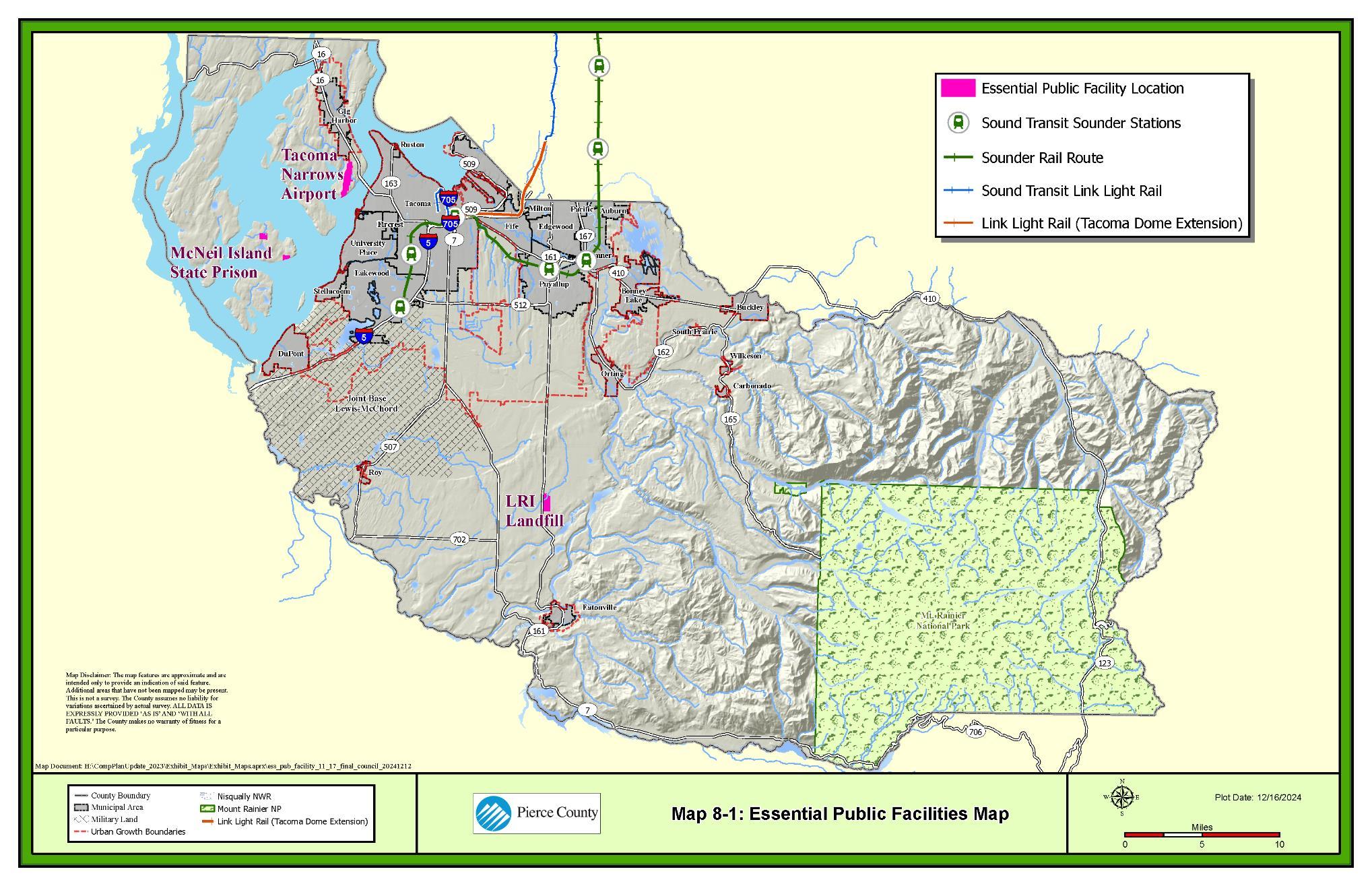
Housing is an essential need for all people. Housing provides shelter but it is also synonymous with home – a place where we feel a sense of belonging. This is the foundation of a strong community and the reason why the Growth Management Act’s housing goal is so important to Pierce County:
Plan for and accommodate housing affordable to all economic segments of the population of this state, promote a variety of residential densities and housing types, and encourage preservation of the existing housing stock.51
Pierce County has a commitment to equity and recognizes that all people are a valuable part of our community. To honor this commitment and keep our community strong, it is our responsibility to do what we can to create the opportunity for all people to make a home in Pierce County.
Housing is regulated to ensure health and safety but is also influenced by local, regional, and national economic and market influences. People’s housing needs are directly related to who they are and their economic and social conditions. Even though the County can’t control these factors, the key to creating housing opportunity is to be thoughtful in our approach and to support a variety of housing types to meet the diverse needs of our community. Since the County has the greatest ability to influence housing opportunity in the unincorporated area, this element focuses on needs and solutions to benefit our residents living outside of our cities and towns.
The Housing Element Background Information Report and other documents in the Housing section provide additional details on housing inventory and needs.
Understanding more about our community helps us to understand what types of housing needs people might have.
As of 2022, the numbers show that about 25% of Pierce County’s population is under age 18 and about 14% is over age 65. As Pierce County grows over the next few decades the proportion of older adults (age 65 and older) is expected to grow to about 23%, with a similar decline in children under 18. A map of 2020 census data finds that currently Pierce County’s
51 RCW 36.70A.020(4)
rural areas have higher percentages of older residents, while our urban unincorporated areas tend to have higher percentages of children.
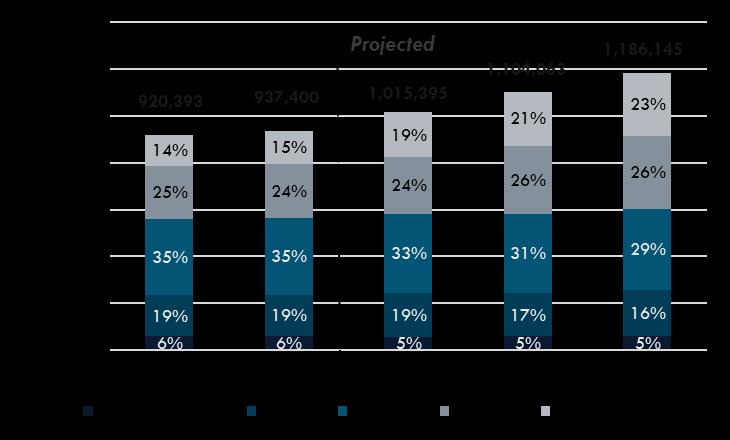
Sources: OFM, 2020 and 2022; GMA 2022 Medium Series Projections; BERK, 2023.
This demographic aging signals that the need for smaller, more affordable units will be strong. Rural areas are limited to low densities and mostly single-family detached housing types. Some older adults will be able to maintain their rural residences as they age with family and community support, others may need to transition to units that are closer to community resources and amenities, including transit. Supporting a variety of housing types will be desirable to help older adults maintain healthy, independent lives.
Housing variety is important to people throughout their lives. Regardless of age or where people live in the county, more than 50% of the households have only one or two people. However, the share of larger households has grown in urban areas outside of cities and towns (the urban unincorporated area). Household size can reflect the occupants’ life stage, family status, culture, or income. In a poll conducted by the County in 2022, 37% of respondents reported that their current housing did not meet their needs. Ensuring a variety of housing sizes can help to address that issue.
Between 2010-2021, household size has increased slightly from 2.59 people per household to 2.61 people per household. The slight increase is partly attributable to the lack of available and
affordable housing supply. People are more likely to share housing when they cannot find available or affordable units that meet their needs. It may also reflect a trend related to the COVID-19 pandemic. Based on predictions from the Washington State Department of Commerce, average household size is expected to decline over the next two decades.
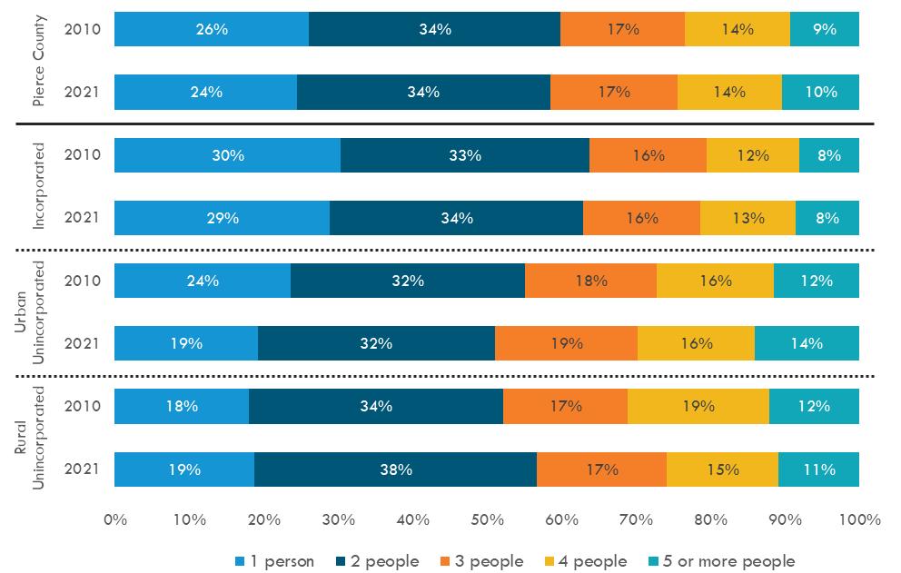
Source: US Census, 2010 and 2021 (Table B25009); BERK, 2023.
The county is diverse, housing needs and associated supportive amenities and services may differ for different cultural groups and communities. Pierce County’s urban areas are significantly more diverse than its rural areas. More than twice as many people living in urban unincorporated communities identify as black, indigenous, or people of color (BIPOC) compared to rural residents. 18% speak language other than English in their home in urban areas versus 7% in rural areas.
9-C: Unincorporated Pierce County BIPOC Population Detail
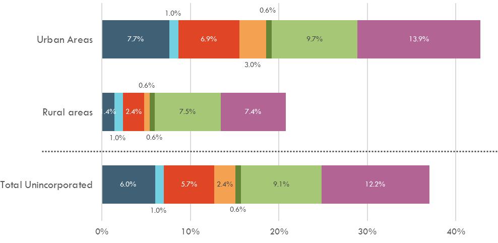
Source: US Census Bureau, 2020, BERK, 2023

About 12% of the population has a disability in unincorporated Pierce County. Disabilities can include sensory disabilities, physical disabilities, mental disabilities, self-care disabilities, gooutside-home disabilities, and employment disabilities. These conditions often require accommodations that can leave people with disabilities at risk of discrimination and harassment in their attempts to secure and maintain housing. There is an ongoing need to promote universal design in housing and local infrastructure investment.
Pierce County has about 7,000 institutionalized members of our community. Institutionalized populations are members of our community that are in nursing homes, psychiatric and hospice care facilities, juvenile care facilities, and correctional facilities. These populations require additional care and supervision and the sites they reside in are specialized to provide effective services.
Pierce County has over 16,000 non-institutionalized group community members. Noninstitutionalized group populations are in the military, live in student housing, or are in emergency/transitional shelters. Roughly half of the non-institutionalized group population are in the military. These community members may also live in sites that provide a specific type of care and services based on the needs of their group.
Household income is the total combined income of all members of a household and often determines what kinds of housing and neighborhoods are available to that household. The federal Housing and Urban Development (HUD) measures income level through area median income (AMI), which classifies households relative to each other and to the midpoint housing
costs in an area. Households with incomes at or below 80% AMI are considered low income. Between 2015-2019, the AMI for Pierce County was $80,200. It rose to $101,800 in 2022.
Between 2015-2021, median family income increased 59% whereas rents and home values increased by 79% and 103%, respectively. With home values and rents rising faster than incomes, housing affordability is increasingly out of reach for many households.
Figure 9-D: Cost Burden by Income Level, Unincorporated Pierce County Households
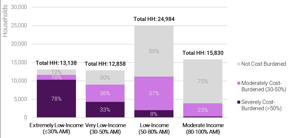
Notes: Income Categories (Extremely Low, Very Low, etc.) are based on Pierce County 2019 HAMFI of $80,200. Sources: HUD CHAS (based on ACS 5-Yr Estimates, 2015-2019), BERK, 2023.
Housing cost burden is a key indicator of housing affordability. A household is considered costburdened if it spends more than 30% of its income on housing costs. Housing cost-burden was most common among the lowest income households. Severe housing cost-burden (those spending more than 50% of their incomes on housing costs) was most common among households with incomes at or below 50% AMI. Moderate housing cost-burden was common across all income levels.
Across the homeless crisis response system in Pierce County, the number of people being served has increased annually and has more than doubled since 2015. The total number of individuals served increased significantly between 2015-2022, from 10,625 to 17,041. Estimates of homelessness are based on point-in-time counts or administrative data about people who receive services typically undercount the full amount of homelessness in a community. Using a different methodology, the Washington State Department of Commerce estimated that in 2020 there were 14,424 homeless individuals and 10,765 households. The Pierce County Comprehensive Plan to End Homelessness recognizes the need for services and facilities exceeds current resources. This plan’s target is that “any person starting a new homeless episode has immediate access to shelter and a permanent housing intervention.” The five
interventions identified are coordinated entry, housing vouchers, permanent supportive housing, rapid rehousing, and shelter. The current funding is at $40 million, with $117 million needed for operations and up to $400 million for capital costs.
Based on demographic and household indicators, the following strategies could address community needs:
• Diversify housing types. To meet the needs of all residents, housing is needed that fits each stage of life in terms of size, design, and affordability for the diverse people in our community. Middle housing consists of housing types that provide alternatives to both detached single-family units and large multi-family flats. This includes duplexes, cottages, row homes, and ADUs. These diversify the types of available and provide options for community members.
• Support adequate housing for special needs. Special needs housing includes permanent supportive housing, group homes, and assisted living. The provision of these within our communities allow for people to continue to live in their preferred neighborhoods while receiving the care that they need.
• Address Homelessness. Ensure adequate housing to prevent homelessness including improving opportunities for low-income housing, permanent supportive housing, and emergency housing to address immediate housing needs. Homelessness and housing insecurity has increased within the county since 2015, which means a diversified approach is needed. The development of housing at the 0-30% AMI combined with a network that can connect community members to re-housing services before experiencing homelessness is needed to curb this growth.
• Shared Housing: This type of housing provides a private living space for individuals that share essential kitchen or sanitary facilities. This could include rooming houses, congregate housing, or shared housing villages. Shared Housing is an option that supports households with very low- and extremely low-incomes including those that work in low-wage jobs, older adults on fixed incomes, and people at risk-of or who have experienced homelessness.
More housing is needed in Pierce County for residents of all incomes as growth occurs. Pierce County has adopted housing unit growth targets that include specific targets at each income level. Land Use policies influence where new housing can be built, with a focus on growth occurring in urban areas served by transit. However, the current inventory of housing and its existing condition also aids in understanding what type of housing may be needed in Pierce County’s unincorporated areas.
See the Land Use Element for more information on land use and zoning.
Under the Washington State Growth Management Act (GMA) local decisions about how to handle growth must be coordinated with regional and countywide policies. Permit data shows that most growth in Pierce County is happening in urban areas, a pattern consistent with state, regional, and countywide policy directives. The communities seeing the most housing production within unincorporated Pierce County are located in or near South Hill, Puyallup, Frederickson, and South Tacoma. Adding new growth to existing urban areas helps prevent sprawl from taking over farmlands and forests, is an efficient use of investments in services and infrastructure and connects people to employment opportunities.
See the Economic Development Element for a broader profile of employment and industry in Pierce County
See the Introduction of this plan for details on coordination of local, countywide, and regional policies.
The majority of employment opportunities in Pierce County are in urban areas. Most residents of the unincorporated area of Pierce County commute outside that area for work, whether it is to a nearby city or town or to another County. Commuting brings costs that add to household expenses. Focusing growth in areas with plentiful transportation options can help to lower those costs. Adding housing near employment areas can also boost economic development and moderate housing costs.
Climate change is addressed throughout the Plan. Learn more in the Design and Character, Land Use, and Environment and Climate Change elements of the plan.
The built environment is the source of 34% of Pierce County’s GHG emissions, and the residential built environment is a source of 40% of those.52 Siting housing near jobs, increasing housing density, energy efficiency improvements, use of renewable energy, weatherization, and temperature regulation can help housing to reduce emissions and improve climate resiliency for residents. Policies related to these issues can be found in the Design and Character and Land Use elements.
Pierce County has developed a Climate Vulnerability Assessment. The document informs climate resilience throughout the Comprehensive Plan. This includes
52 Puget Sound Regional Emissions Analysis, Wedge Analysis, 2022.
strategies related to housing including wildfire safety, improvement of air quality, resilience to flooding and sea-level rise, and energy efficiency.
According to the Washington State Department of Commerce there were 355,799 housing units in Pierce County in 2020, with 57% in incorporated cities and towns and 43% in unincorporated areas. This includes all forms of housing, including permanent supportive housing, so is slightly different from the count in Table 9-A.
Permanent supportive housing provides low-cost housing paired with on-site or off-site voluntary services to support people who are at risk of, or have experienced, homelessness.
Source: Pierce County Assessor, 2023; BERK, 2023.
The majority housing units in Pierce County are detached single-family dwelling units, followed by larger multi-family developments. Middle housing types tend to fall in the range of two-tonine-unit structures, representing only about 9% of unincorporated housing stock in unincorporated Pierce County.
While our demographic data shows that most households have one or two persons, more than two-thirds (2/3) of the housing units in unincorporated Pierce County are two- or threebedroom units. Owner occupied units are more likely to have 4 or more bedrooms, and rental units are more likely to have one bedroom or less. This suggests there may be a need for some larger rental units and some smaller ownership units.
Looking at the County’s housing stock from an affordability perspective there is also a mismatch between the number of housing units available at each affordability level and the number of households at each affordability level. For unincorporated Pierce County, the largest deficits in housing units by affordability level are in the 0-30% and 80%+ AMI categories.
Source: CHAS 2015-2019, BERK 2023.
When these figures are separated to look at rental versus ownership units, an additional deficit is seen for households below 50% AMI. It is estimated that in urban unincorporated Pierce County for every 100 households at or below 50% AMI there are only 34 available rental units that are affordable to them. This deficiency in affordable rental housing is also reflected in the cost burden data for households. Adequate rental housing stock was affordable and available at 80% AMI. This means much of need for new rental housing in Pierce County is at the 30% and 50% AMI level.
Emergency housing provides a spectrum of support for Pierce County residents who have become unhoused. Emergency housing provides short term or transitional support, and limit lengths of stay. Unincorporated Pierce County supports three types of emergency housing:
• Shelters – these provide temporary accommodations on a daily basis.
• Safe parking– these provide a safe and sanitary place for unhoused people to stay overnight in a personal vehicle.
• Temporary housing community – these are intended to provide temporary housing or shelter.
There were no shelter beds or temporary housing communities in unincorporated Pierce County as of 2023. There are a few safe parking sites run by religious institutions and nonprofits.
Unincorporated Pierce County also allows transitional housing in any permanent residential unit. Transitional housing is similar to permanent supportive housing because it is coupled with
supportive services to help people who have experienced homelessness. However, residency in transitional housing is limited, with the goal of integrating residents back into independent housing within two years. It is unknown how many transitional housing units are operating in unincorporated Pierce County as of 2023.
Although Pierce County has been steadily growing, there have not been enough new housing units added to keep up with demand. Between 2010 and 2021, unincorporated Pierce County produced 5,976 fewer housing units than needed to maintain pace with household growth. This creates low vacancy and limits the supply of housing available to buy or rent. As indicated before, it also can be seen in larger household sizes people double up or share housing to afford rising housing costs in a tight market. Since 2012, the months of available and affordable housing supply in Pierce County has reduced from 8 months to just over 1 month. This meant that there is too much competition for available units, which drives up prices and reduces affordability.
Housing needs for Pierce County in 2044 are estimated by the Washington State Department of Commerce’s Housing in All Planning Tool (HAPT). In order to plan for this need, the output of this tool was adopted by Pierce County as its housing target.
*PSH = Permanent supportive housing. Sources: HAPT, 2023; Pierce County, 2023.
Table 9-D: Unincorporated Housing Needs by Income Band, 2020-2044
*PSH = Permanent supportive housing. Sources: HAPT, 2023; Pierce County, 2023.
Pierce County must demonstrate that there is enough land capacity to meet the housing needs for the unincorporated area. The capacity to meet housing needs is directly related to the policies set in the Land Use element and the zoning and development regulations in the Pierce County code that will implement those policies.
Table 9-E: Projected Housing Need and Supply by Income Band (2044) Preferred Alternative
Source: Pierce County, 2024; BERK 2024
*Includes permanent supportive housing (PSH).
**Subtracted the rural target of 3,345, assuming that those units will be low density and meet >120% income band.
The following strategies could help to address housing needs related to growth:
• Create more housing by expanding development opportunities and reducing regulatory barriers. Support ADUs and middle housing in the Pierce County Code and streamline permit processes and procedures.
• Incentivize affordable housing construction through financial incentives such as tax credits and forgivable or low-interest loans.
• Support mobile and manufactured homes as a low-cost option for residents.
• Promote density near high-capacity transit. Increasing growth in areas with highcapacity transit increases housing supply while enabling people who do not own a personal vehicle to meet their daily needs.
Access to housing has not been equal in the United States due to the history of the marginalization of BIPOC (Black, Indigenous, and People of Color) communities. Although there are laws that support fair housing and prevent discrimination in housing and lending, the legacy of these past practices is still reflected in our communities to this day. This legacy is an ongoing problem nationally and locally.
Disparate impacts occur when neutral policies or practices result in disproportionate effects on a defined group or groups of people.
Pierce County conducted an evaluation of Racially Disparate Impacts, Displacement, Displacement Risk, and Exclusion in Housing as part of its Housing Action Strategy in 2022. It found that family household incomes are lower across BIPOC groups when compared to countywide and white alone income levels. As a result, rising housing costs disproportionately burden households of color, who spend more of their income on housing and have lower homeownership rates. These factors create a higher risk of exclusion and displacement for BIPOC community members within the county.
Pierce County evaluates equity in five areas for all proposals:
• Accessibility
• Livability
• Education
• Economy
• Environment
There has also been less investment in infrastructure in areas with a greater proportion of BIPOC residents based on reviews of the County’s equity indices. Areas near Tacoma have better access to parks and transit than other parts of the county; parks are also more available in the Parkland, Spanaway, and South Hill neighborhoods. The lack of amenities available to BIPOC communities can affect quality of life and access to opportunities.
Displacement occurs when people must move from their homes for reasons other than changes in their personal circumstances. This could include moves due to rising rents, evictions or foreclosures, cultural or social exclusion, or other factors. Displacement risk is calculated by looking at areas with increasing rents, areas experiencing demographic shifts, or areas that are vulnerable to change based on factors such as income, race, or rental status.
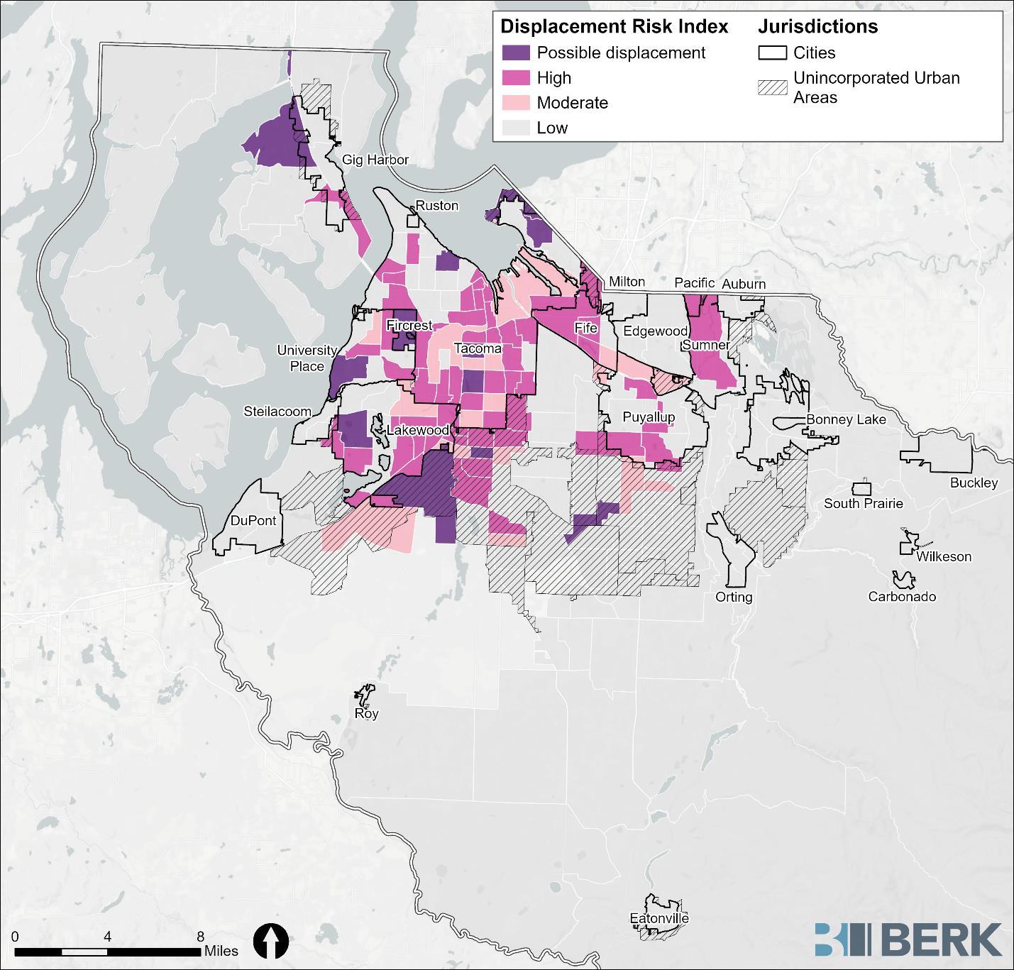
Source: BERK, 2023, Pierce County, 2024
The areas of highest displacement risk within the unincorporated Pierce County are adjacent to cities and town and where this is potential for land use change to accommodate transit, such as South Hill. This is likely due to the growth outpacing housing development in these areas.
The following strategies could help promote housing equity:
• Affordability. Improving housing affordability and supporting the development of affordable housing units provides the greatest benefit to those most economically challenged.
• Awareness. Thinking carefully about equity and the potential for inequitable outcomes is a good first steps towards addressing and preventing disparate housing impacts. The Pierce County Equity Index and Equity Note process are a good first step at building awareness about the impacts of County decision-making.
• Investment. Policies prioritizing investment in areas with low Equity Index scores helps to rebalance community access to opportunity.
• Homeownership. Homeownership improves community stability and eliminates displacement associated with rent increases. If housing prices continue to increase, owning a home also creates a source of generational wealth that can be leveraged to improve opportunity and outcomes for families over time.
GOAL HO-1 Allow for a range of housing types in urban areas of the County to support housing choice and affordability
HO-1.1 Support a variety of housing types that allow moderate and high densities and creative and efficient use of land within the urban area.
HO-1.2 Ensure that housing types within the rural and resource areas retain the rural character and respect the features of the lands.
HO-1.3 Allow middle housing such as duplexes, townhomes, accessory dwelling units, cottages, multiplexes, and other innovative types.
HO-1.4 Encourage multifamily residential development that provides owner-occupied, housing units (i.e., condominium units) through various incentives such as bonus density, increased building height, multifamily housing tax incentives, reduced parking requirements, and other measures.
HO-1.5 Allow mobile homes in areas where other single-family housing is allowed.
HO-1.5.1 Allow for the placement of manufactured housing within mobile home parks in addition to the traditional mobile home units.
HO-1.6 Allow shared housing in urban zones where similar housing unit types are allowed to support affordability for households with very low and extremely low incomes.
HO-1.6.1 Allow rooming houses where single-family homes are allowed.
HO-1.6.2 Allow congregate housing where multi-family and mixed-use development is allowed.
HO-1.6.3 Allow shared housing villages where mobile home parks, multi-family, and cottage development is allowed.
HO-1.6.4 Provide a density equivalent for shared housing that allows multiple sleeping units to be calculated as a single unit of density.
GOAL HO-2 Encourage the development of new housing within the urban growth areas where adequate facilities and services exist or are planned.
HO-2.1 Increase density in communities with existing infrastructure.
HO-2.2 Encourage accessory dwelling unit development to increase diversity in housing stock.
HO-2.2.1 Streamline urban accessory dwelling unit development requirements during the permitting process to reduce development costs and delayed construction.
HO-2.3 Support the redevelopment of surplus properties where infrastructure exists.
HO-2.3.1 Assess all County-owned properties and tax-title properties for suitability for housing prior to disposition as surplus lands.
HO-2.3.2 Sell County surplus properties for developments that provide for affordable housing.
HO-2.3.3 Apply the proceeds from the sale of surplus County property suitable for other uses towards the development of affordable housing.
HO-2.3.4 Allow surplus lands suitable for housing to be land banked.
HO-2.4 Plan for housing density and affordable housing in high-opportunity neighborhoods near existing or future transit routes with high frequency service.
HO-2.5 Promote an understanding of how a variety of dwelling types have historically been a part of livable communities.
GOAL HO-3 Consider the economic implications of regulations and practices on housing costs.
HO-3.1 Ensure consistent, streamlined regulations and procedures.
HO-3.1.1 Consider allowing reduced design standards and zoning and development standards such as parking, height restrictions, and bulk requirements where community livability can be maintained
HO-3.1.2 Provide for streamlined permitting to support housing production
HO-3.1.3 Support building practices consistent with recognized healthy housing standards.
HO-3.1.4 Provide pre-approved building plans for accessory dwelling units, cottage housing units, or other middle housing types to lower design costs for applicants.
GOAL HO-4 Seek ways to prevent discrimination, address displacement, and mitigate past harm in the development and maintenance of housing.
HO-4.1 Collaborate with community leaders, organizations, non-profits, and businesses to help vulnerable groups obtain and maintain housing.
HO-4.2 Support resident ownership of mobile home parks.
HO-4.3 Evaluate the potential for displacement on lands proposed for rezone or redevelopment for public use.
GOAL HO-5 Support the development of housing for older adults, people who have experienced homelessness, people with disabilities, military families, and others with different physical, social, and economic needs.
HO-5.1 Encourage the development of housing built to universal design standards to support housing for people of different abilities.
HO-5.2 Provide a broad range of housing choices in terms of cost, size, design, and suitability for various household types, e.g., families, people of all ages and levels of mobility, couples, and persons with disabilities or special needs with adequate accessibility and safety infrastructure.
HO-5.3 Ensure adequate zoning to support emergency and temporary housing for homeless as well as transitional and permanent supportive housing for formerly unhoused families and individuals.
HO-5.4 Encourage and support the development of affordable, special needs, and foster care housing in Pierce County by providing incentives and technical assistance for housing development.
GOAL HO-6 Promote and assist in the development of the necessary financial tools to address affordable housing for County residents.
HO-6.1 Expand the County Multi-Family Tax Exemption (MFTE) program, where allowed by law, to encourage the development of more affordable multifamily housing.
HO-6.1.1 Collaborate with local lenders and non-profit organizations providing homeownership support for low-, moderate and middle-income households and other demographic groups that historically have low rates of homeownership.
HO-6.2 Seek funding for nonprofit developers to build affordable housing.
HO-6.3 Participate in the federally funded programs that provides assistance to households earning below the County median income who are willing to help build or remodel their own housing.
GOAL HO-7 Create solutions for affordable housing that benefit all economic segments of the population.
HO-7.1 Apply planning and zoning tools identified as techniques to achieve affordable housing, such as: transfer of development rights, redevelopment of vacant and blighted property, development incentives, and inclusionary housing.
HO-7.2 Promote innovative programs and techniques that minimize the cost of affordable housing.
HO-7.2.1 Provide incentives for developers to construct affordable housing for households earning 80% or less of the median household income for the County.
HO-7.2.2 Consider fee exemptions for residential projects that incorporate housing affordable to households earning 80% or less of the County median household.
HO-7.2.3 Support community land trusts that acquire land and develop housing to support affordable home ownership.
HO-7.3 Maintain bonus densities for housing in urban areas that provide affordable units.
HO-7.4 Require inclusionary housing provisions in future developments associated with Comprehensive Plan amendments to increase development potential.
HO-7.4.1 Identify specific development fees and processes that may be waived if a residential development guarantees inclusionary housing provisions.
HO-7.4.2 Implement inclusionary housing provisions based upon consideration of: the number of affordable units, the level of affordability achieved for low income households, the duration of time the units would be maintained as affordable, and a method for monitoring and maintaining affordability over time.
HO-7.5 Integrate required affordable housing units within a development.
HO-7.5.1 Encourage provision of units through various types of housing structures.
HO-7.5.2 Ensure the architectural features of the affordable units are consistent with the overall project.
HO-7.6 Support training, seminars, programs, and partnerships that connect middle and lower income households with affordable housing options, including options for homeownership
HO-7.7 Support programs to reduce the cost of home ownership and reduce displacement for low and moderate-income households such as: emergency repair programs, tax exemptions, weatherization improvements, and energy upgrades.
GOAL HO-8 Reuse the existing housing stock to help meet the housing demand with naturally occurring affordable housing in urban areas.
HO-8.1 Explore and identify opportunities to reutilize and redevelop existing parcels where rehabilitation of existing buildings is not cost-effective.
HO-8.2 Review regulatory restrictions prohibiting rehabilitation of existing housing stock.
HO-8.3 Develop and implement rehabilitation programs and opportunities to reuse existing housing stock.
Naturally occurring affordable housing
Naturally occurring affordable housing is housing that is affordable as a result of the local market and not secured or subsidized through a government or non-profit program.
HO-8.4 Consider adoption of incentives that encourage the preservation of manufactured or mobile home parks outside of high risk floodplains to ensure their continued provision as affordable housing, including: a current use tax incentive conditioned on maintaining the land use as a manufactured/mobile home park and requiring repayment of abated taxes in the event of a manufactured housing community closure or change of use; expansion of the transfer of development rights program; manufactured/mobile home park redevelopment easements; or other creative approaches
Most agricultural activity occurs in rural areas where there are limited housing opportunities. As affordable farmworker housing contributes to a sustainable agricultural economy, it is appropriate for Pierce County to address this topic in its housing element. Pierce County can play a role in providing diverse rural housing choices through zoning and incentives for farmworker housing such as temporary housing that would not remove long-term productive agricultural lands. Recognizing the close proximity of some farmland to the urban areas, encouraging affordable housing solutions in both unincorporated and incorporated areas is appropriate.
GOAL HO-9 Identify strategies to expand opportunities to increase supply of housing to meet the needs of farmworkers and the agricultural industry.
HO-9.1 Protect the economic viability of the agricultural industry by considering innovative planning techniques to allow for farmworker housing supporting the agricultural resource activities.
HO-9.2 Consider the seasonal nature of farming and potential options to accommodate seasonal housing that does not permanently convert agricultural lands of long-term commercial significance.
HO-9.3 Explore the opportunity to provide a siting process to expedite farmworker housing projects using preapproved designs for housing of both temporary and permanent farmworkers employed by the property owner.
HO-9.4 Work with the agricultural community to develop criteria and a process for siting permanent and migrant farmworker housing in rural and agricultural resource areas with consideration given to neighborhood and project security, health and sanitation, availability of public services, access, childcare, and the availability of affordable housing in a nearby urban area.
HO-9.5 Support the development of climate resilient farm worker housing that considers climate vulnerability in siting and design.
GOAL HO-10 Collaborate with public agencies, private institutions, and organizations to remove barriers to providing farmworker housing, and explore innovative approaches to meeting farmworker housing needs.
HO-10.1 Encourage new housing and/or housing rehabilitation in suitable areas.
HO-10.2 Evaluate state requirements for farmworker housing.
HO-10.3 Monitor future development and consider regulatory amendments as necessary to support farmworker housing.
GOAL HO-11 Plan for adequate housing affordable at all income levels for Pierce County.
HO-11.1 Participate in inter-jurisdictional efforts to ensure a fair, equitable and rationale distribution of housing for all income levels and for emergency housing, consistent with land use policies, transportation, and employment locations.
HO-11.2 Coordinate with Pierce County cities and towns to ensure a fair share distribution of affordable housing within new master planned communities.
HO-11.3 Support the development of affordable housing consistent with needs identified by Washington State.
HO-11.4 Monitor the success of the housing policies in accomplishing the goals by developing benchmarks and monitoring the achievement of housing policies at least every five years.
• Housing Background Report, 2023.
• Pierce County Housing Action Strategy, 2022
• Affordable Housing Recommendations, 2021
• Comprehensive Plan to End Homelessness, 2021
9-10
• 2020-2024 Consolidated Plan
• Pierce County Affordable Housing Regulation Recommendations, 2019
• Pierce County Climate Vulnerability Assessment, 2023.

Protection of open space lands is a tool to accomplish numerous County goals, which include protecting our environment, improving quality of life, providing a sense of place to the County, and enhancing our economy. These goals become more challenging as open space lands increase and cost and more important due to increasing development pressures and the compounding effects of climate change. The Open Space Element adopts goals and policies to assist the coordination of the various County programs focused on open space lands.
Multiple Pierce County agencies acquire and manage land for open space for a variety of purposes, including: recreation, carbon sequestration, habitat conservation, and flood risk reduction. These lands are selected based on priorities set by the Comprehensive Plan or other adopted plans that identify specific lands or prioritization methods.
Pierce County’s definition of open space encompasses a range of diverse land types, which are organized into categories based on their function or reason for preservation Although the management and preservation can differ depending on the category, many lands can and do provide multiple values It is intent of this element for various County departments to work together and with community partners to maximize the return on investment in conservation efforts and achieve multiple goals with open space preservation.
For example, a property with a high-value wetland may be acquired to preserve it’s functions, and would be classified as open space for public health, welfare and safety. The property would be managed first to improve water quality, provide habitat, and provide other ecosystem service benefits. However, the land may also have other functional values for carbon sequestration, and/or as part of a trail system
Open–Space - any parcel or area of land or water that is devoted to a functional open space use as defined by any one of the following categories:
A. Habitat. Open space for the preservation of plant and animal habitat may include habitat for fish and wildlife species; rivers, streams, bays, and estuaries; and coastal
beaches, lakeshores, and banks of rivers and streams. Wetlands help recharge aquifers, provide water quality and other ecosystem services.
B. Working Lands. Open space used for the managed production of working lands may include forest lands, agricultural lands, and areas of economic importance for the production of food or fiber.
C. Outdoor Recreation. Open space for outdoor recreation may include athletic fields, recreation facilities, playgrounds, picnic areas, meadows, wooded areas, and trails; and access to beaches and shorelines for swimming, fishing, boating, and beachcombing.
D. Community-Defined Values. Open space for community-defined values may include areas used for greenspace between communities, respites from the built environment, connecting with nature, and areas of outstanding scenic, historic, and cultural value.
E. Public Health and Safety. These types of open spaces may include areas used for stormwater management, flood risk reduction, water quality for public use, air quality, and increasing tree canopy to lower the urban heat island effect.
F. Carbon Sequestration. Carbon sequestration is the process of capturing carbon dioxide from the atmosphere and storing it long-term in plants, soils, and the ocean. By conserving existing vegetation and planting more trees in our open spaces, the County can facilitate this natural process and reduce the amount of carbon dioxide in the atmosphere.
Policies for the protection and management of each category of open space will reside in the appropriate elements of the Comprehensive Plan.
& Climate Change Element
Use Element
& Recreation Element
& Recreation Element
Facilities & Utilities Element
& Climate Change Element
& Recreation Element
Use Element
This section lists general open space policies that pertain to all types of open space. Policies for specific types of open space are listed in various elements of the Comprehensive Plan that relate to the different categories of open space.
GOAL OS-1 County programs that provide for the acquisition and/or preservation of open space shall have established priorities.
OS-1.1 Ensure priorities for the preservation of open space are in conformance with the policies established in Chapter 19D.170, Pierce County Open Space Priorities.
OS-1.2 Coordinate adopted Open Space Priorities with any subsequent updates of the Parks, Recreation, and Open Space Plan for the County.
OS-1.3 Apply the adopted Open Space Priorities to the Conservation Futures Program, Current Use Assessment Program public benefit rating system, and Pierce County development regulations.
OS-1.4 Consider equity in the conservation, development, designation, or acquisition of open space lands, with an emphasis on providing open space in underserved communities and balancing property tax incentives with the associated benefits to County residents.
GOAL OS-2 Ensure that Pierce County open space properties, open space passive recreation parks, conservation easements, and conservation futures covenants are managed and maintained to provide long-term stewardship of the open space function and value.
OS-2.1 Transfer publicly-owned or acquired open space properties to qualified nonprofits, governmental entities, or land trusts for long-term management and stewardship where appropriate.
OS-2.2 Pursue an innovative approach and partnerships in managing County-owned open space properties and work to implement multiple and appropriate strategies to fiscally sustain open space lands.
OS-2.3 Encourage the provision of public easements, or transfer of such areas to public entities when practicable, where linkages between open space and screening buffers occur.
OS-2.4 Locate open spaces contiguous to other open space areas creating the potential for open space corridors wherever possible.
OS-2.5 Develop management plans that outline goals, objectives, and management recommendations for open space properties where appropriate.
GOAL OS-3 Utilize a number of techniques and innovative measures to acquire and conserve open space.
OS-3.1 Consider the use of overlays, special zoning districts (e.g., agricultural zoning or sensitive resource zones), design standards, low impact development strategies, and large-lot zoning to preserve high priority open space areas.
OS-3.2 Provide incentives for open space preservation by allowing innovative measures such as cluster zoning, transfer of development rights, and zero-lotlines.
OS-3.3 Provide increased opportunities for current-use or preferential tax assessment (Chapter 84.34 RCW) for open space lands by promoting public enrollment in the program.
OS-3.3.1 Support historically productive farmlands being reclassified from current-use farm and agriculture land into open space are designated as Farm and Agricultural Conservation Land where appropriate.
OS-3.4 Consider pursuing public acquisition of open space lands through actions such as:
• Fee-simple purchase;
• Less than fee-simple purchase (i.e., purchase of development rights, conservation easements);
• Voluntary donations with tax incentives;
• Land transfers or exchanges;
• Limited development techniques (develop a portion of the site for economic return and leave remainder as open space).; or
• Park impact fee credit.
OS-3.5 Consider pursuing a number of funding mechanisms to acquire open space lands, including but not limited to:
• Property tax levies;
• General obligation bonds and limited general obligation bonds;
• Intergovernmental funds (e.g., State Grants);
• User fees;
• Foundation monies; or
• Real estate excise taxes.
OS-3.6 Recognize the value of open and green space in promoting social and economic health and wellness, encourage the establishment of partnerships with other municipal governments, tribes, state and federal agencies, school and special purpose districts, community organizations, non-profit organizations, and landowners.
OS-3.6.1 Explore programs that incentivize or encourage the use of privatelyowned properties for public use or benefit consistent with open space priorities in the urban growth area.
OS-3.6.2 Prioritize the acquisition and conservation of open space sites located in underserved communities.
In 2023, the Washington State Legislature passed House Bill (HB) 1181 that included new climate-oriented requirements for comprehensive plans. One requirement is for jurisdictions to inventory urban tree canopy coverage. Pierce County will continue coordination to monitor and maintain trees in the urban area. This inventory will be regularly updated using available data from state and regional sources to fully comply with HB 1181 requirements and to increase our communities’ resilience to increasing climate hazards. Additional work is needed to synthesize data on tree canopy from disparate sources into one comprehensive map, and to assess the benefits which urban trees provide for mitigating extreme heat and precipitation. In 2023, the unincorporated urban growth areas in Pierce County had an estimated tree canopy coverage of 36.2%.53 Map OS-1 shows the estimated tree canopy coverage in the County, with focus on the urban growth areas. A future urban forestry plan may explore tree canopy at a more granular level to account for disparities found within these areas.
See the Terrestrial and Aquatic Ecosystems section of the Environment and Climate Change Element for Forestry Management Goals
An urban tree canopy can provide numerous environmental, health, and social benefits. These benefits are broad ranging and can be deeply beneficial to a community.
• Health: Mitigate the urban heat island effect, reduce rates of asthma, a more appealing walking environment to encourage people to walk further, improved connection to nature.
• Environmental: Improved air quality, improved water quality, improved stormwater absorption, and a better habitat for wildlife.
• Social: Create more incidental social connections by encouraging people to be outside, improve mental health for people when they are outside, environmental justice benefits.
• Place: Enhance community design and create a more hospitable urban environment that improves social cohesion in residential areas and economic activity in commercial areas by encouraging people to get out and eat, shop, play.
An urban tree canopy should comprise a mix of trees which may include a higher number of small, compact trees or a fewer number of larger, broader-spanning trees, as well as species that are more compatible with utilities and maintenance needs. The appropriate mix of trees will depend on the environment within which they will need to grow and will vary across zones, land uses, and neighborhoods.
53 Estimate generated in September 2023 based on 2021 National Land Cover Database information generated by the US Forest Service
Appropriate urban tree planting locations vary, and urban areas benefit if each type of planting location is scattered across the urban growth area. Street trees can be used along roadway frontages, parks or pockets of open space can allow larger trees to grow even in dense urban environments, parking lots may have compact growing trees spaced throughout, and development can integrate trees into their development in numerous ways.
GOAL OS-4 Adopt and maintain a forestry plan to preserve and enhance the tree canopy in a way that equitably distributes to residents the benefits that trees can provide, especially urban heat island mitigation.
OS-4.1 Coordinate forestry plans with other open space planning efforts to provide overlapping benefits where practicable, such as improving riparian habitat corridors and improving water quality by lowering temperatures due to increased shading.
OS-4.2 Implement a 40% urban tree canopy coverage target, to be distributed equitably throughout the urban area based on existing conditions and planned land uses.
OS-4.3 Prioritize enhancements to urban tree canopy in underserved communities.
OS-4.4 Work with landowners and businesses to develop strategies to support urban tree canopy goals.
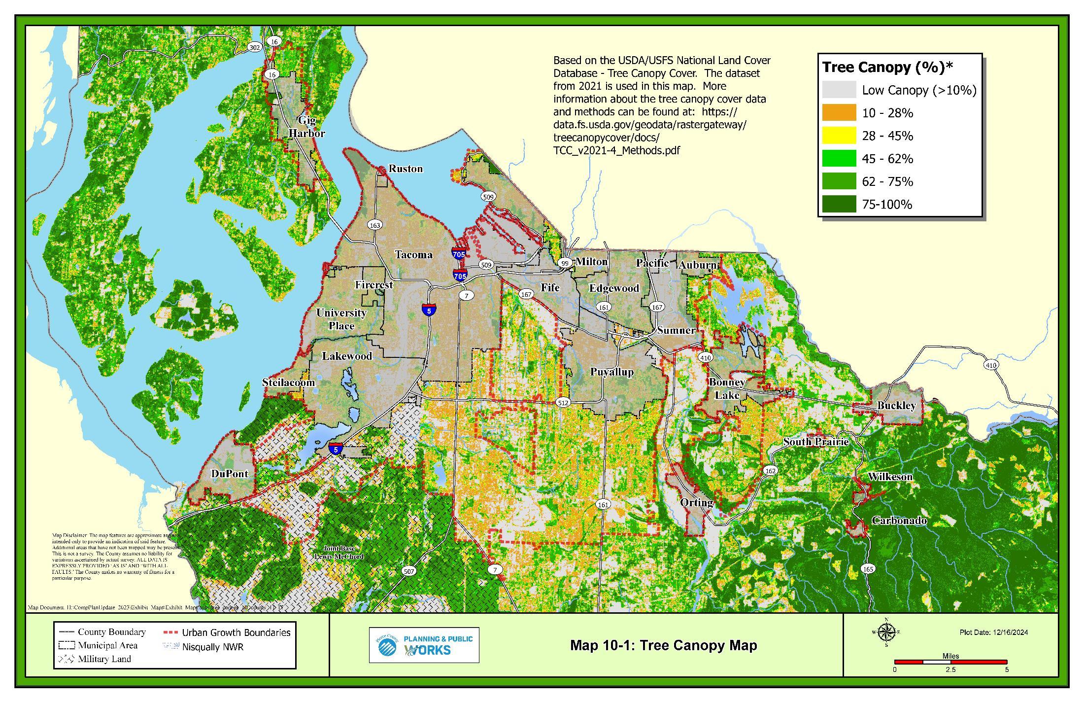
The values of Pierce County residents and their aspirations for the future are guiding forces in this Parks and Recreation Element. This element defines the vision, goals, and objectives that illustrate the preferred future for the parks, open spaces, trails, facilities, and programs provided by Pierce County Parks and Recreation.
For consistency and clarity, the term “park system” will be used throughout this document to refer to all parks, open spaces, trails, facilities, and recreation programs managed by the County.
A vision is an aspirational description of what an organization would like to achieve or accomplish in the future. It is intended to serve as a clear guide for choosing current and future courses of action. The Pierce County Vision for parks, recreation, and open space is: Create livable communities by providing opportunities for people to:
• Connect with Nature
• Live Healthy Lifestyles
• Share Vibrant Community Spaces
• Learn about Sustainable Practices
GOAL PR-1 Provide a park system that supports opportunities for active and passive recreation, promotes healthy lifestyles, and conserves and enhances significant environmental or historical resources.
PR-1.1 Assume direct responsibility for the development, operation, and maintenance of facilities that have regional benefits and align with Pierce County’s vision and primary role as a regional service provider, while balancing the role as the primary service provider in unincorporated areas not served by a park district.
PR-1.1.1 Support countywide sports, recreation programs, and special events through the provision of facilities.
PR-1.1.2 Support objectives in adopted community plans that align with the role of a regional park provider and meet identified countywide needs.
PR-1.2 Plan for the annexation or incorporation of unincorporated urban growth areas.
PR-1.2.1 Land-bank sites for local parks identified in Community Plans if capital funding is designated for that purpose.
PR-1.2.2 When in a potential annexation area, new local parks should be developed in partnership with the local jurisdiction as part of an agreement to transfer the site to the local jurisdiction. 54
PR-1.2.3 Actively seek opportunities to transfer parks located within potential annexation areas or located within park districts and consider providing financial incentives to the receiving jurisdiction such as short-term maintenance or stewardship funding.
PR-1.2.4 Retain regional parks and regional trails of the County park system regardless of incorporation or park district status.
PR-1.2.5 All non-regional park facilities will be transferred to the jurisdiction when capacity to manage the facility is demonstrated.
PR-1.3 Ensure the park system is integrated with and complements other park and recreation service providers in Pierce County.
54 Note: The text box insert regarding PR-1.2.3 ‘transitional Properties” has been removed
PR-1.3.1 Forge partnerships for park development with local jurisdictions or park districts when regional facilities are consistent with meeting the needs of city and County residents.
PR-1.3.2 Where appropriate, develop a select number of regional facilities that are oriented to the highest competitive playing standard for multiagency use.
PR-1.3.3 Develop new sports complexes in partnership with a school district or other service provider.
PR-1.4 Ensure land acquisitions, donated property and land-banked sites are consistent with the Comprehensive Plan policies and the priorities identified in the Parks, Recreation, and Open Space (PROS) Plan.
PR-1.5 Develop new facilities only if on-going operation and maintenance funding is provided at a level necessary to safely operate and maintain the facility at adopted levels of service.
PR-1.6 Implement a whole system management approach to improving and maintaining the park system through integration of long-term sustainability; promoting flexibility of uses and activities; ensuring equity across the system; providing a variety of activities; ensuring adequate support facilities; and designing with cost effective methods and partnerships.
PR-1.7 Ensure the County’s Parks, Recreation and Open Space Plan (PROS) is consistent with the Open Space Element and the Parks and Recreation Element of this Comprehensive Plan. The goals and policies described in the Comprehensive Plan define the outcomes to be produced by implementing the PROS Plan. Comprehensive Plan policies guide decision-making and set forth clear directions on how the County will provide park services to advance and maintain the park system.
GOAL PR-2 Promote active, healthy lifestyles through the development of park system facilities and programs that increase physical activity, enhance the physical and mental health of County residents, and promote safe, equitable, and inclusive access to the park system
PR-2.1 Ensure facilities and programs are available for all people regardless of ability, age, race, ethnicity, or income.
PR-2.2 Ensure healthy food and snacks choices when provided.
PR-2.3 Prohibit smoking and vaping within the park system.
PR-2.4 Work toward an interconnected system of parks and trails that safely connects to schools, civic facilities, shopping, and recreational facilities.
PR-2.5 Partner with local healthcare providers to identify park use as a healthcare solution.
PR-2.6 Provide opportunities for community connection and cohesion.
GOAL PR-3 Support healthy urban areas by promoting strategies, programs, or considering capital projects that can provide a park, publicly accessible open space, or trail within a half-mile of all urban residents.
PR-3.1 The PROS Plan should identify existing urban areas that do not have adequate access to parks, publicly accessible open space, or trails.
PR-3.1.1 Support an analysis that identifies inequitable impacts on disadvantaged communities.
See the Equity Goal & Policies in the Introduction for more detail.
PR-3.1.2 Support identifying access barriers to parks and trails, such as road crossings and a lack of connection to the active transportation system.
GOAL PR-4 Prioritize the use of park capital facility funding sources.
PR-4.1 Capital projects should be prioritized based on:
PR-4.1.1 First maintain the system by preserving the quality and capacity of the existing facilities.
PR-4.1.1.1 Capital replacement decisions should be based on safety, loss of function, regulatory upgrades, end of useful life and a balance of cost benefit.
PR-4.1.2 Second, increasing the capacity at existing park sites by upgrading or adding new facilities to increase flexibility for multiple uses or increase public use.
PR-4.1.3 Third, increasing system capacity by developing new park facilities at new park sites.
PR-4.2 Prioritize development of new park sites based on:
PR-4.2.1 Demonstrated need.
PR-4.2.2 Population served.
PR-4.2.3 Ability to implement programming which advances recreational programming goals of the Comprehensive Plan (GOAL PR-18) and associated policies) and the recreational programing objectives described in the Parks, Recreation and Open Space plan.
PR-4.2.4 Improving equity of service.
PR-4.2.5 Filling in park and open space.
GOAL PR-5 New park and trail sites will be located in consideration of the following:
PR-5.1 Readily accessible via public roads or where roads can be reasonably extended to access the site.
PR-5.2 Located close to prospective users.
PR-5.3 Sites should be suitable for the type of recreation proposed.
GOAL PR-6 Develop facilities that exemplify sustainable practices, connect to surrounding neighborhoods, universally accessible, safe, and cost effective to maintain.
PR-6.1 Use the PROS Plan and community input to guide development and identify appropriate uses and amenities.
PR-6.2 Provide attractive, vibrant community facilities and spaces that promote healthy communities for residents.
PR-6.3 Incorporate sustainability practices into the development, management, and maintenance of the park system.
PR-6.3.1 Consider climate change risks, such as sea level rise or longer droughts, when improving facilities or adding new ones.
PR-6.4 Provide facilities that are accessible for all populations and are adaptable to changing recreational, demographic, and economic trends.
PR-6.5 Provide park system properties that are connected to the surrounding communities through safe pedestrian and bicycle routes.
PR-6.6 Incorporate scenic viewpoints.
PR-6.7 Develop and manage the park system to maximize opportunities for recreation, public access, and participation.
PR-6.8 Develop and implement unified standards to minimize future design and maintenance costs and to promote an identifiable image for the park system.
PR-6.9 Use Master Plans to guide park development and ensure public support. Plans should identify types of uses and development, public access, stewardship, and restoration
PR-6.10 Ensure capital projects are consistent with the Master Plan in type of use and intensity.
GOAL PR-7 Manage the park system in a sustainable and environmentally beneficial manner that contributes to a healthy, livable community, with opportunities to connect with nature
PR-7.1 Stewardship management plans should be prepared for all park system properties.
PR-7.1.1 Management of the park system should be based on the purpose for which the property was acquired with consideration of ecosystems and adjacent land uses.
For other Open Space and urban forestry policies see the Open Space Element
PR-7.1.2 Management of open space should follow good stewardship practices that protect and preserve natural and cultural resources.
PR-7.2 Evaluate all park system properties for public access opportunities with consideration of preservation of valuable natural resources and public demand for access to natural places, and open properties that are appropriate for public access.
PR-7.2.1 Consider sustainable and low-impact public access improvements to allow public access, such as soft-surface trails, boardwalks, and environmental learning opportunities.
PR-7.3 Encourage healthy forest practices across park system properties, considering forest health best practices and preserving and increasing urban tree canopy.
PR-7.3.1 Coordinate implementation strategies for urban tree canopy coverage.
PR-7.4 Support the County Open Space Network by providing a system of open space experiences and corridors to support livable communities, offer relief from the built environment, allow people to connect with nature and ensure the longterm health of the natural environment, residents, and visitors.
PR-7.5 Provide leadership for the planning, coordination and conservation of open space corridors that include unique environmental systems and scenic vistas on a countywide basis.
PR-7.6 Incorporate natural areas and unique ecological features into the park system to protect threatened species, conserve significant resources and habitat, and retain migration corridors that are unique and important to local wildlife.
PR-7.7 Coordinate and support open space identification, acquisition, and management with other County departments and agencies to look for opportunities to leverage resources, reduce expenditures, and achieve multiple County goals when possible.
PR-7.8 Protect property valued for plant, fish, and wildlife habitat rarity, diversity, or connectivity.
PR-7.8.1 Preserve opportunities for people to observe and enjoy fish and wildlife.
PR-7.8.2 Prioritize acquisition of habitats that are considered unique in the Puget Trough or West Cascade ecoregion, are identified biodiversity management areas, contain rare species, or provide habitat connection to these areas.
PR-7.8.3 Prioritize the acquisition of habitat that completes an interconnected network of corridors or spaces.
PR-7.9 Evaluate potential open space acquisitions based on open space priorities in 19D.170.040 as well as adopted County or inter-jurisdictional plans.
PR-7.10 Develop partnerships with tribes, public agencies and jurisdictions, private organizations, and businesses for implementation of habitat conservation across the County.
PR-7.11 Manage, restore, and maintain publicly owned habitat and open space lands.
PR-7.12 Manage the park system with consideration for safety to ensure property is protected from encroachment and unwarranted uses.
GOAL PR-8 Develop secure funding strategies to adequately build, maintain, operate, and promote the park system.
PR-8.1 Develop partnerships with public and private agencies to increase park and recreation benefits for County residents and visitors.
PR-8.1.1 Distribute a percentage of park impact fee and real estate excise tax revenues collected within park district service areas to the Park District for development of capital projects that are available to all County residents.
PR-8.2 Accept donations for the park system consistent with the priorities of the PROS Plan.
PR-8.3 Periodically evaluate park impact fees and other revenue sources to meet increased system demands due to growth.
PR-8.4 Utilize the asset management system to support cost-effective long-term maintenance of the park system.
PR-8.4.1 Implement and fund maintenance protocols that maximize the life of facilities.
PR-8.5 Capital improvements and new development should not be constructed unless accompanied by the necessary operation and maintenance funding.
PR-8.5.1 Ensure operating budgets are sufficient to maintain clean, safe, and inviting parks.
PR-8.6 General fund revenues support Pierce County Parks administration, capital project management, including planning, public engagement, and permitting, maintenance, and operations.
PR-8.6.1 General fund support for the Parks Department should be increased annually to support maintenance and operation costs associated with new capacity projects and programs introduced to the system and should not be supplanted by revenues from capital improvement fund sources including impact fees, second REET or other sources such as parks sales tax.
GOAL PR-9 Serve as a regional coordinator, leading the effort to develop partnerships and foster opportunities for countywide collaboration based on PROS Plan priorities
PR-9.1 Provide leadership in the joint planning and provision of programs with other park and recreation providers to meet countywide recreation needs, where appropriate
PR-9.2 Coordinate with other park and recreation providers to meet the needs for recreation facilities and programs.
PR-9.3 Partner with County departments, cities, and other agencies to identify and conserve public access to open space and recreational opportunities.
PR-9.4 Provide technical assistance to park and recreation providers for the conservation, development, operation and maintenance of parks and recreational facilities.
PR-9.5 Lead efforts to identify regional park and trail needs and siting across the County.
GOAL PR-10 Engage residents in the planning, stewardship, and programming of the park system.
PR-10.1 Provide effective community engagement to increase public awareness and support of the park system and recreation programming.
PR-10.2 Promote the park system as a recreation and tourist destination by increasing name recognition and marketing.
PR-10.3 Increase public awareness of park system amenities, location, and value.
PR-10.4 Enhance customer service by making information and registration more accessible to the community.
PR-10.5 Promote volunteerism to enhance community ownership and stewardship of the park system.
PR-10.6 Ensure community engagement is accessible, representative, and inclusive of underserved, disadvantaged, and vulnerable populations.
PR-10.7 Educate the public about park system rules to ensure the best experience for all users.
GOAL
PR-11
Provide a connected system of trails that link communities and community destinations and provide active transportation and recreation opportunities.
PR-11.1 Accommodate active transportation modes safely and comfortably.
PR-11.2 Improve transportation by completing the regional interconnected trail system and encouraging its use for commuting.
PR-11.3 Create healthy communities by promoting active lifestyles, reducing reliance on the automobile and offering opportunities for recreation through an interconnected trail system.
PR-11.4 Recognize the economic benefit of trail facilities in communities.
PR-11.4.1 Trailheads should be located to promote economic development, efficiency of maintenance and improved safety.
GOAL PR-12 Develop regional and connector trail routes, crossings and trail facilities that are safe and accessible to all and that may provide value for recreation, active transportation, or both.
PR-12.1 Coordinate design standards to prioritize trail user safety where trails are in proximity to roadways and provide safe crossing of streets and other transportation routes.
PR-12.2 Ensure safety of all users through the provision of well maintained, visible, and well signed trail corridors with emergency access.
PR-12.3 Adopt trail master plans responsive to user demands, ensuring facilities accommodate diverse trail users appropriate to the communities served.
PR-12.3.1 Where trails will cross jurisdictional boundaries, coordinate the planning process with local jurisdictions.
GOAL PR-13 Provide facilities and trail support services to accommodate the needs of trail users and are appropriate for the trail route, recognizing that each trail will have unique characteristics
PR-13.1 Provide rest stations, restrooms, seating, picnic tables, water fountains, bike racks, and recycling/trash receptacles as appropriate.
PR-13.2 Work across jurisdictions to adopt common trail development and maintenance standards to improve user experience.
PR-13.3 Consider siting trailheads in areas that allow for shared parking and infrastructure with other community facilities or major destination points along the trail route such as libraries, schools, community centers, and shopping complexes when parking is necessary.
PR-13.4 Provide for wildlife or scenic viewing opportunities where appropriate.
PR-13.5 Provide access for equestrian use in the rural area on routes that serve public stables or other equestrian pathways and do not limit other active transportation uses in the corridor.
GOAL PR-14 Provide trail maintenance that is responsive, cost effective and resourceful for the long-term success of the regional trails system.
PR-14.1 Consider maintenance, including landscaping in the design process.
GOAL PR-15 Provide and enhance connectivity to important County and regional destinations, between multiple jurisdictions, and to neighboring counties.
PR-15.1 Work with Federal, State, and local agencies to identify and procure public property to further the regional trail system.
PR-15.2 Coordinate with cities, local communities, federal agencies, tribes, park districts, user groups, and neighboring counties to develop a successful regional trail system.
PR-15.3 Encourage special purpose districts, cities, towns, ports, tribes, developers, and community plan areas to provide trail connections and provide access to the regional trail system.
PR-15.4 Promote public/private partnerships in development, implementation, operation, and maintenance trail projects.
GOAL PR-16 Explore opportunities to develop trails as a means to improve the level of service for pedestrians or bicyclists.
PR-16.1 Develop and adopt standards for trails in the right-of-way that prioritizes safety for trail users.
PR-16.2 Collaborate across Departments to develop an active transportation network, prioritizing connections between on-road facilities and trails.
GOAL PR-17 Provide public waterfront access through the provision of public piers, swimming beaches, motorized and nonmotorized boat launches, public boat moorage, and water viewpoints.
PR-17.1 Cooperate with other agencies to acquire and preserve shoreline access.
PR-17.2 Enhance the existing recreation opportunities for nonmotorized watercraft users.
PR-17.3 Provide access to shorelines in a manner that is aesthetically compatible with the adjacent properties and sensitive to ecological function.
PR-17.4 Provide for increased shoreline and water access in concert with increased demand from growth and development.
PR-17.5 Promote appropriate water access to help inspire appreciation and stewardship of aquatic resources and habitat.
PR-17.6 Provide water access facilities that are appropriate and safe for the location, with consideration of tides, temperature, and user types.
Community destinations include (PR-17.1):
• Regional and County facilities
• Schools
• Employment centers
• Transit centers
• Significant natural areas
• Landmarks
Methods may include (PR17.3):
• Land dedication
• Purchase
• Use of vacated rail lines (rail-banking) and other rights-of-way
• Donation of land
• Public easements
• Use agreements
GOAL PR-18 Provide recreation programs that serve regional needs and encourage greater participation in areas not served by other providers.
PR-18.1 Focus on core program areas that support the mission of encouraging active, healthy lifestyles, connecting people to nature, supporting vibrant communities, and providing opportunities to learn about sustainability practices.
PR-18.1.1 Provide or collaborate with multidisciplinary health partners in developing programs that support improved physical activity, exposure to nature, health, and well-being.
PR-18.2 Provide innovative, facility-based events to provide social and recreational opportunities based on the interests and needs of the community
PR-18.2.1 Offer an array of self-directed and facilitated programs to give residents the greatest level of access to opportunities.
PR-18.3 Ensure equitable programming for all regardless of age, abilities, race, ethnicity, or income.
PR-18.3.1 Identify and reduce physical and financial barriers to participation.
For more background and technical information see the Technical Sections of this element
The population of Pierce County and the demand on the transportation system are both expected to increase significantly over the 20-year planning period. To keep our economy and environment healthy, it is essential for the transportation system to be able to meet the demands of tomorrow. The challenges of addressing transportation needs include population growth, transportation financing, and the variety of policy options for addressing issues. The County strives to meet the transportation needs of all users while achieving the lowest longterm costs and reducing greenhouse gas emissions.
In order to accommodate needs of all aspects of moving people and goods, it is becoming increasingly important to consider all modes of travel and a wide range of transportation options. The County supports equity in access to transportation options, which can include an increase in the use of transit and other alternatives to the single-occupant vehicle. Safe and efficient alternatives to single-occupant vehicles are needed to reduce the cost of transportation and to provide the infrastructure to attract and retain businesses. Transportation improvements include the information and infrastructure to change travel habits. Transit strategies include improved bus service, high occupancy vehicle lanes, vanpools, and carpools with safe and convenient access to park-and-ride lots. Active transportation systems include facilities to support activities such as bicycling, walking, and rolling. It is
anticipated that Transportation Demand Management will play a greater role in integrating transit, ride sharing, and active transportation systems.
Pierce County's urban travel needs are met by a system of roadways, sidewalks, trails and bike lanes, a bus transit system, commuter rail, and light rail. In addition, the County is served by a maritime port, several general aviation airports, and ferry services. Joint Base Lewis-McChord (JBLM) is a major military facility with complex transportation systems and travel needs.
GOAL TR-1 Collaborate in the development of a resilient countywide multimodal transportation system that considers the mobility needs of all residents, emphasizes safety, minimizes impacts to the natural and built environments, and facilitates freight movement.
TR-1.1 Strategically expand capacity and increase efficiency of the system to move freight, services, and people to, from, and within the urban growth area
TR-1.2 Focus on investments that provide the best balance of system efficiency with the least amount of environmental and social impact.
TR-1.3 Provide information to users of all modes on the rules of the road.
The urban transportation system includes (TR-1.1):
• Roadways
• Fixed-route public transit and shuttle services
• Bicycle and pedestrian facilities
• Water, rail, air, and industrial port and intermodal facilities
• Passenger and freight rail
TR-1.4 Support development and implementation of technology innovations in the transit and transportation systems that improve public health and safety, efficiency, system performance, and infrastructure return on investment.
GOAL TR-2 Invest in all five categories of MOPIA (Maintenance, Operations, Preservation, Improvements, and Administration) in stewardship of the transportation system. Maintenance, Operations, and Preservation are the highest priorities.
TR-2.1 Lower the overall life-cycle costs through effective maintenance and preservation programs.
TR-2.2 Adequately maintain roadways, rights-of-way, and associated County property, while adhering to established levels of service.
TR-2.3 Promote an efficient roadway system through operational activities, improvements, and education.
TR-2.3.1 Recognize that operational improvements can lead to a reduction in the need for new project construction.
TR-2.4 Preserve the County roadway system.
TR-2.4.1 Repave and overlay roadways in a timely manner.
TR-2.4.2 Replace or refurbish infrastructure when needed.
TR-2.5 Improve roadways through widening and extensions to keep pace with growth and enhance safety, particularly in urban areas.
TR-2.6 Provide adequate staffing and funding to administer the maintenance, operations, preservation, and improvement activities.
GOAL TR-3 Develop the transportation system consistent with adopted land use plans for all modes of travel.
TR-3.1 Forecast traffic to plan for transportation infrastructure that accommodates planned growth and maintains service standards.
TR-3.1.1 Explore methods to forecast person and vehicle-trips as County-specific data sources become available.
TR-3.1.2 Plan for connecting residences to local centers of importance, employment centers, and regional transit hubs.
TR-3.1.3 Explore mode split goals for centers to support the development of highcapacity transit communities.
TR-3.2 Reduce vehicle miles traveled with facilities that support active transportation modes and transit.
TR-3.2.1 Recognize that active transportation and transit facilities on corridors with heavy vehicular traffic may not be well suited for all active transportation users.
TR-3.3 Prioritize transportation capacity and system improvements that consider all modes and the overall ability for the transportation system to move people and freight efficiently.
TR-3.3.1 Address forecasted vehicular concurrency failures, gaps in the target priority active transportation network, and amenity deficits at frequent transit stops.
TR-3.3.2 Invest in projects that support an equitable and accessible transportation system in underinvested communities.
TR-3.3.3 Reduce vehicle miles traveled by connecting community destinations, especially by investing in low stress active transportation route options.
TR-3.4 Recognize the need for all transportation improvements to mitigate environmental impacts and avoid displacement to the greatest practicable extent.
TR-3.4.1 Integrate climate change mitigation and adaptation into the design, maintenance, and management of the transportation system.
TR-3.5 Coordinate with utilities, private property owners, and WSDOT to buildout an electric vehicle charging network.
GOAL TR-4 Utilize Vision Zero to incorporate safety into decision-making.
TR-4.1 Utilize the Vision Zero Action Plan to identify safety project prioritization strategies, priority areas for implementation, and recommendations for safety projects and programs for future Transportation Improvement Programs and grant submittals.
TR-4.2 Monitor the effect of transportation projects on overall traffic safety.
TR-4.3 Implement Vision Zero strategies to reduce level of traffic stress at intersections and in neighborhoods identified as being high risk for fatal or serious injury collisions.
The land that contains transportation corridors is referred to as right-of-way. Right-of-way exists for roads, trails, rail lines, and access to navigable waters.
GOAL TR-5 Acquire and preserve rights-of-way.
TR-5.1 Preserve right-of-way for future trail, transit alignments and high-capacity transit.
TR-5.2 Require dedication of right-of-way as a condition for development.
TR-5.3 Request donations of right-of-way to the County.
TR-5.4 Include donated right-of-way in development density calculations so developers who donate are not penalized.
TR-5.5 Purchase rights-of-way and easements.
TR-5.6 Purchase development rights from property owners.
Goal LU-42 includes policies describing the rural character the transportation system.
TR-5.7 Require property owners to grant public easements during development.
TR-5.8 Preserve County rights-of-way that terminate at navigable waters for public access.
TR-5.9 Preserve rail rights-of-way for future rail or other transportation purposes.
TR-5.9.1 Identify abandoned or to be abandoned rail lines and rights-of-way.
TR-5.9.2 Support and encourage the State allocate funds for the preservation of identified rail lines and rights-of-way.
TR-5.10 Protect public rights-of-way from encroachment by any structure, vegetation, landscaping materials, or other obstruction.
TR-5.11 Establish minimum setbacks for property improvements to preserve sufficient right-of-way to serve future transportation needs.
TR-5.12 Assess the potential uses of rights-of-way for all forms of travel to preserve and implement their highest and best transportation use.
TR-5.13 Adopt official controls to facilitate the acquisition of right-of-way for planned transportation corridors.
The road system in Pierce County consists of Federal, State, County, city, and privately-owned facilities. The County's road system connects with the interstate and State highway system, and city streets, as well as numerous privately owned roads throughout the County. Rural roads connect urban centers as well as serving rural areas. Policies supporting the expansion of rural roads balance the needs for the increased flow of people and goods between urban areas with protections for the rural areas.
GOAL TR-6 Encourage direct routing and greater connectivity of the arterial road system, while minimizing impacts to residential neighborhoods and the environment.
GOAL TR-7 Utilize traffic calming measures, as appropriate, to reduce high traffic volumes and speeds through residential neighborhoods.
TR-7.1 Consider allowing on-street parking on minor local and residential streets where suitable.
GOAL TR-8 Provide for the safe use and presence of farm vehicles on the rural roadway network.
TR-8.1 Coordinate with the farming community to understand the specific operational needs of their industry.
TR-8.2 Encourage discussion and analysis of impacts of connectivity as it relates to agricultural lands.
GOAL TR-9 Design and build rural roads to recognize their function in the overall transportation system except as necessary for public facilities as approved by Pierce County.
TR-9.1 Avoid construction of new roads or travel lanes in the rural area, except when essential for travel between urban areas and centers or necessary for public facilities as approved by Pierce County.
TR-9.2 Plan for adequate capacity for freight on rural roads that serve as connections to existing or planned development.
TR-9.3 Restrict new access points from adjacent properties when additional capacity is required on a rural road except as necessary for public facilities as approved by Pierce County.
GOAL TR-10 Consolidate access to State highways, and major and secondary arterials in order to complement the highway and arterial system.
TR-10.1 Identify access to private developments through a system of collector arterials and local access streets.
TR-10.2 Consolidate access in developing commercial and high-density residential areas through shared-use driveways, frontage roads, and local access streets.
TR-10.3 Encourage landowners developing property along highways, and major and secondary arterials to jointly prepare comprehensive access plans that emphasize efficient internal circulation and discourage multiple access points to major roadways.
TR-10.4 Consider access management to reduce the number of conflict points between pedestrians and vehicles, with the intention of improving pedestrian safety.
TR-10.5 Discourage gated communities that impair emergency vehicle access.
Active transportation systems (nonmotorized) include sidewalks, trails, and bike lanes to accommodate pedestrians, bicyclists, and those who roll on other human powered devices for both transportation and recreational purposes. Pierce County’s multi-modal LOS supports safe and accessible bicycle and pedestrian travel through upgraded roadways as development occurs. The multi-modal LOS for pedestrian and bicycles is based on a level of transportation stress (LTS) model that identifies the appropriate infrastructure for road segments based on ensuring safety and comfort for the intended user. Publicly funded upgrades are described in more detail in the CFP.
GOAL TR-11 Develop an interconnected countywide system of active transportation facilities that provide travel options, promote physical activity and well-being, contribute to a healthier population and cleaner environment, and enhance safety.
TR-11.1 Implement complete streets to promotes roadways that are safe and convenient for all users.
TR-11.2 Develop a safe, connected network of active transportation facilities that allows for access to centers and community destinations.
TR-11.2.1 Support the Regional Growth Strategy with active transportation improvements in designated centers and high-capacity transit areas.
TR-11.3 Utilize a system for measuring level of traffic stress for pedestrians and bicyclists that considers vehicle traffic, functional classification, and travel speed.
TR-11.3.1 Evaluate level of traffic stress and available right of way when siting active transportation facilities.
TR-11.4 Consider the potential to reduce vehicle miles traveled when planning active transportation projects.
TR-11.4.1 Prioritize bicycle projects for longer distance travel, especially to centers and community destinations.
TR-11.4.2 Prioritize a complete pedestrian network that facilitates connecting residents to services.
TR-11.5 Support active transportation travel modes as a trip reduction strategy.
TR-11.6 Periodically review and update the road design manual and development regulations so new developments meet the target level of service for active transportation facilities.
TR-11.7 Design infrastructure improvements to support water quality, mitigate the urban heat island effect, improve air quality, or enhance biodiversity to the extent practicable.
TR-11.8 Identify and construct missing links in the active transportation system to facilitate access to the trail system.
TR-11.9 Examine opportunities for trails and separated pathways to accommodate active transportation users in rural areas.
GOAL TR-12 Integrate trails into the transportation system by supporting a regional trail system that provides connections to designated centers, transit, and community destinations.
TR-12.1 Apply trail standards that are compatible with right-of-way needs to support the active transportation network.
TR-12.2 Identify appropriate street connections to trail facilities to support bicycle facilities that connect neighborhoods to the regional trail system.
TR-12.3 Support regional trail planning efforts by connecting the County’s regional trail network to surrounding trail networks.
GOAL TR-13 Require new development to address pedestrian and bicycle needs.
TR-13.1 Provide facilities for bicyclists and pedestrians to access public transit.
GOAL TR-14 Develop, maintain, and improve pedestrian amenities for routes connecting commercial areas to residential neighborhoods, civic uses, and schools.
TR-14.1 Realize both the recreational and transportation value of these routes.
TR-14.2 Accommodate students’ travel to school and bus stops using safe walking corridors.
TR-14.2.1 Consider projects and needs identified in the Safe Routes to School Plan when planning capital projects or identifying mitigation for large residential projects.
GOAL TR-15 Provide a safe and reliable transportation network for youth.
TR-15.1 Promote safety, accessibility and mobility for youth through safe routes to schools.
TR-15.2 Coordinate a Safe Route to Schools Plan with local school districts as part of the transportation improvement plan.
TR-15.3 Actively seek grant funding from federal and State programs to improve transportation networks for equitability, safety, mobility, and physical health around K-12 schools.
TR-15.4 Ensure development regulations promote safe walking and bicycling from residential neighborhoods to schools.
TR-15.5 Encourage residential developers to provide waiting areas for the safe congregation of children transported by bus to school.
Transit service in Pierce County is provided by Pierce Transit, Intercity Transit, and Sound Transit. Pierce Transit provides local fixed-route bus service, Stream Community Line highcapacity transit service between Spanaway and Tacoma Dome Station, a demand response SHUTTLE service for persons with disabilities who are unable to use the fixed-route system, Runner on-demand service for all riders in several geographic areas that don’t have fixed transit, a rideshare program that includes vanpooling and on-demand transit, and park-and-ride facilities to support these services. Intercity Transit provides express bus service between Olympia and Tacoma as well as vanpooling for Thurston County residents into Pierce County. Sound Transit provides express bus service to Seattle, south King County, and Sea-Tac International Airport, Sounder commuter rail between multiple Pierce and King County cities, and the Tacoma Link light rail.
This section includes policies to support transit with design-based level of service (LOS) standards. These policies help promote transit ridership through coordinating appropriate infrastructure. Since the County does not control transit service, these policies focus on the provision of infrastructure for transit stops, consistent with Pierce Transit guidelines.
GOAL TR-16 Encourage and cooperate with transit agencies to provide services that meet the needs of residents.
Services include (TR-16):
o Fixed route transit
o Vanpool
o Rail
o Shuttles
o Tourism-related service
12-8
TR-16.1 Coordinate with transit agencies to increase the number of and span of routes as well as frequency, as funding becomes available, especially to underserved areas and designated centers within the unincorporated area.
TR-16.2 Cooperate with transit agencies in the location of transit centers, park and ride lots, rail stations, bus stops, and support transit services around these areas.
TR-16.3 Support efforts to develop tourist-related transit service that reduces vehicle trips to local attractions, especially Mount Rainier.
TR-16.4 Work with transit agencies to improve bus and rail connections to popular bicycle and pedestrian routes and ferry terminals.
TR-16.5 Encourage transit agencies to add bicycle lockers and other amenities to accommodate multimodal connections at major transit centers or park-andride lots.
TR-16.6 Work with transit agencies to identify improvements within the County rightof-way to support transit operations and rider access to transit facilities.
TR-16.6.1 Coordinate funding opportunities when planned projects overlap.
TR-16.7 Support the development of the regional park-and-ride lot system.
TR-16.8 Encourage the placement of transit shelters that are well lit, clearly visible, well-marked, posted with easy-to-read schedules and route maps, equipped with litter receptacles, and that protect users from inclement weather.
TR-16.9 Coordinate with the Pierce County Coordinated Transportation Services Coalition to address mobility for people with special transportation needs and to implement the countywide Coordinated Transportation Plan recommendations.
TR-16.10 Periodically assess the County’s land use goals, changing demographics, and travel needs of the urban growth area in determining the potential demand for transit services and the need to re-examine the Pierce Transit’s Public Transit Benefit Area boundary for unincorporated areas as allowed by State law.
TR-16.11 Periodically review the changing demographics of the County to identify the degree to which the needs of minority and low-income communities are served by transit and participate in review of the transit agencies assessment of the benefits, burdens, and relative impacts of transit plans and projects to help determine whether they will be equitably distributed among underserved and non-underserved persons and communities.
TR-16.12 Support opportunities to serve or increase transit service to high-employment commercial and industrial centers within the urban growth area.
TR-16.13 Work with Intercity Transit, Pierce Transit and Sound Transit, WSDOT, and other jurisdictions in identifying infrastructure needs of common interest to the broader transit system.
TR-16.14 Encourage Pierce Transit and other service providers to explore and implement cost effective transit service to and from existing cities/towns in rural areas.
GOAL TR-17 Explore strategies to lead to higher levels of transit service.
TR-17.1 Integrate transit-supportive design, in coordination with transit agencies, such as facilities for on-demand transit services, wellconnected street networks, transit signal priority/preemption, bus bulbs/islands, bus turnouts, and queue jump lanes.
TR-17.2 Work with transit agencies to address first and last mile barriers to transit use and connections to jobs and housing including locating active transportation facilities to sidewalks that best serve transit routes.
TR-17.3 Work with partners to develop a range of alternative service options in areas not well served by fixed route transit such as community shuttles, real-time rideshare, community vans, and other innovative options.
Transit-supportive design measures include (TR-17.1):
• Well-connected street network
• Transit signal priority or preemption
• Bus bulbs or islands
• Bus turnouts
• Queue jump lanes
• Business Access Transit lanes
• Dedicated Bus Rapid Transit lanes
TR-17.4 Coordinate with Pierce Transit and WSDOT to implement speed and reliability treatments along County arterials and state highways to support bus and enhanced bus routes.
Pierce County is served by two ferry routes, one operated by the County and the other by the Washington State Department of Transportation (WSDOT). The WSDOT ferry route is between Point Defiance in Tacoma and Vashon Island. The Pierce County ferry route connects Anderson and Ketron Island to the mainland in the town of Steilacoom. All routes accommodate motor vehicles, walk-on passengers, and bicyclists.
GOAL TR-18 Consider the Pierce County Ferry System an extension of the County roadway system.
TR-18.1 Consider sea level rise and flooding when siting or improving ferry infrastructure.
TR-18.2 Modify ferry service to meet increased demand during peak season.
12-10
The efficient movement of freight is a priority for supporting economic development and providing living wage jobs. Movement of goods and services can be achieved using rail systems, trucking, and shipping.
GOAL TR-19 Work in cooperation with local communities, the Washington State Department of Transportation, railroads, labor groups, cities, JBLM, Port authorities, and shippers to meet freight mobility and access needs.
TR-19.1 Identify and preserve all rail lines and services.
TR-19.1.1 Site new rail lines where they will have the minimum possible impact on shorelines and have the least risk of flooding due to sea level rise.
TR-19.2 Coordinate and implement passenger and freight rail service preservation projects consistent with a regional transportation program.
TR-19.3 Consider localized rail service as a means of public transportation and explore partnerships with local railroad operators to provide passenger rail service on existing railways throughout Pierce County.
TR-19.4 Provide for the needs of freight movement and employees within the Frederickson Manufacturing/Industrial Center by ensuring a variety of transportation modes and funding road improvements to accommodate freight movement.
TR-19.5 Support electrification and use of alternative fuels to reduce greenhouse gas emissions.
TR-19.6 Support efforts to construct transportation facilities that will benefit freight movement
Pierce County is served by Seattle-Tacoma International Airport in south King County, two military base airports, and a number of smaller airports owned by the public and private sector. The largest airports located in the County are the military air facilities on Joint Base Lewis McChord (JBLM) - McChord Field and Gray Field. General aviation is served by the Countyowned Tacoma Narrows Airport and Thun Field and several other small private airports.
GOAL TR-20 Participate in regional airport planning to ensure that County needs are met and that County concerns are addressed.
TR-20.1 Support the preservation of air navigation resources and facilities.
TR-20.2 Provide adequate ground transportation to move people and goods to and from airports.
GOAL TR-21 Plan for maintenance and development in the County through each airport’s master plan.
TR-21.1 Periodically review and update development regulations to comply with FAA requirements to support existing operations.
TR-21.2 Review and implement best management practices, to the extent feasible, to mitigate environmental impacts such as noise, greenhouse gas emissions, and stormwater pollution.
Level of service standards exist for all arterials and transit routes to gauge the performance of the system. These service standards should be regionally coordinated.
To gauge the performance of the County road system, Pierce County Council adopts level of service standards (hereafter referred to as service standards or standards). The standards are set according to the Capital Facilities and Utilities Element of this Plan. In the 2024 periodic update, Pierce County transitioned to a scaled LOS system. This system provides future flexibility through adopting an LOS range, which authorizes a higher tolerance for congestion in urban areas and maintains the same service threshold for rural areas.
GOAL TR-22 Establish service standards for County arterials to monitor the performance of the system, evaluate improvement strategies, and facilitate coordination for funding.
TR-22.1 Annually report transportation concurrency on County roadways based on the adopted County service standard.
TR-22.2 Designate roadways as ultimate capacity when traffic volumes would otherwise require capacity improvements.
TR-22.2.1 Recognize that conditions for an ultimate capacity designation will be specific and unique to the arterial segment.
TR-22.2.2 Utilize a feasibility study in determining whether ultimate capacity should be designated based on factors such as: right-of-way acquisition needs, the presence of critical areas, active transportation potential, equity considerations, and other factors.
TR-22.2.3 Adjust maximum vehicular capacity for roadway segments designated as ultimate capacity.
TR-22.2.4 Improvements to ultimate capacity roadways should be focused on transportation demand management measures, operational strategies, and active transportation opportunities.
GOAL TR-23 Ensure that transportation improvements or strategies to accommodate the impacts of development are concurrent with the development.
TR-23.1 Consider varied strategies in the concurrency program to address substandard service standards.
TR-23.2 Consider targeted application of transportation demand strategies on roadways that exceed service standard thresholds.
TR-23.3 Prohibit development in areas that are served by facilities that do not meet concurrency standards.
Transportation Demand Management (TDM) involves strategies that are targeted towards reducing drive-alone travel. TDM efforts include education, programs, incentives, and the provision of infrastructure.
GOAL TR-24 Encourage alternate travel modes as part of an efficient multimodal transportation system and regulatory programs that reduce vehicle miles traveled per capita and shifts travel demand to improve the flow of people and goods.
TR-24.1 Partner with businesses, developers, landlords, nonprofits, or other public agencies to implement travel demand management (TDM) programs.
TR-24.2 Recognize a connected transit and active transportation network as fundamental to encouraging alternatives to single-occupancy vehicle travel and increase travel options, especially to and within centers, and along corridors connecting centers.
TR-24.3 Incorporate TDM strategies into County regulatory programs such as zoning, site design, development standards, and parking management.
Strategies to implement TDM include (TR-24):
• Encourage telework and flexible working schedules for commuters to reduce peak travel time demand.
• Promote commuter trip reduction programs for commercial centers.
• Require accommodation for pedestrian, bicycle, rideshare and transit modes on development sites to facilitate reductions in parking demand.
• Incentivize implementation of parking demand strategies for multifamily and commercial developments within the UGA, including requiring paid parking stalls for residents, providing informational support for alternate modes, and having rideshare/carpool spaces and/or programs
• Connect active transportation routes to transit services and commercial centers.
12-13
GOAL TR-25 Consider impacts on health, environmental justice, and the natural and built environments when designing and implementing facilities.
TR-25.1 Use low impact development practices or environmentally appropriate approaches for the design, construction, and operation of facilities to reduce and mitigate environmental impacts.
TR-25.1.1 Consider strategies to combine LID features with other environmental benefits, such as planting or preserving trees, pollinator habitat or other features as a separator of vehicles and nonmotorized road users.
TR-25.2 Locate and construct improvements to discourage adverse impacts on water quality and other environmental resources.
TR-25.2.1 Ensure for major projects that must cross a fish bearing stream, that new culverts are added and existing culverts are upgraded, consistent with the County’s fish passage program.
TR-25.2.2 Consider reducing the risk of culvert failure by designing culverts and bridges to be climate resilient to prevent future fish barriers and accommodate higher stream flows that may occur with climate change.
TR-25.3 Design facilities to fit within the context of the built or natural environment in which they are located.
TR-25.3.1 Minimize changes to existing topography and impacts to critical areas.
TR-25.4 Mitigate unavoidable environmental and health impacts, including cumulative impacts.
TR-25.5 Use recycled materials in the construction of facilities where appropriate.
TR-25.6 Consider landscaping and other types of buffers along major facilities, where appropriate.
TR-25.6.1 Preserve the natural environment and existing vegetation as much as possible.
The Washington Department of Fish and Wildlife has issued guidance on designing culverts and bridges to be climate resilient to prevent future fish barriers and accommodate higher stream flows that may occur with climate change. Implementation resources include:
• WDFW Water Crossing Designing Guidelines
• WDFW’s climate-changeresilient culvert webpage
• Incorporating Climate Change into the Design of Water Crossing Structures: Final Project Report (2017)
TR-25.6.2 Avoid the removal of trees outside the safety perimeter of roadways in the rural areas.
TR-25.6.3 Relocate or replace any trees removed as part of any roadway projects when feasible.
TR-25.6.3.1 Ensure that any plantings do not affect driver visibility or line of sight.
TR-25.6.4 Include roadside native vegetation and trees in the buffer areas adjacent to arterials.
TR-25.7 Solicit and incorporate the concerns and comments of tribes, community members, and interested parties regarding the planning, design, construction, operation, and maintenance of the system.
GOAL TR-26 Develop a system that minimizes negative impacts to human health and provides opportunities for healthy, non-polluting travel options.
TR-26.1 Encourage carshare and bikeshare programs.
TR-26.2 Develop prevention and recovery strategies, and plan for coordinated responses.
TR-26.2.1 Ensure redundant transportation routes to improve mobility during emergencies.
TR-26.2.2 Coordinate with transit agencies to identify alternative routes for transit service during or as the result of emergencies, including climate hazards.
TR-26.3 Consider the impacts of noise on both the transportation facility user and the larger population when locating and designing future transportation facilities.
GOAL TR-27 Protect the system against disaster and climate hazards such as extreme heat, heavy rainfall, and other events that could lead to extended road closures or transit delays.
TR-27.1 Use climate resilient design for infrastructure to reduce maintenance costs caused by extreme heat and heavy rainfall.
TR-27.2 Implement green infrastructure in street improvements to reduce flooding risks from heavy rainfall.
GOAL TR-28 Coordinate the planning, design, and implementation of improvements with other agencies.
TR-28.1 Coordinate with the Puget Sound Regional Council, Pierce County Regional Council, transportation agencies, tribes, military installations, special purpose districts, ports, other organizations, and other jurisdictions in developing and updating the Regional Transportation Plan and the programming efforts that cross jurisdictional lines.
TR-28.2 Create interlocal agreements that address development impacts on one another’s facilities, including potential developer mitigation measures.
TR-28.3 Coordinate with social service organizations and transit agencies to provide services that meet the needs of transit-dependent residents.
TR-28.4 Coordinate across the County to look for opportunities to accomplish multiple County goals, share resources, and incorporate trails for active transportation within transportation capital projects.
TR-28.5 Request that WSDOT incorporate specific and financially realistic improvements and strategies to address current and future capacity, operational, and safety deficiencies into the Highway System Plan and other multimodal plans.
TR-28.6 Consider the level of service standards of neighboring jurisdictions and the Washington State Department of Transportation (WSDOT).
GOAL TR-29 Develop a multi-year financing plan that identifies sustainable funding sources adequate to construct and maintain the transportation system.
TR-29.1 Prioritize the funding to maintain existing transportation system, including preventative measures that can reduce overall maintenance cost or extend the life of improvements.
TR-29.1.1 Account for the cost of maintenance as the amount of low impact development and street trees increase so that maintenance needs can be appropriately budgeted.
TR-29.2 Reassess land use and transportation strategies if revenue forecasts fall short of expectations.
TR-29.3 Consider how additional funding will be raised, or how the Land Use Element will be reassessed to bring funding and development into balance with the adopted level of service standards will be met.
GOAL TR-30 Reduce the need for new capital improvements through investments in operations, pricing programs, demand management strategies, and system management activities that improve the efficiency of the current system.
GOAL TR-31 Consider new funding options and possibilities in developing additional revenue for development and maintenance of the transportation system.
TR-31.1 Monitor changes in State law to allow additional funding sources
TR-31.2 Encourage a more equitable distribution of State funds generated by a jurisdiction and received by that jurisdiction.
TR-31.3 Encourage public/private partnerships for financing transportation projects.
TR-31.4 Share costs with other jurisdictions for needed improvements that solve shared transportation objectives.
TR-31.5 Maximize opportunities when appropriate to utilize cost recovery to facilities and services needed to serve new developments, in proportion to the impacts and needs generated by individual projects.
TR-31.6 Consider the limited use of Road Improvement Districts by local residents to upgrade public and private roads and develop new roads consistent with County public road standards.
TR-31.7 Continue to seek federal funding for transportation projects that support the military mission and fund the mitigation of its traffic impacts
TR-31.8 Explore projects that can accomplish transportation system goals while also improving connections to military installations in communities that have a high number of military families or commuting servicemembers.
TR-31.9 Continue to leverage County funds to the highest level by pursuing non-County funding sources for transportation funds and using County funds as matching funds.
TR-31.10 Continue to restrict the use of the Road Fund levy to the maintenance, operation, preservation, administration, and improvement of transportation facilities.
TR-31.11 Address anticipated revenue shortfalls through the Transportation Benefit District and programs such as the update of the Traffic Impact Fee Program.
TR-31.12 Identify eligible active transportation projects to include in the Traffic Impact Fee program, focusing on projects such as select regional trails, bicycle facilities and/or sidewalk projects.
The transportation sector is constantly evolving to respond to social and environmental issues as well as emerging technologies. This evolution is in response to both regulatory changes as well as market demand. Current areas of focus relevant to the County’s policies in this comprehensive plan include ways to reduce greenhouse gas emissions while maintaining our current major forms of mobility as well as providing micro-mobility options for people to make last-mile trips or short trips to everyday destinations faster without requiring an automobile.
To continually develop a modern and responsive transportation system, policy support is needed for incorporating into the system potential technological advancements that could feasibly emerge by 2044.
GOAL TR-32 Recognize the effects of emerging transportation trends on the transportation system.
GOAL TR-33 Designate priority corridors and areas for locating charging and alternative fuel stations in coordination with agencies, landowners through public-private partnerships.
12-17
TR-33.1 Ensure that sites for Electric Vehicle (EV) and alternative fueling stations are publicly accessible and located along appropriate roads within the county.
TR-33.2 Consider updates to land use regulations to require or incentivize developments to incorporate alternative fuel infrastructure where appropriate to enable adoption by roadway users along these corridors.
TR-33.3 Explore options for adding public charging stations where on-street parking exists in or near these corridors, including partnerships with utilities.
TR-33.4 Recognize the disproportionate impacts and environmental and health externalities that electric vehicle charging infrastructure may have on lowincome and marginalized communities.
TR-33.5 Support the provision of charging infrastructure for ADA devices and e-bikes.
GOAL TR-34 Consider integrating micro-mobility usage in commercial centers and along transit corridors when developing multimodal infrastructure.
GOAL TR-35 Monitor trends of autonomous vehicles, including for freight and deliveries, within the transportation system.
TR-35.1 Periodically review design standards for ways to incorporate best practices, such as with signage or parking lot design, for the transportation system to accommodate autonomous vehicles.
This Transportation Element represents Pierce County’s roadmap for providing an effective, safe, and equitable transportation system over the next 20 years. This Transportation Element considers the current planning setting and projects, both near-term and long-term. It does this through a largely data-driven process of assessing travel needs and demographics, proposing approaches to address these needs, alongside an understanding of Pierce County’s anticipated financial resources in the coming decades. Pierce County is required by the Growth Management Act (GMA) to update the County’s Comprehensive Plan every 10 years, otherwise known as a periodic review. The last Transportation Element was adopted in 2015.
The boundaries and land area of unincorporated Pierce County have changed in recent years with urban growth area annexations. It is notable that this update of the County Comprehensive Plan offers policies that reinforce and encourage the continued process of annexation and incorporations. In the past 10 years, the growth boundaries have expanded around existing cities and communities rather than the previous focus on incorporating new cities.
The concept of political geography is important in transportation planning as the boundaries and coverage of the County directly relate to the population and facilities that the County serves. Over the next 20 years, Pierce County’s population is expected to grow significantly, which will result in greater demands on the county’s transportation system. Data to represent existing conditions data were collected in 2023. The terms existing conditions and 2023 are used interchangeably in this document. The transportation system must be able to meet future demands to keep the economy and environment healthy. Considering multimodal travel options will be essential to meet the needs of moving people and goods. The strategies presented in this Transportation Element are consistent with state law and regional and countywide policies.
The future prospects for transportation planning are mixed. While there are opportunities in new high-speed transit and a more extensive network of regional bus services, traffic congestion continues to be a headwind, particularly on our state freeway system. There are also the budgetary realities at all levels of government and within transportation agencies that have affected both revenue and expenditures.
• Statutory Authority and Responsibility: Pursuant to Section 47.01.260 RCW, the Washington State Department of Transportation (WSDOT) is responsible for the planning, locating, designing, constructing, improving, repairing, operating, and maintaining of the state highway system.
• State Legislature Pilot Related to Local Agency Projects on WSDOT Facilities: The Washington State Legislature is currently conducting a pilot program that has local agencies deliver WSDOT projects on WSOT facilities that lie within the local jurisdiction. Pierce County is participating in this pilot program funded by the State Legislature by partnering with WSDOT on a roundabout project at the SR‐507/SR‐702 intersection. Should the pilot be successful, WSDOT may on a more regular basis begin to utilize local agencies to identify and deliver projects on local segments of their facilities.
• Statewide Transportation Improvement Program: The 2023–2026 Statewide Transportation Improvement Program describes the distribution of $5.1 billion of federal funding to 1,400 projects statewide. Each year, WSDOT regions and metropolitan planning organizations can submit projects for funding consideration under the Transportation Improvement Plan. In addition to listing funded projects, the program covers performance measures, financial planning, and operation/ maintenance activities.
• Washington Transportation Plan: The current statewide transportation plan, Washington Transportation Plan: 2040 and Beyond, lists statewide planning goals and policy recommendations (Washington State Transportation Commission 2020). The plan breaks actions down by the following six planning goals:
o Economic vitality
o Preservation
o Safety
o Mobility
o Environment and health
o Stewardship
Washington Transportation Plan: 2040 and Beyond is a “refresh” of the 2035 Washington Transportation Plan that was adopted in 2015.
• Highway System Plan: Pursuant to Section 47.06.050 RCW, the Highway System Plan (HSP) recommends specific and financially realistic improvements for the state highway system. It is required to identify current and future capacity, operational, and safety deficiencies and to recommend specific improvements and strategies to address those deficiencies. The 2024 HSP update is currently in progress and will replace the previous edition released in 2007.
• Washington State Active Transportation Plan: Pursuant to Section 47.06.100 RCW, WSDOT is responsible for preparing a bicycle transportation and pedestrian walkways plan which shall propose a statewide strategy for addressing bicycle and pedestrian transportation and include an assessment of statewide bicycle and pedestrian transportation needs.
• Corridor Studies and Other Special Planning Studies: Pursuant to Section 47.06.130 RCW, WSDOT is responsible for conducting multimodal analyses on state highway corridor to recommend the most effective strategy or mix of strategies to address identified deficiencies.
• VISION 2050: The Puget Sound Regional Council covers Pierce, Kitsap, Snohomish, and King counties. VISION 2050 is their regionwide plan to accommodate forecasted regional growth, including effects on the transportation sector.
• Regional Transportation Plan: The Regional Transportation Plan: 2022–2050 implements planning measures per VISION 2050 and is updated every four years. The plan envisions an “integrated multimodal transportation system” for the region and discusses emerging technologies, metrics to evaluate performance, and plan funding strategies.
PIERCE COUNTY
• Transportation Plan: The County’s 2015 Comprehensive Plan Transportation Element serves as the current transportation plan. The Transportation Element addresses legal and regulatory requirements, existing transportation conditions, planning and policy focus areas, funding strategies, and planned transportation projects.
• Active Transportation: The Active Transportation/Nonmotorized Transportation section of the Transportation Element serves as the countywide nonmotorized plan. It discusses County requirements, lists proposed projects, and describes the County’s nonmotorized transportation programs and strategies. Focus areas include the following:
• ADA Transition Plan: Approved in 2020, Pierce County’s Americans with Disabilities Act (ADA) Transition Plan for Public Rights‐of‐Way identifies facilities within the public right‐of‐way that need to be updated to comply with the ADA. These include sidewalks, curb
12-22
ramps, pedestrian push buttons, and driveway entrances. The plan outlines how facilities will be assessed/prioritized; how much it will cost and how it will be funded; a timeline for improvements; and updates to design standards and procedures so that new facilities comply. This plan will be updated every five years.
• Complete Streets: Ordinance 2014‐44s requires nonmotorized improvements be made during road construction, extension, or improvement; where such improvements are not feasible, the ordinance recommends constructing parallel facilities nearby.
• Safe Routes to School: In collaboration with local school districts, the County works to improve infrastructure, educate the community, and enforce traffic laws to create safe corridors for active transportation.
• Trail Development: Pierce County works with local municipalities on regional multi‐use trail development. Trail projects are guided by the Pierce County Parks, Recreation, and Open Space Plan.
• Pierce County Community Plans, Transportation Component: Per the County Code, Pierce County designates 11 specific communities under a community planning framework. Community plans are designed to refine countywide Comprehensive Plan goals and policies to address specific community needs and approaches. Each community plan includes a transportation element covering topics and subject areas similar to the overall county plan, at the local level.
• Traffic Impact Fee (TIF) Program: Traffic impact fees are applied to development within unincorporated Pierce County. Development types are defined using Institute of Transportation Engineers land use codes, and units are determined by the development type. The most recent program utilizes four transportation service areas (TSAs) with “dollars per Land Use Unit” fees. The TIF program is used to fund transportation improvements required to accommodate increased travel demand from future development in the county. Improvements must be tied to new developments and funds cannot be used for operations and maintenance projects.
• Transportation Concurrency Management System (TCMS): The Washington State Growth Management Act requires counties planning under the act to ensure their transportation system meets transportation demand. In 2023, the HB 1181 updating this requirement to require that concurrency systems be multimodal. Pierce County maintains a TCMS, which evaluates key roadway components as “concurrency segments.” This process relies on creating travel demand forecasts and calculating vehicle miles traveled. Concurrency management informs which projects are included in the County’s Transportation Improvement Program.
• Six-Year Transportation Improvement Program and Fourteen-Year Ferry Program: Annual adoption of a Six‐Year Transportation Program (TIP) by the County Council is required prior to budget adoption per RCW 36.81.121. RCW 36.70A requires that projects included in the TIP must be linked to the County’s Comprehensive Plan priorities. The 2024–2029 Transportation Improvement Program outlines the County’s
12-23
comprehensive transportation plan for a 6‐year period. The program includes funding sources, funding levels, and projects to be funded (Pierce County 2023a). Similarly, the County’s 2024–2037 Fourteen‐Year Ferry Program lists major projects, maintenance, and projects that were not funded (Pierce County 2023b).
• Corridors and Connectors Ordinance: Passed in 2012, the Corridors and Connectors Ordinance (Ord. No. 2012‐81) supports transportation element and community plan objectives of retaining rights‐of‐way to facilitate road improvement projects. The ordinance directs the County to preserve rights‐of‐way for key roadway segments and provides maps identifying priority areas. The ordinance supports county and local goals of incentivizing dense urban growth where appropriate, while also preserving the character of less‐dense neighborhoods.
• State Commute Trip Reduction Law: Pierce County is covered by the State Commute Trip Reduction Law and is mandated to assist employers with 100 or more employees in reducing drive‐alone commute frequency. Pierce Trips is a cooperative program managed by the City of Tacoma, Pierce County, and Pierce Transit to assist covered employers with compliance.
• Vision Zero: Vision Zero is an initiative that aims to eliminate all traffic‐related fatalities and serious injuries. Pierce County Council directed the Planning and Public Works Department to prepare a Vision Zero Action Plan. It involves a deliberate planning process that incorporates a shared vision and goals into local policies and long‐range community planning efforts. The ultimate outcome is the development of a Vision Zero Action Plan, which will guide the County's data collection, enforcement and education programs, future design and development standards, and capital investment priorities. The goal of Pierce County Council is for the county to achieve the Vision Zero planning objectives by 2035. By embracing Vision Zero, Pierce County is committed to creating a safer transportation system for everyone, where accidents resulting in severe harm are prevented.
• Parks, Recreation and Open Space (PROS) Plan: This plan matches the needs for park and trail assets with available county, state, and federal funding sources and provides a blueprint to meet needs and accomplish projects in the upcoming decade. Projects include a mix of improvements and expansions to existing facilities and development of new facilities that will serve residents across unincorporated Pierce County.
The Americans with Disabilities Act (ADA) became federal law in 1990 and has been updated numerous times over the years. ADA requires public entities to inventory facilities for deficiencies and create a transition plan to bring facilities into compliance with accepted
standards. In 2014, Pierce County inventoried all sidewalks, curb ramps, pedestrian crossings, and traffic signal systems located on public roadways in unincorporated Pierce County to determine whether they comply.
In 2015, the County initiated an ADA Transition Plan to document the strategy and timeline for bringing pedestrian facilities within the public Right-of-Way into ADA compliance. Ultimately, all facilities will need to be compliant. It should be noted that the current ADA Transition Plan will only address existing facilities within the public Right-of-Way, not the construction of new facilities. The development of new facilities will also be built compliant with the ADA requirements but are outside of the scope of the ADA Transition Plan.
Policy TR-11.1 in this document instructs the County to endorse the concept of complete streets, which promotes roadways that are safe and convenient for all users. In 2014, the Pierce County Council adopted Ordinance 2014-44s, pertaining to the provision of complete streets. Complete streets refer to project implementation that provides for safe and convenient roadways for all users, including pedestrians, bicyclists, transit riders, and motor vehicle drivers of all ages and abilities. The ordinance was listed in The Best Complete Streets Policies of 2014, a report published by the National Complete Streets Coalition, a program of Smart Growth America.
The ordinance pertains to newly constructed or reconstructed roads and directs Pierce County to provide features for all users when building new roadway connections or completing major reconstruction of a road. In the urban area, these roadway elements typically would include bike lanes for bicyclists and sidewalks for pedestrians and other users. In some cases, a roadside trail or pathway might be constructed.
The Complete Streets ordinance includes provisions for precluding the construction of elements for all modes where there are extreme technical, fiscal, or environmental challenges or other reasons where such improvements are not in the best interests of the County or residents. In these cases, the ordinance recommends that the County consider nearby facilities where nonmotorized users can travel in absence of complete streets implementation on the facility that is under construction. The ordinance also directs the County to consider projects on roadways that are not undergoing major construction, such as standalone bike lane and sidewalk construction. Pierce County has several standalone active transportation projects listed in the most recent Transportation Programs document, which is a six-year program of projects that is published annually.
Pierce County coordinates with school districts in the unincorporated urban areas to plan and implement safe routes to school for students who travel by nonmotorized means. The three elements of a successful program are engineering and infrastructure improvements, education and encouragement activities, and enforcement. The County regularly applies for grant funding through the state’s Safe Routes to School grant program but has had limited success for very
limited funding. The County strives to expand upon this program and achieve more success in obtaining funding. In 2015, Pierce County developed a plan with public school districts for identifying priorities, feasibility, and financing options for walking routes near schools. The most recent update to this plan occurred in 2019.
Pierce County has been involved in Transportation Demand Management (TDM) activities since the 1990s. The primary focus has been on working with large employers to reduce the number of drive-alone commute trips, as required by the Washington State Commute Trip Reduction (CTR) Act.
Pierce County is now investing in more all-inclusive strategies to encourage travel behavior changes for all types of trip purposes. Ensuring that people have the ability to walk, bike, or take transit to destinations are important components of any TDM program Goal TR-24 in this document instructs the County to encourage alternate travel modes within an efficient multimodal transportation system that reduces and shifts travel demand to improve the flow of people and goods. The Transportation Demand Management (TDM) section describes the Pierce County TDM Plan and strategies in greater detail.
The Pierce County Parks and Recreation Department is the lead agency developing trails in the unincorporated areas of the county. Pierce County Public Works provides support in this effort, including project design, Right-of-Way acquisition, and construction support activities. Pierce County coordinates with municipalities and organizations, such as ForeverGreen Trails and the Foothills Rails-to-Trails Coalition, in planning and implementing trail projects.
Natural and built environmental constraints preclude trail construction in some areas, making sidewalks and roadway shoulders essential extensions of the trail system. Goal 12A in this document promotes collaboration between Planning & Public Works and other organizations, including Pierce County Parks and Recreation, to develop the Pierce County Regional Trail System, community nonmotorized connections, and local access.
Trail development in the county has largely focused on the Regional Trail System, through the guidance of the Pierce County Parks, Recreation, and Open Space Plan. More recently, the Planning & Public Works and Parks and Recreation Departments are collaborating to identify a system of community connectors that would link schools, parks, and neighborhoods in Pierce County and tie into the regional trail system. The desire is to develop a system of trails, where possible; however, it is clear that constraints will require some of the connectors to be sidewalks, bicycle lanes, or other active transportation facilities.
The Transportation Element is the compliance document required under the Washington State Growth Management Act. As part of developing the Transportation Element, the County reviewed existing and future conditions for transportation in Pierce County. By having insight into how the county will grow in the future, the County can plan for how the transportation system will need to evolve to accommodate the interests and needs of all current and future transportation users.
The county stretches from Puget Sound to the west, to Mount Rainier National Park to the east, and is made-up of 23 unique communities. The counties bordering Pierce County include King County to the north, Yakima County to the east, Lewis County to the south, Thurston County to the southwest, and Kitsap County and Mason County to the northwest. Pierce County is the second most populous county in Washington and has a total area of roughly 1,800 square miles. The County transportation system needs to meet the needs of the local residents, regional travel needs and to accommodate the more than five million visitors the County welcomes per year.
The County is divided into incorporated (city-maintained) and unincorporated (countymaintained) areas. Although the County boundary encompasses these incorporated areas geographically, the responsibility for investment in and maintenance of transportation facilities within these areas largely falls under the responsibility of each respective city. As such, this transportation element focuses more particularly on the capital facilities and transportation network in the unincorporated areas of the County, which are County-owned and maintained.
A Transportation Element needs to serve the entire community, so it is critical to understand who lives in Pierce County and what their needs are. A person’s mobility needs and priorities vary greatly depending on their individual circumstance. For instance, a low-income resident may not have the finances for all transportation options; they may not own a car and might rely on public transit, creating different needs than someone who commutes by car. Someone who does not speak English may require different accommodations than native English speakers. Someone who uses a wheelchair may require more accessible accommodations than someone who does not use mobility devices. As Pierce County’s population becomes increasingly diverse, understanding and responding to these distinctions becomes more important as time goes on.
Table 12-A summarizes eight demographic indicators for the county, divided into incorporated and unincorporated populations representing those indicated. Table 12-B identifies and summarizes potential mobility barriers and needs for populations within the study area. The following sections describe the current demographics in Pierce County.
1. Unincorporated data is not available for foreign born populations.
Source: United States Census Block Group, 2021, United States Census Bureau 1-year ACS B01003, S0101, B03002, B02010, B05002, B16004, B05002, B16004 and B17021, 2021.
• Lack of transportation options
• Unreliable transit service
• Uneven distribution of transportation services
• Long commute times
• Time constraints
• High cost of travel
• Safety and security concerns
• Physical limitations
• Transportation facility design
• Technology and smartphones
• Transportation information unavailability
• Absence of translated materials including route schedules
• Lack of bank account for payment
• Lack of driver’s license
• Increased transportation services and reliability including transit, paratransit, medical shuttle/cabs, and bike lanes
• Increase affordable transportation options, including active transportation
• Reduced-fare programs
• Safe and comfortable access to transportation facilities including transit stops
• Transportation services including paratransit, medical shuttle/cabs
• Sidewalks with even pavement, curb ramps, and bike paths
• Technology adaption education and alternative ways to access real-time travel information
• Technology adaption for declining vision, hearing, motor skills, and cognitive function
• Translation of materials like route information and way-finding signage into other languages
Note: Research on potentially vulnerable populations includes but is not limited to low-income populations, minority populations, disabled populations, seniors and youth, and single parents.
Source: Fehr & Peers, 2023
Figure 12-A shows the percent mode share by travel mode type. Because commute trips within the county will often use both city-maintained and county-maintained facilities, this figure represents countywide trends. Based on this figure, the single-occupant vehicle (SOV) mode share for commute trips (denoted as “drive alone”) in Pierce County countywide is 70%. This represents a decrease from 2010, where approximately 75% of commute trips were SOV. This reduction is largely due to an increase in the proportion of people working from home in recent years (increased from 5% to 16% between 2010 and the present), largely influenced by the effects of the COVID-19 pandemic.
Figure 12-A: Pierce County Commute Trip Mode Share – Countywide
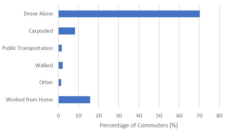
Source: United States Census Bureau 1-year ACS S0801, 2021.
TRAVEL TIME
Figure 12-B shows the average commute travel time experienced by commuters originating from Pierce County represented by percentage of commuters. Because commute trips within the county will often use both city-maintained and county-maintained facilities, this figure represents countywide trends. This figure shows that the majority of commuters have an average travel time of 30-44 minutes. The top three commute durations to work are 20-29 minutes, 30-44 minutes, and 60 minutes or more. This indicates that commutes within Pierce County are generally 20 minutes or longer. Many Pierce County commuters are travelling between counties, with many travelling north to King County or south to Thurston County for work.
12-B: Pierce County Travel Time to Work – Countywide
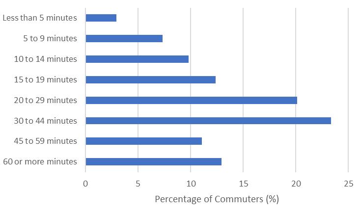
Source: United States Census Bureau 1-year ACS B08303, 2021.
People under 18 or over 64 (youth and seniors) may have different transportation needs than other age groups. Because these groups are less likely to work, most trips are for recreational purposes, school, shopping/errands, and healthcare. Seniors living in urban areas typically spend less time traveling to medical facilities than those living in rural areas. Seniors are also less likely to use transit when shopping or running errands and more likely to share rides with others. For areas with higher concentrations of senior or youth populations, potential mobility barriers may include lack of reliable transportation options such as paratransit services and lack of driver’s licenses (see Table 12-B).
Figure 12-C shows population by Census block group in unincorporated Pierce County. There are about 444,380 people living in the unincorporated areas, as shown in
Table 12-A. About 38% of the people in the unincorporated county are under 18 or over 64. This is similar to 37% from the entire county as shown in Figure 12-C
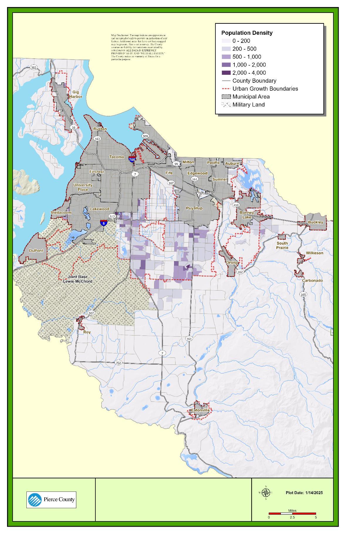
Source: United States Census Block Group, 2021
Within Pierce County, People of Color are more likely to live in a household without a vehicle and are also more likely to rely on transit. For areas with higher concentrations of minority populations, potential mobility barriers may include greater distances to travel; lack of vehicle ownership; high costs of transportation; and uneven distribution of transportation services. Additionally, People of Color are disproportionately more likely to live in a zero-car household, increasing their need for access to transit and other modes (see Table 12-B). PSRC performed a regional study to define this exact modal dynamic; a summary of zero-car households and transit usage by race for the region are provided in Figure 12-D.
Populations with People of Color account for about one-quarter of the total population in unincorporated Pierce County, as summarized in Table 12-C. Asian, Hispanic or Latinx, and Black or African American people make up the largest proportion of People of Color within the unincorporated county. These populations are concentrated in more densely developed areas of the unincorporated county and in closer proximity to incorporated cities (see Figure 12-E).
The median income for households in the study area is approximately $80,000 per year. Households with an Asian member have the highest household income in the study area. Tribal Reservation areas within the study area have a lower median income ($73,000) than the study area average.
Figure 12-D: Vehicle Ownership and Transit Usage
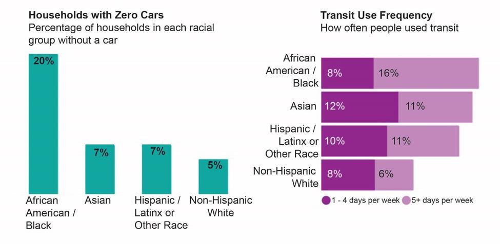
Source: Puget Sound Regional Council, 2019.
Table 12-C. People of Color within the Unincorporated Pierce County
(329,730) Black or African American a
(20,923)
American Indian and Alaska Native a
(3,636) Asian a
Native Hawaiian and Other Pacific Islander a
Some other race a
Note: a. Non-Hispanic populations.
Source: United States Census Block Group, 2021.
(21,837)
(6,974)
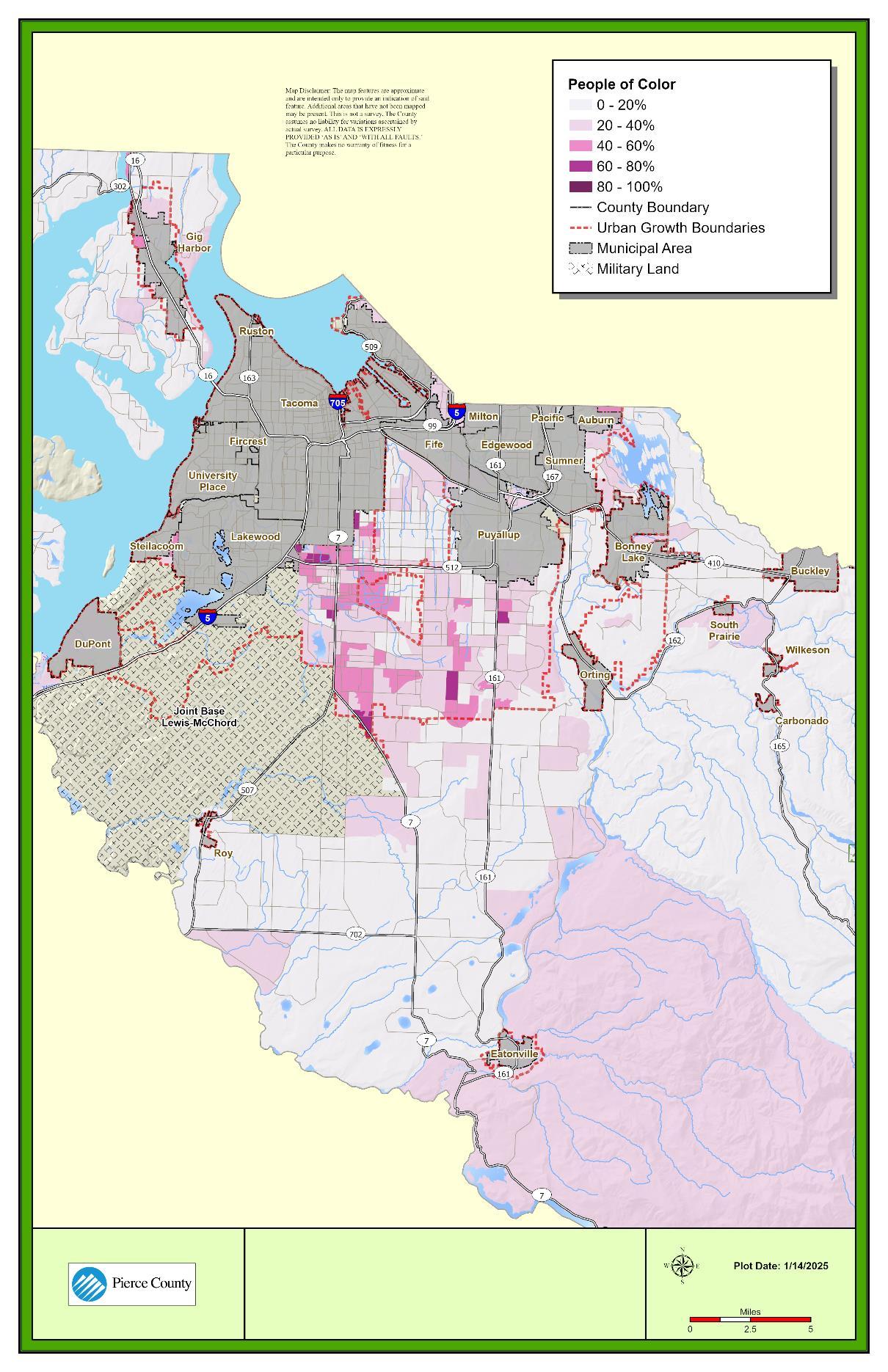
Source: United States Census Block Group, 2021.
Populations with lower incomes may have longer commute times compared to higher income populations. This may be due to living further from the workplace because of housing costs and having to use multiple modes of transportation. For areas with higher concentrations of lowincome populations, potential mobility barriers may include high costs of transportation; high cost of car ownership relative to income; greater distances to travel in locations where housing costs are high; lack of options for payment.
People living in or near poverty generally have fewer resources to meet basic needs and may struggle to find affordable housing. Given the high cost of living in the Puget Sound region, the Puget Sound Regional Council (PSRC) has identified people who are at or below 200% of the federal poverty guidelines as being “low-income”. People at or below 100% of the federal poverty guidelines are referred to as “in-poverty.”
Approximately 25% of the people in unincorporated Pierce County are considered low-income (Table 12-D). Of the people living in poverty, about 60% are minority populations (compared to the overall minority share of the unincorporated population of 43%). Figure 12-F shows the locations of low-income populations in the unincorporated county.
Table 12-D. In-Poverty and Low-Income Populations within Unincorporated Pierce County
Demographic
Note:
(35,937)
a. In-poverty includes populations living at or below 100% of the federal poverty level and Low-income includes populations living at or below 200% of the federal poverty level.
Source: United States Census Block Group, 2021.
12-F.
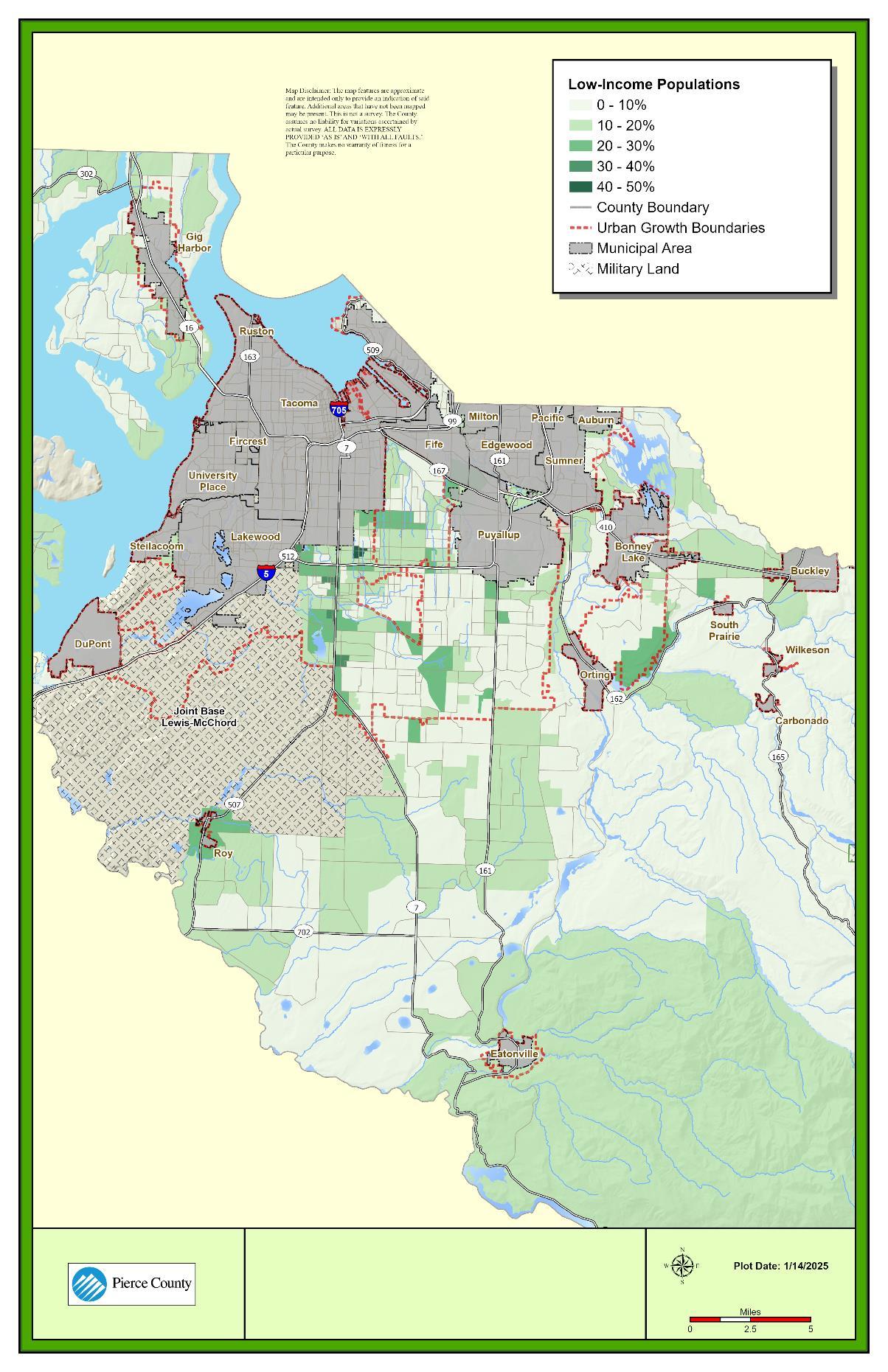
Source: United States Census Block Group, 2021.
Foreign born populations rely more on alternative modes of travel, including carpooling, public transit, walking, and bicycling, and are less likely to commute by single-occupant vehicle. For areas with higher concentrations of foreign born and Limited English Proficiency (LEP) populations, potential mobility barriers may include a lack of driver’s licenses and bank account and the absence of translated materials (see Figure 12-G).
For this demographic variable, countywide data was used rather than just unincorporated due to data availability. About 10% of the people countywide are foreign born, and approximately half of those people are naturalized U.S. citizens. Table 12-E summarizes the native- and foreign-born population that are either naturalized U.S citizen or not a U.S. citizen.
Table 12-F shows that of the limited English-speaking population countywide, the language spoken most commonly at home is Spanish. Figure 12-G shows the percentage and locations of limited English-speaking communities. As established in the previous sections, the county has a mix of demographic and travel patterns that strongly affect the demand for transportation services. The Pierce County roadway system is unique because it accommodates regional vehicle traffic traversing across and through the county and serves local residents’ travel needs to services. The jurisdiction must plan for providing services to all roadway users within the unincorporated county.
Table 12-E. Place of Birth by Nativity and Citizenship Status
Source: United States Census Bureau 1-year ACS B05002, 2021.
Table 12-F. Language Spoken at Home
Source: United States Census Bureau 1-year ACS B16004, 2021.
12-G. Limited English Proficiency Population Within Unincorporated County
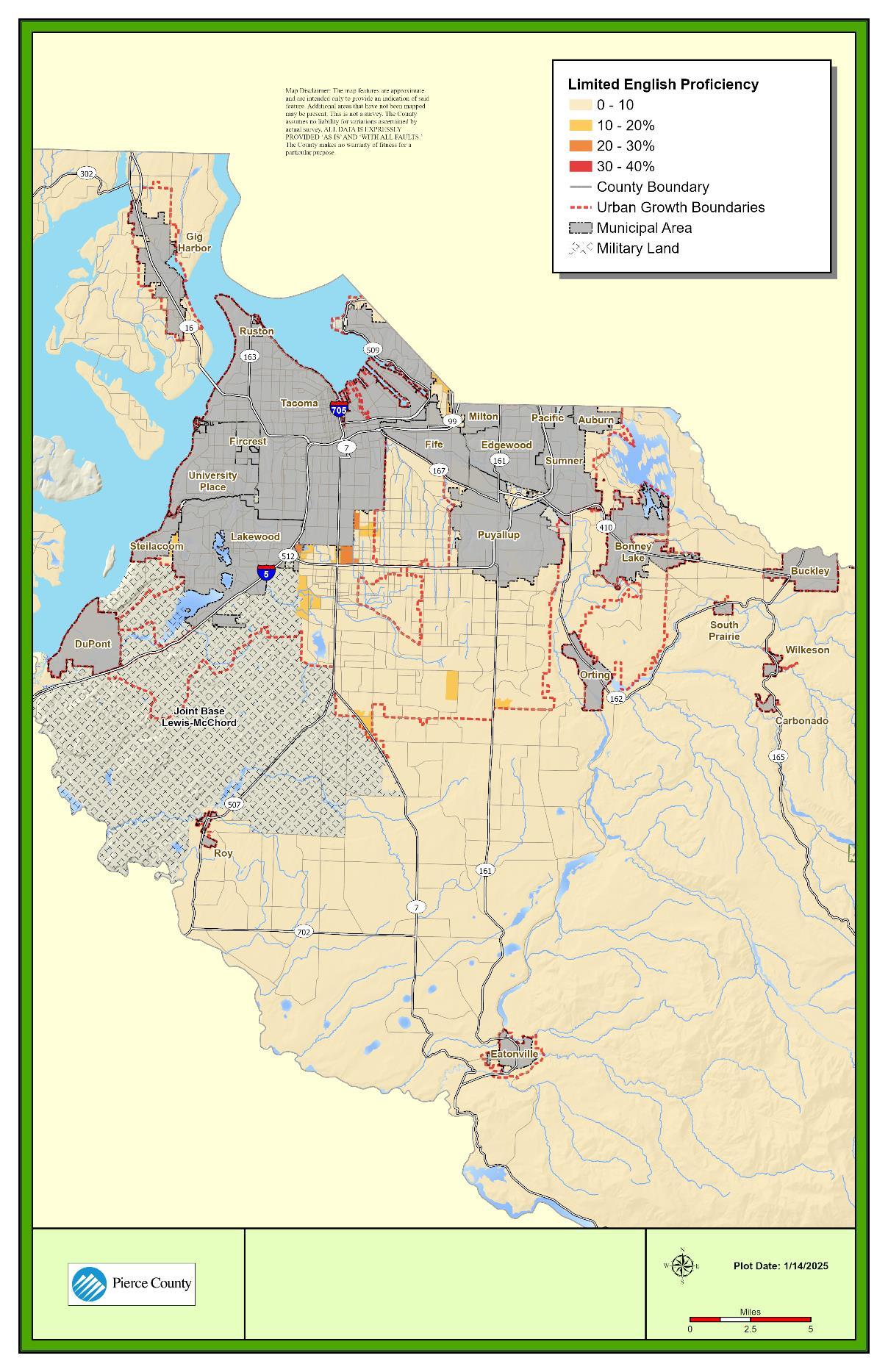
Source: United States Census Block Group, 2021.
Pierce County’s road network is primarily composed of a rural setting with local, county, state, and federally owned facilities. The Washington State Growth Management Act requires the County to inventory state- and county-owned facilities. Interstate and state freeways form the backbone of the Pierce County transportation system. Freeways provide intrastate and interstate linkages to and from Pierce County. In addition, there are a number of state routes crossing the county. The following state-owned highways are wholly or partially within Pierce County:
• Interstate 5 (I‐5) and I‐705
• SR 7, SR 16, SR 99, SR 123, SR 161, SR 162, SR 163, SR 165, SR 167, SR 302, SR 410, SR 507, SR 509, SR 512, SR 702, and SR 706
In 2024, the county-maintained arterial system consisted of approximately 710 arterial roadway miles in the unincorporated areas approximately two-thirds urban and one-third rural. Table 12-G shows a detailed breakdown (for unincorporated Pierce County) of each functional classification in both urban and rural areas. Figure 12-I shows the local functional classifications of roadways throughout unincorporated Pierce County, including the state routes serving the County. As demonstrated in the table, there are more urban roadway miles than rural roadway miles across each functional class except for primitive roads.
Note:
1. Rounded to the
Source: Pierce County, 2024
County
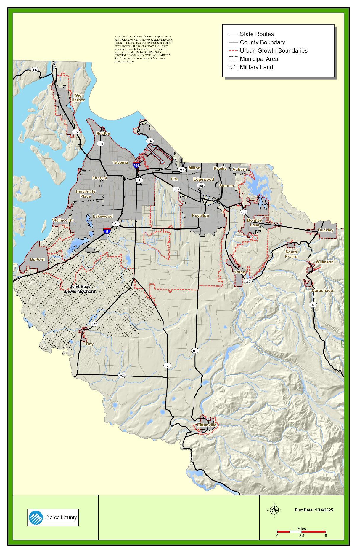
Source: Washington Department of Transportation, 2024.
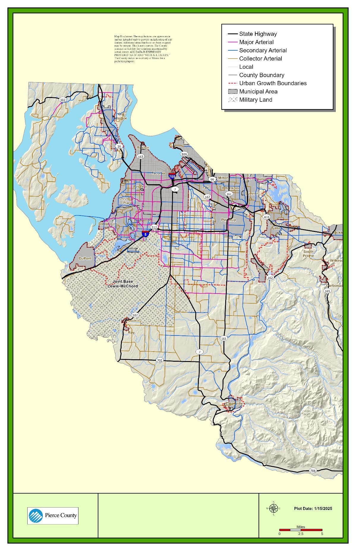
Source: Pierce County, 2024.
While Pierce County is responsible for maintaining, operating, and monitoring its own local network of roadways, Washington State Department of Transportation (WSDOT) facilities also perform a critical role in carrying traffic within and outside the county. It is important to understand the operations of both the county-maintained network and the state highway network when assessing the overall performance of the transportation system.
Pierce County’s Transportation Concurrency Management System (TCMS) addresses the Washington State Growth Management Act requirement that directs certain counties and cities to set and maintain level of service (LOS) standards for the arterial roadway system. Pierce County’s TCMS analyzes county-maintained arterials in a unit called a concurrency segment. A concurrency segment may consist of one or more roadway links, whose extents are usually defined by either intersecting arterials (existing or proposed) or jurisdictional boundaries.
Pierce County defines the service level of an arterial as the observed daily traffic volume divided by a service threshold, which produces a volume/service (V/S) ratio. It is written as:
Weighted Segment Daily V/S
The weighted average is designed to smooth data variations among individual model roadway links contained in a concurrency segment. The V/S ratios resulting from these calculations are then compared to the Pierce County Service Standard of 1.1 V/S to determine whether a particular segment is out of compliance with the standard. Details and examples of TCMS procedures and outputs are available in the latest Transportation Concurrency Management System Annual Report.
The service threshold is similar to a capacity measurement and varies depending on the number of lanes of a facility and the presence of adequate channelization (e.g., turn lanes, turn pockets). Table 12-H lists the adopted Pierce County service thresholds. The V/S letter grade breakdown is summarized in Figure 12-J. While the service threshold measures the traffic saturation level based on daily V/S ratio, the adopted allowable arterial service standard sets the thresholds at which a roadway fails concurrency. The County’s allowable arterial service standard for long-range planning is 1.1 (LOS F) for urban roadways and 1.0 (LOS E) for rural roadways
Notes:
Service threshold is defined by annualized average daily traffic.
1 Turn channelization consists of a roadway having a center two-way left-turn lane or exclusive turn pockets at key locations.
2 Three-lane thresholds pertain to uneven three-lane arterials, which have one lane in one direction and two lanes in the other. Assumes 60 percent of a two-lane capacity is in the direction with one lane (e.g., 0.6*17,600=10,560), plus 40 percent of a four-lane capacity in the direction with two lanes (e.g., 0.4*35,200=14,080). Example total = 10,560+14,080=24,640 or 24,600. If turn channelization is present, the service threshold increases to 30,800. An additional capacity service threshold of 47,400 was derived for four-lane arterials possessing access control. This capacity is applied to 176th Street E after completion of capacity improvement.
Source: Pierce County, 2024
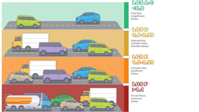
Source: Pierce County, 2024
As per WAC 365-196-430(1)(iii) regarding level of service standards for highways, the Comprehensive Plan also considers the condition of state highways. These standards as they apply to Pierce County are summarized in Figure 12-K, divided by corridor. It should be noted that WSDOT does not provide specific service capacities to measure segment-level level of service. To account for this, the methodology used in this element is based on the Florida Department of Transportation (FDOT) quality level of service (QLOS) methodology, which was developed based on Highway Capacity Manual 6th Edition methodologies. This analysis uses the maximum service volumes, as defined for different letter grades and facility types in the FDOT QLOS methodology and applies these service volumes for the relevant letter grade set by WSDOT as its level of service (LOS) standard. Any instance where the maximum service volume is exceeded (i.e., a V/S of 1.0) on a given corridor represents a failure of the letter grade for that corridor. Table 12-I shows the FDOT QLOS Capacities assumed for each facility type. WSDOT facilities assumed for each facility type are provided in the table. These capacities are summarized in more detail in Appendix B of the FDOT QLOS Handbook, with most recent publication in 2023.
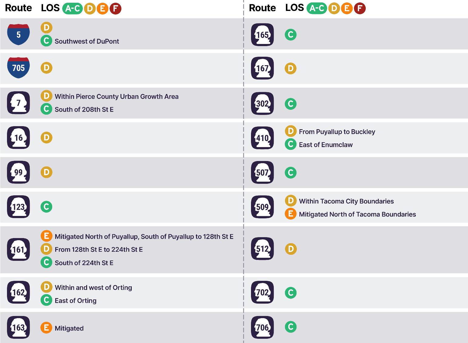
Source: Adapted from Washington Department of Transportation, 2024
Note:
1. PSRC has set a LOS E Mitigated standard for non-HSS routes. Any letter grade noted as “E Mitigated” means that congestion should be mitigated when pm peak hour level of service falls below LOS E.
2. WSDOT has a set a LOS D standard for HSS routes in urban areas and a LOS C standard for HSS routes in rural areas These corridors include SR 16, 99, 167, 509 (within Tacoma City Limits), and 512 as well as I-5 and I-705
Source: Adapted from FDOT Multimodal Quality Level of Service Handbook (2023)
Note:
1. Adjust capacities by factor of 1.05 for locations with ramp metering present.
2. Adjust capacities by: 1.05 for 2-lane segments with channelization; 0.95 for multi-lane segments with channelization; 0.75 for multi-lane segments without channelization.
3. Adjust capacities by: 1.05-1.1 for segments with left- and/or right-turn storage lanes; 0.80 for 2-lane segments with no channelization; 0.80 for multi-lane segments with no channelization (assumes that most if not all of these segments have shoulders for right-turn storage).
4. In reviewing the C2 classification, it was determined that the capacities given more fit national and state park capacities than typical rural segments in Pierce County. As such, C3R was used to represent the majority of rural segments in Pierce County
5. C3C does not give capacities for an LOS E grade. As such, SR 161 and 163 were classified as C4 in any segments with an “LOS E Mitigated” standard.
The 2018 roadway performance measurement is determined by the ratio of daily traffic counts and the assumed arterial capacity. These daily traffic counts were provided by PSRC as part of its most recent SoundCast model. In comparing these data to 2022 data obtained at spot locations, the volume was similar between 2018 and 2022 conditions. The count was calculated for every modeled County classified arterial in the unincorporated area. Figure 12-L maps 2018 daily V/S ratios on all county arterials, while Table 12-J provides a summary of vehicle miles traveled grouped by daily V/S ranges. Table 12-K shows the eight segments with daily V/S ratios of 1.1 or greater in 2018
Abbreviations: V/S = volume/service. Source: Fehr & Peers, 2024
Abbreviations: V/S = volume/service. Source: Fehr & Peers, 2024
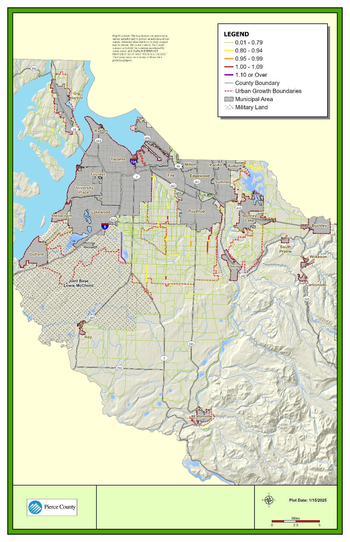
The daily V/S ratios for state facilities in 2018 were calculated using the same method as for County arterials. This analysis used state volume data from 2018, as provided by PSRC in is most recent SoundCast model. In comparing these data to 2022 data obtained at spot locations, the volume was similar between 2018 and 2022 conditions. As such, 2018 data was used to represent existing conditions. Figure 12-M maps whether the given segment meets or does not meet WSDOT V/S standards (defined previously in Figure 12-K). Table 12-L summarizes 2018 State Highway performance in terms of daily V/S ratios.
As noted previously, these V/S ratios are based on service volumes obtained from FDOT’s QLOS methodology for highways and freeways, as WSDOT does not define specific segment capacities for its corridors. Because FDOT QLOS capacities for each respective letter grade were used to define service volumes along the WSDOT corridors, any instance where V/S exceeds 1.0 represents a segment not meeting WSDOT V/S standards. A total of 14 State Highway segments are exceeding WSDOT LOS standards under existing conditions. These include:
• I‐5:
o Between 72nd Street and 54th Avenue E
o Near the SR 512 Interchange
o Between Woodbrook Road and Berkeley Avenue SW
• SR 7:
o At SR 512 interchange
o Between 224th Street E and 232nd Street E
• SR 512:
o Between SR 7 and SR 167
• SR 161 between 128th Street E and 152nd Street E
• SR 162 between SR 410 and downtown Orting
• SR 167 between North County boundary and SR 410
• SR 302 between SR 16 and 118th Avenue
• SR 410:
o Near Bonney Lake downtown
o From east Bonney Lake through Buckley to the County boundary
• SR 507:
o Near Roy downtown
o Approaching McKenna to the South County boundary
Table 12-L Summary of Daily Statistics for State/Federal Roads – Existing (2018)
Abbreviations: V/S = volume/service. Source: Fehr & Peers, 2024.
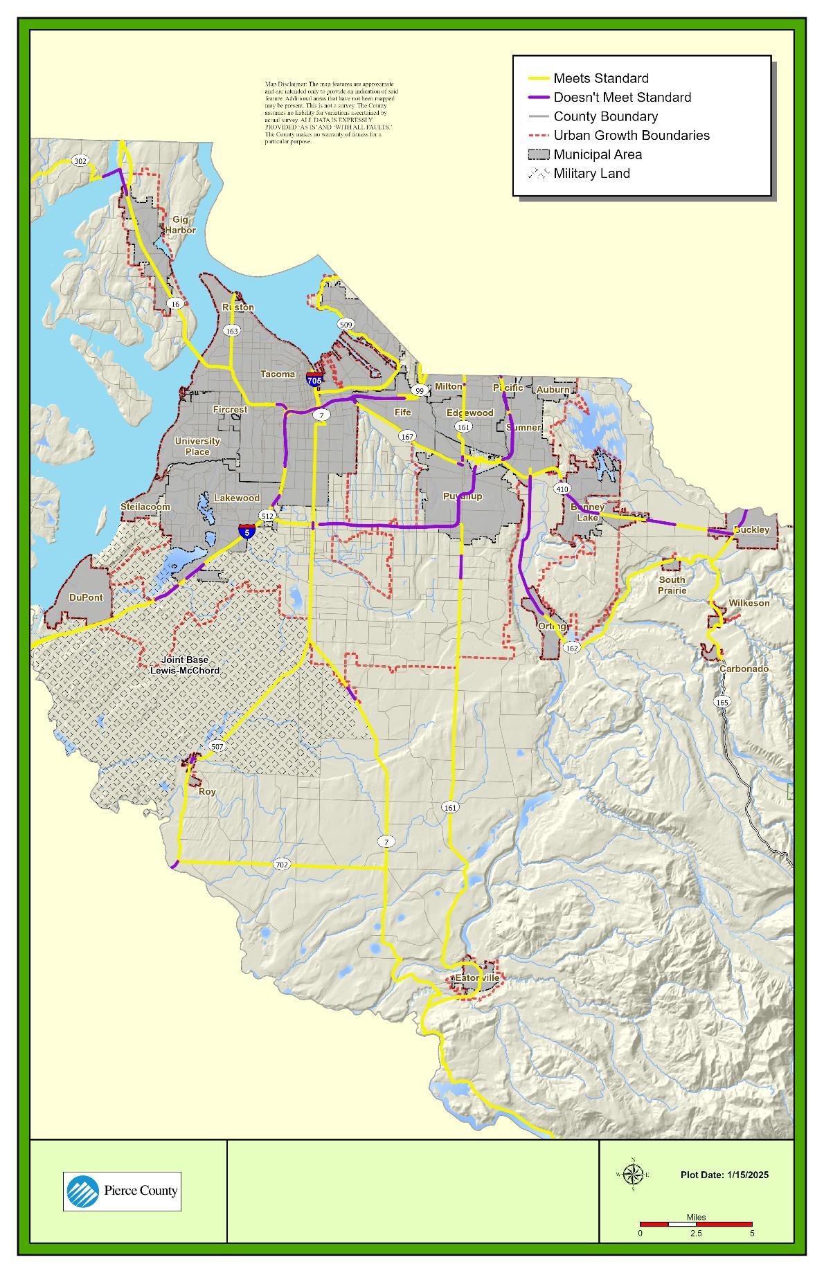
Active transportation (nonmotorized) systems include sidewalks, trails, bike lanes, and roadway shoulders to accommodate people walking, rolling, and bicycling for both transportation and recreational purposes. Paved shoulders are also considered a potential facility for bicyclists, but not for pedestrians except in rural areas. This section summarizes existing facilities and the comfort of these facilities (as described by level of traffic stress) experienced by people walking, rolling, and bicycling.
The County has identified a need for multimodal investment to connect the region’s transportation network. In line with the County’s transition towards a multimodal transportation approach, the County has developed a level of traffic stress (LTS) metric to use as a performance measure for pedestrian and bicycle facilities. These LTS metrics were developed based on extensive research and similar procedures that applied by WSDOT and other jurisdictions throughout the nation. LTS is used to assess conditions of pedestrian and bicycle facilities on County arterial segments in unincorporated Pierce County. LTS conditions on the state highway system are addressed in the Washington State Active Transportation Plan. LTS is split into four levels, visually represented in Figure 12-N for pedestrian facilities and Figure 12-O for bicycle facilities. LTS is calculated based on the following inputs:
• Type of active transportation facility
• Arterial traffic daily volume
• Posted speed limit in miles per hour
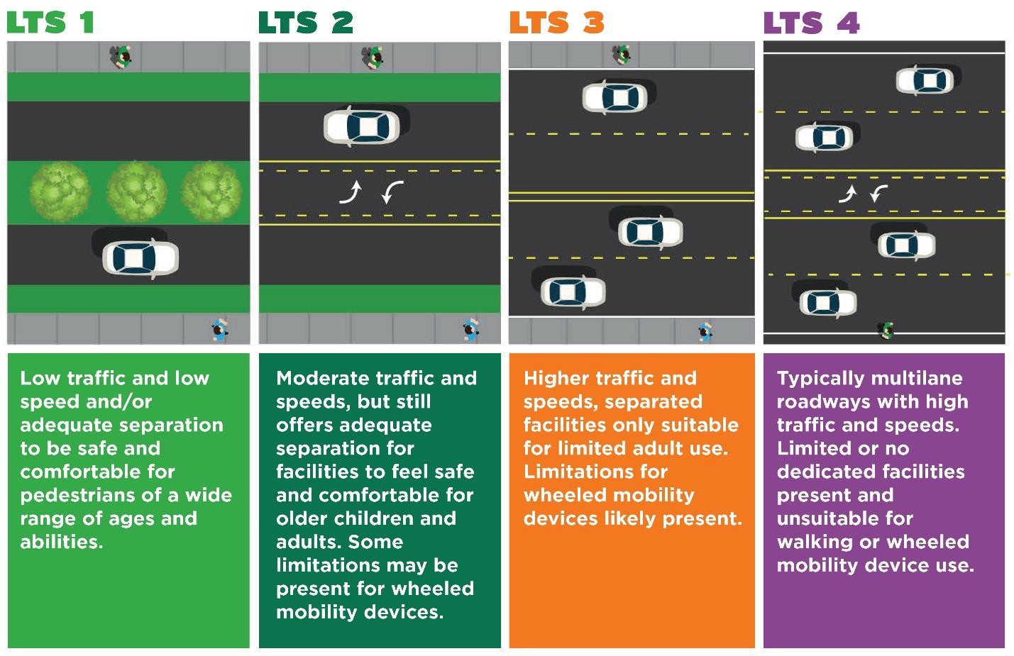
Source: Pierce County, 2024; 2020 Washington State Active Transportation Plan, Washington Department of Transportation, 2020
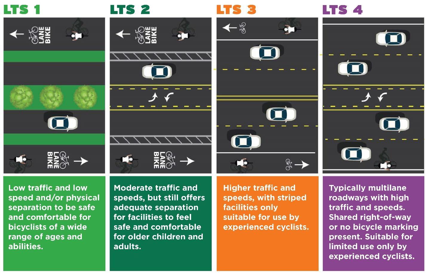
Source: Pierce County, 2024; 2020 Washington State Active Transportation Plan, Washington Department of Transportation, 2020
Pierce County inventoried county-owned sidewalks in 2021 as part of its updated Transition Plan for bringing facilities in the public Right-of-Way into compliance with the Americans with Disabilities Act (ADA) and identified approximately 240 miles of sidewalk, 40 miles of trails, and 7,019 curb ramp locations.
Figure 12-P shows trails and existing sidewalk facilities within unincorporated Pierce County.
12-P. Existing Pedestrian Facilities in Unincorporated Pierce County
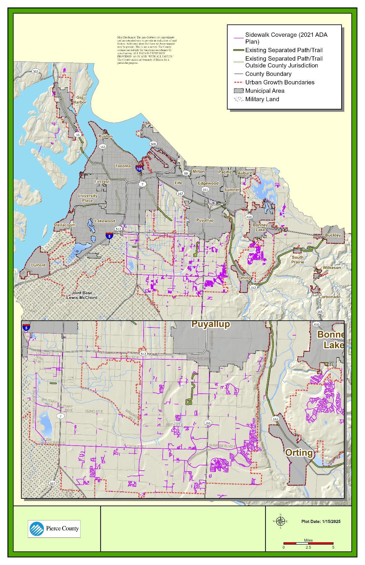
Source: Pierce County, 2024
PEDESTRIAN LEVEL OF TRAFFIC STRESS
Level of traffic stress provides an objective, quantitative assessment of roadway characteristics that affect safety, mobility, and access for transportation use. LTS is calculated on a scale of 1 (lowest level, generally suitable for people of all ages and abilities to use) to 4 (highest level, will be used only out of necessity). Roadway characteristics that are analyzed can be speed limits, existing facilities, travel lanes, and traffic volume. Level of traffic stress can be used to identify how existing infrastructure accommodates people walking, or rather, how the existing infrastructure impedes people walking. Refer back to Figure 12-N for definitions of level of traffic stress for pedestrians. Table 12-M provides proposed thresholds for pedestrian LTS as established by County staff. Considering the type of facility, traffic volume, and speed limit facilitates informed decision-making for pedestrian transportation planning.
Figure 12-Q shows pedestrian facility LTS on arterials within unincorporated Pierce County. The County recognizes that some trip-making requires walking on roads, regardless of conditions. This underscores the importance of understanding the current LTS experienced on all arterial facilities, irrespective of whether facilities currently exist. LTS trends show that most arterial segments are LTS 4 (difficult and uncomfortable for most users) for pedestrian use. Although not shown in Figure 12-Q, most local roadways are either LTS 1 or LTS 2.
Abbreviations: AADT = annualized average daily traffic; LTS = level of traffic stress; mph= miles per hour, k = 1,000.
Source: Pierce County, 2024
Note:
1. Shared use paths and regional trails can accommodate both pedestrian and bicycle travel
12-Q. Pedestrian Level of Traffic Stress (LTS) on County Arterial Network
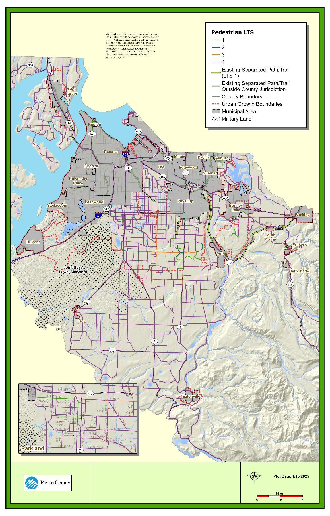
Source: Pierce County, 2024
Pierce County continues to prioritize investment in safe and comfortable bicycle facilities. Within unincorporated Pierce County, there are 18 miles of striped bicycle lanes along arterial roadways. The County also maintains approximately 123 miles of roadway with shoulders 4 feet or wider on at least one side of the road, which could feasibly serve bicyclists. The bike facilities center mainly along principal arterials, although there are a couple within residential neighborhoods, including one that connects to the Pipeline Trail. The location of these bicycle lanes is shown in Figure 12-R. The trails range in terms of surface type and grade and connect both local and regional centers. The County has also planned several regional and connector trails to further expand trail access throughout the county.
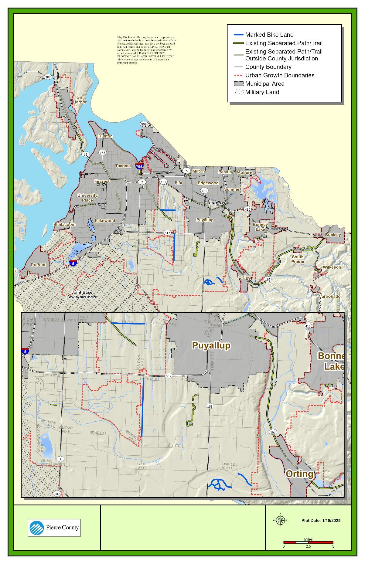
As with pedestrians, roadway characteristics that are analyzed for bicyclists can be speed limits, existing facilities, travel lanes, and traffic volume. Level of traffic stress can be used to identify how existing infrastructure accommodates people cycling, or rather, how the existing infrastructure impedes cycling. Refer back to Figure 12-O for the definitions of level of traffic stress for bicyclists. Table 12-N provides proposed thresholds for bicycle LTS as established by County staff. Considering the type of facility, traffic volume, and speed limit facilitates informed decision-making for bicycle transportation planning.
Figure 12-S shows bicycle facility LTS on arterials within unincorporated Pierce County. The County recognizes that some bike trip-making occurs along roads due to necessity, regardless of conditions. This underscores the importance of understanding the current LTS experienced on all arterial facilities, even though striped bicycle lanes only exist on a few arterials. LTS trends show that most arterial roadways are LTS 4 (difficult and uncomfortable for most users), including along some segments that have striped bike lanes. Although not shown in Figure 12-S, most local roadways are either LTS 1 or LTS 2.
Abbreviations: AADT =
Source: Pierce County, 2024
Note:
1. Paved shoulder measures at least 4 feet wide from edge line to pavement end.
2. Shared use paths and regional trails can accommodate both pedestrian and bicycle travel
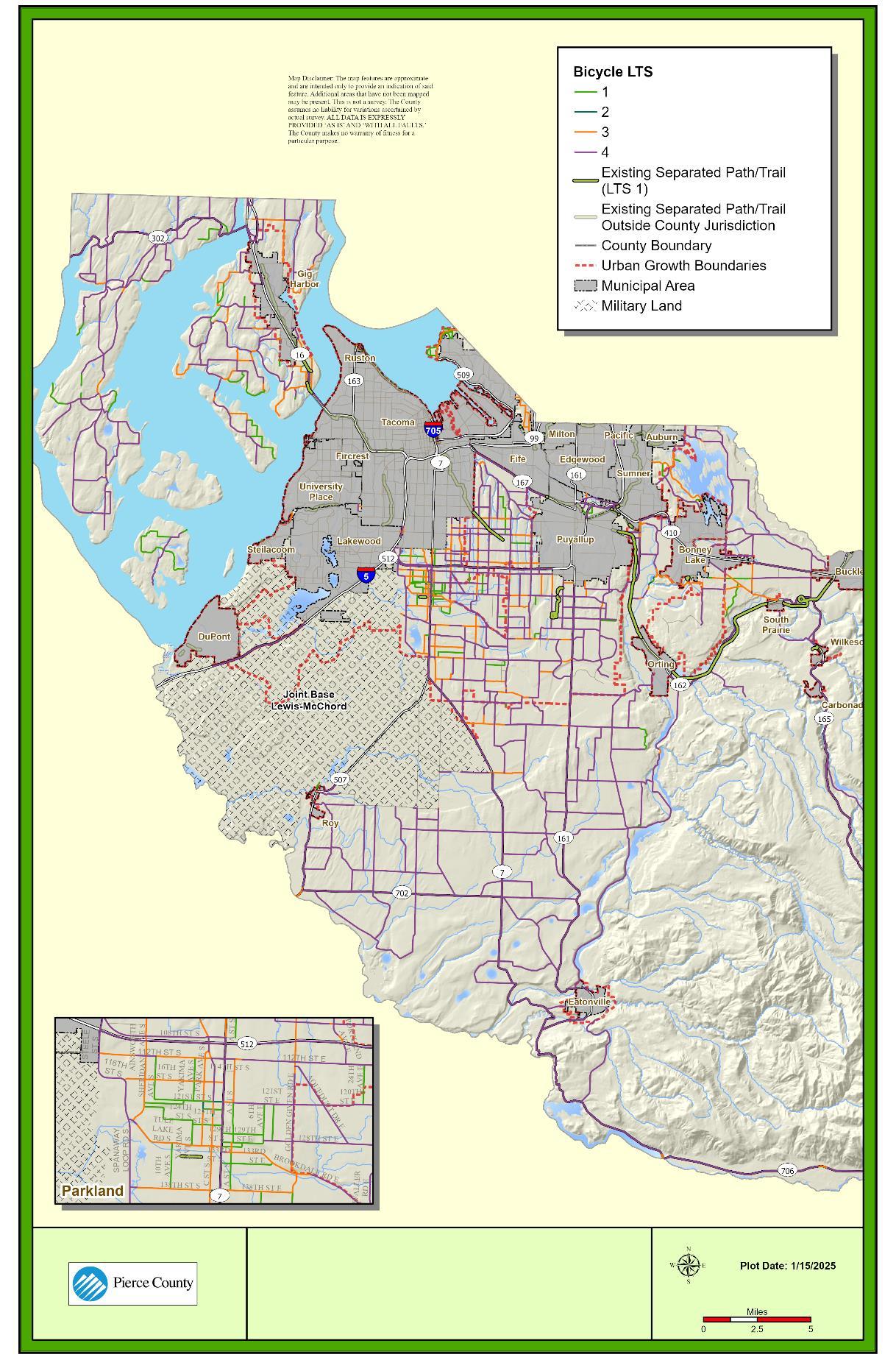
In addition to pedestrian and bicycle facilities maintained by the County, the County also maintains approximately 23.5 miles of paved regional and connector trails. The County has several regional trails that connect more rural areas of the county with more populated areas. These trails range in terms of surface type and grade and connect both local and regional centers. The County has also planned several regional and connector trails to further expand trail access throughout the county. A map of trails included in the Regional Trails Plan is shown in Figure 12-T.
12-T. Existing and Planned Trail Facilities in Unincorporated Pierce County
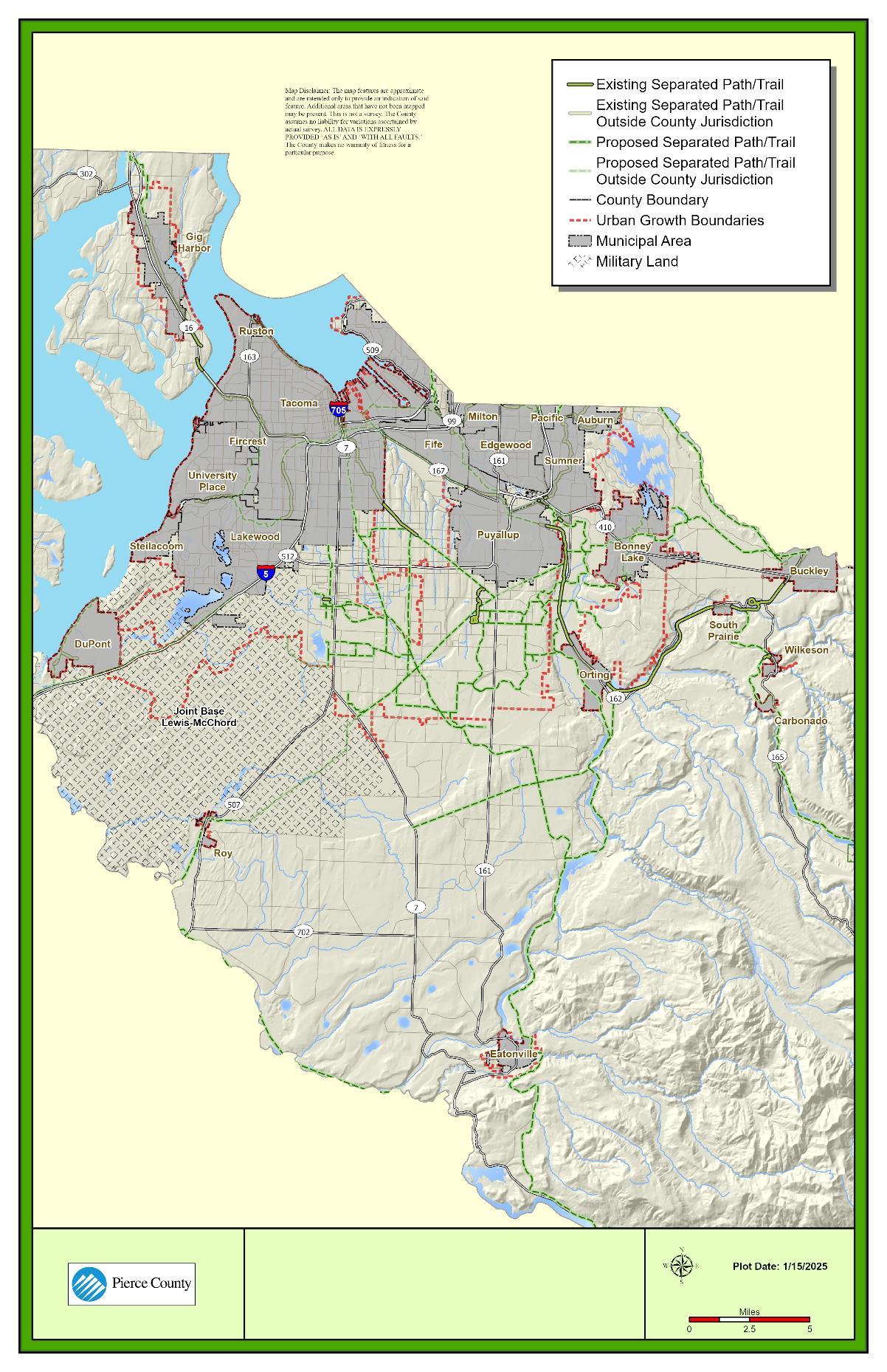
Transit service in Pierce County is provided by Pierce Transit, Intercity Transit, and Sound Transit. The services provided by each of these transit agencies is summarized in Figure 12-U. Existing transit facilities serving Pierce County are shown geospatially in Figure 12-V. This figure also shows the Pierce Transit Public Transit Benefit Area (PTBA), which represents the transit area coverage for Pierce Transit. With the continued expansion of more regional transit options provided by Sound Transit, Pierce Transit has seen a decrease in the transit area coverage to account for more regional routes. Appendix 12-A provides a detailed summary of transit facilities provided by these agencies.
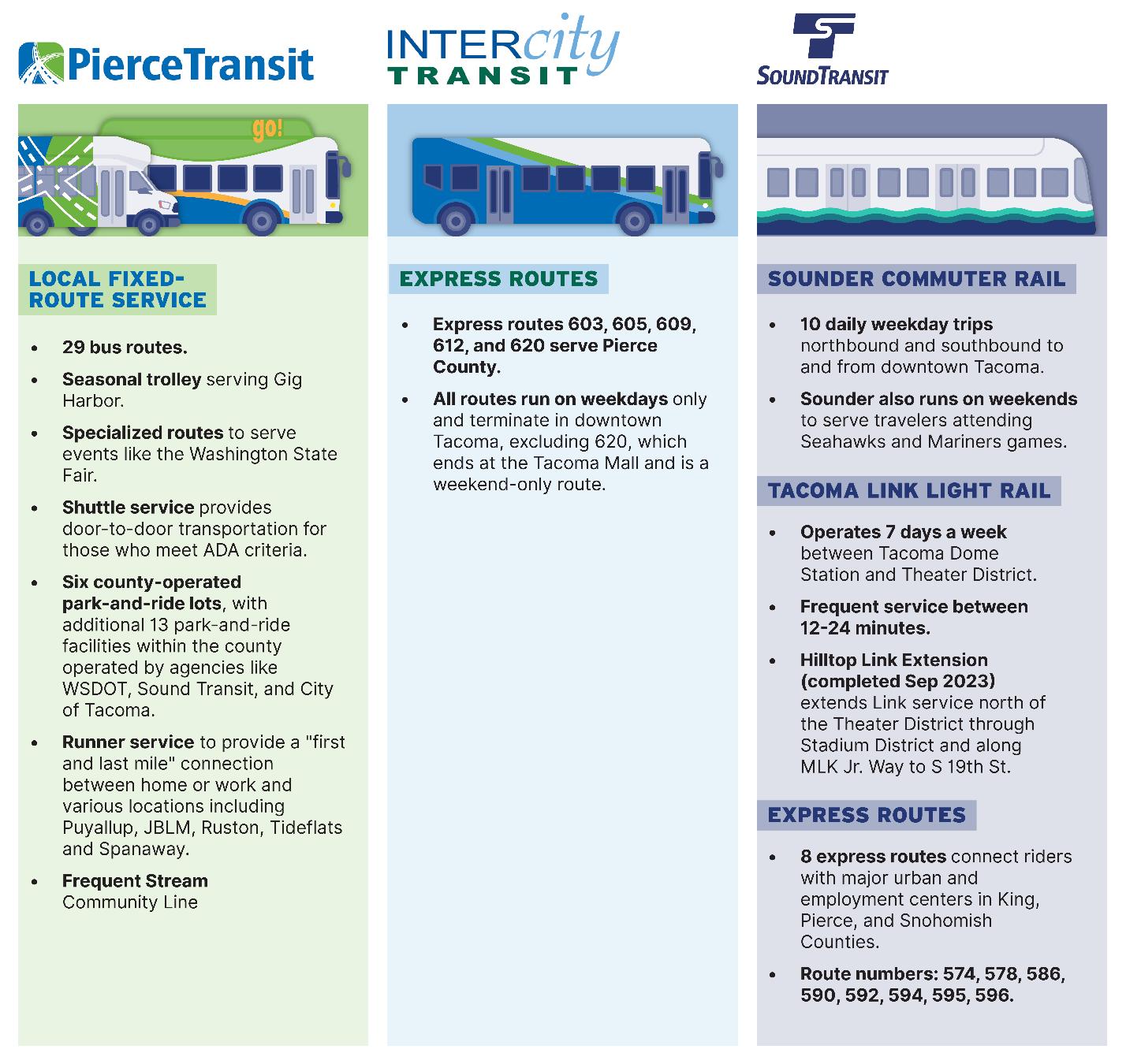
Source: Fehr & Peers, 2024
12-V. Existing Transit Facilities Serving Pierce County, Including Regional Connections
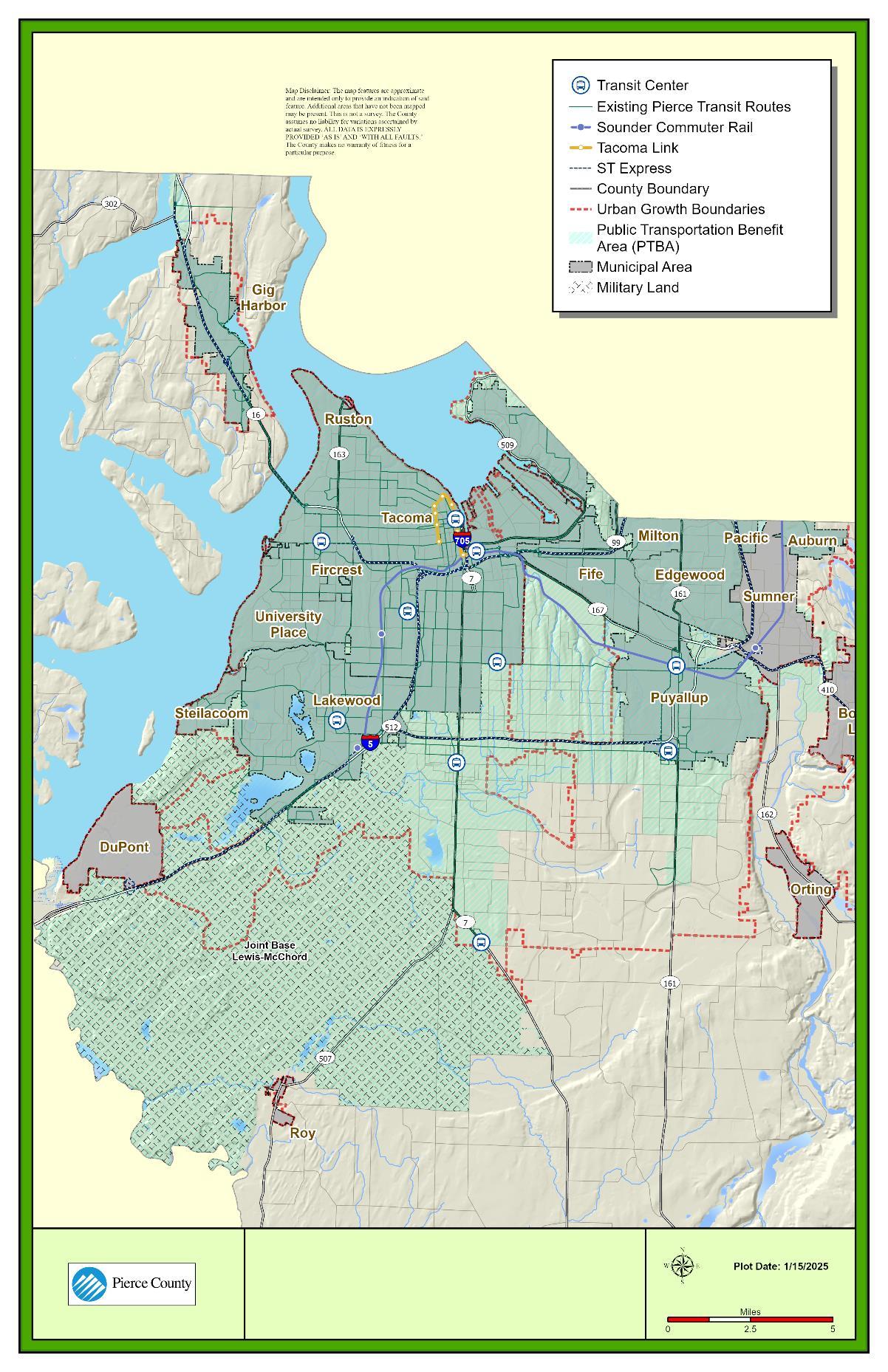
The Port of Tacoma, a key port city along the West Coast, and Joint Base Lewis-McChord are located in Pierce County. The county also features major logistical/manufacturing/industrial zones within the following cities or urban growth areas:
• City of DuPont
• City of Fife
• Frederickson (unincorporated)
• City of Sumner/City of Pacific
• City of Tacoma
The efficient movement of freight is a priority; it supports economic development and provides living wage jobs within these areas and throughout the county. Goods and services can be moved using rail systems, trucking, and shipping. Figure 12-W shows the WSDOT roadway freight corridor classifications for major roadways in Pierce County. Freight corridor classifications are based on annual gross truck tonnage, as follows:
• T‐1 – More than 10 million tons per year
• T‐2 – 4 million to 10 million tons per year
• T‐3 – 300,000 to 4 million tons per year
• T‐4 – 100,000 to 300,000 tons per year
I-5, SR 16, SR 512, and Canyon Road are considered T-1 facilities within the county. In addition to these freight corridors, Pierce County features one Strategic Rail Corridor connecting Pierce County industrial areas to regional industrial centers north and south of the county.
Figure 12-W. WSDOT Roadway Freight Corridor Classifications in Unincorporated Pierce County
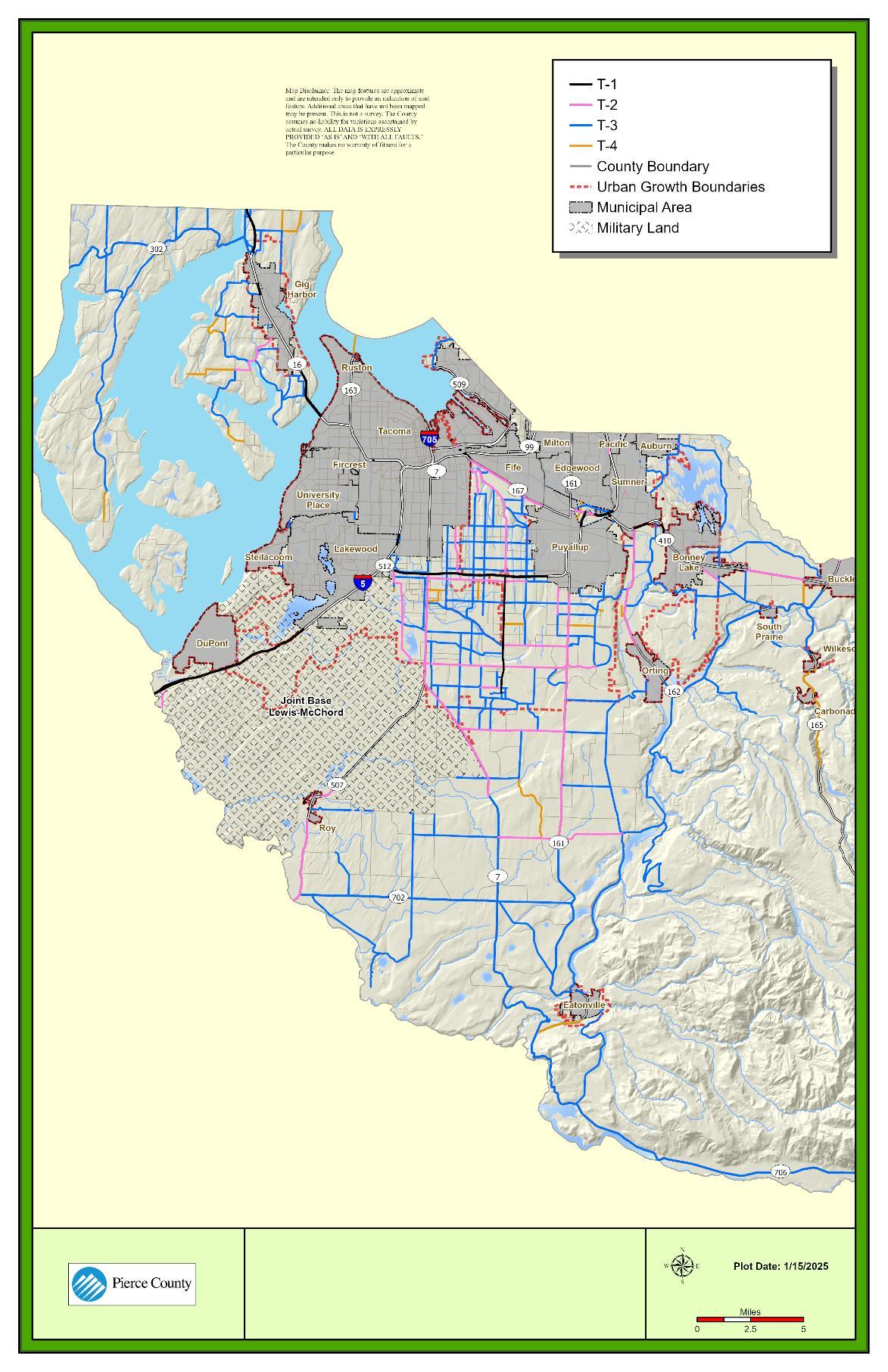
Source: Washington Department of Transportation, 2024.
Pierce County is served by Seattle-Tacoma International Airport in south King County, two military base airports, and several smaller public and private airports.
The largest airports located in the county are the military air facilities on Joint Base Lewis McChord – McChord Field and Gray Field. General aviation is served by the County-owned Tacoma Narrows Airport and Thun Field, as well as several small private airports.
The two County-owned airports provide general and corporate aviation access to the east of Pierce County and west of Puget Sound near Gig Harbor. Airports remain open 24 hours a day, 365 days a year, and are available for day-to-day service and emergency response/search and rescue support as needed. Table 12-O summarizes current facility inventory for Narrows Airport and Thun Field. These air facilities are also shown in Figure 12-X.
Table 12-O: Airports – Current Facility Inventory
Notes:
1 Anchor points for non-hangared smaller aircraft.
2 Number of flights.
Source: Pierce County, 2024.
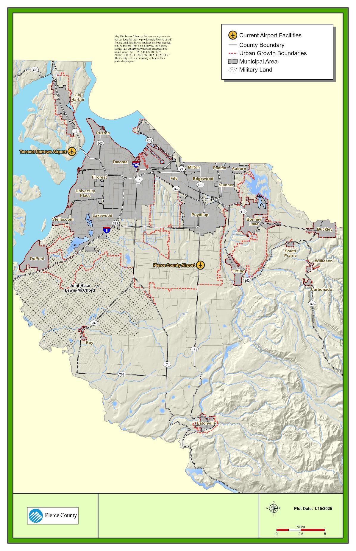
Pierce County is served by two ferry routes, one operated by the County and the other by WSDOT. The WSDOT ferry route is between Point Defiance in Tacoma and Vashon Island. The Pierce County ferry route connects Anderson and Ketron Island to the mainland in the town of Steilacoom. Both routes accommodate motor vehicles and passengers. Frequency of ferry departures between Steilacoom and Anderson Island is approximately hourly during the offpeak season and every half hour during the mid-day and evening peak periods. Ketron Island has three daily round trips between Anderson Island and Steilacoom respectively, one each in the morning, mid-day, and evening.
The overriding performance goals are to provide a 90-plus percent on-time ferry service during scheduled ferry runs and to be prepared to provide emergency service whenever requested. The Pierce County ferry system includes two ferry vessels, two ferry terminals, and three ferry docks. An inventory of the current ferry facilities serving Pierce County is provided in Table 12-P. The capacity of each could be increased using the second vessel with no impact to facilities. These ferry facilities are also shown in Figure 12-Y
Table 12-P. Ferries – Current Facility Inventory
Facility
Steilacoom ferry terminal/landing
Anderson Island ferry terminal/landing
Ketron Island ferry terminal/landing
Current Capacity1
One landing per hour
One landing per hour
Four landings per day, by request
Note: 1 Capacity could be increased using the second vessel with no impact on facilities.
Source: Pierce County, 2024.

WSDOT maintains a collision database containing historic police-reported collisions, including data on severity, contributing circumstance, collision type, and vehicles/modes involved. Figure 12-Z shows general collision trends from 2017 to 2021 for unincorporated Pierce County, including both total collision trends and fatal or serious injury (KSI) collision trends. Overall, collision trends ticked back up in 2021, likely following increased travel following the travel disruptions associated with the COVID-19 pandemic. However, it is worth noting that the incidence of serious and fatal collisions increased substantially. The number of KSI collisions has trended upward since 2018, with the highest number of KSI collisions occurring in 2021. This increase in total and KSI collisions in 2021 is consistent with statewide trends Figure 12-AA shows KSI collision density and locations of traffic fatalities throughout unincorporated Pierce County. The highest density of KSI collisions occur in central unincorporated Pierce County, centered around SR 512. This includes SR 7 within the Parkland/South Tacoma area, Canyon Road in Waller as well as just south of SR 512, and SR 161 in South Hill area. These high-KSI collision density areas largely correspond with areas of higher congestion.
Figure 12-BB shows collisions by severity for all modes, pedestrians and bicyclists separately. Of all collisions, 27% resulted in possible or minor injury, 4% resulted in a fatality or serious injury, and 149 collisions resulted in fatality. Of pedestrian collisions, 58% resulted in possible or minor injury, 35% resulted in a fatality or serious injury, and 27 collisions resulted in fatalities. Of bicycle collisions, 75% resulted in possible or minor injury, 10% resulted in a fatality or serious injury, and 2 collisions resulted in fatalities. The data underscores the importance of protecting vulnerable users such as pedestrians and bicyclists on the roadway network, as collisions involving these users are more likely to result in injury.
Figure 12-Z. Collision Trends by Year, 2017–2021 (Pierce County Maintained Arterials Only)
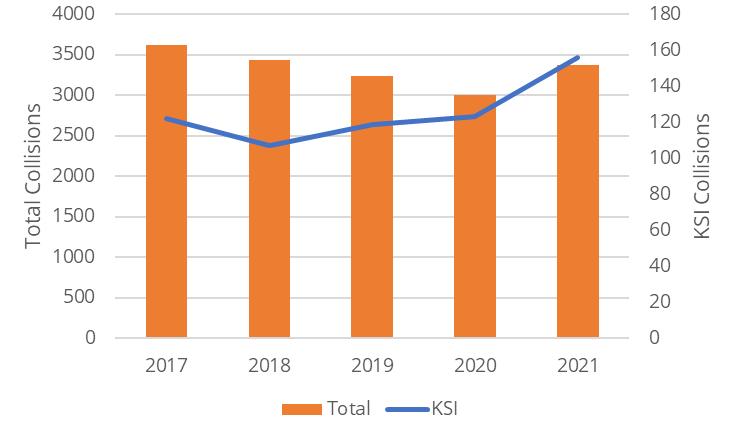
Abbreviation: KSI = fatal or serious injury
Source: WSDOT Collision Database, 2017-2021
Figure 12-AA. Unincorporated Pierce County Fatal or Serious Injury Collisions Heat Map, with Fatalities Overlayed (Pierce County Maintained Arterials Only)
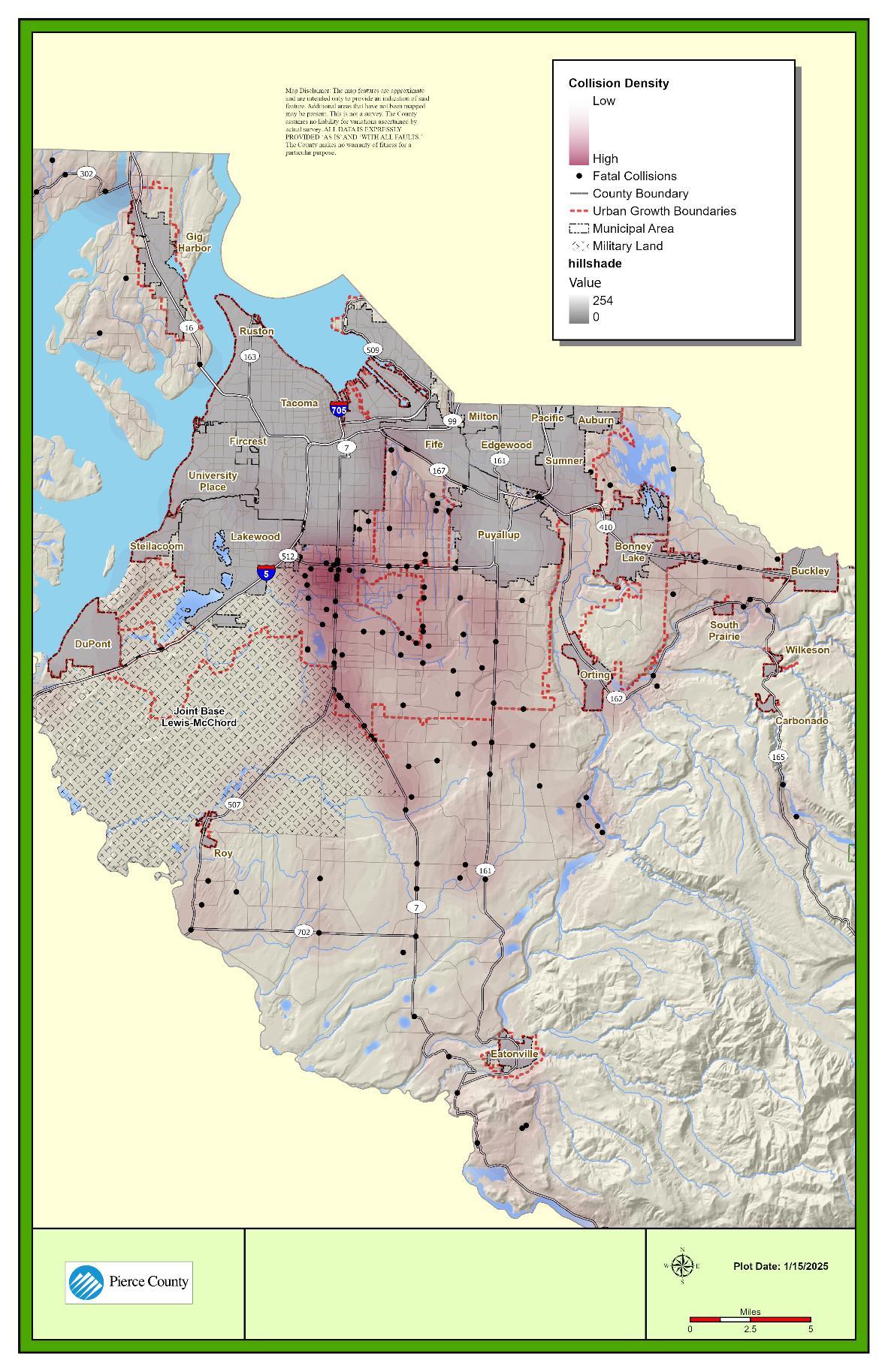
Source: WSDOT Collision Database, 2017-2021
Figure 12-BB. Collisions by Severity and Mode within Unincorporated Pierce County
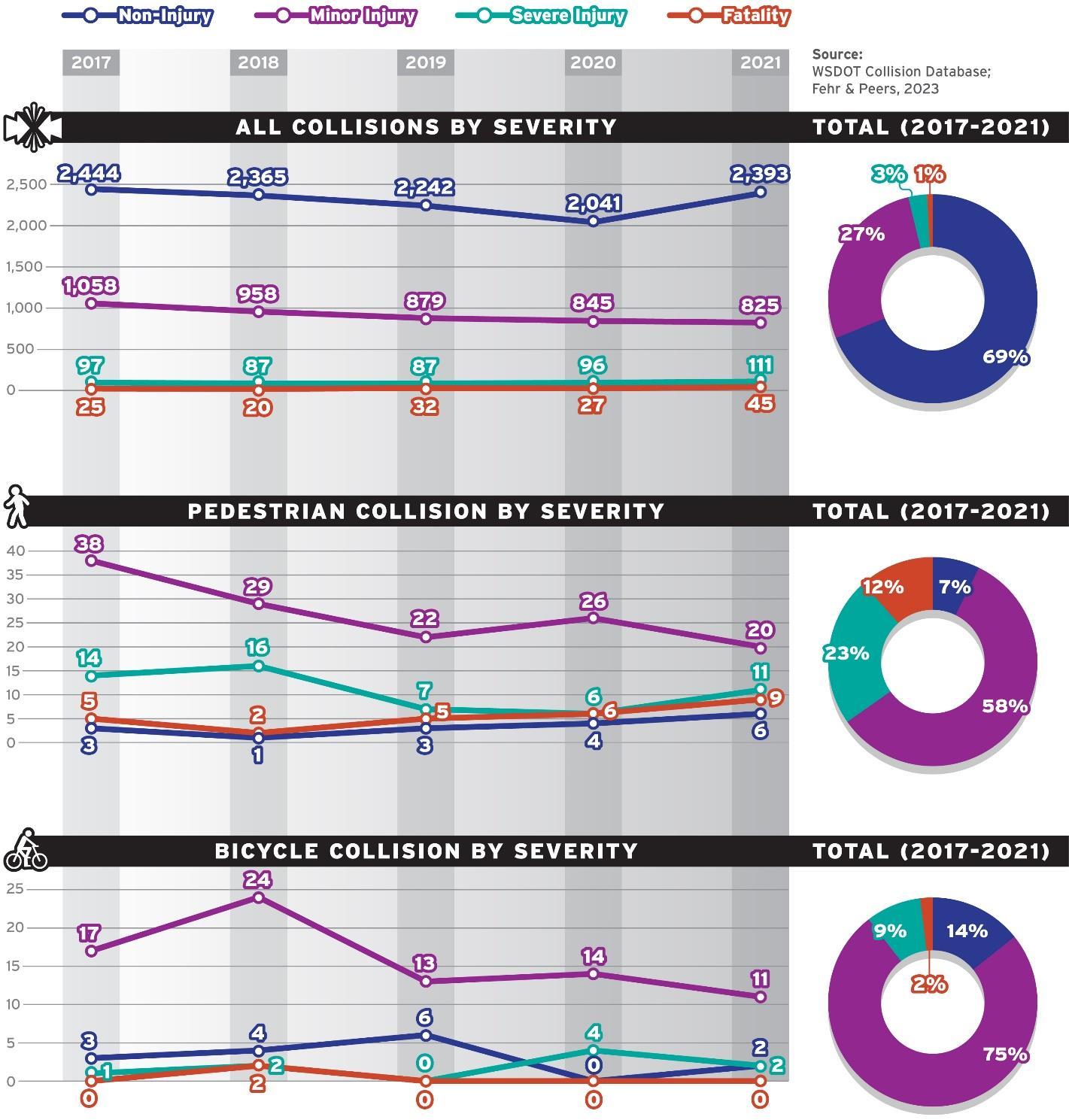
Source: WSDOT Collision Database, 2024
To plan for all modes of transportation, the County is approaching the implementation of MMLOS standards based upon a layered network approach. This approach considers all modes together, understanding how they interrelate, and what key corridors and connections need investment to ensure mobility among the different modal networks. Developing priority networks for each mode that complements County land use priorities facilitates the development of a project list that works toward a fully integrated system. The layered network approach is illustrated in Figure 12-CC
Figure 12-CC. Pierce County’s Layered Network
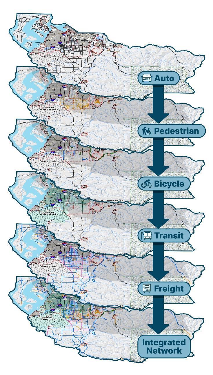
Source: Fehr & Peers, 2024.
The County has limited funding for transportation investments, and it would take years to address all of today’s known transportation needs with the funding currently available. Because of this, the County must prioritize its investments in transportation infrastructure. The County adopted the layered network approach to create a well-connected multimodal transportation system that defines pedestrian, bicycle, and trails needs within priority networks that can operate alongside the arterial roadway network the County has already adopted. The pedestrian and bicycle priority networks are the foundation for evaluating the pedestrian and bicycle level of service (LOS) and identifying high, medium, and lower priority investments.
The pedestrian priority network identifies areas within Pierce County where investment in pedestrian facilities would best enable multimodal access, both locally and regionally, by walking or rolling. This network is representative of the pedestrian LOS standards listed below and would not represent a capital or concurrency requirement of Pierce County. The following assumptions were used to identify the pedestrian priority network (see Figure 12-DD).
• Separated Shared Use Paths/Regional Trails: These existing and proposed facilities provide the highest‐quality, lowest‐stress (LTS 1) routes for people walking and rolling due to separation from vehicle traffic. These trail connections are a central piece of the pedestrian priority network.
• Parallel Facilities to High Congestion Corridors: Within UGA boundaries, the County would seek to provide low‐stress (LTS 2) conditions on identified facilities that run parallel to high congestion corridors. No facilities outside UGA boundaries would be considered priority segments.
• Major/Secondary Arterials within UGA: Within UGA boundaries, the County would seek to provide no more than moderate stress (LTS 3) conditions for people walking along major/secondary arterials within a 0.5‐mile buffer of high congestion corridors or along an identified facility running parallel to these corridors.
• Collector Arterials within UGA: Within UGA boundaries, the County would also seek to provide no more than moderate stress (LTS 3) conditions on select collector arterials within a 0.5‐mile buffer of high congestion corridors, identified parallel facilities, and/or planned frequent transit facilities (15‐minute frequency).
• The pedestrian LTS policies and priority network for the state highway system is addressed in the Washington State Active Transportation Plan.
12-DD. Pedestrian Priority Network
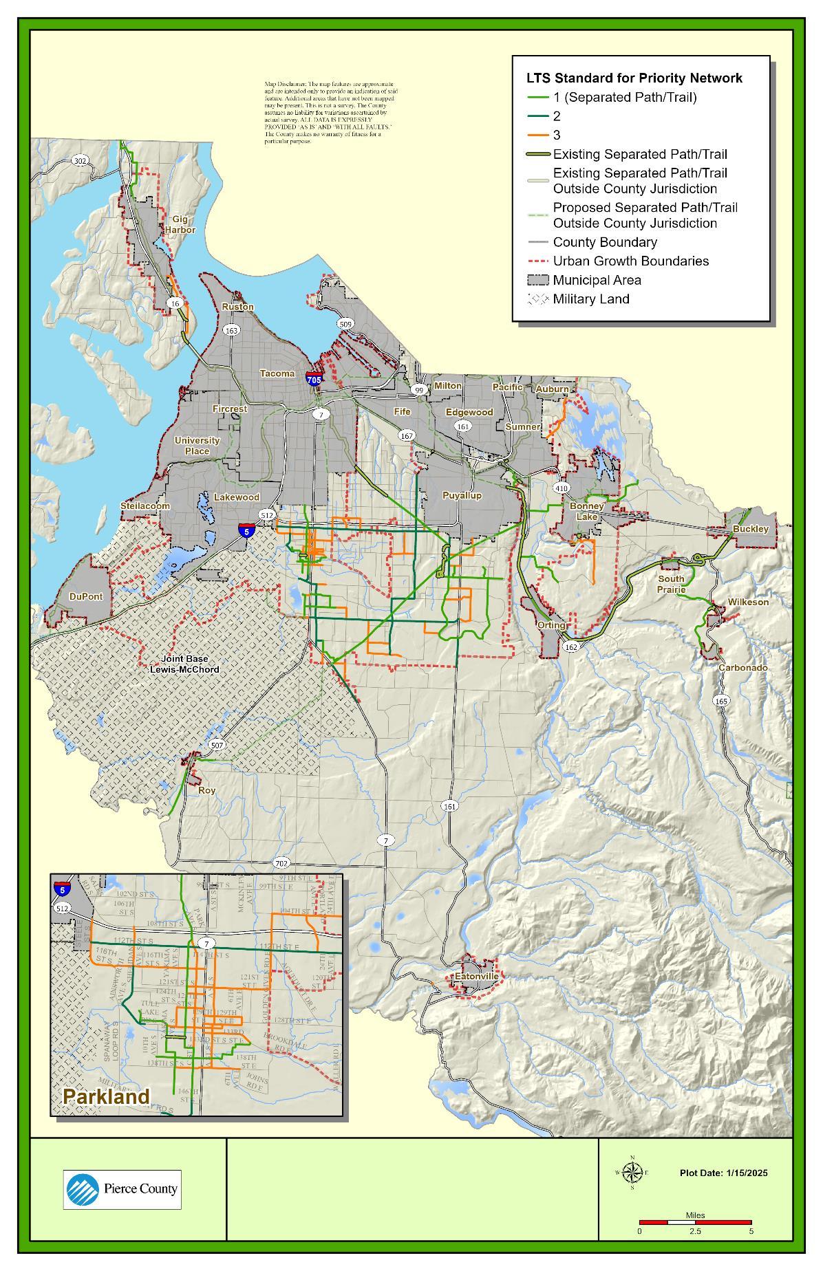
Source: Pierce County, 2024
The bicycle priority network identifies areas within Pierce County where investment in bicycle facilities would enable better multimodal access, both locally and regionally. This network is representative of the bicycle LOS standards listed below and would not represent a capital or concurrency requirement of Pierce County. The following assumptions were used to identify the facility types in the bicycle priority network (see Figure 12-EE).
• Separated Shared Use Paths/Regional Trails: These existing and proposed facilities provide the highest‐quality, lowest‐stress (LTS 1) routes for bicyclists due to separation from vehicle traffic. These trails would provide regional bicycle connections between centers of local importance.
• Parallel Facilities to High Congestion Corridors: These should be included, with exact LTS guideline identified based on whether or not the given segment is within the UGA:
o Within the UGA, the County will strive to provide low‐stress (LTS 1) conditions on identified facilities that run parallel to high congestion corridors. In areas where a parallel facility is not feasible, the County will work to provide low‐stress (LTS 1) conditions on high congestion corridors. Where possible, trails should serve as the parallel facilities.
o Outside the UGA, the County will strive to provide no more than moderate stress (LTS 3) conditions on designated county‐controlled roads.
• Major/Secondary Arterials:
o Within the UGA, the County will strive to provide low‐stress (LTS 2) conditions on select major/secondary arterials that facilitate long‐distance connection between trails, local centers of importance, or parallel facilities to high congestion corridors.
o Outside the UGA, the County will strive to provide no more than moderate stress (LTS 3) conditions on select major/secondary arterials that facilitate long‐distance connection between trails, local centers of importance, or parallel facilities to high congestion corridors.
o The bicycle LTS policies and priority network for the state highway system is addressed in the Washington State Active Transportation Plan.
Figure 12-EE. Bicycle Priority Network
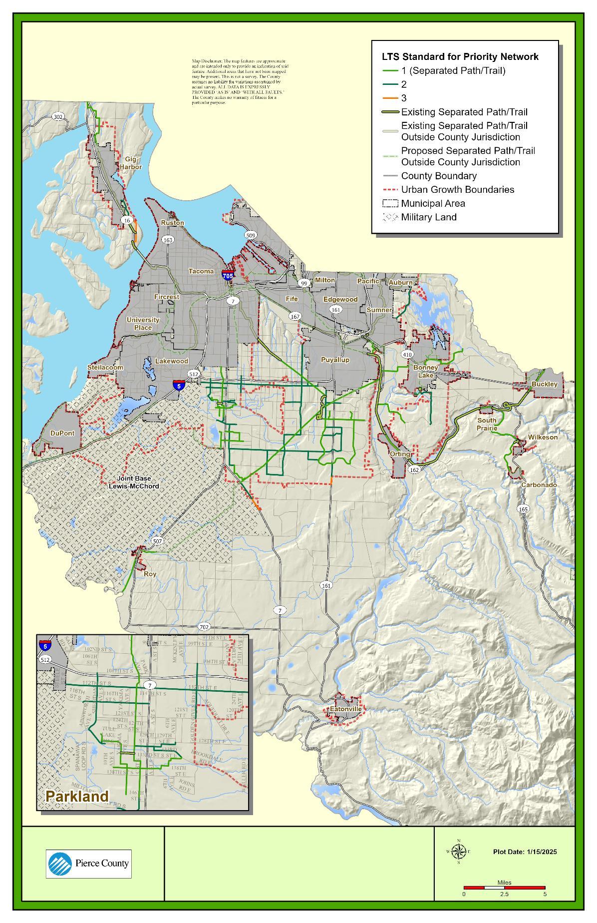
The priority regional trail network is a key part of identifying and prioritizing regional connections for people walking and biking. Trails are by definition low-stress facilities, as they are generally physically separated from vehicle facilities. As such, they are a key investment in facilitating the mobility and comfort of people walking and biking. The County has defined a priority trails network including trails that meet the following criteria:
• Regional in nature, facilitating access to other regional centers of importance.
• Identified as near‐ or mid‐term priorities for County investment, per the Parks PROS plan.
• Connections between centers of local importance, city centers of local importance, or manufacturing and industrial centers within the County.
The priority regional trail network is integrated as a supplement to the pedestrian and bicycle priority networks previously presented in Figure 12-DD and Figure 12-EE.
The Preferred Alternative (2044) transit network is consistent with the PSRC Vision 2050 network which includes Pierce Transit BRT Corridor A. Pierce County supports implementation of the full Pierce Transit Destination 2040 planned network buildout, shown in Figure 12-FF. Consistent with Goal 19, the County will adopt transit supportive policies, including prioritizing investment in bus stops and shelters along the planned frequent transit corridors. These corridors are as follows:
• Stream Community Line: This route, runs parallel to PT Route 1, providing high frequency transit service between Tacoma Dome Station and Spanaway Transit Center.
• Bus Rapid Transit (BRT) Corridor A (Downtown Tacoma to Lakewood): This would replace Pierce Transit Route 2, providing high‐frequency transit service between downtown Tacoma and Lakewood.
• The frequent transit corridors described in Figure 12-FF (Stream Community Line and BRT line A) will improve frequency and access to transit along major corridors under all alternatives, including providing opportunity for Pierce Transit to consider additional feeder routes and/or on‐demand transit opportunities that can supplement these corridors.
12-FF Future Transit Facilities

The County used the following data sources to project conditions in the year 2044:
• PierceCast Travel Model, which is based on PSRC’s SoundCast regional model, is composed of 3,593 traffic analysis zones (TAZs) and 18 external zones. For a detailed discussion of the methodology and assumptions of the travel demand model, see the Draft Environmental Impact Statement. Pierce County prepared traffic volume forecasts for each of the three alternatives based on the different land use projections.
• Pierce County Mobility Dataset (GIS‐Mo), a GIS dataset maintained by the County that includes information on roadway infrastructure, pedestrian, and bicycle facilities. This GIS dataset was updated to reflect 2044 conditions based on currently planned projects in the Capital Facilities Plan and then assessed for updated performance, based on the LOS standards under each alternative.
The PierceCast Travel Model was applied to understand growth under various land use alternatives. The PierceCast model includes population, housing, and employment data from 2018, derived from the US census, Pierce County local data, and the Washington State Employment Security Department (ESD). This land use data was determined to be the best available basis for the growth forecasts, as limited land use growth occurred in unincorporated Pierce County between 2018 and 2023. The County prepared population and employment forecasts for the Preferred Alternative 2044.
Vehicular facilities were assessed by modeling conditions in the year 2044 to include growth allocations as well as funded projects currently under construction.
VEHICLE FACILITIES
No rural segments are projected to operate below LOS E, so this discussion focuses on urban arterials. Table 12-Q shows the County arterial segments with daily V/S ratios of 1.1 (LOS F) or greater in the future, meaning those segments exceed the County’s adopted standard.
Figure 12-GG visualizes Preferred Alternative (2044) County roads performance segments. Table 12-R provides a summary of vehicle miles traveled grouped by daily V/S ranges. In the Preferred Alternative (2044), approximately 3.1 percent of vehicle miles traveled on County arterial roadways occur along arterials that exceed a 1.0 V/S.
Table 12-Q County Segments with Daily V/S Greater than or Equal to 1.1 in Preferred Alternative (2044)
Loop Rd S Tule Lake Rd S to 176th St S (CrossBase Hwy)
Abbreviations: V/S = volume/service. Source: Fehr & Peers, 2024.
Table 12-R Summary of Daily Statistics for County Arterial Roads – Preferred Alternative (2044)
Abbreviations: V/S = volume/service. Source: Fehr & Peers, 2024.
Figure 12-GG County Roads: Preferred Alternative (2044) Daily V/S Ratios Assuming Expected and Committed Projects
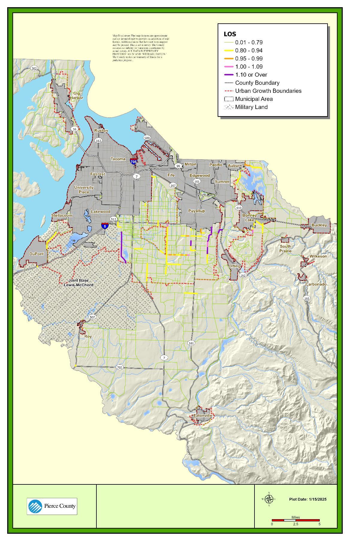
Source: Pierce County, 2024
State highway performance for the Preferred Alternative (2044) was analyzed using volume to maximum service volume comparison, similar to the County methodology. As noted previously, WSDOT maintains its own standards along its roadways (see Figure 12-K). WSDOT does not define specific segment capacities for its corridors, and as such service volumes were obtained from FDOT’s QLOS methodology for highways and freeways.
Table 12-S provides a summary of vehicle miles traveled grouped by daily V/S ranges under the Preferred Alternative (2044) Figure 12-HH visualizes the Preferred Alternative (2044) performance of state routes, focusing on defining where segments meet or do not meet WSDOT standards. Approximately 19 percent of vehicle miles traveled on state facilities occur on segments that exceed a V/S of 1.0. Because FDOT QLOS capacities for each respective letter grade were used to define service volumes along the WSDOT corridors, any instance where V/S exceeds 1.0 represents a segment not meeting WSDOT V/S standards. Performance on state facilities under the Preferred Alternative (2044) show a total of 16 state route segments are expected to exceed WSDOT LOS standards, representing a significant impact on state facilities. These include:
• I-5:
o Between 72nd Street and 54th Avenue E
o Between SR 167 Extension and North County boundary
o Near the SR 512 Interchange
o Between Woodbrook Road and Berkeley Avenue SW
• SR 7:
o At SR 512 interchange
o Between 224th Street E and 232nd Street E
• SR 512:
o Between SR 7 and SR 167
• SR 161:
o Between 128th Street E and 152nd Street E
o Between Valley Avenue NE and River Road
• SR 162:
o Between SR 410 and downtown Orting
• SR 167 (Extension):
o Between SR 161 and I‐5
• SR 302:
o Between SR 16 and 118th Avenue
• SR 410:
o Near Bonney Lake downtown
o From east Bonney Lake through Buckley to the County boundary
• SR 507:
o Near Roy downtown
o Approaching McKenna to the South County boundary
Table 12-S: Summary of Daily Statistics for State/Federal Roads –Preferred Alternative (2044)
Abbreviations: V/S = volume/service. Source: Fehr & Peers, 2024.
Figure 12-HH: State Facilities: Preferred Alternative (2044) Daily V/S Ratios Assuming Expected and Committed Projects
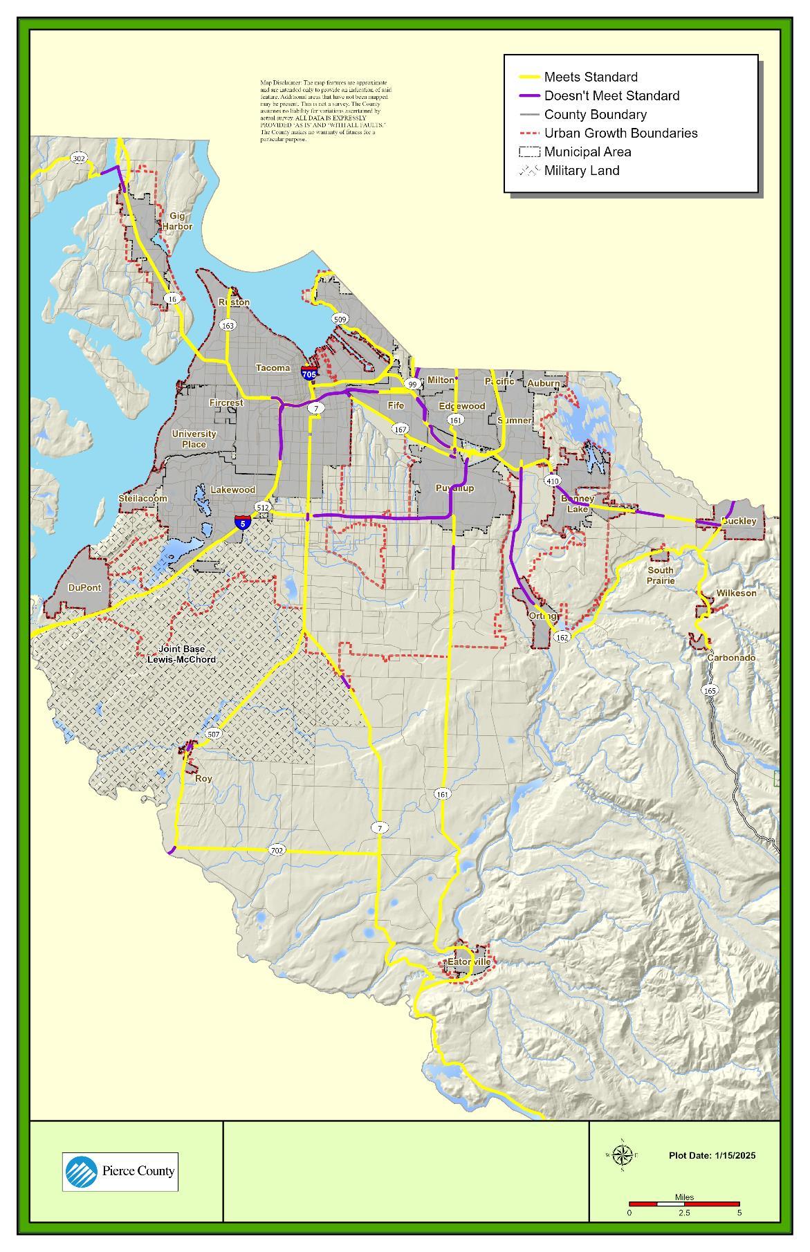
Source: Pierce County, 2024
PRIORITIZATION FOR NEAR-TERM
Recognizing that the level of investment required to fully build the pedestrian and bicycle networks described in the prior section would exceed the near-term resources available to the County over the next 20 years, the County developed a set of prioritization metrics to filter which segments are near-term priorities for pedestrian investment.
The five metrics listed below were used evaluate the priority networks and identify high priority segments for investment:
• Equity: How well a given segment serves overburdened populations.
• Proximity to Destinations: How well a given segment improves mobility, connectivity, and route directness to local centers of importance and/or other culturally significant locations.
• Proximity to Schools and Parks: Improves connections to schools, parks and libraries based on proximity to these uses.
• Safety: Whether a given segment has a history of collisions involving bicycles or pedestrians, both minor injury and KSI collisions.
• Transit Access: How well a given segment facilitates access to transit facilities.
Figure 12-II and Figure 12-KK show the results of the prioritization scoring.
PERFORMANCE
Consistent with the prioritization of pedestrian segments presented previously, specific segments of the priority network that do not meet the LTS standard are designated as high priority locations for investment. The arterial network pedestrian LTS performance under 2044 conditions is shown in Figure 12-JJ.
12-II: Pedestrian Prioritization Scoring
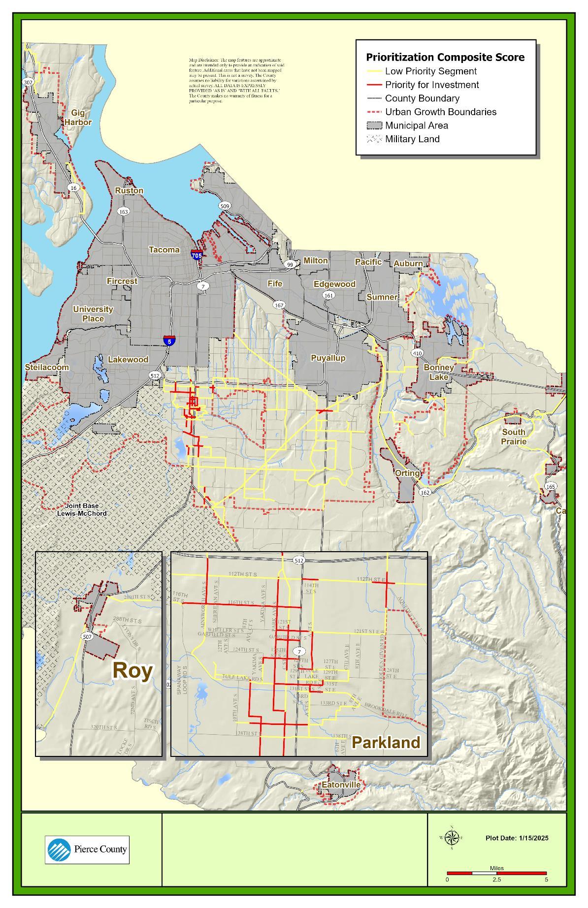
Source: Pierce County, 2024
12-JJ: Preferred Alternative (2044) Pedestrian Level of Traffic Stress (LTS)
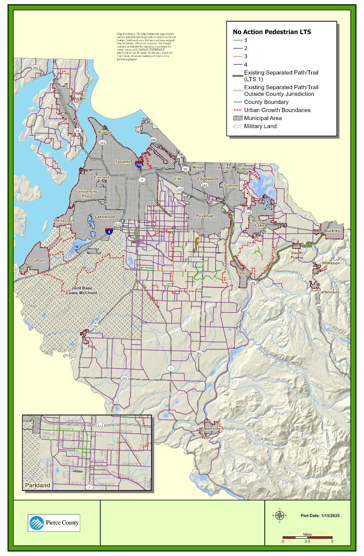
Source: Pierce County, 2024
Recognizing that the level of investment required to fully build the pedestrian and bicycle networks described in the prior section would exceed the near-term resources available to the County over the next 20 years, the County developed a set of prioritization metrics to filter which segments are near-term priorities for investment.
The five metrics listed below were used evaluate the priority networks and identify high priority segments for investment:
• Equity: How well a given segment serves overburdened populations.
• Proximity to Destinations: How well a given segment improves mobility, connectivity, and route directness to local centers of importance and/or other culturally significant locations.
• Proximity to Schools and Parks: Improves connections to schools, parks and libraries based on proximity to these uses.
• Safety: Whether a given segment has a history of collisions involving bicycles or pedestrians, both minor injury and KSI collisions.
• Transit Access: How well a given segment facilitates access to transit facilities.
Figure 12-KK show the results of the prioritization scoring.
PERFORMANCE
The County focuses its bicycle investment on major corridors that provide connections between centers of local importance. Consistent with the prioritization of pedestrian segments presented previously, specific segments of the priority network that do not meet the LTS standard are designated as high priority locations for investment. The arterial network bicycle LTS performance under 2044 conditions is shown in Figure 12-LL
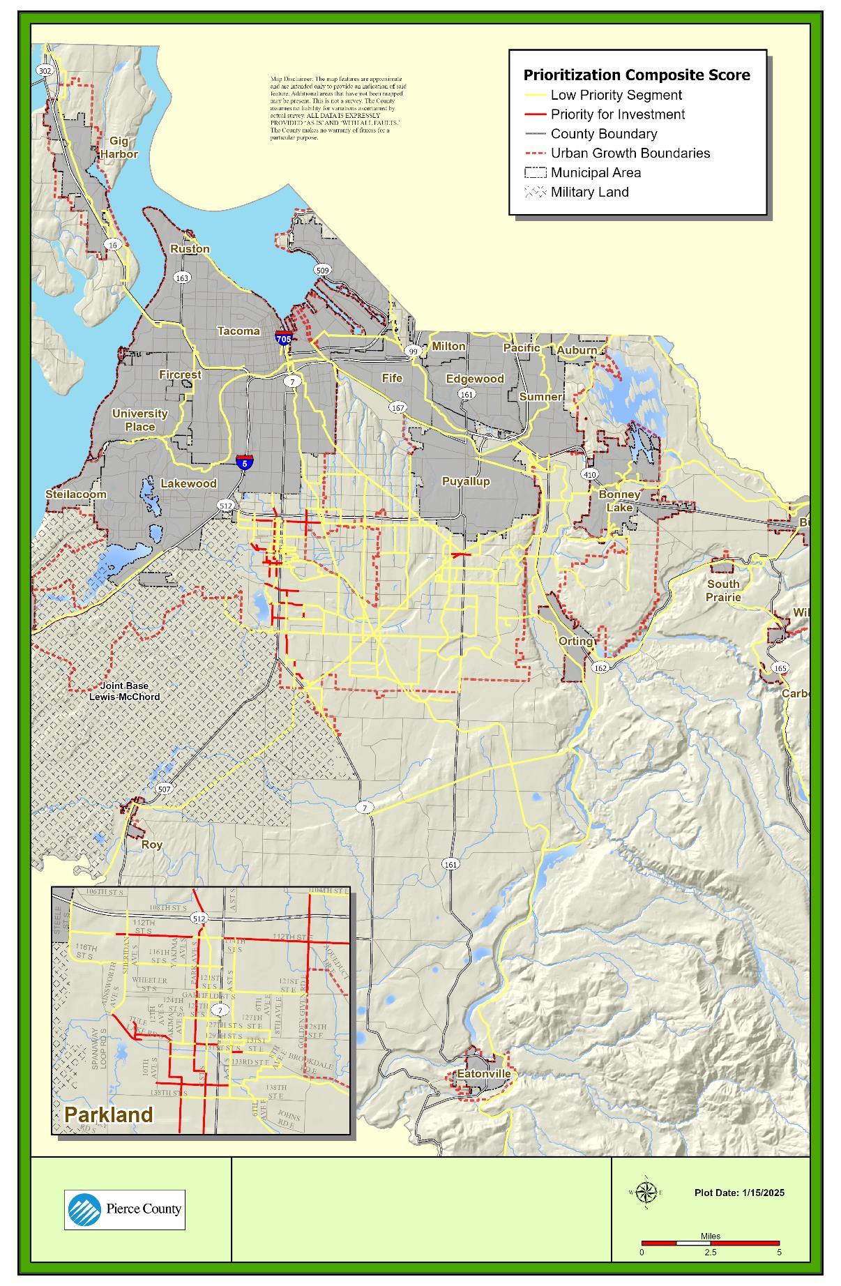
Source: Pierce County, 2024
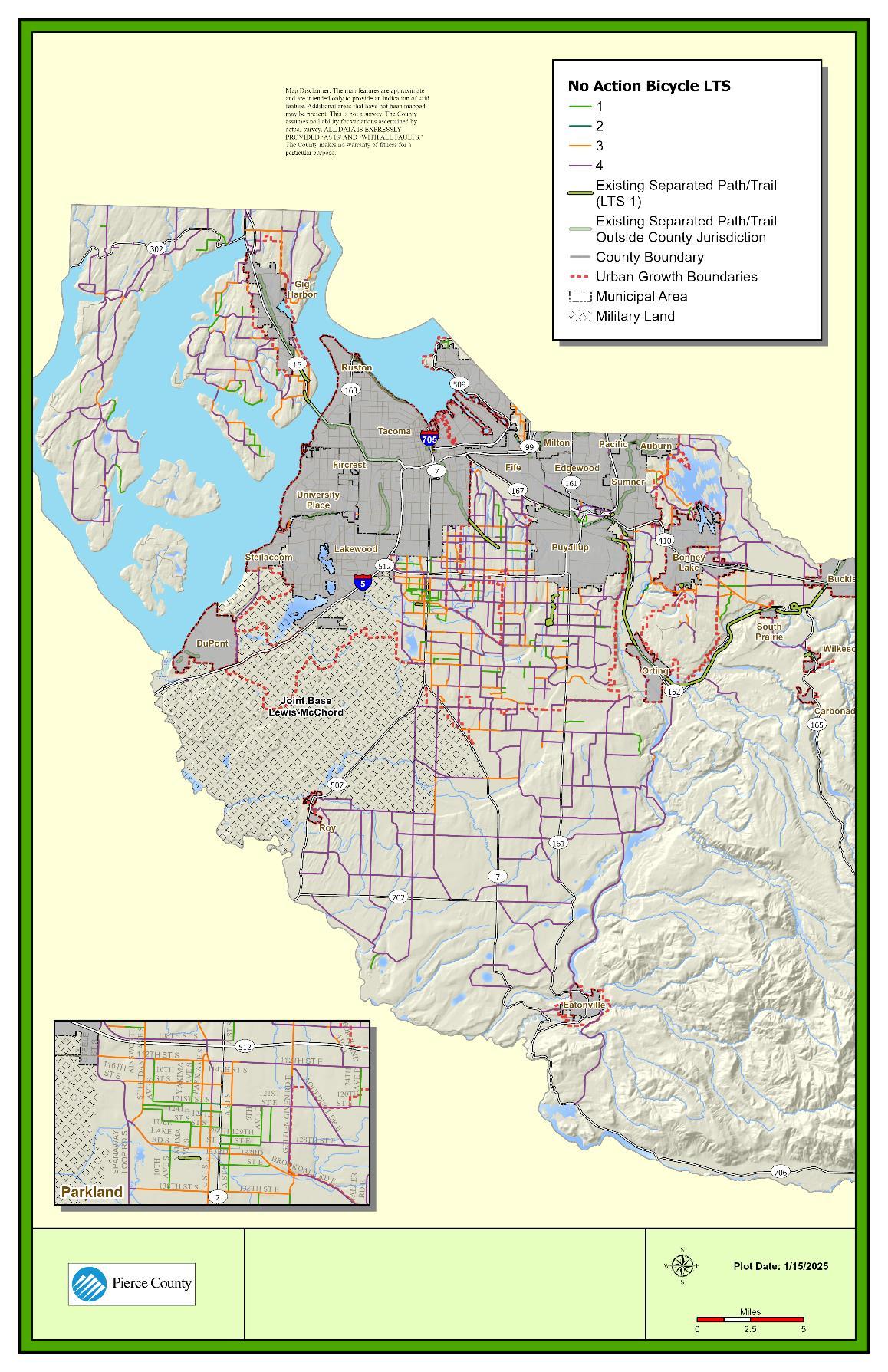
Source: Pierce County, 2024.
Key components for the continuous planning, administration, operation, and improvement of the future transportation system are the following:
• The transportation policies updated in this Comprehensive Plan. These are provided in the Policy Section of the Transportation Element.
o Identification of the County's highest priority investments to improve each of the following modal systems.
▪ Arterial roadway network
▪ Bicycle & pedestrian networks
▪ Transit network
▪ Airports & ferry facilities
• Methods to ensure the maintenance, operations, and preservation of the transportation system, which is critical to both safety and ongoing functionality.
Capital investment in new transit routes and facilities is largely outside the control of the County. However, the County has adopted transit-supportive policies (see Goal 12) to facilitate transit investment in coordination with Pierce Transit, Sound Transit, and InterCity Transit. The following subsections summarize near-term (6-year) and long-term (20-year) project priorities for the County, separated by mode.
This section reviews a list of capital projects identified by the County to meet the demands of growth over the next six years (2024-2029) and over the next 20 years (denoted as costs additional to the six-year period, from 2030-2044). In addition, there are intersection projects and other roadway projects funded in the 2018 TIF Program. Some of these TIF projects are included in the TIP while other projects are identified in Ordinance No. 2018-71s which is incorporated by reference in the Capital Facilities Plan Element. Priorities may shift over time, as new funding sources become available or existing sources are eliminated or revised. The County will continue to annually review and revise its transportation capital projects to meet the needs of future growth as it occurs and will update its Capital Facilities Plan appropriately.
Roadway facility projects identified by the County are provided in Table 12-T, while pedestrian and bicycle projects are provided in Table 12-U. Other road building projects (such as maintenance facilities) are summarized in Table 12-V. Projects for airport and ferry facilities are summarized in Table 12-W and Table 12-X, respectively.
038 AV NW (36 Av NW to Gig Harbor City Limits)
046 AV E / 208 ST E (Intersection)
086 AV EXTENSION (152 St E to 160 St E)
094 AV E / 152 ST E (Intersection)
111 AV E / 122 ST E (Intersection)
112 ST E ('A' St S to 18 Av E)
112 ST S ('C' St S to 'A' St S)
122 AV E (146 St Ct E to 136 St E)
122 AV E (153 St Ct E to 146 St Ct E)
122 AV E (159 St E to 153 St Ct E)
128 ST E (SR-162 to BR #7195-A)
168 ST E (SR-7 to B St E)
Assess road improvements to compliment the City of Gig Harbor project from 36 St NW to Gig Harbor City Limits
Construct urban compact roundabout with the associated sidewalk, illumination, and storm drainage improvements
Preliminary engineering for future roadway extension from 152 St E to 160 St E
Install traffic signal and provide turn lane(s)
Install traffic signal and provide turn lane(s)
Widen to provide turn lane(s), install pedestrian facilities, illumination and provide connectivity within centers and to the future BRT from A' St S to 18 Av E $4,400,000 $29,445,000
Widen to provide turn lane(s), install pedestrian facilities, illumination and provide connectivity within centers and to the future BRT from C St S to A St S $10,000 $26,000
Widen and reconstruct roadway to provide additional lane(s) This segment failed concurrency in 2022 from 146 St Ct E to 136 St E $17,616,000 $228,000
Widen and reconstruct roadway to provide additional lane(s) This segment failed concurrency in 2022 from 153 St Ct E to 146 St Ct E $6,922,000 $6,205,000
Widen and reconstruct roadway to provide additional lane(s) This segment failed concurrency in 2022 from 159 St E to 153 St Ct E. $12,147,000 $-
Public/private partnership to widen and connect to a new arterial roadway from SR-162 to BR #7195-A $40,000 $-
Const bike lanes, curb, gutter, sidewalk, illumination, street parking, improve/install storm drainage and ADA facilities and provide connectivity within centers and to the future BRT from SR-7 to B St E $4,501,000 $74,000
184 ST E (82 AV E to 86 AV E)
The project will rehabilitate, restore, and resurface the roadway All non-compliant ADA curb ramps will be replaced from 82 AV E to 86 AV E $2,504,000 $-
2023 ASPHALT OVERLAY PROGRAM (Various locations)
2024 ASPHALT OVERLAY PROGRAM (Various Locations)
2024 STREET LIGHTING PROGRAM (Various locations)
2025 ASPHALT OERLAY PROGRAM (Various locations)
2026 ASPHALT OVERLAY PROGRAM (Various locations)
304 ST E (73 Ave E to Webster Rd E)
34 AV E SPEED HUMPS (120 St E to 128 St E)
34 ST NW / 63 AV NWTRAFFIC CALMING (34 ST NW / 63 AV NWTRAFFIC CALMING)
3R PROGRAM - 20262029 (Various locations)
68 AV E SPEED HUMPS (Woodland Av E to 144 St E)
ARTONDALE CULVERT REPLACEMENT (MP 0.45 to MP 0.54)
BR #12173-A / 320 ST E - STRINGER REPLACEMENT (At South Ford Muck Ck / 100 Ft. E/O 47 Av E / MP 2.98 to MP 2.99)
BR #17164-B OHOP CK OVERFLOW REPAIRS (Ohop Valley Rd E over Ohop Ck Overflow)
Rehabilitate, resurface roadway, and roadside elements (Various locations)
Rehabilitate, resurface roadway, and roadside elements (Various Locations)
To install street lighting in needful areas throughout Pierce County (Various Locations)
Rehabilitate, resurface roadway and roadside elements (Various Locations)
Rehabilitate, resurface roadway and roadside elements (Various Locations)
Rehabilitate, resurface roadway and bridge deck, replace guardrail from 73 Av E to Webster Rd E
Installation of speed humps for traffic calming purposes from 120 St E to 128 St E
Evaluate corridor for traffic calming measures and measures to reduce traffic cut-through traffic from 32 St NW to 35 St NW $25,000
Rehabilitate, resurface roadway, and roadside elements (Various locations) $20,458,000
Installation of speed humps for traffic calming purposes from Woodland Av E to 144 St E $25,000
Realign the drainage culvert and ditch from Artondale Dr NW (MP 0.45 TO MP 0.54)
Remove and replace exterior treated timber stringers on both sides for the entire length of the bridge Remove and reset existing guardrail on timber posts from At South Ford Muck Ck / 100ft E/O 47 Av E / MP 2.98 to MP 2.99 $154,000
To repair the failing substructure and superstructure elements including the bridge deck, stringers, and abutment caps from Ohop Valley Rd E over Ohop Ck Overflow
$354,000 $15,000
BR #18204-A PUYALLUP RIVER (SR 167 to North Levee Rd E)
BR #19185-A / ORVILLE RD E / KAPOWSIN CK SCOUR REPAIR (Orville Rd E to Kapowsin Ck)
BR #26211-A / FOX IS BR RD GIRDER REPAIRS (Fox Island Bridge Rd over Hale Passage)
BR #26211-A / FOX ISLAND BRIDGE RDTS&L (Fox Island Bridge Rd over Hale Passage)
BR #26211-A FOX IS BR RD - VARIOUS REPAIRS (Fox Island Bridge Rd over Hale Passage)
BR #26211-A / Fox Island BR RD –Replacement Crossing (Fox Island Bridge Rd over Hale Passage)
BR #29202-ACHAMBERS CREEK BRIDGE REPLACEMENT (Chambers Ck Rd W (MP 2.2-2.35))
BR #31221-A / CRAMER RD NW (Cramer Rd NW over Glencove Ck)
BR #34195-A / PATTERSON RD E (110ft Southeast of 212 Av E from MP.10 to MP.20)
BR #6193-A / HARTS LAKE RD S (At Horn Creek) (At Horn Creek (MP 3.94))
Full containment cleaning and inspection of existing bridge from SR 167 to North Levee Rd E $3,500,000
To provide scour protection and bank stabilization to the deteriorated and undermined bridge abutments/wingwalls and adjacent bank from Orville Rd E to Kapowsin Ck
Design and repair of concrete girders that have cracks and/or spalls with rusty rebar exposed on the bottom flange There are 16 girders to be repaired in spans 5, 6, 7, 8, 9, 11, 12 and 14 from Fox Island Bridge Rd over Hale Passage $7,700,000 $-
To provide final type, size and location study for Fox Island Bridge replacement from Fox Island Bridge Rd over Hale Passage $800,000 $-
The design and repair of dapped ends, girders, pads, anchor bolts, piers, and pier walls from Fox Island Bridge Rd over Hale Passage $10,500,000 $-
Provide Replacement crossing based on Type, Size and Location Study $- $200,000,000
Joint project anticipated to leverage multiple funding sources to replace the bridge Type, Size, and Location Study will be completed first by SWM from Chambers Ck Rd W $2,000 $-
$4,689,000 $111,000
Replace bridge from Cramer Rd NW over Glencove Ck
Reconstruct the roadway and replace culvert, using a wall or reinforced slope to accommodate a new fish passable drainage structure with paved shoulders and guardrail from 1212 Av E (MP 0.10 to MP 0.20) $1,884,000 $7,000
Partial fish passage barrier removal and habitat enhancement Replace the existing culvert with a fish passable bridge structure and associated channel restoration work from At Horn Creek (MP 3.94)
$9,488,000 $44,000
BR #7195-A / 128 ST E (At Puyallup River / McCutcheon Rd E)
BR #7195-F / MCCUTCHEON RD E (At Canyon Falls Creek)
BR #8173-C / SCHUDY RD S (Lacamas Creek) (At Lacamas Ck 150 ft N/O 20 Av S (MP 1.60) .)
BR #SUM1204-A / STEWART RD (Stewart Rd over White / Stuck River )
BRIDGE DECK REHABMASHEL RV, PUYALLUP RV, KAPOWSIN CK (BR #26164-A at Mashel RV / BR #6195-A at Puyallup RV / BR #5175C at Kapowsin CK)
BRIDGE DECK REHABILITATIONSCLOVER CREEK, LITTLE MASHEL (BR #17193-D and BR #25164-A)
BRIDGE PAINTINGCOUNTYWIDE (BR #17173-A; BR #24164-B; BR #5174-A; BR #16205A)
BRIDGE REPAIR PROGRAM (Countywide)
C ST S - TRAFFIC CALMING (120 St S to Layfette St S)
C ST S (Garfield St to 120 St S)
Public/private partnership to widen and connect to a new arterial roadway from At Puyallup River / McCutcheon Rd E
Remove fish barrier to accommodate a new fish passable drainage structure from At Canyon Falls Creek
WDFW has classified this location a fish passage barrier Replace the existing culverts with a fish passable new bridge structure, install new guardrail, and rebuild roadway from At Lacamas Ck 150 ft N/O 20 Av S (MP 1.60)
Partnership project to construct a new City of Sumner bridge from Stewart Rd over White / Stuck River
To provide a polyester concrete overlay to permanently rehabilitate the deck from BR #24164A at Mashel RV / BR #6195-A at Puyallup RV / BR #5175-C at Kapowsin Ck
$3,187,000 $233,000
Resurface and restore two bridge decks with a polyester concrete overlay from BR #17193-D and BR #25164-A $744,000
Clean and paint steel elements on several bridges throughout the county from BR #17173-A; BR #24164-B; BR #5174-A; BR #16205-A $1,006,000 $44,000
Annual program to address unplanned bridge repair activities throughout the county as well as planned from Countywide $240,000
Assess corridor for speed management countermeasures and traffic calming opportunities from 120 St S to Layfette St S $50,000 $-
This is an active transportation project that will construct bike/ped improvements from Garfield St to 120 St S $200,000
CANYON RD EASPHALT OVERLAY (160 St E to 138 St E)
CANYON RD E - N EXT / BR #19204-H / 52 ST E / 70 AV E (52 St E / 62 Av E to Puyallup River SR167 to N Levee Rd E / 70 Av E)
CANYON RD ENORTHERLY EXT (1,500 FT S/O Pioneer Wy E to 52 St E / 62 Av E)
CANYON RD ESOUTHERLY EXT (208 St E to 200 St E)
Rehabilitate, resurface roadway, and replace noncompliant ADA curb ramps from 160 St E to 138 St E $3,548,000 $52,000
Construct new roadway and reconstruct existing roadway as part of the Canyon Rd E Northerly Extension corridor improvements from 52 St E / 62 Av E to Puyallup River SR-167 to N Levee Rd E / 70 Av E $38,292,000 $149,227,000
Construct new roadway and overcrossing at the BNSF tracks as part of the Canyon Rd E Northerly Extension corridor improvements from 1,500 ft S/O Pioneer Wy E to 52 St E / 62 Av E $52,052,000 $25,041,000
Construct new roadway from 208 St E to 200 St E from 208 St E to 200 St E $7,138,000 $76,000
CANYON RD E (72 St E to Pioneer Wy E) Widen and reconstruct roadway to provide additional lane(s) from 72 St E to Pioneer Wy $2,256,000 $45,766,000
COUNCIL TRAFFIC AND SAFETY IMPROVEMENTS- 20242029 (Various locations)
EAST BAY DR NW / 25 ST NW / 34 AV NW (Wollochet Dr NW to Point Fosdick Dr)
EMERGENCY REPAIR264 ST E (MP 2.3 to MP 2.5)
FAIRFAX FOREST RESERVE RD (0.92 mi E/O Zavitski Rd to Mt. Rainier National Park)
FALLING WATER BV E (Tehaleh Bv E to 181 Av E)
GOLDEN GIVEN RD E / 99 ST E (Intersection)
GRANT / DEVELOPER MATCHING PROGRAM (Various locations)
To evaluate and implement council-directed improvement projects (Various locations) $612,000 $-
Assess corridor for shoulder improvements to support active transportation use from Wollochet Dr NW to Point Fosdick Dr $75,000 $-
Emergency repair to replace failed culvert and restore the roadway to pre-damaged conditions from At culvert 0.54 miles W of 134 St E (MP 2.41) $721,000 $19,000
Install new culverts, add guardrail, resurface pavement Rehabilitate existing bridge (BR #5177-A) at Tolmie Creek from 0.92 mi E/O Zavitski Rd to Mt. Rainier National Park $6,805,000 $-
Public/private partnership to construct a new arterial roadway from Tehaleh Bv E to 181 Av E $102,000 $-
Construct urban compact roundabout with the associated sidewalk, illumination, and storm drainage improvements $1,396,000 $15,000
Match for unforeseen outside grants, and/or developer latecomer agreements (Various locations) $3,000,000 $-
GUARDRAIL PROGRAM2023 (Various locations)
GUARDRAIL PROGRAM2024 (Various locations)
GUARDRAIL PROGRAM2025 (Various locations)
GUARDRAIL PROGRAM2026-2029 (Various locations)
KEY CENTER TRAFFIC CALMING & SPEED REDUCTION (Key center)
LACKEY RD NW / JACKSON LK RD NW / KEY PEN HY NW (Intersection)
ORTING VALLEY EASTWEST CORRIDOR (122nd St E/Shaw Rd E to SR-162)
Install new guardrail, and/or replace existing guardrail (Various locations)
Install new guardrail, and/or replace existing guardrail (Various locations)
Install new guardrail, and/or replace existing guardrail (Various locations)
Install new guardrail, and/or replace existing guardrail (Various locations)
Design and installation of measures to calm traffic and reduce vehicle speeds through rural activity center from Key Center
Construct rural roundabout with shoulders
Widen and reconstruct roadway to provide additional lane(s) Alternative alignments will be evaluated from Shaw Rd E to SR-162
MILITARY RD E / 152 ST E (Intersection) Install traffic signal
NISQUALLY RD SW (Thurston County Line to I-5)
OHOP VALLEY EXT RD E SLIDE REPAIR (2,640' to 3,168' SW of SR161)
Rehabilitate, resurface roadway and roadside elements from Thurston County Line to I-5 $2,970,000 $30,000
Reconstruct road embankment and surfacing from 2,640 ft to 3,168 ft SW of SR-161 $2,000 $998,000
ORTING-KAPOWSIN HY E / 200 ST E (Intersection) Install traffic signal and provide turn lane(s) $1,000 $-
PUGET SOUND GATEWAY PROGRAM (I5 to SR-161)
ROAD SAFETY - CLRS / SE / HFST (Various locations)
County portion of WSDOT project to build SR-167 from I-5 to SR-161, add lanes, interchange at SR-161 and I-5, ramps at Valley Av E, trail, & toll facilities from I-5 to SR-161 $2,000,000 $-
Install centerline rumble strips, safety edge, and high friction surface treatment at various locations throughout Pierce County $723,000 $-
SOUTH PRAIRIE RD E / 214 AVE E (Intersection) Traffic study $35,000 $-
SPOT SAFETY PROGRAM (Various locations)
SR507 / SR702 (Intersection)
SUMNER TAPPS HY E / S TAPPS DR E (Intersection)
TEHALEH BV E (McCutcheon Rd E to Falling Water Bv E)
Spot safety improvements and funding for grant matching opportunities (Various locations)
Public partnership with WSDOT to construct roundabout and associated sidewalk, illumination, storm drainage at the intersection of two State highways
Traffic study and preliminary engineering for future intersection improvements
Public/private partnership to construct a new arterial roadway from McCutcheon Rd E to Falling Water Bv E
WALLER RD E / 152 ST E (Intersection) Install left turn lanes
224th Street Add channelization from 86th Avenue E to 92nd Court E
$9,499,000
$3,800,000 (2030-2044) Roadway
Source: Fehr & Peers, 2024
1. All project costs are estimated in 2023 dollar values, irrespective of inflation.
2. This project (CRP #5643) is assumed under Alternatives 1 and 2, in conjunction with CRP #5498. Under Alternative 3, this project is replaced with C-7.
3. This project/program assumes a 2.9% annual increase in construction, design and right-of-way costs.
090 AV E - MULTIUSE PATH
138 ST S (Park Av to Spanaway Loop Rd S)
138 ST S (SR-7 (Pacific Av) to Park Av)
159 ST S / 159 ST E (SR 7 to 3 Av Ct E)
160 ST E (66 Av E to 81 Av E)
I-5 / JBLM SHARED USE PATH
(Steilacoom Dupont Rd/East Dr/Huggins Meyer Rd: Wharf Rd to Lakewood City Limits)
LAKELAND HILLS WY - CROSSWALK
(Intersection of Lakeland Hills WY and 22 St E)
128 St E to 126 St E
This is an active transportation project that will construct bike/ped improvements from Park Av to Spanaway Loop Rd S
This is an active transportation project that will construct bike/ped improvements from SR-7 (Pacific Av) to Park Av
Construct sidewalk, paved shoulder, lighting and extend two-way turn lane to B St E Improve traffic signal/ped and provide connectivity within centers and to the future BRT from SR-7 to 3 Av Ct E
$4,588,000 $20,000
Resurface/restore roadway pavement surface ADA compliance to be fulfilled by replacing /installing new sidewalk ramps and modifying intersection Ped push buttons as feasible from 66 Av E to 81 Av E $63,000 $80,000
Joint partnership project to construct shared use path from Steilacoom Dupont Rd/East Dr/Huggins Meyer Rd: Wharf Rd to Lakewood City Limits $26,650,000 $-
Installation of crosswalk, rapid flash beacon, and pedestrian refuge to facilitate park access from Intersection of Lakeland Hills Wy and 22 St E $250,000 $-
Pipeline TrailOrangegate to Half Dollar Park Where possible in the given right-of-way, construct separated path or trail from SR 512 to 104th St E
Source: Pierce County, 2024
1. All project costs are estimated in 2023 dollar values, irrespective of inflation.
2. This project is funded under the Parks and Recreation CIP (2024-2029) rather than the TIP.
3. This project/program assumes a 2.9% annual increase in construction, design and right-of-way costs.
Table 12-V. List of Building Projects for Road Maintenance
Source: Pierce County, 2024
Table 12-W. List of Expected and Committed Airport Facility Projects
Source: Pierce County, 2024. 1.
Pierce County,
In addition to programmed Baseline capital projects identified by the County to meet concurrency, maintenance, and other growth-related needs, the County has identified projects within the Preferred Alternative to address long-term needs for all modes arising from the Preferred Alternative (2044) analysis. Priorities may change over time as new funding sources become available or existing funding sources are eliminated or revised. Project priorities are broken down by mode with their associated costs.
Improvements were identified for any County arterial segment exceeding a V/S threshold of 1.1, and additional modeling was performed to confirm that this addressed the deficiency. The roadway projects identified, including estimated costs, are listed in Table 12-Y, These projects are also shown in Figure 12-MM. Figure 12-NN summarizes the V/S ratios of arterial segments after the identified improvements are implemented. With these planned projects, all segments are anticipated to operate acceptably.
Table 12-Y List of Preferred Alternative (2044) Roadway Projects
Source: Pierce County, 2024
1. All project costs are estimated in 2023 dollar values, irrespective of inflation.
2. The preliminary engineering phase for the Military Road E widening will include an analysis of the potential extension of 128th Street E to SR 162, which is part of the Orting Valley East-West Corridor (122nd St E/Shaw Rd E to SR-162).
12-MM. Preferred Alternative (2044) Roadway Projects
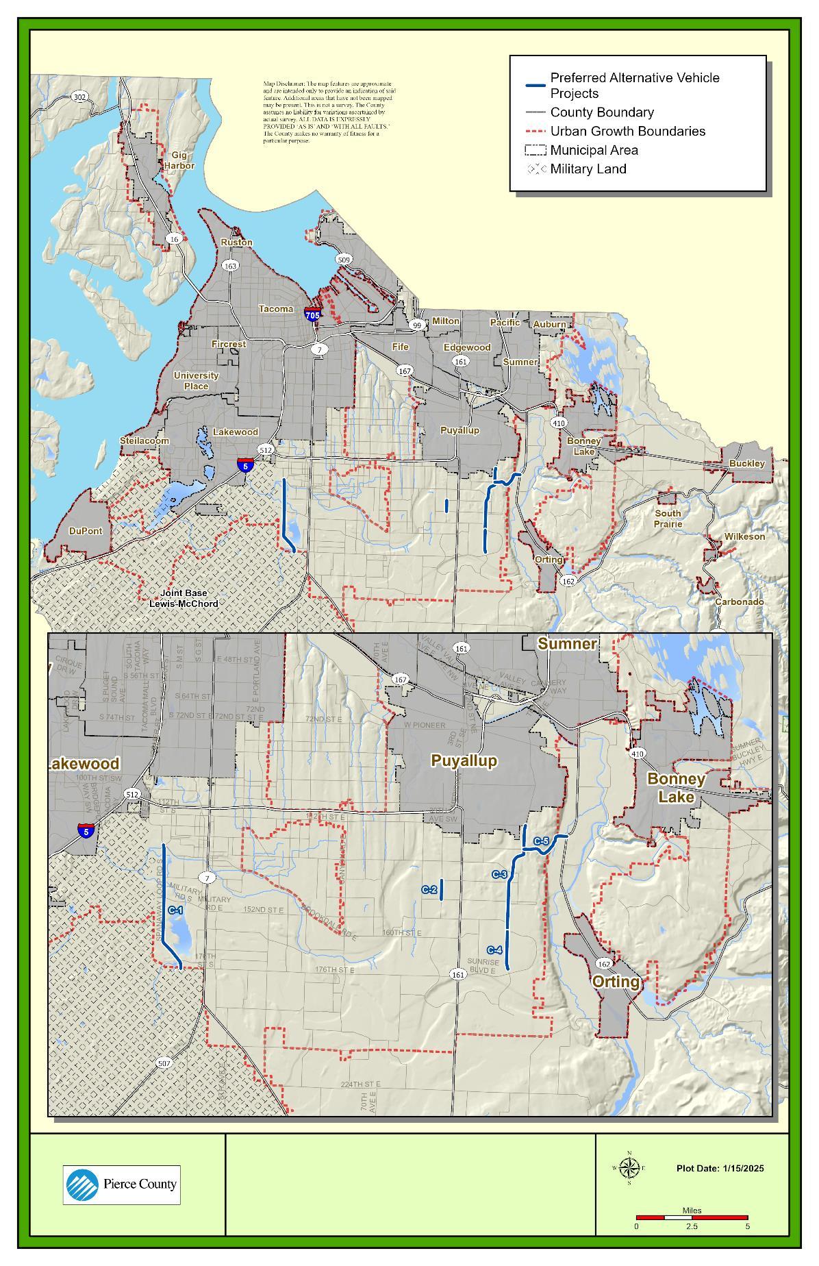
Source: Pierce County, 2024
12-NN County Roads: Preferred Alternative (2044) Daily V/S Ratios with Mitigations
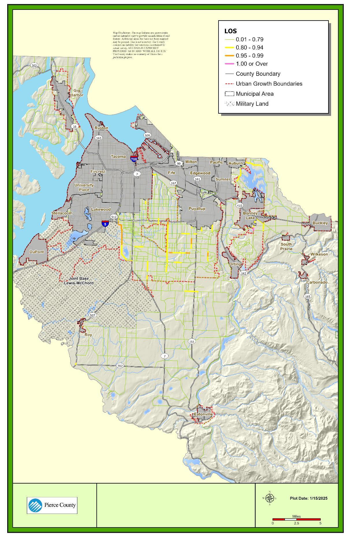
Source: Pierce County, 2024.
Pedestrian and bicycle improvements were identified based on the prioritized segments previously presented for the Preferred Alternative (2044) (see Figure 12-II and Figure 12-KK). These projects, including their estimated costs, are summarized in Table 12-Z. They are also shown in Figure 12-OO.
Table 12-Z. Preferred Alternative (2030-2044) Standalone Active Transportation Projects1
PB-1 108th St S
PB-2 112th St S
PB-3 Tule Lake Rd S
PB-4 Parkland Community Trail
Implement protected bicycle lane along 108th St S from 20th Ave to SR 7 (Pacific Ave) $4,638,017
Implement protected bicycle lane and fill sidewalk gaps along 112th St S from Steele St S to Portland Ave S $18,008,165
Implement protected bicycle lane along Tule Lake Rd S from Spanaway Loop Rd S to 13th Ave S $2,681,847
Where possible in the given right-of-way, construct separated path or trail from Pacific Lutheran University (PLU) to Tule Lake Rd S. If a trail is not possible, pursue an option with sidewalks and bike lane $1,590,909
PB-5 Parkland Community Trail
PB-7 152nd St E
PB-9 Spanaway Community Trail
Where possible in the given right-of-way, construct separated path or trail from Gonyea Playfield to SR 7. If a trail is not possible, pursue an option with sidewalks and bike lane. $1,875,000
Implement protected bicycle lane and fill sidewalk gaps along 152nd St S from Bresemann Blvd S to 13th Ave Ct $11,230,040
Where possible in the given right-of-way, construct separated path or trail from 176th St E to Spanaway Park. If a trail is not possible, pursue an option with sidewalks and bike lane. $3,437,500
PB-10 Parkland Community Trail
Where possible in the given right-of-way, construct separated path or trail from 96th St S to 134th St S. If a trail is not possible, pursue an option with sidewalks and bike lane.
$7,329,545
12-114
PB-11 Tule Lake Rd S
PB-12 Parkland Community Trail
PB-13 Spanaway Community Trail
Implement protected bicycle lane along Tule Lake Rd S from Park Ave S to SR 7 (Pacific Ave) $1,262,045
Where possible in the given right-of-way, construct separated path or trail from Park Ave S to Harry Sprinker Recreation Center. If a trail is not possible, pursue an option with sidewalks and bike lane. $3,522,727
Where possible in the given right-of-way, construct separated path or trail from Park Ave Connector to Spanaway Lake High School. If a trail is not possible, pursue an option with sidewalks and bike lane. $4,232,955
PB-16 Spanaway Community Trail
PB-18 B St E
PB-22 B St E
PB-23 128th St E
PB-24 8th Ave E/Spanaway Community Trail
Where possible in the given right-of-way, construct separated path or trail from Spanaway Lake HS to Spanaway Park. If a trail is not possible, pursue an option with sidewalks and bike lane. $4,232,955
Implement striped bicycle lane and add sidewalk along B St E from 152nd St E to 156th St E $1,577,557
Implement protected bicycle lane and fill sidewalk gaps along B St E from 176th St to 192nd St $9,258,426
Implement buffered bicycle lane and add sidewalk along 128th St E from 6th Ave E to Golden Given Rd $1,230,494
Where possible in the given right-of-way, construct separated path or trail from 192nd St E to 200th St E. If a trail is not possible, pursue an option with sidewalks and bike lane. $1,505,682
PB-25 8th Ave E
PB-26 200th St E/10th Ave E
Fill sidewalk gaps along 8th Ave E from 200th St E to 208th St E $2,417,523
Where possible in the given right-of-way, construct separated path or trail from 8th Ave E to SR 7. If a trail is not possible, pursue an option with sidewalks and bike lane. $1,250,000
PB-27 Golden Given Rd E
PB-39 128th St E
Implement protected bicycle lane and add sidewalk along Golden Given Rd E from 95th St E to 128th St E $11,597,199
Implement protected bicycle lane and add sidewalk along 128th St E from 94th Ave E to 111th Ave E $7,261,602
PB-40 Central Pierce BPA Trail Where possible in the given right-of-way, construct separated path or trail from 94th Ave E to Meridian Ave E. If a trail is not possible, pursue an option with sidewalks and bike lane. $1,875,000
Total Estimated Cost (2030-2044) $102,015,188
Source: Pierce County, 2024.
1. Pedestrian and Bicycle facilities are also addressed in other roadway projects as part of the development. Projects on this list can be considered standalone pedestrian and bicycle projects.
2. All project costs are estimated in 2023 dollar values, irrespective of inflation.
Figure 12-OO. Preferred Alternative (2030-2044) Standalone Pedestrian and Bicycle Projects
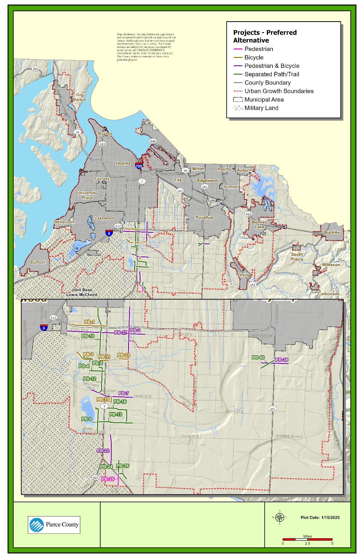
Source: Fehr & Peers, 2024.
The County has two capital improvement funds for transportation facilities and active transportation projects: the Public Works Construction Fund (Fund 320) and the Transportation Facilities Fund (Fund 321). Funding sources for the Public Works Construction Fund consist of REET 2 for roads, traffic impact fees, transfers in from the General Fund and the County Road Fund, federal, state, and local grants, and other miscellaneous revenues. Funding sources for the Transportation Facilities Fund consist of revenue from the sale of capital assets. REET 2 and traffic impact fee revenues are transferred into these funds from special revenue funds where those revenues are collected.
The County has two enterprise funds that pay for capital projects for the County’s airports and ferry system: the Airport Fund (Fund 460) and the Ferry Services Fund (Fund 480). Airport capital projects are funded primarily by federal grants, with some additional support from state funding and airport fees. Ferry capital projects are funded by federal and state grants and transfers from the County Road Fund.
Table 13-12-AA summarizes expenditures related to ferry and airport facilities over 6-year and 20-year horizons. These expenditures do not vary by alternative.
Table 13-12-BB shows consolidated 6-year and 20-year planned capital costs by facility/service category for County-provided facilities and services for Alternatives 1, 2, and 3, respectively. These are based on the project lists and cost estimates presented in the previous section. Estimated capital costs for the 20-year planning period may not represent the full costs of future projects, and additional capital planning efforts will be necessary over the coming years.
Table 13-12-AA. Expenditures Related to Ferry and Airport Facilities
Source: Pierce County, 2024
Note:
1. Although there are ferry and airport projects programmed within the 2030-2044 time period, many of the facilities have not projected all expenditures through 2044. As such, when comparing these expenditures to revenues, only the 2024-2029 time period will be used for ferry and airport facilities.
Table 13-12-BB. Projected Transportation Capital Expenditures, (2024-2044)1
Source: Pierce County, 2024.
Note: 1. All project costs are estimated in 2023 dollar values, irrespective of inflation.
TRANSPORTATION CAPITAL REVENUE SOURCES
As described above, the County allocates 75% of REET 2 revenues to transportation projects. The collection of REET 2 revenues went into effect January 1, 2002. This analysis assumes that real estate assessed values will increase at a rate of 2% annually from 2024 onward. To be conservative, this rate of increase is lower than the historical average levels of growth. This analysis assumes a turnover rate of 5% for properties. The County uses REET 2 for Roads revenues to pay for debt service. The estimated amount available for capital is the remaining amount after this other expense.
The County began collecting traffic impact fees (TIF) in 2007. The intent is for new growth and development to pay a proportionate share of the cost of public road infrastructure improvements needed to serve that development. Traffic impact fees are collected on all new developments. Separate fee rates are established for various types of residential, commercial, and industrial land use types based on traffic generation and the anticipated impact on the roadway network.
Like REET revenues, annual impact fee revenue can vary based on fluctuations in the real estate market and trends in the economy. This analysis projects future revenues based on the projected amount of new construction in the unincorporated area of the County. New construction is assumed to be 1% of total assessed value. Between 2018 and 2022, the County collected on average $8.0 in traffic impact fees per $1,000 of assessed value of new construction. To estimate these revenues going forward, this analysis holds a constant relationship of $8.0 per $1,000 of assessed value of new construction, with future years adjusted for inflation. Impact fees increase annually according to the change in the Construction Cost Index, so the annual inflation adjustment is included to account for the increase in impact fee rates over time. The Traffic Impact Fee Plan is updated periodically as well.
12-119
The County receives federal and state grants to support the cost of transportation-related capital projects. These revenues have historically represented $6.9 million, on average, from 2018 to 2022. Future revenue projections for grants are based on this average amount, annually adjusted for inflation. Other local revenue sources, such as charges for service, are also based on the average amount from 2018 to 2022, annually adjusted for inflation. Projected grant and miscellaneous revenues from 2024 to 2029 are based on the draft 2024-2029 Six-Year Transportation Improvement Plan. The Transportation Improvement Plan includes projected revenue from bond sales from 2027 to 2029.
The Transportation Facilities Fund, which funds road building projects, has not received any revenue from the sale of capital assets from 2018 to 2022, so no revenue for this fund is assumed in future years. The County may choose to pursue the sale of capital assets in future years. Road building projects in 2024 to 2029 are funded by available fund balance.
The Public Works Construction Fund also receives incoming transfers from the County Road Fund, the General Fund, and the Stormwater Management Operating Fund. These transfers are based on capital project needs and availability of funds. Projections for 2024 to 2029 are based on revenues assumed in the draft 2024-2029 Six-Year Transportation Improvement Plan. Projections after 2029 are based on average annual transfers from 2018 to 2022, annually adjusted for inflation. The projections for 2029 to 2044 assume the County Road Fund continues to have capacity to support projects, though the Road Fund’s own primary revenue sources property tax and motor vehicle fuel tax are limited in their growth potential. The Capital Facilities Plan contains additional information.
Airport capital projects are primarily funded by federal grants from the Federal Aviation Administration (FAA), followed by a small amount of state grant funding and airport fees. These locally collected funds are used to match grant funding. The County meets annually with the FAA to talk about projects for the next six years.
Ferry capital projects are funded by transfers from the County Road Fund, the Ferry Fund, and grants. Projects are typically shown as funded by the Road Fund or the Ferry Fund until grant funding is secured.
Table 12-CC details total projected capital revenues for transportation capital projects over the planning period. The County plans to use available fund balance for projects in the 2024 to 2029 time period, but revenues for transportation facilities have also been estimated through 2044. Table 12-DD details total projected capital revenues for ferry and airport facilities. Unlike the transportation facilities, total expenditures and revenues for ferry and airport facilities are only programmed through 2029. As such, this table only presents revenues for the 2024 to 2029 time period.
Table 12-CC: Projected Transportation Capital Revenues, 2022-2044 (YOE$)
Sources: Pierce County, 2023; Washington State Auditor’s Office Financial Intelligence Tool, 2023; BERK, 2023. Note: Includes additional revenue projections not in the Draft 2024-2029 CIP for the purposes of the CFP.
Table 12-DD: Projected Ferry and Airport Capital Revenues, 2022-2029 (YOE$)1
Sources: Pierce County, 2023; Washington State Auditor’s Office Financial Intelligence Tool, 2023; BERK, 2023.
Note:
1. Although some expenditures and revenues have been programmed past the 6-year horizon for airport and ferry facilities, the exact programming of these is still being defined and does not line up with the 20-year horizon. As such, the revenue estimates for these facilities have been limited to a 6-year horizon.
This comparison looks at the total dedicated transportation revenue sources with planned project costs for the 6-year and 20-year planning horizon (2024-2029 and 2024-2044) in order to understand the difference between future dedicated capital costs and potential future revenues. As shown in Table 12-EE, estimated transportation revenues are expected to adequately cover currently programmed capital costs under the 6-year horizon (2024-2029), with a projected surplus of $499,000. For the 20-year horizon, expenditures are anticipated to exceed estimated transportation revenues. It is important to note that the expenditures under both the 6-year and 20-year horizon are based on 2023 cost estimates.
A comparison or ferry and airport facility revenues compared to expected costs is shown in Table 12-FF focusing on the 2024-2029 time period. Based on this comparison, estimated revenues are expected to adequately cover currently programmed capital costs under the 6year horizon (2024-2029).
Table 12-EE. Projected Transportation Capital Revenues and Costs (YOE$)
Sources: Pierce County, 2023; BERK, 2023.
Note: Estimated capital revenues and costs are rounded to the nearest $10,000. Includes additional revenue projections not in the Draft 2024-2029 CFP for the purposes of the CFP.
Table 12-FF. Projected Ferry and Airport Facility Capital Revenues and Costs (YOE$)
Source: Pierce County, 2023.
Note:
1. Although some expenditures and revenues have been programmed past the 6-year horizon for airport and ferry facilities, the exact programming of these is still being defined and does not line up with the 20-year horizon. As such, the revenue estimates for these facilities have been limited to a 6-year horizon.
RCW36.70A.70(6) requires the following: A transportation element that implements, and is consistent with, the land use element. (a) The transportation element shall include the following sub elements: (iv) Finance, including: (C) If probable funding falls short of meeting identified needs, a discussion of how additional funding will be raised, or how land use assumptions will be reassessed to ensure that level of service standards will be met.
The above state law gives certain guidance to jurisdictions facing financial shortfalls in the transportation system. Among the responses that may be considered by the County:
• The County could review its current land use and decide how to reduce future demand on the roadways;
• The Service Standards could be changed either on a global or selective basis. The use of ultimate capacity is used for targeted and specific use that requires other actions from the County;
• The transportation budget could be altered to reduce certain types of services; and/or
• Additional funds may be raised for transportation using existing or new sources.
12-122
Consistent with the Road Fund Sustainability Study performed by the County in 2023, options for increasing revenues to cover expenditures over the 20-year horizon include:
• Initiating a property tax levy lid lift;
• Increasing Traffic Impact Fees;
• Raising funding through a Transportation Benefit District (TBD). The County has already established a TBD which has not yet pursued any revenue funding proposals for voter approval. The County Council serves as the TBD governing board and could impose by a majority vote a vehicle license fee or sales tax increase to raise revenues for transportation projects;
• Using bond funding to support projects;
• Establishing a Tax Increment Finance area; and/ or
• Identifying other funding mechanism for the ferry system. Options could include a TBD sales tax or a ferry district property levy. Should the ferry fund have additional revenue, the Road Fund’s contribution for ferry operations and capital could decrease.
The earlier sections of this report focus upon the improvement of the transportation system. Often, the tendency is to pay particular attention to the infrastructure, such as where new roads might be constructed or widened. That is the improvement component of the plan. The improvement projects stand out in aggregate and sometimes individually relative to the rest of the larger basket of transportation services the County provides to the community.
While building new capacity is important, it is not the most important County undertaking. By policy and in practice, the most important services provided by the County are in taking care of what is in place (maintenance), seeing to the day-to-day tasks (operations), and replacing existing assets in an optimal time frame (preservation). The following narrative describes some of the maintenance, operations, and preservation activities performed by the County. OPERATIONS, MAINTENANCE, AND REHABILITATION BUDGET
MAINTENANCE
Maintaining, operating, and preserving the County’s 1,569 centerline miles of roadway is a long-term investment. It may at times be attractive to local governments to prioritize the improvement projects ahead of sound maintenance and operations programs. However, the long-term outcomes of deferred road maintenance are often financially devastating and unpopular with citizens. For these reasons, this Plan considers what will be needed to maintain, operate, and preserve the County’s existing and future roadway network. The overall goal of the County’s transportation program is to maintain our transportation system assets with the lowest overall lifecycle cost. The County maintains its existing transportation assets through the following actions:
• Repairing potholes, damaged pavement, bridges, storm drainage systems, guardrail, and sidewalks;
• Applying chip seal treatment;
• Grading gravel roads and shoulders;
• Controlling roadside vegetation;
• Pond maintenance on facilities that treat and detain roadway runoff;
• Inspecting and repairing as needed County traffic signs, luminaires, and traffic signal control components;
• Repainting and refurbishing pavement markings (such as crosswalks, arrows, etc.) and restriping roadways;
• Replacing raised pavement markers;
• Responding to citizen calls; and
• Maintaining the County’s ferry system, including the ferry boats, docks, and terminals.
Operations include activities required to safely operate the County’s transportation system. These include the following:
• Street sweeping;
• Roadside mowing;
• Cleaning and inspecting storm drains and stormwater infrastructure;
• Removing snow and ice from roadways;
• Removing roadside litter and dead animals;
• Responding to roadway emergencies such as floods, wind storms, mudslides, hazardous materials spills, earthquakes, and volcanic events;
• Responding to citizen concerns and inquiries;
• Collecting data about the County’s transportation system, such as information related to traffic counts and crashes;
• Completing traffic studies and analysis as needed, as well as reviewing traffic impacts from new developments;
• Paying power costs needed to run the County’s traffic signals and lighting systems; and
• Operating the County’s ferry system, which includes costs such as fuel for the ferries, staff to run the ferries and operate the facilities, and insurance.
Preservation is the replacement or repair of an asset, whereas maintenance is considered to be a routine activity. Examples of preservation activities include the following:
• Repaving or overlaying existing roadways;
• Replacing or refurbishing bridges, sidewalks, retaining walls, guardrails, electrical systems (traffic signals, roadway lighting, etc.), boat Launches, pavement markings, and traffic signs; and
• Preserving the County’s transportation system also includes replacing or refurbishing the ferries, ferry docks, terminals, and the ferry ticket system.
Projects that work toward safety for the travelling public include the following:
• Intersection improvements (turn lanes, roundabouts and traffic signals);
• Pedestrian improvements;
• Rural road improvements, such as shoulders, guardrails, and rumble strips; and
• Traffic enforcement and education.
The Population, Jobs, Travel Characteristics, and Performance section of this document records roadway needs within the 20-year planning period. These projects do the following:
• Address anticipated traffic congestion (Concurrency);
• Attract employers to add jobs (Economic Development);
• Add to the continuity of our roadway network (Corridors and Connectors);
• Facilitate travel to future developments (typically paid for by the development community) or are assumed to be already in place, such as the 176th Street East widening (Assumed Projects).
The County provides maintenance and operations staff to ensure that our facilities are kept in working order; program development staff to manage the County’s transportation budget and to apply for and administer federal and state grants; and the engineering and planning staff needed to preserve and improve the current transportation system, as well as respond to future County transportation needs. Administration costs also include the physical space staff need to complete their day-to-day work as well as general overhead including department management, public communication, legal, and other support.
Previous sections of this Transportation Element describe a number of current and future mobility challenges residents of Pierce County experience and are expected to experience in the County. As noted earlier, the community is experiencing longer travel times on several Washington state highways and County arterials. The 1992 Transportation Plan recommended an extensive list of highway improvement projects to address the current and anticipated deficiencies. Important capacity projects were constructed in the subsequent years.
This Transportation Element notes that there are appropriate times to build additional roadway capacity into the roadway system and recommends a more complete roadway network that provides both greater accessibility and increased mobility within the County. There are a number of connectors and corridors that would serve that purpose.
The term Transportation Demand Management (TDM) does not denote a single program or strategy but refers to actions that allow us to use our transportation system more efficiently. Some strategies recognized by WSDOT include:
• Providing transit passes to students or workers
• Charging for parking
• High occupancy toll lanes
• High occupancy vehicle lanes
• Changing land use zoning to support transit‐oriented development
• Providing showers and bicycle repair and storage at work sites
• Promotions like Wheel Options and Bicycle Month
• Outreach to employers to increase the use of telework and compressed work weeks
• Senior shuttles to health care facilities
• Vanpools
High Occupancy Vehicle (HOV) lanes are a long-standing example of TDM on our state freeway system. The designation of lanes for carpools and buses allows more people to move in the same amount of space and time. While there are presently no HOV lanes on Pierce County
jurisdiction roadways, there is strong evidence of ridesharing. Ridesharing covers a wide range of transportation options through our region, including Pierce Transit buses, vanpools, carpools, and taxis. TDM is used in the form of pricing in the High Occupancy Toll (HOT) lanes that are seen north on SR 167. In addition to these strategies, WSDOT recognizes the following TDM measures:
The collective sum of needed County road improvement projects is not environmentally viable and/or exceeds our ability to pay. The Financing the Plan section describes the high costs associated with building additional capacity on the roadway network within the County. It may easily cost up to $5 million dollars per mile (2023 dollars) to add one lane on a roadway and, as noted earlier, the roadway improvement costs cannot come at the expense of a financially responsible and constrained approach of managing our transportation system.
There may also be environmental impacts to adjacent communities that are not proportionate to the benefits of road projects. This Transportation Element recommends that the County continue to designate certain segments or roadways as having ultimate capacity, particularly under Alternatives 2 and 3. In those designated, there would be a high level of study and possibly strategies that would attempt to understand if alternative actions such as TDM, active mode investment and/or TSMO solutions would play a role in giving affected travelers options for travelling specific corridors.
TDM strategies can help achieve the following:
• Reduces the Need for Vehicle Trips ‐ TDM strategies provide options for transportation network users to travel by a variety of modes, reducing their reliance on personal vehicles.
• Saves Money – Building additional lanes and new roads has become more expensive. Well‐designed TDM programs may have a role in decreasing the need for certain types of infrastructure improvements.
• Increases Mobility Opportunities for All – As noted earlier in this plan, it is estimated there will be approximately 185,400 people 65 years of age and above living in Pierce County by the 20‐year planning horizon. In 2010 there were 87,800 people of that same age group living in the county. This demographic will grow from approximately 11% to 19% of the total population. If there are improvements in such services as transit, this group could benefit.
• Decreases Energy Consumption and Total Cost – Generally, more people in fewer vehicles equate to less energy used and lower overall costs. It is important to note that, while there is a cost savings to a collective group of the population, there may be significant individual savings to each commuter who takes a bus and does not incur costs for gasoline, wear and tear on the vehicle, and, in some cases, increased parking costs.
12-127
• Improves the Environment – Fewer overall vehicles on the roads equates to lower emission levels and less pollution of air and water.
• Makes the community more livable – TDM becomes more significant in a community: the greater presence of ridesharing and other services, such as transit, orients a community to a higher level of activity. Additionally, TDM strategies can result in more interconnected planning and design of communities, which reduces the distance and complexity of trip‐making needs.
Pierce County is the lead agency for state required commute trip reduction (CTR) efforts in Pierce County. Pierce County provides administration oversight; coordinates commuter programs and services; and partners with WSDOT, PSRC, Pierce Transit, Downtown On the Go, and CTR-affected cities. All of the CTR-affected cities, except for the City of Tacoma, contract with Pierce County for basic administration of their CTR Ordinances.
The passage of the state CTR law in 1991 spurred the most populous counties into the TDM arena. Since then, CTR has been the cornerstone of Pierce County’s TDM program.
In the beginning, extensive work was completed to develop zones and goals, identify affected employment sites, and develop employer and commute support services. To this day, a TDM/CTR Work Group oversees the CTR efforts in Pierce County. The Work Group formally operates under the name Pierce Trips.
Several employer services and programs are in place to help employers with the development and implementation of their CTR programs. These services and programs were created to help employers meet commute trip reduction goals established in the CTR law. Pierce Trips continues to provide these services at no cost to employers through successful federal Congestion Mitigation and Air Quality (CMAQ) grant awards. These programs include the following:
• Employer site visits and commute options program development assistance
• Training and networking opportunities
• Marketing materials such as posters and brochures
• Campaigns, promotions, and incentives
• Emergency ride home
• Ride‐matching and transit trip planning assistance
• Recognition and awards
• Commuter Information Centers, HOV parking signs, and hangtags
• Trip tracking calendar and database
• Online support services
Trip reduction efforts are expanding in Pierce County. Pierce County recognizes that the commute trip is a percentage of the total trips on our roadways. In order to more efficiently
12-128
manage our network and contribute positively to the livability of our communities, Pierce County must provide more access to all modes for all trips. Initial expansion efforts include the following:
• Supporting partner endeavors
• Downtown On the Go, a transportation advocate for downtown Tacoma
• University of Washington‐Tacoma Trip Options Program enhancements
• Carshare growth in Pierce County
• Focus on the I‐5 TDM Corridor between the Thurston/Pierce border and City of Tacoma
• Formation of Joint‐Base Lewis McChord (JBLM) TDM Working Group consisting of JBLM, Pierce County, and Pierce Transit staff
• Formation of a JBLM Stakeholders Group consisting of partner agencies
• Development of a JBLM TDM Strategic Implementation Plan
• Collaborating on the Neighborhood based outreach programs
• City of Tacoma resident outreach program, Stadium In Motion
• Joint Base Lewis‐McChord outreach program, JBLM In Motion
• City of Puyallup outreach program with a transit/train emphasis, Puyallup In Motion
• Pierce Transit has cut its routing and frequencies through most of its service area. This makes the concept of leveraging transit as part of a TDM program more challenging.
• Unincorporated Pierce County’s historic and current residential development pattern generally conforms to low and moderate density single-family housing. A few major arterials provide access to the majority of the commercial and office uses, most of which are many miles apart. The lack of significant mixed-use developments results in a situation where many unincorporated residents drive to their destinations.
• Unincorporated Pierce County accounted for over 53% of the overall county housing growth from 2001 to 2010. The low density spread of population makes it challenging to achieve a critical mass of riders along certain corridors.
• Low density development patterns within the County are beginning to change as the County focuses more growth on key urban arterials.
TDM, by definition, encapsulates strategies that attempt to reduce or redirect the demand for travel. Congestion occurs when the demand for the roadway network exceeds the available supply. Traditional strategies have focused on the supply side, such as increasing lanes or
12-129
constructing new roads. These strategies have provided short-term relief but demand will eventually outpace these efforts. By replacing or supplementing these strategies with TDM, Pierce County may reduce the need for costly construction projects as TDM decreases roadway demand thereby relieving congestion. Pierce County is currently focusing TDM efforts in certain corridors and subareas, which will hopefully be effective in reducing traffic in specific areas.
A well-managed TDM program within Pierce County will expand upon the CTR laws currently in effect. The CTR laws target large employers who establish programs to help their employees find alternate mode choices for their commutes. The program has already proven successful and we continue to extend its reach. By encouraging rideshare or nonmotorized commute options, we alleviate congestion throughout peak periods when it matters the most.
In comparison to typical supply side strategies, TDM strategies often cost significantly less. While large TDM infrastructure projects, such as rail, can incur an expense comparable to the expansion of roadways, TDM often employs inexpensive solutions. This allows planners to experiment with a mix of TDM strategies to target different audiences without too much financial commitment. Some TDM efforts, such as CTR, rely more on private investment than on government and public funding.
TDM can also boost a project’s ability to receive funding. Some grant funds, such as CMAQ, largely apply to TDM-related activities. Other funding sources award points to projects that incorporate TDM. Such funding has already allowed us to continue and expand our TDM program. Although road projects generally receive more funding than TDM projects, historically we have been able to receive more TDM funding than roadway funding. This may bode well for the future due to the relatively low costs of TDM projects as compared to roadway projects.
Other actions for the County to pursue include the following:
• Developing and heavily marketing catchment lots in Pierce County that would help galvanize the formation of carpools and vanpools. This would be a residentially based program that may be especially considered in the ultimate capacity corridors.
• Strengthening existing agency and organizational connections and supporting new alliances in the TDM field. Pierce County has worked with Pierce Transit, Tacoma, and several other jurisdictions on TDM. These connections need to be strengthened and augmented.
• Pursuing more grant opportunities. As previously noted, the County has had good success in receiving grants that develop and maintain TDM.
• Reinforcing the land use and transportation connection. The typical housing density the typical housing density in unincorporated areas is very low and there is a lack of nearby mixed‐use developments. Past development patterns and approved low density housing within unincorporated Pierce County drive demand for peak period high‐cost auto
12-130
network improvements. This also makes it difficult to provide base level ridership that would make transit viable in those communities. Pierce County must develop strategies to increase density and attract adequate ridership for this to become financially sustainable. In short, TDM makes good sense in terms of its benefit to the environment, individual, operations of our roadways, and transit systems.
• Protect the Core Functions. Assuming a stable revenue and cost scenario, the financial analysis indicates that the County will need additional resources to cover the core functions of maintaining and operating the County transportation system. Given this, the County will need to be selective in the number and magnitude of projects that focus on improving the infrastructure, in addition to identifying additional funding mechanisms to fund current infrastructure needs.
• Consider ultimate capacity. In the past 20 years, the County has been able to build a number of projects that significantly increased the capacity of certain roadways. In the future, there is a need to review, assess, and potentially act on the concept of limiting the expansion of capacity of certain roadways due to cost, impacts on the built and natural environment, and the need to align with state policy.
• Transportation Demand Management. Single‐occupant vehicle travel is the most common travel mode. The key challenge will be to develop meaningful ways to change how we shop, do errands, and go to work. This Element proposes to focus on specific areas of need and to work with other jurisdictions and agencies to form more carpooling and vanpooling, making it easier to access transit stations. TDM may have a very functional role should ultimate capacity be implemented in the County.
• Active Transportation: A More Determined Program. Most people agree that active transportation facilities are important to have in their community. There are many nominated projects that exceed what could be considered reasonable to expect the County to fund or construct by the planning horizon. It is suggested that a programmatic approach be tested that would identify partners and use seed money to draw down more grant dollars. These efforts could focus on schools and activity centers that have a critical mass of usage and interaction with communities.
• Understand technology and leverage it. The County uses global positioning technologies, software, and communication to conduct standard field operations and uses asset
management to optimize County resources and save money. There is a need to stay cognizant of technologies that may make carpooling, vanpooling, or fixed‐route transit more practical.
• Continue working on all levels with other jurisdictions and agencies. Pierce County works with many jurisdictions and agencies on transportation issues at both the policy and technical level. While much of this interaction may be agency to agency, Pierce County is active at the PSRC policy boards and their technical committees. This interaction has been of benefit both regionally and locally as there is the opportunity to align planning and program objectives. These conversations will become important as PSRC works to implement its Vision 2050 Plan. Also, the County needs to work with the local and regional transit agencies to develop successful TDM programs. While there are some residents who now fall outside of the Pierce Transit Benefit Area, many are still served by that agency. Pierce County should be active in the monitoring and development of services associated with Sound Transit as Sound Transit provides significant long‐haul service to residents on a countywide basis.
In addition to the vehicular LOS and pedestrian/bicycle LTS methodologies described earlier, the County currently monitors “arterial miles meeting concurrency” and “County roads in good or fair condition.” There are other metrics that the County can consider in gauging the performance of its multimodal transportation system, which may include but are not limited to:
• Transit ridership
• Transit route service miles
• Mode share
• Number of carpools/vanpools
• Number or miles of active transportation projects as part of roadway projects
• Number or miles of stand‐alone active transportation projects
• Number of Safe Routes to Schools projects
• Miles of school walking routes
• Percentage of pedestrian and bicycle priority network completed
• Pedestrian and bicycle fatal and serious injury crashes
• Safety projects completed
• Projects completed that provide connectivity with regional trails
• Costs and revenue trends for transportation County staff will continue to coordinate with other local jurisdictions, Pierce Transit, PSRC, and WSDOT to identify common performance metrics that are consistent with our agency plans.
Vehicle miles traveled (VMT) is a key transportation planning metric. VMT is one indicator of the magnitude or extent that a population uses the transportation system. It is acknowledged that the proposed Transportation Element does not reduce the per capita VMT on the Pierce County roads between 2024 and 2044.
While VMT is an important indicator of the use of the transportation system, it should not be the only one Pierce County uses as a baseline for assessing the transportation system, nor for determining future policy and programs. It is suggested that the following factors make VMT less than ideal for measuring Pierce County’s level of effort and effectiveness to reduce future VMT:
• The Roadway Network is Not Entirely Our Own
The County's analysis of current and future roadway conditions clearly indicates that most of the state arterials and freeways are now congested. This level of congestion will increase in 2044 and will spill over onto the local (County) roadway network. While we will continue to work with the state on our respective planning efforts, we do not have programming and operational authority on these facilities.
• The Roadway Demand is Not Entirely Our Own
Pierce County users are the primary users of our local roadway network. However, the VMT for specific roadway facilities is also affected by residents in other jurisdictions who may find the "path of least resistance" to their destination through County roads.
• The Supply of Transit Services is Not Our Own
One important tool in reducing VMT is encouraging and developing alternative modes of transportation for residents. Transit can play an important role in reducing the VMT on the roadway network with adequate coverage and frequencies. However, Pierce Transit and Sound Transit own and operate the primary transit systems in this area. Pierce County will continue to look for opportunities to coordinate usage of their services by County residents but does not make operational decisions for the systems.
While this current Transportation Element does not reduce VMT in 2044, Pierce County proposes the following strategies that would work toward reducing VMT:
• Create Additional Employment Opportunities within the County
The Census data from past years indicate that there is a trend for Pierce County residents to live further from their workplace. The increased distance between home and employment would likely contribute to increased aggregate VMT. The land
use/economic development component of this Comprehensive Plan calls for the continued realization of the Frederickson Manufacturing/Industrial Center. Bringing employment closer to Pierce County residents will decrease the VMT.
• Transportation Demand Management (TDM) and Nonmotorized Strategies Reduce VMT
Pierce County has actively worked to develop its Commute Trip Reduction in compliance with state law and regional policy. Pierce County will explore additional opportunities to reduce VMT through increased usage of transit and rideshare. Complementing these efforts will be a greater emphasis on delivering standalone nonmotorized improvements. It is notable that the Finance Plan calls for $20 million to be targeted toward standalone pedestrian and bicycle facilities.
• Ultimate Capacity
The proposed designation of ultimate capacity roadways supports the examination and possible implementation of additional TDM and nonmotorized improvements. These corridors would be places where road widening is not a preferred option to address congestion problems. This may be because the roadway is already at the maximum feasible number of lanes, or that adjacent land uses are either fully built out or are environmentally constrained. Active mode, operational and transit improvements would be prioritized on these corridors in lieu of capacity improvements.
Route Route Termini
206 Pacific Highway-Tillicum-Madigan Hospital
212 Steilacoom
214 Washington
300 South Tacoma Way
400 Puyallup to Downtown Tacoma
402 Meridian
409 Puyallup–72nd Street TC
497 Lakeland Hills
500 Federal Way
501 Milton–Federal Way
Source: Pierce Transit, Pierce Transit Routes, 2024
Lakewood Transit Center to Tillicum to Madigan Hospital (Joint Base Lewis McChord)
Lakewood Transit Center to Steilacoom
Pierce College at Fort Steilacoom to Lakewood Transit Center
Tacoma Mall to McChord Commissary
Downtown Tacoma to South Hill Mall Transit Center
Federal Way Transit Center to 171st Street and S Meridian Avenue (WA 161)
72nd Street Transit Center to Puyallup
Lakeland Hills to Auburn Sounder Station
Downtown Tacoma to Federal Way Transit Center
Downtown Tacoma to Federal Way Transit Center via Milton