The City of Alexandria Comprehensive Plan would not have been possible without the many residents, business owners, stakeholders, and City officials who devoted their time, attention, and ideas to helping create a stronger vision for the community. We would like to thank each of the Comprehensive Planning Committee members for their dedication throughout this process.
Prepared by:
Rundell Ernstberger Associates
VS Engineering
COMPREHENSIVE PLANNING COMMITTEE
Alan Moore
Amy Bair
Amy McCurry
Andy Diruzza
Ashley Olibas
Autumn Carroll
Brian Cuneo
Gina Brisco
Jennifer Ward
John Burdsall
Lance Love
Lindsey Cuneo
Mark Long
Mike Montgomery
Penny Stevens
Stephanie Baladge
Tiffany Clegg
Todd Naselroad
Tom Johns
Wayne Bruzzese
Wendi Goens
Xavier McCurry
CITY STAFF AND OFFICIALS
Todd Naselroad – Mayor
Autumn Carroll – Administrative Assistant to the Mayor
Alan Moore – Economic Development
Lance Love - Building Commissioner
CITY COUNCIL
Roger Cuneo - District 1
Patty Kuhn - District 2
Wendi Goens - District 3
Amy McCurry - District 4
Pam Luck - District 5
Jeremy VanErman - At Large
Donna Key-Kerr - At Large
1Executive Summary
PURPOSE OF THE PLAN
The Alexandria Comprehensive Plan outlines a vision and strategic framework for future development, redevelopment, and community building projects within the City. It will aid in ensuring that the City maintains a high quality of life for residents and is competitive from an economic development standpoint. The last comprehensive plan was adopted in 2015; since then, City leadership has changed, new homes have been constructed, businesses have opened, and others have closed. Given the current opportunities and on-going challenges, a new comprehensive plan is needed to respond to these changes, reflect current conditions, and most importantly, be representative of the vision and goals of the community.
Indiana state law identifies the requirements that must be incorporated into a comprehensive plan (Indiana Code 36-7-4-502). A comprehensive plan must contain at least the following elements:
• A statement of objectives for the future development of the jurisdiction.
• A statement of policy for the land use development of the jurisdiction.
• A statement of policy for the development of public ways, public places, public lands, public structures, and public utilities.
Supported by a Planning Grant from the Indiana Office of Community and Rural Affairs, and with the assistance of consultants Rundell Ernstberger Associates and VS Engineering, the purpose of the new Alexandria comprehensive plan is to:
• Focus strategic initiatives on housing and neighborhood revitalization
• Improve the downtown with programming and aesthetic enhancements
• Strengthen the existing community and grow from within through redevelopment
• Identify potential growth areas and an annexation strategy to support new industrial and residential development
• Manage and prioritize City investments to maximize impact
• Create a plan that helps the City leverage limited resources to capture additional grants and funding to support implementation of plan recommendations.
SCOPE OF THE PLAN
Alexandria can only make planning and zoning decisions within its current municipal boundaries. However, to ensure compatibility of future growth and land use changes, an area larger than the current City limits was examined as part of this process. The planning area includes all of Alexandria as well as surrounding parcels with development potential and the area north of State Road 28, that has been planned and marketed for an industrial park. This is not an official extra-territorial planning jurisdiction as recognized by state law, but this area will have an effect on the City’s future tax base and utility service area should the municipal boundaries grow.
The plan takes a long-range view to guide land use decisions, preparing capital improvement programs, and determining the rate, timing, and location of future growth. It establishes a vision, goals, and objectives that direct investment and development activity within Alexandria. This then provides the policy basis for zoning regulations and development controls. The comprehensive plan examines the inter-relationships between land use, transportation, utilities, and the local economy.
City leadership and staff, the Plan Commission, and City Council should interpret the goals and objectives as a long-term reflection of the community’s values.
concerning more specific and task-oriented activities.
One of several former industrial sites in the City.
A typical residential street in Alexandria.
A quintessential business window in the downtown.
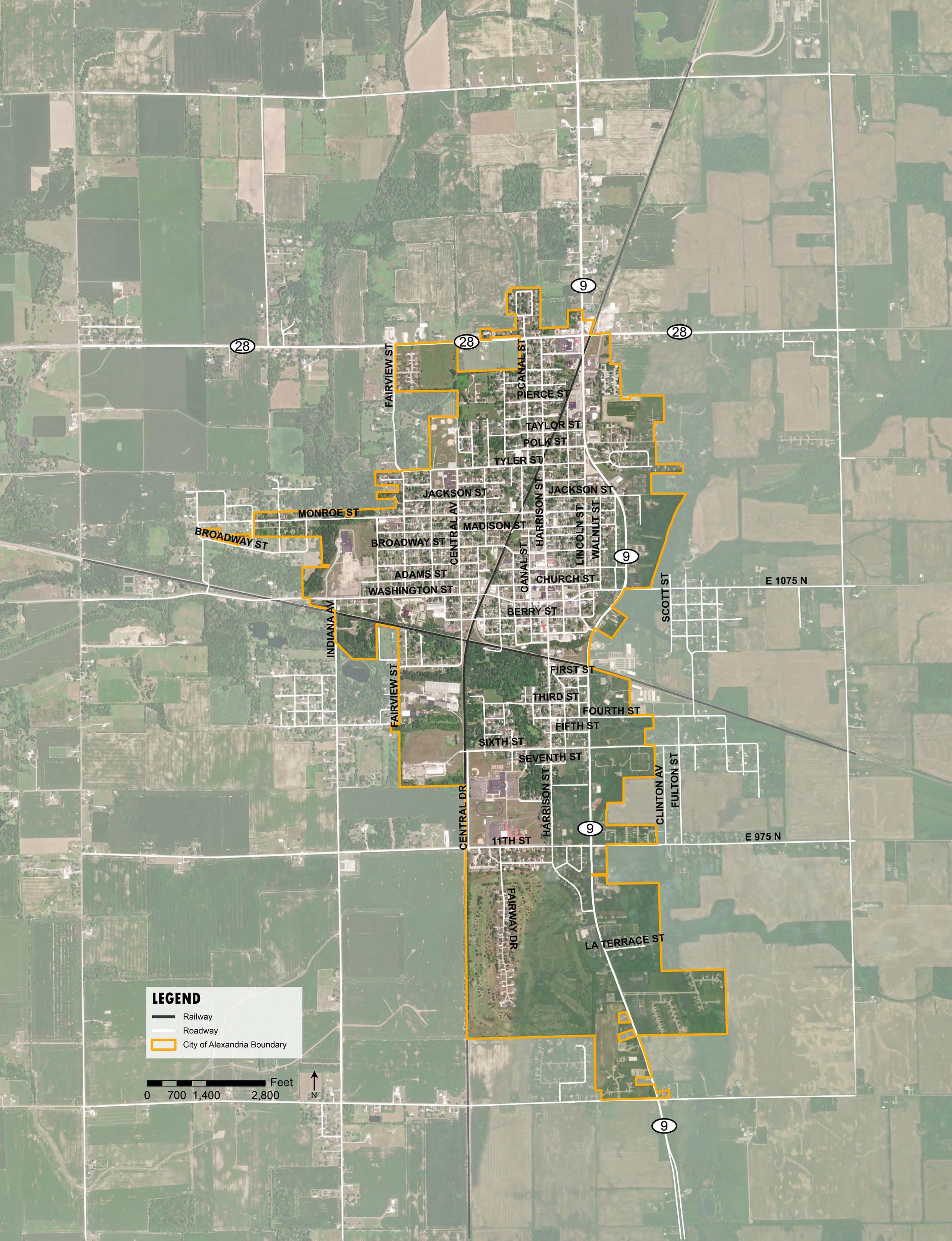
INCORPORATED LIMITS
not contain the actual decisions that should be made. It is, however, a policy document to help guide decision-making related to land use, growth, public investments, and economic development. It serves as a reminder of the community’s collective vision for the future growth and development of the area and should be used as such.
PROCESS TO DEVELOP THE PLAN
Planning is a continuous process that had been initiated prior to this plan and will continue after its adoption. This new Comprehensive Plan is the result of a detailed process that brought residents and stakeholders together to identify existing conditions throughout the City, recognize potential issues and opportunities, and ultimately create recommendations for the future. The plan was developed over nine months with oversight from the Comprehensive Planning Committee (CPC) which included representatives from the City Council, staff, business owners, and other community leaders. The CPC met four times during the process; these meetings were interactive work sessions and resulted in the overall input needed to develop the plan.
In addition to the CPC meetings, a series of focus group discussions was held towards the beginning of the process to gather input from key stakeholders and organizations. The goal of the focus group discussions was to assess the issues each group faces and understand what they hope to achieve through the comprehensive planning process.
Leaders and industry experts in each of the following categories were invited to participate:
• Business leaders and employers
• Developers, builders, and real estate professionals
• Community institutions, non-profits, and service organizations
• Neighborhood leaders and residents
• Regional partners
Additionally, the project team met with a government class at Alexandria-Monroe Jr/Sr. High School to get the student’s unique perspective on the opportunities and issues present in the community. A community open house was held early in the process to solicit input and discuss opportunities, issues, goals and recommendations for the plan. This open house took place in Beulah Park at the Emery Lee Building. Participants were able to voice their opinions, interests, and concerns about the current conditions and future vision for the community. A number of input and visioning exercises were facilitated, and City representatives and the consultant team were available to answer questions. In addition to in-person input opportunities, a project website was maintained throughout the process. This website included background information, meeting materials, and advertised meeting dates to keep the community informed of plan progress.
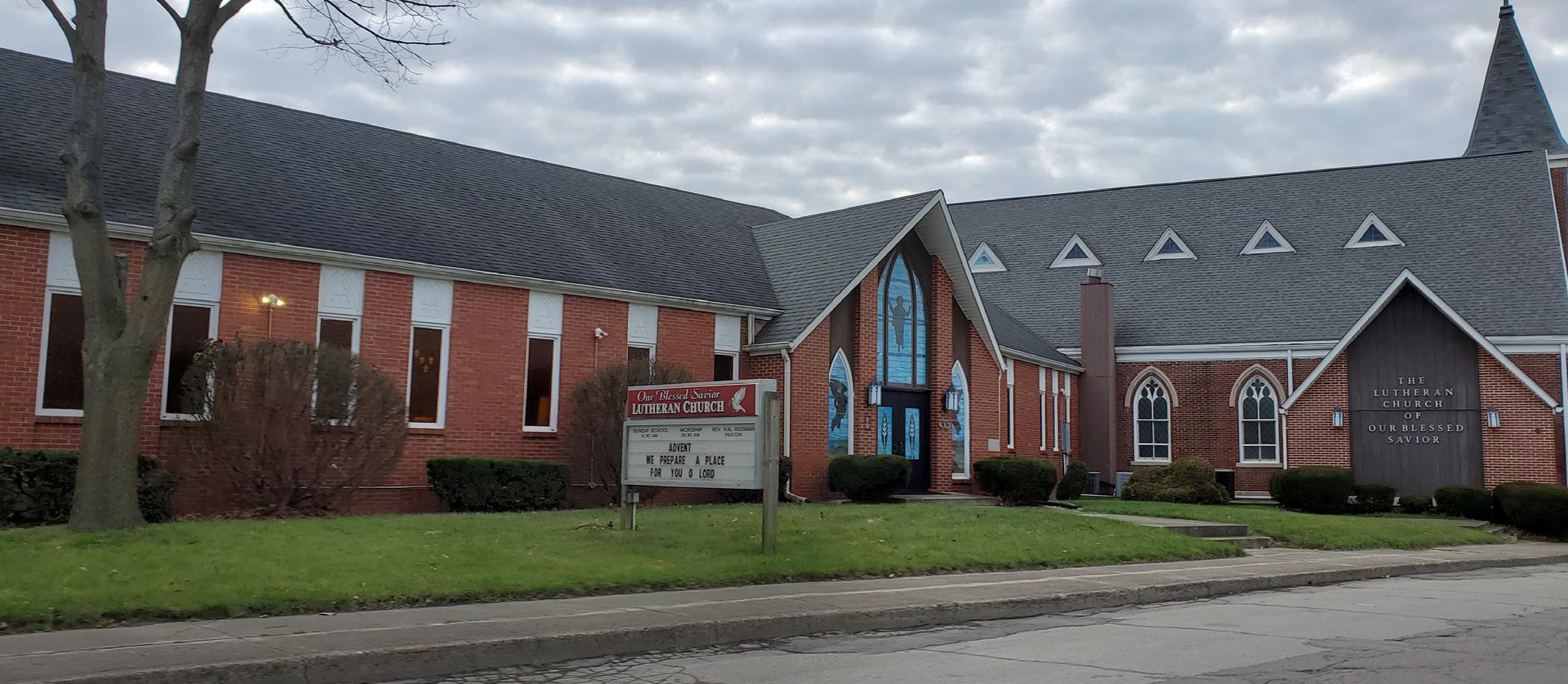
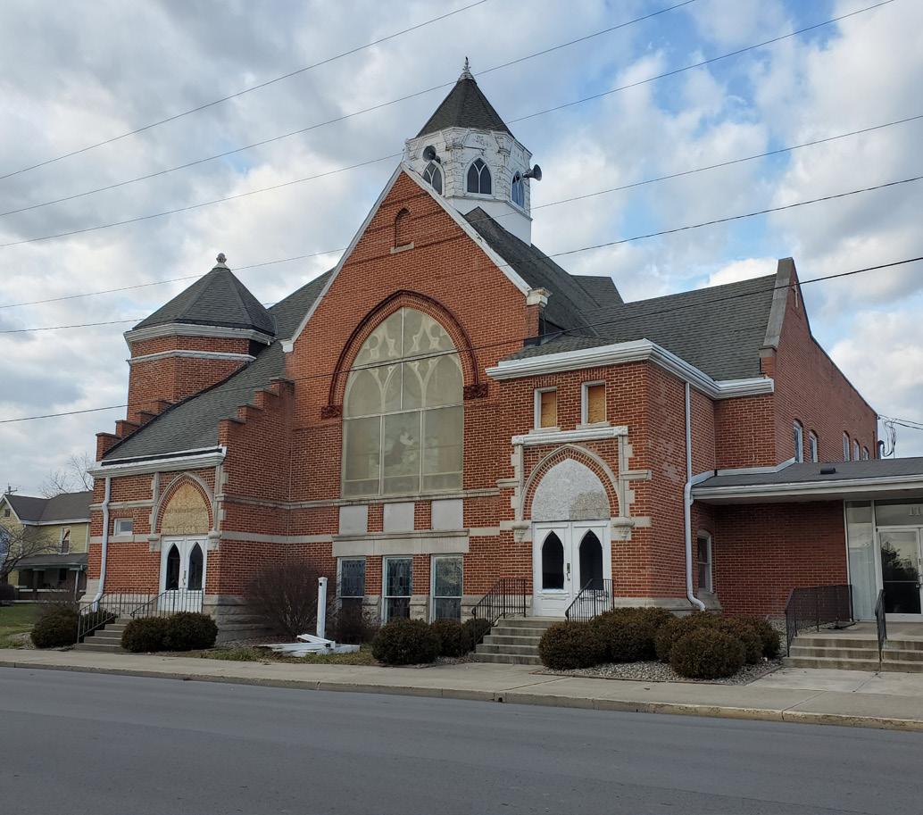
Our Blessed Savior Lutheran Church is one of many places of worship in Alexandria.
PLAN SUMMARY
The remainder of the plan is organized around a community background chapter, thirteen subject matter topics, and an implementation section. They thirteen subject matter topics are:
• Land Use
• Government & Fiscal Capacity
• Public Facilities & Services
• Placemaking
• Economic Development
• Housing
• Transportation
• Agriculture
• Natural Resources
• Parks & Recreation
• Broadband Access
• Historic & Archaeological Resources
• Hazard Mitigation
Each chapter includes a discussion of the existing conditions related to that subject, a vision statement, key goals, and supporting strategies. Also included in each chapter is a discussion of how to implement the recommendations for the respective subject as well as several proposed projects and the action items needed to realize their implementation.
The implementation chapter then goes on to detail how the plan should be interpreted, used to review development proposals, and monitored for needed amendment. A number of potential funding sources are also described to aid the City when undertaking individual project recommendations.
OVERALL VISION STATEMENT
Alexandria is a destination for families to live, work, learn, and grow. From Beulah Park and our growing downtown to two grocery stores and an amazing school campus, we are a connected community that values the diversity, health, and happiness of residents of all ages. We are committed to supporting and growing employment opportunities along State Road 9, Harrison Street, and in the planned industrial park while ensuring modern and high-quality City services are provided in a fiscally responsible manner. Residential development, new subdivisions together with homes constructed on empty lots, will attract homeowners and support businesses, both existing and new. Collectively, these achievements will help to grow household incomes and City revenue and be leveraged to support continued investment in the community and our residents.
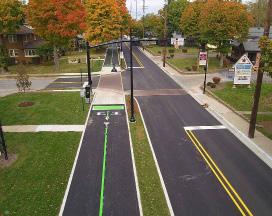
Newly updated sidewalks and crosswalk along Washington Street.
LAND USE
Vision
Develop a balanced mix of land uses, including residential, commercial, industrial, and institutional development, while preserving positive community characteristics and beneficial natural areas.
Goals
1. Encourage new construction and redevelopment on vacant and underutilized lots across the City.
2. Focus commercial and industrial development to the SR 9 and SR 28 corridors.
3. Promote downtown revitalization to attract destination retail and restaurant uses and result in increased residential dwelling units.
4. Work to attract family-oriented businesses and activities so that Alexandria may further establish itself as a desirable location for families in Madison County.
5. Ensure new development reflects the goals and recommendations of this plan, and that the City’s development codes and other ordinances are respected and enforced.
6. Consider annexation of developed areas outside of city limits that receive municipal services and only extend future services if potential development will be annexed into the City.
Projects
1. Review and amend the zoning ordinance to ensure it promotes development in accordance with the goals and recommendations of the comprehensive plan while not being so restrictive that it is an impediment to new development and redevelopment.
2. Conduct an annual review of the Comprehensive Plan and future land use map to ensure it remains in alignment with community growth and development goals.
GOVERNMENT AND FISCAL CAPACITY
Vision
Grow the City’s service and fiscal capacity in conjunction with new development to continue providing the high-quality services and amenities requested by residents and businesses.
Goals
1. Increase the tax base by attracting new development and focusing City investments where they will likely yield increases in valuation for property owners.
2. Continue to leverage the impact of local resources through the pursuit of state, federal, and private grant opportunities.
The SR 28 and SR 9 intersection, looking south.
3. Examine the fiscal impact of new development as part of the development review process, especially when incentives are offered or requested.
4. Continue to improve communication and outreach with residents and business owners.
Projects
1. Conduct a feasibility study to explore the possibility of a new City building, potentially on State Road 9, to increase the visibility of City services and provide a positive image of the City for visitors and through traffic.
2. Conduct a community survey to better understand resident and business perception of City services and preferred mechanisms for communication to create a better interface between City staff, residents, businesses, and visitors.
PUBLIC FACILITIES AND SERVICES
Vision
Maintain and expand public facilities, utility infrastructure, and City services to support existing residents and businesses and aid in the attraction of targeted growth and development.
Goals
1. Expand water and sewer capacity to better serve potential development in the industrial park.
2. Maintain and replace existing infrastructure as necessary to ensure quality service to existing residents and businesses.
3. Ensure new development and redevelopment can be sufficiently served by municipal utilities and other services.
4. Use the newly implemented stormwater fees to improve drainage issues across the City.
Projects
1. Create and maintain a 5-year capital improvements program to help prioritize and budget for future capital expenditures.
2. Review and amend the animal control ordinance and other City codes to be more effective in achieving desired goals.
3. Pursue state and federal grant opportunities to support water and sewer capacity improvements.
PLACEMAKING
Vision
Promote quality of life initiatives that support community health and well-being, educational attainment, and diverse cultural and recreational opportunities for residents and visitors.
Goals
1. Improve the appearance of the public rightof-way and private properties at gateway intersections and along State Road 9.
2. Leverage recent school enhancements to attract residential and employment growth.
3. Create opportunities for additional downtown gathering, recreation, events, and programming.
4. Increase civic participation across all age groups and cultures to build a more vibrant Alexandria and grow the next group of community leaders.
5. Promote public art on both City-owned and private properties, across the City.
Projects
1. Review and amend the zoning ordinance with respect to sign standards, outdoor storage, lighting, and landscaping along key corridors.
2. Implement a public relations and code enforcement campaign to address recurring property maintenance issues throughout the City.
3. Improve the sharing of positive information about the community and local businesses in order to spread good news and celebrate achievements, while combating negative attitudes and perceptions.
4. Become an Indiana Main Street community.
5. Create a public art program in conjunction with Alexandria-Monroe Junior/Senior High School and other City or regional organizations associated with the arts.
6. Design and construct a signature downtown gathering space that provides flexibility to host varied events and activities on the vacant Cityowned property at Harrison and Church Streets.
are one of several active recreation amenities.
ECONOMIC DEVELOPMENT
Vision
Improve employment opportunities by growing existing businesses and attracting new ones, in conjunction with career and technical education (CTE) programs aimed at developing a more skilled workforce.
Goals
1. Incentivize redevelopment of brownfield sites to create opportunities for new industrial and commercial development.
2. Focus business attraction and retention efforts on industries that will provide quality, well-paying jobs to area residents.
The Little League baseball fields on the north side of the City
Red Gold is a major employer located just west of Alexandria.
3. Continue to develop partnerships between Alexandria Community Schools, post-secondary education institutions, and area employers to enhance workforce development and career ladder programs.
4. Utilize available incentives such as tax increment financing (TIF) districts, tax abatement, and other tools to aid in business retention and attraction efforts.
5. Recognize and promote small businesses and local entrepreneurs as a fundamental component of the local economic ecosystem.
Projects
1. Inventory brownfield sites and other vacant or underutilized properties, contact owners, understand potential contamination and redevelopment limitations, and act as liaison so these properties don’t end up at tax sale or online real estate sales and get purchased by out of state owners.
2. Create a pop-up retail village in the downtown to facilitate small business start-ups.
3. Assist local economic development officials in renewing purchase options for the industrial park properties, get proper zoning in place, and continue to promote development opportunities.
4. Create a downtown business plan in conjunction with the Main Street organization to focus a business recruitment strategy and prioritize needed physical improvements.
HOUSING Vision
Strengthen and maintain existing neighborhoods while supporting the construction of varied housing types to attract new homeowners and serve residents of all incomes and ages.
Goals
1. Target City investments in streets, sidewalks, utility infrastructure, and lighting to focused redevelopment areas to support market-driven reinvestment in housing stock.
2. Consider a residential rehabilitation program, similar to a commercial façade program, to promote home-owner improvements to residential structures in the City’s neighborhoods.
3. Ensure opportunities exist for the creation of housing options for first-time buyers, repeat or move-up buyers, and renters both with the future land use plan and zoning ordinance and map.
4. Encourage mixed-density neighborhoods that provide single-family detached homes, townhomes or other single-family attached homes, as well as multi-family apartments within the same neighborhood.
5. Ensure new housing developments contribute to overall community character through the provision of open spaces, trails, landscaping, and other amenities.
Projects
1. Update the zoning ordinance to correct unbuildable lot issues (minimum lot area) and permit a wider array of dwelling types, including accessory dwelling units, in residential districts.
2. Create a rental registration program to ensure accurate and up-to-date contact information for owners to better keep negligent landlords accountable for their properties.
3. Increase code enforcement efforts to ensure safety and improve the appearance of City neighborhoods.
4. Explore creation of a land bank program, potentially in conjunction with the City of Anderson and/or Madison County, to acquire, hold, sell, and sometimes redevelop property so that vacant and underutilized properties are put back to productive use.
TRANSPORTATION
Vision
Maintain a safe and efficient transportation system for all ages and abilities, that connects neighborhoods, community destinations, and employment centers.
Goals
1. Improve connectivity and accessibility between existing neighborhoods and destinations such as commercial areas, schools, parks, and the downtown with improved pedestrian facilities such as sidewalks, multi-use paths, trails, and safe crossings at major intersections.
2. Evaluate options to include new pedestrian and bicycle facilities when undergoing other public works projects.
3. Ensure safe railroad crossings and explore options to limit negative impacts of train traffic through the City.
4. Use investments in transportation and utility infrastructure as a mechanism to direct desired development types in appropriate locations.
5. Communicate with the Indiana Department of Transportation (INDOT) regarding City goals for improvement projects to state controlled routes through Alexandria.
6. Continue to maintain an Americans with Disabilities Act (ADA) Transition Plan.
Projects
1. Continue to leverage local funds with Community Crossings and other state, federal, or private grant programs as they may be available.
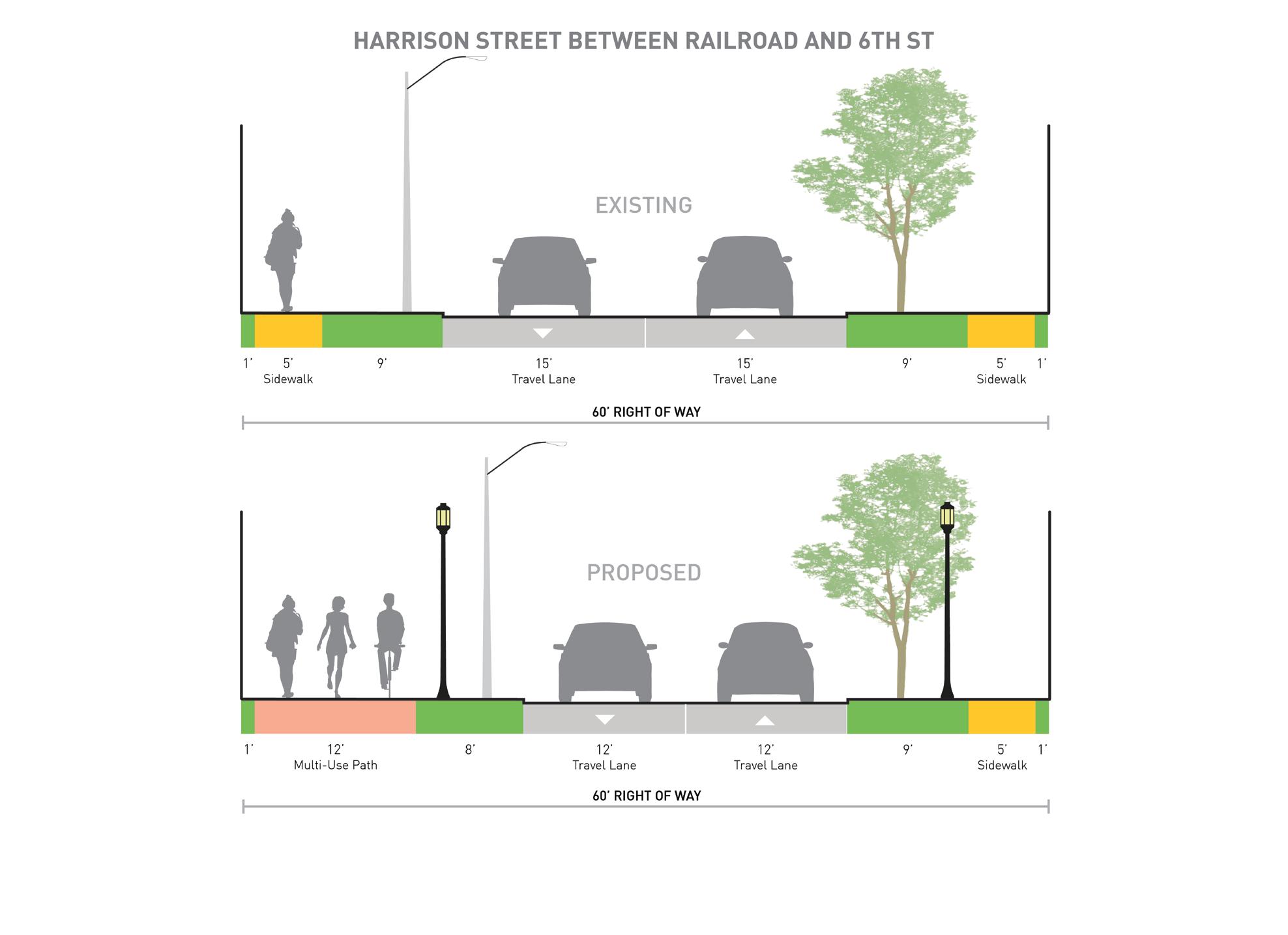
2. Implement streetscape improvements to Harrison Street through the downtown area to improve pedestrian walkability and safety, onstreet parking, lighting, and aesthetics.
3. Continue planning for and construct a trail system through the City-owned wooded property south of the railroad tracks and west of Harrison Street.
Thrift shop along Washington Street.
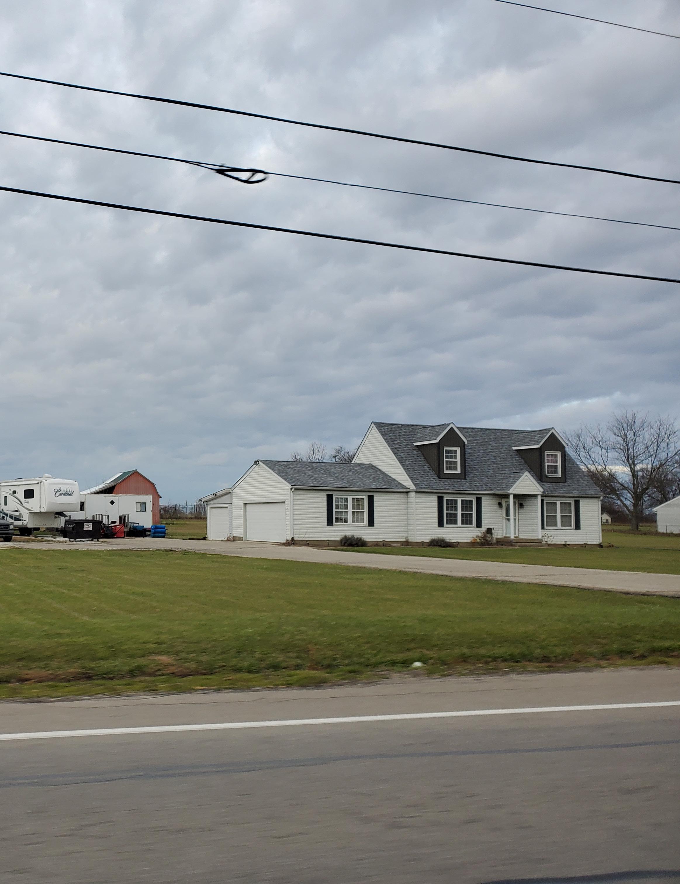
Many Alexandria homes date to before the 1960s.
4. Implement improvements included in the 2018 Americans with Disabilities Act (ADA) Transition Plan in conjunction with other capital improvement planning efforts.
5. Study potential railroad crossing improvements or alternate route solutions to be included in future regional long range transportation plans.
AGRICULTURE
Vision
Recognize the importance of agriculture to the regional economy by promoting the viability of agriculture operations while ensuring properties within city limits are protected from the potential negative impacts of large-scale operations.
Goals
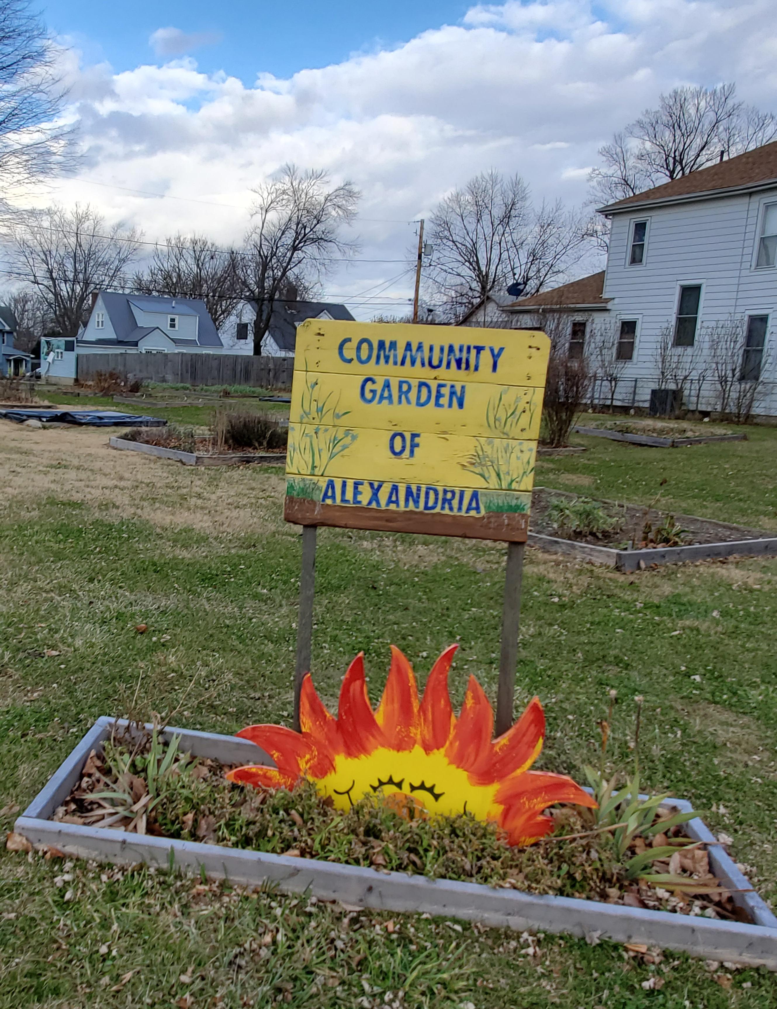
1. Continue hosting the community garden on the City-owned property on Church Street.
2. Continue to promote local agriculture farms and businesses with the farmer’s market and future City programming activities.
Projects
1. Promote existing agriculture and food processing businesses as a means to attract additional employers and grow regional job opportunities, at the planned industrial park and around Alexandria.
NATURAL RESOURCES
Vision
Protect the natural assets within Alexandria in coordination with community land use planning, construction on privately owned property, and parks and recreation development.
Goals
1. Identify and protect environmentally sensitive areas, such as floodplains and wetlands, to limit potential negative impacts from development and ensure long-term environmental quality.
2. Promote development of public and private recreational activities that preserve and provide access to significant natural areas.
3. Continue application of the Flood Damage Prevention standards of the Land Usage code.
Projects
1. Review and amend the zoning ordinance to better protect environmentally sensitive lands, significant forest areas, and other natural features.
The Curve restaurant is a staple of the community.
PARKS AND RECREATION
Vision
Enhance existing City parks and open spaces with additional amenities and programming to support an active and healthy community, promote resident attraction goals, and economic development efforts.
Goals
1. Expand programming activities in parks and public spaces, with opportunities for all ages throughout the year.
2. Increase the use of flood plain areas for public recreational use.
3. Develop a long-range plan for the development and maintenance of the Town’s park and recreation facilities.
4. Upgrade amenities in existing park facilities.
Projects
1. Develop an Indiana Department of Natural Resources (IDNR) Five-Year Parks and Recreation Master Plan to be eligible for potential grant programs.
2. Work with Alexandria Community School Corporation and youth sports leagues to upgrade the fields and amenities at the Little League ballpark.
3. Continue planning for and construct a trail system through the City-owned wooded property south of the railroad tracks and west of Harrison Street. (same as Transportation)
4. Plan for and construct a disc golf course in conjunction with a proposed trail system on the City-owned wooded property south of the railroad tracks and west of Harrison Street.
5. Explore the inclusion of recreational amenities within the proposed downtown signature gathering space.
BROADBAND ACCESS Vision
Expand broadband access across Alexandria to support economic development, online education and skill development, access to remote healthcare, and general communication improvements to enhance quality of life and resident and business attraction efforts.
Goals
1. Increase broadband service in conjunction with regional service providers.
2. Coordinate utility, transportation, stormwater, and other infrastructure improvements to combine construction projects, reduce costs, and expand broadband infrastructure where possible.
Projects
1. Pursue Broadband Ready Community Certification to better position the City for increased broadband deployment.
2. Work with local broadband providers to pursue Next Level Connections Broadband Program funding to expand broadband service in and around Alexandria.
3. Implement a free downtown wifi system to serve businesses, residents, and visitors.
HISTORIC AND ARCHAEOLOGICAL RESOURCES
Vision
Promote and protect the City’s unique historical and archaeological assets so that they may be enjoyed by current and future residents and visitors.
Goals
1. Preserve historic buildings, structures, and sites across Alexandria.
2. Promote the Alexandria Monroe Historical Society, its museum, resources, and events with City communications.
Projects
1. Develop design guidelines to be included in the zoning ordinance to ensure appropriate restoration of existing, historic structures and construction of new buildings in the downtown.
2. Create a façade improvement program to help downtown property owners preserve and enhance important building stock.
3. Increase code enforcement efforts in the downtown to ensure buildings are not damaged beyond repair because of neglect or lack of investment by property owners.
HAZARD MITIGATION
Vision
Proactively plan efforts to reduce the risk to people and property from natural hazards, especially those associated with the floodplain of Pipe Creek.
Goals
1. Reduce flooding impacts to properties within the Pipe Creek floodway and floodplain.
2. Encourage green infrastructure and stormwater best management practices in new development and redevelopment to reduce overall stormwater flows and help to reduce the impacts of flooding events.
3. Ensure critical City facilities are protected from damage during hazard events so that they may maintain or quickly resume key service functions.
4. Coordinate with the Madison County Emergency Management Agency regarding on-going and future hazard mitigation planning.
Projects
1. As part of other zoning ordinance amendments, consider including incentives for use of green infrastructure in new development and redevelopment.
2. Explore regional detention improvements to reduce the size of the Pipe Creek floodplain, resulting in fewer structures within the floodplain, and lesser impacts during flood events.
2General Background
The City of Alexandria is located in Madison County, Indiana. It covers just over threesquare miles (3.02) and is home to 4,900 residents. It is approximately 46 miles northeast of Indianapolis, 10 miles north of Anderson, and west of Interstate 69. State Road 28 runs east-west through the very northern part of Alexandria, and State Road 9 runs north-south through the middle and eastern portion of the City. It is roughly bounded by State Road 28 to the north, State Road 9 to east, 900 North to the south, and North 100 West, and the CSX railroad to the west.
Due to its location, Alexandria is a bedroom community where many of the residents work outside of the City, supporting several nearby cities and towns, and return home in the evenings. Alexandria has several schools for children to attend within the Alexandria-Monroe Community School Corporation that serves much of the Monroe Township population as well as Alexandria. Alexandria-Monroe Elementary School, Alexandria-Monroe Intermediate School, Alexandria-Monroe Junior/Senior High School, and Saint Mary Church and School are all options for children to attend. In recent years, the Alexandria-Monroe schools have been growing and attracting more students from other communities.
Much of the land within the City is residential, but several annual events attract people from all over the county and other neighboring areas. The Madison County 4-H Fair is held in Alexandria at Beulah Park on the eastern side of the City, the Grand Prix (Go Karts) is held in the summer within the downtown, and several festivals and holiday events take place throughout the year, including the Farmer’s Market which takes place at Beulah Park.
DEMOGRAPHICS
Population & Change
Alexandria has experienced many changes since it was first platted in 1836, and finally incorporated as a town in 1898. The Decennial Census looks at the population counts in 10-year intervals starting from 1870 until 2010. Alexandria’s peak population was in 1900 with 7,200 residents. There was a decline in population over the next 20 years and then steady population increases for six decades. Since 1980 however, the population has fluctuated up and down.
One of the biggest challenges currently facing the community is population decline. Since 2011, the community has seen year over year decrease in total population. While Alexandria may have only lost 250 people in the past 8 years, this is a significant percentage for a community of this size. Overall, there has been a five percent decrease in total population between 2011 and 2019. This trend suggests larger community issues. This may include, but is not limited to, housing quality, housing options, job availability, quality of life, and overall availability of activities and events to do and participate in.
Decennial Census, 1870 - 2010
Wikipedia, Alexadria, Indiana
Source: U.S. Decennial Census
Total Population Change, 2011 - 2019
Source: ACS 5-Year Estimates
INCORPORATED LIMITS
Population by Race
The City of Alexandria is not very diverse as the majority of residents identify as white. Less than three percent of the total population identify as Black or African American, Hispanic or Latino, or two or more races.
Population Pyramid
When looking at the age breakdown of the residents of Alexandria, there are 2,277 male and 2,711 female residents. Looking at the pyramid indicates a high number of children and teens, meaning several
Race Breakdown, 2019
Source: ACS 5-Year Estimates 2019
Population Pyramid, 2019
Source: ACS 5-Year Estimates 2019
families live in the City. Starting at the 55 and older age groups, there is a significant difference between the number of female and male residents. This could indicate that more women live in Alexandria, and also that women live longer than men.
There is a healthy population of people aged 20-29 living in the community. Communities of similar size often do not share this trend as young adults move away for college and other opportunities that may not be present in their area. To Alexandria’s benefit, this keeps the community young and diverse across all age groups.
Median Age, State & Alexandria
The median age of people in Alexandria generally aligns with the state. The total population is younger than the state, as are the average age of male residents. Female residents are almost three years older than the state average age.
Median Age, State of Indiana & City of Alexandria Comparison, 2019
Median Age, State of Indiana & City of Alexandria, 2019
Source: ACS 5-Year Estimates 2019
Source: ACS 5-Year Estimates 2019
Household Size, State of Indiana & City of Alexandria, 2019
Housing Breakdown, State and Alexandria
The City of Alexandria has 2,279 total housing units; about 400 of them are vacant. When compared to the State of Indiana, Alexandria has a 6% higher vacancy rate, a 2.6% higher rental rate, and a 2.6% decrease in ownership rate of housing. The vacant rate is concerning for the community as it may be due to unlivable housing structures that need rehabilitation or demolition.
Average Household Size, State and Alexandria
The City of Alexandria and the State of Indiana generally align in their average household size. Indiana’s is 2.52 persons while Alexandria’s is 2.6 persons.
Housing Breakdown, State of Indiana, 2019
Source: ACS 5-Year Estimates 2019
Housing Breakdown, Alexandria, 2019
Source: ACS 5-Year Estimates
Average Household Size, State of Indiana & City of Alexandria, 2019
Source: ACS 5-Year Estimates
Housing Structure Built by Year
The City of Alexandria has had little housing development since 2010. The majority of housing structures within the community were built between 1950 and 1959 (634 housing units), followed by housing that was built in 1939 or earlier (459 housing units). This means that many of the housing structures within the community are older and likely need rehabilitation. Roughly 700 homes were built between 1960 and 1979. The newest structures were build between 2000 and 2009 with only 70 houses constructed during that nine-year time period.
Income per Capita, State and Alexandria
Alexandria residents earn about $5,000 less when compared to the average State of Indiana resident in
Housing Structures Built by Year, 2019
terms of per capita income. In 2019, it was recorded that Alexandria residents earn just under $25,000 while the average Indiana resident earns just under $30,000. This a 19% difference between the City and State.
Median Household Income, State and Alexandria
On a positive note, the median household income of Alexandria compared to the State is nearly equivalent. While the median household income for the State comes in at about $56,300, Alexandria’s is $55,300, which is a two percent difference. This means that some jobs held by residents are high paying.
Income per Capita, State of Indiana & City of Alexandria, 2019
Source:
Median Household Income, State of Indiana & City of Alexandria, 2019
Source:
Gross Rent
Rent prices in Alexandria do not exceed $1,500 based on the 2019 American Community Survey data. There are 634 units available to rent in the City and the majority of those units fall between the $500 and $999 range (486 units). There at 68 units that are less than $500 per month and 80 units that fall between the $1,000 and $1,499 range.
Gross Rent as a Percentage of Household Income (GRAPHI)
While the rent prices may look affordable when compared to larger cities, it is important to look at the gross rent as a percentage of household income (GRAPHI) to get a better idea of how affordable it is for those who are renting. Typically speaking, no
Gross Rent, 2019
$2,500 -
$2,000 - $2,499
$2,000
$1,500 - $1,999
$1,000
more than 30% of a person’s gross income should be spent on rent. If a person is spending more than 30%, the price is considered not affordable, while if they are spending less than 30% it is considered affordable.
In total, there are 193 households that are paying 30% or more of their gross income, which means roughly 30% of total renters in Alexandria are living in “unaffordable” units. This could indicate that several renters have low paying jobs or may potentially be unemployed. On a positive note, there are 220 units where renters have indicated that only 15% to 19.9% of their gross income goes to rent. Alexandria is an affordable place to live as the majority of renters are paying less than 30% of their gross income.
Source: ACS 5-Year Estimates 2019
Gross Rent as a Percentage of Household Income, 2019
Source: ACS 5-Year Estimates 2019
Educational Attainment
In 2019, 85.8% of Alexandria’s residents reported that they had obtained a high school diploma or gone on to continue school. Of those who had obtained a Bachelor’s Degree or higher, there were 14.2% of residents reported.
Educational Attainment, State and Alexandria
Compared to the State, Alexandria has 17% more people who have graduated from high school or continued their education; however, there is a 46% decline in those who have obtained a Bachelor’s Degree or higher.
Educational Attainment, 2019
Source: ACS 5-Year Estimates
Attainment, 2019 Source:
Educational Attainment, State of Indiana & City of Alexandria, 2019
Source: ACS 5-Year Estimates 2019
Employees by Industry
The industry that employees the most residents of Alexandria is the educational services and health care and social assistance industry. There are four schools within Alexandria which makes sense, but for those who travel outside of the City for work, they may work in other similar fields there. The next largest industry is manufacturing, followed by other services excluding public administration. There are very little people employed in the wholesale trade industry, and within the agriculture, forestry, fishing and hunting, and mining industries.
Major Employers in Madison County
Employment numbers by specific business or organization are not available at the city level. Top employers in Madison County has been maintained by Data Axle and reported on the Hoosiers by the Numbers website (www.hoosierdata.in.gov).
The only Alexandria organization on the top ten employers list in Madison County is the Gaithers’ Co. The other large employer in close proximity to Alexandria is Red Gold Inc., located just west in Orestes. Given that educational services, and health care and social assistance is the largest industry in Alexandria, it is likely that the Alexandria Community School Corporation is major employer for the City despite not being in the top ten for the County. A number of Alexandria residents travel to Anderson for employment and likely hold some of the jobs at large employers there. The ten largest employers in Madison County are:
1. Carter Express (Anderson)
2. Community Hospital Of Anderson (Anderson)
3. St. Vincent Anderson Community Affairs (Anderson)
4. Harrah’s Hoosier Park Racing (Anderson)
5. Gaithers’ Co (Alexandria)
6. Red Gold Inc (Orestes)
7. Correctional Industrial Facility (Pendleton)
8. Guide Corp (Pendleton)
9. Nestle USA (Anderson)
10. Walmart Supercenter (Anderson)
Unemployment in Madison County, January 2020 – May 2021
The COVID-19 Pandemic caused a major disruption for employers and workforce across the nation. Using State data, the unemployment rate for Madison County was analyzed monthly between January of 2020 through May 2021. Before March 2020 when the State and Country went into lockdown, Madison County had roughly 2,500 unemployed people. Midway through March when the lockdown started, thousands of people lost their jobs. In April 2020, there is a spike to show than 10,200 people across the county lost their jobs. Since then, the County has been recovering from their high unemployment rate and almost reached pre-pandemic unemployment rates in the span of a year.
Alexandria Employees by Industry, Ages 16 and Older, 2019
Source: ACS 5-Year Estimates 2019
Unemployment in Madison County, January 2020 - May 2021
Source: ACS 5-Year Estimates 2019
Source:
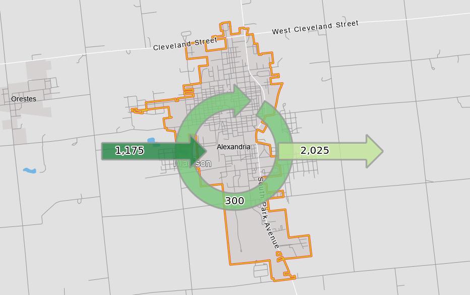
Inflow/Outflow of Job Counts
The inflow and outflow map graphic depicts the number of people coming into Alexandria for work, leaving Alexandria for work, and residents who work within Alexandria. Just under 1,200 people come into the City for work while over 2,000 of Alexandria’s residents work elsewhere outside the City. Approximately 300 residents remain within the community to work.
This could indicate that several residents do not have the skills needed to fulfill existing jobs within the community or are leaving to utilize their skills. Alexandria may not have jobs available for residents with specialized skillsets to work, so they leave to work elsewhere in the County or further away. Residents may work elsewhere for higher paying job opportunities as well. Residents who live and work within the community may be business owners, work for the City, or have a job that allows them to work from home.
Key Anchors
Alexandria may be small, but there are several key anchors and amenities to help keep the
Inflow/Outflow of Jobs, 2019
City alive without sacrificing the small-town feel many residents love. There are several faithbased organizations within the community, small businesses and restaurants, and a few medical/ health centers including the Alexandria Care Center, Ascension Medical Group, Alexandria Health and Wellness, and the Jane Pauley Community Health Center.
These key anchors are:
• Alexandria-Monroe Elementary School
• Alexandria-Monroe Intermediate School
• Alexandria-Monroe Junior/Senior High School
• Saint Mary’s School
• Alexandria Community Center
• Beulah Park
• Madison County Fairgrounds
• Alexandria-Monroe Public Library
• Alexandria-Monroe Historical Society
• City Hall
• Gaither Studios
Commuting Patterns: Work to Home, 2019
Source: onthemap.ces.census.gov
Commuting Patterns: Home to Work, 2019
Source: onthemap.ces.census.gov
3Comprehensive Planning Committee (CPC)
The Comprehensive Planning Committee (CPC) was essential in leading the planning process. The CPC provided input to create the plan’s vision, goals, and strategies, and confirmed proposed projects and implementation recommendations. The CPC was created by the Mayor’s office and included the Mayor, City Staff, Plan Commission representatives, County Council representatives, local business owners, representatives of faith-based organizations serving the community, and residents. This group of individuals met five times during the process. Some of the CPC members also participated in focus group meetings that were held early in the process and an open house described later in the plan on page 39. Following the adoption of the plan, the CPC will be essential in promoting the plan and ensuring the implementation and development of projects are moving forward. The diversity of the CPC members was intentional to include local leaders and representatives to help drive the action-oriented recommendations forward into reality and create meaningful change within the City of Alexandria once the plan is adopted.
CPC MEMBERS
Alan Moore – City of Alexandria Economic Development Dept.
Amy Bair – Resident
Amy McCurry – Alexandria City Council, Business Owner
Andy Diruzza – City of Alexandria Fire Dept.
Ashley Olibas – Alexandria-Monroe Chamber of Commerce
Autumn Carroll – City of Alexandria Administrative Assistant to the Mayor
Brian Cuneo – City of Alexandria Fire Chief
Gina Brisco – Gaither Music
Jennifer Ward – Business Owner
John Burdsall – Resident
Lance Love – City of Alexandria Building Commissioner
Lindsey Cuneo – Downtown Property Owner
Mark Long – Business Owner
Mike Montgomery – City of Alexandria Police
Penny Stevens – Senior Living Coordinator, City of Alexandria Redevelopment Commission, Alexandria Community School Corporation Board Member
Stephanie Baladge – Alexandria Community Schools
Tiffany Clegg – Business Owner
Todd Naselroad – City of Alexandria Mayor
Tom Johns – Alexandria Community School Corporation
Wayne Bruzzese – Business Owner
Wendi Goens – Alexandria City Council
Xavier McCurry – Resident
COMMITTEE’S WORK & MEETINGS
This section outlines the work that the Comprehensive Planning Committee (CPC) has put into the plan including the meetings and open house (public event) held throughout the process. Over the last year, multiple meetings were conduction with the CPC and led by the consultant team. One additional event, Alexandria’s annual Grand Prix, allowed for more of the public to get involved and provide input. The meetings and events held throughout the process were:
• May 5, 2021 – Kick-Off Meeting with City Staff
• June 29, 2021 – CPC Meeting 1
• August 3, 2021 – CPC Meeting 2
• October 19, 2021 – Focus Group Interviews and Open House
• November 4, 2021 – CPC Meeting 3
• December 9, 2021 – CPC Meeting 4
May 5, 2021 – Kick-Off Meeting with City Staff
The project kick-off and coordination meeting was the first meeting held during the planning process. The consultant team met with City Staff at City Hall and focused primarily on introductions and review of the comprehensive planning process. This included:
• Reviewing the schedule of the planning process.
• Determining who would be a part of the Comprehensive Planning Committee (CPC) and participate in the meetings.
• Creating a public engagement plan.
• Discussing focus group participants.
• Determining local events and locations to hold public meetings and engagement opportunities.
• Creating a project website.
• Discussion of past plans and additional information or data the City could provide. This meeting set the framework for the project and determined meeting schedules and upcoming public events that would provide additional public engagement opportunities.
Members of the CPC at the first meeting held on June 29, 2021
June 29, 2021 – CPC Meeting 1
The first CPC meeting was the second meeting in the planning process. This meeting focused on the introductions between the CPC members and consultant team to get to know each other. A basic understanding of what a comprehensive plan is and does was discussed during a short presentation. The presentation also included a review of the planning process schedule, socioeconomic analysis review, and a discussion. The group was asked about what they wanted to see the plan accomplish and to help identify assets, issues, and opportunities within the community.
May of the comments focused on the following key factors:
• Solidifying a vision for the community.
• State Road 9 versus Harrison Street (downtown) development opportunities.
• Housing development.
• Quality housing developments and upkeep of existing structures.
• Variety of options for young families and senior living.
• Providing affordable housing options for buyer.
• Renter versus owner occupied units.
• Improved quality of life.
• Connectivity across the community. Each of these elements will be further expanded in later chapters. Additional concerns brought up in this meeting included outdated zoning, contaminated sites, underutilized industrial sites, the railroads and number of trains that pass through the community, and attracting and retaining people, businesses, and jobs.
August 3, 2021 – CPC Meeting 2
The second CPC meeting did not have a presentation, but the consultant team reviewed the first meeting’s key takeaways and went over the 13 topics the comprehensive plan will cover. The consultant team provided aerial maps of the City of Alexandria’s city limits and broke into discussion groups to begin working towards addressing key issues and concerns identified by the CPC members. The map was used to identify specific areas in the community that needed more attention or were problematic, or where future development or expansion could be located. This discussion was useful in guiding the consultant team to ensure that the plan would address and carry out future wants and needs.
The outline of the 13 topics was created by the Indiana Office of Community and Rural Affairs (OCRA). It was touched on in the first CPC meeting to show everyone how the plan would be organized. The second meeting focused on these specific topics to help the consultant team understand the existing conditions of the community. This information was then used to begin crafting a vision and realistic goals and objectives that the community could achieve over time.
October 19, 2021 – Focus Group Interviews and Open House
The consultants spent a day in Alexandria conducting focus group interviews and holding an open house event in the evening. There were six focus groups which invited several business owners, investors, economic developers, government officials, and a high school government class to provide their thoughts and opinions about Alexandria. Several issues and opportunities were discussed throughout the day about Alexandria involving the need for new development, especially commercial, retail, and entertainment opportunities for families and teenagers.
The open house was a continuation of the conversations held throughout the day. The informal event allowed anyone in the community to stop by and learn about the planning process. Several activity boards were on display for visitors to participate in and provide input on opportunities and concerns within the community. These exercises included a visioning board for people to write down their ideas about what the plan should accomplish and several boards on various topics including land use, transportation, quality of life, economic development, and the downtown where people could vote on what they believed was most important to address in each of the categories.
Resident identifies places around the community of concern in one of the several activities at the open house event
Residents participating in one of the activities at the open house
Existing conditions boards presented at the open house
November 4, 2021 – CPC Meeting 3
The third CPC meeting did not have a presentation. Instead, the consultants provided a handout for the members to review as the consultant team reviewed the drafted vision statement and several of the objectives for each of the 13 topics identified by the Indiana Office of Community and Rural Affairs (OCRA). While not every statement was reviewed in detail, the CPC members provided input on what objectives needed to be edited or removed, provided additional ideas of objectives that could be added, and provided their thoughts on the drafted vision statement.
A revised vision statement was created during the meeting with the intent it would be reviewed at the next meeting as well.
December 9, 2021 – CPC Meeting 4
The fourth CPC meeting reviewed the changes made to the vision statement and objectives that were changed based on the input from the third meeting. Once the members confirmed the changes, the consultant team led a discussion about future use maps and graphics created for the comprehensive plan. These maps included the future land use map, as well as accompanying land use descriptions, the future transportation map, and the future trails map. Sections for Harrison Street were shown to the CPC members to depict how current conditions of the roadway could be redeveloped to include bicycle and pedestrian facilities and make the downtown more accessible. Precedent imagery was shown to help identify how development could potentially look in the future at an appropriate scale for Alexandria.
The meeting ended by identifying key dates for the draft plan, the final CPC meeting, and discussing the OCRA review process and adoption timeline.
ROLE OF THE CPC
As reflected in the meeting summaries, the Comprehensive Planning Committee’s (CPC) role included overall project guidance and well as specific recommendations for subject matter topics. More specifically, the CPC:
• Served as a liaison between the broader community, OCRA, partner organizations, and City leaders.
• Engaged in studying key data indicators and confirming data analysis performed by the consultant team.
• Actively participated in developing the plan and public input process for the City of Alexandria Comprehensive Plan.
Members of the CPC will serve as key implementation drivers in the following months and years once the plan is adopted.
The CPC confirmed the community profile, demographic and economic analysis, and key indicator findings presented by the consultant team. They also helped to provide much of the background and existing conditions information relevant to each subject matter topic, identified
issues and opportunities present in the community, and helped develop plan goals, strategies, and recommendations.
The CPC meetings typically included a brief presentation of research and analysis findings followed by a facilitated discussion led by the consultant team. These discussions were either broken into group activities or informal discussions to review the consultant team’s work while developing the plan, including the vision and goal statements, recommendations, future maps, and other supporting graphics. The results of these discussions were summarized by the consultant team and presented back to the CPC for confirmation of the plan direction and consensus. The CPC was generally in agreement regarding the plan direction and recommendations with little problem reaching consensus.
Finally, some CPC members participated in the open house which was a community engagement effort and promoted the event with friends, family, and neighbors via flyer, social media, and word of mouth. This plan would not have been possible without the continued participation of the CPC throughout the process and their attention to detail to create a future vision for Alexandria.
The Visioning exercise at the open house allowed residents to write down their ideas and wishes for the future of Alexandria
4Land Use
The City of Alexandria is approximately 3.02 square miles. Alexandria has grown since the 2010 census in which the City was only 2.63 square miles. Alexandria is located in Madison County, about 10 miles north of Anderson Indiana. Alexandria is 42 miles northeast of Indianapolis. Alexandria has two state roads to the north and east of the City boundaries. State Road 28 (SR 28) runs east-west to the very north of Alexandria’s boundary and State Road 9 (SR 9) runs north-south along the eastern portion of the City.
The City is divided into three zoning districts: residential, commercial, and industrial. Within the commercial and residential uses it is broken into more specific types that affect the type of development that can occur within that parcel. In total there are seven districts identified in total including: B1, B2, C1, I1, R1, R2, R2 to B1. The future land use map included more detailed categories of the development across the community: single-family residential, multi-family residential, mixed-use, commercial, industrial, institutional, parks and open space, and the floodplain. The remainder of this chapter expands on the discussion of land use in Alexandria and explores goals and recommendations for future development.
EXISTING CONDITIONS
To plan for future growth and development, it is important to understand the existing land use of the community. The existing land use pattern shows not only where concentrations of certain uses are and how the community developed but also what land may be available for new development and redevelopment, and what type of development pressure there may be in the future.
Alexandria’s downtown is located along Harrison Street north of Washington Street. This area is a good central location for businesses, restaurants, and government facilities, and it offers an opportunity for redevelopment and new construction to bring new life back into the area. State Road 9 bypasses the downtown and is a secondary location for commercial development to expand and to capture more revenue from visitors for the City to use.
State Road 9 is a major roadway that will connect residents and visitors to anywhere in the community including parks, neighborhoods, restaurants, schools, and other destinations. State Road 9 will also connect travelers to Interstate 69, which is 7-9 miles from the downtown; there are two interchanges nearby off State Road 28 to the northeast, and 900 N to the southeast respectively.
The City is a part of the Alexandria-Monroe Community School Corporation which serves Alexandria and the population of Monroe Township. Alexandria has four schools; three are public schools and one is private. The three public schools include: Alexandria-Monroe Elementary School (grades Pre-K through 2), Alexandria-Monroe Intermediate School (grades 3 through 6), and Alexandria-Monroe Junior/ Senior High School (grades 7 through 12). The one private school in the City is Saint Mary Church and School, which is a Catholic school, and serves grades Pre-K through 8.
While there are no colleges in the community, Alexandria is located near Ball State University, Anderson University, Indiana Wesleyan University, and Ivy Tech State College-East Central (Muncie, IN).
Alexandria has several churches throughout the community and just outside the City boundaries. Medical services are located within the downtown. Various governmental agencies are dotted within and near the downtown including the Street Department,
City Hall, Township Trustee, and the Indiana Army National Guard office. Alexandria has one public library, located in the downtown adjacent to the Mayor’s Office.
Much of the development in the City is residential. Single-family housing is the dominating housing type with limited multi-family options such as apartments, lofts, condominiums, or multi-plex development. Very little development has happened over the last 20 years. Many of the homes that are older and have fallen into disrepair with little investment happening to improve the facades of housing and preserve or improve overall property value. The newest housing developments are found primarily to the south of the municipal boundaries and near the golf course.
There is very little industrial land designated within the City. Where industrial uses are, they are located centrally to the west of Alexandria, straddling the north and south sides of Washington Street. Other outliers include one site near the railroad tracks northwest of the downtown, and one location southeast of the downtown off East Washington Street.
Commercial uses such as shops and restaurants are primarily located within and near the downtown and along State Road 9. Alexandria’s downtown has several businesses as well. Unfortunately, there are several open plots of land and vacant buildings within the downtown, but they could be developed or renovated for future businesses, retail, and restaurant uses.
There are multiple parks and recreation opportunities across the community, but the three major attractions include Beulah Park, the Alexandria Little League baseball complex, and the Alexandria Community Center. There are a number of festivals and events that take place during the year, and a few other attractions that provide entertainment opportunities for residents and visitors. Beulah Park is a 17-acre space where many events take place throughout the year and is a popular destination for families to visit for the pool, playground, and various sport courts.
EXISTING LAND USE
Soils
The characteristics of different soil classifications can play a significant role in land development, including for buildings, roadways, and associated site and infrastructure improvements. The abbreviations and descriptions included in the table at right and map on the following page depict the various soil classifications in and around Alexandria. The Crosby silt loams and Brookston silty clay loams are the most predominant soil types.
The Crosby, Blount, Miami, Treaty, and Glynwood, soils are described as generally to somewhat poorlydrained. Runoff, erosion, and wetlands are potential barriers to development in these areas. In areas with 0% to 2% slopes runoff is slow and erosion limited, and Crosby silt loams are recommended for intensive agriculture use. Blount silt loams have severe limitations for non-agricultural uses because of slow soil permeability; septic systems should be severely limited in these areas. The Miami soils have moderate limitations for septic systems where slopes exceed 12%. Development
Brookston soils are characterized by somewhat poor to very poor drainage, and generally present limitations for non-agricultural uses due to a seasonal high water table. The high water table severely limits the use of septic systems.
Some well-drained soil types include the Fox, Celina, and Eel groups. These soil types pose few restrictions for development.
Other somewhat poorly to poorly drained soils include the Houghton, Kokomo, Palms, Pewamo, Shoals, Sleeth, Washtenaw, and Westland groups. Soils in these groups that are more prone to hold moisture may present some development limitations. When these soil types are combined with low slopes, there is the potential for localized flooding. Septic systems should not be used in these areas.
Soil Types In and Around Alexandria, 2019
Abbreviation Description
BgmA
BgmB2
Blount silt loam, ground moraine, 0 to 2 percent slopes
MnC2 Miami silt loam, 6 to 12 percent slopes, eroded
MpB3 Miami soils, 2 to 6 percent slopes, severely eroded
MpC3 Miami soils, 6 to 12 percent slopes, severely eroded
MpD3 Miami soils, 12 to 18 percent slopes, severely eroded
Pc Pewamo silty clay loam, 0 to 1 percent slopes
Sh Shoals silt loam, 0 to 2 percent slopes, frequently flooded, brief duration
Sl Sleeth silt loam, 0 to 2 percent slopes
ThrA Treaty silty clay loam, 0 to 1 percent slopes
W Water
Wc Washtenaw complex
Wd Westland silty clay loam, 0 to 2 percent slopes
EXISTING SOILS
Source: Soil Survey Geographic (SSURGO) Database for Indiana, 2019, U.S. Department of Agriculture
VISION AND KEY GOALS
Future land use planning is an important part of the comprehensive plan process because it translates the vision, goals, and objectives of from an idea to a physical, written form that is obtainable. The future land use map was created through examination of existing land use patterns, zoning, and Comprehensive Planning Committee input. In many instances, the existing land use is the desired future use and expected to continue indefinitely. Some of the major changes include State Road 9 becoming primarily a commercial corridor and the downtown becoming more of a destination for small shops, restaurants, and apartments. This would ultimately become a mixed-use area with retail on the first floor and residential uses on a second and third story. Additionally, much of the residential areas did not change. However, one issue that was raised across all public input opportunities and CPC meetings was specific to the quality of the existing housing. Vacant parcels, dilapidated buildings, and unkempt exteriors were some of the main concerns of the residents. While the intent is to keep the housing within the City, housing structure will have to be rehabilitated or replaced through new construction if the City wants to retain and attract existing and new residents in the future.
The future land use plan should not be confused with zoning. While land use and zoning are related, they serve separate functions. Land use describes the activity that occurs on the land, residential or commercial for example. Zoning then regulates the character, building size, density, and other development standards of that land use activity.
There are often multiple residential zones, ranging from single-family homes on large lots to multi-family apartments.
The future land use map is intended to be general in nature and not based on property lines. This allows some development flexibility and interpretation on a project-by-project basis while still establishing the foundation by which to gauge appropriateness of future development petitions. Areas outside of the current municipal boundaries have been included on the future land use map. These areas were included because they are already or likely to be served by City utilities and services if developed. The future land use classifications for these areas should be used to inform zoning decisions for when and if these properties are annexed into Alexandria.
The land use classifications identified on the future land use map are:
• Single-Family Residential
• Multi-Family Residential
• Mixed-Use
• Commercial
• Industrial
• Institutional
• Parks and Open Space
• Floodplain
The future land use descriptions are intended to be more descriptive of the activity happening on the parcel and easier to recognize than typical zoning naming conventions.
FUTURE LAND USE
FUTURE LAND USE
DESCRIPTIONS
Single-Family Residential
The Single-Family Residential classification is designed primarily for established residential blocks and new subdivisions of varying lot and dwelling sizes. The defined character may vary by neighborhood, but new developments should include mostly single-family or duplex homes and transition from the existing development patterns in adjacent neighborhoods. New neighborhoods should have walkable, well-connected street systems that connect to surrounding neighborhoods and nearby destinations. They should be designed around natural features to highlight existing tree stands, ponds, and water courses as accessible community amenities. Parks, schools, religious institutions, and other community facilities may be included in the single-family residential classification at appropriate locations.
Mixed-Density Residential
The Mixed-Density Residential classification is intended for a range of housing types including townhomes, condominiums, and multi-family apartments. This classification also includes established mobile home parks. Densities and housing types may vary but should always consider surrounding character; more dense portions of a development should scale down to reflect adjacent dwelling density and context. These areas allow for greater flexibility in form and scale to achieve active, cohesive, and affordable neighborhoods. Mixed residential developments should be designed around common open space and amenity areas. Multifamily apartments will only be appropriate at certain locations given surrounding development patterns and the nearby transportation system. These areas should be developed in a walkable and connected grid pattern to reinforce the traditional neighborhood design prevalent across Alexandria. Similar to single-family residential areas, natural features such as existing tree stands, ponds, and water courses should be incorporated into the development as amenities, and parks, schools, religious institutions, and other community facilities may be included at appropriate locations.
Mixed-density housing could see the increase in multiplex development such as duplex housing
Mixed-density housing could also include more multifamily developments (apartments)or senior living facilities
Single-family housing with sidewalks and access to onstreet parking
Mixed-Use
Mixed-Use areas provide for a diverse combination of high-activity uses within a connected and walkable block layout. These areas may be characterized by individual buildings that contain a mixture of uses or by single use buildings that contain different uses in close proximity to each other. Appropriate uses include restaurants, small-scale retail and professional services, offices, multifamily apartments and condominiums, townhomes, and recreation amenities. Building height should typically range from two to four stories, with active commercial uses on the first floor and office or residential uses on upper floors. As the primary mixed-use district in Alexandria, the downtown should maintain a coordinated development pattern at the pedestrian scale, with high-quality architecture, plazas, sidewalks, and pedestrian and bicycle amenities to activate the street and connect the area to the residential neighborhoods it supports. Building setbacks from the primary street should be minimal. All buildings should have an entry oriented toward the primary street; first floor non-residential uses should include large windows to allow views into and out of the space to better activate the adjacent streetscape.
Commercial
The Commercial area designation is intended for activity centers including office, retail, restaurants, and professional service businesses. These areas have the potential to be employment and tax revenue generators for the City. Neighborhood scaled commercial centers contain a mix of active uses at key intersections that serve surrounding residential concentrations. These centers should be compatible with and contribute to neighborhood character and livability. They should be defined by building frontages and an activated street, not by parking lots.
Regional serving commercial uses such as those found along state roads 9 and 28 may include higher intensity retail and office developments that attract users from a wider area. These corridors can handle the higher traffic volumes that may be generated. New developments should have integrated designs with coordinated accesses, amenities, and cohesive architecture that fits within the context of the larger corridor. Buildings should be arranged so that they frame and define the street network. Large expanses of surface parking, particularly between
Commercial developments can be used for several purposes
Mixed-use development allows for businesses like offices or commercial uses on the first floor and residential living on the top floors
the building front and the street, should be avoided. Landscape plantings should be used to create more attractive developments and buffer adjacent residential areas. A coordinated pedestrian system should be provided throughout the commercial area, connecting uses on the site and between the site and adjacent properties.
Industrial
The Industrial use classification provides locations for manufacturing, warehousing, and office uses, with some supporting local commercial businesses. While these uses may produce some adverse impacts to the community in terms of traffic or aesthetics, they are incredibly important to the employment and economic base of Alexandria. Building types may include both large footprint users with multi-story buildings on large parcels or groups of smaller structures in a business park setting. Some of these uses involve extensive exterior storage or movement of goods and require measures to control adverse environmental and visual impacts. When potential conflicts between uses may occur, buffering and landscaping should be used to minimize these impacts. Where areas are subdivided for development of an industrial or business park, opportunities for shared open space and regional detention facilities should be explored. Industrial areas may include limited commercial support uses, but these should be as a secondary element that follows the industrial or office development. These areas should be located along rail and roadway corridors with the capacity to handle the necessary volumes of truck traffic and be built out in a planned manner so as to maximize investments in public infrastructure systems.
Institutional
The Institutional classification includes uses such as schools, libraries, cemeteries, religious institutions, and government facilities. These uses may vary in scale and impact to the transportation system. Large institutional uses should be located along thoroughfares with the capacity to handle anticipated traffic generation. Many institutional uses are distributed within single-family residential and other future land use classifications.
Institutional uses include churches, schools, and government facilities
Industrial development should be thoughtfully designed and have proper buffering from the roadway and nearby developments
Parks & Open Space
The Parks & Open Space classification is established to distinguish and protect recreational areas, public parks, and general open space. Uses may include passive open spaces, ball fields, the golf course, conservation areas, and environmentally sensitive lands. Public parks and open space further increase the overall quality of life for residents and should link to each other with bicycle and pedestrian facilities.
Floodplain
While not specifically a recommended future land use, the floodway and flood hazard areas have been identified on the Future Land Use map to help inform planning decisions regarding responsible development. The floodway includes the stream channel and adjacent lands that are reasonably required to discharge flood waters downstream. The flood hazard area is the area that is susceptible to being inundated by a flood event having a 1-percent chance of being equaled or exceeded in any given year. This is sometimes referred to as the base flood or 100-year flood. Future development should not be permitted within the floodway and floodplain; however, these areas may be protected and incorporated into open space on a development site. Existing structures within the floodway present a danger to those property owners as well as those downstream. Long-term, the City should explore opportunities to reduce the size of the floodplain through regional detention improvements and remove critical structures from flood hazard areas as funding and resources become available.
Waterways can be used as signature elements of designs, and the floodplain can be altered to protect surrounding developments
Parks and open space should offer a variety of amenities including upgraded playground equipment, seating, and access to trails
VISION STATEMENT
DEVELOP A BALANCED MIX OF LAND USES, INCLUDING RESIDENTIAL, COMMERCIAL, INDUSTRIAL, AND INSTITUTIONAL DEVELOPMENT, WHILE PRESERVING
POSITIVE COMMUNITY CHARACTERISTICS AND BENEFICIAL NATURAL AREAS.
GOALS & OBJECTIVES
Goal 1
Encourage new construction and redevelopment on vacant and underutilized lots across the City.
a. Create a plan for buildings that can be saved and demolished both within the downtown and across several neighborhoods.
b. Develop criteria for how much money could be invested into future development and renovations of properties that are industrial, commercial, or residential in nature, and based off their location.
c. Use the criteria to develop a dedicated fund for property owners and developers to use for the development or redevelopment of properties.
Goal 2
Focus commercial and industrial development to the SR 9 and SR 28 corridors.
a. Future commercial and industrial development should be compatible with surrounding developments, especially when they are adjacent to residential development.
b. SR 9 and SR 28 corridors provide easy access for residents and visitors without increasing local traffic patterns within the downtown and neighborhoods.
i. As development occurs along SR 9 and SR 28, curb cuts and access to the businesses need to be evaluated as to not create dangerous turning patterns to and from the main road.
Goal 3
Promote downtown revitalization to attract destination retail and restaurant uses and result in increased residential dwelling units.
a. Create a downtown revitalization plan and determine specific needs and standards for the area such as housing, retail, restaurants, and office space.
b. Leverage municipal funds to create an incentive program for downtown investment by working with developers to cover costs of demolition or various improvements to a building exterior, sidewalk improvement, or relax development requirements such as parking standards.
Goal 4
Work to attract family-oriented businesses and activities so that Alexandria may further establish itself as a desirable location for families in Madison County.
a. Work to attract more local businesses that are family-friendly.
b. Attract chain businesses to locate along SR 9 and utilize these opportunities to attract additional development within the community and bring in visitors.
c. Market available lots for development and structures for rehabilitation within the downtown to attract investors and business owners.
Goal 5
Ensure new development reflects the goals and recommendations of this plan, and that the City’s development codes and other ordinances are respected and enforced.
a. Refer to the comprehensive plan’s future land use map to determine if a potential development opportunity aligns with the plan.
b. The City should refer to the zoning ordinance and subdivision regulation to ensure that future development is compatible.
c. If the development location of a specific project does not align with the future land use map or zoning ordinance or subdivision regulations, the City must evaluate the project to see if it will address existing concerns of the community, or accomplish other projects found within the comprehensive plan to make an informed decision to allow or deny the project from moving forward.
i. Additional requirements may be made by the City to make the project more compatible, or allow for reduced development requirements based on location including parking requirements, setback requirements, and open space requirements.
Goal 6
Consider annexation of developed areas outside of city limits that receive municipal services and only extend future services if potential development will be annexed into the City.
a. Develop evaluation criteria for annexation. Criteria may include, but is not limited to, if the property is served by municipal services, infrastructure and utility capacity, fiscal impact, environmental concerns, adjacent development, and planned future use and development.
b. Identify potential areas for annexation.
c. Conduct outreach to property owners regarding annexation.
d. Create policies for providing municipal services to new development, with an understanding that where possible, new development receiving municipal services should be annexed into the City.
e. Draft the annexation policy.
f. Hold a public hearing and adopt the policy as a City Council resolution to guide future annexation discussions.
Promote downtown revitalization through new construction, redevelopment of vacant properties, and preservation of existing buildings
Utility improvements may be necessary to complete as development and redevelopment occurs
IMPLEMENTATION
Land use plays an important role in the form and character of a community. For the City of Alexandria, land use has mainly been kept in an organized context that makes sense for the community. While the development pattern makes sense, the City must continue to encourage growth and development through a variety of opportunities for housing, commercial, and employment options. Several projects are recommended within this chapter.
The physical growth of the City of Alexandria municipal boundaries can be changed through annexation, which means adding land to the existing community and expanding the municipal boundaries. In order to expand the tax base and leverage money for the City to spend, Alexandria needs to increase the value of existing properties within their boundary, add new properties and development, or do a combination of both. Many communities annex land to control the establishment of incompatible development and protect existing and future land uses. In the case for Alexandria, annexation of land would be most beneficial for capitalizing on income tax. More specifically, Alexandria should focus annexation of property on already receiving City utility services or public services. A formal annexation strategy would provide the guidance and rationale for which to consider potential annexation of land, and to align timing of development with the expansion of municipal services. This strategy should include specific criteria for both voluntary and involuntary annexations. Additionally, water
and sewer services for the City should be evaluated to determine if annexation would surpass existing capacity, and upgrades to these facilities should be made prior to annexation.
The zoning ordinance and subdivision regulations should help promote development instead of making the process more difficult. When updating the zoning ordinance and subdivision regulations, there is an opportunity to modernize the information for ease of access and general future use. The future land use map is a guide and should not be confused with the official zoning map and zoning ordinance. The future land use descriptions and map are meant to describe a future development pattern and the intended character of these areas. To fully implement the recommendations within this comprehensive plan, the zoning ordinance and subdivision regulations should be reviewed and amended as necessary to support the goals of the plan. Many of the projects in this plan could be led by the City Council or Plan Commission, but the help of an outside consultant who specializes in land use, zoning, and development control is suggested.
Land use is meant to be ever changing to accommodate the needs of the community. This can be addressed through repurposing vacant and underutilized spaces. Several buildings in the downtown and within neighborhoods are falling apart or need investment to bring up property values and overall appearances. Introducing more quality housing developments such as apartments and single-family housing within the downtown,
replacing dilapidated buildings whether commercial, residential, or industrial in nature with a new building or through remediation either for its intended purpose or a new one – such as remodeling an old industrial building to become apartments but still keep unique interior and exterior qualities of the original building. Future development should fit within the context of the area or neighborhood and avoid incompatible uses next to one another where possible. If there are limited options, and incompatible uses are located next to one another (industrial and residential for example), additional screening, buffering, and beautification strategies through landscaping can be required by the City, and are strongly encouraged within this plan to be included in the zoning ordinance. These tactics help lessen the visual impacts of industrial sites experienced by residents and visitors.
Although it is recommended that demolition be avoided where possible, this plan acknowledges that the City may not be able to save buildings without
several thousands of dollars to bring them up to code and inhabitable or useable. The downtown has prime space for small businesses, employment opportunities, and housing for young individuals and families. The City should create a plan to save existing buildings, especially within the downtown, where the costs of renovations and necessary upgrades to not exceed the cost for demolition and new construction. The benefit of this strategy is that density can be created without drifting too far away from the existing scale and character of the surrounding area and breathe new life into the downtown. Similarly, a plan that evaluates the downtown buildings may allow for the City to create an incentive program for future developers and existing building owners to either make improvements to the property or sell to someone else who would invest in the property. The City would be able to use a dedicated amount of money towards improvements no matter the choice of action (demolition or remediation) to help developers and owners complete the project.
Building demolition in downtown Alexandria
PROJECTS & ACTION STEPS
Project 1
Review and amend the zoning ordinance to ensure it promotes development in accordance with the goals and recommendations of the comprehensive plan while not being so restrictive that it is an impediment to new development and redevelopment.
a. Create a steering committee to review and lead a comprehensive process to update the zoning ordinance
i. The City may review the document and make amendments, or hire an outside consultant team with experience in land use, zoning, and development control to review the documents and create amendments.
b. Draft amendments to the zoning ordinance and subdivision regulations.
c. Conduct an outreach and education campaign in advance of a public hearing by the Plan Commission and adoption by City Council.
d. Make the documents easy to access and navigate by publishing them online in the form of an interactive PDF.
e. Digitize the zoning map and make it accessible online.
Project 2
Conduct an annual review of the Comprehensive Plan and future land use map to ensure it remains in alignment with community growth and development goals.
a. City staff should review the comprehensive plan projects and recommendations and future land use map annually.
b. If projects have been completed, they may be amended from the comprehensive plan.
c. If the projects and recommendations no longer align with current needs of the community, they may be amended and recreated to reflect the changing needs of the community.
d. If the future land use map no longer aligns with the projects and recommendations for future development patterns, the map may be amended and changed to reflect a new development pattern that aligns with current needs of the community.
e. Updates to the comprehensive plan should still be driven by the public, and an outreach meeting should be held to gather input from residents to be reflective of the needs of the public both in projects and recommendations for future land use and development, and for approval of the future land use map to ensure the development pattern is approved.
f. Adopt the amendments at a public hearing through City Council to be used as a guide for future development opportunities.
PUBLIC INPUT
Input regarding future land use and development was discussed at the first CPC meeting and continued throughout much of the planning process. Ideas included moving the commercial core to SR 9 and turning downtown into a more mixed-use destination with local businesses, employment opportunities, and housing development, preservation of buildings within the downtown, redevelopment of vacant and underutilized sites across the community, and potential annexation of adjacent land served by City utilities. Land use conversations continued into the following CPC meetings, throughout the focus group meetings, and was a topic of conversation during the open house event.
Common themes emerged from these conversations including:
• Capitalizing on investment opportunities,
• Encouraging more investment and development opportunities within the downtown,
• Stabilization of neighborhoods with low quality housing,
• Development of new housing,
• Demolition of unsafe structures, when necessary,
• Preservation of existing buildings especially within the downtown, and
• Updating the zoning ordinance to make development on existing lots easier for developers.
When discussing annexation, many of the CPC members shared concerns about the benefits of annexation of nearby land as future development may be difficult, or property owners may be resistant to being annexed.
A mapping exercise was conducted at the open house that asked participants to identify future development and redevelopment areas and areas that would likely be difficult to redevelop. This exercise was done with the CPC members at the second meeting, although the information collected during this meeting related to several topics in addition to future land use and development opportunities and challenges. The most common responses gathered from these activities was the need for new housing development, demolition of unsafe structures, and focusing commercial development along the main corridors of SR 9 and SR 28. Specific comments and findings from these meetings can be found in the Appendix. CPC meeting 2 notes begin on page 176 and community open house results begin on page 184.
5
Government & Fiscal Capacity
Government and fiscal capacity refers to the ability of the municipality to generate revenue. Alexandria’s fiscal capacity is dependent on the assessed value of property, residential incomes, and costs of services provided by the City. This chapter will look at the year end cash and investments for the City of Alexandria and the value of TIF districts.
EXISTING CONDITIONS
The City’s fiscal capacity is used to provide fire and police protection, operate and maintain infrastructure, and perform other developmental functions. The chart shows Alexandria’s year end cash and investments, which details how money was spent over each fiscal year by the City. Until 2017, stormwater activity funds were included in the government activity funds. Government activity funds include the costs for fire, police, and contamination of land (brownfield) maintenance amongst several other funds. Despite the City’s decline in year end cash and investments in 2015 and 2016, Alexandria did recover in the following years. The City is following a trend of recovery and decline instead of remaining consistent year-to-year which is a concern that should be reviewed and addressed. On average, the City had roughly 3.86 million dollars to spend annually between 2011 and 2020.
The City of Alexandria is designated as an Economic Development area and was created by Alexandria’s Redevelopment Commission to allow the Redevelopment Commission to acquire and accept abandoned and substandard properties for the purpose of redevelopment. Within the Economic Development Area, there is one TIF district. The tables below detail the TIF district in Alexandria, which consists of 14 properties and has a gross assessed value of almost 3.6 million dollars. Madison County’s TIF district summary for the calendar year of 2019 which consists of a total of 10 TIF districts and has a gross assessed value of 1.037 billion dollars. A TIF (tax increment financing) district is an area within a City where the base value of those properties are frozen for a period of time. During the lifespan of the TIF district, tax revenue generated from the base value of those properties are reinvested into the area for improvements, new construction, and overall maintenance purposes.
Year End Cash and Investments, 2011 - 2020
Source:
Alexandria Economic Development Area (2019) Summary
VISION AND KEY GOALS
Alexandria’s revenues primarily come from property taxes. Property taxes are based on tax assessments on the value of the land and any improvements that have been made to the property and structures on the property. Additionally, growing municipal revenue is directly related to the City’s ability to grow the local tax base through the attraction of new development and redevelopment of land that is vacant or underutilized,. Growth can also happen through the increase of property values through maintenance and rehabilitation of existing structures or reconstruction of a property. This is particularly important for Alexandria as the majority of land is used for residential development and many of the neighborhoods have several homes in poor condition. Rehabilitation and reinvestment in several homes across Alexandria would increase the tax revenue brought in by the City, and overall value and quality of place would increase across each neighborhood.
It is important for the City to maintain a balance of land uses. As described in the land use chapter, the City should plan for development that is compatible with the surrounding, already existing development and context of the area. In 2008 when the State of Indiana introduced property tax caps, it was to help taxpayers save money, but it also created a loss of revenue for local governments where they provide services. Single family residential property tax is capped at 1% at the assessed value of the home. Residential development typically consumes more services than it pays for with tax revenue making it tax negative for the City. Commercial and industrial developments are capped at 3% of the assessed value. They are commonly tax positive for the City, meaning the taxes are more than the necessary services received. It is important for the City to understand the fiscal impacts of new development in order to make informed decisions regarding growth, annexation, new development, and infrastructure improvements and maintenance.
As Alexandria grows revenue and expands services, the City should improve local communication with residents and businesses. This includes identifying a vision, creating goals, and identifying target audiences for all communications purposes. Targeting the residents of Alexandria, regardless of age, ethnicity, or income, is the first step in improving communication. Other target groups may
be visitors, developers, investors, and economic development professionals. For communication to be successful, the City should share good news and changes that are happening across the community, and create an accessible way to receive ideas, updates, complaints, and other issues that would be submitted by residents. Online websites and social media are great outlets to share information and receive updates, but not everyone may use these sites. Utilizing both online platforms and more formal communications such as newsletters and comment boxes to be forwarded to the appropriate department may be useful for the City and allow staff or volunteers to follow up with those who have questions, comments, and concerns.
At a minimum, the City must increase the tax base in parallel with inflation. If tax revenues don’t grow with inflation, the City will have less spending power annually for services, salaries, maintenance, and other improvements. This means assessed values of property must also increase on pace with inflation. Unfortunately, unkept properties tend to loose value and commercial or industrial buildings that remain vacant will not see increases in assessment. Also, if new job creating development projects seek tax abatement, new assessed value may be created but the City won’t immediately start realizing those increased tax revenues. As such, the City must balance the ability to offer incentives with the reality of increased public service costs. Only when total assessed value and subsequently tax revenue outpace inflation with the City be able to improve fiscal health and expand services as described during the planning process.
Raising tax rates should not be used as a primary means to increasing revenues. The goal is to grow value and revenue through reinvestment in existing properties and structures and new development that does not require significant City incentives. Incentives may still be a valuable tool in certain instances and mentioned elsewhere in this plan, but in all cases must be evaluated based on the specifics of the project and potential long-term benefits to the community.
Other metrics that will help evaluate the fiscal capacity of the City include a decrease in the number of demolished properties, and decreases in vacancy across the residential, commercial, and industrial markets.
VISION STATEMENT
GROW THE CITY’S SERVICE AND FISCAL CAPACITY IN CONJUNCTION WITH NEW DEVELOPMENT TO CONTINUE PROVIDING THE HIGH-QUALITY SERVICES AND AMENITIES REQUESTED BY RESIDENTS AND BUSINESSES.
GOALS & OBJECTIVES
Goal 1
Increase the tax base by attracting new development and focusing City investments where they will likely yield increases in valuation for property owners.
a. Promote redevelopment of vacant and underutilized commercial and industrial properties.
b. Promote rehabilitation and infill of residential properties to raise property values not only for that parcel, but also surrounding properties within the neighborhood.
Goal 2
Continue to leverage the impact of local resources through the pursuit of state, federal, and private grant opportunities.
a. Continue to apply for grants and other funding sources offered through local, state, and federal programs.
b. Keep plans up-to-date to improve eligibility and scoring when applying for grants locally or federally by reviewing them on a semi-annual basis and amending or updating the plans when the projects and recommendations are completed or no longer relevant for the community.
Goal 3
Examine the fiscal impact of new development as part of the development review process, especially when incentives are offered or requested.
a. Encourage development in accordance with the future land use map and other recommendations found in the Land Use, Economic Development and Housing chapters.
b. Ensure the zoning map and zoning ordinance support development that aligns with the future land use map.
c. Consider the fiscal impacts of proposed developments as a part of the development review process.
i. Ensure new construction can help to pay for the public services it will use and be tax positive.
ii. Consider impacts of developing tax negative properties if tax revenues decline.
d. Determine if the creation of a dedicated funding source for improvements to existing properties for property owners will be fiscally beneficial for the City to increase property values and tax revenues.
i. Create specific criteria for property owners to follow to be able to apply for funding assistance.
ii. Award specified amount per property that meets the criteria to help incentivize property owners to continue making improvements.
Goal 4
Continue to improve communication and outreach with residents and business owners.
a. Develop a formal communication platform and procedure which residents can share concerns and ideas, and where the City can share important news and updates.
b. Consider a monthly newsletter and email blast to cater to residents who may not read a newsletter or have access to internet and social media accounts.
c. Streamline the process in which residents can provide information by utilizing a comment box, email, or dedicated voicemail system.
d. Continue utilizing existing social media platforms and keep the City website up-todate.
IMPLEMENTATION
Despite a declining population, limited growth to property values, and municipal tax revenue that fluctuates year-to-year, Alexandria must continue to provide quality services and amenities across the community. City staff and officials, and fire and police, have taken on several tasks to address the needs and concerns of the residents. Local leaders
must find a way to balance the diverse needs of the community with limited resources. The City must consider and determine which services are most essential, and which projects to pursue in the short-term, while adjusting the available budget to determine what funds can be cut and moved to support other departments or utility services.
The objectives and projects found in this chapter focus on increasing the available revenue for the City to reinvest into the area and how to maintain communication with residents and visitors to create a stronger relationship. By exploring ways of increasing overall assessed value of properties, obtaining additional funds to invest into Alexandria, and creating a communication strategy, the City is looking to improve the overall quality of place for residents and visitors. Similarly, previous government leadership has led to some distrust within the community. By improving overall communications and exploring the potential of a new City Hall along State Road 9, which is the major corridor most residents, visitors, and passerby’s use to travel through Alexandria, the City is looking to improve the local government relationship, access, and appearance. This plan is not advocating for a new City Hall building but suggests exploring the possibility of relocation and developing a new facility. A comprehensive analysis of the current facility should be conducted, and a cost analysis of a new facility should be developed so City leaders can make an informed decision and plan for the future.
PROJECTS & ACTION STEPS
Project 1
Conduct a feasibility study to explore the possibility of a new City building, potentially on State Road 9, to increase the visibility of City services and provide a positive image of the City for visitors and through traffic.
a. Consider the relocation of the City building from downtown to along State Road 9 and create evaluation criteria to determine overall importance of the project.
i. Determine if the change in location would make sense: would City Hall be easier to access, would the new building offer more services to residents and visitors that are not already offered within the City, would the new building provide the ability to hire new staff and provide dedicated office space for them, would the development of a new building contribute to the overall quality of place, and would a new City Hall building along State Route 9 generate a positive image of the City while passing by?
b. Hire a consultant team that specializes in feasibility studies to get an estimate for new construction costs.
c. Determine if there is available land for construction and acquire it if not already City owned property.
d. Identify and collect funds for the project through grants, local donations, and by using existing allocated funds if available.
e. Bid the project.
f. Begin construction.
Project 2
Conduct a community survey to better understand resident and business perception of City services and preferred mechanisms for communication to create a better interface between City staff, residents, businesses, and visitors.
a. Determine if this should be City led or outsourced to a communications professional.
b. Utilizing an online survey platform, create a survey that can be sent out to residents, business owners, and other property owners in the community.
c. Provide residents, business owners, and visitors with the ability to fill out the survey or comment cards on paper to be submitted in person or through mail if access to internet is limited.
d. Conduct public outreach campaigns regarding preferred methods of communications between the City, residents, businesses, and visitors.
e. Hold a public meeting to review feedback and present a local communications strategy with information on how to submit feedback online, in-person, through mail, and by phone call. Social media campaigns may be included for annual events such as the Grand Prix, Christmas Parade, and for other summer events like the farmer’s market and outdoor movie nights.
PUBLIC INPUT
Much of the community input related to governmental and fiscal capacity came from the Focus Group meetings and was briefly discussed in the second CPC meeting and during the open house. Several participants noted that the City’s limited funds made it difficult for any major projects to take place in recent years. Despite this, everyone generally agreed that because of the lack of available funds, utility and infrastructure maintenance was a higher priority and focus compared to other potential projects such as the development of a trail system or new open space in the downtown (refer to Appendix meeting notes on pages 176 and 177). Several people noted that while it is important to increase the local tax base by improving property values, they were worried about homes becoming too expensive for existing residents if new development and improvements were to occur too fast. While the goal is to improve property values, the City should avoid displacing existing residents.
Several people noted that there was poor government leadership in the past which led to a distrust between residents and the City leader’s ability to get things done. However, most people agreed that more recently the government seems to actively be making a change to improve the appearance of the government functionally, and in an effort to try and bring in new businesses and development projects while supporting existing businesses (See Appendix Focus Group meeting notes on pages 183 - 187).
Public Facilities & Services
The City of Alexandria is organized into a number of departments tasked with providing public services and maintaining facilities for the community. These public facilities and services are critical to protecting the quality of life for residents, business owners, and visitors. This chapter presents an overview of existing services and utilities provided by the City as well as recommendations on how to maintain superior services for existing residents and businesses while accommodating desired growth and redevelopment. City functions are overseen by the mayor and seven member City Council in conjunction with other City staff, including the Clerk-Treasurer, Building Commissioner, Police Department, Fire Department, Water Department, Waste Water Department, Stormwater Department, Street Department, Parks Department, Recycling Department, Economic Development Department, various boards and commissions, and other department staff.
EXISTING CONDITIONS
Wastewater
The existing wastewater collection and treatment systems were most recently evaluated in a Preliminary Engineering Report (PER) in 2018. In this report, there are several key findings and recommendations to note from previous studies and from the PER itself.
The City of Alexandria saw wastewater utility service begin in the early 1900s with the installation of the combined sewer system, with overflows discharging into Pipe Creek. In the 1950s, a wastewater treatment plant (WWTP) was constructed on the west side of the City off CR 1100 N and some flows were diverted from overflows to the plant. Since then, the City has been gradually improving the stormwater and wastewater collection systems to reduce sewer overflows, improve water quality, and update aging infrastructure. Now, there is only one combined sewer overflow remaining in the system (CSO 005 near S. Central Avenue and River Avenue).
In general, the Alexandria wastewater collection system is adequately sized for purely wastewater flows; however, during wet weather events, the sewers exhibit large amounts of stormwater infiltration and inflow, most of which is due to the system being older and initially a combined sewer system. After completion of the Long-Term Control Plan (LTCP), there may be addition capacity in the wastewater system due to reduced stormwater inflow and infiltration.
The mapping of wastewater infrastructure in the City is dated and consideration should be giving to update all maps and location documentation of infrastructure to better aid staff in maintaining and operating the system.
In the LTCP Update that was finalized in February 2009, twelve Early Action Projects were identified for implementation. As of 2018, eleven of the twelve projects were completed, preparing the City to move forward with more significant projects required by the LTCP to manage the combined sewers within the wastewater service territory.
While the LTCP Early Action Projects are nearly complete, there is still significant effort necessary to complete the full list of LTCP projects. As of the 2018 PER, four of the ten major activities/projects in the LTCP were complete, with two others showing some progress.
In a Sanitary Sewer Evaluation Survey completed in 2010, which was one part of the LTCP, 27 projects were recommended to be completed, all of which were on public property. All of the projects were improvements to the collection system. As of the 2018 PER, twelve projects were complete, 13 were not complete, and two were eliminated or deemed infeasible.
The 2018 PER recommended several projects, with a few different levels of priority or implementation schedule, as shown in the table on the next page.
The costliest project identified in the 2018 PER was to serve the Alexandria Industrial Park at $1.695 million. This improvement would undoubtedly improve the likelihood of development at the park; however, the initial capital cost makes it difficult to implement without progress in attracting businesses to the park.
Project Identified in the 2018 Wastewater Preliminary Engineering Report
should be inflated 15-30% to convert costs to 2022 Dollars, depending on construction timeframe and impacts from supply chain disruptions.
Drinking Water
Similar to the wastewater systems, the existing drinking water distribution and treatment systems were most recently evaluated in a Preliminary Engineering Report (PER) in 2018. In this report, there are several key findings and recommendations to note from previous studies and from the PER itself.
The City of Alexandria saw a drinking water system first constructed in 1895. The City has owned and operated a water well supply field, water treatment plant (WTP), and distribution system for over 50 years. The current system serves approximately 2,080 customers, including the POET biofuel plant to the north of the proposed industrial park. During construction of the biofuel plant in 2007-2008, an additional elevated tank was constructed adjacent to the WTP. During that same time, major upgrades to the WTP, which was originally constructed in 1968, were completed to add supply to serve this new biofuel facility, which currently uses an average of 430,000 gallons of water per day. The new and old treatments systems have a capacity of approximately 2.59 million gallons per day. The WTP and south tower are located near the south end of the City off Park Ave. on Old Mill Creek Dr.
In 2017, the City began exploring the feasibility of a new well on the same property as the existing wells. The aquifer was studied in a report prepared for the construction of biofuel plant in 2007 and it was found to have adequate capacity for additional wells without impacting the water quality or quantity of nearby wells or the overall health of the aquifer. The existing wells are aging and so additional wells should be considered in the near future.
In 2017, the Average Daily Water Usage was 1,219,000 gallons. The Total Available Storage was 1,000,000, which is less than the goal of matching the Average Daily Water Usage; however, the usage by the POET Refinery can be subtracted from the daily usage since the elevated tanks in the City do not serve the refinery. This indicates the existing storage volume is adequate.
In general, the water system is adequately sized for the City; however, there are bottlenecks throughout the system that create pockets of underserved areas. There are also areas that will require extensions in order to provide service if any development were to happen, including at the
Project Identified in the 2018 Drinking Water Preliminary Engineering Report
*Costs should be inflated 15-30% to convert costs to 2022 Dollars, depending on construction timeframe and impacts from supply chain disruptions.
The distribution system is aging requiring ongoing leak repair and maintenance. Several areas have small mains (1”-4”) that are unable to provide the necessary flow or pressure for fire protection. In the 2018 PER, a water audit was completed which identified that an average of 38% of water was lost, which is significantly more than the goal of 15%. Currently, a dedicated 12” main serves the POET Refinery.
There are known lead “goose necks” where some water services enter the home. This is a source of lead leaching into the water and is an obvious health concern, although, to date, samples taken at the taps of customer’s homes have shown very low levels of lead.
The mapping of drinking water infrastructure in the City is dated and consideration should be giving to update all maps and location documentation of infrastructure to better aid staff in maintaining and operating the system.
The 2018 PER recommended several projects, with a few different levels of priority or implementation schedule, as shown in the table below:
The 2018 PER took many recommendations and information from the 2017 Special Waterworks Report – Water Supply Recommendation to the City of Alexandria Business Park. There were not any contradictory recommendations between the reports.
Stormwater
The stormwater collection system has not been evaluated in detail by a recent report as the wastewater and drinking water systems have.
Three main waterways drain through the City. Pipe Creek is the main waterway, draining from east to west along the east and south sides of the City. Alexandria Creek discharges into Pipe Creek from the south and near the south edge of the City, just south of the railroad tracks. Mud Creek drains the west side of the City from north to south and discharges into Pipe Creek on the southwest side of the City.
Since the City is a combined sewer community, much of the stormwater infrastructure is connected to the sewer system; however, there have been significant improvements over the last 30-40 years to separate storm sewer infrastructure and reduce the demand on the combined sewers.
In the developed areas of the City, most streets are drained with an enclosed storm sewer system through curb inlets and piping. The other most common stormwater collection is via roadside ditches and drive culverts. The S.R. 9 corridor also has significant stormwater infrastructure.
Public Facilities
City Hall
Alexandria City Hall is located at 125 N. Wayne St. It is home to the Mayor’s office, Clerk-Treasurer’s office, as well as other City departments including building and economic development. The City Council and other boards and commissions conduct their regular meetings at City Hall.
Utilities Office
The Alexandria utility office is located at 402 W. Washington St. It houses office staff for City utilities and includes both walk-in and drive-thru bill pay options. The City also offers online bill payment.
Street Department
The City’s Street Department operates out of two buildings at 203 N. Pennsylvania Ave., just west of the Norfolk Southern railroad tracks several blocks west of the downtown.
Police Department
The Alexandria Police Department is located at 201 E. Washington St. The mission of the department is: “The Alexandria Police Department shall provide leadership, coordination and delivery of law enforcement support services for the protection and safety of the community.”
Fire Department
The Alexandria Monroe Fire Department and fire station is located at 212 S. Harrison St. It is a fulltime, paid department that serves the City as well as all of Monroe Township.
Parks
Beulah Park (400 E. 4th St.) is the largest facility in the parks system at 17 acres. It includes the city’s swimming pool, numerous sport courts, and the Emery Lee building. The Emery Lee building includes open gathering space and a kitchen and is available for public rental. More information about Beulah Park can be found in the Parks & Recreation chapter beginning on page 139.
The Madison County 4-H Fair is located on countyowned property adjacent to Beulah Park. To the casual observer, Beulah Park and 4-H Fair appear to be one large campus.
The Little League baseball complex is owned by the Alexandria Community School Corporation but functions much like a city-owned facility.
Pipe Creek
Library
The Alexandria Monroe Public Library serves all of Alexandria and Monroe Township. The library is located across the street from City Hall at 117 E. Church St. In addition to loaning materials, the library offers a number of programs and events for residents of all ages.
Community Center
The Alexandria Community Center (315 S. Harrison St.) serves much like a public facility but is actually owned by an independent non-profit organization. If offers a variety of activities and services including classes, recreation activities, a Baby Pantry for families in need, and rentable space.
Other Facilities
The Bob Rogers Center (204 S. Harrison St.) is available for community rental and includes a full kitchen, tables, chairs, and gathering space.
VISION AND KEY GOALS
The goal of the public facilities and services recommendations is to identify improvements needed to support desired growth and development. In general, a community’s utility systems, in conjunction with the transportation network, play a central role in supporting and maintaining economic success and quality of life. These systems are costly to create, extend, and maintain. As such, additional utility planning will need to occur in coordination with development proposals.
Utility infrastructure is a vital component of any new development. By strategically locating infrastructure investments and service extensions, the City can direct development to desired locations. Developers will be more likely to pursue opportunities at sites already served by municipal utilities and a robust transportation network, as opposed to paying for extensions to other sites.
Utility upgrades and extensions are costly, and as such, the City must plan them carefully. A 5-year capital improvement program is useful in prioritizing projects and identifying funding for both utility and transportation improvements. Proposals or requests to extend municipal utility service to areas outside of the City should:
• Be consistent with service extension plans.
• Not exceed current capacity.
• Meet City design and construction standards.
• Be contingent upon annexation into City limits.
• Enhance the contiguous development area of Alexandria and not represent potentially costly leapfrog development.
Additionally, the City should coordinate with other utility providers when undertaking roadway or infrastructure projects. When the City or another provider is undertaking a capital improvements project, such as a road reconstruction or sewer line replacement that requires disturbance to the right-of-way, other potential improvements should be considered to create time efficiencies and cost savings. This is especially true for continued broadband deployment across Alexandria.
VISION STATEMENT
MAINTAIN AND EXPAND PUBLIC FACILITIES, UTILITY INFRASTRUCTURE, AND CITY SERVICES TO SUPPORT EXISTING RESIDENTS AND BUSINESSES AND AID IN THE ATTRACTION OF TARGETED GROWTH AND DEVELOPMENT.
GOALS & OBJECTIVES
Goal 1
Expand water and sewer capacity to better serve potential development in the industrial park.
a. Develop an updated Preliminary Engineering Report (PER), which builds from the effort that has already been completed, and studies how best to serve the industrial park.
b. Utilize the PER in discussions with potential developers.
c. Leverage local funding and financing opportunities such as tax increment financing (TIF), and planning results of the PER to pursue funding for improvements.
Goal 2
Maintain and replace existing infrastructure as necessary to ensure quality service to existing residents and businesses.
a. Upgrade outdated and undersized water lines where possible.
b. Continue to expand and improve the storm sewer system to reduce localized flooding.
Goal 3
Ensure new development and redevelopment can be sufficiently served by municipal utilities and other services.
a. Use investments in public facilities and services as a tool to direct desired development to appropriate locations.
b. Increase water service capacity to accommodate new development, both in the potential industrial park and across the City.
c. Increase wastewater treatment capacity to accommodate development and redevelopment throughout the City and potential industrial park.
Goal 4
Use the newly implemented stormwater fees to improve drainage issues across the City.
a. Focus on stormwater/sewer separation to simultaneously improve drainage while increasing capacity in combined sewers.
b. Create a digital map of the existing storm sewer systems to better understand capacity and how new development or redevelopment can connect.
IMPLEMENTATION
Planning and budgeting for maintenance and expansion of public facilities and services is incredibly important given the costs associated with these tasks. A capital improvements plan (CIP) is a planning document that covers a typical timeframe of five years and is updated annually. It aids in plan implementation by identifying and allocating the necessary funding for short-range infrastructure and capital improvement projects. The document states the City Council’s prioritization of the financial resources available for capital project spending by identifying which projects should be included, when they should be constructed, and how they will be financed. The CIP represents the City’s tentative commitment to comply with the plan unless circumstances or priorities change in the future. Nevertheless, it should not be considered an automatic authorization of the construction of projects, the allocation of resources and a public procurement process will still be needed. The CIP can then be used to prioritize drinking water, sewer, and stormwater projects, and identify funds that could be used as the local match for applicable grant programs.
PROJECTS & ACTION STEPS
Project 1
Create and maintain a 5-year capital improvements program to help prioritize and budget for future capital expenditures.
a. Develop a list of needed capital projects, equipment purchases, and major studies needed for the City.
b. Determine cost estimates and timetables for each project, purchase, and study.
c. Prioritize needed improvements.
d. Identify funding options and develop a financing plan.
e. Prepare the initial capital improvements plan for a five-year timeframe.
f. Adopt the capital improvements plan by City Council resolution.
g. Update the plan on an annual basis, to remove completed projects and add new ones.
Project 2
Review and amend the animal control ordinance and other City codes to be more effective in achieving desired goals.
a. Review the animal control ordinance, nuisance ordinance, and any other City codes that contribute to community character and quality of life.
b. Compare Alexandria’s ordinances with nearby communities in terms of how citations are issued, and fines levied.
c. Assess if existing ordinance language effectively addresses community issues and goals.
d. Draft updates to applicable ordinances.
e. Advertise and hold a public hearing(s).
f. Adopt new ordinances as needed.
g. Monitor the effectiveness of update ordinances and amend if not resulting in community compliance and improvement.
Project 3
Pursue state and federal grant opportunities to support water and sewer capacity improvements.
a. Identify City staff with capacity and expertise in grant writing.
b. Continue to develop partnerships with private and nonprofit organizations that can assist with grant writing efforts.
c. In conjunction with capital improvements planning, identify local project needs and potential matching funds.
d. Research grant opportunities, including but not limited to the State Revolving Fund (SRF) loan program, State Water Infrastructure Fund (SWIF) grants, and American Rescue Plan (ARP) funding, for alignment with local projects.
e. Confirm eligibility of local projects and apply for grants.
PUBLIC INPUT
Public facilities and services were discussed throughout the planning process. At CPC meeting 2, specific discussion questions included:
• Is there treatment capacity at the wastewater plant? Is there an adequate conveyance system for existing and desired development?
• Is there treatment capacity at the water plant? Is there an adequate conveyance system for existing and desired development?
• Does the City’s stormwater system adequately function to convey runoff?
• Are there additional capital needs or service improvements for the police or fire departments?
The City has adequate sewer and water capacity to serve new development. However, realization of the planned industrial park may necessitate system upgrades depending on end user industries. Other concerns mentioned were a lack of enforcement of City ordinances and additional funding and resource needs for the Police Department.
Public facility and service deficiencies were not widely mentioned during the focus group meetings except for code enforcement and street repair. Multiple attendees emphasized a need for more proactive enforcement of City codes and ordinances so that buildings don’t deteriorate to the point that demolition is the only option. Additionally, the animal control ordinance was mentioned as specifically lacking in strength to achieve desired results. The City began the process to update this ordinance while the comprehensive plan process was on-going. While a need for additional street maintenance was identified, City successes with the Community Crossings grant program, especially for Washington Street, were recognized.
7Placemaking
Placemaking is an approach that focuses on the design, development, and maintenance of public spaces. These projects can range from parks and open spaces to the installations of lights and wayfinding signage along streets and sidewalks. Placemaking capitalizes on a community’s existing assets and often is used to reinvest in the community by enhancing overall quality of place and promoting people’s health.
Placemaking can be government led or community drive, but the ultimate goal is to create a place where people want to visit. This is usually achieved through the enhancement of underutilized spaces within a community but can be an extension of existing assets already available or nearby as well.
The City of Alexandria has placed an emphasis on placemaking within the community. Beulah Park doubles as a park space for every day recreational activities for residents and as the Madison County 4-H Fair Grounds during the summer which attracts families and visitors from across the county. The park has a pool, trails, a playground, and picnic tables for people to enjoy at their leisure. The Alexandria Community Center provides multiple activities and classes for people of all ages including youth sports, exercise classes, and a baby pantry for families in need. Several businesses also contribute to the overall entertainment that residents can enjoy including a small movie theater, bowling alley, and multiple spaces that can be rented for celebrations and events.
EXISTING CONDITIONS
Community Wellness Parks
Alexandria has an abundance of parks and recreational opportunities throughout the community.
Beulah Park is a 17-acre park and has something for everyone to use. The park hosts a swimming pool, wading pool, lap pool, diving board, and two-story water slide that can be used during the summer. Tennis courts, basketball courts, and volleyball courts can be used all day and are lighted in the evening. Trails, picnic tables, and pavilions are spread throughout the park making it a great destination for events and parties to be held.
Alexandria Indiana Little League is a large baseball complex with five fields. Team practices begin the last week of August and games start the second week of September. The season lasts through the end of October, making baseball a perfect fall activity for children and teenagers across the community. There are multiple divisions for boys and girls to play in ranging from ages eight to sixteen.
The Madison County 4-H Fair is located in Alexandria at Beulah Park. The 4-H Fair has been open since 1929 and offers entertainment, music, youth activities, carnival rides and games, fair food, and showcases all phases of agriculture. It is a collaborative community event that promotes the achievements and talents of youth individuals in grades K-13.
Community Center
The Alexandria Community Center contributes to community wellness by providing a series of activities and services to all people. The Community Center offers various classes; youth sports activities including football, basketball, soccer, and more; a Baby Pantry for families in need; rentable space for community wide events, conferences, parties, and more; and is a Disaster Relief site.
Beulah Park playground
Beulah Park has several amenities including tennis counts for residents and visitors to use
Norwood bowling alley
Other Recreational Amenities
The Emery Lee and Bob Rogers Facilities are rentable spaces for events that each provide a full kitchen, tables, and chairs.
Norwood Bowl is a local bowling alley that offers family and league bowling events to the community.
The Alex Theatre is a two-screen movie theater used for regular movie screening, private movie screenings, birthday parties, and occasionally hosts other events for residents and visitors.
Culture
The City of Alexandria was platted in June of 1836 in the hopes that the Indiana Central Canal would be built. The canal plans failed, but when natural gas was discovered in 1887, Alexandria grew. The Alexandria Company was formed, and businessmen moved to the area offering free fuel, lights, and land to manufacturers who would locate in Alexandria. In just 13 years, the population grew by almost seven thousand people.
Factories were built that manufactured bricks, plate glass, and steel. As the manufacturing industry grew, businesses opened to serve the employees who worked in the factories.
In 1898, the first interurban train in the State was built and connected Alexandria to Anderson and Marion. This train was used by employees of the factories to get to and from work across these three cities.
Natural gas eventually died out in the early 1900’s leaving the residents and employees of Alexandria with a choice to stay or leave. Those who stayed
helped to build a better City after the fallout from the loss of natural gas. By the late 1920s, there were five factories left in the City from the gas boom era.
Alexandria received its nickname “Small Town, U.S.A.” around World War II when the United States Office of War Information selected Alexandria as the typical American town and wrote about it in a book. The booklet was distributed in 1943 and showcased Alexandria’s image on the cover.
Following the natural gas boom and World War II, the economy shifted and supports a mixture of light and heavy industrial businesses, restaurants, shops, entertainment, and housing.
Education
The City is a part of the Alexandria-Monroe Community School Corporation which serves Alexandria and the population of Monroe Township. Alexandria has four schools:
• Alexandria-Monroe Elementary School (grades Pre-K through 2),
• Alexandria-Monroe Intermediate School (grades 3 through 6),
• Alexandria-Monroe Junior/Senior High School (grades 7 through 12), and
• Saint Mary Church and School (grades Pre-K through 8).
The City does not have any universities or postsecondary educational opportunities but has multiple options for higher education nearby. Alexandria is located near Ball State University, Anderson University, Indiana Wesleyan University, and Ivy Tech State College-East Central (Muncie, IN).
Alexandria-Monroe High School
VISION AND KEY GOALS
Placemaking is a subjective concept that combines tangible and intangible elements of a community including social, cultural, economic, and physical characteristics. The relationship between these elements creates a unique community that influences the experiences of residents and visitors.
Placemaking is a concept which many people take into consideration when deciding where to live. Positive placemaking attributes are often associated with housing character, job availability, access to recreational and entertainment opportunities, quality schools, and an overall healthy environment. Placemaking not only connects these attributes with one another and builds on them but connects residents with each other and helps to develop a sense of community within an area. These community characteristics are what make a place more attractive to future residents and businesses and help improve a community’s reputation and image. In short, placemaking contributes to the overall quality of life and place a person can experience.
The City can support placemaking efforts by ensuring opportunities for small businesses and job creation, infrastructure improvements and enhancements, and well maintained and affordable housing options for people of all ages.
Alexandria has several successful businesses that bring in customers from nearby communities. Alexandria has an opportunity to build on this by encouraging State Road 9 to become a commercial corridor, and by reinventing and investing in the downtown to open up small businesses in vacant storefronts and temporary shopping stalls for entrepreneurs who are not ready to commit to leasing a large space themselves. This plan acknowledges there are challenges when it comes to the quality of buildings within the community, including several commercial buildings in the downtown which may be unsafe to use without rehabilitation. The City can begin to save and allocate funding towards restoration of existing buildings and upgrades, or in some cases cover the cost of demolition for a new development to be built in its place. Public-private partnerships should be explored as they can lead to tremendous change and investment within a community. An additional way of increasing potential investment would be to fund infrastructure and amenity upgrades directly in front of a building (improvements to the streetscape).
Diverse, affordable, and well-maintained housing options are critical for overall appearance of a community and contributing to quality of place. Housing programs are considered successful when there is a noticeable difference in the upkeep of the community. Maintenance can be difficult to keep up with as a property owner, but even harder
Painted murals on the sides of buildings can show off the City’s history and increase the amount of public art across the community
to enforce from a government standpoint with limited funding available to keep the City running. Property owners may not be able to dedicate time to maintaining their home due to busy schedules, physically being unable to do the work, or unable to afford completing various tasks. The immediate concern is ensuring that the existing homes that are unstable and uninhabitable are not being lived in or used. However, finding a way to prevent existing homes that are in poor conditions from reaching an uninhabitable state is also a priority that needs to be addressed. Special funding could be set aside by the City to help those who need it, and volunteers could help during the fall and winter with the removal of leaves and snow. The goals and projects in this chapter are just a start to be able to reach the standard the community would like to see for all homes in the future. Additional housing programs can be found in the Housing Chapter on page 99.
Additional recreational opportunities include the development of a trails system throughout the community and other open space development and enhancements to existing amenities. The trail at Beulah Park is used frequently by those looking to get some exercise in, and by expanding access to the park from several other community anchors and neighborhoods, residents will have a safe, dedicate route throughout the community without having to walk along narrow sidewalks or street edges where vehicles drive. This allows residents and visitors the ability to experience the community without need of a vehicle. Trails are also important to factor into a community’s quality of life as it provides a safe mode of transportation for people who may not have a personal vehicle or have a vehicle and want to be able to walk around the City but feel unsafe walking or biking in the roadway, or have to navigate uneven or incomplete sidewalks. Trails also contribute to the overall mental and physical health of residents and visitors. Development of trails can be a long and expensive proves, but projects like these are designed to be completed in phases as funding becomes available through grants.
Beulah Park is one of the biggest anchors for the community – if not the biggest attraction when compared to the local schools. Throughout this process, Beulah Park was a focus of many people stating the park was great but that there was an opportunity to continue to use it for additional events and provide safer access to it for pedestrians across
State Road 9. A dedicated crossing to the park may be something the City look into in the future, but for an improvement to be made anywhere along State Road 9, the City will have to contact the State and work together to add a dedicated crossing space, stoplight, or other roadway maintenance. Additional transportation objectives and projects can be found in the Transportation Chapter starting on page 109.
Finally, a significant factor and measure of success related to placemaking is civic pride and engagement. Too frequently it is the same group of individuals leading civic organizations, serving on City boards and commissions, and generally volunteering their time. These individuals are incredibly dedicated to the success of Alexandria, but they only have so much capacity. Current City leaders must work to develop new relationships and grow the next group of local leaders. This should be done in partnership with local schools and through the organization of City led service projects where new volunteers may be identified. These projects and events could be linked to neighborhood or park clean ups, beautification and tree planting projects, or volunteer efforts at community destinations such as the library or Alexandria Monroe Historical Society. This will be considered a success when existing elected and appointed leaders feel like they can choose to end their service without feeling like they are leaving the City, boards, commissions, and service organizations short-staffed and that they know willing and capable leaders are waiting in the wings.
VISION STATEMENT
PROMOTE QUALITY OF LIFE INITIATIVES THAT SUPPORT COMMUNITY HEALTH AND WELL-BEING, EDUCATIONAL ATTAINMENT, AND DIVERSE CULTURAL AND RECREATIONAL OPPORTUNITIES FOR RESIDENTS AND VISITORS.
GOALS & OBJECTIVES
Goal 1
Improve the appearance of the public rightof-way and private properties at gateway intersections and along State Road 9.
a. Identify key intersections across Alexandria.
b. Make a list of improvements for each intersection including but not limited to additional or new plantings, lighting, signage, general maintenance of the roadway, sidewalk improvements, curb cut improvements, and inclusion of public art.
c. If necessary, meet with property owners or State representatives to discuss the improvements.
d. Determine cost of improvements for each intersection.
e. Begin improving the landscape and upgrading the infrastructure to create a more attractive gateway intersection into the City as funding becomes available.
Goal 2
Leverage recent school enhancements to attract residential and employment growth.
a. Promote school sports, clubs, extracurricular activities, and other news throughout the community on social media, the City website, and in a local newsletter.
b. Continue to make investments in the school, support students, and maintain and improve educational opportunities to attract more families and businesses to the area.
Goal 3
Create opportunities for additional downtown gathering, recreation, events, and programming.
a. Promote the preservation of an open space within the downtown to be developed into a gathering space to host outdoor events and be used for leisurely activities.
b. Utilize existing events such as the Farmer’s Market to encourage people to go to the downtown for additional shopping opportunities, grab lunch or dinner, or participate in family-friendly activities.
c. Continue Alexandria Main Street, Inc. efforts and pursue official Indiana Main Street accreditation.
Goal 4
Increase civic participation across all age groups and cultures to build a more vibrant Alexandria and grow the next group of community leaders.
a. Increase resident and student awareness of historical and cultural importance of the City.
b. Foster partnerships between the school and government entities to develop programs where those interested in government could work with the City to complete an internship.
c. Use outreach and existing relationships to identify new members for appointed boards and commissions as a first step to possibly running for elected office.
d. Organize City-led service projects such as neighborhood cleanups, tree plantings, and other events to increase civic engagement.
Goal 5
Promote public art on both City-owned and private properties, across the City.
a. Identify locations within the downtown and other key anchors or destinations in Alexandria that could be used for public art installations.
b. Encourage property owners and students from the local schools to come together to paint murals or create a freestanding art pieces to be installed at key locations and on properties.
c. Consider incentives or grants for new development or redevelopment that includes public art as a component of the project.
IMPLEMENTATION
Not all projects should be long-term, big picture items or programmatic in nature. Short-term placemaking projects in the City can help breathe new life into the community by incorporating City branding, art installations, and signage. By updating existing design and development standards, this can help enhance the community as development and redevelopment occurs over time.
Gathering spaces have become increasingly important for community programming, but even more recently open spaces have been a driving factor in what makes communities attractive.
Gathering spaces typically have art that highlights the community’s culture or history, promote economic development, and add to the image of the community. Public art should be on display for people to see and experience and may include wall murals, sculptures, interactive water features, light features, integrated architecture, landscape architecture design, and temporary installations.
Alexandria has some wall murals within the downtown painted on the sides of buildings, and a history of music within the City, but there are very few nods to the history of the area unless a visitor or resident is familiar with Alexandria. With the incorporation of a public art program, and working with high school students, the community can get more involved in creating a space for residents and visitors to enjoy together that was created with one another. The community would be able to develop a plan that identifies sites for art installations and
Small public gathering space at Bicentennial Park in Mooresville, Indiana
murals, develop concepts, hold design competitions, and begin developing these concepts. The City would be in charge of developing an overall plan for these art locations, identifying artists and types of art, and funding for the projects. Many other communities have used funds from a capital improvement plan, grant funding, private donations, charging a 1% public art fee to development applications to help fund the program, and providing incentives if public art was included as a part of a development project.
Brand identities have been pivotal for businesses and corporations in successfully marketing themselves to build a customer base and for selling products. Communities can look to this type of marketing technique and adapt some of these strategies to building up an image. This should be more than a slogan or tagline on a sign – a brand should be created that helps to define and differentiate one community from the next. History is important, but branding should be reflective of what the community is today and wants to be in the future.
Indiana Main Street is a program that encourages community-driven revitalization of downtown areas across the State. Alexandria has several dedicated business owners and advocates who would enjoy helping the downtown come back to life and be used as an active space for residents and visitors to go to. This is a program through the Indiana Office of Community and Rural Affairs (OCRA) in which communities can use a guide created by the department to help become an Indiana Main Street Community. The guide helps small communities create a vision, strategies, and action steps that are achievable while attracting investment, development, and redevelopment.
PROJECTS & ACTION STEPS
Project 1
Review and amend the zoning ordinance with respect to sign standards, outdoor storage, lighting, and landscaping along key corridors.
a. Create a steering committee to review and lead a comprehensive process to update the design standards
i. The City may review the document and make amendments, or hire an outside consultant team with experience in design standards to review the documents and create amendments.
ii. This should be done simultaneously with the zoning ordinance updates referenced in the Land Use Chapter on page 58 under projects and action steps to avoid creating inconsistencies or incompatibilities.
b. Draft amendments to design standards.
c. Conduct an outreach and education campaign in advance of a public hearing by the Plan Commission and adoption by City Council.
d. Make the documents easy to access and navigate by publishing it online in the form of an interactive PDF.
Project 2
Implement a public relations and code enforcement campaign to address recurring property maintenance issues throughout the City.
a. Review existing code enforcement regulations, timelines, and penalty fines and update if necessary.
b. Present any amendments to the City Council for approval.
c. Conduct an information campaign about City codes and widespread code enforcement violations such as abandoned buildings, trash, tall grass and weeds, graffiti, and inoperable vehicles.
d. Hire a full-time building commissioner and part-time assistant to help with the update and review of a complete building inventory of the community, review of permits, and issuing code violations.
e. Create a comprehensive inventory of:
i. Submitted permits stating what they are for, at which address, and if the permit was approved or denied.
ii. List of unsafe structures and properties who are in violation of the code with the corresponding address, issues, and specific code violation(s) sited.
f. Use a ticketing system for code enforcement violations. When the property owner is contacted, the code violation is mailed, or the code violation is posted, keep a list of the date(s) contact was made in order to adhere to timelines and penalty fines.
g. Consult with peer communities about successful efforts and explore the American Association of Code Enforcement’s brochure found here: https://cdn.ymaws.com/ www.aace1.org/resource/resmgr/docs/ importance_of_ce_brochure.pdf.
Project 3
Improve the sharing of positive information about the community and local businesses in order to spread good news and celebrate achievements, while combating negative attitudes and perceptions.
a. Use social media and monthly newsletter to promote activities and programs around the community.
b. Highlight the achievements of residents, businesses, and students.
Project 4
Become an Indiana Main Street community.
a. Utilizing the Indiana Office of Community and Rural Affairs website, download the guide on how to form a Main Street Organization and begin the process.
b. Set up a meeting with the OCRA Community Liaison and review program eligibility.
c. Create an organization with members who will be responsible for the Main Street program.
i. Create a Board of Directors or an advisory board, develop a committee structure, and hold mandatory meetings for the group to attend to address issues and move forward in becoming a designated Main Street community.
d. Develop a vision, strategies, and achievable action steps for attracting investment, development, and redevelopment.
e. Develop partnerships with City and County officials, local business owners, economic developers, and significant stakeholders within the community to help participate in the program.
f. Gain community support for the program.
g. Look for fundings opportunities through the OCRA website, by utilizing a capital improvement program, and existing City funds to begin improving the downtown.
h. Work towards becoming a 501(c)(3).
Project 5
Create a public art program in conjunction with Alexandria-Monroe Junior/Senior High School and other City or regional organizations associated with the arts.
a. Create a public art program through the City.
b. Work with local artists, high school students in the art club, and look for other opportunities for installations and design submissions to incorporate work throughout the community.
c. Create partnerships with non-profit organizations and local businesses to help fund art installations and other related projects.
d. Identify additional funding sources, including utilizing funds from a capital improvement program.
e. Incentivize new development to incorporate public art.
Project 6
Design and construct a signature downtown gathering space that provides flexibility to host varied events and activities on the vacant Cityowned property at Harrison and Church Streets.
a. Hire a consultant to work with the City in creating a signature downtown space.
b. Design the space to be flexible to hold events but still an attraction for people to use daily.
i. Incorporate seating, tables, landscaping, trees, public art, lighting, and other elements to make the space comfortable for all times of the day throughout the year.
c. Create a plan for development and identify cost execute the construction of the gathering space.
d. Approve the design.
e. Obtain funds.
f. Bid the project.
g. Construct.
PUBLIC INPUT
Placemaking was a primary topic of conversation since the start of the project due do the fact it covers a variety of qualities within a community that can positively impact someone’s experience. Since the first CPC meeting, many people identified the need to revitalize downtown (see notes on page 174). The conversation shifted away from the typical commercial setting to a more entertainment-based district with arts, activities, and the possibility of creating a cultural district. Several ideas and issues were discussed at each meeting but enhancing overall quality of life opportunities for people of all ages was a common thread that was revisited through the rest of the CPC meetings and at the open house event.
One of the biggest issues facing Alexandria is the loss of population. To retain and attract new residents, Alexandria must have amenities that people are looking for including housing, education, and work opportunities. The strength of the Alexandria Community School Corporation was mentioned at CPC meeting 1 (page 174), and focus group meetings 3, 4, 5, and 6 (pages 181-183). While this is a significant feature for Alexandria to have, the City has to be able to provide housing opportunities for families looking to relocate and provide activities for children and teenagers. By focusing on the schools, Alexandria will continue to be successful in attracting students. However, the City must also support the growth of the schools and overall population through housing development, commercial and retail opportunities, and quality of life enhancements, or the City will struggle to attract new families or investment opportunities.
In addition to this, many people noted during the CPC and focus group meetings that there was no unifying vision for the community (CPC 1 - page 175, Focus Group 4 - page 181). It is hard to determine what Alexandria should be as many people still refer to the community as “Small Town, U.S.A.” which it was affectionately dubbed in the early 1940s. While the nickname is nice to have and be recognized for, Alexandria is not moving forward like other communities nearby which many people would like to see change in the future. Despite the limited funding available to the community to spend, many people would like to see more investment happen if it could catalyze other investment and development opportunities.
Multiple exercises at the community open house addressed placemaking topics (see results beginning on page 184). Programs and improvements deemed to have the most impact on quality of life included:
• Better quality housing
• More housing diversity
• Increased entertainment options
• More community events and programming
• More retail and restaurant options, especially locally-owned
Specific to the downtown, attendees identified the following as key improvements:
• New construction on empty lots
• Maintenance and repair of unkempt buildings
• Demolition of unsafe structures
• Recreation space
• More retail businesses
As part of the “One Wish” exercise (page 187), several respondents noted a value to diversity and an interest in seeing this specifically called out in the plan. The overall vision statement found in the Executive Summary on page 11 was modified after the open house to include this language.
8
Economic Development
Many small cities and towns across the United States, especially those removed from metropolitan areas, are looking for ways to strengthen their local economy, enhance quality of life for residents and workers, and build on local assets. However, the truth for many Indiana communities is that they are greatly influenced by national and international economic forces, and business retention and attraction has become increasingly difficult. Dramatic changes in the logistics industr y have weakened supply chains and the value of work products and labor coming from small towns has been diminished in the larger manufacturing picture.
As a result, most growth over the last 15 years has been concentrated in urban hubs while small town and rural communities have remained dormant or lost ground. These challenges are reflected in Alexandria, including a decline in population and net loss of jobs over the last decade.
Fortunately, just as there are national challenges, there have also been strategies developed for America’s small towns. Many of the recommendations and projects identified in this chapter focus economic development efforts in three different ways:
• Growing existing businesses and further developing a local entrepreneurial culture.
• Utilizing available incentives to attract businesses that provide quality jobs.
• Continuing partnerships between the local school corporation, post-secondary education institutions, and area employers.
While there is work to be done modernizing Alexandria’s economic engine, there are positive indicators of future growth, especially regarding place-based or quality of life approaches. Alexandria already has many of the features needed to develop these areas, including a historic downtown, established neighborhoods, and a proven record of local business owners investing in the community.
EXISTING CONDITIONS
The following Alexandria statistics were gathered from current data, most of which comes from the U.S. Census Bureau’s 2019 ACS 5-year estimates. In cases where recent data is not available at the City level, Madison County data has been used.
The City’s population was 4,988 in 2019, according to Census Bureau estimates. It has declined by 5% since 2011. There are 2,266 people over the age of 16 currently in the labor force.
The median household income of $55,330, is just lower than the state as a whole ($56,303). Furthermore, Alexandria and Indiana all have lower median incomes than the U.S. average of $62,843.
The largest job sector – at 33% - is education services and health care and social assistance. About 733 people are employed in those jobs. The next largest job sector is manufacturing, with approximately 16% or 359 jobs.
Educational Attainment
The education and skills of the local workforce helps determine what sort of companies move to a community. As the Indiana and national economies become more knowledge-based and demand adaptable skills from workers, Alexandria must ensure its residents are well-educated in order to remain competitive.
Almost 89% of Alexandria’s adult population is a high school graduate or above, compared to 73% for Indiana. Unfortunately, only 14% of Alexandria’s population has a bachelor’s degree or greater, compared to 26% for the state. In 2019, 51% of students who graduated from Alexandria community schools enrolled in college, according to the Indiana College Readiness Report.
Major Employers
The top employers of Madison County are Ascension St. Vincent Anderson, Community Hospital of Anderson, and Red Gold. Ascension St. Vincent Anderson employs roughly 2,200 people, while Community Hospital of Anderson and Red Gold employ 1,550 and 1,400, respectively.
Commuting
The mean travel time to work for residents is 25 minutes, indicating most leave city limits every workday. An unfortunate economic side effect of these longer drives is that commuters often spend more money on food and convenience goods closer to their place of work or along their commute than they do back home.
Local Economic Development Resources
Alexandria’s economic development efforts rely on coordination and working with numerous partner organizations, including:
• Corporation for Economic Development Anderson/Madison County Indiana
• Madison County Chamber
• Alexandria Monroe Chamber of Commerce
• Anderson Madison County Visitors Bureau
• Madison County Council of Governments (MPO)
• Alexandria Main Street, Inc.
Industrial Properties
Alexandria has a rich manufacturing history and was for a long time known as a General Motors town. Most of these auto suppliers have closed or relocated and the vacant sites are still visible in the community today. Replacing these manufacturing jobs within the community would be a tremendous economic boost, but attracting new industrial firms is difficult.
One opportunity to attract new manufacturing or food processing industries to Alexandria is the planned industrial park, northeast of the intersection of state roads 9 and 28. The potential 460 acre park is site certified shovel ready with the Indiana Economic Development Corp. The City currently serves the site with utilities, but they may be undersized for some users. Additionally, the park is served by the Norfolk Southern railroad, which may make it more attractive to certain industries. The Corporation for Economic Development Anderson/Madison County is actively
marketing the properties in conjunction with the City. Purchase options for the parcels will need to be renewed as they are approaching expiration.
In addition to the planned industrial park, the City has several vacant or underutilized industrial properties currently within city limits. One is the former Al-Man/Johns-Manville site on West Washington Street that was the site of a devastating fire in 1994. The remaining building on the site is still used by Red Gold, but the remainder of the site remains empty. Other significant industrial properties are also on the west side of the city, south of Washington Street.
VISION AND KEY GOALS
Economic development opportunities are constantly shifting as a community grows, and industry trends change. In order to protect the City from future economic shifts, the City needs to continue to focus on and support economic development efforts that will diversify the job base and increase the average hourly wage in Alexandria. There is no single strategy that will lead to a more diverse economy; communities use a combination of approaches that often include:
• Developing regional collaboration.
• Promoting entrepreneurial development and providing technical assistance to small and startup businesses.
• Leveraging existing assets to support local growth.
• Enhancing the skills and capacity of the area workforce.
• Encouraging reinvestment of local wealth back in to the economy.
Often times, economic development activities focus on business attraction efforts and luring new businesses and the promise of job creation to the community. While new business development does have a positive economic impact on the community, it also requires a substantial amount of resources.
The “Economic Gardening” approach is based upon studies that show that many of the new jobs created in a community come from existing businesses, yet oftentimes business retention and expansion efforts receive fewer resources than attraction and business recruitment efforts. This approach is based
upon a “grow from within” strategy helping existing businesses grow larger both in terms of jobs, wages, and wealth. This strategy includes more focus on strategic growth challenges such as developing new markets, refining business models, and gaining access to competitive intelligence. This shifts the role of the economic development official into helping CEOs and entrepreneurs identify which issues are hindering growth and then leveraging local resources to reduce barriers and improve the business climate. This may include workforce development and skills training programs and partnerships, financial incentives, and business coaching.
Whether growing existing businesses or attracting new ones, the goal is the same, increase the number of quality, well-paying jobs for Alexandria residents. Increasingly, economic growth is happening on opposite ends of a spectrum, with high-tech and high-wage jobs on one side and low-wage service sector jobs on the other. “Middle-class” or medium-wage jobs have not seen comparable growth. Alexandria is unlikely to capture significant high-tech and high-wage jobs, and therefore must focus on these medium-wage jobs. These quality jobs are characterized by steady improvement in quality of life and standard of living for workers and an opportunity for advancement of low-income households. Quality jobs pay at least a living wage for the region and include healthcare benefits, paid time off, advancement opportunities, and a level of job security. A living wage calculator created by Massachusetts Institute of Technology (MIT) calculated the living wage for a Madison County family of four (two working adults and two children) to be $19.44 per hour per working adult. For a family of four with only one working adult, that living hourly wage jumps to $31.84 per hour (2022, Dr. Amy K. Glasmeier and the Massachusetts Institute of Technology).
To further support the concept of ‘quality’ jobs, Alexandria should focus economic development efforts on industries that compete based on quality, not on price. Industries where competition is based on quality will typically have higher wages, improved labor relations, and a greater commitment to the community. Industries competing to offer the lowest cost will often prioritize low labor costs, productivity which may come at the expense of jobs, and may be more likely to relocate to keep operational costs at a minimum.
VISION STATEMENT
IMPROVE EMPLOYMENT OPPORTUNITIES BY GROWING EXISTING BUSINESSES AND ATTRACTING NEW ONES, IN CONJUNCTION WITH CAREER AND TECHNICAL EDUCATION (CTE) PROGRAMS AIMED AT DEVELOPING A MORE SKILLED WORKFORCE.
GOALS & OBJECTIVES
Goal 1
Incentivize redevelopment of brownfield sites to create opportunities for new industrial and commercial development.
a. Establish and maintain a comprehensive database of brownfield sites including an assessment of health and environmental hazards, existing structures, and potential reuses.
b. Establish criteria by which to evaluate brownfield redevelopment opportunities.
c. Work with the Indiana Brownfields Program to identify technical and financial assistance opportunities for owners and developers of brownfield sites.
Goal 2
Focus business attraction and retention efforts on industries that will provide quality, well-paying jobs to area residents.
a. Work with the Corporation for Economic Development of Anderson and Madison County to identify business clusters that are potential strengths or emerging strengths for the area.
b. Identify local businesses associated with targeted clusters that would help fill the supply chain.
c. As part of a broader business retention and expansion visitation program, interview local industry human resources leaders and managers to determine potential skill gaps.
d. Organize and host business round table meetings based on business clusters.
e. Work with the Corporation for Economic Development to implement surveys of existing businesses to better capitalize on retention and expansion opportunities.
Goal 3
Continue to develop partnerships between Alexandria Community Schools, post-secondary education institutions, and area employers to enhance workforce development and career ladder programs.
a. Determine industry clusters that would require higher levels of hiring, are experiencing worker shortages or whose growth would best benefit the City.
b. Continue partnerships between industry leaders and local secondary and postsecondary training providers (i.e. Alexandria Community Schools, Ivy Tech, Anderson University).
c. Continue existing and develop new training and certification programs for participating industry clusters that would provide acceptable curricula and credentialing to participating perspective employees. These programs must address training not only for entry level positions, but also for advancement and transition between entrylevel and mid-level positions.
Incentivize the
Encourage rehabilitation of buildings, especially in the downtown, for businesses and entrepreneurs to utilize
Goal 4
Utilize available incentives such as tax increment financing (TIF) districts, tax abatement, and other tools to aid in business retention and attraction efforts.
a. Evaluate current financial incentive programs and evaluate success in reaching intended results.
b. Develop overall criteria to determine eligibility for each incentive type/program.
c. Refine scoring system for incentive eligibility based upon criteria to encourage a fair and objective evaluation process for presentation to decision-making bodies.
Goal 5
Recognize and promote small businesses and local entrepreneurs as a fundamental component of the local economic ecosystem.
a. Leverage existing small business successes and momentum to develop additional entrepreneurs in the City.
b. Focus continued efforts on the downtown as a physical location for a growing entrepreneurial ecosystem.
c. Work with other Madison County communities to grow and support a regional entrepreneurship and innovation cluster.
d. Offer incentives for startup and growing small businesses as opposed to larger, more visible attraction efforts.
e. Consider using City resources to support establishment of a entrepreneurship and coworking facility in the downtown from which to grow the local businesses.
IMPLEMENTATION
Sustaining long-term economic growth in a community comes from fostering the development of ideas and creation of new businesses from existing assets. While traditional economic development efforts focused on attracting new industries and service operations is still important, there is a growing need to develop and connect small businesses to promote economic growth from within. As Alexandria’s industrial landscape has shifted away from manufacturing, it is increasingly important to focus economic development efforts on industries where service and intellectual capital drives
redevelopment of underutilized and vacant buildings and sites throughout the City
expansion. This will better allow small businesses and entrepreneurs to be successful, ultimately leading to growth for the City economy.
The recommended projects recognize this need to balance attraction efforts related to the potential industrial park and existing vacant industrial sites, with investments to facilitate small business creation and growth, especially in the downtown. Specific to the downtown, this includes creating a retail pop-up village to provide much needed leasable space for small business start ups, and building Main Street Alexandria, Inc. capacity to develop a downtown business plan in conjunction with the Chamber of Commerce and downtown businesses. More generally, the City should work to better inventory and research possible brownfield sites to understand potential contamination and limits on redevelopment. With better knowledge of site constraints and ownership interests, the City can be more prepared to connect existing owners with new development partners. Finally, to ensure the continued viability of the planned industrial park, the City should support local economic development professionals efforts to renew purchase options on those properties as they expire.
PROJECTS & ACTION STEPS
Project 1
Inventory brownfield sites and other vacant or underutilized properties, contact owners, understand potential contamination and redevelopment limitations, and act as liaison so these properties don’t end up at tax sale or online real estate sales and get purchased by out of state owners.
a. Establish and maintain a database of brownfield and vacant sites, including information on environmental hazards, existing structures, and other potential issues as available.
b. Research and contact properties owners in order to maintain actual name and contact information for each property.
c. Work with property owners to evaluate and understand potential impediments to redevelopment.
d. Promote redevelopment of these properties in accordance with the future land use map and other plan recommendations.
e. Determine owner willingness to sell properties and anticipate when properties may be marketed for sale and try to attract local buyers.
Project 2
Create a pop-up retail village in the downtown to facilitate small business start-ups.
a. Conduct a survey of local businesses and entrepreneurs to determine potential interest in pop-up spaces.
b. Evaluate City-owned properties in the downtown that could be used to locate the village.
c. Partner with the Chamber of Commerce or another organization to develop an operations plan for the village.
d. Determine structures to be used for pop-up spaces.
e. Develop a village plan that meets all code requirements.
f. Create the pop-up village.
g. Evaluate program successes and make necessary changes for the future.
Project 3
Assist local economic development officials in renewing purchase options for the industrial park properties, get proper zoning in place, and continue to promote development opportunities.
a. Continue collaboration with the Corporation for Economic Development regarding attraction efforts to the potential industrial park.
b. Explore annexation or extra-territorial planning jurisdiction for the properties so that appropriate City zoning districts can be proactively applied to parcels.
c. Share planning and engineering updates with economic development staff and potential end users.
d. Finalize purchase option renewals for industrial park properties to ensure park viability into the future.
Project 4
Create a downtown business plan in conjunction with the Main Street organization to focus a business recruitment strategy and prioritize needed physical improvements.
a. Partner with Alexandria Main Street, Inc. on a business recruitment strategy.
b. Prioritize physical improvements to the downtown that would support economic development goals.
c. Add priority projects to the capital improvement plan.
d. Use the comprehensive plan as a starting point for continued downtown planning and explore additional OCRA planning and construction grants for downtown improvements.
PUBLIC INPUT
Given the importance of economic development efforts to the long-term success of the City, it was discussed early and throughout the community engagement process. Attracting new industries that create jobs for local residents was a primary theme from the first CPC meeting (see notes beginning on page 174). Discussion at the second CPC meeting focused on how prepared the City is to capture/ serve desired business expansion and attraction, and what are the limiting factors regarding the City’s economic development efforts. Continued focus on
the planned industrial park was identified as critical to overall community economic development efforts, but significant water and sewer improvements will be needed (see notes beginning on page 176).
Economic development themes were commonly reference during focus group meetings (see notes beginning on page 179). The need to attract employers and jobs that would then allow people to stay in the community or return after post-secondary education was identified by many as a top desire. Continued promotion of the industrial park was also a common theme of these discussions. Although the industrial park is currently outside of city limits, it is anticipated that development would be served by City water and sewer utilities, and as such, should be annexed.
At the community open house, participants were asked to identify what the City’s role should be regarding economic development efforts. Top responses included construct and rehabilitate building stock to attract businesses, create a revolving loan fund in partnership with a local bank, and focus on community-wide quality of life initiatives rather than specific incentives to potential projects. No one selected the option of “Nothing, leave it up to the market,” suggesting there is support for continued city efforts related to economic development. As compared to CPC and focus group input, few open house attendees identified “Provide infrastructure improvements” as a top choice (see page 186).
Create a downtown business plan in conjunction with the Main Street organization to create a business recruitment strategy and prioritize needed physical improvements across the area
Housing
Alexandria is home to numerous neighborhoods that offer a welcoming, small town experience for residents and their families. Maintaining these neighborhoods takes work and on-going investment in the housing stock and necessary infrastructure. Housing is a fundamental building block of the City, and an adequate supply of safe, affordable, quality housing is critical to the success of resident and job attraction efforts.
Factors related to the strength of housing in an area include a variety of dwelling types thereby creating housing choice; age, condition, and maintenance; construction quality; and economics. Other contributing influences on housing strength include public parks and open spaces, schools, community services and institutions, and job opportunities.
EXISTING CONDITIONS
General Housing Information
Housing data included in the U.S. Census Bureau’s 2019 American Community Survey (ACS) 5-year estimates was analyzed for both Alexandria and the State of Indiana, revealing the following trends:
• Between 2010 and 2019, the median value of owner-occupied dwelling units in Alexandria decreased by 7%, from $77,800 to $72,400. Over this same time period, the median value of homes for the state as a whole increased 15%.
• Roughly half (49%) of Alexandria’s owneroccupied housing stock is valued between $50,000-$100,000, while the state has a much larger proportion of higher-end homes (costing $200,000 and above).
• In terms of overall housing unit vacancy, Alexandria has a higher rate (17.1%) when compared to the state (11.0%). However, Alexandria has a 0% vacancy rate among homeowners. The homeowner vacancy rate at the state level is 1.5%. This may suggest an unmet demand for more housing and the potential to attract additional development interest.
• There is a slightly higher percentage of people renting their homes in Alexandria (33.5%) than the state average (30.9%). That number has increased slightly – up from 32.9% in 2010.
• The fair market rent (FMR) for a two-bedroom apartment in the Anderson/Madison County metro area in 2021 was $804 per month (U.S. Dept. of Housing and Urban Development). This data is not available at the City level.
• At that FMR, someone who earns the minimum hourly wage ($7.25) must work 85 hours a week, 52 weeks per year in order to make the two-bedroom FMR affordable, according to the National Low-Income Housing Coalition. This means spending no more than 30% of income on rent. Of course, most people do not work that many hours, so they must spend more than 30% of their income on rent and subsequently live in unaffordable homes.
• A majority of the housing units (51.8%) in Alexandria were built before 1960.
Housing Cost Burdens:
• The U.S. Census Bureau collects information on what percentage of a household’s income goes toward housing. Numbers that exceed 30% are considered unaffordable because unexpected problems such as injuries or lay-offs could leave the person unable to afford their home.
• 8% of homeowners pay more than 30%.
• 21.9% of renters pay more than 30%.
Additional information can also be found in Chapter 2, General Background, relating to housing trends in Alexandria.
A typical residential block south of the downtown area.
This home on S. Harrison Street exemplifies the quality character of established Alexandria neighborhoods.
VISION AND KEY GOALS
Alexandria must focus on creating new housing opportunities to reverse population trends. Annexation would help to physically grow Alexandria in land mass and therefore give the City more land to develop, but in cases where annexation might be difficult, emphasis needs to be placed on existing properties and lots within the City. By thinking small, Alexandria can begin to look into allowing accessory dwelling units on existing single family lots and reducing lot sizes to better capture new development in established neighborhoods. This would also accommodate those looking for more affordable housing options and smaller spaces.
Additional dwelling types could also serve existing residents as they age or create opportunities to attract new ones. By allowing more duplexes, multi-plexes, and townhomes within some existing neighborhoods where the overall character of the neighborhood would not be greatly affected, more people can begin to move and live in Alexandria.
Renovations of existing homes that are in need of repair would also help in restoring older buildings and preserving historic ones. Incentives for residential rehabilitation could help alleviate total costs for residents, which may help to encourage more people to reinvest in their property. Adaptive reuse of structures for housing should also be considered. Depending on the building and location, adaptive reuse of a multi-storied buildings in the downtown or nearby could return upper stories to use as apartments. Additionally, the renovation of vacant or underutilized industrial sites could provide opportunities for residential reuse assuming the site is free from environmental contamination.
New housing construction in the City
VISION STATEMENT
STRENGTHEN AND MAINTAIN EXISTING NEIGHBORHOODS
WHILE SUPPORTING THE CONSTRUCTION OF VARIED HOUSING TYPES TO ATTRACT NEW HOMEOWNERS AND SERVE RESIDENTS OF ALL INCOMES AND AGES.
GOALS & OBJECTIVES
Goal 1
Target City investments in streets, sidewalks, utility infrastructure, and lighting to focused redevelopment areas to support market-driven reinvestment in housing stock.
a. Identify residential blocks that have the greatest potential to realize marketdrive redevelopment given minimal City investments.
b. Coordinate needed improvements with the 5-year Capital Improvements Plan.
c. Fund improvements as resources are available.
d. Work outwards from investment areas to capitalize on past successes.
Goal 2
Consider a residential rehabilitation program, similar to a commercial façade program, to promote home-owner improvements to residential structures in the City’s neighborhoods.
a. Research similar programs and define eligibility criteria.
b. Allocate local funds to seed the program and try to leverage these with additional grants.
c. Advertise successful home rehabs as a way to share good news and promote continued investment in City neighborhoods.
Goal 3
Ensure opportunities exist for the creation of housing options for first-time buyers, repeat or move-up buyers, and renters both with the future land use plan and zoning ordinance and map.
a. Ensure the zoning ordinance allows higher density housing options than what is currently permitted.
b. Identify areas appropriate for residential growth and ensure the proper zoning is in place for the desired residential product.
c. Support land use and zoning changes that will lead to the construction of more diverse housing types.
Goal 4
Encourage mixed-density neighborhoods that provide single-family detached homes, townhomes or other single-family attached homes, as well as multi-family apartments within the same neighborhood.
a. Ensure the zoning ordinance allows a variety of residential dwelling types in residential districts.
b. Identify areas appropriate for residential growth and ensure the proper zoning is in place for the desired residential product.
c. Consider adding a Planned Unit Development (PUD) district to the zoning ordinance to allow more flexibility and creativity in mixing housing types and uses in new development.
d. Establish criteria to evaluate potential dwelling types and mixes, based on surrounding context and density, affordability, impact to infrastructure and municipal services, and open spaces and amenities. Rather than prescribe a use or dwelling type mix, projects should be evaluated on a case by case basis with regard to defined criteria.
Goal 5
Ensure new housing developments contribute to overall community character through the provision of open spaces, trails, landscaping, and other amenities.
a. Review the zoning ordinance to ensure development standards result in quality character while not being so costly or difficult that they reduce development interest.
a. Add provisions for common area amenities such as multi-use trails along the perimeter and/or through new neighborhoods, common area signage and landscaping, and street lights.
a. Maintain communication with residential developers to understand current housing trends and land development costs so that standards can be adjusted accordingly.
IMPLEMENTATION
The current zoning ordinance acts as a major barrier in realizing new housing construction, especially on existing City lots. Most of the R-1 lots in the City measure 45 to 55 feet in width and 120 to 145 feet in depth. This does not meet the 70-foot minimum lot width requirement or the 10,000 square feet minimum lot area standard. Many of the R-2 lots in the City measure 50 feet wide by 125 feet deep, and total 6,250 square feet. This does not meet the minimum lot area requirement of 7,000 square feet in the R-2 district. Subsequently, these lots are ‘unbuildable’ by planning and zoning standards because they don’t meet minimum requirements. To build a new structure, a property owner would need two adjacent lots so that when combined, they meet the minimum requirements for one lot. Alternatively, a lot could be split with each half going to an adjoining parcel to meet minimum requirements.
The zoning ordinance is an important tool in ensuring the health, safety, and welfare of the community, and it should result in quality development that aligns with the community vision. However, some of the development standards in the current ordinance act to prevent new development on older lots, which is a goal of this plan. As such, the City Council should initiate an amendment to the zoning ordinance to current this problem. Two options include:
1. Reducing the minimum lot width and area requirements for both the R-1 and R-2 districts.
2. Create a new provision that states any lot legally platted before an established date is considered ‘buildable’ so long as it is no smaller than the width and area at the time of original platting.
This amendment should be initiated in the shortterm. Once the City has additional resources, a larger review and amendment of the zoning ordinance should be conducted. This larger review and update would assist in accomplishing several of the housing goals including:
• Ensure opportunities exist for the creation of housing options for first-time buyers, repeat or move-up buyers, and renters both with the future land use plan and zoning ordinance and map.
• Encourage mixed-density neighborhoods that provide single-family detached homes, townhomes or other single-family attached
Apartments in Alexandria
homes, as well as multi-family apartments within the same neighborhood.
• Ensure new housing developments contribute to overall community character through the provision of open spaces, trails, landscaping, and other amenities.
The housing goals focus on what the City can do to further promote and help catalyze private investment in residential construction and maintenance. A key activity to support these goals is a focus on maintaining quality housing stock and attractive neighborhoods. Occasionally, houses fall into disrepair and their may be nuisance violations on the property. This is especially true for rental properties with out-of-town landlords. A solution to encourage maintenance and enforcement is a Rental Registration Program. It would require that all landlords register their property with the City, along with additional contact information, and proof of property inspection. They would also be required to submit the information of any tenant(s) who would be living in that property, along with their contact information as well. Alexandria will have to determine if the program should cover all rental properties including single-family houses, multifamily houses, townhomes, apartment units, etc. Program specifics vary, but registration typically lasts for a couple of years. Additionally, the City should establish parameters regarding inspection. For instance, does it happen every two years to all properties, only when properties register for the first time, only after a code violation or neighbor complaint, and so on. Enforcement of these properties should be easier for the City to maintain based on having landlord, tenant, and inspection information at all times.
After removing zoning barriers, the City should explore other mechanisms to attract new development on existing lots and speed neighborhood revitalization efforts. One such mechanism is a land bank program. A land bank program may be established as either a public agency or a non-profit organization. They are created to acquire, hold, sell, and sometimes redevelop property in order to return vacant and underutilized properties back to productive use, often to serve goals such as increasing affordable housing or stabilizing property values in the surrounding neighborhood.
A land bank could serve a number of goals for Alexandria and the larger Madison County area, including providing a mechanism for assembling taxdelinquent or abandoned parcels for the purpose of redevelopment, acquiring and holding strategically important properties until they could be developed for affordable housing or other products not being served by the market, and acquiring properties to convert to other uses such as mixed use, parks, or open space. In addition to acquiring and holding land, the land bank could lease or sell property. It is unrealistic for the City to undertake this project alone; City leaders should explore partnerships with Anderson, Madison County, and other interested jurisdictions to make a land bank program more feasible for all.
A duplex in the Timberlake Estates subdivision.
A single family home in the Timberlake Estates subdivision.
PROJECTS & ACTION STEPS
Project 1
Update the zoning ordinance to correct unbuildable lot issues (minimum lot area) and permit a wider array of dwelling types, including accessory dwelling units, in residential districts.
a. Create a steering committee to review and lead a comprehensive process to update the zoning ordinance and subdivision standards.
b. Consult with a zoning and land use professional to facilitate an update to the zoning and subdivision control ordinances.
c. Draft amendments, with a particular focus on removing barriers to development on vacant lots.
d. Conduct an outreach and education campaign to property owners and builders in advance of a public hearing by the Plan Commission and adoption by the City Council.
e. Make documents easy to access and navigate by publishing them online in the form of an interactive PDF.
Project 2
Create a rental registration program to ensure accurate and up-to-date contact information for owners to better keep negligent landlords accountable for their properties.
a. Create a steering committee to research similar programs in comparable communities.
b. Conduct community meetings with both rental property owners and tenants.
c. Determine program goals and parameters for Alexandria, including types of properties subject to the requirements and when inspections occur. For example, all rental properties, only properties with four or more units, exempt owner-occupied properties (duplex with the owner living in one side). Regarding inspections, all properties, a random sample, or only properties with a code citation or complaint.
d. Develop program materials, such as the registration application, fees, fines, and then create the program by City Council ordinance.
e. Communicate final program details to property owners.
f. Periodically evaluate the success of the program in achieving desired goals and amend as necessary.
Project 3
Increase code enforcement efforts to ensure safety and improve the appearance of City neighborhoods.
a. Conduct an information campaign about City codes and widespread code enforcement violations such as abandoned buildings, poorly maintained buildings, trash, tall grass and weeds, graffiti, and inoperable vehicles.
b. Explore the use of a ticketing system instead of court orders for code enforcement violations.
c. Consult with peer communities about successful efforts and explore recommendations of the American Association of Code Enforcement.
d. Consider creation of a code enforcement board or delegate such responsibility to the Plan Commission as part of the zoning ordinance and their official Rules of Procedure.
e. Develop a pilot program to target a specific issue within the City for a 6-month time frame to gauge how successful the program can be.
f. Seek approval from City Council on pilot program.
g. Implement pilot program and monitor results, including number of existing violations prior to start of program, number of owners/ tenants/landlords contacted, number of violations remedied, and the number of citations issued.
Project 4
Explore creation of a land bank program, potentially in conjunction with the City of Anderson and/or Madison County, to acquire, hold, sell, and sometimes redevelop property so that vacant and underutilized properties are put back to productive use.
a. Create a steering committee with representatives from Alexandria, Anderson, Madison County, and other interested municipalities in the region.
b. Explore land bank program options as either a public agency or a non-profit organization.
c. Determine program functions, such as acquire and hold properties, demolish structures, rehabilitate structures for resale, sell or transfer properties, lease or rent properties.
d. Finalize land bank structure and organization.
e. Help support initial operating costs of the land bank until it becomes self-sustaining.
f. Continue working with the land bank to ensure policies, decisions, and transactions support Alexandria’s goals for neighborhood stabilization.
PUBLIC INPUT
Housing was consistently identified as a top priority by almost all groups participating in the process. It was discussed by the CPC in some way at each of their meetings. At CPC meeting 1 (see notes beginning on page 174) the group was asked to identify current issues in the community and housing was a common theme. This included:
• Issues with dilapidated buildings
• The zoning ordinance preventing new development
• Problems with rental properties, and especially out-of-town landlords
• Lack of quality, affordable housing; good houses selling immediately
Blight elimination program successes were highlighted, including that the City condemned and demolished 20 properties. Unfortunately, the City doesn’t have sufficient resources to continue the program and too frequently the empty lots are purchased by a neighbor for a bigger yard, and not built upon. This prevents the property from being returned to tax generating use. At the second CPC meeting (see notes beginning on page 176), discussion questions addressed needed housing variety, where new housing development could be located, and barriers to both existing home rehabilitation and construction of new units. CPC members identified a need for more owner-occupied single family housing as well as units specifically designed and targeted to seniors. Maintenance, rehabilitation, and unfortunately code enforcement of unkempt structures was also noted. Out-of-town landlords were specifically identified as an issue.
The community open house asked several questions regarding housing (see results in the Appendix beginning on page 184). In terms of land uses to encourage, senior housing and affordable housing were identified as two top goals. Better quality housing and additional housing supply were identified as needed to enhance quality of life. One exercise specifically asked what improvements are most needed in Alexandria’s neighborhoods. Top responses included rehabilitation and repair of existing homes, and demolition of unsafe structures and lot preparation for sale, new or reconstructed sidewalks, and pocket parks and other community gathering spaces.
10Transportation
Historically, communities are built off and develop around a transportation network. While State Road 9 may not have been the main reason for the City building out, the plan for the Indiana Central Canal and first interurban train in the State of Indiana contributed to its early life and success. Today, State Road 9 is the primary entrance and exit into the City and is lined with several businesses which can be easily accessed by residents and visitors.
Situated in the southwest corner of where State Road 28 and State Road 9 intersect, and along State Road 9, Alexandria has remained successful even with the closure of the former interurban train in the 1950s. Although the downtown does not see as much daily traffic as it used to, this does not deter the community from finding new ways to be successful. The City is seeking ways to increase investment along State Road 9 and within the downtown through the increase of local businesses and entertainment opportunities while capitalizing on existing transportation assets and future enhancements.
EXISTING CONDITIONS
Harrison Street
Harrison Street serves as the main north-south roadway through Alexandria’s downtown. It connects from State Road 28 at the north to Harrison Boulevard at the south (which intersects with State Road 9). Harrison Street may typically be traveled most often by residents to avoid traffic on State Road 9, but provides direct access to several of the neighborhoods, downtown, community center, and fire station.
Washington Street
Washington Street runs east-west through the downtown and middle of Alexandria. Its location makes it a perfect connector to get to nearly any destination in the community. Multiple businesses and neighborhoods are located off the road, and its intersection with Harrison Street and State Road 9 allows for easy access to north-south routes to get to your destination quickly.
State
Road 28 and State Road 9
State Road 9 is the primary north-south roadway used by employees and travelers. It also provides access to State Road 28 (runs east-west to the north of the community) and is the main roadway residents use to get to Interstate 69. State Road 9 provides access to multiple businesses, Beulah Park, and Yule Golf and Driving Range. State Road 28 does not connect to many of the community’s offerings, but is surrounded by fast food options, a gas station, laundry mat, and the Alexandria Bingo Hall. State Road 28 eventually turns into US-35 past the I-69 interchange, 6 miles west of where SR 9 intersects with SR 28.
Proximity to Interstate 69
As mentioned, the City of Alexandria is within a 7-9 miles from the downtown depending on which exit is being taken. Interstate 69 connects to multiple communities including wrapping around the southern part of Anderson and going towards Indianapolis when driving south, and heading north will go through Fort Wayne, Auburn, Angola, and into the state of Michigan.
Walking path surrounding Beulah Park
Railroad crossing in Alexandria
West Washington Street from Harrison Street
Local Roadway Network
Alexandria’s roadway network was designed as a grid pattern with all streets having at least one travel lane in each direction. Alleys typically are designed for traffic to flow one way, but allow residents access to the back of their property for parking needs and keep local and main roadways clear of parked vehicles.
Many streets have on-street parking, such as Harrison Street, available for residents and visitors. For neighborhood roadways, cars may be parked on one side of the roadway or other. Tree lawns can be seen in a few places if there are sidewalks, but more often the edge of the roadway will meet up with the front of the property line. Several sidewalks
Trails and Sidewalk Network
While there is no community-wide trail system connecting major anchors across Alexandria, there is a small trail that runs around Beulah Park. The trail is often used by those looking to get some exercise in and walk laps around the park.
The City has an interesting sidewalk network. While many major roadways such as Washington Street and Harrison Street have sidewalks developed on either side of the street, several neighborhood streets and other key destinations either do not have sidewalks developed or are not maintained for proper use. Additionally, some sidewalks may be too narrow to use comfortably with utility poles, signage, and trees disrupting the pathway. Generally speaking, a large portion of existing sidewalks need repairs made, to be replaced, or for sidewalk gaps to be filled in to create a complete path, while other streets should have whole segments of sidewalks developed in order to increase overall accessibility and walkability of the City.
The City has explored the idea of a trails master plan directly south of the railroad surrounding Pipe Creek. Additionally, the City would like to increase overall sidewalk accessibility by making sure all sidewalks are ADA accessible in the future. Alexandria adopted the Americans with Disabilities Act (ADA) Transition Plan in 2018 as the first step in ensuring new development is designed to be ADA accessible, and existing infrastructure can be upgraded to meet the standards.
Railroads
There are two railroads that run through Alexandria. One runs north-south and the other runs east-west. Both rail lines are active in the community.
The first step in implementing transportation enhancements is to create standards for street development and maintenance and record an existing conditions analysis of the roadway network. A successful strategy for improving roadways is to make a commitment through zoning and development standards that accommodate both vehicle and pedestrian use. This typically includes the adoption of standards for sidewalk width and separation from the street, landscaping such as street trees, lighting, signage, curb ramps, cross walks, and on-street parking.
Many streets across the community were developed with sidewalks but overtime became unwalkable or uncomfortable to use. Signage, poles, and overgrown areas make a pedestrian friendly walking path too narrow or difficult to walk along. Additionally, some parts of the community may have sidewalks that do not connect, creating gaps between the infrastructure, and in some neighborhoods, sidewalks that are overgrown with grass may now be used for parking purposes. When sidewalks are nonexistent or poorly maintained, people who rely on walking as their primary mode of transportation are typically forced to walk in streets with vehicular traffic or through several yards to reach their destination. Unfortunately, several of the existing sidewalks are not ADA accessible due to objects within the pathway and the lack of curb ramps from the street to the sidewalk elevation. As a bedroom community, Alexandria’s emphasis on sidewalks has been minimal especially when it comes to usable sidewalks. By creating a commitment to the residents of Alexandria with an emphasis on overall accessibility, the City will build up the community’s character and comfortability and provide appealing streetscapes for new development and redevelopment to occur along. Additionally, more people may walk to their desired destinations: residents to downtown or Beulah Park to visit the Farmer’s Market in the summer, students can walk to school using a safe route, and those who are disabled can easily navigate the community without the fear of having to travel with vehicles.
Alexandria’s limited funding makes sidewalk development and maintenance difficult. Although this is common for communities all over the state and county, construction projects should be selected that align with the community’s Capital Improvement
Plan (Public Facilities and Services chapter page 69) and will provide the greatest return. The City should focus on projects that are highly visible, promote and protect existing assets, leverage private interest and investment, and offer the most opportunity for new development and redevelopment.
One of the focus areas called out in this chapter is Harrison Street. Harrison Street is the spine of Alexandria which connects residents and visitors to the major anchors of the community. This corridor provides access to several of the neighborhoods and runs directly through the downtown. By focusing on this corridor, and creating a more pedestrian and bicyclist friendly environment, Alexandria will work to protect, preserve, and enhance the nearby neighborhoods and development in the downtown, encourage preservation and upkeep of buildings, and increase overall investment especially within the downtown by strengthening the visual appearance of Harrison Street. Although several improvements have been made to the existing sidewalks within the downtown, Harrison Street could potentially be redesigned to include a designated trail or multi-use path separate of the roadway. This would help to increase the trail network system in the City.
While developing a trails system is an important amenity and way of increasing connectivity across the community, sidewalks are equally as important in improving overall connectivity. Sidewalks create a safe, designated space for those walking from one location to another without having to walk in the roadway with traffic. Several neighborhoods do not have sidewalks or have poorly maintained sidewalks that are not easily walkable. In addition to this, many of the sidewalks are not ADA compliant because there are no curb ramps, signage is posted directly into the sidewalk, utility poles may be in the way, and there are sidewalk gaps in some locations. Sidewalks will increase accessibility across the community, improve the visual aesthetic of neighborhoods and the community, and increase property values.
Although it is recommended that sidewalks be developed on both sides of the street, this may not be feasible or necessary in all areas across Alexandria. The City should consider creating a connectivity and ADA transition plan to evaluate the roadways where trails, multi-use trails, sidewalks, and cross walks should be implemented, developed, or redeveloped and gain an idea for what the fiscal
FUNCTIONAL CLASSIFICATION OF THE ROADWAYS
need of these improvements would be. Similarly, the City should update their development and design standards for new development to include the need for sidewalks to be developed on both sides of the road so the City will not have to create new sidewalks at a later date.
The railroads in Alexandria have caused several problems for residents and visitors. There are several crossings located in the community, which is rare for other communities similar in size to Alexandria. The City should look into alternative methods of bypassing some of these crossings for pedestrian and vehicular traffic. Although this is an expensive endeavor, Alexandria would be able to improve traffic flow throughout the day.
It should be noted that transportation projects are expensive. Many of these projects will be dependent on grant funding, new development and investment, and State funded improvements to roads with INDOT jurisdiction such as State Road 9. Where and when possible, improvements should be made in coordination with utility and other infrastructure projects. This will help keep costs down and reduce overall construction and roadway closure times.
Sidewalks across the City may be difficult to walk along comfortably
There are several railroad crossings across the community which can make navigating Alexandria difficult for drivers and uncomfortable for pedestrians and bicyclists
TRANSPORTATION NETWORK IMPROVEMENTS
VISION STATEMENT
MAINTAIN A SAFE AND EFFICIENT TRANSPORTATION SYSTEM FOR ALL AGES AND ABILITIES, THAT CONNECTS NEIGHBORHOODS, COMMUNITY DESTINATIONS, AND EMPLOYMENT CENTERS.
GOALS & OBJECTIVES
Goal 1
Improve connectivity and accessibility between existing neighborhoods and destinations such as commercial areas, schools, parks, and the downtown with improved pedestrian facilities such as sidewalks, multi-use paths, trails, and safe crossings at major intersections.
a. Replace non-compliant curb ramps.
b. Replace sidewalks where low maintenance has made them unusable.
c. Develop new sidewalks where there are gaps or are none but should be.
d. Create a connectivity plan for the City that identifies the location best suited for multiuse paths, trails, sidewalks, and cross walks should be implemented and get an estimate of the fiscal impact the City will be taking on.
Goal 2
Evaluate options to include new pedestrian and bicycle facilities when undergoing other public works projects.
a. Determine where bike racks, benches, and crosswalks with appropriate signalized signage, along with other pedestrian and bicyclist friendly amenities should be installed.
b. Create an inventory of locations with necessary improvements and determine which are the highest priority to install first.
Goal 3
Ensure safe railroad crossings and explore options to limit negative impacts of train traffic through the City.
a. Create a study that looks at the number of trains that go through Alexandria in a day (on average), how long a typical train takes to pass, how much time out of a day the trains take up, and on average how many cars are stopped at the crossings. Analyze the information to determine what the negative impacts of train traffic are.
b. Explore options for developing new infrastructure for pedestrian and vehicular traffic at key crossing points to avoid stop times due to trains.
Goal 4
Use investments in transportation and utility infrastructure as a mechanism to direct desired development types in appropriate locations.
a. Focus transportation infrastructure improvements at key destinations within the community such as the downtown and along major corridors.
b. Improvements in these areas may leverage other private investment and development such as businesses and new housing opportunities.
Goal 5
Communicate with the Indiana Department of Transportation (INDOT) regarding City goals for improvement projects to state controlled routes through Alexandria.
a. Create a corridor study for State Road 9 and State Road 28 and identify necessary improvements and needs for continued development along the roadways.
b. Work with State and identify funding opportunities to implement improvements, utilizing the plan for rationale to gain support from the State.
Goal 6
Continue to maintain an Americans with Disabilities Act (ADA) Transition Plan.
a. Review the Americans with Disabilities Act (ADA) Transition Plan that was adopted in 2018 on an annual basis and make sure it is still applicable to the needs of Alexandria.
HARRISON STREET
REIMAGINED
Harrison Street is a primary north-south route through Alexandria. In order to better serve the community and provide a key bicycle and pedestrian connection, the corridor was reimagined to include a multi-use path on the west side of the street. Additional changes to each corridor segment are recommended to increase safety.
The cross sections have been divided into six segments. The right-of-way along Harrison Street varies. To create typical sections, each of the segments show the most common conditions along the roadway. Each segment is paired with one graphic representation of the existing roadway conditions and one or two graphics with a proposed cross section that is designed to fit the existing right of way. The City may explore other options in the future that may extend past the existing right-of-way, but the City will have to acquire the land to make upgrades outside of the existing right-of-way.
Major changes to note throughout each section include the reduction of the width of travel lanes in segments D, E, and F, the reduction of the width of the on-street parking lanes in segment C, removal of an on-street parking lane in segment B, and inclusion of bumpouts in segments A, C, and D. All segments show a proposed multi-use pathway at varying widths from State Road 28 to Eleventh Street on the west side of the roadway, as well as street trees and pedestrian scaled lighting.
Goals 1 and 2 are supported by this reimagined streetscape by improving accessibility and safety across the community. Additionally, it will improve the overall experience of pedestrians and bicyclists navigating the community. Harrison Street is a main route to access any number of the destinations in Alexandria and could be used as a catalyst for implementing a more complete trails network across the community. A trails map can be found in the Parks and Recreation chapter.
F E D C B A
IMPLEMENTATION
The transportation networks within Alexandria should support the existing and future development pattern of the community. The City does a great job at maintaining the roadways and addressing issues when reported, but the City should also be proactive and work on additional maintenance and development of other amenities. Generally speaking, roadways need to be able to support increased pedestrian and bicyclist use and well maintained for there to be continued use. This will help to increase the overall aesthetic of the community and enhance the community’s character and increase property values. Alexandria is a community where families are looking to move to. By increasing the amount of available outdoor amenities for existing and future residents to utilize and overall safety across the community, Alexandria will be able to capture additional investment opportunities that bring more commercial, retail, entertainment, and employment options to the City.
It should be noted that transportation projects are expensive. While all of these projects were identified and deemed important during the planning process, limitations in City funding were also discussed. If any of these projects are to be implemented in the near-term, they will likely be dependent on grant funding, new development and investment, and/or State funding when related to roadways under INDOT jurisdiction, such as State Road 9. Otherwise, most of these projects should be considered long-term and may not occur until substantial maintenance or reconstruction is necessary and therefore allows for the incorporation of design changes in accordance with plan goals. Where and when possible, improvements should be made in coordination with utility and other infrastructure projects. This will help keep costs down and reduce overall construction and roadway closure times.
PROJECTS & ACTION STEPS
Project 1
Continue to leverage local funds with Community Crossings and other state, federal, or private grant programs as they may be available.
a. Conduct additional studies and develop additional plans, including a corridor study plan for State Road 28 and State Road 9, to help leverage state funds for improvements to INDOT controlled roadways.
b. Using existing plans, such as this comprehensive plan, apply for funding through state, federal, and private grant opportunities specific for transportation and infrastructure improvements.
Project 2
Implement streetscape improvements to Harrison Street through the downtown area to improve pedestrian walkability and safety, onstreet parking, lighting, and aesthetics.
a. Form a local project committee of City officials, Main Street organization members, and business owners to determine appropriate project limits, phasing, and scope.
b. Refine the project goals and develop a project program that may include additional streetscape amenities such as benches, bike racks, signage, and planters, curb bumpouts, crosswalks, ADA accessible curb ramps, and gateways.
c. Consult with and hire a design professional for completion of design and construction documents.
d. Develop a phasing plan for how the corridor would be reconstructed.
e. Identify and start to obtain funding including grants and reallocating existing City funds.
f. Coordinate with business owners, property owners, and residents by holding informative meetings about the importance of the project, cost of the project, construction times, and phasing of the project.
g. Bid project.
h. Begin construction of the project starting at phase one when funds are available and continuing so on until all phases of the project are complete.
Project 3
Continue planning for and construct a trail system through the City-owned wooded property south of the railroad tracks and west of Harrison Street.
a. Hire a consultant team to conduct a study of the site and develop a trails master plan.
i. Determine entry and exit points to and from the site.
ii. Create a multi-phased trail plan complete with bridge crossings over the creek.
iii. Include amenities such as benches, a restroom space, water fountain, and emergency call boxes and their locations within the space in the master plan.
iv. Develop a fiscal estimate for construction costs.
b. Hold public hearing to adopt the plan.
c. Create a fund to save money and apply for grants to begin development.
Project 4
Implement improvements included in the 2018 Americans with Disabilities Act (ADA) Transition Plan in conjunction with other capital improvement planning efforts.
a. Review the Americans with Disabilities Act (ADA) Transition Plan when planning for improvements or upgrades to roadway infrastructure.
b. Organize projects to address more than one issue at any time, including upgrading sidewalks and necessary infrastructure to be ADA compliant, or through the completion of a project already within the Transition Plan.
Project 5
Study potential railroad crossing improvements or alternate route solutions to be included in future regional long range transportation plans.
a. Hire a transportation planner or work with MCCOG to conduct a study that looks at the number of trains that go through Alexandria in a day (on average), how long a typical train takes to pass, how much time out of a day the trains take up, and on average how many cars are stopped at the crossings. Analyze the information to determine what the negative impacts of train traffic are .
b. Explore options for developing new infrastructure for pedestrian and vehicular traffic at key crossing points to avoid stop times due to trains.
c. Obtain funding for future projects.
d. Bid and construct projects when funding becomes available.
Project 6
Explore conversion of downtown traffic signals to signed four-way stops.
a. Conduct a traffic study through downtown and analyze the data.
b. Using the data collected, determine if traffic signals are needed within the area by looking at collision rates and travel times and compare them to the average statistics for four-way stop intersections in similar communities.
c. If the study shows there is no need for signalized intersections in the downtown, hire a team to remove the fixtures and replace them with stop signs.
d. If possible, try to coordinate the removal of traffic signals with additional infrastructure improvements and construction including travel lane and curb realignment, restriping, and sidewalk and trail maintenance and construction.
PUBLIC INPUT
Many people discussed the need to continue trail expansion, if not across the community, then at least within Beulah Park. There were no major safety concerns identified within the downtown or neighborhoods. However, it was noted that buildings need to be maintained or safely demolished to prevent collapsing buildings from falling into the roadway and causing damage to existing infrastructure. Many concerns focused on the number of trains that come through Alexandria on a daily basis and create traffic delay for people traveling along State Road 9 and through the local roads. Many of the discussions held within the CPC meetings focused on State Road 9 becoming a commercial/business corridor while the downtown becomes more of an entertainment district, and that overall walkability and connectivity through a mode other than a vehicle should be a focus.
At the first CPC meeting, transportation related discussion focused on a general lack of accessibility and that Alexandria is not a very walkable community. Connections between major anchors and destinations in the City should be prioritized (see notes on page 174).
The second CPC meeting (see notes on page 176), members were asked:
• Are there existing roadway or intersection safety concerns? If so, where?
• Are there any congestion/capacity issues?
• Where are new roads needed?
• Does the City’s sidewalk system provide adequate accessibility? If not, where are the key gaps?
• Where are the best opportunities for future trails/connections/extensions?
Few roadway safety issues were identified but the many at-grade railroad crossings were identified on a City map as problematic. Additional comments focused on sidewalk improvements and the potential for a loan fund or cost share to assist adjacent property owners with sidewalk replacement. Harrison Street was also a focus of conversation, specifically the potential to convert traffic signalized intersections into 4-way stops and streetscape redesign to allow for wider sidewalks, which may limit on-street parking to one side of the road.
Several focus groups brought up transportation issues, especially the last group of the day (see notes on page 183). They identified needed trail connections to the school campus, Beulah Park, and the Little League baseball fields on the north side of the City. Aesthetic issues along the SR 9 corridor were also mentioned.
During the open house event (see notes beginning on page 184), many of the people who participated in the activities agreed that new and improved pedestrian and bicycles facilities were a high priority for the City. However, service expansion for the Transportation for Rural Areas of Madison County was the highest voted for investment for the City to make, meaning that public transportation needs to be more accessible for residents.
This page intentionally left blank
11Agriculture
Although the City of Alexandria has very little farmland within its municipal boundaries, the community is surrounded by agricultural use. Madison County had 667 farms which made up about 208,000 acres of land in 2017. Much of the existing farmland within Alexandria is undeveloped property but will be used for residential development. These properties will likely be developed in the coming years and not serve as an agricultural use within the municipal boundaries.
Alexandria is supportive of local agricultural businesses despite having limited agriculture operations within City limits. There is a community garden in the downtown for residents to plant and grow vegetables, fruits, and herbs, and anyone can come by and take produce when ripe. Additionally, the Farmer’s Market is a great way for local farmers to sell fresh products to residents and visitors.
EXISTING CONDITIONS
Alexandria does not have a strong identity as a farming community, but supports local businesses and farmers. Although not directly related to agriculture within the community, Red Gold has a facility in Orestes west of the City, and POET Bioprocessing is just northeast of the municipal boundary. Red Gold is a food products supplier of ketchup and POET turns corn into ethanol and highquality feed for livestock. Both of these businesses are major employers in the community despite being outside of Alexandria’s incorporated area.
Alexandria has a local community garden within the downtown across from City Hall where residents can plant and grown vegetables, fruits, and herbs. The community garden is open to anyone in the community to come by and take produce home with them – even if they have not planted or contributed to the community garden. The City also hosts a Farmer’s Market in the summer which provides residents and visitors with another source of fresh produce.
VISION AND KEY GOALS
Even though Alexandria is not a farming community, the City would like to recognize the importance of the agricultural industry that surrounds the community. Through continued education and opportunities for residents to take part in the community garden, Alexandria is helping provide access to healthy foods. The community works together to produce crops which are often shared with each other. This is particularly beneficial for those families who may have a hard time getting access to healthy, fresh foods.
Additionally, the Farmer’s Market is a successful summer event where the community is able to host local farmers to sell their produce and value added products. This helps to attract people living across Madison County and nearby communities to visit Alexandria and support small family businesses at the market.
While there is presently a small amount of actively farmed property within Alexandria incorporated limits, agriculture is not a desired long-term use within the City. The CPC discussed the subject matter topics at their second meeting and determined that
Agriculture as a topic should not be a primary focus of this planning effort (Appendix, page 182). That is not to say that agriculture uses and agricultural preservation are not important to the community or certainly the larger region, but current property within City limits or property brought in to City limits in the future, should ultimately be planned for nonagricultural use.
POET Bioprocessing facilities
Community Garden in Alexandria (photo obtained from the Alexandria Community Gardens Facebook page)
VISION STATEMENT
RECOGNIZE THE IMPORTANCE OF AGRICULTURE TO THE REGIONAL ECONOMY BY PROMOTING THE VIABILITY OF AGRICULTURE OPERATIONS WHILE ENSURING PROPERTIES WITHIN CITY LIMITS ARE PROTECTED FROM THE POTENTIAL NEGATIVE IMPACTS OF LARGE-SCALE OPERATIONS.
GOALS & OBJECTIVES
Goal 1
Continue hosting the community garden on the City-owned property on Church Street.
a. Utilize social media and local news postings to continue to advertise planting and harvesting times, and get more people involved.
b. Keep a running list of the vegetable, fruits, and herbs that are planted so the community can look out for items they may want and come pick them up when they are ripe.
Goal 2
Continue to promote local agriculture farms and businesses with the farmer’s market and future City programming activities.
a. Use social media, newsletters, and flyers to attract local farmers and small businesses to set up a booth at the Farmer’s Market in the summer to sell their produce.
IMPLEMENTATION
Investment in agriculture for the community is not a top priority for Alexandria. However, the Farmer’s Market is a great opportunity to attract new businesses and people to the area and a great way to show off the small town. Beulah Park is a great asset for the community and a primary location to hold the majority of community events because of the size of the space. However, the park is already a successful amenity and an attraction by itself. While the park is a great location to hold the Farmer’s Market because of the available space, there is an opportunity for the Farmer’s Market to be relocated and invite people into the downtown and begin to reinvigorate the area.
By moving even just a portion of the Farmer’s Market from Beulah Park to the downtown, more people would be able to experience some of the local businesses, relax in the pocket park, and see the community garden. By activating the downtown with more programming opportunities, similar to Beulah Park, the City may be able to attract more investment with the increased amount of foot traffic an event like this would bring. This would increase tourism, events, and attract visitors to come shop and eat at many of the local attractions. This is a stepping stone, but the City should look for ways to capitalize on major destinations within the community and find ways to connect them where possible to help visitors spend more time in Alexandria.
PROJECTS & ACTION STEPS
Project 1
Promote existing agriculture and food processing businesses as a means to attract additional employers and grow regional job opportunities, at the planned industrial park and around Alexandria.
a. Continue to develop relationships with regional employers such as Red Gold and POET Bioprocessing.
b. Leverage these relationships with continued marketing of business park to supporting industries that may benefit from proximity.
c. Work with Madison County and the Corporation for Economic Development (CED) to proactively zone the properties for industrial use.
d. Develop additional marketing materials that highlight site benefits related to transportation, water, and sewer infrastructure.
PUBLIC INPUT
Very little input was given on agricultural uses within the community throughout the process. When directly asking the CPC members about the inclusion of this chapter, many people agreed that Alexandria was a supportive community that values the dedication local farmer’s put into their work and want to support the small businesses and local entrepreneurs anyway they are able. Specific discussion at the second CPC meeting regarding agriculture (see notes on page 177) identified Red Gold and POET, while outside City limits, as key agriculture related businesses. The community garden near City Hall was identified as an asset, as was the Farmers Market.
At the third CPC meeting, members had mixed opinions on the idea of relocating the farmers market from Beulah Park to the downtown (see notes on page 177). Many CPC members thought that Beulah Park was the right location to host the Market, but others saw the benefit of relocating the event to the downtown in order to bring attention and more activity back into the downtown as a way of revitalizing the space. Successful events such as the Farmers Market should be built upon when possible. Ultimately, the CPC suggested removing that project and the only agriculture project should be a more general statement supporting the nearby agriculture industry and agribusinesses. The CPC could not identify any other needed agriculture goals or projects. Similarly, no agriculture issues or opportunities were brought up by focus group participants.
This page intentionally left blank
12Natural Resources
Alexandria grew in 1887 due to the discovery of natural gas and many people and factories moved into the community. However, gas died out in the 1900’s leaving many of the people living there to make a decision to stay or leave the area to find new jobs. While there are no other major natural resources the community can utilize today, Alexandria has two creeks: Pipe Creek and Alexandria Creek. Pipe Creek runs east-west through the community while Alexandria Creeks runs north-south.
These creeks are at the center of the floodplain which can be reviewed in more detail in the Hazard Mitigation Chapter starting on page 159.
EXISTING CONDITIONS
Alexandria has two creeks: Pipe Creek and Alexandria Creek. Pipe Creek runs east-west through the community while Alexandria Creeks runs north-south. Of the two, Pipe Creek is the more significant waterway that runs into the White River in Noblesville, Indiana and ends south of a small town, Gaston, Indiana. Alexandria Creek branches off from Pipe Creek and ends before reaching the southernmost part of the municipal boundary of the City.
Other than the creeks, there are a limited number of other waterbodies and wetlands in Alexandria. Where there are wetlands, development has been avoided.
VISION AND KEY GOALS
The community would like to continue protecting the creeks and use them as an asset in the future if possible. To protect the waterways, the City has to ensure that development does not negatively impact the quality of the water. In turn, the City should also protect the development of buildings and other structures especially if they are located within the floodplain.
There are over 500 properties that are somehow impacted by the 100-year floodplain. It is the City’s responsibility to protect existing and future development by requiring development within the floodplain to either be avoided or constructed in a manner so that flooding impacts do not cause significant damage in the short-term. Over time, additional remediation may be necessary for property owners.
More about this topic can be found in the Hazard Mitigation chapter on page 159.
Pipe Creek
VISION STATEMENT
PROTECT THE NATURAL ASSETS WITHIN ALEXANDRIA IN COORDINATION WITH COMMUNITY LAND USE PLANNING, CONSTRUCTION ON PRIVATELY OWNED PROPERTY, AND PARKS AND RECREATION DEVELOPMENT.
GOALS & OBJECTIVES
Goal 1
Identify and protect environmentally sensitive areas, such as floodplains and wetlands, to limit potential negative impacts from development and ensure long-term environmental quality.
a. Using the environmental map and GIS data, confirm the locations of wetlands and create a list of properties within the floodplain.
b. Review and revise hazard mitigation standards for the development of structures within the floodplain.
c. Ensure that the City does not approve of development in wetlands unless it is a lowimpact development type such as a trail and not a building structure
Goal 2
Promote development of public and private recreational activities that preserve and provide access to significant natural areas.
a. Work with communities who have preserved their natural areas successfully and determine if similar strategies could be implemented across the community.
b. Encourage low impact development, such as trails and the addition of wetland plantings, and create an educational opportunity for residents, students, and visitors to experience.
Goal 3
Continue application of the Flood Damage Prevention standards of the Land Usage code.
a. Review standards and update the Land Usage Code, Section 152, if necessary.
b. Adopted amendments.
c. Use the standards in Section 152 for development within the floodplain.
IMPLEMENTATION
Alexandria is a small community that is almost entirely built out. Although the City does not have to worry about too much more development occurring within the floodplain in the center of the community, the zoning ordinance should be reviewed and updated to ensure that environmentally sensitives area are protected when future development is planned. This is particularly important for preserving the water quality of the Creeks and making sure that there is little run-off from adjacent developments. Other hazard mitigation techniques and flood control should be explored and included within the zoning ordinance and design standards.
PROJECTS & ACTION STEPS
Project 1
Review and amend the zoning ordinance to better protect environmentally sensitive lands, significant forest areas, and other natural features.
a. Review the zoning ordinance to ensure that environmentally sensitive lands, forest areas, and waterways and waterbodies are included.
b. Amend the zoning ordinance to include these areas and protection standards are written.
c. Adopt amendments.
PUBLIC INPUT
There was very little input given throughout the process relating to natural resources. Much of the public input received on this topic was related to hazard mitigation and can be found on page 159 of the Hazard Mitigation chapter.
At the third CPC meeting (see notes on page 177), the group was asked to respond to the draft vision, goals, and objectives. The committee was supportive of the natural resources goals and indicated they should be maintained in the plan. At the same time, they also recognized that much of the City’s interest in natural resources is actually covered in the Land Use, Parks & Recreation, and Hazard Mitigation chapters. Natural resource harvesting or extraction as a use or industry is not recommended within City limits, and as such, has limited applicability as part of this planning effort.
This page intentionally left blank
13Parks & Recreation
Parks and recreation amenities are a critical component of vibrant, sustainable communities. They play a major role in the attraction and retention of residents and are also an important consideration for existing and new businesses looking to invest in the community. They increase quality of life, encourage healthy living, and are often used protect environmentally sensitive areas. Alexandria has several quality recreation facilities as well as city-owned open spaces that could be developed into parks. City leaders and residents repeatedly voiced interest in enhancing existing park facilities and creating new ones throughout the planning process.
EXISTING CONDITIONS
The primary facility in Alexandria’s park system is Beulah Park. It covers approximately 16 acres and was dedicated in 1939. Within Beulah Park is the Alexandria Swimming Pool and Emery Lee Building. Additional amenities include a walking trail, basketball courts, a tennis court, playground, and several picnic shelters. Immediately west of Beulah Park is the Madison County 4H Fairgrounds, which includes additional gathering space and parking. The Parks Department also operates the Bob Rogers Facility on S. Harrison Street. It is available for rent for group, family, or business events.
City-owned properties that could be enhanced with active or passive recreation amenities include the 22-acre wooded property along Pipe Creek, south of railroad tracks and west of Harrison St, and several parcels comprising 16 acres east of SR 9, west of Pipe Creek, and south of Jackson Street. Both of these properties are significantly affected by the Pipe Creek floodplain and would have to be designed accordingly.
Finally, Harrison Square Park is a small plaza and gazebo in the heart of downtown, at the southeast corner of Harrison and Church streets. This is an attractive space with trees and other landscape plantings, benches, and a fountain, but would benefit from additional activity programming to increase use.
VISION AND KEY GOALS
In order to maintain a successful parks and recreation system within the community, one that responds to resident needs and desires, additional parks and recreation planning should occur. Parks and recreation planning has numerous benefits that include establishing overall goals and objectives for the system, garnering public input, determining system shortfalls, and prioritizing projects. Many communities within Indiana complete Five-Year Parks and Recreation Plans in coordination with the Indiana Department of Natural Resources (IDNR). Completion of an IDNR approved Five-Year Parks and Recreation Plan makes communities eligible to receive construction grant funding for parks projects through the DNR. These parks master plans can be completed internally by City staff or by an external consultant. To remain eligible for grants, they must be updated every five years. Requirements and guidance for the Five-Year Parks and Recreation Plan can be found on the DNR’s website at: www.in.gov/dnr/state-parks/recreation/planning/ park-planning-information-and-guidelines/
Over the course of the comprehensive planning process, several reoccurring themes developed with regard to parks and recreation. For one, additional parks and recreation programming is needed at existing facilities. Secondly, additional gathering and recreation spaces are needed. Top locations include on vacant City-owned property in the downtown, at the southwest corner of Harrison and Church streets, and also at the City-owned property along Pipe Creek, south of the railroad tracks and west of Harrison Street. The fact that the City already owns both of these properties makes them much more feasible. Additional planning is needed for both, and both would require significant capital investments that may only be possible with additional grant funding. The downtown gathering space could be used for concerts, performances, movies on the lawn, and other community events and festivals. Additionally, there is a desire for a trails system to connect Alexandria’s neighborhoods, shopping areas, and key destinations.
The City had a preliminary trail alignment and cost estimate prepared for the property along Pipe Creek, with the trail ultimately connecting to Central Dr. and the high school ball fields. It included ADA improvements to nearby intersections but necessitated three pedestrian bridges, two over Pipe
FUTURE TRAILS MAP
Creek and one over Alexandria Creek, a tributary. Improvements were programmed for FY 2026, but the overall project cost will be difficult for Alexandria to accomplish. Reduction in project scope or alternate alignments will likely be needed before the project can become a reality.
While not a city-owned park, the Little League baseball fields were identified as needing improvements during both the second CPC meeting and at one of the focus group meetings. The ball fields are owned by the school corporation. Needed improvements include re-surfacing of ball diamonds, improvements to the roadway and parking areas, and additional site improvements to enhance accessibility and modernize facilities. Given the City’s limited parks budget and because this is not a City-owned facility, any improvements will need to be led by the sports leagues that utilize the facility and the Alexandria Community School Corporation as property owners.
The desire for parks and recreation investment is not unique to Alexandria and is indicative of a larger national trend that shows quality of life projects such as parks and trails are a critical part of creating sustainable and thriving communities. National evidence shows that parks and recreation opportunities are one of the top components that new businesses, developers, and families consider when (re)locating and investing in a community. Communities across Indiana and the country have shown that investment in public works projects such as parks and trails spur economic development and can lead to significant private investment.
Expand programming activities in parks and public spaces with opportunities for people of all ages
Work with the Alexandria Community School Corporation and youth sports leagues to upgrade the Little League ballpark (fields at Billericay Park in Frankfort, IN)
VISION STATEMENT
ENHANCE EXISTING CITY PARKS AND OPEN SPACES WITH ADDITIONAL AMENITIES AND PROGRAMMING TO SUPPORT AN ACTIVE AND HEALTHY COMMUNITY, PROMOTE RESIDENT ATTRACTION GOALS, AND ECONOMIC DEVELOPMENT EFFORTS.
GOALS & OBJECTIVES
Goal 1
Expand programming activities in parks and public spaces, with opportunities for all ages throughout the year.
a. Identify under-utilized parks and public spaces and determine if design enhancements are needed.
b. Increase collaboration between the Parks Department and non-profit organizations that could assist with planning and implementation of programs and services.
c. Promote intergenerational programming through outdoor activities, education, community service, and more.
d. Periodically survey organizational partners and users to rate satisfaction and identify gaps and opportunities.
Goal 2
Increase the use of flood plain areas for public recreational use.
a. Continue to acquire or secure protection of lands within the flood plain through City purchase or dedication as part of a development plan.
b. Determine areas appropriate for public recreational, educational, and research use as well as those areas that should be protected.
c. Coordinate access improvements to the areas deemed appropriate for public use in coordination with long-range parks planning.
Goal 3
Develop a long-range plan for the development and maintenance of the Town’s park and recreation facilities.
a. Seek support from individuals with a particular interest and focus on parks and recreation facilities.
b. Prepare a formal document, such as a FiveYear Parks and Recreation Master Plan, to guide parks and recreation maintenance and development.
Goal 4
Upgrade amenities in existing park facilities.
a. Identify outdated and unsafe playground equipment and amenities.
b. Provide accessible connections to and between park amenities.
c. Identify funding sources for park maintenance and upgrades.
IMPLEMENTATION
Investment in parks and recreation facilities can be challenging and expensive. Fiscal budgets must first focus on basic maintenance and upkeep and any excess community funds are typically needed for other infrastructure upgrades or municipal services. If the City wishes to implement park and recreation enhancements, it is critical that the community garner public support and allocate funds for parks and recreation projects.
As noted, parks and recreation projects have proven to serve as catalysts for redevelopment and investment in communities across the State and country. Alexandria leaders must balance day-to-day service needs with long-term investment in facilities such as these that could result in increased tax revenue for the community and thereby increased public works budgets.
PROJECTS & ACTION STEPS
Project 1
Develop an Indiana Department of Natural Resources (IDNR) Five-Year Parks and Recreation Master Plan to be eligible for potential grant programs.
a. Research the master plan requirements on the DNR website.
b. Hold community meetings and garner public support of plan recommendations.
c. Compile a master plan through the use of the Park Board, Town Staff, and/or an outside consultant.
d. Coordinate accessibility needs of the parks system with the City’s ADA Transition Plan.
Project 2
Work with Alexandria Community School Corporation and youth sports leagues to upgrade the fields and amenities at the Little League ballpark.
a. Coordinate with field users and the school system on facility needs.
b. Develop an agreement regarding shared use facilities, liability, and maintenance responsibilities.
c. Identify project funding through grants, donations, and league revenues.
d. Construct improvements.
e. Inform residents of the sharing agreement and that facilities may be used by the community when not being used for league or school events.
Project 3
Continue planning for and construct a trail system through the City-owned wooded property south of the railroad tracks and west of Harrison Street. (Also found in the Transportation Chapter)
a. Hold community meetings and garner public support and better define goals for the project.
b. Consult with a design professional and develop a schematic design, Design renderings, and construction cost opinion for use in budgeting, phasing, and fund raising for development of a formal, multi-use trail.
c. Identify project funding through grants, available tax dollars, and donations.
d. Consult with a design professional for completion of design and construction documentation.
e. Bid and construct the project.
Construct a trails system throughout the community that may also include roadway realignment (see more in the Transportation Chapter)
Explore the inclusion of recreational amenities within the proposed downtown signature gathering space
Project 4
Plan for and construct a disc golf course in conjunction with a proposed trail system on the City-owned wooded property south of the railroad tracks and west of Harrison Street.
a. As part of the above project, or potentially before it, evaluate interest in a disc gold course through the property.
b. Work with area disc golf clubs on development of a course design and maintenance plan.
c. Identify project funding through grants, available tax dollars, and donations.
d. Determine if City staff and volunteers can construct the course or if the project needs to be issued for bid.
e. Fund and construct the disc gold course.
Project 5
Explore the inclusion of recreational amenities within the proposed downtown signature gathering space.
a. Hold community input meetings and garner public support.
b. Consult with a design professional and develop a schematic design, design renderings, and construction cost opinion for use in budgeting and fund raising.
c. Identify project funding through grants, available tax dollars, and donations.
d. Consult with a design professional for completion of design and construction documentation.
e. Bid and construct the project.
PUBLIC INPUT
Beulah Park and the Madison County 4H Fairgrounds were identified as key community assets by both the CPC (CPC Meeting 1 notes on page 174) and focus group meeting participants. Most saw parks and trails as a key component of quality of life initiatives needed to attract the desired residents and employers.
At the second CPC meeting (see notes on page 177), the committee was asked about strengths of the current park system, what additional amenities are needed, and are there potential areas for future parks. The committee identified desired activities and upgraded facilities including: disc golf, pickle ball, replace tennis courts, more sports fields, an amphitheater, and a dog park. Upgrades to the Little League baseball fields and additional trails were also noted. The disc golf course and trails were specifically mentioned for the City-owned property along Pipe Creek, south of the downtown. A previous trail plan through this property was discussed, but initial cost estimates were too high for the City at that time.
At the community open house (see results beginning on page 184), pocket parks and community gathering spaces were identified as a needed neighborhood improvements and more community events and programming was a top choice for quality of life improvements. “Expand/improve the parks system” did not rank high in the quality of life exercise.
Fit-Trail sign along path leading to Alexandria-Monroe High School that promotes exercise and health
14Broadband Access
Reliable, high-speed internet access is a required infrastructure and quality-of-life amenity that is needed to attract and retain residents and support entrepreneurship and workforce development. Broadband allows for a more flexible lifestyle by providing greater access to education through distance learning programs or remote employment. It is critical in supporting educational goals, especially through virtual learning programs. Students without adequate internet access face a digital divide that may prevent them from keeping pace with peers that do have internet access, both with continued virtual education and in the classroom. Additionally, as telemedicine services become more heavily used by healthcare providers, broadband access can support better care. Finally, high-speed internet can open new doors to entertainment and communication options like movie and television streaming and various social media platforms.
EXISTING CONDITIONS
The vast majority of Alexandria is served by at least one, if not more, broadband service providers. Cable broadband service is provided by Xfinity (Comcast), while fiber-optic broadband is provided by AT&T, EarthLink, and Frontier. Fiber-optic services are typically faster and more reliable, but also more expensive than cable. Despite being slower, cable can still support fast speeds that are adequate for most residential and business users.
Xfinity covers almost all of Alexandria, as does AT&T to slightly smaller extent, followed by Frontier and EarthLink. The primary challenge to realizing more widespread usage of broadband across the community is affordability. Broadband infrastructure,
VISION AND KEY GOALS
Improved broadband roll-out and affordability will have a significant local impact. It will allow community members to connect to state-of-theart technologies and will also make it easier for Alexandria to attract new residents and businesses. Existing businesses and other institutions, such as schools and health care providers, will also benefit from access to broadband services. Locals may then be able to use broadband to connect to telemedicine and online education offerings. Additionally, residents may be more able to work remotely from their homes, which could result in additional resident attraction as a more mobile workforce seeks out quality school systems and small-town characteristics.
In addition to wider broadband infrastructure roll out, the City should explore a free, downtown wifi network to be utilized by residents, visitors, and businesses. Use of the internet is central to most of our daily lives. Free public wifi contributes to better connections and interactions between residents, visitors, and citizens, especially for those operating on pre-paid cellphone plans that may have data limits. Free wifi can be used to said those with less income and resources, while also supporting nearby businesses and restaurants. Ultimately, a City wifi network is a tool for empowerment, social inclusion, and marketing. The network infrastructure can be placed on the numerous City-owned properties in the downtown including Harrison Square Park, the library, city hall, fire department, and others. After serving key downtown blocks of Harrison Street between John Street and Berry Street, the network could then be expanded.
VISION STATEMENT
EXPAND BROADBAND ACCESS ACROSS ALEXANDRIA TO SUPPORT ECONOMIC DEVELOPMENT, ONLINE EDUCATION AND SKILL DEVELOPMENT, ACCESS TO REMOTE HEALTHCARE, AND GENERAL COMMUNICATION IMPROVEMENTS TO ENHANCE QUALITY OF LIFE AND RESIDENT AND BUSINESS ATTRACTION EFFORTS.
GOALS & OBJECTIVES
Goal 1
Increase broadband service in conjunction with regional service providers.
a. Build community support for increased broadband deployment.
b. Identify service gaps and other challenges in realizing wider broadband use by residents and businesses.
c. Develop public policies that support broadband development, including right-ofway access and coordination with City public works projects, streamlined permitting, and potential financial support.
d. Offer training and resources to low income residents through community assets such as the library, school, and workforce programs.
e. Use City resources to support additional broadband deployment and free community wifi networks at key locations, starting with the downtown area.
Goal 2
Coordinate utility, transportation, stormwater, and other infrastructure improvements to combine construction projects, reduce costs, and expand broadband infrastructure where possible.
a. Maintain relationships with area utility and service providers to be aware of their potential projects.
b. Maintain an on-going list of potential projects and anticipated capital needs.
c. Periodically update the City’s Capital Improvement Plan based on anticipated project needs.
d. Communicate planned capital improvements with utility and service providers outside of City government and ask they so the same.
e. Coordinate projects where possible.
IMPLEMENTATION
The broadband projects focus on expanding the local network, with the ultimate goal of increasing affordability and use by the community. Broadband readiness and increased deployment are major statewide initiatives and there are multiple programs that could be used to leverage limited local funds. Most broadband infrastructure is privately owned by service providers, but the City can better position themselves and these providers by becoming a “Broadband Ready Community.” The City can also utilize already available broadband networks to support the downtown and downtown businesses with a free wifi system. While this system would have startup and on-going maintenance costs, these should be seen as both economic development and quality of life investments.
PROJECTS & ACTION STEPS
Project 1
Pursue Broadband Ready Community Certification to better position the City for increased broadband deployment.
a. Research and review the eight Broadband Ready Community criteria to ensure Alexandria can meet program requirements.
b. Identify a point person and project review procedures in accordance with program requirements.
c. Adopt a Broadband Ready Community ordinance.
d. Complete the application.
Project 2
Work with local broadband providers to pursue Next Level Connections Broadband Program funding to expand broadband service in and around Alexandria.
a. Begin discussions with broadband service providers before the next funding round opens.
b. Develop a list of potential projects.
c. Evaluate projects in terms of greatest return on investment to unserved end users, including households, businesses and community anchor institutions.
d. Develop project budget and identify local matching funds.
e. Submit a letter of intent when the next funding round opens.
f. Submit a project application.
Project 3
Implement a free downtown wifi system to serve businesses, residents, and visitors.
a. Conduct outreach with downtown business and property owners to determine project goals.
b. Explore partnerships with broadband service providers regarding hardware and software needs.
c. Budget for and allocate initial startup costs and on-going maintenance expenses.
d. Install system.
e. Inform the community about the system, it’s coverage extent, and any limitations on use.
PUBLIC INPUT
Broadband access and expansion were not heavily discussed by the CPC nor as part of focus group meetings. The topic did not come up at the first CPC meeting. At the second CPC meeting, when directly asked about broadband access, the committee identified a need for improved services. This is especially an issue for low-income households that may have service available but the cost is prohibitive. Additionally, once outside of City limits, broadband service decreases considerably. The importance of broadband has been highlighted recently given e-learning during the COVID pandemic and as more people may seek jobs that allow them to work from home. Also mentioned was a desire for a free downtown wifi network to support businesses and serve visitors (see CPC 2 notes on page 177).
The last focus group (see notes on page 183) is the only one that identified better internet service and quality across the community as a need. They also mentioned the attractiveness of free wifi downtown as the area is redeveloped and able to attract more people and businesses.
15Historic & Archaeological Resources
Alexandria has a rich history dating back to the early 1800s when it was first surveyed and platted. Named after Alexander the Great, Alexandria was incorporated as a town in 1876 and then a city in 1893. Between that time, gas was discovered in the area and the population increased exponentially. By 1900, the City’s population was over 7,200; still the peak to this day.
The vast supply and low cost of gas resulted in industrial growth, especially amongst the glass, brick, and steel industries. As the population grew, so to did supporting institutions such as banks, newspapers, and cultural amenities. Transportation advancements also came in the form of the state’s first electric interurban railway from Anderson to Alexandria. A plaque at the intersection of Harrison and Church streets notes the service by Union Traction Company beginning on January 1, 1898.
Unfortunately, wasteful practices dramatically depleted the areas gas field by the early 1900s and Alexandria’s economy suffered. Despite the national challenges faced as a result of World War II, Alexandria became famous as “Small Town, U.S.A.” After a search by the U.S. Office of War Information, the community was selected as representative of the typical American small town. A booklet was created to advertise this idealized small town and it’s combination of agriculture and industry. This booklet was re-introduced in 1993 for its 50th anniversary and many residents reflect fondly on the “small town” moniker.
Additional information about the history of Alexandria can be found at the Alexandria Monroe Township Historical Society Museum at 313 North Harrison Street and online at www.alexandriahistoricalsociety. com.
EXISTING CONDITIONS
Original downtown building stock, especially along Harrison Street, was primarily constructed between 1887 and 1920. Many of the downtown blocks still provide a cohesive streetscape, with the exception of the southwest corner of Harrison and Church streets. Architectural styles vary; some buildings maintain many of their original features while others have been altered more dramatically. This is especially true of first floor commercial facades. Buildings noted as of particular value include the library, movie theater, and Monroe Township Historical Society Museum. With the exception of the original portion of the library, a Carnegie library, these buildings are special more for the services they provide than the actual historic character of the structures.
VISION AND KEY GOALS
As described above, the rich history and character of Alexandria plays a major role in creating the charm that residents and visitors find attractive. It is also the historic development pattern of the community that creates the friendly pedestrian scale and walkability that many newer communities do not reflect. In order to maintain this character, it is necessary that the community protect its historic and archaeological resources and continue to market them to raise additional awareness and interest. Within the downtown specifically, it is important that existing historic structures be protected and maintained to avoid additional demolition or loss. As buildings are demolished, the pedestrian-friendly character and scale of the downtown is diminished.
A powerful tool in protecting and restoring historic structures is to form a local investment group of like-minded individuals who work with City officials to purchase, stabilize, and market buildings to potential investors as they become available. In order for this to work, the investment group must be comprised of individuals whose primary interest is the long-term vitality of the community and not quick profit. This can be particularly effective in the downtown area and can help minimize the loss of historic structures due to lack of maintenance and absentee ownership.
Additionally, the City should explore incentives and programs it can use to catalyze and further promote private investment. One such type of financial tool is a facade improvement program. Grant funds may be available to help seed the program with additional funding provided by the City. Program details will then determine what types of improvements are eligible and what percentage of matching funds are required by the property owner. More details about a potential facade improvement program can be found later in this chapter. Successful efforts related to preservation may be measured in dollars spent on building maintenance and rehabilitation, reduction in the number buildings demolished or collapsing annually, as well as increased visitors to the downtown and other historic attractions.
Gaither Studios is the recording studio of Gospel singers Bill and Gloria Gaither. The studio can be rented to record music and videos.
VISION STATEMENT
PROMOTE AND PROTECT THE CITY’S UNIQUE HISTORICAL AND ARCHAEOLOGICAL ASSETS SO THAT THEY MAY BE ENJOYED BY CURRENT AND FUTURE RESIDENTS AND VISITORS.
GOALS & OBJECTIVES
Goal 1
Preserve historic buildings, structures, and sites across Alexandria.
a. Develop documents, such as design guidelines or amendments to the zoning ordinance, to guide the renovation and protection of historic resources.
b. Implement financial tools, such as a facade improvement program, to encourage renovation and restoration of historic structures.
c. Where necessary, use code enforcement and ordinance violation fines to remedy unsafe buildings and promote better maintenance.
Goal 2
Promote the Alexandria Monroe Historical Society, its museum, resources, and events with City communications.
a. Continue to share information about the Alexandria Monroe Historical Society on the City’s webpage and through social media.
b. Facilitate partnerships between the Alexandria Monroe Historical Society and other community groups and non-profit organizations to enhance communication and collaboration.
IMPLEMENTATION
Renovation and restoration of historic structures can be quite expensive. Depending on the level of structural damage, it can sometimes be more costly to renovate a structure than to demolish it and build new. Because historic structures are one of the defining elements of Alexandria, it is critical the community embrace them and make every effort to protect and restore them, before more are lost to demolition or neglect.
The projects noted below seek to provide tools that will aid the community in the protection and restoration of historic structures and features. This includes developing design guidelines for new and existing structures in the downtown area, creating a façade program to assist building owners with maintenance and repair, and finally, increasing code enforcement efforts to prevent neglect and a subsequent need to demolish existing historic structures.
The design guidelines should be incorporated into the zoning ordinance to make them official development regulations for the City. This will help to ensure the historic features of existing buildings are repaired and not replaced, and if those features must be replaced, that the new work in done in a compatible manner. Similarly, new development in the downtown on lots that are currently vacant needs to respect the form and scale of traditional development. This includes buildings being located close to the sidewalk, a high percentage of windows on the street level first floor, use of brick and masonry façade materials, and appropriately scaled lighting and signage.
The façade improvement program would provide matching grants to building owners for façade maintenance, repair, painting, windows, signage, and other street facing improvements. The City should also consider if roofing or other structural repairs are eligible. After all, it doesn’t make sense to fund façade improvements if there are major leaks contributing to structural damage. When determining maintenance and renovation work to be performed, each building must be considered on a case-by-case basis. In order of priority, the following rules should apply:
• Address any structural damage, deterioration, or significant threats.
• Perform ongoing maintenance items such as repointing, painting, re-glazing windows, roof repairs and replacement if necessary, and other weatherization, required to mitigate deterioration.
• If a building is structurally sound, consider other improvements such as repair or replacement of architectural details which have been removed or are damaged; installation of appropriate signs, awnings, or light fixtures; and other improvements that will not compromise the historic integrity of the building.
Finally, one of the most effective means of stabilizing property values and creating a quality downtown is by ensuring the good maintenance of buildings and lots. Unfortunately, when properties are not adequately maintained, the City may have to get involved through code enforcement. This is typically a resource intensive process that involves City staff and legal counsel. Some communities employ fulltime code enforcement personnel that actively look for violations. To help create a more successful and efficient code enforcement process, the City should create a code enforcement hotline and online portal where citizens can go to report code violations they have seen in the community. In all cases, City staff will first have to determine if a violation is present; the City should then seek cooperation from property owners to fix issues before proceeding with official enforcement. The end goal of the program should be compliance and a more attractive community, and code enforcement should not be looked at as a potential revenue stream for the City. More active code enforcement will show property owners that the City is serious about its appearance and hopefully elevate property maintenance city-wide.
As opposed to trying to pursue all code violations at all times, it may be more efficient and effective to target code enforcement efforts to specific issues for a set period of time. The City should first conduct an outreach and education campaign informing residents and property owners of the code provisions and indicate that enforcement regarding that topic will begin on a specified date. On that date, enforcement notices should be sent out to those determined to be violating the code. The notices should state a period of time in which the property has to come into compliance. After that time, monetary fines will be applied. One of the benefits to this targeted approach is that no one can claim unfair treatment by the City because multiple similar notices will be sent at the same time. Similarly, when dealing with multiple similar violations, there will likely be efficiencies realized for staff and legal counsel resources.
Historic sign in Alexandria
PROJECTS & ACTION STEPS
Project 1
Develop design guidelines to be included in the zoning ordinance to ensure appropriate restoration of existing, historic structures and construction of new buildings in the downtown.
a. Consult with a design professional such as a preservation architect to establish appropriate design guidelines.
b. Engage the City and local property owners in the process.
c. Educate property and business owners about the design guidelines.
d. Adopt the guidelines via City Council ordinance.
Project 2
Create a façade improvement program to help downtown property owners preserve and enhance important building stock.
a. Identify potential funding sources to support a façade improvement program such as grants or TIF district revenue.
b. Consult with a historic preservation architect to evaluate and determine specific building needs for key structures in the downtown, including cost estimates for needed work.
c. Incorporate these evaluations and cost estimates into marketing materials for vacant and underutilized downtown structures.
d. Develop and host educational sessions about the program, design guidelines, and historic preservation techniques.
e. Encourage immediate restoration through a “quick fix” approach for storefronts, that would include simple repairs to wood, touch up painting, removing abandoned signs, and creating community displays in empty windows.
f. Evaluate program successes and make modifications as needed.
Project 3
Increase code enforcement efforts in the downtown to ensure buildings are not damaged beyond repair because of neglect or lack of investment by property owners.
a. Conduct an information campaign about City codes and widespread code enforcement violations such as abandoned buildings,
poorly maintained buildings, trash, tall grass and weeds, graffiti, and inoperable vehicles.
b. Explore the use of a ticketing system instead of court orders for code enforcement violations.
c. Consult with peer communities about successful efforts and explore recommendations of the American Association of Code Enforcement.
d. Consider creation of a code enforcement board or delegate such responsibility to the Plan Commission as part of the zoning ordinance and their official Rules of Procedure.
e. Develop a pilot program to target a specific issue within the City for a 6-month time frame to gauge how successful the program can be.
f. Seek approval from City Council on pilot program.
g. Implement pilot program and monitor results, including number of existing violations prior to start of program, number of owners/ tenants/landlords contacted, number of violations remedied, and the number of citations issued.
PUBLIC INPUT
Alexandria’s downtown buildings were commonly referenced as a top asset in both CPC and focus group meetings. During the planning process, a downtown building partially collapsed into the street. The idea of “demolition through neglect” and the need to better protect these buildings was then frequently mentioned. Specific key assets identified at CPC meeting 1 (see notes on page 174) were the theater and Alexandria Monroe Township Historical Society Museum, both on N. Harrison Street and Gaither Studios on SR 9. Located outside of City limits, the “World’s Largest Ball of Paint” was noted as a significant regional attraction. At the second CPC meeting (see notes on page 177), the Elder House and the original Carnegie library were also mentioned as assets. In general, the committee felt these assets as well as historic building stock were not adequately protected. Multiple focus group participants, including the high school students (see notes beginning on page 179), referenced the recently collapsed building and a need for better preservation, even if that means through potentially costly code enforcement.
Hazard Mitigation
Federal Emergency Management Agency (FEMA) defines hazard mitigation as “the effort to reduce loss of life and property by lessening the impact of disasters. This is achieved through risk analysis, which results in information that provides a foundation for mitigation activities that reduce risk, and flood insurance that protects financial investment.” These disasters may include flooding, drought, severe heat, tornadoes, blizzards, or other extreme storms. Too often, planning for and investing in strategies to mitigate disasters is not a priority until after a significant disaster has occurred. Integrating hazard mitigation planning into other initiatives such as this comprehensive plan as well as more day-to-day planning discussions such as development review, is the most effective way to ensure the community is properly addressing potential issues.
POTENTIAL HAZARDS
Flood
The severity of floods can be influenced by multiple factors including the amount and intensity of precipitation, soils and their ability to allow infiltration, and development activity. Natural factors such as the amount of rainfall or types of soils cannot be controlled, but Alexandria can control the location and intensity of new development. The floodway and floodplain are designated by FEMA; this area is then used to administer the national flood insurance program (NFIP). Development in the floodway and 100-year floodplain, which together make up the FEMA flood hazard area, can reduce available floodwater storage areas, increase stormwater flow rates, and reduce infiltration into the ground. Additionally, buildings and infrastructure in flood hazard areas are more susceptible to damage.
Drought
A drought is brought on by a lack of precipitation over an extended period of time, usually a season or more, and results in a water shortage. Droughts are not always associated with extreme heat. Because impacts are not localized, a drought may affect all of Alexandria.
Severe Heat
Severe heat events are those where temperatures are 10 degrees of more above the average high temperature for several days to several weeks. Severe heat affects people and animals, especially children, the elderly, and those with compromised health. Effects may include heat exhaustion, heat stroke, or sun stroke. Severe heat would likely affect all of Alexandria given the typical large geographic impact.
Tornado
Tornadoes can result in wind speeds of 65 miles per hour to over 300 miles per hour. Damage from lighter tornadoes may be limited to roofs, gutters, and tree limbs. Stronger tornadoes may result in demolished structures, large flying debris, and widespread damage. There is no record of a tornado touching down or damaging property in Alexandria. However, on September 20, 2002 an EF-2 tornado that began in Monroe County remained on the ground for 112 miles, passing just east of Alexandria. More recently, on July 20, 2018, an EF-1 tornado formed in eastern
Madison County. No injuries were reported, but the storm did damage a home, barn, and storage shed. Because the area affected by a tornado is difficult to predict, the entire City is at potential risk in the future.
Blizzard
A blizzard includes heavy snow and/or ice accumulation. Blizzards are most dangerous when combined with high wind speeds that result in greatly reduced visibility. A heavy snow condition is an accumulation of 6 inches or more of snow in 48 hours or less. An ice storm is the result of precipitation freezing on contact and accumulating to a thickness of one-quarter inch or more. Severe winter storms will impact a large geographic area, likely the entire City.
Other Severe Storm
Severe storms may include high wind speeds, lighting, and/or hail. The National Weather Service classifies a thunderstorm as “severe” when wind speeds exceed 58 miles per hour, it produces a tornado, or it results in hail at least three-quarters of an inch in diameter. Damage resulting from severe storms may come from failing limbs, downed power lines, or the hail itself. Again, impacts will typically be wide ranging and may affect all areas of the community.
EXISTING CONDITIONS
While preparing for any of these potential hazards isn’t easy, flooding is the most geography specific hazard facing Alexandria. There are multiple floodplains within the City limits along each major waterway (Pipe Creek, Alexandria Creek, and Mud Creek). The majority of flood risk is present near Pipe Creek. It is the largest waterway and has the largest floodplain as well. There are at least 80 properties with buildings within the floodplain that are at risk for flood damage during larger events. There are no major facilities within the Mud Creek or Alexandria Creek floodplains.
Pipe Creek has seen historical flooding within the City, especially around the crossing with the railroad tracks near the south side of the City. Pipe Creek and Alexandria Creek converge in a large undeveloped area between the railroad tracks, Third Street, Harrison Street, and Central Avenue. This
ENVIRONMENTAL
area has seen regular flooding and may present an opportunity for regional detention or recreational facilities, such as a park, that could better utilize the property without putting existing or future buildings at risk.
Due to the agricultural dependency of the local economy, the primary impacts from drought are economic. The aquifer on the east side of the City was not at a great risk during historical droughts.
VISION AND KEY GOALS
Development, both structures and site improvements, has a significant effect on the natural environment. Subsequently, communities must balance growth and development with protection of natural areas that help in mitigating the impact of hazards. Zoning and subdivision ordinances are the primary way local governments shape the built environment. The City’s ordinances are somewhat dated and do not reflect current best management practices. It is important to identify areas of the ordinance that prevent or prohibit the use of these best practices and then identify where incentives can be used so future development is in alignment with the vision of natural area protection and hazard mitigation.
Future development should not be permitted within the floodway and floodplain; however, these areas may be protected and incorporated into open space on a development site. Existing structures within the floodway and floodplain present a danger to those property owners as well as others downstream. Unfortunately, because Alexandria has so many properties impacted by flood hazard areas, removal
of all these structures would be detrimental to development framework and tax base of the City. Additional study is needed to better identify the most at-risk structures and those that play a significant role in altering natural drainage during flood events.
Additionally, the zoning ordinance should be amended to allow for and promote the use of green infrastructure in future development and redevelopment. Conventional development includes buildings, roads, and sidewalks that are all impervious surfaces. These impervious surfaces do not allow stormwater to infiltrate and recharge groundwater supplies. Instead, stormwater travels over the land and runs off at a rate much higher than would occur on the site before development. This stormwater runoff carries pollutants and sediment to receiving lakes, streams, and rivers thus degrading water quality. Increased stormwater volumes can also contribute to greater downstream flooding. Green infrastructure improvements can minimize runoff by: preserving existing natural features on a site, reducing the amount of impervious coverage, disconnecting drainage flows, and increasing opportunities for infiltration.
Drought, severe heat, tornadoes, blizzards, and other severe storms can happen anywhere and everywhere in Alexandria. Many of the factors that lead to these events are outside of City control, and as such, it is impossible for the City to completely mitigate their impacts. However, the City can work to increase community understanding of the danger posed by these disasters, as well as what to do when they are forecast and after they occur.
Ponds and other water features may be designed for aesthetic, drainage, and retention purposes such as the one pictured above, along Timberlake Parkway
FLOOD HAZARD AREAS
VISION STATEMENT
PROACTIVELY PLAN EFFORTS TO REDUCE THE RISK TO PEOPLE AND PROPERTY FROM NATURAL HAZARDS,
ESPECIALLY THOSE ASSOCIATED WITH THE FLOODPLAIN OF PIPE CREEK.
GOALS & OBJECTIVES
Goal 1
Reduce flooding impacts to properties within the Pipe Creek floodway and floodplain.
h. Direct new development to properties outside of flood hazard areas, or if a property is impacted by a flood hazard area, ensure no new buildings are located on that portion of the property.
i. Restore areas of the flood plain to better replicate pre-development conditions.
j. Promote removal of existing structures in flood hazard areas through buyout programs offered by FEMA and the Department of Housing and Urban Development.
Goal 2
Encourage green infrastructure and stormwater best management practices in new development and redevelopment to reduce overall stormwater flows and help to minimize the impacts of flooding events.
a. Review and amend the zoning ordinance and other development regulations to remove barriers to green infrastructure best management practices.
b. Add detailed standards for specific best management practices to the City’s construction standards and details.
c. Offer incentives or reduced requirements for development proposals that include green infrastructure. These incentives may include reduced stormwater utility fees or density bonuses.
Goal 3
Ensure critical City facilities are protected from damage during hazard events so that they may maintain or quickly resume key service functions.
a. Identify critical facilities that are at risk of damage from natural hazards.
b. Retrofit existing critical facilities and ensure new facilities are constructed with structural improvements that will prevent or minimize hazard caused damage.
Goal 4
Coordinate with the Madison County Emergency Management Agency regarding on-going and future hazard mitigation planning.
a. Inform and educate the community about the types of hazards Alexandria is exposed to, where they may occur, and recommended responses should they occur.
b. Share and promote Madison County EMA warnings, communications, and field team operations.
c. Increase inter-agency coordination on planning, projects, hazard response, and funding opportunities.
IMPLEMENTATION
Hazards can have a significant negative impact on a community’s quality of life. It is important for the plan to provide policy direction on how Alexandria can work to prevent hazardous conditions and better manage them when they do occur. Land use planning, development regulations and emergency management play key roles in assessing and reducing the risk to people and property. It is important for the City to have an understanding of underlying natural conditions and past event history to develop hazard mitigation and prevention programs.
Development regulations are one of the best tools the community has in ensuring future growth and development respect the potential effects of natural hazards. The zoning and subdivision control ordinances should be reviewed and updated to reflect current trends in floodplain zoning and stormwater management. Additionally, the City could take a more pro-active role in creating regional stormwater detention facilities to provide benefit to existing properties in the floodplain as well as an incentive for new development as they would no longer have to dedicate a portion of their site for individual, on-site detention or retention improvements.
PROJECTS & ACTION STEPS
Project 1
As part of other zoning ordinance amendments, consider including incentives for use of green infrastructure in new development and redevelopment.
a. Create a steering committee to lead a comprehensive process to update the zoning ordinance.
b. Consult with a zoning and land use professional to facilitate and write the zoning ordinance update.
c. Review the existing zoning ordinance with specific respect to green infrastructure and other stormwater management practices.
d. Draft zoning ordinance amendments to better reflect green infrastructure best practices such as more robust flood hazard area regulations, allowing green infrastructure stormwater installations on
private development, and encouraging use of native plants for landscape requirements.
e. Adopt the updated zoning ordinance.
f. Educate residents, businesses, developers, and builders about new zoning standards.
Project 2
Explore regional detention improvements to reduce the size of the Pipe Creek floodplain, resulting in fewer structures within the floodplain, and lesser impacts during flood events.
a. Examine local waterways, flood areas, and soils to determine potential regional detention facility location(s).
b. Consider design options that may allow the facility to be used as a recreation destination when not fully inundated.
c. Consult with an engineering professional to develop potential cost estimates.
d. Evaluate financing mechanisms such as additional stormwater impact fees, sale of usage rights for private development so that they don’t have to construct and maintain their own detention systems, and state and federal grants or low interest loans.
e. Conduct cost/benefit analysis on potential stormwater improvements, reduction of flood area, and number of structures that could be removed from flood hazard areas.
f. Pursue funding opportunities and construct the facilities.
PUBLIC INPUT
The second CPC meeting was used to facilitate discussion regarding the subject matter topics to be included per the comprehensive plan technical requirements. The committee did identify past flood events, and specifically, a flood in early 2008. It inundated several roadways in the City and the high school had to used as an emergency shelter, but thankfully, property damage was minimal. Other than flood concerns, little was mentioned about potential hazards, either by the CPC, focus group participants, or community meeting attendees. The CPC did confirm that it’s not that the community doesn’t care about hazard mitigation and disaster preparedness, it’s just that resources are limited and must first be directed to public safety, utilities, and other critical City functions.
17Implementation
Implementation is the process by which the recommendations of the comprehensive plan get translated into meaningful change within the community. The implementation section lays out the next steps necessary to realize the goals, objectives, and recommendations related to the plan’s vision. It is important that key stakeholders, including the City Council, Plan Commission, City Staff, business leaders and not-forprofit organizations play a key role implementing this comprehensive plan.
While the plan goals and strategies have been organized under the many subject matter topics, they are all interconnected, and implementation relies on treating each component as a part of a whole. Care was taken to ensure the Plan provides policies, programs, and recommendations within the context of that basic reality. Not all the goals and objectives can be completed immediately, so the plan must be treated as a living document. This means that the plan should continue to evolve over time as physical, economic, and social conditions change, and as resources become available. The City must consider the necessary staff and budget resources and prioritize actions in order to successfully implement the comprehensive plan.
Extensive effort was taken to ensure the comprehensive plan reflects the desired land use pattern for the community, and identifies improvements needed for undeveloped and targeted redevelopment areas over the next 20 years. This 20-year period allows adequate time to implement new development ordinances, adjust existing land use patterns where needed, and improve infrastructure networks. It also allows the City adequate time to formulate capital improvement strategies and funding sources to implement the recommendations and achieve ultimate success of this planning
effort. While the planning horizon spans 20 years, the plan will need to be reviewed and updated before then. City leaders and staff must track progress in meeting the plan goals and objectives, determine when an update should be initiated, what changes should be incorporated, and how those changes will be made. Any amendments should include an evaluation of the existing conditions, vision, goals, objectives, and key strategies.
INTERPRETATION
The comprehensive plan should serve as Alexandria’s guide for land use and development policies to promote orderly growth and redevelopment within City limits. The long-range goals, objectives, and strategies, along with the supporting maps, are intended to guide development decisions towards the community’s collective vision of the future. City staff, the Plan Commission, and City Council should interpret the goals and objectives as a long-term and deliberately broad vision. The Commission and Council should keep in mind that this plan reflects the community’s values. City officials cannot expect to control all circumstances. However, the spirit of this plan should be adhered to in order to ensure that the community’s values are maintained. Members of the Plan Commission and City Council should interpret the plan recommendations by saying, “given our long-term goals and changing community conditions, these are the projects and programs that we want to complete in the short-term and long-term, and this is how we plan to accomplish them.” Interpreting the plan in this way will enable the members of both the Commission and Council to justify their approval, or denial, of any proposed development or redevelopment in Alexandria.
When a new annexation, rezoning, or subdivision request is filed with the City, staff should review and evaluate the application against the Alexandria Comprehensive Plan and the City’s other ordinances, and provide a staff report with a formal recommendation to the Plan Commission regarding its findings. The staff report should include an evaluation of the development and the degree to which the proposed project conforms to the plan’s goals, objectives, strategies, and future land use map.
The Alexandria Comprehensive Plan does not contain the actual decisions that should be made; however, it does serve as a reminder and provide guidance of the community’s collective vision for the future growth and development of the area, and should be interpreted as such.
ZONING AND DEVELOPMENT REVIEW
Zoning protects the rights of individual property owners while promoting the general welfare of the community. The purpose of zoning is to locate specific land uses where they are most appropriate. In determining the most appropriate zoning designation, the City must consider such things as public utilities, road access, and the existing or established development pattern of the area in which development is proposed.
From a policy standpoint, the plan will provide guidance specifically for changes in land use through rezonings or future land use amendments. The City Council and Plan Commission should consider the relevant section of the plan when reviewing applications and desired changes. Specifically, this review should determine whether a rezone or land use amendment is consistent with the Comprehensive Plan, applicable recommendations in the plan, and the future land use and transportation maps. If the application is supported by the relevant sections of the plan, then the rezoning/ amendment should be approved. If the application is not supported by the relevant sections of the plan, then the Council and Commission should either deny the application or approve the application with specific written commitments that would make it consistent with the intent of the comprehensive plan. A situation could occur where changes happen in Alexandria that make the Comprehensive Plan inconsistent with the values and goals of the community. At that point, the Commission or Council should note this inconsistency and the comprehensive plan should be updated to be responsive to these changing conditions.
In general, the Plan Commission and City Council should consider that a rezone is justifiable under the following circumstances:
• When the requested rezoning is consistent with long range land use plans adopted by the City Council.
• When there was an error or oversight in the original zoning of the property.
• When changes have occurred to conditions in the vicinity of the property which prevent the reasonable use of the property as currently zoned.
• When the requested rezoning benefits the community at large.
Should the Plan Commission recommend approval to the City Council for numerous rezones that are substantially inconsistent with the future land use map included in this plan, the plan should be amended. This is an indication that the area’s conditions, issues and/or priorities have changed.
MONITORING AND UPDATES
Planning does not have a defined beginning and end. It is an on-going process that responds to new information and circumstances and incorporates changing conditions into decisions. Circumstances that may change include physical conditions of buildings and infrastructure, economic climate, the natural environment, and social and community goals.
Once the plan is adopted it will need to be revised from time to time to ensure that it stays consistent and relevant to current conditions. An implementation committee designated by the City Council should be used to monitor and update this plan. A plan update should occur at intervals of approximately every five years. The purpose of the plan update is to re-evaluate the goals, policies, and strategies contained within this plan, noting those to change and those to remove. New goals and implementation projects should be added as needed, to make sure the plan remains effective and provides the needed direction.
FISCAL CONSIDERATIONS
The implementation of the comprehensive plan will require the City’s financial commitment and support. Although it is the City’s intent to administer this plan with the current financial resources available, monies may need to be set aside in future budgets to carry out some of the recommended actions. The adoption of the Comprehensive Plan does not authorize expenditures for its implementation. The City Council, in accordance with state statutes and the Alexandria’s policies, may authorize the financial resources to implement the plan. Additional funding may be available from outside sources. When opportunities become available and make sense financially, the City should seek these funds through federal, state or local grants, loans and other resources.
POTENTIAL FUNDING SOURCES
The following is a list and description of agencies and organizations that could potentially fund recommendations and projects described earlier in the plan. Because individual programs change from time to time and funding may not always be available in a given budget year, Alexandria should continue to search for and monitor grants and other funding programs to identify new opportunities as they are available.
INDIANA HOUSING AND COMMUNITY DEVELOPMENT AUTHORITY (IHCDA)
IHCDA helps communities build upon their assets to create places with ready access to opportunities, goods, and services. They also promote, finance, and support a broad range of housing solutions, from temporary shelters to homeownership. IHCDA’s work is done in partnership with developers, lenders, investors, and nonprofit organizations that use their financing to serve low- and moderate-income Hoosiers. Programs may focus on preservation and construction of affordable housing, redevelopment and reuse of vacant and underutilized structures, and down payment assistance directly to borrowers.
INDIANA DEPARTMENT OF TRANSPORTATION (INDOT)
The Indiana Department of Transportation (INDOT) offers funding to Indiana municipalities through its Local Public Agency Program. Specific funding opportunities and fiscal resources vary by year, but programs are typically in the form of partnerships between INDOT and Hoosier communities, both urban and rural, to invest in infrastructure projects that catalyze economic development, create jobs, and strengthen local transportation networks. Projects that are eligible for funding may include roads, bridges, and active transportation projects such as trails and multi-use paths.
INDIANA ARTS COMMISSION (IAC)
The Indiana Arts Commission is an agency of State Government funded by the Indiana General Assembly and the National Endowment for the Arts, a federal agency. The Arts Commission advocates arts development opportunities across the state, and stewards effective use of public and private resources for the arts. It stimulates public interest in, and participation with, Indiana’s diverse arts resources and cultural heritage. The Arts Commission works to enhance public awareness of the arts, life-long learning opportunities, and arts education programs. They support arts organizations with operational funds as well as fund individual public arts projects.
INDIANA DEPARTMENT OF NATURAL RESOURCES
The Indiana Department of Natural Resources (DNR) administers programs utilizing both federal and state funds. Program goals and funding cycles vary; past and present programs focus on historic preservation; land conservation; parks and recreation planning, construction, and programming; and trail construction.
INDIANA FINANCE AUTHORITY (IFA) PROGRAMS
The Indiana Finance Authority offers several financial programs and incentives to businesses, manufacturing facilities and communities. This includes assisting in the redevelopment of brownfield properties; providing low-interest loans for municipal water and wastewater infrastructure; and issuing tax-exempt bonds to lower the cost of financing for manufacturing projects, health care facilities, private institutions of higher education and certain other qualified projects.
INDIANA LANDMARKS
Indiana Landmarks makes grants available to nonprofit organizations to rescue and restore jeopardized historic properties. Some programs will fund professional architectural and engineering feasibility studies and other preservation consulting services, as well as organizational development, while others fund loans to buy and/or restore historic properties. In making loan decisions, special consideration is frequently given to projects that will save buildings listed in or eligible for the National Register of Historic Places or located in a National or State Register historic district.
INDIANA OFFICE OF COMMUNITY AND RURAL AFFAIRS
The Indiana Office of Community and Rural Affairs (OCRA) works with Indiana communities to build relevant and economically thriving places where people want to live, work and grow. The Indiana Office of Community and Rural Affairs works with local, state and national partners to provide resources and technical assistance to aid communities in shaping and achieving their vision for community and economic development.
OCRA frequently operates a variety of programs funding many different types of improvements at any given time. Past and present programs have focused on preservation and rehabilitation of historic properties; economic development activities for sites, buildings, and equipment; public facilities; stormwater infrastructure; municipal water and wastewater systems; trails; and broadband infrastructure deployment.
INDIANA HUMANITIES
Indiana Humanities offers a competitive grants program which awards funding to Indiana not-forprofit organizations, schools, and other institutions. These grants respond to initiatives from not-for-profit organizations that wish to sponsor public programs such as town hall meetings, workshops, lectures, exhibits, reading and discussion programs, and production of humanities resources.
COMMUNITY LOANS
A Community Development Financial Institution (CDFI) provides capital, credit, and financial services to markets and populations that are underserved by traditional financial institutions. Communities can rebuild their physical environments and help businesses create jobs by accessing the capital and services of a CDFI. There are several CDFIs currently serving Indiana communities.
U.S. DEPARTMENT OF AGRICULTURE (USDA)
The USDA offers loans, grants, and loan guarantees to support essential services such as housing, economic development, health care, first responder services and equipment, and water, electric and communications infrastructure. Technical assistance is also offered to help communities undertake community empowerment programs.
U.S. DEPARTMENT OF COMMERCE ECONOMIC DEVELOPMENT ADMINISTRATION (EDA)
The EDA uses federal funds to establish a foundation for sustainable job growth and the building of durable regional economies throughout the United States. EDA encourages its partners around the country to develop initiatives that advance new ideas and creative approaches to address rapidly evolving economic conditions. EDA works directly with communities and regions to help them build the capacity for economic development based on local business conditions and needs. EDA’s grant investments in planning, technical assistance,
and infrastructure construction are designed to leverage existing regional assets to support the implementation of economic development strategies that make it easier for businesses to start and grow.
EDA’s varied programs and structure enable nimble operations and allow for innovation and responsiveness to changing economic needs and conditions faced by its local and state government partners. Grants made under these programs are designed to leverage existing regional assets to support the implementation of economic development strategies that advance new ideas and creative approaches to advance economic prosperity in distressed communities.
NATIONAL ENDOWMENT FOR THE ARTS
Grants are available to support the creation of art that meets the highest standards of excellence, public engagement with diverse and excellent art, lifelong learning in the arts, and the strengthening of communities through the arts. The National Endowment for the Arts funds both organizations and individuals.
U.S. SMALL BUSINESS ADMINISTRATION (SBA)
SBA provides a number of financial assistance programs for small businesses that have been specifically designed to meet key financing needs, including debt financing, surety bonds, and equity financing.
AAppendix
CPC MEETING 1
1. Welcome & Introductions
2. Project Purpose & Process
a. Purpose
b. Process
c. Schedule
d. Community Engagement
3. Socioeconomic Analysis
a. Demographics
b. Housing
c. Employment
4. Discussion
a. Issues & Opportunities
b. Vision
5. Next Steps
Notes Issues in the community
• A lot of residents do not have vehicles
• People cannot get to State Road 9
• Abundance of signage
• Contaminated sites across the community
• Poverty
• Lack of accessibility and connections between major anchors in Alexandria
• Not a walkable community
• Housing
• Issues with the quality of existing housing
• Dilapidated buildings with hard to reach owners
• Zoning makes it difficult to develop on vacant parcels
• Available land for development but not for sale
• Unemployment and lack of workers
• Board members who are unfamiliar with Indiana Code and the zoning ordinance who are unable to help address specific problems within the community
Assets in the community
• Alexandria-Monroe schools
• New upgrades to the school including increased space and an auxiliary gym
• Full time police and fire departments with high service levels
• Local grocery store
• Restaurants
• Movie theater
• Historical Society
• World’s largest ball of paint is an attraction
• 4H Fair at Beulah Park
• Grad Prix
• Community center
• Chamber of Commerce
Other items
• Would like to start a rental registration program
• Would like to be able to maintain a blight elimination program
• Land is cheap to buy within and near the City
• Land may have environmental issues that need to be addressed for development to happen
• Want to better target areas for development
• Need to look at more “money making” opportunities What should be included in the vision?
• Increase homeowners
• Increased quality of life
• More walkability and better sidewalks
• Expansion of City services such as water and sewer capacity
• Increased job opportunities
• High paying
• Quality jobs
• Development to the northeast of the City
• Successful school system
• CNA program - vocational program
If this plan can only accomplish one thing, what should it be?
• Solidifying a vision that is realistic
• Creating a scope that is attainable and provides direction for Alexandria to move in
• Help obtaining funds from the State to improve the community
• Make quality development along State Road 9 and within the downtown a focus
• Reinvestment and redevelopment in the downtown to make it an attraction
• Address poverty issues
• Provide more access and connections across the community
• Place an emphasis on quality of life amenities for all ages How should Alexandria be described 20 years from now?
• A destination for families to live, work, and learn
• To have made a change from today and improved quality of life opportunities for residents and visitors
CPC MEETING 2
4. Small Group Activities a. Discussion Questions & Mapping
5. Next Steps
Notes
Land Use
• Need housing for families to move into - more residential land
• Review of zoning ordinance to allow for development of smaller lots for homes
• How to attract investors to develop and redevelop in the downtown
• Grow neighborhoods and property values and bring in investment opportunities without gentrifying the community
Government & Fiscal Capacity
• Encourage banks and the City to offer incentives and abatements to property owners and developers
• Leverage existing City funds
• Create a revolving loan fund
• Need a full-time code enforcer
Public Facilities & Services
• Increase water and sewer capacity in order to extend services
• New municipal building on SR 9
• Infrastructure from business park to sewer plant
• New water plan closer to business park
• Stormwater fees will be on taxes next year
• Additional fire station south of RR tracks would improve safety/response time
Placemaking
• Need sidewalk improvements across many areas of the City
• Existing Programming
• Parades: 4H, Homecoming, Christmas
• Grand Prix (karts)
• Fair
• Movies in park
• Would like to see Sidewalk Days brought back
Economic Development
• How to attract investment within the downtown
• Eye sore downtown buildings with out of town owners
• How to bring in more housing developments
Housing
• New housing development
• Single-family
• Ownership not rentals
• Senior housing
• Quality housing development
• Housing ranging from $90 - $140 thousand
• 4 - 5 bedroom homes
• Home renovations of existing housing
• Housing maintenance/improvement program
• People and companies not living or located within the community buying properties and holding on to them
• Property owners not selling but not maintaining the land and structure
• Code enforcement
• Need full-time building inspector Transportation
• Transportation service is needed for residents
• Need sidewalk improvements / revolving loan fund
• Convert Harrison St traffic signals to 4-way stops or flashers
• Harrison St streetscape improvements
• Wider sidewalks
• Explore limiting parking to one side
Agriculture
• Red Gold and POET outside of City
• Community garden by City Hall
• Farmers market
• Limited agriculture businesses in City, but certainly nearby Natural Resources
• None
Parks and Recreation
• Want more activities and upgraded facilities
• Disc golf
• Pickle ball
• Replacing tennis courts
• Building more sports fields
• Upgraded baseball complex
• Develop amphitheater
• Dog park
• Trails Broadband Access
• There is a need for improved services, especially outside the City
• Kids and e-learning
• Downtown free wifi
Historic & Archaeological Resources
• Assets
• Elder House
• Library (Carnegie)
• Assets and historic building stock probably not sufficiently protected
Hazard Mitigation
• Last big flood in January 2008
CPC MEETING 3
2. Focus Group Discussions & Open House Review
3. Topic Area Goals and Objectives
a. Land Use
b. Government & Fiscal Capacity
c. Public Facilities & Services
d. Placemaking
e. Economic Development
f. Housing
g. Transportation
h. Agriculture
i. Natural Resources
j. Parks & Recreation
k. Historic & Archaeological Resources
l. Hazard Mitigation
4. Discussion
5. Next Steps Notes
News and Updates
• New bakery sign went up
• Two buildings along SR 9 have been repainted
• Homes are being built Vision
• Revise the previous statement
• Avoid specific names - be more generic about businesses and housing types
Goals and Projects
• Explore the Farmer’s Market and expand opportunities that could be tied to the event
• Can remove some of the projects recommended in the transportation category
• Keep the Agriculture topic within the plan and change the project to be more reflective of the community’s support of agribusiness
• Keep the Natural Resources topic
• Unpaved walking path in Beulah Park is not City owned and would have to work with the County to improve it
CPC MEETING 4
2. Vision, Goals, Objectives, Projects Update
a. Vision Statement
b. Objectives and Projects
c. Additional Comments
Precedent Images
a. Downtown Gathering & Event Space
b. Harrison St Streetscape
c. Pop Up Retail Village
7. Next Steps
a. Draft Plan - Week of Jan. 17th
b. CPC Meeting - Week of Jan. 24th
c. Community Open House - early Feb.
d. OCRA Review
e. Planning Commission Hearing - Feb. 28th
f. City Council Adoption - Mar. 7th
Notes News
• Site visit for industrial development
• Christmas Parade
• Golf Course redevelopment started Vision, Goals, and Projects
• Vision is good
• Alexandria is surrounded by agricultural lands and supports ag businesses
• Explore an extension of the Farmers Market into downtown without moving it from it’s existing location at Beulah Park
Future Land Use Map and Descriptions
• Need to remove some of the land identified as potential for being annexed into the community
• Explore constructed wetlands projects
• Explore including impact fees in the goals and objectives in one of the topic categories
Future Transportation Map
• Add sidewalk needs and gaps to the map
Future Trails Map and Section
• Explore the use of emergency call boxes in parks, especially if the land south of the downtown and railroad is developed
FOCUS GROUP MEETINGS
Notes by Meeting
Meeting 1 - Business Leaders
• Vision for the future
• Bring in more businesses
• City needs to take a more pro-active role
• Would be okay with tax abatements
• Need family-friendly restaurants and activities within the community
• Have several bars but kids cannot go there to eat
• Old bakery lot in downtown should be built with storefronts and not developed as an open/active space
• Should create/facilitate little grouping of buildings or sheds for retail or other business startups
• Limited rental space in the downtown
• Issues
• Need to save deteriorating buildings
• The community is not the most accepting of outsiders coming in
• “Clique-filled” community
• Previous leaders and have discouraged development from happening in the past
• Old car wash property having trouble being redeveloped
• Cost to rehabilitate old buildings is cost prohibitive
• Demolition is cheaper in most cases
• Nothing for children or teenagers to do
• Why would they come back to Alexandria after college?
• Need to better advertise future industrial park and other development opportunities
• Housing
• Rental property market is tight
• No homes available over $200,000 sold before ever reaching the market
• Most home sales within Alexandria are in the $80,000 range
• Difficult to find owners of buildings within the downtown
• Owner may not live in town or have moved away
• Records are not kept up-to-date
• Owner may not want to sell to interested parties but do not put in work to maintain the property
• Difficult to attract businesses and investors to the community
• Positive assets
• Old feed store building may be opening as a new business
• Similar to Sweetwater Pump
• Bakery along State Road 9 is planning to open
• Do not have crime problems as other neighboring communities
• Working on getting a Main Street Organization restarted
• Need more volunteers for this
• Other
• 80% of Sweetwater Pump business is from out of town
• 50% of the Curve business is not local
• Would like to establish a 50/50 march of funds for maintenance and repair of buildings and structures
• Limited City funding makes this difficult to do
Meeting 2 - Student Government
• Vision
• Fix infrastructure issues
• Repair roadways
• Develop sidewalks and trails
• Investment in the older buildings in the downtown
• Do not let the buildings crumble
• Demolish buildings if they become a safety hazard
• Another gathering space
• More investment in the downtown
• More programming and events
• Festivals
• Food trucks
• Outdoor/drive-in movies for all ages
• Murals and public art in the downtown
• Issues
• Too many dollar stores
• Run-down conditions
• Empty buildings
• Collapsing buildings
• There is nothing to do in the downtown so no one spends time there
• If there was more to do in the area, teens would stay around and hang out with each other
• Need more jobs
• High paying jobs
• More variety
• Teens have a hard time getting jobs locally - especially ones they would prefer to work over others (sit-down restaurant versus fast food)
• Vandalism
• Positive assets
• Bowling alley
• Park is okay but has age restrictions
• Could be better for teens
• Addition of the auxiliary gym at the high school
• Cheap to live here
• Other
• Need to change the skate park
• Teenagers often spend their free time driving around or going to other communities to hang out
• Museum is only open on Tuesdays and Saturdays
• Volunteers work at the Museum which dictates the hours of operation
• Would like a place for laser tag, go carts, and paint ball activities
• Would like more quality businesses and professional jobs to locate in Alexandria or nearby
• Several existing programs are underutilized
• No one wants to stay in Alexandria to make a change
• Change needs to happen to bring people and businesses into the community
• Alexandria needs to be a place with things to do to become more attractive
Meeting 3 - Builders, Developers, Real Estate, Property Owners
• Vision
• Need a restaurant downtown
• Winter pop-up shops
• Attractions for families and teens
• Downtown event space (indoors)
• Invest in ball fields and do something with the vacant school building to the south
• Advertise good news and create a more welcoming presence
• Little feedback and communication from the City
• Pave longer portion of the walking path (along the railroad) in Beulah Park
• Issues
• Building maintenance
• Need to demolish the unsafe buildings
• Need more pro-active code enforcement
• Could use more centrally located City-owned parking lot in the downtown
• Positive assets
• More local shops are opening
• Schools
• Golf course renovation and duplex development
• Feed store is being remodeled
• Other
• There are a lot of local owners but no investment going into their properties
• Infrastructure maintenance needed across the community
• Repave streets
• Repave walking paths
• Need more diversity of people
• Need a rentable space for events where alcohol is permitted on the premises
• How to keep new businesses alive as they develop
• How to get the younger generations involved more within the community
Meeting 4 - Neighborhood, Regional Partners, Community Leaders
• Vision
• Need one clear, cohesive vision
• Achievable
• Issues
• Identity problems
• Currently do not have a vision
• “Who are we?”
• City does enough to get by
• City is reactive and pro-active to
• Since General Motors left, the City has had no direction or idea of where it wanted to go
• City hires new officers and train them, but those officers will then leave to work in other communities because they receive better pay in the other community compared to Alexandria
• Animal control problem
• Ordinance does nothing
• Fines are cheap and do not make a difference
• Decaying buildings
• There are anywhere from 30-50 abandoned houses across the community currently
• Streets and sidewalks need improved
• Positive assets
• Recent growth of businesses and housing development
• Recent school investments
• Other
• City needs to find better ways to capitalize and bring in funds to reinvest back into the community
• Need more jobs locally
• State Road 9 acts as a bypass to the downtown which may contribute to the lack of development and investment in that area
• Need to create a new vision for the downtown
Meeting 5 - Transportation and Utilities
• Vision
• Potential uses at the proposed industrial park: manufacturing, rubber/tire, food processing
• Leverage vacant lots to potential employers/ new businesses
• Move the ball of paint to Harrison Street
• Would create a downtown attraction
• Issues
• Industrial park
• No zoning in place
• Option to purchase will be expiring soon; look to renew and then address zoning issue
• Labor force issues - unsure if the development will be able to attract the necessary workforce
• Railroad crossings - need to spend money to identify a solution, then lobby to get it paid for and built
• Gaither presence may be gone in the next five years
• Slow recovery since General Motors left
• There is a lack of money and economic drivers in the community
• Will be difficult to attract commercial and residential development and investment without any drivers
• Decline in population
• Age of brick is an issue for the infrastructure
• Positive assets
• Strong school system
• Great superintendent and staff
• A lot of investment in the students
• Beulah Park is the strongest asset for the community
• Basic park development compared to other communities and what they are doing with their parks
• Other
• POET Bioprocessing
• Land bank
• County is looking to start one in Anderson
Meeting 6 - Developers
• Vision
• Need family-oriented restaurant
• Trail connections
• Harrison Street to schools
• Harrison Street to Beulah Park
• Harrison Street to the baseball diamonds
• Gaming area downtown
• Co-working space
• Available space above the Glove Corp. building
• Disc golf course in trail/amenity area south of the railroad tracks
• Issues
• Building stock
• Buildings falling down
• State Road 9 aesthetics
• Sign ordinance enforcement
• Harrison and Church Streets - abandoned
• Positive assets
• New residential development on Harrison Street
• Other
• Not attractive to bring in new businesses here
• Downtown is ugly
• Better internet quality across the community
• Offer free wifi in the downtown as it is redeveloped to attract more people and businesses
• Need a space for kids and teenagers to go after school
• Schools very positive
COMMUNITY OPEN HOUSE RESULTS
My ONE wish for Alexandria is...
We need to put something in writing that diversity is valued
Something that will make Alexandria a “destination.”
This can be wide scope of houses, entertainment, jobs
Diversity (racial, religious, LGBTQ+) will be included in the conversation when developing the Comprehensive Plan
PLACE STICKY
To create more family friendly restaurants Need programs for seniors!
NOTES HERE
Please inclue diversity statement in comprehensive plan: (ie. we value in Alexandria)
If this plan can only accomplish one thing, what would you like it to be? Please use a sticky note to record your idea and add it to the board.
ASSETS & OPPORTUNITIES
Place a dot sticker ( ) on the map for a place, thing, or characteristic that you find to have a positive impact on the City. Then, fill in the corresponding blank with a brief description. If you would like to identify a location outside of the map area, please place the sticker on the edge of the map.
ISSUES & CONCERNS
Place a dot sticker ( ) on the map for a place, thing, or characteristic that you find to have a negative impact on the City. Then, fill in the corresponding blank with a brief description. If you would like to identify a location outside of the map area, please place the sticker on the edge of the map.
Sprawl development. Keep close to urban core versus annexing later. This is an eyesore. Clean up or remove concrete/weeds/etc.