PIKE COUNTY INTERCHANGE AREA MASTER PLAN
OCTOBER 2017 DRAFT JANUARY 2018


This Page Intentionally Left Blank

PIKE COUNTY INTERCHANGE AREA MASTER PLAN
OCTOBER 2017 DRAFT JANUARY 2018
This Page Intentionally Left Blank
The Pike County Interchange Area Master Plan would not have been possible without the tremendous input, feedback, and expertise of Pike County Economic Development Corporation leadership and staff. We would also like to give a special thank you to the project advisory committee and the many residents, business owners, and allied professionals who generously devoted their time and thoughts in the hopes of building a stronger community.
Ashley Willis, Pike County EDC
Brian Davis, County Commissioner
Jim Gaskins, Sisson Steel
Joe Henson, Hoosier Energy
Joe Sutton, Sutton Drilling
John Mandabach, Bowman Family Holdings
Max Elliott, County Council
Paul Wheatley, The Wheatley Group
R.C. Klipsch, City of Petersburg
County Council
Dennis Bishop
Greg Mangin
Greg Willis
Max Elliott
Randy Harris
Todd Meadors
Travis Troutman
County Commissioners
Brian Davis
Jeff Nelson
Ryan Coleman
Pike County EDC Board of Directors
Advanced Disposal, Tom Fletcher
Bowman Family Holdings, John Mandabach
City of Petersburg, Mayor R.C. Klipsch
Duke Energy, Kurt Phegley
German American, Joe Dedman
Golden Living Center, Cathy Eckert
Grain Processing Corporation, Mike Wilson
Hoosier Energy, Joe Henson
Indianapolis Power & Light, Mark Flint
Marge’s Hallmark, Gary Leavitt
Memorial Hospital & Health Care Center, Luke Buchta
Midwestern Engineers, Inc., Jon Craig
New Wave Communications, Morgan Foster
Ohio Valley Gas Corporation, Jim Dean
Parsifal Corporation, Jo Hadley
Petersburg Hardware Store/County Council, Dennis Bishop
Pike County Chamber, Robin Smith
Pike County Commission, Jeff Nelson
The Press-Dispatch, Andy Heuring
Pike County Soil & Water Consv., Kelly Atkins
Sisson Steel, Inc., Jim Gaskins
Sutton Drilling LLC, Joe Sutton
Town of Spurgeon, Pam Coberly
Town of Winslow, Beth Bennett
Vectren, James Bundren
WIN Energy REMC, Tom Gregory


Chris Brewer
Hilary Page
Garrett Harper
Dan Huebner
Joe Vitone
Katrina Lewis
Jared Reynolds

Jon Craig
Clint Roos, PE
1.
This Page Intentionally Left Blank

PIKE COUNTY INTERCHANGE AREA MASTER PLAN
The Pike County Interchange Area Master Plan details a vision for future land uses, infrastructure investments, and economic development initiatives for approximately 4,000 acres surrounding the State Road 61 and Interstate 69 interchange. The plan seeks to promote land use strategies that direct growth and development to appropriate locations; identify necessary roadway, utility, and stormwater infrastructure upgrades; and prioritize strategies and potential funding sources for implementation. Ultimately, success of the plan will result in diversification of the local economy to create additional and higher paying job opportunities, increased household incomes, and an expanded tax base for the Pike County and Petersburg community.
With construction of the new I-69 between Evansville and Indianapolis, transportation access to Pike County will continue to improve. Sections 2 and 3 of the project, including Exit 46, were opened in November of 2012. Section 4 and the connection to Bloomington was opened in late 2015. While completion of Section 6 and the upgrade to interstate standards all the way to Indianapolis is some years away, the I-69 project represents a unique opportunity for the community. The interchange area serves as a gateway to the City of Petersburg to the north and greater Pike County to the south and west. The increased access associated with the new interstate has the potential to attract significant new development. As such, this plan will serve as a long-range guide for policy and investment decisions related to growth and development
• A plan and tool for future review and updates
• Strategic land use recommendations
• Targeted development types
• Road infrastructure, utility, and stormwater management recommendations
• Potential mechanisms by which to ensure plan adherence
• Design guideline recommendations
• Potential funding sources
• Coordination between City and County leaders
in the area. While many of these projects and initiatives may occur in a shorter time frame as resources become available, larger development projects will happen as market forces dictate.
It is intended that this plan be used as a tool by Pike County, City of Petersburg, and Pike County Economic Development Corporation decision makers as well as other public and private entities. Multiple stakeholders representing a wide variety of interests and organizations have been included in the planning process. As such, the City and County should continue to evolve these partnerships throughout the implementation of this plan. In doing so, the plan will continue to reflect the values of the community, serve as a guide to decision making regarding new development, and outline governmental strategies that can be employed to accomplish the various recommendations.
The Pike County Economic Development Corporation (EDC) retained the planning team of Rundell Ernstberger Associates (REA), AECOM, and Midwestern Engineers Inc. (MEI) to facilitate the planning process and creation of the strategic land use and economic development plan for the interchange area. The process began in March 2017; a project steering committee was organized and met for the first time in April. This group included representatives from the EDC, City and County government, property owners, and other community leaders. They continued to meet periodically throughout the process to provide input and direction for plan components and feedback on draft recommendations. Additionally, a series of key stakeholder and focus group discussions was held early in the process to gain a wide array of input on existing opportunities and concerns within the study area. Groups represented in these meetings included:
• Workforce development professionals
• County officials
• Property owners
• Pike County School Corporation
• City officials
• Utility providers
• Transportation professionals
• Local realtors
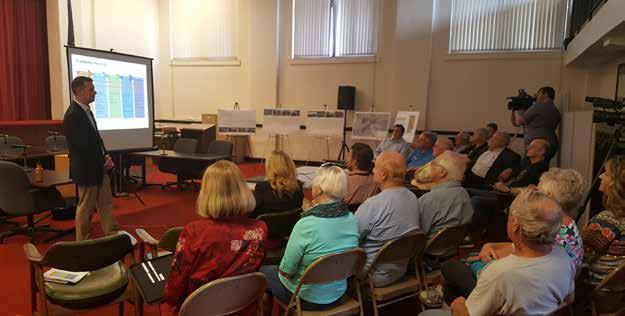
Two public meetings were conducted as part of the master planning process. The first meeting occurred on May 25, 2017. It included presentation of the existing conditions information that had been collected at that time in addition to issue and opportunity exercises for meeting participants.
The second public meeting was held on August 24, 2017. The presentation at this meeting included an overview of the planning process and discussion of key findings and recommendations. The presentation was followed by a question and answer session with the consulting team. Both meetings were held at the Pike County Courthouse in downtown Petersburg. Following the second public meeting, the consultant team finalized plan recommendations, created the action plan, and developed infrastructure cost estimates, resulting in plan completion in October 2017.
A key component of the planning process was continuing to develop the vision for the interchange area. The vision statement is a brief narrative that reflects local potential and makes a commitment to future action. Developed towards the beginning of the process, it helps to define the direction in which the plan should proceed. The vision not only serves as part of a decision-making tool for the plan, but also for the decisions that are made in implementing the plan.
Goals and action plans further define the vision and outline a guide for future growth and development in a manner that will reflect the area’s unique character. They illustrate physical, social, and economic environments that should be achieved during implementation. Goals also form the framework for more detailed decision making
Transformation of the State Road 61 and I-69 interchange area will lead to:
• Diverse employment opportunities;
• Increased household incomes and municipal tax bases; and
• Attractive amenities for families, visitors, and the local workforce.
This will be accomplished through:
• Development of a mix of industrial, commercial, and residential uses;
• Leveraging existing local partnerships and equity partners; and
• Marketing area strengths with respect to location, utilities, infrastructure, and local leadership.
Ultimately, the interchange area will become the employment, recreation, and residential destination within the region.
and should be used by the EDC, City, and County when prioritizing needed public improvements and services.
Development around the interchange area will contain a dynamic mix of uses and activities to strengthen the economic base of the community and serve both residents and visitors of Pike County. Land resources will be used efficiently, with priority given to development sites already served by public utilities. Land use regulations and other tools should be maintained in order to better prescribe the vision of the plan, while also being flexible over time to respond to changing conditions.
Provide a safe and efficient transportation system that connects employment centers, neighborhoods, and community amenities. The existing transportation system should be used to help determine appropriate locations for future development based on existing capacity and expansion potential. Future investments in transportation infrastructure should support planned development patterns and intensities. Similar to utilities, investments in the transportation system should be used to direct growth and construction of new roadways should not come at the expense of maintaining existing facilities.
Utilities & Infrastructure
Plan for and develop infrastructure systems that efficiently serve the existing residents and businesses with the capacity to accommodate planned growth and development. Utilities and infrastructure are costly to expand; as such, use and expansion of public services must be done to maximize efficiency. Investments in utilities and infrastructure should be seen as investments in directing and managing growth and maintaining fiscal responsibility.
The enhancement and preservation of quality natural systems, ecologically sensitive lands, and scenic views should be ensured when new development occurs. A healthy environment supports social well-being, sustains economic development, and protects against flooding and other natural events. Where possible, open space areas should be used to provide opportunities for both passive and active recreation.
The economic Development Strategy for Pike County acknowledges the benefit of an active public – private partnership between Pike County EDC and Bowman Family Holdings (BFH),
which affords access to construction equipment, knowledge of infrastructure, and BFH’s interest and capability in project investment, ultimately elevating the positioning of shovel ready sites along I-69 for industrial development. Further, a strategic combination of large and contiguous acreage, interstate access, proximity to the Southwest Indiana Megasite, access to considerable electrical generation capacity, and a traditional local association with heavy industry lays the groundwork for an array of industrial and distribution opportunities:
• Auto assembly, including parts suppliers
• Plastic and rubber product manufacturing, tied to Tier 1, 2, and 3 automotive assembly
• Chemical and plastics processing, tied to agriculture and food production
• Metal forging, stamping, and smelting
• Mining & mining support services
• Energy generation
• Food processing and manufacturing
• Truck Transportation, Logistics, and Warehousing, linked to 3rd Party Logistics Providers (3PL), with connections into automotive, as well as internet order fulfillment
• Internet Fulfillment, data processing and hosting, including server farms
• Agribusiness
• Administrative and support services
While opportunities are clear, the EDC and Bowman Family Holdings need to acknowledge constraints that can influence opportunities. While Pike County is not alone across Indiana in having very low unemployment (below 4%), the limited local supply of new workers is an apparent constraint, which may require local officials to embrace strategies related to construction of new housing, as well as workforce development (including expanded apprenticeships). Recent announcements related to EDA funding of the Entrepreneurship & Technology Center of Pike County are a clear step forward in this regard. The new facility is expected to offer co-working & maker spaces for prototyping and production as well as an employment training center.
As the EDC, Bowman Family Holdings, and other area property owners move forward to evaluate industrial development opportunities, the following should also be kept in mind:
1. For local units of government, real and personal property tax abatement is a primary economic development tool, particularly for manufacturing and distribution activities. Pike County also needs to see the incentive conversation in context with being a capable partner to expanding or relocating companies, reducing risk through provision of robust infrastructure (physical and workforce). As such it may be important to have “skin in the game” with these companies.
2. While Indiana remains a critical state for US manufacturing, adding over 56 million
square feet of industrial and distribution space statewide since 2006, there are many locations across Indiana that are competing for future industrial development. For Pike County, opportunities do link with connectivity to I-69, which should boost industrial absorption beyond currently modest levels. While “metro” counties have tended to capture a majority of statewide industrial demand, urban counties such as Marion are gradually running out of vacant greenfield sites to support new construction.
3. Continue to work with State of Indiana Economic Development to ensure that available sites are identified and marketed.
4. Leverage Bowman Family Holdings investment capability and interest.
The interchange area master plan creates a development district that provides opportunity for employment generating businesses while planning for infrastructure improvements and protecting natural resources. The design concept is intended to communicate a desired development form. Transportation and utility infrastructure improvements and expansions that are needed to support this development form are identified in greater detail within the plan.
The master plan area is designed as an employment district comprised predominantly of light industrial, heavy industrial, and warehousing uses. The conceptual layout plan creates a number of potential development sites at varying scales, ranging from over 300 acres for a single manufacturing or production use, down to smaller five acre light industrial sites, one acre restaurant/ retail sites, and smaller single-family residential lots. There is flexibility within some of the subareas where larger sites could be subdivided into business or industrial park developments with five to 20 acre lots, or where smaller lots could be grouped given interest from a larger footprint user.
The area north of the I-69 and SR 61 interchange should include a mixture of commercial uses such as restaurants, hotels, gas stations, variety stores, and other retail businesses to serve Petersburg residents, the local workforce, and interstate travelers. These commercial uses should be located
closest to the interstate and along the SR 61 frontage. They should be designed to contribute to overall community character; businesses that detract from the community’s image, such as truck stops, are not appropriate in this high profile location. Supporting this commercial development is a range of residential housing types. Medium density residential development should be used to separate the commercial areas closer to the interchange from single-family residential development farther from the interchange. County Road 400 N will be supported by additional new roads to serve growth and development in this area. Sidewalks and multi-use trails should be included in new developments to create multimodal connections between residential and commercial areas as well as to Prides Creek Park and downtown Petersburg.
The south interchange area includes existing residential development and holds tremendous opportunity as a new employment center not only for Petersburg and Pike County, but Southwest Indiana as a whole. The Entrepreneurship & Technology Center of Pike County, to be located just south of the interchange on the west side of SR 61, will help frame a gateway to this district. Opportunities for additional retail development are present on the east side of SR 61, just south of the interchange, with access to either SR 61 or the planned County Road 350 N upgrade and extension. Manufacturing, warehousing, logistics, and other industrial uses of varying scales and intensities can be accommodated between the
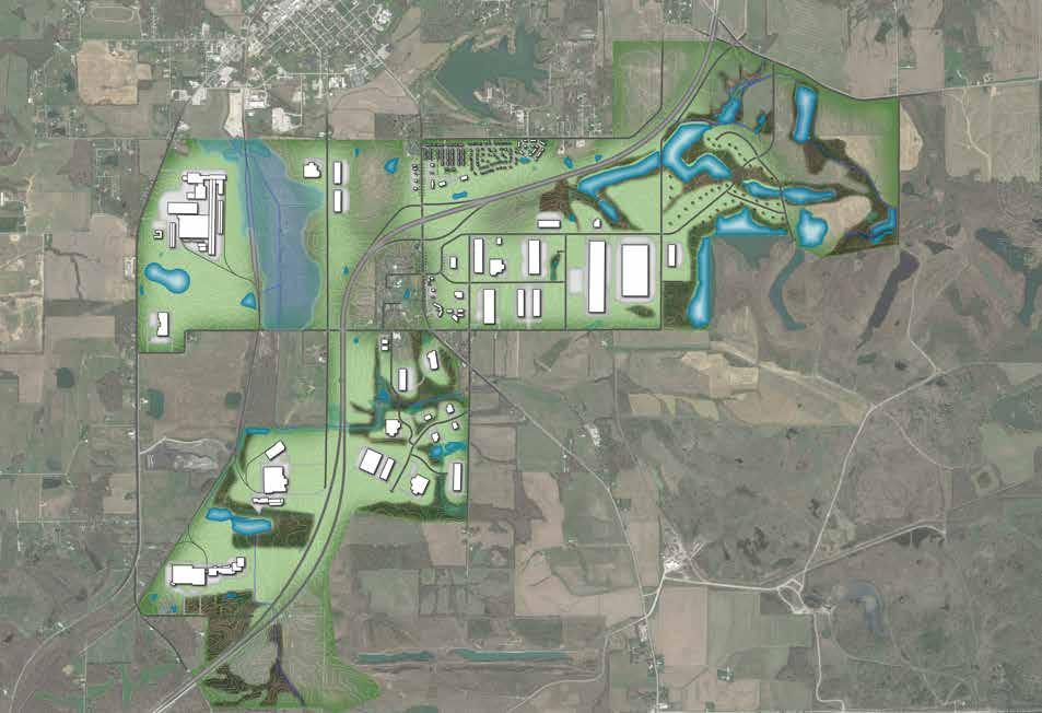
interstate and County Road 300 N. Smaller sites could be created in a business or industrial park setting closer to SR 61 while larger footprint uses can be accommodated on large parcels to the east. Additional road upgrades to CR 300 N and CR 175 E will be required in addition to internal access roads and drives.
As an Indiana Site Certified-Silver Tier site, Generation Springs is primed for a combination of manufacturing, warehousing, logistics, and other industrial uses in a park like setting. Existing tree stands, topography, and the haul road alignment are used to organize a variety of sites, ranging in size from 4 acres to 60 acres. Individual sites as well as internal roads can be accessed from CR 300 N, SR 61, and CR 75 E.
Two large areas adjacent to the Indiana Southern railroad have been identified to attract medium to heavy industrial, rail transportation users. The northernmost of these areas is bounded by Meridian Rd. to the east, SR 57 to the west, CR 400 N to the north, and CR 300 N to the south. The parcels west of the railroad could be organized with frontage and vehicular transportation access to SR 57 and rail access to the east. The parcels east of the railroad in this sub-area are heavily impacted by the 100 year flood plain, and as such, may be more costly to develop. Generally, less intense industrial operations should be located closer to the City of Petersburg and Meridian Rd. The southernmost rail adjacent site in the master
plan area is between the Indiana Southern tracks and Interstate 69. Vehicular access to this subarea would come via Meridian Rd./Line Rd. With over one mile of rail frontage, this site could accommodate some of the heaviest industrial users, and as such should be preserved in large tracts. Development in either of these rail sites will require improvements to CR 300 N.
The northeast portion of the master plan area has been designated for low density residential development. The area east of the interstate and south of SR 356, has the potential for a range of single family developments including higher end homes on lake front parcels, larger lot homes on what is currently agriculture land, and traditional subdivisions. The existing natural amenities in this area should be protected and used to promote development here. Given the relative distance to existing sewer and water utilities, shorter term residential development in this area will likely be served by on-site well and septic systems. The recommended larger lot sizes are conducive to these needs. An expanded transportation network will be required through this area with connections to both CR 175 E and SR 356. North of the interstate and east of Prides Creek Park, land is available on either side of CR 175 E for single family residential subdivisions. However, given the location and lack of existing utilities, it is anticipated this area will not develop until after the Interchange – North area and subsequent utility extensions along CR 400 N. In the interim, this area should remain in agriculture use.
The Pike County Interchange Area Master Plan is both a development guide and policy document for future decision-making within the study area. Success of the plan will require on-going coordination and partnerships between the Pike County Economic Development Corporation (EDC), Pike County, City of Petersburg, and local property owners. While the master plan effort has gone to great lengths to develop and refine project priorities and the vision for the study area, meaningful implementation cannot occur without a supportive regulatory framework. Therefore, it will be incumbent upon the City, County, and EDC to implement the respective policies and recommendations contained herein.
While the City of Petersburg utilizes zoning and has planning and zoning jurisdiction over a portion of the study area, the County has elected not to implement county-wide zoning. As such, different mechanisms are recommended for the areas within the City’s planning authority versus those areas outside of it. Zoning ordinances regulate the uses that are permitted on a property, the size and organization of structures, and additional items such as landscaping, parking, and signage. Zoning can help to protect property values by keeping potentially incompatible uses away from each other and providing some assurance as to what can and cannot happen in a particular area. From a development standpoint, businesses and developers find zoning attractive because it provides some certainty about the acceptance and approval of a project if it meets minimum requirements. Because the City of Petersburg
already has a zoning ordinance in place and a Plan Commission to review development applications, amendments to the existing ordinance to reflect the goals and policies of the master plan are recommended.
An additional zoning tool to be used in areas outside of City planning and zoning control is what is known as Planned Unit Development (PUD). PUD is both the name of the regulatory process as well as the type of development. Before a PUD could be created, the County would have to adopt an enabling ordinance. Unlike typical zoning where the districts and standards are prescribed by the municipality, a PUD allows an owner or developer to propose zoning standards that would only apply to their subject property. This is an attractive option for implementation of the master plan because it would not create county-wide zoning, but would allow for individual owners to apply zoning to their property by choice.
In cases where zoning is either not practical or not desired, Covenants, Conditions, and Restrictions (CC&Rs) can be used to accomplish many of the same goals. Unlike traditional zoning or PUD zoning, CC&Rs require no City or County enabling ordinance or review. They are a private agreement made by a prospective purchaser as a condition of purchasing a piece of land in question. As such, they are enforced by an individual or association as opposed to the City or County that would enforce zoning regulations. One potential downfall of CC&Rs is that they are not as common or readily researched by potential site selectors when compared to zoning. Despite
these potential disadvantages, they may still be a useful tool for regulating development within the master plan area. These implementation mechanisms and the processes to create them are discussed in greater detail later in the plan.
This deliverable contains “forward-looking statements” which relate to expectations, beliefs, intentions or strategies regarding the future. These statements may be identified by the use of words like “anticipate,” “believe,” “estimate,” “expect,” “intend,” “may,” “plan,” “project,” “will,” “should,” “seek,” and similar expressions. These forward-looking statements reflect assumptions with respect to future events and are subject to future economic conditions, and other risks and uncertainties. Actual and future results and trends could differ materially from those set forth in such statements due to various factors, including, without limitation, those discussed in this document. These factors are beyond this effort’s ability to control or predict. Accordingly, we make no warranty or representation that any of the projected values or results contained in this deliverable will actually be achieved.
PIKE COUNTY INTERCHANGE AREA MASTER PLAN
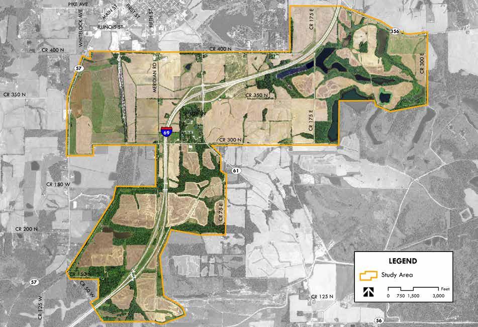
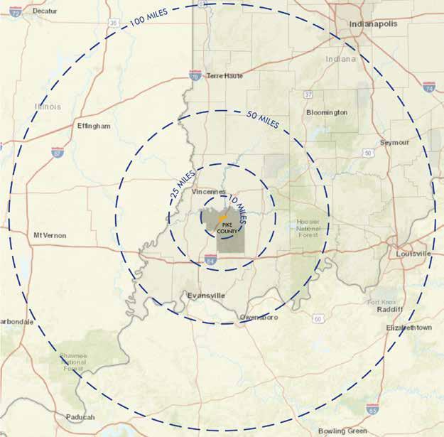
The Pike County Interchange Area Master Plan study area is located just south of the City of Petersburg, along both sides of Interstate 69 in Pike County, Indiana. The study area includes approximately 4,000 acres of land area. As depicted in the location map the to the right, the study area is approximately 40 miles from the City of Evansville and 100 miles from the City of Indianapolis.
Pike County Economic Development Corporation (EDC), Bowman Family Holdings, Pike County Board of Commissioners, Pike County Council, City of Petersburg, and area property owners began working on development of the interchange area long before the master planning process was started. Several recent initiatives have set the stage for competitive marketing of the area. This includes creation of two tax increment financing (TIF) districts, marketing of the Southwest Indiana Megasite including the Generation Springs Indiana Site Certified Silver area, planning and acquisition of funding for the Entrepreneurship & Technology Center of Pike County, and extending sanitary sewer service south of the interstate.
A TIF district uses future property tax revenues generated within a defined area to pay for improvements and incentivize development. TIF revenues can be used for both capital and noncapital expenditures including: infrastructure REGIONAL CONTEXT
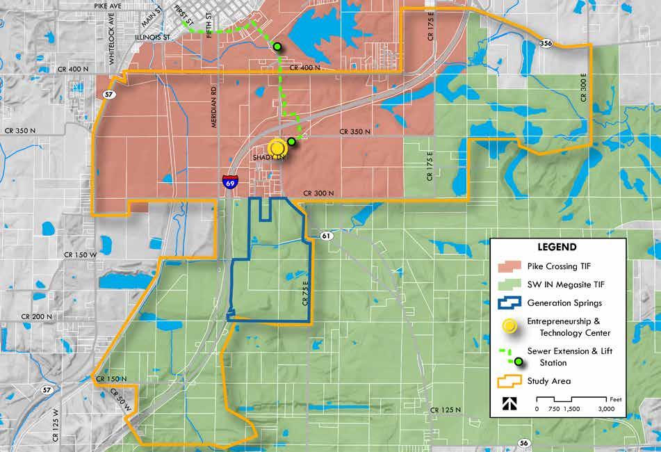
investments (sewer, water, stormwater, streets, multimodal facilities, traffic control, lighting), land and building acquisition, demolition, site improvements, parks, educational or worker retraining programs, and planning studies that benefit the allocation area. Two TIF districts have been created and together, cover almost the entire study area. The Pike Crossing TIF district includes the area immediately surrounding the interchange and lands north of the study area, towards the City of Petersburg. The Megasite TIF was created in 2016 and includes over 9,000 acres, much of which is owned by Bowman Family Holdings. This includes the south and east portions of the master plan area.
The Southwest Indiana Megasite encompasses 8,000 acres owned by Bowman Family Holdings. The megasite is served by numerous utility providers and two rail lines. The Indiana Southern Railroad serves the western portion of the megasite while the Norfolk Southern rail loop serves the southeast portion of the site. Included within the larger megasite is Generation Springs, a 340-acre greenfield site that was awarded Indiana Site Certified Silver status in late 2016. Generation Springs is a public/private partnership between Pike County, Bowman Family Holdings, WIN Energy and Hoosier Energy. As part of the site certification process, a Phase 1 environmental assessment, ALTA survey, and topographical report were all created.
The Entrepreneurship & Technology Center of Pike County, to be located just south of the interchange along the west side of SR 56/61, has been in the planning stages for several years. During the master plan process, the center was awarded a grant for $787,500 from the Economic Development Administration. The facility will offer co-working space, maker space with prototyping capabilities, and a training center that will cater to workforce development needs. The Entrepreneurship & Technology Center of Pike County will be an invaluable business resource and visibly positioned at the interchange to send a message of innovation and growth.
A partnership between Pike County and the City of Petersburg resulted in the construction of two lift stations and over 7,000 feet of new sewer mains in 2014 and 2015. This extension crosses

the interstate to the south and was installed to facilitate development in the master plan area. Additional collector facilities will tie into these mains as development occurs.
The majority of the plan area is currently used for agriculture purposes and includes associated woodlands and several residential homesteads on large lots. There is one single family residential subdivision just south of the interchange along the west side of SR 61, comprised of approximately 20 homes. Two religious institutions are present in the plan area; River of Life Fellowship on the south side of E CR 300 N, just west of SR 61, and Brenton Chapel Church of Christ on the south side of E CR 400 N, across from Prides Creek Park. The only commercial use in the study area is also located along E CR 400 N, just east of the Brenton Chapel Church of Christ. The existing land use map can be seen on the facing page.


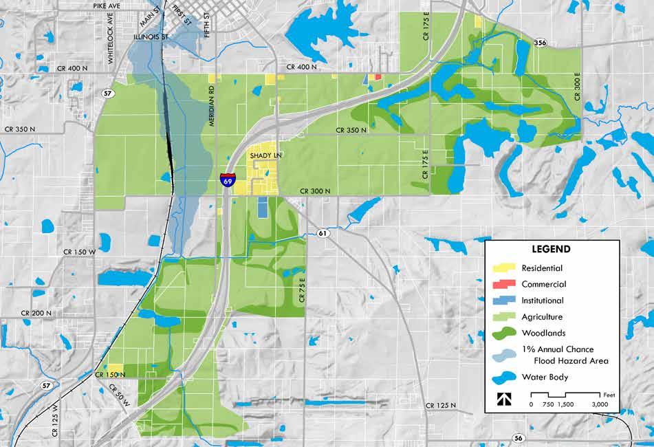
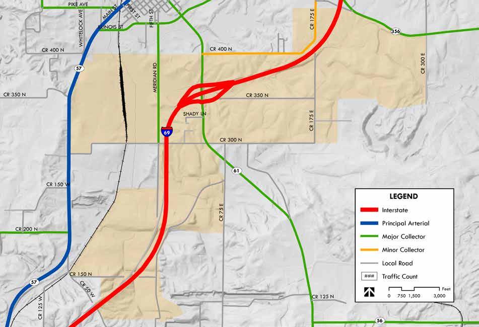
The study area is centered around the I-69 and SR 56/61 interchange. As such, primary access to the study area is via SR 56/61 with local access then provided by the county road network. The functional classification map on the facing page identifies SR 57 as the principal arterial in the area, providing connections to Washington to the north and Oakland City to the south. SR 61 is classified as a major collector; it connects to downtown Petersburg and north to the City of Vincennes. Just south of the study area, SR 56/61 split with SR 56 then providing an important connection to the City of Jasper to the east. Meridian Road is also classified as a major collector and provides north-south access to all of the study area west of the interstate. CR 400 N and CR 175 E are considered minor collectors and provide access to the study parcels to the northeast of the interchange.
Traffic counts (INDOT, 2016) have also been included on the functional classification map. These counts indicate greater trip demand to the south, towards Evansville as opposed to north, towards Washington and Bloomington beyond. As additional sections of I-69 are completed through Monroe and Morgan counties ultimately connecting to I-465 around Indianapolis, these traffic counts are expected to increase. The existing low traffic volumes on SR 61 and SR 57 suggest excess capacity is available to serve new development without significant impact to the transportation network.
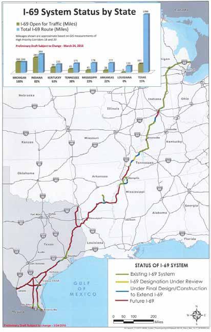
The map to the right presents an overview of I-69 completion status, from outside Detroit, Michigan to the US-Mexico border in Texas. When completed, I-69 will stretch over 2,400 miles. As of 2016, the interstate was 100% complete in Michigan, 82% complete in Indiana, and 63% complete in Kentucky. The system continues through Tennessee, Mississippi, and Arkansas which are 28%, 23%, and 22% complete, respectively. Alignment has not yet been specified through Louisiana, and 15% of the 1,086 miles have been completed in Texas.
A number of utility providers service the study area; they include:
Electric Power
• WIN Energy, a member of the Hoosier Energy Cooperative
• Duke Energy
Natural Gas
• Ohio Valley Gas
• Vectren Water
• City of Petersburg
• Pike-Gibson Water, Inc.
• Otwell Water Corporation
Sewer
• City of Petersburg
Electric Power
Significant electric power capacity is available given the presence of the 345 kV Duke transmission lines that run east-west through the northern portion of the study area, in addition to 138 kV and 69 kV subtransmission lines running north south through the study area. Distribution lines (12 kV) are present along SR 61, SR 57, CR 300 N, and CR 175 E. The existing electric power infrastructure could be a significant attractor for industries with large power demands.
Ohio Valley Gas and Vectren serve different portions of the study area with natural gas. Both have additional capacity with which to serve development, however, capacity is ultimately determined by the transmission company, Texas Gas Transmission Co., that operate the two, 10inch pipelines that traverse the study area eastwest between the interstate and the City of Petersburg.
The City of Petersburg has several water mains near or within the planning area. There is a 10-inch water main on both the north and south sides of I-69 along SR 56/61. This 10-inch main extends through the heart of the planning area along SR 56/61. Pike-Gibson also has several water mains near or within the planning area and more specifically serves portions of the south and west sides of the planning area. There is an 8-inch water main along SR 57 that begins south of the SR 57 and CR 400 N intersection. The 8-inch main extends through the planning area and continues running south along SR 57. Otwell Water Corporation serves portions of the north and northeast sides of the planning area. Additional existing facilities are discussed in greater detail with the infrastructure recommendations later in this plan.
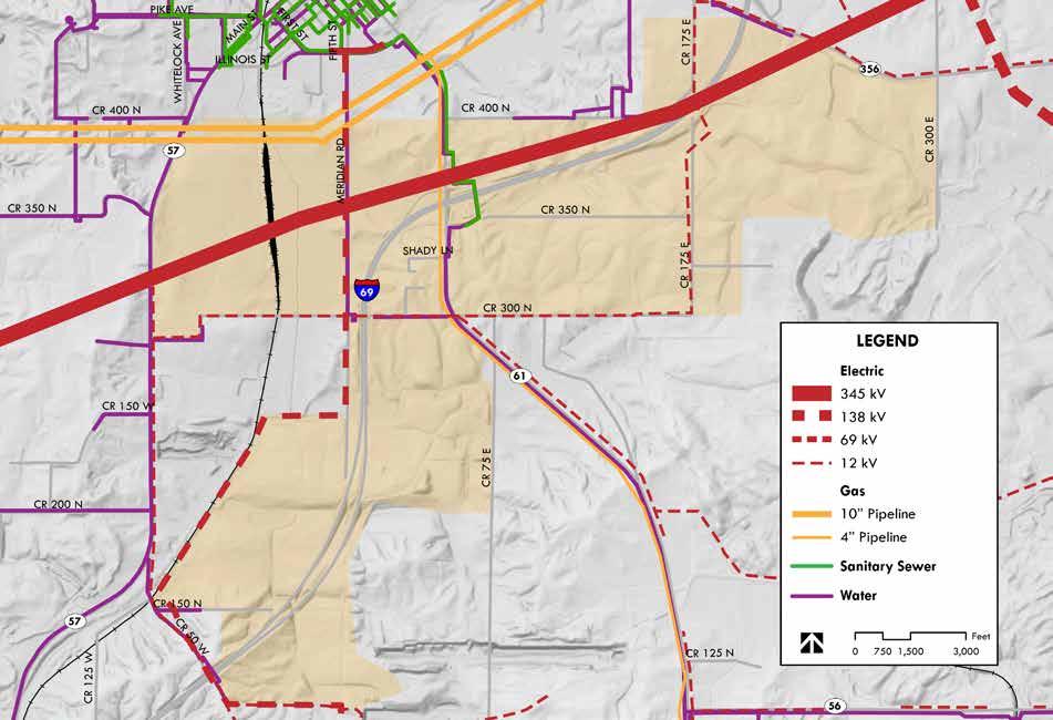
The only public sewer system in the planning area is the City of Petersburg. The City of Petersburg’s existing sewer collection system is roughly equal to the City corporate limits, covering an area of approximately 1.47 sq. miles. I-69 Lift Station Nos. 1 and 2 were installed in 2014/15 along with 6,000 feet of 6-inch force main and 1,280 feet of 8-inch gravity sewer. The I-69 Improvements are base facilities to allow some future development in the I-69 Corridor. Additional facilities may be constructed with development and most likely turned over to the City for operation and maintenance.
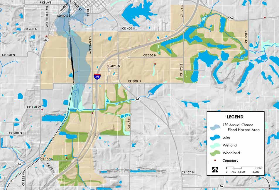
Prides Creek flows north to south along the western side of the study area. A significant portion of the area between Meridian Road and the Indiana Southern railroad, north of CR 300 N is within the 1% annual chance flood hazard area, or 100-year floodplain. The 100-year floodplain is any area that is susceptible to being inundated by water during a 100-year flood event. A 100year flood is not one that will occur every 100 years but is instead a flood that has a one percent chance of happening in any given year. A number of unnamed drainage courses also flow through the study area but none include a flood hazard area.
Lakes and wetlands can also be seen on the map on the facing page. These wetland areas have been identified as part of the 2014 National Wetland Inventory. The approximate extent and location of these wetlands is mapped using aerial photography. The National Wetland Inventory does not map some types of wetlands because of limitations of aerial imagery as a primary data source. Given the approximate nature and potential for unaccounted wetland areas, more detailed site analysis should be conducted before any planned development.
Woodlands and other vegetated open spaces have also been mapped to inform the planning process. These open space areas are identified as having intrinsic value and contributing to the character of the study area. While woodland areas may be harvested for timber or cleared for development, care should be taken to minimize the impact to the existing landscape in order to protect the unique character of these areas.
Three cemetery sites are present in the study area. Most notably, the Brenton Family Cemetery is located approximately 0.75 miles east of SR 56/61, just south of E CR 350 N. Peter Brenton is the namesake for the City of Petersburg. These cemetery sites must be preserved, and specific to the Brenton Family Cemetery, access to the site should be improved.
The US economy and population can be aggregated into 11 Megaregions that account for about 70% of the population and 80% of US private economic output. Based on Private employment figures, 20% of US manufacturing employment is represented by the Great Lakes Region with 4.2% of US manufacturing represented in Indiana alone.
Employment data presented to the right and on the following pages comes from the Bureau of Labor Statistics - Quarterly Census of Employment and Wages (QCEW) program. Data is classified using the North American Industry Classification System (NAICS), the standard used by Federal agencies in classifying business establishments for the purpose of collecting, analyzing, and publishing statistical data related to the U.S. business economy. Descriptions of industry classifications can be found at www.census.gov/eos/www/naics/.
Many of the figures presented are the location quotients of top sectors within a geography, be that the Great Lakes megaregion, State of Indiana, Southwest Indiana, or Pike County. Location quotient (LQ) is a valuable way of quantifying how concentrated a particular industry is in a region as compared to the national average. Industry sectors with a location quotient greater than one indicate that the local economy has a larger than average share of this industry when compared to the national economy. It helps to reveal what makes a particular region unique,
Location Quotient is a measure of how concentrated an industry or sector is in a region as compared to the national average. For example, primary metal manufacturing is almost twice as concentrated in the Great Lakes Megaregion than the national average.
Source: Regional Plan Association, AECOM
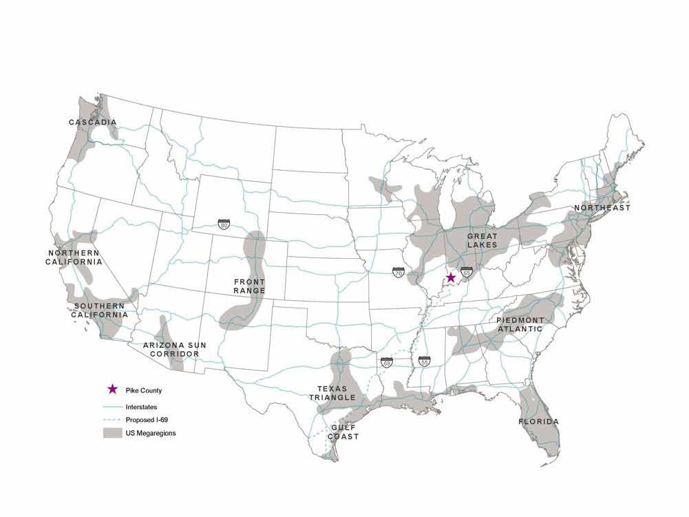
Megaregions are large networks of metropolitan regions, defined by layers of relationships including: environmental systems and topography; infrastructure systems; economic linkages; settlement patterns and land use; and shared culture and history (Source: Regional Plan Association). While Pike County lies just outside of the Great Lakes megaregion, completion of I-69 and development along the interstate corridor will serve to reduce that separation.
and subsequently how a specific industry may translate into a competitive advantage locally.
• While the largest employment sectors in the Great Lakes Megaregion are service-based, the Region’s manufacturing sectors constitute a higher proportion of total employment than typical in the United States.
• In the Great Lakes Region, manufacturing employment has increased at a 2.0% annual rate between 2010 and 2015 while the manufacturing location quotient increased at a 1.0% annual rate.
• In the State of Indiana, manufacturing employment increased at a 3.0% annual rate between 2010 and 2015, while the manufacturing location quotient increased at a 1.7% annual rate.
• Between 2010 and 2015, 231,382 manufacturing jobs were added in the Great Lakes Region.
• At 0.2% per year, the Great Lakes has the slowest population growth of any Megaregion. Adding only half a million people since 2010.
Indiana mimics the employment trends of the Great Lakes Megaregion.
• Four of the five largest employment sectors in Indiana are again service-based sectors. Similar to the Region, Indiana has a strong concentration of manufacturing employment. Indiana’s employment location quotients are even greater than those of the Region overall.
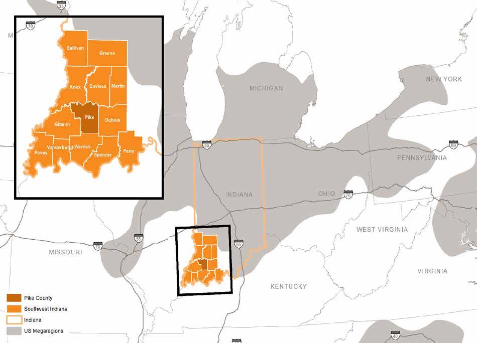

For the purpose of this study, Southwest Indiana has been defined to include Daviess, Dubois, Gibson, Greene, Knox, Martin, Perry, Pike, Posey, Spencer, Sullivan, Vanderburgh, and Warrick counties (map on page 33).
• Southwest Indiana has a high concentration of furniture and related products manufacturing - Dubois County
• Southwest Indiana has a high concentration of mining employment - Pike and Warrick counties
Location quotients are sensitive to how big a geography is. Since Pike County is very small relative to US averages, the location quotients for Pike County may seem exaggerated because the reality is, Pike County has an employment mix that is fairly unique (heavy emphasis on mining, utilities, etc.). This helps to account for why “waste management services” as a sector has such a high employment LQ in Pike County and “pipeline transportation” and “museums & historical sites” have high establishment LQs.
While the IPL Petersburg Power Plant is a major employer in the county, it is not included on the “Pike County Top 5 Sectors by Employment Count” chart to the right. This is because the BLS does not disclose data for this sector, to protect the confidentiality of what would be the only employer in that sector in the geography.
Evansville MSA (0.2%) and Bloomington MSA (0.6%) grew at a faster annualized rate than SW Indiana (0.1%).
Pike County’s population decreased at a .5% annualized rate between 2008 and 2015. 22% of the population loss occurred in Petersburg.
8 of 13 SW Indiana counties and 62% of all Indiana counties have experienced population loss since 2008.
There are 17 Indiana counties that grew at an annualized rate of 1% or faster between 2008 and 2015. Two of these counties were in Southwest Indiana (Daviess and Warrick). Of these 17, the common denominator was direct access to an interstate. Pike County needs to capitalize on the opportunities in Petersburg and its location on I-69 to stabilize its population.
Pike County’s median age is increasing as a higher proportion of its population is over 65 and the proportion of younger individuals decreases.
At current trends, 56% of Pike County’s population will be between 25 and 64 years old and 26% over 65 years old by 2030.
Pike County’s unemployment rate decreased to 3.6% in March 2017; the region is effectively at full employment.
Despite decreasing population, Pike County’s labor force grew by 449 from 2009-2016 as more people sought jobs.
From 2010-2014 Pike County had a net outflow of 668 residents, the majority to neighboring counties. Daviess County was the only neighboring county from which Pike County had a net inflow. (Census Flows Mapper)
Pike County had a net outflow of 2,336 workers in 2014. This means over 2,300 more people leave Pike County for their job than travel to it for work (4,270 outflow to 1,934 inflow). Since 2008, inflow to the county has increased 4.6% annualized and outflow has decreased 1.3% annualized. (US Census On The Map)
Pike County is losing residents, but there is an increase in the number of people coming to Pike County to work and a decrease in the number of people leaving the county for work.
(March 2017)
(March 2017)
Pike County had strong housing construction during the 1990s and early 2000s, but experienced a decrease during the last decade.
Pike County’s housing replacement (per 1,000 residents) is lower than neighboring counties that it’s losing population to and higher than Daviess County, which it has a net inflow from.
Sources point to a housing unit replacement rate of 3 per 1,000 annually as a benchmark.
New Industrial Buildings by Square Footage
Since 2005, a majority of new industrial buildings are less than 250,000 square feet (85%).
• For buildings less than 250,000 sf, the average building size is 42,000 sf, which would require a site of approximately 5 acres in size, assuming 20% building lot coverage.
• For buildings between 250,000 sf and 500,000 sf, the average building size is 380,000 sf, which could require a site of approximately 43 acres.
• For buildings between 750,000 and 1 million sf, the average industrial building size is 830,000 sf, which could require a site of approximately 95 acres.
• Looking at compound annual growth rates, the segment that is adding space at the fastest pace statewide is the 250,000 to 500,000 sf segment, which saw the addition of about 3.5 million sf per year since 2005.
Source: CoStar
The largest sites represent the smallest share of development opportunities.
Across Indiana, it would appear that there is demand for one to two 100+ acre sites per year.
While demand across Indiana favors smaller parcels (<60 acres), the state has a significant number of industrial sites with more than 100 acres.
The vast majority of larger industrial sites (>100 acres) do not appear to be shovel ready.
Among the top 20 mega-sites in Indiana, the average labor force within a 5-mile radius is approximately 13,000 laborers compared to 2,617 at the Interchange Area location.
However, in terms of maximum acreage, our study area is approximately 4,000 acres , compared to the top 20 mega-site average of 1,512 acres.
On average, each site is approximately 7.5 miles away from the nearest interstate, significantly more distant than the study area’s immediate proximity to I-69.
In order to better understand potential demand for industrial sites and structures, Indiana counties were organized into five classifications:
• Interstate - counties with direct access to an interstate that traverses the state
• Metro - counties with relatively high population and employment density
• Non-interstate - generally rural counties without direct access to an interstate
• Southwest Indiana Interstate - counties in SW Indiana with direct access
• Southwest Indiana Non-interstate - counties in SW Indiana without direct access or those that access I-69, including Pike County. These counties are considered non-interstate because they have historically not had interstate access and despite the opening of I-69 Sections 1, 2, 3, and 4, lack wider connectivity to Indianapolis and beyond.
For Pike County, completion of I-69 across Indiana will result in a material increase in access.
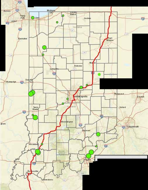
Indiana counties were also examined based on the amount of industrial acreage available for development, as identified by the State of Indiana Department of Economic Development. Finally, Indiana counties were examined based on the amount of industrial acreage available for development, as a percentage of total statewide inventory. Pike County emerges from this analysis


with a relevant share of statewide vacant land for industrial development (map on page 46).
State of Indiana data regarding shovel ready sites is shown on page 47. While a number of counties have at least 100 acres available, not all counties have the same level of interstate access
Since 2006, Indiana has added a total of 56 million square feet of industrial space (manufacturing and warehouse); about 5.6 million square feet per year.
This annual level of inventory growth provides context for statewide growth, and the ability of sites in Pike County to compete for a share of future state wide growth.
10 Year
Study Area
Interstate Counties (rural)
Interstate Counties (SW Indiana)
Since 2007, the above table summarizes the average 10 year increase in industrial inventory by county type, reinforcing the significant increase in absorption potential for interstate served counties. Non-interstate counties in southwest Indiana averaged just 800 square feet of development over a ten year period. Interstate counties averaged over 175,000 during the ten year period. While metro counties command a larger share of the market, many of these counties have significantly less vacant land available for new development. As Pike County transitions from a non-interstate county in southwest Indiana to an interstate served county with broader connectivity, a significant increase in absorption should be realized.
The identified average absorption rate reflects a realistic long term trajectory for industrial development in Pike County. At the same time, the following are true:
• Typical warehouse and internet fulfillment buildings are considerably larger than 175,000 sf, averaging up to 500,000 square feet or more. Capturing one of these projects could result in exceeding average absorption.
• Resource processing and major manufacturing facilities require considerably more acreage than typical industrial sites; >200 acres in some cases. The master plan area includes several potential sites
• While Pike County has the potential to perform above the long-term average of 175,000 sf per 10 years, annual absorption of one 500,000 sf building per year over 20 years, would result in absorption of roughly 10 million sf of buildings requiring approximately 1,000 acres of land (assuming 25% lot coverage). This outstanding growth performance would only consume one quarter of the gross master plan area
• Property owners will need to consider alternative uses, ranging from mining to agricultural production for their holdings in Pike County.
The map to the right depicts the future county classification that assumes I-69 completion to Indianapolis and transformation of Pike County from a non-interstate classification to an interstate classification, ultimately yielding much greater industrial development absorbtion potential.
PIKE COUNTY I-69 CORRIDOR MASTER PLAN

THURSDAY, MAY 25TH | 4:00 - 6:00 pm
PIKE COUNTY COURTHOUSE BASEMENT
801 MAIN ST, PETERSBURG, IN 47567
The Pike County Economic Development Corporation is currently developing a land use and economic development master plan for the interchange area. The plan will outline a vision and strategy to create development opportunities and job growth for both Pike County and the City of Petersburg.
Come share your vision and take part in an exciting discussion on how we can continue to grow as a community. The meeting format is informal; you are invited to attend at anytime.

www.pikecogrowth.org pikegrowth@pikeco.org
Flyer advertising the first public meeting, held on May 25, 2017.
In addition to input provided by the project advisory committee, the planning process included several opportunities for public input. Two public meetings were held; the first towards the beginning of the process focused on existing conditions and issue and opportunity identification. The second public meeting included a presentation of preliminary recommendations with the opportunity for question and answer. Additionally, a series of key stakeholder and focus group discussions was held early in the process to gain a wide array of input from local officials, property owners, and allied professionals that included:
• Workforce development professionals
• County officials
• Property owners
• Pike County School Corporation
• City officials
• Utility providers
• Transportation professionals
• Local realtors
A summary of results compiled from both public meetings and focus groups follows.
• Growth in region and pro-growth attitude locally
• Leadership group all on same page
• Large land area available
• Infrastructure and utilities already in place for many sites
• School System / Project Lead the Way is very strong
• Prides Creek Park is a strong amenity
• Access and Connectivity – to Evansville in 30 minutes
• Low taxes
• Reasonable cost of land
• Willing to use incentives aggressively
• Rail access for several large sites
• Availability of labor force
• Perception of workforce, no industry to drive growth since coal decline
• Brain drain
• Concerned with lack of master plan/zoning
• Limited financial resources – decreasing assessed values
• Lack of employment diversity – coal
• Commuting – net migration out of Pike County
• Lack available housing stock - even if attract jobs, no houses for them, limited local builders
• Keep youth in area
• Better wage jobs, with benefits
• Flexibility of development sites with the ability to execute with speed
• Large footprint users, not every project needs to create a high number of jobs
• Continual progress and build-out even if it takes time
• Take time to do it right
• Communication with EDC regarding potential development
• Retail uses north of interstate
• Get the proposed technology center built
• Hearing more positive things about Pike Co.
• Opening of the interstate
• Development along Illinois St.
• Increase in traffic along SR 61 after the interchange opened
• Healthcare
• Manufacturing – auto, plastics, woodworking
• Logistics
• Agriculture
• Retail Driving Forces for the Future
• Availability of workforce housing
• Quality of life initiatives
• Must diversify industries
• Overall success of southwest Indiana, if the region succeeds, Pike Co. will succeed
• Evansville will grow to the north, this should help Pike Co. given easy access
• Natural amenities
• Existing residents – don’t want to see displacement
• Whether the community has enough existing amenities to attract new jobs/residents
• Desirability of a truck stop
• Attitudes towards zoning and annexation within the County
• Public attitudes on development – any development is good for the County or wait for the right businesses
• Unknowns of developing on previously mined ground
• Use of tax incentives - don’t subsidize new development at cost to existing residents
PIKE COUNTY INTERCHANGE AREA MASTER PLAN
The economic Development Strategy for Pike County acknowledges the benefit of an active public – private partnership between Pike County EDC and Bowman Family Holdings (BFH), which affords access to construction equipment, knowledge of infrastructure, and BFH’s interest and capability in project investment, ultimately elevating the positioning of shovel ready sites along I-69 for industrial development. Further, a strategic combination of large and contiguous acreage, interstate access, access to considerable electrical generation capacity, and a traditional local association with heavy industry lays the groundwork for an array of industrial and distribution opportunities. This section seeks to identify sectors of opportunity for the future, through analysis of industrial clusters, proximity to geographic end markets, and the impact of specific technology enablers, considering the unique locational attributes of the interchange area.
AECOM identified two local and fourteen global end markets with the ability to support growth in a variety of industry sectors. These markets were identified through a literature review of leading industry reports on high growth markets, cuttingedge technology, and demographic and economic trends.
Once identified, a ten year (2017 to 2026) market potential for each end market was estimated. The market potentials are driven by market enablers
– technological advances, demographic, and economic trends.
These market enablers are driving growth in a variety of markets throughout industry supply chains. These technologies interplay with one another, fostering innovation, lowering costs, and creating new products. For example, 3D printing can use advanced materials such as powdered metals/composites to build prototypes cheaper and faster; warehouse inventory data can be collected using advanced sensors and stored and analyzed in the cloud using big data analytic tools and improving logistics.
End markets with several opportunities for these types of technological synergies have a particularly strong growth potential over the next ten years. Market enablers are detailed on the next several pages.


End markets prime for significant growth by enabling trends End markets identified as suitable/desirable f o r Pike County based on employment and
other trends
Local
Autonomous Vehicles Microgrids Smart Home Devices Wearable Technologies
Bioenergy


• Streamlines R&D and prototyping
• Lowers fixed costs of production
• Enhances customization

• Examples: powdered metals, composites, nanomaterials, and carbon fiber
• Reduce production cost and time
• Improve product qualities such as weight, strength, and durability

• Components that gather data and communicate it over a network
• Gather large variety of physical data, including touch, movement, temperature, and sound
• Improve processes and quality

• Uses algorithms and software
• Improves analysis of large quantities of data
• Creates actionable insights from sensor-collected data

• Enables growth through fluid & flexible IT
• Eliminates need for up-front investments and physical hardware
• Enables smart device communication
• Reduces size & cost of consumer products

• Creates a network of objects that can communicate
• Improves tracking of materials & products
• Allows efficient collection, communication, analysis, & optimization information

• Easy and affordable access to logistics is a competitive advantage in a variety of end markets

• Smaller, more powerful semiconductors reduce product costs
• Improve product designs & operation
• Allow expansion of sensor technologies

• Improves computing power
• Streamlines business approaches

• Growing demand for health care and related services/products
• Changing housing demands as Baby Boomers downsize

• 2.5 Billion more people will live in Cities by 2050
• Increases demand for real estate, infrastructure, and community services

• Significant investment needed to maintain, restore, and replace infrastructure to support increased demand
• Creates opportunities for emerging technologies to improve infrastructure construction, provision, and operation
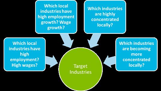
In the interest of the long-term development and success of the County, industries with strong employment trends, linked to growing local and global markets, and leveraging regional strengths can be targeted. By reviewing employment, wage, and freight tonnage data at local, regional, and state levels, twelve target industries have been identified for further analysis. These industries represent specific local and regional strengths in the following industry clusters:
• Agribusiness (Agriculture & Food Processing)
• Construction
• Health Care
• Logistics
• Manufacturing
• Mining
• Retail
To determine which industries to target, several factors were analyzed. Specifically, employment trends statewide, regionally, and locally are a key indicator of an industry’s potential in a given market:
• Indiana, Southwest Indiana, and Pike County employment trends for 2009 and 2015 were analyzed.
• The top ten highest ranking industries in terms of employment size, employment growth, and employment concentration for the three geographies were selected for further analysis.
• These top industries were compared across metrics and geographies.
100 3-Digit NAICS industries were filtered to 50 top rated industries.
To further refine the analysis these 50 industries were reviewed for their potential suitability to the county and compared across metrics and geographies. The result is 12 targeted industries.
The approach leverages apparent statewide strengths in:
• Transportation Equipment Manufacturing
• Truck Transportation, Logistics, and Warehousing
• Internet Fulfillment
• Data processing and hosting
• Administrative and support services
• Plastic and rubber product manufacturing Industries
A combination of large and contiguous acreage, interstate access, access to considerable electricity, and a local association with heavy industry lays groundwork for consideration of heavy industrial opportunities:
• Auto assembly
• Chemical and plastics processing
• Energy production
• Metal forging, stamping, and smelting
• Mining & mining support services
Southwest Indiana Top Employment Industries
The trends for Southwest Indiana mimic state strengths in manufacturing, with over 1/4 of top industries manufacturing related, and highlight the Region’s strength in Mining: nearly 30% of the state’s mining jobs, but less than 10% of the population, are located in the Region.
Mining and utility operations are highly concentrated in Southwest Indiana, and Pike County in particular. The analysis points to potential for expansion of mining operations, which would create corresponding demand for support services.
Food related manufacturing is in the midst of transition, creating opportunities. Since 2012, consumer preferences have shifted in a structural way, with greater interest in food safety and convenience. Organic food producers have also moved into the mainstream, reducing costs. Due to these changes, as well as the broader influence of lower commodity prices, there has been significant consolidation among mature food producers, offset by a wave of new food producing companies that are in a growth mode. For Pike County, the study points to opportunities for food processing facilities.
The US is a relatively small producer of greenhouse vegetables. As preferences shift and there is a need for modern methods to raise food production globally, additional demand for greenhouse / vertical farming of higher value produce may result. This may be further supported by transportation access improvements associated with I-69.
Mining & Related Support Services
Food Processing
Potential for expansion of mining operations, linked with support services
Industry consolidation, new companies emerging, production closer to geographic end markets.
Agricultural Production Green houses / vertical farms for higher value produce
Plastics & Rubber Products
Manufacturing
Fabricated Metal Product Manufacturing
Transportation Equipment
Manufacturing
Furniture & Related Product
Manufacturing
Data Processing & Hosting
Truck Transportation / Warehouse
Hospital / Outpatient Facilities
Tier 1-2-3 automotive suppliers
Tier 1-2-3 automotive suppliers
Expansion of Toyota Highlander; New electric vehicles
Concentrated in Indiana, with growth in employment
Opportunity for server farms connected to considerable electrical capacity
Growth of 3rd Party Logistics providers, and connected to on-going strength of Indiana for manufacturing
Strategic location of Indiana in context with the Midwest “mega-region” for warehousing to support internet retail
Emergence of “micro hospitals” and continued growth of outpatient centers
Nursing & Residential Care Facilities Alignment with boomer generation pivot into retirement
With EPA fuel economy standards requiring automakers to find strategies that make cars lighter and stronger, use of plastics in cars has only increased. Southwest Indiana is proximate to several major final assembly plants, and can expect interest from tier 1-2-3 automotive suppliers looking to produce parts.
Companies in this sector transform metal into intermediate and end products, typically involving forging, stamping, forming, and machining. Automotive (Tier 1-2-3 suppliers) are a likely source of demand for fabricated metals. Demand can also originate related to hand tools, hardware, structural metals, wire products, machine shops, coating and engraving.
While major final assembly plants come along rarely, anticipated expansion of existing plants is common (Toyota Highlander production in Princeton, for example). Looking to the future, with companies such as Tesla looking at a second plant to build new electric vehicles, as the automotive supply chain gradually pivots to electricity, its likely that a new wave of suppliers will be looking for locations proximate to plants.
Furniture manufacturing remains surprisingly concentrated in Indiana, and particularly concentrated and southwest Indiana, with growth in employment. Jasper, Indiana is a major hub of furniture manufacturing in Southwestern Indiana, a location proximate to Petersburg.
Opportunity for server farms connected to considerable electrical capacity. Data processing is seen as a growth industry linked to expansion of internet based shopping. Proximity to fiber optic corridors and access to inexpensive electricity have been determinants of location.
Growth of 3rd Party Logistics providers (3PL) can be tied to Indiana’s ongoing strength in manufacturing, with emphasis on automotive, where companies such as Toyota contract with 3PL’s and parts sequencers to manage the flow of parts into a final assembly plant.
Strategic location of Indiana in context with the Midwest “mega-region” for warehousing to support internet retail. Central Indiana has seen tremendous growth in demand for warehouse space linked to retailers looking for order fulfillment support.
Two of the top sectors across Indiana are ambulatory health care services and hospitals. Specific trends include the gradual emergence of “micro hospitals” in smaller communities, as well as the continued growth of outpatient facilities.
Pike County already supports a concentration of employment in nursing and social assistance. With expectations for an aging population linked to boomer-age retirements, there is an expectation that demand for nursing and care facilities will grow in towns and cities such as Petersburg, for example.
Any conversation about industrial development begins with the reality that the nature of manufacturing and distribution has changed fundamentally over the past 10-15 years. Where once heavy manufacturing facilities imported raw materials and turned them into finished goods in larger integrated plants, today manufacturing is an additive process, with products moving through several assembly stages, taking place over larger distances and involving multiple suppliers, linked by increasingly nimble supply chains. Inventory is drastically reduced, and global supply chains provide just-in-time delivery of components or finished goods. Inventory is more likely to be moving on a truck or container than stored in a warehouse, meaning that land use factors associated with truck access and trailer parking / storage figure more importantly in site design today.
Growth of the internet has also led to the emergence of larger order fulfillment centers run by companies such as Amazon and others. This point is magnified by continued growth in internet based shopping. According to the U.S. Census Bureau, electronic shopping accounted for more than 10% of retail spending in 2012. Fulfillment centers used to be the reserve of catalog businesses, but have been reborn for the 21st Century. Based on published reports, companies such as Amazon have plans to further expand their regional footprint of distribution centers
to better and more quickly serve local markets. These significantly larger distribution buildings have significant land requirements (more than 40 acres), along with considerable impervious surfaces for truck parking and employee parking, which leads to needs for stormwater management as well.
The typologies reflect a broad array of industrial development opportunities, ranging from small manufacturing buildings (30,000 SF) up to larger distribution and fulfillment centers that cover more than 900,000 square feet of improved space. Site requirements range from 1-2 acres to more than 40 acres.
These industrial buildings can range between 28,000 SF and 75,000 SF., Floor to area ratios reflect the needs of specific users, with a range between 0.25 and 0.31. Building clear ceiling heights ranging from 14 to 24 feet. Typical users include wholesale and service businesses, more so in urban areas. Many have a retail component, that can drive more parking. Typical uses can range from coffee roasters to kitchen supply stores, hotel laundry services, uniform companies, etc.
Employee / patron parking requirements tend to increase with wholesale and service businesses. Truck impacts are modest, with daily deliveries by UPS or FEDEX. Limited need for on-site truck parking.
Owner-occupied buildings are more likely to see smaller floor area ratios (FAR) initially, as the owner will likely purchase a larger site to allow for future expansion. Floor area ratio is the relationship between the usable floor area of a building as compared to the total area of the lot.
These buildings can range between 75,000 SF and over 1 million SF. Larger owner-occupied buildings can exceed 100,000 to 200,000 SF. Floor to
area ratios reflect the needs of specific users, with a range between 0.25 and 0.31. Building clear ceiling heights ranging from 14 to 24 feet, unless there is a warehousing requirement. Typical users include light manufacturing and assembly. In the Automotive space, tier 1 suppliers are a main driver of demand, with space requirements linked to the nature of the production process within the building. Employee, truck parking, and dock requirements tend to increase significantly with buildings larger than 100,000 SF.
Flex space is the most common building type for speculative projects. As its name would suggest, it is the most flexible option for multi-tenant accommodations and tenants that do not build-tosuit. The variety of uses for flex space includes office, distribution, light manufacturing, showroom (furniture, textiles, equipment, etc.), laboratories, or other research and development functions; larger buildings are used by freight forwarders. Speculative flex projects are typically one-story and range up to about 100,000 square feet. Larger, more often owner occupied or build to suit flex buildings can be up to 400,000 SF. Given the variety of tenant needs, demising partitions for subdivisions and office build out can change frequently. Often, tenants opt for approximately 25% office space. Flex projects can be built on an infill basis, in part because the larger office build-out percentage typically drives higher rents compared to pure distribution or warehouse uses.
These industrial buildings can range between 250,000 SF and 500,000 SF, with land requirements of between 15 and 20 acres. Floor to area ratios reflect the needs of specific users along with plans for future expansion / future phases, but can range between 0.23 and 0.5. Many accommodate highly automated systems, with computerized cranes and standardized racks. Ceiling heights link with automated automatic sort and retrieval systems. Facilities are geared toward storage of high volume goods in standardized packaging (books, electronics, etc.). With a high ratio of loading docks, these facilities can generate truck impacts are significant, along with greater need for trailer parking areas. Rail access can be an important consideration.

Property attributes generally include:
• The concept is a fulfillment center, but Amazon is the exception rather than the rule.
• Significantly more car parking for employees, along with truck trailer storage
• Generally single-tenant occupancy
• Racking and conveyors throughout the building
• Tend to locate in lower cost locations
This Page Intentionally Left Blank
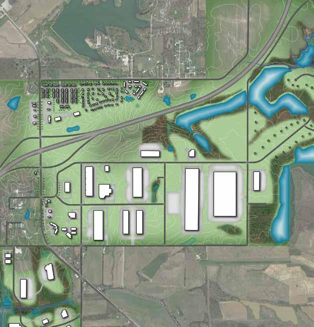
The interchange area master plan creates a development district that provides opportunity for employment generating businesses while planning for infrastructure improvements and protecting natural resources. The design concept is intended to communicate a desired development form. Future land use descriptions are provided to detail the mixture, intensity, and character of desired development. Transportation and utility infrastructure improvements and expansions that are needed to support this development form are then identified in greater detail.
The master plan area is designed as an employment district comprised predominantly of light industrial, heavy industrial, and warehousing uses. The conceptual layout plan creates a number of potential development sites at varying scales, ranging from over 300 acres for a single manufacturing or production use, down to smaller five acre light industrial sites, one acre restaurant/ retail sites, and smaller single-family residential lots. Generally, smaller commercial sites are located adjacent to the interchange along SR 56/61. Shared frontage and rear access roads have been designed to minimize curb cuts onto the state route. The area north of the interstate, closer to the City of Petersburg and already served by city utilities, incorporates a variety of housing types. Ranging from multi-family apartments to townhomes and detached single-family residences on smaller lots, these new units should help to stabilize the community population and provide for greater housing choice in the market.
West of the interchange, several large industrial operations are depicted on sites adjacent to the Indiana Southern rail tracks and Ashby Yards. Additional supporting industries may be able to infill sites along Meridian Road, SR 57, and CR 300 N. Improvements to the transportation system in this area will be required along Meridian Road and CR 300 N.
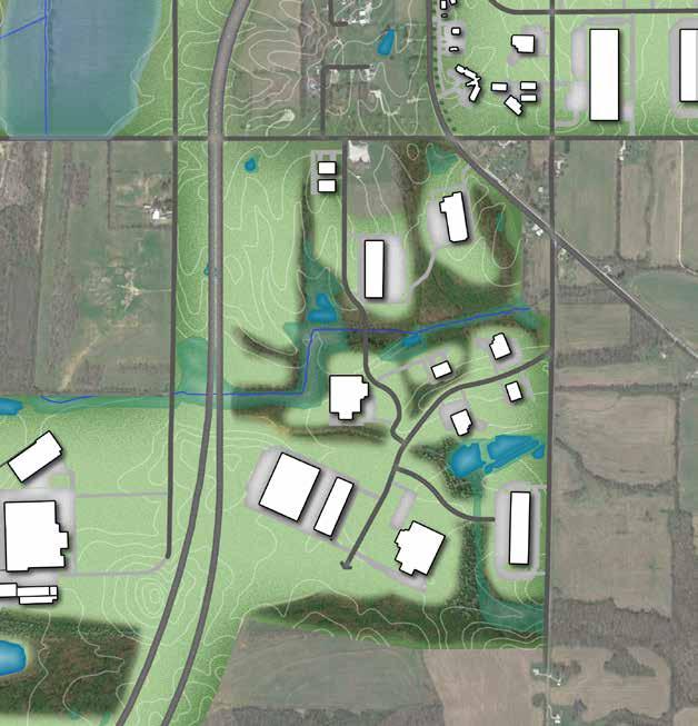
South of the interchange, the Pike Crossing and Generation Springs sites include a range of office/warehouse flex and light industrial uses. These areas have been organized around the existing transportation system, natural features, and topography. The Pike Crossing site is a blank slate that could be subdivided into a number of configurations. The rendering depicts smaller sites closer to SR 56/61 with larger warehouse distribution businesses to the east. The large acreage and flexibility of this area is a unique advantage. If market conditions dictate, some of the larger sites could be subdivided into industrial parks with lots between 5 and 25 acres. Additional roadways will need to be constructed within Pike Crossing to serve new development. Connections to the east and SR 356 have also been included to provide an east-west truck route that bypasses the City of Petersburg. Within Generation Springs, the old haul road will be improved and serve as the central thoroughfare. An additional connector from CR 300 N to the haul road provides access to several development sites and provides an additional access point for emergency services.
East of Pike Crossing, on the lands surrounding the numerous lakes south of the interstate, 38 homes
From our position, the master plan is happening at the most opportune time because Bowman Family Holdings has begun marketing the megasite and having a master plan for the site and the adjacent I-69 interchange areas provides our prospective tenants with assurances that their pending investment in our community is protected. This marketing effort comes after considerable time and resources have been put into a partnership that harnesses public and private investments, political leadership and contributions and support from utility partners. Additional steps have been taken to receive state recognized site certified shovel ready designations, establish Economic Revitalization Areas (ERA), and create Tax Increment Finance (TIF) districts to assist with business recruitment and fully leverage our local economic development toolbox in conjunction with the Indiana Economic Development Corporation (IEDC).
John Mandabach Bowman Family Holdings
are depicted on lots ranging from three to five acres. This area has been laid out to maximize lake front parcels while ensuring lot sizes are large enough to handle residential drinking wells and on-site septic systems. Each subarea is described in more detail on the following pages.
The area north of the I-69 and SR 61 interchange should include a mixture of commercial uses such as restaurants, hotels, gas stations, variety stores, and other retail businesses to serve Petersburg residents, the local workforce, and interstate travelers. These commercial uses should be located closest to the interstate and along the SR 61 frontage and supported by a range of residential development types. Medium density residential development should be used to separate the commercial areas closer to the interchange from single-family residential development farther from the interchange. County Road 400 N will be supported by additional new roads to serve growth and development in this area. Sidewalks and multi-use trails should be included in new developments to create multimodal connections between residential and commercial areas as well as to Prides Creek Park and downtown Petersburg.
The south interchange area includes existing residential development and holds tremendous opportunity as a new employment center not only for Petersburg and Pike County, but Southwest Indiana as a whole. The Entrepreneurship & Technology Center of Pike County, to be located
just south of the interchange on the west side of SR 61, will help frame a gateway to this district. Opportunities for additional retail development are present on the east side of SR 61, just south of the interchange, with access to either SR 61 or the planned County Road 350 N upgrade and extension. Manufacturing, warehousing, logistics, and other industrial uses of varying scales and intensities can be accommodated between the interstate and County Road 300 N. Smaller sites could be created in a business or industrial park setting closer to SR 61 while larger footprint uses can be accommodated on large parcels to the east. Access to the Brenton Family Cemetery, located central to this area and just south of E CR 350 N should be provided with signage identifying this cultural asset. Additional road upgrades to CR 300 N and CR 175 E will be required in addition to internal access roads and drives.
As an Indiana Site Certified-Silver Tier site, Generation Springs is primed for a combination of manufacturing, warehousing, logistics, and other industrial uses in a park like setting. Existing tree stands, topography, and the haul road alignment are used to organize a variety of sites, ranging in size from 4 acres to 60 acres. Individual sites as well as internal roads can be accessed from CR 300 N, SR 61, and CR 75 E.
Two large areas adjacent to the Indiana Southern railroad have been identified to attract medium to heavy industrial, rail transportation users. The northernmost of these areas is bounded by Meridian Rd. to the east, SR 57 to the west, CR 400 N to the north, and CR 300 N to the south. The parcels west of the railroad could be organized with frontage and vehicular transportation access to SR 57 and rail access to the east. The parcels east of the railroad in this sub-area are heavily impacted by the 100 year flood plain, and as such, may be more costly to develop. Generally, less intense industrial operations should be located closer to the City of Petersburg and Meridian Rd. The southernmost rail adjacent site in the master plan area is between the Indiana Southern tracks
My company wholeheartedly supports the master planning efforts that Pike County has undertaken. Like many other businesses, we realize that our economic development efforts must start with a market based plan that leverages our existing assets while focusing on emerging opportunities that fit strategically within our targeted industries.
Jim Gaskins Sisson Steel
and Interstate 69. Vehicular access to this subarea would come via Meridian Rd./Line Rd. With over one mile of rail frontage, this site could accommodate some of the heaviest industrial users, and as such should be preserved in large tracts. Development in either of these rail sites will require improvements to CR 300 N.
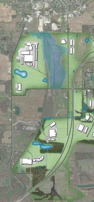
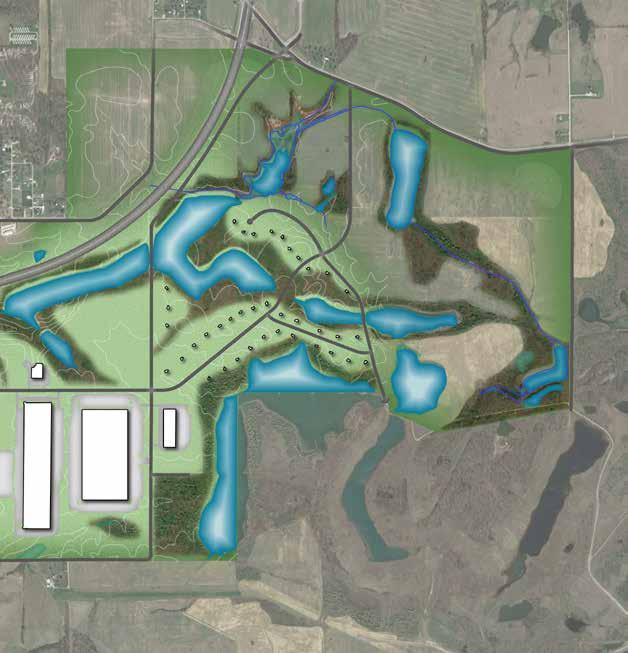
The northeast portion of the master plan area has been designated for low density residential development. The area east of the interstate and south of SR 356, has the potential for a range of single family developments including higher end homes on lake front parcels, larger lot homes on what is currently agriculture land, and traditional subdivisions. The existing natural amenities in this area should be protected and used to promote development here. Given the relative distance to existing sewer and water utilities, shorter term residential development in this area will likely be served by on-site well and septic systems. The recommended larger lot sizes are conducive to these needs. An expanded transportation network will be required through this area with connections to both CR 175 E and SR 356. North of the interstate and east of Prides Creek Park, land is available on either side of CR 175 E for single family residential subdivisions. However, given the location and lack of existing utilities, it is anticipated this area will not develop until after the Interchange – North area and subsequent utility extensions along CR 400 N. In the interim, this area should remain in agriculture use.
The land use framework plan for the interchange area is the map to guide future development. It physically represents the vision and goals established during the planning process and provides the context for future decision-making in regard to development and changes in zoning. Sound land use planning promotes fiscally responsible growth, balances a compatible mix of uses, ensures a quality of life for area residents, and helps create a strong tax base. The objectives of the land use framework are to: 1) ensure that development within the master plan area takes place in an orderly and complimentary fashion, and 2) ensure that the necessary facilities and infrastructure needed for future development have been or will be provided for.
The future land use framework was created through examination of existing land use patterns, environmental conditions, the transportation network, zoning, and stakeholder input. This map should not be confused with zoning. While land use and zoning are related, they serve separate functions. Land use describes the activity that occurs on the land, single-family residential for example. Zoning then regulates the character, building size, density, and other development standards of that land use activity. The land use framework map is intended to be general in nature and not based on specific property lines. This allows some development flexibility and interpretation on a project by project basis while still establishing the foundation by which to make judgments on the appropriateness of future development petitions.
Additionally, development character is just as, if not more important than individual land use. For this reason, the future land use designations and supporting imagery on the following pages aim to include descriptions of desired character and intensity in addition to land use mixes. More so than specific use, character creates the overall image of the community and influences the attitudes of residents, visitors, and the business community.
This master plan is very important to the City of Petersburg because it aids us in attracting capital investments and job growth which adds new tax base lessening the burden of local government. Furthermore this effort will also provide us with a land use plan that we will utilize when considering the future deployment of utilities and other infrastructure supporting economic growth.
Mayor RC Klipsch City of Petersburg
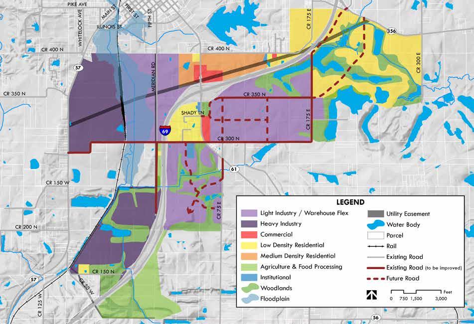
These areas are primarily comprised of lower intensity manufacturing, warehousing, research and development, and office uses. Building types may include both large footprint users with multi-story buildings on large parcels or groups of smaller structures in a business park setting. Light industrial uses conduct nearly all operations within a closed building and do not have extensive outdoor storage areas or operations. When potential conflicts between uses may occur, buffering and landscaping should be used to minimize these impacts. Where areas are subdivided for development of an industrial or business park, opportunities for shared open space and stormwater management should be explored. Flex areas may include limited commercial support uses, but these should be as a secondary element that follows the industrial or office development.
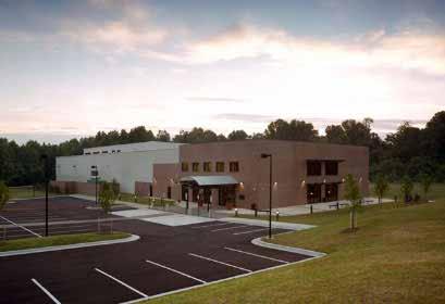
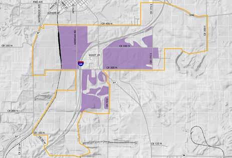
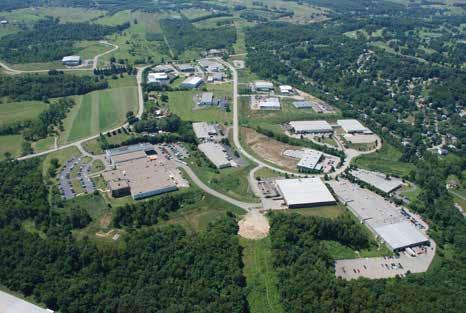
More intensive manufacturing and industrial uses that may involve the processing of raw materials. Heavily industrial uses often involve outdoor operations and material storage. This district requires standards to ensure the protection of public safety, community character, and compatibility with neighboring uses. For sites utilizing outside storage and/or processing, increased amounts of buffering and/or setback should be required. These areas should be located along rail and roadway corridors with the capacity to handle the necessary volumes of truck traffic and be built out in a planned manner so as to maximize investments in public infrastructure systems.
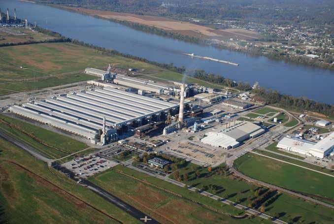
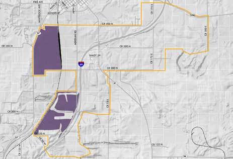
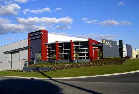
Concentrations of commercial uses generally oriented to automobile access, including retail, restaurant, personal service, office, hotel, and automobilerelated uses. Businesses may be concentrated within shopping centers, developed as outlots, or as stand-alone parcels. These developments may be designed to serve residents, the local workforce, and/or travelers along Interstate 69. Where appropriate sidewalks and multi-use trails should be included to create bicycle and pedestrian connections between residential and commercial areas as well as to Prides Creek Park and downtown Petersburg.
Low density residential areas are generally characterized by single family homes on larger lots. New development should be designed around natural features to highlight lakes, streams, forested areas, hillsides and hilltops. Lot sizes under two acres should be served by municipal sewer and water utilities. Lots over two acres may utilize on-site septic or other sewer treatment systems and private groundwater wells. In addition to existing residential development in these areas, limited institutional and recreation uses may also be present.

Medium density residential development is characterized by single family homes on smaller lots or multiple primary structures or units per lot. Common forms include apartments, condominiums, and town homes. Medium density single family developments may be in the range of 4 to 10 units per acre. New medium density development should have walkable, well-connected street systems that link to surrounding neighborhoods and nearby destinations. These areas must be served by public utilities.

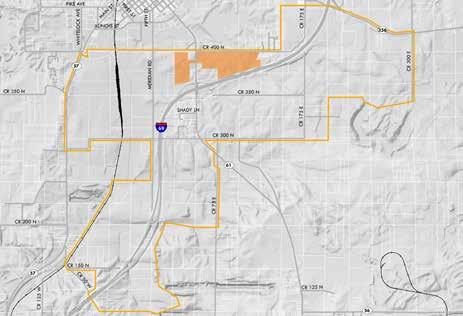
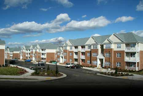
Lands that are sparsely populated and used primarily for farmland, raising of livestock, food processing facilities, and single family homes associated with agriculture use. Food processing uses may require special considerations for truck traffic, material storage, and mitigating potential impacts to neighboring properties. Generally, these areas will utilize on-site services where public utilities are not available.

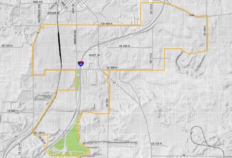
These areas are intended for the preservation of natural features and environmentally sensitive lands as well as the provision of passive and active recreation spaces. Conservation of floodplains, hillsides, and hilltops has an inherent long-term value. However, most of the woodland areas are on private property and as such may be harvested for timber or removed to accommodate new development. Where possible, new development should be designed to minimize disruption of existing habitats and natural features.

While not specifically a land use, the floodway and flood hazard areas have been identified on the land use framework map to help inform thoughtful planning decisions regarding responsible development. The flood hazard area is the area that is susceptible to being inundated by a flood event having a 1-percent chance of being equaled or exceeded in any given year. This is sometimes referred to as the base flood or 100-year floodplain.
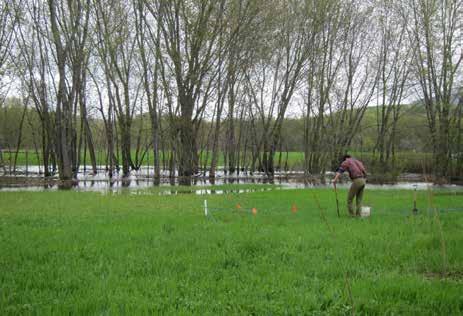
An area’s transportation network plays a central role in supporting and maintaining economic success and quality of life. If goods, services or people cannot move effectively and efficiently through an area the economic, environmental and social well-being of the area are impacted making it less desirable to new or expanded businesses. As a part of the planning process, the transportation network has been viewed as a key component to the success of the master plan area and overall goals of the project.
The transportation network and land use framework presented in this plan are highly interconnected. The proposed land use plan was developed around existing corridors and the opportunities each offered. By using the existing transportation system to inform the proposed land use planning process, future infrastructure investments can be done in support or encouragement of new development projects.
The recommendations discussed in this section represent an integrated vision that will allow for an increase in development while maintaining safety, connectivity and mobility throughout the study area. It is recommended that whenever possible, Pike County and the City of Petersburg leverage local resources to pursue additional funding opportunities with the Indiana Department of Transportation (INDOT) Local Public Agency Programs, such as the Community Crossings Matching Grant.
Access management is the systematic control of location, spacing, design and operation of driveways, median openings, interchanges and street connections to a roadway. By implementing access management tools, a safer, calmer transportation system can be created. Access management seeks to limit and consolidate access along major roadways, while promoting a supporting street system and unified access and circulation system for development. The result is a roadway that functions safely and efficiently for its useful life, and a more attractive network of corridors. While the existing alignment and location of the road corridors and intersections can be modified to accommodate the projected development expansion, several new roads, intersections and driveways will be needed as parcels are developed. These new transportation amenities should include access management solutions in order to create a safe, efficient transportation system. A variety of access management solutions can be utilized within new development and are discussed in the following sections.
Raised medians: Raised medians provide several positive traffic flows, safety and aesthetic benefits. They physically separate opposing traffic streams, and they limit the locations where conflicting movements can be made across those main traffic streams. Raised medians provide a location for deceleration and storage of left turning vehicles that removes them from the through traffic stream. They also provide a refuge for pedestrians crossing the street.
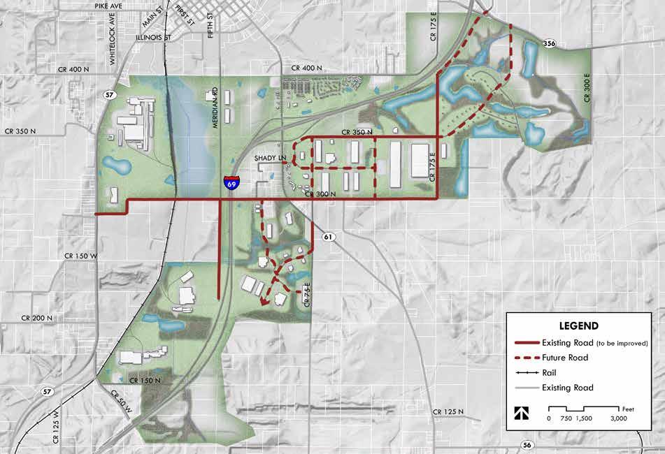
Signal spacing: Signalized intersections often determine the level of service and quality of overall roadway operations. New and proposed traffic signals should be placed and timed accordingly so that traffic can move through each signal at an appropriate speed.
Non-signalized spacing of cross streets also greatly affects the safety and efficiency of a roadway. Separating non-signalized connections simplifies the drive workload and helps reduce the risk of collisions. Throughout the study area additional curb cuts for parking and business entries should be consolidated so that an efficient flow of traffic is achieved.
: Left turn lanes are an important access management measure because they allow left turning vehicles to be separated from the through traffic. This helps to reduce delays and traffic backups that cause lane changing and rear end collisions. In areas of new development, left turn lanes could be incorporated along county roads so that traffic entering development sites does not impede the general circulation pattern.
Frontage and Rear Access Roads: Frontage and rear access roads help to relieve congestion on corridors in two ways. They allow for the consolidation of driveways, thereby removing conflicts on the main road and they reduce traffic volumes on the main road for short trips between nearby uses.
Planning level cost opinions have been developed for the recommended roadway constructions and reconstructions identified on the transportation framework map. These costs are preliminary; as specific improvements are pursued more detailed cost estimates should be prepared before financing is acquired to ensure that final budgets are not exceeded. The cost opinions include construction, design and inspection fees. All roadways are assumed to consist of two, 12foot travel lanes. The baseline costs include open stormwater conveyance systems and no pedestrian facilities. The total cost of baseline roadway improvements is $23,559,600. If the open stormwater conveyance system was replaced with piped infrastructure and two, 5-foot pedestrian sidewalks or one, 10-foot multi-use path was added to each roadway improvement, the total cost would be $30,386,000. This cost reflects an approximate $115 per linear foot increase for the roadway given these improvements. The baseline cost estimate is included in the table on the next page.
The Utility Master Plan (UMP) for the project area includes the following:
• Identifying existing water and wastewater utilities near the planning area
• Analyzing projected land use and transportation framework determined through the steering committee and planning process, and
• Assisting in options development and recommendations that address system and utility needs for projected build out of the planning area.
Existing conditions mapping was obtained from water and wastewater utility providers and incorporated into a Geographical Information System (GIS) which was subsequently used in development of the UMP.
This section describes existing conditions of public water supply facilities near the Pike County EDC planning area. Public water supply in the Pike County EDC planning area is provided by the City of Petersburg, Pike-Gibson Water, Inc., and the Otwell Water Corporation. The Water Works component of the master plan is intended to assist officials in facilitating orderly growth of the water
system and for providing adequate facilities to support expectations for service.
A map of the existing water distribution system is included with this report. The existing water distribution system installed within or near the planning area is more specifically described as follows:
1. City of Petersburg – The City has several water mains near or within the planning area. There is a 10-inch water main on both the north and south sides of I-69 along State Road 56/State Road 61 (SR 56/61). This 10-inch main extends through the heart of the planning area along SR 56/61. There are also existing 4-inch and 6-inch water mains along Line Road. The 4-inch water main along Line Road terminates at the intersection of Line Road and County Road 300 North (CR 300 N). A 4-inch water main runs east along CR 300 N from I-69 to the intersection with SR 61. This main does not go under I-69.
Midwestern Engineers, Inc. is currently assisting the City of Petersburg with water utility master planning. A Preliminary Engineering Report (PER) has been supplied to the City of Petersburg and an application made to USDA-RD for proposed water system improvements. The PER is currently under review. Proposed improvements consist of a new water treatment plant, two new wells in the City’s wellfield, distribution main improvements in city limits, rehabilitation of the City’s two elevated water storage tanks,
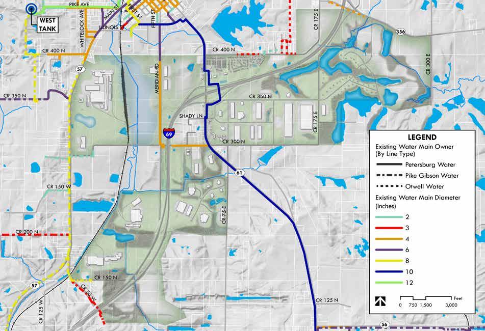
and a new elevated water storage tank south of the planning area along the SR 61 corridor. The proposed new elevated water storage tank would be located along SR 61 near the intersection of County Road 100 E. The site has a favorable elevation of approximately 550 feet which would require a tank height of approximately 120 foot to overflow to match the City’s existing pressure plane. The new water treatment plant will be designed to be expandable for future growth and development in this area. There is also additional capacity in the White River Outwash Aquifer.
2. Pike-Gibson Water, Inc. – Pike-Gibson also has several water mains near or within the planning area and more specifically serves portions of the south and west sides of the planning area. There is an 8-inch water main along State Road 57 (SR 57) that begins south of the SR 57 and CR 400 N intersection. The 8-inch main extends through the planning area and continues running south along SR 57. There is also an existing 6-inch water main that begins at the intersection of SR 57 and Cart Road and continues running west along Cart Road. There are also several runs of 2-inch and 3-inch water main located on the south and west sides of the planning area.
3. Otwell Water Corporation – Otwell Water Corporation serves portions of the north and northeast sides of the planning area. There is an existing 3-inch water main that begins between SR 61 and I-69 on CR 400 N and
continues north between Prides Creek Lake and CR 175 E until its intersection with SR 356. There is also an existing 4-inch water main that runs east-west along SR 356 west of I-69. The water main continues on the east side of I-69 along CR 475 N in this area. There are also small portions of 3-inch and 4-inch water main along SR 356 east of I-69.
A key to any utility master planning project is an understanding of current and future demands of the facilities. For public water supply planning, this requires a sound, reliable projection of future population, and an understanding of land use and development trends occurring within the service area. An important goal for community leaders will be the implementation of development policies which have a positive impact upon residential growth and commercial and industrial trade while promoting coordinated use of available land.
With regards to municipal infrastructure and public water supply, population forecasting plays an important role in planning for the future. Sound capital improvements programs are dependent upon realistic projections to ensure that the needed facilities are in place in a timely manner. Failure to plan properly can lead to water shortages and development delays due to the lack of the necessary infrastructure.
The recently completed PER for the City of Petersburg details the existing system design and capacity, and recommends upgrades through the system for a 20-year planning period. This
PER is included in the appendix sections of this study. The Petersburg PER considered a moderate amount of development to take place near the I-69 interchange, including average water usage of up to 500,000 gallons per day. The PER proposes improvements to meet a projected peak demand of 2.21 million gallons per day, which includes the demand which Petersburg is currently contractually obligated to sell to Pike Gibson Water, Inc. The improvements recommended in the Petersburg PER consist of construction of new supply wells, construction of a new water treatment plant, a new 750,000 gallon elevated storage tank south of I-69, and several distribution system improvements.
This utility master plan addresses significant industrial and residential development beyond that which was addressed in the Petersburg PER. The development proposed in this master plan includes about 1,600 acres of industrial development, and an additional 500 acres of residential and commercial development. A difficulty in projecting future demands from the proposed industrial areas is that specific industrial usage has not been proposed, and industrial water needs can vary dramatically between differing usages. For example, warehousing operations require significantly less water than a food processing facility.
For this planning study, water demand due to new development has been projected to be 360 gallons per minute, or about 520,000 gallons per day, distributed throughout the planned development area. This represents moderate
usage for industrial development. If development interest comes from industries with higher water usage requirements than the recommendations of this master plan, the conceptual layout will have to be re-evaluated to ensure the ability to provide the necessary volume of water without adverse effects to other customers of the water system.
This master plan also accounts for fire flow demands. Fire flow demands represent the ability of a water system to deliver a large volume of water to a concentrated point for the purpose of fire suppression. Because fire flows represent extremely high usage in a short period, they often dictate the design of the distribution system, and the necessary storage tank size. This master plan considers a fire flow of 3,000 gallons per minute. This is a recommended fire flow for industrial developments.
The included water map shows the proposed layout of water mains that will be necessary to serve the proposed development area and provide fire flows of 3,000 gallons per minute throughout the planning area. The proposed water mains are all 12-inch, and are laid out following the existing and proposed transportation system, mainly along existing county roads. 12-inch mains are necessary to provide the required fire flows throughout the proposed development area. If proposed developments would change the layout of the road network then the exact location of the proposed lines would require modification. The following paragraphs describe the location of the proposed mains.
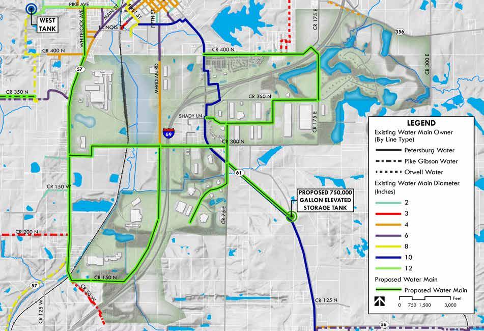
Proposed mains west of I-69 begin with a reinforcement main near the west tank. This main begins at Pike Avenue and Whitelock Drive and continues south, following State Road 57 to the southern end of the planning study before turning east along County Road 150 N and then north paralleling I-69 to CR 300 N where it meets an existing 4-inch line coming south from Petersburg. On CR 300 N a proposed main extends from SR 57 east and meets the proposed line from the south and then continues under I-69 to the east side of the freeway, meeting the existing 10-inch main on SR 56/61 and other proposed mains.
North of I-69 a proposed main extends east from SR 56/61 along CR 400 N to I-69, where it passes beneath the interstate and continues south along CR 175 E to CR 350 N. At this point future low density residential to the east would tie into the proposed mains, and a specific layout would be generated for the residential area. A proposed main continues west along CR 350 N for one half mile, then turns south for one quarter mile before continuing west to SR 56/61. A proposed main runs north-south along CR 75 E, connecting the east-west mains with the existing 10-inch main and continuing to serve the proposed development area to the south.
The proposed 750,000 gallon tank is located on SR 56/61 near the intersection with CR 100 E. The proposed layout requires a reinforcing line parallel to the existing 10-inch main from the tank to CR 75 E to ensure that fire flow demands can be met throughout the proposed area.
When the proposed water mains are installed it will be necessary to strategically locate fire hydrants for fire suppression and system maintenance. It is recommended that within residential areas fire hydrants be placed at no more than 500 foot intervals. In industrial areas, it is recommended that specific site design be considered to ensure that fire hydrants provide appropriate coverage of all structures, and that structures have integrated fire suppression systems with dedicated water supply lines.
Recommendations made to the City of Petersburg in the PER would expand plant capacity to match the estimated peak day demand of 2.21 million gallons, while the average daily demand would raise to 1,585,000 gallons. The PER considers a daily average demand in the Pike County EDC planning area of 500,000 gallons. Any development in the planning area greater than anticipated within this study may require additional water sources and treatment facilities.
The new elevated storage tank will increase system storage capacity to 1,850,000 gallons. Storage is recommended to be between 1 and 2 days average system usage plus fire flow demands. Fire flow is required for a minimum of 2 hours, resulting in a required storage volume of 360,000 gallons (3,000 gallons per minute x 120 minutes) in addition to the 1,585,000 gallons average daily usage found in the PER. Based on this, the storage volume will also not be adequate for expansion beyond the 500,000 gallons per day already accounted for in the PER. Full build-out
of the proposed development area with industrial users will require additional water storage if average usage above 500,000 gallons per day is achieved in the planning area or if existing customers, such as Pike Gibson Water, require additional capacity. If this occurs the White River Outwash Aquifer system has additional capacity and the City of Petersburg’s new water treatment plant is expandable.
Cost estimates have been prepared for the installation of proposed water mains in the planning area. These costs are preliminary, and should only be used for early planning processes. If these improvements are pursued more detailed cost estimates should be prepared before financing is acquired to ensure that final budgets are not exceeded. The following construction cost estimates include the installation of water main, including bores underneath I-69 and the railroad, necessary appurtenances, and replacement of surfacing. These costs do not include nonconstruction costs, or installation of fire hydrants, as it is assumed that hydrants will not be placed until specific site plans are approved to ensure necessary coverage of the proposed structures.
The total estimated construction costs for the proposed water mains is $8,360,000. If future average demands exceed 250,000 gallons per day then additional costs would be incurred to expand the water supply, treatment, and storage capacities of the Petersburg water system.
The above noted construction costs are based on a per lineal foot cost and can be used to create a phasing plan as economic development occurs in the area. These costs should be considered with the Utilities and Infrastructure Implementation Matrix included with this planning study.
The primary goal of this section of the UMP is to evaluate and identify the existing sewer collection and treatment systems in the Pike County EDC planning area and to plan for future growth and expansion in the Pike County EDC planning area. A comprehensive assessment of all components of the sewer collection and treatment systems are not necessary to achieve these goals in an effective manner; however, knowledge of the existing system is important for future planning. Additional goals and objectives of this plan are as follows:
• Maintain a wastewater collection system and ensure its adequacy to protect the health and safety of all residents and businesses in the City of Petersburg and the Pike County EDC planning area.
• Provide wastewater collection, transmission, and treatment that will satisfy existing needs and projected growth.
• Coordinate facilities with designated land use and recognize the relationship between sewer infrastructure capabilities, natural features, and environmental and physical factors. Improvements should also strive to maintain equitable levels of service, safeguard public health and safety, and serve new development in a timely manner.
• Encourage efficient use of existing and planned sanitary sewer collection and treatment facilities.
This section provides a general overview of the existing public sewer collection and treatment systems near the Pike County EDC planning area. The only public sewer system in the planning area is the City of Petersburg. The City of Petersburg’s existing sewer collection system is roughly equal to the City corporate limits, covering an area of approximately 1.47 sq. miles. The sanitary collection system is a conventional gravity system consisting of: approximately 4,700 L.F. of 18” gravity sewer; 4,300 L.F. of 12” gravity sewer; 200 L.F. of 10” gravity sewer; and 90,250 L.F. of 8” gravity sewer. The system also contains approximately 11,000 L.F. of force main and eight lift stations. Seven of the lift stations have their own collection zone. The 8th lift station serves a single commercial customer and discharges into another collection zone. It should be noted that
• Coordinate the location of wastewater facilities with projected land use and transportation framework identified by the steering committee and project team.
I-69 Lift Station Nos. 1 and 2 were installed in 2014/15 along with 6,000 feet of 6-inch force main and 1,280 feet of 8-inch gravity sewer. The I-69 Improvements are base facilities to allow some future development in the I-69 Corridor. Additional facilities may be constructed with development and most likely turned over to the City for operation and maintenance. The collection system, except the I-69 improvements, is subject to inflow and infiltration (I&I) during rainfall events.
The City operates a Class II Trickling Filter type wastewater treatment plant (WWTP) under NPDES Permit No. IN0024325. The Average Design Flow is 0.6 Million Gallons per Day (MGD) and the Peak Design Flow is 1.8 MGD. An 18-inch gravity interceptor discharges into the WWTP Influent Structure. The Headworks Structure consists of a macerator, bar screen and three raw wastewater pumps. The raw wastewater pumps pump into a three chamber Primary Clarifier. From the Primary Clarifier, sewage flows by gravity through two Trickling Filters. A Transfer Lift Station pumps filtered water to two Final Clarifiers. From the Final Clarifiers, effluent flows by gravity to the Ultraviolet (UV) Disinfection System before being discharged to the White River or Prides Creek. Waste sludge from the clarifiers is sent to the Anaerobic Digester. Digested sludge is sent to the drying beds for dewatering. Dried sludge is disposed in a land fill.
Midwestern Engineers, Inc. is currently in the process of assisting the City of Petersburg with wastewater utility master planning and is currently finalizing a Preliminary Engineering Report that summarizes existing facilities and identifies proposed improvements. The city anticipates application to USDA-Rural Development for construction improvements in the 2017 calendar year. Construction of proposed improvements is anticipated to begin in 2018 and be complete and in service by 2020. The majority of planned improvements are to the wastewater treatment plant and lift stations within the corporate limits. The plan does account for increased flows from the Pike County EDC I-69 planning area.
As part of the PER, the proposed WWTP would be expanded to have an Average Design Flow of 1.30 MGD and a Peak Day Flow of 3.75 MGD. This design criteria provides a WWTP that is capable of treating projected future demands and eliminates the possibility of a connection ban. Part of the reason for the WWTP expansion is to handle increased flows from the Pike County EDC planning area.
The PER considers an Average Design Flow increase of approximately 450,000 GPD from future industrial development within the service area, which includes the Pike County EDC planning area. Should development in the Pike County EDC planning area exceed 450,000 GPD, as estimated with this planning study, it would require development of additional sewer collection and treatment facilities.
A more detailed list of PER recommendations are as follows:
1. WWTP Process Improvements/Expansion
a. Two New Trickling Filters
b. New Sewage Grinder
c. Two new Circular Primary Clarifiers
d. Replacement of Raw Wastewater Pumps
e. Rehabilitate Anaerobic Digestor
f. Two New Final Clarifiers
g. New Transfer Lift Station
h. New Chemical Injection Facility for Phosphorous
i. Replacement of UV Disinfection Unit
j. New Sludge Drying Beds
k. New Sludge Lift Station
l. New Standby Diesel Generator
2. SSO Improvements
a. New Equalization Lagoon
b. New Supply Lift Station with Diversion Structure
c. New Gravity Return Piping
3. Collection System Improvements
a. New Sewage Grinder
b. New Standby Generator for L.S. #3 & #5
The Sanitary Sewer Master Plan is based upon the existing sewer collection and treatment system indicated above from field reconnaissance, historic engineering and planning data, and information provided by the City of Petersburg.
Proposed improvements are anticipated to occur in the near future pending approval and obligation from USDA-RD. This information was incorporated into a GIS database for use with the UMP.
In order to evaluate the Town’s existing sanitary collection system and plan for expansion of the system to meet future development, estimates of loadings and capacities needed to be determined for the proposed land use and site layouts developed during the Pike County EDC planning process.
Commonly accepted industry standards were used to project flows based on land use acreage, building size and/or dwelling units. For residential areas, average daily wastewater generation were based on a unit estimate of 310 gallons per day per household. For commercial, industrial, and institutional areas, wastewater generation estimates are based upon a quantity of flow per unit area. Business and commercial developments are likely to include a mix of office space, warehousing, retail, and business support facilities. For commercial applications, we have calculated developable acreage based upon the building layout developed during the planning stages for the applicable service area, and applied a
wastewater generation rate of 1,000 gallons per day per acre (gpd/ac). Wastewater flows from industrial sources will vary widely depending upon the size and nature of the facility and its level of water consumption. Because of this variation, we have used a design value of 2,500 gpd/ac for the light to heavy industrial development expected to occur within undeveloped portions of the planning area zoned for industrial use.
In order to properly estimate wastewater flow rates in the major interceptors the planning area was divided into a number of sewer sub-basins. These sub-basin boundaries are based upon the location of the major interceptor sewers found in the collection system, and the areas which are served by those interceptors and their tributaries. The sub-basin boundaries were also used to estimate reasonable and realistic wastewater loadings for planning purposes. The sub-basin delineations serve to appropriately define where the wastewater flows and loadings were entered into the collection system model. Three subbasins were developed for the planning area and are more particularly described as follows:
This subbasin is anticipated to handle flows west of I-69 from the planned heavy and light industrial sites. Each industrial site is anticipated to have their own lift station that would pump generated flows into a force main that would run along SR 57 north to existing City of Petersburg Lift Station No. 5. From Lift Station No. 5, flows would be conveyed in the existing force main into a gravity
sewer and ultimately to the existing WWTP. Based upon the preliminary site layouts, a 6-inch force main would be needed to convey flows to a lift station to be located in the vicinity of the intersection of CR 400 N and SR 57. Flows would then be conveyed via a 6-inch force main to Lift Station No. 5 where they would be conveyed via existing sewer infrastructure to the WWTP. The proposed WWTP expansion as part of the City of Petersburg PER would be sized adequately to handle the proposed flows from Subbasin No. 1.
Subbasin No. 1
This subbasin would handle flows north from the proposed residential and commercial areas north of I-69 and east of Subbasin No. 1. It would also handle a small amount of development on the south side of the I-69 interchange. A 6-inch force main would convey flows from the low density residential on the far east extent of this subbasin to a gravity sewer commencing in vicinity of the intersection of CR 175 E and CR 400 N. From there an 8-inch gravity sewer would conveys flows to the existing 6-inch force main running north to an existing lift station along SR 56/61 where it would then be ultimately conveyed to the existing City WWTP.
This subbasin would handle flows south of I-69 and Subbasin No. 2. The City’s planned WWTP expansion has capacity to handle development in Subbasin No. 1 and Subbasin No. 2; however, the large amount of development south of I-69 would need to be collected, conveyed, and treated
at another location if full build out would occur. There is capacity for initial development in these areas to be conveyed to the existing lift station and force main south of the I-69 interchange. A new sewer interceptor is needed to convey flows to a new WWTP to be sited within or near the Pike County EDC planning area as development exceeds capacity of the existing force main and lift station. Based upon a preliminary analysis of the proposed land use and transportation framework the preferred site for a new WWTP would be between CR 300 N and CR 175 North south of the proposed light industry/warehouse flex land use. The proposed WWTP would discharge to a tributary to Prides Creek on the east side of I-69 and be conveyed to Prides Creek located on the west side of I-69. An alternative site for a new WWTP could be northwest of the intersection of CR 175 E and CR 350 N on the south side of I-69. The alternative site would discharge into a proposed gravity sewer that would convey flows north of I-69 and ultimately to Prides Creek. Site constraints should be further evaluated before this location is chosen for the final location of the proposed WWTP due to mining activity in the area. Discussions and coordination will also need to occur with IDEM during final site selection and planning. Additional coordination and due diligence must be performed in order to determine the best location for a new WWTP.
Force main, lift stations, and gravity sewer will be required to convey flows to the new WWTP. Depending upon the location of the new WWTP, the collection system will vary. A preliminary
alignment of the collection system is shown on the proposed Sanitary Sewer Master Plan.
Total flow projections for all three subbasins are as noted below in table to the right.
The Pike County EDC planning area improvements will include new sewers which should be sized to accommodate the future growth at the time they are constructed. In some areas, the improvements include upgrades or reinforcements to existing facilities which are considered important elements of the system needed to meet future flow conditions. For the master plan, slopes of new gravity mains are based upon the minimum grades allowable for that pipe diameter per the Ten States Recommended Standards for Wastewater Facilities, commonly known as the “Ten State Standards.” In some cases, steeper slopes with smaller diameter gravity mains may be possible based on final design grades.
This plan is intended to provide a guideline which will allow Pike County EDC to meet the peak wastewater flow demands anticipated for ultimate build out of the planning area. This would also provide a guideline for Pike County EDC to utilize as development occurs in areas needing new sewers or areas in need of upgrades to existing sewers or lift stations to accommodate the new development. Coordination will need to occur with the City of Petersburg as well as appropriate state and federal agencies.
PROPOSED CITY OWNED FORCE MAIN TO EX. LIFT STATION #5 ± 4,150 L.F.
NEW CITY OWNED SEWAGE LIFT STATION
PROPOSED DEVELOPMENT SUBBASIN No. 1 FORCE MAIN ± 3,650 L.F.
PROPOSED DEVELOPMENT SUBBASIN No. 2 GRAVITY MAIN ± 5,350 L.F.
PROPOSED DEVELOPMENT SUBBASIN No. 2 FORCE MAIN ± 3,450 L.F.
PROPOSED DEVELOPMENT SUBBASIN No. 3 LIFT STATION
PROPOSED DEVELOPMENT SUBBASIN No. 1 FORCE MAIN ± 11,550 L.F.
HEAVY INDUSTRY - PRE-TREAT & SEND TO EXIST. WWTP
PROPOSED DEVELOPMENT SUBBASIN No. 3 FORCE MAIN ± 4,800 L.F.
PROPOSED DEVELOPMENT SUBBASIN No. 1 FORCE MAIN ± 3,550 L.F.
PROPOSED DEVELOPMENT SUBBASIN No. 3 LIFT STATION
PROPOSED DEVELOPMENT SUBBASIN No. 3 FORCE MAIN ± 3,100 L.F.
PROPOSED DEVELOPMENT SUBBASIN No. 3 GRAVITY MAIN ± 11,450 L.F.
2,800 L.F. - 10” GRAVITY SEWER TO OUTFALL
PROPOSED DEVELOPMENT SUBBASIN No. 1 FORCE MAIN ± 1,100 L.F.
PROPOSED DEVELOPMENT SUBBASIN No. 3 GRAVITY MAIN ± 1,050 L.F.
FUTURE PREFERRED DEVELOPMENT WWTP SITE FOR SUBBASIN No. 3
The Sanitary Sewer Master Plan has identified the subbasins and proposed improvements as discussed in previous sections. The preliminary sizing and general locations for interceptor sewers, lift stations, a new WWTP, and related facilities are shown on exhibits included with this report. Pike County EDC and other sources that may use this study in the future should understand the plan is flexible and the locations of planned infrastructure are subject to land acquisition, site requirements, and final design recommendations. Coordination will also need to be performed with the Indiana Department of Environmental Management and various other state and federal agencies.
Preliminary cost estimates have been prepared for recommended sewer projects and related facilities and improvements discussed in this Master Plan. Capital costs for these improvements projects are presented in the following tables, in the order of the sewer study areas described in above sections of the report. These estimates are based on 2017 dollars, and should be reviewed and updated as necessary to account for inflation and changes in local economic conditions. It should also be noted that these estimates do not include the costs associated with the construction of sanitary sewers within private developments or the costs for sewers which may be needed to convey wastewater from future developments to proposed interceptors.
Estimates for such future conveyance facilities can be prepared after documentary evidence is provided to indicate a general plan for grading and wastewater collection within a planned development. Unit costs presented in the following tables are base construction costs which include contractor overhead and profit and are based on historical publicly bid project data. A fifteen percent (15%) construction contingency has been added, along with a twenty five percent (25%) allowance for engineering, legal, administrative, and management expenses.
The above noted construction costs are based on a per lineal foot cost and can be used to create a phasing plan as economic development occurs in the area. These costs should be considered along with Utilities and Infrastructure Implementation Matrix included with this planning study.
As previously noted in the Context section of this plan and referenced in the letter from WIN Energy to the left, the Pike County interchange area has significant electric power infrastructure and capacity to serve new development. Where possible, new electrical supplies lines should be installed underground. Developers may face costs to install underground conduit but utility providers will install all cabling. Normally new underground lines and equipment will be installed by the provider at no cost to the developer, providing the estimated revenue meets the utilities payback schedule. If the estimated cost of the installation exceeds the estimated revenue, the developer may pay the difference of such costs in advance of construction. Providers may not make any underground installation, if in their judgment it is not technically or economically justified as specified by the IURC. Typical above ground space needs for new infrastructure include an approximate 25-foot by 25-foot area for regulator stations as needed. In the event a large load user requires an additional substation, a 2-acre land area would be required. Ideally, this land area would be provided by the development project; a one year design build process would be needed for the substation.
WIN Energy is excited about the master plan for approximately 4,000 acres along the I-69 corridor in Pike County. This Master Plan will act as a blueprint for development and growth in Pike County facilitating capital investment and job creation. As a not-for-profit electric distribution cooperative serving major portions of Pike County, WIN Energy along with our wholesale electric provider, Hoosier Energy, are pleased to provide the following information for inclusion in the Pike County Master Plan.
WIN Energy provides electric services to homes, businesses, farms and industrial members (customers) within the area under review by the Master Plan. With over 12,000 members and; 2,600 miles of energized electric distributions lines throughout our service territory supported by over 50 dedicated employees, WIN Energy can meet the electric needs of any potential industrial or commercial endeavor.
For those industrial customers needing transmission level service, our wholesale electric provider, Hoosier Energy, will assist us in meeting those needs. Hoosier Energy is a not-for-profit generation and transmission cooperative (G&T) that provides transmission level electric power to WIN Energy and 17 other member/owner distribution cooperatives in central and southern Indiana and southeast Illinois.
Pike County has a tremendous electric transmission infrastructure and the capacity available to meet future demand. Hoosier Energy owns and operates 69kV and 161kV transmission lines in Pike County and has interconnection agreements with other electric utilities within the county that provide access to 138kV and 345kV transmission lines. This transmission infrastructure provides a significant advantage to businesses and industries with large electric requirements with available redundancy that also needs unmatched reliability.
Together WIN Energy and Hoosier Energy have the combined distribution and transmission capacity to serve a wide variety of load sizes in Pike County. Also, due to being electric cooperatives, we are able to move more swiftly and have the flexibility to meet the needs of area under study.
We believe we are perfectly poised to provide and deliver the energy needed to power Pike County industry and are excited to continue to partner with Pike County as they look to the future for continued economic growth and prosperity.
Tom Gregory, CEO WIN Energy
This letter serves as Vectren’s intent and support to provide electric and natural gas service to Pike County’s applicable master plan designated area as well as the proposed Generation Springs Mega Site.
Vectren is an Indiana based utility with significant infrastructure and financial capabilities for service to current and potential residential, commercial and industrial customers. Vectren works collaboratively with local communities and economic development organizations to promote key development initiatives like your community has proposed in Pike County. It is imperative Vectren works in parallel with future customers to understand their energy requirements so Vectren and the community can provide efficient solutions.
We look forward to a longstanding relationship as your energy provider and community partner within Pike County. Please reach out to me with any questions regarding reliability and service.
Thomas L. Bailey, Director Industrial Sales & Economic Development Vectren Corporation
Development of proposed industrial, commercial, and residential uses would all increase the demand for natural gas within the master plan area. Natural gas will be distributed through the area with connections to the existing Ohio Valley Gas (OVG) 4-inch main along SR 56/61, extension of the Vectren main south along SR 57, and potential additional new mains as needed. Both OVG and Vectren currently have excess capacity that could serve new development. The OVG 4-inch main along SR 56/61 could add another 40 million British thermal units (BTU) of output per day depending on the location of end users. Several options exist for extending Vectren infrastructure south along SR 57, as either a medium pressure or high pressure main with differing capacities. Increases over existing capacity will be dictated by supply availability from the Texas Gas Transmission Co. 10-inch pipeline which runs east/west between the City of Petersburg and I-69. Current capacity of approximately 7,500 decatherms (Dth) per day suggests the ability to serve any new gas demands.
Natural gas consumption among industrial users can vary significantly. It may be used for heating, cooling, and cooking, similar to commercial and residential uses; it may also be a base ingredient for products such as fertilizers, plastics, and other chemicals. Since overall consumption, hourly loads, and delivery pressures can vary widely, it is difficult to forecast necessary supplies and corresponding infrastructure needs. Similarly, the costs of natural gas infrastructure can vary
widely based on pipe diameter and delivery pressure. As such, linear foot costs are not been included here like in previous sections. Typically, end users/developers do not install gas mains and are only responsible for on-site connections. The cost to install or extend mains are borne solely by the utility provider. The end user/developer will have to offset installation costs should the planned development not be projected to meet a 5-year payback period, as approved by the Indiana Utility Regulatory Commission (IURC).
Data regarding natural gas consumption for warehouse, food service, hospitality, and other uses is gathered by the U.S. Energy Information Administration (EIA) Commercial Buildings Energy Consumption Survey (CBECS). The most recent available data is from 2012, and is presented for several uses in the table below.
Source: U.S. Energy Information Administration Commercial Buildings Energy Consumption Survey 2012
Nonrefrigerated warehouse and storage buildings use an average of 18 cubic feet of gas per square foot of building area per year. One cubic foot of gas is approximately equal to 1,000 BTUs, meaning the 40 million BTU/day capacity of the OVG main line could serve over 750,000 square feet of warehouse buildings. Average natural gas usage for a single family residence in the Midwest is 90.3 million BTU per year (US EIA Residential Energy Consumption Survey, 2009). The 40 million BTU/day capacity could serve an additional 162 homes in the area. These figures are based on the existing infrastructure; additional upgrades or extensions would create even greater capacity.
As existing roadways are improved and new roadways constructed, additional right-of-way or easements should be secured for new gas infrastructure. A standard 20-foot easement is recommended for typical distribution gas mains while high pressure mains will require a 40 to 50-foot easement. The EDC should continue to communicate hourly loads, geographic locations, and delivery pressures of potential projects to natural gas providers so they may adequately respond to requests for information.
Ohio Valley Gas Corporation (OVGC) whole heartedly supports the vision cast by the Pike County Growth Council for the development of the 4,000 acres surrounding the State Road 61 and Interstate 69 interchange, known as the Pike County Interchange Area Master Plan.
OVGC is an investor-owned utility which provides natural gas distribution and transportation services to residential, commercial, industrial and governmental customers in 16 Indiana counties and 1 county in Ohio. OVGC, and its wholly owned subsidiary, OVGI, are operated under rules and regulations established by the Indiana Utility Regulatory Commission (IURC), the Public Utility Commission of Ohio (PUCO) and the U.S. Department of Transportation.
Our Company was founded in 1943 in Tell City, Indiana and has grown, via several acquisitions of existing utilities and numerous pipeline extensions, to provide service to more than fifty communities in central and southern Indiana and several small communities in Ohio. Our company’s various distribution systems are all connected to interstate pipeline systems operated by either Texas Gas Transmission, LLC. a wholly owned subsidiary of Boardwalk Pipeline Partners, LP or ANR, a TransCanada company.
Customers residing in the Interchange Area Master Plan would be personally served locally by our dedicated staff from the Sullivan District Office. Sullivan is on U.S. Highway 41, a main route between Evansville and Chicago, and is 25 miles south of Interstate 70 at Terre Haute. In addition to the community of Sullivan, this District Office serves customers along Texas Gas Transmission’s Pipeline, including the incorporated towns of Riley in Vigo County, Dugger, Farmersburg, Hymera and Shelburn, in Sullivan County, and Winslow in Pike County. Service also includes areas in these Indiana counties: Greene, Pike, Knox, Sullivan and Vigo. OVG also serves Blackhawk in Vigo County; Cass, Curryville, and New Lebanon in Sullivan County and Arthur, Ayrshire, and Campbelltown in Pike County.
OVGC already has approximately 30 miles of natural gas distribution main in Pike County providing natural gas service to homes, businesses, and industrial customers.
Within the Area Master Plan, OVGC has a 4” 150 psig natural gas main along SR 61, under I-69, south to Winslow. OVG currently serves customers along the existing route and is prepared to upgrade and expand infrastructure to serve new residential, industrial, and commercial customers.
OVGC can provide service to large industrial customers, limited only by the capacity of the Natural Gas Transmission Company, Boardwalk Pipeline Partners (currently about 7,500 Dth/day). OVGC is committed to working with Boardwalk Pipeline Partners (Texas Gas) to assure adequate natural gas supply for proposed customers and industry.
We are well positioned to provide the natural gas needs of homes, businesses, and industrial customers in the Master Plan Area. Thus making the vision of diversifying the local economy, creating high paying job opportunities, increasing household incomes and expanding the tax base in Pike County a reality.
Scott A. Williams, Executive Vice President Ohio Valley Gas Corporation
Industrial and business tenants have a wide range of potential telecommunications infrastructure needs; telecommunications utilities include those that supply telephone, cable, TV or digital broadband internet. Fast, reliable connectivity has become increasingly important as advances in technology have occurred, and broadband is an expected piece of infrastructure just like water or electrical service. All new telecommunications installations will typically utilize fiber optic cable, as copper cable is generally no longer used.
Local broadband internet is provided to portions of the study area by Frontier, NewWave Communications, and HughesNet. Indiana Fiber Network (IFN) and owner/partner PSC maintain fiber infrastructure in the study area. IFN currently has a 48 fiber cable along SR 356 between Petersburg and Otwell, while PSC has a 96 fiber cable along SR 56/61 between Petersburg and Jasper. NewWave Communications operates a high density fiber cable through the master plan area as well.
Extending the fiber network to better serve the master plan area could significantly aid in economic development efforts. Beyond broadband, fiber connectivity and redundancy may be required for information intensive end users like data centers and even healthcare. Sites with inadequate connectivity may be quickly passed over for projects requiring broadband, making the process of elimination easier for investment decisionmakers.
PSC is a broadband company certified in the State of Indiana. We provide voice, video, and data services to residential, small business, large enterprise, healthcare units, schools, libraries, and government entities throughout Perry, Spencer, Dubois and Pike counties. PSC has been in existence since 1953, having deployed fiber optics since the early 1980’s, and is the area ‘s premier leader in fiber network deployment and services.
PSC has in excess of 1,500 miles of fiber deployed connecting over 6,000 locations throughout our regional footprint.
PSC has a state-of-the-art regional Dense Wavelength Division Multiplex (DWDM) fiber ring network that can scale up to 400 Gbps.
PSC’s network is very scalable, robust, and secure. We have dual homed connectivity to Indiana Fiber Network (IFN), a state-wide network, of which PSC is an equity partner. Along with this connectivity we also have additional redundancy to the Cermak data center in Chicago.
PSC has local responsive installation and support available 24 hours a day, 7 days a week.
James M. Dauby
PSC President and CEO
IFN provides transport services via our backbone fiber routes, dedicated partner routes, and specific customer expansion sales. It is an extremely reliable and protected solution to provide connectivity to the most demanding customer-market segment.
IFN has in excess of 4,400 route miles of single-mode fiber, connecting in excess of 4,000 buildings in Indiana. Additionally, IFN provides national connectivity through carrier hotels and INDATEL to expand our footprint. Providing the most secure, reliable, and cost-effective telecommunications services possible is what makes IFN the preferred Fiber Network.
How your organization can benefit with IFN’s Fiber Transport Service:
• Ethernet Simplicity: IFN delivers fiber transport service via familiar Ethernet technology.
• Standards-Based: IFN follows the Metro Ethernet Forum (MEF) standards.
• Cost-Effectiveness: IFN delivers high-speed Ethernet connectivity at noticeable cost savings compared with traditional communication providers.
• Flexibility and Scalability: Multiple transport configuration options are supported to fit your connectivity needs from 10Mbps to 100Gbps.
• Professional installation and local support: IFN’s dedicated local support team is available 24 hours a day, 7 days a week.
Robert Ramsey
IFN, Director of Business Development
NewWave is proud to be the area’s top choice for Internet, Phone and Television solutions for the Pike County area. We are able to provide local exchange service in the Petersburg exchange, as well as port numbers from a current provider. This letter serves as a letter of support for the project, and willingness to meet the Communications needs to new development at the mega site.
We have an array of products to meet the needs at the site. We are able to offer a Fiber solution, Phone, and of course Cable TV.
NewWave offers 24/7 local technical support. We also have in place a redundant fiber ring as to avoid any service interruptions.
As far as phone service, we can offer the following:
• Traditional POTS lines
• Fax Lines
• PRI
• SIP Trunk Service
• Toll Free Service
• Hosted Phone Service (Polycom Phones)
We look forward to working with you, please let me know of any questions you may have.
Morgan Foster, Business Sales Executive NewWave Communications
It is recommended that 4-inch, plastic conduit be installed as part of all new roadway constructions or improvements. A “dig once” policy makes it cheaper and easier to install fiber optic cable in the future as the area is developed. A typical cost for installing fiber cable along county roads is $10 per linear foot, not including right-of-way or easement acquisition. Where conduit is already in place, installation costs are approximately $3-$4 per linear foot.
Most new cable will be installed by the utility provider, but some underground conduits may be requested to be installed under proposed roadways by the developer. Utility providers will typically provide the conduit material. The various telecommunications providers may install single or multiple conduits. The telecommunications providers should be engaged during the planning and design phases of development projects to determine the facilities they prefer to have installed. Additionally, the telecommunications providers will seek to use either exiting right-ofway, shared utility easements or designate private easements to locate their cabling.
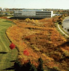

As development within the master plan area occurs, buildings, roads, and sidewalks and other impervious surfaces will lead to increases in stormwater volume. These impervious surfaces do not allow stormwater to infiltrate and recharge groundwater supplies. Instead, stormwater travels over the land and runs off at a rate much higher than would occur on the site before development. This stormwater runoff can carry pollutants and sediment to receiving lakes, streams, and rivers thus degrading water quality. Additionally, increased stormwater volumes contribute to greater downstream flooding.
Given the land availability and large sites within the study area, it is anticipated that stormwater management will occur at the site level. Traditionally, this involves using pipes, curbs, and detention basins to direct and/or temporarily store the stormwater before it is discharged to a receiving waterway.
Low impact development (LID) and green infrastructure best management practices should be incorporated into site design to minimize runoff by: decreasing site disturbance during construction, preserving existing natural features on a site, reducing the amount of impervious coverage, disconnecting drainage flows, and increasing opportunities for infiltration. The following are some potential best management practices; while some are meant for larger scale installations, many can be scaled appropriately to serve single sites, or a combination of sites and developments.
Detention basins, or dry ponds, slow and hold stormwater flows for a period of time. They have an orifice level with the bottom of the basin so that all of the water eventually drains out and it remains dry between storms. Retention basins have a permanent pool of water that fluctuates in response to precipitation and runoff from the contributing areas. Maintaining a pool discourages resuspension and keeps deposited sediments at the bottom of the holding area, but does increase the potential for drowning hazards.
At a larger scale, the study area can benefit from the incorporation of a series of linked infrastructure projects to contribute to a better integrated and thriving ecological system. Through the construction of a series of large and small detention basins a district wide amenity can be created while also providing a necessary piece of storm water infrastructure. The constructed storm water chain creates a living system that promotes infiltration and groundwater recharge, manages the rate of flow through the overall system, and contributes to the treatment of suspended soils and particulate-bound pollutants and supports healthy, native plant growth.
Rain gardens are planted areas that typically consist of deep rooted native plants in a shallow depression. These designed gardens are capable of collecting local storm water and contain it until it can infiltrate into the soil. Allowing for bioretention in site design allows for recharging of groundwater supplies and naturally removes most contaminates in the runoff. Rain gardens also provide wildlife habitat and aesthetic enhancements to development. These projects are also reasonable to implement at virtually any site level.
Bioswales are linear storm water management elements that augment the conventional storm water management system. Swales along roadway pavement edges and parking lots are strategically planted with native plants to slow storm water runoff. By slowing the rate of runoff, soil erosion is minimized and the groundwater supply can be recharged with naturally filtered water. Bioswales can help reduce peak flows for storm events and have been shown to significantly decrease the costs of storm water infrastructure in both site development and roadway construction.
Permeable pavements are an alternative paving material that allows rainwater to pass through the pavement surface. Similar to rain gardens and bioswales, the storm water percolates into the soil. The use of permeable pavements can also reduce the need and size for large detention facilities found in traditional site development requirements. Permeable pavement solutions can be easily incorporated into parking lot design, walkways, public alleys and low traffic streets.
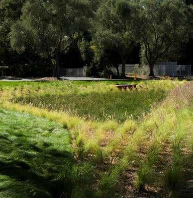

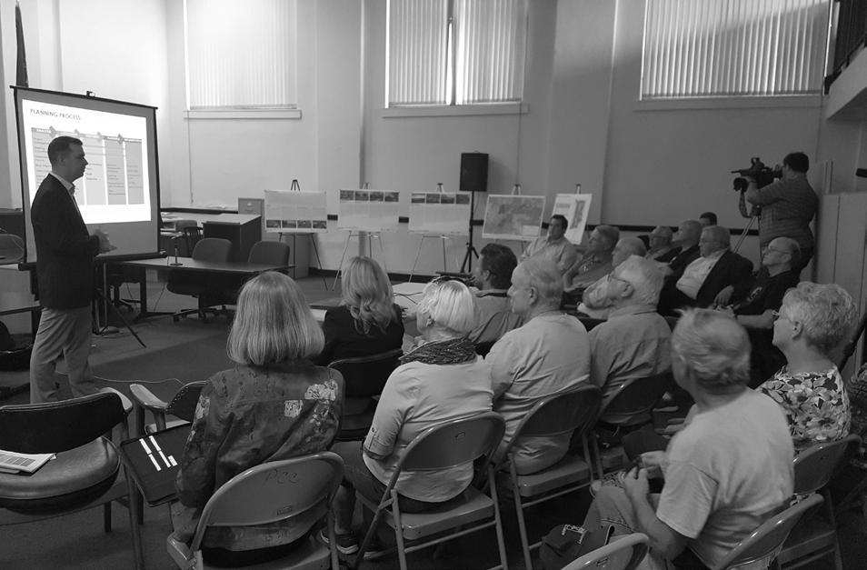
The Pike County Interchange Area Master Plan is both a development guide and policy document for future decision-making within the study area. Success of the plan will require on-going coordination and partnerships between the Pike County Economic Development Corporation (EDC), Pike County, City of Petersburg, and local property owners. The previous sections of this plan spell out the vision, goals, policy and physical recommendations. This section focuses on implementation and how those recommendations can be realized. Just as the EDC, County, and City have collaborated on this study, they will need to be able to implement this plan both jointly and independently via other regulations and policies as permitted under Indiana State Law. In addition, for the master plan to function over time, it must be periodically reviewed and updated in order to stay responsive to trends or changes in economic, physical, social or political conditions. The following pages identify the necessary steps and provide a road map for successful plan implementation, organized around four areas:
• Plan Monitoring and Update
• Regulatory Tools
• Action Plan
• Funding Community engagement should be incorporated throughout the implementation process to ensure that the plan continues to represent local vision and desires.
Planning does not have a defined beginning and end. It is an on-going process that responds to new information and circumstances and incorporates changing conditions into the decision-making process. Circumstances that may change include physical conditions of infrastructure, economic climate, the natural environment, and social and community goals. The master plan will need to be revised from time to time to ensure that it stays consistent and relevant to current conditions. A plan update should occur at intervals of approximately every five years, unless a more immediate amendment is warranted. The purpose of the plan update is to re-evaluate the goals, policies, and strategies contained within the master plan, and to develop new policies if necessary. Plan updates should include opportunities for involvement by property owners, the public, local boards and commissions, and elected and appointed officials.
A disciplined schedule for plan review is also helpful in plan implementation. Noting areas of the plan’s success helps to build support for future planning activities. The identification of less successful components of the plan may suggest a need for refinement and/or amendment. The EDC should conduct a thorough annual review of the plan, asking whether the conditions on which the plan was predicated still hold true. Within that review, each development policy should be reviewed with respect to achievement, in process,
or no longer relevant. An annual “report card” should be prepared as part of on-going strategic planning process to review and document activities within the study area and relevant successes or failures of plan policies and regulatory tools. This annual report should be presented to both County and City leadership.
While the master plan effort has gone to great lengths to develop and refine project priorities and the vision for the study area, meaningful implementation cannot occur without a supportive regulatory framework. Land use and development control tools must complete the difficult task of balancing community interest with individual property rights. Therefore, it will be incumbent upon the City, County, and EDC to choose the tools and approaches that will work best for them to implement the respective policies and recommendations contained herein. Considerations when selecting implementation tools include:
• Ability to achieve desired goals
• Effectiveness in changing the existing development type and/or character
• Ease of understanding for property owners and the public
• Ease of administration for City and County officials
• Impacts to established uses
• Potential increase in development costs
• What are strict standards versus where could some flexibility be included
• How can incentives be used to achieve development goals while offering some benefit to owners/developers
Zoning is the most common form of land use and design control in Indiana. While the City of Petersburg utilizes zoning and has planning and zoning jurisdiction over a portion of the study area, the County has elected not to implement county-wide zoning. As such, different mechanisms are recommended for the areas within the City’s planning authority versus those areas outside of it.
Zoning ordinances regulate the uses that are permitted on a property, the size and organization of structures, and additional items such as landscaping, parking, and signage. Zoning can help to protect property values by keeping potentially incompatible uses away from each other and providing some assurance as to what can and cannot happen in a particular area. From a development standpoint, businesses and developers find zoning attractive because it provides some certainty about the acceptance and approval of a project if it meets minimum requirements. And just like with home owners, commercial and industrial property owners want to ensure incompatible uses will not locate next door and create potential nuisance complaints against their operations. Finally, zoning can help
to contribute to community character by requiring lighting, street trees, and limiting excessive signage. Because the City of Petersburg already has a zoning ordinance in place and a Plan Commission to review development applications, amendments to the existing ordinance to reflect the goals and policies of the master plan are recommended.
An additional zoning tool that could be implemented for areas outside of City planning and zoning control is what is known as Planned Unit Development (PUD). PUD is both the name of the regulatory process as well as the type of development. PUDs are allowed under Indiana Code 36-7-4-1500. Before a PUD could be created, the County would have to adopt an enabling ordinance. Unlike typical zoning where the districts and standards are prescribed by the municipality, a PUD allows an owner or developer to propose zoning standards that would only apply to their subject property. This is an attractive option for implementation of the master plan because it would not create county-wide zoning, but would allow for individual owners to apply zoning to their property by choice.
In cases where zoning is either not practical or not desired, Covenants, Conditions, and Restrictions (CC&Rs) can be used to accomplish many of the same goals. Unlike traditional zoning or PUD zoning, CC&Rs require no City or County enabling ordinance or review. They are a private agreement made by a prospective purchaser as a condition of purchasing a piece of land in question. As such, they are enforced by an
individual or association as opposed to the City or County that would enforce zoning regulations. One potential downfall of CC&Rs is that they are not as common or readily researched by potential site selectors when compared to zoning. Despite these potential disadvantages, they may still be a useful tool for regulating development within the master plan area.
Given the specific goals and objectives for development within the interchange area, the City of Petersburg would be best served by creating a special interchange district. The Interstate Flex District would provide for a variety of employment opportunities with a mixture of office, retail, warehousing, and light industrial uses. Recommendations for this district are outlined below. These recommendations need to be incorporated into the City of Petersburg Zoning Ordinance text through the process described in Indiana Code 36-7-4-600. After amendment of the zoning text, the district may then be applied to appropriate properties within the study area. The City of Petersburg may elect to initiate these rezonings or allow property owners to petition for zoning changes. The City’s existing R-2 Residential District can be used in areas identified for medium density residential use on the land use plan. This district allows for a variety of housing types including single-family attached, single-family detached, and multi-family residential uses.
Interstate Flex District
• Purpose and Intent
The Interstate Flex District is intended to provide for a variety of employment opportunities through a combination of commercial, warehouse, and flex uses in a coordinated and compatible manner. Further, the district is intended to include high quality development, establish basic standards for structures, signage, lighting, and other site improvements, and preserve the integrity and safety along adjacent roadways.
• Plan Commission Approval
The Plan Commission must approve, approve with conditions, or disapprove the development plan for all parcels within the Interstate Flex District.
• Permitted Uses
▫ Animal care, vet clinic
▫ Convenience stores, including gasoline sales (Truck scales, overnight parking, and showers are not permitted)
▫ Day care
▫ Entertainment and recreation
▫ Hotels
▫ Institutional uses, including schools, parks, religious assembly, hospitals, urgent care, community and civic centers
▫ Light manufacturing, where all activity is contained within the building
▫ Medical office
▫ Office
▫ Outside sales, including building materials, yard, garden, and farm supply
▫ Personal services
▫ Research and development
▫ Restaurants, sit down
▫ Restaurants, fast food
▫ Retail
▫ Utilities
▫ Warehouse
• Special Exception Uses
▫ Car wash, when not associated with a convenience store providing gasoline sales
▫ Motor vehicle sales or rental
▫ Motor vehicle service
▫ Off premise (outdoor advertising) signs
▫ Wireless telecommunications facilities
• Lot Dimensions
▫ Minimum Area: 10,000 square feet
▫ Minimum Width: All lots shall abut a public or private street for a minimum distance of 100 feet
• Setbacks
▫ Minimum front yard: 50 feet
▫ Minimum rear yard: 20 feet / 30 feet when adjacent to a residential use or district
▫ Minimum side yard: 20 feet / 30 feet when adjacent to a residential use or district
• Building Height
▫ Maximum building height: 45 feet
• Accessory Uses and Structures
▫ Should be architecturally compatible with the principal building. Architectural compatibility includes, but is not limited to, kind, color, and texture of building materials, and the type, design, and character of windows, doors, light fixtures, signs, and supplementary elements. If alternate building materials are to be used or the accessory building is not architecturally compatible with the principal building, it should be screened through the use of landscape plantings, fences, and/or walls.
• Parking
▫ Parking lots should be designed to provide coordinated access to parking areas on adjoining tracts or parcels wherever feasible. Parking areas on parcels along SR 61 should include stub connections for future development on adjacent sites.
▫ All parking lots and drives shall be paved with asphalt, concrete, brick pavers, or other high quality paving material as approved by the Plan Commission.
▫ Parking within front yards along SR 61 should be limited to a maximum of two (2) rows of parking. A double-loaded parking aisle should be considered two (2) rows.
▫ Loading bays and/or overhead doors (in commercial uses) shall be screened from views from SR 61 and adjacent residential properties through the use of landscape plantings, fences, and/or walls as approved by the Plan Commission.
• Landscape and Buffering
▫ A landscape plan should be required as part of the Plan Commission site development plan review
▫ Buffer Yards – a perimeter landscape buffer is required per Section 16.04.290 of the existing zoning ordinance
▫ Utility equipment and trash collection areas shall be permitted per the needs of the business establishment. These areas should be screened from views from the public right-of-way and adjacent residential properties through the use of landscape plantings, opaque fences, and/or walls as approved by the Plan Commission.
▫ Outdoor storage of materials which is incidental to the principal use should be permitted when enclosed by an opaque fence or wall with a minimum height of six (6) feet. Stored materials shall not project or be visible above the top of the fence or wall.
▫ All plant material proposed to be used in accordance with any landscape plan shall meet the following specifications:
· Shade trees: A minimum of two and one-half (2 ½) inch caliper.
· Ornamental trees: A minimum of one and one-half (1 ½) inch caliper.
· Evergreen trees: A minimum height of eight (8) feet.
· Shrubs: A minimum height of eighteen (18) inches.
▫ The use of native plant species and cultivars of native plant species that are adapted to the local climate is encouraged within the Interstate Flex District
▫ To the greatest extent possible, existing trees should be saved upon development of a property unless it can be demonstrated that the site design restrictions necessitate their removal.
▫ To encourage tree preservation, each tree preserved greater than six (6) inch caliper shall convert as credits for required landscaping. Credits for each preserved six (6) inch caliper tree shall be:
· Two (2) required shade trees or
· Four (4) ornamental trees
• Lighting
▫ A lighting plan should be required as part of the Plan Commission site development plan review
▫ Internal drive, parking, loading, and walkway areas should be illuminated as evenly as possible, not exceeding an average of 3 footcandles.
▫ All freestanding lights and lights mounted on walls or facades should use cutoff, or full cutoff luminaires.
▫ Lighting should not cause illumination beyond any residential lot line in excess of 0.1 footcandles of light and any nonresidential property line or road right-ofway line in excess of 0.3 footcandles of light.
• Signage
▫ Off-premise (outdoor advertising) signs should only be permitted as a special exception use in the Interstate Flex District.
▫ In addition to established criteria for evaluating special exception uses, criteria used to review off-premise signage may include:
· Does not block views or vistas of bodies of water, natural areas, or buildings and landmarks of significance.
· Not placed on top of buildings.
· Does not interfere with already installed signage, whether on a building or freestanding.
· Does not impact residential development or result in unsightly views from residential areas.
• Architectural Requirements
▫ Buildings should generally avoid long, monotonous, uninterrupted walls or roof planes.
▫ Building entrances should be well-defined and articulated by architectural elements such as lintels, pediments, pilasters, columns, and other design elements appropriate to the architectural style and details of the building.
▫ Roof mounted equipment should be screened through the use of a parapet wall or other design detail, as approved by the Plan Commission.
▫ All exterior wall building materials shall be high quality, and shall be any combination of the following:
· Brick or face tile
· Wood lap siding
· Stone
· Glass (reflective glass shall be limited to a maximum of fifty percent (50%) of the area of any facade wall on which glass is used)
· Tinted and/or textured concrete masonry units (such as split-face block and burnished block)
· Architectural precast concrete or tiltup concrete panels
· Architectural metal, corrugated or ribbed metal siding shall be limited to a maximum of fifty percent (50%) of the area of any facade wall on which architectural metal is used
· Exterior Insulation and Finish Systems (EIFS)
· Fiber cement board.
• Access and Circulation
▫ Common entrances shared by several properties and developments is strongly encouraged.
▫ Access roads to contiguous tracts should be coordinated so as to form one main access road serving adjacent developments. Access roads should be designed to align with one another, where possible.
▫ A ten foot wide, paved trail should be provided on all properties fronting SR 61, along the length of the frontage. This should include accessible curb ramps at intersections and any crossings that include a grade change. The Plan Commission, at its discretion, may accept dedication of a permanent easement for such trail construction in lieu of actual trail construction.
▫ Dedicated pedestrian paths should be constructed to connect parking areas to building entrances. Additionally, buildings fronting on SR 61 should include pedestrian facilities connecting building entrances to the trail along the roadway.
• Placement of utilities
▫ The installation of new utility systems should be installed underground in a manner approved by the applicable utility provider. Certain appurtenances and accessory equipment that must be
installed above ground for servicing is permitted. This may include fire hydrants, gas and electrical meters, electric service cabinets, irrigation controllers, and similar features.
▫ Electric power transmission lines are exempt from this requirement.
▫ Where undergrounding is not feasible, alternative placement should be approved by the Plan Commission during site development plan review.
Before a PUD ordinance can be adopted for particular real estate, a Planned Unit Development district must be created within the zoning ordinance. The process to adopt an initial zoning ordinance is described in Indiana Code 36-7-4-600 series and PUD ordinances are described in more detail under Indiana Code 36-7-4-1500 series. Before a zoning ordinance can be created, Indiana Code requires that a comprehensive plan must first be adopted for the jurisdiction. The steps to create a zoning ordinance that allows for planned unit developments within Pike County is outlined below.
1. Convene the Pike County Area Plan Commission and appoint new members as necessary.
2. Review and ensure the vision and policies of the Pike County 2008 Comprehensive Plan are still applicable.
3. Plan Commission must initiate a proposal to create the zoning ordinance.
4. Prepare zoning ordinance text that describes the geographic area over which it shall apply. The zoning ordinance text will need to have at least two districts. One district would be for unrestricted uses and would initially be applied to the entire geographic area. In practice, this would be a continuation of the current “no zoning” condition. The second district would be the Planned Unit Development District. This district would not initially be applied to any land area but would be created for later application if requested by a property owner. A zoning map would be prepared to reflect these districts.
5. Plan Commission must give notice of and hold a public hearing on the proposed ordinance.
6. Plan Commission must vote to make a recommendation to and certify their decision to the County Commissioners.
7. County Commissioners then adopt the ordinance.
8. Plan Commission must publish notice of adoption.
After adoption of the initial zoning ordinance, a similar but slightly less involved process would be used to adopt the PUD ordinance itself.
1. Property owner prepares PUD district ordinance and map.
2. Submit PUD proposal to Plan Commission.
3. Plan Commission must give notice of and hold a public hearing on the proposed PUD.
4. Plan Commission must vote to make a recommendation to and certify their decision to the County Commissioners regarding the proposed PUD.
5. County Commissioners then adopt the PUD ordinance.
At a minimum, the PUD district ordinance must designate the property to which it applies, specify the uses permitted in the district, specify any additional development requirements, and specify the documentation to be submitted for development projects within the PUD area. These minimums may not be adequate for a clear and effective PUD ordinance. The following is a potential outline for PUD ordinances that may be created for portions of the master plan area. In some cases, not all sections may be deemed necessary by the owner/developer:
1. Intent – Overall goals
2. Applicability – Boundaries of the PUD and geographic definition of any subareas, if applicable
3. Process – Description of application requirements and any special review procedures
4. Permitted Uses – listed by subarea, if applicable
Development Review Committee Creation –Sample Language
A Development Review Committee (DRC) is hereby created for the [NAME OF PUD]. The DRC shall consist of not less than one member or more than five members. The initial members shall be appointed by the [DEVELOPER OF PUD]. The [DEVELOPER OF PUD] shall also have the right to remove and replace members of the DRC from time to time for any reason, in its sole discretion. If the event of the removal or resignation of a member or members, the [DEVELOPER OF PUD] is authorized to appoint the successor or successors to fill the vacancies. The DRC may solicit the advice and recommendation of any person or entity with expertise in any discipline it deems appropriate for advice as to matters pending before it. If the DRC contains more than 1 member, the members shall elect a chairperson and vice-chairperson and adopt bylaws.
If the [DEVELOPER OF PUD] so desires to voluntarily relinquish its authority, it shall do so by written notice sent to Pike County Area Plan Commission, Board of Commissioners, and all owners of property within the [NAME OF PUD].
Prior to the issuance of an improvement location permit and the construction of any structures or other improvements upon real estate located within the [NAME OF PUD], the owner or tenant of the subject parcel of real estate shall petition the DRC for approval. Such petition shall include the following:
[LIST OF SUBMITTAL REQUIREMENTS]
5. Accessory Uses – uses permitted only when associated with a principal use
6. Development Standards – listed by subarea, if applicable
a. Minimum lot area
b. Minimum lot width and/or frontage
c. Minimum front, side, and rear setbacks
d. Maximum building height
e. Maximum site coverage
7. Architecture
a. Exterior building materials
b. Other architectural standards may be used to articulate building entrances, screen mechanical equipment, and/or avoid long, uninterrupted wall planes. These standards may not be appropriate given the warehouse and industrial flex spaces planned for large portions of the master plan area.
8. Landscaping and Screening
a. Minimum landscaped area – this should correspond to maximum site coverage (6.e.)
b. Perimeter or buffer landscaping between different use categories
c. Parking lot landscaping
d. Screening of outdoor storage or utility areas
e. Standards for the minimum size of landscape material at time of installation
f. Requirements or credits for preservation of existing tree stands
9. Lighting
a. Minimum light levels, typically expressed in footcandles, for internal streets, driveways, parking lots, and service areas
b. Additional standards may include maximum mounting heights or types of luminaires permitted (full cutoff, cutoff, etc.)
10. Parking - Number of parking spaces based on use and intensity (square footage)
11. Signage
a. Permitted sign types
b. Maximum sign area, may be based on façade area
12. Drainage and Erosion Control
a. Erosion control practices to be used during construction activity
b. Stormwater drainage regulations
13. Definitions - key terms and how measurements will be calculated
One item of particular importance for PUDs in the master plan area will be item 3. Process in the above outline. Given the many large parcels and property owners who own large land areas within the study boundary, combined with no existing zoning, it is anticipated that some individual review and approval of development petitions will be desired to protect the value of the owner’s surrounding land. A special development review committee can be created through text included in the PUD ordinance. This committee should include one or more members, appointed by the owner and/or master developer. If these members will be appointed for a set term that should be spelled out in the ordinance. Similarly, if they may be removed or replaced at any time that should be made clear.
The PUD should also describe the review and approval process by the development review committee. Typically, approval from the development review committee would be required before the issuance of a building permit from the County. Application requirements for the potential owner or tenant may include site plans, building elevations, landscape plans, signage plans, construction planning and phasing, as well as a general description of anticipated operations. Timelines for application submittal and review, design review committee action, and formal approval should be expressed.
CC&Rs may be written into the deed of a property or into the bylaws of a subdivision, which the deed would then reference. Like zoning, CC&Rs may limit the types of land use permitted, define architectural standards, put controls on business activities, and require special review processes. CC&Rs are created by the developer and signed by subsequent owners of property. If CC&Rs are to be used to control land use and development within a commercial or industrial park, as may be the case for a portion of the master plan area, they should generally include:
1. Identification of the Declarant – the owner/ developer, typically organized as an Indiana corporation. It is important to maintain clarity in language between the current owner who is creating the CC&Rs versus subsequent owners who will be subject to it.
2. Definitions – key terms as to how they relate to the CC&Rs
3. Applicability – typically all subsequent owners, guests, tenants, or other occupants of the property
4. Rights to Common Areas – if applicable
5. Permitted or Prohibited Uses – In some cases the developer may want to only permit a specific list of uses. In other cases, it may only be several uses that are expressly prohibited with all other uses being permitted
6. Additional Development Controls
a. Architectural standards
b. Parking and loading requirements
c. Lighting
d. Signage
e. Landscaping
f. Outdoor storage and operations
g. Performance standards – noise, odor, vibration
7. Association – In cases where CC&Rs are being applied to a single property, an association is not necessary. However, where multiple properties will be governed by a common set of CC&Rs, as association is strongly encouraged.
a. Organization – typically a non-profit under the laws of the State of Indiana
b. Membership – typically divided into two categories. Class A members are those owners other than the developer. Class B members are the developer.
c. Voting Rights – Voting rights can vary substantially. Some CC&Rs give equal voting weight to Class A and B members. Other sets of CC&Rs weight voting so that the developer gets more votes per lot than Class A members. Some CC&Rs allow for total control and amendment by the Class B member as long as they maintain
ownership of a single lot. Whatever system is selected, it needs to be clearly defined within the CC&Rs.
d. Board of Directors and Meeting Schedule
e. Bylaws – typically attached as an exhibit
f. Responsibilities – typically maintenance of common areas, assessment and collection of fees, and enforcement of rules and regulations
8. Design Review Committee – if applicable
a. Members – appointed by board or Class B member
b. Purpose and Duties – review the design and location of all proposed developments and additions
9. Assessments – typically the developer is exempt from both annual and special assessments
a. Annual Assessments
b. Special Assessments
10. Process for Amendments
As private land use controls, CC&Rs are enforced by adjacent property owners or the association via a lawsuit, seeking an injunction against the prohibited activity. This can make enforcement costly and time consuming. One way to counteract this is through strong association management and prompt identification of violations.
The following table includes a list of projects and initiatives organized around the four plan goals of land use, transportation, utilities & infrastructure, and landscape & natural systems. These projects and initiatives translate the land use, transportation, and utility frameworks as well as larger plan goals and recommendations into a series of manageable actions, ultimately leading to realization of the master plan study.
In order to help plan for the efficient use of limited resources, a relative timeframe is developed for each project. These timeframes begin to identify priority projects, but should be considered planning tools. They are not a commitment to action or funding of a project by a certain deadline. Project timeframes may shift given changing conditions, as development progresses, or as potential funding sources are made available. The five timeframes are:
• Immediate / On-Going: 0 – 1 years
• Short Term: 1 – 3 years
• Medium Term: 4 – 6 years
• Long Term: 7+ years
• As Development Requires: These projects should generally be considered long term but may move up in priority given specific development proposals that would warrant the immediate investment
Responsible parties are identified for each project in order to begin conversations and the organization that will be required for implementation. Responsible parties include City and County boards, commissions, and departments; the economic development corporation; land and business owners; potential funding partners; and other state and local agencies.
1. Update the City of Petersburg Comprehensive Plan, including goals and policies of the Master Plan.
2. Update the City of Petersburg Zoning Ordinance to create a new interchange district or districts to promote the land use and development goals of the Master Plan for areas within City planning and zoning jurisdiction.
3. Adopt a Planned Unit Development (PUD) enabling ordinance to allow voluntary zoning of property for areas outside of City planning and zoning jurisdiction.
4. Develop a model set of Covenants, Conditions, and Restrictions (CC&Rs) to reflect the land use and development goals of the Master Plan, to be used by property owners and developers where zoning is not practical.
5. Develop a policy for expanding the City’s planning and zoning jurisdiction or annexation of lands into the City to better serve new development with public services.
6. Pursue “Shovel Ready” site certification for additional properties within the Master Plan area.
7. Construct the Technology Center as a gate-way to Pike Crossing, Generation Springs, and the larger south interchange area.
8. Construct a speculative, flex building of approximately 50,000 square feet, with the potential for expansion, at the southeast quad-rant of the interchange.
1. Reconstruct CR 300 N from SR 56 / 61 to SR 57.
2. Complete the Phase 1 reconstruction of E CR 350 N and new connection to SR 61.
3. Reconstruct CR 175 E from E CR 300 N to the interstate.
4. Reconstruct CR 300 N from SR 61 to CR 175 E.
5. Reconstruct Meridian Road from CR 300 N to the southern terminus.
6. Improve the N CR 75 E and SR 61 intersection and connection to Generation Springs, including safety improvements such as acceleration and deceleration lanes, and gate-way elements such as signage, landscaping and lighting.
7. Improve the Generation Springs haul road from N CR 75 E to a distance approximately ¼ mile east of the interstate.
8. Construct a new road through the Generation Springs site from CR 300 N to the haul road.
9. Construct a new road, extending E CR 350 N to SR 356.
10. Construct a new road, extending CR 175 E to SR 356, paralleling Interstate 69.
11. Construct new roads between E CR 350 N and E CR 300 N to serve development in Pike Crossing.
12. Evaluate options to include bicycle and pedestrian facilities in public works projects and as a development regulation in the City of Petersburg Zoning Ordinance.
Council INDOT
Council INDOT
1. Conduct fiscal impact studies as part of business attraction and incentive efforts to ensure that new development can help pay for public services.
2. Coordinate utility, transportation, storm water, and other infrastructure improvements to combine construction projects and reduce costs.
3. Pro-actively coordinate with INDOT regarding improvements to state routes within the Master Plan area.
4. Update City and County ordinances to re-quire right-ofway and/or easement dedication during the development process.
5. Construct a new City of Petersburg water treatment plant and water supply well necessary for average daily demand of approximately 500,000 gallons in the planning area.
6. Construct a new 750,000 gallon, elevated water storage tank along the SR 61 corridor, south of Petersburg in order to increase system storage to be between 1 to 2 days average system usage plus fire flow.
7. Construct improvements to the City of Petersburg wastewater treatment plant in order to increase treatment capacity.
8. Coordinate extension of utilities along with transportation improvements outlined above in Transportation Matrix. Obtain R/W necessary for utility extensions. Establish funding sources for utility extensions.
9. Extend water and sanitary sewer service in the Interchange – North planning area.
CONTINUED
10. Extend water and sanitary sewer service to the Generation Springs site and Pike Crossing. Construct new wastewater treatment plant south of Generation Springs as development warrants and exceeds capacity of Interchange – North force main.
11. Extend sanitary sewer service to the Indiana Southern Sites.
12. Develop a policy for the dedication of utility infrastructure to the City of Petersburg.
1. Explore the use of green infrastructure and other stormwater best management practices in all new development in order to reduce the risk of flooding.
2. Adopt/update development ordinances to limit construction within the floodplain to passive and active recreation uses, utility easements, and non-critical site improvements.
3. Adopt/update development ordinances to provide incentives for the preservation of open space and wooded areas.
4. Ensure the preservation of and access to important cultural and historical assets, including the Brenton Family Cemetery.
Funding for the complete development of the Interchange Area Master Plan will require creative use of resources, partnerships, leveraging opportunities, and judicious timing. Potential funding sources are easy to identify, but obtaining money from them can be difficult. Funds are limited and competitive. For these reasons, it is essential that the implementation of projects be accomplished in a way to maximize efficiency and return on investment. It is recommended that whenever possible, Pike County and the City of Petersburg leverage local resources to pursue additional funding opportunities with the Indiana Department of Transportation (INDOT) Local Public Agency Programs. The following section discusses various funding sources for implementation of this plan’s recommendations and realization of the plan vision.
Backed by the credit and “taxing power” of the issuing jurisdiction, a bond is government debt issued to raise money to finance capital improvements. A bond issue requires a vote by citizens in a general election. Property taxes and other revenue then pay for the bond’s retirement.
INDOT’s Common Paths program is a larger umbrella program and approach to road planning, design, and decision-making that considers and balances the dynamic needs of various users of our transportation system with a focus on moving people and goods safe and efficiently from point
A to point B. The program is about the basics: improving the transportation system’s safety and functionality for all users regardless of age, ability, or mode of travel (car, truck, walking, biking, or transit) and satisfies national Complete Streets initiatives. Improvements are funded through three individual programs: American with Disabilities Act (ADA) Transition Plan Development & Oversight, Small Communities Sidewalk Program (SCSP), and the Indiana Stellar Communities designation.
CDBG entitlement program allocates annual grants to cities, counties, and states to develop safe housing and expand economic opportunities for low- and moderate-income people. Activities supported by these funds must address one of the national priorities: benefit low- and moderateincome persons, prevention or elimination of blight, or address community development needs that pose serious and immediate threat to the health or welfare of a community. Within Indiana, the Office of Community & Rural Affairs (OCRA) administers CDBG funds through a number of programs including: Blight Clearance Program, Main Street Revitalization Program, Planning Grants (Comprehensive Plans, Utility Plans, Park Plans, etc.), Stormwater Improvement Program, and Wastewater Drinking Water Program.
CreatINg Places is a place-based crowdfunding grant program offered through the Indiana Housing and Community Development Authority (IHCDA) for non-profits and local units of government. The program is focused on placemaking activities, such as implementing creative community improvements, activating underused public spaces, creating new public spaces, establishing public wi-fi in a community gathering space, streetscape beautifications, etc. Like other crowdfunding programs, residents can contribute to programs and projects they are interested in seeing implemented. If the fundraising goal is met within a specific timeframe, funding is matched by IHCDA. Up to $50,000 of matching grant funds are available per project.
Under this FFO, EDA solicits applications from applicants in rural and urban areas to provide investments that support construction, nonconstruction, technical assistance, and revolving loan fund projects under EDA’s Public Works and EAA programs. Grants and cooperative agreements made under these programs are designed to leverage existing regional assets and support the implementation of economic development strategies that advance new ideas and creative approaches to advance economic prosperity in distressed communities. EDA provides strategic investments on a competitivemerit-basis to support economic development,
foster job creation, and attract private investment in economically distressed areas of the United States.
An impact fee is a charge on new development to pay for the cost of infrastructure and related services that are necessitated by and benefit the new development. The fee is based on the type of development assessed for the increase in the burden on infrastructure. Fees contribute to a nonreverting fund and can be used for infrastructure improvements and amenities including park and recreation and multimodal projects.
Commercial and industrial sites with contamination are not attractive to private developers and often require significant financial resources, legal disputes, and complex regulatory hurdles. The Indiana Brownfield Program’s Revolving Loan Fund offers low cost funding to finance environmental cleanups and facilitate redevelopment of brownfield sites. Under the Brownfields Tax Incentive, environmental cleanup costs are fully deductible in the year incurred.
TAP projects are federally subsidized, communitybased projects that expand travel choices and enhance the transportation experience by improving the cultural, historic, aesthetic, and environmental aspects of transportation infrastructure. Fifty percent of TAP funds are sub allocated to areas and Metropolitan Planning Organizations (MPOs) based on population. A competitive process for these funds is used at both the regional MPO and at the State level and the program requires local communities to contribute a minimum 20 percent match (80 percent federal funds, 20 percent local).
TAP funds may be used for projects or activities that are related to surface transportation and described in the definition of “Transportation Alternatives.” This includes:
• Construction, planning, and design of on-road and off-road trail facilities for pedestrians, bicyclists, and other non-motorized forms of transportation.
• Construction, planning, and design of infrastructure-related projects and systems that will provide safe routes for non-drivers, including children, older adults, and individuals with disabilities to access daily needs.
• Community improvement activities, including—
▫ Inventory, control, or removal of outdoor advertising;
▫ Historic preservation and rehabilitation of historic transportation facilities;
▫ Vegetation management practices in transportation rights-of-way to improve roadway safety, prevent against invasive species, and provide erosion control; and
▫ Archaeological activities relating to impacts from implementation of a transportation project eligible under 23 USC.
• Any environmental mitigation activity, including pollution prevention and pollution abatement activities and mitigation to—
▫ Address storm water management, control, and water pollution prevention or abatement related to highway construction or due to highway runoff; or
▫ Reduce vehicle-caused wildlife mortality or to restore and maintain connectivity among terrestrial or aquatic habitats.
The eligible entities to receive TAP funds are local governments; regional transportation authorities; transit agencies; natural resource or public land agencies; school districts, local education agencies, or schools; tribal governments; and any other local or regional governmental entity with responsibility for oversight of transportation or recreational trails (other than a metropolitan planning organization or a State agency) that the State determines to be eligible.
Funding available to Park and Recreation Boards in Indiana. Since the LWCF is a reimbursing program, the project sponsor does not receive the grant funds at the time of application approval. The sponsor must have the local matching 50% of the project cost available prior to the application. The sponsoring park and recreation board is reimbursed 50% of the actual costs of the approved project. Local sources of funding that may be derived from tax levies, bond issues, gifts, appropriations, and donations, are used to match federal assistance. Grant applications may consist of land acquisition and/or facility construction or renovation for local public parks for outdoor recreation. New parks or additions to existing parks may be funded.
The LIHTC program is the dominant federal funding source for affordable housing but is administered at the state level. There are two programs within LIHTC, the 4% and 9% credit. The 4% program, which offers less financial incentives, is a noncompetitive process, whereas the 9% program, which provides significantly more funding, is highly competitive. Though this program targets households earning between 30% and 60% Area Median Income, the actual makeup of each project will vary.
Class 1 and short line railroads do pay property taxes, but in a fashion different than other users of real estate. For operating railroads, taxes are assessed for operating track vs other ancillary real estate. State agencies track these factors for each railroad in relation to reported revenue, and collect corresponding taxes for distribution in local counties based on corresponding shares of statewide rail infrastructure. While this revenue stream may be modest, local officials in Pike County should investigate this revenue stream for use in supporting rail-linked industrial development efforts.
Funding for the acquisition and/or development of multi-use recreational trail projects. Since this is a reimbursing program, the project sponsor will not receive a cash grant at the time of project approval. Instead, the sponsor must pay the bills and then be reimbursed for a maximum of 80% of the expenses incurred for the project. The Indiana RTP will provide 80% matching reimbursement assistance for eligible projects.
Section 108 Loans are a flexible federal funding source that provide local municipalities with a source of financing for economic development, housing rehab, public facilities, and other development projects. This program allows local governments to leverage their CDBG allocation into federally
guaranteed loans. Local governments must pledge their current and future allocation as security for the loan.
The STP program provides flexible funding that may be used by States and localities for projects to preserve and improve the conditions and performance on any Federal-aid highway, bridge and tunnel projects on any public road, pedestrian and bicycle infrastructure, and transit capital projects, including intercity bus terminals. Administered through INDOT, this is an 80/20 matching program.
A TIF district uses future property tax revenues generated within a defined area to pay for improvements and incentivize redevelopment. As the assessed values (AV) of properties within a TIF district increase, the incremental growth in the property taxes since the establishment of the district (base year) is captured to assist with investment in the area. Taxing entities within the TIF district will receive the same amount of taxes as identified in the base year even though the AV is increasing.
USDA Rural Development operates over fifty financial assistance programs for a variety of rural applications. The Water & Waste Disposal Loan & Grant Program provides funding for clean and reliable drinking water systems, sanitary sewage disposal, sanitary solid waste disposal, and storm water drainage improvements. Funding is most commonly available in the form of long-term, low interest loans but may include grants to help keep used costs reasonable.