The Cambridge City Comprehensive Plan would not have been possible without the many residents, business owners, and other stakeholders who devoted their time and ideas to help aid in building a stronger and more vibrant community. We would also like to thank each Comprehensive Planning Committee member for their dedication and commitment throughout this process.
Acknowledgments
Comprehensive Planning Committee
Beth Leisure
Brad Bowman
Brandon Pennington
Brenda McLane
Briana Wetzel
Carrie Miles
Chad Bowman
Danny Berry
Debbie Prather
Debbie McGinley
Doug Young
Jessie Russett
Jill King
Jim King
Karen Bay-Winslow
Ken Newton
Nathan Ulerick
Nathan Riggs
Susie Dungan Thank You
Sarah Pennington
Sherry Ervin
Steve Sorah
Town Council
Jeff Mardis
Debbie McGinley
Nathan Riggs
Steve Sorah
Dan Worl
Town Staff
Sherry Ervin - Town Clerk
Doug Young - Superintendent of Public Works
1
Executive Summary
Purpose of the Plan
The Cambridge City Comprehensive Plan outlines a vision and strategic framework for future development, redevelopment, and community building projects within the Town. It will aid in ensuring that the Town maintains a high quality of life for residents and is competitive from an economic development standpoint. The previous plan was created in 2002; since then, the Town has experienced significant redevelopment in the downtown, creation of the industrial park, and changes in leadership and staff. Given the present opportunities and past changes that have occurred, a new comprehensive plan was needed to respond to these changes, reflect current conditions, and most importantly, be representative of the vision and goals of current residents and businesses.
Indiana state law identifies requirements that need to be incorporated into a comprehensive plan (Indiana Code 367-4-502). A comprehensive plan must contain at least the following elements:
• A statement of objectives for the future development of the jurisdiction.
• A statement of policy for the land use development of the jurisdiction.
• A statement of policy for the development of public ways, public places, public lands, public structures, and public utilities.
Executive Summary
Supported by a Planning Grant from the Indiana Office of Community and Rural Affairs, and with the assistance of consultants Rundell Ernstberger Associates and SB Research & Planning, the overall purpose of the new comprehensive plan for the Town of Cambridge City is to:
• Identify strategies to enhance existing neighborhoods and locations appropriate for new housing development.
• Promote development and redevelopment in alignment with economic development goals, both within the Town and at the Gateway Industrial Park.
• Create action-oriented recommendations to help guide local decision-making regarding infrastructure improvements, land use changes, and parks and trails investment.
• Ensure the Town can attract new jobs and residents while also maintaining the existing character and high quality of life.
Scope of the Plan
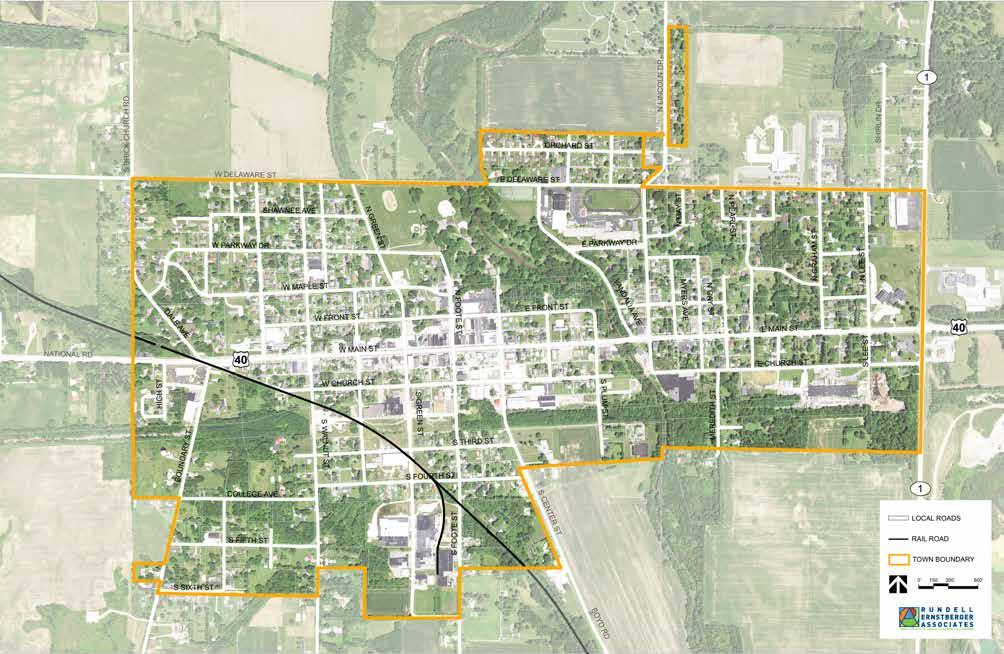
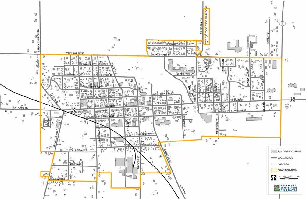
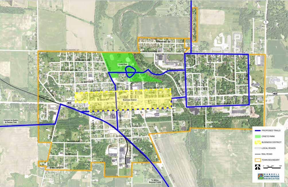
Cambridge City has the power to make planning and zoning decisions only within its municipal boundaries. However, to ensure compatibility of future growth and land use changes, an area larger than the current Town boundaries was addressed with this process. The planning area includes all of Cambridge City as well as the immediate surrounding vicinity and area along State Road 1 to the I-70 interchange. This is not an official extra-territorial planning jurisdiction as recognized by state law, but this area will have an effect on the Town’s future tax base and utility service area should the municipal boundaries grow.
The plan takes a long-range view to guide land use decisions, preparing capital improvement programs, and determining the rate, timing, and location of future growth. It establishes a vision, goals, and objectives that direct investment and development activity within Cambridge City. This then provides the policy basis for zoning regulations and development controls. The comprehensive plan examines the inter-relationships between land use, transportation, utilities, and the local economy.
Town staff, the Plan Commission, and Town Council should interpret the goals and objectives as a long-term reflection of the community’s values. The spirit of this plan should be remembered when reviewing development and policy proposals to ensure that the community’s vision is respected. The implementation projects and action steps are intended to direct the day-to-day decisions concerning more specific and task-oriented activities. Interpreting the plan in this way will enable the members of both the Commission and Council to justify approval, or denial, of any proposed development or redevelopment projects or policy initiatives brought forth for the Town.
When a new annexation, rezone, subdivision, or site plan review request is filed with the Town, it should be reviewed and evaluated against the comprehensive plan and the City’s other plans and ordinances. The comprehensive plan is not an ordinance and does not contain the actual decisions that should be made. It is however, a policy document to help guide decisionmaking related to land use, growth, public investments, and economic development. It serves as a reminder of the community’s collective vision for the future growth and development of the area and should be used as such.
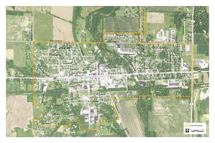
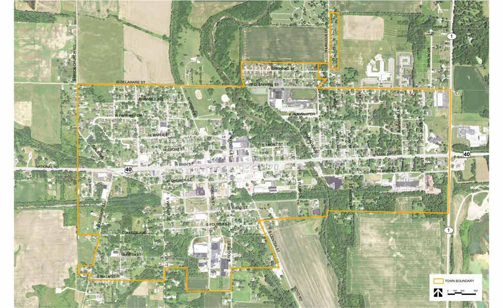
INCORPORATED LIMITS
Executive Summary
Process to Develop the Plan
Planning is a continuous process that had been initiated prior to this plan and will continue after its adoption. This new Comprehensive Plan is the result of a detailed process that brought residents and stakeholders together to identify existing conditions throughout the Town, recognize potential issues and opportunities, and ultimately create recommendations for the future. The plan was developed over ten months with oversight from the Comprehensive Planning Committee (CPC) which included representatives from the Town Council and Plan Commission, Town staff, business owners, and other community leaders. The CPC met four times during the process; these meetings were interactive work sessions and resulted in the overall input needed to develop the plan.
In addition to the CPC meetings, a series of focus group discussions was held early in the process to gather input from key stakeholders and organizations. The goal of the focus group discussions was to assess the issues each group faces and understand what they hoped to achieve through the comprehensive planning process.
Leaders and industry experts in each of the following categories were invited to participate:
• Business leaders and employers
• Developers, builders, and real estate professionals
• Community institutions, non-profits, and service organizations
• Neighborhood leaders and residents
• Regional partners
• Lincoln High School student government group
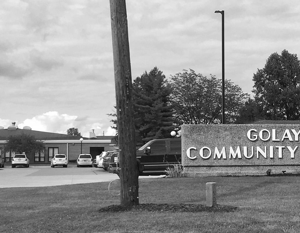
A community open house was held early in the process to solicit input and discuss opportunities, issues, goals and recommendations for the plan. This open house took place at the Golay Community Center. Participants were able to voice their opinions, interests, and concerns about the current conditions and future vision for the community. A number of input and visioning exercises were facilitated, and Town representatives and the consultant team were available to answer questions. A second open house to share key plan recommendations was conducted in advance of plan adoption. In addition to in-person input opportunities, a project website was maintained throughout the process. This website included background information, meeting materials, and a frequently asked questions section to keep the community informed of plan progress.
Plan Summary
The majority of the plan is organized around twelve subject matter chapters. They are:
• Land Use
• Government & Fiscal Capacity
• Public Facilities & Services
• Placemaking
• Economic Development
• Housing
• Transportation
• Agriculture
• Natural Resources
• Parks & Recreation
• Historic & Archaeological Resources
• Hazard Mitigation
Each chapter, with the exception of Agriculture and Natural Resources, includes a discussion of the existing conditions related to that subject, a vision statement, key goals, and supporting strategies. Also included in each chapter is a discussion of how to implement the recommendations for the respective subject as well as several proposed projects and the action items needed to realize their implementation.
Land Use (Chapter 4, Pages 45 - 53)
KEY FINDINGS:
Cambridge City is approximately 1.02 square miles in area. The Town is divided into seven zoning districts: Suburban (S), Residential (A), Residential (B), Local Business (LB), General Business (GB), Industrial (I), and Flood Plain (FP). For the most part, the existing land use map and zoning map align. Cambridge City’s downtown is located to the west of the Whitewater River and straddles US 40. This central location is where much of the commercial businesses and offices are located. Additional commercial development is located on the east side of Town along SR 1, especially near the SR 1/I-70 interchange, although this area is actually outside Town limits. Residential uses are located to the north and south of downtown, and to the east near Lincoln Middle and High School and Golay Community Center. Industrial sites are primarily along Church Street and in the southern portion of Town.
The future land use map was created through examination of existing land use patterns, zoning, and stakeholder input. In many instances, the existing land use is the desired future use and expected to continue indefinitely. However, there are some areas where changes in land use are anticipated as farm properties are developed for the first time or vacant and underutilized properties are redeveloped.
VISION:
Maintain a balance of land uses throughout the community while preserving existing character, using land efficiently, and protecting environmentally sensitive areas.
GOALS & STRATEGIES:
1. Encourage the annexation of adjacent areas already receiving Town services and those that support the growth and development goals of the community.
2. Promote infill and redevelopment of vacant and underutilized parcels.
3. Ensure land use and development regulations reflect the community’s desired development goals and support contemporary land use best practices including compact, walkable development.
4. Protect flood areas and other sensitive lands from development.
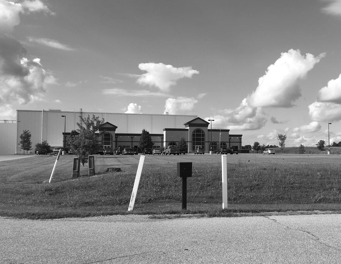
5. Support continued development of the Gateway Industrial Park.
6. Ensure Town codes and ordinances are respected and enforced.
DESIRED OUTCOMES:
Land use plays an important role in the form and character of a community. For Cambridge City, land use has mainly been kept in an organized context that makes sense. To continue this thoughtful development pattern while encouraging growth, several projects are recommended.
1. Create and adopt an annexation policy for Cambridge City.
2. Update zoning and development regulations and modernize these documents for ease of access and future use.
FUTURE LAND USE
The Future Land Use Plan is one of the key components of the Comprehensive Plan as it provides guidance for future land use and development decisions by the Town Council and Plan Commission. It also allows residents to better understand desired development types and locations.
Government & Fiscal Capacity (Chapter 5, Pages 55 - 61)
KEY FINDINGS:
Government and fiscal capacity refers to the ability of the municipality to generate revenue. Cambridge City’s fiscal capacity is dependent on a number of factors including the assessed value of property, personal incomes of residents, and the cost of services provided by the Town. The Town’s fiscal resources are used to provide police protection, operate and maintain infrastructure, and perform other developmental functions. The average per capita total expenditure for Cambridge City was $1,799.40, below the average for all Indiana cities and towns, $1,998.39. After removing enterprise expenditures, the Cambridge City per capita expenditure of $1,454.04 is higher than the average of $1,057.07 for all Indiana cities and towns. This may be the result of economies of scale for larger municipalities that reduces the per capita cost of services.
Cambridge City’s revenue is largely based on property taxes, which are in turn based on tax assessments on the value of land and improvements. Subsequently, growing municipal revenue is dependent on growing the Town’s tax base. For this reason, it is important that the Town maintain a balance of land uses. Property taxes for single family residential development are capped at 1% of the assessed value and as such, residential development typically consumes more services than it pays for with tax revenue. Commercial and industrial
development is taxed at 3% of assessed value and is tax positive, in that the taxes these uses pay more than covers the services they receive. It is important for the community and Town leaders to understand the fiscal impacts of new development in order to make informed decisions regarding growth, annexation, new development, and infrastructure improvements.
VISION:
Expand government capacity and ensure the Town’s fiscal health in order to provide superior services and amenities to residents, businesses, and visitors.
GOALS & STRATEGIES:
1. Grow the assessed value of properties within Cambridge City to generate additional tax revenue.
2. Ensure a balance of land uses to provide a stable and consistent tax base, understanding that single family residential development often requires higher service outlays that may not be fully paid for by those properties. Commercial and industrial development often requires fewer service outlays and pays a higher portion of property taxes.
3. Improve Town interaction and ease of communication with residents and businesses.
DESIRED OUTCOMES:
Running a town is not easy. Despite a decline in Cambridge City’s population, limited growth to property values, and the resulting implications on municipal tax revenue, the Town still must provide quality services and amenities across the community. Local leaders must balance residents’ many diverse interests with the Town’s limited resources. Beyond the larger ability to grow revenue as a result of increases in assessed value, the government and fiscal capacity projects involve better planning for expenditures, making it easier for residents and businesses to pay bills with the Town, and exploring the feasibility of a new Town Hall building.
1. Develop an online bill payment system for Town utilities as a convenience to residents and business owners.
2. Conduct a needs assessment of the existing City Building and a feasibility study to explore the construction of a new Town Hall and Police Station.
Executive Summary
Public Facilities & Services (Chapter 6, Pages 63 - 69)
KEY FINDINGS:
Cambridge City has a number of departments and organizations that provide public services and maintain facilities for the community. These public facilities and services are critical to protecting the quality of life for residents, business owners, and visitors.
Water Works: Cambridge City operates two drinking water systems. One system primarily serves the incorporated town limits as well as some nearby properties just outside town limits. The second system serves the Gateway Industrial Park and commercial development near the Interstate 70 and State Road 1 interchange. The town system accommodates daily demand of approximately 200,000 gallons; there is plenty of excess capacity to serve new development and redevelopment in and around the existing Town boundary. The industrial park system currently utilizes two wells, the treatment facility, and a 400,000 gallon elevated water tank. However, current demand averages 500,000 gallons per day. An additional elevated water tank and supply well is needed to service any new development in the area.
Sanitary Sewer: Sanitary sewer service in Cambridge City is provided by the Western Wayne Regional Sewer District. The wastewater treatment facility on the south side of Town is currently exceeding desired capacity.
The Town, County, and sewer district are in the process of finalizing an agreement to construct a new treatment plant on the existing site.
Stormwater: The Town has an incomplete stormwater system in that stormwater infrastructure is not present in some of the older areas of the community. Additionally, no map of existing stormwater facilities exists.
Police: The Cambridge City Police Department serves both Cambridge City and Dublin, and currently includes the chief, one sergeant, one school resource officer, and three patrolmen.
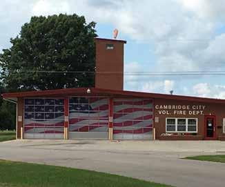
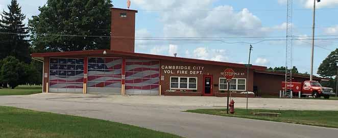
Fire: The Cambridge City Fire Department is an all volunteer department providing fire & rescue services to Cambridge City and Western Wayne County.
VISION:
Maintain utility infrastructure and public services to better serve existing residents and businesses and expand capacity to accommodate desired growth and development.
GOALS & STRATEGIES:
1. Ensure new development and redevelopment will be adequately served by necessary municipal utilities and services.
2. Maintain and replace existing infrastructure to ensure safety.
3. Coordinate utility, transportation, stormwater and other infrastructure improvements to combine construction projects and reduce costs where possible.
DESIRED OUTCOMES:
The goal of the public facilities and services recommendations is to identify improvements needed to support desired growth and development. In general, a community’s utility systems, in conjunction with the transportation network, play a central role in supporting and maintaining economic success and quality of life. These systems are costly to create, extend, and maintain. As such, additional utility planning will need to occur in coordination with development proposals.
1. Create and maintain a capital improvements plan to prioritize and budget for future infrastructure upgrades and extensions.
2. Construct a new elevated water tank to serve additional development in the industrial park.
3. Construct needed wastewater treatment upgrades to serve both the Town and industrial park.
4. Create a map of the existing stormwater conveyance system.
Placemaking (Chapter 7, Pages 71 - 79)
KEY FINDINGS:
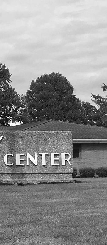
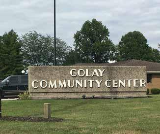
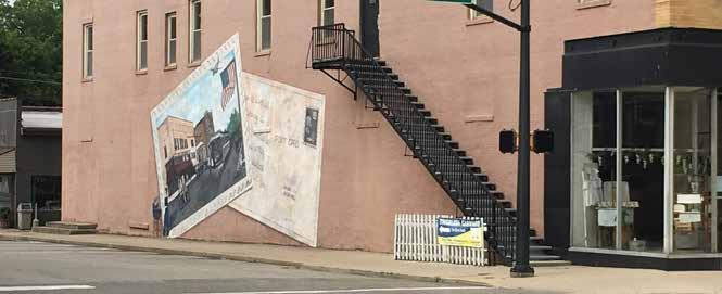
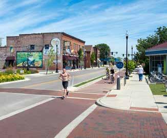
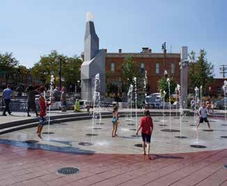
Placemaking is a subjective concept that combines both tangible and intangible elements of a community, including its social, cultural, economic, and physical attributes. The relationship between these elements creates a unique community fabric that influences the experiences of residents and visitors. Positive attributes are often associated with housing character, job availability, quality schools, access to recreation and entertainment, and a healthy environment. Cambridge City has placed emphasis and focus on placemaking in the community. Multiple murals are painted on the side of buildings to represent different historical events, figures, and facts regarding the community and additional quality of life amenities have been added over time. The Golay Center is an incredible community asset that provides meeting space and multiple recreational opportunities including a swimming pool, sports courts, and fitness center. Creitz Park is the Town’s largest park and home to a number of sports courts opportunities, as well as playgrounds and other amenities.
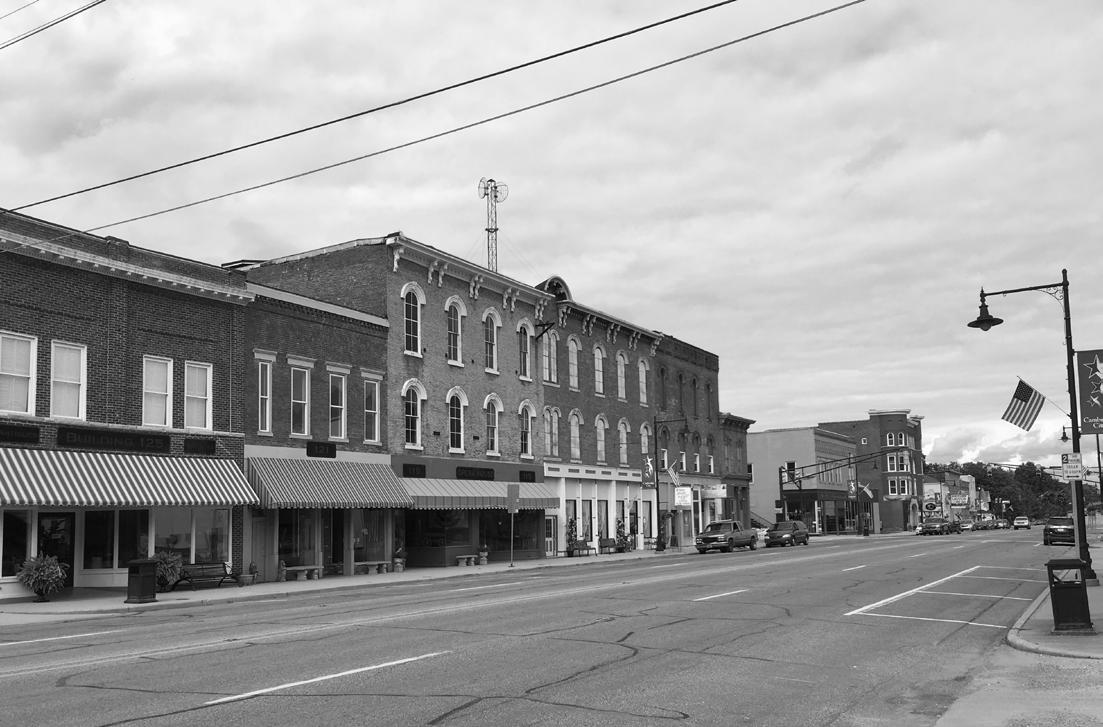
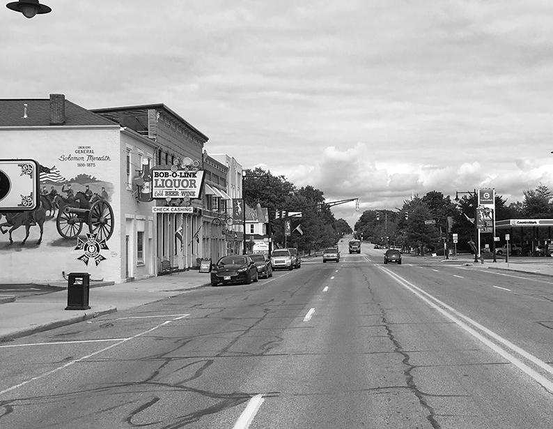
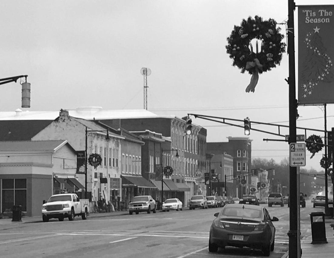
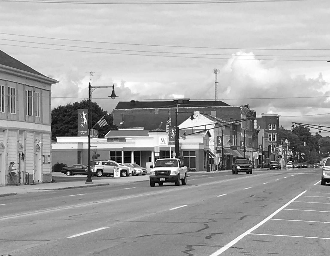
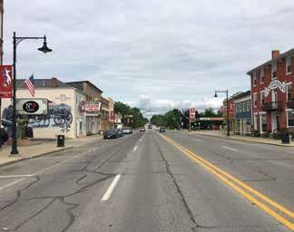
Downtown is the heart and soul of the Town and where most people spend their time. The restaurants and antique stores in the downtown provide numerous eating and shopping opportunities for both residents and the many tourists they bring to the area. Over 60% of the
community is a part of the National Registry of Historic Places.
Community programming continues to develop within Cambridge City. There are three annual events, of which Canal Days is probably the most well-known. It is a three-day event that takes place downtown on the weekend after Labor Day. The Winter Wonderland light display in the park is another significant community event. Finally, the Cambridge City Antique Fair brings in people from across the region.
VISION:
Improve the quality of life of residents and attract additional businesses and visitors by enhancing existing amenities and creating new opportunities for community gathering, recreation, and general well-being.
GOALS & STRATEGIES:
1. Encourage the expansion and protection of open spaces within the town.
2. Collaborate with Western Wayne Schools to attract and grow the student population and unique course offerings.
3. Continue to promote public art projects on both private and Town-owned properties.
4. Celebrate the cultural, historic, and artistic resources of the Cambridge City community.
DESIRED OUTCOMES:
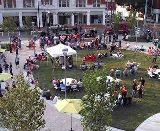
In addition to the big picture initiatives like small business development, housing rehabilitation, and creating a trail system, short-term placemaking projects the Town can focus on include expanding public art installations and incorporating Town branding into gateways and wayfinding signs.
1. Create a public art program to facilitate public art installations and programming.
2. Conduct a community branding initiative and use the results to implement a gateway and wayfinding signage program.
3. Develop a trail network within the community and to surrounding communities. (See Parks & Recreation)
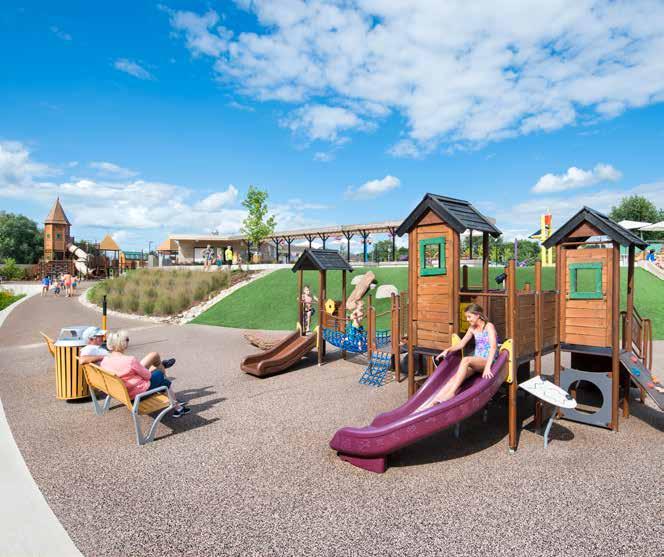
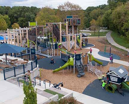
4. Upgrade playground equipment and provide accessibility upgrades within Creitz Park. (See Parks & Recreation)
Executive Summary
Economic Development
(Chapter 8, Pages 81 - 89)
KEY FINDINGS:
Small towns and rural communities throughout the U.S. are looking for ways to strengthen their economies, provide better quality of life and build on local assets. But the truth for Cambridge City and most other small towns is that they’re greatly influenced by national and international economic forces. As a result, the lion’s share of growth in the last decade has been concentrated— with relatively few exceptions—in a small cohort of urban hubs while the rest of the country has drifted or lost ground. These national challenges are reflected in Cambridge City, including declining populations and loss of farms and working lands.
The following Cambridge City statistics were gathered from current data, most of which comes from the U.S. Census Bureau’s 2017 ACS. In cases where new information is not available for the town, Wayne County data was used instead.
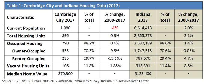
• The town’s population was 1,980 in 2018, according to Census Bureau estimates. It has declined by 1% since 2010.
• There are 943 people age 16 or over in labor force.
• The median household income of $35,000, is markedly lower than Wayne County’s ($41,813)
and Indiana’s ($54,181). Furthermore, Cambridge City, Wayne County and Indiana all have smaller median incomes than the U.S. average of $52,182.
• The largest job sector – at 24% - is education, health care and social assistance. About 211 people are employed in those jobs.
• Although the town has a high percentage of manufacturing jobs – 22% - local workers in those jobs get paid relatively less than state and national averages.
• About 12% of Cambridge City’s population has an associate’s, bachelor’s or graduate degree, compared to 32% in Indiana.
VISION:
Cambridge City will balance economic investment against maintaining the small-town character that attracts visitors, residents and local businesses.
GOALS & STRATEGIES:
1. Make the distinction between “growth” and “investment.” Building on ongoing investments, rather than “growth” as defined by increasing employment, population or tax base, is essential to reinvigorate a struggling economy.
2. Be focused. Investments of time, money and other community resources are most effective when targeted to an area that is big enough to offer opportunities for change and small enough to make visible improvements that will spur other investment.
3. Start where there is already momentum. Economic development efforts are most effective in places where there is already private-sector activity. Once these initial investments start to show success, it’s easier to attract additional investment to nearby locations, thus spreading the momentum incrementally over time.
4. Find the right partners for specific goals. Successful economic development efforts rely on partnerships across public agencies and private investors, especially when different types of funding are involved.
5. Communicate and coordinate. Good communication and coordination among groups and agencies can help ensure that all available resources support the community’s vision and can help achieve goals at minimal cost by avoiding redundancy, conflicting efforts, and spreading resources too thin for meaningful improvement.
DESIRED OUTCOMES:
Cambridge City should be a place where people from many different walks of life can find a home. Unfortunately, national, and statewide trends are acting against local interests, including: brain drain as young people seek better opportunities in large cities, tighter lending policies which make it difficult for young families to get mortgages, water and sewer capacity to support new growth, an aging population in need of specialized units and builders unwilling to take chances in small towns when the new real estate market is hot in urban areas. Fortunately, there are many projects a comprehensive land use plan can include to improve the local economy.
1. Begin community discussions on historic preservation regulations.
2. Begin community discussions on code enforcement with the aim of improving neighborhoods and economic conditions so that the community is known as a good place to live, raise families, work and retire in.
3. Begin community discussions on creating a downtown tax increment finance (TIF) district.
4. Create a downtown business plan.
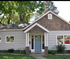
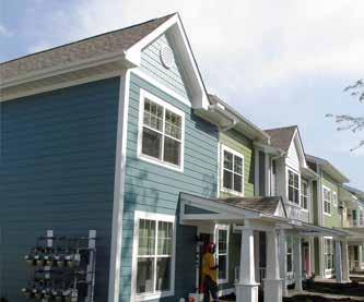
Housing (Chapter 9, Pages 91 - 97)
KEY FINDINGS:
Cambridge City is what’s traditionally called a bedroom community; most of its residents work elsewhere and return to the community at night. The average commute is about 30 minutes. While that’s unlikely to change soon, many small towns have begun to attract new residents for their quality of life, particularly people whose internet-based job means they can work from anywhere, including their home.
The most recent data for Cambridge City is from the U.S. Census Bureau’s 2012-2017 American Community Survey (ACS), which reveals the following trends:
• Between 2000 and 2012, the median value of Cambridge City homes increased slower (8%) than the county (23%) or the Indiana average (33%). The city’s median home value was $70,300.
• Roughly half (48%) of Cambridge City’s owneroccupied housing stock is valued between $50,000-$100,000. Both the county and state have a larger proportion of high-end homes (costing $150k and above).
• Cambridge City’s homeowner vacancy rate (0.7%) is lower than both the county (2.5%) and the state (1.8%). The low vacancy rate would – ideallysignal an unmet demand for more housing and
would attract the attention of developers willing to build new units.
• There is a slightly higher percentage of people renting their homes in Cambridge City (29.7%) than the state average (29.4%). That number has been decreasing – down from 35.3% from 2010 to 2017.
VISION:
Continue to make Cambridge City an attractive and diverse community.
GOALS & STRATEGIES:
1. Think small. Affordable housing will not just come in the form of single-family homes, duplexes and apartments.
2. Think creatively. The free market system, where developers are welcomed to build all the housing units a town needs, has not worked out in Cambridge City. Until the free market decides to respond to local conditions, some creativity and experimentation may be in order.
3. Renovate older houses. If new homes are not being constructed fast enough, the next solution is restoring and updating existing homes. This type of renovation is usually driven by individual property owners, but local leaders can help get things started.
4. Adaptive re-use of non-residential property.
Executive Summary
Transportation (Chapter 10, Pages 99 - 111)
DESIRED OUTCOMES:
Housing is an essential element of any community and critical to attracting and retaining residents. In addition to developing a housing strategy and making concentrated efforts to diversify housing types within the community, Cambridge City should consider using incentives to better facilitate housing renovation, rehabilitation, and new construction.
1. Study and prioritize the best areas for future housing growth in conjunction with the future land use map.
2. Make use of public land for affordable housing. Reducing the land costs of a residential project can be a valuable way to foster housing affordability for lower-income residents.
3. While waiting for the two previous projects to take hold, explore short-term methods to incentivize people to move to town.
KEY FINDINGS:
Communities develop around transportation networks and Cambridge City is no different. Transportation has played a critical role in the historic development of the community beginning with the Whitewater Canal and National Road, the Pennsylvania Railroad, and followed by the development of U.S. 40, State Road 1, and ultimately Interstate 70.
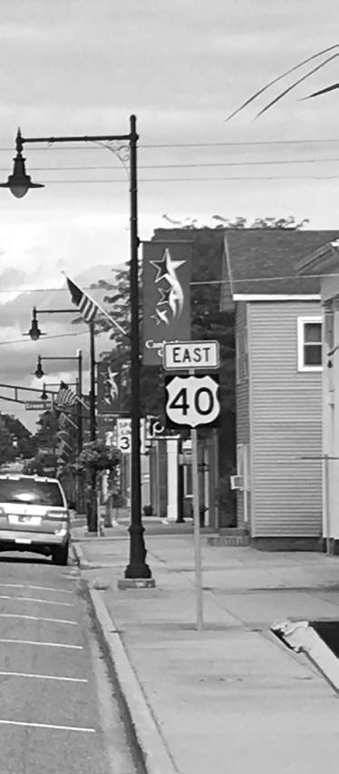
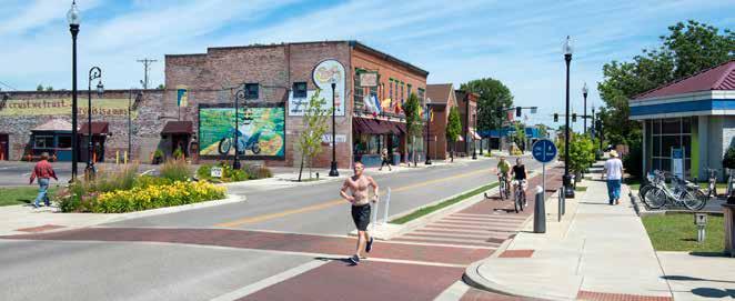
While the majority of through-traffic has shifted from U.S. 40, the community’s historic “Main Street,” to Interstate 70, Cambridge City remains conveniently located in proximity of the interstate and within 50 miles of major urban areas including Indianapolis and Dayton. The community now seeks strategies to capitalize on the transportation assets to guide future land-use and amenity development.
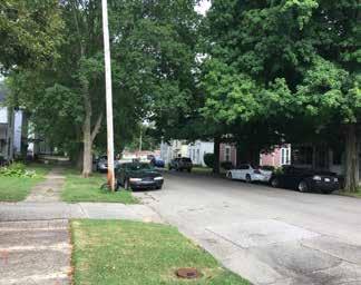
The majority of local streets within Cambridge City are laid out in a traditional grid pattern and streets are either two-way north/south or two-way east/west. Most have on-street parallel parking and sidewalks separated from the street by tree lawns with mature street trees. Sidewalks are in various conditions with some in need of replacement due to general decay and tree upheaval. Most curb ramps are not ADA compliant. In many locations, original, limestone curbs remain intact and add to the historic character of the surrounding
neighborhoods. One block north and south of U.S. 40 are serviced by mid-block alleys, however, those are the only alleys within the community. Some exceptions to the traditional street grid and layout occur on the north side of the community where typical, mid and late twentieth century homes developed in a more suburban pattern with lower density. In these areas, sidewalks are less prevalent.
VISION:
Improve the town’s transportation system to address existing deficiencies and failing infrastructure, promote walkability, enhance aesthetics, connect to future development, and promote future growth.
GOALS & STRATEGIES:
1. Improve failing and deteriorating roadways.
2. Improve accessibility within the community.
3. Protect, promote, and enhance the Main Street (U.S. 40/Historic National Road) streetscape.
4. Extend transportation networks to future development areas.
5. Encourage active living and improve quality of life through the incorporation of trails.
DESIRED OUTCOMES:
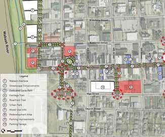
The first step in implementing transportation enhancements is to implement standards for street development and maintenance and complete an audit of existing conditions. As is good practice and has proven the most successful historically, a commitment should be made through zoning and development standards to providing complete streets that accommodate both vehicles and pedestrians alike. Looking forward, the City should consider future trends in transportation and increase pedestrian and bicycle safety, as well as provide general aesthetic improvements to enhance the community’s character. It should be noted that transportation projects by their nature are expensive. Many of them will be dependent on grant funding, new development, and State funded improvements to roads under INDOT jurisdiction.
1. Develop standards for street development and maintenance and conduct an audit of existing conditions.
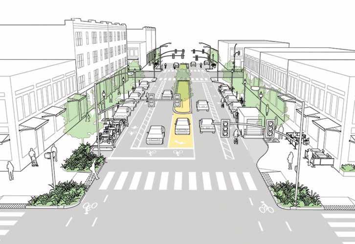
2. Implement streetscape improvements to downtown Main Street to improve pedestrian walkability and safety, infrastructure issues, aesthetics, and local curb appeal.
3. Implement improvements to Church and Front Streets to replace failing infrastructure, improve pedestrian walkability, provide ADA compliance, and protect neighborhood character.
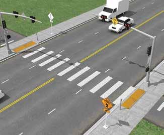
4. Provide pedestrian improvements including sidewalks, crosswalks, and lighting to SR 1.
5. Plan for streetscape improvements to existing and future streets.
6. Refer to Parks and Recreation, chapter 13, for specific implementation projects and action steps regarding trail development.
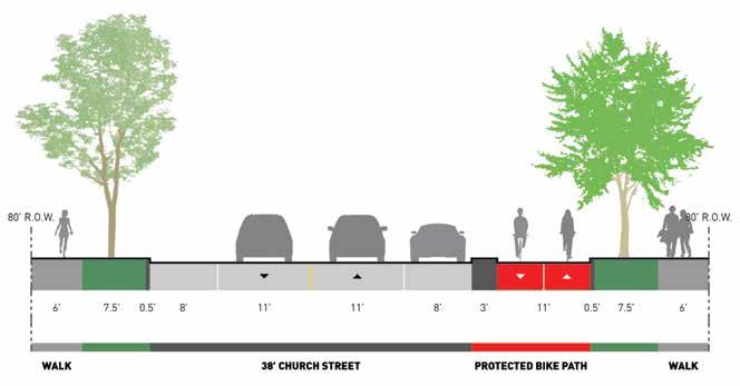
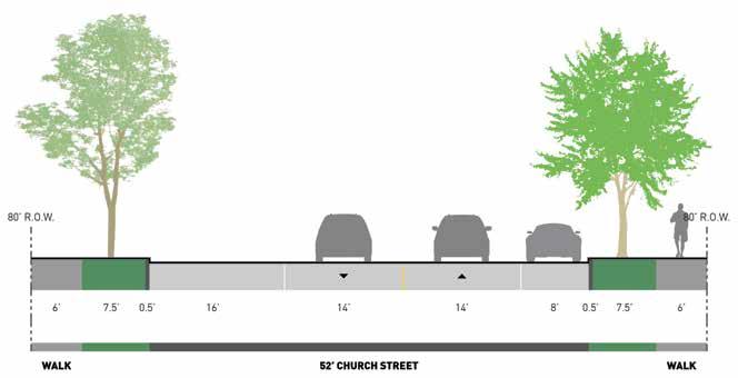
Roadway repairs and bicycle and pedestrian enhancements were commonly identified as a need along several streets in Cambridge City, including Church Street. The above cross section shows proposed Church Street improvements, including a new protected bike path.
Executive Summary
Parks & Recreation (Chapter 13, Pages 117 - 127)
KEY FINDINGS:
Parks and recreation amenities are a critical component of vibrant, sustainable communities. They play a major role in the attraction and retention of residents and are also an important consideration for existing and new businesses looking to invest in the community. They increase quality of life, encourage healthy living, and often protect environmentally sensitive areas.
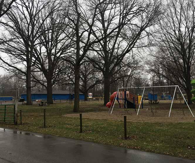
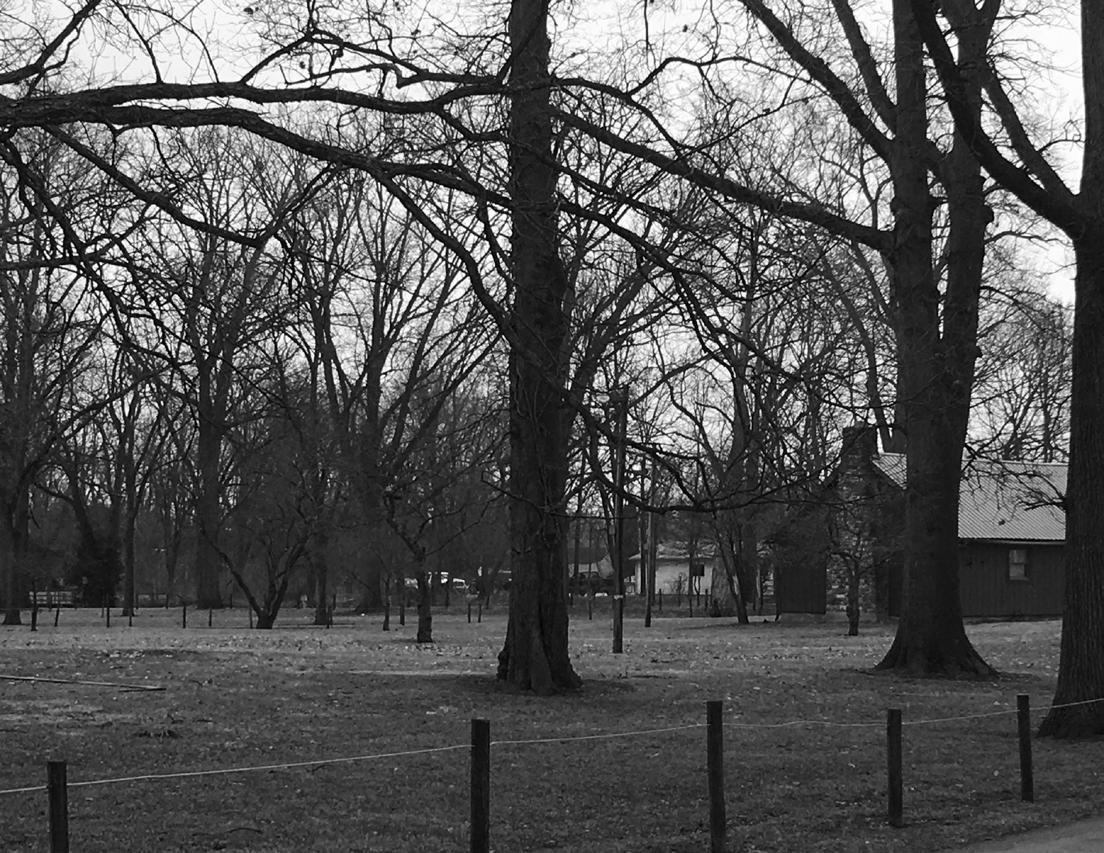
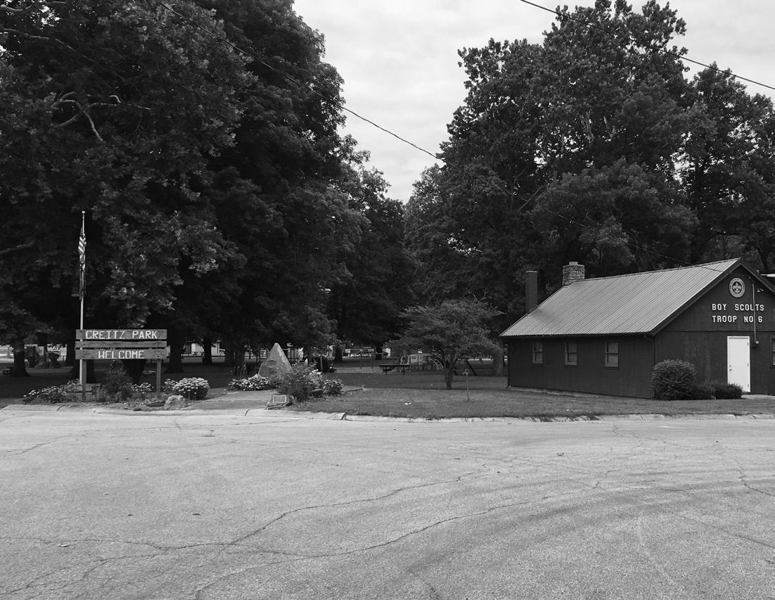
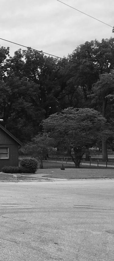
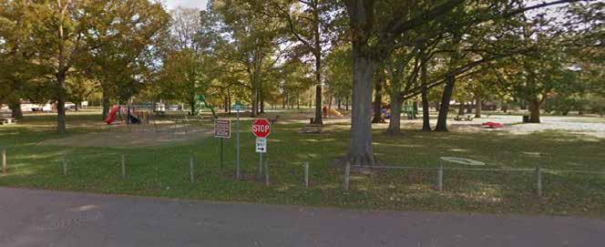
While Cambridge City does not have a current parks master plan, the community has several parks and recreation amenities within its corporate limits and within close proximity of the community. The Cambridge City Parks system consists of two (2) parks, Creitz Park and the Mini Park on U.S. 40. The primary park in Cambridge City, Creitz Park is centered in the community north of U.S. 40 and is comprised of just under 32 acres. Amenities within the park include multiple pieces of playground equipment, an open air shelter, a cabin used primarily for Boy Scout activities, a basketball court, volleyball court, three (3) ball diamonds with dugouts and press boxes, a concession’s building with restrooms, a horse ring, a pedestrian bridge over the Whitewater River, and a natural amphitheater used primarily for watching activities in the horse ring, ball diamonds, and annual fireworks display. Playground equipment within the park is aging and some is in need of replacement. Accessible pedestrian paths
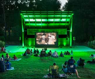
to park features are largely non-existent. The Town has expressed the desire for newer play equipment, a splash pad, and an event space capable of hosting small performances, movies on the lawn, etc.
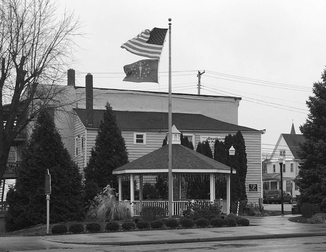
The Mini Park is located at the southeast corner of U.S.40 and Foote Street. This park is a small, commemorative park with landscaping, a flagpole, decorative clock, gazebo, and plaque commemorating the community’s history and founding. The park is primarily used by visitors to the communities and local residents who enjoy people watching along Main Street.
VISION:
Improve the Town’s park and recreation system to improve quality of life, support economic (re) development, modernize facilities, and provide additional recreation opportunities to Town residents and youth.
GOALS & STRATEGIES:
1. Develop a long-range plan for the development and maintenance of the Town’s park and recreation facilities.
2. Upgrade amenities within existing parks facilities.
3. Develop new parks and recreation facilities that will provide desired community amenities,
enhance quality of life, and encourage economic development.
DESIRED OUTCOMES:
Investment in parks and recreation facilities can be challenging and expensive. Fiscal budgets typically provide minimal allocations for use in basic maintenance and upkeep and any excess community funds are typically needed for basic infrastructure upgrades and maintenance or replacement of the public works tools and equipment. If the Town wishes to implement park and recreation enhancements, it is critical that the community garner public support and allocate funds for parks and recreation projects.
1. Establish a Parks Board.
2. Develop an Indiana Department of Natural Resources (IDNR) Five-Year Parks and Recreation Master Plan.
3. Upgrade playground equipment and provide accessibility upgrades within Creitz Park.
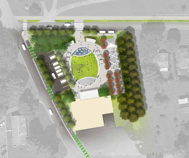
4. Create a flexible gathering space and splash pad north of the existing fire station.
5. Develop a trail network within the community and to surrounding communities.
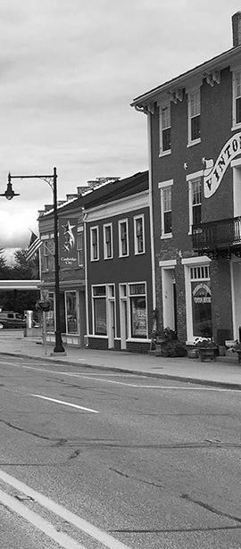
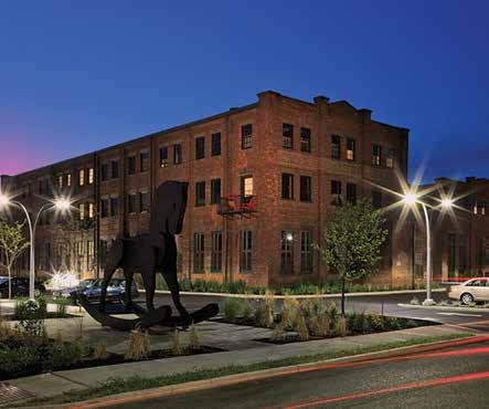
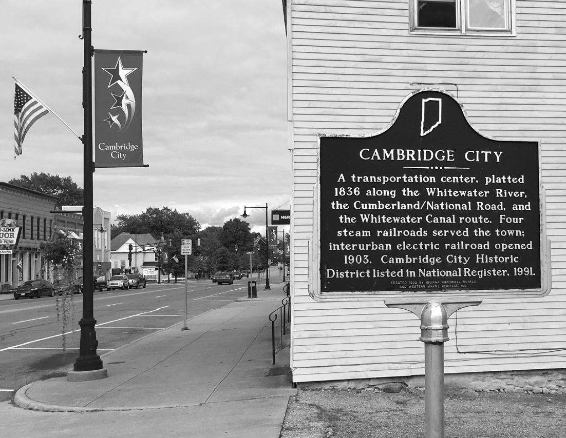
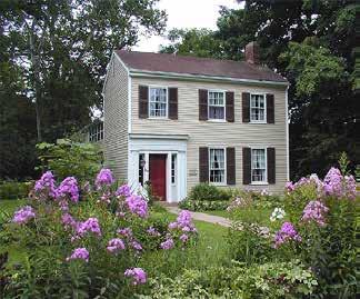
Due to its location along the Historic National Road and Whitewater Canal, Cambridge City has a rich history dating to the early 1800s. Many historic structures and sites remain in place which help create the traditional charm of the community and attract visitors regionally. The community contains a significant historic district that is listed on the National Park Service’s National Register of Historic Places. The district encompasses more than 60% of the community’s total area and is roughly bounded by Boundary Street on the west, Maple Street on the north, High Street on the east, and 4th Street on the south. Within the district, there are 572 contributing buildings and 2 contributing structures. Along Main Street, many historic commercial buildings remain intact and occupied on the lower levels with a variety of business types in operation. While some upper levels of historic commercial buildings are occupied and in-use as residences, most are unoccupied and primarily used for storage. Upgrades and renovations to the upper levels are needed to support modern housing needs.
Other significant historic resources include the former Whitewater Canal which was constructed in the mid1800s to transport agricultural goods from Hagerstown
Executive Summary
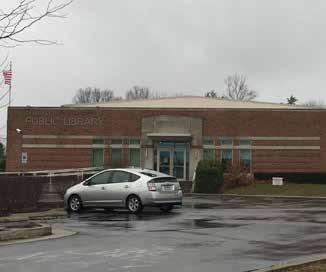
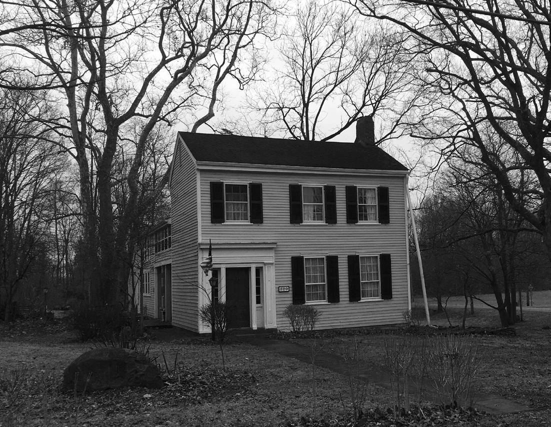
just north of Cambridge City to the Ohio River in southern Indiana. While the system has been filled in, its remnants and routing continue to serve as a tourist attraction for the community. The Cambridge City community is also well known for Overbeck Pottery which was produced by the Overbeck sisters from 1911 to 1955 in their home which remains intact and restored at 520 East Church Street. Today, a large collection of Overbeck pottery remains on display at the Overbeck Museum located in the Cambridge City Library and attracts visitors from all over.
VISION:
Protect and promote the historic archaeological resources within the community.
GOALS & STRATEGIES:
1. Promote historic buildings, structures, and sites within the community.
2. Protect historic buildings, structures, and sites within the community.
DESIRED OUTCOMES:
It is important that historic structures be protected and maintained to avoid long-term demolition or loss. The community is fortunate to have several blocks of buildings remaining intact, but if buildings are lost, so too is the friendly density and scale of the downtown
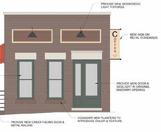
that makes it successful. One tool for protecting historic structures, both commercial and residential, may include the incorporation of Design Guidelines into the community. Specific to historic buildings, another tool for protecting and restoring historic structures is to form a local investment group of like-minded individuals who work with Town officials to purchase, stabilize, and market buildings to potential investors as they become available. Specific to the downtown, another tool for protecting historic structures and developing additional revitalization strategies would be the completion of a Downtown Revitalization Plan. Because historic structures are one of the defining elements of Cambridge City, it is critical the community embrace them and make every effort to protect and restore them. The projects noted below seek to provide tools that will aid the community in the protection and restoration of historic structures and features.
1. Develop design guidelines for the restoration of existing, historic structures and the construction of new buildings.
2. Form a local investment group.
3. Complete a Downtown Revitalization Plan.
4. Increase marketing efforts of local historic features.
Hazard Mitigation (Chapter 15, Pages 137 - 143)
KEY FINDINGS:
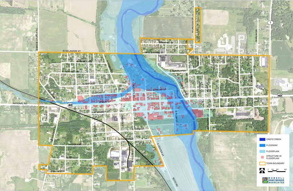
Federal Emergency Management Agency (FEMA) defines hazard mitigation as “the effort to reduce loss of life and property by lessening the impact of disasters. This is achieved through risk analysis, which results in information that provides a foundation for mitigation activities that reduce risk, and flood insurance that protects financial investment.” These disasters may include flooding, drought, severe heat, tornadoes, blizzards, or other extreme storms. While preparing for any of these potential hazards isn’t easy, flooding is the most geography specific hazard that Cambridge City faces. Within the 1.02 square miles of incorporated Town area, 132 acres lie within the floodway or 100year floodplain. Approximately 20% of the Town is within the floodway or floodplain, and within this area there are 286 structures. Structures such as park shelters and ball field dugouts may not be substantially damaged during a flood event. Unfortunately, most all of the development on the north side of Main Street, as well as the south side of Main Street and Church Street between Foote Street and the Whitewater River is within the floodplain. A flood event could result in significant damage to both old and new development in the area.
VISION:
Reduce the risk to people and property with proactive
planning to minimize the impact of hazard events.
GOALS & STRATEGIES:
1. Increase community awareness of Cambridge City’s vulnerability to potential natural hazards.
2. Reduce flooding impacts to properties within the Whitewater River floodway and floodplain.
3. Encourage green infrastructure and other stormwater best management practices in new development and redevelopment.
4. Ensure critical facilities are protected from damage so that they may resume functions during hazard events.
DESIRED OUTCOMES:
Hazards can have a significant negative impact on a community’s quality of life. It is important for the plan to provide policy direction on how Cambridge City can work to prevent hazardous conditions and better manage them when they do occur. Land use planning, development regulations and emergency management play key roles in assessing and reducing the risk to people and property.
1. Designate snow removal/evacuation routes.
2. Amend the zoning ordinance to include hazard mitigation strategies.
Implementation (Chapter 4, Pages 145 - 181)
The plan concludes with a detailed implementation matrix, priority initiatives, and potential funding mechanisms for proposed projects.
Top 10 Initiatives
After taking into consideration the communicated needs of the Town and the information and ideas discussed throughout this plan, a ‘Top 10’ initiatives list was put together to help create and prioritize an implementation working plan. These recommendations and the associated action steps described in more detail later in the plan will provide the foundation by which to accomplish additional plan goals. During plan review periods, the Town should reassess current conditions and adjust this list appropriately. The ‘Top 10’ , in no particular order, are as follows:
• Create a downtown revitalization plan.
• Form an economic development group to explore creation of a tax increment financing (TIF) district.
• Update the zoning and subdivision ordinances.
• Start a housing initiative to improve the condition and appearance of Cambridge City neighborhoods.
• Create a five-year capital improvements plan.
• Develop a communications plan to enhance collaboration with residents and community organizations.
• Create a 5-year parks and recreation master plan.
• Develop a code enforcement strategy and ticketing system.
• Form a stormwater board and map the existing system.
• Create a public space for community programming and events.
2
General Background
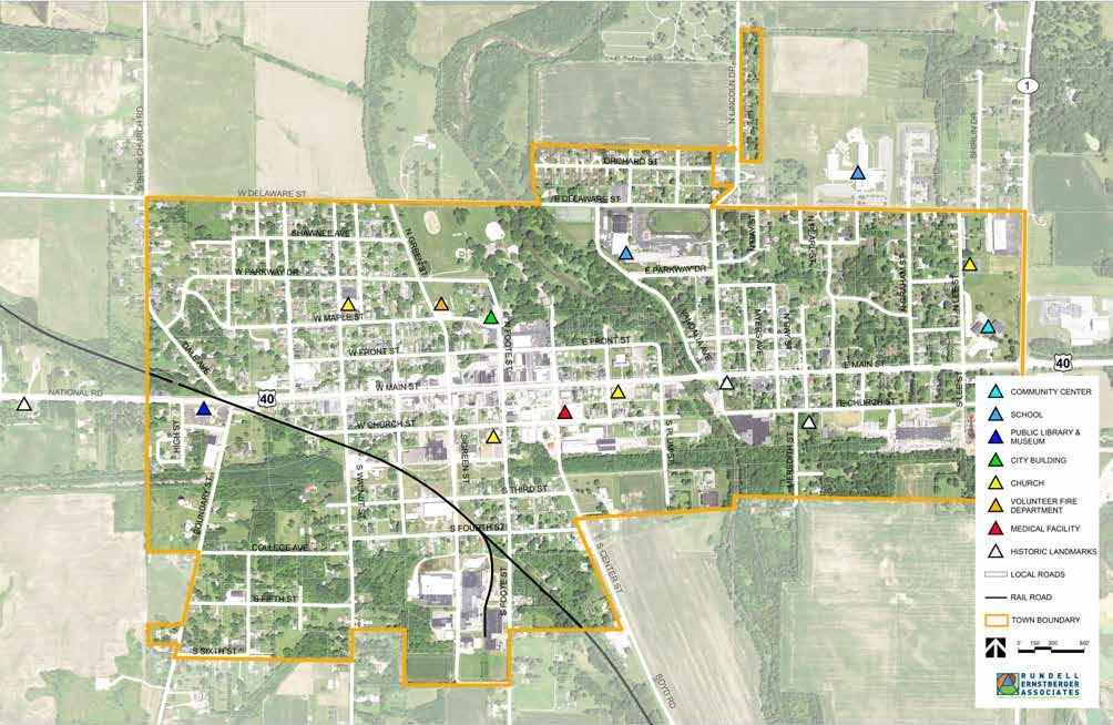
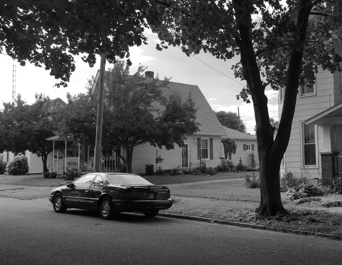
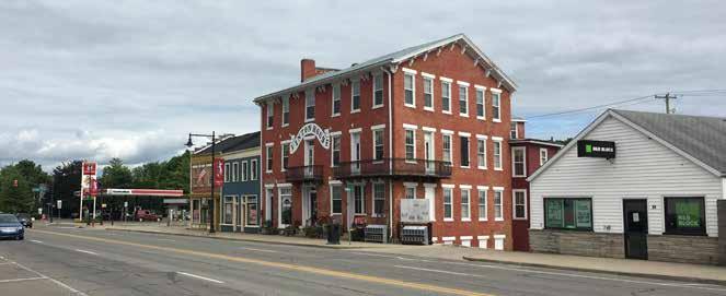
The Town of Cambridge City is located in western Wayne County, Indiana. It covers a total area of 1.02 square miles and is home to just under 2,000 people. It is located south of Interstate 70, to the west of State Road 1, and borders US 40 which is also Main Street.
Cambridge City is the central point for residents of other small communities nearby to visit. Dublin, Mount Auburn, and Pershing are all located along US 40. Milton, south of Cambridge City along State Road 1, also has a direct connection to Cambridge City. Each of these communities are independent of one another; Cambridge City is the largest in this area. Due to the central location, Cambridge City offers other residents of these nearby towns more opportunities than their own communities.
Much of the land use within Cambridge City is residential, with some commercial located primarily in the downtown core along US 40. Industrial uses line the south of the town, and the schools are located in the north. A rail line runs through the town that, for the most part, is not active except for a few times throughout the year. There are many key anchors in this community, and parts of the community, including the downtown, have been added to the National Historic Registry.
INCORPORATED LIMITS
Demographics
Population by Race
Population by Race
The Town of Cambridge City is not very diverse as the majority of residents identify as white. The next leading race that individuals identify as is being of two or more races. In total, only 3.3 percent of the population is not white.
Source: U.S. Census Bureau, ACS 5-Year Estimates
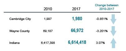
Population Change between 2010 and 2017
Population Change
From 2010 to 2017, the Town of Cambridge City has seen a decrease in population. The population of Wayne County seems to be decreasing more than Cambridge City which indicates that the town is doing better overall at retaining residents when compared to the County. Unfortunately, Cambridge City is not following the state trends. Indiana itself has seen a three percent increase in the total population from 2010 to 2017.
Source: U.S. Census Bureau, ACS 5-Year Estimates
Demographics
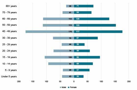
Population Pyramid
From 2010 to 2017, the population only decreased by 17 people, going from 1,997 residents to 1,980 residents. When looking at the age breakdown of the population of residents in Cambridge City in 2017, the majority of people were aged 40-69 which indicates an aging population. Ages 20-39 are shown to have a slightly lower number than other age groups. Individuals that fall within this age group are primarily college students, college graduates, and young professionals. This age gap, while not large, could indicate that after high school people are moving away for higher education and/or jobs.
Source: U.S. Census Bureau, ACS 5-Year Estimates
Population Pyramid, 2017
Educational Attainment of Residents 25 years and older, 2017
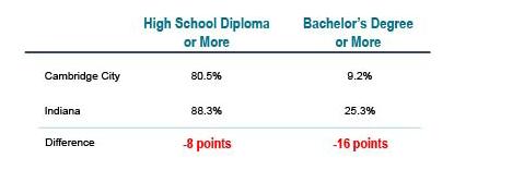
Educational Attainment of Residents 25 years and older
A majority of residents aged 25 and older have obtained a high school diploma or what would be the equivalent. Under 20 percent of the population does not have a high school diploma while nearly 40 percent of the population has either some type of college education or higher, including graduate or professional degrees.
Source: U.S. Census Bureau, ACS 5-Year Estimates
Educational Attainment, 2017
The educational attainment of Cambridge City residents is similar to the educational attainment in Wayne County. When looking at the state of Indiana compared to Cambridge City, Cambridge City residents fall short. Statewide, educational attainment percentages exceed those of Cambridge City by 8 percentage points with regard to having graduated from high school, and 16 percentage points with respect to having attained a bachelor’s degree.
Source: U.S. Census Bureau, ACS 5-Year Estimates
School Enrollment in Cambridge City
School Enrollment in Cambridge City
Cambridge City has seen an increase in student enrollment from the 2015/2016 school year to the 2016/2017 school year.
Source: U.S. Census Bureau, ACS 5-Year Estimates
Employment
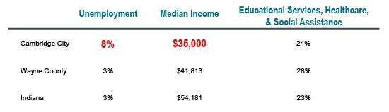
Unemployment, Median Income, and Assistance
The Town of Cambridge City has a high unemployment rate and low median income. Both Wayne County and the State have a three percent unemployment rate, but Cambridge City is five percent higher. Wayne County also has a $6,000 higher median income compared to Cambridge City, and the State is $19,000 more than Cambridge City.
Overall, Cambridge City and the State supply roughly the same amount of assistance to residents who need it. Wayne County supports 28% of their population which is higher than the State (23%) and Cambridge City (24%).
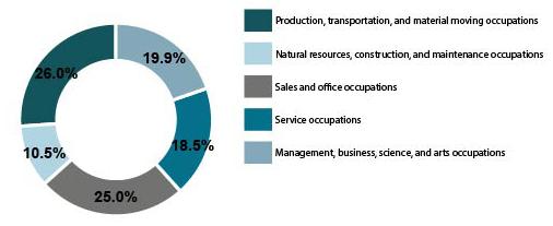
Employment by Industry
Cambridge City residents are employed across a range of industries. The leading employment industries are production, transportation, and material moving occupations. Sales and office occupations are the second most common job sector.
Unemployment, Median Income, and Assistance, 2017
Source: U.S. Census Bureau, ACS 5-Year Estimates
Employment by Industry, 2017
Source: U.S. Census Bureau, ACS 5-Year Estimates
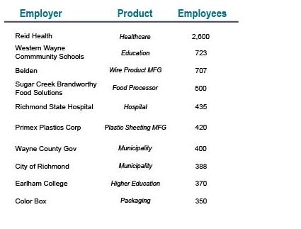
Major Employers
Major Employers
The major employers within Wayne County are shown to the left. As previously noted, Cambridge City has a diverse amount of job opportunities but for those more specialized, professional jobs, it is lacking. Residents may move entirely for a job opportunity because it is not available nearby. However, for those wishing to pursue a career path medically, in education, or go to work at different industrial sites, this area holds many opportunities and likely will continue to increase.
No information is available on how many of these employees also live in Cambridge City.
Source: U.S. Census Bureau, ACS 5-Year Estimates
Housing
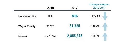
Change in Housing Units between 2010 and 2017
Cambridge City has decreased their total housing units between the years 2010 to 2017. There were a total of 40 housing units lost over those seven years, which is a four percent decrease. Wayne County did increase their overall housing units throughout those same years, but not even by one percent. This could signify that there is low demand for people moving to the county.
Indiana as a state did increase their total housing units within this same timeframe too. During those seven years, Indiana nearly increased the total housing units by almost three percent.
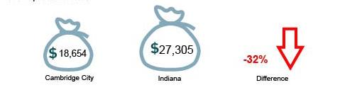
Per Capita Income
In 2017, the per capita income for Cambridge City was a little over $18,500. Across the state, the per capita income was $27,000. This is a 32% difference in the town and state. This does make sense as Cambridge City has a higher unemployment rate at eight percent while the state is at three percent. There is also a $19,000 difference in average median income between the state and Cambridge City.
Change in Housing Units between 2010 and 2017
Source: U.S. Census Bureau, ACS 5-Year Estimates
Source: U.S. Census Bureau, ACS 5-Year Estimates
Per Capita Income, 2017
Homeowner/Renter Occupancy Percentage of Total Housing, 2017
Source: U.S. Census Bureau, ACS 5-Year Estimates
Housing Occupancy, 2017
Source: U.S. Census Bureau, ACS 5-Year Estimates
Homeowner and Renter
Occupancy
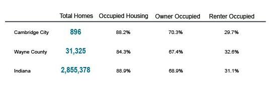
Cambridge City follows the state trends when looking at how many owner and renter occupied housing units there are. Both Cambridge City and the state of Indiana have around a 30% renter occupancy rate and 70% homeowner occupancy rate. Cambridge City is doing better than Wayne County, where there is about a two percent increase in renters and two percent decrease in homeowners across the whole of the county.
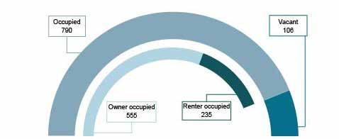
Housing Occupancy
Cambridge City has a total of 896 housing units. Of those, 106 are vacant. The 790 remaining units can be broken down by owner occupied and renter occupied units which is about a 30/70 split. There are a total of 235 renter occupied units and 555 owner occupied units.
Key Anchors
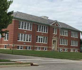
Although the Town of Cambridge City is small, there are multiple anchors for the community that help keep it alive without sacrificing the small town feel that everyone loves.
The downtown plays a large role for the community. It is the place that most people visit for shopping and eating. Key anchors within the downtown include the antique shops, Number 9 Grill, Cutshaw’s Family Market, and the former public library now known as the Archives.
Other notable key anchors are:
• The Golay Community Center
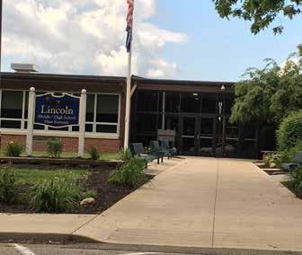
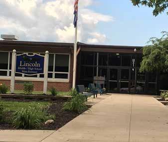
• Lincoln Middle and High School
• Western Wayne Elementary School
• The Overbeck Pottery Museum & public library
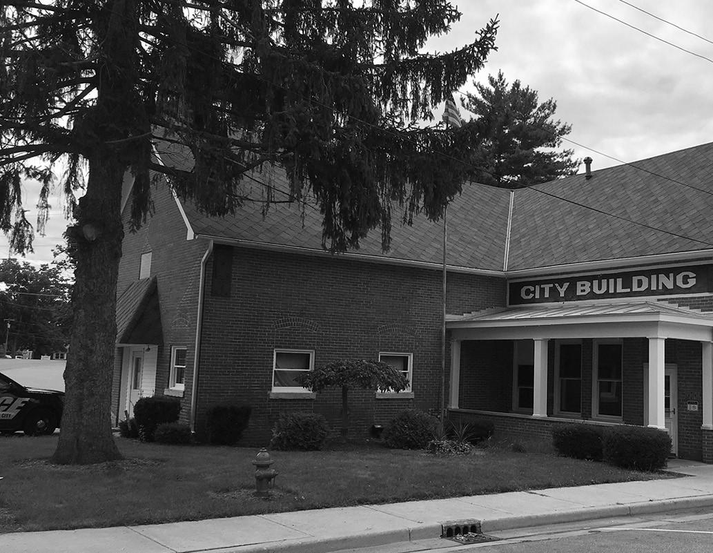
• The City Building
• Multiple churches
• A volunteer fire department
• Cambridge City Family Medicine
• Huddleston House
• Cutshaw’s Family Market
KEY ANCHORS
3 Comprehensive Planning Committee
The Comprehensive Planning Committee (CPC) was absolutely essential in leading the plan process; providing input to generate the plan vision, goals, and strategies; and confirming proposed projects and implementation recommendations. The CPC was organized by the Town Council and included Council members, Plan Commission representatives, Town staff, local business owners, residents, and representatives of faith-based and non-profit organizations serving the Cambridge City community. This diverse group met four times during the planning process. Members of the CPC also participated in the focus group meetings, open house, and Canal Days events described later in this chapter. Following adoption of the plan, the CPC will be integral in promoting and ensuring plan implementation through continued engagement. The diverse make-up of the CPC, including influential local leaders, ensures that the action-oriented plan recommendations can efficiently be translated into noticeable and meaningful change within Cambridge City.
Comprehensive Planning Committee
CPC Members
Beth Leisure - National Road Antique Mall, the Archive, County Council
Brad Bowman - Bowman & Thalls Insurance
Brandon Pennington - Lincoln High School
Brenda McLane - Western Wayne News
Briana Wetzel - Town of Cambridge City
Carrie Miles - Neighborhood Health Center
Chad Bowman - Bowman and Thalls Insurance
Danny Berry - Cambridge City Christian Church
Debbie Prather - First Bank
Debbie McGinley - Town Council
Doug Young - Superintendent of Public Works
Jessie Russett - Cambridge City Main Street
Jill King - King’s Café, Cambridge City Main Street
Jim King - King’s Café, Cambridge City Main Street
Karen Bay-Winslow - Cambridge City Library
Ken Newton - Medicenter Pharmacy
Nathan Ulerick - Turpin Electric, Dublin Volunteer Fire Department
Nathan Riggs - Town Council
Sarah Pennington - Harrington Hoch Insurance
Sherry Ervin - Town Clerk
Steve Sorah - Town Council
Susie Dungan - Dungan Plumbing
Committee’s Work & Meetings
This section outlines the work that the Comprehensive Planning Committee (CPC) has put into the plan including all the meetings and public events held throughout this process. Over the last year, multiple meetings have been conducted with the CPC. Additional events, such as an open house and canal days, allowed for more of the public to get involved. Below is a list of all the meetings that have been completed throughout this process:
• May 29, 2019 – Project Kickoff & Coordination
• June 26, 2019 – Comprehensive Planning Committee Meeting 1
• August 8, 2019 – Comprehensive Planning Committee Meeting 2
• August 29, 2019 – Focus Groups and Open House
• September 7, 2019 – Canal Days
• November 19, 2019 – Comprehensive Planning Committee Meeting 3
• January 7, 2020 – Comprehensive Planning Committee Meeting 4
May 29, 2019
Project Kickoff & Coordination:
The project kickoff and coordination meeting was the first meeting held. It was located at the Cambridge City Town Hall and the primary focus was for introductions and to go over the comprehensive planning process. This included:
• Review of the schedule
• Determining who would be a part of the Comprehensive Planning Committee and the meetings
• Developing a public engagement plan
• Creating focus groups
• Determining when and where to do public workshops
• Creating a project website
• Discussion of past plans and any additional information or data the Town could provide This meeting set the framework for the project and determined meeting schedules and upcoming public events that would provide public engagement opportunities.
Committee’s Work & Meetings
June 26, 2019
CPC Meeting 1
The first CPC meeting was the second meeting in the comprehensive planning process. It focused on introductions and getting to know each other as the primary group helping to lead the plan. A basic understanding of what a comprehensive plan is and does was discussed.
After a short presentation, the committee was asked about what they wanted to see the plan accomplish. Issues, assets, and opportunities were discussed, and many of the comments focused on the following key factors:
• Streets and utilities
• Housing
• Annexation of nearby land
• Parks and trails
• Quality of life
Each of these key elements will be further expanded on in later chapters. Additional concerns brought up during this meeting included outdated zoning, old manufacturing buildings, the rail line that runs through the town, interaction with the city and county, attracting more jobs and residents to the area, and increasing community participation.
August 8, 2019
CPC Meeting 2
The second CPC meeting involved an overview of the first meeting and discussion of the plan layout and subjects to cover. The purpose of the overview was to ensure that the plan was working towards addressing key issues and concerns, as well as to ensure the plan would address and accomplish future wants and needs of the community.
The outline of the comprehensive plan set by the Indiana Office of Community and Rural Affairs (OCRA) was discussed during this meeting in order to show the committee members how the plan would generally be organized and to further develop the subject analysis chapters. This helped to develop the existing conditions sections of each chapter, as well as discuss in depth what they felt were the most important and realistic goals that the community could achieve over time.
August 29, 2019
Focus Groups and Open House
Five focus group meetings were held on August 29, 2019. Focus groups were generally designed to gather people from similar interests including business owners and investors, community leaders, residents, the Lincoln High School Student Government, and others. The groups were invited to participate in a 45 minute discussion of the community and talk about strengths, weaknesses, concerns, opportunities, and anything that might be happening around the community, both good and bad. This was a continuation of existing conditions research and identifying key focus areas of the plan.
Between the five groups, there was significant overlap. Every group felt as though growth was the biggest general concern and goal for the community. Growth was focused on expansion of housing, resident attraction, attracting job opportunities, and annexation when beneficial for the Town.
Many people discussed the uniqueness of Cambridge City and its numerous opportunities. The problems which were noted included job and resident attraction, lack of available, high quality housing, and finding ways to encourage visitors to spend additional time and money within the community. While the antique shops and Number 9 Grill are the major draws to Cambridge City, the community feels like there needs to be more.
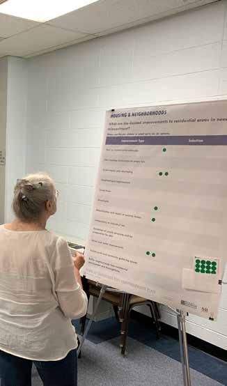
The public open house event was held in the early evening after the focus groups in the morning and afternoon. From 4:30 pm to 6:30 pm, anyone was welcome to stop by the Golay Community Center and talk about the plan with staff. Multiple activities were set up for people to participate in and boards that showed demographic and economic data were displayed to show change over time and illustrate, local, regional, and statewide trends.
September 7, 2019
Canal Days
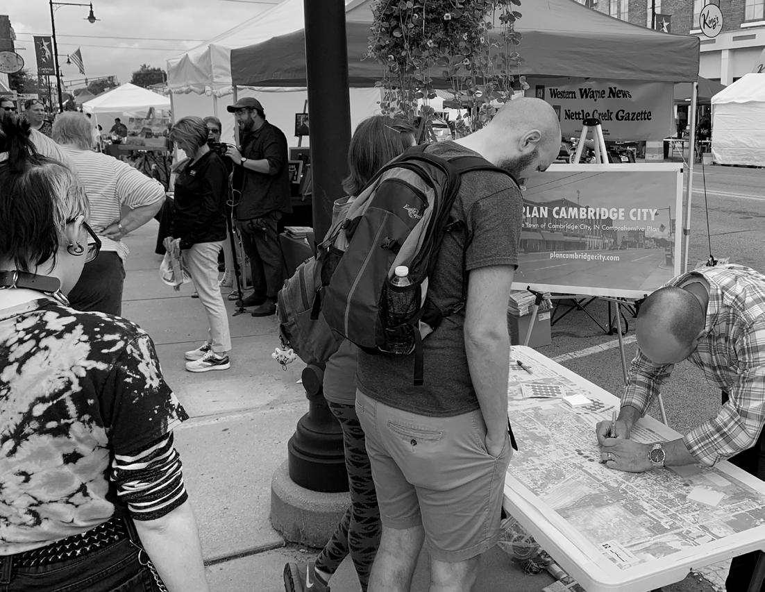
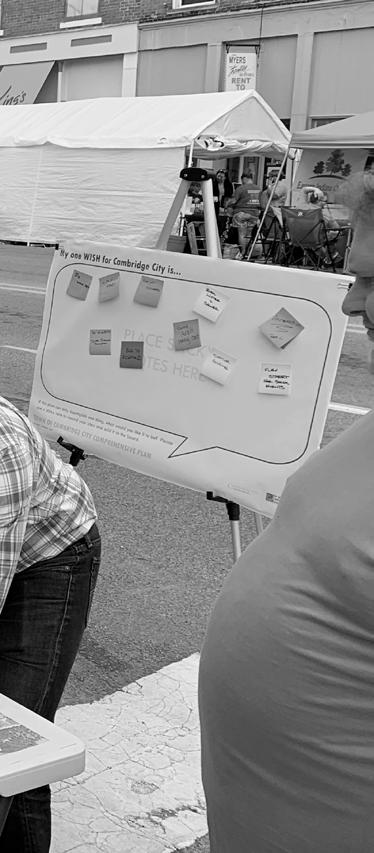
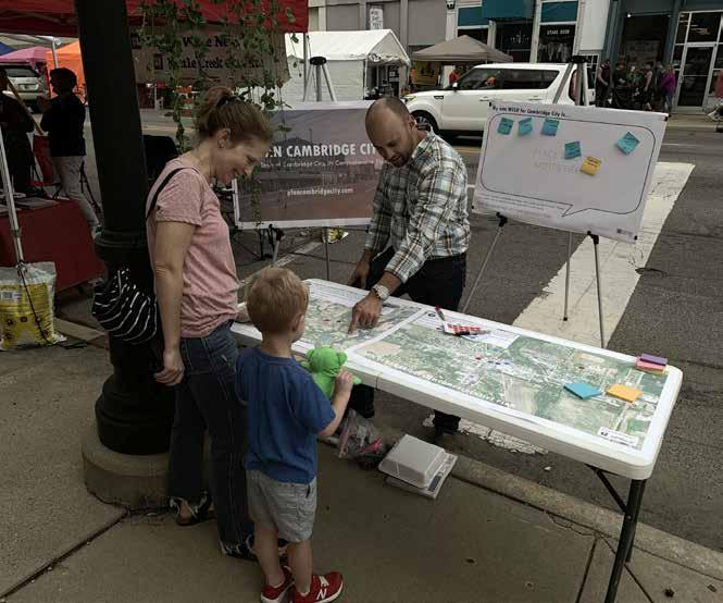
Canal Days is a community wide event held the weekend after Labor Day in Cambridge City. There is food, games, a Duck Race, shopping, and concerts in the evening. This is one of three annual events held in Cambridge City and it brings in people from all over the County. In order to take advantage of this event, a booth was set up on Saturday, September 7th, and people were asked to participate in various activities that involved writing down “one wish” for Cambridge City and drawing on maps of the town and surrounding area to depict opportunities and concerns.
A community open house was held at the Golay Community Center on August 29, 2019.
Committee’s Work & Meetings
November 19, 2019
CPC Meeting 3
The second to last CPC meeting focused on summarizing the public engagement that had been completed, as well as discussing general background information of the community. The bulk of the meeting was discussing the subject matter topics and what had been completed up to that point.
Maps were been created for multiple topics and presented to the committee for further review and existing conditions of each subject matter were summarized. Each chapter of the plan was presented with a vision statement and general goals and strategies for reaction by the CPC and to determine how large a role it should play in the plan.
January 7, 2020
CPC Meeting 4
The final CPC committee meeting prior to submitting the final draft plan for committee review was held at the start of the new year. This meeting was an overview at the finalized vision statements, goals, objectives, and implementation strategies and provided the final opportunity for revisions prior to review of the entire draft plan.
The primary meeting goal was to ensure that all recommendations were agreed upon by the committee and that they worked to achieve the concerns of the community. If any other concerns came up during this meeting, they were addressed, and changes made for the final draft of the plan.
Additionally, the CPC requested completion of an implementation table chart to clearly identify the goals and subsequent steps to achieving those goals.
June 17, 2020
Online Community Meeting
An online community meeting was held on June 17th. Both online and dial-in options for the meeting were published in the Western Wayne News and on the project website, and a flyer was shared with the Comprehensive Planning Committee so they could help advertise the meeting. The consultant team presented an overview of the plan process as well as key findings and recommendations for each of the subject matter topics. The presentation was followed by a question and answer session, and a recording of the meeting was posted to the project website the following day. Questions primarily focused on implementation and how to begin using the plan soon after adoption.
Role of the CPC
As reflected in the meeting summaries above, the Comprehensive Planning Committee’s (CPC’s), or steering committee’s, role included overall project guidance as well as specific recommendations for subject matter topics. The CPC served as the liaison between the consultant team and the Town Council, residents, and business owners. Members of the CPC will also serve as key implementation drivers in the months and years following plan adoption.
More specifically, the CPC confirmed the community profile, demographic, and key indicator findings presented by the consultant team. They provided much of the background and existing conditions information relevant to each subject matter topic, and identified the issues and opportunities that were then used to develop plan goals, strategies, and recommendations. CPC meetings typically included a brief presentation of research and analysis findings, followed by a facilitated discussion led by the consultant team. Results of these discussions were then summarized by the consultant team and then presented back to the CPC for confirmation of plan direction and consensus at the next meeting. The CPC was generally in agreement regarding plan direction and recommendations, and there were few if any issues reaching consensus.
Additionally, CPC members participated in community engagement efforts and promoted those events with friends, colleagues, and other associates. This plan would not have been possible without the obvious care members of the CPC displayed throughout the process.
Community input exercises at the annual Canal Days festival.
4 Land Use
Cambridge City is approximately 1.02 square miles in area. It is located in western Wayne County, south of Interstate 70, with the downtown and Main Street being situated on US 40, and IN State Road 1 being the easternmost border of the town.
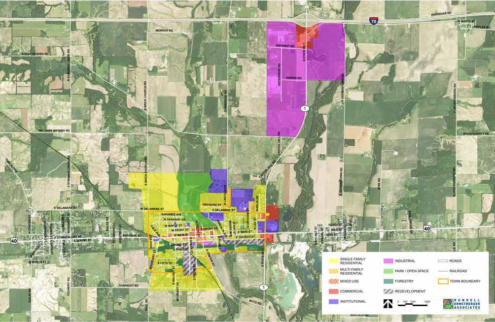
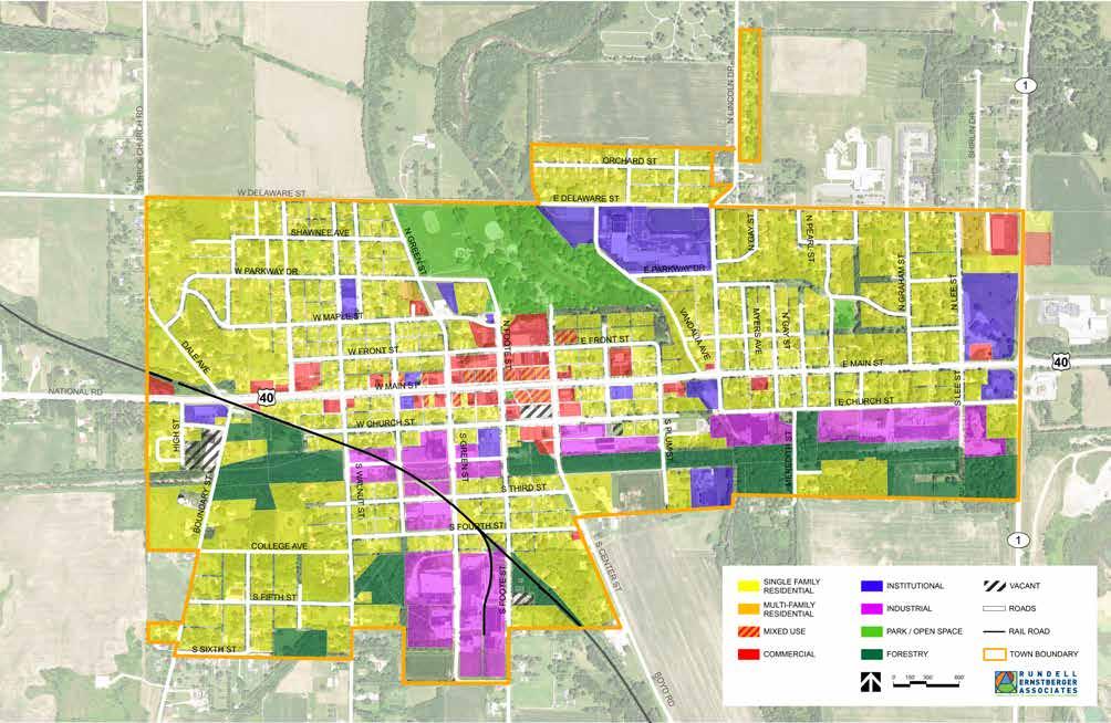
The Town is divided into seven zoning districts: Suburban (S), Residential (A), Residential (B), Local Business (LB), General Business (GB), Industrial (I), and Flood Plain (FP). For the most part, the existing land use map and zoning map align. There is no digital copy of the zoning map; it can only be found physically printed and framed in the City Building. The existing land use map created for this plan, and found on the following pages, includes more defined categories. Single family residential, multi-family residential, mixed use, commercial, institutional, industrial, park and open space, forestry, and vacant land make up this list of categories. The remainder of this chapter expands on the discussion of land use in Cambridge City and explores the goals for future development of the community.
Existing Conditions Land Use
In order to plan for future growth and development, it is important to have an understanding of existing land use supply. The existing land use pattern shows not only where concentrations of certain uses are but also what land may be available for development, and what type of development pressure that may be. Cambridge City’s downtown is located to the west of Creitz Creek and straddles US 40. This central location is where much of the commercial businesses and offices are located. Additional commercial development is located on the east side of Town along SR 1, especially near the SR 1/I-70 interchange, although this area is actually outside Town limits.
The map on the next page shows the existing land use pattern of the community. Residential uses are located to the north and south of downtown, and to the east near Lincoln Middle and High School and Golay Community Center. Industrial sites are primarily along Church Street and in the southern portion of Town. Creitz Park is the largest park within the community, but a small pocket
park at Main Street and Foote Street and a centrally located neighborhood park south of Western Wayne Elementary School also contribute to the park and open space network. Institutional uses are scattered across the community but can be easily accessed from US 40.
The zoning map identifies the general area of Creitz Park as floodplain, which is accurate (see Chapter 15 Hazard Mitigation for the floodplain map) and a proper use of that land. Areas surrounding Main Street west of the river to Mulberry Street, south bordering Center Street, and at the intersection of Foote Street and 3rd Street are all zoned for general business. The industrial district makes up nearly the rest of the southernmost portion of Cambridge City, and lines the length of 2nd Street to SR 1. The rest of the community is zoned for some type of residential use including suburban development and what is likely single and multi-family residential dwellings. There is no zoning dedicated to park and open space or institutional uses but are generally considered to be allowed within proper
contexts like residential zones. Not shown on either the zoning map or the existing land use map, as they focus on the incorporated boundary of Cambridge City, is the Gateway Industrial Park near the Interstate 70 and SR 1 interchange. The industrial park is in unincorporated Wayne County but served by Cambridge City water the Western Wayne Sewer District.
The benefit of zoning is that it already sets a vision for the future of development, but now that Cambridge City is primarily developed with little room to grow, the zoning map might need to be revisited and adjusted according to what is best for the community in the coming years.
EXISTING LAND USE
Land Use
Vision + Recommendations
Future land use planning is an important part of the comprehensive plan process because it translates the vision, goals, and objectives into a tangible, physical form. The future land use map was created through examination of existing land use patterns, zoning, and stakeholder input. In many instances, the existing land use is the desired future use and expected to continue indefinitely. However, there are some areas where changes in land use are anticipated as farm properties are developed for the first time or vacant and under-utilized properties are redeveloped. These redevelopment areas have been identified on the future land use map on the next page.
The future land use plan should not be confused with zoning. While land use and zoning are related, they serve separate functions. Land use describes the activity that occurs on the land, residential for example. Zoning then regulates the character, building size, density, and other development standards of that land use activity. There are often multiple different residential zones, ranging from single-family houses on larger lots to duplexes and multifamily apartments.
The future land use map is intended to be general in nature and not based on specific property lines. This allows some development flexibility and interpretation on a project by project basis while still establishing the foundation by which to make judgments on the appropriateness of future development petitions. Additionally, an area larger than the current Town limits has been included on the future land use map. This is because these adjacent lands are already or would likely be served by Town utilities and services if developed. The future land use classifications for these areas should be used to inform zoning decisions should these properties be annexed into the Town.
The land use classifications included on the future land use plan are:
• Single Family Residential
• Multi-family Residential
• Mixed Use
• Commercial
• Industrial
• Institutional
• Redevelopment
• Parks & Open Space
• Forestry
FUTURE LAND USE
Land Use
Vision Statement
Maintain a balance of land uses throughout the community while preserving existing character, using land efficiently, and protecting environmentally sensitive areas.
Key Goals & Strategies
1. Encourage the annexation of adjacent areas already receiving Town services and those that support the growth and development goals of the community.
a. Create an annexation policy to promote economic and residential growth for Cambridge City.
b. Promote the annexation of land that is currently being provided with Cambridge City municipal services but not within the current Town boundaries.
c. Promote the annexation of desired growth areas adjacent to Cambridge City that may reasonably be served with extensions of municipal infrastructure and services.
2. Promote infill and redevelopment of vacant and underutilized parcels.
a. Create an inventory of potential infill and redevelopment sites.
b. Consider offering incentives for infill and redevelopment projects on sites already served by municipal services and utilities.
c. Use infill development to better activate streets and neighborhoods and improve overall community aesthetics.
d. Ensure new development and redevelopment is compatible with the established or desired character of the surrounding area.
3. Ensure land use and development regulations reflect the community’s desired development goals and support contemporary land use best practices including compact, walkable development.
a. Promote mixed use development in and around the downtown area.
b. Encourage new residential development to attract families and employees of area businesses.
c. Continue coordination with Wayne County and the Economic Development Corporation of Wayne County regarding attraction and development of employment generating uses.
d. Review and amend the zoning ordinance and subdivision control ordinance to reflect the goals and strategies recommended in this plan.
Key Goals & Strategies
4. Protect flood areas and other sensitive lands from development.
a. Limit construction within flood hazard areas and designated wetlands.
b. Promote the value of protecting and preserving flood hazard areas and maintaining healthy stream corridors.
c. Encourage the implementation of green infrastructure and stormwater management best practices to reduce the effects of flooding.
d. Increase flood mitigation and stormwater detention infrastructure on Town-owned properties that have the potential to reduce the impact to the floodplain.
5. Support continued development of the Gateway Industrial Park.
a. Continue collaboration between the Town, County, and other service providers on utility capacity expansions to facilitate additional development within the park.
b. Market Cambridge City and the Town’s quality of life amenities in conjunction with economic development efforts at the industrial park.
6. Ensure Town codes and ordinances are respected and enforced.
a. Increase code enforcement to ensure proper maintenance of buildings and sites.
b. Consider a Town Action Center program to share information and receive code complaints, that could include a dedicated phone number, email address, or form on the Town website.
Measurable Outcomes:
a. Increase in municipal area from annexation of properties already receiving Town services.
b. Increased assessed values of commercial and industrial properties as redevelopment occurs.
c. Reduction in the number of structures within flood hazard areas.
d. Increase in the number of businesses operating in the Gateway Industrial Park.
Land Use
Implementation
Land use plays an important role in the form and character of a community. For Cambridge City, land use has mainly been kept in an organized context that makes sense. To continue this thoughtful development pattern while encouraging growth, several projects are recommended.
Physical growth of the Cambridge City municipal boundaries can be altered through annexation, which simply means adding to something larger. In order to expand the tax base, Cambridge City needs to either increase the value of properties already in Town, add new properties and development to the Town area, or both. Many communities annex land in order to control the establishment of incompatible development and protect existing and future land uses. Additionally, the Town should prioritize annexation of property already receiving Town utilities or public services. A formal annexation strategy would provide the guidance and rationale by which to consider potential annexation and to more closely match the timing of development to the provision of municipal services. The strategy should include specific criteria for both voluntary and involuntary annexations.
Updating the zoning ordinance, subdivision regulations, and modernizing the information for ease of access and general future use is another project directly related to land use and development. This plan and the future land use map are only guides and should not be confused with the official zoning map and ordinance. In order to fully implement the recommendations of the comprehensive plan, the zoning and subdivision ordinances should be reviewed and amended as necessary to support the goals of the plan. While these projects could be led by the Town Council or Plan Commission, the help of an outside consultant who specialized in land use, zoning, and development controls is suggested.
Finally, land use is meant to be ever changing to accommodate the dynamic needs of the community. This can be addressed through repurposing vacant or underutilized space in the community. The south side of Cambridge City has several industrial sites that are either vacant or underutilized and could be repurposed for other uses, such as various housing opportunities or other light industrial businesses that fit more within a neighborhood context. Industrial uses can still be
used in these areas (classified as redevelopment on the future land use map), but screening, buffering, and beautification through landscape treatments should be a part of future industrial development. These tactics help to lessen the visual impact of an industrial site when adjacent to residential uses. These properties could also be redeveloped into mixed use or office developments, but significant demand for prime office space is unlikely in the short-term. Existing buildings might not need to be completely demolished and could be redeveloped into apartments of various sizes assuming costs of renovation and necessary upgrades do not exceed the costs of demolition and new construction. The benefit of this strategy is that density can be created without drifting too far away from the existing scale and character of the surrounding area.
Project 1
Create and adopt an annexation policy for Cambridge City.
1. Identify potential parcels for annexation.
2. Conduct outreach to property owners regarding annexation.
3. Develop evaluation criteria for annexation. Criteria may include, but not be limited to whether the property is already served by municipal services, infrastructure and utility capacity, fiscal impact, environmental concerns, existing or adjacent development, and planned future use.
4. Create policies for providing municipal services to new development, with an understanding that where possible, new development receiving municipal services should be annexed into the Town.
5. Draft the annexation policy.
6. Hold a public hearing and adopt the policy as a Town Council resolution to guide future annexation discussions.
Project 2
Update zoning and development regulations and modernize these documents for ease of access and future use.
1. Create a steering committee to review and lead a comprehensive process to update the zoning ordinance.
2. Consult with a zoning and land use professional to facilitate an update to the zoning and subdivision control ordinances.
3. Draft amendments.
4. Conduct an outreach and education campaign in advance of a public hearing by the Plan Commission and adoption by the Town Council.
5. Make documents easy to access and navigate by publishing them online in the form of an interactive PDF.
6. Digitize the zoning map.
Public Input
Input regarding future land use and development began at the first CPC meeting (Appendix, page 184) and continued through much of the planning process. Ideas included continued commercial and industrial development near the interchange, diversifying housing development, redeveloping vacant and underutilized manufacturing sites, and annexation of adjacent areas served by Town utilities. Land use conversations continued at CPC meetings 2 and 3 (Appendix, pages 186 and 188 respectively). Additionally, questions about desired uses and development character were asked during the focus group meetings. Common themes coming out of these meetings included a need to capitalize and continue investment in the downtown, stabilize neighborhoods with concentrations of lowquality housing, and developing new housing products affordable to the local workforce. In general, a positive attitude towards growth was expressed by many participants, but there was an acknowledgement that some in the community may be resistant to it (Appendix, page 190).
A mapping exercise was conducted at the community open house that asked participants to identify future development and redevelopment areas. New housing to the north of the existing Town limits and rehabilitation of neighborhoods on the Town’s west side were the most common responses.
5 Government & Fiscal Capacity
Government and fiscal capacity refers to the ability of the municipality to generate revenue. Cambridge City’s fiscal capacity is dependent on a number of factors including the assessed value of property, personal incomes of residents, and the cost of services provided by the Town. The Town has done a great job of providing excellent services and growing fiscal capacity despite the slight decline in population and reduction in number of housing units from 2010 to 2017. The chart on the following page tracks year end cash and investments for the Town over the last five years. It should be noted there was a discrepancy between year-end totals for 2016 and year-beginning balance for 2017 that accounts for the significant decline in the chart. Since 2017, Cambridge City’s combined year end cash and investment balance has grown by over $700,000.
Government & Fiscal Capacity
Existing Conditions
The Town’s fiscal capacity is used to provide police protection, operate and maintain infrastructure, and perform other developmental functions. The following table details per capita expenditures by the Town. The average for all Indiana cities and towns is included for reference. These expenditures are the actual disbursements made by the local government and may be different from the tax revenue received and the authorized budget appropriations. The per capita expenditure is the sum of all its expenditures for a given year net of transfers, interfund loans, agency fund disbursements, and purchases of investments, as identifiable in the Annual Financial Report, divided by the local government’s population (Indiana Department of Local Government Finance).
Many factors may impact expenditure levels for cities and towns. Not all municipalities provide all services or services at comparable levels. For example, Cambridge City has an all-volunteer fire department while a larger municipality would have paid positions and more significant equipment. Additionally, some municipalities provide enterprise services, such as electrical, water, sewer, and solid waste removal, while others do not. Cities and towns that provide these services may have greater per capita expenditures than local governments that do not. To allow for comparison, per capita expenditures are broken down into total non-enterprise net expenditures and total net expenditures, which is the sum of non-enterprise and enterprise expenditures. The average per capita total expenditure for Cambridge City was $1,799.40, below the average for all Indiana cities and towns, $1,998.39. After removing enterprise expenditures, the Cambridge City per capita expenditure of $1,454.04 is higher than the average of $1,057.07 for all Indiana cities and towns. This may be the result of economies of scale for larger municipalities that reduces the per capita cost of services.
In addition to tax revenue and user fees from Townprovided services, Cambridge City has been successful in acquiring grant funding to help pay for infrastructure planning and improvements. Recent awards include:
• 2019 INDOT Community Crossings Matching Grant - $180,000
• 2019 USDA Rural Development Water and Waste Disposal Predevelopment Planning Grants$30,000
• 2018 INDOT Community Crossings Matching Grant - $202,500
• 2016 INDOT Community Crossings Matching Grant - $31,342
It will be important for Cambridge City to continue leveraging local funds in pursuit of grant opportunities.
Government & Fiscal Capacity
Vision + Recommendations
Cambridge City’s revenue is largely based on property taxes, which are in turn based on tax assessments on the value of land and improvements. Subsequently, growing municipal revenue is dependent on growing the Town’s tax base. This can be accomplished by attracting new development or redevelopment on land that is vacant, underutilized, or used for agriculture. It can also happen through increases in property value as buildings and sites are improved and better maintained. This is especially important for Cambridge City neighborhoods. As blocks and neighborhoods with numerous homes in poor condition see rehabilitation and reinvestment activities, values for the whole neighborhood should increase.
Additionally, it is important that the Town maintain a balance of land uses. Property taxes for single family residential development are capped at 1% of the assessed value and as such, residential development typically consumes more services than it pays for with tax revenue. Commercial and industrial development is taxed at 3% of assessed value and is tax positive, in that the taxes these uses pay more than covers the services they receive. It is important for the community and Town leaders to understand the fiscal impacts of new development in order to make informed decisions regarding growth, annexation, new development, and infrastructure improvements.
As the Town is able to grow revenue and expand services, it should also look to improve communication and interaction with residents and businesses. This includes identifying messaging goals and target audiences for Town communications. At a minimum, the target audience should be all Cambridge City residents, regardless of age, income, or ethnicity. Additional targets may be potential visitors, developers, or economic development professionals. With these communications, the Town should focus on sharing good news, while also creating specific channels by which to receive complaints or issues identified by residents. While Facebook is an effective way to share news at essentially no cost, it may not reach or be accessible to all residents. A formal communications plan may still include Facebook as one component, as well as a general Town email address that could then be forwarded to the appropriate person/department, a dedicated voicemail inbox, improved website and comment form, or some combination thereof.
Vision Statement
Expand government capacity and ensure the Town’s fiscal health in order to provide superior services and amenities to residents, businesses, and visitors.
Key Goals & Strategies
1. Grow the assessed value of properties within Cambridge City to generate additional tax revenue.
a. Promote redevelopment of vacant and underutilized commercial and industrial properties.
b. Promote rehabilitation and infill of residential properties to raise the value of those properties themselves, and surrounding properties in the neighborhood.
2. Ensure a balance of land uses to provide a stable and consistent tax base, understanding that single family residential development often requires higher service outlays that may not be fully paid for by those properties. Commercial and industrial development often requires fewer service outlays and pays a higher portion of property taxes.
a. Encourage development in accordance with the future land use plan and other recommendations in the Land Use, Economic Development, and Housing chapters.
b. Ensure the zoning map and ordinance support development in accordance with the future land use map.
c. Consider the fiscal impacts of proposed development as part of the development review process to ensure that new construction can help to pay for the public services it will use.
3. Improve Town interaction and ease of communication with residents and businesses.
a. Develop a formal communication platform and procedure by which residents can share concerns with the Town, and the Town can share important news and other information.
b. Consider adding Town staff, such as a communications director, town planner, or economic development director as resources may become available.
c. Continue to utilize the Town website and social media accounts to share information and interact with residents and business owners.
Measurable Outcomes:
a. Decrease in the number of vacant properties.
b. Increase in collective assessed value of properties within Town.
c. Growth in tax revenue without raising tax rates.
Government & Fiscal Capacity
Implementation
Running a town is not easy. Despite a decline in Cambridge City’s population, limited growth to property values, and the resulting implications on municipal tax revenue, the Town still must provide quality services and amenities across the community. Staff and officials are increasingly spread thin in addressing all the needs and concerns of the community. Local leaders must balance residents’ many diverse interests with the Town’s limited resources. Unfortunately, that can mean not everyone’s needs can or will be met in a timely manner. Town leaders must consider which services are most essential, which budgets to cut or boost, and whether to raise fees on town-provided services and utilities.
Beyond the larger ability to grow revenue as a result of increases in assessed value, the government and fiscal capacity projects involve better planning for expenditures, making it easier for residents and businesses to pay bills with the Town, and exploring the feasibility of a new Town Hall building. The existing City Building has tremendous character and a central location, but maintenance expenses are increasing. This plan is not advocating for a new Town Hall building. However, a better assessment of the needs of the current facility should be performed in conjunction with a cost analysis of a new facility so that Town leaders can make informed decisions and proactively plan for the future.
Project 1
Develop an online bill payment system for Town utilities as a convenience to residents and business owners.
1. Research vendors that offer online bill payment services.
2. Determine the cost to the Town to offer such a service and evaluate long-term financial feasibility.
3. Select online bill payment service.
4. Integrate or link from Town website.
5. Conduct an outreach and education campaign regarding the new service for residents and businesses.
Project 2
Conduct a needs assessment of the existing City Building and a feasibility study to explore the construction of a new Town Hall and Police Station.
1. Consult with a design professional for completion of the feasibility study.
2. Analyze existing uses and services conducted at Town Hall.
3. Determine future space needs and desired uses/ services to be offered at Town Hall.
4. Perform a cost analysis of on-going maintenance of the existing Town Hall versus construction and maintenance of a new facility.
5. If feasible, identify and procure funding including grants and available tax dollars for a new facility.
Public Input
Much of the community input related to government and fiscal capacity came from the subject matter discussions as part of CPC meeting 2 (Appendix, page 186). Comments included a general agreement that communication with and attitudes regarding Town staff were improving. From a service standpoint, CPC members voiced an interest in modernizing Town facilities and services, specifically an ability to pay water bills online.
Some comments from the focus group meetings also related to government and fiscal capacity (Appendix, page 190). There was a general understanding that the Town struggles with limited resources and that to grow services, the Town needs new investment and increased tax revenues.
Maintenance costs are increasing for the City Building. A buildings needs assessment should be performed in conjunction with studying the cost and feasibility of a new Town Hall so that fiscally responsible decisions can be made for the future.
6 Public Facilities & Services
Cambridge City has a number of departments and organizations that provide public services and maintain facilities for the community. These public facilities and services are critical to protecting the quality of life for residents, business owners, and visitors. This chapter presents an overview of existing facilities and services provided in the Town as well as recommendations on how to better serve existing residents and accommodate desired growth and redevelopment. While most of these facilities and services are provided by the Town, some fall to other governmental agencies and organizations. Town functions are overseen by the five member Town Council in conjunction with Town staff, including the Town Clerk, Office Clerk, Superintendent of Public Works, and other department staff.
Public Facilities & Services
Existing Conditions
Water Works
Cambridge City operates two drinking water systems. One system primarily serves the incorporated town limits as well as some nearby properties just outside town limits. The second system serves the Gateway Industrial Park and commercial development near the Interstate 70 and State Road 1 interchange. The town system accommodates daily demand of approximately 200,000 gallons through three wells and the treatment facility on the south side of Main Street at Lincoln Drive, and a 500,000 gallon elevated water tank on the west side of Town. There is plenty of excess capacity to serve new development and redevelopment in and around the existing Town boundary.
The primary issues with the Town system are several 2-inch, galvanized steel water lines that need to be replaced. These lines are outdated and undersized and must be replaced before any new homes or businesses can tie into them. These lines are primarily in the northwest corner of Town, along S. Fourth Street (east of Green Street), and along Front Street on either side of the river. There are also several very old hydrants that need to be replaced. Going forward, the Town wishes to create loops in the water system where possible and install additional hydrants.
The industrial park system currently utilizes two wells, the treatment facility, and a 400,000 gallon elevated water tank. However, current demand averages 500,000 gallons per day. An additional elevated water tank and supply well is needed to service any new development in the area. It is anticipated that an 800,000 gallon tank is needed. The Town was recently awarded a grant from the USDA to start planning for water system upgrades. There are no immediate plans to connect the two systems given the distance between them.
Sanitary Sewer
Sanitary sewer service in Cambridge City is provided by the Western Wayne Regional Sewer District. The wastewater treatment facility on the south side of Town is currently exceeding desired capacity. Multiple alternatives have recently been considered for how to expand sewer capacity. The Town, County, and sewer district are in the process of finalizing an agreement to construct a new treatment plant on the existing site. This expansion is needed to serve any new development or redevelopment both in Town or at the industrial park.
Stormwater
The Town has an incomplete stormwater system in that stormwater infrastructure is not present in some of the older areas of the community. Additionally, no map of existing stormwater facilities exists. The Town recently implemented a stormwater utility rate charge that is applied to property tax bills. The first payment is expected with Spring 2020 taxes; this fee is anticipated to generate $40,000 to $50,000 annually. A stormwater utility board should be created to manage these funds.
Police
The Cambridge City Police Department serves both Cambridge City and Dublin. The Police Department operates out of the City Building at 127 N. Foote Street. The department was founded in 1836 and currently includes the chief, one sergeant, one school resource officer, and three patrolmen.
Fire
The Cambridge City Fire Department is an all volunteer department providing fire & rescue services to Cambridge City and Western Wayne County. It was established in 1876; the station is at 127 W. Maple Street.
Library
The Cambridge City Public Library is located at 600 W. Main Street. The 11,000 square foot facility houses not only the library but also the Overbeck Museum. The Overbeck Museum is dedicated to preserving the creative art of the Overbeck sisters who lived and worked in Cambridge City and produced pottery between 1911 and 1955. The library is staffed by a director, children’s librarian, and three assistants. It is open six days a week.
Public Facilities & Services
Vision + Recommendations
The goal of the public facilities and services recommendations is to identify improvements needed to support desired growth and development. In general, a community’s utility systems, in conjunction with the transportation network, play a central role in supporting and maintaining economic success and quality of life. These systems are costly to create, extend, and maintain. As such, additional utility planning will need to occur in coordination with development proposals.
Plan to Serve Targeted Development Areas
Utility infrastructure is a vital component of any new development. By strategically locating infrastructure investments and service extensions, the Town can direct development to desired locations. Developers will be more likely to pursue opportunities at sites already served by municipal utilities and a robust transportation network, as opposed to paying for extensions to other sites.
Utility upgrades and extensions are costly, and as such, the Town must plan them carefully. A 5-year capital improvement program is useful in prioritizing projects and identifying funding for both utility and transportation improvements. Proposals or requests to extend municipal utility service to areas outside of the Town should:
• Be consistent with service extension plans.
• Of a demand within current capacity.
• Meet Town design and construction standards.
• Be contingent upon annexation into Town limits.
• Enhance the contiguous development area of the Cambridge City and not represent leapfrog development.
Coordinate Utility Improvements with Road Work
Cambridge City is the primary public facility and service provider for water, stormwater, and transportation infrastructure within the municipal boundaries. Other providers include the Western Wayne Regional Sewer District, Indiana Department of Transportation, Duke Energy, Vectren Energy, Comcast, Frontier, and others. When the Town or another provider is undertaking a capital improvements project, such as a road reconstruction or sewer line replacement that requires disturbance to the right-of-way, other potential improvements should be considered to create time efficiencies and cost savings. By working to allow for coordinated construction of multiple projects at the same time, public exposure to the working zones and traffic congestion will be reduced, the overall cost of the projects will be reduced, and increased collaboration will allow for future planning to remain cohesive.
Vision Statement
Maintain utility infrastructure and public services to better serve existing residents and businesses and expand capacity to accommodate desired growth and development.
Key Goals & Strategies
1. Ensure new development and redevelopment will be adequately served by necessary municipal utilities and services.
a. Use investments in public facilities and services as a tool to direct desired development to appropriate locations.
b. Increase water service capacity to accommodate new development in the industrial park.
c. Increase wastewater treatment capacity to accommodate development and redevelopment throughout the Town and industrial park.
2. Maintain and replace existing infrastructure to ensure safety.
a. Upgrade outdated and undersized water lines and add hydrants where possible.
b. Continue to expand and improve the storm sewer system to reduce localized flooding.
3. Coordinate utility, transportation, stormwater and other infrastructure improvements to combine construction projects and reduce costs where possible.
a. Maintain relationships with area utility and service providers to be aware of their potential projects.
b. Communicate planned Town improvement projects with other providers.
Measurable Outcomes:
a. Increase water service capacity.
b. Increase wastewater treatment capacity.
c. Increase in storm sewer service area and linear feet of conveyance pipe.
d. Reduction in the number and length of 2-inch water lines in Town.
e. Replacement of outdated fire hydrants.
Public Facilities & Services
Implementation
Planning and budgeting for maintenance and expansion of public facilities and services is incredibly important given the costs associated with these tasks. A capital improvements plan (CIP) is a planning document that covers a timeframe of three to five years and is updated annually. It aids in plan implementation by providing the necessary funding for short-range infrastructure and capital improvement projects. The document states the Town Council’s prioritization of the financial resources available for capital project spending by identifying which projects should be included, when they should be constructed, and how they will be financed. The CIP represents the Town’s tentative commitment to comply with the plan unless circumstances or priorities change in the future. Nevertheless, it should not be considered an automatic authorization of the construction of projects, the allocation of resources and a public procurement process will still be needed.
The CIP can then be used to prioritize drinking water, sewer, and stormwater projects. A new wastewater treatment facility is needed before any significant development or redevelopment can occur both within Town or at the industrial park. Plans to replace construct a new treatment facility on excess land at the current treatment site were on-going during the planning process. After finalizing a plan to expand wastewater treatment capacity, the Town will need to grow drinking water capacity at the industrial park system. Outside of these major projects, the Town should use forthcoming stormwater utility fees to map the existing system and develop a list of potential system improvements that may be paid for by future fees.
Project 1
Create and maintain a capital improvements plan to prioritize and budget for future infrastructure upgrades and extensions.
1. Develop a list of needed capital projects, equipment purchases, and major studies needed for the Town.
2. Determine cost estimates and timetables for each project, purchase, and study.
3. Prioritize needed improvements.
4. Identify funding options and develop a financing plan.
5. Prepare the initial capital improvements plan for a three to five-year timeframe.
6. Adopt the capital improvements plan by Town Council resolution.
7. Update the plan on an annual basis, to remove completed projects and add new ones.
Projects 2 + 3
Construct a new elevated water tank to serve additional development in the industrial park.
1. Determine project scope and needed tank size.
2. Coordinate with Wayne County on potential funding sources and plans for improvement.
3. Identify and procure funding including grants and available tax dollars.
4. Consult with a design professional for completion of design and construction documentation.
5. Bid and construct the project.
Construct needed wastewater treatment upgrades to serve both the Town and industrial park.
1. Finalize usage agreements needed to make the new sewer treatment plant feasible.
2. Finalize agreement with Wayne County on potential funding sources.
3. Identify and procure additional funding including grants and loans.
4. Consult with a design professional for completion of design and construction documentation.
5. Bid and construct the project.
Project 4
Create a map of the existing stormwater conveyance system.
1. Collect past construction documents and other historical plans related to the Town’s stormwater conveyance system.
2. Consult with a design professional to review past documentation, conduct field analysis, and create a digital file of the existing stormwater system.
Public Input
Public facilities and services were discussed at CPC meeting 2 (Appendix, page 186). Issues with current water and sewer capacity were identified as a primary need, especially in the context of desired growth, in and near Town as well as at the industrial park. Other concerns mentioned were a lack of enforcement of Town ordinances and the deteriorating condition of the City Building. Exploration of renovation options versus construction of a new building were mentioned. Recent improvements to the fire station were identified as a positive.
The consultant team had two separate meetings with the Town’s Superintendent of Public Works to gain a better understanding of the Town’s existing infrastructure systems. Much of this information is included in the preceding Existing Conditions section (pages 64 and 65).
Public facility and service deficiencies were not widely mentioned during the focus group meetings except for code enforcement. Multiple attendees emphasized a need for more proactive enforcement of Town codes and ordinances.
7 Placemaking
Placemaking is an approach that focuses on design and management of public spaces. Projects can range from creation of a park space to the installation of lights along a street. Placemaking works to capitalize on a community’s existing assets and potential for reinvestment by promoting people’s health and wellbeing. This can be government led or community driven, but the goal is to create a place where people want to be by enhancing underutilized spaces in a community.
Cambridge City has placed emphasis and focus on placemaking in the community. Multiple murals are painted on the side of buildings to represent different historical events, figures, and facts regarding the community and additional quality of life amenities have been added over time. The Golay Center provides rentable gathering rooms and multiple recreational opportunities including a swimming pool, sports courts, and fitness center. Creitz Park also provides a number of sports courts opportunities, as well as playgrounds and other amenities.
Placemaking
Existing Conditions
Community Wellness:
Community wellness places emphasis on the quality of life residents feel in Cambridge City. The amenities that Cambridge City currently offers are limited, but the town’s location allows the residents easy access to more options within an hour drive.
Creitz Park, the Golay Community Center, and downtown are all assets that the residents can utilize. Public comments have indicated that the revitalization of some of the buildings and new businesses have brought the community closer together. The community center is also very useful as it offers multiple learning opportunities and can be used for community events. The park, while deemed underused by the public, is still a large space with opportunity for investment and enhancement.
Downtown is an important feature for the community. It is the heart and soul of the Town and where most people spend their time. The restaurants and antique stores in the downtown provide numerous eating and shopping opportunities.
Community programming continues to develop within Cambridge City. There are three annual events, of which Canal Days is probably the most well-known.
It is a three-day event that takes place downtown on the weekend after Labor Day. A parade and multiple vendor spaces as well as the regular businesses along Main Street are driving factors that bring people to the area from one year to the next. This event allows people to walk through the stores, eat locally, and experience all that Cambridge City has to offer as a community.
The Winter Wonderland light display in the park is another event that happens in December. From the start of the month until Christmas, people can visit Creitz Park to see a display of lights, enjoy hot chocolate and candy, and visit Santa Claus.
The Cambridge City Antique Fair brings in people from across the region. This event is great for the community because of the multitude of antique shops within the downtown. Local community contests also encourage friendly competition with different businesses from across the county as well.
The schools are a very important feature for community wellness as well. Schools have been instrumental in bringing students and families to Cambridge City and other neighboring communities. Because of this, families within the community are close knit.
Culture:
Cambridge City has a lot of cultural significance dating back to the 1800s. Over 60% of the community is a part of the National Registry of Historic Places. There are two buildings within this boundary that are historically significant for the community, and one located directly west of the Cambridge City boundary. These structures are the Overbeck House, Conklin-Montgomery House, and Huddleston House located in Mount Auburn.
The former library location in the downtown, now known as the Archives, is used as an event space and storage for historic documents of the Town. The new library, located on the western edge of the Town along US 40, also has a display of Overbeck Pottery for people to visit.
The Whitewater Canal is a culturally significant asset within the community. Originally created as a transportation corridor between Cincinnati and Hagerstown, located just north of Cambridge City, the canal provided needed transport of people and goods prior to the development of the railroad. While the majority of the canal has been filled in, its remnants remain an attraction to history enthusiasts.
For more information, see Chapter 14, Historic and Archaeological Resources.
Education:
Cambridge City has multiple schools: Lincoln Middle and High Schools located within the boundaries of the town, Western Wayne Elementary which is located nearby the middle and high schools but directly outside of the town boundary, and Central Elementary School which closed in 1995 and deferred students to Western Wayne Elementary. All the schools service Cambridge City and surrounding communities such as Milton, Pershing, Mount Auburn, and Dublin. The three schools that are open service the majority of the surrounding communities. Central Elementary School was recently purchased by SugarCreek and will be converted into a daycare for children of employees. With additional school closures in adjacent communities, Western Wayne Elementary and Lincoln Middle and High Schools have become the deferral schools for most students. Additional areas where parents might send their children to school are located in Centerville and Richmond to the east, Hagerstown to the north, and Knightstown to the west, which can be easily accessed along US 40.
The high school ranks as an average school for the state with a C+ rating, the middle school has a C rating, and the elementary school also has a C rating. The schools are average in comparison to other public schools across the state of Indiana.
There are no post-secondary education institutions within Cambridge City, however the location of the community is central to multiple colleges and universities. Earlham College in Richmond is a private liberal arts college that is a part of the Great Lakes Colleges Association with 13 locations. Ball State University in Muncie is a public university and has seven academic colleges that offer over 180 majors and more than 130 minors. IU East is located in Richmond and shares a campus with IVY Tech Richmond. Multiple Ivy Tech Community College campuses and other higher education institutions are located in close proximity of the community.
Central Elementary School which closed in 1995
Lincoln Middle and High School
Placemaking
Vision + Recommendations
Placemaking is a subjective concept that combines both tangible and intangible elements of a community, including its social, cultural, economic, and physical attributes. The relationship between these elements creates a unique community fabric that influences the experiences of residents and visitors. Positive attributes are often associated with housing character, job availability, quality schools, access to recreation and entertainment, and a healthy environment. Just as important to overall placemaking efforts is the interaction of residents with each other and building community among its members. Strong community characteristics improve community vitality while contributing to a place’s reputation and image. These characteristics are what make people want to live in Cambridge City and make businesses want to locate here.
The Town can support placemaking efforts by ensuring opportunities for small business and job creation. This can be done in a multitude of ways including incentives and local entrepreneurship. However, dedicating space that can be used for offices, shops, and restaurants might be difficult depending on the current condition of existing buildings and the need for upgrades. One way of doing this is to begin allocating public funds towards the
restoration and upgrades of different buildings. Publicprivate partnerships can lead to a tremendous change in the community when an investor has a lowered cost associated with the purchase and renovation of a building. Additional ways of increasing potential investment would be to cover the cost of infrastructure and even amenity upgrades directly in front of the building (streetscape improvements). Ways of measuring success for this project would be fairly noticeable as investors, business owners, and property owners would have to come in and purchase the building(s). Once a business or office was open, this project would be considered a success.
Diverse, affordable, and well-maintained housing options are central to quality of life. Housing programs will be considered successful when there is a noticeable difference in the upkeep of certain blocks. Maintenance can be difficult thing to keep up with, especially for homeowners with busy schedules, those who cannot afford it, or those who simply do not have the physical ability anymore. Special funding could be set aside by the Town to help those who need it and volunteers could easily play a role during fall and winter to help with the removal of leaves and snow. Additional work might
need to be done in order to reach the standard that the community would like to see of all homes, such as new roofing or a coat of paint. Additional housing programs and incentives are discussed in Chapter 9.
A trails system can be particularly important for a community of this size for many reasons, the first being that the primary mode of transportation does not have to be a personal vehicle if someone is staying within the community for entertainment and leisure purposes. Trails increase quality of life by improving the overall mental and physical health of residents and visitors. Multiple modes of transportation should be available to residents and visitors and creating a safe trail system to connect neighborhoods and key anchors in the community is especially important for those who do not have a vehicle. This can be a long process and potentially expensive to implement, but projects like these are often completed in phases as funding becomes available and often will receive additional funding through grants due to the popularity of trails and benefits they have on quality of life. Success can be measured through the creation and implementation of a network of trails within Cambridge City.
Creitz Park is a jewel in the community that has become an underutilized asset. Throughout this process, Creitz Park was a main focus as people identified wanting updated equipment and overall beautification to make the park a more enjoyable destination. Additional recommendations include a park expansion to be located behind the fire station. This would likely become a new hang out space adjacent to the remainder of the park with a splash pad, space for concessions and food trucks, outdoor seating to be used throughout the day and night, additional lighting fixtures, and space for outdoor public games. This expansion would double as an activity space for community events such as Friday night movie screenings during the summer, a dedicated space to hold the Farmer’s Market, and rentable space for parties and special events.
For more information on these projects, please see Chapters 8 (Economic Development), 9 (Housing), 10 (Transportation), and 13 (Parks and Recreation).
Creitz Park located just north and northeast of the Volunteer Fire Department station has opportunity to be reimagined through improvements to the playground equipment and sports fields.
Placemaking
Vision Statement
Improve the quality of life of residents and attract additional businesses and visitors by enhancing existing amenities and creating new opportunities for community gathering, recreation, and general well-being.
Key Goals & Strategies
1. Encourage the expansion and protection of open spaces within the town.
a. Promote the preservation of open spaces and protect environmentally sensitive areas.
b. Enhance Creitz Park by providing additional amenities such as trails, enhanced sports fields, and additional game spaces for people to use and enjoy.
c. Enhance underutilized spaces near schools or community assets by providing benches, sidewalks, lighting, and other infrastructure improvements.
2. Collaborate with Western Wayne Schools to attract and grow the student population and unique course offerings.
a. Foster partnerships between schools, employers, and other local organizations to develop programs that help students remain in Cambridge City and/or return after college.
b. Work with the Economic Development Corporation of Wayne County and area employers to develop programs and skills training that benefits students and helps local businesses with job placement.
3. Continue to promote public art projects on both private and Town-owned properties.
a. Identify locations within park and other Townowned properties that could be used for public art installations.
b. Encourage property owners to paint murals and/or install freestanding public art on their properties.
c. Consider incentives or grants for new development or redevelopment that includes public art as a component of the project.
4. Celebrate the cultural, historic, and artistic resources of the Cambridge City community.
a. Increase resident awareness of the community’s heritage through public space programming and activities.
b. Use Cambridge City’s history and culture to attract and grow tourism-related businesses and attractions.
c. Ensure development opportunities and adequate infrastructure exist to grow the tourism economy.
Measurable Outcomes:
a. Reduce the average age of equipment in Creitz Park.
b. Increase per capita park space.
c. Increase school enrollment for Western Wayne Schools.
d. Improvement in school letter grades for state accountability system.
e. Increase in the number of public art projects in Town.
f. Increase in the number of programmed events and festivals in the community.
Implementation
In addition to the big picture initiatives previously discussed, short-term placemaking projects the Town can focus on include expanding public art installations and incorporating Town branding into gateways and wayfinding signs.
Successful public gathering spaces typically contain art, and more cities and towns are using art coupled with programming in public spaces to highlight their culture, promote economic development, and add to the image of the community. Public art is most effective when it results in awareness and interest in civic design within a community. Public art can take many forms, but in general is designed with the intent to be displayed and experienced in the public realm, as opposed to in a museum or gallery. Public art may include:
• Wall murals
• Sculptures
• Interactive water features, video images, or light displays
• Integrated architecture and landscape architecture design
• Pop-up or installations intended to be temporary
Cambridge City already has a fantastic collection of wall murals in the downtown to build a public art program from. With a public art program, a community will develop a plan that identifies sites, concepts, and potential approaches for integrating public art into capital projects. This plan would then be submitted to a local arts commission and approved by the Town Council. Once approved, the Town would develop project parameters, a process for selection of artists, and coordinate artists’ work with the professionals designing a public space, park, or capital project. The arts commission and Town Council would need to determine how to fund this program. Many communities have used the following sources:
• Fund as part of capital improvements plan.
• Create a grant or other special funding programs for private donors, not-for-profits, etc.
• Charge a 1% public art fee to development applications to fund program.
• Provide incentives if public art is included as part of a development project.
Developing a brand identity has long been used by businesses and corporations to build a customer base, launch a new product, or maintain a certain image.
Placemaking
Communities can use many of the same techniques to build confidence in existing residents, attract visitors, and grow the local economy. More than a logo and tagline, a brand is a set of tools used to create differentiation of the community and over time build an appearance, feeling, and imagery among residents and the surrounding region. While a community’s history is important, branding should reflect what the community is today and what it wants to be tomorrow.
Branding standards may then be incorporated into gateway treatments and wayfinding signage. In the context of planning, a gateway is a landmark, land use transition, or significant feature that is a point of visual interest when entering a community. Gateways into Cambridge City play a significant role as part the regional transportation network, moving people into and around the community. They also contribute to community character and the first impression realized by travelers passing through Town on US 40, new visitors to the community traveling along US 40 or SR 1, or residents who come in and out of Town daily. Gateways are typically a combination of elements that work together to create an experience as someone travels in and round the community. Various components of a gateway could include public art, landscape plantings, signage, adjacent private development, and various other aesthetic treatments.
Similarly, the ability to navigate a community is vitally important to its economic prosperity. Visitors to a community need to be able to orient themselves, find local services and points of interest, and feel that they can safely travel to their destination. It is recommended that Cambridge City implement a coordinated and comprehensive graphic signage and wayfinding system using the community brand as a means for directing drivers, riders and pedestrians to key destinations.
Project 1
Create a public art program to facilitate public art installations and programming.
1. Ensure the zoning ordinance permits art, including statues, murals, and other elements that can be considered art as opposed to just signage.
2. Organize a community arts council to lead public art and programming efforts.
3. Create a list of potential sites on Town-owned property that could include an art element.
Public art, such as the wall painting on the side of this building shown, should become part of a larger public art program started by the local community to encourage more public art installations in any and all forms, not just paintings.
Projects 2, 3 + 4
4. Curate temporary art exhibits or installations inside vacant buildings in downtown to provide some visual interest and limit the impact of vacant storefronts.
5. Partner with community organizations to expand programming and activities in the downtown and other public spaces.
6. Develop a grant program to help fund public art installations on private property where they would otherwise be unlikely to happen.
Conduct a community branding initiative and use the results to implement a gateway and wayfinding signage program.
1. Create a committee to lead the development of a branding and marketing strategy. Representatives could include Town staff, business leaders, nonprofit organizations, and residents.
2. Identify groups or individuals likely to benefit from the implementation of a branding and marketing program and solicit funds from those beneficiaries in addition to public contributions.
3. Secure the services of design/marketing professionals to prepare the branding package.
4. Use the branding program to develop gateway and wayfinding material that can be used to help residents and visitors more easily move throughout Cambridge City and locate desired destinations.
5. Consult with a design professional and develop a schematic design, design renderings, and construction cost opinion for use in budgeting, phasing, and fund raising for development of a gateway and signage package.
6. Identify project funding through grants, available tax dollars, and donations.
7. Consult with a design professional for completion of design and construction documentation.
8. Bid and construct the project(s).
Develop a trail network within the community and to surrounding communities. (See Parks & Recreation)
Upgrade playground equipment and provide accessibility upgrades within Creitz Park. (See Parks & Recreation)
Public Input
Since placemaking is such a diverse and somewhat subjective topic, it was prevalent in many public and CPC comments throughout the process. Beginning with CPC 1, committee members voiced interest in the plan addressing parks, trails, the school system, employment, and overall community pride (Appendix, page 184). At the second CPC meeting, members voiced agreement that the Town is on the right track regarding placemaking improvements. There was some disagreement regarding assessment of the current school system. During the focus group discussions, the small-town community feel was identified as a top strength. Many felt like Cambridge City is the best place in Wayne County, and would like to do better to attract and retain more families and teenagers. The school system is also very important to the community and without the school, the town might not survive in its current state. Focusing on the school and making it a focal point to bring children here, as well as making sure there are opportunities for teenagers and families were voiced as needs (Appendix, page 190). An exercise at the community open house asked participants to identify programs or improvements that would have the greatest impact on quality of life. Top responses were more workforce training opportunities, diversity employment opportunities, and better housing quality. Unfortunately responses for more programming, public art, and bicycle and pedestrian facilities all ranked fairly low.
8Economic Development
Small towns and rural communities throughout the U.S. are looking for ways to strengthen their economies, provide better quality of life and build on local assets.
But the truth for Cambridge City and most other small towns is that they’re greatly influenced by national and international economic forces. Challenges include rapid growth at nearby metropolitan edges, declining rural populations and loss of farms and working lands. According to Countering the Geography of Discontent, a 2018 report by the Brookings Institution:
“Recent decades have witnessed a massive shift in the relationship between the nation’s biggest, most prosperous metropolitan and non-metropolitan areas. Globalization has weakened the supply chains that once connected these regions. The rise of the information economy has boosted the returns to urban skills and diminished the importance of the resources and manual labor that non-metropolitan areas provided during the heyday of the manufacturing economy.
As a result, the lion’s share of growth in the last decade has been concentrated—with relatively few exceptions—in a small cohort of urban hubs while the rest of the country has drifted or lost ground. Nearly a decade after the end of the recession, many small towns and rural areas have yet to return to their 2008 employment levels.”
These national challenges are reflected in Cambridge City, including declining populations and loss of farms and working lands.
Economic Development
Existing Conditions
General
Fortunately, just as there are national challenges, there have also been strategies developed for America’s small towns. For example, this excerpt from Framework for Creating A Smart Growth Economic Development Strategy: A Tool For Small Cities and Towns, by the U.S. EPA, states:
Rather than simply seeking to attract major employers to replace these lost jobs, cities have tried a different method to anticipate and overcome some of these challenges. This emerging shift toward place-based approaches to economic development can go by various names. This document uses the term “smart growth economic development” to refer to a strategy that builds upon existing assets, takes incremental actions to strengthen communities and builds longterm value to attract a range of investments.
Although there is work to be done modernizing Cambridge City’s economic engine, there are many positive indicators of future growth, especially regarding place-based or quality of life approaches. Cambridge City already has many of the features needed to develop these areas, including an attractive, compact downtown, established neighborhoods and a proven record of local business owners investing in the community.
General Economic Information
The following Cambridge City statistics were gathered from current data, most of which comes from the U.S. Census Bureau’s 2017 ACS. In cases where new information is not available for the town, Wayne County data was used instead.
• The town’s population was 1,980 in 2018, according to Census Bureau estimates. It has declined by 1% since 2010.
• There are 943 people age 16 or over in labor force.
• The median household income of $35,000, is markedly lower than Wayne County’s ($41,813) and Indiana’s ($54,181). Furthermore, Cambridge City, Wayne County and Indiana all have smaller median incomes than the U.S. average of $52,182.
• The largest job sector – at 24% - is education, health care and social assistance. About 211 people are employed in those jobs.
• Although the town has a high percentage of manufacturing jobs – 22% - local workers in those jobs get paid relatively less than state and national averages.
Property Value
Part of assessing Cambridge City’s economy is looking at the total assessed value of its residential, agricultural, commercial and industrial property. Trends in this area are important because property tax is the major funder of local government. In 2018 the town’s total net assessed value was:
• $48,768,222 for residential land.
• $30,817,509 for agricultural land.
• $10,403,040 for commercial land.
• $3,132,855 for industrial land.
The key point here is that homeowners are carrying the lion’s share of the tax burden, Because commercial and industrial properties are taxed at a higher rate than residential, increasing the amount of those two land uses will raise more money for the town and help relieve the tax burden of homeowners.
Refer to Chapter 2, General Background, and Chapter 9, Housing, for more housing information and analysis of existing conditions.
Educational Attainment
The education and skills of the local workforce helps determine what sort of companies move to a community. As the Indiana and national economies become more knowledge-based and demand adaptable skills from workers, Cambridge City must ensure its residents are well-educated in order to remain competitive.
• About 12% of Cambridge City’s population has an associate’s, bachelor’s or graduate degree, compared to 32% in Indiana.
• 62% of students who graduated from a Wayne County high school enrolled in college, according to the Indiana College Readiness Report 2018. Only 70% of those students continued for a second year of school.
Please refer to Chapter 2, General Background, for more informations regarding demographic information and analysis.
Major Employers
The top employers of Wayne County are Reid Health, Western Wayne Community Schools, Belden, and Sugar Creek Brandworthy Food Solutions. Reid Health employs roughly 2,600 people, while Western Wayne Community Schools, Belden, and Sugar Creek employ anywhere from 500 to 723 employees.
Refer to Chapter 2, General Background, for the complete breakdown of the top ten employers in the County found in the economy analysis. This data does not record how many employees are from Cambridge City - only the total number of employees at each company.
Commuting
The mean travel time to work for residents is 27 minutes, indicating they leave town limits every workday. An unfortunate economic side effect of these longer drives is that commuters often spend more money on food, errands, etc., at their place of work or along their commute than they do back home.
Local Economic Development Resources
A town of Cambridge City’s size needs every available resource in its tool belt. Some of Cambridge City’s economic development partners include:
• Cambridge City Main Street.
• Cambridge City Chamber of Commerce.
• Economic Development Corporation of Wayne County.
• Wayne County Convention & Tourism Bureau.
• Eastern Indiana Regional Planning Commission.
• Richmond Main Street Initiative, Inc. Although it serves another city, there are opportunities to share resources and ideas.
Economic Development
Industrial Properties
The town has a history of hosting local manufacturing firms and many residents have factory jobs in the county. Restoring some manufacturing jobs within the town would be an economic boost, but recruiting industrial firms faces challenges.
One challenge and opportunity is the Indiana Gateway Industrial Park, off Interstate 70. It is operated and maintained by the town but is in the county. It has eight lots ranging in size from 25 to 40 acres. Current tenants include Taconic Farms, DOT Foods and Sugar Creek Packing Company.
Three lots remain in this 282-acre IEDC Shovel Ready Certified industrial park, according to the Economic Development Corporation of Wayne County website. The owners of all three lots are willing to sell smaller portions of their lots, with a minimum size of 1 to 2 acres
However, lack of marginal capacity for sewer services is limiting development. The town and county are working together to increase capacity so the remaining sites can be more aggressively marketed. Once the sewer capacity is increased, any manufacturer looking to set up locally would most likely look at the industrial
park first because of its access to the interstate. While a new operation might provide local jobs, it would not contribute to Cambridge City’s property tax base.
The town does have industrial property inside its borders, including Miller Wood Specialties, which makes pallets and the Potter Paint Co. site. Other manufacturing property is not in use or is underutilized. Steelworks Meg Division on Green Street is permanently closed. The 75,000 square-foot building sits on 4.5 acres. Determining the best uses of these large properties is important for the town’s future, whether it be as manufacturing sites or repurposed for other uses.
Agriculture in the Economy
Although manufacturing is Cambridge City’s biggest job sector, the local role and tradition of farming cannot be ignored. While data isn’t available for the town, Wayne County has 768 farms with an average size of 213 acres, according to the U.S. Department of Agricultures’ 2017 Census of Agriculture. Those numbers are dropping. In 2002, the county had 850 farms at an average size of 201 acres.
Utilities
Investments in modern infrastructure are the foundations for economic development, including utilities - water, sewer, electrical, gas, roads and broadband. New businesses cannot relocate to town and existing businesses can’t respond to customer demands without this service. Possible locations for new growth are routinely eliminated because they lack the needed infrastructure.
People want to live where there is broadband service. Moreover, it has become an essential quality-of-life amenity for many as it opens new doors to entertainment and communication options like downloading or streaming movies and television shows directly to a computer or TV, accessing music through applications like iTunes, and video conferencing through applications like Skype or Facetime. Broadband allows for a more flexible lifestyle by providing greater access to education through distance learning programs or remote employment.
The town does provide Wi-Fi downtown but only for two blocks from Center Street to Green Street, according to a utility department representative. The project was a joint venture between the town and chamber. The representative was unsure of any expansion plans.
Vision + Recommendations
Cambridge City should be a place where people from many different walks of life can find a home. Unfortunately, national, and statewide trends are acting against local interests, including: brain drain as young people seek better opportunities in large cities, tighter lending policies which make it difficult for young families to get mortgages, water and sewer capacity to support new growth, an aging population in need of specialized units and builders unwilling to take chances in small towns when the new real estate market is hot in urban areas.
Fortunately, there are many projects a comprehensive land use plan can include to improve the local economy. Determining if you are a community that wants to grow or a community that needs be invested in is a first step in strengthening housing. Investments can bring long-term gains to a community by increasing value, whereas growth focuses on increasing employment, population, and the overall tax base. Investment of time and money into community resources can also spur overall improvements in adjacent areas. Quality of life plays a direct role in affecting business opportunities and investments, the overall housing value, and how residents take pride in their community.
Cambridge City is already seeing major investment in the downtown, and this should continue. Since successful revitalization is already happening in the community, this could continue to leverage and bring in additional investment opportunities. Private and public investors should be involved throughout this process. Investments do not strictly relate to the business and employment side of a community. Housing investment in a community where there is demand to live there, good schools, and a thriving downtown is a valued asset for investors. Communication is key – public and private partnerships work best in a community where there are clear goals that the community is aiming to meet. Investing in a community should not only strive to achieve those goals but also add to the quality of life and place for residents, employees, and visitors.
Economic Development
Vision Statement
Cambridge City will balance economic investment against maintaining the small-town character that attracts visitors, residents and local businesses.
Key Goals &
Strategies
1. Make the distinction between “growth” and “investment.” Building on ongoing investments, rather than “growth” as defined by increasing employment, population or tax base, is essential to reinvigorate a struggling economy.
a. Pursue a Main Street Revitalization Grant from the Indiana Office of Community and Rural Affairs (OCRA) for infrastructure improvements to the downtown.
b. Explore the possibility of creating a local Tax Increment Finance (TIF) district.
c. Invest in the future by leading discussions that prepare local stakeholders for projects such as zoning and land use and protecting quality of life.
2. Be focused. Investments of time, money and other community resources are most effective when targeted to an area that is big enough to offer opportunities for change and small enough to make visible improvements that will spur other investment.
a. Target investments such as facade improvements, road repair, sidewalk and bicycle infrastructure, and utility upgrades to key areas as identified in this plan.
3. Start where there is already momentum. Economic development efforts are most effective in places where there is already private-sector activity. Once these initial investments start to show success, it’s easier to attract additional investment to nearby locations, thus spreading the momentum incrementally over time.
a. Focus continued efforts on the downtown given recent successes.
b. Recruit businesses to support existing downtown shops and services.
Key Goals & Strategies
4. Find the right partners for specific goals. Successful economic development efforts rely on partnerships across public agencies and private investors, especially when different types of funding are involved.
a. Set goals to align with specific funding sources to improve the odds of securing money for implementation.
b. Utilize existing partners and relationships, such as Main Street and the chamber of commerce, to further economic development goals.
c. Strengthen ties to statewide programs, such as OCRA and its other Main Street affiliates.
d. Partner with the Indiana Community and Housing Development Authority for housing projects.
5. Communicate and coordinate. Good communication and coordination among groups and agencies can help ensure that all available resources support the community’s vision and can help achieve goals at minimal cost by avoiding redundancy, conflicting efforts, and spreading resources too thin for meaningful improvement.
a. Ensure local government champions projects and leads by a consistent force in conjunction with other organizations, such as a Main Street group.
Measurable Outcomes:
a. Organize a TIF exploratory committee.
b. Geographically define a targeted investment area for priority projects.
c. Increase in the number of downtown businesses.
d. Increase in the number of businesses in the Gateway Industrial Park.
e. Reduction it the unemployment rate for Town residents.
Economic Development
Implementation
The economy of a community is one of the most important factors for a community. A healthy, local economy is something that all small towns strive to have and continue to develop. Similar to housing, schools, and quality of life amenities and opportunities, jobs and businesses are the backbone of most communities. Cambridge City has historical significance and a thriving downtown that the residents take pride in. A focus on preserving historic buildings within the downtown and surrounding neighborhoods should be of importance to the community. Beautiful, well-kept communities with historical buildings are timeless and, for a small town like Cambridge City, will continue to attract people for years to come.
Code enforcement is also a big factor for the housing stock, but should be applied to all properties across Cambridge City – especially in the downtown. Code enforcement is a tactic that the community implements to encourage residents to take responsibility in their home and even businesses. This can be anything from
general maintenance in the way the property looks (i.e. cut grass, maintained landscape, etc.) to the physical characteristics of the building. Encouraging people to maintain their property is important because well-kept neighborhoods and districts create first impressions for potential new residents, investors, and visitors. Residents and business owners should take pride in their community and be willing to invest and maintain in those properties.
Investment can be difficult for small towns such as Cambridge City. One way of addressing this would be to create a tax increment financing (TIF) district. This allows for tax money to be collected and reinvested back into an area of the community. Additionally, creating a business plan that help to focus on the general downtown and businesses within can work to leverage additional grant funding for more investment opportunities. Revitalization and maintaining that momentum when success begins is key to attracting investors and continuing future development.
Project 1
Begin community discussions on historic preservation regulations.
1. Recognize historic preservation as a form of green building in that it reuses structures already present instead of new construction.
2. Advertise historic preservation efforts to help the town become more competitive because historic, unique buildings give areas more prominence.
3. Adopt new regulations encouraging preservation. These rules can vary greatly in severity, ranging from a demolition delay until the project is reviewed, to strict construction guidelines. In most cases, the regulations should apply only to a small area with the community’s most historic buildings.
4. Support historic preservation with programs such as a façade improvement grant or loan.
5. Consult with Indiana Landmarks Eastern regional office is in Cambridge City.
Project 2
Begin community discussions on code enforcement with the aim of improving neighborhoods and economic conditions so that the community is known as a good place to live, raise families, work and retire in.
1. Conduct an information campaign about Town codes and widespread code enforcement violations such as abandoned buildings, trash, tall grass and weeds, graffiti, and inoperable vehicles.
2. Explore use of a ticketing system instead of court orders for code enforcement violations.
3. Consult with peer communities about successful efforts and explore the American Association of Code Enforcement’s brochure, found at https://cdn. ymaws.com/www.aace1.org/resource/resmgr/ docs/importance_of_ce_brochure.pdf.
Projects 3 + 4
Begin community discussions on creating a downtown tax increment finance (TIF) district.
1. Because the legal and financial advice needed to create districts is considerable, and because they divert new property tax money from public schools and other institutions, a wider public discussion is needed before creating a TIF district.
2. Conduct road trips to some of the many Indiana towns which have TIF districts to hear about successes and lessons learned.
3. Consult with municipal finance and accounting professionals who can advise Cambridge City on the pros and cons of creating a local TIF district.
Create a downtown business plan.
1. Partner with the Main Street organization on a business recruitment strategy.
2. Prioritize physical improvements to the downtown that would support economic development goals.
3. Use the comprehensive plan as a starting point to continued downtown planning and explore the OCRA downtown revitalization plan grant.
Public Input
Given the importance of economic development efforts to the long-term success of the Town, it was discussed early and throughout the community engagement process. Attracting new industries that create jobs for local residents was a primary theme from the first CPC meeting (Appendix, page 184). Economic development data was presented at the second CPC meeting along with specific questions addressing the topic. Input (Appendix, page 186) suggested that the high unemployment rate was misleading because some area employers, especially Sugar Creek, are always hiring. It was recognized that there is limited land for development within Town limits, and as such, the Town has not explored creation of a TIF district. There was a willingness to explore the topic for the downtown to better leverage on-going investments in the area.
Economic development themes were commonly reference during focus group meetings. The need to attract employers and jobs that would then allow people to stay in the community or return after post-secondary education was identified by many as a top desire. Continued development of the industrial park was also a common theme of these discussions. Although the industrial park is outside of town limits, it would have a significant benefit on the Town and its residents.
Housing
The quality of local housing influences everything from the daily lives of residents to the impressions of people driving through town. A neighborhood’s image enhances or detracts from property values and a town’s ability to attract growth. If a town reasonably hopes to entice new residents and businesses, it needs housing choices. Specifically, it needs a sufficient supply of homes with current amenities and that are move-in ready.
Cambridge City is what’s traditionally called a bedroom community; most of its residents work elsewhere and return to the community at night. The average commute is about 30 minutes. While that’s unlikely to change soon, many small towns have begun to attract new residents for their quality of life, particularly people whose internet-based job means they can work from anywhere, including their home.
To further complicate matters, local leaders will need to tackle how they can meet the demand for housing that is different from years past. Today, nearly 3 in 5 housing units in Wayne County are made up of single-parent or nonfamily households, according to Wayne County Housing Snapshot, a 2018 report sponsored by the Eastern Indiana Regional Planning Council. For this reason, it is particularly important for Cambridge City to develop more housing options. Affordable housing does not mean cheap housing; affordable housing means housing that a person can pay for within their price range and feel relatively safe and happy living there.
Quality of life is key to the town’s future growth, and a big part of that quality is a housing market that supports a diverse population and their needs.
Housing
Existing Conditions
General Housing Information
The most recent data for Cambridge City is from the U.S. Census Bureau’s 2012-2017 American Community Survey (ACS), which reveals the following trends:
• Between 2000 and 2012, the median value of Cambridge City homes increased slower (8%) than the county (23%) or the Indiana average (33%). The city’s median home value was $70,300.
• Roughly half (48%) of Cambridge City’s owneroccupied housing stock is valued between $50,000-$100,000. Both the county and state have a larger proportion of high-end homes (costing $150k and above).
• Cambridge City’s homeowner vacancy rate (0.7%) is lower than both the county (2.5%) and the state (1.8%). The low vacancy rate would – ideallysignal an unmet demand for more housing and would attract the attention of developers willing to build new units.
• There is a slightly higher percentage of people renting their homes in Cambridge City (29.7%) than the state average (29.4%). That number has been decreasing – down from 35.3% from 2010 to 2017.
• The fair market rent (FMR) for a two-bedroom apartment in Wayne County is $688. The Indiana
FMR is $834. Government agencies do not estimate the rate at the town level.
• At that FMR, someone who earns the minimum hourly wage ($7.25) must work 73 hours a week, 52 weeks per year in order to make the twobedroom FMR in Wayne County affordable, according to the National Low-Income Housing Coalition. Of course, most people do not work that many hours, so they live in unaffordable homes.
• A majority of the housing units (nearly 84%) in Wayne County were built before 1989 with 51%
of the units built before 1960, according to Wayne County Housing Snapshot, a 2018 report sponsored by the Eastern Indiana Regional Planning Council.
• 70% of owner-occupied units in Wayne County are composed of households with no children under 18 years living in the home. There is clear evidence that most households consist of older individuals, empty nesters and single residents, according to the planning council study.
Additional information can also be found in Chapter 2, General Background, relating to housing trends in Cambridge City.
Housing Cost Burdens
The U.S. Census Bureau collects information on what percentage of a household’s income goes toward housing. Numbers that exceed 30% are considered unaffordable because unexpected problems such as injuries or lay-offs could leave the person unable to afford their home.
• 7% of homeowners pay more than 30%..
• 31% of renters pay more than 30%.
Foreclosures
Although foreclosure rates have dropped since the recession, they continue to be a problem in many Indiana communities. There were five foreclosed properties listed for sale in October 2019 at the website foreclosure.com. They range in price from $39,900 for a house on Church Street to $110,670 for one on U.S. 40.
Building Permits
Building permits are generally a good indicator of the strength of a housing market and can be a useful benchmark for economic growth. Information is only available at the county level; from 2011-2018 there was an increase in building permits in Wayne County. When comparing total building permits issued, there was a 78 percent decrease from 2001-2012.
Vision + Recommendations
Cambridge City should focus on their housing stock. Annexation would help to physically grow Cambridge City in land mass and therefore give the town more land to develop, but in cases where annexation might be difficult emphasis needs to be placed on the existing land within the town limits. Housing still needs to be developed for new residents and in varying sizes. By thinking small, Cambridge City could begin to look into accessory dwelling units on currently properties, tiny homes, and even apartment types that would accommodate those looking for more affordable housing options and smaller spaces.
Additional styles of housing development could also serve as various options for the community. Where infill within some existing neighborhoods or near the downtown, lots may be an appropriate size to provide housing options beyond single family types. By allowing housing development such as duplex housing or even multiplex development within some existing neighborhoods where the overall character of the neighborhood would not be greatly affected, more people can begin to move and live in Cambridge City.
Renovations of existing homes that are dilapidated would also help in restoring older buildings and preserving historic ones. Some homes additionally might be better to demolish and rebuild in case renovation
costs would be too extensive. Incentives for residential rehabilitation could help alleviate total costs for residents, which may help to encourage more people to reinvest in their property. Adaptive reuse of housing for another use should also be considered. Depending on the building and location, adaptive reuse of a multi-storied building in the downtown or nearby could mean the reuse of the upper stories changing from underutilized space to available apartments. Additionally, the renovation of vacant or underutilized industrial sites could provide opportunities for residential reuse.
Housing
Vision Statement
Continue to make Cambridge City an attractive and diverse community.
Key Goals & Strategies
1. Think small. Affordable housing will not just come in the form of single-family homes, duplexes and apartments.
a. Encourage small-scale housing options like accessory dwelling units, tiny homes and microapartments, to increase housing affordability.
2. Think creatively. The free market system, where developers are welcomed to build all the housing units a town needs, has not worked out in Cambridge City. Until the free market decides to respond to local conditions, some creativity and experimentation may be in order.
a. Consider changes to the zoning ordinance that would permit more duplexes, multi-plexes, and accessory dwelling units in more districts.
b. Encourage renovation and rehabilitation of upper floors in the downtown to create apartments, condos, and lofts.
c. Explore public-private partnerships where town government offers tax credits to developers for constructing a certain number of affordable units, or where the government adjusts some codes and ordinances to allow for creative housing options to grow.
3. Renovate older houses. If new homes are not being constructed fast enough, the next solution is restoring and updating existing homes. This type of renovation is usually driven by individual property owners, but local leaders can help get things started.
a. Evaluate vacant housing stock and determine which structures need to be demolished and which can be rehabilitated.
b. Establish a program and pursue funding for blight elimination and demolition of unsafe structures.
c. Consider incentives for residential rehabilitation such as permit or utility fee waivers, tax abatement, or rehab grants and low interest loans.
4. Adaptive re-use of non-residential property.
a. Evaluate vacant and underutilized nonresidential properties to determine those that should be preserved for commercial or industrial use versus those that would be advantageous to convert to residential use.
b. Consider incentives for redevelopment projects that meet the goals of the comprehensive plan. Incentives may include permit or utility fee waivers, flexible standards incorporated into the zoning ordinance, Town-led infrastructure upgrades, or tax abatement.
Measurable Outcomes:
a. Reduction in the number of vacant housing units.
b. Increase in the overall number of housing units in Cambridge City.
c. Increase in the combined assessed value of residential property in the Town.
d. Increase in the number of dwelling units on the upper floors of downtown buildings.
e. Reduction in the number of code enforcement complaints for residential property.
Implementation
Housing is essential for any community to have in order to attract and retain people. By looking at future housing goals that a community wants to reach, it is important to look at the available land and determine where housing should be developed. It is important to look at the costs of this, including utility extension and road creation. Development of all types will cost money, and creating a future housing development plan can help a community think about the costs of construction for future expansions.
Additionally, as housing becomes available either through new development or rehabilitation of buildings, a community should consider what types of housing are in demand for the area. Various housing types and styles are good because they allow for flexibility in style and price. Affordable housing should be considered throughout development to ensure that people can live within Cambridge City.
Cambridge City should always be looking for ways to attract new residents and investors to the area. Incentive programs could encourage someone to buy a house or develop housing in the community.
Example: Home Prior to Renovation (Source: www.remodelaholic. com)
Example: Home Post Renovation (Source: www.remodelaholic. com)
Housing
Project 1
Study and prioritize the best areas for future housing growth in conjunction with the future land use map.
1. In planning for these new unit or subdivisions, consider cluster development, where homes are situated in groupings relatively close together, while larger areas of open space within the development form a buffer with adjacent land uses.
2. Find an investor/developer to buy one large tract and then minimize road-building and utility extension costs by clustering the houses relatively close together.
3. Amend development regulations in the zoning ordinance to support this type of development now so they are in place when a developer arrives.
Project 2
Make use of public land for affordable housing. Reducing the land costs of a residential project can be a valuable way to foster housing affordability for lower-income residents.
1. Take a broad view of public land development opportunities, exploring the potential for affordable housing on not just vacant publicly held sites but also under-utilized parking lots, sites where nolonger-needed public facilities are located, and— increasingly—as part of the development of new public facilities such as community centers, libraries, fire stations and police stations.
Example: Adaptive Reuse of Light Manufacturing Building as Housing (Source: www.chronogram.com)
While waiting for the two previous projects to take hold, explore short-term methods to incentivize people to move to town. Here are examples of programs being tried by other towns:
1. Warren, Minn.: The town offers a utility credit of $600 and a free building permit for new residents buying an existing home as their primary residence. Anyone who purchases a home or builds one in Warren also receives a free family swim pass. Total of 10 incentives.
2. Argyle, Minn.: City offers city-owned residential lots to prospective buyers at a cost of $1 and payment of any legal fees associated with the transaction. The city-owned lots are ones that were taken over after taxes were unpaid or the lots were abandoned. New owners also receive a coupon book that can be used at local businesses.
3. Crookston, Minn.: A two-year tax abatement is offered for people building new homes. The city, school district and county have all agreed to participate.
4. Northwood, N.D.: A housing incentive program offers an energy efficiency rebate of up to $2,000, in addition to a $75,000 exemption on the first two years of tax valuation. New home builders get a $90 Northwood Public Schools activity pass, a $350 Northwood family golf membership, a $300 berm tree, a subscription to the Northwood Gleaner newspaper and $4,000 in Northwood Bucks for residents who build a home for a price of at least $100,000.
Public Input
Housing was consistently identified as a top priority by almost all groups participating in the process. It was discussed by the CPC in some way at each of their meetings. At CPC meeting 1 the group was asked what this plan needs to accomplish; housing was a common answer, and more specifically to identify areas for new mid-price homes as well as address maintenance and rehabilitation of distressed homes (Appendix, page 184). Additionally, several potential areas for residential growth were identified during the mapping exercise (Appendix, page 185). At the second, third, and fourth CPC meetings, the group discussed the appropriate role the Town should play in realizing new home construction and renovation. It was agreed that incentives should be explored in addition to increased code enforcement efforts (Appendix, page 189). Similar themes also emerged from the focus group meetings.
The community open house asked several questions regarding housing. In addition to mapping areas for new housing, several attendees located areas of problem housing and the need for clean up and rehab (Appendix, page 197). A specific exercise asked attendees to identify desired improvements for residential areas from a list. Top responses included demolition of unsafe structures, rehab and repair of existing homes, and new or reconstructed sidewalks (Appendix, page 198).
10Transportation
Communities develop around transportation networks and Cambridge City is no different. Transportation has played a critical role in the historic development of the community beginning with the Whitewater Canal and National Road, the Pennsylvania Railroad, and followed by the development of U.S. 40, State Road 1, and ultimately Interstate 70.
While the majority of through-traffic has shifted from U.S. 40, the community’s historic “Main Street,” to Interstate 70, Cambridge City remains conveniently located in proximity of the interstate and within 50 miles of major urban areas including Indianapolis and Dayton. The community now seeks strategies to capitalize on the transportation assets to guide future land-use and amenity development.
Transportation
Existing Conditions
White Water Canal
The genesis of Cambridge City and its development historically can be directly linked to transportation. Sited at the intersection of the historic National Road and the Whitewater Canal, Cambridge City was platted in 1835 and experienced significant growth with the development of the canal system which was envisioned in 1834 and reached the community in 1846. The Whitewater Canal began as a significant state investment project that connected the Ohio River to Whitewater Valley communities as far north as Hagerstown, approximately 8.5 miles north of Cambridge City. This infrastructure eased the transportation of agricultural products which was the primary income for the area. Today, the canal system is largely filled in, but its routing and remains continue to be an attraction for historians and tourists.
U.S. 40 & Main Street
In addition to the Whitewater Canal, Cambridge City is sited on the National Road, locally known as Main Street, which began developing in the early 1800s and historically connected Cumberland, Maryland to Vandalia, Illinois and served as the nation’s route to westward expansion. Subsequently, the National Road through Cambridge City became a part of U.S. 40, which was the nation’s first improved highway and which remains a major route connecting Utah on the west to New Jersey on the east.
Through the downtown commercial area and to the west, U.S. 40 incorporates a large right-of-way providing two east bound and two westbound travel lanes, as well as on-street parallel parking on both the north and south curb lines, and expansive sidewalks. Historic-style lighting accents the streets with colorful perennial baskets that are well-cared for in the summer months. Few other amenities such as benches, wayfinding signage, street trees, etc. are provided but would add to the ambiance and aesthetics of the downtown. Sidewalks extend west to the neighboring communities of Mt. Auburn and Dublin which serves as an amenity for pedestrians who frequently walk between the communities. East of downtown, U.S. 40 narrows two one travel lane in either direction with on-street parallel parking on both sides of
the street, as well as sidewalks separated from the street by tree lawns with many mature street trees. Once east of S.R. 1, U.S. 40 returns to the four lane configuration experienced in the downtown, however, sidewalks end east of S.R. 1. Sidewalks connecting Cambridge City to the neighboring community of Pershing would be beneficial for pedestrians traveling between the communities. U.S. 40 remains in the state’s jurisdiction and provides traffic relief to the nearby interstate during construction, emergencies, and inclement weather.
National Road, U.S. 40, Main Street
FIGURE-GROUND MAP
Transportation
Additional Connections & Connectivity
Other major thoroughfares through and near Cambridge City include Interstate 70 and State Road 1. Interstate 70 roughly follows the path of U.S. 40 and connects Cove Fort, Utah on the west to Baltimore, Maryland on the east. This major thoroughfare serves as the largest transportation corridor near Cambridge City and has resulted in a shift of industrial development from the city’s historic core to the community’s industrial park adjacent to the interstate.
State Road 1 serves as a major north/south corridor connecting Ft. Wayne, Indiana on the north to Cincinnati, Ohio on the south. More locally, SR 1 serves as the major connector between the nearby communities of Hagerstown, Milton, and Connersville.
The majority of local streets within Cambridge City are laid out in a traditional grid pattern and streets are either two-way north/south or two-way east/west. Most have on-street parallel parking and sidewalks separated from the street by tree lawns with mature street trees. The mature trees add to the character of the neighborhoods, but some are in poor condition and in need of removal. In many locations, trees have been removed over time without replacement. Sidewalks are in various conditions with some in need of replacement due to general decay and tree upheaval. Most curb ramps are not ADA compliant. In many locations, original,
limestone curbs remain intact and add to the historic character of the surrounding neighborhoods. One block north and south of U.S. 40 are serviced by mid-block alleys, however, those are the only alleys within the community.
Some exceptions to the traditional street grid and layout occur on the north side of the community where typical, mid and late twentieth century homes developed in a more suburban pattern with lower density. In these areas, sidewalks are less prevalent.
The Railroad
Throughout the mid to late 1800s, the development of the railroad system also aided in the communities’ development and provided transport of people and goods throughout the Midwest. The primary east/ west railroad, the Pennsylvania Railroad, was formed through the acquisition of numerous, smaller railroads that ultimately formed a larger line connecting Pittsburg, Pennsylvania to St. Louis, Missouri. Decommissioned in the late 1960s, the rail line has remained largely abandoned. The old Pennsylvania Railroad is now a part of the State of Indiana’s Visionary Trails System and there is significant interest for redeveloping the corridor into a multi-use trail.
The other primary railroad which runs through the community is the Connersville and New Castle Railroad. Noted as an active rail line, the corridor has received very little use in the last 10 years. If it were to be abandoned, the corridor could provide significant opportunities for reuse as a trail corridor that would provide connections to nearby communities and recreational facilities, as well as to the former Pennsylvania Railroad noted above.
West Front Street
ROAD CLASSIFICATIONS
Transportation
Vision + Recommendations
The first step in implementing transportation enhancements is to implement standards for street development and maintenance and complete an audit of existing conditions. As is good practice and has proven the most successful historically, a commitment should be made through zoning and development standards to providing complete streets that accommodate both vehicles and pedestrians alike and which are appealing to live on and patronize. This includes adopting standards for sidewalk width and separation from the street, implementation of street trees, lighting, curb ramps, crosswalks, on-street parking, etc. In relation to Cambridge City, the historic nature of the community is both an advantage and a disadvantage. Fortunately, the majority of the streets were developed with most of the components necessary for providing complete streets. Unfortunately, due to the age of the community, issues with regards to accessibility were not often a consideration and most of the side streets lack accessible curb ramps at intersections. A continued commitment to the historic type of street development within the community, but with an emphasis on accessibility, will help maintain the community’s character and provide appealing and comfortable streets for new development and re-development.
With limited funds, as is common for communities all over the state and country, construction projects should be selected that align with the community’s Capital Improvements Plan as recommended in the Public Facilities and Services chapter (see chapter 6) and which will provide the greatest return. This means focusing on projects for the community that are highly visible, protect and promote existing assets, offer the most opportunity for new and/or redevelopment, and leverage private interest and investment.
One area of focus should be Main Street/U.S. 40/ Historic National Road. This corridor remains the lifeblood of the community, supporting local businesses, providing local jobs, and attracting visitors to the community from across the state and country. Focusing on aesthetic, pedestrian, and gateway enhancements to this corridor will protect and encourage existing downtown investment while encouraging new investment and strengthening the visual appeal of the community’s gateway, front door, and the small town, historic character that everyone loves about Cambridge City.
Example: Commercial Streetscape Example Kirkwood Ave., Bloomington, IN Example: Curb Bump Out (Source:
Also a critical gateway and corridor to the community that is experiencing continued development, and which should not be ignored, is SR 1. A large amount of traffic narrowly bypasses the core of the Cambridge City community on a daily basis as it travels north and south from Interstate 70 to other locations. Gateway statements should be prominent along this corridor to attract visitors into the community. Additionally, as new development occurs along SR 1, it is important to ensure that SR1 be improved with pedestrian facilities that allow access to businesses such as the new Dollar Store, existing CVS, and future Reid Health facility. It is likely that development along the SR 1 corridor will continue into the future, and if annexation of the residences north of Delaware Street is considered, it will be important to provide walking connections to existing homes.
Another area of transportation focus should be within the community’s residential neighborhoods. As quality housing has been identified as one of the community’s greatest needs and desires, it is critical that the community make strategic investment to stabilize, support, and uplift the existing housing stock. Public investment projects that have an initial focus on the streets within close proximity of Main Street, such as Church and Front Streets, will have an impact that will be able to capitalize on the recent improvements and investment along Main Street. Targeted investment in these areas
will incentive private redevelopment of homes that are attractive to residents who want to be close to the commercial activity within downtown. Improvements to streets should focus on replacement of dilapidated and heaved sidewalks, installation of ADA compliant curb ramps and street crossings, milling and/or reconstruction of streets to correct drainage concerns, and protection and/or re-establishment of the street tree inventory which adds significant character to the community. Where possible, historic features such as limestone curbs and underlying brick streets should be maintained and/ or restored.
As Main Street and surrounding areas are stabilized and improved, improvements should radiate out throughout the community to improve additional existing streets/ streetscapes, and to extend infrastructure to new and/ or redevelopment parcels that support the community’s long-term goals.
It should be noted that transportation projects by their nature are expensive. Many of them will be dependent on grant funding, new development, and State funded improvements to roads within INDOT jurisdiction. Where possible, improvements should be done in coordination with utility and other infrastructure projects to help keep costs down and any improvements to US 40 and SR 1 will require significant INDOT coordination.
Improve the town’s transportation system to address existing deficiencies and failing infrastructure, promote walkability, enhance aesthetics, connect to future development, and promote future growth.
Key Goals & Strategies
1. Improve failing and deteriorating roadways.
a. Mill and resurface target streets.
b. Reconstruct target streets.
2. Improve accessibility within the community.
a. Replace non-compliant curb ramps.
b. Replace deteriorated and heaving sidewalks.
c. Extend sidewalks to existing development where they do not exist.
3. Protect, promote, and enhance the Main Street (U.S. 40/Historic National Road) streetscape.
a. Replace non-compliant curb ramps.
b. Provide additional streetscape amenities such as benches, street trees, planters, and wayfinding signage.
c. Improve walkability and pedestrian safety by implementing traffic calming strategies such as curb bump-outs at intersections and enhance crosswalks.
4. Extend transportation networks to future development areas.
a. Extend/construct new roads and sidewalks to development parcels.
5. Encourage active living and improve quality of life through the incorporation of trails.
a. Implement multi-use trails on abandoned rail lines.
b. Implement bike trails/facilities on target streets.
c. Extend trail systems to existing parks/open spaces.
d. Plan for the redevelopment of existing, underutilized railroads should they be abandoned in the future.
Measurable Outcomes:
a. Increase in the average pavement rating (PASER) number for Town roads.
b. Decrease in the number on non-ADA compliant curb ramps.
c. Increase in the linear feet of sidewalk within Town right-of-way.
d. Increase in the linear feet of trails and shared use paths within the community.
Implementation
The transportation networks within Cambridge City have guided the community’s development historically. The comfortable scale and traditional development is a part of what makes the community attractive. Looking forward, the City should consider future trends in transportation and increase pedestrian and bicycle safety, as well as provide general aesthetic improvements to enhance the community’s character.
It should be noted that transportation projects by their nature are expensive. Many of them will be dependent on grant funding, new development, and State funded improvements to roads within INDOT jurisdiction. Where possible, improvements should be done in coordination with utility and other infrastructure projects to help keep costs down and any improvements to US 40 and SR 1 will require significant INDOT coordination.
Project 1
Develop standards for street development and maintenance and conduct an audit of existing conditions.
1. Form a local project committee to oversee the development of local streetscape standards.
2. Develop an ADA Transition Plan for the community to focus on accessibility needs within existing, public facilities.
3. Identify standards for various types of streets in commercial, residential, and industrial districts in regards to new development and maintenance.
4. Codify/Adopt standards to ensure the Town’s desires are being achieved.
Example: Typical Main Street (Source: www.nacto.org)
Example: Complete Street, Jacobsville, IN
Transportation
Project 2
Implement streetscape improvements to downtown Main Street to improve pedestrian walkability and safety, infrastructure issues, aesthetics, and local curb appeal.
1. Form a local project committee of Town officials, Main Street organization members, and business owners to determine the appropriate project limits, phasing, and scope.
2. Refine the project goals and develop a project program that may include additional streetscape amenities (i.e. benches, bike racks, signage, planters, lighting, etc.), curb bump-outs, crosswalks, ADA curb ramps, gateways, etc.
3. Coordinate with INDOT on local desires and State plans for the corridor.
4. Identify and procure funding including grants and available tax dollars.
5. Consult with a design professional for completion of design and construction documentation.
6. Bid and construct the project.
Example: Redeveloped Neighborhood Main Street (www.nacto.org)
Project 3
Implement improvements to Church and Front Streets to replace failing infrastructure, improve pedestrian walkability, provide ADA compliance, and protect neighborhood character.
1. Form a local project committee of Town officials and neighborhood residents to determine the appropriate project limits, phasing and scope.
2. Refine the project goals and develop a project program that may include sidewalk and curb reconstruction, street milling/resurfacing/ reconstruction, ADA curb ramps, street tree maintenance/removal/replacement, etc.
3. Review the trail recommendations outlined as a part of the park’s and recreation recommendations and incorporate into the streetscape improvements projects.
4. Identify and procure funding including grants and available tax dollars.
5. Consult with a design professional for completion of design and construction documentation.
6. Bid and construct the project.
Transportation
Project 4
Provide pedestrian improvements including sidewalks, crosswalks, and lighting to SR 1.
1. Form a local project committee.
2. Develop a program of preferred project elements (i.e. sidewalks, lighting, curb ramps, etc.)
3. Coordinate with INDOT on potential funding sources and plans for improvement.
4. Identify and procure funding including grants and available tax dollars.
5. Consult with a design professional for completion of design and construction documentation.
6. Bid and construct the project.
Project 5
Plan for streetscape improvements to existing and future streets.
1. Form a local project committee and/or higher a design professional to review local, existing streets and infrastructure.
2. Prioritize the streets within Town in need of the most maintenance and/or the areas that are not currently served by basic infrastructure such as sidewalks.
3. Identify potential locations for future streets and infrastructure based on development opportunities and goals.
4. Develop formal recommendations for phased improvements as money becomes available.
Project 6
Refer to Parks and Recreation, chapter 13, for specific implementation projects and action steps regarding trail development.
Example: Hybrid Pedestrian Beacon for crossing SR 1 (Source: www. nacto.org)
Public Input
Fortunately, most community input related to transportation focused on creation of trials, sidewalk improvements, and improving the condition of existing roads. No major safety concerns were voiced, nor was the need for significant new road construction. At CPC meeting 2, Church Street was identified as the top priority (Appendix, page 186). A trail system concept was presented at CPC meeting 3, but it was deemed too costly and may impact too many Town streets. The proposed improvements for Church Street, including the protected bicycle path, was still seen as a recommendation that should be included in the plan (see page 109). No roadway safety concerns were identified during the focus group meetings, discussion focused primarily on improvements to existing streets, especially Church and Front streets.
At the community open house, several instances of poor road or sidewalk conditions were mapped (Appendix, page 197). An exercise asked participants to rank desired transportation investments. New or improved pedestrian facilities was the highest rated response, followed by resurfacing existing roads, improvements to public transportation systems, and constructing new roads, respectively (Appendix, 198).
Example: Improved Main Street
11 Agriculture
A vision, goals, and strategies have not been included for agriculture. While there is presently a small amount of actively farmed property within Cambridge City incorporated limits, agriculture is not a desired long-term use within the Town. The CPC discussed the subject matter topics at their third meeting and determined that Agriculture as a topic is not applicable to this planning effort (Appendix, page188). That is not to say that agriculture uses and agricultural preservation are not important to the community or certainly the larger region, but current property within Town limits or property brought in to Town limits in the future, should be planned for non-agricultural use.
12Natural Resources
Specific goals and recommendations regarding natural resources are not included in this plan. Within Town limits are a portion of the Whitewater River and several significant woodland and open space areas. However, the CPC discussed the subject matter topics at their third meeting (Appendix, page 188) and deterimined goals and strategies to capitalize on these natural assets and protect against potential damage would be better included in the Land Use, Placemaking, Parks & Recreation, and Hazard Mitigation chapters. Natural resource harvesting or extraction as a use or industry is not recommended within Town limits, and as such, is not applicable to this planning effort.
13 Parks & Recreation
Parks and recreation amenities are a critical component of vibrant, sustainable communities. They play a major role in the attraction and retention of residents and are also an important consideration for existing and new businesses looking to invest in the community. They increase quality of life, encourage healthy living, and often protect environmentally sensitive areas.
Cambridge City is fortunate to have access to multiple facilities within the community and in nearby, surrounding communities. The Town seeks to enhance their offerings through improvements to existing parks, and the development of new parks and trails.
Parks & Recreation
Existing Conditions
While Cambridge City does not have a current parks master plan, the community has several parks and recreation amenities within its corporate limits and within close proximity of the community. The Cambridge City Parks system consists of two (2) parks, Creitz Park and the Mini Park on U.S. 40. The primary park in Cambridge City, Creitz Park is centered in the community north of U.S. 40 and is comprised of just under 32 acres. The park is sited on the east and west banks of the Whitewater River and is bounded on the south by Creitz Creek. The park is primarily within the floodplain with the exception of the western extents of the property. Amenities within the park include multiple pieces of playground equipment, an open air shelter, a cabin used primarily for Boy Scout activities, a basketball court, volleyball court, three (3) ball diamonds with dugouts and press boxes, a concession’s building with restrooms, a horse ring, a pedestrian bridge over the Whitewater River, and a natural amphitheater used primarily for watching activities in the horse ring, ball diamonds, and annual fireworks display. Roads within the park are paved and a large, asphalt parking lot is provided near the ball diamonds.
Playground equipment within the park is aging and some is in need of replacement. Accessible pedestrian paths to park features are largely non-existent. The Town has expressed the desire for newer play equipment, a splash pad, and an event space capable of hosting small performances, movies on the lawn, etc.
The Mini Park is located at the southeast corner of U.S.40 and Foote Street. This park is a small, commemorative park with landscaping, a flagpole, decorative clock, gazebo, and plaque commemorating the community’s history and founding. The park is primarily used by visitors to the communities and local residents who enjoy people watching along Main Street.
Other open spaces and natural features within the town limits include the Whitewater River and Creitz Creek. These water systems are largely inaccessible and traverse through private property. Past interest has been expressed for constructing a trail system along the corridors which would require easements from private property owners.
Just north of the town’s corporate limits, Riverside Cemetery serves as a large green space used by many for walking and passive recreation. The town may want to consider annexation of this property. Additionally, Lincoln High School/Middle School provides tennis courts, a football field, and a running track. Lincoln Elementary School provides multiple playgrounds and a running track as well. Located at the intersection of U.S. 40 and S.R. 1, the Golay Community Center is a major community asset and non-profit offering an Olympic size swimming pool, indoor and outdoor basketball courts, fitness training, aerobics, and rentable event spaces. This facility also offers outdoor pickleball courts.
As Cambridge City is within three miles of four (4) other communities, it is not uncommon for residents of Cambridge City and the surrounding communities to use each other’s facilities. Mt. Auburn, immediately west of Cambridge City, has a small park with a few pieces of playground equipment, a picnic shelter, and some picnic tables. The Town of Dublin, immediately west of Mt. Auburn, is home to Wilson Park which provides competitive softball fields that service all of the communities, as well as some recently installed playground equipment, a picnic shelter, and the Dublin Community Club which is also a roller skating rink.
East of Cambridge City, the Town of Pershing has the former Pershing School which now serves as administrative offices for the Western Wayne School Corporation. This facility provides a basketball court and open fields for impromptu play. Immediately south of Cambridge City, the Town of Milton has a small community park with some recently installed playground equipment and the former Milton School grounds which serves as a large community open space. Additionally, located on the north side of Milton, the Western Wayne School Corporation also owns a baseball field which
receives regular use during the Spring and Summer months and which is sited immediately adjacent to the Connersville and New Castle Railroad.
It has been noted that a trail system to connect the parks facilities in each of the communities would be beneficial to community residents and youth as there are currently limited walking connections between the facilities.
Additionally, a trail system within Cambridge City has been noted as a desire to connect the business district, neighborhoods, parks, and school system.
Creitz Park Playgrounds
Mini Park
Parks & Recreation
Vision + Recommendations
In order to maintain a successful parks and recreation system within the community that responds to the resident’s needs and desires, additional parks and recreation planning should occur. Parks and recreation planning has numerous benefits that include establishing overall goals and objectives for the system, garnering public input, determining system shortfalls, and prioritizing projects among others. Many communities within Indiana complete Five-Year Parks and Recreation Plans in coordination with the Indiana Department of Natural Resources (IDNR). Completion of an IDNR approved Five-Year Parks and Recreation Plan makes communities eligible to receive construction grant funding for parks’ projects through the DNR. These parks master plans can be completed internally by Town staff or by an external consultant, however, to remain eligible for grants, they must be updated every five years. Requirements and guidance for the Five-Year Parks and Recreation Plan can be found on the DNR’s website.
Throughout the course of the comprehensive planning process, several reoccurring themes have surfaced with regards to parks and recreation. One, there is a desire for improvements to the existing playground equipment and facilities within Creitz Park. Secondly, there is a need and desire for new facilities such as a splash pad and flexible gathering space that could be programmed
with various activities that encourage quality of life and attract people to the community, as well as complement the activity occurring along Main Street. Additionally, there is a desire for trails to connect Cambridge City’s assets and those of the surrounding communities.
These desires are not unique to Cambridge City and are indicative of a larger national trend that shows quality of life projects such as parks and trails are a critical part of creating sustainable and thriving communities. National evidence shows that parks and recreation opportunities are one of the top components that new businesses, developers, and families consider when (re)locating and investing in a community. Communities across Indiana and the country have shown that investment in public works projects such as parks and trails spurs economic development and lead to significant private investment.
An example of this that is directly relatable to Cambridge City is the Town of Daleville, Indiana. With a population of approximately 1,600, Daleville is sited just off of I-69 and along SR 67 and SR 32. Over time, the majority of the Town’s historic downtown buildings had been lost due to lack of maintenance and a shift in transportation patterns from SR 32 to SR 67 and I-69. Being so close to the interstate and within 50 minutes of Indianapolis, the Town of Daleville was looking to increase community
investment, revitalize their downtown, develop new housing, and attract new residents to the community. Upon completion of a Downtown Revitalization Plan and identification of several priority projects, the Town invested approximately $4 million into their community park to provide a performance stage and lawn, rentable picnic shelters, a playground, splash pad, and improved accessibility and parking. Since completion of the park, the Community has seen over $16 million in private investment, which has included new commercial and light manufacturing businesses and market rate apartments and homes. The community is continuing to invest in themselves focusing on trails and other quality of life improvements and continues to see significant private interest within the community.
With regards to new park improvements and new park facilities in Cambridge City, it is logical to consider Creitz Park for development of a splash pad and/ or flexible gathering space. The park is conveniently located within close proximity of the downtown, surrounding neighborhoods, and the school system. While the majority of the park is located within the floodplain and/or floodway, several underutilized acres are available immediately north of the existing fire station and along the eastern perimeter of the park and adjacent to Green Street.
Development of a new facility in this location should focus on creation of a space that can be actively used and programmed. Elements of the facility may include a small performance stage that could serve as a rentable shelter, a performance lawn, water feature such as a splash pad, shaded seating, and activities for adults such as bocce, ping pong, cornhole, swings, etc. In addition, if sited immediately north of the fire station, portions of the fire station itself could be used a rentable public facility and could serve as a revenue generator for the department.
Regarding trails, the community has significant potential for development of a trail system. As noted above, Green Street offers a large right-of-way that would allow for development of a multi-use trail, or trail capable of supporting bicyclists and pedestrians that could connect south to downtown (Main Street), and further south to Church Street. Church Street provides a very large right-of-way that could accommodate a multi-use path that, in coordination with other corridor enhancements noted in the Transportation chapter, could help stabilize the area and potentially attract investment in the surrounding, historic homes, and potentially spur some redevelopment in the former industrial area south of Church St. Additionally, Church St. provides direct connections to the existing Connersville and New Castle
Railroad which, if abandoned, could be redeveloped as a rail-trail and provide a physical connection north of Cambridge City and south to Milton and the Western Wayne Schools baseball field. At the west end of Church Street, a connection could be made via Boundary Street to the public library and via the former Pennsy Railroad or Main St. to the Huddleston House and further west to Mt. Auburn and Dublin.
From Green Street’s location at Creitz Park and the Cambridge City Fire Dept., a trail connection could be made to the east via park property or Parkway Drive to Creitz Park, across the Whitewater River, and via Parkway Drive to Lincoln High School and Middle School. Continuing the system east, Lincoln Drive affords available right-of-way to make a trail connection north to Delaware Street before heading east to Lincoln Elementary School. Continuing east, a trail could follow the Delaware Street alignment connecting to Stone Gate Apartments before traveling south down Lee Street and connecting to the Golay Community Center. Continuing south along Lee Street and across Main Street, a trail could reconnect to Church Street and travel back west providing a connection to the Overbeck House. A new pedestrian bridge would either need to span the Whitewater River south of Main Street in order to reconnect to Church St. west of the creek or the trail
could travel north to Main Street at Lincoln Drive, and potentially all the way back to the Middle School, cross at the existing bridge, and then travel south down Plum Street to reconnect to Church Street.
Daleville Town Hall Park, Performance Stage, Daleville, IN
Parks & Recreation
Vision Statement
Improve the Town’s park and recreation system to improve quality of life, support economic (re)development, modernize facilities, and provide additional recreation opportunities to Town residents and youth.
Key Goals & Strategies
1. Develop a long-range plan for the development and maintenance of the Town’s park and recreation facilities.
a. Seek support from individuals with a particular interest and focus on parks and recreation facilities.
b. Prepare a formal document to guide parks and recreation maintenance and development.
2. Upgrade amenities within existing parks facilities.
a. Identify outdated and unsafe playground equipment and amenities.
b. Provide accessible connections to and between park’s amenities.
c. Identify funding sources for park maintenance and upgrades.
3. Develop new parks and recreation facilities that will provide desired community amenities, enhance quality of life, and encourage economic development.
a. Pursue implementation of a splash pad or other water feature.
b. Implement a flexible, gathering space that can support small performances, movies on the lawn, and community events.
c. Implement trails that will accommodate a variety of users and provide connections between parks and community amenities.
Measurable Outcomes:
a. Indiana Department of Natural Resources approval of a 5-year Parks Master Plan.
b. Reduction in the average age of play equipment and amenities in Creitz Park.
c. Increase in ADA accessible features within Town park spaces.
d. Increase in per capita spending on parks and recreation to create new and enhanced amenities in existing facilities.
Implementation
Investment in parks and recreation facilities can be challenging and expensive. Fiscal budgets typically provide minimal allocations for use in basic maintenance and upkeep and any excess community funds are typically needed for basic infrastructure upgrades and maintenance or replacement of the public works tools and equipment. If the Town wishes to implement park and recreation enhancements, it is critical that the community garner public support and allocate funds for parks and recreation projects.
As noted above, parks and recreation projects have proven to serve as catalysts for redevelopment and investment in communities across the State and country. The Cambridge City community leadership should use case studies such as Daleville and others when garnering public support and pursuing parks and recreation projects such as those noted below. It is highly likely that investment in facilities such as these could result in increased tax revenue for the community and thereby increased public works budgets.
Daleville Town Hall Park, Playgrounds & Splash Pad, Daleville, IN
Parks & Recreation
Projects 1 + 2
Establish a Parks Board.
1. Identify individuals with an interest in the community’s park and recreation facilities.
2. Appoint interested individuals to a Park Board.
Develop an Indiana Department of Natural Resources (IDNR) Five-Year Parks and Recreation Master Plan.
1. Download the master plan requirements from the DNR website.
2. Hold public meetings and garner public support.
3. Compile a master plan through the use of the Park Board, Town Staff, and/or an outside consultant.
4. Coordinate accessibility needs of the parks system with the ADA Transition Plan noted in the Transportation chapter.
Projects 3 + 4
Upgrade playground equipment and provide accessibility upgrades within Creitz Park.
1. Utilize the parks master plan to identify priority projects within the park.
2. Identify funding opportunities through IDNR, local tax funds, grants, and donations to upgrade equipment and provide accessible routes to features.
Create a flexible gathering space and splash pad north of the existing fire station.
1. Hold public input meetings and garner public support.
2. Consult with a design professional and develop a schematic design, design renderings, and construction cost opinion for use in budgeting and fund raising.
3. Identify project funding through grants, available tax dollars, and donations.
4. Consult with a design professional for completion of design and construction documentation.
5. Bid and construct the project.
Performance Lawn
Upgraded Playground Equipment
Creitz Park Concept North of Cambridge City Volunteer Fire Department
Multi-Use Plaza/Water Feature
Parks & Recreation
Project 5
Develop a trail network within the community and to surrounding communities.
1. Hold public meetings and garner public support.
2. Start small and implement signage, painted striping, and other creative and inexpensive ways to define trail routes.
3. Consult with a design professional and develop a schematic design, design renderings, and construction cost opinion for use in budgeting, phasing, and fund raising for development of a formal, multi-use trail.
4. Identify project funding through grants, available tax dollars, and donations.
5. Consult with a design professional for completion of design and construction documentation.
6. Bid and construct the project.
Public Input
Park and trail improvements was identified as a major desire at the first CPC meeting (Appendix, page 184). Subsequent CPC meetings focused on specific park improvements as well as a potential trail system throughout Town. Specific discussion topics at the third CPC meeting related to creating a 5-year parks master plan and beginning planning for park improvements next to the fire station (Appendix, page 188).
During the focus group meetings, the student government group spoke extensively about park needs. While they recognize that Creitz Park is a nice, large amenity, it offers little for them to do. Even smaller scale improvements such as cornhole or disc golf would attract a broader range of users to the park. At the community open house, Creitz Park was the most frequently identified community asset (Appendix, page 196).
Jacobsville Complete Street, Evansville, IN
TRAIL NETWORK MAP
14 Historic & Archaeological Resources
Due to its location along the Historic National Road and Whitewater Canal, Cambridge City has a rich history dating to the early 1800s. Many historic structures and sites remain in place which help create the traditional charm of the community and attract visitors regionally.
The community now seeks to capitalize on these assets in an effort to encourage increased tourism and attraction to the community.
Historic & Archaeological Resources
Existing Conditions
Due to its siting on the National Road and at the intersection of historically prominent trade routes, Cambridge City has a rich history dating to the early 1800s.
The community contains a significant historic district that is listed on the National Park Service’s National Register of Historic Places. The district encompasses more than 60% of the community’s total area and is roughly bounded by Boundary Street on the west, Maple Street on the north, High Street on the east, and 4th Street on the south. Within the district, there are 572 contributing buildings and 2 contributing structures. Along Main Street, many historic commercial buildings remain intact and occupied on the lower levels with a variety of business types in operation. While some upper levels of historic commercial buildings are occupied and in-use as residences, most are unoccupied and primarily used for storage. Upgrades and renovations to the upper levels are needed to support modern housing needs.
Within the historic district north and south of Main Street, mostly mid to late 19th, and early 20th century homes occupy the residential areas of the community. Housing stock appears to be in various conditions based on maintenance and upkeep with the area north of Main Street appearing to be the most stable.
Other significant historic resources include the former Whitewater Canal which was constructed in the mid1800s to transport agricultural goods from Hagerstown just north of Cambridge City to the Ohio River in southern Indiana. While the system has been filled in, its remnants and routing continue to serve as a tourist attraction for the community.
The Cambridge City community is also well known for Overbeck Pottery which was produced by the Overbeck sisters from 1911 to 1955 in their home which remains intact and restored at 520 East Church Street.
The Overbeck sisters are culturally significant because they were pioneers in the Arts and Culture Movement in Indiana and they were a women owned business venture which was a rarity at the time. Their pottery became nationally and internationally renowned for its quality and unique color. Today, a large collection of Overbeck pottery remains on display at the Overbeck Museum located in the Cambridge City Library and attracts visitors from all over.
Although it is located immediately west of Cambridge City in Mt. Auburn, the Huddleston House serves as a historically significant structure which many associate with the Cambridge City community. The structure was constructed in 1841 and originally served as a historic inn for travelers along the National Road. Today, the
structure and grounds are owned by Indiana Landmarks and it serves as a regional office for the organization as well as a museum providing a glimpse into early pioneer life in Indiana. The structure and grounds are also rentable for special events.
Overbeck House (Source: www.waynet.org)
Vision + Recommendations
As previously alluded to, the rich history and historic character of Cambridge City plays a major role in creating the charm of the community that residents and visitors find attractive. It is also the historic development pattern of the community that creates the friendly pedestrian scale and walkability that many newer communities do not enjoy. In order to maintain this character, it is necessary that the community protect its historic and archaeological resources and continue to market them to raise additional awareness and interest.
Within the downtown specifically, it is important that historic structures be protected and maintained to avoid long-term demolition or loss. The community is fortunate to have several blocks of buildings remaining intact, but if buildings are lost, so too is the friendly density and scale of the downtown that makes it successful.
One tool for protecting historic structures, both commercial and residential, may include the incorporation of Design Guidelines into the community. Design Guidelines are not intended to restrict renovation of existing buildings or construction of new ones, but to offer guidance or best practices for maintaining
historic structures and their character. With regard to new construction, the purpose of Design Guidelines is to ensure that new construction does not detract from historic development. The purpose is not to require the replication of historic structures, but to set forth guidance on building heights, setbacks, appropriate materials, etc.
Specific to historic buildings, another tool for protecting and restoring historic structures is to form a local investment group of like-minded individuals who work with Town officials to purchase, stabilize, and market buildings to potential investors as they become available. In order for this to work, the investment group must be comprised of individuals whose primary interest is the long-term vitality of the community and not quick profit. This can be particularly effective in the downtown area and can help minimize the loss of historic structures due to lack of maintenance and absentee ownership.
Specific to the downtown, another tool for protecting historic structures and developing additional revitalization strategies would be the completion of a Downtown Revitalization Plan. The Indiana Office of Community and Rural Affairs (OCRA) offers grants
to communities for completion of such plans. These plans provide a deeper review of the downtown specifically, review of key downtown buildings, and offer revitalization strategies for the commercial core. Completion of a downtown revitalization plan also makes the community eligible for construction grant funding through OCRA which can be used for building restoration or streetscape enhancements. Additional information regarding Downtown Revitalization Plans can be found on OCRA’s website.
Cambridge City currently markets itself through the Richmond/Wayne County IN Convention and Visitors Bureau, as well as on the Cambridge City Area Chamber of Commerce websites. The community should consider additional marketing of history or cultural heritage trails that visitors could follow to see local historic and archaeological resources in person. These trails could be supplemented with interpretive signage or an audio tour highlighting the importance of the historical features. This would help raise awareness and interest in protection of local, historic resources.
Historic & Archaeological Resources
Vision Statement
Protect and promote the historic archaeological resources within the community.
Key Goals & Strategies
1. Promote historic buildings, structures, and sites within the community.
a. Build relationships with local historic property owners and entities.
b. Market local historic resources regionally to continue encouraged tourism.
2. Protect historic buildings, structures, and sites within the community.
a. Develop documents to guide the renovation and protection of historic resources.
b. Implement financial tools to encourage renovation and restoration of historic structures.
Measurable Outcomes:
a. Acquire grant funding for a Downtown Revitalization Plan.
b. Increase in annual visitors to historic attractions within Cambridge City.
c. Increase in dollars invested in historic structures for the purpose of re-use.
d. Reduction in the number of buildings demolished annually within the historic district.
Available Downtown Cambridge City Storefronts
Example: Design Recommendations, Frankfort, IN
Implementation
Renovation and restoration of historic structures can be quite expensive. Depending on the level of structural damage, it can sometimes be more costly to renovate a structure than to demolish it and build new. Because historic structures are one of the defining elements of Cambridge City, it is critical the community embrace them and make every effort to protect and restore them.
The projects noted below seek to provide tools that will aid the community in the protection and restoration of historic structures and features.
Historic Vinton House
Historic & Archaeological Resources
Project 1
Develop design guidelines for the restoration of existing, historic structures and the construction of new buildings.
1. Consult with a design professional such as a preservation architect to establish appropriate design guidelines.
2. Engage the Town and local property owners in the process.
3. Educate the public about design guidelines.
4. Adopt guidelines via Town Council.
Project 2
Form a local investment group.
1. Town officials approach a group of potential investors to share their ideas and purpose of the group.
2. Contact people from other communities to learn about forming a group and getting started.
3. Research supplementary funding and support such as Town incentives, local not-for-profits, banks, and grants.
4. Acquire property.
5. Renovate for businesses.
6. Market structures.
7. Recruit potential tenants.
Historic Huddleston House
Example: Downtown Revitalization Plan, Vincennes, IN
Project 3
Complete a Downtown Revitalization Plan.
1. Consult with a grant writer on pursuing an OCRA funded Downtown Revitalization Plan.
2. Prepare an RFP and hire a consultant to lead the downtown revitalization planning process.
3. Define the plan priorities based on community input.
4. Get formal approval of Downtown Revitalization Plan from OCRA.
5. Adopt the Downtown Revitalization Plan.
6. Pursue OCRA construction grant funding based on priorities identified during the planning process.
Project 4
Increase marketing efforts of local historic features.
1. Form a group of individuals with a particular interest in the history of the community.
2. Develop recommendations for walking and driving tours throughout Cambridge City and the surrounding communities.
3. Market the tours on local websites and social media.
4. Program scheduled events for historical tours led by local historians, residents, etc.
Public Input
Cambridge City’s historic resources were commonly referenced as a top asset in both CPC and focus group meetings. There was general consensus that the community does a good job advertising historic buildings and overall character, especially along Main Street/US 40. While many of the most famous structures are well protected, several participants voiced a fear that lesser known, but still historic structures, across the community are not being cared for as needed. Many of these buildings will be damaged beyond repair with more active code enforcement or preservation standards (Appendix, page 190).
15Hazard Mitigation
Federal Emergency Management Agency (FEMA) defines hazard mitigation as “the effort to reduce loss of life and property by lessening the impact of disasters. This is achieved through risk analysis, which results in information that provides a foundation for mitigation activities that reduce risk, and flood insurance that protects financial investment.” These disasters may include flooding, drought, severe heat, tornadoes, blizzards, or other extreme storms. Unfortunately, planning for and investing in strategies to mitigate disasters is rarely a priority, except when a disaster is in the midst of occurring. More often, focus is placed on issues affecting quality of life, economic development, or the transportation network. However, hazards play a part in the background for many of the other priorities a community must address and should be a consideration when those issues are on being discussed. For this reason, integrating hazard mitigation planning into other initiatives such as this comprehensive plan as well as more day-today planning discussions such as development review, is the most effective way to ensure the community is properly addressing potential issues.
Hazard Mitigation
Existing Conditions
Potential Hazards
Flood
Floods can be influenced by several factors including the amount and intensity of precipitation, soils and geology, and development activity. Obviously, Cambridge City can’t control the amount of rainfall or soils in the ground, but they can control the location and intensity of development activity. The floodway and floodplain are designated by FEMA; this area is then used to administer the national flood insurance program (NFIP). Development in the floodway and 100-year floodplain, which together make up the FEMA flood hazard area, can reduce available floodwater storage areas, increase stormwater flow rates, and reduce infiltration into the ground. Additionally, buildings and infrastructure in flood hazard areas are more susceptible to damage.
Drought
A drought is brought on by a lack of precipitation over an extended period of time, usually a season or more, and results in a water shortage. Droughts are not always associated with extreme heat. Because impacts are not localized, a drought may affect all of Cambridge City.
Severe Heat
Severe heat events are those where temperatures are 10 degrees of more above the average high temperature for several days to several weeks. Severe heat affects people and animals, especially children, the elderly, and those with compromised health. Effects may include heat exhaustion, heat stroke, or sun stroke. Severe heat would likely affect all of Cambridge City given the typical large geographic impact.
Tornado
Tornadoes can result in wind speeds of 65 miles per hour to over 300 miles per hour. Damage from lighter tornadoes may be limited to roofs, gutters, and tree limbs. Stronger tornadoes may result in leveled structures, large flying debris, and significant damage. In 2019, Indiana experienced 32 tornadoes, one of which occurred in Wayne County (NOAA National Centers for Environmental Information). Because the area affected by a tornado is difficult to predict, the entire Town is at potential risk.
Blizzard
A blizzard includes heavy snow and/or ice accumulation. Blizzards are most dangerous when combined with high wind speeds that result in greatly reduced visibility. A heavy snow condition is an accumulation of 6 inches or more of snow in 48 hours or less. An ice storm is the result of precipitation freezing on contact and accumulating to a thickness of one-quarter inch or more. Severe winter storms will impact a large geographic area, likely the entire Town of Cambridge City.
Other Severe Storm
Severe storms may include high wind speeds, lighting, and/or hail. The National Weather Service classifies a thunderstorm as “severe” when wind speeds exceed 58 miles per hour, it produces a tornado, or it results in hail at least three-quarters of an inch in diameter. Damage resulting from severe storms may come from failing limbs, downed power lines, or the hail itself. Again, impacts will typically be wide ranging and may affect all areas of the community.
FLOOD HAZARD AREAS
Hazard Mitigation
While preparing for any of these potential hazards isn’t easy, flooding is the most geography specific hazard that Cambridge City faces. Within the 1.02 square miles or 650 acres of incorporated Town area, 132 acres lie within the floodway or 100-year floodplain. The floodway includes the stream channel and adjacent lands that are reasonably required to discharge flood waters downstream. The 100-year floodplain or flood hazard area as it is also referred, is the area that is susceptible to being inundated by a flood event having a 1-percent chance of being equaled or exceeded in any given year. Approximately 20% of the Town is within the floodway or floodplain, and within this area there are 286 structures. Structures such as park shelters and ball field dugouts may not be substantially damaged during a flood event. Unfortunately, most all of the development on the north side of Main Street, as well as the south side of Main Street and Church Street between Foote Street and the Whitewater River is within the floodplain. A flood event could result in significant damage to both old and new development in the area.
Most of Main Street east of Foote Street is within the 100-year floodplain.
It is imperative that critical community facilities are protected from hazards so that they may remain functional during emergencies.
Vision + Recommendations
Human development has a significant effect on the natural environment; consequently, communities must balance growth and development with protection of natural areas that help in mitigating the impact of hazards. Zoning and subdivision ordinances are the primary way local governments shape the built environment. The Town’s ordinances are somewhat dated and do not reflect current best management practices. It is important to identify areas of the ordinance that prevent or prohibit the use of these best practices and then identify where incentives and encouragement can be placed into the ordinances so future development is in congruence with the vision of natural area protection and hazard mitigation.
Future development should not be permitted within the floodway and floodplain; however, these areas may be protected and incorporated into open space on a development site. Existing structures within the floodway and floodplain present a danger to those property owners as well as others downstream. Unfortunately, because Cambridge City has so many structures in the
flood hazard area in such visible locations in town, removal of these structures would be detrimental to the urban fabric and historic character of the community. Additional study is needed to better identify the most at-risk structures and those that play a significant role in altering natural drainage during flood events. The Town should consider a program to remove these structures as funding and resources become available or at a minimum, prevent reconstruction of them if damaged in a flood. Update and continued application of the Floodplain District in the zoning ordinance is absolutely necessary to reduce future impacts and associated costs of flooding.
Additionally, the zoning ordinance should be amended to allow for and promote the use of green infrastructure in future development and redevelopment. Conventional development includes buildings, roads, and sidewalks that are all impervious surfaces. These impervious surfaces do not allow stormwater to infiltrate and recharge groundwater supplies. Instead, stormwater travels over the land and runs off at a rate much higher
than would occur on the site before development. This stormwater runoff carries pollutants and sediment to receiving lakes, streams, and rivers thus degrading water quality. Increased stormwater volumes can also contribute to greater downstream flooding. Green infrastructure practices have been developed to mitigate the negative impacts of stormwater at the site, municipal, and watershed levels. Green infrastructure improvements can minimize runoff by: preserving existing natural features on a site, reducing the amount of impervious coverage, disconnecting drainage flows, and increasing opportunities for infiltration.
Drought, severe heat, tornadoes, blizzards, and other severe storms can happen anywhere and everywhere in Cambridge City. Many of the factors that lead to these events are outside of Town control, and as such, it is impossible for the Town to completely mitigate their impacts. However, the Town can work to increase community understanding of the danger posed by these disasters, as well as what to do when they are forecast, and after they occur.
Hazard Mitigation
Vision Statement
Reduce the risk to people and property with proactive planning to minimize the impact of hazard events.
Key Goals & Strategies
1. Increase community awareness of Cambridge City’s vulnerability to potential natural hazards.
a. Inform and educate the community about the types of hazards Cambridge City is exposed to, where they occur, and recommended responses. This includes but is not limited to flood, drought, extreme heat, tornado, blizzard, or severe winter storm.
b. Share and promote the 2014 Wayne County Comprehensive Emergency Management Plan.
c. Increase inter-agency coordination on planning, projects, hazard response, and funding opportunities.
2. Reduce flooding impacts to properties within the Whitewater River floodway and floodplain.
a. Review and better understand potential flood areas and flood depths.
b. Direct new development to properties outside of flood hazard areas, or if a property is impacted by a flood hazard area, ensure no new buildings are located there.
c. Promote removal of existing structures in flood hazard areas.
d. Restore areas of the flood plain to better replicate pre-development conditions.
3. Encourage green infrastructure and other stormwater best management practices in new development and redevelopment.
a. Review and amend the zoning ordinance and other development regulations to remove barriers to green infrastructure best management practices.
b. Add detailed standards for specific best management practices to the Town’s Construction Standards Manual.
c. Offer incentives or reduced requirements for development proposals that include green infrastructure. These incentives may include reduced stormwater utility fees or density bonuses.
4. Ensure critical facilities are protected from damage so that they may resume functions during hazard events.
a. Identify critical facilities that are at risk of damage from natural hazards.
b. Retrofit existing critical facilities and ensure new facilities are constructed with structural improvements that will prevent or minimize damage.
Measurable Outcomes:
a. Reduce the number of structures within flood hazard areas.
a. Increase in the number of properties utilizing onsite stormwater best management practices.
Implementation
Hazards can have a significant negative impact on a community’s quality of life. It is important for the plan to provide policy direction on how Cambridge City can work to prevent hazardous conditions and better manage them when they do occur. Land use planning, development regulations and emergency management play key roles in assessing and reducing the risk to people and property. It is important for the Town to have an understanding of underlying natural conditions and past event history to develop hazard mitigation and prevention programs.
As previously mentioned, the zoning and subdivision control ordinances are one of the best tools the community has in ensuring future growth and development respect the potential effects of natural hazards. The zoning and subdivision control ordinances should be reviewed and updated to reflect current trends in floodplain zoning, stormwater management, and solar and wind energy conversion systems. Additionally, should a flood or other natural disaster occur that creates the need to evacuate the community, it is important those plans and routed have been identified beforehand and shared with residents and business owners.
Projects 1 + 2
Designate snow removal/evacuation routes.
1. Identify and map snow removal and evacuation routes.
2. Post signage.
3. Notify residents and businesses.
Amend the zoning ordinance to include hazard mitigation strategies.
1. Create a steering committee to lead a comprehensive process to update the zoning ordinance.
2. Consult with a zoning and land use professional to facilitate and write the zoning ordinance update.
3. Review the existing zoning ordinance with specific respect to hazard mitigation goals.
4. Draft zoning ordinance amendments to better reflect hazard mitigation best practices such as more robust flood hazard area regulations, allowing green infrastructure stormwater practices, encouraging use of native plants for landscape requirements, and additional development standards to ensure critical facilities are better protected.
5. Adopt the updated zoning ordinance.
6. Educate residents, businesses, developers, and builders about new zoning standards.
Public Input
Drainage issues and the fact that many Main Street buildings are in the floodplain was identified as a concern at the first CPC meeting (Appendix, page 184). Subsequent discussions with the Superintendent of Public Works identified an incomplete storm sewer system. In fact, no map of the existing system exists. An interest in using forthcoming storm sewer utility fees to create a map of the existing system was confirmed.
Similarly, replacing outdated infrastructure to alleviate drainage and flooding concerns was mentioned during focus group meetings. No comments regarding flooding or hazard mitigation were made at the community open house. Many residents may not know the extent of the floodplain and how many structures are within it.
16Implementation
Implementation is the process by which the recommendations of the comprehensive plan get translated into meaningful change within the community. The implementation section lays out the next steps necessary in order to realize the goals, objectives, and recommendations related to the plan’s vision. It is important that key stakeholders, including the Town Council, Plan Commission, Town Staff, business leaders and not-for-profit organizations play a key role implementing this comprehensive plan.
While the plan goals and strategies have been organized under the many subject matter topics, they are all interconnected, and implementation relies on treating each component as a part of a whole. Care was taken to ensure the Plan provides policies, programs, and recommendations within the context of that basic reality. Not all the goals and objectives can be completed immediately, so the plan must be treated as a living document. This means that the plan should continue to evolve over time as physical, economic, and social conditions change, and as resources become available. The Town must consider the necessary staff and budget resources and prioritize actions in order to successfully implement the comprehensive plan.
Extensive discussion was undertaken to ensure the comprehensive plan reflects the desired land use pattern for the community, and identifies improvements needed for undeveloped and targeted redevelopment areas over the next 20 years. This 20-year period allows adequate time to implement new development ordinances, adjust existing land use patterns where needed, and improve the transportation network. It also allows the Town adequate time to formulate capital improvement strategies and funding sources to implement the recommendations and achieve
Implementation
ultimate success of this planning effort. While the planning horizon spans 20 years, the plan will need to be reviewed and updated before then. Town leaders and staff must track progress in meeting the plan goals and objectives, determine when an update should be initiated, what changes should be incorporated, and how those changes will be incorporated. Any amendments should include an evaluation of the existing conditions, vision, goals, objectives, and key strategies.
Interpretation
The comprehensive plan should serve as Cambridge City’s guide for land use and development policies to promote orderly growth and redevelopment within Town limits. The long-range goals, objectives, and strategies, along with the supporting maps, are intended to guide development decisions towards the community’s collective vision of the future. Town staff, the Plan Commission, and Town Council should interpret the goals and objectives as a long-term and deliberately broad vision. The Commission and Council should keep in mind that this plan reflects the community’s values. Town officials cannot expect to control all circumstances. However, the spirit of this plan should be adhered to in order to ensure that the community’s values are maintained. Members of the Plan Commission and Town Council should interpret the plan recommendations
by saying, “given our long-term goals and changing community conditions, these are the projects and programs that we want to complete in the short-term and long-term, and this is how we plan to accomplish them.” Interpreting the plan in this way will enable the members of both the Commission and Council to justify their approval, or denial, of any proposed development or redevelopment in Cambridge City.
When a new annexation, rezoning, or subdivision request is filed with the Town, staff should review and evaluate the application against the Cambridge City Comprehensive Plan and the Town’s other ordinances, and provide a staff report with a formal recommendation to the Plan Commission regarding its findings. The staff report should include an evaluation of the development and the degree to which the proposed project conforms to the plan’s goals, objectives, strategies, and future land use and transportation maps.
The Cambridge City Comprehensive Plan does not contain the actual decisions that should be made; however, it does serve as a reminder and provide guidance of the community’s collective vision for the future growth and development of the area, and should be interpreted as such.
Zoning and Development Review
Zoning protects the rights of individual property owners while promoting the general welfare of the community. The purpose of zoning is to locate specific land uses where they are most appropriate. In determining the most appropriate zoning designation, the Town must consider such things as public utilities, road access, and the existing or established development pattern of the area in which development is proposed.
From a policy standpoint, the plan will provide guidance specifically for changes in land use through rezonings or future land use amendments. The Town Council and Plan Commission should consider the relevant section of the plan when reviewing applications and desired changes. Specifically, this review should determine whether a rezone or land use amendment is consistent with the Comprehensive Plan, applicable recommendations in the plan, and the future land use and transportation maps. If the application is supported by the relevant sections of the plan, then the rezoning/amendment should be approved. If the application is not supported by the relevant sections of the plan, then the Council and Commission should either deny the application or approve the application with conditions that would make it consistent with the intent of the comprehensive
plan. A situation could occur where changes happen in Cambridge City that make the Comprehensive Plan inconsistent with the values and goals of the Town. At that point, the Commission or Council should note this inconsistency and the comprehensive plan should be updated to be responsive to these changing conditions.
In general, the Plan Commission and Town Council should consider that a rezone is justifiable under the following circumstances:
• When the requested rezoning is consistent with long range land use plans adopted by the Town Council.
• When there was an error or oversight in the original zoning of the property.
• When changes have occurred to conditions in the vicinity of the property which prevent the reasonable use of the property as currently zoned.
• When the requested rezoning benefits the community at large.
Should the Plan Commission recommend approval to the Town Council for numerous rezones that are substantially inconsistent with the future land use map included in this plan, the plan should be amended. This is an indication that the area’s conditions, issues and/or priorities have changed.
Monitoring and Updates
Planning does not have a defined beginning and end. It is an on-going process that responds to new information and circumstances and incorporates changing conditions into decisions. Circumstances that may change include physical conditions of buildings and infrastructure, economic climate, the natural environment, and social and community goals.
Once the plan is adopted it will need to be revised from time to time to ensure that it stays consistent and relevant to current conditions. An implementation committee designated by the Town Council should be used to monitor and update this plan. A plan update should occur at intervals of approximately every five years. The purpose of the plan update is to re-evaluate the goals, policies, and strategies contained within this plan, noting those to change and those to remove. New goals and implementation projects should be added as needed, to make sure the plan remains effective and provides the needed direction.
Fiscal Considerations
The implementation of the comprehensive plan will require the Town’s financial commitment and support. Although it is the Town’s intent to administer this plan with the current financial resources available, monies may need to be set aside in future budgets to carry out some of the recommended actions. The adoption of the Comprehensive Plan does not authorize expenditures for its implementation. The Town Council, in accordance with state statutes and the Town’s policies, may authorize the financial resources to implement the plan. Additional funding may be available from outside sources. When opportunities become available and make sense financially, the Town should seek these funds through federal, state or local grants, loans and other resources.
Primary Projects
After taking into consideration the described needs of the Town and the information and ideas discussed throughout the planning process, a list of ten primary initiatives has been identified to help create a working plan of next steps. These recommendations and associated action steps should be used as the first set of task items to be completed. During plan review periods, the Town should reassess current conditions and adjust this list appropriately. The top ten projects, in no particular order, are:
Implementation
PROJECT: CREATE A DOWNTOWN REVITALIZATION PLAN
Goal:
Continue to plan for and develop strategies that strengthen Main Street and downtown Cambridge City.
Description:
The comprehensive plan is just that, comprehensive in its examination and planning for the whole of Cambridge City. While there are numerous goals and recommendations included in this plan related to the downtown area, a more focused Downtown Revitalization Plan would be beneficial. The Indiana Office of Community and Rural Affairs offers planning grants for downtown revitalization plans, similar to the grant that was used to fund this plan. Funding is limited to $40,000 for communities over 2,000 people and $30,000 for communities under 2,000 people in size. A minimum local match of 10% is required.
A downtown revitalization plan describes the physical, cultural, and economic conditions of the downtown, including issues and opportunities related to commercial activity, infrastructure, parking, streetscapes, and public space improvements. It should prescribe a vision and set of key goals specific to the downtown. Additionally, façade renderings and recommended improvements are included for each building and streetscape renderings and recommendations are included for each street in the
study area. Downtown revitalization plans are helpful in identifying a downtown business strategy and immediate next steps that can be taken to improve the physical appearance and condition of the downtown. They can also be used to pursue additional funding through Main Street Revitalization grants for projects such as streetscape enhancement, façade renovation program, or downtown infrastructure rehabilitation.
Action Steps:
1. Begin discussions with OCRA community liaison for the East Central region.
2. Create a local steering committee to lead the downtown revitalization plan process.
3. Prepare and submit a planning grant application for an OCRA downtown revitalization plan.
4. Conduct a qualification based RFQ process to select a consultant to assist in preparing the downtown revitalization plan.
5. Draft the plan.
6. Conduct an outreach and education campaign in advance of a public hearing by the Plan Commission and adoption by the Town Council.
7. Work to implement plan policies and recommendations.
PROJECT: FORM AN ECONOMIC DEVELOPMENT GROUP TO EXPLORE CREATION OF A TAX
INCREMENT FINANCING (TIF) DISTRICT
Goal:
Gain a better understanding of potential economic development tools that may be used to fund improvements that support the growth of existing businesses and the attraction of new ones.
Description:
Incentives such as real estate and personal property tax abatements, infrastructure improvements, and Tax Increment Financing (TIF) district allocations are important tools in economic development efforts to grow and attract jobs and wealth to the local economy. TIF districts capture the additional tax revenue as a result of development, redevelopment, or increased property values. Those additional revenues must then be re-invested within the TIF boundary. TIF districts are typically established for high growth or priority growth/redevelopment areas such as a business park or downtown. TIF funds can be used to pay the expenses of Redevelopment Commission for the public improvements; pay principal and interest on bonds or leases; construct roads, streets, and sidewalks for access to new development; construct water and sewer lines; acquire real estate; build parking facilities; or install street
lighting. For example, the Town can extend utility services or transportation infrastructure for a development project and then use the tax increment generated by that project to pay back the cost of the improvement.
Establishing a TIF district will require financial resources as consultation with municipal finance and accounting professionals will be needed. Before a TIF district can be defined, a Redevelopment Commission (RDC) must be established. The RDC defines the economic development area and adopts the TIF declaratory resolution. The Town Council would then grant final approval of a TIF district. IC 36-7-14 contains the detailed provisions related to TIF in Indiana.
Action Steps:
1. Because the legal and financial advice needed to create districts is considerable, and because they divert new property tax money from public schools and other institutions, a wider public discussion is needed before creating a TIF district.
2. Conduct road trips to some of the many Indiana towns which have TIF districts to hear about successes and lessons learned.
3. Consult with municipal finance and accounting professionals who can advise Cambridge City on the pros and cons of creating a local TIF district.
4. If the Town decides to proceed with creating a TIF district, the requisite steps are:
a. Town Council creates and appoints the Redevelopment Commission (RDC).
b. RDC makes a declaration of public purpose.
c. RDC makes findings and prepares the plan.
d. RDC approves declaratory resolution.
e. Town Council approves plan at a public hearing.
f. Town Council adopts resolution establishing a redevelopment project area.
g. RDC determines the redevelopment project area is an economic development area (EDA).
h. Town Council approves determination of project area and TIF is established.
Implementation
PROJECT: UPDATE THE ZONING AND SUBDIVISION ORDINANCES
Goal:
Develop a more contemporary zoning ordinance that reinforces goals of the comprehensive plan and is userfriendly for residents, business owners, and developers.
Description:
The Cambridge City Comprehensive Plan is a statement of policy and it is not a regulatory document. The most common regulatory means for implementing the plan is through zoning and subdivision ordinances. The zoning ordinance regulates land use and development for land within the Town. It controls the size, density, and character of development within a district through the use of developmental standards. Additionally, zoning classifications are broken into permitted land uses within each district as well as conditional or special exception land uses. In addition to restricting uses, zoning ordinances also dictate the bulk of development (typically through height requirements, floor-area ratios, maximum lot coverage, and/or minimum open space) and building placement on the site (typically through the use of building setbacks). The subdivision regulations
control how parcels are subdivided to create smaller lots. This includes for residential purposes as well as commercial or industrial development. In addition to standards for lot creation, the subdivision regulations also control construction of infrastructure and utilities that will be dedicated to the Town when complete.
When a comprehensive plan is updated, a review of the zoning ordinance is recommended to determine if any changes are needed. Additionally, zoning ordinances have continued to evolve over the years in response to the following: technological advances; the need for more flexibility in development; changes in demographics; lack of attainable housing; multi-modal transportation options; amendments to Indiana planning statutes; and changes in communications. Given the age of the Town’s zoning and subdivision ordinances adoption of this new comprehensive plan, Cambridge City should undertake a comprehensive review and make the necessary changes to bring these development regulations in line with current best practice and the comprehensive plan.
Action Steps:
1. Create a steering committee to review and lead a comprehensive process to update the zoning ordinance and subdivision standards.
2. Consult with a zoning and land use professional to facilitate an update to the zoning and subdivision control ordinances.
3. Draft amendments.
4. Conduct an outreach and education campaign in advance of a public hearing by the Plan Commission and adoption by the Town Council.
5. Make documents easy to access and navigate by publishing them online in the form of an interactive PDF.
6. Update planning and zoning applications to reflect updated processes and standards of the new ordinances.
7. Conduct training with Town staff, Plan Commission, Board of Zoning Appeals, and the Town Council regarding administration and interpretation of the new ordinances.
PROJECT: START A HOUSING INITIATIVE TO IMPROVE THE CONDITION AND APPEARANCE OF CAMBRIDGE CITY NEIGHBORHOODS
Goal:
Promote the cleanup, maintenance, rehabilitation, and elimination of blight in Cambridge City neighborhoods.
Description:
The Town must continue efforts to strengthen and beautify existing neighborhoods. One way to accomplish this is through promoting and incentivizing infill on vacant lots and rehabilitation of outdated or unkempt housing stock. Residential infill refers to the construction of new homes on vacant lots in existing neighborhoods. Occasionally these lots were never built on, but more frequently they result from demolition of a damaged or poorly maintained structure. Infill activity presents an opportunity to improve the fabric of existing neighborhoods while creating housing units for new residents. It is important that infill development reflect the context and scale of the existing neighborhood.
Residential infill development can be challenging because of the scattered nature and potentially low number of lots, outdated infrastructure, or increased construction costs. In instances where a house was demolished, there are often large portions of the old foundation and utility connections just underground.
Another challenge is that home buyers who may be willing to take on a significant rehabilitation project can’t navigate the more complex lending requirements for the necessary loans. Town incentives and programs could be used to help offset some of these challenges, while increased code enforcement can target inadequate maintenance.
The Town could establish a home repair grant or low-interest loan program, similar to a downtown façade improvement program but available to owner-occupied housing. The Indiana Housing & Community Development Authority (IHCDA) has an owner-occupied rehabilitation program funded with Community Development Block Grant (CDBG) funds.
IHCDA does not fund owners directly; the grants of up to $25,000 per home must be administered through the local government or a not-for-profit organization. The Town should consider applying to IHCDA for the owner-occupied rehabilitation program. Another residential infill incentive would be to reduce permitting or utility connection fees for these lots. This would best be accomplished with a Town Council approved ordinance that establishes clear criteria, which fees may be reduced, and how much.
Action Steps:
1. Evaluate vacant housing stock and determine which structures need to be demolished and which can be rehabilitated.
2. Establish a program and pursue funding for blight elimination and demolition of unsafe structures.
3. Consider incentives for residential rehabilitation such as permit or utility fee waivers, tax abatement, or rehab grants and low interest loans.
4. Establish appropriate incentives through Council approved ordinances.
5. Review and amend the zoning ordinance to ensure it allows desired infill types.
6. Support desired infill and redevelopment through public investments in infrastructure improvements and beautification efforts.
7. Continually enforce Town codes to protect investment and property values in Cambridge City neighborhoods.
Implementation
PROJECT: CREATE A FIVE-YEAR CAPITAL IMPROVEMENTS PLAN
Goal:
Proactively plan for necessary infrastructure maintenance and extensions to ensure resident quality of life and the ability to attract desired businesses.
Description:
A capital improvements plan (CIP) is a planning document that covers a timeframe of three to five years and is updated annually. It aids in plan implementation by providing the necessary funding for short-range infrastructure and capital improvement projects. The document provides guidance and planning for capital improvements throughout the Town and allocates financial resources to various community needs and requests. The CIP states the Town Council’s prioritization of the financial resources available for capital project spending by identifying which projects should be included, when they should be constructed, and how they will be financed. This plan represents the Town’s tentative commitment to comply with comprehensive plan recommendations unless circumstances or priorities change in the future. The commitment is more certain in the first year of the CIP and becomes increasingly more tenuous in subsequent years. Nevertheless, the CIP
should be used as the Town’s present plan and priority over the next three to five years. Even though the CIP is a planning document, it should not be an automatic authorization of the construction of projects, given the necessary procurement process and the allocation of resources.
Action Steps:
1. Develop a list of needed capital projects, equipment purchases, and major studies needed for the Town.
2. Determine cost estimates and timetables for each project, purchase, and study.
3. Prioritize needed improvements.
4. Identify funding options and develop a financing plan.
5. Prepare the initial capital improvements plan for a three to five-year timeframe.
6. Adopt the capital improvements plan by Town Council resolution.
7. Update the plan on an annual basis, to remove completed projects and add new ones.
PROJECT: DEVELOP A COMMUNICATIONS PLAN TO ENHANCE COLLABORATION WITH RESIDENTS AND COMMUNITY ORGANIZATIONS
Goal:
Ensure the Town is maximizing communication with and between local officials, residents, businesses, and community organizations.
Description:
In order to better emphasize the good things happening within Cambridge City and call for more people to help improve the community, the Town should develop a communications plan and identify opportunities to highlight positive aspects of the Town and call attention to good news. Additionally, specific mechanisms by which to submit code complaints or identify other Town issues should be created, so that these discussions don’t take over other meetings, events, or the day-to-day responsibilities of Town staff.
One of the themes heard early in the planning process was a decline in civic engagement. From a reduction in volunteerism to a decline in involvement with local government, the community will be facing challenges in
developing the next group of local leaders. Improving communications and engagement is important to show that local leaders are accessible and always interested in listening and that they do a lot of work behind the scenes that may not receive public attention.
For many non-residents, the Town’s website and Facebook page may be the first way they interact with Cambridge City. The website should be easy to navigate and provide information about the City. It can also be used by residents to get in contact with the local government if there are any concerns. A formal communications plan should include components related to the website and Facebook page, as well as a broader outreach strategy, general Town email address that could then be forwarded to the appropriate person/department, a dedicated voicemail inbox to receive input 24 hours a day as opposed to just the general Town Hall office number, a website comment form, or some combination thereof.
Action Steps:
1. Form a local project committee of Town officials and residents to develop goals and objectives of the communications plan.
2. Determine the communication mechanisms needed to reach a broad audience of Cambridge City residents and business owners.
3. Create a regularly scheduled event forum for information sharing and coordination between the Town and non-profit organizations.
4. Implement needed communication mechanisms including updates to the Town website and social media accounts.
5. Evaluate results and the reach of Town communications.
Implementation
PROJECT: CREATE A 5-YEAR PARKS AND RECREATION MASTER PLAN
Goal:
Better plan for and expand parks improvements and program activities to attract new residents and visitors.
Description:
In order to maintain a successful parks and recreation system that responds to resident’s needs and desires, parks and recreation planning must occur. Parks and recreation planning has numerous benefits that include establishing overall goals and objectives for the system, collecting public input, determining system shortfalls, and prioritizing projects. In addition to physical park improvements, a 5-Year Parks and Recreation Master Plan focuses on programming activities and events that happen within parks or other community spaces. An up to date parks and recreation plan can help in acquiring grant funding through the Indiana Department of Natural Resources (DNR) or from other organizations that fund community parks and recreation.
The DNR maintains a Small Town Fill-In-The-Blank (FITB) 5-Year Parks and Recreation Master Plan template for communities with populations under 7,000. For
communities seeking grant funds through the Land and Water Conservation Fund (LWCF), a first draft is due by January 15 of any given grant year with the final draft due April 15. Prerequisite to submitting the plan is establishing a Park Board to govern parks and recreation activities
Action Steps:
1. Establish and appoint a Park Board.
2. Download the master plan requirements from the DNR website.
3. Hold public meetings and garner public support.
4. Compile a master plan through the use of the Park Board, Town Staff, and/or an outside consultant.
5. Coordinate accessibility needs of the parks system with the ADA Transition Plan noted in the Transportation chapter.
PROJECT: DEVELOP A CODE ENFORCEMENT STRATEGY AND TICKETING SYSTEM
Goal:
Ensure compliance with Town codes and ordinances to ensure a safe, healthy, and attractive community.
Description:
Town codes such as the zoning ordinance, building code, nuisance regulations, and weeds ordinance are important to protect the health, safety, welfare, and aesthetic character of the community. However, they are only beneficial when they are respected by all residents and business owners. When property owners do not adequately maintain the structures and sites they own, Town-led code enforcement will likely be required to realize abatement of violations. Code enforcement is a time and resource intensive process, but incredibly important in implementing the recommendations of this plan and realizing the big picture vision for the community. Code enforcement, or lack thereof, was identified as a major issue throughout the comprehensive planning process.
As opposed to trying to pursue all code violations at all times, it may be more efficient and effective to target code enforcement efforts to specific issues for a set period of time. For example, inoperable vehicles may be one focus, and then move on to high grass/ weeds, unsafe buildings, or illegal signage. One of the
benefits to this targeted approach is that no individual can claim unfair treatment by the Town because multiple similar notices will be sent at the same time. Similarly, when dealing with multiple similar violations, there will likely be efficiencies realized for staff and legal counsel resources. The end goal of such a program should be code compliance leading to a more attractive community, it will also show property owners that the Town is serious about its appearance and hopefully elevate property maintenance city-wide.
Additionally, many communities are trying to shift code enforcement efforts away from court orders and to a ticketing system that can be used by police or code enforcement officers. Such a ticketing system would need to be established through a Town Council ordinance.
Action Steps:
1. Conduct an information campaign about Town codes and widespread code enforcement violations such as abandoned buildings, poorly maintained buildings, trash, tall grass and weeds, graffiti, and inoperable vehicles.
2. Explore the use of a ticketing system instead of court orders for code enforcement violations.
3. Consult with peer communities about successful efforts and explore recommendations of the American Association of Code Enforcement.
4. Consider creation of a code enforcement board or delegate such responsibility to the Plan Commission as part of the zoning ordinance and their official Rules of Procedure.
5. Develop a pilot program to target a specific issue within the Town for a 6-month time frame to gauge how successful the program can be.
6. Seek approval from Town Council on pilot program.
7. Implement pilot program and monitor results, including number of existing violations prior to start of program, number of owners/tenants/landlords contacted, number of violations remedied, and the number of citations issued.
Implementation
PROJECT: FORM A STORMWATER BOARD AND MAP THE EXISTING SYSTEM
Goal:
Establish a framework by which to guide stormwater utility investments, ultimately leading to a safer and more efficient system.
Description:
The Town should soon be receiving the first distribution of stormwater fees collected with biannual property tax bills. These stormwater utility fees are expected to generate $40,000 to $50,000 per year. The first step in administering these fees and determining future projects should be establishing a Stormwater Board. The stormwater board should consist of three directors, appointed by the Cambridge City Town Council. The stormwater board can then provide oversight and administration of stormwater management funds and projects. This includes determining project priorities, adopting an annual budget, approving contracts for related work, and recommending the issuance of bonds by the Town Council for major projects.
After the board has been created, the priority project should be mapping the existing stormwater system. There is no complete document, either digital or in hard copy, of the Town’s stormwater conveyance system of
inlets, basins, and drainpipes. Mapping this system will rely on limited existing documentation, the institutional knowledge of the Superintendent of Public Works, and additional field research and analysis. This project will require the work of a civil engineering consultant. Creation of a digital map of the system with component locations and sizes will be important as the stormwater board looks to make extensions and improvements in the future.
Action Steps:
1. Establish and appoint a Stormwater Board.
2. Consult with a civil engineering professional to analyze and map the existing stormwater system.
3. Develop a list of additional stormwater projects, equipment purchases, and studies needed.
4. Determine cost estimates and timetables for each project, purchase, and study.
5. Prioritize needed improvements.
6. Incorporate projects that cannot be paid for entirely with stormwater utility fees into the Town’s broader capital improvements plan.
PROJECT: CREATE A PUBLIC SPACE FOR COMMUNITY PROGRAMMING AND EVENTS
Goal:
Creation of a space for year-round activity, performances, and events for both residents and visitors that will become a signature location in Cambridge City.
Description:
A flexible gathering space can be programmed with various activities that encourage quality of life and attract people to the community, as well as complement the activity occurring along Main Street. The portion of Creitz Park outside of the floodplain, immediately north of the fire station and adjacent to Green Street is an ideal location for such a space. The park is conveniently located near the downtown, surrounding neighborhoods, and school facilities. Enhancements in this location should focus on creation of a space that can be actively used and programmed throughout the year.
Elements of the facility may include a small performance stage that could serve as a rentable shelter, a performance lawn, water feature such as a splash pad, shaded seating, and activities for adults such as bocce, ping pong, cornhole, or bench swings. A flexible community space could be used to host the farmers market, outdoor movie nights, concerts, and activities
during Canal Days or other community festivals. In addition, if sited immediately north of the fire station, portions of the fire station itself could be used a rentable public facility and could serve as a revenue generator for the department. While the Town pursues larger scale improvements near the park and fire station, it may also be beneficial to identify shorter-term improvements to another location so that many of the programming events can begin sooner.
Action Steps:
1. Hold public input meetings and garner public support.
2. Consult with a design professional and develop a schematic design, design renderings, and construction cost opinion for use in budgeting and fund raising.
3. Identify project funding through grants, available tax dollars, and donations.
4. Consult with a design professional for completion of design and construction documentation.
5. Bid and construct the project.
Implementation Matrix Implementation
The following matrix lists each of the proposed projects under the subject matter topics. For each project, the respective action steps, relative timeline, cost magnitude, and parties necessary for implementation are identified. These timeframes are intended only to serve as a guide for plan implementation and should be considered flexible. Implementation will depend on funding
Goals/Objectives:
limitations, staff availability, citizen involvement, and other changing conditions.
Timeline Assumptions:
Short-Term = 0-3 years
Mid-Term = 4-7 years
Long-Term = 7+ years
Land Use 1: Create and adopt an annexation policy for Cambridge City.
a. Identify potential parcels.
b. Conduct outreach to property owners regarding annexation. Short-Term
c. Develop evaluation criteria for annexation. Criteria may include, but not be limited to whether the property is already served by municipal services, infrastructure and utility capacity, fiscal impact, environmental concerns, existing or adjacent development, and planned future use.
d. Create policies for providing municipal services to new development, with an understanding that where possible, new development receiving municipal services should be annexed into the Town.
e. Draft the annexation policy.
f. Hold a public hearing and adopt the policy as a Town Council resolution to guide future annexation discussions.
Cost Assumptions:
$ = Less than $100,000
$$ = $100,000 to $500,000
$$$ = $500,000 +
Town Council, Plan Commission, Economic Development Corporation, Redevelopment Commission, Consultant
Council, Plan Commission, Economic Development Corporation, Redevelopment Commission, Consultant
Commission, Economic Development Corporation, Redevelopment Commission, Consultant
Mid-Term $ Town Council, Plan Commission, Economic Development Corporation, Redevelopment Commission, Consultant
Mid-Term $ Town Council, Plan Commission, Economic Development Corporation, Redevelopment Commission, Consultant
Council, Plan Commission, EDC, RC
Goals/Objectives:
Land Use 2: Update zoning and development regulations and modernize these documents for ease of access and future use.
a. Create a steering committee to review and lead a comprehensive process to update the zoning ordinance.
b. Consult with a zoning and land use professional to facilitate an update to the zoning and subdivision control ordinances.
c. Draft amendments.
d. Conduct an outreach and education campaign in advance of a public hearing by the Plan Commission and adoption by the Town Council.
e. Make documents easy to access and navigate by publishing them online in the form of an interactive PDF.
f. Digitize the zoning map.
Integrate or link from Town website.
e. Conduct an outreach and education campaign regarding the new service for residents and businesses.
Council, Town Staff, Plan Commission,
Residents, Business Owners
Committee, Consultant
Government & Fiscal Capacity 1: Develop an online bill payment system for Town utilities as
a. Research vendors that offer online bill payment services.
Implementation
Goals/Objectives:
Government & Fiscal Capacity 2: Conduct a feasibility study to explore the construction of a new Town Hall building.
a. Consult with a design professional for completion of the feasibility study.
b. Analyze existing uses and services conducted at Town Hall.
c. Determine future space needs and desired uses/services to be offered at Town Hall.
d. Perform a cost analysis of on-going maintenance of the existing Town Hall versus construction and maintenance of a new facility.
e. If feasible, identify and procure funding including grants and available tax dollars for a new facility.
Short-Term $ Town Council, Town Staff
Short-Term $ Town Council, Consultant
Short-Term $ Town Council, Consultant
Short-Term $ Consultant
Mid-Term $$$ Town Council, Town Staff, Consultant
Public Facilities & Services 1: Create and maintain a capital improvements plan to prioritize and budge for future expenditures.
a. Develop a list of needed capital projects, equipment purchases, and major studies needed for the Town.
b. Determine cost estimates and timetables for each project, purchase, and study.
c. Prioritize needed improvements.
d. Identify funding options and develop a financing plan.
e. Prepare the initial capital improvements plan for a three to five-year timeframe.
f. Adopt the capital improvements plan by Town Council resolution.
g. Update the plan on an annual basis, to remove completed projects and add new ones.
Short-Term NA Town Staff, Town Council, Local Residents, Business Owners
Short-Term $ Town Staff, Town Council, Consultant
Short-Term NA Town Staff, Town Council
Short-Term $ Town Staff, Town Council, Consultant
Short-Term $ Town Council, Consultant
Short-Term NA Town Council
Ongoing $ Town Council
Goals/Objectives:
Public Facilities & Services 2: Construct a new elevated water tank to serve additional development in the industrial park.
a. Determine project scope and needed tank size.
a. Coordinate with Wayne County on potential funding sources and plans for improvement.
b. Identify and procure funding including grants and available tax dollars.
c. Consult with a design professional for completion of design and construction documentation.
Bid and construct the project.
a. Finalize usage agreements needed to make the new sewer treatment plant feasible.
b. Finalize agreement with Wayne County on potential funding sources.
c. Identify and procure additional funding including grants and loans.
d. Consult with a design professional for completion of design and construction documentation.
e. Bid and construct the project.
Town Staff, County Commissioners, EDC, Consultant
County Commissioners, EDC, Consultant
Town Staff, County Commissioners, EDC, Consultant
Staff, County Commissioners, EDC, Consultant
Town Staff, Consultant
Town Council, County Commissioners, EDC, Consultant
Town Council, County Commissioners, EDC, Consultant
Town Council, County Commissioners, EDC, Consultant
Public Facilities & Services 3: Construct needed wastewater treatment upgrades to serve both the Town and industrial park.
Implementation
Goals/Objectives:
Public Facilities & Services 4: Create a map of the existing stormwater conveyance system.
a. Collect past construction documents and other historical plans related to the Town’s stormwater conveyance system.
b. Consult with a design professional to review past documentation, conduct field analysis, and create a digital file of the existing stormwater system.
Placemaking 1: Create a public art program to facilitate public art installations and programming.
a. Ensure the zoning ordinance permits art, including statues, murals, and other elements that can be considered art as opposed to just signage.
b. Organize a community arts council to lead public art and programming efforts.
c. Create a list of potential sites on Town-owned property that could include an art element.
d. Curate temporary art exhibits or installations inside vacant buildings in downtown to provide some visual interest and limit the impact of vacant storefronts.
e. Partner with community organizations to expand programming and activities in the downtown and other public spaces.
f. Develop a grant program to help fund public art installations on private property where they would otherwise be unlikely to happen.
Placemaking 2: Conduct a community branding initiative and use the results to implement a gateway and wayfinding signage program.
a. Create a committee to lead the development of a branding and marketing strategy. Representatives could include Town staff, business leaders, non-profit organizations, and residents.
b. Identify groups or individuals likely to benefit from the implementation of a branding and marketing program and solicit funds from those beneficiaries in addition to public contributions.
c. Secure the services of design/marketing professionals to prepare the branding package.
of Commerce,
Goals/Objectives:
d. Use the branding program to develop gateway and wayfinding material that can be used to help residents and visitors more easily move throughout Cambridge City and locate desired destinations.
e. Consult with a design professional and develop a schematic design, design renderings, and construction cost opinion for use in budgeting, phasing, and fund raising for development of a gateway and signage package.
f. Identify project funding through grants, available tax dollars, and donations.
g. Consult with a design professional for completion of design and construction documentation.
Placemaking 3: Develop a trail network within the community and to surrounding communities. (See Parks & Recreation)
Placemaking 4: Upgrade playground equipment and provide accessibility upgrades within Creitz Park. (See Parks & Recreation)
a. Recognize historic preservation as a form of green building in that it reuses structures already present instead of new construction.
b. Advertise historic preservation efforts to help the town become more competitive because historic, unique buildings give areas more prominence.
Town Council, Historical Society, Main Street Organization, Business Owners, Plan Commission, Local Residents
Town Council, Main Street Organization, Business Owners, Local Residents
c. Adopt new regulations encouraging preservation. These rules can vary greatly in severity, ranging from a demolition delay until the project is reviewed, to strict construction guidelines. In most cases, the regulations should apply only to a small area with the community’s most historic buildings. Short-Term $ Town Council, Plan Commission, Consultant
d. Support historic preservation with programs such as a façade improvement grant or loan.
e. Consult with Indiana Landmarks Eastern regional office is in Cambridge City.
Short-Term $ Town Council, Plan Commission, Main Street Organization, Local Banks
Short-Term NA Town Council, Historical Society, Main Street Organization
Economic Development 1: Begin community discussions on historic preservation regulations.
Implementation
Goals/Objectives:
Economic Development 2: Begin community discussions on code enforcement with the aim of improving neighborhoods and economic conditions so that the community is known as a good place to live, raise families, work and retire in.
a. Conduct an information campaign about Town codes and widespread code enforcement violations such as abandoned buildings, trash, tall grass and weeds, graffiti, and inoperable vehicles.
b. Explore use of a ticketing system instead of court orders for code enforcement violations.
c. Consult with peer communities about successful efforts and explore the American Association of Code Enforcement’s brochure, found at https://cdn.ymaws.com/www.aace1.org/resource/resmgr/docs/ importance_of_ce_brochure.pdf.
Economic Development 3: Begin community discussions on creating a downtown tax increment finance (TIF) district.
a. Because the legal and financial advice needed to create districts is considerable, and because they divert new property tax money from public schools and other institutions, a wider public discussion is needed before creating a TIF district.
b. Conduct road trips to some of the many Indiana towns which have TIF districts to hear about successes and lessons learned.
c. Consult with municipal finance and accounting professionals who can advise Cambridge City on the pros and cons of creating a local TIF district.
Economic Development 4: Create a downtown business plan.
a. Partner with the Main Street organization on a business recruitment strategy.
b. Prioritize physical improvements to the downtown that would support economic development goals.
c. Use the comprehensive plan as a starting point to continued downtown planning and explore the OCRA downtown revitalization plan grant.
Main Street Organization, Chamber of Commerce, EDC
Goals/Objectives:
Housing 1: Study and prioritize the best areas for future housing growth in conjunction with the future land use map.
a. In planning for new unit or subdivisions, consider cluster development, where homes are situated in groupings relatively close together, while larger areas of open space within the development form a buffer with adjacent land uses.
b. Find an investor/developer to buy one large tract and then minimize road-building and utility extension costs by clustering the houses relatively close together.
c. Amend development regulations in the zoning ordinance to support this type of development now so they are in place when a developer arrives.
Short-Term NA Town Council, Plan Commission, Redevelopment Commission
Mid-Term $ Town Council, Plan Commission, Redevelopment Commission
Short-term $ Town Council, Plan Commission
Housing 2: Make use of public land for affordable housing. Reducing the land costs of a residential project can be a valuable way to foster housing affordability for lower-income residents. Study and prioritize the best areas for future housing growth in conjunction with the future land use map.
a. Take a broad view of public land development opportunities, exploring the potential for affordable housing on not just vacant publicly held sites but also under-utilized parking lots, sites where no-longer-needed public facilities are located, and—increasingly—as part of the development of new public facilities such as community centers, libraries, fire stations and police stations.
3: While waiting for the two previous projects to take hold, explore short-term methods to incentivize people to move
a. Review methods other communities have used to incentive people to move to town. Reference Warren, MN, Argyle, MN, Crookston, MN, & Northwood, ND.
b. Review feasibility of implementing similar tactics in town with local leadership.
Short-Term NA Town Council, Town Staff, Plan Commission, Redevelopment Commission
Short-Term NA Town Council, Plan Commission, Redevelopment Commission
Housing
to town.
Short-Term NA Town Council, Town Staff, Plan Commission, Redevelopment Commission
Implementation
Goals/Objectives:
Transportation 1: Develop standards for street development and maintenance and conduct an audit of existing conditions.
a. Form a local project committee to oversee the development of local streetscape standards.
b. Develop an ADA Transition Plan for the community to focus on accessibility needs within existing, public facilities.
c. Identify standards for various types of streets in commercial, residential, and industrial districts in regard to new development and maintenance.
d. Codify/adopt standards to ensure the Town’s desires are being achieved.
Council, Town Staff, Plan Commission, Main Street Organization, Business Owners, Local Residents, Consultant
Project Committee, Consultant
Committee, Consultant
Transportation 2: Implement streetscape improvements to downtown Main Street to improve pedestrian walkability and safety, infrastructure issues, aesthetics, and local curb appeal.
a. Form a local project committee of Town officials, Main Street organization members, and business owners to determine the appropriate project limits, phasing, and scope.
b. Refine the project goals and develop a project program that may include additional streetscape amenities (i.e. benches, bike racks, signage, planters, lighting, etc.), curb bump-outs, crosswalks, ADA curb ramps, gateways, etc.
c. Coordinate with INDOT on local desires and State plans for the corridor.
d. Identify and procure funding including grants and available tax dollars.
e. Consult with a design professional for completion of design and construction documentation.
f. Bid and construct the project.
Committee, Consultant
Committee, Consultant
Goals/Objectives:
Transportation 3: Implement improvements to Church and Front Streets to replace failing infrastructure, improve pedestrian walkability, provide ADA compliance, and protect neighborhood character.
a. Form a local project committee of Town officials and neighborhood residents to determine the appropriate project limits, phasing and scope.
b. Refine the project goals and develop a project program that may include sidewalk and curb reconstruction, street milling/resurfacing/reconstruction, ADA curb ramps, street tree maintenance/removal/replacement, etc.
c. Review the trail recommendations outlined as a part of the park’s and recreation recommendations and incorporate into the streetscape improvements projects.
d. Identify and procure funding including grants and available tax dollars.
e. Consult with a design professional for completion of design and construction documentation.
f. Bid and construct the project.
Transportation 4: Provide pedestrian improvements including sidewalks and lighting to SR 1.
a. Form a local project committee.
b. Develop a program of preferred project elements (i.e. sidewalks, lighting, curb ramps, etc.)
c. Coordinate with INDOT on potential funding sources and plans for improvement.
d. Identify and procure funding including grants and available tax dollars.
e. Consult with a design professional for completion of design and construction documentation.
f. Bid and construct the project.
Short-Term NA Town Council, Town Staff, Business Owners, Local Residents
Short-Term NA Project Committee
Short-Term NA Project Committee
Short-Term $ Project Committee
Mid-Term $$ Project Committee, Consultant
Mid-Term $$$ Project Committee, Consultant
Short-Term NA Town Council, Town Staff, Main Street Organization, Business Owners, Local Residents, INDOT
Short-Term NA Project Committee
Short-Term NA Project Committee, INDOT
Mid-Term $ Project Committee
Mid-Term $$ Project Committee, Consultant
Mid-Term $$$ Project Committee, Consultant
Implementation
Goals/Objectives:
Transportation 5: Plan for streetscape improvements to existing and future streets.
a. Form a local project committee and/or higher a design professional to review local, existing streets and infrastructure.
b. Prioritize the streets within Town in need of the most maintenance and/or the areas that are not currently served by basic infrastructure such as sidewalks.
c. Identify potential locations for future streets and infrastructure based on development opportunities and goals.
d. Develop formal recommendations for phased improvements as money becomes available.
Transportation 6: Refer to Parks and Recreation chapter for specific implementation projects and action steps regarding trail development.
c. Compile a master plan through the use of the Park Board, Town Staff, and/or an outside consultant.
d. Coordinate accessibility needs of the parks system with the ADA Transition Plan noted in the Transportation chapter.
Consultant
Consultant
Parks & Recreation 1: Establish a Parks Board.
a. Identify individuals with an interest in the community’s park and recreation facilities.
b. Appoint interested individuals to a Park Board.
& Recreation 2: Develop an Indiana Department of Natural Resources (IDNR) Five-Year Parks and Recreation Master Plan.
a. Download the master plan requirements from the DNR website.
Council, Town Staff, Park Board
b. Hold public meetings and garner public support.
Staff, Park Board
Goals/Objectives:
Parks & Recreation 3: Upgrade playground equipment and provide accessibility upgrades within Creitz Park.
a. Utilize the parks master plan to identify priority projects within the park.
b. Identify funding opportunities through IDNR, local tax funds, grants, and donations to upgrade equipment and provide accessible routes to features.
Parks & Recreation 4: Create a flexible gathering space and splash pad north of the existing fire station.
a. Hold public input meetings and garner public support.
b. Consult with a design professional and develop a schematic design, design renderings, and construction cost opinion for use in budgeting and fund raising.
c. Identify project funding through grants, available tax dollars, and donations.
d. Consult with a design professional for completion of design and construction documentation.
e. Bid and construct the project.
Parks & Recreation 5: Develop a trail network within the community and to surrounding communities.
a. Hold public meetings and garner public support.
b. Start small and implement signage, painted striping, and other creative and inexpensive ways to define trail routes.
c. Consult with a design professional and develop a schematic design, design renderings, and construction cost opinion for use in budgeting, phasing, and fund raising for development of a formal, multi-use trail.
d. Identify project funding through grants, available tax dollars, and donations.
e. Consult with a design professional for completion of design and construction documentation.
f. Bid and construct the project.
Park Board
Council, Park Board
Consultant
Consultant
Consultant
Board, Consultant
Board, Consultant
Implementation
Goals/Objectives:
Historic & Archaeological Resources1: Develop design guidelines for the restoration of existing, historic structures and the construction of new buildings.
a. Consult with a design professional such as a preservation architect to establish appropriate design guidelines.
b. Engage the Town and local property owners in the process.
c. Educate the public about design guidelines.
Town Council, Plan Commission, Main Street Organization, Historical Society, Consultant
Plan Commission, Main Street Organization, Business Owners, Local Residents, Historical Society, Consultant
Plan Commission, Main Street Organization, Business Owners, Local Residents, Historical Society, Consultant d. Adopt guidelines via Town Council.
Historic & Archaeological Resources 2: Form a local investment group.
a. Town officials approach a group of potential investors to share their ideas and purpose of the group.
b. Contact people from other communities to learn about forming a group and getting started.
c. Research supplementary funding and support such as Town incentives, local not-for-profits, banks, and grants.
Main Street Organization, Business Owners, Local Residents, Redevelopment Commission d. Acquire property.
e. Renovate for businesses.
f. Market structures.
g. Recruit potential tenants.
Investment Group, Main Street Organization, Chamber of Commerce
Investment Group, Main Street Organization, Chamber of Commerce
Goals/Objectives:
Historic & Archaeological Resources 3: Complete a Downtown Revitalization Plan.
a. Consult with a grant writer on pursuing an OCRA funded Downtown Revitalization Pl
b. Prepare an RFP and hire a consultant to lead the downtown revitalization planning process.
c. Define the plan priorities based on community input.
d. Get formal approval of Downtown Revitalization Plan from OCRA.
e. Adopt the Downtown Revitalization Plan.
f. Pursue OCRA construction grant funding based on priorities identified during the planning process.
Town Council, Main Street Organization, Business Owners, OCRA, Consultant
Consultant
Council, Consultant
a. Form a group of individuals with a particular interest in the history of the community.
b. Develop recommendations for walking and driving tours throughout Cambridge City and the surrounding communities.
c. Market the tours on local websites and social media.
d. Program scheduled events for historical tours led by local historians, residents, etc.
Mitigation
a. Identify and map snow removal and evacuation routes.
b. Post signage.
c. Notify residents and businesses.
Resources
Implementation
Goals/Objectives:
Hazard Mitigation 2: Amend the zoning ordinance to include hazard mitigation strategies.
a. Create a steering committee to lead a comprehensive process to update the zoning ordinance. Short-Term NA Town Council, Town Staff, Plan Commission, Main Street Organization, Business Owners, Local Residents
b. Consult with a zoning and land use professional to facilitate and write the zoning ordinance update. Short-Term $ Steering Committee, Consultant
c. Review the existing zoning ordinance with specific respect to hazard mitigation goals.
d. Draft zoning ordinance amendments to better reflect hazard mitigation best practices such as more robust flood hazard area regulations, allowing green infrastructure stormwater practices, encouraging use of native plants for landscape requirements, and additional development standards to ensure critical facilities are better protected.
e. Adopt the updated zoning ordinance.
f. Educate residents, businesses, developers, and builders about new zoning standards.
Short-Term $ Steering Committee, Consultant
Short-Term $ Steering Committee, Consultant
Short-Term NA Town Council, Plan Commission
Short-Term NA Town Council, Plan Commission
Potential Funding Sources
The following is a list and description of funding sources that may be used to help finance recommendations and projects described earlier in the plan. Because these programs change from time to time and funding may not always be available in a given budget year, Cambridge City should continue to search for and monitor grants and other funding programs to identify new opportunities as they are available.
Indiana Housing and Community Development Authority (IHCDA)
COMMUNITY LOANS
A Community Development Financial Institution (CDFI) provides capital, credit, and financial services to markets and populations that are underserved by traditional financial institutions. Communities can rebuild their physical environments and help businesses create jobs by accessing the capital and services of a CDFI.
CDFIs provide a unique range of financial products and services in economically distressed target markets, including mortgage financing for low-income and first time home buyers and nonprofit developers, flexible underwriting and risk capital for community facilities, and technical assistance, commercial loans and investments to start-up or expanding businesses in low-income areas.
In order to capitalize better places and brighter futures, the Community Investment Fund of Indiana, Inc. (CIFI) provides development services and loans in qualified investment areas and to low income individuals that lack access to financial products or services throughout the state. Its purpose is to generate positive change by increasing financial and social capital flows across the state by directly financing projects, assisting in leveraging additional capital, and facilitating access to program services. CIFI’s primary customers are individuals, businesses, not-for-profit organizations, community service providers and affordable housing developers.
Small Business and Entrepreneurship Development
Community Enhancement and Economic Development (CEED) Loan Program
The Community Enhancement and Economic Development Loan Program (CEED) is the State of Indiana’s loan program under the Section 108 Loan Guarantee Program (24 CFR 570, subpart M). CEED provides communities with a source of loan financing for economic development, housing rehabilitation, public facilities, and other large-scale projects.
Implementation
Eligible applicants include all non-entitlement Local Units of Government (including Counties) in Indiana. Funds may be used by the Local Unit of Government or lent to another public or private entity (e.g. for profit or nonprofit housing developer, an operating business) that will undertake an eligible activity.
Activities eligible for CEED financing include:
• Economic development activities eligible under CDBG;
• Machinery and Equipment;
• Acquisition of improved or unimproved real property in fee or by long-term lease, including acquisition for economic development purposes;
• Site preparation, including construction, reconstruction, installation of public and other site improvements, utilities or facilities (other than buildings), or remediation of properties with known or suspected environmental contamination;
• Clearance, demolition, and removal, including movement of structures to other sites and remediation of properties with known or suspected environmental contamination of buildings and improvements on real property acquired or rehabilitated;
• Payment of interest on the guaranteed loan and issuance costs of public offerings; and
• Payment of issuance, underwriting, servicing, trust administration and other costs associated with private sector financing of debt obligations.
Business Expansion and Entrepreneurship Development (BEED) Program
In 2010, after recognizing the need for more microenterprise opportunities throughout the state, IHCDA created the Business Expansion and Entrepreneurship Development (BEED) Program, with the primary goal of assisting and fostering microenterprise development through community lending.
Pairing business counseling with financial assistance, the BEED program loans business up to $10,000 for start-ups and $25,000 to expand existing businesses. The BEED program may be paired with the Individual Development Account (IDA) matched savings program as well. IHCDA currently works with several community action agencies around the state, serving microentrepreneurs in 57 of Indiana’s 92 counties.
USDA RURAL DEVELOPMENT
The USDA offers loans, grants and loan guarantees to support essential services such as housing, economic development, health care, first responder services and equipment, and water, electric and communications infrastructure. Technical assistance is also offered to help communities undertake community empowerment programs.
Community Facilities Direct Loan & Grant Program – provides affordable funding to develop essential community facilities in rural areas. An essential community facility is defined as a facility that provides an essential service to the local community for the orderly development of the community in a primarily rural area, and does not include private, commercial or business undertakings.
Rural Community Development Initiative Grantsprovides funding to help non-profit housing and community development organizations support housing, community facilities, and community and economic development projects in rural areas.
INDOT COMMUNITY CROSSINGS GRANT
Launched in 2016, the Community Crossings matching grant program provides nearly $150 million in funding to cities, towns, and counties across Indiana to make improvements to local roads and bridges. Community Crossings is a partnership between INDOT and Hoosier communities, both urban and rural, to invest in infrastructure projects that catalyze economic development, create jobs, and strengthen local transportation networks.
Community Crossings is currently on hold as resources have been reallocated due to COVID-19.
HOME INVESTMENT PARTNERSHIP PROGRAM
The HOME Investment Partnerships Program (HOME) provides formula grants to States and localities that communities use - often in partnership with local nonprofit groups - to fund a wide range of activities including building, buying, and/or rehabilitating affordable housing for rent or homeownership or providing direct rental assistance to low-income people.
HOME is the largest Federal block grant to state and local governments designed exclusively to create affordable housing for low-income households.
HOME funds are awarded annually as formula grants
to participating jurisdictions (PJs). The program’s flexibility allows States and local governments to use HOME funds for grants, direct loans, loan guarantees or other forms of credit enhancements, or rental assistance or security deposits.
INDIANA ARTS COMMISSION (IAC)
The Indiana Arts Commission is an agency of State Government funded by the Indiana General Assembly and the National Endowment for the Arts, a federal agency. The Arts Commission advocates arts development opportunities across the state, and stewards effective use of public and private resources for the arts. It stimulates public interest in, and participation with, Indiana’s diverse arts resources and cultural heritage. The Arts Commission works to enhance public awareness of the arts, life-long learning opportunities, and arts education programs.
Regional Initiative Grant Program - The Regional Initiative Grant Program includes Arts Operating Support grants and Arts Project Support grants.
Arts Operating Support - The AOS grant is a Regional Initiative Grant that provides annual operating support for ongoing artistic and administrative function of eligible arts organizations that provide quality arts activities with special attention to underserved
communities. There are two AOS grant programs with different criteria needs: AOS I, an annual regional grant and AOS II, a two-year regional grant.
Arts Operating Support III/Multi-Regional -
The AOSIII/Multi-Regional program will provide annual operating support for the ongoing artistic and administrative functions of eligible arts organizations that provide quality arts on a statewide or multi-regional basis, with special attention to underserved communities.
Arts
Project
Support
(APS) - The APS grant is a Regional Initiative Grant that provides arts project support for eligible organizations (arts or non-arts organizations). This is designed to support new and existing arts projects and activities produced or presented by eligible organizations to provide general public access to quality arts and cultural activities, with special attention to underserved communities.
Regional Arts Partner Grant Program - In
collaboration with the IAC, the Regional Arts Partner program exists to promote and expand participation in the arts in Indiana. It provides broad local access to arts services and funding opportunities throughout the State of Indiana. Services include, but are not limited to, information and referral, technical assistance, and regranting of state and federal funds.
Implementation
Arts Midwest Touring Fund - With funding provided in part by the IAC, Arts Midwest offers grants directly to presenting organizations (organizations that book artists to perform in their venues). Funded engagements feature public performances and community engagement activities by professional touring artists that reach underserved audiences and foster exchanges between artists and Midwest communities.
INDIANA DEPARTMENT OF NATURAL RESOURCES
Historic Preservation Fund
Each year, the DHPA receives funding under the Historic Preservation Fund (HPF) Program, which is administered by the U.S. Department of the Interior, National Park Service. The HPF Program helps to promote historic preservation and archaeology in Indiana by providing assistance to projects that will aid the State in meeting its goals for cultural resource management.
Under the HPF matching grants program, grant awards are made in three project categories: Architectural and Historical, Archaeological, and Acquisition and Development. Architectural and Historical projects include: National Register nominations for eligible historic districts; public education programs and materials relating to preservation, such as workshops,
training events, publications, and brochures; feasibility studies, architectural and engineering plans, and specifications for the rehabilitation and/or adaptive reuse of National Register-listed properties; historic structure reports for National Register-listed properties; and historic context studies with National Register nominations for specific types of historic resources.
Acquisition and Development projects include the preservation, rehabilitation, restoration, and acquisition of National Register-listed properties. This category is often referred to as “bricks and mortar money,” and is used to help save buildings and structures that are severely threatened or endangered. Note that properties not listed in the National Register are not eligible to receive federal HPF funds.
Federal Rehabilitation Investment Tax Credit Program
The federal government offers Income tax credits for privately owned and funded historic preservation activities. The Rehabilitation Investment Tax Credit (RITC) equals 20% of rehabilitation costs for qualified work at income-producing properties that are certified historic buildings. Eligible properties include commercial buildings, factories, or even old houses but they must be income producing, such as rental properties.
A taxpayer should claim the federal tax credit in the tax year during which the building (or phase of project) is placed in service. The program permits carryover of unused credit to subsequent tax years. The Indiana RITC is also limited to a maximum credit of $100,000 per project. The taxpayer has up to 30 months following the claim of a federal tax credit to complete the certification that the project meets the Secretary of the Interior’s Standards. However, the Part 1 application, Determination of Eligibility, must have been submitted prior to filing the credit claim. The program requires that the completed project be certified as complete before a tax claim may be submitted.
The Land & Water Conservation Fund (LWCF)
The Land and Water Conservation Fund was passed by Congress in 1965 to assist eligible governmental units in the provision of new park areas. Fund applicants may request amounts ranging from a minimum of $10,000 up to a maximum of $200,000. If any changes are made to the manual/application they will be posted by March 1. Applications are available online or upon request from the Division of Outdoor Recreation. Only park and recreation boards established under Indiana law are eligible. The park and recreation board must also have a current 5-year master plan for parks and recreation on file, approved at the Division of Outdoor Recreation.
INDIANA FINANCE AUTHORITY (IFA) PROGRAMS
The Indiana Finance Authority offers several financial programs and incentives to businesses, manufacturing facilities and communities.
Indiana Brownfields Program
The Indiana Brownfields Program encourages and assists investment in the redevelopment of brownfield properties by helping communities via educational, financial, technical and legal assistance to identify and mitigate environmental barriers that impede local economic growth.
State Revolving Fund Loan Programs
The State Revolving Fund (SRF) Loan Programs provide low-interest loans to Indiana communities for projects that improve wastewater and drinking water infrastructure.
Tax-Exempt Bond Programs
The IFA is authorized to issue tax-exempt bonds, which lower the cost of financing for manufacturing projects, health care facilities, private institutions of higher education and certain other qualified projects. In order to qualify for tax-exempt financing, an applicant that is not a 501(c) (3) must first be awarded “Volume Cap.”
Indiana is allotted annually a specific amount of Volume Cap that may be awarded to qualified applicants for the purpose of issuing tax-exempt bonds. Tax-exempt bonds are often structured similarly to a term loan or mortgage, and the interest rates vary based on the company’s financial situation, credit enhancements, method of sale of bonds and the current market.
Volume Cap Program (prerequisite for taxexempt financing through IFA)
The IFA awards Volume Cap to applicants within Indiana’s allotted capacity to issue tax-exempt private activity bonds. Volume Cap is competitively awarded based on jobs created and/or retained, wages, capital investment, project location, dedication to low-income housing and other factors. A borrower who is not a 501(c)(3) must be awarded Volume Cap before issuing bonds through the IFA.
Large Bond Program (for lower-interest borrowing of amounts more than $3M)
Applicants who need to issue more than $3 million in bonds can utilize the IFA through this program. Also known as Industrial Revenue Bonds (IRBs) or Industrial Development Bonds (IDBs), these private activity bonds are issued by state or local government entities for the benefit of a private company.
Small Bond Program (for lower-interest borrowing of amounts $3M or less)
Applicants who need to issue $3 million or less in bonds can utilize the IFA’s Small Bond Program. The bonds can be used for costs related to manufacturing, agriculture and nonprofit organizations such as charter schools.
INDIANA LANDMARKS
Endangered Places Grants
Indiana Landmarks’ makes Endangered Places Grants available to nonprofit organizations to rescue and restore jeopardized historic properties.
Efroymson Family Endangered Places Grants
Through the Efroymson Family Endangered Places Grant Fund, Indiana Landmarks’ makes grants available to nonprofit organizations for professional architectural and engineering feasibility studies and other preservation consulting services, as well as organizational development. The grants may not be used for physical restoration work. Efroymson Family Endangered Places Grants are awarded on a four-to-one matching basis, with four dollars from us matching each local cash dollar. We will fund 80% of the total project cost up to $2,500. For more information, contact the Indiana Landmarks Eastern Regional Office.
Implementation
Endangered Places Loans
Nonprofit preservation organizations may apply to Indiana Landmarks for Endangered Places loans to buy and/or restore historic properties. The recipient of loan funds must attach Indiana Landmarks’ protective covenant to the property deed. Indiana Landmarks’ Endangered Places Loans have a $75,000 limit and low-interest terms for the first three years. In making loan decisions, we give special consideration to projects that will save buildings listed in or eligible for the National Register of Historic Places or located in a National or State Register historic district.
INDIANA OFFICE OF COMMUNITY AND RURAL AFFAIRS
Planning Grants
OCRA funds a number of different planning grants through Federal Community Development Block Grant (CDBG) dollars from the U.S. Department of Housing and Urban Development (HUD). The program encourages communities to plan for long-term community development and can be used for projects relating to such issues as infrastructure, broadband, downtown revitalization, and community facilities.
Specifically, grant categories include:
• Environmental infrastructure studies
• Comprehensive plans
• Downtown revitalization plans
• Economic development plans
• Public facilities plans (including libraries, community centers, etc.)
• Historic preservation plans
• Broadband plans
• Environmental assessments
Maximum grant awards vary by project type, scope, and/or community size and range from $20,000 to $50,000. In all cases, a minimum local match of 10% of the total project cost is required for funding consideration. Applications are now accepted quarterly.
Historic Renovation Grant Program
The State of Indiana has replaced its former State Investment Tax Credit program with the Historic Renovation Grant Program, to preserve and rehabilitate historic properties in order to further incentivize downtown economic development. The property must be listed on the National Register or be a contributing resource listed in the County’s Indiana Historic Sites and Structures Inventory. The property must be incomeproducing, renovation follow the Secretary of the Interior’s Standards, and is subject to the State Historic Preservation Office Review. Eligible activities include exterior restoration and structural repairs. The maximum grant award is $100,000 with an owner match of 50%. For further information, contact the OCRA Community Liaison for the East Central District.
COMMUNITY DEVELOPMENT BLOCK GRANTS
Main Street Revitalization Program
The Indiana Office of Community and Rural Affairs assists Indiana’s rural residents in their endeavors to create successful, sustainable communities and improve local quality of life. MSRP grants are funded with federal Community Development Block Grant (CDBG) dollars from the U.S. Department of Housing and Urban Development (HUD).
The goal of the Main Street Revitalization Program is to encourage communities with eligible populations to focus on long-term community development efforts.
Public Facilities Program (PFP)
Community facilities enhance the lives of residents in numerous ways. Libraries, museums, community centers, and performance spaces open doors to knowledge and ideas, culture, and enjoyment. In addition to community facilities, historic preservation projects are eligible for PFP.
The goals of our Public Facilities Program are to:
• Improve Quality of Place
• Generate jobs and spur economic revitalization
Blight Clearance Program (BCP)
Many Indiana communities are burdened with deteriorated or abandoned downtown buildings and vacant, dilapidated industrial sites. In many instances these unsightly and dangerous buildings make them undesirable to investors and new residents. Though some communities are burdened by a disproportionate number of these sites, their presence does not have to be considered the community’s downfall. These sites are often found in downtowns or near transportation corridors, and could be thought of as opportunities— if the funds to address the clearance/demolition were available.
The Indiana Office of Community and Rural Affairs has created the Blight Clearance Program to help local units of government address these blighted properties.
Stormwater Improvements Program (SIP)
Property owners in many communities across the state of Indiana suffer from flooded property and sewer backups due to inadequate stormwater management. Flooding is expensive to clean up, depresses property values, and degrades water quality. With increasingly severe weather and overloaded sewer systems, experts say the cost will continue to rise. The goals of our Stormwater
Improvements Program are to:
• Reduce flooding
• Cut stormwater treatment and energy costs
• Protect rivers, lakes, and vital landscape
• Generate jobs and spur economic revitalization Wastewater and Drinking Water (WDW)
Many communities in Indiana struggle with inadequate water supply and failing wastewater treatment. The Office of Community and Rural Affairs is committed to improving the quality of water and wastewater in Indiana and assisting in financing appropriate water and sewer infrastructure for communities and counties that have planned and set priorities for long-term development.
The goals of our wastewater and drinking water program are:
• Protect the health and environment
• Reduce utility rates for low-to-moderate income communities
• Improve rural infrastructure to enable longterm economic growth
Implementation
NATIONAL ENDOWMENT FOR THE ARTS
Grants are available to support the creation of art that meets the highest standards of excellence, public engagement with diverse and excellent art, lifelong learning in the arts, and the strengthening of communities through the arts. Matching grants generally range from $10,000 to $100,000. A minimum cost share/match equal to the grant amount is required.
SMALL BUSINESS ADMINISTRATION
SBA provides a number of financial assistance programs for small businesses that have been specifically designed to meet key financing needs, including debt financing, surety bonds, and equity financing.
INDIANA HUMANITIES
Indiana Humanities offers a competitive grants program which awards funding to Indiana not-for-profit organizations, schools, and other institutions. Humanities Initiative Grants are awarded to conduct public programs dealing with the humanities. These grants
respond to initiatives from not-for-profit organizations that wish to sponsor public programs such as town hall meetings, workshops, lectures, exhibits, reading and discussion programs, and production of humanities resources. Funding for these grants is provided by the National Endowment for the Humanities, a federal agency.
Historic Preservation Education grants are the result of a partnership between Indiana Humanities and Indiana Landmarks. Eligible projects include lectures, workshops, conferences, the production of multimedia materials and heritage or cultural tourism programs. Educational print plus online materials such as walking tour brochures, guides to historic homes and curriculum units constitute eligible projects as well. Grant projects must involve professionals or experts in the field of historic preservation as presenters or advisors.
DEPARTMENT OF COMMERCE ECONOMIC DEVELOPMENT ADMINISTRATION (EDA)
EDA’s Public Works and Economic Adjustment Assistance (EAA) programs provide economically distressed communities and regions with comprehensive and
flexible resources to address a wide variety of economic needs. Projects funded by these programs will support work in Opportunity Zones and will support the mission of the Department by, among other things, leading to the creation and retention of jobs and increased private investment, advancing innovation, enhancing the manufacturing capacities of regions, providing workforce development opportunities, and growing ecosystems that attract foreign direct investment.
Through the PWEAA NOFO, EDA solicits applications from applicants in order to provide investments that support construction, non-construction, planning, technical assistance, and revolving loan fund projects under EDA’s Public Works program and EAA programs (which includes Assistance to Coal Communities). Grants and cooperative agreements made under these programs are designed to leverage existing regional assets and support the implementation of economic development strategies that advance new ideas and creative approaches to advance economic prosperity in distressed communities, including those negatively impacted by changes to the coal economy. Applications are accepted on an ongoing basis.
This Page Intentionally Left Blank
A Appendix
CPC Meeting 1
Agenda
1. Welcome & Introductions
2. Project Purpose & Background
• What is a Comprehensive Plan & How is it Used?
• Grant Requirements
• Why Update the Plan Now?
• Average Cambridge City Resident
• Economic Vitality Indicators
• Process
• Schedule
• Committee Expectations
3. Public Engagement
• Project Website
• Focus Group Discussions
• Community Workshops
4. Discussion
• Project Area
• What Must This Plan Accomplish?
• Assets, Issues & Opportunities Identification
• Report Back
5. Next Steps
Notes
One Thing to Accomplish:
• Streets, curbs, utilities
• Housing
• Water using business
• Annexation
• Full-time fire department
• South side redevelopment
• Parks – playgrounds, trails, river access, river walk
• Trails (pedestrian connectivity) to commercial assets
• Employment
• Defining quality of life importance
How to Describe Cambridge City in 20 years:
• Jobs, recreation, housing
• Thriving (economically)
• Historical, thriving, modern community
• Good problems
• Vibrant
Opportunities:
• Old manufacturing
• Event planning
• Outdated zoning (1957)
• Old rail lines
• Interaction with city and county
Advertise:
• Good water
• Downtown
• Cemetery
• Old historic homes
• History
• Parks (Creitz) (bicentennial)
◦ New places for parks
• transportation
Avoid:
• Front and Church Street
• Schools
Investment that would Yield Impact:
• Hotel/motel at interstate
• Large employer
• Housing Accomplish:
• Housing
◦ Supply of medium to upper priced housing
◦ Maintenance
• Bring back community pride
• Ordinance and code enforcement
• Schools – trying to implement change but feel resist (70% get free/reduced lunch)
◦ Use to attract families
• Childcare
• Need to reduce high unemployment
• How can community help take care of neighbors/properties who can’t maintain?
• Have pride in downtown
◦ How to expand to larger community
• Use plan to strengthen and grow community culture
• Community participation
• Infrastructure – replace again/failing
◦ Extend Main Street improvements north and south
◦ Drainage issues / floodplain
• Capture the people shopping/recreating here
• Grow entrepreneurship with youth
• Quality of place
• Somewhere for kids to congregate
CAMBRIDGE CITY COMPREHENSIVE PLAN
CPC Meeting 2
Notes
Land Use
• Development priorities:
◦ Redevelopment of old factories
◦ Hotels near interstate
4. Subject Matter Discussion
• Land Use
• Government and Fiscal Capacity
• Public Facilities and Services
• Placemaking
• Economic Development
• Housing
• Transportation
• Agriculture
• Natural Resources
• Parks and Recreation
• Historic and Archaeological Resources
• Hazard Mitigation
5. Next Steps
• Focus Group Discussions
• Community Workshop 1
◦ Downtown buildings (Benton House, US Bank Building)
◦ Old car wash property and lot just south
• Housing potential – Opera House buildings on Main Street
Transportation
• Need sidewalks to Dollar General
• All of Church Street needs to be a focus area
• Recently awarded Community Crossing funds for N. Foote St, will include sidewalks to park
Government Capacity
• Attitude towards Town staff is trending positive, has been improved outreach
• Have to pay water bill in person, should be able to do this online
• Capital improvements – have immediate water and sewer needs, will prevent us from being able to grow
Public Facilities
• Town’s water system has condition issues, more focused on maintaining what we have
• Town is initiating water study
• Town sells water to development around interchange (in the County)
• Recent improvements to fire station
• Need new fire truck, looking 5 years out to buy a new (used) one
• Town building is outdated, maintenance will soon be too expensive. Should explore relocation to near fire station or onto Main Street.
• Need better enforcement of ordinances, especially related to junk cars
• Need to update some development ordinances, too outdated
• Make sure we keep what we have, ie police department, Golay Center, etc. The Town has lots of assets we can’t afford to lose.
Placemaking:
• On the right track, again, don’t want to back track and lose what we have
• Town does a good job of “telling our story”
• Some disagreement on whether schools are improving or not, questions of perception versus reality
Employment / Economic Development
• Feel 8 % unemployment number is misleading because Sugar Creek is always looking for
employees and has had to bring people in from Cincinnati
• There is not much readily developable (or redevelopable) property in Town. Much of what is vacant or functionally vacant isn’t for sale
• Don’t have a TIF district but would consider exploring
• Have not used tax abatements anytime recent Housing
• Need to figure out how Town can assist with housing redevelopment. Example of how that can’t break free from bank ownership and it’s just not maintained.
• Not providing housing that promoted job growth
• See a coming need for more senior apartments or other flexible housing options
Miscellaneous
• Have gigabit fiber running through downtown, don’t exploit that enough
• Have small area of free wifi coverage downtown
CPC Meeting 3
Notes
What’s new?
• Sewage plant is going to start their expansion (1.8 million gallons per day)
◦ New facility on the site of the existing that can be expanded
◦ Unsure of Timing
CPC 4 – January 7th
• Sugar Creek is adding more equipment and people (expanding)
◦ Will be using Western Wayne Sewer
• New sidewalk to the park
Subject matter topics
• Land Use
◦ Annexation plan needs to have a fiscal understanding behind it
◦ Makes sense to take the land that is already being served – makes for better argument, helps to continue annexation process
◦ More houses – places to live, is there a calculation for knowing where you want to be?
◦ Depends, fixing up existing homes might not be the right market but a combination of new development and rehab might be
• Economic Development
◦ Overlay district to protect the downtown and future construction within it
◦ TIF – Already have issues with money… will it be effective here?
◦ TIF is one of the only few tools a small town has in its kit that can be beneficial for reinvestment of tax money in an area
• Housing
◦ Variety of housing options in Cambridge City – what is the realistic range that CC can have within the community?
◦ People are looking to live here, but can’t due to availability – need to make quick differences to make opportunities and take advantage of it
◦ Rental registration program created for rent properties including what is for rent, the owner/leaser, and who is renter. This allows for inspections to be done and make sure that standards are being met otherwise fines can be issued.
• Transportation
◦ Foote Street – mixed feelings but don’t hate it; does not want to lose parking for businesses
• Parks and Recreation
◦ How to get the new park behind the fire station happen - funding
◦ Include in a 5-year master plan for the park
• Agriculture
◦ Small amount in Town but envision it for future residential development
◦ Not really applicable
• Natural resources
◦ Basically just Creitz Park
CPC Meeting 4
Notes
News
• Moving forward with Center Street project – to resurface the road, some sidewalk improvements and curb ramps
• Wants to provide street access to the park from Foote Street (extension) – need to look for the best route (Community Crossings Grants, CC only pay 25%)
◦ Will make pedestrian bridge ADA accessible as well – either through ramp addition or new bridge construction
• Sewer meeting in week and a half – bringing project to a close
Land Use
• Need to explain “’infill” in the document
• Get examples for towns that have done similar projects to emphasis that doing these items is successful
• Forming a stormwater committee to help improve stormwater drainage
Government and Fiscal Capacity
• New town hall building – mixed opinions
◦ Provide options to explore – renovate, rebuild, new construction, etc.
Public Facilities and Services
• Did receive the grant for water expansion
• Should there be suggestions of selling different
utilities (water for example) in order to try and alleviate some of the strain the Town faces?
• Feasibility study(ies) need to be done
Placemaking
• Collaboration is important and need to make those relationships strong
• Main Street efforts and overlap/coordination with other non-profits. Town help to put funds towards helping revitalization efforts
Housing
• Enforcement is the first step in ensuring that people are paying taxes
• Cannot go after only one person – needs to be a bigger effort
• CDBG Grant funding for blighted properties to fix them up – Tina could be a primary contact in getting the application done
◦ Incentivize getting ownership of properties from other owners
◦ Need to re-organize/activate Planning Commission
Transportation
• How to get those partnerships with Richmond and Wayne County to help with these plans and projects and funding
Focus Group Meetings
Notes
Meeting 1 – Business Leaders
• Positive changes:
o Buildings coming to life again, starting at Building 125 (antique shop)
o Sidewalks have been positive since installation between Dublin and Cambridge – have lighting for walkability at night
o Investment by healthcare
o Classic Midwestern town
o Parking on Main Street is wide and available
o Reclaiming a building in downtown currently to continue to strengthen downtown (formerly Alco, next to CVS building on SR 1)
o Accessible community
o High community involvement from residents –people care about what’s going on
• Focus on:
o Housing and increasing tax base
o Growth!
Growth has not happened because owners are unwilling to sell land & demand is not present
Where are the investors at?
Lack of annexation is not for a lack of trying – residents in those areas are vocal about not wanting to be a part of Cambridge City
Group of people who don’t want to grow (expansion and growth is not “possible” currently)
o How do you grow but still keep the character and charm of Cambridge City currently? Keep the same identity but grow and expand (housing and tax base)
o Need to increase housing options either in terms of variety for developers to build or for someone to buy land and build their own place from a blank slate
o Bring families to the community; poverty level is decreasing BUT second highest in Wayne County behind Richmond
Keep people in the community instead of driving to and leaving
o Live-Work opportunity in Cambridge City
Housing inventory is low
“if you can get there in an hour, it’s your community”
o Why are people choosing to not live here?
Housing
Safety
Childcare (bring in Kinder Care)
o “Had to build a house (in Hagerstown) because there was nothing to buy in Cambridge City”
There is a lot of value in a smaller community but building a house is not always the best investment
o Small number of unemployed papers going through H&R Block office
• On-going challenges:
o Housing
o Continued expansion of the Sewer Plant
o Neighborhoods need to stop declining (Church Street) – need investment
Is happening, just needs to happen in different areas as well
o Declining population is a threat
Older community that is the “sustaining” thing for CC
How to replace an aging demographic with people who are moving to larger areas? Different viewpoints – what is the next generation going to be like for CC?
“Be successful enough to get out”
• Family-oriented community – great schools in CC
o Each school has their own unique character and opportunities
o Need to figure out how to expand on their schools and bring in people to live in the area and create the demand for living and working here (“Lincoln School System is outstanding”)
• How to bring in professionals looking for specific jobs?
• Create a site that talks about what the community is without having to search throughout Google (microsite) – rebranding & marketing, communication?
• How do you interact with your community?
o Call the city about problems – seems responsive
o Meetings – good about being informal for
people to engage and ask questions
More accessible than other towns
You know who they are
o Sewer has been more responsive since Michael started
Reported (texted Michael about) a smell and was out in 5-minutes to check out the problem and get it fixed
o YMCA to bring community together
• Appropriate role for the City to help?
o Should the City have a role in helping meet the housing demand?
Enforcement – start to identify those homes
Make sure homeowners are upkeeping with their homes
People might not be able to afford to upkeep their homes, start a sponsorship program to help?
• Replace a windowsill or repaint just to do something to improve the homes for people who can’t afford to do it or physically cannot do it
• Community engagement opportunities
• Could do this as “Wayne County” instead of just Cambridge City
• Teams to work on different homes to get a multitude done at the same time and make a larger impact
o Create a sense of community
Downtown – one building set off a domino
effect
• One building getting fixed up made neighboring owners fix theirs up to look better next to each other
• If this plan can only accomplish one thing, what would it be?
o Housing (variety)
o Investment / reinvestment
o Broadband? – not a lot of success in smaller communities
Meeting 2 – Student Government
• What changes have happened?
o No. 9 restaurant (food in general)
o Canal Days – gotten smaller but still great
o Not a lot of change has happened
o Library moved from next to No. 9 to current location
• What do you like?
o Homey, safe, small community
o Know everyone and the community is “family”
o “put together” community
o “likes to eat food”
• Would like to not have to drive everywhere
o Leaves Cambridge for shopping, movies, bowling, outdoor stuff (going to the bike trails elsewhere)
o Wants more sidewalks (Cross Country runners would feel safer) along Church Street
o Wants to see economic growth for the area
• Park:
o Does not feel safe, “druggies” use it
Not taken care of, needs maintenance
Not attractive; teenagers are not attracted to it
Sports areas need to be revamped
Additional sport opportunities like a Ga-Ga Ball court, cornhole, etc. for the community to use
Picnic area and paths near the park and creek?
• Why come back?
o Grew up here
o Family
• Why leave?
o Opportunities for other jobs elsewhere (especially when they are specific)
o Internet is not reliable
• Own a business or drive to work?
o Jobs in Cambridge are for teens – not adults, teenagers have more opportunities to work in CC than adults do because of a lack of professional opportunities in more specific fields
o “no money to be made”
o Needs growth
o Kids primarily work at King’s, No. 9, and Cutshaws.
• Do not turn into Richmond; keep small identity without getting too big
o Growth without compromise
Focus Group Meetings
o The Richmond downtown died off when businesses and growth in general expanded north towards 70
• Work to revitalize the open space and keep development close to home
o Don’t grow businesses out towards 70
• One thing:
o Focus on the park
Heart of the city
o Canal Days (events and programming)
The cost for Canal Days started bringing the event down
o Sidewalks
o There is not a lot going on for young people, and it’s shrinking
• Cannot lose the school
o “lose the school, community dies”
o Combine school administrations without consolidating the buildings
Provide more opportunities for student education
Help the budget (Lincoln is losing teachers due to pay)
Meeting 3 – Real Estate / Builders / Property Owners
• Downtown looks great
o Corridor families repaired the buildings – what about the children? Will they upkeep them? Sell them? Will they continue to be maintained/occupied or fall into disrepair?
• School system is close to non-existent
o So small (high school 300 total students?)
• How do you get businesses to come that pay more than $12 an hour?
o Need more higher paying jobs, not necessarily professional jobs but not opposed
• Housing needs
• How to get teachers? Combine the High schools to get more teachers to stay and allow for more opportunities for learning and sports expansion
• Sugar Creek causing problems for the area
• Changes in the community:
o Updating some of the buildings for updating/ grading the aesthetic
o Jobs
Sugar Creek
DOT
o School System needs to step up and put a focus
o Cambridge City is economically challenged
• Needs a good draw for the town
o Keeping teenagers employed and willing to work especially
• Real estate – average purchase price – lower than $50k, selling for $80k
o Quality contractors is hard to find in the area
• More code enforcement
• Canal Days – declined because of lack of vendors and getting people to come sell their things that are not junk
o Flea market type event now
o More arts
o Vendors need to have a better set up
o Quality over quantity
• Bring a Beer Garden to the area? Attract the young crowd
• One thing the plan could accomplish:
o Fix the housing blight
o Properties in the flood plain????
o Schools
o Jobs
Meeting 4 – Neighborhood Leaders
• What are some changes?
o Since sidewalks were installed on 40, there has been more people walking
o More sports in the park
o Restaurants (Lumpy’s getting more traffic, No. 9)
o Reinvestment in the downtown along Main Street
Wider streets and parking makes people like Cambridge’s downtown more
o Antique District is a big pull
o Small community – less political hate and bashing than compared to those in Richmond
• What are the primary concerns now or driving forces that can impact CC in the coming years?
o Schools – where are the families? Replace the young population
o Downtown – was vacant but revitalized
o Lost industrial and therefore people because of
having a lack of jobs
DOT and Sugar Creek helping to provide jobs
Lost families because the jobs are located elsewhere
o Infrastructure needs to be revamped
water leaks and sanitation improvements
City Council doesn’t have this on the front burner – “let things ride”
• Wants to keep the small-town mentality but be prepared for growth and able to fix problems as they happen or even proactively.
• Code enforcement needs to happen – enforce the laws you have
o Need to prioritize some issues over others
o Reactionary v. proactive
o Send out notices?
• Work with the communities and county surrounding CC
• Wayne County weekends
o Every weekend radio station sets up in a city/ town across the county to encourage people to get out and support smaller communities
• What role should the City play
o Enforcement
o Need for new housing
o More rentals
• Not a lot of opportunities for housing development within the boundaries
o Should the farmland be annexed and devel-
oped? Housing development can take away from the food produced for CC
o City provides services to those who are not in CC. Should they become a part of CC
• Potential for the vacant industrial spaces/facilities?
o Green space facility option?
• Wants more trees – if the farmland gets developed make sure the agricultural aspect can still be preserved somewhere (industrial warehousing???)
• Business owners/startups/entrepreneurs get hounded for trying to grow their business in CC (if it differs from the norm or is too professional)
• Bed and breakfast or hotel to allow for more people to stay in the community
o People can commute but that takes away from the community and investment opportunity
o Could AirBnB be a solution for short-term??
• Housing assistance for brining the home up to more livable standards? Is it possible to look towards some type of option for that?
o Start a business to help with that?
o Transitional living services?
• How utilized are the upper floors of some of the businesses downtown?
o Depends – could be used for storage or added utilities instead of living
• If this plan can accomplish one thing?
o Housing and bringing families back into the community
o Jobs
o Have to get people to come to something that they want to live in
o More/better marketing and programming
• Could an arts district be a possibility?
Meeting 5 – Regional Partners
• Changes:
o Businesses and tourism in the Famous Antiques Alley
o Restaurants
o Growth of the Industrial Park
o School
o Outsiders are willing to invest in Cambridge City even for a few hours for dinner
o Beautification
The downtown: sidewalks, light posts, murals
• Concerns for throughout the process?
o Poverty rate is increasing, and population is declining (schools facing a problem)
Stigma that comes with rising poverty
People are leaving schools because of race and poverty (poverty mainly, not super diverse)
o Quality housing
Maintenance
Commercial properties look good compared to housing
• Shift from homeowners to more rental properties with owners living elsewhere
Focus Group Meetings
• Problems are everywhere within the area, not a Cambridge City specific issue
No new housing construction within CC
No nicer housing stock for people to buy
o Southside is not a place you want to be once off Main Street (3rd, 4th, 5th, College)
Some of the north side too
• Would people be more inclined to move here if there was just more/better housing?
o Schools will play a role in this
o Opportunities for better marketing and communications effort
o Amenities for families? Where are they? What is there? How to add thing that will attract families
• How to enhance what they have –
o Cambridge City seems to be checking off what they need for a successful downtown so where should enhancements be made?
• How do you interact with town leadership and staff?
o Shops, restaurants, tourism trade, etc.
o Schools have worked to be more transparent with what they are trying to do and engage the community
Doing better now than before
o Not always accepting of volunteers or open to it with residents of the Town
o Wayne Co Chamber –
Connected to the larger businesses in the
area, somewhat connected to the smaller ones
Have an appointed member from Cambridge that sits on a seat (representation for all small towns)
Meetings are very well attended especially from members outside of the community
• Are there other issues building capacity? (Plans cannot be reliant on the City/Town staff – what can be done to move forward?)
o Business/commercial
Economic issue
o Tourism transitions
People who are working towards revitalization don’t see the boundaries of “us versus them” and are an energetic group
Replacing the aging population with younger population?
o Apathy
o Lack of involvement
o You know what you know and if you don’t know, then you don’t
Changing the lives of the people who already live here? Trying to get new people to relocate?
o Income based housing = slum lord housing
(people misunderstand the message and definition and what is trying to be done)
Look at the missing middle housing for potential development?
• Upcoming things/initiatives that are happening?
o Main Street got a grant (?) is looking to develop arts
o Chamber – Wayne County Weekends
Partner with organizations and radio station to promote communities throughout the County (rotates every weekend)
o Dot/Sugar Creek? Opening the kinder-care thing
Need for a water tower
o Neto creek looking for a consolidation of offices (check name)
Cambridge is dependent on the High School so it cannot go away
How to provide for the kids?
Meeting 6 – Community Organizations & Flex
• Changes in the community?
o Downtown
Huge improvements over the last 15 years
Restaurants and ice cream to bring people to the area
o Decrease in attendance at different events (Antique Event, Canal Days)
Lack of things that interest people – needs to be spiced up
Things have run their course
Not as much to do anymore
Things for younger kids to do
City is doing more THINGS though around the town
o Population is aging so interests might not be in those same activities as before
o Newspaper changed
Engagement and involvement
Paper looks better – more information and coming from multiple places and people
Students in the paper all the time
• Issues in the community:
o Housing
Affordable and quality
Currently run down when they were nicer years ago
Residents don’t keep up with maintenance and physical constraints prohibiting maintenance from being done
Housing might hold more people than is meant for
Sometimes school is the cleanest place for students – not their home
o Get people to take advantages of services, not abuse them
o Jobs in the community
Factories are gone, industrial uses
o Drugs in the community
Employment opportunities are there but
they cannot find qualified people, or people who will pass a drug test, people who will show up to the interview, or people who will show up to their job and/or on time if they do show up
o Poverty level seems worse here than in other neighboring communities
Socioeconomic status
o Save versus spending money immediately
• Workforce development
o Efforts through the school system for youth
o Adult education programs and development for region?
Manufacturing matters
Connersville- White water valley career adult education
• Housing
o Appropriate role for the town in terms of incentivizing redevelopment/rehabilitation of existing homes
Enforcement can be difficult, expensive, and time consuming
o Demolish or barricade for safety purposes
o Habitat for Humanity – could there be some type of partnership? (Richmond)
o Revolving loan fund? Grant? Other programming opportunity?
o Families want to move here and haven’t found things that are available or that aren’t here for them
Develop more housing
Development could happen in south CC (3rd street and Church)
• One thing we can accomplish with plan or through the process?
o Offer more recreation options to keep people here
o Social things to get people to stay here
Do something to support families
o Movie theater
o Outdoor community pool
o Senior housing opportunities
o Rushville revamped their movie theater to turn it into a community center
o Not a lot for teenagers to do here (stay out of trouble)
o More public parking (create a parking lot, especially for during different events)
o More community events
o Welcome center
Community Open House
ASSETS & OPPORTUNITIES
Place a dot sticker on the map for a place, thing, or characteristic that you find to have a positive impact on the Town. Then, fill in the corresponding blank with a brief description. If you would like to identify a location outside of the map area, please place the sticker on the edge of the map. The River Ag, Two Sisters Ministries, Briannas Hope Park
ISSUES & CONCERNS
Place a dot sticker on the map for a place, thing, or characteristic that you find to have a negative impact on the Town. Then, fill in the corresponding blank with a brief description. If you would like to identify a location outside of the map area, please place the sticker on the edge of the map.
Stage door needs to be cleaned up and occupied
Clean up, wood burning
Clean up
Clean up housing
Clean up housing
Sidewalks need rehab
Blight on Church Street
Blight on Front Street
Blight/abandoned cars. Road conditions - lead to school
Conditions
Community Open House
TRANSPORTATION
Rank the importance of the following transportation investments over the next 10 years, with “1” being the most important and “6” being the least important.
Please use the numbered dot stickers to record your input.
QUALITY OF LIFE
What programs or improvements would have the most significant impact on quality of
What are the desired improvements to residential areas in need of reinvestment? Please use the dot stickers to select up to six (6) options.
FUTURE LAND USE
Please use a dot sticker to mark future development or redevelopment areas, and then note the type of development you think is appropriate at that location. ?