The City of Greensburg 2015 Comprehensive Plan would not have been possible without the tremendous input, feedback, and expertise of the City’s leadership and staff. We would also like to give a special thank you to the project steering committee and the many residents and business owners who generously devoted their time and thoughts in the hopes of building a stronger and more vibrant city.
Mayor
Gary Herbert
City Council
Terry Wagner, District 1
Blake O’Mara, District 2
Jaime Cain, District 3
Darrell Poling, District 4
Glenn Tebbe, Council At Large
Plan Commission
Blake O’Mara
Bruce Bockover
Roy Middendorf
Kevin Fleetwood
John Hedinger
Tom Hunter
Glenn Tebbe
Engineering, Planning & Zoning Office
Ron May, PE, City Engineer
Linda Hash, Assistant
Steering Committee
Adam Wentzel
Andy Scholle
Archie Brown
Bryan Robbins
Chris Bower
Don Whipple
Jeff Emsweller
Jim Cummings
Kevin Fleetwood
Marc Coplon
Shannon McLeod
Terry Wagner
Tom Hunter
Wendy Blake
Consultant
www.chacompanies.com
of Contents
1. Introduction & Executive Summary
2. Vision and Goals
3. Land Use
4. Housing & Neighborhoods
5. Economic Development 6. Infrastructure & Services 7. Downtown 8. Community Character 9. Parks & Recreation 10. Implementation
Existing Conditions
1. INTRODUCTION & EXECUTIVE SUMMARY
PURPOSE OF THE COMPREHENSIVE PLAN
In 2014, the City of Greensburg began a process to update the City’s comprehensive plan. The plan is a long-range, 20-year community visioning document that outlines the desired land use, transportation, neighborhood, economic development, and community character strategies for growth, development, and redevelopment of the City of Greensburg. The previous plan was adopted in 2007 and much has changed in the community since that time. Supported in part by a Planning Grant from the Indiana Office of Community and Rural Affairs, and with the assistance of consultant CHA, the City wanted to reassess
the vision and strategies to ensure the plan meets the needs and values of today.
The comprehensive plan was updated with the purpose of:
• Providing a clear vision of where the City of Greensburg wants to be in the future
• Spurring economic development
• Creating a new future land use map to help guide land use policy-making decisions
• Including a new group of stakeholders and residents in shaping the vision, goals and policy framework for the City
1Introduction & Executive Summary
HOW THIS PLAN SHOULD BE USED
The Comprehensive Plan is a legal document that serves as a decision-making guide for both officials and citizens and is intended to be a tool for the promotion of public health, safety, morals, convenience, order, and general welfare of the community. It also aims to provide efficiency and economy in the process of development. The Comprehensive Plan is not an ordinance. It is however, a policy
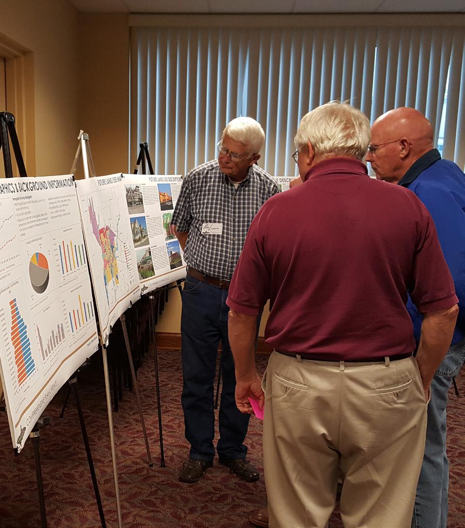
Participants at the public open house on September 29, 2015.
document that will guide decision-making related to land use, growth, public investments, and economic development.
In order to help prioritize improvements and initiatives and create a working plan, relative timeframes have been identified for each plan objective. However, implementation of the goals, strategies, and specific projects included in this plan will depend on budgetary considerations, staff availability, citizen involvement, and other potential changing conditions. The decision to undertake any project at a particular time is a discretionary policy decision of City staff and leadership.
HOW THIS PLAN IS ORGANIZED
This plan provides the basis for policies and regulations that will guide the physical and economic development of the community. The plan includes maps, diagrams, and representative imagery of the concepts presented in order to make the document more clear and accessible to City officials, residents, developers, and other groups.
The plan is organized around a vision statement and series of goals and objectives. The goal statements look to accomplish the overall vision by each addressing an element of the plan. The goal is then achieved through a series of objectives. The intent and importance of each objective is summarized along with
an identified priority timeframe. The four timeframes are:
• Immediate / On-going – Less than 1 year
• Short – 1 to 3 years
• Medium – 4 to 6 years
• Long – 7 + years
Actions steps and required resources are identified for each objective as well. The action steps lay out the sequential process that will be necessary to achieve the objective. The resources are those City departments, community groups, or programs that will be involved in implementation.
PLAN PROCESS
Planning is a continuous process that had been initiated prior to this plan and will continue after its adoption. This new Comprehensive Plan is the result of a detailed process that brought residents and stakeholders together to identify existing conditions throughout the City, recognize potential trends, and ultimately create recommendations for the future. The Greensburg Comprehensive Plan was developed over ten months with oversight from a project steering committee which included the Mayor of Greensburg, representatives from the Plan Commission and Redevelopment Commission, City staff, and other community leaders. The committee met six times throughout the process; these meetings were interactive work sessions and
resulted in the overall input needed to develop the plan.
In addition to the regularly held steering committee meetings, a series of focus group discussions was held and two public open houses were used to solicit input from the broader community. The goal of the focus group discussions was to assess the issues each group faces in terms of economic development, land use, growth, and other important factors, to get a better understanding of what may be addressed through the comprehensive planning process. Each meeting lasted approximately 45 minutes and was conducted with a “conversational” type of format in order to gather information.
Focus Groups included:
• City Department Directors
• Advisory Plan Commission, Board of Zoning Appeals, and Redevelopment Commission
• Board of Works, Airport Board, and Water Board
• Downtown merchants/businesses
• Business leaders
• Real Estate/Development community
• Service & religious organizations
• Utilities
The first public workshop tool place on June 23, 2015 at the Greensburg City Hall. The workshop participants were able to voice their opinions, interests, and concerns about the current conditions and future visions of
the community. Residents were first taken through an exercise to indicate the strengths, weaknesses, and opportunities that currently exist. Next, the residents were given the chance to create a series of vision statements and goals that they believed would be necessary for Greensburg’s continued growth and success.
After these two exercises where completed, all of the comments were posted on the wall and the residents were given stickers to indicate the issues and opportunities they found most important.
The second public workshop was an open house format held on September 29, 2015. The public and interested parties were able to spend as much time as they wanted at stations representing various facets of the plan. City officials and the planning consultants staffed these stations and were on hand to answer questions and provide additional in-sight. Comment cards were also available for the public to record written feedback.
In addition to the on-going public engagement, the plan process was broken into four major components:
• Existing Conditions Analysis
• Vision & Components Framework
• Implementation Plan
• Final Plan & Adoption
The existing conditions analysis phase looked both objectively and subjectively at the issues and challenges facing the City. Issues and opportunities were discussed with
the project steering committee, at the first public workshop, and during the focus group discussions. A Demographics & Retail Analysis was prepared, highlighting population, housing, and retail market conditions. The existing conditions information is included in the appendix of this plan.
The vision and components framework included the creation of the plan vision statement and associated goal topics. The vision and goals served as the structure for the remainder of the plan process. Many of the objectives include ideas that were generated during public engagement while others incorporate best practices demonstrated in other communities. The objectives were refined with the steering committee and action plans for the execution of each objective were crafted.
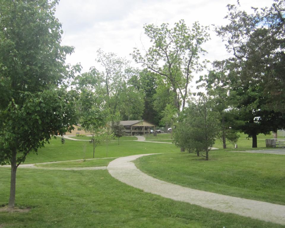
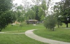
The existing conditions analysis phase identified key community assets such as Decatur County Park.
1Introduction & Executive Summary
The implementation plan involved identifying the relative priority of each objective. These priority timeframes can be used to aid in decision making and implementation. After the second workshop, the plan was presented to the Plan Commission and City Council as part of the adoption process. The Plan Commission held a public hearing and approved and certified the plan at their October 20, 2015 meeting. The City Council adopted the plan at their November 2, 2015 meeting, after which it was submitted to the Indiana Office of Community and Rural Affairs for final approval as part of the grant process.
PLANNING AREA
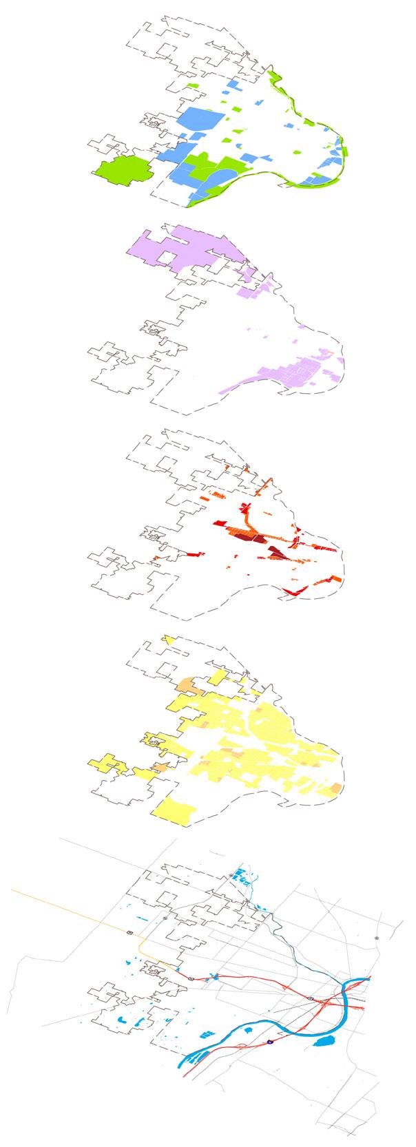
The City of Greensburg has the power to make planning and zoning decisions only within its city boundaries. However, in order to ensure compatibility of future growth and land use changes, an area larger than the current City boundaries was included in the future land use plan. This is not an official extra-territorial planning jurisdiction as recognized by state law but this area will have an effect on the City’s future tax base and utility service area. As such, it was examined in terms of future development potential. The following map depicts the incorporated City boundaries (tan shading) as well as the overall “planning area” (orange line).
VISION
The vision statement was created based on input and guidance from the public and the steering committee. The vision provides a sense of direction and creates a picture of what the community is in the future, once the plan is achieved. While not the only consideration, policymakers and decision makers should always remember the vision to help assess decisions in the future.
Greensburg welcomes growth and will continue to preserve its small town character while providing superior services to residents, businesses, and visitors alike. There is a balanced mix of manufacturing, retail and agriculture which have thrived without compromising the beauty and health of the natural environment. Industry attraction and planned growth are combined with fiscal responsibility to result in an incredible place to live, work, and relax. The beautiful parks, unparalleled schools, historic downtown, social activities and cultural amenities make Greensburg a place where people grow up and want to return. The unique location between Indianapolis and Cincinnati contributes to job opportunities for all. This is supported by diverse housing options which continue to attract emerging professionals, young families, and active seniors, and allow them to remain in Greensburg for every stage of their lives.
As an active community, Greensburg has a strong system of trails, sidewalks, and roads that connect the City’s neighborhoods, downtown, recreational areas, and cultural and commercial hubs. Together, these efforts result in a perfect melding of industry, agriculture, education and a safe and prosperous way of life in Greensburg.
GOALS
Goal statements were developed for seven broad categories including land use, housing and neighborhoods, economic development, infrastructure and services, downtown, community character, and parks and recreation. In conjunction with the vision, these goals serve as the backbone of the plan and provide the basis for development decisions. They are implemented by legislative and policy actions throughout the City, such as zoning ordinances, design regulations, capital improvement programs, and building code enforcement. To help guide this implementation, a series of objectives and action steps is presented for each goal later in the plan.
Land Use
Establish and maintain a balance of land uses throughout the community while using land efficiently and protecting environmentally sensitive areas.
1Introduction & Executive Summary
Housing and Neighborhoods
Promote diversity in the community’s housing options that attracts new residents, while at the same time satisfies the needs of the current residents as their housing preferences change.
Economic Development
Grow existing businesses and attract new ones to establish a diverse employment base resulting in job opportunities for all in the community.
Infrastructure & Services
Plan for and develop infrastructure systems and a transportation network that efficiently serve the existing residents and businesses with the capacity to accommodate planned growth and development.
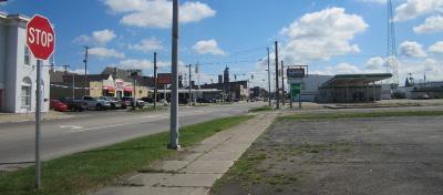
Downtown
Continue to develop an active downtown that supports social and cultural diversity for the residents of the community in an inviting and walkable atmosphere.
Community Character
Use the existing amenities and positive characteristics of the community as a catalyst for additional amenities and improvement that will continue to increase the quality of life for the residents of Greensburg.
Parks & Recreation
Continue to grow and operate an unequaled parks and trails system for residents and visitors that promotes health, active living, and environmental protection.
FUTURE LAND USE
Future land use planning is an important part of the comprehensive plan process because it translates the vision, goals, and objectives into a tangible, physical form. The future land use map was created through examination of existing land use patterns, zoning, and stakeholder input. In many instances, the existing land use is the desired future use and expected to continue indefinitely. However, there are some areas where changes in land use are anticipated as farm properties are developed for the first time or vacant and under-utilized properties are redeveloped. The land use classifications included on the proposed future land use map are:
• Downtown
• Residential
• Local Commercial
• Regional Commercial
• Transitional Commercial
• Industrial
• Industrial / Office Flex
• Parks
• Public / Semi-Public
• Floodplain
These land use classifications are described in detail in Section 3 of this plan.
Land use planning involves examining multiple layers of information including past development patterns, anticipated market demands, transportation systems, utility availability, and the natural environment.
Proposed Future Land Use Map
1Introduction & Executive Summary
IMPLEMENTATION – TOP PRIORITIES
After taking into consideration the communicated needs of the City and the information and ideas discussed throughout this plan, a ‘top 10’ recommendations list has been put together to help prioritize improvements for the City and help create a working plan. These recommendations and associated action steps should be used as the first set of work plan items to be prioritized and completed. During plan review periods, the City should reassess current conditions and adjust this list appropriately. The ‘top 10’ recommendations, in no particular order, are as follows:
• Develop an inter-jurisdictional agreement with Decatur County regarding review of development around the City periphery.
• Ensure buildings and property are properly maintained to support neighborhood stabilization.
• Focus economic development efforts to diversify the job base and increase incomes and amenities in Greensburg.
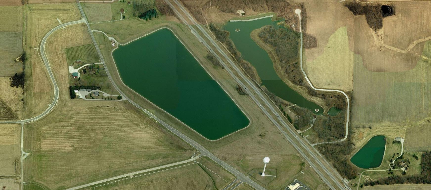
• Examine options for a new fire station south of the railroad tracks versus infrastructure improvements that would allow for better public safety service to this area.
• Install and improve the stormwater infrastructure system to reduce the risk of flooding and property damage.
• Expand the Greensburg Municipal Airport to service larger aircraft.
• Implement the streetscape plan for the roads surrounding the County courthouse to provide continuity with the existing improvements along Broadway Street.
• Ensure that development regulations allow for a mixture of uses in the downtown, including housing, and reflect best practices for walkable urban districts.
• Develop and implement a branding and wayfinding program to help strengthen the City.
• Expand the existing trail system to better serve residents and connect community destinations.
2. VISION, GOALS & OBJECTIVES
WHAT IS A VISION
A vision is a statement that reflects local potential and makes a commitment to future action. A vision generally describes what the community wants to be. The vision statement is a clear, succinct, and purposeful statement that everyone generally agrees with and is easily understood to help define the direction in which the plan should proceed.
A vision provides a sense of direction and is the overall end-game once the plan is achieved, hence a vision is written as if you have traveled into the future and are describing Greensburg as it should be. If an idea, policy or objective would help advance Greensburg towards its vision it was included in the plan. If the idea did not help advance the City towards the
vision, then it was not included. The vision not only serves as part of a decision-making tool for the plan, but also for the decisions that are made in implementing the plan. While not the only consideration, policymakers and decision makers should always remember the vision to help guide whether or not a decision is right.
HOW WAS THE VISION CREATED
Exercises were conducted with the project steering committee and at the first public workshop where participants were asked what they value about Greensburg and what they would like to see improved in the future. Areas such as social and economic well-being,
2
Vision, Goals & Objectives
physical character, growth considerations, recreation, and employment were considered. The vision statement was then drafted using key words and phrases that came out of these exercises and then refined with the steering committee.
VISION STATEMENT
Greensburg welcomes growth and will continue to preserve its small town character while providing superior services to residents, businesses, and visitors alike. There is a balanced mix of manufacturing, retail and agriculture which have thrived without compromising the beauty and health of the natural environment. Industry attraction and planned growth are combined with fiscal responsibility to result in an incredible place to live, work, and relax. The beautiful parks, unparalleled schools, historic downtown, social activities and cultural amenities make Greensburg a place where people grow up and want to return. The unique location between Indianapolis and Cincinnati contributes to job opportunities for all. This is supported by diverse housing options which continue to attract emerging professionals, young families, and active seniors, and allow them to remain in Greensburg for every stage of their lives. As an active community, Greensburg has a strong system of trails, sidewalks,
and roads that connect the City’s neighborhoods, downtown, recreational areas, and cultural and commercial hubs. Together, these efforts result in a perfect melding of industry, agriculture, education and a safe and prosperous way of life in Greensburg.
WHAT ARE GOALS, OBJECTIVES AND ACTION STEPS
Goals, objectives, and action plans outline a guide for future growth and development in a manner that will reflect the City’s unique character. In developing the goals and objectives, it is important to analyze demographics, housing, economic conditions, services and facilities, cultural and natural resources, and existing land use.
An equally important step in developing goals is public engagement. From all the information gathered throughout the public workshops and focus group interviews, basic goals and objectives were derived to address issues in seven broad categories, including land use, housing and neighborhoods, economic development, infrastructure and services, downtown, community character, and parks and recreation.
HOW ARE THE GOALS AND OBJECTIVES ORGANIZED?
The Comprehensive Plan is based upon goals and objectives. Each has a distinctive meaning and purpose in the planning process. Together, goals and objectives serve as the basis for development decisions. They are implemented by legislative and policy actions throughout the city, such as zoning ordinances, design regulations, capital improvement programs, and building code enforcement. It is important to note that the goals and subsequent objectives are listed in no particular order. The objectives are lettered so that they may be easily referenced in the future; the letters do not represent a hierarchy or order of importance.
Goals
Goals are concise statements that describe in general terms, a desired future condition that further defines the vision statement. They are the future of the plan and address those things the City wants to accomplish over the life of the plan. Goals also form the framework for more detailed decision making and are used by the City to establish priorities for needed public improvements and services.
Objectives
Objectives are statements that describe a specific, measurable, future condition to be
attained during a stated period of time and, ultimately, the course of action required to achieve a stated goal. Objectives are statements of community intent against which individual actions and decisions are evaluated. Objectives should be sufficiently quantifiable to gauge the appropriateness of development applications, have a general time frame, and be understood by both the decision-makers and the general community.
Action Plans
The action plan is an extension of the objective and describes how the objective may be accomplished. As the comprehensive plan is a broad document with a long time horizon, the action plans should be refined into more detail when it is time to implement the objective. The action plan describes the who, what, when, where and how. This includes explaining the reasoning for the objective and how it can be implemented, the timeframe of when implementation should begin, the steps necessary for successful implementation and the people and resources needed to make it happen.
GOALS & OBJECTIVES
Land Use
GOAL: Establish and maintain a balance of land uses throughout the community while using land efficiently and protecting environmentally sensitive areas.
OBJECTIVES:
A. Promote infill and redevelopment of underutilized parcels in areas already served by utilities and City services.
B. Ensure outward growth is currently or will be adequately served by utilities and City services.
C. Ensure new development and redevelopment reflects surrounding character, scale, and use.
D. Develop an inter-jurisdictional agreement with Decatur County regarding review of development around the City periphery.
E. Create an annexation policy to ensure a fair level of service to all of Greensburg while increasing assessed valuation, economic growth, and environmental protection.
F. Reduce the risk of flooding and damage by protecting the floodway and floodplain.
2Vision, Goals & Objectives
Housing and Neighborhoods
GOAL: Promote diversity in the community’s housing options that attracts new residents, while at the same time satisfies the needs of the current residents as their housing preferences change.
OBJECTIVES:
A. Maintain a balance of housing choices for first-time home buyers, repeat buyers, and renters through the provision of conventional subdivisions, multi-family developments, large-lot developments, and senior housing.
B. Support infill and redevelopment in established neighborhoods through investment and incentive programs provided by the City.
C. Ensure buildings and property are properly maintained to support neighborhood stabilization.
D. Partner with local businesses to establish a grant program designed to fund improvements to Greensburg neighborhoods.
E. Help to facilitate the creation of neighborhood groups to organize and coordinate beautification efforts, crime prevention efforts, and ensure other critical neighborhood issues are addressed.
F. Inter-connect neighborhoods with retail, employment, and recreation destinations. Several of the goals and objectives involve improving the function and appearance of key corridors and gateways.
G. Ensure quality in new housing developments with the provision of community open space, landscaping, and other amenities.
Economic Development
GOAL: Grow existing businesses and attract new ones to establish a diverse employment base resulting in job opportunities for all in the community.
OBJECTIVES:
A. Focus economic development efforts to diversify the job base and increase incomes and amenities in Greensburg.
B. Develop guidelines for the use of public incentives as a potential attraction tool.
C. Continue to partner with local schools on workforce development initiatives.
D. Continue the business visitation program to support and strengthen the local business climate.
E. Capitalize on existing automobile manufacturing businesses to attract additional suppliers and manufacturers to fill gaps in the supply chain.
F. Continue to promote and develop existing agriculture businesses and other industries currently present in Greensburg.
G. Continue regional coordination and partnerships with surrounding jurisdictions and organizations.
H. Identify and develop entrepreneurial and small business talent through personal, peer, group, and community coaching.
I. Continue to utilize loan programs, grants, and other economic development tools to assist existing businesses and attract new ones.
J. Continue to grow the hospitality and retail sectors to serve residents and visitors and aid in the attraction of new businesses.
Infrastructure & Services
GOAL: Plan for and develop infrastructure systems and a transportation network that efficiently serve the existing residents and businesses with the capacity to accommodate planned growth and development.
OBJECTIVES:
A. Complete the construction of Veteran’s Way.
B. Create and fund an annual street maintenance and repair budget.
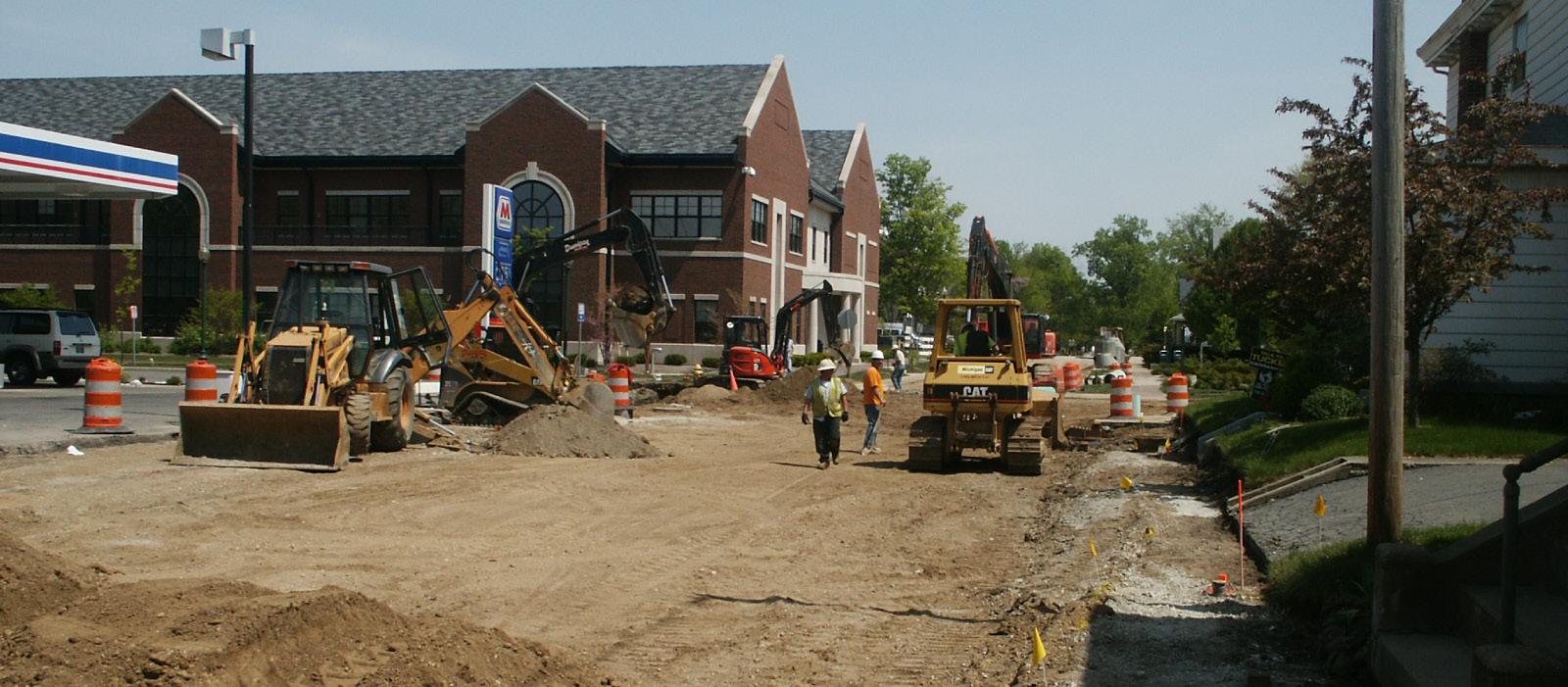
C. Examine options for a new fire station south of the railroad tracks versus infrastructure improvements that would allow for better public safety service to this area.
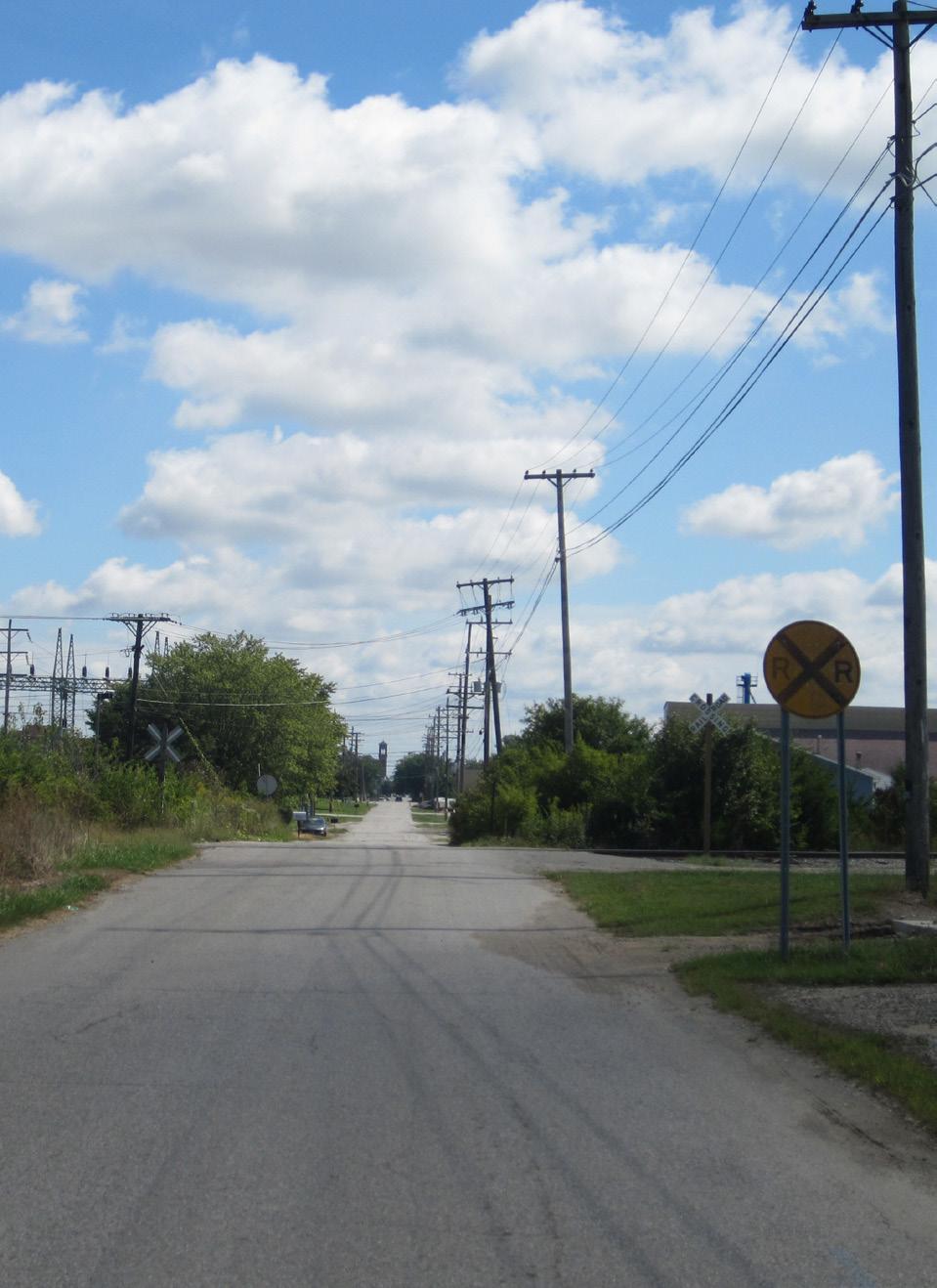
D. Ensure safety and operation at all at-grade railroad crossings.
E. Continue to upgrade utility infrastructure to meet the needs of growing and new businesses.
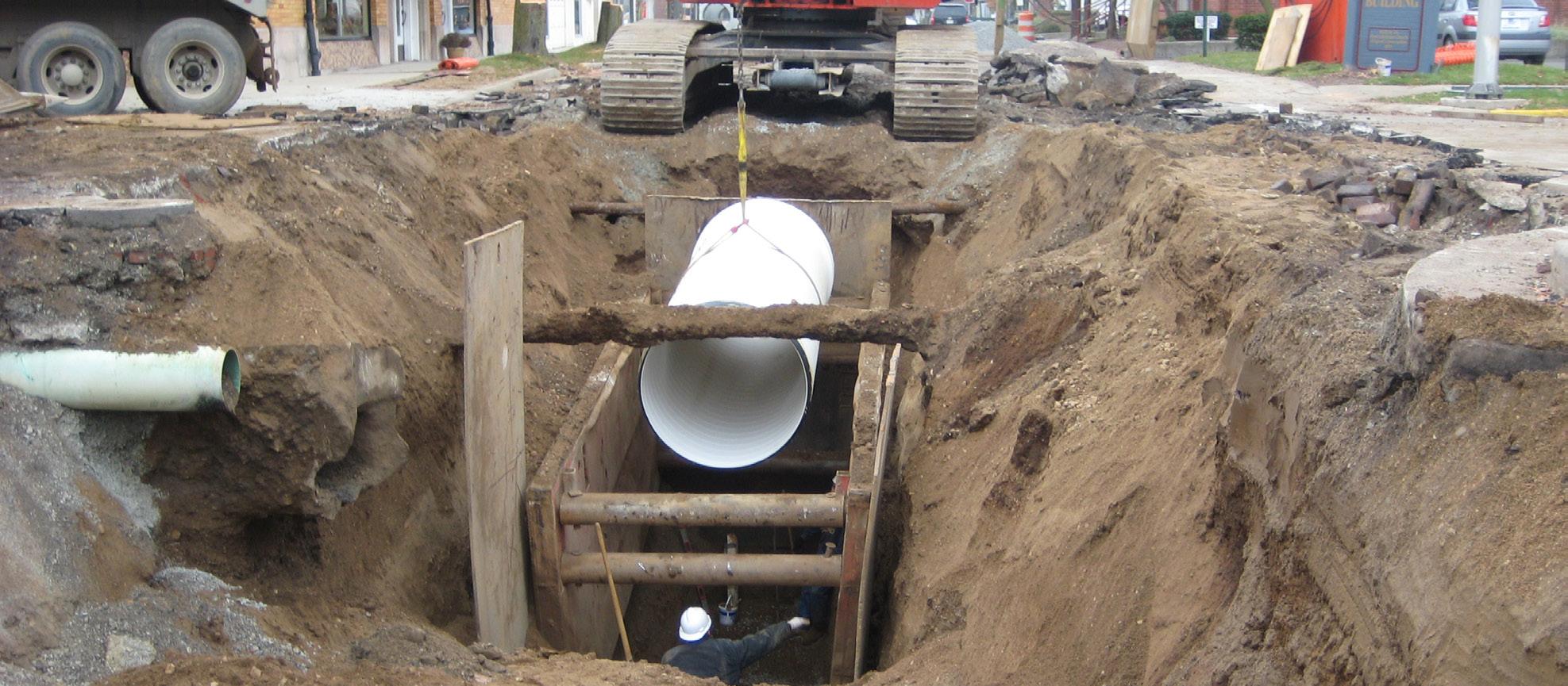
F. Install and improve the stormwater infrastructure system to reduce the risk of flooding and property damage.
G. Examine options for a new surface water treatment facility to ensure adequate potable water supply for the City.
H. Adopt a complete streets policy to better accommodate users of all ages and abilities.
I. Identify gaps in the sidewalk network and create a plan to complete priority sections.
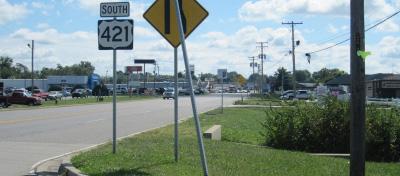
J. Closely coordinate with INDOT regarding improvements to state routes within Greensburg city limits.
K. Coordinate utility, transportation, storm water, and other infrastructure improvements to combine construction projects and reduce costs.
L. Expand the Greensburg Municipal Airport to service larger aircraft.
Downtown
GOAL: Continue to develop an active downtown that supports social and cultural diversity for the residents of the community in an inviting and walkable atmosphere.
OBJECTIVES:
A. Enhance gateway and corridor connections between the downtown area and surrounding neighborhoods.
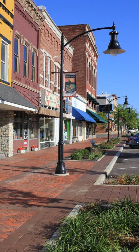
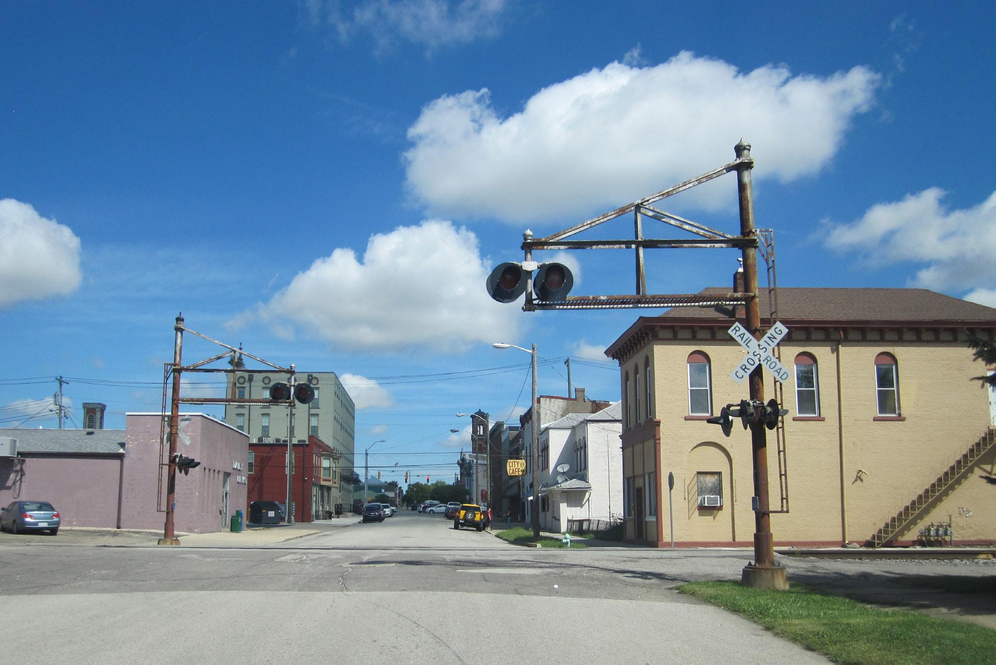
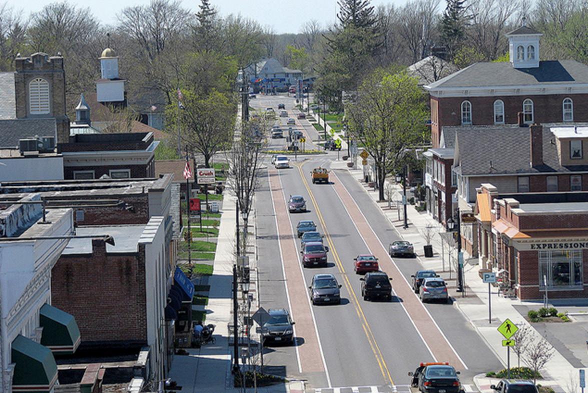
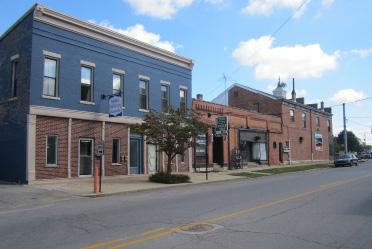
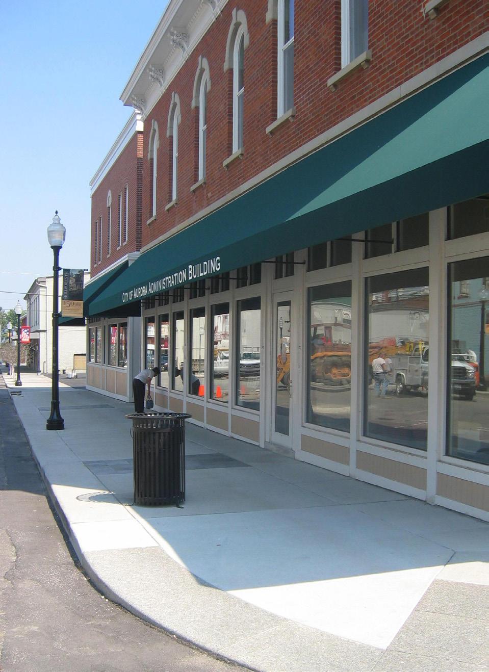
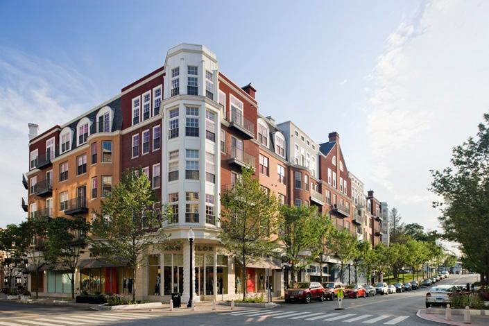
Downtown is the civic, cultural, and business hub of the community; the walkable atmosphere must be preserved and protected. (Image: Main Street Greensburg)
2Vision, Goals & Objectives
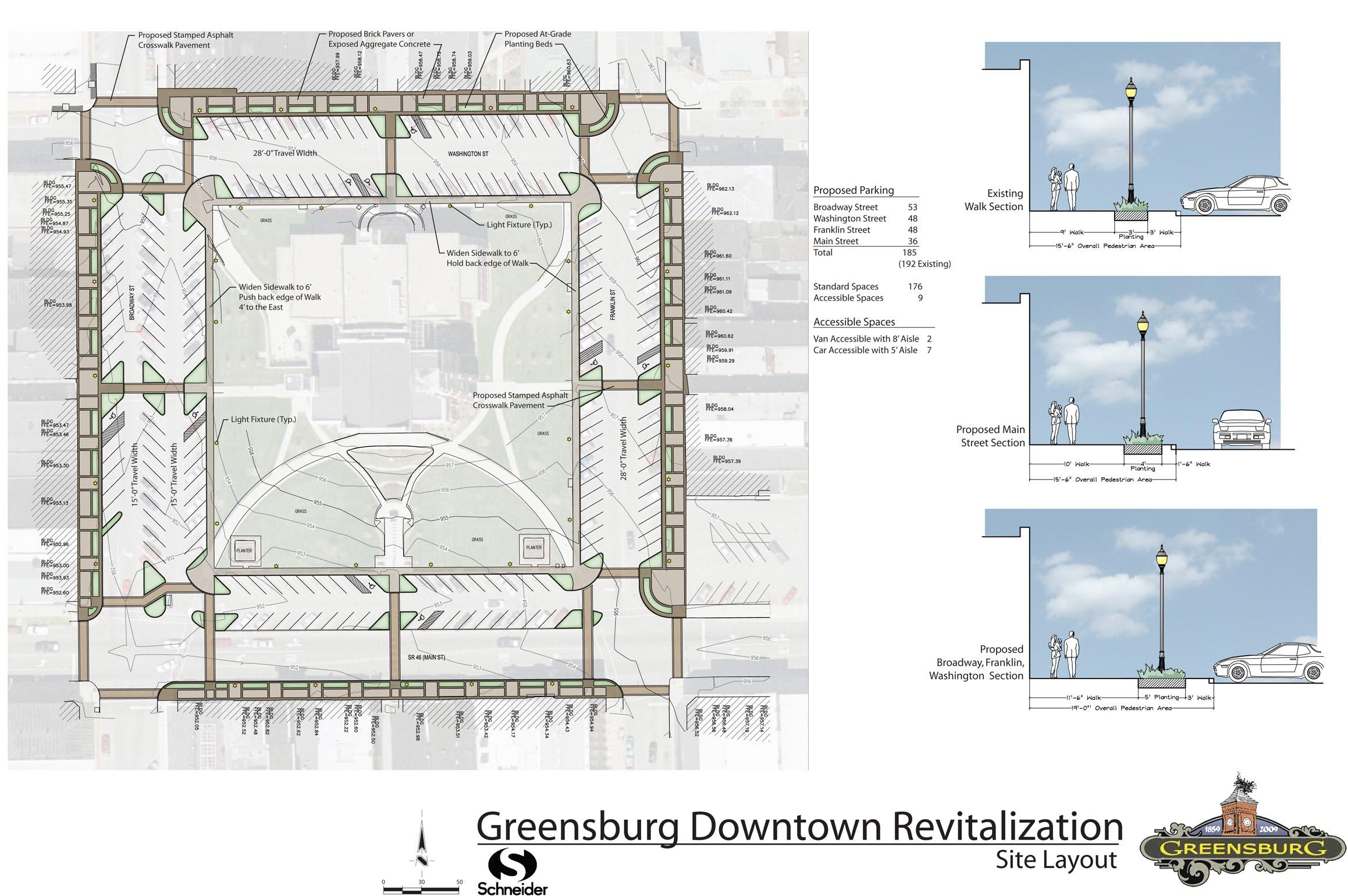
B. Implement the streetscape plan for the roads surrounding the County courthouse to provide continuity with the existing improvements along Broadway Street.
C. Support infill development that reflects and reinforces the historic character in the downtown area.
D. Ensure that development regulations allow for a mixture of uses, including housing, and reflect best practices for walkable urban districts.
E. Continue and expand the existing façade improvement program to restore the historic character in the downtown area.
F. Ensure surrounding development supports and positively impacts the downtown.
Community Character
GOAL: Use the existing amenities and positive characteristics of the community as a catalyst for additional amenities and improvement that will continue to increase the quality of life for the residents of Greensburg.
OBJECTIVES:
A. Continue streetscape improvements on Lincoln Street through to SR46/Main Street.
B. Collaborate with INDOT to implement streetscape improvements on Michigan Avenue from SR3 to its terminus northwest of Downtown Greensburg.
C. Collaborate with INDOT to develop and implement streetscape improvements on SR46/Main Street, specifically near the county courthouse in Downtown Greensburg.
D. Utilize public-private partnerships with local industries to create, implement, and fund a public art program to further beautify the community as a whole.
E. Develop and implement a branding and wayfinding program to help strengthen the City.
F. Utilize development tools and incentives to establish a higher quality of design and construction at key gateway areas.
Parks & Recreation
GOAL: Continue to grow and operate an unequaled parks and trails system for residents and visitors that promotes health, active living, and environmental protection.
OBJECTIVES:
A. Expand the existing trail system to better serve residents and connect community destinations.
B. Expand the current park system to include facilities of varying sizes that are distributed throughout the entire City, serving more of the community.
C. Partner with community schools to develop an agreement where the school grounds can be used as park space outside of school hours.
D. Identify and partner with non-profit organizations who fund parks and trails to maintain and grow the existing park system.
E. Expand existing sports and recreation programming to serve both youths and adults in the community.
3. LAND USE
GOAL:
Establish and maintain a balance of land uses throughout the community while using land efficiently and protecting environmentally sensitive areas.
3Land Use
WHY IS FUTURE LAND USE PLANNING IMPORTANT?
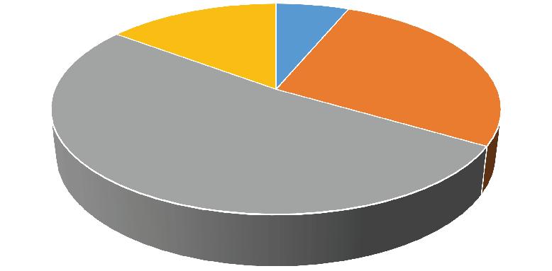
In order to plan for future growth and development, it is important to have an understanding of existing land use supply. The existing land use pattern shows not only where concentrations of certain uses are but also what land may be available for development and what type of development pressure that may be. The current City area is approximately 9.32 square miles, or almost 6,000 acres. Industrial uses account for the largest land consumers at approximately 35%. Residential development accounts for almost 30% of the City area. Agriculture is the next largest use at nearly 16% with commercial uses around 9%.
Future land use planning is an important part of the comprehensive plan process because it translates the vision, goals, and objectives into a tangible, physical form. The future land use map was created through examination of existing land use patterns, zoning, and stakeholder input. In many instances, the existing land use is the desired future use and expected to continue indefinitely. However, there are some areas where changes in land use are anticipated as farm properties are developed for the first time or vacant and under-utilized properties are redeveloped.
The future land use plan should not be confused with zoning. While land use and zoning are related, they serve separate functions. Land
use describes the activity that occurs on the land, residential for example. Zoning then regulates the character, building size, density, and other development standards of that land use activity. There are often multiple different residential zones, ranging from single-family houses on larger lots to duplexes and multifamily apartments.
The future land use map is intended to be general in nature and not based on specific property lines. This allows some development flexibility and interpretation on a project by project basis while still establishing the foundation by which to make judgments on the appropriateness of future development petitions.
The land use classifications included on the proposed future land use map are:
• Downtown
• Residential
• Local Commercial
• Regional Commercial
• Transitional Commercial
• Industrial
• Industrial / Office Flex
• Parks
• Public / Semi-Public
• Floodplain
As discussed in the Introduction & Executive Summary section, the future land use planning area includes lands currently outside the incorporated City limits. This area is approximately 9,400 acres; the future land use classifications are shown in the following pie chart as a percentage of the total planning area:
Future Land Use by Percent of Planning Area.
Proposed Future Land Use Map
3Land Use
LAND USE CLASSIFICATIONS
Downtown
Focused around the courthouse square, the City of Greensburg’s downtown incorporates a mixture of uses in a pedestrian friendly environment. Currently this area is primarily comprised of local businesses, but in the future the downtown could become a more diverse cultural hub for the community that consists of residential, commercial, and public open spaces. Promoting mixed-use development is critical to a healthy downtown by promoting housing variety and creating an immediate customer base for local retailers. Infill development should reflect the size and scale of surrounding uses and should promote pedestrian access. Design standards can be used to ensure historical context and promote street life and activity.
Residential
The residential land use classification is intended to promote and enhance established neighborhoods and identify areas for the creation of new neighborhoods. These areas consist primarily of single-family homes with some duplexes and multi-family apartments as well as supporting schools, parks, open spaces, and religious institutions. In established residential areas, infill and redevelopment should reflect the surrounding density and form. New residential areas should allow for a variety of densities and housing types, creating more housing options throughout the community. New residential developments should include coordinated open spaces and amenities, have adequate access to transportation systems, and must be served by public utilities.
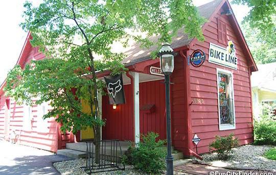
Local Commercial
Local commercial areas provide a location for retailers and businesses that serve the needs of nearby residents and employees. Common examples include convenience retail, restaurants, small offices, and support services. These uses are generally automobile-oriented and as such located along thoroughfares in proximity to the neighborhoods and businesses they serve. It is important to ensure the adjacent transportation systems can accommodate potential traffic generated by local commercial uses; these areas should be connected to the neighborhoods they serve with bicycle and pedestrian facilities. Cross access and shared drives should be included where possible. Architectural requirements, design guidelines, and landscaping standards should be used to ensure these districts will be attractive places in the community.
Regional Commercial
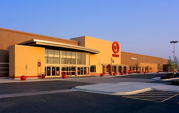
The regional commercial classification is created for commercial uses that provide for shopping, services, and employment for residents of Greensburg and the surrounding area, and travelers along Interstate 74. Generally, businesses in this classification are more intense in terms of traffic, parking, and land use. Due to the large impact of these businesses, setbacks and landscaping buffers should be used to maintain the character of the surrounding areas. These uses are automobileoriented and should be located along primary thoroughfares that can accommodate potential traffic generated by new development.
Transitional Commercial
Transitional commercial districts are established for two main purposes. Transitional commercial districts can be areas that are currently, or are expected to experience land use change from single family residential to local commercial or higher intensity residential uses. The other purpose for transitional commercial districts is to provide a buffer between higher intensity land uses like industrial and heavy commercial to lower intensity land uses like residential neighborhoods. As corridors transition, it is important to maintain the character and scale of the neighborhood. Architectural and site design standards can help improve the aesthetic appearance; uses that generate high traffic volumes are not appropriate for transitional commercial areas.
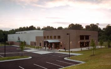
Industrial
The industrial classification is intended to support the existing industrial businesses, while at the same time allowing for growth and encouraging new development of manufacturing and processing facilities. The uses found in industrial districts may have a high impact on adjacent lands, require extensive infrastructure improvements, public facilities, and access to major transportation networks. To help limit the impact from industrial development, significant landscape buffers and setbacks should be used to separate other uses.
3Land Use
LAND USE CLASSIFICATIONS
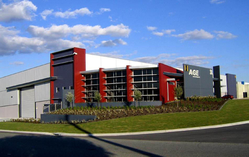
Office / Industrial Flex
The office and industrial flex classification is established to encourage development for a range of office, research and development, light industrial, and small-scale warehousing uses that will spur economic growth and employment opportunities in Greensburg. Many light industrial uses resemble office buildings from the exterior and as such are compatible in flex areas; these areas could include a combination of both high intensity users within multi-story buildings on large parcels and groups of smaller structures in a campus setting. All operations should be completely contained within enclosed structures. This land use classification has a smaller impact when compared to traditional industrial land uses and should be used to transition between industrial districts and lower impact land uses. Some support commercial use may be appropriate as a secondary element in these areas.
Public / Semi-Public Facility
The public / semi-public facility classification is for identifying areas where governmental, educational, or general public facilities are located. The scale, character, and intensity of development will be dependent on the use and surrounding area. This land use classification is compatible with most other land uses, and therefore its placement in the community is very flexible to changes in the city’s current and future needs.
Parks
The parks classification is established to distinguish and protect recreational areas, public parks, and general open space. Uses may include passive open spaces, ball fields, play equipment, golf courses, community gardens, conservation areas, and environmentally sensitive lands. Public parks and open space further increase the overall quality of life for residents. Recreation and park areas should be used as a respite from urban development and link to each other with bicycle and pedestrian facilities.
Floodplain
While floodplain areas are not an active land use, they are included on the future land use map to help inform decisions on where development should or should not happen. Floodplain maps are created and maintained at a state and federal level, therefore the City of Greensburg has little control over where these areas occur. The floodplain may be used for passive recreation and open space while most other development should be avoided. Limiting disturbance within the floodplain protects ecologically sensitive land and helps to prevent downstream flooding.
LUA
Immediate / On-going
PROMOTE INFILL AND REDEVELOPMENT OF UNDERUTILIZED PARCELS IN AREAS ALREADY SERVED BY UTILITIES AND CITY SERVICES.
Summary:
There are many challenges when developing vacant and underutilized parcels in established neighborhoods. These challenges include the scattered location and potentially low number of infill parcels, ill-suited development regulations, outdated infrastructure, and potential environmental contamination (brownfields). Furthermore, many modern development regulations favor the development of greenfield properties where there are few constraints and land is readily available. To encourage infill development, local governments often use incentives to promote infill construction and rehabilitation.
Reasons for offering incentives include:
• Aesthetically improving underutilized and blighted areas and helping catalyze additional revitalization efforts.
• Improving tax revenues in built-out areas of the city already served by public utilities.
• Increasing density and providing affordable housing to meet growing community needs.
• Directing development to already urbanized areas, therefore preserving agriculture lands on the fringe of the city.
• Promoting densities that are more supportive of walkable environments.
These incentives may come in many forms and should be determined with discussion between City departments, elected and
appointed officials, targeted neighborhood representatives, and area home builders. Potential incentives may include:
• City-led infrastructure and amenity upgrades.
• Reduced permit and utility connection fees.
• Fast track or streamlined permitting.
• Reduced development requirements for standards such as lot size, setback, or parking.
• Tax deferrals.
• Density bonuses.
Action Steps:
1. Conduct outreach to neighborhood groups, the local construction industry, and the wider community to develop consensus around desired infill types and strategies.
2. Create a residential infill guidelines to identify appropriate building types and site design principles.
3. Identify non-residential buildings with adaptive re-use potential.
4. Support private investment in targeted infill areas with investments in public infrastructure and municipal services.
5. Amend the Zoning Ordinance to better support infill development and include incentives for infill construction and rehabilitation of under-utilized properties.
6. Continue enforcing established City codes to protect the property values of new infill development.
Resources:
• Engineering, Planning & Zoning Department
• Plan Commission
• Redevelopment Commission
• City Council
• Development community
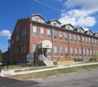
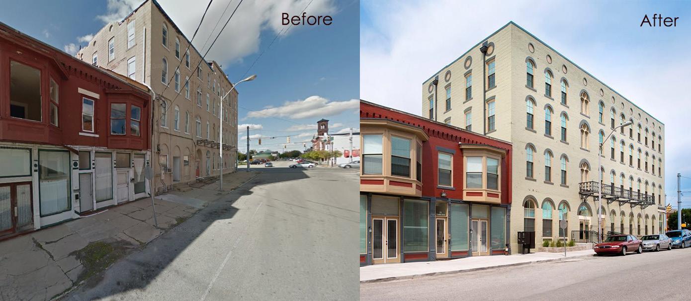
Infill development at the corner of First and Ireland streets has resulted in the conversion of a historic industrial building into multi-family apartments.
3Land Use
LUB
Immediate / On-going
ENSURE OUTWARD GROWTH IS CURRENTLY OR WILL BE ADEQUATELY SERVED BY UTILITIES AND CITY SERVICES.
Summary:
As Greensburg continues to develop, the City’s growth must coincide with the expansion of utility systems and municipal services. These systems require continual investment to keep pace with demand, replace aging infrastructure, and keep systems in a state of good function. Maintaining infrastructure and services depends upon future revenue streams. Most utilities are funded through monthly usage bills as well as tap and availability fees at the time of construction. Other City services may be funded through usage fees and property taxes.
Land use planning both within City limits and in surrounding fringe should precede and not follow annexation and the extension of utility infrastructure. Additionally, developers benefitting from public infrastructure expansion should be required to contribute to the financing of such expansion. To guarantee adequate public facilities and a high quality of life through infrastructure and service provision, it is recommended that Greensburg develop an Adequate Public Facilities (APF) ordinance or include similar language in the Subdivision Control and/or Zoning Ordinance.
An APF ordinance ties the pace and location of development to the availability of public facilities and services and ensures that the necessary public infrastructure and services are available at accepted levels of service required to support new development at the time the development occurs. An APF ordinance accomplishes three main objectives:
• Links the provision of needed public facilities and services to the type, amount, location, density, build-out rate, and timing of new development.
• Ensures the new development does not out pace the ability of service providers to accommodate such development at established service standards.
• Coordinates public facility and service capacity with the demands created by new development.
In addition to covering all City utility services, the APF ordinance could be written to include transportation infrastructure, police and fire protection, parks, and other community facilities. If adequate infrastructure is not available at adopted levels of service the new development would be denied or conditionally approved pending adequate facilities.
Action Steps:
1. Develop an adequate facilities ordinance or language in the Subdivision Control and/or Zoning Ordinance that limits the extension of City utilities to those areas where annexation and identified growth and/or redevelopment is desired.
2. Do not approve new developments where utility infrastructure cannot be extended before applications for building permits are received.
3. Consider the cumulative impacts of new development including availability of services, transportation access, natural resources, and environmental constraints.
4. Encourage compact development to reduce land consumption and infrastructure costs.
Resources:
• Engineering, Planning & Zoning Department
• Water & Wastewater Office
• Greensburg Police Department
• Greensburg Fire Department
• Other utility providers (Duke, Vectren, Decatur County REMC, Decatur County Rural Water Corp.)
• Plan Commission
• City Council City growth must coincide with the expansion and maintenance of infrastructure and municipal services.
3Land Use
LUC
Short Range
ENSURE NEW DEVELOPMENT AND REDEVELOPMENT REFLECTS SURROUNDING CHARACTER, SCALE, AND USE.
Summary:
The previous comprehensive planning process identified areas of residential, commercial, and industrial growth but lacked sufficient detail regarding development scale and character. In order to provide more clarity to developers, City staff, and City officials, the future land use map was developed to include more land use designations. In addition to the desired future land uses, new development and redevelopment, especially in residential areas should be designed to reflect adjacent character and scale. Other recommendations in this plan also aim for a mixture of housing types and sizes. In new residential developments, mixed densities may be included to allow some more compact areas while scaling down in intensity to reflect adjacent character. This is important because while new development increases the tax base of the City, new homes and businesses also increase the cost of city services such as sewer, water, fire and police protection, parks, libraries, and roads. Low density residential development is almost always tax negative. Even when home prices are high, the long term infrastructure maintenance and replacement costs outweigh the tax revenues. In order to better match existing residential characters and intensities, and reduce the costs of low density residential development, the City must promote future residential development that reflects existing character but also allows more mixed densities.
Action Steps:
1. Assess current development intensity in various parts of the City taking into account future land use, location, and existing development.
2. Assess the current Zoning Ordinance and zoning map to determine potential adjustments to development intensity/ density, architecture, bulk, massing, open space and setback requirements.
3. Amend the Zoning Ordinance and zoning map to adjust requirements so that development intensity/density, architecture, bulk, massing, open space and setback requirements are more in-line with the character of existing development while also taking into account the desired future housing balance.
Resources:
• Engineering, Planning & Zoning Department
• Plan Commission
• City Council
LUD
Immediate / On-going
DEVELOP
AN INTER-
JURISDICTIONAL AGREEMENT WITH DECATUR COUNTY REGARDING REVIEW OF DEVELOPMENT AROUND THE CITY PERIPHERY.
Summary:
The City has a strong relationship with Decatur County. The City currently has representatives on the Area Plan Commission to provide input on various development proposals. The City, as part of the land use plan, has identified several areas of future growth which are outside of the jurisdictional limits of Greensburg. It is important for Greensburg to develop a more formalized agreement with the County in order to specifically discuss actions related to the development of specific parcels adjacent to the City boundary. This could include standards to develop the parcel for utilities, streets and zoning classifications. However, prior to any of this occurring, the City needs to enter into an inter-jurisdictional agreement with Decatur County.
Action Steps:
1. Work with consultant to understand all issues related to inter-jurisdictional agreements and how it would impact Greensburg.
2. Work with County to develop language for the inter-jurisdictional agreement including how reviews will work, what standards that property will be developed to, etc.
3. Plan Commission will have a public hearing and provide recommendation to City Council.
4. City Council will adopt inter-jurisdictional agreement.
5. Periodically review and update agreement as areas develop out.
Resources:
• Engineering, Planning & Zoning Department
• Legal Department
• Plan Commission
3Land Use
LUE
Short Range
CREATE AN ANNEXATION POLICY TO ENSURE A FAIR LEVEL OF SERVICE TO ALL OF GREENSBURG WHILE INCREASING
ASSESSED VALUATION, ECONOMIC GROWTH, AND ENVIRONMENTAL PROTECTION.
Summary:
Annexation is a key tool used to guide a community’s continued growth and to manage the type and location of growth in the future. Many communities annex land in order to control the establishment of incompatible development and protect existing and future land uses.
Annexation is the legal process by which a community can expand. According to Indiana State Law, the area annexed much receive municipal services such as police, fire and capital improvements within a reasonable time period but no later than 3 years after annexation. During the annexation process, Greensburg could apply zoning to those properties to ensure that they fit with the vision set forth herein this Plan.
Indiana Code 36-4-3 states that one of two conditions must be met in order for annexation to occur:
1. The territory is at least 1/8 contiguous, the density of the territory is at least three persons/acre; 60% of the territory is subdivided; or the territory is zoned commercial, industrial, or business or
2. The territory is contiguous, except that at least one-fourth (1/4) rather than oneeighth of the boundary must coincide with municipal boundaries; and the land is needed and can be used by the municipality for its development in the reasonably near future.
Annexation may be initiated by the City or by the property owners.
The City needs to develop an annexation strategy to provide the guidance and rationale by which to consider potential annexation and to more closely match the timing of development to the provision of municipal services. The strategy should identify parcels, timing, potential zoning and municipal services. The strategy should include specific criteria for both voluntary and involuntary annexations.
Action Steps:
1. Identify parcels for future annexation.
2. Outreach to property owners regarding annexation.
3. Develop evaluation criteria for annexation. Some criteria could include:
a. Surrounding existing development
b. Environmental issues
c. Municipal services
d. Infrastructure and utility capacity
e. Fiscal impact
4. Draft policies for providing municipal services for new development.
5. Draft strategy.
6. Hold public hearing.
7. Adopt annexation policy as a resolution to guide future annexation decisions.
Resources:
• Engineering, Planning & Zoning Department
• Legal Department
• Plan Commission
• Street Department
• Greensburg School Corporation
• Water Department
• Wastewater Department
3Land Use
LUF
Immediate / On-going
REDUCE THE RISK OF FLOODING AND DAMAGE BY PROTECTING THE FLOODWAY AND FLOODPLAIN.
Summary:
Flooding events have been some of the most widespread and costly natural disasters in the United States despite continued investment in structural flood controls and other nonstructural measures. Flood events and impacts are anticipated to increase in the future as the frequency and severity of storms increases as well as the pressure for more development in at-risk areas. Limiting development in flood hazard areas is absolutely necessary to reduce future impacts and associated costs of flooding.
A flood hazard zoning district or overlay zone should be created to include all areas of special flood hazard (floodplain, floodway, and floodway fringe) as identified on Federal Emergency Management Agency (FEMA) Flood Insurance Rate Maps. Special flood hazard areas are those that would be under water during a 100-year flood. A 100-year flood does not mean a flood of that magnitude can only happen once every 100 years but rather, there is a 1 percent chance of a flood of that magnitude every year. Uses allowed in the flood hazard areas are typically limited to agriculture, public parks and playgrounds. Additional development may be permitted in the floodway fringe if the developed land’s elevation is increased through the use of cut and fill to a level two (2) feet above the regulatory flood profile, as long as there is no net loss of floodway fringe.
Action Steps:
1. Create a flood hazard zoning district or overlay zone to limit development within the 100-year floodplain to those uses devoted to greenspace preservation.
2. Periodically review the identified boundaries of the flood hazard zoning district or overlay zone to ensure they coincide with the 100-year floodplain.
3. Identify and maintain a database of at risk properties and structures within the flood hazard areas.
4. Purchase at risk properties in the floodplain as resources are available.
Resources:
• Engineering, Planning & Zoning Department
• Plan Commission
• City Council
4. HOUSING & NEIGHBORHOODS
GOAL:
Promote diversity in the community’s housing options that attracts new residents, while at the same time satisfies the needs of the current residents as their housing preferences change.
4
Housing & Neighborhoods
HN A
Immediate / On-going
MAINTAIN
A BALANCE OF HOUSING CHOICES WITH THE PROVISION OF CONVENTIONAL SUBDIVISIONS, MULTIFAMILY DEVELOPMENTS, LARGE-LOT DEVELOPMENT, AND SENIOR HOUSING WITH OPTIONS FOR FIRST-TIME HOME BUYERS, REPEAT BUYERS, AND RENTERS.
Summary:
Currently, many subdivisions or neighborhoods contain a homogenous housing stock that caters to one particular market segment. Oftentimes, an individual will not have the same demands through their entire life and find they need to relocate outside of their neighborhood or community to meet their housing needs. As families expand, there is more demand for areas in which different family generations can live closer together. Integrating different housing styles and types within the community can have a huge impact on the long-term viability of neighborhoods and the ability to meet the needs of Greensburg residents as their housing situations and preferences change.
Throughout the planning process, concerns were raised about the lack of variety in Greensburg’s housing stock. Participants indicated that there are many houses at or below the $150,000 price and several areas of the City that have homes priced at over $300,000. However, the choices in the $150,000 to $300,000 range are few and far between. People searching for homes in the price range often have to expand their search outside of Greensburg to include Batesville or Shelbyville. Subsequently, these households are then supporting retail businesses and restaurants closer to home. Lack of housing choice may also be hindering economic development efforts if targeted companies don’t see housing availability for their employees in the community.
One way to promote diversity in the housing stock is to both permit and encourage the development of new housing types. These new housing types can be in the form of higher density single family residential or auxiliary dwelling units. The higher density single family housing could be townhomes, duplexes, or more compact detached dwellings. Additionally, accessory apartments can provide an extra income source or allow aging family members to remain close to relatives for care.
Action Steps:
1. Amend the zoning ordinance to allow accessory dwelling units and higher density housing options than what is currently permitted.
2. Identify areas appropriate for residential growth and ensure the proper zoning is in place for the desired residential product.
3. Support land use and zoning changes that will lead to provisions for more diverse housing types.
4. Periodically review development regulations to assess their effectiveness in leading to a variety of housing types.
Resources
• Engineering, Planning & Zoning Department
• Plan Commission
• City Council
• Development community
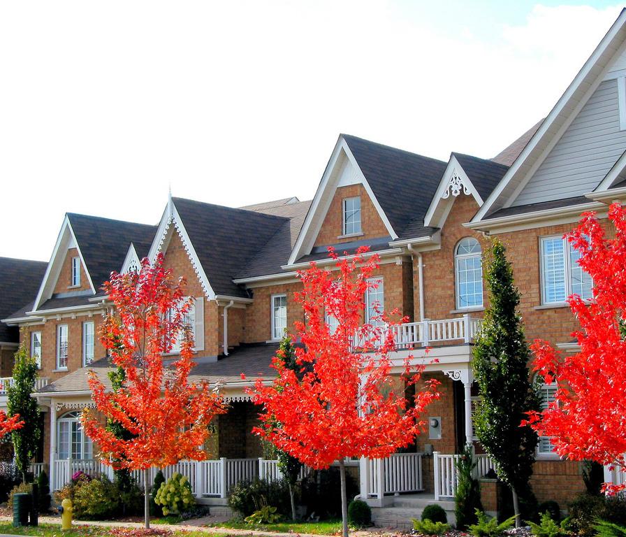
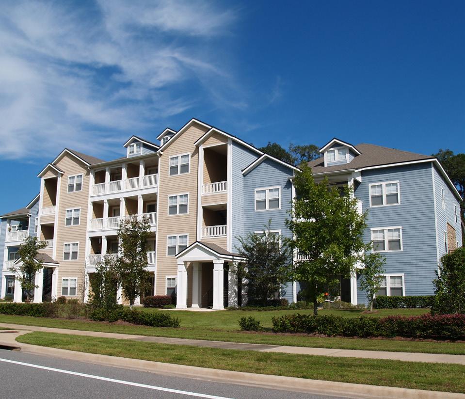
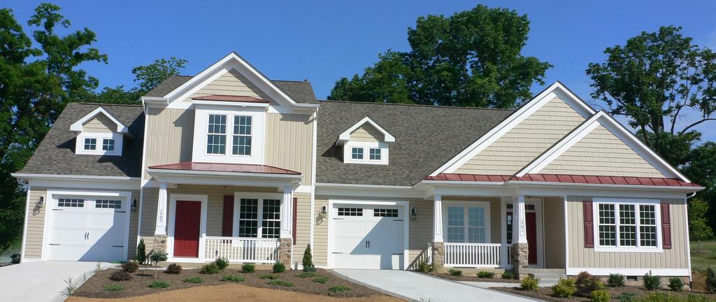
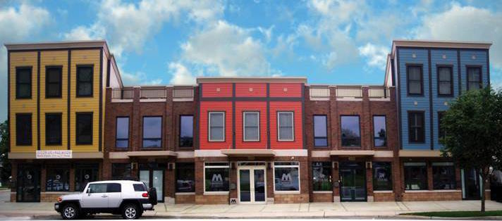
Diverse housing options such as single family attached townhomes (top left), multi-family apartments (top right), and duplexes (bottom) can help to serve residents of all ages.
4Housing & Neighborhoods
HN BMedium Term
PROMOTE INFILL AND REDEVELOPMENT IN ESTABLISHED NEIGHBORHOODS THROUGH INVESTMENT AND INCENTIVE PROGRAMS PROVIDED BY THE CITY.
Summary:
Greensburg has a larger percentage of housing constructed before 1939 when compared to the State of Indiana. Some of this housing has been well maintained and contributes significantly to the historic character of the community. However, some of this housing has not been adequately maintained, has been converted into multi-family rentals, and is located in neighborhoods that have seen teardowns and demolition resulting in vacant and underutilized lots in areas already served by city utilities.
The City of Greensburg can help alleviate these issues by providing incentives for developers who complete infill and redevelopment projects in targeted areas. The City should demonstrate their long-term commitment to these neighborhoods with City-led infrastructure investments. This would most
likely come in the form of road, sidewalk, or public facility improvement, but it could involve property beautification programs that help improve the curb appeal in a neighborhood. After the city has shown its commitment to these neighborhoods developers will be more likely to invest their own money for infill and redevelopment projects. Offering incentive programs to these developers from the city may further lessen the developer hesitation and increase the likelihood of reinvestment. Incentives may include reduced permitting or utility connection fees, density bonuses, or reductions in other development standards such as setbacks, parking, or lot size. Too often zoning ordinances are written to address new development and as such, can create barriers to re-investment and redevelopment in older parts of the City.
Action Steps:
1. Facilitate discussions between neighborhood groups, local construction industries, and potential investors to determine the most effective and financially viable incentive programs.
2. Create an “Infill and Redevelopment Guide” to establish design standards and appropriate building types that will qualify for the incentive program.
3. Support desired infill and redevelopment through public investments in infrastructure improvements and beautification efforts.
4. Ensure that the current zoning allows the building types and infill projects that the community desires. Amend the zoning ordinance if those building types are not permitted.
5. Continually enforce the city’s codes to protect the property values of new infill and redevelopment.
Resources:
• Engineering, Planning & Zoning Department
• Plan Commission
• City Council
• Redevelopment Commission
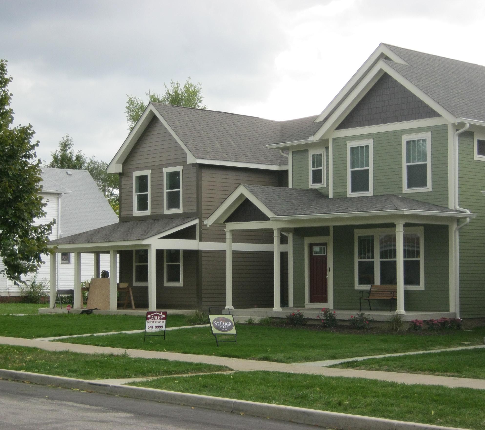
An example of infill housing constructed in a traditional neighborhood in Indianapolis, Indiana.
4Housing & Neighborhoods
HN CShort Term
ENSURE BUILDINGS AND PROPERTIES ARE PROPERLY MAINTAINED TO SUPPORT NEIGHBORHOOD STABILIZATION.
Summary:
One of the most effective means of stabilizing property values and creating quality neighborhoods is by ensuring the good maintenance of buildings and lots. This is equally important in neighborhoods as it is in business and industrial districts. Unfortunately when properties are not adequately maintained, the City may have to get involved through code enforcement. This is typically a resource intensive process that involves City staff and legal counsel. Some communities employ full-time code enforcement personnel that actively look for violations. To help create a more successful and efficient code enforcement process, the City could create a code enforcement hotline and website where citizens can go to report code violations they have seen in their neighborhoods. In all cases, City staff will first have to determine if a violation is present; the City should then seek cooperation from property owners to fix issues before proceeding with official enforcement. The end goal of the program should be compliance and a more attractive community, and code enforcement should not be looked at as a potential revenue stream for the City. More active code enforcement will show property owners that the City is serious about its appearance and hopefully elevate property maintenance city-wide.
Action Steps
1. Establish a phone number and online form to report code violations.
2. Advertise the number and website to the public as a resource.
3. Begin an educational program to inform residents and property owners about why city codes are important and the positive impact enforcing the City’s codes will have on their property value and quality of life.
4. Continually enforce the City’s codes to ensure proper building maintenance.
Resources
• Engineering, Planning & Zoning Department
• Mayor’s Office
• Plan Commission
• City Council
• Legal Counsel
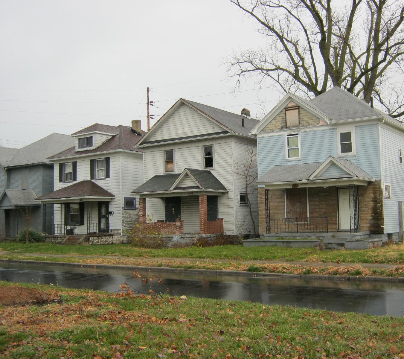
Poorly maintained properties in a neighborhood in Dayton, Ohio have a detrimental effect on the overall health of the area.
4Housing & Neighborhoods
Long Term
PARTNER WITH LOCAL BUSINESSES TO ESTABLISH A PUBLIC GRANT PROGRAM DESIGNED TO FUND IMPROVEMENTS IN GREENSBURG NEIGHBORHOODS.
Summary:
Establishing public grant programs designed specifically for neighborhoods allows the residents of these neighborhoods to have an active role in shaping their community’s future. Neighborhood residents will be able to decide what projects will provide the greatest impact on the area and submit those for a grant. This grant program could be established through donations from local industries to fund capital projects which would not be funded by traditional City programs. These programs may also fund events and service projects at the grassroots level. Based on funding availability, different grants may be established for different types of projects. By investing in their community, these industries are essentially investing in themselves and their current and future workforce by providing them a better community to live in.
Whether small or large in scale, it is important to establish clear grant guidelines. These should be as simple as possible while still achieving the overall program goals and may include:
• Funding objectives
• Projects that may receive priority, if any.
• Program eligibility requirements for receiving funding.
• Levels of grants to be awarded.
• The application review process, review criteria, and funding cycle, if any.
Actions Steps:
1. Facilitate discussions between neighborhood organizations, public leaders, and prominent industries to establish goals for the program.
2. Acquire either one time donations, or longterm reoccurring funding commitments from private partners in the community.
3. Establish the grant guidelines, application process, and review process.
4. Open the grant for submissions and advertise to neighborhood organizations about the possibilities of the funding program.
5. Review submitted application and select and award grant recipients.
6. Continue searching out and acquiring private funding if it is decided that the grant program will occur on a regular basis.
Resources:
• Engineering, Planning & Zoning Department
• Neighborhood Organizations
• Industry Leaders (Funding Source)
HNMedium Term
HELP TO FACILITATE THE CREATION OF NEIGHBORHOOD GROUPS TO ORGANIZE AND COORDINATE BEAUTIFICATION EFFORTS, CRIME PREVENTION EFFORTS, AND ENSURE OTHER CRITICAL NEIGHBORHOOD ISSUES ARE ADDRESSED.
Summary:
Ask people where they live and the range of results can vary from a specific street, neighborhood, city, or even state. How we describe the places where we live often says a lot about them. Residents of vibrant neighborhoods will often describe themselves as residents of that neighborhood rather than the city or town as a whole, while residents of places with less character may have to define some larger geography as where they live.
Safe, attractive, and welcoming neighborhoods make life better for their residents and a collection of these neighborhoods makes life better for the whole city. Great cities and the neighborhoods within them don’t just happen. Plans are made to guide the growth and changes that are constantly occurring. In order to improve quality of life in the City, preserve cultural and historic character, and enhance sense of place, the City should assist in the creation of neighborhood groups. This would help to establish stronger connections between neighborhoods and local government and aid in:
• Information distribution
• Advocating on behalf of the neighborhood
• Coordinating city services with needed user groups
• Anticipating neighborhood needs and presenting issues to city staff
• Promoting and marketing neighborhood events
Action Steps:
1. Facilitate discussions to determine where the appropriate boundaries for neighborhoods should be located.
2. Establish the official boundaries to define appropriate neighborhoods in the city.
3. Educate the community members on the benefits of organizing neighborhood organizations in which the leaders of those associations could have a direct line of communication with city leadership.
4. Support the newly formed neighborhood organizations in developing programs that improve the overall character of the neighborhood.
Resources:
• Engineering, Planning & Zoning Department
• Mayor’s Office
• City Council
• Residents
• Service Organizations
4
Housing & Neighborhoods
Long Term
INTERCONNECT NEIGHBORHOODS WITH RETAIL, EMPLOYMENT, AND RECREATION DESTINATIONS.
Summary:
Connectivity refers to the density of connections in pedestrian and road networks and the directness of links. A well-connected road or pedestrian network has many short links, numerous intersections, and minimal dead-ends. As connectivity increases, travel distances decrease and route options increase, allowing more direct travel between housing, commercial centers, and recreation attractions.
Typical connectivity standards or goals may include the features below. Of course, standards must be flexible and accommodate unique local conditions.
• Encourage average intersection spacing for local streets to be 300-400 feet.
• Limit maximum intersection spacing for local streets to about 600 feet.
• Limit maximum intersection spacing for arterial streets to about 1,000 feet.
• Limit maximum spacing between pedestrian/bicycle connections to about 350 feet (that is, it creates mid-block paths and pedestrian shortcuts).
• Reduce street pavement widths to 24-36 feet.
• Limit cul-de-sacs (for example, to 20% of streets in a subdivision).
• Limit the maximum length of cul-de-sacs to 200 or 400 feet.
• Limit or discourage gated communities and other restricted access roads.
• Require multiple access connections between a development and arterial streets.
• Create a planning process to connect street “stubs,” that is, streets that are initially cul-de-sacs but can be connected when adjacent parcels are developed in the future.
Action Steps:
1. Continue development and implementation of the trail network.
2. Continue to identify potential pedestrian linkages between neighborhoods and pedestrian destinations to reduce travel time, encourage walking and improve safety.
3. Work with local schools to develop safe routes to school plans to improve accessibility to federal and state funding sources.
4. Determine facility type that would most adequately serve each area identified for improvements.
5. Determine funding sources and rights of way acquisition issues.
6. Modify long-term transportation plans as needed to incorporate projects into the implementation schedule.
7. Pursue Transportation Alternatives funding.
Resources:
• Engineering, Planning & Zoning Department
• Plan Commission
• Indiana Department of Transportation
• Decatur County Parks and Recreation
• Transportation Alternatives funding
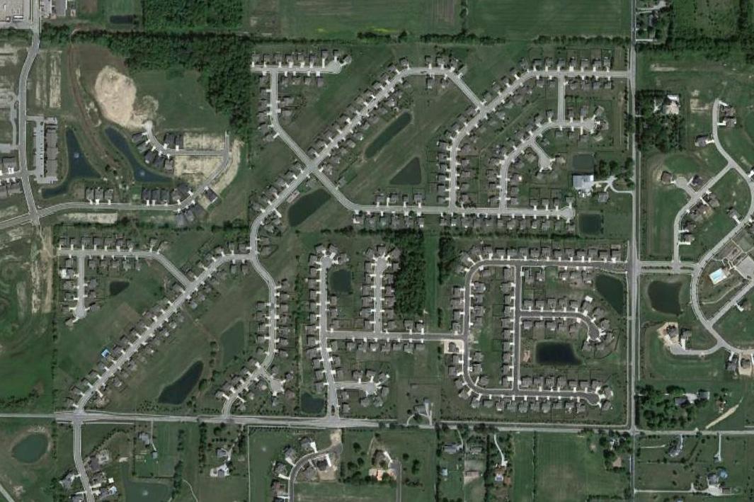
An example of poor connectivity where two houses that are fairly close together require a significantly longer trip to reach one another.
33 April 29, 2013
4Housing & Neighborhoods
HNShort Term
ENSURE QUALITY IN HOUSING DEVELOPMENTS WITH THE PROVISION OF COMMUNITY OPEN SPACE, LANDSCAPING, AND OTHER AMENITIES.
Summary:
As Greenburg continues to grow, it must stay current with the ever-changing housing market. The creation of new housing units almost always matches demand, the more difficult task is to ensure that new housing developments are of the quality and character desired by the community. Neighborhoods are where most Greensburg residents call home, and as such are the primary places to recreate, interact, and spend time outdoors. Quality subdivisions should be developed with respect to surrounding context to create more communal and attractive spaces with the provision of recreation areas, landscaping, and bicycle and pedestrian facilities. Subdivisions should not be developed as stand-alone entities with no connections to adjacent neighborhoods.
Action Steps:
1. Review the zoning ordinance and zoning map to determine potential adjustments to development intensity/density, architecture, bulk, massing, open space and setback requirements.
2. Consider incentives for tree preservation or additional open space amenities.
3. Amend the zoning ordinance to include more than one single-family residential district to allow for variability in density and open space requirements.
4. Amend the zoning ordinance to include anti-monotony regulations to prevent repetitive and uninteresting streets.
5. Amend the zoning ordinance to include design standards for multi-family residential development, including building form and scale, architectural detailing, acceptable building materials, and required amenities.
6. Ensure required open spaces are designed as usable and inviting spaces to facilitate interaction, not empty buffer spaces that are seldom used.
Resources:
• Engineering, Planning & Zoning Department
• Plan Commission
• City Council
A planted landscape median at the entrance to a neighborhood contributes to local character and identity.
5. ECONOMIC DEVELOPMENT
GOAL:
Grow existing businesses and attract new ones to establish a diverse employment base resulting in job opportunities for all in the community.
5Economic Development
EDA
Immediate / On-going
FOCUS ECONOMIC DEVELOPMENT EFFORTS TO DIVERSIFY THE JOB BASE AND INCREASE INCOMES AND AMENITIES IN GREENSBURG.
Summary:
One of the key strategies for the City to market itself for businesses is its location halfway between Indianapolis and Cincinnati. The City of Greensburg has established an industrial base of manufacturing in the City. The City understands the importance of diversifying its tax base after watching communities across the United States become distressed with the demise of the automotive industry during the recent recession. Additionally, the City supports the entrepreneurial spirit with smaller manufacturing businesses and independent retailers located in the vibrant downtown.
In order to protect the City from business slumps in the future, the City needs to continue to focus on and support economic development efforts that will diversify the job base and increase the average hourly wage in Greensburg. There is no single strategy that will lead to a more diverse economy; communities use a combination of approached that often include:
• Developing regional collaboration
• Promoting entrepreneurial development and providing technical assistance to small and start-up businesses.
• Leveraging existing assets to support local growth
• Enhancing the skills and capacity of the area workforce
• Encouraging reinvestment of local wealth back in to the economy.
The objectives on the following pages provide a more in depth analysis of many of these approaches.
Action Steps:
1. Hire a consultant to expand on the Greensburg Decatur County Economic Development Corporation targeted industries to identify business clusters that are potential strengths or emerging strengths.
2. Identify local businesses associated with targeted clusters that would help fill the supply chain
3. Develop matches between potential local producers (suppliers) and local businesses in targeted clusters.
4. Develop attraction programs to attract potential suppliers to relocate locally to help fill demands in the supply chain.
5. As part of a broader business retention and expansion visitation program, interview local industry human resources leaders and manager to determine potential skill gaps.
6. Organize and host business roundtable meetings based on business clusters.
7. Work with Greensburg Decatur County Economic Development Corporation to implement surveys of existing businesses. This would include identifying a scientific survey method, develop a timeline for data collection, develop questionnaire, develop media/public relations campaign to promote the survey and ensure a high
return rate, aggregate survey to analyze the results, repeat the survey annually or bi-annually.
Resources:
• Mayor’s Office
• Engineering, Planning & Zoning Department
• Greensburg Chamber of Commerce
• Main Street Greensburg
• Greensburg Decatur County Economic Development Corporation
• Southeast Regional Logistics Council
• Greensburg Community Schools
• Ivey Tech Community College
• Project Lead the Way
• Purdue College of Technology – Columbus
• Indiana Wesleyan University - Columbus
The automotive manufacturing industry has been incredibly important to the economic vitality of the City but efforts should be made to diversify the job base and protect against market shifts.
5Economic Development
ED B
DEVELOP GUIDELINES FOR THE USE OF PUBLIC INCENTIVES AS A POTENTIAL ATTRACTION TOOL.
Summary:
Incentives such as tax abatements are an important tool in economic development efforts to help attract and retain key businesses that will generate jobs and wealth for the local economy. It is important that a good assessment is done prior to approving incentives to assure that public investment will benefit the overall community. There are a number of best practices that other communities have used to help protect public investments in the private sector, but also make sure that they remain competitive in growing their community. Best practices include:
• Aligning incentives with a well-defined economic development strategy.
• Conduct a good cost-benefit analysis of potential incentive candidates. As a part of the review process, this will help decisionmakers better determine the overall net fiscal impact for deploying incentives in relation to the economic return to the community both short and long-term.
• There should be clear performance standards that must be met by those awarded incentives including penalties for failing to meet agreed upon performance criteria. Typical performance standards include a certain amount of job generation, increase in assessed value, minimum wage standards, participation in workforce training programs, or infrastructure development. Penalties, often called “clawbacks,” are provisions within an
incentive package that require those that receive incentives to pay back the incentive to the community if performance criteria are not met.
Incentive programs should be evaluated regularly. A mistake many communities make is that once incentives are given, there is not often the oversight and monitoring to track compliance with performance criteria, or more importantly, determine whether a particular incentive program is truly generating the economic returns intended.
Action Steps:
1. Evaluate current financial incentive programs and evaluate success in reaching intended results.
2. Develop overall criteria to determine incentive eligibility, noting that not all programs may have the same eligibility.
3. Refine scoring system for incentive eligibility based upon criteria to encourage a fair and objective evaluation process for presentation to decision-making bodies.
Resources:
• Greensburg Decatur County Economic Development Corporation
• Mayor’s Office
• Engineering, Planning & Zoning Department
• City Council
5Economic Development
EDC
Immediate / On-going
CONTINUE TO PARTNER WITH LOCAL SCHOOLS ON WORKFORCE DEVELOPMENT INITIATIVES.
Summary:
Workforce development is a critical component of any successful economic development effort. Workforce development may include skill development for displaced workers, on-thejob training for existing employees, education reform to adjust local curriculum, and other assistance to remove barriers to employment such as childcare, transportation, and skills accreditation. Industry growth is dependent on the supply of skilled labor. Without the availability of an adequate workforce, local expansion and the attraction of new businesses will be limited.
The Greensburg Learning Center is a tremendous community asset that should continue to be supported and expanded to help workers ensure their long-term employability and progression along a career path. Additional vocational training and two-year post-secondary programs in the community, either at the Learning Center or at another location, should be developed. A career ladders or pathways strategy supports worker transitions from work to training throughout the worker’s career. The objective is to offer continued step training to advance skills over time to improve overall wages and employment opportunities. Often times these pathways are developed in conjunction with industry groups, trade unions, and training organizations such as colleges, universities, and secondary schools. These programs will help transition the worker better into the workforce and help
identify and connect incumbent workers with training necessary for career advancement. For example, a career pathways program in health care can help advance a worker from an entry level nursing assistant to an LPN, RN, and potentially an advanced nursing specialty. Instead of all of this training upfront, which may be too much of a burden for many workers, the training can be in step programs allowing for continued employment and work along each step of the ladder. Career ladder programs are often focused on critical industries and occupations with employment gaps. These programs should be appropriately focused to existing and emerging industries and occupations.
Action Steps:
1. Determine industry cluster foci that would require higher levels of hiring, are experiencing worker shortages or whose growth would best benefit the City. These industries also need to include occupations that have a defined career progression.
2. Continue partnerships between industry leaders and local secondary and postsecondary training providers (ie Greensburg Community Schools, IUPUC, Ivy Tech).
3. Develop a recruitment program to recruit perspective employees for areas of occupational need and shortages. This recruitment program would screen applicants and refer them to training programs that have been customized for participating industry clusters.
4. Continue existing and develop new training and certification programs for participating industry clusters that would provide acceptable curricula and credentialing to participating perspective employees. These programs must address training not only for entry level positions, but also for advancement and transition between entry-level and mid-level, and mid-level and advanced-level.
Resources:
• Greensburg Decatur County Economic Development Corporation
• Greensburg Community Schools
• Ivy Tech Community College
• Indiana University Purdue University Columbus
• WorkOne Southeast
• Indiana Head Start Association
• Identified and participating industry clusters and businesses
• Area labor unions and trade groups
• Trade Adjustment Assistance Community College and Career Training Grant Program
• Workforce Innovation Fund
• H-1B Technical Skills Training Grants
• Health Care Innovation Challenge Grants
• Jobs and Innovation Accelerator Challenge Grants
Example of a career ladder for the heathcare profession.
5Economic Development
EDD
Immediate / On-going
CONTINUE THE BUSINESS VISITATION PROGRAM TO SUPPORT AND STRENGTHEN THE LOCAL BUSINESS CLIMATE.
Summary:
It is often said that 75 percent of resources for local economic development are spent on attracting 25 percent of new jobs to the community. Until recently, economic development efforts overlooked the fact that almost three-quarters of new jobs are created by existing businesses within the community. Improving business relations, improving communications, and reducing local barriers to growth can improve the business climate and accelerate job growth.
A Business Retention & Expansion (BR&E) program works to focus local economic development efforts on improving relationships with existing businesses, develop a working partnership with these businesses, and help work to match local and state resources to business needs. This can include identifying incentives, workforce training, serving as a liaison between local government and businesses, or business coaching, to name a few. To accomplish this, the community must develop a strong business visitation program.
The objectives of a BR&E program should be to:
• Demonstrate to local businesses that the community appreciates and supports their contributions to local economic growth and wealth.
• Help solve problems that businesses face where local resources can be brought to bear.
• Match education and technical assistance
programs to improve a business’s competitiveness.
A good BR&E program has the following components:
• An economic development official that is focused specifically on existing business development.
• A structured visitation program that includes face-to-face meetings with the same individuals to build trust.
• An annual survey program to supplement visits to identifying business needs on a broader scale.
• A follow-up visitation program to target specific barriers or issues that local resources can help solve.
Oftentimes a good business retention program requires a good deal of personhours and resources. One way local economic development agencies can supplement staff is to develop a volunteer program of local leaders or retired businessmen to assist with visitations or follow-up meetings based upon technical proficiencies.
Action Steps:
1. Appoint a coordinator for the program within the Economic Development Corporation staff. The coordinator will oversee staff resources and primary contacts.
2. Develop a volunteer taskforce to assist with business visitation and on-going business communications.
3. Develop an outreach marketing program to businesses to understand the intent of the program.
4. Develop a visitation schedule and hold meetings with local businesses. It is important that the confidentiality of information is maintained and that staff remain consistent so trust relationships can develop.
5. Supplement personal visitation with business retention and expansion surveys that can provide comparable and quantitative information on business needs.
6. Develop roundtables of similar businesses to foster better inter-business coordination and cooperation.
7. Assure follow-through on addressing issues and needs that businesses have that can be met by the local community.
Resources:
• Greensburg Decatur County Economic Development Corporation
• Volunteer program to expand interviewers (from business community)
• Corporate/community foundation grants for initial program development
• Chamber of Commerce
• Main Street Greensburg
PERCENT OF JOB GROWTH BY ECONOMIC DEVELOPMENT TYPE
Business Attraction, 15%
Study by Blane Canada, LTD, a major industrial site selection firm, showed the average percentage of job growth generated by existing businesses versus the attraction of new businesses.
5Economic Development
ED E
Immediate / On-going
CAPITALIZE ON EXISTING AUTOMOBILE MANUFACTURING BUSINESSES TO ATTRACT
ADDITIONAL SUPPLIERS AND MANUFACTURERS TO FILL GAPS IN THE SUPPLY CHAIN.
Summary:
Local communities often compete directly with each other to attract new businesses and jobs. While economic incentives like property tax abatements are still a big tool to be used by local economic developers, more communities are turning towards building long-term and sustainable relationships and climates to retain and grow their local businesses. One focus is to better develop the supply chain for key base sector employers. The supply chain refers to the overall process from moving a good from raw materials to finished product for the consumer. An individual business’s supply chain includes the suppliers that sell goods to the business and the buyers who buy finished product from that business. Depending upon the type of business, economic forces such as transportation costs or the need for specialized skilled labor pools make it more advantageous for various business types to locate closer together. These are called business clusters. A cluster analysis with a supply chain focus can identify existing product flows and help determine if attraction of new businesses or expansion of existing businesses can decrease supply chain costs and improve the overall business climate. This can be done through a combination of cluster analysis and identification, econometric modeling, and individual interviews and surveys with local businesses.
According to the US Small Business Association, proximate supply chains can:
• Innovate in conjunction with their suppliers — proximity between product design, engineering, marketing, and manufacturing teams can accelerate innovation;
• Practice more agile inventory management;
• Monitor production quality through frequent and ad hoc site visits;
• Reduce transit times for input goods;
• Limit the risk of supply chain disruptions caused by natural disasters, port strikes, and other emergencies;
• Minimize vulnerability to volatile energy costs — less energy is required to transport goods from nearby versus distant suppliers — as well as unpredictable currency values when sourcing from foreign suppliers.
Greensburg can provide support to local businesses to optimize their supply chain by:
• Assisting businesses in identifying gaps in their supply chain;
• Helping to match suppliers and buyers within the local market;
• More interaction with industry supply chain clusters as part of an overall business retention and expansion program.
Action Steps:
1. Identify all local businesses associated with automobile manufacturing.
2. Visit businesses to ascertain location of customer base and suppliers.
3. Develop matches between potential local producers (suppliers) and local businesses in targeted clusters.
4. Develop programs to attract potential suppliers to relocate locally to help fill local demands in the supply chain.
Resources:
• Greensburg Decatur County Economic Development Corporation
• Local industry associations and businesses in target cluster
• Chamber of Commerce
• US Economic Development Administration Technical Assistance Grants
5Economic Development
ED F
Immediate / On-going
CONTINUE TO PROMOTE AND DEVELOP EXISTING AGRICULTURE BUSINESSES AND OTHER INDUSTRIES CURRENTLY PRESENT IN GREENSBURG.
Summary:
Farming has historically been a significant segment of both Decatur County and Greensburg’s economy. While the majority of crop production and livestock raising takes place outside of the City, these operations are supported by agriculture-related businesses in Greensburg. The City wishes to promote agriculture and forest industries and enhance the economic viability of farming in Decatur County by promoting existing agriculture businesses such as implement dealers, agriculture product manufacturers and retailers, and agriculture-focused transportation companies.
Additionally, urban farming within City limits, farmer’s markets, and direct to consumer farm sales may strengthen the agriculture identity and economy in Greensburg. Increasing the amount of locally grown fruits and vegetables alaso promotes community health by expanding residents’ access to fresh, nutritious foods.
Action Steps:
1. Identify all local businesses associated with the agriculture industry.
2. Organize and host business roundtable meetings based on business clusters.
3. Ensure land use regulations permit agriculture activities appropriate within City limits.
4. Develop a marketing program to attract new agriculture businesses to the community.
Resources:
• Greensburg Decatur County Economic Development Corporation
• Local industry associations and businesses in target cluster
• Chamber of Commerce
EDG
Immediate / On-going
CONTINUE REGIONAL COORDINATION AND PARTNERSHIPS WITH SURROUNDING JURISDICTIONS AND ORGANIZATIONS.
Summary:
Regional coordination, communities working together and sharing information across political boundaries, is essential in the current business world. Employees, capital, and goods and services are all increasingly mobile. Regions must work together to develop, support, and promote common economic objectives for the benefit of each partner.
It is often difficult for one community to provide all of the necessary inputs and support to emerging enterprises, especially in undiversified manufacturing or agricultural economies. The results of regional collaboration can be mutually supportive plans and competitive benefits such as:
• A wider network of compatible business clustering.
• A wider array of services provided to a larger market.
• Efficiency in government resources by reducing overlaps in services.
• Coordinated infrastructure improvements.
• Capitalization of different skill sets.
• A unified image and asset base to project to businesses and people outside of the region.
Action Steps:
1. Continue to identify area public, private, non-profit and education institutions that could be potential partners. Existing regional organizations and state and federal agencies may also be beneficial partners.
2. Commit city staff and resources to participate in those organizations to build alliances and influence decision-making at the regional level.
Resources:
• Mayor
• City Council
• Engineering, Planning & Zoning Department
• Greensburg Decatur County Economic Development Corporation
• Greensburg Chamber of Commerce
5Economic Development
EDH
Immediate / On-going
IDENTIFY AND DEVELOP ENTREPRENEURIAL AND SMALL BUSINESS TALENT THROUGH PERSONAL, PEER, GROUP, AND COMMUNITY COACHING.
Summary:
Often times, economic development activities focus on business attraction efforts and luring new businesses and the promise of job creation to the community. While new business development does have a positive economic impact on the community, it also requires a substantial amount of resources. The “Economic Gardening” approach is based upon studies that show that many of the new jobs created in a community come from existing businesses, yet oftentimes business retention and expansion efforts receive fewer resources than attraction and business recruitment efforts.
The economic gardening approach is based upon a “grow from within” strategy helping existing businesses grow larger both in terms of jobs, wages, and wealth. This strategy includes more focus on strategic growth challenges such as developing new markets, refining business models, and gaining access to competitive intelligence. This shifts the role of the economic development official into helping CEOs and entrepreneurs identify which issues are hindering growth and then leveraging local resources to reduce barriers and improve the business climate. This may include workforce development and skills training programs and partnerships, financial incentives, business coaching, providing collective business or market intelligence, or additional strategies.
An entrepreneurship training program focuses directly on equipping potential entrepreneurs and new small business owners within a community with the knowledge and tools necessary to develop and sustain a successful business venture. The programs focus on a curriculum that includes the mechanics of running a business, strategic planning and marketing, understanding markets and customers, and financing. The programs typically also provide post-course counseling and coaching as the entrepreneur applies those skills to a new venture or startup.
Action Steps:
1. Develop a curriculum and training committee to determine overall audience and curriculum.
2. Develop a curriculum that addresses major small business development and entrepreneurship skill areas such as strategic planning, competitive advantage, target marketing, sales, human resources, cash flow and accounting, and financing.
3. Identify a training provider and program administrator.
4. Develop a targeted marketing program aimed at individuals or groups in which training would be beneficial.
5. Track progress of program participants to help measure success in generating new business startups and business success.
6. Link class graduation with access to capital funding like a micro-enterprise loan program and/or incubator or on-going coaching assistance.
Resources:
• IU Kelley School of Business/Johnson Center for Entrepreneurship & Innovation
• Local venture capital firms and programs
• Indiana Housing and Community Development Authority
• Greensburg Decatur County Economic Development Corporation
• Chamber of Commerce
• Main Street Greensburg
• U.S. Small Business Administration
• South East Indiana SCORE
SCORE is a nonprofit organization dedicated to assisting entrepreneurs and helping small businesses start, grow, and succeed. SCORE is also a resource partner with the U.S. Small Business Administration (SBA).
5Economic Development
ED I
Immediate / On-going
CONTINUE TO UTILIZE LOAN PROGRAMS, GRANTS, AND OTHER ECONOMIC DEVELOPMENT TOOLS TO ASSIST EXISTING BUSINESSES AND ATTRACT NEW ONES.
Summary:
The community currently uses a combination of economic development tools to support existing businesses and help grow new ones. Developing entrepreneurial talent and small businesses was a theme heard throughout the planning process. One such tool to assist small and start-up businesses are microenterprise loans.
Microenterprise loan fund programs target assistance for small businesses and startups that are typically not bankable. When the business startup has no other options, these programs provide “gap” financing, which means the funds are provided only when other financing sources are not available, to avoid competition with traditional banking institutions. Funds can be used for just about any purpose: machinery or equipment, building acquisition, new construction, remodeling, inventory, and/or working capital.
These programs are typically set up as revolving loan programs where repayment is used to replenish the fund for new borrowers. Typically, funding amounts are small and are capped for very small enterprises and include low to moderate income requirements. Many communities tie pre-business training and coaching as part of the loan requirements. They need to be tied to creating one or more jobs. These programs can be seeded through the Indiana Microenterprise Program through the Indiana Housing and Community Development Authority or through private banks that are looking to meet Community
Reinvestment requirements from the Federal Reserve.
Oftentimes small micro-business and entrepreneurial startups in distressed areas lack the ability to qualify for traditional financing and loan programs. This program can help small enterprises develop and thrive by providing gap financing. This can create immediate jobs within the targeted area as well as set the stage for future hiring as successful enterprises expand.
Action Steps:
1. Review overall mission and ensure funding priorities align with economic development and growth priorities.
2. Solicit additional seed funds from the Indiana Housing and Community Development Authority, local foundations, local corporations and financial institution Community Reinvestment Act funding. Seed money will be for sustaining the fund and growing capacity.
3. Appoint or hire a loan manager with experience in bookkeeping and ability to manage funds and compliance requirements.
4. Develop loan review committee who will be responsible for reviewing loan applications.
5. Develop application materials and application review criteria.
6. Market the program to the local small business community, banks and financial institutions, and financial planners who often have first contact with new startups seeking financing.
Resources:
• Local community foundations
• Local corporate foundations
• Economic Development Department
• Financial institution CRA funding
• Indiana Housing and Community Development Authority
The Indiana Housing & Community Development Authority offers small businesses loans through the Community Enhancement and Economic Development (CEED) Loan Program and the Business Expansion and Entrepreneurship Development (BEED) Program.
5Economic Development
ED J
Immediate / On-going
CONTINUE TO GROW THE HOSPITALITY AND RETAIL SECTORS TO SERVE RESIDENTS AND VISITORS AND AID IN THE ATTRACTION OF NEW BUSINESSES.
Summary:
Typical economic development goals include attracting and retaining employers, increasing the number of jobs in the community, raising incomes, and ultimately expanding the tax base of the City. Because of this, efforts are often focused on the more productive commercial and industrial sectors of the economy while the hospitality and retail sectors are viewed as secondary or dependent on primary job creators. It is true that retail businesses are often driven by the number of “rooftops” and will follow the creation of good jobs but that does not necessarily mean the anticipated retailers will locate within the City of Greensburg. If employees are traveling into the community for work but living elsewhere, that disposable income being used on retail and hospitality may be captured closer to home.
In order to grow the retail and hospitality sectors, the City must ensure there are appropriately zoned and competitively priced, developable areas within the City. Currently, the supply of undeveloped retail land is relatively low and prices are high. The completion of Veterans Way is intended to provide access to new commercial lands with visibility from the interstate. This may help to position Greensburg as more of a regional retail destination, while expanding job opportunities and aiding in the attraction of non-retail business growth.
Action Steps:
1. Be pro-active in zoning land for retail and hospitality uses in desired areas.
2. Upgrade the character of retail corridors with investment in streetscape amenities.
3. Coordinate business development efforts between the City, Chamber of Commerce, Economic Development Corporation, and other applicable organizations to create clusters of synergistic retailers.
Resources:
• Engineering, Planning & Zoning Department
• Plan Commission
• City Council
• Greensburg Chamber of Commerce
• Main Street Greensburg
• Greensburg Decatur County Economic Development Corporation
GOAL:
Plan for and develop infrastructure systems and a transportation network that efficiently serve the existing residents and businesses with the capacity to accommodate planned growth and development.
6Infrastructure & Services
Proposed
Transportation Improvements Summary Map
ISA
Short Term
COMPLETE THE CONSTRUCTION OF VETERAN’S WAY.
Summary:
Phase 1 of the Veteran’s Way project was under construction during the comprehensive plan process. Phase 1 stretches 1.1 miles from US 421 / Michigan Ave, north and then east along what is now Smith Road to the existing 90 degree turn east of Carver Street. Phase 2 will then continue the roadway to connect with State Road 3 at the existing Lincoln Street intersection. When complete, Veteran’s Way will provide access to developable land with visibility from Interstate 74 in hopes of bringing additional commercial development to the City. The majority of the funding for Phase 2 will come from a grant from the Indiana Department of Transportation, with a targeted completion date in 2018.
Action Steps:
1. Develop design alternatives and preliminary alignment.
2. Finalize engineering design.
3. Identify and acquire funding for property acquisition and construction.
4. Acquire right-of-way.
5. Advertise for bids and select contractor.
6. Construct new roadway segment.
Resources:
• Engineering, Planning & Zoning Department
• City Council
• Redevelopment Commission
• Street Department
• Indiana Department of Transportation
Preliminary Veteran’s Way Phase 2 alignment showing the connection to Lincoln Street at SR 3.
View looking west along Veteran’s Way during Phase 1 construction.
6Infrastructure & Services
ISB
Short Term
CREATE AND FUND AN ANNUAL STREET MAINTENANCE AND REPAIR BUDGET.
Summary:
Road maintenance and repair was identified as a common concern during the public outreach process, especially a lack of centerline and lane striping. Outside of funds for routine maintenance such as patching potholes and snow plowing, little money is budgeted for street repair, replacement, or resurfacing. Most recent road projects have utilized federal funds and/or Tax Increment Financing (TIF) funds for design and construction. The City should create and fund an annual street maintenance budget as part of the large capital improvement planning.
Because of limited financial resources, evaluation criteria should be established to prioritize projects. The two primary sources of funding for capital projects are revenues and the issuance of City bonds. Revenue sources include sales and development taxes, state shared revenue, and utility fees. On-going revenue streams should be used for annual maintenance and repair. Municipal bonds should only be used to fund large projects as necessary. Payments are then made by the municipality to the bond holder over an established period of time.
Action Steps:
1. Define criteria for evaluating road improvements.
2. Maintain an on-going list of potential projects and anticipated capital needs.
3. Periodically update and adopt the City’s Capital Improvement Plan based on anticipated need and projected growth.
Resources:
• Street Department
• Engineering, Planning & Zoning Department
• Mayor’s Office
• City Council
ISC
Immediate / On-going
EXAMINE OPTIONS FOR A NEW FIRE STATION SOUTH OF THE RAILROAD TRACKS
VERSUS INFRASTRUCTURE IMPROVEMENTS THAT WOULD ALLOW FOR BETTER PUBLIC SAFETY SERVICE TO THIS AREA.
Summary:
The 2007 Comprehensive Plan proposed a new fire station in the vicinity of the intersection of S Michigan Avenue / US 421 and S Co Rd 60 E. In the time since the previous planning effort, rail traffic through the City has increased. Providing adequate response times and public safety service to the areas of the City south of the railroad tracks remains a potential issue. If an accident or fire would occur south of Railroad Street when a train is passing through or stopped in the City, the fire department and first responders may be delayed. While an additional fire station south of the railroad tracks may be justified, the City should also examine the possibility of infrastructure improvements that would allow for access during times when a train is present. This would most likely be in the form of a grade separated (overpass) rail crossing. Initial costs would likely be higher for a grade separated crossing when compared to a new station but when equipment and on-going staffing and maintenance are considered, the overpass may be more feasible.
Action Steps:
1. Create a special study committee with representatives from the Fire Department, Police Department, Street Department, Engineering, Planning & Zoning Department, Decatur County Emergency Management Agency, and other applicable organizations.
2. Establish a strategy and goals for the study.
3. Develop evaluation criteria for viable alternatives.
4. Complete a cost – benefit analysis of alternatives.
5. Develop a recommended alternative to then pursue funding for the desired approach.
Resources:
• Fire Department
• Police Department
• Street Department
• Engineering, Planning & Zoning Department
• Decatur County Emergency Management Agency
• Central Railroad Company of Indiana
6Infrastructure & Services
ENSURE SAFETY AND OPERATION AT ALL AT-GRADE RAILROAD CROSSINGS.
Summary:
Train traffic volume has increased along the Central Railroad Company of Indiana tracks through Greensburg since the opening of the Honda manufacturing plant. Continued economic development successes and future Honda expansion may further increase the number of trains. There are numerous atgrade street crossings of the rail tracks within the City limits, most of which do not include safety gates or arms. Greensburg should work with the railway owner to ensure safety at all crossings. Rail crossing best practices to increase pedestrian and motorist safety include:
• Advanced warning signage
• Stop signs
• Pavement markings
• Flashing light signals
• Automatic control gates
• Gate arm skirting to discourage pedestrians from ducking under the arm
• Warning bells/sirens
• “Second Train Coming” active warning signage
• Clearing vegetation in sight triangles
• Lighting
• Improvements to the crossing surface
Action Steps:
1. Prioritize list of crossings in need of improvement.
2. Coordinate with rail owner / operator.
3. Identify and pursue funding for rail safety improvements.
4. Implement safety measures as funding is available.
Resources:
• Engineering, Planning & Zoning Department
• Street Department
• City Council
• Central Railroad Company of Indiana
• Indiana Department of Transportation
The
numerous at-grade rail crossings within City limits including along W. Washington Street (left) and Franklin Street (right) create traffic delays and safety concerns.
6Infrastructure & Services
ISE
Immediate / On-going
CONTINUE TO UPGRADE UTILITY INFRASTRUCTURE TO MEET THE NEEDS OF GROWING AND NEW BUSINESSES.
Summary:
As Greensburg continues to grow, development must proceed at a pace not to exceed the expansion of utility systems. To date, the utility companies serving Greensburg have been able to serve new and growing businesses with excess capacity or extend services as needed. This greatly aids in economic development efforts as a lack of necessary utilities can be a substantial obstacle to expansion or construction. Additionally, leapfrog development patterns and reactionary utility extensions can lead to increased extension distances, requiring more piping, pumping, and site disturbance. When this happens, the high costs are passed on to all customers, not just those using the upgraded or extended service. So while it is important to grow and maintain excellent utility systems, these extensions should be coordinated with land use and economic development plans to ensure efficiencies for all users.
Proposals to extend municipal utility service to areas outside of the City should:
• Be consistent with service extension plans.
• Of a demand within current capacity.
• Meet City design and construction standards.
• Enhance the contiguous development area of the City of Greensburg.
Action Steps:
1. Incorporate planned utility extensions as part of on-going land use planning and capital improvements programming.
2. Coordinate municipal service extensions with private and semi-public utility providers and vice versa.
Resources:
• Duke Energy
• Vectren
• Decatur County REMC
• Water and Wastewater Office
• Frontier Communications
• Enhanced Telecommunications Corporation (ETC)
• Decatur County Rural Water Corporation
• Engineering, Planning & Zoning Department
• City Council
ISF
INSTALL AND
IMPROVE
THE STORMWATER INFRASTRUCTURE SYSTEM TO REDUCE THE RISK OF FLOODING AND PROPERTY DAMAGE.
Summary:
Human development typically includes buildings, roads, and sidewalks that are all impervious surfaces. These impervious surfaces do not allow stormwater to infiltrate and recharge groundwater supplies. Instead, stormwater travels over the land and runs off at a rate much higher than would occur on the site before development. This stormwater runoff carries pollutants and sediment to receiving lakes, streams, and rivers thus degrading water quality. Additionally, increased stormwater volumes contribute to greater downstream flooding. Current stormwater management practices dictate that runoff be managed at the site level, using pipes, curbs, and detention basins to direct and/or temporarily store the stormwater until it is discharged at a rate equal to the pre-development condition. However, many parts of Greensburg were built out before the stormwater management regulations were in place. This lack of stormwater infrastructure results in periodic flooding after rain storms. Stormwater management retrofits are often very costly, but still a good investment. In 2010, the City commissioned a Stormwater Capital Improvement Project Program study with the help of a consultant. The study recommended a series of infrastructure improvements with an estimated total cost over $20 million. In order to implement these projects or other stormwater improvements, the City should consider developing a stormwater utility. This would then allow the City to collect fees to fund future improvements. Fees may be
based on type of development and/or the area of impervious coverage. In many cases singlefamily residential properties are billed a flat rate while commercial and industrial development charges are based on impervious area.
Action Steps:
1. Conduct a feasibility study to determine if implementing a stormwater utility is sensible in Greensburg.
2. If feasible, determine rates and the billing system that will be used. This may be combined with other water, wastewater, or utility billing.
3. Conduct a public information program to inform residents and businesses of the new fees.
4. Adopt an ordinance creating the stormwater utility; this may include credits or exemptions to provide relief from fees for certain land uses or incorporation of other stormwater management best practices.
5. Implement the stormwater utility program.
Resources:
• City Council
• Mayor’s Office
• Engineering, Planning & Zoning Department
• Water Department
• Wastewater Department
6Infrastructure & Services
EXAMINE OPTIONS FOR A NEW SURFACE WATER TREATMENT FACILITY TO ENSURE ADEQUATE POTABLE WATER SUPPLY FOR THE CITY.
Summary:
The City’s drinking water supply depends on both the quantity of water available to be extracted from water sources and the capacity of the City’s water treatment plants. The former depends on factors generally outside of human control such as quantity or rainfall and recharge of groundwater aquifers. The capacity of City water treatment facilities can be managed and increased with capital investment. The City currently utilizes both surface and groundwater supplies to meet the potable water needs of the community.
Measures to manage water demand and increase system efficiency will be important for the future success of Greensburg. However, over the long term, additional water sources will likely be needed to meet demand. For this reason, the City should explore the potential of a new surface water treatment facility either near the existing plant or near a new reservoir. The existing surface water treatment plant is older than the groundwater plant and will likely warrant upgrade or replacement first.
Action Steps:
1. Continue to monitor potable water demand as it compares to overall treatment capacity.
2. Conduct a feasibility assessment of potential treatment system improvements versus new facility construction.
3. Incorporate recommendations of the feasibility study into long-range capital improvements planning.
4. Identify and acquire funding for improvements.
5. Construct improvements to increase water supply for the City.
Resources:
• Mayor’s Office
• City Council
• Water Department
• Engineering, Planning & Zoning Department
The existing reservoir and surface water treatment plant provide a portion of the City’s potable water supply. A new treatment facility may be needed in the future to meet growing demands.
6
Infrastructure & Services
ISH
ADOPT A COMPLETE STREETS POLICY TO BETTER ACCOMMODATE USERS OF ALL AGES AND ABILITIES.
Summary:
Complete streets are designed to allow the safe access and movement of all users regardless of age and ability. A complete streets policy ensures that adequate consideration is given to multiple transportation users and abilities when designing, constructing, and reconstructing roadways and adjacent transportation facilities.
A complete streets policy is not a design prescription that states all roadways must contain every transportation element possible or that existing roadways must immediately be retrofitted. Instead, the complete streets policy requires that consideration be given to each transportation mode; walking, bicycling, driving, and transit. Obviously not all roads will be part of transit routes and some conditions may exist that prevent the inclusion of bicycle facilities. The intent is to recognize transportation corridors as more than streets for cars and to provide appropriate pedestrian and bicycle facilities in as many locations as possible.
Design elements of multi-modal streets can include:
• Sidewalks
• Bicycle lanes
• Dedicated transit lanes
• Safe and accessible pedestrian crossings
• Accessible pedestrian signals
• Comfortable and accessible transit stops
• Crosswalk countdown timers
• Pedestrian-scaled lighting
• Protected median islands for wide crossings
Not every street will need all of these elements but every street should be designed to balance safety and convenience for everyone using the road, regardless of age, ability or transportation mode. The benefits of these streets include:
• Improved safety
• Encourage walking and biking as opposed to driving
• Improved public health
• Improved environmental quality
• Allow for mobility of the elderly, children, and persons with disabilities
An example of an incomplete street; the lack of accessible pedestrian infrastructure leads to pedestrians in the roadway.
Action Steps:
1. Create a complete streets policy committee with representatives from the Engineering, Planning & Zoning Department, Plan Commission, Street Department, and community.
2. Establish a vision, strategy, and goals for the policy.
3. Develop evaluation criteria for the provision of necessary modes.
4. Draft the complete streets policy to guide future transportation decisions.
5. Adopt the policy.
Resources:
• Engineering, Planning & Zoning Department
• Street Department
• Plan Commission
• City Council
This complete street accommodates pedestrians, bicyclists, and motorists in a safe and attractive environment.
6Infrastructure & Services
IS
IDENTIFY GAPS IN THE SIDEWALK NETWORK AND CREATE A PLAN TO COMPLETE PRIORITY SECTIONS.
Summary:
Sidewalks are a key component of creating an attractive, walkable community. They help to connect residents to recreational amenities and commercial areas. Many streets in the city do not have or are lacking key connections in sidewalk infrastructure. Sidewalks should be repaired and installed where applicable to enhance continuity between and within neighborhoods. This would promote walkability and make Greensburg a more attractive and pedestrian friendly environment. Because funding for transportation projects, especially projects that serve non-vehicular travel, is limited, prioritization of the most important projects is necessary to ensure that the projects with the greatest benefit are constructed first. The current City policy require property owners to maintain the portion of the sidewalk in front of their parcel and repair or replace the sidewalk as needed. However, where a sidewalk is not present, the property owners are not required to install one. Additionally, the City may need to take it upon themselves to repair and replace sidewalks in targeted areas of the City to spur additional investment from property owners or serve areas where it may not be financially feasible for home owners to replace their sidewalks. Factors to consider when prioritizing projects
may include:
• Proximity to pedestrian or bicycle generators such as schools, parks, office areas, and higher density residential development.
• Connection to City or regional trails.
• Location along an arterial or major collector.
• Proximity to low-income neighborhood.
Action Steps:
1. Identify key pedestrian generators.
2. Identify potential barriers to pedestrian accessibility.
3. Map gaps in pedestrian facilities.
4. Develop evaluation criteria to prioritize projects.
5. Seek creative funding such as public-private partnerships and grant opportunities to construct missing or deteriorated sidewalk facilities.
Resources:
• Mayor’s Office
• City Council
• Engineering, Planning & Zoning Department
• Street Department
An existing sidewalk gap along N. Michigan Avenue.
6Infrastructure & Services
ISJ
Short Term
CLOSELY COORDINATE WITH INDOT REGARDING IMPROVEMENTS TO STATE ROUTES WITHIN GREENSBURG CITY LIMITS.
Summary:
The City of Greensburg is a transportation crossroads for several regional thoroughfares including Interstate 74, US Highway 421, State Road 3, and State Road 46. All of these roadways are under the control of the Indiana Department of Transportation and as such, the City has limited authority regarding maintenance and improvements. The City should capitalize on all opportunities to coordinate with INDOT regarding state routes through the City. The City should leverage local funds to supply required matches for additional funding from INDOT. With local cooperation and investment, INDOT is increasingly willing to partner on beautification and enhancement efforts.
The Highway 421 / Buckeye Street streetscape in the Town of Osgood is an example of local coordination with INDOT that created a more attractive and pedestrian friendly streetscape through the center of town.
Action Steps:
1. Identify a City contact person to act as a liaison with INDOT.
2. Continue communication regarding existing concerns and potential projects.
3. Using existing City resources and pursue additional funding to provide local matching funds for beautification and enhancement efforts.
Resources:
• Mayor’s Office
• City Council
• Engineering, Planning & Zoning Department
• Street Department
• Indiana Department of Transportation
ISK
Immediate / On-going
COORDINATE UTILITY, TRANSPORTATION, STORMWATER, AND OTHER INFRASTRUCTURE IMPROVEMENTS TO COMBINE CONSTRUCTION PROJECTS AND REDUCE COSTS.
Summary:
The City of Greensburg is the primary public facility and service provider for water, sewer, stormwater, and transportation infrastructure within the municipal boundaries. Other providers include the Indiana Department of Transportation, Vectren Energy, Duke Energy, Decatur County REMC, Decatur County Rural Water, Frontier Communications, Enhanced Telecommunications Corporation (ETC), and others. When the City of Greensburg or another provider is undertaking a capital improvements project, such as a road reconstruction or sewer line replacement that requires disturbance to the right-of-way, other potential improvements should be considered to create time efficiencies and cost savings.
Action Steps:
1. Maintain relationships with all utility and service providers within the municipal boundaries.
2. Maintain an on-going list of potential projects and anticipated capital needs.
3. Periodically update and adopt the City’s Capital Improvement Plan based on anticipated project needs.
4. Communicate planned capital improvements with utility and service providers outside of City government and ask they so the same.
5. Coordinate projects where possible.
Resources:
• Engineering, Planning & Zoning Department
• City Council
• Street Department
• Indiana Department of Transportation
• Duke Energy
• Vectren
• Decatur County REMC
• Water and Wastewater Office
• Frontier Communications
• Enhanced Telecommunications Corporation (ETC)
• Decatur County Rural Water Corporation
6Infrastructure & Services
LISImmediate / On-going
EXPAND THE GREENSBURG MUNICIPAL AIRPORT TO SERVICE LARGER AIRCRAFT.
Summary:
The Greenburg Municipal Airport is a public use airport located just south of the intersection of State Roads 3 and 46 on the southwest side of the City. It was purchased by the City in 2007 and is managed by the Greensburg Board of Aviation Commissioners. There have been ongoing plans to expand the runway from the current 3,400 feet to 5,400 feet with a parallel taxiway. An airport layout plan was approved in 2010 with the environmental review process currently underway.
This new runway would allow larger aircraft including regional jets to use the airport. The airport expansion could serve as a strong economic development tool and aid in supporting existing businesses and attracting new ones. The City should support continued efforts to complete the expansion.
Action Steps:
1. Complete environmental review of the proposed airport layout plan.
2. Identify and acquire funding from the FAA for property acquisition and construction.
3. Acquire necessary property.
4. Advertise for bids and select contractor.
5. Construct airport improvements.
Resources:
• Mayor’s Office
• City Council
• Board of Aviation Commissioners
• Federal Aviation Administration (FAA)
Proposed Airport Layout Plan
7. DOWNTOWN
GOAL:
Continue to develop an active downtown that supports social and cultural diversity for the residents of the community in an inviting and walkable atmosphere.
DTA
Long Term
ENHANCE GATEWAY AND CORRIDOR
CONNECTIONS BETWEEN THE DOWNTOWN AREA AND THE SURROUNDING NEIGHBORHOODS.
Summary:
Downtown Greensburg and the areas surrounding it currently have a sense of a physical and aesthetic disconnect. To help bridge this gap and expand the “Downtown Atmosphere” that is so prevalent on the courthouse square, the City should create downtown gateways and prioritize bicycle and pedestrian connections to and from the downtown. Additional streetscape design, infill development, and wayfinding signage will tie the downtown and surrounding neighborhoods together. The first major improvement that needs to occur is to finish the streetscape design work that was done on the four streets that make-up the courthouse square. The west side of the square was completed, but the other three have not yet been updated. During this streetscape update, roads leading out of downtown should be considered for improvements as well. One of the most effective ways to connect the downtown and the surrounding neighborhoods is by giving the residents of those neighborhoods safe accessible sidewalks to form a physical connection. These sidewalks can be part of the new streetscape designs, providing both beautiful streets and safe sidewalks at the same time.
Many of the businesses on the edge of downtown have placed their parking lots behind their building which is commonly a good practice for walkable urban areas, but because the parking requirements are so high in this area the parking lots are quite large and
create a physical gap separating the downtown form the surrounding neighborhoods. With lower parking requirements these large lots could begin to be used for infill development. Another major factor that is causing a sense of disconnect between the downtown and the neighborhoods surrounding it is the separation of land uses between the two areas. The downtown area is primarily commercial uses; retail stores, service businesses, and restaurants while the surrounding neighborhoods are mostly residential land uses with single family homes. If the large parking lots that are currently creating a barrier around downtown were developed with new structures that had a vertical mix of residential units and retail space than these developments could serve as the transition between the two currently separated areas.
Action Steps:
1. Design and continue streetscape improvements to the rest of downtown and into the surrounding neighborhoods, including pedestrian infrastructure in these designs.
2. Extend the signage and branding efforts of Downtown Greensburg into the surrounding neighborhoods.
3. Amend the zoning ordinance to allow lower parking requirements in the downtown area so that the large parking lots can become infill development opportunities.
4. Support efforts for infill development that promote best practices for walkable urban areas and encourage future growth.
Resources:
• Engineering, Planning & Zoning Department
• Plan Commission
• City Council
• Redevelopment Commission
• Main Street Greensburg
Entrances to downtown would benefit from additional gateway signage, landscape treatments, lighting, and other amenities to create a stronger connection between the downtown and surrounding neighborhoods.
IMPLEMENT
THE
STREETSCAPE PLAN FOR THE ROADS SURROUNDING THE COUNTY COURTHOUSE TO PROVIDE CONTINUITY WITH THE EXISTING IMPROVEMENTS ALONG BROADWAY STREET.
Summary:
Downtown Greensburg is not only a valued asset to the city, it also serves as the political and cultural hub for all of Decatur County. The Broadway Street enhancements were completed in 2010 after recognizing the need for a safer and more aesthetically pleasing courthouse square. The remaining three blocks around the courthouse along Main Street, Franklin Street, and Washington Street should be competed to unify the square and continue demonstrating a commitment to the success of the downtown. The existing plans should be reviewed to ensure this is still the desired vision for the square, after which design should be finalized and funding pursued. Collaboration with the Indiana Department of Transportation will be necessary as Main Street is also State Road 46 and under INDOT control.
Action Steps:
1. Collaborate with INDOT to develop the streetscape for the southern section of the courthouse square.
2. Finalize design recommendations and preliminary engineering.
3. Identify and acquire funding for construction.
4. Advertise for bids and select contractor.
5. Construct streetscape improvements.
Resources:
• Engineering, Planning & Zoning Department
• Plan Commission
• City Council
• Redevelopment Commission
• Main Street Greensburg
• Decatur County Commissioners
• Indiana Department of Transportation
The downtown streetscape plan included improvements on all four streets comprising the square. The Broadway Street enhancements were completed in 2010. (Image: The Schneider Corporation)
DTC
Immediate / On-going
SUPPORT INFILL DEVELOPMENT THAT REFLECTS AND REINFORCES THE HISTORIC CHARACTER IN THE DOWNTOWN AREA.
Summary:
Aside from the iconic courthouse, downtown Greensburg is known for the historic character that has been preserved around the square and in neighboring blocks. To ensure this historic character remains, new construction and redevelopment will need to be designed in such a way that matches the historic atmosphere. One way that this can be accomplished is by developing design standards that will ensure new development and redevelopments will complement the existing historic buildings in the downtown. These design standards can include; façade requirements, maximum and minimum setbacks, height restrictions, and parking requirements. Increasing these design standards in the downtown will result in better quality construction and redevelopment that will help to spur continued investment in the area.
Action Steps:
1. Facilitate discussions with major stakeholders in the downtown area to determine what design features are important to the character of Downtown Greensburg.
2. Amend the zoning ordinance for the Central Business District to include the design standards most important in maintaining the character of downtown.
3. Promote infill development and redevelopment that embraces these new design standards.
Resources:
• Engineering, Planning & Zoning Department
• Plan Commission
• City Council
• Redevelopment Commission
• Main Street Greensburg
• Historical Society of Decatur County
An infill development that includes retail on the first floor with residential units above reflects historic scale and character but with a more contemporary design.
DTD
Immediate / On-going
ENSURE THAT DEVELOPMENT REGULATIONS ALLOW FOR MIXED-USE DEVELOPMENTS AND REFLECT BEST PRACTICES FOR WALKABLE URBAN DISTRICTS.
Summary:
Downtowns become more vibrant with more activity happening in them throughout the day, but many downtowns suffer from the fact that they are only home to businesses. This means that outside of typical business hours there is little to no activity in these areas. A solution to this problem is to provide attractive residential units and late night businesses and activities. Offering these amenities will create an environment that is interesting and activated for a majority of the day, 7 days a week.
To help support residential and commercial uses in the downtown district, the zoning ordinance needs to allow for a mix of uses in a single building. Retail commercial uses should be limited to the ground floor, this helps to activate the street level and attracts individuals into the stores. Residential and office uses can be reserved for upper floors, these uses are not as dependent on their connection with the individuals on the street level. Having this mix of uses in the downtown district will allow individuals to live, work, and “play” in Downtown Greensburg.
Action Steps:
1. Develop text and map amendments (if necessary) to the zoning ordinance to allow for a more mixed-use in the downtown area.
2. Engage downtown businesses and citizens on these potential changes.
3. Adopt changes to the zoning ordinance.
4. Promote mixed-use development to property owners and future developers.
Resources:
• Engineering, Planning & Zoning Department
• Plan Commission
• City Council
• Redevelopment Commission
• Main Street Greensburg
Mixed-use development that includes residential or office uses above ground floor retail can contribute to more around-the-clock activity in the downtown.
DT E
Immediate / On-going
CONTINUE AND EXPAND
THE EXISTING FAÇADE IMPROVEMENT PROGRAM TO RESTORE AND PRESERVE THE HISTORIC CHARACTER IN THE DOWNTOWN AREA
Summary:
The façade improvement program was established to initiate enhancements to historic buildings in the downtown district. The grant program is operated by Main Street Greensburg and provides a 50 / 50 match of up to $5,000 for any business or building owner who is renovating a façade within the area bounded by North Street, Lincoln Street, Railroad Street, and Ireland Street. The monies can be used for repair or cleaning of existing facades; exterior painting; repairing or replacing architectural elements such as cornices, doors, windows, lighting, and decorative details; and sign removal, repair or replacement.
While this program is working successfully, informing more property owners of this program would allow more buildings to have their façades restored. With more interest in this grant program, Main Street Greensburg will need support from new donors to help meet the higher demand in grants. These donations will mostly come from major businesses and employers in the community, but these donations can also come from residents that have an interest in the overall success of Greensburg.
Action Steps:
1. Contact major industries and employers in the community and ask for both short-term and long-term financial commitments for funding future grants.
2. Educate the property owners in the downtown district about this and other grant opportunities they qualify for.
3. Consider expansions of the eligible area.
4. Continue to assess goals and successes of the program and amend as necessary.
Resources:
• Main Street Greensburg
• Engineering, Planning & Zoning Department
• Plan Commission
• Major Industries and Employers
Before and after photos of the building at 105 S. Franklin Street. The improvements were partially funded through the Main Street Greensburg facade improvement program. (Image: Main Street Greensburg)
DT F
Immediate / On-going
ENSURE SURROUNDING DEVELOPMENT SUPPORTS AND POSITIVELY IMPACTS THE DOWNTOWN.
Summary:
The success of the downtown district is highly influenced by the types of land uses and developments that surround it. Currently there is a wide array of uses surrounding the downtown district, some of these are supporting the downtown, while others are detracting from it. The commercial land uses surrounding a majority of the downtown are supporting the current land uses in the area by creating a larger district of commercial businesses that attract more consumers to the area. The residential areas near downtown help to provide residents that can support the commercial district in and around downtown.
Unfortunately there are numerous vacant and underutilized parcels and several surface parking lots surrounding the central business district. When redeveloped these properties should be converted to commercial and residential uses that contribute to the downtown character. Industrial uses should be relocated to more appropriate areas on the periphery of the City. Some of the existing industrial site have become an eye-sore to the community, and a deterrent to future development. These uses can create negative externalities for the properties in close proximity to them, in turn lower their property values.
Action Steps:
1. Amend the zoning ordinance for the Central Business District to include the standards which detail appropriate uses and promote character of downtown.
2. Establish a procedure to review plans that are submitted for projects within or near the downtown area.
3. Promote and enforce the additional standards for the downtown and surrounding area to encourage a more cohesive district.
Resources:
• Engineering, Planning & Zoning Department
• Plan Commission
• City Council
• Redevelopment Commission
• Main Street Greensburg
8. COMMUNITY CHARACTER
GOAL:
Use the existing amenities and positive characteristics of the community as a catalyst for additional amenities and improvement that will continue to increase the quality of life for the residents of Greensburg.
8Community Character
CCA Long
Term
CONTINUE STREETSCAPE IMPROVEMENTS ON LINCOLN STREET THROUGH TO SR46/MAIN STREET.
Summary:
In 2012 the City of Greensburg completed a two-year construction project which consisted of reconstruction of approximately one mile of Lincoln Street from SR 3 to 1st Street. The reconstruction work included gateway signage, water mains, storm sewers, roadway, sidewalks, traffic signals, street lights, fire hydrants, and decorative landscaping. These improvements have had a positive impact on the corridor and improved the overall aesthetic character of the community.
It is recommended that streetscape enhancements be continued along Lincoln Street, south of 1st Street and the Decatur County Memorial Hospital to SR 46 / Main Street. The character of the roadway transitions from commercial uses north of 1st Street to residential uses south of 1st Street. Because of this, the streetscape treatment should be modified some. The overall design theme and fixtures should remain consistent but the specific design should be modified to protect the existing, mature street trees and adjacent residential development.
Actions Steps:
1. Identify and acquire funding for design.
2. Develop plans, using the recent Lincoln Street improvements as a starting point.
3. Finalize design recommendations and preliminary engineering.
4. Identify and acquire funding for construction.
5. Advertise for bids and select contractor.
6. Construct new roadway segment.
Resources:
• Engineering, Planning & Zoning Department
• Street Department
• City Council
Lincoln Street streetscape enhancements at the corner of First Street and Lincoln Street.
View looking south along Lincoln Street; the existing tree lawn should be maintained but additional improvements may help unify the streetscape south to Main Street.
8Community Character
CCB
Long Term
COLLABORATE WITH INDOT TO IMPLEMENT STREETSCAPE IMPROVEMENTS ON MICHIGAN AVENUE FROM SR3 TO ITS TERMINUS NORTHWEST OF DOWNTOWN GREENSBURG.
Summary:
With the construction of the Interstate 74 / US 421 interchange, the Michigan Avenue corridor has become a major gateway into the City. The current configuration of the rightof-way from SR 3 to downtown Greensburg is very automobile-oriented with few if any pedestrian facilities in sections. The corridor hosts a steady volume of vehicular traffic while accommodating single-family residential homes, community serving retailers, and civic institutions, among other types of land uses. The corridors role as a transportation thoroughfare, commercial district, and residential street has resulted in conflicting land uses, traffic inefficiencies, and unsafe pedestrian environments.
In order to increase the aesthetic appearance of the corridor and accommodate more transportation modes than just automobiles, the City should partner with INDOT to implement a streetscape plan for Michigan Avenue. Principal elements of the plan should include:
• Desired land use and development character along the corridor.
• The design of roadway improvements to best support the desired land use mix and community character while maintaining a safe and efficient transportation system.
• How non-roadway and right-of-way improvements (e.g. sidewalks, bicycle lanes, landscaping, lighting and furnishings, signage) should be incorporated to
increase the aesthetic appeal of the corridor, encourage new investment, and support multiple modes of transportation.
Action Steps:
1. Continue coordination with INDOT to ensure the City has a voice in future improvements or modifications to US 421 / Michigan Ave.
2. Take an active role and participate in developing studies for roadway reconstruction that will improve flow, but also develop travel options for all modes including bicycles and pedestrians.
3. Engage businesses and residents along the corridor and work to make sure modifications do not negatively impact operations in commercial areas.
4. Coordinate design with INDOT, consultant, and other City departments.
5. Assist in funding acquisition and if necessary, easement or property purchase.
6. Construct improvements.
7. Establish an on-going maintenance plan.
Resources:
• Indiana Department of Transportation
• Mayor’s Office
• Engineering, Planning & Zoning Department
• Street Department
• Board of Works
• City Council
Existing views along Michigan Avenue showing a lack of pedestrian amenities, varied signage, and limited landscaping.
8Community Character
CCC
Long Term
COLLABORATE WITH INDOT TO DEVELOP AND IMPLEMENT STREETSCAPE IMPROVEMENTS ON SR46/MAIN STREET, SPECIFICALLY NEAR THE COUNTY COURTHOUSE IN DOWNTOWN GREENSBURG.
Summary:
State Road 46 is one of the main corridors for individuals traveling around or through Greensburg, and for this reason, should be a more aesthetically pleasing corridor. The only portion of this road that has a consistent sidewalk is within and near the downtown district, which makes it very dangerous for pedestrians in other areas. Along with an absence of sidewalks, there are few street trees planted along the road. With the number of daily travelers on State Road 46, it should be a more attractive corridor that embodies the character of the entire community. Additionally, much of the State Road 46 corridor does not include storm water management techniques beyond typical storm drains. Each time there is a heavy storm that the storm drains can’t manage, the road becomes temporarily flooded.
The segment of State Road 46 that runs through the downtown district does include most of these amenities, but because the downtown district is such an iconic asset to the community, this segment should provide an even better experience. Streetscape improvements around the courthouse square are included in the Downtown section of this plan.
The entire streetscape improvement process will need to be coordinated with INDOT because they have control over this state road. The new improvements should include street trees and a sidewalk network on the portions of State Road 46 outside of the downtown district. Within the downtown there needs to
be more pedestrian amenities and potentially bicycle facilities. These facilities can include; bike racks, benches, information kiosks, landscaping buffers separating the sidewalk from the travel lanes, pedestrian scaled lighting, and well defined crosswalks.
Action Steps:
1. Continue coordination with INDOT to ensure the City has a voice in future improvements or modifications to SR 2 / Main Street.
2. Take an active role and participate in developing studies for roadway reconstruction that will improve flow, but also develop travel options for all modes including bicycles and pedestrians.
3. Engage businesses and residents along the corridor and work to make sure modifications do not negatively impact operations in commercial areas.
4. Coordinate design with INDOT, consultant, and other City departments.
5. Assist in funding acquisition and if necessary, easement or property purchase.
6. Construct improvements.
7. Establish an on-going maintenance plan.
Resources:
• Indiana Department of Transportation
• Mayor’s Office
• Engineering, Planning & Zoning Department
• Street Department
• Board of Works
• City Council Streetscape improvements along Main Street would create a more attractive entrance into downtown and create a safer pedestrian environment.
8Community Character
Medium Term
UTILIZE
PUBLIC-PRIVATE PARTNERSHIPS
WITH LOCAL INDUSTRIES TO CREATE, IMPLEMENT, AND FUND A PUBLIC ART PROGRAM TO FURTHER BEAUTIFY THE COMMUNITY AS A WHOLE.
Summary:
Public art is a simple and unique way to make a community a more beautiful place to live and raise a family. Public art can be used to transform a plain wall or an uninteresting plaza into a culturally diverse space that serves as a new landmark for the community. These pieces of art can even be created by Greensburg residents, allowing citizens to have a more direct impact on shaping their physical community. Typically, the types of public art that will be funded are long-term projects that are intended to remain for a number of years or even a few decades before they are moved or replaced. Aside from long-term projects, a public art program could arrange to have different traveling exhibits rotate their work in the community throughout the year.
The City wishes to support arts programming but leadership of this objective will need to happen outside of City Hall. Implementing these projects should occur through publicprivate partnerships with industries in the community. These partnerships with private industries would be seen as philanthropic work that is bettering the community as a whole.
Action Steps:
1. Examine the zoning ordinance and ensure that the ordinance does not prevent artistic expression and encourages public art as a part of a development program.
2. Modify the zoning ordinance as needed through the amendment process.
3. Examine planned public infrastructure projects and locations to determine if public art should be included as a component of the project.
4. Work with the arts community through an arts master planning process to determine locations throughout the community where public art could enhance or contribute to improved neighborhood aesthetics and sense of place.
5. Develop an information piece to make property owners aware of potential funding sources and allies within the community that can assist with public art creation, selection or installation.
Resources:
• Mayor’s Office
• Engineering, Planning & Zoning Department
• City Council
• Plan Commission
• Greensburg Decatur County Economic Development Corporation
• Main Street Greensburg
• Historical Society of Decatur County
• Arts and Culture Council of Decatur County
Opportunities for public art include spaces within the public right-of-way like the decorative fountain and seating in the Fountain Square neighborhood of Indianapolis (left), blank building walls (right), and additional civic and private properties.
8Community Character
CCE
Short Term
DEVELOP AND IMPLEMENT A BRANDING AND WAYFINDING PROGRAM TO HELP STRENGTHEN THE CITY.
Summary:
Developing a brand identity has long been used by businesses and corporations to build a customer base, launch a new product, or maintain a certain image. Communities can use many of the same techniques to build confidence in existing residents, attract visitors, and grow the local economy. More than a logo and tagline, a brand is a set of tools used to create differentiation of the community and over time build an appearance, feeling, and imagery among residents and the surrounding region.
There are concerns with trying to develop a branding strategy or expand on existing efforts. Incorporating cliché statements and themes in a brand can be interpreted as artificial and contrived and therefore offputting. Additionally, if the brand doesn’t resonate with the local community, it will not be accepted and used as a selling point. The best brands are relevant to locals and done with creativity. While a community’s history is important, branding should reflect what the community is today and what it is going to be tomorrow.
Branding standards may then be incorporated into gateway treatments and wayfinding signage. The ability to navigate a city is vitally important to its economic prosperity. Visitors to a community need to be able to orient, find local services and points of interest, and feel that they can safely travel to their destination. It is recommended that the City implement a coordinated and comprehensive
graphic signage and wayfinding system using the community brand as a means for directing drivers, riders and pedestrians to key destinations within the City of Greensburg and surrounding areas.
The Las Vegas welcome sign is an iconic gateway feature which contributes to city branding and is immediately recognizable. While this style may not be appropriate for Greensburg, this sign illustrates the powerful message a gateway can deliver.
Action Steps:
1. Create a committee to lead the development of a branding and marketing strategy. Representatives could include City staff, business leaders, non-profit organizations, and residents.
2. Develop a list of desired outcomes and a timeline for implementation of the branding program.
3. Identify groups or individuals likely to benefit from the implementation of a branding and marketing program and solicit funds from those beneficiaries in addition to public contributions.
4. Secure the services of design/marketing professionals to prepare the branding package.
5. Develop an annual marketing budget and lead individual to oversee on-going marketing updates.
6. Monitor program success and amend as needed to achieve desired results and newly emerging targets.
7. Use the branding program to develop wayfinding material that can be used to help individuals more easily move throughout Greensburg.
Resources:
• Mayor’s Office
• Engineering, Planning & Zoning Department
• City Council
• Plan Commission
• Greensburg Decatur County Economic Development Corporation
• Main Street Greensburg
• Street Department
• Visit Decatur County
• Decatur County Visitors & Recreation Bureau
An example of a wayfinding signage system developed for the White Lick Creek Trail in Avon, Indiana.
8Community Character
CCF
UTILIZE DEVELOPMENT TOOLS AND INCENTIVES TO ESTABLISH A HIGHER QUALITY OF DESIGN AND CONSTRUCTION AT KEY GATEWAY AREAS.
Summary:
A gateway is a landmark, streetscape, or land use transition that a resident or visitor first sees and experiences when entering a particular area. It not only provides a physical and sensory point of entry into a place but helps to define community identity and can have a significant impact on perceptions of the area. Gateways should not be thought of simply as objects placed in the landscape, but as a series of spaces and elements that are interconnected and provide a unique and identifiable sense of place.
Greensburg’s major gateways and entry corridors provide a range of experiences from highway oriented businesses to residential thoroughfares and even rural county roads. Currently there are few distinguishing features or architectural detail to inform travelers of their entrance into the community. Design guidelines and incentives should be used in gateway areas to promote and include:
• Higher quality building design
• Public art
• Signage
• Landscape plantings
• Enhanced lighting
• Recreation spaces
Potential development incentives may include:
• Density bonuses
• Reduced permit or connection fees
• City-led infrastructure improvements
Ensuring that the main entry points in the community are the best they can be will help to encourage higher design standards throughout all of the community.
Action Steps:
1. Identify the key gateways that are most traveled by individuals as they enter and exit the city.
2. Conduct public outreach to validate gateway locations and identities and ultimately develop goals and objectives of the program.
3. Amend the zoning ordinance to create an overlay district for these areas that promotes high design standards.
4. Ensure code enforcement in these high visibility areas.
Resources:
• Engineering, Planning & Zoning Department
• Plan Commission
• City Council
9. PARKS & RECREATION
GOAL:
Continue to grow and operate an unequaled parks and trails system for residents and visitors that promotes health, active living, and environmental protection.
9Parks & Recreation
PRA
Immediate / On-going
EXPAND THE EXISTING TRAIL SYSTEM TO BETTER CONNECT THE COMMUNITY AND MORE EASILY SERVE THE RESIDENTS.
Summary:
The need for improved bicycle and pedestrian facilities in Greensburg was a consistent theme throughout the planning process. Multimodal facilities not only provide increased transportation choices and recreation amenities but also contribute to community character, improve quality of life, and can act as an economic development tool. The City should strive to develop a system that connects existing and future neighborhoods, commercial destinations, parks and schools, as well as other regional trails and paths. The existing trail running from the Decatur County Community Schools administration building, south to Oddfellows-Rebekah Park has been widely used since its opening.
The trails or multi-use paths recommended on the following map should generally be constructed as 10 - 12 foot wide, hard surfaces that can be shared by pedestrians, bicyclists, and other non-motorized users. The primary distinction between a trail and a multi-use path is whether it is located adjacent to a roadway. Multi-use paths are located within the road right-of-way and may be present on one or both sides of the street. When present only on one side of the street, a sidewalk is recommended on the other side. Multi-use paths are often used as a transportation alternative; therefore, a planted strip should be installed as a buffer between the roadway and the path wherever possible.
The word “trail” is used to describe paths that are not located adjacent to a road but instead
follow natural features, rail corridors, utility corridors, or other features.
Routes on the map are identified as “primary” or “secondary.” These designations were based on factors such as route importance, existing right-of-way width, potential property acquisition, and anticipated construction difficulty or cost. As conditions change, these priorities should be re-evaluated. Also, not all “primary” routes need be constructed before “secondary” routes. If conditions exist where a “secondary” route is feasible and contributes to the network, it should certainly pursued.
Action Steps:
1. Create an Alternative Transportation task force.
2. Prioritize projects identified on the Proposed Trail Map.
3. Develop implementation schedules for priority projects.
4. Identify and pursue funding opportunities.
Resources:
• Decatur County Parks and Recreation
• Engineering, Planning & Zoning Department
• City Council
• Street Department
Proposed Trail and Multi-Use Path Map
PRB
Immediate / On-going
EXPAND THE CURRENT PARK SYSTEM
TO INCLUDE
FACILITIES OF VARYING SIZES THAT ARE DISTRIBUTED THROUGHOUT THE ENTIRE CITY, SERVING MORE OF THE COMMUNITY.
Summary:
Creating and maintaining quality parks and recreation spaces within urban areas is difficult.
The current Decatur County Parks and Recreation system includes several facilities within Greensburg including Decatur County Park and the nearby youth sports complex, pool, and skate park, as well as North Park, Oddfellows-Rebekah Park, and Shriver Field. While these facilities do an excellent job of providing recreation opportunities, they should be supplemented by smaller spaces distributed throughout the City. Sometimes called pocket parks, these mini-park attractions can provide accessible, comfortable places for nearby residents to relax and socialize.
Often not more than a quarter of an acre, these pocket parks give every single member of the community a recreational opportunity close to their home. They are not intended to serve the entire City the way a traditional City or County park would and as such don’t require large play structures or parking areas. They should connect to the areas they serve with bicycle and pedestrian facilities and often include items such as small passive recreation spaces, seating, ornamental plantings, or community gardens. Pocket parks are tremendous neighborhood assets and help to form a sense of place for residents.
Action Steps:
1. Identify the short term and long term goals for the parks system in Greensburg and Decatur County, assessing the areas that are in most need of park facilities and those areas that are adequately served.
2. Secure the necessary funding sources to begin the top priority projects, while continually searching for more funding sources to complete all of the community’s goal.
3. Begin acquiring the parcels of land needed to complete each new park facility, location of projects may be dependent on the acquisition cost of land.
4. Design and construct the new parks to meet the wants and needs of the residents that will be utilizing the space most often.
5. Continually fund routine maintenance of the facilities to ensure they are high quality assets to the community that remain attractive to new residents.
Resources:
• Decatur County Parks and Recreation
• Engineering, Planning & Zoning Department
• Plan Commission
• Greensburg City Council
PRC
Immediate / On-going
PARTNER WITH COMMUNITY SCHOOLS TO DEVELOP AN AGREEMENT WHERE THE SCHOOL GROUNDS CAN BE USED AS PARK SPACE OUTSIDE OF SCHOOL HOURS.
Summary:
Purchasing property and developing community parks is an expensive proposition for local communities. In addition to the initial costs of land acquisition and construction, ongoing maintenance costs make creating new parks even more difficult. School playgrounds can provide an ideal resource to serve these growing recreation needs for not only students but the entire community after school hours. The Greensburg Community School Corporation already permits the use of school grounds for recreation during non-school times. Formalizing a shared-use agreement and funding strategy for a schools-parks relationship may further improve facilities and create the ability to leverage limited resources for the development and maintenance of shared parks/playgrounds. This would ultimately result in cost savings to all groups and improved service to the community.
Beyond the financial benefits of such a partnership, by combining school playgrounds and neighborhood parks, a sense of neighborhood identity is reinforced with local residents.
Action Steps:
1. Facilitate discussion between Greensburg Community Schools, Decatur County Community Schools, and the Decatur County Parks and Recreation Department to determine the details of this partnership.
2. Determine rules and regulations for these facilities.
3. Develop an inter-local agreement regarding shared use facilities, liability, and on-going maintenance for both established park/ playground facilities as well as for new facilities that may be constructed in the future.
4. Inform the public that identified school playgrounds can be utilized as neighborhood parks per established rules and regulations.
Resources:
• Greensburg Community Schools
• Decatur County Community Schools
• Decatur County Parks and Recreation
• Greensburg City Council
• Decatur County Commissioners
9
Parks & Recreation
PRD
Immediate / On-going
IDENTIFY
AND PARTNER WITH NON-PROFIT ORGANIZATIONS WHO FUND PARKS AND TRAILS TO MAINTAIN AND GROW THE EXISTING PARK SYSTEM.
Summary:
Funding park and trail maintenance and expansion requires creative use of resources, partnerships, leveraging opportunities, and judicious timing. Potential funding sources are easy to identify, but obtaining money from them can be difficult. Funds are limited and competitive. For these reasons, it is essential that the implementation of park and trail projects be accomplished in a way to maximize efficiency and return on investment.
Funding for parks, trails, and pedestrian facilities and programs come from a variety of sources, including transportation and nontransportation federal funds as well as local resources such as tax revenue and voterapproved bonds. Private sources of parks and recreation funds include non-profit organizations either directly or indirectly associated with parks and trails, as well as corporate and business sponsors. Public sector efforts can then be leveraged with private sector funding sources from small businesses, corporations and grant foundations, civic organizations, and even private citizens as part of the local match.
The Transportation Alternatives Program (TAP) is a relatively new funding program created as part of the Moving Ahead for Progress in the 21st Century (MAP-21) transportation bill passed in 2013. The TAP program essentially combined the existing Transportation Enhancements (TE), Safe Routes to School (SRTS), and Recreational Trails Program (RTP). INDOT administers TAP
funds and the subsequent engineering design and contracting of awarded projects.
TAP projects are federally subsidized, community-based projects that expand travel choices and enhance the transportation experience by improving the cultural, historic, aesthetic, and environmental aspects of transportation infrastructure. Fifty percent of TAP funds are sub-allocated to areas and Metropolitan Planning Organizations (MPOs) based on population. A competitive process for these funds is used at both the regional MPO and at the State level and the program requires local communities to contribute a minimum 20 percent match (80 percent federal funds, 20 percent local).
Under the MAP-21 bill the Safe Routes to School (SRTS) program was eliminated as a separate program; however, SRTS projects are eligible for funding as a part of the new TAP. SRTS projects address a long-term trend away from children bicycling and walking to school to being transported by private automobile or bus. The trend has not only been part of the increasing levels of traffic congestion and air pollution, but also linked to child health and obesity problems. Projects must be within two miles of an elementary or middle school.
An assistance program of the Department of Transportation’s Federal Highway Administration (FHWA), the Recreational Trails Program (RTP) was continued at current funding levels under the TAP umbrella. The program provides funds to develop and
maintain recreational trails and trail-related facilities for both non-motorized and motorized recreational trail uses.
TAP funds may be used for projects or activities that are related to surface transportation and may include:
• Construction, planning, and design of on-road and off-road trail facilities for pedestrians, bicyclists, and other nonmotorized forms of transportation.
• Construction, planning, and design of infrastructure-related projects and systems that will provide safe routes for nondrivers, including children, older adults, and individuals with disabilities to access daily needs.
• Conversion and use of abandoned railroad corridors for trails for pedestrians, bicyclists, or other non-motorized transportation users.
• Construction of turnouts, overlooks, and viewing areas.
• Community improvement activities, including—
- Inventory, control, or removal of outdoor advertising;
- Historic preservation and rehabilitation of historic transportation facilities;
- Vegetation management practices in transportation rights-of-way to improve roadway safety, prevent against invasive species, and provide erosion control
- Archaeological activities relating to impacts from implementation of a transportation project eligible under 23 USC.
• Any environmental mitigation activity, including pollution prevention and pollution abatement activities and mitigation to—
- Address storm water management, control, and water pollution prevention or abatement related to highway construction or due to highway runoff; or
- Reduce vehicle-caused wildlife mortality or to restore and maintain connectivity among terrestrial or aquatic habitats.
The Surface Transportation Program (STP) is another transportation funding mechanism administered through INDOT. These funds may be used to construct alternative transportation facilities. This is an 80/20 program as well. For both STP and TAP projects, non-profit funding sources can be used to provide the local match in addition to City-committed funds.
Action Steps:
1. Create an Alternative Transportation task force.
2. Prioritize projects identified on the Proposed Trail Map.
3. Develop implementation schedules.
4. Identify and pursue funding opportunities.
Resources:
• Decatur County Parks and Recreation
• Engineering, Planning & Zoning Department
• City Council
• Street Department
• Indiana Department of Transportation
• Decatur County Community Foundation
• The Hospital Foundation of Decatur County
View looking north where the trail crosses Montgomery Road.
PRE
Immediate / On-going
EXPAND EXISTING SPORTS AND RECREATION PROGRAMMING TO SERVE BOTH YOUTHS AND ADULTS IN THE COMMUNITY.
Summary:
Two topics were reiterated throughout the issue and opportunity identification portion of the planning process. Those items were the importance of youth sports to the community and the desire to be an active and healthy community. Parks and recreation programming combine these two topics as an important mechanism for ensuring community health and fitness. To continue this trend in Greensburg, sports and recreation programs should be targeted for both youths and adults.
As part of the next update to the Decatur County Parks and Recreation Five Year Master Plan, the organization should examine expanding the existing programming, which includes softball, baseball, football, soccer, and weight lifting to include emerging trends such as aquatics, senior services, outdoor and environmental education, and therapeutic services. By adding to the current core offerings, a more diverse population may be included.
Action Steps:
1. Conduct a needs assessment survey as part of the next update to the Five Year Parks Master Plan.
2. Develop new programs based on the results of the survey and the capacity of current facilities.
3. Advertise and offer new programs as resources are available.
Resources:
• Decatur County Parks and Recreation
• Decatur County Family YMCA
10. IMPLEMENTATION
Implementation is a critical component of any comprehensive plan. The City of Greensburg been very thoughtful in its approach in order to carefully craft their vision for the future. The implementation section lays out the immediate steps necessary in order to implement all of the goals and the action steps related to the vision. It is important that the key stakeholders, including Mayor, City Council, Plan Commission, City Staff, other business leaders and not-for-profit organizations play a key role implementing this comprehensive plan.
When this plan was created it was done so with the understanding that the time frame was 20 years. Not all of these action steps can be completed immediately. The City must take into account the necessary staff and budget
resources and prioritize the actions in order to successfully implement the Comprehensive Plan. Below are the steps that the city needs to take to start implementation of the Comprehensive Plan.
ADOPTION
The first step to implement the plan is to adopt it. The process must be done in accordance with I.C. 36 - 7 - 4 - 501. During the preparation of this plan, two public meetings were held in order to gain input. The last public meeting included information that was incorporated into the final document.
The Plan Commission will need to hold a public hearing to recommend approval to the City Council as the policy for growth and
10Implementation
development for the City for the next 20 years. Then the City Council must prepare a resolution to adopt a comprehensive plan to ensure that it promotes the public health safety, morals inconvenience, order of for the general welfare, and the sake of efficiency and economy in the process of development. Typically, the City Council has a process for adopting resolutions and generally involves a public hearing allowing public comment as part of this process. Using a resolution, the City Council will formally adopt the Comprehensive Plan - by a simple majority vote.
Even with a well-designed planning process, at community may black consensus on certain issues or, in the worst case, may not have enough support to adopt a plan and that case, a local government may want to:
• Set up a committee to work through the remaining issues. The committee should have balanced representation from all sides of the issues in dispute and a definite timeline for reporting back its recommendations.
• Recommend further study of issues with a clear timeline. Through additional study, participants may discover new information that will help them develop consensus.
• If the community is extremely divided on an issue it may be necessary to bring in a professional facilitator or a mediator to help it find a solution. Sometimes the community must make tough choices and move on.
INTERPRETATION
The City’s comprehensive plan contains many different recommendations in each chapter that will be carried out through existing departments and programs. During the creation of this plan, several departments including both City and County, have come to together to create this plan.
The comprehensive plan should serve as Greensburg’s guide for land use and development policies for development and redevelopment. The long range goals, objectives, and recommendations, along with the supporting maps, are intended to guide development decisions towards the community’s collective vision of the future. Members of the City staff, Plan Commission and City Council should interpret the goals and objectives as a long-term and deliberately broad vision. The Commission and Council should keep in mind that this plan reflects the community’s values. City officials cannot expect to control all circumstances. However, the spirit of this plan should be adhered to in order to ensure that the community’s values are maintained. The strategic recommendations, on the other hand, are intended to direct the day-to-day decisions concerning more specific and task oriented activities. Members of the Plan Commission and City Council should interpret the strategic recommendations by saying, “given our long-term goals and changing community conditions, these are the projects and programs that we want to
complete in the short-term and long-term, and this is how we plan to accomplish them.” Interpreting the plan in this way will enable the members of both the Commission and Council to justify their approval, or denial, of any proposed development or redevelopment in Greensburg.
When a new annexation, rezone, planned unit development (PUD), subdivision, or site plan review request is filed with the Engineering, Planning & Zoning Department, the City Planning/Engineering staff as well as other city departments should review and evaluate the application against the Greensburg Comprehensive Plan and the City’s other ordinances and provide a staff report with a formal recommendation to the Plan Commission regarding its findings. The staff report should include an evaluation of the development and the degree to which the proposed project conforms to the plan’s goals, objectives, recommendations, and future land use, transportation and trails maps.
The Greensburg Comprehensive Plan does not contain the actual decisions that should be made; however, it does serve as a reminder and provide guidance of the community’s collective vision for the future growth and development of this area and should be interpreted as such.
The future implementation of this plan requires on-going communication and interaction between City departments and with the County. Strong partnerships are needed to foster good communication and provide
additional alliances in the implementation of some of these recommendations.
REZONING AND DEVELOPMENT REVIEW
Zoning protects the rights of individual property owners while promoting the general welfare of the community. The purpose of zoning is to locate specific land uses where they are most appropriate. In determining the most appropriate zoning designation, the City must consider such things as public utilities, road access, and the existing or established development pattern of the area in which development is proposed.
From a policy standpoint, the plan will provide guidance specifically for changes in land use through rezonings or future land use amendments. The City Council and Plan Commission should give consideration to the relevant section of the plan when reviewing applications and desired changes. Specifically this review would determine whether a rezone or land use amendment is consistent with the Comprehensive Plan, appropriate recommendations in the Plan and Future Land Use and Transportation Maps. If the application is supported by the various relevant sections of the Plan, then the rezoning/amendment should be approved. If the application is not supported by the various relevant sections of the Plan, then the Council and Commission should either deny the application or approve the application with conditions that would
make it consistent with the intent of the Plan.
A situation could occur where changes have occurred either socially, physically, culturally or economically in Greensburg that make the Comprehensive Plan inconsistent with the values and goals of the City. At that point, the Commission or Council should note that and the comprehensive plan needs to be updated to be consistent and responsive to the changing conditions.
In general, the Plan Commission and City Council should consider that a rezone is only justifiable under the following circumstances:
• When the requested rezoning is consistent with long range land use plans adopted by the City Council
• When there was an error or oversight in the original zoning of the property
• When changes have occurred to conditions in the vicinity of the property which prevent the reasonable use of the property as currently zoned
• When the requested rezoning benefits the community at large
Rezones should not be granted because of a single hardship expressed by a property owner or group of property owners. The community’s collective vision for the future is not negotiable.
Should the Plan Commission recommend approval to the City Council for numerous rezones that are substantially inconsistent with the future land use map associated with the Greensburg Comprehensive Plan, the plan
should be updated. This is an indication that the area’s conditions, issues and/or priorities have changed.
MONITORING AND UPDATES
Planning does not have a defined beginning and end. It is an on-going process that responds to new information and circumstances and incorporates changing conditions into decisions. Circumstances that may change include physical conditions of buildings and/ or infrastructure, economic climate, the natural environment, and social and community goals. Once the plan is adopted it will need to be revised from time to time to ensure that it stays consistent and relevant to current conditions. It is best that the City continue in the same partnership with the County, as it has to undertake the creation of this plan. An implementation committee designated by the Plan Commission should be used to monitor and update this plan. A plan update should occur at intervals of approximately every five years. The purpose of the plan update is to re-evaluate the goals, policies, and strategies contained within this Plan (noting those to change and those to remove), and to develop new policies if necessary to make sure that this Plan is being effective.
A disciplined schedule for plan review is helpful in plan implementation. Noting areas of the plan’s success helps to build support for future planning activities. The identification of less successful components of the plan
10Implementation
may suggest a need for refinement and/or amendment. The Plan Commission should conduct a thorough annual review of the plan, asking whether the conditions on which the plan was predicated still hold true. An annual “report card” should be prepared by the City staff which reviews and documents the activities of the Redevelopment Commission, Plan Commission, Board of Zoning Appeals, and City Council that are relevant to Greensburg. This annual report should be presented to the Plan Commission and forwarded to the City Council.
IMPLEMENTATION TOOLS
The Comprehensive Plan also provides guidance for land use planning tools and development actions and decisions. The specific tools of the planning process could include zoning ordinance, subdivision control ordinance, capital improvement programs, land bank programs, redevelopment programs.
Zoning Ordinance
The Greensburg Comprehensive Plan is a statement of policy and it is not a regulatory document. The most common regulatory means for implementing the plan include zoning and subdivision ordinances. The Zoning Ordinance regulates land use and development for land within the city. It controls the size, density, and character of development within a district through the use of developmental standards. Additionally, zoning classifications are broken into permitted land uses within
each district as well as conditional and special exception land uses. In addition to restricting uses, zoning ordinances also dictate the bulk of development (typically through height requirements, floor-area ratios, etc.) and its site placement (typically through the use of building lot setbacks). The majority of the chapters of the plan address the various design standards, community character, placement and location of development and redevelopment that would support the zoning ordinance.
Currently the zoning for the City is managed through Greensburg’s Engineering, Planning and Zoning Department as well as the Plan Commission. Therefore, the City should consider revising its ordinances to be consistent with the recommendations of this plan. Some potential items to consider include:
• Create a Unified Development Code: a Unified Development Code is a Code where zoning and subdivision are combine together to reduce conflicting regulations, ensure consistent enforcement and create efficiencies in the review and development process.
• Remove “compounding” uses within each zoning district
• Create “purposes” for each individual district rather than one overall purpose that covers multiple, residential, commercial, etc.
• Create use matrix and update uses –this will allow the districts to be more streamlined and allow easier interpretation
of use across districts and whether they are permitted, excluded, exceptions or conditional uses.
• Review bulk standards to ensure consistent with more conventional uses. Convert these standards to a bulk table.
• Put all definitions into one location
• Utilize graphics to help demonstrate terms and regulations (similar to what is in the sign ordinance)
• Re-address billboards both static and electronic
• Put sign regulations in a table to quickly understand and access
• Update parking standards – specifically number of spaces as some of these are out of date, and include shared parking options
• Moving the landscaping in the parking standards section into a landscape section
• Create a section for general standards and combine fences, home occupations, manufactured homes, etc.
• Take fees out of ordinance and make separate so it’s easily updated.
• Create a landscape section to address aesthetics
• Create an administrative review process
• Create a joint review process with the County
Subdivision Control Regulations
Subdivision control regulations provide standards for the division of land and the development of many types of infrastructure within subdivisions. Standards could include the splitting of the number of tracts of land, design of streets, sidewalk and pathway locations and other physical improvements to the land. The purpose of Subdivision Control Regulations is to protect the owner from inadequate services which are needed for different types of land uses as well as limit the burden on taxpayers for having to provide additional costs for underserved or improperly designed improvements. The Greensburg Plan Commission has a process for reviewing subdivisions. Some potential items to consider include:
• Create a Unified Development Ordinance with the Zoning Ordinance and Subdivision Control Regulations
• Update definitions and ensure consistent with zoning definitions
• Write a process for splitting lots
• Write standards/processes for a major and minor subdivisions. Typically a minor subdivision is 4 or less lots, a major is more than 4 lots.
• Update subdivisions principals for development (arrangement, reverse frontage lots and access to lots, frontage on improved streets, grading, blocks, etc.)
• Add a section on vacation, re-subdivision and combination of plats.
• Add a section on assurances for completion and maintenance of improvement
Building Code
The Building Code regulates the condition and maintenance of all property, buildings and structures. It also provides the standards for supplied utilities to ensure structures are safe, sanitary and fit for habitation.
TOP PRIORITIES
After taking into consideration the communicated needs of the City and the information and ideas discussed throughout this plan, a ‘top 10’ recommendations list has been put together to help prioritize improvements for the City and help create a working plan. These recommendations and associated action steps should be used as the first set of work plan items to be prioritized and completed. During plan review periods, the City should reassess current conditions and adjust this list appropriately. The ‘top 10’ recommendations, in no particular order, are as follows:
• Develop an inter-jurisdictional agreement with Decatur County regarding review of development around the City periphery.
• Ensure buildings and property are properly maintained to support neighborhood stabilization.
• Focus economic development efforts to diversify the job base and increase incomes and amenities in Greensburg.
• Examine options for a new fire station south of the railroad tracks versus infrastructure improvements that would allow for better public safety service to this area.
• Install and improve the stormwater infrastructure system to reduce the risk of flooding and property damage.
• Expand the Greensburg Municipal Airport to service larger aircraft.
• Implement the streetscape plan for the roads surrounding the County courthouse to provide continuity with the existing improvements along Broadway Street.
• Ensure that development regulations allow for a mixture of uses in the downtown, including housing, and reflect best practices for walkable urban districts.
• Develop and implement a branding and wayfinding program to help strengthen the City.
• Expand the existing trail system to better serve residents and connect community destinations.
APPENDIX. EXISTING CONDITIONS
LAND USE
In order to plan for future growth and development, it is important to have an understanding of existing land use supply. The existing land use pattern shows not only where concentrations of certain uses are but also what land may be available for development and what type of development pressure that may be. The land use pattern will determine impacts to transportation infrastructure and municipal services and what mitigation factors may be required to sustain community growth.
Greensburg’s existing land use was studied using a combination of aerial analysis and site visits. The analysis of existing land use shows several clear patterns. Industrial and residential development are the primary uses
in the City, comprising 39% and 25% of the existing City area, respectively. Industrial areas are generally concentrated to the northeast and northwest corners of the City with an additional area south of State Road 3 between Carver and Broadway streets. Residential uses are distributed throughout the City with a combination of traditional neighborhoods developed on a grid street pattern in the central area of the City and more suburban residential developments with curvilinear streets and cul-de-sacs on the outer edges. While single family homes are the most dominant residential type, duplexes and several multi-family developments do increase residential options.
The primary commercial areas include the courthouse square and surrounding central
AExisting Conditions
business district, major thoroughfare routes including Main Street west of downtown, Lincoln Street, State Road 3, and Michigan Avenue / US Highway 421. Commercial land use makes up 9% of the municipal area. Institutional uses such as government buildings, schools, and religious institutions are generally distributed throughout the City and total 3% of the area. Parks and open spaces make up approximately 8% of Greensburg’s area with agriculture lands representing the remaining 16%. These agriculture areas are generally located in the northwest and southwest portions of the City. It is expected that these areas be developed for more intense use at some point in the future. Agricultural land within the City limits should not be expected to remain in productive use forever.
TRANSPORTATION
The City of Greensburg is located at the intersection of many different local and regional transportation thoroughfares. Interstate 74 runs along the northern border, helping to make Greensburg a destination within the larger regional market. This interstate has two interchanges within the City, one of them is at the intersection of State Road 3 with the other interchange at US Highway 421, near the Honda Assembly plant in the northwest corner of the City. The State Road 3 Bypass has been a catalyst for commercial growth because of the connection it forms between surrounding communities and Interstate 74. In addition to state controlled routes I-74, US Highway 421, and State Road 3, State Road 46 runs eastwest through the City.
These state routes establish the transportation framework and are complimented by significant north-south routes in Lincoln Street, Broadway Street, and Ireland Street. Other prominent east-west routes include Park Road, North Street, First Street, and Barachel Lane. The majority of the City has been developed on the grid street pattern which has resulted in increased connectivity and few significant congestion issues.
Existing transportation issues identified during the planning process include:
• High truck traffic volumes through the downtown.
• Intersection concerns where S County Road 60 E intersects S Michigan Ave / Hwy 421.
• Congestion along S Michigan Avenue where it meets Main Street.
• Lack of aesthetics and pedestrian facilities along SR 46 and Michigan Avenue at community entrances.
• Lack of pedestrian facilities along much of Montgomery Road.
• Concerns with the area around the SR 3, Lincoln Street, and Greenview Drive intersection.
• Have several significant gaps in the sidewalk system as well as areas with crumbling sidewalks.
View of Montgomery Road looking west, heading towards Greensburg Community High School.
AExisting Conditions
DEMOGRAPHICS
This section examines several demographic characteristics related to population and housing in the City of Greensburg. This information is meant to allow a direct comparison to the analysis conducted for the city’s 2007 Comprehensive Plan, and can be used to document changes in various measures of community composition and welfare. As appropriate, values are also provided for comparison communities sharing similar characteristics with the City of Greensburg, in order to track Greensburg’s relative progress.
Population Growth
Figure A.1 shows the long-term population change patterns for the City of Greensburg and Decatur County, from 1900-2010.
Figure A.1 - Decennial Census Population 19002010
Over the time period from 1900 to 2010, the City of Greensburg’s population has steadily increased from approximately 5,000 residents at the beginning of the 20th Century to approximately 11,500 residents in 2010. The population of Decatur County has also increased over this time period, from approximately 19,500 residents in 1900 to approximately 25,700 residents in 2010. These values indicate that, since 1900, the City of Greensburg is the primary source of population growth in Decatur County: Outside the City of Greensburg, Decatur County’s population has actually decreased slightly over time.
The City of Greensburg’s population increased by 12.0% between 2000 and 2010, and Decatur County’s total population increased by 4.8% over this time period. The population of Decatur County outside the City of Greensburg decreased by approximately 50 residents between 2000 and 2010. It is likely that, during this time period, most change occurred from 2005 forward, after the Honda facility was introduced to the community.
Figure A.2 shows recent population estimates for the City of Greensburg and Decatur County, based on data from the Census Bureau’s American Community Survey (ACS) for 20102013.
Figure A.2 – American Community Survey Population 2010-2013
Source: Indiana Business Research Center
Source: American Community Survey
The 2013 population of the City of Greensburg was an estimated 11,747 residents; this represents an increase of 209 residents, or 1.8%, from the city’s 2010 population of 11,538. The county’s total population increased by an estimated 537 residents over this time period, indicating that growth has occurred both within and beyond the city limits. The population increases may be attributed to ongoing activity at the Honda facility and employment opportunities in associated fields or services which support the facility and its employees.
Age
Working age adults (age 25-64) represent approximately half of the Greensburg population (Figure A.3) - this is similar to the age distribution at a statewide level. The city’s population is aging slightly: the median age of Greensburg residents increased from 35.5
A.3 - Functional Age Group
Source: American Community Survey
Figure A.4 – Age by Sex, 2010
Source: American Community Survey
years to 36.0 years between 2000 and 2010. As shown in Figure A.4, the city’s population increased most significantly in the 5-9, 2529, and 50-54 year age groups. The city will experience an increasing proportion of aging residents in the near to medium term, as residents currently in the 50-69 year age range continue to grow older.
Race
More than 95 percent of Greensburg residents identify as white or Caucasian. Asian residents represent 1.6% of the population, black or African American residents represent 1.1%, and residents of some other race represent 1.4% of the city’s population. Residents of two or more races represent 0.5% of the population.
Figure A.5: Racial Composition
Source: American Community Survey, 2013
Educational Attainment
Table A.1 on the next page summarizes the educational attainment of adults aged 25 or more, for the City of Greensburg, Decatur County, and the State of Indiana overall. Compared against statewide levels, a higher proportion of Greensburg City and Decatur County residents hold a high school diploma without indicating additional education. A greater proportion of residents at the state level hold a bachelor’s or advanced graduate/ professional degree than in Greensburg or Decatur County. Statewide, 23.2 percent of adult residents hold a bachelor’s or graduate/ professional degree. In comparison, 14.6 percent of Greensburg residents and 13.7 percent of Decatur County residents hold a bachelor’s or graduate/professional degree.
Income
The median household income in Greensburg in 2013 (American Community Survey) was $42,842 – this is more than $5,000 less than the Decatur County value of $48,047 and the Indiana statewide median household income of $48,248. Residents of Greensburg, generally speaking, have less spending power than the residents of other parts of the region and state.
Income growth for City of Greensburg residents has also lagged behind income growth in Decatur County and Indiana statewide since the year 2000. Between 2000 (US Census SF3) and 2013, the median household income in
Figure
AExisting Conditions
Source: American Community Survey, 2013
Greensburg increased by 12.6 percent, while median household income increased by 16 percent in Decatur County and 19 percent statewide. This may indicate that, although the Honda facility has delivered a large number of jobs to the area, many employees and other residents with higher income levels prefer to live outside the city. Additionally, it is possible that, although the facility has created many jobs, these jobs do not provide enough income to significantly affect the median household value.
Source: American Community Survey, 2013
Population Summary
Key characteristics of the City of Greensburg population include:
• The city’s population has been increasing steadily over the past century or more. Significant population growth of 12 percent occurred over the decade from 2000 to 2010, but this growth appears to have slowed from 2010 to 2013.
• Greensburg will experience an increasing proportion of aging residents in the near to medium term, as residents currently in the 50-69 year age range continue to grow older.
• More than 95 percent of Greensburg residents are classified as white or Caucasian; Asian American residents represent the next largest population by race, at 1.6 percent.
• A lower proportion of Greensburg and Decatur county residents hold advanced (bachelor’s or graduate/professional) degrees than at the statewide level.
• Lower median household income than the county and state mean relatively less spending power for goods and services
HOUSING
In 2010, the American Community Survey (ACS) indicates that 4,989 housing units were located in the City of Greensburg. This marks an increase of nearly 12 percent between 2000
Figure A.6: Median Household Income
Table A.1: Educational Attainment
and 2010. The ACS indicates an additional 3 percent increase between 2010 and 2013. This growth is significant, and is likely a result of expanded job opportunities in the community.
Age of Housing
More than one-quarter of the homes in Greensburg were built prior to 1940, and nearly two-thirds of the homes in Greensburg were constructed prior to 1980. The proportion of very old (built prior to 1940) homes is less than in Decatur County, but much more than for Indiana overall. While older housing can be attractive for the quality of architecture and character, its downside includes the need for upgrades and maintenance, as well as a lack of modern energy efficiency. Generally housing needs to be renovated or replaced after a 30 year period – a strong majority of the city’s housing stock is more than 30 years old. Considering that the number of housing units has increased significantly in recent years, it appears that new construction is preferred to the renovation of existing housing in the community.
Figure A.7: Age of Housing
Home Value
The median home value in Greensburg was $103,300 in 2013 , marking an increase of $18,200 (21%) from the median value of $85,100 in 2000. It appears that housing demand may have increased in response to expanded employment opportunities; newly constructed homes may have higher values than much of the older housing stock, especially if older homes are not improved.
The median home value in the City of Greensburg remains significantly less than the $122,800 value statewide, as well as the $112,000 median value for Decatur County. The higher values outside city limits in Decatur County indicate that homebuyers may place a greater value on larger suburban or rural properties within the local real estate market. Median home values are higher in Greensburg than most of the regional communities listed below in Figure A.8, with the exception of Milhousen which has higher median values.
Figure A.8: Median Home Value
Figure A.9: Housing Tenure
Source: American Community Survey, 2013
Tenure
Home ownership is weaker in Greensburg than in the county or statewide. Sixty-one percent of homes are owner-occupied, compared to 70 percent statewide and 71 percent in Decatur County. Conversely, Greensburg has a higher proportion of rental housing than in Decatur County or in Indiana overall.
Positive attributes of rental housing include the flexibility and affordability it provides residents. Some negative aspects of rental housing include the foregone financial benefits of homeownership to renters, increased turnover within neighborhoods, and the diminished maintenance or upkeep that sometimes result when out-of-town landlords own rental properties.
The relatively low rate of homeownership in Greensburg could indicate that residents struggle to overcome financial barriers such as the down payment required to secure a mortgage, given current income levels.
AExisting Conditions
Housing Summary
Key characteristics of the City of Greensburg housing market include:
• The number of housing units in the city of Greensburg continues to increase. This is likely in response to new employment opportunities, and may suggest that new construction is preferred to the improvement and maintenance of older housing stock.
• The city’s housing stock is relatively old. While older housing can be appealing for its architectural character and history, it can also have disadvantages such as declining condition and need of repair, and a lack of energy efficiency. The older housing stock may require programs to encourage maintenance, restoration, and repair.
• Increasing median home values reflect an increase in demand, likely in response to the introduction of the Honda plant. This may also indicate investment in housing improvements and construction, which benefits the local economy.
• A relatively low rate of home ownership is often associated with high turnover within the housing market. Typically, homeowners tend to invest more money and maintenance in their property, to the benefit of neighborhood stability and character.
RETAIL MARKET ANALYSIS
As part of the Comprehensive Plan process, CHA used retail marketplace data acquired from ESRI to identify current levels of demand and supply for various retail subsectors. This process is used to identify the differences – or gaps – between the retail goods and services provided within a market area (supply), and the retail goods and services consumed by the market area’s population (demand).
If retail supply exceeds retail demand within the market area, a retail surplus exists. This generally occurs when establishments within a market area attract consumers from beyond the market area, or when sales within a retail subsector are greater than expected levels for the market area. The level of retail goods and services provided within the market is more than sufficient to support the population of the market area.
If the supply for retail goods and services is less than the demand for retail and goods or services, a retail void exists within a market area. “Retail leakage” is a term used interchangeably with “retail void”. This occurs when the residents of the market area purchase a share of their goods and services –by choice or necessity – from beyond the area, and offsetting purchases from non-residents are relatively low. The presence of a retail void may indicate that opportunities exist to capture some of the consumer spending through the introduction or expansion of retail activity in the area.
This analysis approximates the Greensburg market area by using a twenty-minute drive time from the Courthouse Square. This area encompasses the entire City of Greensburg and several smaller communities in Decatur County. This is meant to approximate the extended market area from which retailers in the city would draw the majority of their customers.
Within this market area, the following retail subsectors are considered by the analysis:
• Motor vehicle and parts dealers – includes car dealers, auto parts and tire stores
• Furniture and home furnishings stores
• Electronics and appliance stores
• Building materials, garden equipment and supply stores
• Food and beverage stores – includes grocery stores, specialty food stores, beer/ wine/liquor stores
• Health and personal care stores – includes drug stores/pharmacies and medical supply stores
• Gasoline stations
• Clothing and clothing accessories stores – includes clothing stores, shoe stores, jewelry stores, etc.
• Sporting goods, hobby, book and music stores
• General merchandise stores – includes major general merchandise retailers such as Walmart
• Miscellaneous store retailers – includes florists, office supplies, second-hand and other stores
• Nonstore retailers – includes online and mail-order retailers, and vending machines
• Food services and drinking places –includes restaurants and bars
The gap analysis provides information for each retail subsector, within the market area. Results of the analysis indicate the presence of retail surplus or retail void in the Greensburg area and are provided below.
Retail Gap Analysis Results
Table A.2 provides values for retail demand, retail supply, retail gap, and leakage/surplus factor for each retail subsector within the 20 minute drive time Greensburg market area.
Retail demand is the estimated spending by residents living within the market area.
Retail supply is the revenue collected by retailers located within the market area.
Retail gap is calculated as the difference between retail demand and retail supply (retail demand - retail supply).
Leakage/Surplus Factor is defined by ESRI as “…a measure of the relationship between supply and demand that ranges from +100 (total leakage) to -100 (total surplus).
• A positive value represents ‘leakage’ of retail opportunity outside the trade area.
• A negative value represents a surplus of retail sales, a market where customers are drawn from outside the trade area.”
Table A.2: Retail Gap Analysis
AExisting Conditions
Figure A.10 charts the Leakage/Surplus Factor for each retail subsector.
Figure A.10: Leakage/Surplus Factor by Retail Subsector
Following is a description of findings for each retail subsector.
• Motor vehicle and parts dealers: With a retail gap of more than $6 million and a leakage factor of 6.9, it appears that some residents of the market area purchase their vehicles from establishments located outside of the area. This retail gap is small to moderate in scale. The automobile sales industry has trended in favor of large dealerships which draw customers from a large geographic area. The population of
the city and surrounding communities is unlikely to sustain new dealerships for major auto manufacturers, given its proximity to the major Indianapolis and Cincinnati markets with their large populations and commercial base.
• Furniture and home furnishings stores: With a retail gap of approximately $2.6 million and leakage/surplus factor of 41.9, a significant portion of purchases by residents are likely made outside the market area. In the Greensburg area, many
furniture-related purchases may occur at large general merchandise establishments such as the local Walmart supercenter; this may help to account for the sizable retail gap. Although there may be opportunities for additional operations or expansion in the trade area, this potential is limited by the community’s population size.
• Electronics and appliance stores: The leakage/surplus factor of 58.8 indicates that much of the spending by residents on electronics and appliances either occurs
outside the trade area, or within a different subsector such as general merchandise. Additionally, online sales typically account for a significant share of electronics sales –and this effect may be even greater in areas with limited brick-and-mortar options. Smaller-scale electronics or appliance sales may be viable in the trade area, but this potential is limited by the community’s population size.
• Building materials, garden equipment and supply stores: A leakage factor of 6.1 and retail gap of $932,000 indicate that some resident spending from this subsector may be occurring outside the trade area. Additionally, some spending is likely transferred to the general merchandise subsector. There does not appear to be much opportunity for entry or expansion among building materials/garden equipment retailers, although it may be possible for small-scale establishments to succeed.
• Food and beverage stores: A significant retail gap of more than $20 million and leakage/surplus factor of 43.6 exist for food and beverage stores. Spending in this retail subsector is considerably less than the expected level. The “food and beverage store” values do not include spending on groceries and other food items that occur at the Walmart Supercenter, which may be the largest retailer of groceries in the market area. Additional grocery retailers entering or expanding in
the market would need to compete with the Walmart Supercenter as well as other existing grocery/food retailers; for this reason, market opportunity is not nearly as abundant as the leakage factor suggests.
• Health and personal care stores: As one of the few retail subsectors showing a retail surplus (leakage/surplus factor of -6.1) in the trade area, health and personal care stores account for a greater level of sales than expected in this market. This may be because there are relatively few retail options in the Greensburg market compared with larger cities; this may lead consumers to purchase more non-healthcare items such as food and household goods at drug stores. There is not likely to be much room for new entry or expansion in the health and personal care store retail subsector.
• Gasoline stations: Greensburg’s location along Interstate 74 likely plays a role in the market area’s retail surplus, with a retail gap of -$9.6 million and leakage/surplus factor of -16.2. When motorists traveling the Interstate stop to purchase gas and convenience store goods at gas stations located along the highway, these sales contribute to the supply values recorded for the market area. These sales to consumers from outside the area provide a surplus in the gasoline station subsector.
• Clothing and clothing accessories stores: This retail subsector has a retail gap of $3.9 million and leakage/surplus factor of 19.0. There is significant leakage from the trade area as residents purchase clothing and accessories at shopping centers or malls in larger markets such as Indianapolis or Cincinnati. Clothing sales at general merchandise stores such as the local Walmart Supercenter, and online sales, also contribute to the leakage of sales from this subsector. Clothing retailers tend to aggregate in shopping center formats, and the population residing within the Greensburg market is unlikely to support this type of retail development. However, retail developments such as outlet malls, serving as regional destinations, have found success in relatively small communities which provide highway access and proximity to large markets. In these cases, visitors living outside the local area support a destination facility that would not be viable based on spending by just local residents. Given Greensburg’s location along Interstate 74 and 60-90 minute drive times to Indianapolis, Cincinnati and Louisville, such concepts may be worth exploring in the future.
• Sporting goods, hobby, book and music stores: These subsector of specialty retailers shows significant leakage, with a retail gap of $3.8 million and leakage/ surplus factor of 45.0 in the trade area. Simply put, the Greensburg market is
AExisting Conditions
not large enough to allow the location of large, leisure-oriented retailers in this subsector. Residents likely purchase a significant portion of these goods at general merchandise establishments like the Walmart Supercenter or at out-of-town retailers. Online purchases also contribute to leakage from the trade area. While it is possible for small, niche retailers to succeed in the Greensburg market, this potential is limited by the community’s population and income characteristics.
• General merchandise stores: The Walmart Supercenter in Greensburg is the area’s largest retailer by a wide margin, and attracts a high volume of sales from residents of the trade area as well as consumers who travel from outside the trade area to shop here. As a result, the general merchandise subsector has a significant surplus: The retail gap is -$46.1 million and leakage/ surplus factor is -33.3. A large general merchandise retailer like Walmart carries a wide array of products. In a small market such as Greensburg that cannot support large-scale specialty retailers (i.e. Best Buy, Petsmart, clothing establishments, etc.), fewer competing retailers are present and this leads residents to spend a greater proportion of their income at a general merchandise establishment. Additionally, establishments the size of Walmart offer pricing that is affordable to most residents, and this leads to increased sales in a market where incomes are generally lower than
average. Within the trade area, sales at the local Walmart Supercenter likely reduce sales in other subsectors such as furniture, electronics, building/garden materials, clothing, sporting goods retailers, etc. The existing Walmart is highly successful, and its presence likely prevents other would-be competitors in general merchandise and other retail subsectors from entering the trade area.
• Miscellaneous store retailers: This retail subsector, which includes florists, office supply stores and other retailers, posts a retail surplus of -$2.5 million and leakage/ surplus factor of -14.9. Based on the data, it is unclear exactly what types of these miscellaneous retail establishments are finding success in the trade area, and how they are affected by competition from large establishments in the market such as the Walmart Supercenter. While the presence of some existing “miscellaneous retailers” may limit the entry or expansion of similar establishments due to the limited size of the Greensburg market, other niche establishments may find success by offering goods or services that are new or unique to the area.
• Nonstore retailers: Leakage is quite high in nonstore retail for the trade area: The retail gap is $5.6 million and leakage/ surplus factor is 63.6. Few online and/or mail order retailers are located in the trade area, and online or mail order purchases
made by residents are generally delivered from outside the trade area.
• Food services and drinking places: This subsector has a small retail gap of $631,000 and leakage/surplus factor of 1.3. Although there is some leakage from the trade area, the levels of supply and demand in the trade area are nearly equal. By nature, the food and drink industry is quite competitive and has high a relatively high turnover rate as establishments enter and leave the market. Opportunities may exist for new establishments in the trade area, particularly in locations that attract both residents and motorists traveling Interstate 74. While a wide variety of food and drink providers can find success in almost any market, recent industry trends have favored “fast-casual” establishments that offer menu items that are slightly more upscale than traditional fast food, while maintaining reasonable pricing . Such establishments may find success within the trade area, although they may need to rely on the Interstate as a source of customers due to the city’s limited population.
Retail Analysis Summary
The Greensburg retail market is limited by the population size of the city and surrounding communities, as well as lower-than-average incomes in the area. For these reasons, many large-scale and national chain retailers may not be able to operate successfully in the Greensburg community. The retail gap analysis shows significant market leakage in most retail subsectors, and particularly for the subsectors in which retailers specialize in providing a specific type of goods – for example, furniture, electronics, sporting goods or hobby retailers, and grocery stores are under-represented in the trade area examined.
Large general merchandise establishments such as Greensburg’s Walmart Supercenter tend to do very well in small-city markets. By providing a wide variety of merchandise at reasonable prices, they can fill many market roles as more specialized large-scale retailers are unable to operate in markets of this size. The general merchandise subsector posts a substantial surplus in the Greensburg market area, indicating that residents of the area spend a greater-than-typical amount of money in general merchandise, and that the Walmart Supercenter draws customers from beyond the trade area. Strong performance in the general merchandise subsector results in diverted spending from other subsectors as large general merchandise establishments offer pricing and convenience that is difficult for smaller competitors to match in a small market.
There appear to be some opportunities for growth of the retail sector in the City of Greensburg. The city’s location along Interstate 74 is an asset that may be leveraged to help overcome the city’s limited population. Locations near the highway interchange – within approximately one half mile – provide opportunities for food and drink establishments to serve both the local community and motorists traveling along I-74. So-called “fast-casual” restaurants providing the convenience of traditional fast food but in a more upscale setting with menu items that are typically healthier and higher-quality, may be a good fit for the I-74 interchange area.
On a regional scale, Greensburg has a major locational advantage: It is located along a major highway, within approximately one hour of Indianapolis and Cincinnati, and within approximately 90 minutes of Louisville. Other small communities have found success by developing regional attractions such as retail shopping outlet centers, which are meant to primarily serve a large regional population as well as the smaller local community. Such opportunities may warrant investigation in the future.
There is always a role for small, often local niche retailers that offer unique goods and services which cannot be replicated by large nationalscale operations. These small establishments often play important roles within a community due to their local roots and local – as opposed to remote, corporate – management. It is important for the city, community business
organizations, and economic development agencies to promote awareness of these small businesses, and to support their unique needs.
As the population of Greensburg and the surrounding area continue to grow, opportunities for further expansion of the retail sector may arise. As part of the city’s ongoing planning efforts, it should periodically evaluate trends in the retail industry, in order to identify new and emerging industry trends that may be suited to the community given its growing population and locational advantages.