Ondundu Project Location
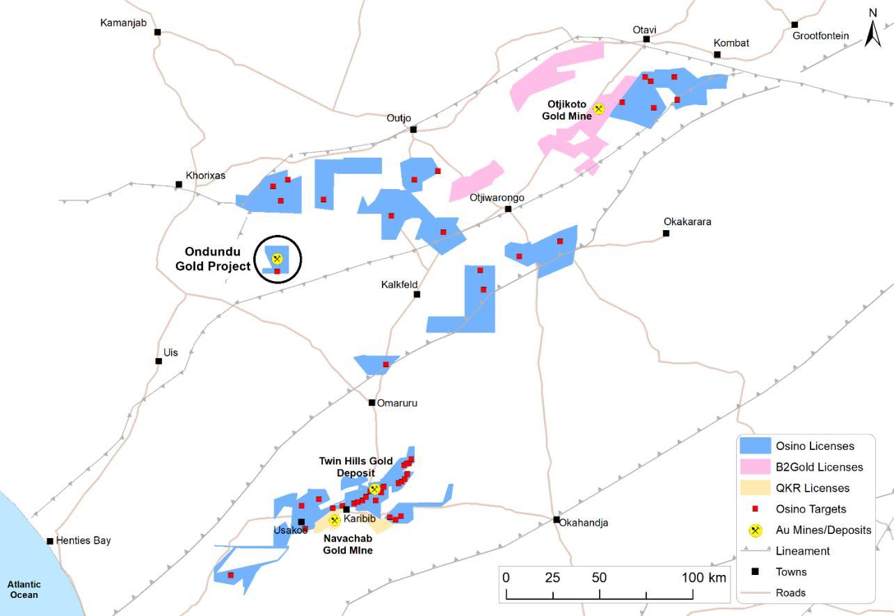
The Ondundu Gold Project is located in north central Namibia approximately 270km northwest of Windhoek and 130km northwest of the Company’s Twin Hills Gold Project (Figure 1). It lies within EPL 3195 which has an area of 10,386.5 hectares
History
The Ondundu Project area has a long history of mining and exploration since its discovery in 1917. Between 1922 and 1964 approximately 20,000 ounces of gold were recovered by small scale miners.
Systematic exploration commenced in the 1980’s and the first documented drilling was carried out by Tsumeb Corporation Ltd (TCL) (1980 1985), with similar programs by Goldfields Ltd (1985 1990) and Westport Resources Namibia (Pty) Ltd (2005 2010). The first major drilling campaign was conducted by Angus Mining Ltd in 2010 and 2011. B2Gold’s involvement in the project commenced in 2015 and they were responsible for the majority of drilling at the Project until 2021
Geological Data
The drilling database was consolidated by CSA Global from an Access database which was supplied to Osino by B2Gold. The data was validated and some collars verified in the field by the responsible qualified person (QP).
The validated database totals 74,832m of drilling from 854 holes and 5,166m of trenching (Table 1 and Figure 3). DD holes range from 22m to 650m in depth, while RC holes range from 20m to 202m in depth. Most of the drillholes were oriented at 70° azimuth and 60° dip.
2
Figure 1: Ondundu Gold Project location relative to Osino’s Namibian ground holdings
Drillholes were generally sampled at one meter intervals. A subset of this data, approximately 46,500m of mostly DD, was used for the mineral resource estimate.
Table 1: Drilling and trenching database
Period Company
Count
Drilled/Trenched Meters
DD RAB RC RCDD TRCH DD RAB RC RCDD TRCH
1980 1985 TCL 24 3,824
1985 1990 Goldfields / TCL 6* 1,729
2005 2010 Westport 11 525
2010 2011 Angus 4 147
2015 2020 B2Gold 153 392
Total 201 539
312 3,389 960 14,086 5,166
35,649 12,251 865
42,039 15,640 1,825 14,086 5,166
Note: * including deepening of 2 existing TCL DD holes. DD is diamond core drilling, RAB is rotary air blast drilling, RC is reverse circulation drilling, RCDD is reverse circulation pre collar drilling with diamond core tails, and TRCH is trenching
Geological logging and sampling methodology were reviewed for drill core (B2Gold campaign) at the Ondundu core yard by the QP in accordance with National Instrument 43 101 (“NI 43 101”) requirements and was deemed to be reasonable and acceptable.
Geology
The Project is located in the Northern Zone of the Damara Orogen in Namibia, about 15 km north of the Autseib/Otjohorongo Fault. The Project area is underlain entirely by meta sedimentary rocks of the Kuiseb Formation of the upper Swakop Group, comprising schistose quartz feldspar mica meta greywacke and meta pelite rocks, which are often calcareous. The rocks in the Project area are metamorphosed to greenschist facies.
The main geological feature in the Project area is the low amplitude Ondundu anticline, a major north trending antiformal fold which plunges approximately 30° to the south. Parasitic folds within the regional anticline have concentrated gold mineralization mainly in bedding parallel veins. The Ondundu anticline and its parasitic folds have an axial planar slaty cleavage which trends north to north northeast and dips steeply west.
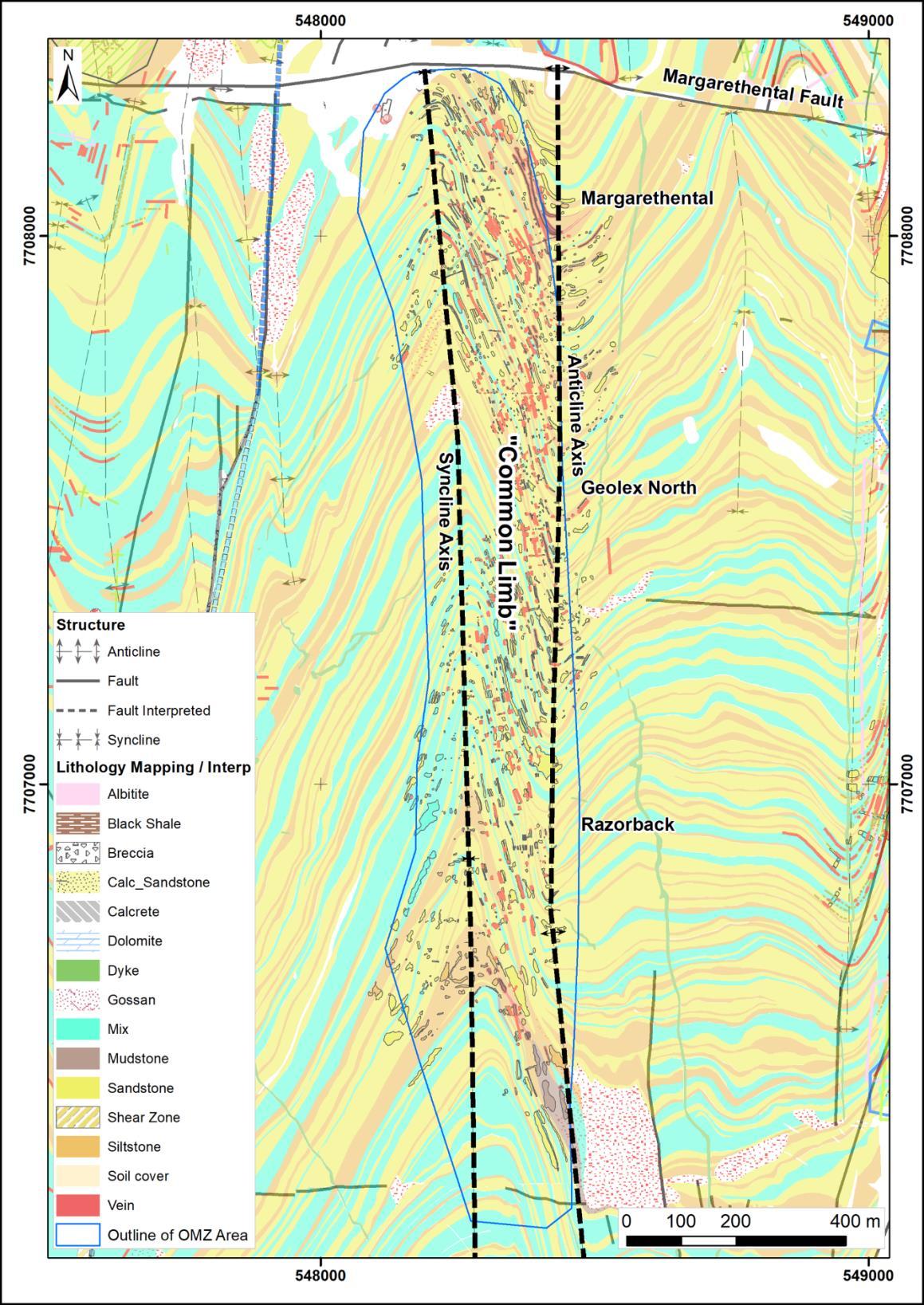
The main mineralization from Margarethental in the north to Razorback in the south (the Ondundu Main Zone or OMZ), occurs on the steep west facing limb of a parasitic syncline anticline pair (previously termed the “Common Limb”) on the eastern limb of the southeastern part of the Ondundu anticline (Figure 2). The other limbs of the syncline anticline pair are shallow dipping.
The Common Limb is anomalous in the Project area in its steep dip, although other deflections in bedding which have smaller limb lengths and overall amplitude do occur and have similar dips. These steep limb dips reflect local accommodation of high strain which correspond with hydrothermal fluid flow and gold mineralization.
The two most prominent areas of gold bearing veins are at Razorback and Margarethental with clustered sets of quartz veins which could be controlled by underlying shear zones that appear to step in an en echelon pattern in the Geolex North area (Figure 2)
3
45 63 47
6
51 63 47
Mineral Resource Estimate
The Ondundu deposit is known for its coarse, nuggety gold mineralization, which gives rise to narrow high grade gold intersections. The style of gold mineralization at Ondundu, hosted primarily within narrow quartz carbonate veins, is thus quite different to the broad disseminated nature of the mineralization at the Twin Hills Gold Deposit.
4
Figure 2: Ondundu Main Zone and Common Limb (Source: B2Gold mapping and interpretation data)
The narrow gold intersections at Ondundu are inherently difficult to model in three dimensions, unlike the wide and more coherent nature of mineralization at Twin Hills. Like many similar coarse gold deposits, sampling at Ondundu requires routine screen fire assays and will benefit from large sample volumes to adequately capture the coarse and irregular nature of the gold.
It is noteworthy that most of the drillholes used in this Maiden Mineral Resource Estimate for Ondundu are from diamond core drilling of a relatively small core diameter, specifically NQ core size with a nominal core diameter of 47.6mm. The uncertainty in the modelling at Ondundu is therefore amplified by the small sample volumes, as well as the relatively low drilling density available at present.

Osino believes that larger sample volumes and increased drilling density may improve the confidence in the modelling and has the potential to improve the overall resource. Consequently, additional large diameter reverse circulation and larger (HQ) core diameter drilling will commence on the project later this year.
B2Gold did assess this to some extent, but only drilled 2 twin RC holes (1 each at Margarethental & Razorback) and concluded: “… RC is less sensitive to grade variability in the upper and lower grade range, this potentially could have advantages in modelling the deposit due to potentially better grade continuity with RC.”
Gold mineralization was interpreted and modelled from a combination of structural and assay data for each of the Ondundu mineralization domains (Figure 3). The shear zone mineralization, hosted in sandstones, siltstones and a mix thereof, dips from 80° east to vertical and ranges from a few meters to 50m in thickness.
The bedding plane mineralization is less continuous and parallel to the local bedding plane (255° dip direction at 60° dip) within the Common Limb. A 0.4g/t Au threshold was used to manually code mineralized intersections into either shear zone or bedding plane mineralization. The modelled mineralization includes mineralized
5
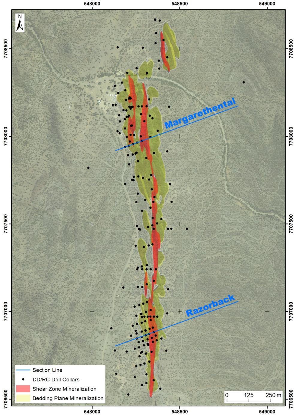
Figure 3: Plan view showing part of the drilling database indicated by collar location and type in the Ondundu area
intersections, with the geometry guided by local structural trends.
Cross Sections
The cross sections depict the mineralization at the two main targets, Razorback and Margarethental (Figure 4). The cross sections are oriented to align with the plane of the closest spaced drilling and to illustrate the geometry and orientation of the mineralization.
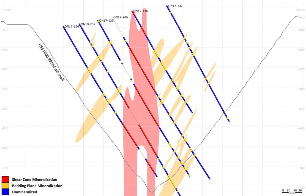
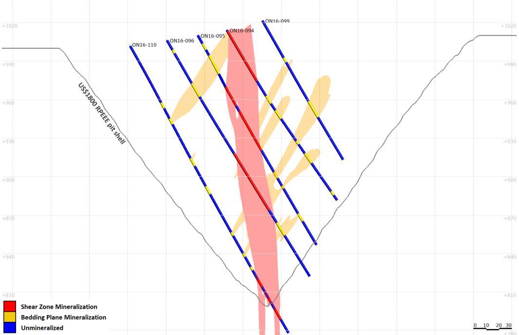
The mineral resource reporting pit shell at US$1800/oz is included in the sections below for reference purposes (Figure 5 and Figure 6) The conceptual pit shell represents reasonable prospects for eventual economic extraction (RPEEE) by open pit mining.
6
Figure 4: Section line locations shown in plan view with mineralization domains and drillhole collars
Gold grade was estimated using ordinary kriging from 2m composites into 25m x 25m x 5m (XYZ) blocks. Estimated grades were validated by means of global statistics and swath analyses. Bulk density wasdetermined using an Archimedes type technique on core and assigned to the model based on oxidation/weathering such that oxidized material was assigned a density of 2.60 t/m3, transitional material 2.67 t/m3 and fresh rock 2.75 t/m3 .
7
Figure 5: Razorback section looking north showing mineralization and coded intersections (refer to Figure 4)
Figure 6: Margarethental section looking north showing mineralization and coded intersections (refer to Figure 4)
Reasonable Prospects for Eventual Economic Extraction
CIM Definition Standards for Mineral Resources and Mineral Reserves states that a mineral resource is a concentration or occurrence of solid material of economic interest in or on the Earth’s crust in such form, grade or quality and quantity that there are reasonable prospects for eventual economic extraction (RPEEE)
To satisfy the requirement of RPEEE by open pit mining, reporting pit shells were determined based on conceptual parameters and costs and assuming a gold price of US$1800/oz. Based on preliminary test work results, gold recovery is planned to be achieved by crushing, coarse milling, gravity separation and intensive leaching of gravity concentrate. The lateral extent of the reporting pit shells and gold grade distribution in the resource block model is shown in the diagram below (Figure 7).

8
Figure 7: Plan view showing material in the US$1800/oz reporting pit shell above 0.5g/t Au
Mineral Resource Classification
Material within the reporting pit shell was classified according to mineral resource confidence categories defined in CIM Definition Standards for Mineral Resources and Mineral Reserves. Data quality and quantity, geological and grade continuity, and confidence in the grade and density estimates were considered when classifying the mineral resource.
The mineral resource is classified as Inferred and is classified up to a drill spacing of 100m on strike and 50m on section, although the main areas of Razorback and Margarethental are typically supported by drilling spaced at 25m x 25m and 50m x 25m respectively. No mineral resource is classified more than 50m beyond the last line of drilling It is reasonable to expect that the majority of Inferred mineral resources could be upgraded to Indicated mineral resources with infill drilling.
Mineral Resource Statement
The mineral resource is that material within the US$1800/oz reporting pit shell above a 0.5g/t Au cut off grade. The mineral resource estimate has an effective date of 7 October 2022 (Table 2), and a corresponding technical report disclosing the mineral resource estimate in accordance with NI 43 101 will be prepared by CSA Global (Pty) Ltd for the Company The Company will file the technical report on SEDAR under its profile at www.sedar.com within 45 days of the date of this news release.
Table 2: Mineral Resource for the Ondundu Gold Project at a 0.5 g/t Au cut off as at 7 October 2022
Tonnes Grade Troy Ounces (millions) (g/t Au) (millions)
Inferred 26 1.13 0.9
Notes on mineral resource reporting:
1. Figures have been rounded to the appropriate level of precision for the reporting of mineral resources.
2. Mineral resources are stated as in situ dry tonnes. All figures are in metric tonnes.
3. The mineral resource has been classified under the guidelines of the CIM Definition Standards for Mineral Resources and Mineral Reserves and adopted by the CIM Council, and procedures for classifying the reported mineral resources were undertaken within the context of the Canadian Securities Administrators NI 43 101.
4. The mineral resource is reported within a conceptual pit shell determined using a gold price of US$1,800/oz and conceptual parameters and costs to support assumptions relating to reasonable prospects for eventual economic extraction:
a. 4% royalty (3% government royalty and 1% export levy)
b. Selling costs of US$2.75/oz
c. Mining costs of US$2.00/t ore and US$1.85/t waste, with additional cost attributed to depth below surface
d. Processing and rehandling costs of US$8.15/t run of mine ore
e. G&A cost of US$4.00/t run of mine ore
f. Slope angle of 48° in weathered rock and 55° in fresh rock
g. 90% gold recovery from CIL circuit
5. Mineral resources that are not Mineral Reserves do not have demonstrated economic viability.
Cut-off Grade Variation
The estimated block model was tabulated at various cut off grades (Table 3). This tabulation does not represent a mineral resource in any way and only serves to illustrate the nature of the mineralization and sensitivity to various cut offs.
9
Category
Table 3: Classified block model within the US$1800/oz reporting pit shell at various cut-off grades
Cut Off Grade Tonnes Grade Troy Ounces (g/t Au) (millions) (g/t Au) (millions)
0.5 26 1.13 0.9 0.6 22 1.22 0.9 0.7 19 1.31 0.8 0.8 16 1.41 0.7 0.9 14 1.51 0.7 1.0 12 1.61 0.6
Gold Price Sensitivity
The estimated block model was subject to RPEEE scenarios at various gold prices (Table 4). This tabulation does not represent a mineral resource in any way and only serves to illustrate the sensitivity of gold price on the RPEEE pit shell.
Table 4: RPEEE sensitivity relative to gold price at a 0.5 g/t Au cut off
Gold Price Tonnes Grade Troy Ounces (US$/oz) (millions) (g/t Au) (millions) 1,600 24.7 1.13 0.90 1,800 25.7 1.13 0.93 2,000 26.3 1.12 0.95
Metallurgical Testwork
Osino collected mineralised material from multiple Ondundu cores and combined 24 such samples into eight bags which were subsequently combined further into two composite samples, for gravity tests conducted in Johannesburg. The aim was to generate two composites with significant differences in gold grade and mineralogy, and this objective was achieved.
After comprehensive assays of the two samples, extended gravity recovery gold evaluation (EGRG) tests were carried out according to the following procedure. Gold recovery at each stage of milling as well as ultimate gold recovery to concentrate was recorded
The raw test results were modelled by Gravity Concentrators Africa (GCA) using a simulation package to predict the likely recovery of gold in a commercial installation using primary jigging of relatively coarse material followed by centrifugal concentrators in closed circuit with a mill. The modelling of results from the tests conducted on the two samples suggested that after milling to 80% passing 75 micron, gold recovery in the range of 70 80% to gravity concentrate (containing less than 2% of the solid feed to the circuit) could be achieved
GCA’s report noted that further work will be needed at a later stage of development to ensure that the samples for this preliminary testwork were representative
10
Quality Assurance / Quality Control
The assay data derived from B2Gold drilling campaigns were verified by means of QA/QC which included the insertion of certified reference materials, blanks, and duplicates into sample batches sent forsample preparation and analysis. The results of the QAQC program were reviewed by the QP. Use of the geological data for mineral resource estimation and reporting is approved by the QP.
Qualified Person’s Statement
The mineral resource estimate was carried out by Mr. Anton Geldenhuys (MEng), a registered Professional Natural Scientist (SACNASP, membership number 400313/04) of CSA Global (Pty) Ltd., who is an independent Qualified Person (QP) as defined by CIM Definition Standards for Mineral Resources and Mineral Reserves in accordance with NI 43 101. Mr. Geldenhuys is a geoscientist and is qualified as a geologist (Honours) and engineer (Masters) and has over 21 years of relevant industry experience. Mr. Geldenhuys is a member in good standing of the South African Council for Natural Scientific Professions (SACNASP) and has sufficient experience relevant to the commodity, style of mineralization and activity which he is undertaking to qualify as a QP under NI 43 101. Mr. Geldenhuys has reviewed and approved the scientific and technical information in this news release.
About Osino Resources
Osino is a Canadian gold exploration and development company focused on the fast tracked development of our Twin Hills Gold Project (“Twin Hills”) in central Namibia. Twin Hills is at an advanced stage of exploration and development with more than 220,000m of drilling completed on the project since its grassroots discovery by Osino with various advanced development studies underway.
Osino has a large ground position of approximately 6,900km2 located within Namibia’s prospective Damara sedimentary mineral belt, mostly in proximity to and along strike of the producing Navachab and Otjikoto Gold Mines. The Company is actively exploring a range of gold prospects and targets along the belt by utilizing a portfolio approach geared towards discovery, targeting gold mineralization that fits the broad orogenic gold model
Our core projects are favorably located north and north west of Namibia’s capital city Windhoek. By virtue of their location, the projects benefit significantly from Namibia’s well established infrastructure with paved highways, railway, power and water in close proximity. Namibia is mining friendly and lauded as one of the continent’s most politically and socially stable jurisdictions. Osino continues to evaluate new ground with a view to expanding our Namibian portfolio.
Further details are available on the Company's website at https://osinoresources.com/
On Behalf of The Board of Directors
"Heye Daun"
Heye Daun
Chief Executive Officer, President, and Director
CONTACT INFORMATION
Osino Resources Corp.
Julia Becker: Investor Relations Manager
Tel: +1 (604) 785 0850
jbecker@osinoresources.com
11


