
REDEVELOPMENT Proposal
Somdat Tularam | S.P.A.C.E
“Before the design of any urban space, we must understanding the existing environment and policies that are in place that will allow us to develop logical design decisions.”


Table Of Contents

DESIGN CONCEPT EVOLUTION OF DESIGN LAND USE PLAN MASTERPLAN STREETSCAPE PUBLIC SPACES Fig. 1. S.P.A.C.E Proposal PAGE 3 PAGES 4,5 PAGE 6
7
8, 9
10-13
PAGE
PAGES
PAGES
S P A C E
Symbiosis: Connections of different ecosystems in a shared environment develops a natural habitat for wildlife.
Panopticon: Sight-lines play an important role in overall awareness of safety.
Atrium: Dynamic paths surrounded by different activities. Easy way-finding and flow of functions

Confluence: Dynamic paths surrounded by different activities. easy way-finding and flow of functions
Symbiosis: Connections of different ecosystems in a shared environment develops a natural habitat for wildlife.

Conceptual design of is an important component for any design decision Most of the designs are guided by a concept that are often followed from the beginning till the very end of the project Concepts are what tells the overall story sometimes they are given names or phrases which describes the area In a single word or phrase, what is the design concept? The Design Concept is “S P A C E”, which can be broken down into five different sections:

S --“Symbiosis ..””(Micro ecosystem)
P --“ Panopticon”(Safety Views)

A --“ Atrium”(Open Spaces)
C --“ Confluence”(Merging of Activities)
E --“ Engagement”(Community Participation)
The Concept behind S P A C E really does tie everything together nicely if you break it down into five different sections as stated above
DESIGN CONCEPT
Fig. 2. Micro Ecosystems
Fig. 3. Safety & Views
Fig. 4. Open Spaces
Fig. 5. Merging of Activities
Fig. 6. Community Participation
The phrase “S P A C E” goes back to the planning phase of the project, during that point of time the idea was to create a public realm that would be suitable to everyone. Implementation of an ecological approach where environments of living things had shared space which created a relationship towards each other. Incorporate the idea of “ Panopticon” For the way buildings are placed regarding the heights. Buildings placement at the entrance of the site would be like security towers that can look down

Buildings are layered and spaced in a way that promotes a secureness meaning that there are no hidden alleyways. Inclusiveness of a space that would respond to being both attractive and having successful outdoor spaces for both private and public uses, this would include the outdoor patio spaces for restaurants and cafés. Develop the site in a way where it would have the ability to adapt to change from social, technological and economic conditions The flow of spaces throughout the site would come together as one where to would transition smoothly from two spaces to one, for example the space of an outdoor patio to the green space trail towards a park with the ease of movement.


Human engagements with both the site and nature plays a crucial role in the development of the character of the site. Going to a place and seeing others having a good time will promote itself by inviting others join in on whatever is going on at the time, this would include having community events hosted by sponsors for upcoming events on a bigger scale.

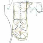
EVOLUTI OF DESIGNON Fig. 7. Phase One Revision Fig. 8. Second Phase Revision Fig. 9. Third Phase Revision
Fig. 10. Layers of Site Development
The evolution of any project goes a long way when it comes to how the area looked before and what it can look like after, even after different iterations on the overall site. Currently, Port Credit was mainly a place where it was used for “Boaters” but as the area had sort of died down it needed a revamp when it came to giving that area a new purpose. Giving a place a new purpose does bring people together since it’s something fresh in a new environment.. Here at S.P.A.C.E.
We originally looked at the site and thought to ourselves what can be added to this space that would get people to visit or even live here. There have been many revisions of how the master plan of the site would have come out but with these revisions of the evolution process, we analyzed that people would like a mix-use area that had more than one purpose which would be suitable for everyone. In the first few revisions of this project, there have been changes to the layout of buildings and how the spaces would have connected with the use of a network system that made sense.
Then we took a look at precedent studies that gave inspiration to adding different elements that would make the space stand out, this would be the protruded deck that is in the current park space of the existing site. Building height design was another part that had many changes along the way which had to suit the overall look and feel of the site along with where they were placed and what function it had to the public. Overall the evolution of this project had its ups and downs when it came to looking at the overall pros and cons of what changed and what didn’t change but the pros will always be more impactful than one small con. It took a lot of back and forth with what we have proposed with S.P.A.C.E but it made it even better as an overall outcome. Looking back at the existing site to what is being proposed there are a lot of changes that will happen which will give area designated uses.

EVOLUTION OF DESIGN
Fig. 11. Final Revision

5. 4. 6. 7. 8. 11. 12. 10. 9. 13. 14. 15. 16. 17. 18. 3. 3. 2. MARINA & FARMER’S MARKET CENTER 2. 1. 2. 3. 4. 6. 7. 7.
1. 2.
7.
8. 9. 10. 11. 12. 13. 14. 15. 16. 17. 18. MAIN PEDESTRIAN SPINE NETWORK MIXED-USE RESIDENTIAL BUILDINGS RETAIL STORE MIXED-USE HIGHRISE BUILDING 5. MIXED-USE MEDUIM RISE BUILDING RESTURANTS LUXURAY RESTURANT HUB ATRUIM STONE LEAF AREA CAFE BAKERERY/CAFE S.P.A.C.E PARK PLAYGROUND AREA RELAX S.P.A.C.E ZONE MULTI-PURPOSE FACILITY BUILDING iNTERACTIVE WALKING ZONE SKATE BOARDING ZONE LEGEND LAND USE PLAN
7. 7.
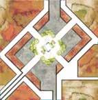
12. Land Use Plan of Site
Fig.
LEGEND MAIN PEDESTRIAN SPINE NETWORK VEHICULAR ROUTE BUS ROUTE BUS STOP PRIMARY ACCESS POINT SECONDARY ACCESS POINT MASTER PLAN
13. Master Plan of Site
Fig.
The streetscape design of the selected area of S P A C E tells a story that focuses on the movement of different types of mobility systems, this would include walkers, transit, cycling and drivers The point that has been selected, it’s a hotspot where there will be a constant floor of pedestrians crossing the road to get to the atrium and other facilities within the lower part of the site.


Buildings Sidewalk Drop off Zone Shared Drive Lane Green Blvd Shared Drive Lane Drop off Zone Multi-Use Sidewalk Buildings Varies 2.5 M 2.5 M 3.5 M 2.5 M 3.5 M 2.5 M 5.0 M Varies
STREETSCAPE DESIGN Fig. 14. Aerial View of Streetscape Fig. 15. Aerial View of Streetscape at Mid-Point Fig. 16. Aerial View of Streetscape
S.P.A.C.E has been developed to ensure that there is an interaction or transition between different mobility types within the public realm The design of the streetscape reflects the community, this would include having dropoff zones along the main street that goes in and out of the site, having a variety of tree canopies along the site that provides shade and a naturally pleasing look when approaching from the exterior of the site The main spine of the S P A C E is a pedestrian that acts as a getaway that connects them from one area of the site to another, the path is also shared by transit users only to get people closer to the second half of the site and it acts as a public space where events can also take place during certain Streetscape design plays an important role in any major site, for example, this site is mainly focused on having people get around safely from point A to B with no disturbance of flow.


STREETSCAPE DESIGN Fig. 17. Human Eye View of Streetscape Fig. 18. Human Eye View of Streetscape
Major public spaces can make an impact to the surrounding built environment, at S P A C E there are three main areas that would be classified as a public realm for the new development of Port Credit One of those areas is located in the centre of the site which refers to the “ Atruim”, is it a space where people would hang out during the day and enjoy them selves while shopping at the nearby shops located close by.


PUBLIC SPACES Fig. 18. Aerial View of Public Space Fig. 19. Human Eye View of Public Space Fig. 21. View of Public Space Fig. 20. Aerial View Key Map
Then there is an area which is located at the tip of the site which can referred as the “Stone Leaf”, is it a space where individuals would hang out in the green spaces to enjoy the view of the lake along with enjoying the Cafe that is located close by It’s an open area where people would also gather and have a good time due to the open feel of that area, there are plenty of tree canopy which acts as shelter from the sun


Also there are placement of furniture that would assist the individual if they were tired There are speakers which will play meditating music around the walking path which will give users a soothing feel while having a walk.

PUBLIC SPACES Fig. 24. Aerial View Key Map Fig. 22. Aerial View of Public Space Fig. 23. Human Eye View of Public Space
When it comes to making a place unique there will always be some type of implantation of something, that something can range from a variety of things that can have an impact on the built environment At S P A C E at the location of the tip of the site, also referred ad Stone Leaf, there are these speakers that are built into the ground that gives people that peaceful feeling when passing by the area There are other places throughout the site that has this as well, the reason for this is that people experience things a lot differently so why not add something that makes the area flow into each other? That would be sounds of nature when walking through the Stone Leaf area or even when walking along the paths of the area you see interactive posts that show you where you are and makes it easy to navigate easily Lit paths ways at night that turn on at a certain time when there is movement help people feel safer at night, especially in such a big area.


PUBLIC SPACES Fig. 25. Human Eye View of Public Space Fig. 26. Human Eye View of Public Space Fig. 27. Aerial View of Key Map
And finally there is another public realm to S P A C E which is located at the old section of the site to the west where there is not a play ground along with a public facility building that would be suitable for everyone this area also has a splash pad for little kids during the summer months there is also an outdoor cooking picnic area where people can enjoy the outdoors Adjacent to that is a skating park


PUBLIC SPACES Fig. 30. Aerial View of Key Map Fig. 28. Human Eye View of Public Space Fig. 29. Human Eye View of Public Space
“Before the design of any that will allow us to develop
Somdat Tularam | S.P.A.C.E