RETHINKING 322
Strategies for the proposed State College
Area Connector in Penns-Brush Valley

1

Area Connector in Penns-Brush Valley
Prepared by the Penn State Department of Landscape Architecture Advanced Design Studio (LARCH 414), with support from landscape architecture faculty, the Centre County Historical Society and the Hamer Center for Community Design, with additional input from the Penn State Law and Sustainability Institute, and the Thomas D. Larson Pennsylvania Transportation Institute.
Electronic and printed distribution of this document was supported with a grant from the Hamer Center for Community Design.
Keith Faminiano
Erik Forsten
Joseph Notte
Coleman W. Riegle
Desire Rivera
Abigail G. Rodgers
Tyler Shumaker
David Wasson
With an Introduction by Paul Daniel Marriott, Associate Professor of Landscape Architecture and LARCH 414 studio instructor
The information, concepts and illustrations in this document were developed by students in the Department of Landscape Architecture at Penn State during the fall semester of 2022 to offer strategies to consider for the State College Area Connector project under study by the Pennsylvania Department of Transportation and are not intended as engineering or safety advice.
Publication Date: February 2023
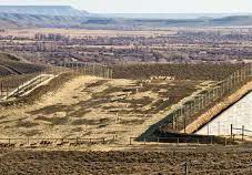
Image: Penns Valley - Google Earth

We extend our appreciation and gratitude to the following individuals and organizations who provided invaluable advice and insight from across Penn State’s University Park campus, across the Centre Region, and across the country.
LARCH 414 | Class of Fall 2022
Penn State, Department of Landscape Architecture
Dean D. Ball, PE, Assistant District Engineer, District 2, PennDOT
Ira Beckerman, Retired Archaeologist, PennDOT
Dorothy Blair, President of Nittany Valley Environmental Coalition
Peter A. Butler, Pennsylvania Game Commission (North Central Region)
Charles Andrew ‘Andy’ Cole, Professor of Landscape Architecture, Director, E+D: Ecology plus Design, Penn State
Matthew Cox, President of Centre Bike
Bruce Dell, Director of City Planning, Brunswick, MD
Eric T. Donnell, PhD, PE, Professor of Civil Engineering, Director, Thomas D. Larson Pennsylvania Transportation Institute, Penn State
Joan Floura, Senior Landscape Architect and Partner, Floura Teeter Landscape Architects, Baltimore, MD
Lara Fowler, Professor of Teaching Law, Interim Director Sustainability Institute, Interim Chief Sustainability Officer, Penn State
Lisa Domenica Iulo, Associate Professor of Architecture, Director, Hamer Center for Community Design, Penn State
Kevin James, PE, Associate Vice President, Michael Baker International
Marianne Kuhns, Kuhns Tree Farm
Elizabeth Lose, Assistant Director, Centre County Planning & Community Development Office
Terry Melton, Clearwater Conservancy
Jason Roth, Ecologist/Environmental Project Manager, Colorado DOT
James Saylor, Principal Transportation Planner Centre County Metropolitan Planning Organization for Centre Regional Planning Agency
Charles Scott, Senior Associate and Project Manager, Jones & Jones Architects and Landscape Architects, Seattle, WA
Mary Sorensen, Executive Director, Centre County Historical Society
Alec Spangler, Assistant Professor of Landscape Architecture, Penn State
Roxi Thoren, Department Head and Professor of Landscape Architecture, Penn State
Thomas Yahner, Emeritus Professor of Landscape Architecture, Penn State
David Yeager, Assistant District Forester, Resource Department of Conservation & Natural Resources Rothrock State Forest, District 5
With special thanks to Lara Fowler and Mary Sorensen for editing and administrative oversight. With additional thanks to David Wasson and Tyler Schumaker for building the site model, and Abigail G. Rodgers and Keith Faminiano for graphic design and print production of this publication.
INTRODUCTION by Paul Daniel Marriott...............................................................................08
GLOSSARY.......................................................................................................................................10
STRATEGIES
Strategy: Context Sensitive Solutions.............................................................................12-24
Strategy: Flexible Highway Design...................................................................................26-34
Strategy: Wildlife Crossings...............................................................................................36-46
Strategy: Multi-modal Connections.................................................................................48-56
Strategy: Rethinking Safety...............................................................................................58-66
Strategy: Land Conservation.............................................................................................68-82
Strategy: Mitigation.............................................................................................................84-94
Strategy: Pollinator Highways..........................................................................................96-130
APPENDIX..............................................................................................................................132-133
-Pennsylvania Department of Transportation summary statement

-List of meetings attended
-Penns-Brush Valley Rural Historic District, National Register Determination of Eligibility
Roundabout design, Brunswick, MDWelcome to Rethinking 322, Strategies for the proposed State College Area Connector in Penns-Brush Valley.
This publication was prepared as the final project for the eight students in the Advanced Design Studio, LARCH 414, at the Department of Landscape Architecture at Penn State, who spent the 2022 fall semester exploring strategies to rethink the proposed State College Area Connector (SCAC) project under study by the Pennsylvania Department of Transportation (PennDOT).
Each student was charged with identifying an interest area related to the proposed highway or the contextual setting of Penns-Brush Valley. Their focus areas were refined during the early weeks of the semester as they attended public meetings for the SCAC project and met with local advocacy organizations, government agencies and individual stakeholders to gather different perspectives about the proposed highway. The responses from area residents, advocacy organizations and agencies were extraordinarily generous, and the sincere concerns they shared with the students, from improved highway safety to preserving rural heritage, are reflected in each student’s strategy section in this document.
It is fair to say the community response to the SCAC has been controversial and contradictory. While the students heard near uniform opposition to the preliminary design concepts for the SCAC, they also heard near uniform agreement that the current US 322 corridor between Potters Mills and Boalsburg requires significant safety improvements—an extraordinarily complex conundrum as they embarked on their fifteen-week course assignment. Therefore, the students were tasked not to endorse any of the proposed corridors under consideration by PennDOT for the SCAC, but rather to focus on the opportunities such a project might provide if the local communities could articulate a unified vision of what was desired, not only for the proposed highway project, but also for the future of Penns-Brush Valley.
From the start, the students identified the passion and affection for the rural character, historic sites and agricultural heritage of the valley as a common theme in public meetings and the one-on-one conversations they had with area stakeholders. They learned about the SCAC within the 168 square-mile Penns-Brush Valley Rural Historic District that was determined eligible for the National Register of Historic Places in 2002.
Within this context, specific concerns about climate change, growth in the Centre Region, ecosystem integrity and sustainable farming were also voiced.
As a result, the students determined that while PennDOT’s actions could impact the legacy of the valley, so too could local land use policies and conservation programs.


As the students explored their interests, they met twice weekly to share their research and community contacts with one another. In addition, in person and virtual visits to the studio augmented their explorations with insights from Jones & Jones Architects and Landscape Architects in Seattle, the Penn State Law and Sustainability Institute, the Thomas D. Larson Pennsylvania Transportation Institute at Penn State, the Centre County Historical Society, and PennDOT Region 2. The students traveled to Baltimore to meet with Floura Teeter Landscape Architects to learn about the design process for the award-winning Maryland Route 200/ Intercounty Connector (ICC) project and visited the Context Sensitive Solutions (CSS) freeway to study the road’s alignment, sound barrier design, integrated regional bike trail, wildlife crossings and pollinator plantings. After, they traveled to Brunswick, Maryland (population 8,000) to meet with the Director of Planning and tour the state’s most successful roundabout program—a joint effort by the city, a local developer and the Maryland State Highway Administration that has improved traffic efficiency and safety in the growing rural community.
Many of these influences shaped the presentations and engagements during the student-led community design charrette in Boalsburg sponsored by the Department of Landscape Architecture, Centre County Historical Society, and Hamer Center for Community Design on Sunday, October 30th, 2022. At this public event, students facilitated conversations and tested and refined their strategies with feedback from residents and advocates during an afternoon working session to rethink the future of Penns-Brush Valley.
The result of each student’s studio work is presented in the following strategy sections. Their strategies are offered as an introduction to the many possibilities for safe, flexible and context sensitive solutions for the SCAC and smart, sustainable, and relevant land management for the region. It is hoped that they will spark not only lively conversations, but also a new vision to rethink 322 and the future of Penns-Brush Valley.
—Paul Daniel Marriott, Studio ProfessorDan is a licensed landscape architect and has consulted on transportation projects for the Federal Highway Administration and National Park Service. He is a past member of the Transportation Research Board’s Standing Committee on Landscape and Environmental Design. He co-founded and chairs the Preserving the Historic Road International biennial conference (sponsored by FHWA and AASHTO) and is the author of Saving Historic Roads, Design and Policy Guidelines (Wiley) and From Milestones to Mile-Markers, Understanding Historic Roads (FHWA-National Scenic Byways Program), and served on the External Review Committee for FHWA’s Flexibility in Highway Design guide. He has been an expert reviewer for UNESCO World Heritage roads and developed context sensitive solutions, scenic byway and historic roads trainings, and corridor management plans for state transportation departments including, Arizona, Alaska, California, Colorado, Hawaii, Illinois, Indiana, New Jersey, New Mexico, New York, and the Osage Nation and Massachusetts Department of Conservation and Recreation. In addition, he has consulted on transportation projects in Australia, Canada, Mexico, and the United Kingdom.
Paul Daniel Marriott, PhD Principal and Founder of Paul Daniel Marriott + Associates and Associate Professor of Landscape Architecture at Penn StateAASHTO—American Association of State Highway and Transportation Officials, a national state-led organization that conducts research and presents guidance on highway design. AASHTO guidance offers a range of acceptable solutions for different aspects of highway design and has been adopted by FHWA for federal highway projects. A state may adopt the full range or a more limited range as a state standard for highway design.
ADT—average daily traffic, a calculation of the average number of vehicles on a particular segment of roadway measured in whole days. Alignment—the movement of a roadway through the landscape; its curves, straight sections, and hills.
Arterial—a roadway providing the principal high-volume and high-speed linkages within a community and between communities. Avenue—a broad urban thoroughfare, usually tree-lined.
Berm—an artificial hill or mound created for screening or to enhance a design landscape.
Boulevard—a broad urban thoroughfare, usually tree-lined and with a broad median.
Clear zone—the recommended area alongside a roadway clear of all potential hazards (something an automobile might strike) such as trees, rocks, utility poles, and the like. The recommended width of a clear zone varies based on the functional classification of the road.
Collector—a roadway providing service between arterials and local roads.
CSS—Context Sensitive Solutions, also known as Context Sensitive Design, is an approach to highway design that considers community structure, local landscapes, and environmental settings as an integral part of highway planning and design.
Cut and Fill—the removal (cut) or placement (fill) of soil in construction. Ideally highway construction projects are designed so that cut and fill are “balanced;” i.e., the amount of soil removed in a hillside “cut” equals the amount required to “fill” the ravine at the base of the hill. Designed landscape—a landscape, or the alteration or modification of the natural landscape, that has been created specifically to provide a desired experience (usually aesthetic) to the user or a community. Designed landscapes are generally created by a landscape architect, planner, architect, or other design professional.
Design speed—the maximum safe speed at which a vehicle can be expected to operate on a roadway. The speed for which a roadway is designed—this may not be the posted speed.
DOT—department of transportation
Errant vehicle—a vehicle leaving the roadway in a reckless or uncontrolled manner.
Expectancy—a theory, based on a motorist’s “knowledge stores” of driving experiences, that suggests predictable driver responses to familiar situations and settings. Routine experiences, such as sufficient merging space at the end of a freeway ramp, become unconsciously established in the driver’s mind—thus creating conflict should the “expectancy” not be met.
FHWA—Federal Highway Administration
Galvanized steel—a zinc coating applied to steel to prevent rusting. Galvanized steel has a flat chalky-gray appearance. Guardrail—a barrier, usually of a post-and-beam construction located alongside a roadway, in medians and in front of hazards to prevent an errant vehicle from striking an obstacle or encountering a dangerous slope or drop-off.
Horizontal alignment—the movement of a roadway to the left or right; its curves.
Integrity—the current quality of a feature or element when compared to its original quality.
Jersey barrier—a angled concrete barrier designed to guide an errant vehicle back to the roadway and guard against hazards. Limited access—a concept whereby the entrances and exits of a roadway are restricted to certain locations—generally to allow for higher speed traffic movement due to the absence of cross streets and intersections.
Local road—a roadway serving adjacent residences and businesses—generally of low-volume traffic
Median—a central space, often planted, dividing opposite moving travel lanes.
MPO—Metropolitan Planning Organization, a federally-mandated and federally-funded transportation policy-making organization to ensure regional cooperation in transportation planning.
MUTCD—Manual of Uniform Traffic Control Devices, the FHWA guidance for regulatory signs
National Register of Historic Places—a national listing of sites meeting the U.S. Secretary of the Interior’s standards, maintained by the National Park Service.
NEPA—National Environmental Policy Act of 1969, a federal review program to ensure federally funded projects assess potential impacts to the environment. NEPA is dependent on federal funding. When there is no federal funding, PennDOT follows Section 2002 of the Administrative Code of 1929, which defines the powers and duties held by PennDOT. Act 120 of P.L. 356 amended Section 2002 in 1970 to add requirements to address environmental impacts from transportation projects.
Post and cable guardrail—a guardrail constructed of regularly spaced posts connected by a flexible (usually steel) cable.
Posted speed—the speed at which a roadway is signed. This is usually, though not always, lower than the design speed.
Realignment—the repositioning of a segment of a roadway.
Reinforced concrete—concrete with a steel reinforcing framework. Reinforcing enables the concrete to perform in structural situations. Concrete by its nature resists high compressive loads (the heavy weight of a truck, for example). Steel reinforcing resists high-tensile loads (the pull to the left or right one would encounter on a bridge, for example).
Right-of-way—the land area dedicated to or associated with a roadway that is owned or managed by the road management entity—including the roadway, shoulder, and affiliated landscape.
Road diet—the removal or narrowing of lanes to make a road safer or more efficient.
Shoulder—a stabilized level area adjacent and parallel to the roadway that provides a recovery space for an errant vehicle or a safe space for a disabled vehicle.
Sight distance—the length of roadway ahead that is visible to the motorist.
Standards—the legally adopted policies and practices directing the design and construction of a road in a state or municipality.
Street—an urban thoroughfare, usually defined by buildings.
Superelevation—the banking or sloping of a road curve to enable vehicles to maintain a speed consistent with the overall speed of the roadway. The banked ends of racing tracks represent an exaggerated superelevation.
Taking—in legal terms, the direct acquisition of property, or the implementation of policies or actions that significantly impact a property.
Tort liability—a situation in which an injury or harm has occurred, due to a breach of a preexisting duty or obligation, resulting in potential exposure to an individual or organization for damages.
Traffic calming—a strategy to slow vehicle speed through the use of physical changes in the road’s alignment, including speed humps, speed tables, roundabouts, and chicanes (a shift in the horizontal alignment). A speed table was installed in front of the HUB on Penn State’s University Park Campus to improve pedestrian safety.
Vertical alignment—the movement of a roadway up and down; its hills.
Volume—the number of vehicles a roadway carries.
Watershed—an area of land drained by a particular body or bodies of water. An individual body of water often belongs to a hierarchy of watersheds—a tributary river off the Susquehanna River has its own watershed of creeks but is also a part of the larger Susquehanna River watershed and the even larger Chesapeake Bay watershed.
W-Beam—a common type of guardrail/barrier recognized by its curved, “W,” face.
LARCH 414 studio class during a survey of the regional trail, sound barriers and plantings along the MD Route 200/Intercounty Connector (ICC) Trail. Students (left to right), Joseph Notte, Tyler Shumaker, Coleman

Riegle, Desire Rivera, Abigail G. Rodgers, David Wasson, Keith Faminiano, Erik Forsten
Parkway—a roadway contiguous with or linking park spaces. In its truest definition, a parkway provides access to recreational, scenic, or leisure spaces.
PennDOT—Pennsylvania Department of Transportation
Image: Paul Daniel Marriott

Context Sensitive Solutions (CSS) is a strategy promoted by the Federal Highway Administration (FHWA) to consider highway design in sympathy with the adjacent landscapes and communities in the proposed corridor. Under CSS programs, a state transportation agency considers not only the function of the road but also the community setting of the road. CSS projects may include lighting that replicates historic fixtures or lighting that is designed to protect the night sky, the use of traditional materials for bridge abutments or walls, a broad median to minimize the visual impact of the road in a scenic area or the rerouting of a proposed corridor to protect critical farmland or ecosystems. CSS is not a program to “decorate” highways, but a program to recognize the aesthetic and environmental resources of a region through design interventions designed to minimize the visual and ecological impacts of a transportation project.
 Image: Colorado DOT
I-70 - Colorado
Image: Federal Lands Highway
Image: Colorado DOT
I-70 - Colorado
Image: Federal Lands Highway
“A collaborative, interdisciplinary approach that involves all stakeholders to provide a transportation facility that fits its physical setting and preserves scenic, aesthetic, historic, and environmental resources, while maintaining safety and mobility.”
- Federal Lands Highway
Respect All Stakeholders
Provide Safe Passage
Minimize Impacts to Existing Interdisciplinary Design Teams
Community Engagement
Vision, Purpose, and Need
Clear Decision Making
Deliver a Quality Solution
Context Sensitive Solutions (CSS) may come in a wide variety of formats, from helping guide the engagement between a Department of Transportation (DOT) and a community, to wildlife considerations, to ‘laying lightly on the land’, and everything in between. Most DOTs have their own definition of what CSS may look like (or directly copy from the Federal Lands Highway), and a well-engaged community member should seek out their local and regional DOT’s definitions of CSS.
The Federal Lands Highway’s (FLH) definition was used in this inquiry because it is wellencompassing and lays out a series of eight criteria. This allows the FLH’s understanding of CSS to be easily followed by a community member who may be unfamiliar with roadway design.


The CSS criteria listed by the FLH and this inquiry should be viewed as guiding considerations, not as design regulations. Every project, ecosystem, and community deserves individualized consideration. However, the following statements can and should be adapted as a means of working towards a wonderful transportation project!

“Not just designing for the sake of the roadway, but also for the sake of Penns-Brush Valley.”
- David Wasson
“Be respectful of the land, partner, and agency goals, tribal values, and cultural significance of landforms and sites, wildlife, and habitat.”
“Provide safe passage for residents, travelers, tourists, recreationists, and wildlife by working cooperatively to integrate safety as a basic business principle in all activities.”
- Federal Lands Highway
Large projects involve a variety of inputs from engineers, land owners, community members, politicians, taxpayers, and more. Naturally, all of these stakeholders come with their own set of priorities, requirements, and expectations. Ultimately, however, there is a common desire of all groups, whether it be safety, cost, or other outcomes. Finding one of these common grounds can serve to be crucial at reaching mutual respect.
Hostility towards one agency, person, community, organization, or others only serves to weaken the foundational ties of the project, the ties which the final project will be built upon.
Another aspect that should be understood the Federal Lands Highway criteria for respecting all stakeholders; specifically where it states one should also be respectful of “wildlife and habitat.” Wildlife cannot advocate for their own well-being and habitat, and thus the other stakeholder groups should accommodate discussions of these non-verbal stakeholders.

Figure 1.01 - Natchez Trace Parkway - TN

Image: National Park Service
US 93 between Wye and Polson, Montana, (completed between 1989 and the early 2000s, with the landscape architecture firm Jones & Jones) is an excellent example of multiple stakeholders coming to a mutual understanding. Agencies found themselves at odds with each other, but ultimately highway designs were integrated with community values and wildlife concerns to create a project which is respectful of the residents, environment, and tribal leaders located within the Flathead Reservation. Above in Figure 1.02, one can see a wildlife crossing positioned next to a sign explaining the context of the roadway to motorists, complete with indigenous language of the Bitterroot Salish Kootenai, and Pend d’Oreille tribes.


Ensuring safe passage, fundamentally, refers to the roadways’ safety for all users. All roadways consider the safety of motorists, and increasingly consider the safety of pedestrians and cyclists, but the Federal Lands Highway take their criteria one step further to incorporate recreationists and wildlife. While this may not be the first thought when considering a new roadway, passage across a roadway is just as crucial as a passage along a roadway.
CO 82 over Independence Pass near the Twin Lakes region of Colorado excellently handles these considerations. For example, due to winter conditions, the roadway is closed to vehicles in the winter. This leaves the surface clear for snowmobiles, cross-country skiers, and even mixed rock-ice climbers to attack the faces near the roadway. Additionally, on select days during the summertime, the roadway is closed to allow for recreational and competitive cycling of the route!

VT 108 through Smugglers Notch in Vermont features a prominent, yet safe, chicane around boulders as depicted in Figure 1.06 below. This two-way yet one-lane roadway is also a prominent trail in the region. Featured in Figure 1.05 above, a land bridge is an excellent means of transporting wildlife across a heavily traveled roadway, giving safe passage to wildlife in turn increases vehicle safety.

 Figure 1.03 - US 93 - Montana
Image: Jones & Jones
Images: David B. Wasson
Figure 1.06 - VT 108 - Vermont
Figure 1.4 - CO 82 - Colorado
Figure 1.03 - US 93 - Montana
Image: Jones & Jones
Images: David B. Wasson
Figure 1.06 - VT 108 - Vermont
Figure 1.4 - CO 82 - Colorado
“Minimize impacts to existing features and conditions in a manner that lays ‘lightly on the land’ and minimizes construction impacts on the traveling public”
Existing landscapes, communities, and developments come with their own set of intrinsic values which deserve individual consideration. One phrase in particular, “lay lightly on the land” can serve as a guiding principle when considering the value of the existing features and conditions.
Paris Pike, also known as US 27/68 is located just outside of Lexington, Kentucky, and goes through scenic horse country. When a plan to expand the existing roadway was proposed, it was met with significant opposition. After decades of litigation, the project was completed and works beautifully with the landscape. The stonewall in Figure 1.08 is an example of working with the landscape; this particular wall, just like the tree behind it, predates the construction of the highway which can be seen beyond the two features. The wall maintains the character of the landscape while the steel barrier, ensures standards of motorist safety. Figure 1.09 allows one to see how a roadway may be designed to flow through a landscape, gracefully sweeping around existing features such as mature trees, stone walls, wetlands, creeks, streams, and more.


Figure 1.07 above demonstrates another means of “laying lightly on the land” as it floats above the magnificent landscape. These two roadways increase the aesthetic beauty of the areas, while making them more accessible and efficient.


A diverse background and diverse skill sets are needed to achieve any major ambition worth admiration in life. Roadway projects are certainly no different. From structural engineers, to planners, traffic engineers, surveyors, biologists, civil engineers, and landscape architects, expertise is gathered from all corners of roadway design and roadway adjacent design to achieve a world-class project where all facets are thoroughly considered.

As previously discussed, both US 93, featured above in Figure 1.11, as well as Paris Pike, featured in Figure 1.12 below, gathered knowledge, input, and expertise from all applicable fields. These two projects will continue to reappear in the coming pages. They are examples of difficult projects which, through trials and tribulations, resulted in excellent projects! However, a project completed relatively recently, MD 200 which is featured to the left in Figure 1.10, also used a highly diverse, interdisciplinary design team to achieve excellence. The project, also known as the Intercounty Connector (ICC) is an outer ring road of Washington, D.C., and featured engineers, biologists, and landscape architects. Each of these fields brought their specialties and skills which resulted in no part of the project being overlooked; it even features a land bridge for children to safely get to school.
Images: Bierderman Real Estate Figure 1.12 - Paris Pike - Kentucky
Images: Jones & Jones“Use interdisciplinary project development teams to develop cost-effective, creative solutions that fit into the natural and human environments while functioning efficiently and operating safely.”
- Federal Lands HighwayImage: David B. Wasson Image: Asheville Citizen-Times Figure 1.11 - US 93 - Flathead Reservation - Montana Figure 1.10 - MD 200, View from the land bridge Penns-Brush Valley Studio Fall 2022
“As appropriate, actively communicate and employ early, continuous, and meaningful participation of the public and all stakeholders throughout the transportation planning, program development, and project delivery process in an open, honest, and respectful manner.”

“Satisfy the project vision, purpose, and need as developed and agreed upon early in the process by a full range of stakeholders.”
Operating behind ‘closed doors’ leads to distrust and, ultimately, a project that fails the community. Community members provide detailed insight into the needs, wants, and concerns of the local area. In this process, persons of all backgrounds and understandings must be engaged to ensure meaningful dialogue.


Community members enter a project at all points; from preliminary environmental studies through the completion of construction. One community member may be highly interested in the impacts of the earthmoving stage of construction and not join the conversation until years into the project, while another may be interested only in the methodologies of early environmental studies. Whatever the case may be, it is crucial that all community members feel welcomed, heard, and respected before, during, and after the projected timeframe of the transportation process.
A clearly developed set of statements prior to action on highway projects is a critical step that allows for guiding beliefs. Just as a company sets a mission statement, transportation projects often come with their own mission statements, need statements, vision statements, purpose statements, and/or others. These are carefully crafted statements that identify what is important to the project, keeping it on track throughout the design, engineering, and construction process.

As seen in Figure 1.16, MD 200 had a very clear statement that included water quality and wildlife considerations. As a result of these statements, and environmental studies confirming the need for design in line with these facets, the large bridge shown in Figure 1.16 was constructed. It is not merely a convert for water to flow, but it also keeps the banks intact and allows for easy wildlife movement under the highway.

The Boston Big Dig, as seen in Figure 1.17 above, was another example of an established vision, purpose, and need which helped the project navigate complex and powerful stakeholders, eventually creating a highly regarded project.

“Demonstrate clearly defined, effective, decisionmaking and implementation that meets commitments.”
“Deliver a quality transportation solution with efficient and effective use of everyone’s resources in cost, effort, and material.”
Context Sensitive Solutions recognize that all stakeholders cannot be present in every decision-making process. This means that whoever is making a decision must act in the best interest of all parties and not just themselves. If a certain specie of tree cannot be obtained, what should be substituted in its place? Scenarios such as this occurred during the construction of MD 200, as seen in Figure 1.20, and due to written statements, the specific specie was able to be substituted with another that met the pre-determined commitments.
These decisions are not just during construction; a decision that may have to be made is when or how often public meetings and hearings are hosted. Where are these hosted to make the most number of people able to attend and comfortable attending? If funding or time is limited, which segment of the project receives the attention?

The final criterion as developed by the Federal Lands Highway is perhaps the most important of the eight. The previous seven criteria ebb and flow and twist and turn, but must eventually end with a quality transportation solution. What is a quality solution? Well, that is determined by the end users. Did the project win any awards? Do the motorists feel safe and inspired while driving the roadway? Do cyclists feel incorporated into the project? Does a small ground squirrel feel comfortable using a wildlife crossing? The determination of a quality transportation solution is different for every user, and is thus not an across-the-board phrase.


What is important, however, is that it meets the predetermined points which were developed early on in conjunction with all stakeholders. These can be found within the ”Vision, Purpose, and Need”. If the project was intended at lowering the number of accidents at an intersection while installing a bike lane, were both of those done? If so, then it is likely a quality transportation solution.


David is from State College, Pennsylvania. He is interested in public lands management where he seeks to work with the NPS, USFS, or the BLM to create new methods of balancing recreation, resource extraction, ecologies, and more. David has two minors, Geography and Climatology, and has been the recipient of Penn State Landscape Architecture departmental awards in Visual Communications, Stormwater Management, Materials Implementation, and Leader in Social Good. He is also a Valley Family Award recipient from the College of Arts and Architecture.
- About the Office of Federal Lands Highway | FHWA. (n.d.). Retrieved December 9, 2022, from https://highways.dot.gov/federal-lands/about.
- Context Sensitivity | FHWA. (n.d.). Retrieved December 9, 2022, from https://highways.dot.gov/ federal-lands/about/context-sensitivity.
- Intercounty Connector (ICC)/MD 200. MDTA. (n.d.). Retrieved December 9, 2022, from https:// mdta.maryland.gov/ICC/ICC.html.
- Intercounty Connector (ICC) contract C. JMT. (2022, December 6). Retrieved December 9, 2022, from https://jmt.com/projects/intercounty-connector-icc-contract-c/.
- Jones, G., Parker, C., & Scott, C. (2019, July 26). Designing America’s Wildlife Highway: Montana’s U.S. Highway 93. Community Planning and Zoning. Retrieved December 8, 2022, from https://community-planning.extension.org/designing-americas-wildlife-highway-montanas-u-shighway-93/.

- Paris pike historic rock fence repair. Dry Stone Conservancy. (n.d.). Retrieved December 9, 2022, from https://www.drystone.org/paris-pike-historic-rock-fence-repair.
- Pennsylvania Department of Transportation. (2012, December). General Design. Retrieved December 9, 2022, from https://www.dot.state.pa.us/public/Bureaus/design/PUB13M/Chapters/ Chap01.pdf.
- Ride for the pass. Independence Pass Foundation. (n.d.). Retrieved December 9, 2022, from https://www.independencepass.org/ride-for-the-pass.
Understanding that a quality design that accomodates its surroundings does not compromise safety.
ErikFlexible Highway Design is a strategy promoted by FHWA and the American Association of State Highway and Transportation Officials (AASHTO) to reconsider how we design highways. Flexible highway designs work to accommodate the safety and access needs of all user groups in a highway corridor. Rather than focus on a single or limited user group (commuter traffic, for example), flexible highway design balances the safety and efficiency of all user groups (commuter traffic and bicycle, school, pedestrian, recreation, and commercial traffic, for example). Flexible highway design includes multi-modal corridor planning for different user groups, traffic calming to lower speeds, and enhanced pedestrian safety or local access in congested areas. Flexible highway design ensures the maximum safety for all user groups rather than the maximum efficiency for a single user group.

 Image: Roozbeh Rokni
“Modest expense increases will long be forgotten when US 322 has been established as a beloved feature of the Valley.”
Flexibility is not a term particular to any one discipline. In the framework of highway design, it could be described as the merging of safety procedures with responsive approaches to the landscape. Both work in tandem to produce a road that simultaneously achieves a high level of efficiency and cohesion with its environment.


Historically, safety has driven the design of a project, such as I-99 through Port Matilda (Figure 2.02). Safety remains of the utmost importance, but recent projects such as Paris Pike (Figure 2.03) better incorporate the landscape. This holistic approach leads to roads that are vastly improved aesthetically while also improving safety and function.

A rigid approach to design and construction will leave US 322 feeling as if it was imposed on the Valley, overpowering the meaningful local features (Figure 2.04). Instead, a variety of road forms should be considered with attention to the local surroundings. That way, US 322 develops into another attractive feature of the Valley (Figure 2.05).
“The intent of this policy is to provide guidance to the designer by referencing a recommended range of values for critical dimensions. It is not intended to be a detailed design manual that could supercede the need for the application of sound principles by the knowledgeable design professional. Sufficient flexibility is permitted to encourage independent designs tailored to particular situations.”
- A Policy on Geometric Design of Highways and Streets (The Green Book)
“This Guide encourages highway designers to expand their consideration in applying the Green Book criteria. It shows that having a process that is open, includes good public involvement and fosters creative thinking is an essential part of achieving good design.”

- A Guide for Achieving Flexibility in Highway Design


The two books quoted to the left were created by the American Association of State Highway and Transportation Officials (AASHTO), a nationwide organization that helps to set guidance for all kinds of transportation, land, sea, and air. Both books -in particular the Green Book- are major references used by state departments of transportation to assist in the design of their road systems. The quoted sections are from their respective introductions and show support for an appropriate level of flexibility rather than a rigid, top-down approach to highway design. It is crucial to understand that departments of transportation draw their policies and standards from literature that explicitly champions responsive design principles.
- Erik ForstenFigure 2.04
Flexibility is the merging of safety procedures with responsive approaches to the landscapeFigure 2.02 Image: Google Earth safety landscape Figure 2.03 Image: Google Earth Figure 2.01 Figure 2.05, Having the road respond to different locations. Penns-Brush Valley Studio Fall 2022

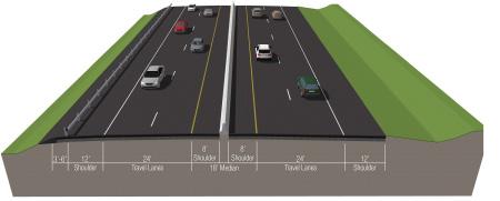
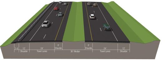
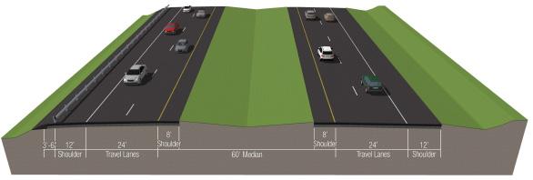
In the initial phases of the creation of US 322, the Pennsylvania Department of Transportation has presented preliminary design ideas (Figure 2.06). This PennDOT graphic nicely initiates an understanding that there are options for the road’s design. However, it may suggest to the public that only one type of median can be constructed. A clearer picture of the possibilities emerges when these sections are combined.


An excellent example of significant changes throughout a road is Vermont State Highway 108 - Smuggler’s Notch. Starting as a typical highway (Figure 2.07), the road comes to a point where the steel barrier switches to a wooden barrier (Figure 2.08). This barrier is backed with steel and meets the same safety standard as a typical W-Beam, but this signals to the driver that changes in the driving conditions are approaching. Further ahead, the barrier dissapears along with the median stripes (Figure 2.09) which prepares drivers to cautiously navigate the winding mountain passage (Figure 2.10). Thanks to these signals, Smuggler’s Notch is an incredibly safe road. While Penns-Brush Valley is different, consider how these principles could be applied to US 322 which currently lacks this type of transition between the freeway and two-lane sections (Figure 2.11).


Highways are a major contributor to impervious surfaces, which prevents rainwater infiltration and increases runoff of pollutants such as gasoline and motor oil. US 27/68 in Kentucky, also known as Paris Pike (Figure 2.12), cut down on the impact of the road by utilizing a grass shoulder supported with compacted gravel so it can be safely used by vehicles. Switching the proposed US 322 project to a grass shoulder similar to Paris Pike would result in a reduction of approximately 30% of impervious surface (Figure 2.13).

The communities surrounding the Paris Pike project were adamant about preserving the character of their beloved horse country. In some places, the wooden barriers used on the highway mimic the nearby horse pasture fences (Figure 2.14), while other stretches of the highway use a brown-coated W-Beam barrier (Figure 2.15) that maintains safety standards while matching better with local stone walls.


“Heavily traveled, high-speed highways and highways carrying large numbers of trucks should have usable shoulders at least 3.0 m [10 ft] wide.”

Each foot of the cross section accounts for around 50,000 square feet of impervious surface along US 322.
Main Street in my hometown of Concord, New Hampshire, was a dangerous road for many years. A four-lane road cutting through local shopping (Figure 2.16) and past the State House emphasized speed efficiency over the pedestrian district. As accidents continued to occur, the city decided to replace the inside lanes with a granite block median (Figure 2.17). This came with a fair share of controversy, but once implemented the effect was immediate. A simple change in the material of the road paved the way for a rethinking of the street space. Trucks now use the median to unload (Figure 2.18), while the granite deters cars from attempting to pass one another - a familiar issue on existing US 322 with left turning lanes (Figure 2.19). Material changes make a serious impact on the motorist’s understanding of where to drive and how to navigate the road. US 322 could apply this understanding to its newly designed median to ameliorate some of the issues with speeding vehicles attempting to pass (Figure 2.20).


In Flexibility in Highway Design AASHTO urges plantings in the median for both aesthetics and safety. Examples are found just south of the PA border in Maryland (Figure 2.21), or in distant Spain (2.22). Shrub species are selected to reduce headlight glare at night and ease visual overload during the day.


“Wider medians also allow for the retention of existing vegetation or new landscaping for aesthetics, and also help to reduce or eliminate headlight glare.”
Figure 2.23 is the accumulated result of information from each concept in this section on design flexibility. The change between iterations is significant, but it should be noted that this is only one possibility. The most suitable alternative will emerge through continued engagement. US 322 must ultimately be defined by the will of communities of the Valley.
American Association of Highway and Transportation Officials. A Guide for Achieving Flexibility in Highway Design. Washington, DC, AASHTO, 2004.
American Association Of State Highway And Transportation Officials. A Policy on Geometric Design of Highways and Streets. 7th ed., Washington, DC, AASHTO, 2018.
Erik is from Concord, New Hampshire. He enjoys golf and playing the trumpet and hopes to pursue a career in transportation design. He believes that the human element of design manifests through attention to detail.

Maryland State Highway Administration. Landscape Design Guide. Maryland Department of Transportation, Dec. 2016, www.roads.maryland.gov/OED/SHALandscapeDesignGuide.pdf.
New Hampshire Preservation Award Commitee. “Concord’s Main Street.” New Hampshire Preservation Alliance, 2017, www.nhpreservation.org/blog/concords-main-street.
Paul Daniel Marriott, and National Trust. Saving Historic Roads. John Wiley & Sons Incorporated, 1998.

Schneider, Krista L. The Paris-Lexington Road Community-Based Planning and Context Sensitive Highway Design. Edited by Landscape Architecture Foundation, Washington, DC, Island Press, 2003.
Water Science School. “Impervious Surfaces and Flooding | U.S. Geological Survey.” www.usgs.gov, 5 June 2018, www.usgs.gov/special-topics/water-science-school/science/impervioussurfaces-and-flooding.


Strategies of animal passages funneling wildlife towards habitat corridors
Desire Rivera | LARCH 414 | Fall 2022
Wildlife crossings are strategies to maintain functioning habitats before, during and after the construction of a highway project. Successful wildlife crossings not only benefit migrating wildlife, but also reduce highway fatalities by minimizing the wildlife/driver interface. Different animals move in different ways and require different types of crossings—either over or under the highway. The types and locations of wildlife crossings required for reptiles, and small and large mammals is based on observed patterns and habits. In addition, fencing along the edge of the highway should provide an “escape” route to allow larger mammals that get trapped within the highway right-of-way to return safely to the other side. In agricultural areas, crossings to allow for the movement of livestock between fields bisected by a highway project should be considered—helping minimize the roadway’s impact on agricultural operations.
Wildlife is an essential part of our ecosystem. Animals play a major role in keeping the environment balanced. Within Centre County, there are habitats and animal species that need to be protected. However, with increasing development and new roads, once continuous habitats are divided into smaller unconnected patches. Wildlife, exposed to more and more manmade obstacles are forced to cross major highways like US 322, leading to major accidents.
Since the pandemic, there has been a 7.2% increase in animal-related collisions. Pennsylvania is a high-risk state within the top 10 of collision rates. There have been over 160,000 insurance claims within PA, 67% involving deer. Deer collisions cost about $4,000 per claim, resulting in over $400,000,000 in medical and damage expenses per year. Centre County ranks 27th in the state with 81 crashes and 15 injuries in the last year. Wildlife crossings have been shown to reduce the number of animal collisions by 90% by a study conducted on the US 93 wildlife crossings.


The amount of space an animal uses regularly is called a home range. They can stretch for miles or as little as a few feet. Animals move for shelter, mating, food, care for the young, and more. A home range is key to their survival. Using their home range, we can identify priority areas that need crossings to connect species from the other side of the fragmented habitat.
White Tailed Deer (Range: 3-5 sq-mi)

Black Bear (F Range: 6-8 sq-mi)

(M Range: 20 sq-mi)
Coyote (Pack Range: 30-60 sq-mi) Bobcat (F Range: 7 sq-mi)

(M Range: 16 sq-mi)
Fox (Range: 2-3 sq-mi)

Squirrel (F Range: 1 sq-mi) Racoon (F Range: 3-5 sq-m) Rabbit (Range: 7.7 sq-mi) Skunk (Range: 4 sq-mi) Chipmunk (F Range: 0.004 sq-mi) (M Range: 3 sq-mi) (M Range: 1-18 sq-m) (M Range: 0.007 sq-mi)


“Reconnecting animals to their habitats is crucial to increase safety and save lives in Penns-Brush Valley” -Desire RiveraImage: ©Metronews, Staff Photo
Major Roads
Forested Areas


Other Landuse
In Figure 3.01, the map shows layers of land use. Forest areas in green are fragmented by urban, agricultural, suburban, and other land use in yellow.
Montana was ranked second in the United States for wildlife collisions in 2016. In the span of fourteen years, from 1990 to 2004, wildlife collisions increased by 50%, making it a common reoccurrence. To combat this, the state set two goals: reducing human and wildlife traffic crashes, and maintaining habitat connectivity for wildlife. They found that wildlife fencing and crossing structures proved most effective in reducing the effects on natural and recreational resources resulting in 90% reduction rates.

The transitions from developed areas to habitat region impacts rich diversity resulting in increased rates of animal collisions particularly around the transitional areas. Types of transitions are urban, suburban to rural. Suburban, agricultural to forested, and agricultural to forested. Within these transitions is the opportunity to add wildlife crossings to save human and animal lives.

The greater Yellowstone region is a critical habitat for migrating animals and over thirty indigenous tribes; home to elk, mule, moose, and more. However, roadways endanger each group by disconnecting communities, land, water, and wildlife. A wildlife crossing in Trappers Point is considered a success in Wyoming, which united habitats to create a continuous landscape.
Counties follow this precedent to implement crossings in places with high accident rates to reduce collisions by up to 90%.
In Europe, gray wolves are recolonizing parts of the continent. As a repeating pattern, we see that roads reduce connectivity and disrupt the movement of animal species. After the construction of the crossings in Brandenburg, Germany, a study conducted showed the gray wolf, wild boar, roe, and red deer consistently used the bridge--over 100,000 animals in fifteen years (1990-2004). These species are relatively more active during the evening and night versus the daytime. Researchers say that the gray wolf population in Germany stays safe and continues to grow due to green bridges.


As the largest overpass, they can accommodate a wide range of animal diversity and habitat connections. They adapt to road infrastructures for specific wildlife movements and species like amphibian and reptile passages. In Figure 3.02 is a landscape bridge in Banff National Park. With increasing park vegetation, traffic volumes skyrocketed, as did animal-related collisions. The first two overpasses built in Banff were a safer alternative that reduced animal-vehicle collisions by 80%.


These overpass structures, smaller than landscape bridges, are designed to meet the needs of small to large wildlife according to specific criteria of mobility and habitat. Typically, these will be layered with topsoil, planted with vegetation, and bordered by a wall or fence to direct wildlife to the crossing. By providing habitual elements on the structure, other species like reptiles, and arboreal species will use the structure. These crossings prohibit human activities and are intended for wildlife use only. Many species prefer limited human interactions.
As the smallest wildlife overpass, it is designed to provide mobility for human and animal use. They are best adapted for human-disturbed and intensive environments. These overpasses accommodate small to medium mammals accustomed to human activity. In Figure 3.03, the multi-use overpass in Texas measures 150 feet in length and stretches over a six-lane Wurzbach Parkway below. This overpass joined two sides of Phil Hardberger Park, providing a safe passage for both people and wild animals through its 330 wooded acres.

Canopy Overpass
Canopy overpasses are designed for arboreal species that travel through tree canopies. These species typically have trouble traveling across open areas that are not forested. For example, squirrels always move and store food in their nests, having to cross dangerous roads many times a day. Already navigating through trees in a few days, these species learn to travel through a canopy overpass to reach nesting areas more efficiently. They can be made out of different materials like metal or rope as represented in Figure 3.04.
Dimensions
A long elevated bridge with no dimension limitations can become the largest underpass structure vertically. Commonly used for crossing wetland habitats, they span over waterways at minor elevations to protect important aquatic systems. They are used as an alternative when constructing on cut-and-fill slopes, which would limit wildlife movement.
A viaduct also serves spatially to preserve landscape character and topography, allowing animals to move freely.

Smaller than viaducts, they are the largest underpasses wildlife uses. They are designed specifically for large mammals, but medium to small mammals also use them to travel across habitats. If there is cover provided along the walls using techniques like root wad or adding vegetation. The vegetation will act as a noise barrier to promote smaller animal use. For performance, the underpass must be in a minimal human disturbance area.
Dimensions
Landscape Bridges
Width 230ft to >330ft
Lenth No limitations
Wildlife Overpass
Width 130-230ft
Lenth No limitations
Multi-use Overpass
Width 32ft-130ft
Lenth No limitations
Canopy Overpass

Width No limitations
Lenth No limitations
Viaduct/Flyover
Width No Limitations
Length No Limitiation
Large Mammal Underpass
Width 23ft to >32ft
Height >13ft
How does wildlife know to use wildlife crossings?
Habitats are specific environments ideal for certain types of animals. The type of habitat depends on the region’s climate and geography. All wildlife have habitats, which provide them with the basic needs of survival. When designing wildlife crossing, the surrounding environment is important. To ensure wildlife use constructed crossings, these variables should be considered:
1. width, height, length

These underpasses serve human and wildlife mobility. When farms are split, the underpass passage will allow farmers and landowners to reach the other side of their property. The dimensions can be adjusted to allow equipment, cattle, and other livestock to travel through. In Figure 3.05, a farm in Easley Co. Sligo, Ireland created an underpass to allow their cows to reach the other side of the property. However, these underpasses are not adequate for all animal wildlife due to the crossing being located in human-dominated landscapes.

Dimensions
Width 16.5ft to >23ft
Height 8.2 ft to >11.5ft
An underpass with water flow is designed to support moving water and wildlife. Typically, medium to small mammals uses these underpasses if their habitat is within the vicinity of the structure. The smaller mammals would be species adapted to a riparian environment. Larger mammals will use these structures.
A smaller underpass, these structures were designed primarily for small to medium mammals. It can be rectangular, square, or circular, depending on the needs of the species you are targeting. These underpasses should be placed in areas with high landscape permeability and are known as wildlife travel corridors. The design of this underpass must meet the movement of the widest range of species that live in the targeted areas. With a widened range, high and low-mobility animals can use this underpass.

A modified culvert is a conduit covered with soil or rock. It permits and diverts water passages within riparian channels and irrigation canals. Culverts can have four sides forming a rectangular or square called a “Box culvert”. When placed horizontally, the culvert can form multiple chambers if needed. They also can be continuous in circumference with the lower portion buried or not, as seen in Figure 3.06. More commonly known as a pipe.


Width 6.5ft to >10ft
Height 10ft to >13ft
Width 1-4ft
Height 1-4ft
2. openness
3. structure floor (whether natural or a manmade material)
4. fencing (whether present or absent)
5. distance to forest cover
Underpass tunnels are designed to accommodate small mammals. Some medium mammals use them to travel, but not often. The design features necessary to facilitate tunnel use of certain species depend on size, placement, moisture, temperature, and noise. It is more practical to create multiple tunnels across sections of the roadway rather than relying on a single passage. It’s more effective in mitigation efforts of amphibians and reptiles as concentration locations are expanded to support limited animal mobility. Fencing will need to be considered to direct and intercept these species towards the tunnels.
6. distance to drainage
7. human use
8. traffic intensity
9. vegetation and soil
10. water drainage
11. home range
These variables are guides that determine the best fit environment to promote animal use. You must think about factors like using native soils, decreasing noise, and adding particular covers to attract certain species. For example. deer prefer high, wide, and short-length crossing structures. Whereas black bears prefer wildlife crossing that is long, low, and narrow. By researching and learning what types of environments these species live in and adapting the crossings to fit those qualifications, each crossing will have a higher chance of being successful.
Fourth-year Landscape Architecture Student

Desire is from Reading, Pennsylvania. She is interested in the implementation of habitat conservation in urban ecological planning and transportation. She believes design that protects and advocates for both humans and non-human communities can transform how we value and connect to the landscape. She hopes to pursue a career as a practicing landscape architect.
- Clevenger, Anthony Huijser. Wildlife Crossing Structure Handbook: Design and Evaluation in North America. 1 Jan. 2011, rosap.ntl.bts.gov/view/dot/41646.
- Design Manual Part 2 Contextual Roadway Design. www.dot.state.pa.us/public/pubsforms/ Publications/PUB+13/June+2022+Change+No.+1.pdf.
- Here’s the 10 PA Counties With the Most Deer Vs Vehicle Crashes. www.centredaily.com/news/ state/pennsylvania/article264368191.html.
- “How Likely Are You to Have an Animal Collision?” State Farm, www.statefarm.com/simpleinsights/auto-and-vehicles/how-likely-are-you-to-have-an-animal-collision.
- Media. “Insurance Details.” Pennsylvania Pressroom, www.media.pa.gov/pages/Insurance-details. aspx?newsid=464.
- Sharpe, Patricia. “How Texas Wildlife Crossings Are Saving Lives and Money.” Texas Monthly, 13 Aug. 2021, www.texasmonthly.com/travel/texas-wildlife-crossings-saving-lives-and-money.
State Farm. “Drivers Struck More Than 2 Million Animals During the Pandemic.” November the Most - Dangerous Month for Animal Collisions, 13 May 2022, newsroom.statefarm.com/november-themost-dangerous-month-for-animal-collisions.
- “Studies Show Wildlife Highway Crossings, Fences Reduce Animal Collisions With Vehicles by 90%.” Stgnews, 18 Dec. 2020, www.stgeorgeutah.com/news/archive/2020/12/18/prc-studies-showwildlife-highway-crossings-fences-reduce-animal-collisions-with-vehicles-by-90.
- Wildlife Crossings Key to Highway Safety in Banff – discoverAPEGA. discoverapega.ca/stories/ wildlife-crossings-key-to-highway-safety-in-banff.


Coleman
Multi-Modal Connections is a strategy to encourage and facilitate safe and efficient travel by different user groups. Successful multi-model programs invest in infrastructure to make alternative transportation not just feasible, but also efficient, convenient, and pleasant. Studies show that corridor users are more likely to utilize an alternate means of transportation if it is pleasant and perceived as safe. For example, a bike trail behind a steel barrier along a busy highway is less desirable than a bike trail separated from a busy highway by trees and shrubs. In addition, alternative routes must be equally efficient and avoid lengthy detours (such as complicated pedestrian crossings or overly circuitous bike routes, for example). Like highways, multi-modal systems should offer convenient connections, accommodate different users (recreation and commuter, for example) and be well maintained.
Image: Fairfax County Park Authority, VirginiaOn a local scale, Centre County is an automobile-centric community. There is an existing bike system within State College, however, many segments are fragmented and unprotected against car traffic. In addition, Bike Route G connects Boalsburg to Centre Hall. Unfortunately, there are zero non-motorized connections elsewhere within Penns-Brush Valley. In order to evaluate the expansion of US 322 the local communities and governments must rethink how people travel through the county.
According to the Rails-to-Trails Conservancy, many communities have been surprised at how trails have become sources of community identity and pride. Effects are magnified when communities use trails to highlight and provide access to historic and cultural resources. Many trails themselves preserve historically significant transportation corridors.
With the possible expansion and redirection of the Penns-Brush Valley section of US 322, it has never been more important than now to look for alternative modes of transportation within Centre County.

The economic effects of trails are sometimes readily apparent (as in the case of trailside businesses) but are sometimes more subtle, like when a company decides to move to a particular community because of amenities like trails.
Linear greenspaces, which includes trails, have all the traditional conservation benefits of preserving green space but also have additional benefits by way of their linear nature. As tools for ecology and conservation, trails help preserve important natural landscapes, provide needed links between fragmented habitats and offer tremendous opportunities for protecting plant and animal species. They can also be useful tools for wetland preservation, allowing humans to experience nature with minimal environmental impact and helping them understand the importance of natural ecosystems.
Many areas of the United States incorporate trails and similar facilities into their transit plans, relying upon trail facilities to “feed” people into and out of transit stations in a safe and efficient manner. The ability to avoid congested streets and highways, and travel through natural areas on foot or by non-motorized means, is a large factor in a community’s “livability.”
The Virginia Capital Trail is a dedicated, paved bicycle and pedestrian trail crossing four counties and 51.7 miles along VA 5 between Jamestown and Richmond, Virginia. The Virginia Capital Trail was the result of a public-private partnership between the Virginia Department of Transportation and the Virginia Capital Trail Foundation.
The Foundation is responsible for making the experience on the trail a safe, educational, and unforgettable experience for users by supplying signs, trailheads, benches, as well as many more amenities. As you travel along the trail, you will encounter the rich history of Virginia. Many of these sections pass historic sites and other attractions, full of history, running throughout. There are also many places to rest, relax, dine and explore along your journey.
“Trails have the power to transform communities and create joyful, vibrant public spaces that are equitable and inclusive.”
-Rails-to-TrailsFigure 4.01 - Virginia Capital Trail Penns-Brush Valley Studio Fall 2022
Maryland’s Intercounty Connector Trail serves as an important commuting route across Montgomery County and Prince George’s County in Metropolitan Washington, DC. The multimodal transportation corridor provides a Class 1 paved pathway that is separated from Maryland 200, the major freeway within the transportation corridor, by a sound barrier or a wide planted area with safety fencing (the fencing is coated with black PVC to blend into the landscape).
The ICC Trail is enhanced with existing and planted trees and shrubs. Careful attention was made to mitigate the visual impact of the sound barrier with heavy plantings on both sides of the wall. As a result, hikers and bikers along the path and local neighborhoods have an attractive green edge, rather than a typical freeway wall. The ICC Trail provides direct access to four parks along the corridor and links to the regional bike and hiking trails.


The first map features what a high-speed bike access route might look like. The route focuses on connecting destinations in, ideally, the most populated areas with the most resources. This route would provide a nonvehicular transportation route as an alternative to US 322; for a commuting bicyclist or someone on an electric bike, it could take approximately the same amount of time it takes to travel US 322 by car.
 Image: Paul Daniel Marriott
The scenic connector route focuses on connecting as many communities along the US 322 corridor as possible while remaining a trail designed for recreation and leisure. Instead of cutting through private properties this trail would utilize the existing road network.


Looking at different ways to utilize existing space to create cycling and pedestrian pathways while still allowing car traffic to flow. For a multi modal system to function properly cyclists, pedestrians, and automobiles should be able to travel without interfearing with other transport lanes. The use of buffers helps to insure safety and comfort travel for all user types.
Route Centre County boasts a number of important hiking trails traveling through large areas of stateprotected conservation lands. In addition to a large footpath system, the area contains many Class A trout streams that provide for fishing recreation. While there is already a bike and footpath from State College leading to the Mid State Trail, the longest hiking trail in Pennsylvania, there is no direct connection into Bellefonte. Bellefonte is on the Chicago to New York City Bicycle Route, a significant national bike trail which, if connected to Penns-Brush Valley could be amplified for greater economic development. Such a bicycle route could provide access to fishing spots, regional hiking trails, and historic Bellefonte.
Fifth-year Landscape Architecture Student
Coleman is from Charlottesville, Virginia. He is interested in climate adaptive design as well as sustainable development.


ACA. “Interactive Network Map.” Adventure Cycling Association, https://www.adventurecycling.org/ routes-and-maps/adventure-cycling-route-network/interactive-network-map/.
Conservancy, Rails-to-Trails. “Benefits of Trails: Rails-to-Trails Conservancy.” Railstotrails.org, https://www.railstotrails.org/experience-trails/benefits-of-trails/.

“ICC Intercounty Connector Trail Map, Guide - Maryland | Alltrails.” AllTrail.com, https://www. alltrails.com/trail/us/maryland/icc-intercounty-connector-trail.
Pilkington, Craig. “History of the Capital Trail.” Virginia Capital Trail Foundation, Virginia Capital Trail Foundation, 5 Mar. 2018, https://www.virginiacapitaltrail.org/news-posts/2018/3/5/ history-of-the-capital-trail.
“Types of Trails.” National Parks Service, U.S. Department of the Interior, https://www.nps.gov/sub jects/trails/types-of-trails.htm.
Way to improve the safety on US 322

Joseph Notte LARCH 414 | Fall 2022
Safety is of paramount importance on every roadway. Many states are rethinking safety solutions with a greater emphasis on multiple users and the specific needs of different road types, two-lane rural vs. freeway, for example— particularly where different road types and users intersect. The American Association of State Highway and Transportation Officials (AASHTO) notes that accident rates are higher in areas where the roadway changes significantly or unexpectedly. Rethinking safety and shifting away from a single approach to highway safety is being driven by a dramatic increase in highway fatalities in the United States. In a November 27, 2022, article, “The Exceptionally American Problem of Rising Highway Deaths,” the New York Times reported that since 1994 highway-related pedestrian deaths have increased by 19%, bicycle deaths by 17%, and motorcycle deaths by 140%.

get truck traffic off the road and make it safer at the same time?”
- Joseph NotteTrucks can be found throughout the length of US 322 and especially within Centre County. Not only is Centre County the center of the state but it is a hub between major interstates and highways. Unfortunately, due to the abundance of trucks on the roads, they can also become hazards. Specifically, on the “connector” stretch of US 322, there have been a number of truck-related accidents in recent years that have shut down the road for a periods of time, causing injuries, and in the worst case, deaths.
On the right are examples of recent accidents involving trucks on US 322.
Figure 5.01 “Person Taken to the Hospital After Crash”-3/23/21
Figure 5.02 “Crash Shuts Down Part of US 322”-10/12/20
Figure 5.03 “1 Dead After Tractor Trailer vs. Car Crash” 12/6/21


Figure 5.04 “Part of US 322 Shut Down”- 11/8/2022
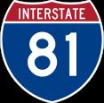
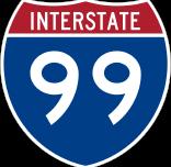
As mentioned, trucks enter the Centre County region from all directions, particularly from four main highways that direct trucks to and from US 322. These are I-80, I-99, I-76, and I-81; see Figures 5.06 and 507 There are many alternative routes for trucks to take when traveling from major cities across Central Pennsylvania. What, we should ask, is leading to “induced demand” or trucks traveling through the Centre County region when they may not be coming to this area as a destination?

For example, if a trucker is traveling from Philadelphia or Harrisburg, or Baltimore-Washington, why not take the PA Turnpike to Interstate 99 or 81, or US Route 15, then connect to Interstate 80? Could it be due to tolls on the PA Turnpike? Chronic traffic congestion in Breezewood? Regional travel considerations are important in addressing local impacts in Centre County.

Map Key:US 322/22

I-80

I-99 PA Turnpike I-81
Trucks are increasing in numbers on US 322. In the best case scenarios, trucks cause slowdowns and, in the worst case scenarios, fatal accidents. These types of incidents will need to be addressed as truck traffic increases in the coming years. It is important that we address the issues associated with them and find ways to improve the safety of all users along the route

Local highway travel includes US 322, I-99, and I-80. These three major highways come together here in Centre County as seen in Figure 5.07 and that is part of the reason for the high truck traffic along this route. PennDOT representatives, in their presentation to our class on November 3rd, 2022, said that 80-90% of the truck traffic coming into the area is going to I-80 or I-99. The remainder of truck trips is most likely for local deliveries.
“How can weImage: Twitter @511PAStateCollege Figure 5.03 Figure 5.05 Figure 5.04 Figure 5.01 Figure 5.02 Image: WTAJlocalnews Image: StateCollege.com Image: Centre Daily Times Image: wjactv.com Penns-Brush Valley Studio Fall 2022 Image: Google Earth Figure 5.06 Figure 5.07 Map Key: State College Image: Google Earth
Figures 5.08 and 5.09 show the difference between PennDOT’s Planning and Environmental Linkage (PEL) Study and the scope of the region that trucks seem to be coming from.

Conversations with PennDOT staff indicated that they only counted trucks within the study area in their research (Figure 5.09), not the broader regional dynamics. While this is useful information, it doesn’t recognize the origin of trucks from outside of the study area shown (Figure 5.08). From a statewide point of view, it would be helpful to know where trucks are coming from and where they need to travel to (statewide, regional, local). If trucks are in fact coming from further away and simply passing through, are there better routes to consider? Would improvements on the PA Turnpike, such as like lowering tolls, convince truckers and their employers to take alternative routes? How about improving the PA Turnpike connections between I-70 in Breezewood and I-99 in Bedford? Neither intersection as a direct freeway-to-freeway connection.
Transitions are another safety concern. On the existing US 322 corridor, there are two transition points where US 322 changes from a 4-lane divided highway to a 2-lane highway corridor: one at the newly built Potter Mill transition (Figure 5.10) and one at the existing Boalsburg transition (Figure 5.11). These transitions could and should be redesigned to improve their safety. While this will most likely happen according to PennDOT’s future plans for the route, these areas are both currently segments of frequent accidents and should be addressed more immediately.


Using publicly available data from PennDOT’s website and help assistance from the Larson Transportation Institute the high number of recent accidents occurring at each of these transitional segments.
US 322/22
I-80 I-99 PA Turnpike I-81
Potters Mills - 8 accidents within the last year (2021) Boalsburg - 16 accidents in the past 5 years (2016-2021)

Due to the accidents within this transition segment at Potters Mills, I would like to imagine an in-between design implementation that could be modified now, before the design for the rest of the 322 connector (see Figure 5.12)

In order to improve safety, this design would shift the current merge to a single lane on US 322 at Potters Mills westbound. By making the right lane an EXIT ONLY lane for traffic exiting for PA 144 North to Potters Mills, through traffic will move to the left lane earlier. This would have all through traffic in the left lane after the interchange. Heading east on US 322 from the current two-lane segment, the single lane for US 322 would continue farther east and join merging traffic entering US 322 East from PA 144, where the two-lane segment would begin, heading to Seven Mountains. The reduction of lanes in both directions would allow space for a grass median between the PA 144 interchange and existing two-lane US 322 roadway. This would create a clearer expectation of a changing roadway between the existing two and four lane sections. Steel-backed wood barriers in this area would replace the concrete barriers. This would provide a “step-down” between the existing freeway segment and the existing two-lane segment. The new median would provide a better transition and could be planted with pollinators and be a location for a welcome sign to Penns-Brush Valley or the Centre Region. Due to current accidents in this area, this design should be implemented in advance of the SCAC plan.
Similarly, the accidents found at this on-ramp from Boalsburg and the four-lane to two-lane transition here presents a similar alignment for potential accidents.

As with Potters Mills, this section would shift the merge from four lanes to two lanes by utilizing EXIT ONLY lanes. For the eastbound interchange on the Mount Nittany Expressway (US 322) with PA 45, the right lane would become an EXIT ONLY lane, which would have through traffic on US 322 into a single lane earlier. This would avoid the current problem with the proximity of the merge from two lanes to a single lane near the entry ramp for eastbound traffic coming onto US 322 from Business 322/Boal Avenue. This current entry ramp is designed as a high-speed merge, which sets an expectation for a freeway for eastbound motorists, when they are actually approaching the two-lane rural arterial. Traveling westbound on US 322, the current single US 322 lane should be extended and merge with the westbound traffic entering from PA 45—at which point the two lanes continue as the Mt. Nittany Expressway. As with Potters Mills, a grass median would help clarify the transition between the four-lane freeway and two-lane arterial. Currently the transitions suggest the high-speed


Joseph Notte.
Fourth-year Landscape Architecture Student
Joey is from Yardley, Pennsylvania, just North of Philadelphia. He is interested in urban design and transportation. He was passionate about working with community members on this project and hopes to continue to do similar work in the near future. He has also been working as a Grubhub driver during this fall semester and has become quite farmiliar with the road network in Penns-Brush Valley and hopes to see a meaningful and safe improvement to the region.
Rushton, Geoff. “1 Person Taken to the Hospital after Crash Involving Gasoline Tanker on US 322.” StateCollege.com, 23 Mar. 2021, www.statecollege.com/part-of-route-322-in-centre-county-closedfollowing-crash-involving-gasoline-tanker/. Accessed 29 Nov. 2022.
ssauro@pennlive.com, Sean Sauro |. “Propane Truck Crash Closes Portion of US 322 in Central Pa.” Pennlive, 28 Oct. 2019, www.pennlive.com/news/2019/10/propane-truck-crash-closes-porting-ofroute-322-in-central-pa.html. Accessed 29 Nov. 2022.
Staff, WJAC. “1 Dead, Part of US 322 Closed after Tractor Trailer vs. Car Crash: Centre Co. Officials.” WJAC, 6 Dec. 2021, wjactv.com/news/local/1-dead-part-of-route-322-closed-after-tractor-trailervs-car-crash-centre-co-officials. Accessed 29 Nov. 2022.

Weaver, Jared. “Crash Involving PennDOT Paint Truck Closes Road in Mifflin County.” ABC27, 27 July 2022, www.abc27.com/news/top-stories/crews-clean-line-painting-materials-after-PennDOT-truckcrash/. Accessed 29 Nov. 2022.
---. “US 322 Outside Centre County Reopened after Tractor-Trailer Crash.” WTAJ - Www.wtaj.com, 8 Nov. 2022, www.wtaj.com/news/local-news/route-322-outside-centre-county-partially-closedfrom-tractor-trailer-rollover/. Accessed 29 Nov. 2022.
Preserving the Natural Beauty, Ecology, and Agriculture of Penns-Brush Valley


Land conservation strategies provide opportunities to protect and manage land recognized for agricultural, environmental, scenic, and historic values. Proposed highway projects are often a wake-up call for communities that have long viewed a particular landscape as safe and secure. A new highway project raises not just the vulnerabilities of highway construction on a community, but also the potential development pressures that may change traditional land uses such as agriculture and rural communities. Land conversation strategies offer multiple tools for landowners and community leaders to protect, conserve, and manage the land and guide proactive change for the future. Easements may be donated or purchased to project lands from development, and land use policies can encourage responsible development to allow for growth that respects community identity.
and historical lands that must be preserved.”
-
AbigailRodgers
The natural beauty of the Penns-Brush Valley landscape is at risk due to impacts from the potential development of the State College Area Connector. Already, decades of farmland and forestland are vanishing as new highways, streets, homes, and commercial buildings are being constructed.

The Penn’s-Brush Valley Studio actively attended community meetings. These community meetings included the Linden Hall meeting in late August 2022, visits to the Centre County Historical Preservation Society, and the PennDOThosted community meetings in late October 2022. It is clear that the local community understands the significance of preserving open areas; see Figure 6.02. In addition to being aesthetically pleasing, living close to woodlands and agricultural fields has various environmental advantages. They serve as a habitat for local flora and fauna and maintain water quality and supply.
The long-term preservation of open spaces is a goal shared by Centre County, organizations such as ClearWater Conservancy, the Nittany Valley Environmental Coalition, and the Centre County Historical Society, and local municipalities. Each organization has a unique strategy in place.

The construction of a freeway will likely impact several conservation easements in the US 322 corridor. This takes away important agricultural land, ecological habitats, and preserved land. The goal of this project is to show research on the current conserved land in the area, provide the best potential conserved lands, and establish additional policies for the community and municipalities to undertake as a result of this project.
“Developing a new or expanded roadway on a conserved property requires condemning the conservation easement. In many cases, the value of those development rights restricted by the conservation easement may be worth significantly more than the underlying land.”
- ClearWater Conservancy
“...causing a lot of collateral damage to valuable and irreplaceable farmland and family farms that have existed for generations”
- Centre County Farmland Trust
Land conservation is the long-term protection and management of land resources, such as open space, farmland, and forest land. It offers many options for protecting land from development and ensuring it is always preserved. Conservation can be accomplished in a variety of ways, and both governmental and nonprofit organizations from all over the world are working toward this goal for land preservation.
For example, a person may elect to permanently protect their property from development, just as a government may opt to do the same by establishing public lands like national parks or wilderness regions. Different objectives for land conservation may exist, such as preserving an area’s scenic value or safeguarding endangered species and ecological habitats. Maintaining natural areas for future generations is always valuable (Miller, 2022).
Figure 6.02 illustrates a 120-acre Western Pennsylvania Conservancy (WPC) conservation easement in Miles Township, Centre County. The conservation easement provides protection for a riparian buffer along the 3,000-foot section of Elk Creek that crosses through the property.
“The environmental and neighborhood quality of life in Centre County is also key to Penn State’s Future”
- Nittany Valley Environmental Coalition
“The Farm (Tait Farm) is a community gathering place for seasonal celebrations, family outings to the country and a strong part of the agricultural community in Pennsylvania”
- R. Anderson
The Centre County-based land trust and resource conservation group, ClearWater Conservancy of Central Pennsylvania was established in 1980. Through land conservation, water resource protection, and community engagement on environmental issues, their purpose is to support the conservation and restoration of natural resources in Central Pennsylvania. Over 525 acres of land in Centre County are currently protected by conservation easements thanks to ClearWater Conservancy.
Through numerous land conservation and stream restoration initiatives in places like Rhoneymeade, Millbrook Marsh, the Musser Gap Greenway, and The Barrens to Bald Eagle Wildlife Corridor, ClearWater Conservancy has had a significant impact on Penns-Brush Valley and Central Pennsylvania.
Figure 6.03 shows successful land conservation at Millbrook Marsh in Centre County. The marsh has collaborated with a number of organizations and community groups on environmental education, habitat protection, and restoration initiatives. ClearWater Conservancy holds a conservation easement for the 50-acres of wetland with Penn State.

“The Penns-Brush Valley provides valuable agricultural, ecological,Image: Google Earth Figure 6.01
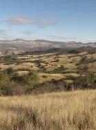
A conservation or preservation easement is a voluntary agreement between a property owner and the holder of the easement concerning the treatment of the property by present and future owners. Such an agreement allows a property owner to continue owning and using a property while assuring its protection. The property can still be sold, rented, mortgaged, or transferred. The easement runs with the land regardless of ownership. Conservation easements can be purchased or acquired by donations. In most cases, nonprofit organizations obtain land through donation, while government agencies purchase them.
The WPC eased a property through a donation of a private landowner, Dale Stover. The conservation easement is a 186acre property in Haines Township, Centre County. This land was Centre County’s first conservation easement to the Conservancy. The easement is jointly owned and managed by the WPC and Centre County Farmland Trust (Figure 6.04).
The Centre County Farmland Trusts preserves the legacy of Centre County’s valuable agricultural land and open space in partnership with landowners who wish to preserve their land through the donation of perpetual conservation easements.


An installment sale enables an organization to spread out its expenditure of funds over time and may in some cases enable the seller to distribute any capital gains tax liability over several years. A bargain sale or donative sale allows organizations to acquire a property partly as a purchase and partly as a gift. The seller sets a price below the appraised value and considers the difference to be a gift. The seller can claim a charitable income tax deduction, provided the appraised value of the donation is at least 20% of the property’s overall value. Taxation on capital gains, if any, will also be lower because the gain will be lower. The seller’s compensation, therefore, is in both cash and tax savings.
Figure 6.05 and Figure 6.06 feature the Big Sur land trust in California that used a bargain sale for a scenic 3,040-acre ranch. The buyer provided financing and the trust purchased the land at a bargain, which gave the seller a tax deduction and then immediately resold the property to the buyer with the added restrictions of development, plus a provision for access to the land for the University of California for educational and research purposes. If not for the Land Trust, the place would have become a private condominium-and-hotel development.
Limited development is selling the land with restrictions to protect resources. This can be done directly by land trusts, limited partnerships, or private investors. Typically, land trusts and partnerships use this as a technique for when there is not the money for complete protection of a parcel. For property owners, this is an excellent way to gain more cash than from the tax benefits deriving from a simple easement donation, while allowing the continuation of ownership and farming, ranching, or timbering on the bulk of the property.
Signage from the Centre County Agricultural Land Preservation Board (Figure 6.07) was established in August 1989 as a statement of the County’s complete dedication to the Pennsylvania farmland preservation program.

Impacted Farmland Trust Property
One potentially impacted Centre County farmland trust (Figure 6.08) is located south of 322 in Potter Township off Par Sonic Road. This farm is an operating heifer operation on 31 acres of good, valuable farmland.

Penns-Brush Valley Studio Fall 2022
The purchase of agriculture conservation easements was initiated in 1989 in accordance with Act 149 in the PA law and is administered by the Centre County Planning and Community Development Office in cooperation with the agricultural land preservation board. PACE actively preserves farmland by compensating landowners for the development rights they give up when they place an Agricultural Conservation Easement on their property. PACE has purchased 58 properties on over 8,763 acres of farmland in Centre County. Currently, there is a wait list of approximately 36 active applications from landowners interested in preserving their farms through the PACE program.
Spr n g Creek Watershed Preser ved Protec ed Land
p n C e k Wa e h d

Proposed US 322 alternatives may affect this 287-acre property in Harris Township (Figure 6.12) which was conserved by ClearWater Conservancy in 1990. The property protects approximately 3,700 linear feet of Spring Creek, only 1.5 miles from the eastern-most headwater springs of the main stem of Spring Creek. The Stone farmhouse on the property was built in 1840 and 180 years later, the property is still in active agriculture. Nittany Farms was once owned by Dr. and Mrs. William Henning. Dr. Henning was the Secretary of Agriculture for the Commonwealth of Pennsylvania. It also contains the historic Old Standford cemetery.
US 322 alternatives may affect this approximately six-acre riparian buffer project along the Sharer Road in Harris Township (Figure 6.13) that was completed with partners including the Natural Resources Conservation Program, the Center for Dirt and Gravel Roads, and the U.S. Fish and Wildlife Service. The affected riparian buffer is highlighted in blue in Figure 6.13.
US 322 alternatives may affect this riparian buffer project along Elks Club Road in Harris Township (Figure 6.14).


By analyzing the current conservation lands with the most productive agricultural lands in PennDOT’s targeted corridors, we can identify, as an example, lands that would be best considered for a conservation easement. The best locations are ones that are adjacent to current easements, so there is an

opportunity to combine the lands. These potential conservation lands are highlighted in red and could create a new corridor that has the opportunity to provide habitat, recreational trails, bike paths, and wildlife protection.

A great example of the process of combining adjacent conservation lands in Centre County is the ClearWater Conservancy’s Barrens to Bald Eagle Wildlife Corridor. This project restored what was once a farm field into a habitat hot spot by collecting adjacent lands under conservation easements. The new habitat creates a home for a variety of native plant and wildlife species.
ClearWater Conservancy owns and maintains the 39-acres of the corridor and it is protected with a permanent conservation easement held by Halfmoon Township. The conservation land is located between the Bald Eagle Ridge in the north and Scotia Barrens in the south. ClearWater Conservancy and other partners established the conservation of the Barrens to Bald Eagle Wildlife Corridor (B2BE) in 2010.
Conservation Subdivision Design:

Refers to residential developments where half or more of the buildable land area is designated as undivided, permanent open space. Conservation subdivision design does not reduce the number of residential units allowed under existing zoning, but rather reduces lots sizes and places the remaining acreage under easement. The jointly held land offers residents shared community space and a buffer from neighboring development, protecting rural character for residents.

One of the biggest remaining examples of pitch pinescrub oak barrens is in the Commonwealth, Scotia Barrens is a rare habitat. It is incredibly valuable as a refuge for a wide range of wildlife, a major source of local groundwater supply, and a location to educate the youth about nature. Key wildlife in the B2BE is marked with signage in Figure 6.17.
Step 1: Identifying the Land that is to be Preserved
Primary Conservation Areas (PCA): unbuildable wetlands, waterbodies, floodplains, and steep slopes.
Secondary Conservation Areas (SCA): mature woodlands, upland buffers around wetlands, water-bodies, prime farmland, natural meadows, critical wildlife habitat, sites of historic, cultural, or archaeological significance.


Step 2:
Deduct PCAs from total parcel acreage and calculate the number of dwellings allowed by zoning on the remaining parts of the site (including SCAs) - the number of units is located around the SCAs.
Conventional Development (32 Houses)
Step 3:
Looking at the buildable land on site, at least one-quarter must remain relatively undisturbed open space, one-quarter must be modified for active or passive recreational purposes, and up to one-half may be developed.
Economical Advantages:
1. Reduces infrastructure engineering and construction costs.
2. Marketing and Sales advantages by allowing developers and Realtors to capitalize on the positive features that can form the basis for an environmentally orientated marketing strategy highlighting the benefits of living in a community where upland forest habitat or productive farmlands have been preserved.
3. Value appreciation: homes in conservation subdivisions appreciate faster than their counterparts in conventional development.
Conservation Design (32 Houses)
In Figure 6.20, note the large central space with shared ponds and meadowland. Siepmann Realty in Wisconsin says: “When they buy a one-acre lot in their conservation subdivision, they are actually receiving the use of more than 80 acres.”


Social and Recreational Advantages:
Allows neighbors to be more acquainted with each other, encourages more community activities through its open space, and creates pedestrian-friendly paths.
Environmental and Ecological Advantages:
1. Habitat protection, Reduces runoff, and produces cleaner water quality.
2. Creates a system of interconnecting corridors for a variety of wildlife at all levels of food chain.

Abby was born and raised in Lititz, Pennsylvania. Her career goals align with Land Conservation as she is interested in protecting valuable historic and ecological landscapes. She anticipates continuing with this research as she pursues more sustainable designs in her future career as a landscape architect. One of the most important takeaways from this studio was that landscape architects can have a substantial impact on highway and transportation design and that local community actions are required to further protect valuable landscapes.
- The Big Sur Land Trust Is Trying to Buy Paradise. | News ... https://www.montereycountyweekly. com/news/local_news/the-big-sur-land-trust-is-trying-to-buy-paradise/article_81f14a4c-a6f65681-a3b1-3eab928a64a8.html.
- “Clearwater Conservancy Earns National Recognition.” StateCollege.com, 5 Jan. 2021, https://www. statecollege.com/centre-county-gazette/clearwater-conservancy-earns-national-recognition/.
- h2admin. “Conservancy Protects a 120-Acre Property in Centre County.” Western Pennsylvania Conservancy, 2 Nov. 2017, https://waterlandlife.org/conservancy-protects-120-acre-propertycentre-county/.

- Miller Last Modified Date: November 24, B. “What Is Land Conservation?” All Things Nature, 24 Nov. 2022, https://www.allthingsnature.org/what-is-land-conservation.htm.
- On the Move: Wildlife Corridors, the B2BE, and Migratory Birds! https://www. clearwaterconservancy.org/single-post/on-the-move-wildlife-corridors-the-b2be-and-migratorybirds.
-“Pace Program.” PACE Program | Centre County, PA - Official Website, https://centrecountypa. gov/609/PACE-Program.

Mitigation strategies are supported by the Federal Highway Administration (FHWA) to lessen the impacts of highway construction on communities. For highway projects that may compromise or severely impact existing resources, such as ecosystems, habitat or historic districts, mitigation strategies offer the state or local community an opportunity to advance a separate project designed to reduce the loss of a resource. A mitigation agreement could result in the acquisition of new lands to offset parks or habitat taken for a project, funds to develop a museum or resource center to showcase regional history or ecosystems lost due to construction, a program to improve water quality and stormwater management, or funds for the documentation and study of a historic site before construction. Mitigation strategies should be identified by the community early in the planning phase of a highway project.
 Tyler Shumaker | LARCH 414 | Fall 2022
Penns-Brush Valley Studio Fall 2022
US 322 Community Charrette in Boalsburg, October 2022,
Tyler Shumaker | LARCH 414 | Fall 2022
Penns-Brush Valley Studio Fall 2022
US 322 Community Charrette in Boalsburg, October 2022,
Although there are many solutions that are possible for this project, I believe that a mitigation strategy will help to give local community members more options when the newly proposed route gets built. Often when highway projects like this are built, they may take and degrade land, ecosystems, habitat or historic districts away from the local community. Thus the transportation agency may be required to give back to the community through a mitigation agreement. The goal of this strategy would be to introduce community members to the possibilities that can be acheived through the use of a strategic mitigation plan.
This is only one example of mitigation. A mitigation strategy does not have to be limited to water quality education facility and park, it could also be a number of other helpful community resources such as an agricultural legacy facility, wildlife education center, or improveed trail connections.

Mercer Slough Nature Park is located in the heart of Bellevue, Washington. When Sound Transit (the Central Puget Sound Regional Transit Authority) wanted to extend the high-priority East Link light rail through the park, citizen opposition was high. The park is a haven of trails through forests, wetlands and meadows, allowing local residents to connect with nature. As mitigation for the transit project, Sound Transit agreed to restore six acres of wetland and wetland buffer within the park, plant 2,800 trees to replace the 691 taken for construction, and acquire an additional six acres of new land adjacent to the park to compensate for the three acres permanently taken for the light rail.
The Intercounty Connector (ICC) also known as MD 200, makes an 18-mile link between I-95 and I-270, and crosses a number of parks, conservation lands, and stream-valley parks owned by the Maryland National Capital Park and Planning Commission (M-NCPPC). Crossing these protected spaces, and taking park lands for a new freeway when MD 200 was being planned in the early 2000s, was going to be a challenge regardless of which of the proposed corridors was selected. While the Maryland State Highway Administration (SHA) worked to minimize the environmental impacts when considering different freeway alignments, park land was going to be taken regardless of the final route selected for the freeway. Importantly, SHA, recognizing the environmental issues, “had the foresight to require substantial environmental improvements as part of the project” budget due to the Maryland’s Smart Growth policies, noted David Marks, a former official with the Maryland Department of Transportation [Baltimore Sun, Nov. 15, 2007] In addition to the State reimbursing M-NCPPC for lost acreage, the two parties agreed to a one-for-one acre replacement for park land taken.
In a Memorandum of Understanding (MOU) between the SHA and the M-NCPPC, the two parties agreed on a one-acre replacement for each one-acre taken, noting that “replacement land will be of equal or greater natural resource, recreation and economic value as the parkland being taken” and required that SHA and M-NCPPC work “collaboratively to compare acreage, natural resource, recreation, and economic values.” [Montgomery County Planning Board, ICC Study Planning Board
Briefing #7, July 22, 2005]
Penns-Brush Valley Studio Fall 2022

Image: Lake Washington’s water wetlands- from Environmental Works Communinty Design Center

Image: Visitor Center- from Environmental Works Communinty Design Center
Image: MD 200’s alignment was shifted .5 miles to avoid Lake Needwood in Rock Creek Regional Park. credit: M-NCPPC

Image: MD 200 crossing Rock Creek, wide arch facilitates wildlife crossing credit: wikiwand.com
 Image: Meadville Stream- from Meadville Tribune
The recent study for the State College Area Connector project, would provide the area with a unique opportunity to envision a mitigation project centered around water quality education. Education is the keystone of change and knowledge of local environmental issues can aid in better land management.

My proposal is to create a wetland park as mitigation for the SCAC project. The park would be adjacent to local waterways to serve the community through an educational center that will teach visitors about water quality issues within Penns-Brush Valley while also allowing them to explore the stream and wetland through trails and boardwalks. Additionally, this park would provide the opportunity to be a trailhead connector to other natural recreational resources such as Rothrock State Park.

The basis for the facility stems from the opportunity to educate individuals within the Penns-Brush Valley community about their local ecosystems and water resources. It will show how their actions can negatively impact natural resources not only for them, but for those who live downstream, including the Chesapeake bay some 200 miles away.


The maps show the impairment of local streams on a watershed scale (Figure 2) as well as community-scale (Figure 1) within Penns-Brush Valley. Streams located in the circle in PennDOT’s current study area, are already under a significant amount of stress due to the agricultural runoff of fertilizers and other chemical sediments.
The community-scale map shows potential waste sites that PennDOT has researched and indicated as a potential evironmental threat to the area. Outlined in orange, red, and yellow are the potential waste sites that indicate the type of waste that could be produced on-site during construction. It is important to note the proximity that these waste sites have too many local streams within the valley. With the potential expansion of the US 322 corridor connector, the threat of impairment by runoff increases significantly.

“Providing water centric education and recreational oppertunites to the Penns Valley community”
- Tyler Shumaker

Cedar Run
Boal Gap Run SinkingCreek PotterRun SinkingCreek
The proposed educational facility would provide a point of entry to visitors interested in learning more about their local environment and natural water resources within the valley, while also being a starting point or a resting point for hikers.
Bridge House- LaGuardia Design Group


The design of the building would be seamlessly integrated into the surrounding landscape, and would act as an extension of natural topography by being partially nested with a hill or berm. To deal with the stormwater runoff the building will work with the natural topography and channel the water through a central bioswale that runs under and through the building making it a unique feature in the landscape. The external facade will consist of glass curtain walls, wood paneling, and exposed steel structural supports.


The building interior will be designed to accommodate and foster a learning atmosphere by offering functional spaces such as classrooms, a conference hall, a forum/auditorium, and an exhibit space. The interior space will continue the language of the exterior facade by utilizing wood paneling to help soften and blend the structure of the building with the natural setting. The glass curtain walls will provide the building with natural lighting and passive heating during the winter.


 Image:
 Casa na TerraBarrocal Portugal
Image: Schorenmatte buildingBasel, Switzerland
Forum area
Collaborative classroom Conference Hall
Exhibit area
Penns-Brush Valley Studio Fall 2022
Image:
Image: Casa na TerraBarrocal Portugal
Image: Schorenmatte buildingBasel, Switzerland
Forum area
Collaborative classroom Conference Hall
Exhibit area
Penns-Brush Valley Studio Fall 2022

In addition to the educational facility, this park would have trailways and boardwalks for visitors to explore parts of the wetland and stream thus allowing them to better connect with the natural environment. The design intent behind these pathways will be to create an experience with nature that is both aesthetically and spatially interesting to hike on. Having the park located in a diverse landscape is crucial, as the landscape transitions from a densely wooded forest to a wetland help keep the trails interesting for the hikers.


Facilities, access and interpretative signage help visitors to learn about a place. Upper images: When construction of Interstate 68 in Maryland exposed a remarkable 350-million-year-old syncline, the State Highway Administration developed an interpretive center and provided access for visitors. Lower image: The Norristown Farm Park in Montgomery County, Pennsylvania, has an elegant interpretive sign system to explain the history and ecology of the 690-acre park. Good graphic design is an important aspect of successful sign systems.
 Image: Zuidpolder Landscape Park- Rotterdam Netherlands Image: Grotto Falls trail-Gatlinburg, TN
Image: Division of Parks, Trails and Historic Sites, Montgomery County, PA.
Image: Sideling Hill Interpretive Center, Interstate 68, Maryland - from Herald Mail Media Image: Sideling Hill interpretive boardwalk access- from Herald Mail Media
Image: Zuidpolder Landscape Park- Rotterdam Netherlands Image: Grotto Falls trail-Gatlinburg, TN
Image: Division of Parks, Trails and Historic Sites, Montgomery County, PA.
Image: Sideling Hill Interpretive Center, Interstate 68, Maryland - from Herald Mail Media Image: Sideling Hill interpretive boardwalk access- from Herald Mail Media
Tyler Shumaker
Fourth-year Landscape Architecture Student
Tyler is from Wynnewood, Pennsylvania. He is interested in the integration of stormwater and water quality practices into the design/planning process and hopes to pursue a career as a practicing Landscape Architect.

-Detail mercer slough nature park. Environmental Works. (n.d.). Retrieved December 8, 2022, from https://www.eworks.org/detailland-mercer-slough-nature-park.
-Lewis, M. (2019, March 27). Md. has ‘one-of-a-kind’ ambition for Sideling Hill Welcome Center. Herald. Retrieved December 8, 2022, from https://www.heraldmailmedia.com/story/news/ local/2019/03/27/md-has-one-of-a-kind-ambition-for-sideling-hillwelcome-center/44324647/.
-Pennsylvania Department of Transportation (PennDOT), Federal Highway Administration (FHWA), & Skelly and Loy, Inc., A Terracon Company. (2021, January). State College Area Connector.
- PEL Study Resources. Retrieved December 9, 2022, from https://terracon.maps.arcgis.com/apps/webappviewer/index. html?id=e41bc8fe87ba4903bbc4c10a17283269.
References
- designboom, ridhika naidoo I. (2010, May 7). Joshua Beck and Tom Reiner: The wave. designboom. Retrieved December 8, 2022, from https://www.designboom.com/architecture/joshua-beck-andtom-reiner-the-wave/.
- Changchun culture of Water Ecology Park: 2019 ASLA professional awards. Changchun Culture of Water Ecology Park 2019 ASLA Professional Awards. (n.d.). Retrieved December 6, 2022, from https://www.asla.org/2019awards/620097-Changchun_Culture_Of_Water_Ecology_Park.html.
- Vocon-CHR 10. Office Snapshots. (2019, February 28). Retrieved December 8, 2022, from https:// officesnapshots.com/photos/114334/.
- East End TransformationWashington University in St. Louis, M. L. E. E. D. P. W. H. A. and A. 80. (2019, December 20). East end transformation: Washington University in St. Louis. KIERAN TIMBERLAKE.
Retrieved December 6, 2022, from https://kierantimberlake.com/pages/view/462/east-endtransformation/parent:3.
- Trumpf Truconnect besucherforum Daniel Stauch photography. World. (n.d.). Retrieved December 6, 2022, from https://www.world-architects.com/en/daniel-stauch-photography-stuttgart/project/ trumpf-truconnect-besucherforum.
- Learning & teaching building. John Wardle Architects. (n.d.). Retrieved December 6, 2022, from https://www.johnwardlearchitects.com/projects/learning-teaching-building/.
-Zuidpolder Landscape Park, Rotterdam region, Barendrecht, Amsterdamse Poort by arcadis. Landezine. (n.d.). Retrieved December 8, 2022, from https://landezine.com/zuidpolder-landscapepark-rotterdam-region-barendrechtamsterdamse-poort-by-arcadis/.
-Gwadzinski. (2022, May 15). Most popular waterfalls in the Smokies. Great Smoky National Park Trips. Retrieved December 8, 2022, from https://www.mysmokymountainpark.com/things-to-do/ natural-wonders/waterfalls/.
-Living, S. (n.d.). Casa na Terra. Silent Living. Retrieved December 8, 2022, from https://www. silentliving.pt/houses/casa-na-terra/.
-Landscape architecture. LaGuardia Design Group. (n.d.). Retrieved December 8, 2022, from https://laguardiadesigngroup.com/projects/highland-terrace.
-Garderobengebäude Schorenmatte, ersatzneubau. [Tastaturkürzel + 0]. (n.d.). Retrieved December 8, 2022, from https://www.hochbau-gebaeudemanagement.bs.ch/projekte/abgeschlosseneprojekte/schorenmatte.html.

Incorporating Native Plants to the State College Area
Connector in Penns-Brush Valley
Keith Faminiano | LARCH 414 Fall 2022
Strategy
The concept of “Pollinator Highways” is a strategy to utilize highway corridors to support healthy ecosystems and sustainable farming. Highway medians, interchanges and roadsides represent large land areas that may be used to enhance local plant diversity. Under pollinator highway programs, the highway right-ofway (the adjacent land owned by the state), or nearby lands (through acquisition, easements, or permissions) are seeded with plants that support pollinator species in a region. Plants must be carefully selected based on local agriculture practices and livestock. For example, some valued pollinator plants, such as milkweed essential to monarch butterfly migration, can be harmful to certain animals. A management plan should be implemented to maintain and monitor the success of the plantings, and make necessary changes based on evolving land use and agricultural practices.

“We need to be mindful and explore environmentally sound design options for our highway rightof-ways.”
Penns-Brush Valley is home to beautiful landscape features ranging from lush forests to protected agricultural farmlands. It also has diverse wildlife that is important to the local ecology of the valley.


US 322 is a two-lane roadway that winds through the valley and is the primary corridor going to State College from Southeastern Pennsylvania. PennDOT proposed the State College Area Connector Project which primarily seeks to enlarge the highway through a redesign of US 322 from Potters Mills to Boalsburg. With that in mind, significant portions of Penns-Brush Valley will be affected including pollinator habitats.
Pollinators are crucial in our natural ecosystem because they pollinate plants for food production and keep us fed. Recently, there has been a significant decrease in our pollinator population due to multiple concerns. This project is going to focus on one of the problems, which is habitat loss caused by infrastructure development such as highways. This project is going to use the State College Area Connector as an opportunity to build pollinator habitats.

Pennsylvania is home to around 350 species of bees and more may be discovered in the future. Together with other pollinators such as butterflies and moths, they provide unparalleled ecosystem services that we humans and other living species have been benefiting from. This project will focus on bees and other endangered species like the Monarch butterfly. The native plants selection for the pollinator habitats along the State College Area Connecter will be pollinator-friendly for the local species.
Western honeybee (Apis mellifera)
Honeybees are key pollinators and thrive well in colonies. They can pollinate multiple crops.


Bumble bee (Bombus)
They pollinate important crops like tomatoes. They also nest underground.
Squash bee (Peponapis pruinosa)
From its name, squash bees pollinate squashes and pumpkins which are cultivated in Penns Valley.
Eastern carpenter bee (Xylocopa virginica)
Carpenter bees like to nest in cedar trees. They pollinate flowers and agricultural crops.


Penns-Brush Valley Studio Fall 2022
Monarch butterfly (Danaus plexippus)
Monarch butterflies are now an endangered pollinator species.

Blue orchard mason bee (Osmia lignaria)
These solitary bees pollinate fast and are active in the early spring.
(c) Tom McC., some rights reserved (CC BY-NC-ND) (c) Brian Buckner-Keith Faminiano
1 Established pollinator habitats in PennsBrush Valley
Create a pollinator habitat corridor along the proposed State College Area Connector connecting fragmented pollinator habitats in Centre County. Provide safe nesting places for pollinators away from disturbances and the noise from the roadways.


2 Healthier ecosystem and biodiversity along US-322 through Penns-Brush Valley
3 Positive social impact and awareness to the pollinator crisis
Diversify the pollinator ecosystem through planting multiple native plant and tree species.
Design various microbiomes along the corridor that resemble the broader Penns-Brush Valley landscape.
Preserve the character of the valley through a carefully selected and organized design palette. Create planting habitats that will remind people about the importance of pollinator habitats.
1 Native Plant Seed Mixes
It’s crucial to diversify pollinator-friendly native plant species as much as possible according to Jason Roth, the environmental project manager and ecologist of Colorado Department of Transportation’s Region 4, who’s currently working on a pollinator restoration project from Longmont to Niwot, Colorado. The significance of diversified seed mixes is to make sure that different pollinators have a variety of plants to get food.
Instead of using the conventional lawn within the highway corridor, this research aims to explore lawn alternatives. The contemporary right-of-way includes public lands along the rural roadways and tree lawns (the land between the curb and sidewalk) in suburban and urban areas. The issue with this is it is difficult and expensive to maintain the lawns. Noise from the lawn maintenance machinery also disrupts and confuses the pollinators. Using ecolawns to soften the edges of roadways is more cost-efficient and environmentally friendly. The pollinators also benefit from ecolawns as an additional source of food.
3 Pollinator Nesting Places
Different pollinator species require their own specific nesting places to rest and function properly. They also need these spaces to lay their eggs. These spaces include: bare soil, bee houses, and trees, as examples. It’s also important to strategically locate these nesting spaces to not confuse the pollinators.
2 Ecolawns Penns-Brush Valley Studio Fall 2022 Image: Toadflax, California and red poppies line the Clayton Bypass - by NCDOT1 North Carolina DOT: Wildflower Program


Composed of a series of wildflower plantings along multiple roadsides in North Carolina, this project started in 1985 as part of the North Carolina Department of Transportation’s highway beautification movement to promote tourism. Although the main goal is to entice tourists, this project also provides acres of wildflowers as habitats for pollinators and is maintained regularly by the state.

2 Ohio DOT: Pollinator Habitat Program
The Ohio Department of Transportation (ODOT) implemented this program in 2017 to help provide habitats to pollinators. This has reduced mowing operations by four times by replacing lawns with acres of native plant habitats and ultimately helping the pollinators. ODOT has been working with different sectors and private landowners to transform acres of land into pollinator corridors and address the pollinator crisis.
 Penns-Brush Valley Studio Fall 2022
Image: Pollinator habitat on Ross County’s roadside - by ODOT
Image: Baby Blue Eyes along N.C. Highway 107, NC - by NCDOT
Image: Black-eyed Susans in I-40, NC - by NCDOT
Penns-Brush Valley Studio Fall 2022
Image: Pollinator habitat on Ross County’s roadside - by ODOT
Image: Baby Blue Eyes along N.C. Highway 107, NC - by NCDOT
Image: Black-eyed Susans in I-40, NC - by NCDOT


PennDOT narrowed down their route options to these three roadways.
This project will focus on the areas covered by and adjacent to the conglomeration of PennDOT’s current three options (November 2022). It will cut through both Harris and Potter Townships and branch out from the existing US 322. This creates fragmentation in Penns-Brush Valley.


Secure Agricultural Parcels Map
The proposed highway alternatives will cut through a number of agricultural security areas which will impact the productivity of each farmland and create fragmented parcels. In addition, the roadway can potentially cause more polluted runoff to the farmlands.


Most of the spaces along the area of focus have well-drained soils but there are also patches of poorly-drained and excessively-drained soils. Some plants would not thrive in poorly-drained soils like the Canadian goldenrod (Solidago canadensis), so that will be considered.


Mapping the farmland use is crucial to ensure the safety of livestock in the adjacent spaces. Some native plants such as milkweeds can be toxic to cattle if consumed. Those species must be planted away from spaces with livestock such as pasture parcels shown in this map.
There are significant areas adjacent to the focus area that are covered by woods. These spaces shall not be touched because pollinators can use these spaces as habitats.
Penns-Brush Valley Studio Fall 2022A myriad of native plants thrive in Centre County, Pennsylvania, but not all are pollinator-friendly. This research seeks to identify various native plant species that will provide habitats to multiple species of bees and butterflies. Here are a few notable plants:


Pollinators need water to function properly. This map shows nearby water bodies that will be helpful for this research to locate specific design elements. There are a number of water bodies in the focus area that will be beneficial for the pollinators.
 Image: Canadian goldenrods (Solidago canadensis), which attract pollinators at a residential property in Centre County.
Image: White snakeroot (Ageratina altissima) on the edges of Colyer Lake.
Image: Swamp milkweed (Asclepias incarnata), which is native to Centre County and a monarch nectar plant.
Image: Canadian goldenrods (Solidago canadensis), which attract pollinators at a residential property in Centre County.
Image: White snakeroot (Ageratina altissima) on the edges of Colyer Lake.
Image: Swamp milkweed (Asclepias incarnata), which is native to Centre County and a monarch nectar plant.
Seed Mix 1 - General Seed Mix
This seed mix will be the default mix that will be used all throughout the focus area.
Swamp milkweed (Asclepias incarnata)
White snakeroot (Ageratina altissima)


Seed Mix 2 - Diversity Seed Mix
This seed mix will be used alongside seed mix 1 to encourage plant diversity.
Common yarrow (Achillea millefolium)
Stiff goldenrod (Solidago rigida)
Clustered mountain mint (Pycnanthemum muticum)

Seed Mix 5 - Excessively-drained Soils Area Seed Mix
This seed mix will be used on areas with excessively-drained soils.
Canadian goldenrod (Solidago canadensis)


Husker’s Red Beard Tongue (Penstemon digitalis ‘Husker’s Red’)
Seed Mix 6 - Shaded Area Seed Mix
This seed mix will include native plants that thrive on shaded areas.

Common yarrow (Achillea millefolium)


Little bluestem (Schizachyrium scoparium)
Ox-eye sunflower (Heliopsis helianthoides)
Lead plant (Amorpha canescens) Bluestem (Andropogon gerardii)
Coastal plain Joe Pye weed (Euthrochium dubium)
Common milkweed (Asclepias syriaca)


Blue false indigo (Baptisia australis)

Seed Mix 3 - Pasture Area Seed Mix
This seed mix will be used on areas along and close to parcels with livestock.
Seed Mix 4 - Poorly-drained Soil
Area Seed Mix
This seed mix will be on areas with poorly-drained soils.
Faminiano
Grass-leaved goldenrod (Euthamia graminifolia)
Common dogbane (Apocynum cannabinum)
Ox-eye sunflower (Heliopsis helianthoides)


Giant hyssop (Agastache rugosa)
Arrowwood viburnum (Viburnum dentatum)
Seed Mix 7 - Water Area Seed Mix
This seed mix will be used on areas close to water bodies like ponds and streams.
Pennsylvania sedge (Carex pensylvanica)

Giant hyssop (Agastache rugosa)


Wild geranium (Geranium maculatum)
Lance-leaved tickseed (Coreopsis lanceolata)

New Jersey tea (Ceanothus americanus)
False boneset (Brickellia eupatorioides)
Virginia wild rye (Elymus virginicus)
New England aster (Aster novae-angliae)

Common sneezeweed (Helenium autumnale)

Great blue lobelia (Lobelia siphilitica)

Virginia wild rye (Elymus virginicus)


Coastal plain Joe Pye weed (Euthrochium dubium)
Common boneset (Eupatorium perfoliatum)

Purple-stemmed beggar ticks (Bidens connata)
Swamp Milkweed (Asclepias incarnata)


Seed Mix 8 - Ecolawn Seed Mix
This seed mix will be composed of native groundcovers that can recreate the look of the lawn.


Canada anemone (Anemonastrum canadense)
Penns-Brush Valley Studio Fall 2022
Red clover (Trifolium pratense)

Queen Anne’s lace (Daucus carota)
Hop trefoil (Trifolium campestre)

White clover (Trifolium repens)

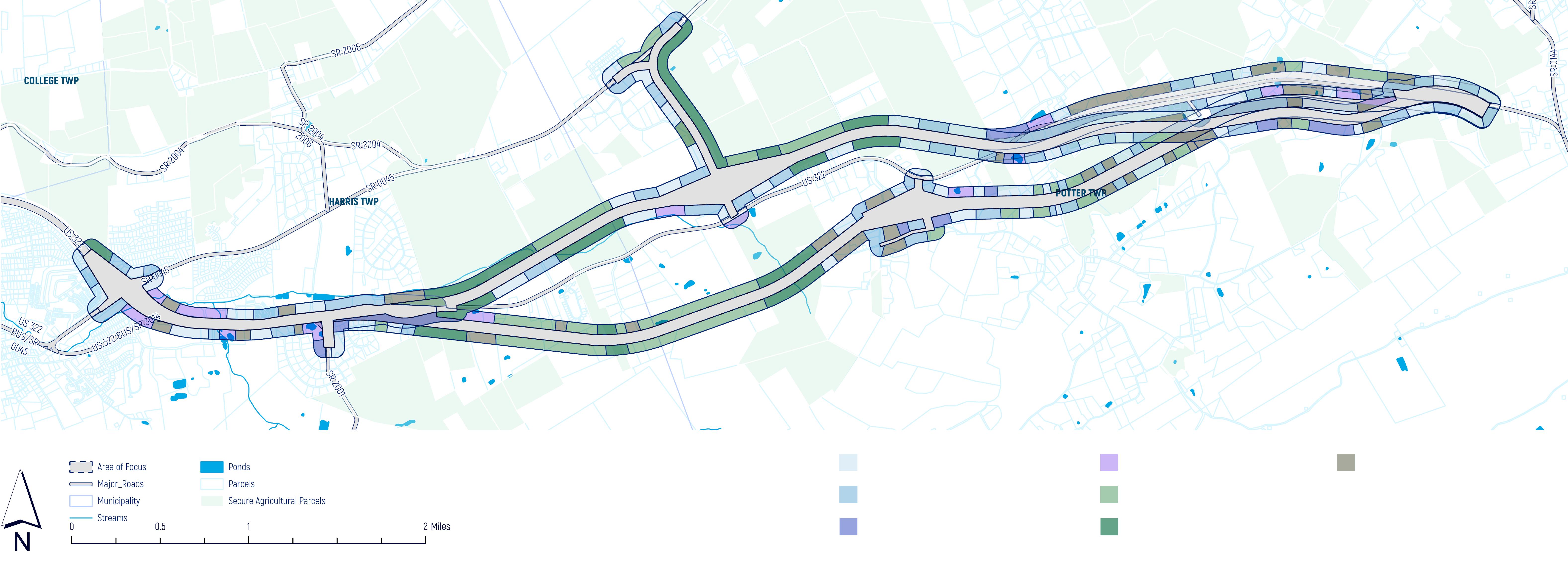
Seed Mix 1 & 8 + Nesting Spaces
Seed Mix 2 & 8 + Nesting Spaces
Seed Mix 5 & 8 + Nesting Spaces
Penns-Brush Valley Studio Fall 2022
Seed Mix 7 & 8 + Nesting Spaces Seed Mix 4 & 8 + Nesting Spaces
Seed Mix 6 & 8 + Nesting Spaces
Seed Mix 3 & 8 + Nesting Spaces
This seed mix will be the default mix that will be used all throughout the focus area.
This seed mix will be used alongside seed mix 1 to encourage plant diversity.


Seed Mix 3 - Pasture Area Seed Mix
This seed mix will be used on areas along and close to parcels with livestock.


Seed Mix 4 - Poorly-drained Soil Area Seed Mix
This seed mix will be on areas with poorly-drained soils.
Seed Mix 5 - Excessively-drained Soils Area Seed Mix
This seed mix will be used on areas with excessively-drained soils.
Seed Mix 6 - Shaded Area Seed Mix
This seed mix will include native plants that thrive on shaded areas.

Penns-Brush Valley Studio Fall 2022

Seed Mix 7 - Water Area Seed Mix
This seed mix will be used on areas close to water bodies like ponds and streams.

Seed Mix 1 - General Seed Mix
Seed Mix 2 - Diversity Seed Mix
Seed Mix 3 - Pasture Area Seed Mix
Seed Mix 4 - Poorly-drained Soil Area Seed Mix
Seed Mix 5 - Excessively-drained Soils Area Seed Mix


Seed Mix 6 - Shaded Area Seed Mix
 Penns-Brush Valley Studio Fall 2022
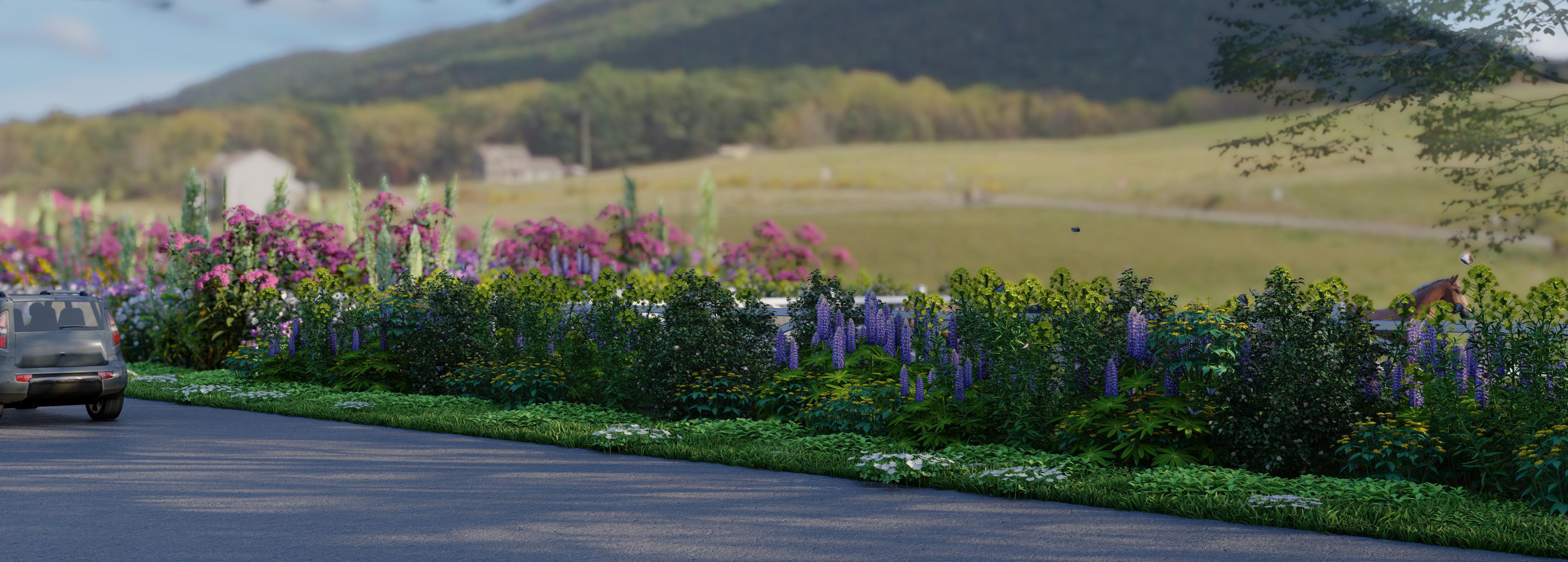 Penns-Brush Valley Studio Fall 2022
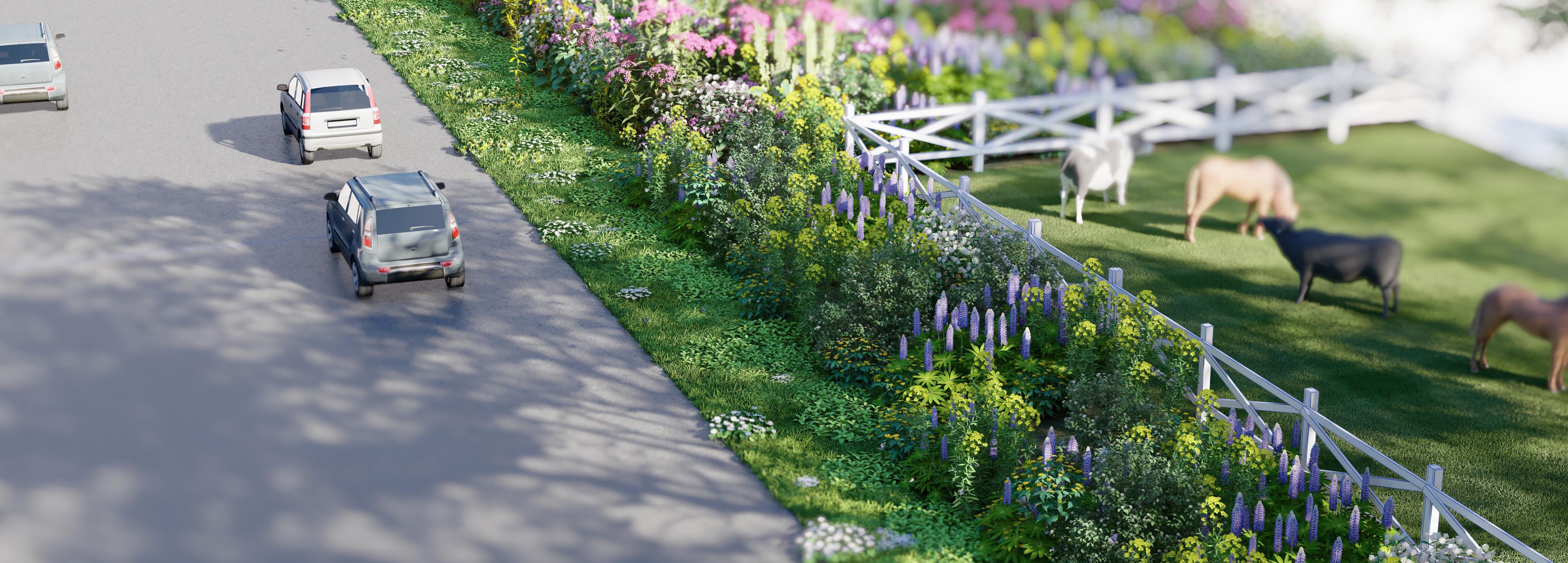 Penns-Brush Valley Studio Fall 2022
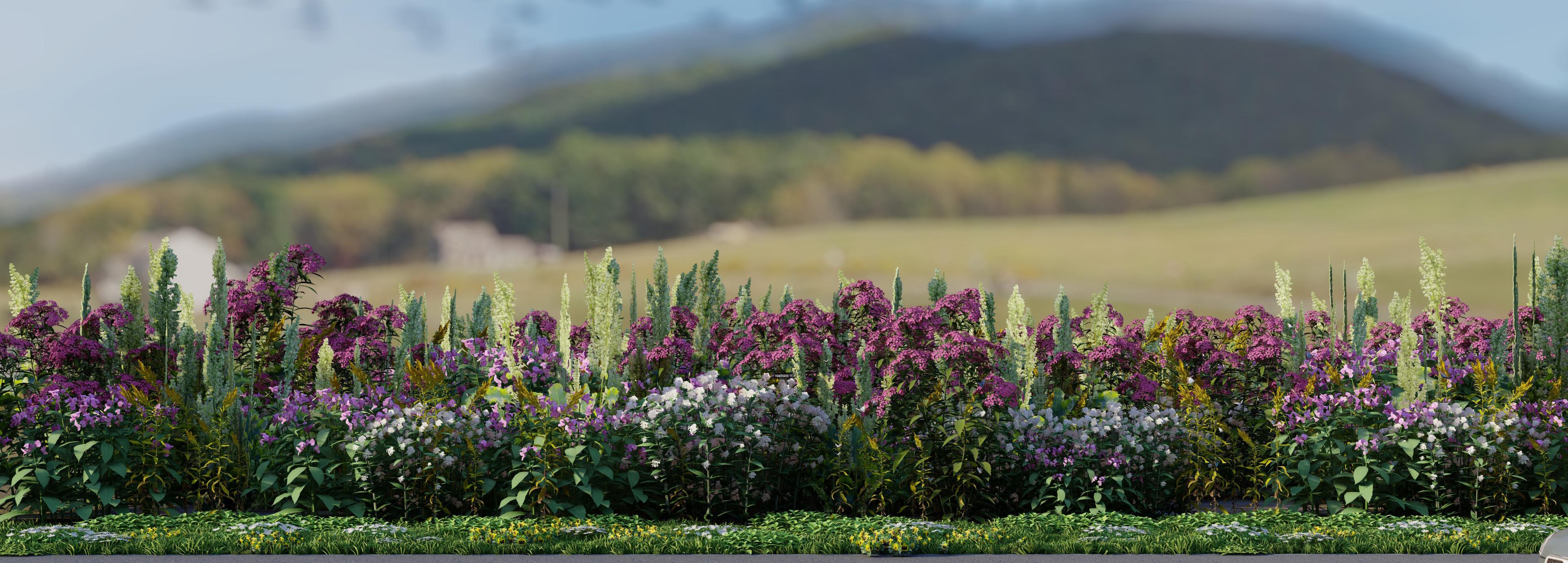 Penns-Brush Valley Studio Fall 2022
Keith is a licensed landscape architect in the Philippines and produced multiple designs for hospitality and urban projects. He is currently an international student from Corcuera, Philippines. He is focusing on applying landscape architecture to agricultural landscapes and the natural environment as he thinks there should be more attention given to these spaces in a climate change perspective. He can be contacted at keithfaminiano@gmail.com.
1. Best Plants for Pollinators (no date). Available at: https://extension.psu.edu/ best-plants-for-pollinators (Accessed: 3 November 2022).
2. Flohr, Travis and Meehan, Dan. “GIS Data Package I.” LARCH 256: GIS Skills. GIS Data Package at Penn State, University Park, PA. Spring 2022. Retrieved from: https://drive.google.com/ file/d/1bnUtMmU48wMZD3aJK4smA45i6H53ld08/view

3. Fiedler, A.K., Landis, D.A. and Wratten, S.D. (2008) ‘Maximizing ecosystem services from conservation biological control: The role of habitat management’, Biological Control, 45(2), pp. 254–271. Available at: https://doi.org/10.1016/j.biocontrol.2007.12.009.
4. Frischie, S. et al. (no date) ‘Pollinator-Friendly Parks’,.
5. Great Pollinator Plants for Pennsylvania (no date) Gardenia.net. Available at: https://www. gardenia.net/guide/great-pollinator-plants-for-pennsylvania (Accessed: 21 November 2022).
6. NCDOT: Wildflower Program (no date) NCDOT. Available at: https://www.ncdot.gov/initiatives-policies/environmental/wildflower/Pages/NCDOT (Accessed: 3 November 2022).
7. ODOT’s Pollinator Habitats Update Ohio Department of Transportation (no date). Available at: https://www.transportation.ohio.gov/programs/polliantor-habitat-program/resources/ wildflower-projects (Accessed: 20 November 2022).

8. Wagner, D.L. et al. (2021) ‘Insect decline in the Anthropocene: Death by a thousand cuts’, Proceedings of the National Academy of Sciences, 118(2), p. e2023989118. Available at: https://doi.org/10.1073/pnas.2023989118.
9. Weaner, L. and Christopher, T. (2016) Garden revolution: how our landscapes can be a source of environmental change. Portland, Oregon: Timber Press.
10. Who are Our Pollinators? (no date). Available at: https://extension.psu.edu/ who-are-our-pollinators (Accessed: 3 November 2022).
FaminianoPenns-Brush Valley Studio Fall 2022
Pennsylvania Department of Transportation
1. State College Area Connector Website: https://www.PennDOT.pa.gov/RegionalOffices/district-2/ConstructionsProjectsAndRoadwork/SCAC/Pages/default.aspx
2. Public Meetings
10/19/2022 at Nittany Middle School in State College, PA.
10/20/2022 at Nittany Middle School in State College, PA.
Penns-Brush Valley Studio
1. Community Meetings Attended: 08/30/2022 Linden Hall Community Meeting at Mount Nittany Winery
09/01/2022 Law Meeting with Lara Fowler at The Stuckeman Family Building
09/01/2022 Meeting with Mary Sorenson at The Centre County Historical Society
09/13/2022 Penns-Brush Valley Studio Presentation at Centre Lifelink
10/06/2022 Zoom meeting with Charles Scott at Jones and Jones Architects and Landscape Architects
10/06/2022 Meeting with Eric Donnell, Director, Thomas D. Larson Pennsylvania Transportation Institute, Penn State
10/19/2022 PennDOT at Nittany Middle School in State College, PA.
10/20/2022 PennDOT at Nittany Middle School in State College, PA.
10/30/2022 Penns-Brush Valley Studio community charette at Calvary Church
11/01/2022 Meeting with Joan Floura at Floura Teeter Landscape Architects
11/01/2022 Meeting with Bruce Dell - city planner in Brunswick, Maryland
11/03/2022 Studio class meeting with PennDOT, District 2, at the Stuckeman Family Building
12/01/2022 Penns-Brush Valley Studio final presentation at Centre Lifelink
2. Published Article: PSU News: https://www.psu.edu/news/arts-and-architecture/story/stuckeman-school-students-help-local-community-advocate-design
Penns-Brush Valley Rural Historic District, National Register of Historic Places
1. Centre County Historical Society
https://centrehistory.org/wp-content/uploads/2022/03/Penns-Brush-Valley-NR-Nomination_email.pdf