THE OLD CITY OF BHOPAL


21 fieldwork participants are architects, social workers, engineers, landscape architects and planners, coming from Albania, Bangladesh, Canada, China, France, Germany, Honduras, India, Lithuania, Morocco, Mexico, Norway, Tunisia and the USA
This report is the outcome of a one-semester fieldwork in Bhopal, India, conducted by students at the Faculty of Architecture and Design at the Norwegian University of Science and Technology (NTNU) in collaboration with the School of Planning and Architecture (SPA) Bhopal and SPA Delhi. The fieldwork was part of a research project “Smart Sustainable City Regions in India” (SSCRI) financed by the Norwegian Centre for International Cooperation in Education (SIU). The onesemester fieldwork is an integral part of the 2-year International Master of Science Program in Urban Ecological Planning (UEP) at NTNU. Previous fieldtrips have been undertaken in Nepal, Uganda and India.
This first semester fieldwork gives students a real life practice of the so-called ‘UEP approach’, which focuses on an integrated area-based situation analysis followed by strategic proposals. Through daily interactions with local communities and relevant stakeholders, students became acquainted with the community and discovered the complex realities of these areas, with their specific assets and challenges.
By using a design thinking and participatory methods, this exercise gives the community a voice by making them active participants.
As is tradition, the diverse backgrounds and nationalities of students participating in the UEP fieldwork ensures a multi-perspective view. This year’s
The main topic studied was informality in all its forms, and particular attention has been given to public space, gender, heritage, land and urban

transformation. Students were also asked to put their areas and proposals in the perspective of the Smart Cities Mission, which is the largest urban development fund and initiative currently implemented by the Government of India.

The semester started with two intensive weeks of preparation with a number of lectures at the home campus of NTNU in Trondheim. The first weeks of our stay in Bhopal, the students became familiar with the city while staying at the SPA Bhopal campus, through a number of lectures and presentations from students and staff from SPA Bhopal and a heritage walk through the old city. By the end of these first weeks, students were divided in six groups and assigned an area.
Through a joint workshop with SPA Bhopal, SPA Delhi and Krvia Mumbai on participatory methods familiarized themselves with their communities and participatory methods, which helped them to build trust with the residents. They continued using these methods and design thinking methods to conduct a situational analysis involving different stakeholders.
A joint workshop with the design students from SPA Bhopal on co-design followed by a number of community workshops integrated the design thinking approach that helped to co-design a series of proposals. Students prepared four situational reports with proposals. This reports sums up the work done by group 5 and 6 in the Old City.
Hanne Vrebos, Rolee Aranya, Brita Fladvad Nielsen and Peter Andreas Gotsch, fieldwork supervisors, NTNU, Department of Architecture and Planning.First of all, we want to thank the faculty at the School of Planning and Architecture (SPA) Bhopal and Prof. Dr. N. Sridharan for all the assistance during our work.
We would like to thank our friends, the Master in Design students from SPA Bhopal, Sumit Yadav, Rinki Sambhani, Manav Singh and Jayant Kumar, as well as Master in Planning students from SPA Delhi, Nikhil Shah, Debaditya Swarna, Deepshikha Sinha and Tanushri Bahl, and Shivadnyi Barate, Prajakta Ahire and Swara Bendre from Kamla Raheja Vidyanidhi Institute for Architecture and Environmental Studies Mumbai, for the help of exploring the areas further, investigating different participatory tools with the locals, granting us new perspectives.
Our work would not be possible without the assistance of our teachers, and we would like to thank Prof. Rolee Aranya, Prof. Peter Andreas Gotsch, Brita Fladvad Nielsen and Hanne Verbos, for sharing their knowledge and guiding us through our work. A special thanks goes to our friend, Gunika Rishi, for her effort organizing and cultural guidance. On behalf of group 6, we would also like to express our gratitude to Harshita Shula, our translator, for helping us get in touch with the locals and to gain a broader understanding of the community.
Last but not least, we want to show a special gratitude to the residents and shop owners of the Old City in Bhopal, for their hospitality and willingness to share so much with us in contribution to our work. We are immensely grateful to all the locals for taking their time

This report is the culmination of three months of fieldwork in the Old City of Bhopal, Madhya Pradesh, India. Our team was comprised of seven students, divided into two groups. Although both groups conducted their fieldwork in the Old City of Bhopal, the areas were very distinct. Therefore, the report has been divided into two sections. The first section covers the analysis of the Chowk Bazaar conducted by the students of Group 5, and the second details the work of Group 6 on Nakkar Khana.
The Nakkar Khana area is situated west of Chowk Bazar. The area of focus for this study is a dense block consisting of a handful of iconic palaces of historic value by Iqbal Maidan. It is a place of identity for the whole city, and is currently of special relevance due to the ongoing renovation project of the Sadar Manzil, by the 100 Smart City Mission in Bhopal.
Through different participatory methods we engaged with the locals to gain an insight to their culture and daily lives, weaknesses and strengths, and hopes for the area,. Among the methods used were spontaneous interactions, interviews, drawing activities, mapping, ranking activities, videos and co-design workshops.
The Chowk Bazaar is situated on the north-east corner of Upper Lake, and is home to vibrant markets, a rich history, and mixed use commercial and residential areas. To prepare our situation analysis, we used interviews, storytelling, card sorts, and community activities with a variety of different stakeholders in this area. These methods, along with site observations, allowed us to gain an understanding of the opportunities and threats facing this area. We found that traffic congestion, parking, and a lack of open space were at the centre of the community’s concerns.
The valuable insights we got from the communities and stakeholders through the methods used, makes the foundation for the situational analysis. The situational analysis focuses on the society and social infrastructure, physical infrastructure, and the heritage value of the area. The main issues identified were related to the highly trafficked Sultania Road, the poor condition of the old royal palaces, and the lack of initiative to take responsibility for their repair and maintenance.
To address these concerns, we selected a smaller area of our site to develop a proposal for strategic change. The proposal was the result of our engagement with residents, shop owners, vendors, government officials, religious leaders, teachers, and children. The focus that emerged was re-envisioning public space for a liveable Chowk Bazaar.
This led to three proposals. The first focuses on pedestrian safety, and aims at bettering the situation for pedestrians. The second aims at raising awareness to the rich culture and history of the area, as well as the poor conditions of the walls. The last and third addresses the lack of communication between the local people and the government, by proposing a platform for stakeholders to meet and shape the future of the area together.

India is the “world’s largest democracy” with a population of 1.3 billion and growing (BBC News, 2018). It is the 7th largest country by area, and is comprised of 29 states and 7 Union territories. Although the major languages of India are Hindi and English, there and over 20 other official languages (BBC News, 2018).
in the world, and holds the position as the 3rd largest startup base in the world (India Brand Equity Foundation, 2018). At the same time, India is dealing with significant social, economic and environmental problems.
Madhya Pradesh means “central state” and is located in the heart of India. Madhya Pradesh is the 6th largest state of India by population and 2nd largest state by area (GlobalSecurity, 2018). The major industries of Madhya Pradesh are largely driven by natural resources, and many people live below the poverty line (GlobalSecurity, 2018). The capital of the state is Bhopal.
The early rulers of Bhopal were a muslim family known as the Nawabs; their rule began in 1723 and lasted until 1947. There was a total of eight rulers during the entire reign of the Nawabs. During the rule of the first Nawab, Bhopal was able to withstand the conquering of the Marthas who successfully conquered nearby states, such as Indore and Gwalior. This was an important victory for Bhopal, and the state was able to remain under Muslim-rule.
In the year 1819 the Begums became the first female rulers of Bhopal. The fact that the state was ruled by women, made the royalty of Bhopal unique for that time. There were a total of 5 rulers during this time period, and the Begums built some of the major historic structures that can be seen within the old city today. Among them were Sultan Kaikhusrau Jahan Begum, an advocate for the emancipation of women, who constructed her palace, the Sadar Manzil. After her rule, her son came into power in 1926, and was the last ruling Nawab of Bhopal.
India is rich in history, with some of the oldest surviving civilizations. It has the fastest growing major economy
Figure 5 - India: Bhopal in Madhya Pradesh

Bhopal is centrally located in Madhya Pradesh, about 600 kilometres south of Delhi. Bhopal is the 17th largest city in India, and is a hub for various educational and research institutions of national importance. According to the 2011 census data, Bhopal has a population of 1,798,218 (Office of the Registrar General & Census Commissioner, India, 2018). It is one of the greenest cities in India, and is called the “City of Lakes” as it is situated around 2 large artificially created lakes.
Situated on the north-east corner of upper lake, the Old City of Bhopal is a center of history, culture, and commerce. At its centre, is the Chowk Bazaar, which is a vibrant marketplace. The Old City also houses the Sadar Manzil, which up until recently was the headquarters of the Bhopal Municipal Corporation (BMC). The palace is known for its combination of Asian and Western styles of architecture, and is now being renovated.
The rule of the Begums resulted in a unique and diverse culture in Bhopal. Although the Begums were Muslim, Hindus were given important government positions in the state, leading to peace and a cosmopolitan culture (NIC, n.d.). This religious peace is present in the Old City of Bhopal today.

Related to the more recent history of Bhopal is the Union Carbide gas leak disaster that occured on the night of December 2-3, 1984. The poisonous gas cloud was carried by wind in the southeastern direction over Bhopal, spreading over the city, including the old city centre. This gas leak took the lives of over 3,800 people and is known as the world’s largest industrial disaster.
The Smart City Mission in India was launched in 2015. With the mission, the Government of India seeks to address the issue of urbanization with the transformation of 100 selected cities. Through the Smart Cities challenge, cities around the country compete to gain the benefits from the mission. The program is founded by the central government in the period between 2017 and 2022. During the period the aim is to make the cities more citizen friendly and sustainable, sustainable cities that can provide a good quality life to its citizens, and of course, “smarter”. There is, however, no universally accepted definition of what a smart city is. A smart city have different meanings for different people, and the definitions varies therefore from country to country and even city to city (Smart City Mission, 2016).
According to the government, the gas leak was contained in eight hours, but the effect of this catastrophic industrial disaster still effects the city today(Dutta, 2017). Many victims have yet to receive adequate compensation from Union Carbide/Dow Chemicals and the Indian government. The relationship between the Indian government and the victims is tenuous. The victims feel neglected because, the Madhya Pradesh government used gas relief money to build 13 sulabhsauchalayas cremation grounds, schools, yoga centers, and dustbins in non affected areas for general public use. This is only one example. (RBT, 2018)
Bhopal was selected as one of the 20 Smart Cities in the first round. Their vision is to transform the city of lakes, its tradition and heritage which is a leading derivation for a smart, connected, and eco-friendly communities which can focus on education, research, entrepreneurship, and tourism. It is among 20 cities that approached the mission differently, focusing on redevelopment rather than retrofitting (Smart City Bhopal, 2018). This means that the project focus on replacing the existing built environment to enable a new layout with enhanced infrastructure, using mixed land use and increased density (Smart Cities Mission, 2017).
A focus of the Smart City Mission in Bhopal is Smart Heritage. A big ongoing project is the restoration of the old palace Sadar Manzil, called adaptive reuse and heritage conservation of Sadar Manzil.

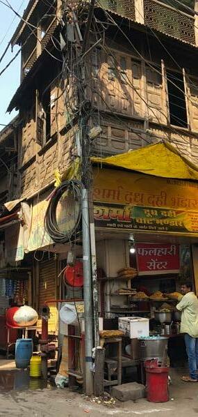
The Chowk Bazaar is a place of colours, cultures, commerce, and festivities. This area is one of the oldest commercial and residential areas of Bhopal (SPA Bhopal Masters of Planning Studio, 2018). In the name, ‘Chowk Bazaar’, ‘Chowk’ refers to junction and ‘Bazaar’ refers to market. This area is roughly forty hectares in size, and is located at the north-east corner of Upper Lake, in the heart of the Old City of Bhopal (SPA Bhopal Masters of Planning Studio, 2018).
When it was constructed, the Chowk Bazaar could be entered through seven gates: Imami, Itwara, Somwara, Mangalwara, Budhwara, Jumerati, and Peer gate; named after the seven days of the week (SPA Bhopal Masters of Planning Studio, 2018). Many of these gates have since been demolished, leaving Jumerati as the only gate standing today.
Historically, the Chowk Bazaar was primarily a residential area with grand homes, palaces, and courtyards (SPA Bhopal Masters of Planning Studio, 2018). The function of this area has shifted over time to become a commercial hub for the city. Today, commercial activities range from wholesale markets and warehouses to retail shops and banking.
During the 19th century, the Chowk Bazaar featured palaces, courtyards, and other residential spaces. Over time, this area grew as a commercial centre with a variety of different markets with specialty goods. The Chowk Bazaar is known for the Jama mosque and the diversity of different markets. Many people live in this area, which along with its heritage, make it a unique mixed use space.
Figure 8 - Main roads in the Chowk Bazaar N
The aims of this study were: 1) to gain an understanding of the community, context and elements of informality in the Chowk Bazaar, and 2) to develop a proposal for strategic change, which could improve the liveability of this area.
To achieve these aims, we adopted a human-centred design approach, which allowed us to conduct our study at a neighbourhood level, placing people at the centre of planning. Over the course of our fieldwork we:
The history of the Chowk Bazaar dates back to 1837, when it was constructed as a walled city built around the Jama Mosque (SPA Bhopal Masters of Planning Studio, 2018). The narrow streets were designed using a grid pattern with four cardinal roads leading toward the mosque. Several wider peripheral roads were constructed around the walled city, to connect the Chowk Bazaar with other areas of Bhopal (SPA Bhopal Masters of Planning Studio, 2018).
Collected background information on the history of the Chowk Bazaar

• Engaged with community members and key stakeholders
• Mapped residential and commercial spaces, parking, and formal and informal vendors

• Explored the different forms of informality in our area
• Reviewed relevant planning policies and bylaws
• Prepared a situational analysis based on our findings
• Identified strengths, weaknesses, opportunities, and threats in our area
• Developed a proposal in close interaction with the community and other stakeholders
Figure 9 - Market in the Chowk Bazaar
For this project, our team was assigned the Chowk Bazaar, which is located in the Old City of Bhopal. Insights learned through our initial investigations, allowed us to select a specific geographic area and focus for our study.

members were from India, or had travelled to Bhopal before. One member of our team spoke Hindi, which was the most prevalent language spoken in our site. Language, cultural differences and the busy pace of life in the Chowk Bazaar, presented limitations to our research.
As time was a limitation, we decided to select a smaller area within the Chowk Bazaar that could be analyzed as a case study. We selected the area located within Tabba Miyan Mahal Rd, Itwara Rd, Fish Market Rd, and the Jama Mosque because many of the challenges and opportunities this area presented were representative of the Chowk Bazaar as a whole.
Informality was a major consideration for our work. Many of the challenges and opportunities we observed in this site, were due to various forms of informality. The informal economy and informal use of space was important to understand, as it influenced the way this community functioned and the bond between people.
The concept of liveability emerged as it provided a framework for us to analyze informal connections and develop strategic actions that could benefit this area. Liveability has many definitions and components. In our research, we explored elements of liveability, which were appropriate for our study at our site.
A significant limitation for this project was our lack of familiarity with the local context. None of our team
To conduct our research, we followed a humancentred design approach as described in “The Fieldwork Guide to Human-Centred Design” by IDEO.org. Human-centred design “is about getting to the people you’re designing for and hearing from them in their own words” (IDEO.org, 2015, p.39). It was difficult to know which human-centred design methods would be effective in the Chowk Bazaar. Our process involved testing different methods through trial and error to find out what worked best in this community.
Our perception of an effective method, did not always work in practice. We continuously reviewed and adapted our methods to capture the stories of the community, while meeting the needs of our study. We created a timeline to illustrate the significant events of our fieldwork semester and to provide an overview of the process we followed. In the following sections, we will discuss each of our methods of data collection in detail.
Introduced to Urban Ecological Planning and participated in community engagement, teamwork, and GIS workshops
Our team of four comes from different backgrounds and countries including Norway, Bangladesh, Tunisia and Canada
Participatory planning workshop with SPA Delhi and KRVIA Mumbai
Conducted interviews and focus group discussions in the Chowk Bazaar
Meeting with Ward Councillors, religious leaders, business owners, and community members in our area
Participatory activity which illustrated what people liked and what is missing in their area
First time we presented our draft proposals Showcase of our fieldwork with SPA Bhopal and invited guests
Aug’ 13
Sep’ 10
Sep’ 3
Sep’ 14
Sep’ 18 Oct’ 4
Oct’ 11 Oct’ 19
Oct’ 29
Nov’ 20
Familiarized ourselves with the local context
First visit to the Old City in Bhopal
Co-design workshop with SPA Bhopal
Studied housing, traffic, parking, and green space, by conducting a card sort
Oct’ 12 Site mapping
Collected information through GPS points, photographs, videos and hand drawn mapping
Oct’ 23
Nov’ 1
Drawing activity
Participatory activity designed to engage local school children
Community workshop
Poster session in our study area with activities and discussions to collect feedback on our proposals
Nov’ 27 Examination
Final presentation of our fieldwork
Figure 11 - Timeline of our fieldwork
For this project, we had six weeks to conduct our fieldwork, prepare a situational analysis, and develop a proposal for strategic change that could benefit the community. To do this, we employed several humancentred design methods with a variety of different stakeholders. We engaged with local residents, business owners, shop workers, street vendors, shoppers, government officials, religious leaders, teachers, and school children.
We began our fieldwork by immersing ourselves in the community. We walked the streets of the Chowk Bazaar, ate at local restaurants, and sat and observed community interactions. We did this for a couple of days to gain an understanding of the area, and become visible for people living and working here.

The first method we used was informal interviews and focus groups. This method allowed us to meet people in the community and begin to hear their stories. At first, people were curious about our presence and wondered where we came from. Once they understood we were students studying the Chowk Bazaar, many people were excited to share their knowledge and stories.
narratives collected when conducting interviews as opposed to focus groups. In one of our interviews with an elderly lady, she was telling us about her experiences living in the Chowk Bazaar. When her husband entered the room, she did not feel as comfortable sharing her perspective and the conversation shifted to his narrative.
-
For this method, we partnered with two Masters students from the School of Planning and Architecture, Delhi (SPA Delhi) and one from Kamla Raheja Vidyanidhi Institute for Architecture and Environmental Studies, Mumbai (KRVIA).
Similarly, we gathered different information when talking with a single business owner, compared to a group of business owners. In some situations, focus groups stimulated new ideas and discussion, however this was not always the case.
We used the term ‘interview’ to refer to our discussion with one person. ‘Focus group’ was the term used whenever we engaged with two or more people at the same time. There were notable differences in the


In our interviews, we did not use a set script. Our questions were aimed at gathering people’s stories and developing an understanding and appreciation for this area. Questions that arose in multiple interviews included:
What do you like about this area? How do you travel from place to place?
What is it like living/working in this area? What are the challenges you face in this place?
We asked open-ended questions like these whenever we could, to avoid a yes or no response and to open up the discussion. Interviews and focus groups provided valuable insights to this community, and allowed us to narrow our focus.

The second method we attempted was storytelling. In this method, we asked people open-ended questions that might prompt them to tell a story. The story could be about their business, family history, or what a typical day looks like for them. Our plan was to capture their stories through writing and sketching as they told it to us. In practice, this method was difficult to use. Stories were told in Hindi, and there was not enough time for the Hindi speakers in our group to translate, take notes, and create sketches of what was being said.
This method for community engagement had its strengths and weaknesses. One of the major strengths was it allowed people to see a variety of topics relevant to their area, and select what they cared about most. This was important information to gather, however it did not always tell us what was missing or what community members wished was different in their area.
For this portion of our fieldwork, we partnered with two Masters students from the School of Planning and Architecture, Bhopal (SPA Bhopal). To make the most of our time together, we decided to adapt our methods. Instead of attempting to capture too much information at once, we returned to the informal interview to record people’s stories.
To gain a deeper understanding of what people in our area cared about, we worked in collaboration with Masters students from SPA Bhopal to prepare a card sort. A card sort is “a quick and easy way to spark conversation about what matters most to people” (IDEO.org, 2015, p.57). We developed a deck of cards, each with words and an image, that profiled topics we heard in earlier interviews were relevant to the Chowk Bazaar. To test this method in our area, we handed the deck of cards to community members and asked them to rank the cards according to what they felt was most important.

In one card sort, the business owner selected “basic infrastructure” as the most important thing he cared about. When asked why he selected this card, he stated that without basic infrastructure, like electricity, water, and drainage, his business would not be able to function. For our study, we were trying to find out what the community needs were, however individual participants organized cards based on their personal priorities.
The card game method was a logical next step to improve the card sort. To develop the card game, we thought carefully about the topics for each card, and created guiding questions to frame the activity. We conducted the card game with the following questions:
What do you like about this area? What is missing in this area?
This adaptation to our methods yielded positive results. The guiding questions allowed participants to talk more in depth about opportunities and
street vendor
challenges in their community. We used this activity with local residents, shop owners and workers, street vendors, women, children, and the Ward Councillor of this area.
One additional question that emerged was “what are the most significant challenges of this area?”. This was a useful question to get people talking about problems they had noticed, and what solutions could look like.
Over the course of our fieldwork, we engaged in three different community activities in the Chowk Bazaar. The first was not planned by us. We were invited to celebrate the Navaratri Festival, which included music, dancing, and introductions with many community members.
From our previous methods, we learned that places for children to play were missing in this area. To varify this information, we met with a local school and conducted a drawing activity. We asked the children to draw their favourite places to play, and explain to us what they had drawn.

The drawing activity had mixed results. We learned about places in the community where children go to play. However, the method failed to capture what the barriers are to play, or where more play areas are needed.
The final community engagement activity we conducted was a community workshop. This method was intended to collect feedback from the community about our fieldwork and test our ideas for strategic change. For this workshop, we set up poster boards on tables across the street from Najja Dada Park. We showcased our work, answered questions, and collected feedback.

As part of this community workshop, we provided chalk for a street art activity. Classes of children from the school we worked with previously, came to visit us and participate. Community members from different backgrounds came to our workshop and gave us their feedback.
This community workshop was very interactive and provided a sense of closure for our study. It allowed us to develop a proposal for strategic change in collaboration with the people living and working here. It also provided a unique opportunity to test our ideas in the field.
Figure
Figure
- Child's drawing of their favourite place to play
- Community workshop
In addition to the human-centred design methods mentioned above, we used photographs, GPS points, drawings, and video footage.
Photographs allowed us to capture various uses of space in the Chowk Bazaar. They also proved useful as we developed our proposal and needed to visualise the area in new ways. We did not take photographs immediately, as we wanted to build trust with people in the community first. When we had established this connection, we took photographs to document the work we did in the field.
To document commercial and residential spaces, as well as the location of street vendors, we collected GPS points using an application on our cell phones called Collector for ArcGIS. We used this data to create maps showing the mix of different uses in our area.
Drawing is another method we used in our fieldwork. We documented the extent of two-wheeler parking in our site, through hand-drawn maps.
To show our experiences in the Old City, we collaborated with three other classmates to produce a video of our fieldwork. We filmed video footage over several weeks for this project. The video we created is not included in our report, however it provided a different view of the Chowk Bazaar for us to reflect on.
In this section, we will present the findings of our fieldwork study. To structure our report, we have divided the situational analysis into six sections: People and Place, Physical Infrastructure, Mobility, Markets & Vendors, Social, Government and Religious Organizations, and Community Spaces.
Our situational analysis will also discuss informality we observed in the Chowk Bazaar. The concept of informality emerged through our methods, and allowed us to develop a proposal for strategic change.
To gain an understanding of the people and place of the Chowk Bazaar, we immersed ourselves in the context.
Through our interviews, we found there was a strong community bond in this place. A long-term resident told us people do not need to lock their doors as the community looks out for one another. Residents and local business owners spoke of a harmony between people of different background and religions.
The main religions we found in this place were Hindu, Muslim, and Jain. These religions coexisted in the Chowk Bazaar, with Hindu idols and celebrations often taking place right beside the Jama Mosque.
Figure 18 - Street shop in the Chowk Bazaar

Figure 19 - Hindu celebration next to the Jama Mosque

Although this area was known for its commercial significance, we found it had many other values and uses. Residents and shop owners we talked to were very proud of this area. Many have lived here for generations, and do not want to leave because of their strong connection to this place.
However, we learned through our focus groups that some families are moving out due to noise pollution, traffic congestion, and parking problems. In buildings where families have moved out, upper floors have been converted to storage space for the businesses below.
We found the Chowk Bazaar houses schools, community centres, mosques, temples, and many residential spaces. In the card game activity, the Jama Mosque, market, and community bond were often selected as elements the community liked most about this place.
In the card sort activity we conducted with several business owners, basic infrastructure was selected as the most important topic of consideration for the Chowk Bazaar. They told us without basic infrastructure their businesses would not be able to function. To gain an understanding of basic infrastructure, we conducted a review of the housing and building typology, waste management, water and drainage, and electricity.
Figure 20 - Mixed use in the Chowk Bazaar
Figure 21 - Land use of our selected area
The building typology of our study area can be characterized as low-rise commercial mixed use. Many buildings were built of brick with cement plaster and housed commercial on the ground floor with residential spaces above.
We collected GPS points and descriptions for most of the buildings in our study area. We recorded information about the use, number of stories, and state of the building based on visual inspection. We were not able to reach some of the buildings on the inside of the blocks, because there was no clear pathway to reach them.
139
Commercial and Residential
Commercial
If residents rebuilt now, they would need to comply with minimum setback distances prescribed in these rules, and lose valuable space in their homes. As a result, buildings were continuous undergoing smaller repair, however there is a limit to how long this strategy can last. Many buildings were in poor quality, and required large repairs or complete rebuilds.
Parking
NUMBER OF STORIES
83 17 3
Studying the history of housing in the Chowk Bazaar, we learned that blocks were designed with inner courtyards. Residents explained how many courtyards have been lost or fragmented, as families grew and extended their houses. This informal encroachment has led to space issues and overcrowding. Courtyards that were previously used for open space, are now used for private parking, workshops or storage.
story
Water and drainage were two topics we learned about through site observation in the Chowk Bazaar. There were a number of hand pumps, which provided a source of water in this area. Buildings were connected to water supplied by the Bhopal Municipal Corporation, however not all the shops on the ground floor required water access. Residents and restaurant owners we talked to were not affected by water issues.
story
categories do not add up to the same total number of buildings. This is because some buildings were under construction or otherwise could not be included under all the categories. For example, a parking courtyard in this area was recorded under ‘building use’ but not under the categories of ‘number of stories’ or ‘state of the building’.
When we interviewed people in this area, waste management was not a major issue they discussed. Walking around the site, we noticed garbage was sometimes piled in the streets. Local residents told us that sometimes cows eat this garbage and get sick.
The majority of buildings were mixed use residential and commercial. We observed that the older buildings were usually two to three stories and in poor condition. The newer buildings were four or five stories and in better repair.
Residents told us that the degrading state of the buildings was a big problem in the Chowk Bazaar. In an interview with a resident of Itwara Rd, we learned that people were reluctant to rebuild their houses because of the Bhumi Vikas Rules, 1984. These rules came into force after many of the buildings in this area were built.
In an interview with a manager from the Health and Environment Department, we learned that the Chowk Bazaar has gone “dustbin free” under the Swachh Bharat Abhiyan. This is a large nationwide cleanliness campaign by the Government of India. Instead, they have adopted a door to door waste collection system, which occurs two to three times a day. Waste is collected by carts and brought to a nearby collection facility.

We observed that streets in the Chowk Bazaar had drainage running down both sides of the road. Talking to the Ward Counsellor, we discovered there are plans to cover the drains, however the work was only partially completed. On several occasions, we witnessed workers cleaning waste from drains to ensure they were clear for waste water to flow. The drains that had covers provided informal seating options for community members.
In the various methods we conducted, we did not hear many concern regarding electricity. Business owners spoke of the importance of basic infrastructure, however they did not mention power outages or problems with the energy grid.
Walking around the site, we noticed that power lines were often tangled. During parades and cultural events, we observed people lifting these lines to allow vehicles with tall parade floats to drive under them.
To understand this area in the context of mobility, we have gathered information on connectivity, traffic, and parking in and around the Chowk Bazaar.

The Chowk Bazaar was originally built as a walled city with narrow streets designed using a grid pattern (SPA Bhopal Masters of Planning Studio, 2018). It was built with four cardinal roads leading to the Jama Mosque (SPA Bhopal Masters of Planning Studio, 2018). Wider peripheral roads were constructed around the walled city to provide connectivity with the surrounding areas of Bhopal (SPA Bhopal Masters of Planning Studio, 2018).
The main roads which connected the Chowk Bazaar are Hamidia Rd, Sultania Rd, Chwoki Imam Bara Rd, Itwara Rd, and Azad Market Rd.
Traffic Traffic congestion was one of the major issues of the Chowk Bazaar. With the narrow streets and densely built area, traffic problems were increasing with the expanding population. In almost every interaction we had with the community, traffic congestion was mentioned as a pressing issue.
Inside the Chowk Bazaar, distances between areas were walkable. However, through our interviews we found that residents, shop owners, and shoppers preferred to use their two wheelers to get around, which added to the congestion we experienced in this area.
There were multiple ways to get to the Chowk Bazaar. Public buses ran on the main roads, and there were also minibuses, auto-rickshaws, tata magic vans and other options for travelling in and out of this area.
Many upgrades were made by the local authorities to control the traffic flow, such as clearing the roundabout in Imami Gate, making the peripheral roads one way, and restricting direct entry from Kamla Park and VIP road. To access the Chowk Bazaar, one needed to go around Sadar Manzil and enter from Peer Gate or Jumerati Gate. People did not always follow these traffic rules and often went the wrong way down a one way street.
Peer Gate, Jumerati Gate and Itwara Gate were the major entry point for vehicles. In the focus group we conducted with cloth vendors in this area, it was identified that most delivery vehicles pass through Peer Gate and Itwara Gate and a small portion through Jumerati Gate.
The traffic congestion had significant implications for people living and working in the Chowk Bazaar. In multiple interviews, community members mentioned that traffic congestion, lack of parking, and noise pollution have forced many residents to move out of this area. Some moved to the new city and others moved just outside the gates.
In the future, the Metro Rail which is planned for Bhopal will bring a new level of connectivity and public transportation access to this area.
Figure 25 - Timeline of traffic congestion in Chowk Bazaar
Shops are closed. Streets are empty and residents are visible. Some household activities can be seen on the streets.
Shops start to open gradually. 2 wheelers and cars can be seen driving through the streets, and some pedestrian activity. Small deliveries to the shops occur during this time.
Streets get busy with commercial activities. Peak time is between 14.00-18.00. Highly congested traffic situation. The density of 2 wheelers increases tremendously. Informal vendors gather around the Jama Mosque square.
Streets are still busy with commercial activities. Traffic congestion remains high. More people can be seen hanging around, drinking tea and gossiping.
Shops start to close. Traffic becomes lighter. Streets start to empty. Residents, mainly males hang around the tea-stalls and closed shops.
With the heavy traffic congestion and increased commercialization of this area, parking was a major issue for people. A large number of two wheelers were parked on the narrow streets of the Chowk Bazaar, making it difficult to navigate.

in this area. However, people said they are too far away or that they do not want to pay for parking. In an interview with a shop owner whose family had lived in the Chowk Bazaar for three generations, we learned that every morning he parks his car outside this area. At night, he drives back to park in front of his house once the traffic and parking issues have calmed down.
During the peak period of the day, which was between 14:00 and 18:00, we observed major congestion and parking challenges. In a survey of our selected study area, we counted 652 two wheelers parked in our study area, with many more attempting to drive through.
Through our interviews with the community, we learned there are areas to park cars and two wheelers
There were also multi-level parking facilities close to the Chowk Bazaar. Some residents said these facilities were used on a regular basis, others said
that people did not want to park and be forced to walk to their homes, stores, or to conduct their shopping. Almost all the people we engaged with who complained about parking, admitted they drove their
Figure 27 - Map of two wheeler parking and street vendors


N
Figure 28 - Existing parking facilities
Figure 29 - Parking congestion
two wheelers to get around and were contributing to the problem. Community members said that driving right to their shops and houses was still the easiest way to get around.
In an interview with the Ward Counsellor, we learned that to address issues of parking and traffic in the past, the Bhopal Municipal Corporation made the Chowk Bazaar a no vehicle zone. The vehicle ban lasted for six months, but was lifted due to pressure from residents and local businesses.
Although traffic and parking were the main issues identified by community members, there was a disconnect between how individual actions contributed to the problem. There were parking and public transportation options available in this area, however they were not being utilised. Talking with residents, it became clear that incremental policy and behaviour changes will need to go hand in hand to tackle the complexities of parking in this area.
In our card sort and card game activities, markets and vendors were identified as elements people liked most about this area. People told us that no matter what you needed, you could find it in the Chowk Bazaar.
The Chowk Bazaar had many specialty markets, including:
• Kolhapuri Market (Sandal/Shoe for men)
• Chudi Market (Bangles)
• Lakherapura Market (Clothing market for weddings)
• Sarafa Market (Jewelry market)
• Marwari Market (Shoe market)
• Hardware/Electronics markets
• Household utensils markets
There were mostly jewelry shops surrounding the Jama Mosque square. However, the section in the southwest consisted of wholesale clothing markets for colourful sarees, kurtis, and traditional wedding attire.
buildings there were shops on the upper floors as well, or this space had been converted to storage. Many shops in this area expanded beyond their property onto the street. This informal encroachment was problematic for parking and traffic, as it reduced the width of the street even further.
In our area, we noticed that many new buildings were under construction. Through our interviews, we learned that older residential buildings were being demolished and replaced by new commercial buildings. Commercial rents were higher than residential rents in this area, which was driving this change.
Shoes Market
Utensils Market
Cloth Market
Electronic Market
Jewellery Market
Along Itwara road, there were mainly electronic shops along with some food stores. At the outer edge of the Chowk Bazaar there were fish and meat markets. The Tabba Miyan Mahal Rd consisted of mainly clothing stores along with some grocery and food shops.
The ground floors of the building were usually shops and the residences were located upstairs. In some
Figure 30 - Market areas of the Chowk Bazaar

We talked with many different shop owners in the Chowk Bazaar. The majority of owners we interviewed had inherited their shops from their family. Usually, owners lived above their shops, however this was not always the case. We also met with people who had bought their shops or were renting. There were many powerful individuals, groups, and institutions who owned land in the Chowk Bazaar. For example, an institution called the Waqf Board owned all of the storefronts below the Jama Mosque. Another important institution we came in contact with was the Gujarati Samaj. This institution owned a school and a community centre in the Chowk Bazaar, where we conducted interviews and met members of the community.

Informal vendors were part of the character of the Chowk Bazaar. Many informal vendors we talked to said they had been doing the same work in the same area for generations. These long-term vendors, were in a way semi-formal, because of the length of time they had worked in the area and partnerships they had formed with the community.
We interviewed an elderly flower vendor who had been sitting under the same big tree next to the Jama Mosque for almost forty years. People in the community respected him and would often stop to talk. This vendor had a long standing relationship and social position in the community.
Figure
Similarly, an informal jewelry maker we interviewed, told us he had many long standing contracts with local businesses. His family had been making jewelry in this way for generations, and was integrated with the surrounding formal business community.
Most of the informal vendors in the Chowk Bazaar, were concentrated around the Jama Mosque. We observed that they set up in the same spot at the same time everyday. Some vendors, including vegetable vendors, had carts and move around this area to conduct their business.
In an interviews with the Ward Counsellor, we learned that the Bhopal Municipal Corporation had set aside areas for these informal vendors to conduct their business. However, vendors were not interested in relocating, as their livelihoods were tied to the connections and partnerships they had established in their current location.
One of the jewelry street vendor we talked with said it would be better if he could get a more permanent place near the Jama Mosque. Many of the vendors shared a similar desire to stay close to the area they already were working in. Formal jewelry retailers also wanted these informal vendors near their shops, as they completed contracts necessary for their business.
Over the course of our fieldwork, we interacted with several important organizations including the Bhopal Municipal Corporation, Bhopal Smart City Development Corporation Limited, Madhya Pradesh State Waqf Board, and the Gujarati Samaj.
objectives included improved traffic management and walkability. The Bhopal Smart City Development Corporation Limited was an important stakeholder for us to consider, because they have funds and operated independently from political decisions.
In our interview with the Bhopal Municipal Corporation, we learned that Bhopal is divided into 85 wards. The Chowk Bazaar falls under ward 20 and 21. The site we selected for our study is contained within ward 20. We learned there were plans to rejuvenate the Chowk Bazaar. Five years ago, tender was passed, budget was allocated and work began on several projects including:

• resurfacing the area around the Jama Mosque
• converting the Chowk Bazaar to a no vehicle zone
• constructing new facades for all of the buildings surrounding the Jama Mosque
• removing informal vendors to combat encroachment on the streets

• transitioning all the electrical wires and cables underground
• covering the open drains on the streets
• building multi-level parking
At the time of our fieldwork, multi-level parking had been built, the area around the Jama Mosque was repaved with kota stones, and many drains were covered.
Another important organization in this area was the Madhya Pradesh State Waqf Board. In an interview with the Nayab Mufti of Bhopal, the second highest person in the Muslim community in the state, we learned that the Waqf Board was created to improve the administration of waqfs. Waqfs are endowments made by a Muslim to a religious, educational, or charitable cause.
Through this interaction, we realized that the Jama Mosque was included under the management of the Waqf Board. We also learned that a separate division called the Auqaf-e-Shahi was responsible for renting out the shops and other properties belonging to them.
In our fieldwork, we came across several important societies that were active in the Chowk Bazaar. We interacted most with the Gujarati Samaj, who owned the low-income school and community centre we worked in. This society had a good reputation in the community, which allowed them to contribute to the development of this area.
The Bhopal Smart City Development Corporation Limited did not have any projects in the Chowk Bazaar. During our visit to their head office, we learned their
At first, people were only concerned about traffic and parking issues in their area. As we used different participatory methods, we learned that people were also concerned about community spaces. In the card game activities, open space, gathering space, and places for children to play were often selected as things missing in this area.
We found there were several different kinds of community spaces in the Chowk Bazaar. For example, when we asked a group of high school students where they “hang out” they told us “inside of course”. In one focus group we conducted, the parents told us they send their children to a school outside the area because there is no outdoor places to play.
Through our observations, we found many residential areas had interior courtyards. Some of these had been converted to parking or storage, however others were used as community gathering spaces. These courtyards provided a more quiet, safe space for people to gather and for kids to play.

We found that the streets themselves were a popular community gathering space. Over the course of our fieldwork, we observed cultural celebrations and religious festivals taking place right on the street. Men, women, and children all seemed to be able to participate in these community activities.
Restaurants and informal vendors, such as chai stands, served as places for people to gather. We noticed it was usually men who gathered in more informal ways
Figure 34 - Current condition of Najja Dada Park


around local businesses on the street. Although we saw some women sitting on the stairs outside, they usually tended to sit and talk in restaurants or more private spaces.
In our fieldwork, we found one park space in the Chowk Bazaar. This was Najja Dada park. At the time of our site visits, the park was filled with garbage, animal waste, and the play infrastructure was in poor condition. On one occasion we witnessed children in the park, however community members we interviewed often described it as “dirty and unsafe”.
In our community engagement, we asked children from the Gujarati Samaj school located next to the park, to draw their favourite places to play. Many of them drew their houses or Kamla Park, which is a popular community space just outside the Chowk Bazaar. However, some students drew Najja Dada park and told us they played there sometimes. However, there was no way to enter the park without walking down the busy street to the entrance beside the fire station.
In this exercise, we mapped different stakeholders according to their interest in the community and power they had to make change. We grouped the stakeholders into categories according to their roles in the area. Stakeholders including local residents, the Gujarati Samaj, religious institutions, and the Municipality were identified as having a high interest and high power to make change in the community.
Workers and tourists had less power and interest.
There were many power dynamics and relationships between different stakeholders. Theoretically, the
Municipality was the most powerful stakeholder in this area. However, we found that religious institutions and influential families had power to impact their decisions.
Female residents and children had vested interests in the community, although they had very little power to make change. On the other hand, the Bhopal Smart City Development Corporation Limited did not have any current interest in the Chowk Bazaar, however they have a large potential to influence this area.

To summarize our findings, we prepared a SWOT analysis to highlight the strengths, weaknesses, opportunities and threats in this area.
The situational analysis provided many insights into the Chowk Bazaar, however in order to meet the aims and objectives, we needed to synthesize this information into a proposal for strategic change. Stakeholder mapping and a SWOT analysis, were useful tools to visualize the information we collected in the field. We took our time to conduct these activities, and make sense of the information we gathered.
Social Economic Political Religious
Our interviews, card games, community activities and other methods revealed a lack of open space was at the core of many challenges this area was facing. The narrow streets, encroachment from shops and two wheeler parking, and increased commercial significance of this area have caused severe traffic congestion and parking problems. These issues, along with noise pollution, have prompted many families to move out of the Chowk Bazaar.
Community bond important for the overall safety and security of this place
Commercial hub of the city
Known for the Jama Mosque and diversity of markets
Mix of residential and commercial spaces
Easily accessible from surrounding areas of Bhopal
Narrow streets and encroachment from businesses made it di cult to move around this area
Residents expressed concerns about tra c congestion, especially during peak times
People did not utilise parking facilities, and street were crowded by two wheeler parking
Lack of open space, sitting space and places for children to play
Noise pollution from tra c, businesses, and festivals on the street
History of the Chowk Bazaar, heritage buildings and traditional markets provide opportunities for tourism
Many people already live, work and shop in this area making it a vibrant mixed use space
Bhopal Smart City Development Corportation Limited does not have any current projects in this area, however future projects linked to tra c management and walkability could be developed
Najja Dada Park, located beside the Gujarati Samaj school, could become a hub for community activity and recreation space
As commercial activities in the Chowk Bazaar intensify, tra c and parking issues could increase
Value of commercial spaces is driving out residential uses, which could impact the community feel of this place
Urban renewal is erasing the built history
Many buildings in this area are old and are in need of serious repairs or complete rebuilds
Residents, shop owners, and other community members identified open space, seating and gathering space, and places for children to play as the things that were missing in this area. Almost everyone we talked to, wanted to have access to these amenities for a more liveable Chowk Bazaar.
After talking with the Ward Counsellor, we understood how a top-down policy intervention, without the support of the community, is not enough. Past restrictions on vehicles and parking in the Chowk Bazaar did not work, as plans were not developed and implemented in partnership with local people.

However, we found there was a disconnect between what people envisioned for the Chowk Bazaar, and the actions they were taking. For example, shop owners wanted to see less traffic congestion in their area, however they were not willing to use existing parking facilities that required them to walk the final distance to their shops. Residents wanted more places for kids to be play, yet courtyards were converted to private parking and storage space.
To develop our proposal, we asked the community in our area what changes they wanted to see happen. We generated ideas for small-scale interventions for seating space, gathering space and play space, which could trigger a shift in how people viewed this area. Through our proposal, we hope to inspire a change in perspective, and ultimately, a change in behaviour regarding how space is used in the Chowk Bazaar.
Figure 41 - Selected prototype area for action proposal
Figure 42 - Park / Open space card


In our research, we came across the concept of liveability, which is a term used to understand people’s satisfaction with their environment. Liveability can been defined in different ways. In Sustainable Urban Environments: An Ecosystem Approach, Machiel van Dorst defines liveability as “the quality of the match between people and their living environment” (van Dorst, 2012, p.223).
In our fieldwork, we did not analyze all aspects of liveability in the Chowk Bazaar, however we found the concept of liveability useful to structure our ideas.
In our situational analysis, we learned that gathering space, seating space, and children’s play spaces were elements the community wanted to improve in this area. Our challenge was to find creative ways to improve “the quality of the match” between what the community wanted and what this area provided.
The theme that emerged for our action proposal was
“Re-envisioning Public Space for a Liveable Chowk Bazaar”. The basis for our proposal was that people wanted to see reductions in traffic congestion and parking issues, and increased access to gathering areas, seating space, and children’s play space. The area we selected to implement this proposal was Najja Dada Park and the adjacent alley. Najja Dada Park was selected because it was the only park space in this area, and it was located beside the Gujarati Samaj school. The alley was chosen as it was a dead
Figure 43 - Street next to Najja Dada Park
end street, which meant it was quieter and had families and children living nearby.
Our proposal was created in collaboration with members of the community, and provides short-term and long-term actions to achieving this vision.
The components of our action proposal are to:
1) Realize the potential of Najja Dada Park
2) Designate community seating space in and around the park; and
3) Shift perspectives of public space by creating street art in the alley across from the park
perception many residents have about this area being dirty and unsafe.
In the short-term, we propose to conduct a community park clean-up. This event could be carried out as a partnership between the Bhopal Municipal Corporation, local residents and community organizations such as Bhopal I-Clean. A park clean-up is an important action because it could change the

If local residents are part of the clean-up, we hope to see an increased sense of ownership of this community space. This event could take place in a day and requires cleaning supplies and a means of transporting the waste from the site to a disposal facility. We considered arranging a park clean-up with local community members, however we did not have enough time to carry out this action.
Najja Dada has almost no visibility from the street and limited access from surrounding areas. The park has high walls and sits above street level. There is a single entrance located next to the fire station, which is often used as parking by the firetruck.
Talking with the principal of the Gujarati Samaj school, we learned there is a need for a better connection between the school and Najja Dada park. We propose an additional entrance could be built to provide direct access for the school children. For this action, the Bhopal Municipal Corporation could engage with the Gujarati Samaj school to identify the best place to build this entry point.
Our long term action proposal is to improve access and visibility by constructing an entrance at the northwest corner of the park. The community has identified a need for more open space, and this park offers a unique opportunity to meet this need. Stairs in the entrance could provide additional informal seating, and would allow people to see what is happening inside the park.
The Municipality could be responsible for park maintenance, and the community could decide how they want to use this space. It could be a place for play, gathering, cultural activities, concerts, or festivals. The main idea is to empower people to use the space how they want, in a way that is beneficial to the community as a whole.

In our interactions with the community, access to seating was identified multiple times as something missing in this area. Our initial thought was to design and build more seating in and around Najja Dada Park. However, after conducting additional site visits we realized there is no room to build more seating. The streets surrounding the park are narrow, and often crowded by parking and traffic.
There are opportunities to improve access to informal seating in this area. For this short-term action, we propose painting existing benches, ledges, and stairs with a colour to define them as community seating space. We noticed these types of informal areas where
already being used for seating, however they were often blocked by parked two wheelers, street vendors, and encroachment from surrounding businesses.

Two questions that emerged were:
1) Who owns these informal spaces?
2) Who will carry out the work of designating informal seating?

Informal spaces around Najja Dada Park and the alley have mixed ownership. The drainage covers and many of the ledges were owned by the Bhopal Municipal Corporation, and could be painted as seating space if the Municipality decided to carry out this action. Staircases, benches, and other informal seating was often on private property, and would require permission to paint.
The Bhopal Municipal Corporation, interested community groups and businesses could partner in this seating project. Local residents we talked to during our community workshop, were interested in improving access to seating and might be interested in painting ledges or stairs as community seating. Business owners may also be interested in partnering, as improved access to seating could attract more customers.
Designating areas of informal seating around Najja Dada Park with a colour, we hope to spark
the community’s interest in protecting seating and gathering spaces. If this intervention is successful, our long-term action is to select other areas of the Chowk Bazaar in need of seating, and replicate this process.
Areas of the Chowk Bazaar, had different needs. This would have to be taken into consideration when developing future plans for community seating. What worked in the alley across from Najja Dada Park, might not work around the Jama Mosque. Adapting the process to be context specific, would be essential to a successful seating plan for the Chowk Bazaar.
In consultation with key stakeholders in this area, we developed a short-term action for a community led street art activity. At the community workshop, we conducted a trial of a street art activity by asking children from the Gujarati Samaj school if they wanted to make chalk drawings on the road with us.
Many children were interested, and soon the alley was filled with drawings of flowers, stick figures of people, and a hopscotch game. During the period we conducted this street art activity, we noticed people change their behaviour and decide not to drive down the alley.
Our proposal is to conduct a more permanent street art installation in the alley adjacent to Najja Dada Park. It could be carried out by interested community members and local artists with designs and images that were meaningful to the community.
Streets are some of the most fundamental public spaces. This proposal for street art could challenge ideas that streets are primarily for cars, parking, and transportation of goods. The benefits of this activity could include greater public ownership over the street, increased play space and gathering space, and create a tourism attraction that could benefit local businesses.

Figure 48 - Illustration of Street art in Chowk Bazaar
Figure 49 - Kids drawing with chalks on the streets

Through the methods we collected, we realized street art could be a first step in a traffic calming initiative for the Chowk Bazaar. In our interview with the Ward Counsellor, we learned that a complete ban on vehicles did not work in the past. This was because residents and shop owners were not engaged in a meaningful way or included in the implementation process.
If street art installations begin to change perceptions of how streets are used, perhaps the community would be open to incremental policy change to make the Chowk Bazaar a traffic calm area. Policy change could
include banning vehicles during certain times of the day, limiting areas where vehicles are allowed to go, and restricting parking. In any case, we recommend that the Bhopal Municipal Corporation engage with the community about what they want for their area, and develop policies to meet this vision.
The Bhopal Smart City Development Corporation Limited does not currently have any projects in the Chowk Bazaar, however there could be opportunities for partnership. In our meeting with staff from Bhopal Smart City, we learned that one of their objectives is to improve walkability in the city. Going forward, it would be interesting to see if a traffic calming initiative could be tied in with their plans to improve walkability for a more liveable Chowk Bazaar.


The Nakkar Khana area is situated in the old city centre of Bhopal. It is a historic area with a handful of iconic palaces by the square, Iqbal Maidan, and is a point of identity for the whole city. Every Bhopali is familiar with this area and can tell of details and stories they know of the facades, the square, and the history of the kings and queens that built and inhabited the space many years ago. The area is of high heritage value, and its development is of relevance for the whole city.
While the history of the old city is very well known amongst the people of Bhopal, few people are aware of the conditions of the buildings and the life behind the old palace walls today. The area of Nakkar Khana is an introverted area, with a number of different residential pockets hiding behind the thick walls. Some are centred around the courtyards of old palaces, others are settled in less distinct pockets of the area and some are residing in newer high rise apartment buildings that have replaced what was once there.

makes this area especially interesting today. The promise of future renovation and tourism will have a great effect on the development of the area in the future.
The following report is divided into three main parts. First, it describes the process and the used methods during the fieldwork. A situational analysis of the Nakkar Khana area follows. The analysis have three main chapters dealing with societal infrastructure, physical infrastructure and heritage. The report ends with the presentation of three proposals for strategic change in the area, one dealing with each of the three chapters in the situational analysis.
We focus on one block in the Nakkar Khana area. This block is dense and diverse. It is 7.72 hectare in size and as identified by the locals, it consists of 14 different sections. These in not less 5 palaces, 4 mosques, 5 schools, 4 commercial pockets, and more than 7 residential areas. This area has a unique, prominent, visible and well known outside, but a diverse, hidden and rich inside that, through our time spent there, have had the opportunity to discover more about.
The ongoing 100 Smart City Mission in Bhopal, and their current renovation project of the Sadar Manzil,
While the notion of informality has a long tradition in both the development context and in scholarly debate, there is still a great deal of confusion about how to define informality. Uwe Altrock argues that one cannot dichotomize formality and informality. Altrock goes on to present two forms of informality: complementary and supplementary. Complementary informality refers to informality that contributes to making formal institutions work. On the other hand, supplementary informality refers to informality that contributes to fulfilling similar tasks of organizing social life where this cannot be expected from formal institutions. (Altrock 2012)
The following situational analysis includes three main chapters in terms of societal infrastructure, physical infrastructure as well as heritage. Each of these chapters leads to a table that gives an over view of the related strengths and weaknesses. This overview discusses furthermore the level of formality, respectively of informality in terms of the three main topics and is based on the two forms of informality introduced by Uwe Altrock. Most of the in formation refers to conducted interviews and other participatory activities on the site as well as to some secondary research where needed.

Delhi. As no translator was available during this week, we continued with individual mapping by observation. The following week focused on the problem research objective ‚traffic‘ which had been part of the former observations. Week 8 included all topics we were working on during the last weeks as a participatory Card Game had been conducted with the aim at ranking them. Also, the group did a final stakeholder analysis. (see below)
The process of the fieldwork starts with the arrival in Bhopal (04/09/2018) and ends with the final exams and the submission of the reports (26/11/2018). These twelve weeks came along with several milestones, different problem research objectives as well as diverse used methods. (see fig. 02)
The milestones include the first site visit, the joint SPA Delhi and KRVIA Mumbai as well as the Joint Studio with the Design Students of SPA Bhopal during the first five weeks. Within the first joint studio, the problem research objective focused on the Iqbal Maidan, its main stakeholders as well as on a first insight to the history of the area. The following week set the boundaries of the area. During the the second joint studio together with the Design students of SPA Bhopal, the main focus lay on amenities such as water and waste infrastructure. Week 6 was revealing in terms of the Sadar Manzil Project. It included an interview with its responsible
Week 9,10 and 11 were important to narrow down the findings to two/three main topics (traffic and heritage) and to come up with the related proposals. This included the visit of Bhopal Smart City Development Corporation Limited, an interview with a related Start up as well as with the Sadar Manzil civil engineer, the site visit with Peter Gotsch as well as the two Co-Design Workshop with Street Vendors, School Children and local residents.
As figure 02 visualizes, the amount of milestones peaked during week 8, 9 and 11. This indicates also the point, when the amount of Data collection within the process (see fig. 03) decreases: It changed from ‚Discovering‘ and ‚Researching‘ to ‚Defining‘, ‚Ideation‘ as well as ‚Prototyping‘ (see Design Thinking below). Initially, the Card Game mentioned above should have served to define two to three main topics and relating proposals. However, it brought up even more topics during week 8. This indicated one of the most difficult part within the process. Again, during the Co-Design Workshops (street vendors and feedback interviews), the amount of information increased, whereas its amount decreased during implementing the feedback, ideating and prototyping afterwards. This fact shows that the ideation part happened mostly directly in group 6. In summary, primary sources and a qualitative approach were more important than quantitative. By taking a qualitative approach group 6 as “outsiders” tried to understand the insiders underlying reasons, opinions and motivations through daily interactions.
Similar to the Data Collection, also the quantity and quality of participation increased with every week.
In contrast to the Data, it increased until the last site visit in week 11. Due to coming to the site repeatedly, people started to recognize us, the level of trust increased both from the side of the local people as well as from the side. Therefore the level of participation and interaction with the people became more intense and fruitful. Indeed, the so-called icebreakers have been the joint studios, the use of a video camera, the Card Game as well as the small Co-Design Workshops. However, the most intense interaction and information during the process, we gathered by ‚normal‘ interviews, starting with informal chats and individual stories, leading into formal questions.
DISCOVER RESEARCH
Naturally, there have also been several decreases in the quality and quantity of participation during the weeks. During week 4, we mostly stayed on the campus and when we went to the site, we tried
to define the boundaries of the area without much interaction. Furthermore, week 6 came along with language barriers as there was no translator available.
prototype which can be understood as a physical or visual artifact of the developed ideas; in case of this fieldwork it lead to the three proposal stated below.
Quality
Participation
RESEARCHRESEARCH
DEFINE
IDEATE/ PROPOSAL IDEATE/ PROPOSAL IDEATE/ PROPOSAL
DEFINE IDEATE/ PROPOSAL PROTOTYPE/ PROPOSAL
PROTOTYPE/ PROPOSAL
The most extreme decline in terms of the quality and quantity of participation, we faced between week 9 and 10, even if, in retrospect, the most visible milestones happened at week 9. After Defining the first main topic as well as the draft of the proposals, the group focused more on secondary research and individual work. Also, during this particular week, there has been a temporary enchantment going one within the group. On the one hand, the local people had built trust. On the other hand, the group faced doubts related to the feeling that wasn’t able to communicate properly the idea of the fieldwork to the local people and the municipality, “just” leaving after all these interesting discussions and stories. However, during the last week on site and the final Co-Design Workshop with the school children as well as feedback interviews (related to proposal 3), the interaction and feeling of trust peaked.
During the fieldwork, our group has been working with participatory methods and human centered design. The people who live in the Nakkar Khana area and who face daily its bright sides and challenges are seen as key-holder for urban change. This human-centred approach is based on so-called “Design Thinking”. It uses the toolkit of Designers in order to include the people in the designing process for innovation. Also, Design Thinking can be used in term of Urban Planning, exemplary for more inclusive participatory processes and city development.
The last step in the DT process considers the future implementation of the prototype as solution for the formerly discovered problem. This step, however, was not part of the fieldwork. Important to note is that the process is based on so-called iteration. This means that the adopted approach takes constantly feedback from the people and goes a step back in the process in case that the feedback shows that more information or another direction is needed. Related to this fieldwork, especially the interviews and Co-Design Workshops brought up constantly new information, forcing us to jump back to further research. The process can be also described as “Double Diamond” as it is characterized by two parts of diverging and converging information. As main reference and toolkit during the fieldwork, we used the “Field Guide to Human-Centered Design” (HCD Kit 2015).
The Design Thinking Process includes several steps: It leads from “discovering” (i.e. observation, empathy) and “researching’ to “defining” a specific problem of a particular topic. Beside observation, spontaneous interactions and interviews, the participatory methods in this fieldwork included mapping, ranking activities and video ethnography. These are further described below.
The next step “Ideation” includes the development of ideas related to the discovered problem. Within this part, visual Storytelling plays an important role. In order to brainstorm/ideate, stakeholder and affinity mapping as well as Co-Design Workshops were used during this fieldwork. These are further described below too. The outcome of the ideation part is a
The first approach to the Nakkar Khana area was based on observation. However, this method was used continuously until the end of the fieldwork. It was of special importance since every visit developed new insights and since there had been a language barrier.
By actively looking and listening, we gained insight into the values and day-to-day routine activities of the
locals. This included not only the public space such as Iqbal Maidan or the traffic behavior (i.e. by repeatedly counting vehicles) but also the life “behind the walls” of the area. Consciously, we tried to distance ourselves from our own cultural ties, values and prejudices to observe as neutrally as possible and to reveal the complexity and different layers in the area. This however, proved to be a difficult task and needs to be practiced; especially as the Nakkar Khana doesn’t allow much observing without directly entering semiprivate or private spaces, including direct interaction.
People approached us naturally, the residents were curious about our intentions. In this sense, our different ethnicities helped to get in touch with people. Therefore, we took advantage of the situations where people asked to take pictures or “selfies” by asking back small questions about their daily lives, hopes and dreams. This and other self initiated interactions, like buying fruits from the street vendors and having casual conversations in the streets helped us develop relations and building trust with the locals. Also, it gave a valuable insight about people’s daily routines or other detailed information, such as what they eat for dinner or whom they are visiting in the afternoon. This included countless cups of chai to chat, an application of mehndi or looking at old letters or wedding pictures which gave us a deeper understanding of the people, their community and culture.

based on body or sign language, others, mainly more structured interviews, with the assistance of a translator. The “filter” of translation, however, seemed to undermine some of the information from the spontaneous interactions and the translated conversations were already “interpreted”. However, the translator was invaluable and necessary, and it gave us the opportunity to collect information from other groups of people, like elders and children, and not only from the more educated members of the community who spoke English.
In the beginning of the fieldwork, we interviewed mostly housewives and school children, because those were the most present stakeholders at the time of the first visits (between 10am to 4pm). Moreover, as we are female, it was easier to approach housewives and women in general. The women felt comfortable talking and taking off their headscarves once entering their homes; but in contrast, most of the men were skeptical in their interacting behaviour at the beginning. Beside the more informal interviews within the spontaneous interactions mentioned above, more formal interviews were prepared on different topics. The nature of the interviews changed during the process of the fieldwork. While aiming at gaining as much information as possible in the beginning, they turned more focused and specific in the end.
Fig. 58: Interviews and mapping on Iqbal Maidan
with traffic regulation. Being new to both the social and political context in Bhopal and India in general, we discovered that interviewing these experts was valuable in order to quickly fill us in on different topics. They gave us valuable insights to relevant history, politics and context. We discovered that it was easier to speak to these experts than trying to find the information online, which in many cases did not exist.
By listening in retrospect, almost every time new information occurred. It was also helpful for gathering direct quotes to make sure that we relied on what people said instead of reporting (and therefore interpreting) the spoken words based on our notes. Last but not least, it pointed out our flaws as interviewees, for instance interrupting the person being interviewed.
Most locals in the area have Urdu and/or Hindi as their mother tongue. Some were able to communicate in English, including mainly the younger generation. Therefore, some of the interactions with locals were
During the fieldwork we also encountered people with different areas of expertise. Among these were the architect of the renovation project at the Sadar Manzil, the responsible for the Smart City Heritage project in Bhopal, as well as a startup company working
After a couple of trials and errors, we learned that every team member should have a clear role during the interview. One would ask the questions, one would take notes and the third would document the interview and the atmosphere with a video camera. This helped us approach people in a more structured and calm way. This also had an impact on the person being interviewed; for instance, less skepticism than in the beginning.
In summary, Interviews with locals and experts were the most relevant and powerful method of our research, that we kept coming back to from the first day to the last, and brought us valuable insights of the area. At the same time, we learned several lessons in terms of conducting interviews.
During a joint studio with SPA Delhi and KRVIA Mumbai (see timeline above), we (and while still in the process of getting to know the boundaries of the area) found ourselves holding a spontaneous workshop with the students of Hamidia Government Girls school. The event was not prepared. In the chaos that endured after entering the school, together with the SPA and KRIVA students, a drawing competition was set with the task to draw the things in the area that they enjoyed the most.
In retrospect, the task might have been too broad for the students. And while we got an indication that the girls enjoyed Bhopal’s green spaces, lakes and historic landmarks, we should have taken the time to ask them more questions about their drawings and the thoughts that inspired them.

On the very last day of the fieldwork, another workshop with 22 girls between the ages of 15-17 was held. The workshop included a presentation of the discoveries that we made during the last weeks, showing them the proposals and thanking for the input two months earlier. The task of the Workshop for the students was to draw what they could imagine on a painting on the wall outside their school, something related to the history or daily life in the area. This time, we also made it more clear that this workshop was only for study purpose. Also, the task was considered to be more concrete and we took our time to ask the school girls what they had drawn and why.
To better understand the complex area behind the outer facades, the tool of “mapping” was used. The locals were able to draw, identify, name and explain the different areas separated by the walls. This was especially useful as some of the places were difficult to enter. On the same time, this was a starting point to see the community and the sections through the eyes of the local people. Moreover, it was a good starter for conversation and trust-building.
the topics on post-its. After doing so, the tool of affinity mapping was used. This means that each group member ranked the topics with five dots in terms of importance for the area. This resulted in eight main topics possible to deepen (Water, traffic, walls and interconnections, rooftops, communities, women, education, public information). The result was later used for the ranking activity (see below).
After almost six weeks of fieldwork, however, we faced an amount of uncorrelated data as result of the several used methods mentioned above. In order to narrow the findings and to focus on a few main topics, we listed all
Furthermore, we did stakeholder mapping pursuing the two axis ‚most interest‘ and ‚most power‘ and tried to assign them to the chosen topics. Thereby we realized what stakeholders haven’t been address yet; including religious communities, governmental stakeholders, commuters, street vendors as well shop owners.
Fig. 60: Mapping of different sections, Shifa Manzil

In order to grade the eight topics chosen by affinity mapping (see above) together with the local communities, a Card Game was prepared. It could be described as ‚grading activity’ and was inspired by The Field Guide to Human-Centered Design. 23 different cards were prepared and presented to the people. Each card showed one simple image of different aspects in the area that we already encountered during the last weeks of fieldwork. We tried to be conscious when making the cards so that the symbols were universal and not “westernized” or generally difficult to understand. For instance, instead of preparing a card with‚ ‘communities‘, several single cards for ‘family‘, ‘neighbourhood‘, ‘friends‘ etc.were prepared.
The task for the participants was to place the cards into the three different categories “not so important”, “important” and “very important”. In total, 21 people participated in the activity. We tried to address a wide range of people including different living areas, ages, professions as well as gender. Older people, especially the women, were more reluctant to participate in this activity. Their children explained that this was because they were less educated and did not think they would understand.
It proved to be efficient to approach people with something concrete. There was no hesitation and the images on the cards were easy for the people to understand. Playing this game with the locals helped us to better understand their values and problems, and was a great way to communicate, even with the language barrier. The game also proved to be a great
conversation starter. The results were both useful as well as surprising; for instance, people valued water and nature over family and religion.
In the field, we also worked with video as a visual method. The video recordings proved to be an effective tool of documentation, both to capture the complexity in the everyday lives in the area as well as to gain direct quotes or to remember interviews. The tool of “video ethnography” is based on the idea to give the local people the chance to tell their stories through the use of the video-media. This makes it possible to see the world through the lense of other people. Therefore, we had the intention of producing
a participatory video with the people related to the issue of preservation.

In the last weeks of the project, we presented the idea of a video project to the people before doing interviews. The ones who wanted to participate were given the opportunity to tell the stories they wanted to tell and make the statements they wanted to make. Allowing people to articulate in their own words what they wanted to say and show they guided us to understand what they think is important in their lives and situations. In this way, we gave the people a voice.
“Documentary filmmaking is by nature collaborative. Quite simply, it’s impossible to make a film about other people on your own”(Barbash and Taylor, 1997)
Fig. 62: Introducing the camera on Iqbal Maidan

At first we were reluctant to bring out the camera, we were worried that we would come across as intruders. But the people’s willingness to share fascinated us. The locals in our area, and in india in general are fond of having their picture and video taken. Children especially loved to be photographed, or “clicked”, and to see the pictures and video footage taken of them through the screen on the camera. We discovered that the camera in some situations was actually less intrusive than the pen and paper we had been carrying earlier. Everybody could watch and comment on what had been recorded of them, but only some would be able to read the words in our notebooks and the finalised report.
To get more out of the method, we could have taken it a step further and given the locals the opportunity to shape the video and take control of the production from us. By helping with the editing, we could have discussed and analyzed the recordings together. They could have chosen the right parts to include and highlighted the sections that are most important for them. If time would have allowed they could even have set out to film new parts if they thought something was missing.
In the work with the proposals, it was important for us to work together with the community, and be guided by them to discover the interventions that would work best in the Nakkar Khana area. Instead of organizing one big workshop, inviting all the stakeholders in the area, we chose to conduct a small workshop. This was due to the introverted character of the area, with the
lack of a natural gathering space for all the residents. Presenting our ideas and getting locals feedback was also a natural part of every interview during the last weeks.
The Card Game tool was adopted during the last period of the fieldwork to be a Co-Design Workshop. With the aim to investigate possible solutions for the pedestrian safety issue at the Sultania Road, we prepared conversation starters in the shape of cards with drawings and themes connected to traffic and regulation of traffic. These cards were addressed to the different people working or spending time by the road to see how they would react. Important contributors were street vendors, rickshaw drivers and school children waiting for their busses. After the results from the first day, the concept was developed, we adapted the cards to a more pointed design-issue. Through the use of these cards with simple drawings, we were able to receive valuable input and feedback on what kind of interventions might or might not work in this area.
The previously mentioned drawing activities with the school girls were among the workshops conducted.


We first entered the site with the goal of getting to know the people in the community, building relationships with them, and understanding their strengths and weaknesses without having too many preconceived ideas about their lives and issues. Therefore, we did not do much secondary research in the beginning of the fieldwork, but in retrospect we could have done more of this kind of research in order to gain more perspective on the area so that we could better structure the initial methods used. Having more precise initial methods also could have helped us narrow our focus from the beginning of the fieldwork, giving us more time to explore specific issues within the community.
Since the area of Nakkar Khana is so diverse, consisting of over 14 different sections, each with their own diverse characteristics, we spent much of our time in the field trying to learn about the different sections and connect with people in each section through the use of the methods listed above. While we were able to gain a great deal of insight about the area as a whole, choosing a few specific sections to focus on in the beginning could have assisted us in gaining a more in depth understanding of specific areas and building even closer bonds with a smaller group of stakeholders.
The finished videos are a representation of shared experiences we had with the locals. They are a description of the culture, society, gesture, movement, values, rhythm and flow of the area from september to november 2018.
The following situational analysis includes three main chapters in terms of societal infrastructure, physical infrastructure as well as heritage. Most of the information refers to conducted interviews and other participatory activities on the site as well as to some secondary research where needed.

Originally, the block consisted of 18 different pa laces and mosques. Only 12 of these structures remain today. According to the local people, the area can still be divided into different sections, and during the fieldwork, we were able to identify 14. This is largely due to most of the parts being sepa rated from each other by the big palace structures, and the lack of internal roads. The 14 smaller com
characters. Some are busy only during the day due to workers (i.e. Sheesh Mahal or Sadar Manzil) or to school children (i.e. Hamidia Girls School). Others consist of close-knit families and neighbours living together in old palaces. Also, small residential pockets can be found between the walls. Last but not least, there are some newer apartment buil dings that replace the former palaces. The newer building mass is situated on the north side of the block, creating a contrast between the north and the south.
Even though new buildings are arising in the area, most of the current residents have been living there for generations. This came along with the finding that almost all the long-term residents being encountered during the fieldwork had the last name

Sadar Manzil served as the royal courtroom of the Nawabs and Begums who ruled Bhopal. Up until recently, the Sadar Manzil was the headquarters of Bho pal Municipal Corporation (BMC). The palace is known for its combination of Asian and Western styles of ar chitecture, and is now being renovated. The goal for the renovation is to develop a new spot of tourism and tourist promotion, by restoring the original glory and pride of this building. At first, the project was initiated by the municipality. However, due to trouble financing the project was transferred to the Smart City Mission once it was lanced in Bhopal.
According to the current owner, Hamid Manzil was built around 125 years ago and has been gifted to her grandmother in law. The Hindi term “Manzil” can be generally translated as “destination” or “storey”. Today, Hamid Manzil is still privately owned but wit hout residential use. For 23 years the current owner and Nawab descendant has been using the space as a school for 1800 students during the day, called the Scholars Academy Higher Secondary School Bhopal She is also the principle of the school. In the evenings, the the space doubles as a wedding venue.
Sadar Manzil, which can be translated to english as “main stage”, will be home to a performance area, a museum showcasing Bhopal’s history and a cafeteria serving dishes for which the city is known. This museum would be the only museum that is dedicated to the history wof Bhopal, which makes it special and repre sentative of Bhopal and the Old City in particular. It is supposed to be a place where people can interact, pre cisely as a public space that can be used for all types of activities. The project is a point of pride for the whole Smart City mission in Bhopal. (Smart City Bhopal 2018)
During these days (December 2018), the construction workers are temporarily residing in the palace.
“Hamidullah, a Nawab of Bhopal, was born in my printer room” - Principle of the school and Nawab Descendant
Shaukat Mahal is the biggest of the palaces facing the Iqbal Maidan. The Hindi term “Mahal” indicates a “palace”. The palace was constructed in 1830 as a wedding gift for the first female ruler of Bhopal. The architecture is distinct with a Islamic style influenced by french design. (EENADU India 2018) Descendants of the Nawab family still own the structure and reside there. Its former library is nowadays used to store post. The previous bathing area, also called “Ham mam”, is today converted to a restaurant facing the Iqbal maidan and Sultania Road. The restaurant is called “Hotspot”. According to the owner of Shaukat Mahal, parts of the facade have been demolished by the Bhopal Municipal Corporation during this summer (2018) with the result that the family had to move to a safer part of the palace as they cannot use these rooms anymore.
Fig. 66: Map (left) over different sections in the Nakkar Khana area
Fig. 67: (above) Sadar Manzil, construction site (september 2018);


Fig. 68: (below) Nakkar Khana Colony
Zeenat Mahal is literally walled by Shaukat Mahal in the West, by Hera Masjid in the South, Sheesh Mahal in the East and the Nakkar Khana Colony in the North. Due to this location, it needs to be said that the group was not able to gather any more information about this former palace; neither by interacting with the local people or the Municipality nor by secondary research.

Fig. 69: (above) Shaukat Mahal;
Fig. 70: (below) Fatheali Complex
Sheesh Mahal, or the “glass palace”, was previously owned by the Nawab family. Nowadays it is a property owned by the government. Since 1976, the Mahal has been home to the Bhopal Nargic Sahakari Bank as well as to a press printing magazines for the Bharatiya Janata Party, which is the political party of the current prime mi nister, for 25 years. Moreover, four families of ministers are residing in the palace. The families were allotted by the government and are in charge of a 20 year tenure lease.
Zafri, Musahan, Hera and Ashifa Masjid are the four mosques in the analyzed area. The Zafri Masjid is cur rently under renovation whereas the other three are in regular use. Ashifa Mansjid is an all male-mosque.
Next door to the Ashifa Masjid lives a small community, mentioned above as “residential pockets [...] between the walls”. Three brothers and their families are resi ding there with their approximately 9 to 11 children.
For 60 years, this courtyard has been home to the Zari Centre. Here, 12 to 15 employees work every day on teaching and making embroidery and dresses. The production is mainly situated on one side of the cour tyard, while on the other, a family of 7 relatives to the owner lives. Even though the centre is well hidden in side a courtyard, all the residents in the whole Nakkar Khana area seems to be familiar with this little clothing establishment. Many have had their most valued clo thing made here.

In the middle of the block, surrounded by the rear walls of the Manzils, a big residential pocket consis ting of smaller houses are built. The building mass is partly situated where there was free space and partly in the ruins of the Kadim Manzil, built 300 years back. Previously, the area was inhabited by the employees of the Nawabs. 10-15 families lives in the settlement today, some with up to 34 members. The residents tell
of having lived here for generations, and that many of their neighbours are relatives.
The residents refer to the area as two different parts, defined by the two dead end lanes, the east and the west lane. The impression we got from talking to the residents is that they all know everyone in their lane, and some, but not all, in the other.
The family living here today have owned the manzil for more than 180 years, he is the fifth generation. He lives here with 25 of his relatives. In the same building as an Islamic school was established over 50 years ago.
Only half of the Shifa Manzil is still standing. The two parts was owned by two brothers, one of them chose to sell his part to developers, and it was demolished for the sake of the construction of the new Fatheali Complex. The family is happy that more people will be given the opportunity to live in this area.
The Fatheali Complex is the newest addition to the block. In one of the apartment buildings families have started moving in, the second is under construction and a third is being planned on the remaining parts of the plot. They are 6 stories high and will house 18 three bedroom apartments for government retirees and their families each.
“The first of the Nawabs got married here”
The Hamidia Government Girls School and Orpha nage resides in an old palace where the Begums used to live. The teachers told that some of the rooms are not like classrooms, some look more like they are fit to welcome palace guests and other like you are sup posed to take a rest.
“The main door of the school is very big and heavy that it cannot be even moved with our hands. Some times we face difficulty to close it, but it reminds us about the grandness of that time”
This manzil is smaller in size compared to the others, and is only occupied by one family, They came to live here in 1926. Earlier, it was interconnected with all the other palaces in the block trough balconies and underground passages.


residential commercial
mix-use school
Mosques
Sadar manzil
Fig. 71: Humayun Manzil (above)
Fig. 72: Nakkar Khana Colony (left)
N
Fig. 73: Landuse plan

The main use of land in the area is for residential or edu cational purposes. Residents live in a variety of different situations, from residing in the old historic palaces, to new apartments and slanted one story houses. In total, there are 5 schools in the block. Most of the students do not live in the area but come from around the city. Every day, children in school uniforms gather outside the Iq bal Maidan, in between the street vendors, to catch their school bus or get picked up by their dads.

In addition to this, it is visible that the area has a large muslim population by the 4 mosques that adorn the block. Other uses vary from bank to press and soon the museum and public space inside Sadar Manzil, all owned by the government.
Along the outskirts of the block there is some commer cial activity, although the area is outside the main com mercial district of the Old City, the Chowk Bazar. A hand ful of small scale businesses have been created facing the road. Restaurants like Begums BBQ take advantage of the history to offer an unique experience.
The buildings in Nakkar Khana are owned by either the government or private owners. The government has ownership over old palaces, a bank, govern ment offices, schools and residential areas. Within the private sector there are residents, developers, commercial business owners and landlords.
Due to the construction of new high rise apartments in Nakkar Khana, new residents have started to settle. These apartments are built by developers and sold to people. Some, like in the new Fatheali Complex are sold to former government employees and their families.
The most prominent commercial activity however, are the street vendors along the Sultania road selling fruits and vegetables. The vendors are informal but are of so cial value. The vendor spend the whole day offering their services. They have a large customer base from the busy road and users of the Iqbal Maidan. Some locals come to the area just to shop for produce. During the night they store their carts behind the stage at Iqbal Maidan.
74: Ownership
According to the vendors, the government accepts that they occupy the space most days, but on days there are public events on the maidan they will have to find another place to put their wagons or they would be chased away.
The structures of heritage value in Nakkar Khana are under the ownership of either the government or private owners. The private owners of these struc tures are royal family descendants who have inhe rited the property by their ancestors, others have been gifted the palaces and some have bought the land from migrated families. Most inherited proper ties have multiple ownerships, where siblings have gotten one portion each. Some use the space for residential purposes, while others use their properties for commercial or educational purposes while living in the newer parts of the city.
Although the Nawabs and Begums built and owned all of the palaces in the past, only a portion still be longs to the royal family descendants, the rest of the palaces have been taken by the government. Locals told that the government had taken many proper ties from them. The cause has often been debt duty that had to be paid when particular family members died. “Government is government, they can take whatever. They can just make it their own place and then shift you to another place and make it touristic or do whatever they do”. As a consequence of this, some of the palace owners have a lower perceived sense of tenure.
Families residing in government-owned buildings are mainly families of government employees, that have been granted a 20 years tenure.
However, not all the people who reside in the area own the properties or have legal rights to live there. Some of the privately owned properties are no lon ger inhabited by the owners. There has been a ten dency for others to come and reside in these spaces without formal documentation.
Two older residents in the Nakkar Khana colony who currently lives in a small home on top of a rooftop, spoke about also owning the ground floor. They live upstairs now because a family occupied and settled in the space forcefully. It has been like this for 19 years, the people do not leave, and if they go there to gain the space back, they are threatened.
There are several main stakeholders in the Nakkar Khana area.
The government/municipality, partnered with Smart Cities, is dealing with heritage conservation of Sadar Manzil. The government also has ownership of some of the heritage buildings within the area, many on which require conservation as well.
The current role of Smart City in Nakkar Khana is to conserve and renovate Sadar Manzil. Smart City is working along with the government to conserve this palace, which formerly housed government offices, into a gallery, performance area, museum, restaurant, and more for both tourists and the local community.
There are long-term home owning residents whose fa milies have lived there for over 100 years, government workers who are living in homes provided to them by the government for 20 years tenure, and newer residents who are renters in the newer apartment complexes. Most residents are middle class and practice Islam.
Many of the residents who currently resides in the old palaces are descendants of the Nawabs and Begums. Their families have lived there for generations, and the royal family descendants are still the owners of those palaces that have not been taken by the government.
The restaurant and shop owners are either residents of the area who also own their commercial space or they are commuters who are renting the space for their business. The line between resident and shop owner is often blurred in Nakkar Khana.
The majority of the school children of this area come from a different section of the old city to attend school in Nakkar Khana. The years of the school children range from lower primary to higher secondary, and there is one government girls school, one mixed go vernment school, an islamic school, and two private mixed schools.

People for Heritage Conservation is an NGO focused on convincing the government to conserve heritage areas. They have members in Mumbai, Delhi, and an office Bhopal (M.P. Nagar), and the organization consists of 7 volunteers. The leader is a resident in the Nakkar Khana Colony, and speaks of being largely mo tivated by the decay in his own neighbourhood.
The informal street vendors in the Nakkar Khana area sell fruits and vegetables along Sultania Rd., and de pend on the traffic on this road in order to sustain themselves.
Sultania Rd. is the major road that runs through the area and it is the only road connecting the new city to the old city. Therefore, it has many commuters coming to and from both parts of the city and often driving the opposite way on this already busy road.
After discovering the main stakeholders, a so-called Stakeholder-Mapping (see fig. xx) was made which helped to identify who has the most interest in the fu ture development of the area and who holds the most power for this change: Most of the main stakeholders such as the restaurant and shop owners, the school children, the street vendors and the commuters are located in the field „less power“/„less interest“. In ge neral, the residents as well as the Nawab descendants showed the most interest for their area whereas the government holds the most power. This relation will be further addressed, especially in terms of traffic, he ritage policies as well as in the last proposal.
The listed main stakeholders in the area could be further more divided into the four sections „governmental“ and „tourists“ as well as „local“ and „external“. The latter indicates that the people are not living in the area.
The Smart City and the government is working towar ds an increased tourism in the Nakkar Khana area in the future. The promise of tourism will therefore be of great influence on how the area will be shaped in the coming years. However, within this framework, the tourists are listed rather as future than as actual stakeholders in the area.
local external tourist
governmental
Religion plays a major role in the past and the present nature of the area. The Nawabs and Begums who ruled Bhopal from 1707 to 1949 were Muslim, and the primary location for the palaces and mosques that they built were in the Old City. The predominant religion practiced in the area is still Islam, even though the state is predominantly Hindu.
Since this area, as many heritage centres, has had the chance to evolve over centuries it has resolved to a large extent the differences in religious and cultural beliefs of the people, allowing the inhabitants of this area to live peacefully amongst each other (BMC, 2006). Although the relationship between Muslims and Hindus is tentative in many parts of India, people speak of Bhopal as a city that is said to have a certain level of peace between the two religious groups.

Within the block there are four mosques and 6 in close proximity, as well as an Islamic government school. As a part of Islamic culture, five times during the day, Adhan can be heard throughout the entire Old City centre. The calling from the Mosque tells the people that it is time for praying. During the prayer, our work and interaction with the people had to take a 5-10 mi nute break. At this time the shops in the area would briefly cease doing business and the streets would get less busy. Therefore religion is an aspect of the area that greatly shapes the environment.
Many women in Nakkar Khana wear headscarves to cover their heads as a part of Islamic tradition. Howe ver, when these women invited us into their homes they felt comfortable taking their headscarves off. This was one of the benefits of being an all female group and it allowed us to connect more deeply with the wo men of this area.
A livelihood is defined as comprising “... the capabili ties, material and social assets, and activities required for a means of living” (Chambers; Conway, 1992). Ta king that concept one step further, a livelihood is said to be sustainable when it can cope with and recover from stressors and shocks, and maintain or enhance its capabilities and assets both now and in the future (Carney, 1992). This understanding of sustainable live lihoods served as a basis for understanding the com plex conditions of the community members in Nak kar Khana and helped us figure out not only what the community lacks but what assets they possess.
physical capital since they too own their palace, but both the facade and the internal walls are in extremely poor condition.The residents of the Fatheali Complex rent but do not own their property, which lowers their physical capital somewhat, but the building is new and does not risk falling down. This gives the residents of the Fateh Ali complex a higher amount of physical ca pital than the other areas.
At the core of the sustainable livelihoods framework are the five assets on which households or individuals draw to build their livelihoods. These assets include human, social, physical, financial, and natural capital.
In order to analyze the livelihoods of some of the larger residential spaces in Nakkar Khana we used these five assets, to construct asset pentagons.The purpo se of an asset pentagon is to analyze a community’s vulnerability to trends and the level of their livelihood security. The diagrams are also a good way of visua lise how different the neighbourhoods in this diverse block are.
Since most of the residents of the Nakkar Khana colo ny own their homes they have a great deal of physical capital, however since the condition of the walls is so poor it lowers their amount of physical capital. The owners of Shaukat Mahal possess a similar amount of
The residents of Nakkar Khana colony and the owners of Shaukat Mahal are middle class and don’t struggle financially day-to-day, however they do not possess enough financial capital to repair the walls that are cru mbling around them, which drastically lowers their fi nancial capital. The residents of the Fatheali Complex are also middle class and don’t struggle with finances, and they also do not need to possess the financial ca pital to repair their homes. This makes their financial capital higher than the other two areas.
The Nakkar Khana colony consists of many large families and community members who provide support to one another, this gives them a great deal of social capi tal, but their lack of government support and networks to address issues within their community lowers their social capital. Shaukat Mahal is primarily maintained by one family and they don’t have a large community to go to for support, they also lack government sup port and networks to address issues. The combination of these factors makes their social capital lower than the Nakkar Khana colony. The residents of the Fatheali Complex live in newer apartment buildings that don’t
have courtyards that allow for the community to in teract with each other, also many of the residents are new and don’t have the strong connections with their community that older communities do. This makes their social capital lower than Nakkar colony and the owners of Shaukat Mahal.
The children in Nakkar Khana colony are educated and the husbands and some of the wives possess enough skills to be employed, however they lack the skills to maintain a large part of their physical capital which is their shelter; this drastically lowers their human capi tal. The owners of Shaukat Mahal are both educated and they possess tools, resources, and skills necessary to generate income, therefore the human capital for Shaukat Mahal is slightly higher than for the Nakkar Khana colony. However, none of the owners of Shau
kat Mahal possess the skills to repair their crumbling palace, which also negatively affects their human ca pital. The residents of the Fatheali Complex are quite educated, with a large portion of the residents being college educated young people, and in contrast to the other two residential areas, they don’t need to possess the skills to fix crumbling walls. This makes their hu man capital higher than the other two areas.
The Nakkar Khana colony as well as the Nawab des cendants in Shaukat Mahal have a greater amount of natural capital than the residents in the Fatheali Complex because of the open and somewhat green courtyards that they have. Fatheali on the other hand has no green or open spaces within their apartment complex.
Fig. 78-79: Different «Capital» (H=Human, S= Social, N= Natural, P= Physical, F= Financial ) in Nakkar Khana Colony, Fatheali Complex, Shaukat Mahal
The Nakkar Khana area is also a diverse area in terms of building typology. The building mass varies from old, grand palaces to brand new buildings. From one storey houses hidden in low-rise residential pockets built next to and on top of old ruins to six storey apartments towering over the rest. From simple iron plates to huge limestone walls. From one palace that extends across an equally large area as 10-15 families live in small residential buildings. From buildings designed for religious purposes, to royal and residential.
The newer building mass is situated on the north side of the block towards Nakkar Khana Road, while the majority of old structures are facing the Sultania Road and Iqbal Maidan in the south. The contrast is largely due to demolition of old buildings facing Nakkar Kha na Road in the transformation of the area. The west and the east side are more introverted, like a transit zone, consisting mainly of old walls with a couple of doors to allow entry.
The old palace structures were built more than 200 years ago. They define the characteristics of the area with their tall, thick walls and rundown facades. The palace designs are centered around a courtyard. The courtyard was a place to meet and provided an ef ficient way to cool down the houses during the hot indian summers. Some, like the Sadar Manzil and Shaukat Mahal have a waterbody to keep it even cooler. They also provide air, light and privacy. Today, the courtyards also, proves to be calm and silent escapes from the highly trafficked and busy road outside.
Since most of the buildings in Nakkar Khana are old pa laces built by the royal family, there are windows, doors, rooftops, and tunnels that link the buildings together, allowing for movement and connectivity within the block. Nowadays most interconnections are still visible but closed. One reason is the current ownership of the palaces and revitalisation projects by the government such as Sadar Manzil. For instance, the doors between the Hamidia Girls School and Sadar Manzil have been closed as recently as one month ago.
“We could go from here, from terrace to terrace. As kids it was not considered very nice for us to roam around the streets, so we were not allowed to go out on the roads, so we used to go there”
The water that supplies the area comes from the Upper Lake. Water comes to all residents once a day and they have to be at home in order to collect it. The method of collection differs across various households; some have to fill up individual containers with water as the water comes from a hose. Other families turn a knob when water is being distributed and it fills up a tank. Some families that have multiple tanks to be able to collect more water. Some residents have expressed that there is a lack of water during the summer mon ths. A civil engineer student living in Fateh Ali told that the water often times only comes for 30 minutes a day.
Fig. 81: Rooftop with former interconnections, Shifa Manzil

The Nakkar Khana area is introverted, characterized by massive, historic walls. At first sight, public space in the area seems like a rarity. This led to a barrier, and made it difficult to interact with the residents in the beginning. However, there can be identified se veral types of public as well as semi-public space in the area.
Mahal is going to state a main example as it repre sents the area’s main facade of heritage value along side the Iqbal Maidan.
Based on the Charter of Public Space by 2013, Rome, public space is roughly defined as „all places publicly owned or of public use, accessible and enjoyable by all for free and without a profit motive. Each public space has its own spatial, historic, environmental, so cial and economic features.“ (Charter of Public Space 2013, 5)
The Sultania Road includes not only streets but also street vendors, workshops and restaurants alongside. Even though there are restrictions in terms of walkability and safety due to the unregulated traffic situation, the road is generally accessible for everyone. The part of the road on the north side of Iqbal Maidan serves as a bus stop, where busses stop to pick up schoolchildren, workers and others every day.
Within this framework, the Sultania Road and the Iqbal Maidan indicate the most obvious public spaces in the Nakkar Khana area. Examples of semi-public space are the several mosques in the area, as well as the cour tyards and rooftops.
Water, nature and clean streets are some of the topics valued most by the locals. This was made clear of the outcome of the Card Game. The game was conduc ted with 21 stakeholders of every age, and they were asked to arrange 22 topics, from electricity and reli gion to sports and food, in order to understand what was most important to them. The topics given highest priority were all related to public space, and show how important this public asset is for the locals. The historic walls in poor condition are important as pects in the public space. If they fall or are destroyed they will change the face of the space. The Shaukat
The Iqbal Maidan indicates also a public space along side Sultania Road, surrounded by Shaukat Mahal, Moti Mahal, Moti Masjid as well as Gauhar Mahal. The Iqbal Maidan came into existence 1891, when the former Khir niwala Maidan colonnade with two gates was demoli shed. It was named after Muhammad Iqbal who wrote the anthem of India. (Sathyamurthy/Patankar 2012)
The maidan is predominantly used during the day time by construction workers, migrants waiting for possible work as well as by non-working or homeless men. It is also used for political events and religious, both muslim and Hindu, conventions. Also, related to the Hindu festival, Navratri, a filming happened. During the afternoon and early evening, the users are mostly school boys for playing football or cricket. During the night time maidan is used as a gathering place by lo cal men and it furthermore serves as a shelter for the homeless at night.
of a rather western understanding of public space, it must be also taken as a part of the culture and the daily routine of the women. Some of the younger wo men being interviewed about this imbalance in public space stated that their daily schedule does not allow them to play on the maidan. Their lives take place mostly between their educational institutions, homes, and friends homes as well as spots around the Upper Lake and therefore mostly in semi-public spaces. The Mosques and Courtyards could be understood as such semi-public spaces.
However, the Iqbal Maidan, and the public spaces in general lack presence of women. They go to the maidan only when there are public events or festi vals. However, before judging this non-presence out

“I spent time there [Iqbal Maidan] when I was a child, but I don’t have time for that in my schedule” Young female resident (18) about not using the Iqbal Maidan
Iqbal Maidan is easily accessible from the Upper Lake through a staircase and gates in the Gauhar Mahal in the south. They connect the Iqbal Maidan and the Old City in general with the Upper lake is an important point of reference and gathering for Bhopal. The trees play a big role in the square, being the only points of shade and consequently a gathering place for the users of the space.
Fig. 82: (right) Iqbal Maidan
The mosques are for public use and without profit as motive. However, it restricts the accessibility to this point that there are mosques especially for men as well as for women, as well as religious activity and be liefs. Out of the groups experience, the mosques were the places that were the most complicated to enter to explore and interact with people.

The area is characterized by the many palaces and their courtyards. There are some courtyards that are only for private use such as Humayun Manzil. However, there are also courtyards such as the Zari Centre that function as residential courtyard as well as for commercial use. Also the Hameed Manzil has two functions: During the day its serves as Scholars Academy, on several the evenings during the week, it is used for weddings. The courtyards of the Nakkar Khana Colony, on the other hand, are not for public use, however, they serve as gathering point for the different neighbours of the Co lony. Last but not least, the privately owned courtyard of Shaukat Mahal used to run a restaurant with possi bilities to gather around the fountain and Naan oven.

The planned features for the Sadar Manzil by the Mu nicipal office of Bhopal include a gallery, performance area as well as a museum. Moreover, one of the Goals of the Smart City Project Bhopal is to create „a well pre served Public Plaza“ including public town hall activi ties and public events are planned (Smart City Bhopal, 2018). However, as to the conducted interviews during the fieldwork, there has seemingly no participation going on in terms of the future use of Sadar Manzil. Therefore, the questions remains, if the Sadar Manzil is able to function as a future local meeting point.
Fig. 83: (right above) Courtyard, Bhopal Nagrik Sahakari Bank
Fig. 84: (right below) Courtyard, Hamid Manzil
The Nakkar Khana area is surrounded by four roads. The Nakkar Khana Road, Fatehgarh Road, Chowki Ta laiya Road and Sultania Road. As there are no internal roads linking the areas together, the residents have to use the main surrounding roads to reach other parts of the area.
The graph below shows how many vehicles and pe destrians that pass the iqbal maidan over a period of 5 minutes. It is an average of multiple countings on diffe rent times of the day: Average in Right Direction: 309; Average in Wrong Direction: 100; Average Walking: 7.
Fig. 85: Average of Pedestrians and Vehicles on Sultania Road
The Sultania Road is the main road that connects the new and the old parts of the city: it expands eastwards from the Imami Gate to the northern part of the Lower Lake, south-east of the area. It plays a major role in the Nakkar Khana area. Not only the Sadar Manzil, but also the Shaukat Mahal, Sheesh Mahal as well as Iqbal Maidan are accessed via Sultania Road. The north side of Iqbal Maidan serves as a bus stop to pick up school children, workers and others every day.
Both the residents, vendors and the commuters whose livelihoods are connected to Sultania road, speaks about the increased amount of traffic on the road the last 5-10 years. The increased traffic have become a significant issue the last years.
Many of the concrete issues stated by the people in the area were related to the highly trafficked Sultania Road. Rickshaw drivers speak of traffic jams, particu larly around the two Gates (Sadar Manzil and Shaukat Mahal). According to the street vendors, the heavy traffic causes loss of customers, even though the dri vers are their main customer base. The schoolchildren waiting to get picked up by the school bus or their pa rents every day are not allowed to walk home because there is no safe space for pedestrians to walk on the side of the road. Residents speak of witnessing acci-
“Everybody wants this particular stretch to be a pe destrian stretch” - Responsible Architect for restora tion of Sadar Manzil
dents right outside their homes, because of trouble while crossing the road.
The heavy traffic causes difficulties and insecurity for road users to navigate, both for pedestrians and dri vers. This was locals main concern related to traffic is the safety of pedestrians, as there are no safe place to cross the streets or space to walk on the side of the road.
One reason for the high amount of traffic is the formally one-way-road is used in both directions. For this use, the road has been stated too narrow by some of the interviewed people listed above. Also, people told of religious activities on the roads around Imami Gate (see map xx). This causes often diversion of traffic into Sulta nia Road. Moreover, people park or turn their vehicles amidst or alongside the street while blocking the traffic. This, on the other hand, refers to the few free parking possibilities in the Old City. In the evenings, however, the road appears to be less crowded.
Measures to improve the situation have been taken already. However, there have been statements during the interview with the start up as well as with local re sidents and street vendors that the formal traffic regu lation is being neglected. Police have been installed to regulate Sultania Road around Iqbal Maidan but left soon after. Locals told of speed breakers appearing and then disappearing after 6 to 8 months. The road was also regulated to a one-way street, but most of the time a quarter of the traffic on the road is still driving in the wrong direction.
There is a footpath on the northern side of Iqbal Mai dan. However, street vendors selling selling fruits and vegetables to the vehicles passing by, block it. This is serves for the vendors to provide the needed shade needed for their fruits and vegetables, they attach an additional canvas to their carts, and attach it to the trees and bushes alongside Iqbal Maidan.
In the interview with the architect of the Sadar Manzil Pro ject, he stated that the particular stretch between Sadar Manzil and Moti Masjid is wanted as a pedestrian zone: “Everybody wants this particular stretch to be a pedes trian stretch”. However, because this road is the main road that connects the old and the newer parts of the city, a major change in the traffic infrastructure in the old city is needed. The Smart City Project is currently working on walkability and non-motorized solutions for Bhopal.
The Smart Cities renovation project, the Sadar Manzil, is also affected by these problems. The traffic poses a hindrance to cross the road and access the palace. It therefore is difficult to reach the palace, both for locals as well as future tourists. According to the civil engineer and supervisor of the Smart Heritage Project Sadar Manzil, the renovation of the Shaukat Mahal Gate is being considered as a pathway so that people can cross safely over this bridge. They are also looking at large scale solutions to redirect the traffic.
The Government of Madhya Pradesh is currently working on a metro-project in Bhopal, to reach the trans portation needs of the city. 3 of the 5 planned routes will pass the Nakkar Khana area, and will have a big impact on the traffic situation today.
The Nakkar Khana Area constitutes a part of the his toric Old City of Bhopal and includes the heritage buildings Shaukat Mahal and Sadar Manzil. These buildings, and other of historic value, were built and inhabited by the royal family. Thus, history and heri tage plays an important role in the area.
Cultural heritage can be defined as both tangible and intangible. Tangible heritage includes historic areas and built structures, like buildings, places, monuments and artifacts. Intangible refers to cultural and artistic traditions, and customs of society. Heritage is a dyna mic concept that affects not only physical structures and the past but also includes personal stories and emotions, economies and the society that lives in and around the heritage buildings (INTACH 2018). The term therefore combines the past, present and the fu ture of the area. In the Nakkar Khana area, we have been focusing on tangible heritage.
The old royal palaces that people currently live in and around are in many cases in poor condition. The cracked and leaning walls have the potential to fall and therefore poses as a physical vulnerability and an issue of safety for the residents. The deteriorating physical environment risks ruining both the livelihoods of the people who live here, and the heritage value of the area. The problem of a deteriorating physical environment is listed as one of five main “challenges for historic districts in the 21st century Indian cities” (UNESCO 2010, 4) The poor maintenance in the Nak kar Khana area is largely due to negligence and lack of investment by the landowners and little or no help from the authorities.
Through interactions with locals, we discovered that they have a great pride in the history, traditions and built heritage in the area they live. Children and adults both were happy to show us the major historic buil dings, pointing out details and telling stories of life in the old days. Few however, were familiar with the plans of the current renovation of the Sadar Manzil.
The western side of the block consists of one wall. On this wall, there is written a warning stating that cars should not park here because the wall might fall down. The sign is old but it is yet to be repaired. On the other side of this wall there are two government schools and a girl’s orphanage. The wall however, is said to fall towards the street so the children are safe. Howe ver, the collapse of such a large wall is still a hazard for the outside community and will compromise the livelihoods and privacy of the school and orphanage children. Currently, this wall has no apparent value to most people and the government, as it is seen as just a blank wall on the verge of collapsing.
In July 2018, the demolition of the facade of Shau kat Mahal started. The BMC decided to demolish the structure due to fear of it collapsing at any moment and it was a risk to the lives of many in the area. This is said to be due to the negligence of the local autho
rities over the years (Eenadu India, 2018). However, the building is privately owned. After the demolition, when the building was said to be safe, BMC left. The owner told that during the monsoon season after the facade was torn down, the rainwater flooded the in side of the building, worsening the state of the whole construction.
“It is coming down. Slowly it is coming down.” Heritage for people, NGO
The walls were built during the Nawabs and Begums rule and the way they were constructed and built differs greatly from their condition today. The residents who live surrounding the crumbling walls do not have the skills to fix them themselves. They are dependent on help from experts and the cost of maintaining the pro perty is too high. The renovation project in the Sadar
Fig. 86: Deteriorated Shaukat Mahal

Manzil, as an example, has employed workers from the south of india, because they are the only ones who know how to work with the limestone material. With the situation today, a general opinion from the locals is that they would rather that the walls fell down once and for all, because then they could just make new ones themselves, or in some cases, that the government would see the urgency and provide the help needed. Then they would be able to repair and restore the new structures themselves, their resilience against the po tential threat of the walls coming down would be higher and they themselves would be less vulnerable.
“Many, many people come here to see the building and they are feeling very sad to see the building be cause there is no maintenance. These are old buil dings, their maintenance is wey expensive. Nowa days our wealth is not good, therefore I am not able to do (it), the government must help”
Since the palaces was built more than 200 years ago, people have adapted the buildings to their modern lives. The residents in the old structures have access to toilet, electricity and water, through not 24 hours a day. Most families also have a television for entertain ment.
in all of the original palace features that still remain. These examples of modern use of heritage spaces show the historical pride that the inhabitants of these spaces have.
Residents speak of Iqbal maidan as a place who used to be a beautiful square with lush green khirini trees. Now there are only two left. The palaces edging the square, Shaukat and Sheesh Mahal made it a even more vibrant experience. Now there are commercial shops and restaurants are coming up changing the original structures and facades in absence of any heritage regulations.
This is the case in the palaces Shaukat Mahal and Ha mid Manzil, where the owners have made an attempt to take advantage of the historic situation to make a base for their livelihoods. The signs of the Begums BBQ and the Nawabs Inn adorn the facades today. They are both restaurants aiming at giving the modern visitors a unique experience related to the areas histo ry and architecture.
The term Smart Heritage was first coined in 2014 du ring a joint meeting at the International Biennial of Art and Heritage Management (AR&PA) in Valladolid, Spain. However, the concept of Smart Heritage is one yet to be defined. During three workshops, one of which took place in Bhopal, the Indian National Trust for Art and Cultural Heritage (INTACH ) explored the meaning of smart heritage within a smart city. By pre serving the historic core, the city recognises the value of heritage and safeguard the authenticity of a place, and its history and culture that can not be ignored.
They believe if the city is on a path to becoming ‘Smart’, heritage too should be redefined in order to “help manage the problems of the present and the future” (INTACH, 2018).
In Begums BBQ, pictures of the the Begums and Nawabs are hung throughout the restaurant and their slogan is “The Queen of Good Food”. The Nawab Inn, however, has ceased business, and only the signs remain posted on the facade of Shaukat Mahal. The fast food chain Hot Spot is currently inhabiting the for mer spa of the Nawabs and Begums located in Shau kat Mahal. While Hot Spot doesn’t have an ode to the history of this area in its title, the owner takes pride
The Bhopal Smart City Development Corporation Li mited (BSCDCL) mentions heritage within their vision, which is to transform the city of lakes, its tradition and heritage which is a leading derivation for smart, connected, and eco-friendly communities which can focus on education, research, entrepreneurship, and tourism (BSCDCL, 2018). However, on their website heritage is not mentioned very often. The idea of Smart Heritage is a term that was coined by INTACH, but has yet to be fully integrated into the Smart City mission and plan of Bhopal.
According to the Bhopal City Development Plan, the city’s historical structures require special attention, meaning conservation, adaptive reuse and improve ment of the structures are needed in order for them to remain standing (BMC, 2006).
The goal of the BMC according to this plan is to have a well-maintained historic urban center and a historic town to attract the tourism activity, by the end of horizon year 2012. BMC highlights the richness and diversity of histo ric urban centers, referring to these areas as multi-func tional organisms with residential, social, political, cultural and economical activities; all of these features very much present in the area of Nakkar Khana (BMC, 2006).
Fig. 87: Construction site Fatheali Complex
The municipality proposes a list of strategies that will allow them to reach their identified goal. Some of these strategies include: studying and documenting the historical aspects of an area in order to a create a marked map, dividing identified heritage features and providing legal back up to protect these features, formulating specific projects for the conservation, pre servation, etc. of identified heritage areas, seeing that demolition of historical/heritage buildings are only done with extensive and intensive consultation with the people and peoples groups, and entrusting the local community with the care and maintenance of he ritage.
Overall, the Bhopal Municipal Corporation is see mingly approaching heritage in Bhopal from a very people centric stand point and it appears that they
wish to conserve as much of the heritage areas as they can, while enriching the lives of the local community.
However, there have been multiple news articles dis cussing how the BMC has made big promises about heritage preservation in the past that they have not followed through on. One article from 2006 discusses the BMC heritage cell that was set up a year and a half before the article was written, but hadn’t convened for 10 months. It is also said that no new plan of action was made by BMC to utilise the sum of Rs 10 lakh that had been earmarked in that year’s budget and even the regular conservation activity that was taking place at the Sadar Manzil, had been stopped (HT, 2006).
In an article from August 2018, it states that Madhya Pradesh is finally taking a step towards heri tage preservation by working to give private owners of heritage properties transferable development rights (TDR). The TDR program is a voluntary, incen tive-based program that allows landowners to sell development rights from their land to a developer or other interested party who then can use these rights to increase the density of development at another designated location (UWSP, 2005).
People for Heritage Conservation is an NGO focused on convincing the government to conserve heritage areas by documenting damage of heritage places then going to the government to confront them with ques tions about why these sites have not been conserved.

They want to tackle the lack of government interest in the preservation of heritage and the lack of knowledge amongst the local people of their rights as citizens and as owners of heritage structures. People for Heritage Conservation has members in Mumbai, Delhi, and an office Bhopal (M.P. Nagar), and the organization consists of 7 volunteers.
The leader is a resident in the Nakkar Khana Colony, and speaks of being largely motivated by the decay in his own neighbourhood. He claims that the go vernment is making excuses about not being able to conserve heritage structures in the area. In reference to the demolition of part of Shaukat Mahal’s façade he states that there was time to conserve it, but the government decided to take it down.
The seller of development rights would still own the property and would be able to continue using it, while an easement would be placed on the property that’ll prevent further development. TDR has the ability to protect land or property resources at the same time providing additional income to both the landowner and the holder of the development rights (USWP, 2005).
“What we do is that whatever happens with the heri tage places we take pictures and video. Then we go to the government and discuss with them why it has not been conserved. If it has been conserved you can save things, right? But they are just destroying all the heri tage places of Old Bhopal. They are just destroying it and they are selling the places to build these kinds of apartments.”
“But now, these things [heritage] are vanishing. These things are vanishing by our deeds, by our things. Like, we are selling out our properties, we are just des troying heritage things.”
of some of the private owners is that it is not their res ponsibility to maintain the built heritage. This is the case in Shaukat Mahal, where the facade was demoli shed due to safety concerns.
The discussion of the conditions of the walls and buil dings and who will preserve and repair them is largely based around ownership status. According to the Central Public Works Department, it is the duty of the owners of a heritage building and buildings in heritage precincts to carry out regular repairs and maintenance of the buildings. The State Government, the Municipal Corporation or other local bodies are not responsible for such repairs and maintenance except for buildings owned by them (CPWD, 2013).
The problem is both at a community level, and a go vernment level. The government has some challenges because they can not invest in a private building wit hout any specific reason. They state that the only way they can help privately owned properties is by resto ring the facades. However, there is little point in resto ring the facades when the structure is weak.
The impression we got after spending time with the lo cals, was that there is a general distrust towards the au thorities. Residents and street vendors tell stories about officials coming, asking them questions and then they disappear and nothing happens. They feel that the go vernment does not involve them in any of the decisions being made and that the government is going to do what they want to do regardless of how it affects the people.
As many of the properties have been inherited by descendants of the former royal family, most of the palaces have multiple ownerships. This leads to problems in terms of conservation, because all the owners have to agree in order for repair work to start, and they have in many cases different wishes for its future. This is the case of Shifa Manzil. Where two brothers owned one portion of the palace each. One wanted to continue to live there, while the other wished to profit from the heritage and move out. Today, only half the palace is still standing, while on the plot of the second, the new Fatheali Complex is being built.
As mentioned in the previous section, the government is working hard towards incentivising heritage preservation by giving private owners of heritage properties transferable development rights (TDR). None of the community members that we spoke with had any knowledge of TDR. There seems to be either a lack of communication between the government and the residents or just general confusion about what the government’s role is in private heritage conservation.
Possessing a sense of ownership however, particularly in heritage areas, can go beyond one’s legal proper ty. The community’s understanding of heritage is very important. The architect of the Sadar Manzil project told that the sustenance of heritage is based on the community. If there is no ownership of the community you cannot sustain the heritage. If the neighbourhood considers the site as their pride, that will stop a person from disfiguring it, they will keep a warden watch of the place. The community’s understanding of heritage is therefore very important.
BMC have previously made big promises about heri tage preservations, but they have not been followed up. Locals have lost faith in the promises of the municipality, and do not believe that anything will happen. This can also be linked back to the Union Carbide gas tragedy of 1948, where the victims are still fighting to receive adequate compensation.
There are no incentives connected to heritage status, therefore in many cases, the private owners in the area either cannot afford or have moved out and lost inte rest in the maintenance of the property. The attitude
However, the case in the Nakkar Khana area is that the occupants of the properties is not always the owners, where the owners have migrated to other places This creates a baseline dispute. When the property does not belong to the occupants, the motivation for spen ding money on repair and maintenance is low. Espe cially in the cases where the residents do not have for mal legal rights to occupy the space, and face threat of eviction.
A pattern we noticed after conversations with the lo cals however, is that many view the cultural heritage in the area as an liability rather than an asset. They are proud of the area and its history, but see the mainte nance and upkeep of it as problematic. However, the historic buildings have potential to be a major asset for the locals in the area, but most do not know how to take advantage of it. Some have done measures like the establishing of restaurant like the Begums BBQ, but they are a few. The government is aiming at future tourism, and the promise of profit that comes with it, by the restoration of government owned buildings like Sadar Manzil.
For example, in an interview with a resident of the Nak kar Khana colony, he stated “...they [the government] are just destroying all of the heritage places of Old Bho pal. They are just destroying it and they are selling the places to build apartments.”
This general opinion amongst occupants is that the government can do whatever they want, which makes some residents feel as if their property does not belong to them, and that there is always the threat of being evicted. This leads to a lower perceived sense of tenure security and consequently a lack of motivation to spend their money on the property’s repair and maintenance.
“indian government do not listen to anybody, they do whatever they want. they do not ask people about it” resident of Nakkar Khana colony
“[we, the government] can only renovate the facades, inside the building is private property...no complica tion in restoring the façade, if I do the work inside the building then there is complication.”
Civil Engineer of Sadar Manzil
The Smart City Project Bhopal envisions for the future Sadar Manzil, among others, „a new spot of tourism“ (Smart City Bhopal 2018). This leads to the question of what impact Smart Heritage and tourism would have for the development of the Nakkar Khana area in the future. Tourism seems to be directly linked to the future maintenance and therefore also conditions of the heritage buildings. With the promise of tou rism comes both the opportunity for improved finan cial capital, but also the danger of gentrification.
However, others were under the impression that they would not be affected by the potential future tou rism, and that the government would be the only ones who would benefit from it.
According to the ‘UNESCO - UN-HABITAT Toolkit on Historic Districts for All- India’ (2010), tourism “can (...) help to preserve a heritage and enhance awar eness of it among the local actors” (UNESCO 2010, 21). Howver, tourism needs to take into account the possible impact on its social, cultural, economical as well as natural environment. Otherwise it could have negative effects. (UNESCO 2010, 21)
While asking local stakeholders about their opinion of the future of the area, there are optimistic as well as pessimistic perceptions. The responsible for the NGO Heritage for People states that “each and every one of us like heritage things. The things that have been built thousand years ago, hundred years ago two hun dred years ago, we always have an interest to see. To feel that by our self”. Implying that this could result in an bigger interest in the area from other people. The Nawab descendant and owner of Shaukat Mahal states on the one hand: “We can change, I have many ideas, there is hope”. His ideas include among others to rent out one room to tourists.

After spending two months studying and getting to know the Nakkar Khana area, interacting with locals, and learning about their lives, hopes and desires, we have seen a community with unique challenges, pos sibilities and strengths. There are both pressing issues and unrealized potential and qualities that should be preserved and highlighted.
We propose three small interventions that might trigger a positive change in this area. Two are suggestion on physical short term improvements that could be implemented right away. The last aims to better the communication around heritage preservation among the major stakeholders in the long run.
The proposals are presented and discussed with the local communities and stakeholders in various smaller workshops. They have been developed in cooperation with them and their feedback, but are still only proto types, starting points for participatory processes that would lead to the final solutions. The goal is that the final solutions would trigger a change that would be nefit the livelihoods of the people, not just their phy sical surroundings.

The Sultania Road on the north side of Iqbal Maidan is highly trafficked. This causes trouble of navigating, both for pedestrians and vehicle drivers. Interviews with local people showed that they are concerned with the safety of pedestrians as it is hard to cross the road and there are neither possibilities to cross the streets or space for pedestrians to walk safely on the side of the road. The government is looking for large scale solutions to solve the issue i the future.
We propose to provide the street vendors with the shade needed, but in a new way, so that the footpath can be free and available for pedestrians to use. By drilling holes on the raised step dividing the road and the footpath, and providing the vendors with a pair of bamboo sticks, they could fix their thread to this new installation instead of the bushes on the wall by the maidan.
There is a footpath on the north side of Iqbal Maidan. Here street vendors are selling fruits and vegetables to commuters and passersby. They are dependent on shade to keep their goods fresh throughout the day. No such shade is provided naturally in this particular area, so the vendors have extended the roof over their carts with an additional piece of tarp fastened with strings in the bushes on the Maidan, angled downwar ds to avoid the sun from the south. This installation blocks the footpath entirely.

To make it easier and safer for pedestrians, both locals and tourists, to navigate the area
The bamboo sticks would be an addition to the ven dors equipment that they bring and plant in the holes themselves when they arrive to set up their installa tions in the mornings. The sticks could be stored by their charts during the nights, behind the stage at the maidan, leaving the holes as the only permanent change on the historic urban environment when the vendors are not there.
The proposal focuses on pedestrian safety. It is a small scale, short term intervention, hoping to affect the situation for the pedestrians in a positive direction soon, without too much effort in terms of regulation and finances. It would promote walkability in the area, which is positive for both the environment and physi cal health, and could motivate other measures to bet ter the situation for pedestrians. With the big Sadar Manzil project, the municipality is eager to find solu tions for tourist to easier navigate the area, and this proposal could be a starting point for this.
Sultania Road
footpath
There are two aspects of the Nakkar Khana area that stand out immediately: the heritage of the community and the old palace walls that enclose the area. The walls and old Nawab and Begum palaces that people currently inhabit are strongly linked to the heritage of this area, but in many parts of our area the walls are in poor condition and have the potential to fall. The walls in this area provide an atmosphere that is quiet and cool for the people inside them. They also represent a history that many long term residents are personally connected to.
On the prominent wall on the western side of the block, there is written a warning stating that cars should not park there because the wall has the potential to fall down. On the other side of this wall there are two go vernment schools and a girl’s orphanage. The principal stated that she believes the wall will fall towards the street and not on the school children, but she does not believe anything will be done about it until it actually falls. Although the wall is said to not harm the children, the collapsing of the wall would be dangerous to the outside community, it would compromise the liveliho ods of the school children and orphans, and it would be yet another piece of heritage gone.
The warning have been posted there for many years but the government has yet to repair it. The wall cur rently has no apparent value to most locals as it is seen as just a blank wall on the verge of collapsing.

Sultania Road
An aim for the proposal was for it to be possible and affordable for the vendors to put together on their own. With permission from the municipality, the vendors would even borrow tools to do it themselves. After doing co-design sessions with the vendors, we learned that they appreciated the idea and were po sitive to the possibility of changing their way of atta ching the strings in the bushes.
There is a risk of the vendors slipping back to old ha bits, occupying the footpath with their two wheelers and boxes. However, we heard from the vendors that in their experience, people walking are more likely to purchase their goods than people driving, like most of their cus tomer base today. Having potential customers walking on the footpath on one side of their carts and driving on the other could therefore prove be beneficial for their business. If this proves to be the case, we propose that the regular vendors organize themselves to take turns on the responsibility for making sure that the other ven dors keep the space free for pedestrians to use
footpath
Increase people’s sense of ownership of the heritage buildings and awareness of the poor condition of the walls in the area through a short-term intervention.
In response to our findings, we are proposing the ad dition of a mural to the wall in order to raise awareness of the rich culture and history of the area, as well as address the issue of the poor condition of the walls. In the design of the mural we are proposing the use of some of the drawings of heritage spaces and struc tures done by the school girls of Hamidia Government Girls School, which include the Sadar Manzil. Also in cluded in the proposed design would be a crack/ope ning painted through a portion of the mural. Within the opening the mural would showcase the diversity of the people living behind the walls.
In an essay by Miwon Kwon, she breaks down public art into three separate paradigms: art in public spaces, art as public spaces, and art in the public interests (Pa lermo,2014). The method that we are proposing most closely aligns with the paradigm of art in the public interests. Art in public interests refers to public art that focuses on social issues and involves collaborations with “marginalized” social groups rather than the ur ban managerial class (Kwon, 1997).
Therefore, it is our hope that the portion of the wall mural showcasing the heritage structures would foster a sense of ownership of the heritage and the walls on top of the existing pride of the area.

The Sadar Manzil which is currently being renovated is expected to include a museum showcasing Bhopal’s history. Therefore the inclusion of Sadar Manzil as a part of the heritage portion of the mural could draw people to the museum, increasing the Smart City’s perceived value of the wall, as well as drawing the lo cal community to Sadar Manzil where the next propo sal, Heritage Cell for People, may be located.
The proposed opening/cracked in the mural will bring awareness to the conditions of the deteriorating walls. It brings life to the concerns about the conditions of the walls that we heard from community members during our time in Nakkar Khana. At the same times it could display the rich, diverse lives of the people behind the walls that would be affected if the walls were to collapse. It also acts as a reminder to the com munity that if they continue to be voiceless on the to pic of conservation, their way of life could be compro mised.
which would be located inside of Sadar Manzil and consists of local community members (see Heritage Cell proposal).
This heritage cell could seek the use of local artists in the actual painting of the mural. Local artists could be found by holding a competition similar to the ‘My
City My Wall’ campaign art competition, launched by the Bhopal Municipal Corporation to paint the walls of a 1 km stretch within Bhopal’s new city. By seeking local participation in the creation and imple mentation of this mural, we hope to foster a sense of ownership and connection to this wall among the local community.
Without a sense of ownership from the local commu nity, it is nearly impossible for heritage to be sustained.
Due to the inclusion of the Sadar Manzil in the wall mural, we are proposing that the funds for the mural could come from the Smart City Project which is wor king on the restoration of Sadar Manzil and bringing more tourism into the old city.
This wall mural could also be a project that could be undertaken by the proposed Heritage Cell for People
Heritage plays an important role in this area, as it contains a variety of buildings with historic value. Among those is the Sadar Manzil, a former residence of the royal Nawab family which is currently being renovated as part of the Smart City Project Bhopal. The planned use include a gallery, performance area as well as a museum. It is also envisioned as „a new spot of tourism“ (Smart City Bhopal 2018). However, while Sadar Manzil is being renovated, the other his toric structures in the area are crumbling, some have fallen and others have been demolished by concern to safety. Based on interactions with several stakeholders in the area, the situational analysis revealed three main issues that appeared in terms of heritage in the area. These include:
power for this process. While the government appears to be investing more in future tourism without partici pation of the local residents (also related to the Sadar Manzil project), the local people state their current needs and worries. These include the conditions and the maintenance of the historic buildings, especially when it comes to private ownership. Still, people have no possibility to address the government directly.
3. The maintenance and poor condition of heritage buildings poses an issue in the area. Especially the pri vately owned heritage buildings are often falling apart due to financial incapabilities and governmental negli gence. For instance, the 180-year-old Shaukat Mahal is feared to collapse after no maintenance for many years. In terms of livelihoods, the deteriorating physical environment risks ruining both the heritage value of the area, as well as the social, financial, and physical capital of the people who live there.
Out of the three main issues stated above, three main needs can be deduced which the following proposal is based on: 1. More legislative transparency, 2. Better communication between government and local stakehol ders, 3. Better maintenance of heritage buildings.
1. There is no transparency in terms of heritage legis lation and ownership in the area. Inter alia, this beco mes clear in terms of the Transferable Development Rights, (see Heritage Policies) that none of the private owners or governmental people have been aware of during the conducted interviews.
2. There is insufficient communication between the government and the diverse local stakeholders. Among other findings, the stakeholder mapping (see Key Stakeholder) revealed that the local residents and Nawab descendants show the most interest for the future development of the area whereas the govern ment and the Sadar Manzil responsibles hold the most
To provide better transparency and communication between the government and the local people as well as to promote considerate maintenance of the condi tion of the heritage buildings with a long-term inter vention.
Bhopal based NGO People for Heritage Conservation, currently situated in MP Nagar, Bhopal.
According to the responsible architect, not every spot of the future renovated Sadar Manzil has been given a specific use. Therefore, space is left to serve as a town hall meeting point for the local (and governmen tal) stakeholders in and around the area. Furthermore, it could be used for lectures, workshops or a meeting point for possible future touristic activities. However, this proposal leaves out any specific physical or De sign suggestions for the space.
Within this framework, we propose the Heritage Cell for People: A concrete space at Sadar Manzil that serves as a meeting point for local stakeholders and the government to shape the future of the area to gether. The Cell would be kept and run by the existing
Instead, we propose some short- and long-term in terventions that could be on the agenda of the the Heritage Cell for People. Short-term refers to the idea that the mentioned actions do not need much effort in implementation und could be implemented at first. The interventions, therefore, describe a possible im plementation process of the proposal. They are fur thermore categorised by the three main needs trans parency, communication and maintenance.
• provision of a simple overview of the ownership situation in the area
• provision of a transparent legislative frame work in terms of heritage and its ownership, including and promoting the Transferable Development Rights (TDR)
• both online (i.e Smart City Website, Future Heritage Cell Website) and physical (i.e. information board at the future space at Sadar Manzil)
• Revitalisation Plan, i.a. to highlight the needed modification of heritage regulation
• Set up the reduction in property tax for tra ditional buildings in order that private owner can better manage the restoration of the old buildings (i.e. Shaukat Mahal)
• Promote NGO ‚People for Heritage Conser vation‘ as new link between locals and gover nment
• Set up new online platform ‚Heritage Cell for People‘; include also social networks such as facebook, instagram, twitter, whatsapp)
• Discuss/set up space at future Sadar Manzil (NGO together with government/Smart City responsibles)
• Shift office NGO ,People for Heritage Con servation‘ from MP Nagar Zone to Sadar Manzil
• Set up community meetings at Sadar Manzil
• Launch of ‚Heritage Cell awards‘ for indivi duals and organisations who show efforts in terms of heritage
The best-case scenario related to the Heritage Cell for People would create a sustainable management of the heritage in the Nakkar Khana area. Sustainable refers to a heritage approach which provides more transpa rency related its legislative framework, a better com munication between the government and the local people (including more self-initiative for the latter) as well as a responsible maintenance of the historic struc tures. Moreover, it would include a flourishing tourism for the area and could promote more walkability and safety within in the Sultania Road. This mixture would increase the welfare, the infrastructure and therefore the livelihood resilience in the area. Moreover, it would revitalize its historical identity and awareness.
• Heritage Walks (with ‚India City Walks‘*), includes also support of tourism
• Festivals with local artists, includes also sup port of tourism
• Wall paintings (see wall mural proposal)
mid-term intervention
• Joint Workshops and Lectures with SPA Bhopal or INTACH**, local residents and tou rists, i.e about the Old City Bhopal, Conser vation, smart heritage or organic (self-) main tenance of the walls
• Support of a responsible number of Guest houses in the area (i.e. in Shaukat Mahal)
• Bye-Law for prohibition to pull down heritage buildings without permission
However, these aspects could also lead into negative scenarios. For instance, uncontrolled tourism could create increasing gentrification in the area and thus, could cause the displacement of the local people with less financial, social or human capital. Furthermore, the focus on tourism could transform the historic area in a museum rather than to the preservation of its cur rent lively and diverse communities. Vice versa, the further negligence of the heritage structures could en tirely destroy the historic background of the area.

The three months we spent in Bhopal was a time of experiential learning. For many members of our group, everything in the Old City was new. The language barriers and cultural differences, informal ways of conducting business, and perceived chaos of the markets were part of this experiential learning. Even crossing the street, was not somethingw to be taken for granted.
In the Chowk Bazaar, our first impressions were of a busy marketplace filled with activity. In our initial interactions with the community, we learned that traffic congestion and parking were the most pressing issues in this area. We realized this place is not just a commercial centre, but a vibrant mixed used space with residential areas and a strong community bond. This realization led us to the concept of liveability, which we used to develop our proposals.
This fieldwork experience was both challenging and rewarding. Working in the Old City was difficult as the context was different from what most of us were familiar with. It is hard to summarize everything we learned over the past three months. Many times during our fieldwork, we felt overwhelmed that nothing we could propose would be able to help the community. Situations were often very complex, and involved multiple stakeholder, bureaucracy and processes we did not understand.
The Old City, particularly the Nakkar Khana area, is known for its rich heritage and the many historic buildings that are still being inhabited today. These historic buildings, with their purposely designed walls provide the inhabitants of Nakkar Khana with a quiet and temperate environment that contrasts greatly with the busy roads that surround it. Through a number of meaningful interactions we tried focus our proposals on topics that reflected the concerns of this community. This included pedestrian safety, the poor condition of the historic walls, and the lack of communication between the government and the people, largely regarding the conditions of historic buildings.
We learned how informality impacts businesses, relationships, and uses of space. We had the privilege of engaging with many different stakeholders, and developed an understanding of the opportunities and challenges facing this area. The community welcomed us into their homes and businesses, and shared their culture, stories, chai and celebrations.
We realized there are many different ways in which communities function. People have different lives, livelihoods and roles in their community. In the Old City it was sometimes difficult to understand at first glance what was going on. The community shared their knowledge, issues, opportunities and vulnerabilities with us. We learned that people have their own strategies for dealing with informality, and focusing on the community’s strengths, rather than their weaknesses, is a good place to start.
Nakkar Khana Area, Old City Bhopal

Background: Environmental Planning Country: Canada

Zeineb MHIRI


Background: Architecture Country: Tunisia
Guro Blikås
Background: Architecture Country: Norway
Mafruha Rezwana
Background: Architecture Country:Bangladesh

Background: Food Studies
Country: United States
Bruna Rohling


Background: Urban Planning Country: Germany
Background: Architecture Country: Norway
Altrock, Uwe (2012). Conceptualising Informality: Some Thoughts on the Way towards Generalisation Urban Informalities: Reflections on the Formal and Informal
Arnett, S. P. (1998). Purdah. King’s College.
BBC News. (2018) India country profile. Available at: https://www.bbc.com/news/world-southasia-12557384 (accessed 23 Nov. 2018).
Bhopal National Informatics Centre (n.d.). History of Bhopal
BMC (2006). Bhopal City Development Plan.
BMC heritage cell is history. (2006). Hindustan Times
Carney, D. (1998). Implementing the sustainable rural livelihoods approach (pp. 3-23). London: Department for International Development.
Chambers, R., & Conway, G. (1992). Sustainable Rural Livelihoods: Practical Concepts for the 21st Century. Brighton: University of Sussex, Institute for Development Studies.
Central Public Works Department (CPWD) (2013): Conservation of Heritage Buildings - A Guide. https:// cpwd.gov.in/Publication/ConservationHertbuildings. pdf, last access 28/11/18
Charter of Public Space 2013, 5 - 7
Directorate of Census Operations (2011). Madhya Pradesh Ministry of Home Affairs.
EENADU India (2018): Apathy leads to demolition of Bhopal’s 180-year-old heritage. http://www. eenaduindia.com/states/north/madhya-pradesh/ bhopal/2018/07/19071706/Apathy-leads-todemolition-of-Bhopals-180yearold-heritage.vpf; last access 15/11/2018
Global Security. (2018) Madhya PradeshBackground. Available at: https://www.globalsecurity. org/military/world/india/madhya-pradeshbackground.htm (accessed 23 Nov. 2018).
HCD Kit (2015): The field guide to human-centered Design.
IDEO.org. (2015) The field guide to human-centered design. San Francisco: Design Kit.
INTACH (2018): Smart Heritage - Bhopal. 15th – 17th January 2018. http://heritage.intach.org/event/smartheritage-bhopal/; last access 15/11/18
India Brand Equity Foundation. (2018) About Indian economy growth rate & statistics. Available at: https://www.ibef.org/economy/indian-economyoverview (accessed 23 Nov. 2018).
Khoshnevis, Boshra (2016). Project proposal on livelihood generation and livelihood preservation in Nater village through tourism industry. MundusUrbano.
Madhya Pradesh Waqf Board. (2011) About Madhya Pradesh Waqf Board. Available at: http://www.mpwaqfboard.org/Public%20Page/ AboutMPWaqfBoard.aspx (accessed 23 Nov. 2018).
Smart City Bhopal (2018): Adaptive reuse and Heritage conservation of Sadar Manzil. https:// smartbhopal.city/our-projects/adaptive-reuse-andheritage-conservation-of-sadar-manzi, last access 22/11/18
Maps of India (MOI) (2018). History of Bhopal Netherlands, pp. 223–241.
Office of the Registrar General & Census Commissioner, India. (2018) 2011 census data. Available at: http://www.censusindia.gov.in/pca/ SearchDetails.aspx?Id=541075 (accessed 23 Nov. 2018).
Sathyamurthy/Patankar (2012): Iqbal Maidan- Bhopal, Documentation and Interventions. https://issuu.com/ kabi1990/docs/iqbalmaidan; last access 21/11/18
Sanjiv, G. (2004) Revitalization of Chowk Bazaar, Bhopal. Bhopal: Masters of Architecture (Urban Design)
Smart Cities Mission (2016): What is Smart City. http://smartcities.gov.in/upload/uploadfiles/files/ What%20is%20Smart%20City.pdfi, last access 28/10/18
Smart Cities Mission (2017): Strategies. http:// smartcities.gov.in/content/innerpage/strategy.php, last access 23/11/2018
Smart City Bhopal (2018): About us. https:// smartbhopal.city/about-us, last access 28/10/18
SPA Bhopal Masters of Planning Studio. (2018) Bhopal area appreciation report. Bhopal: School of Planning and Architecture, pp. 5–29.
Times of India (2017): Experts trip on city history at ‘Heritage walk’ in Bhopal. https://timesofindia. indiatimes.com/city/bhopal/experts-trip-on-cityhistory-at-heritage-walk/articleshow/61328372.cms; last access 15/11/18
UNESCO (2010). Historic Districts for All - India. A social and human approach for sustainable revitalisation. Brochure for Local Authorities. March 2010.
UWSP (2005). Planning Implementation Tools Transfer of Development Rights (TDR). In Center for Land Use Education.
Van Dorst, M. (2012) Liveability, Sustainable Urban Environments: An Ecosystem Approach. Springer
Figure 23 Building information for our selected site
Figure 24 Drainage cleaning by Municipal staff
All of the photographs and figures listed below are taken or drawn by group 5 and 6 themselves.
Figure 1 Iqbal Maidan
Figure 2 A street in Chowk Bazaar
Figure 3 Flowers for Diwali celebration
Figure 4 Engagement with a stakeholder
Figure 5 India: Bhopal in Madhya Pradesh
Figure 6 The Old City in Bhopal
Figure 7 Woman walking in Nakkar Khana Colony
Figure 8 Main roads in the Chowk Bazaar
Figure 9 Market in the Chowk Bazaar
Figure 10 Our selected site in the Chowk Bazaar
Figure 11 Timeline of our fieldwork
Figure 12 Process of our methods
Figure 13 Focus group discussion with cloth vendors
Figure 14 Map of engagement with the community
Figure 15 Card game with a street vendor
Figure 16 Child’s drawing of their favourite place to play
Figure 17 Community workshop
Figure 18 Street shop in the Chowk Bazaar
Figure 19 Hindu celebration next to the Jama Mosque
Figure 20 Mixed use in the Chowk Bazaar
Figure 21 Land use of our selected area
Figure 22 Building typology in the Chowk Bazaar
Figure 25 Timeline of traffic congestion in Chowk Bazaar
Figure 26 Morning traffic in the Chowk Bazaar
Figure 27 Map of two wheeler parking and street vendors
Figure 28 Existing parking facilities
Figure 29 Parking congestion
Figure 30 Market areas of the Chowk Bazaar
Figure 31 Jewellery street vendor next to Jama Mosque
Figure 32 Informal street vendors map in our area
Figure 33 Informal street vendor card
Figure 34 Current condition of Najja Dada Park
Figure 35 Community bond card
Figure 36 Garbage in Najja Dada Park
Figure 37 Stakeholder map
Figure 38 Stakeholder mapping activity
Figure 39 SWOT Analysis
Figure 40 Sarafa Chowk street
Figure 41 Selected prototype area for action proposal
Figure 42 Park / Open space card
Figure 43 Street next to Najja Dada Park
Figure 44 Najja Dada Park
Figure 45 Illustration of Najja Dada Park and surrounding areas
Figure 46 Existing informal seating place
Figure 47 Illustration of designated seating spaces
Figure 48 Illustration of Street art in Chowk Bazaar
Figure 49 Kids drawing with chalks on the streets
Figure 50 Cross section of existing scenario of Najja Dada Park and surrounding area
Figure 51 Cross section of our proposal for Najja Dada Park
Figure 52 Woman sitting on a informal seating place
Figure 53 Sultania Road, Old City Bhopal
Figure 54 First interviews on Iqbal Maidan, Old City Bhopal
Figure 55 Timeline, Milestones and Problem Research Objectives
Figure 56 Amount of Data Collection
Figure 57 Quantity and Quality of Participation
Figure 58 Interviews and mapping on Iqbal Maidan
Figure 59 Drawing Workshop at Hamidia Girls School
Figure 60 Mapping of different sections, Shifa Manzil
Figure 61 Ranking activity, Shaukat Mahal
Figure 62 Introducing the camera on Iqbal Maidan
Figure 63 Drawing of Iqbal Maidan by school girl, Co-Workshop
Figure 64 Practicing participatory methods
Figure 65 Courtyard, Nakkar Khana Colony
Figure 66 Map over different sections in the Nakkar Khana area
Figure 67 Sadar Manzil construction site (September 2018)
Figure 68 Nakkar Khana Colony
Figure 69 Shaukat Mahal
Figure 70 Fatheali Complex
Figure 71 Humayun Manzil
Figure 72 Nakkar Khana Colony
Figure 73 Landuse plan
Figure 74 Ownership
Figure 75 Children in the Nakkar Khana Colony
Figure 76 Stakeholder Mapping Nakkar Khana area
Figure 77 Ashifa Mansjid
Figure 78-79 Different “capital” in Nakkar Khana area
Figure 80 Building typologies, cross section
Figure 81 Rooftop with former interconnections, Shifa Manzil
Figure 82 Iqbal Maidan
Figure 83 Courtyard Bhopal Nagrik Sahakari Bank
Figure 84 Courtyard Hamid Manzil
Figure 85 Average of pedestrians and vehicles on Sultania Road
Figure 86 Deterioated Shaukat Mahal
Figure 87 Fatheali Complex construction site
Figure 88 Sultania Road, entrance Shaukat Mahal
Figure 89 Residents buying groceries from their window
Figure 90 Street Vendor Installations, Sultania Rd./Iqbal Maidan
Figure 91 Pedestrian Safety Proposal
Figure 92 Written warning on western side of the wall
Figure 93 Vision for wall mural proposal
Figure 94 Main issues heritage
Figure 95 Heritage Cell for People at Sadar Manzil
Figure 96-98 Possible interventions at Heritage Cell for People
Figure 99 Tea shop in Nakkar Khana area