


University of Hawai‘i Community Design Center
The Nature Conservancy Hawai‘i and Palmyra
DRAFT April 2025

In February 2025, The Nature Conservancy (TNC) and The University of Hawaiʻi Community Design Center (UHCDC) conducted an initial series engagement events as part of a broader initiative to explore nature-based solutions for coastal resilience. The project team met with stakeholders and community members to listen, gather feedback, and understand priorities and concerns regarding the project area.
This phase of engagement consisted of three meetings: one in-person event at the Lahaina Intermediate School cafeteria in Lahaina, HI, followed by two virtual sessions on Zoom, with a combined total of 92 participants. The primary focus of these events was to introduce the project and gather ideas and knowledge from the community.
In addition to preparing and guiding engagement activities, UHCDC created educational materials focused on the importance of coral reefs, nature-based solutions, traditional ecological knowledge, and sea-level rise effects and adaptation. These resources were integrated into the sessions to provide context and support informed discussions.
This report chapter summarizes event materials, interactive exercises, and outcomes. Insights gathered from the initial community engagement phase will shape the preliminary visioning and conceptual design development, ultimately aiming to create a framework for a more resilient and sustainable Olowalu-Ukumehame coastline and reef system.
Event dates:
February 6, 2025, 5:30 - 7:30 PM (Lahaina Intermediate School) - 55 participants
February 11, 2025, 12:00 - 1:30 PM (Zoom) - 27 participants
February 13, 2025, 5:30 - 7:00 PM (Zoom) - 10 participants
Engagement activities/materials included in this chapter:
Project Overview and Background Materials
Entry Question
Activity 1: Talk-Story Map
Activity 2: Ridge-to-Reef Model
Activity 3: Coastal Interventions
Exit Question
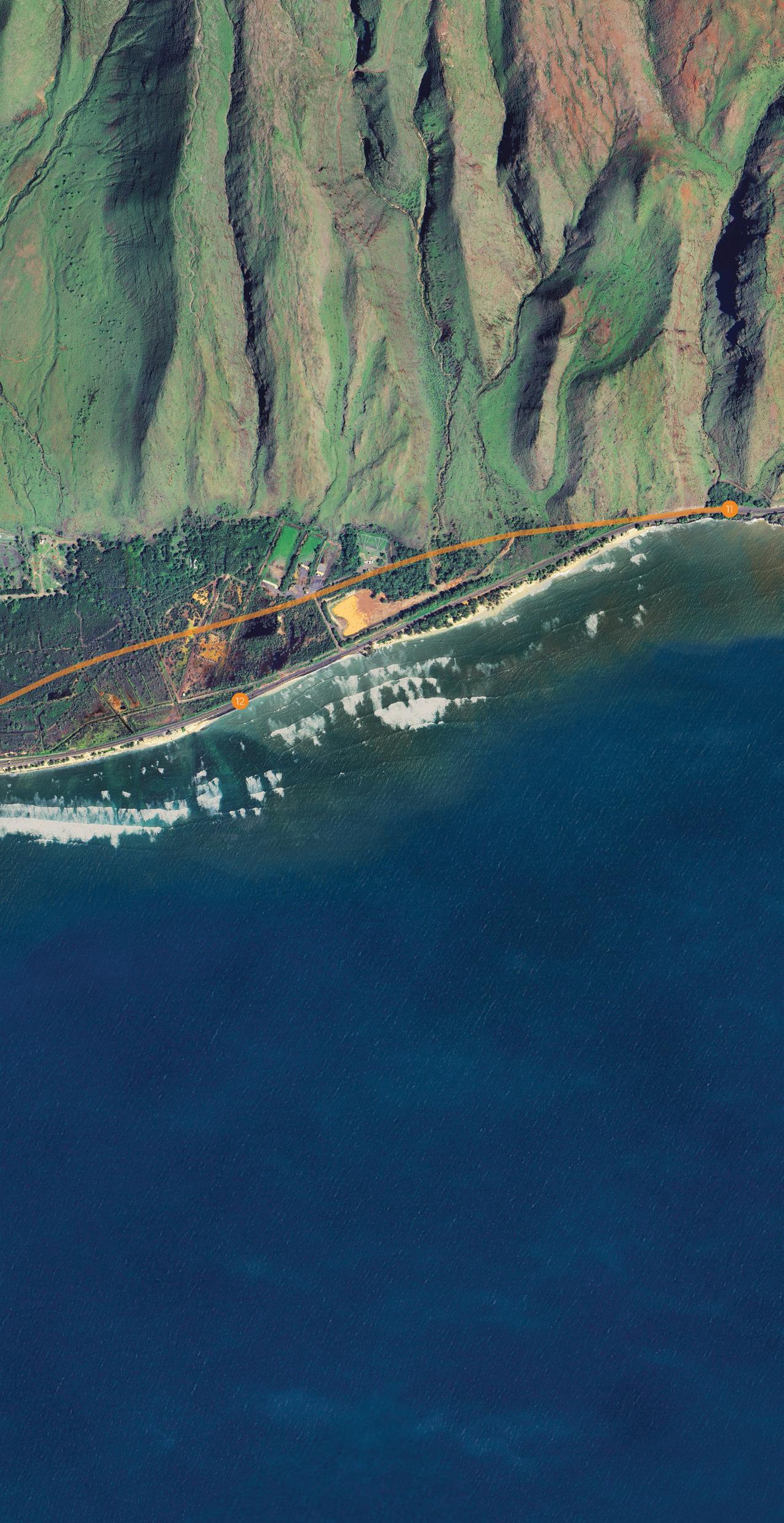
The upcoming Honoapiʻilani Highway realignment provides a unique opportunity for your input on the future of the Olowalu and Ukumehame coastal corridor that reflects ʻike kupuna, nature-based solutions, and community priorities.
JOIN US TO LEARN ABOUT THE PROJECT AND SHARE YOUR ʻIKE AND MANAʻO.
Thursday Feb 6, 2025
5:30 - 7:30 PM LAHAINA INTERMEDIATE CAFETERIA 871 Lahainaluna Rd, Lahaina, HI 96761
https://tnc.zoom.us/meeting/register/x4O3irrQQqONiFoIkhWTA ALTERNATIVE 1
Tuesday Feb 11, 2025 12 - 1:30 PM ZOOM REGISTRATION

Thursday Feb 13, 2025 5:30 - 7 PM ZOOM REGISTRATION

https://tnc.zoom.us/meeting/register/ pxGgqK0MToiRijZvvUdPyA ALTERNATIVE 2
Each meeting will cover the same content: project introduction, interactive community visioning, and talk story. At the in-person event, light dinner and beverages will be served. Throughout the year, there will be two additional rounds of visioning and co-design meetings.

For additional project and meeting info, please scan the QR code. QUESTIONS? https://storymaps.arcgis.com/stories/2ba79613d0aa4da182fe9bc34cc10cc7
Contact: t.farnsworth@tnc.org UHCDC.olowalu@gmail.com

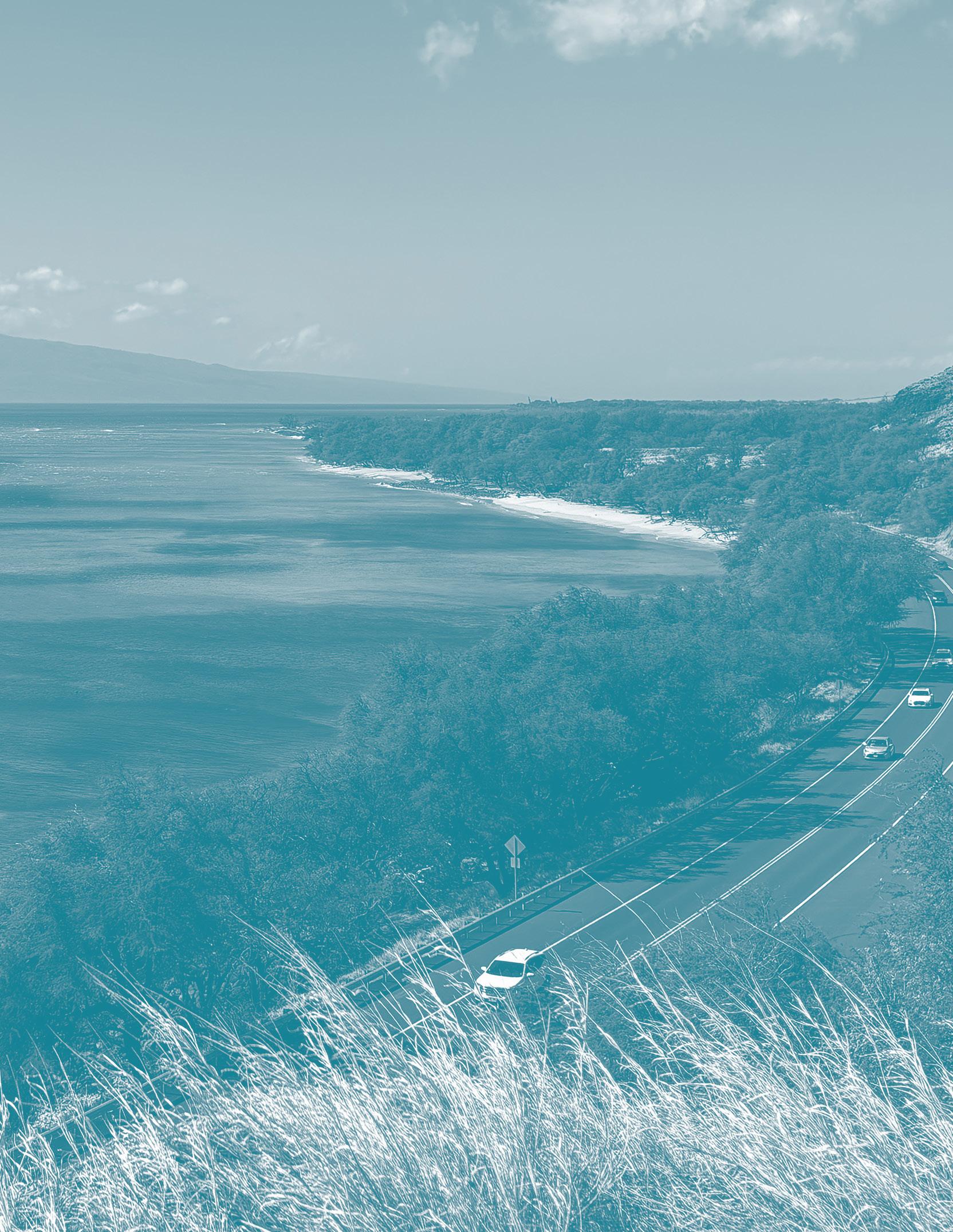
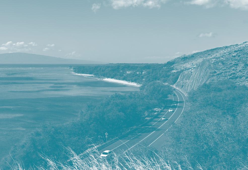
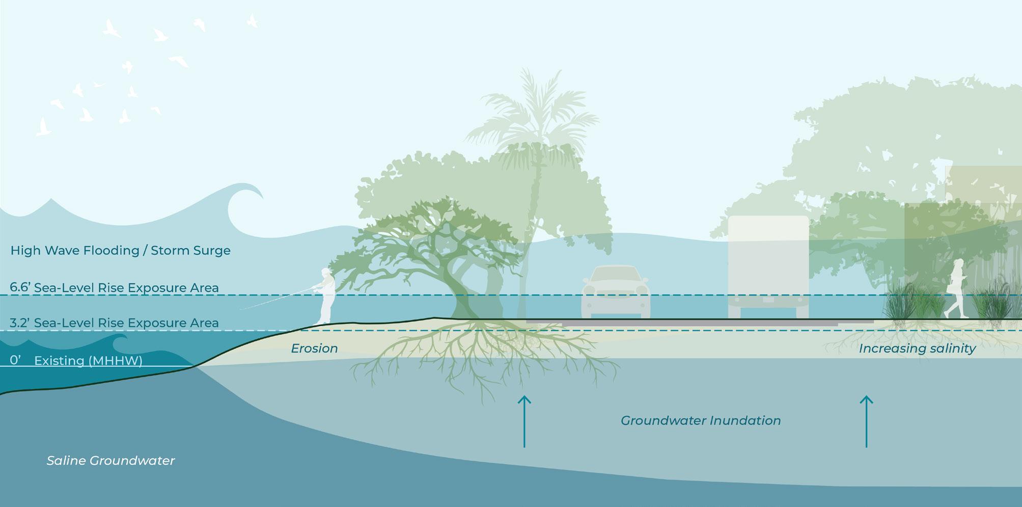
The planned Honoapiʻilani Highway realignment provides opportunities to re-imagine the Olowalu-Ukumehame coastal corridor by incorporating park spaces, traditional biocultural practices, and nature-based solutions.
This project aims to strengthen coastal ecosystems, reduce pressures on the Olowalu-Ukumehame reef system, and improve resilience to help the area adapt to climate change effects, including sea level rise.
TNC Team:
Tamara Farnsworth, Coastal Resilience Project Manager
Dr. Kim Falinski, Coastal & Estuarine Scientist
Scott Crawford, Maui Marine Program Director
Emily Fielding, Hawai’i Marine Conservation Director
Nalei Sampson, Maui Marine Project Coordinator
UHCDC Team:
Judith Stilgenbauer, FASLA, Principal Investigator and Professor Emily Sobolewski Knight, ASLA, Research Associate Sierra Spears, Research Associate Student Assistants: Zoë Angelopulo, Dersel Bonai, Sarah Obra-Nakata, Kenny Morrow
Contact:
t.farnsworth@tnc.org or UHCDC.Olowalu@gmail.com


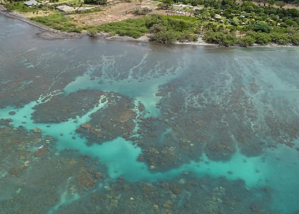
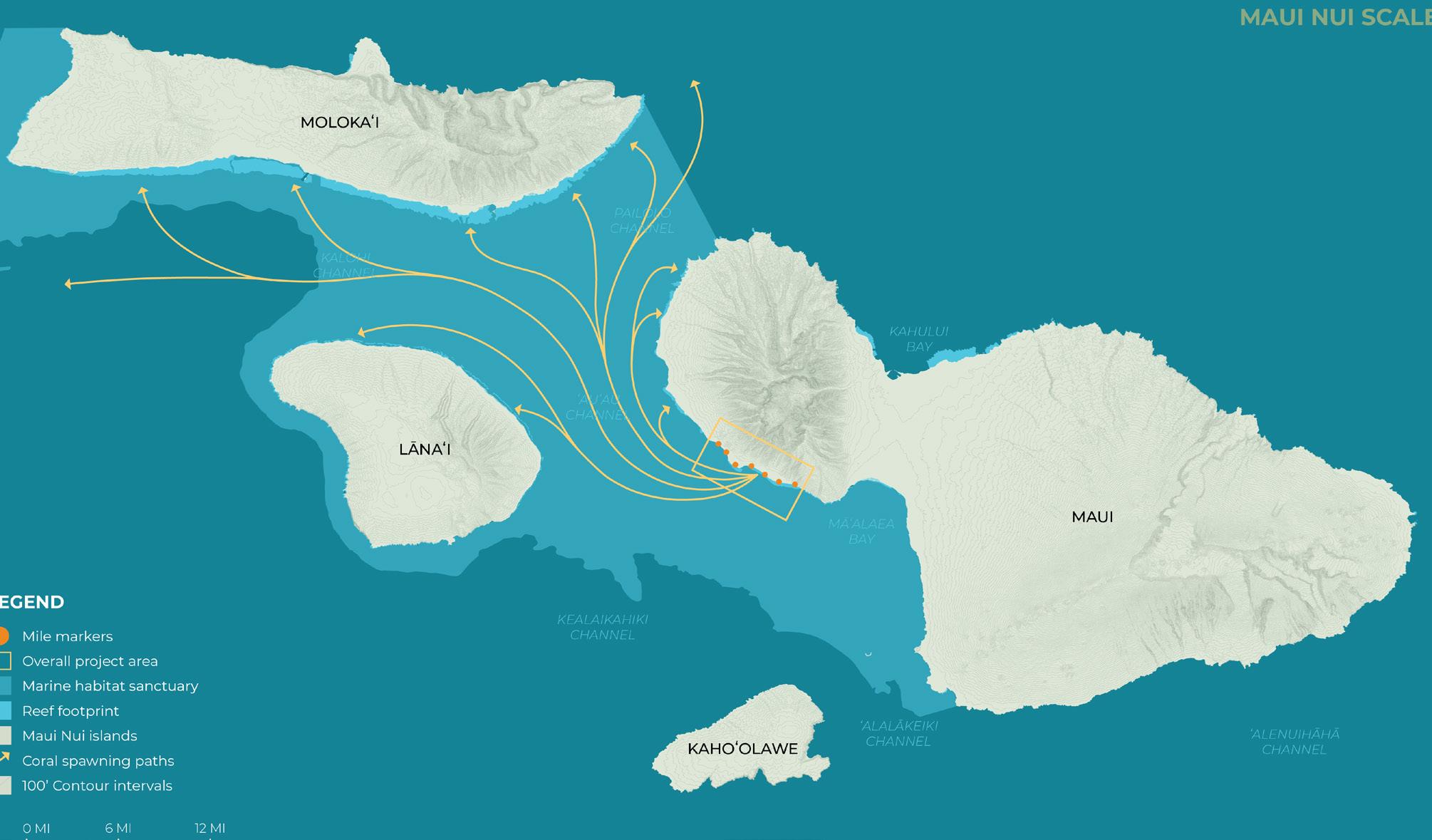
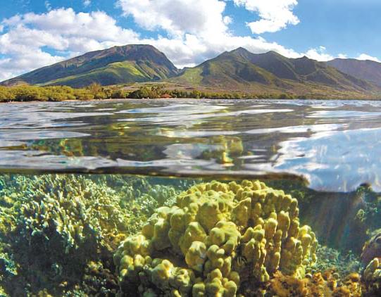
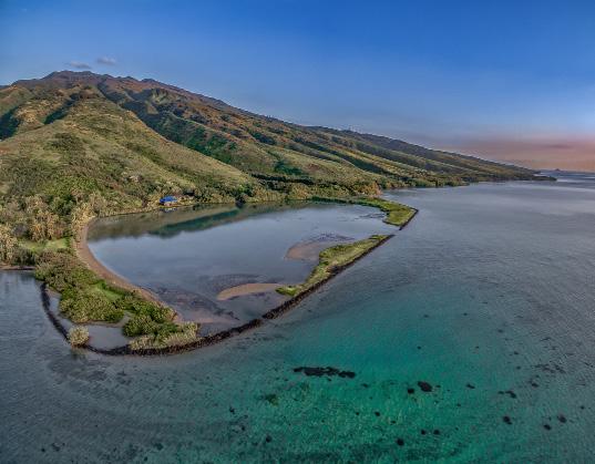
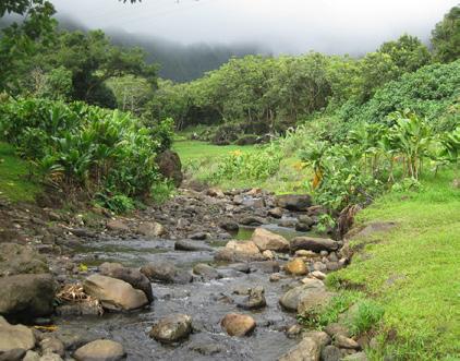
In 2017, West Maui’s Olowalu reef was declared a Mission Blue Hope Spot—a place that is critical to the health of our oceans. Spanning the coast from Olowalu to Pāpalaua, the 939-acre reef boasts a stunning diversity of coral, harbors the largest known manta ray population in the United States, and is a primary source of coral larvae for the reefs of Lāna’i, Moloka’i, and West Maui.
Coral Reef Benefits
Protect Coasts
Coral reefs block up to 97% of the wave energy hitting our coastlines.
Prevent Flooding
Reefs provide flood protection to people, property, and jobs valued at more than $836 million each year.
Sustain Fisheries
Hawai’i’s reefs support nearshore fisheries worth $13.4 million each year.
Support Livelihoods
Coral reefs contribute more than $1.2 billion through reef-related tourism to the state’s economy.
Connect Us to Cultural Heritage
Hawai’i’s reefs connect us to our islands’ natural and cultural heritage.
Source: https://www.nature.org/en-us/get-involved/how-to-help/places-we-protect/olowalu


Nature-based solutions are sustainable planning, design, environmental management, and engineering practices that weave natural features or processes into the built environment to promote adaptation and resilience. These solutions use natural features and processes to combat climate change and reduce flood risk.
Source: www.fema.gov/emergency-managers/risk-management/climate-resilience/nature-based-solutions (accessed 2024)
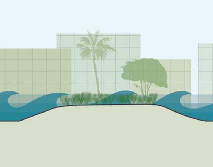
Natural and nature-inspired layered blue-green infrastructure that stabilizes and protects coastal edges and landscapes, absorbs flooding, attenuates wave energy, provides habitat, improves water quality, biodiversity, and promotes coastal resilience.
Reef Restoration
Increase biodiversity
Protect coastline from wave impacts
Create habitat for native species
Living Breakwaters
Increase biodiversity
Protect coastline from wave impacts
Create habitat for native species
Contribute to layered living shorelines
Wetlands, Tidal Marshes, Coastal Buffers
Provide ecosystem services
Increase distance between water and development
Absorb inundation and sediment
Provide habitat
Dune Restoration
Provide coastal protection
Increase native habitat
Reduce the risk of coastal hazards
Traditional Ecological Knowledge
The location-specific evolving knowledge acquired by indigenous and local peoples over hundreds or thousands of years through direct contact with the environment. Hawaiian biocultural land-water practices manage resources sustainably and create community.

Loʻi Kalo (Wetland Taro Farming)
Filter water and capture sediment
Promote biodiversity
Contribute to flood mitigation
Regulate soil and water temperature
Support local food cultivation
Provide cultural and educational opportunities
Promote public and community health
Loko Iʻa (Fishponds)
Capture sediment
Support local food production
Provide cultural and educational opportunities
Engage the community
Contribute to living shoreline systems
Provide ecosystem services and biodiversity
Benefit local economy
In the built environment, many vegetated landscape elements function as green infrastructure. Those systems harness natural processes, contribute to biodiversity, and increase resilience by providing critical ecosystem services for communities and sites.
Stream Bank Naturalization
Increase vegetation cover
Control erosion
Provide ecosystem services
Support native riparian habitat
Increase biodiversity
Native Plant/Forest Restoration
Create native habitat
Sequester carbon dioxide
Improve air and water quality
Decrease runoff and erosion
Provide economic benefits
Green Stormwater Infrastructure
Mitigate and clean runoff and sediment
Reduce sediment discharge into water
Provide other ecosystem services
Increase biodiversity and habitat
Benefit public health
Reduce flood risk and increase resilience
Intentional integration of landscape elements that produce food, energy/fuel, fiber and/or other resources in sustainable and locale-appropriate ways while providing environmental and social/cultural benefits.
Agroforestry
Increase shade and regulate microclimate
Enhance soil health and air quality
Support local food cultivation
Sequester carbon
Reduce sediment and runoff
Provide restorative properties
Engage the community
Create wildlife habitat
Support mauka-makai connectivity
Traditional Agriculture and Farming
Produce local food
Establish pilina with āʻina
Promote food security
Support pollinator species
Re-use stormwater & greywater
Enhance soil health
Build community
Benefit public health

Nature-Based and Living Systems
Soft blue-green infrastructure that supports ecosystem services, increases the distance between water and the built environment, retains and absorbs inundation, attenuates waves, slows erosion, provides habitat, and contributes to biodiversity. Examples: wetlands, tidal marshes, and other living coastal buffers.
Managed Retreat (Relocation)
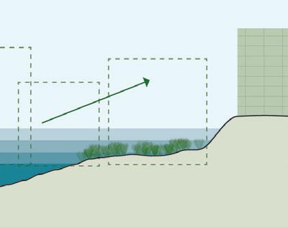
Long-term relocation or removal of existing buildings, infrastructure, and resources out of hazard areas to higher elevations and limited construction of new development in vulnerable areas. Planned withdrawal from the shoreline and/or low-lying zones over time through strategic relocation. Example: Honoapiʻilani Hwy re-alignment.
Hardened Shoreline Protection
Hard, engineered, linear infrastructure systems designed to defend, armor, and stabilize the shoreline and resources in their current location. Examples: impermeable structures, seawalls, levees, dikes, revetments, groins, breakwaters, riprap, dams, flood gates, storm surge barriers, etc.
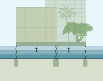
Floodable Structures and Landscapes
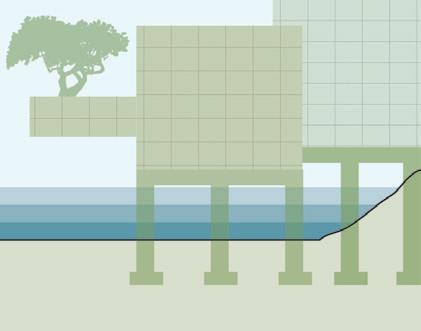
Structures and landscapes designed to withstand and function during inundation events. Accommodating habitable space, critical assets, and vulnerable infrastructure on upper levels or at higher elevations decreases hazard risks and increases resilience to the impacts of sea level rise and flooding.
Elevated Structures and Landscapes
Accommodating in place by raising the height of land, infrastructure, buildings, and other resources for existing or new development over time to safer elevations using fill and/or pilings with the goal of decreasing hazard risks and increasing resilience to the impacts of sea level rise and flooding.
Floating Structures and Landscapes
Accommodating and adapting in place by floating buildings, transportation elements, and infrastructure designed with fluctuating and rising water levels in mind has the potential to increase resilience to the impacts of sea level rise and flooding. Structures are fastened to the coast or bottom of water with flexible connections.
In-Person and Virtual Engagement Event Results (2/6/25, 2/11/25, 2/13/25)
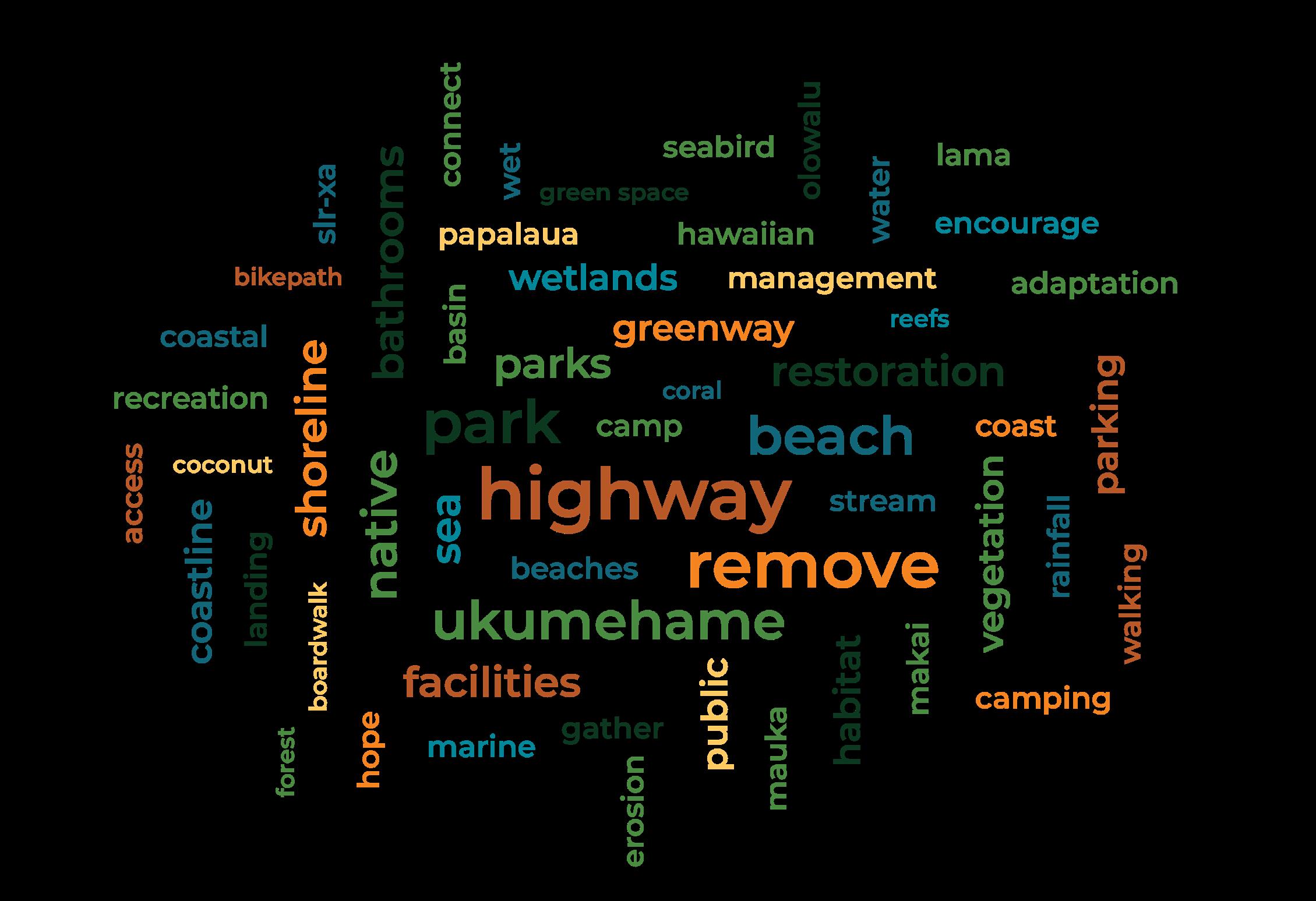
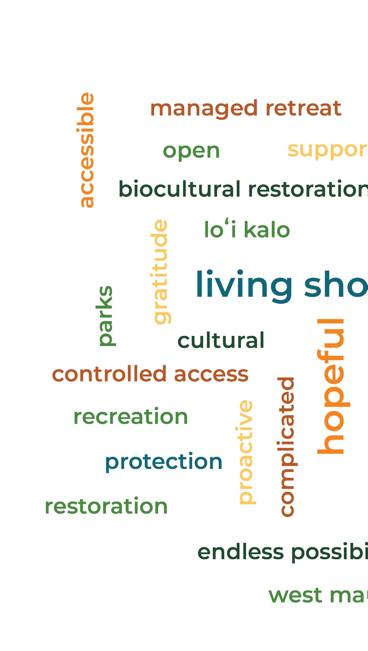
What is the first word that comes to mind when you think of the current Honoapi’ilani Highway?
At the start of the in-person engagement event, participants were invited to respond to an entry question displayed on a whiteboard: “What is the first word that comes to mind when you think of the current Honoapiʻilani Highway?” This prompt encouraged community members to share their immediate thoughts and perceptions, setting the tone for the discussions ahead.
As participants entered the cafeteria, they wrote their responses directly on the whiteboard, creating a collective reflection of public sentiment. The words varied widely, capturing both concerns and observations, from traffic and erosion to access and resilience.
During the two virtual events, participants engaged with the same question through Mentimeter, a digital interactive tool that allowed them to contribute responses in real time.
The resulting word cloud visually summarizes the responses from both in-person and virtual events. In the graphic, larger words indicate more frequent mentions, illustrating key themes. Participant responses highlighted the vulnerabilities and challenges of the existing Honoapiʻilani Highway while also acknowledging the surrounding area’s natural beauty and significance.
Top responses from participants were:
• Traffic (8)
• Erosion (7)
• Sea-level rise (5)
• Wet (3)
• Flooding (3)
• Scenic (3)
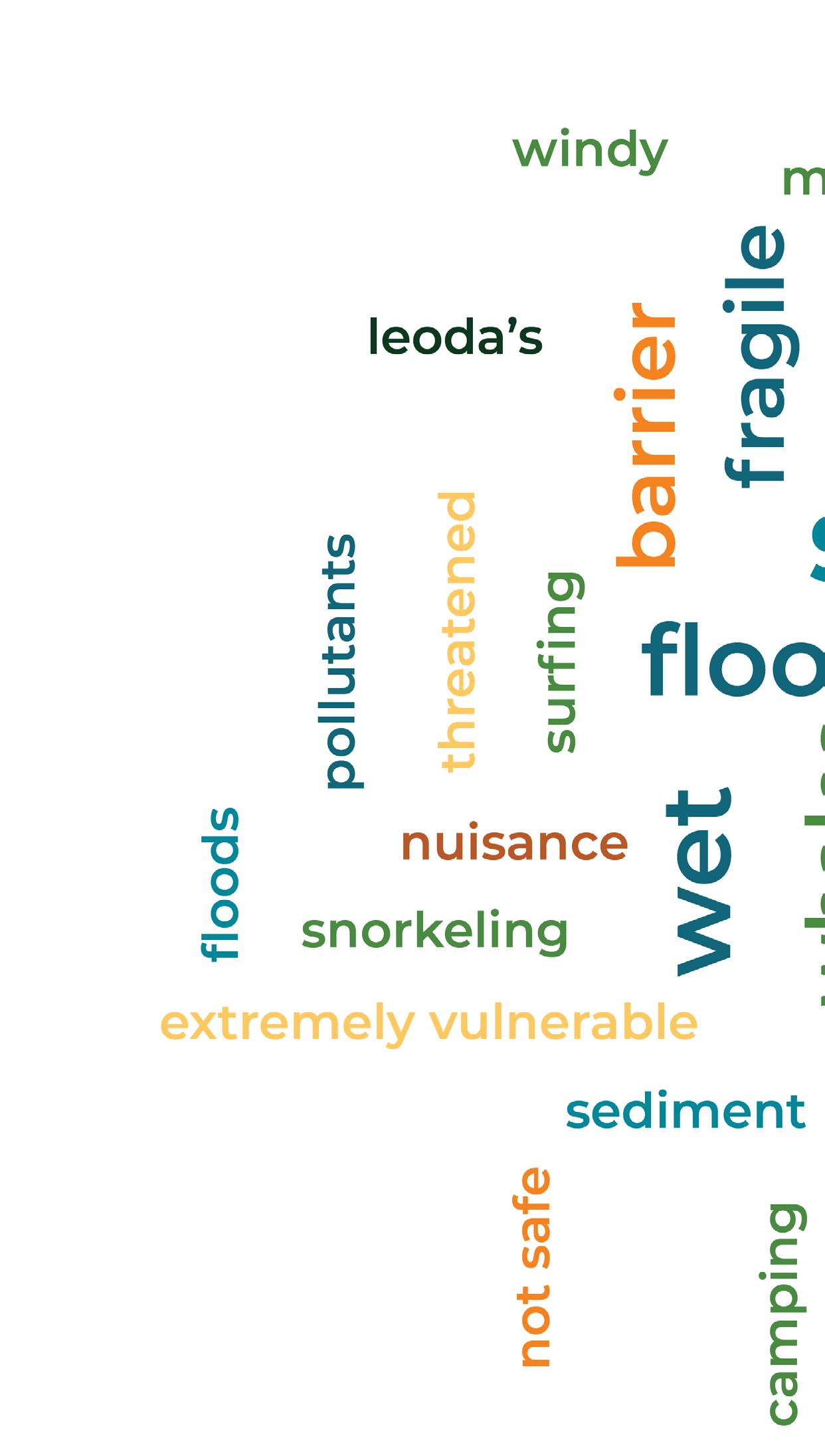
Categories Green: Natural features and recreation
Orange/yellow: Road-related hazards and problems
Blue: Climate-related vulnerabilities
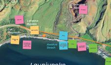
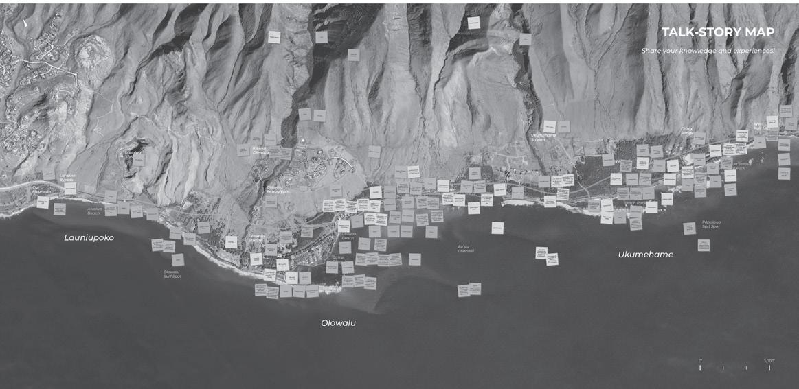
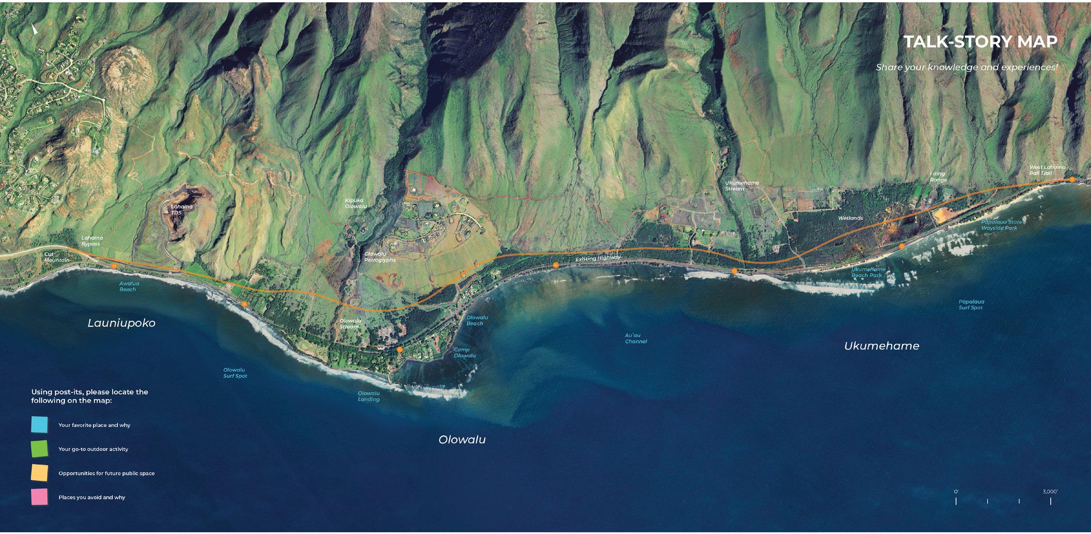
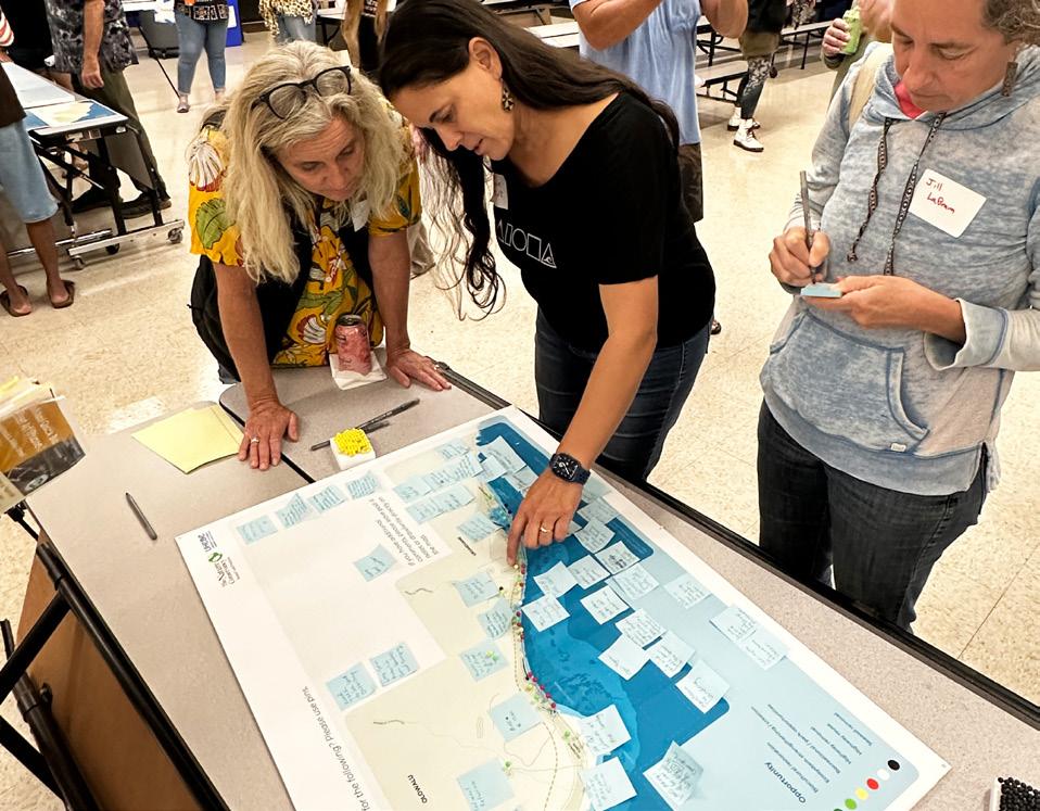
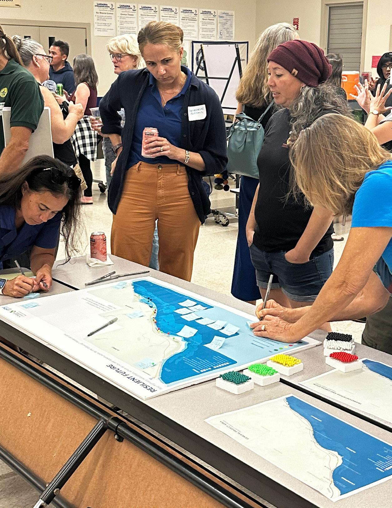
Local knowledge from residents and community members is essential in developing a conceptual design that prioritizes both coastal resilience and the well-being of the community. The first interactive exercise encouraged participants to share their insight and expertise about the existing project area.
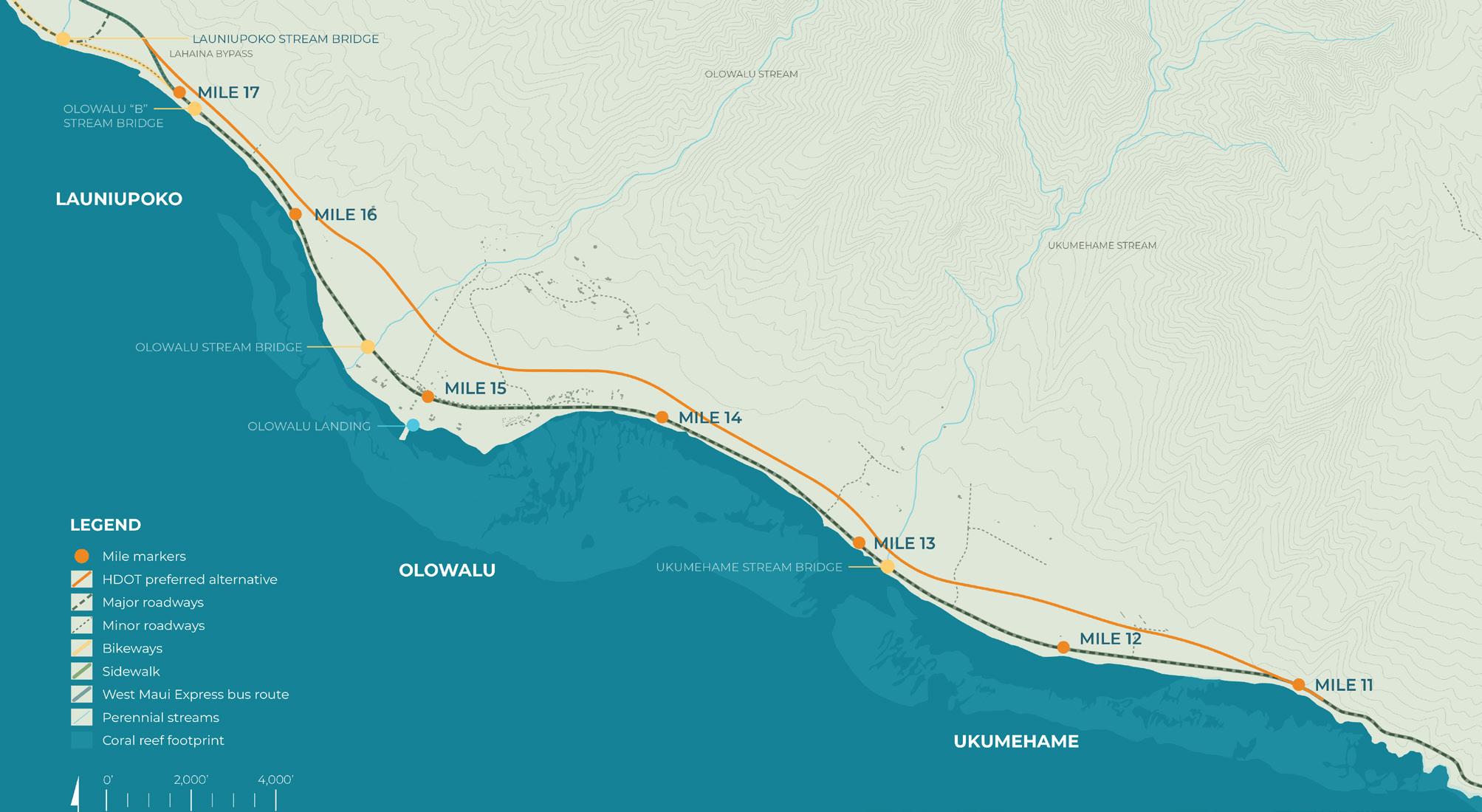
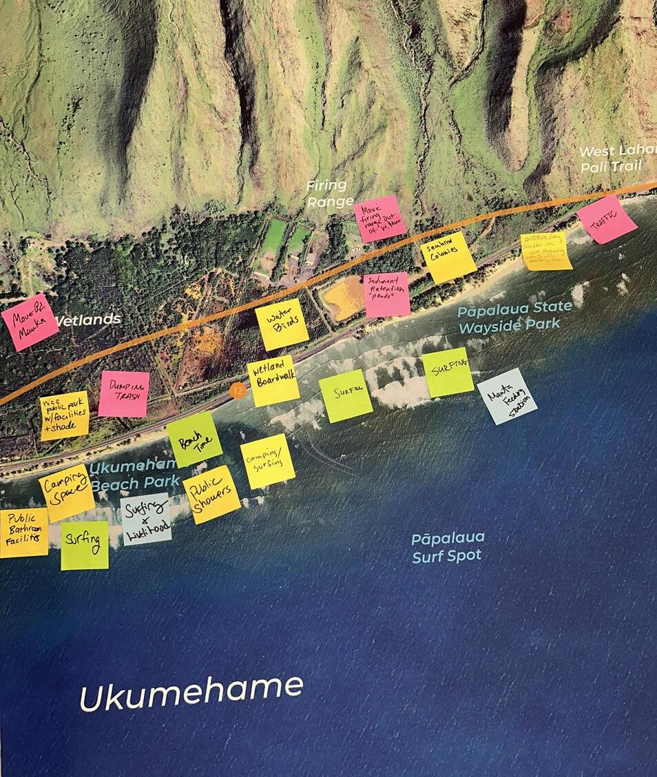
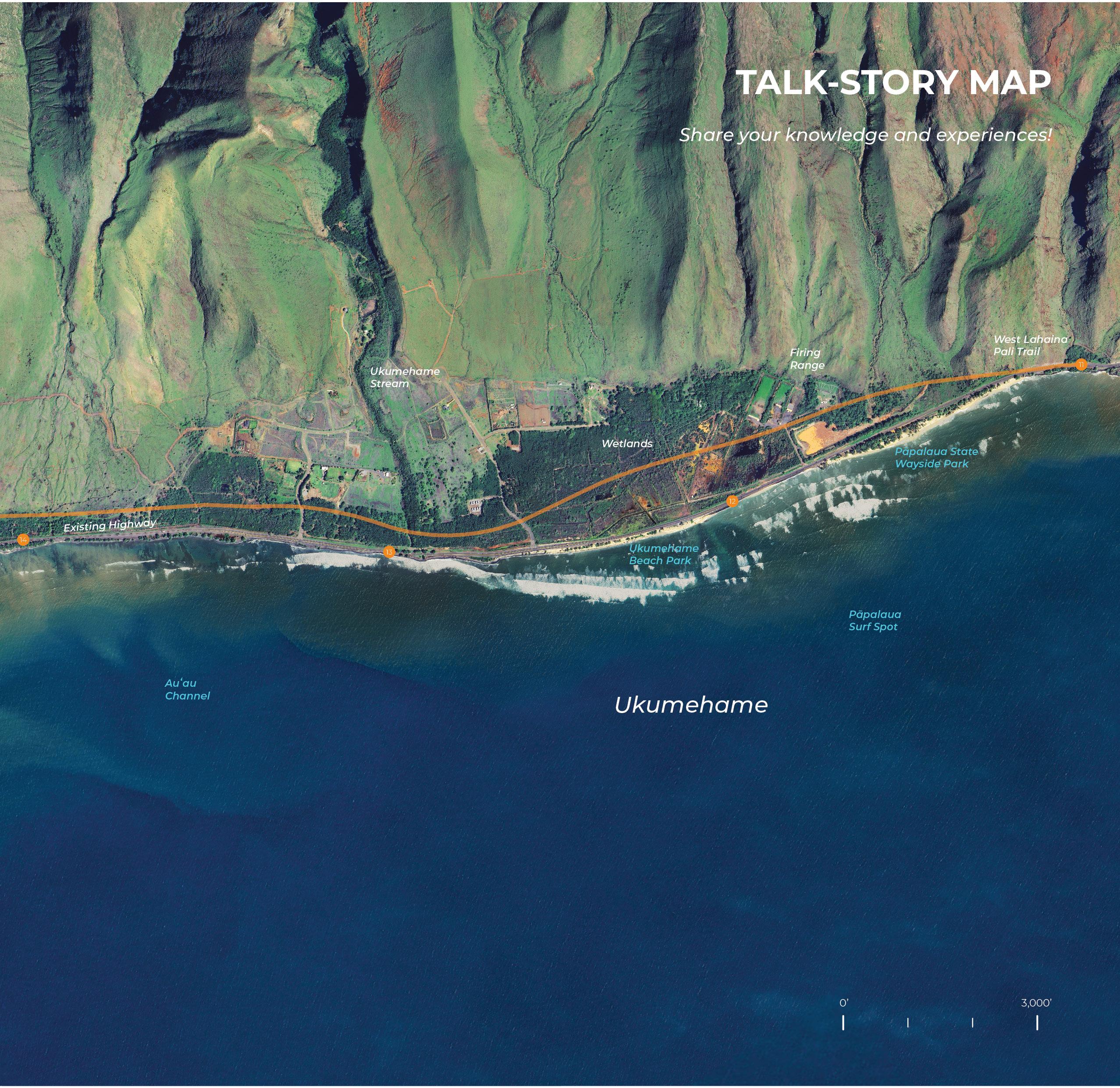
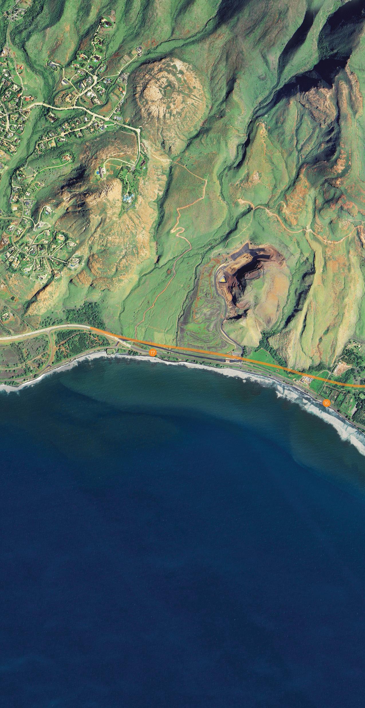
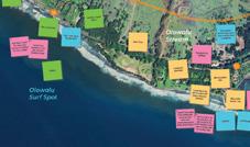
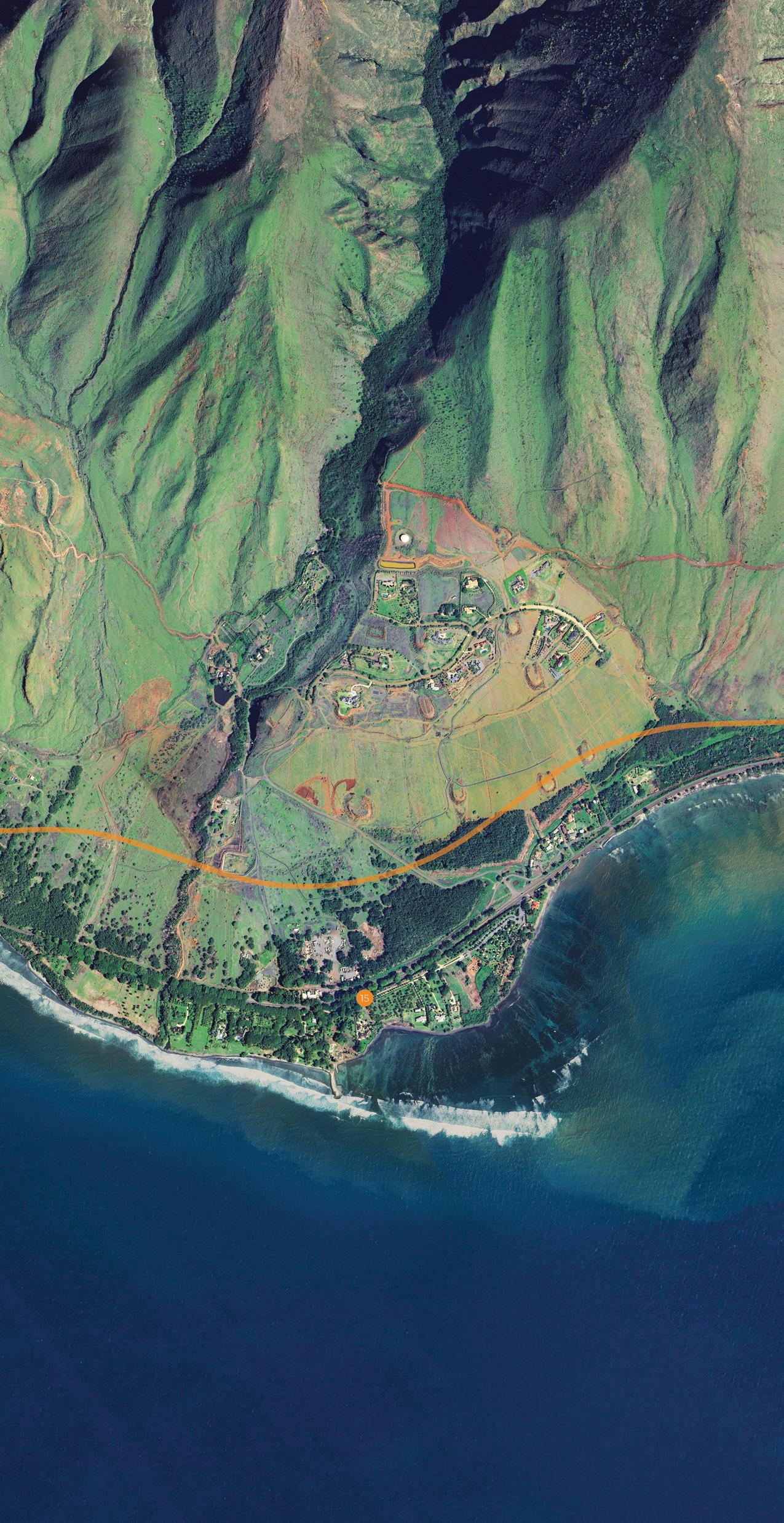
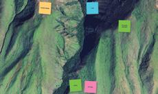
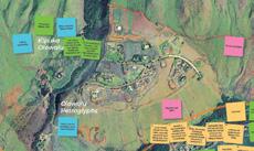
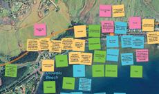
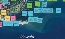
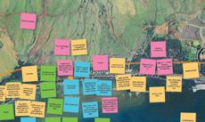
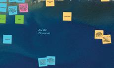
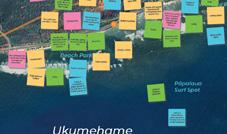
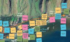
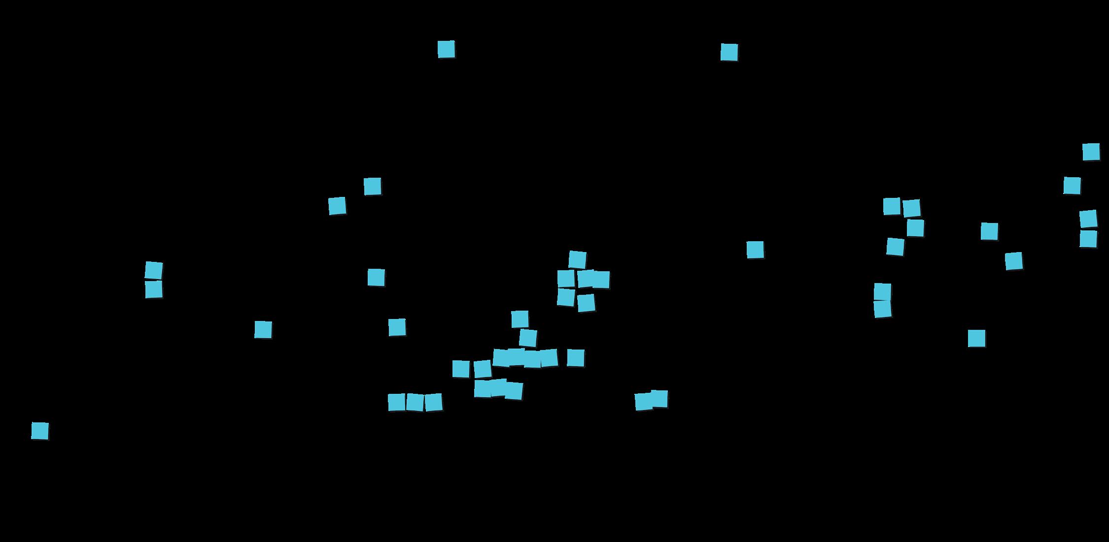
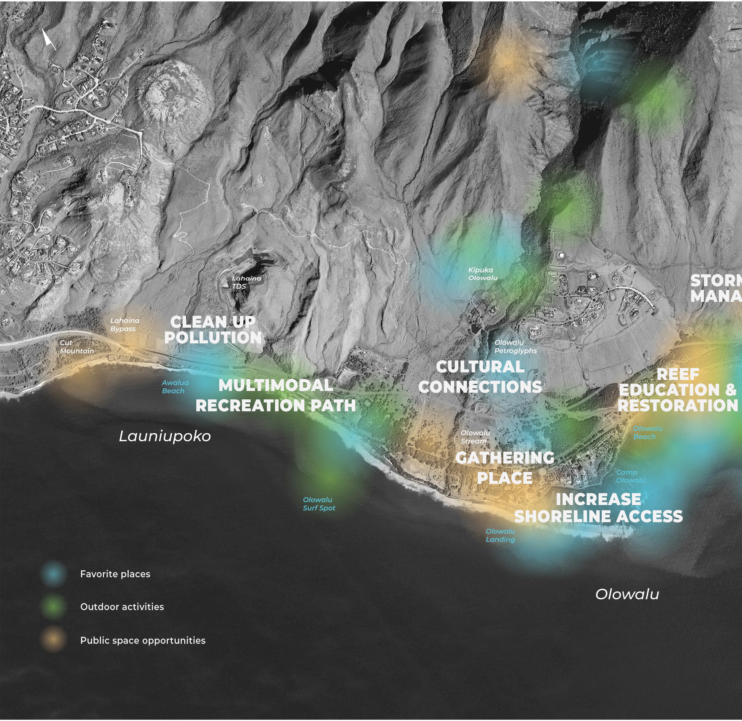
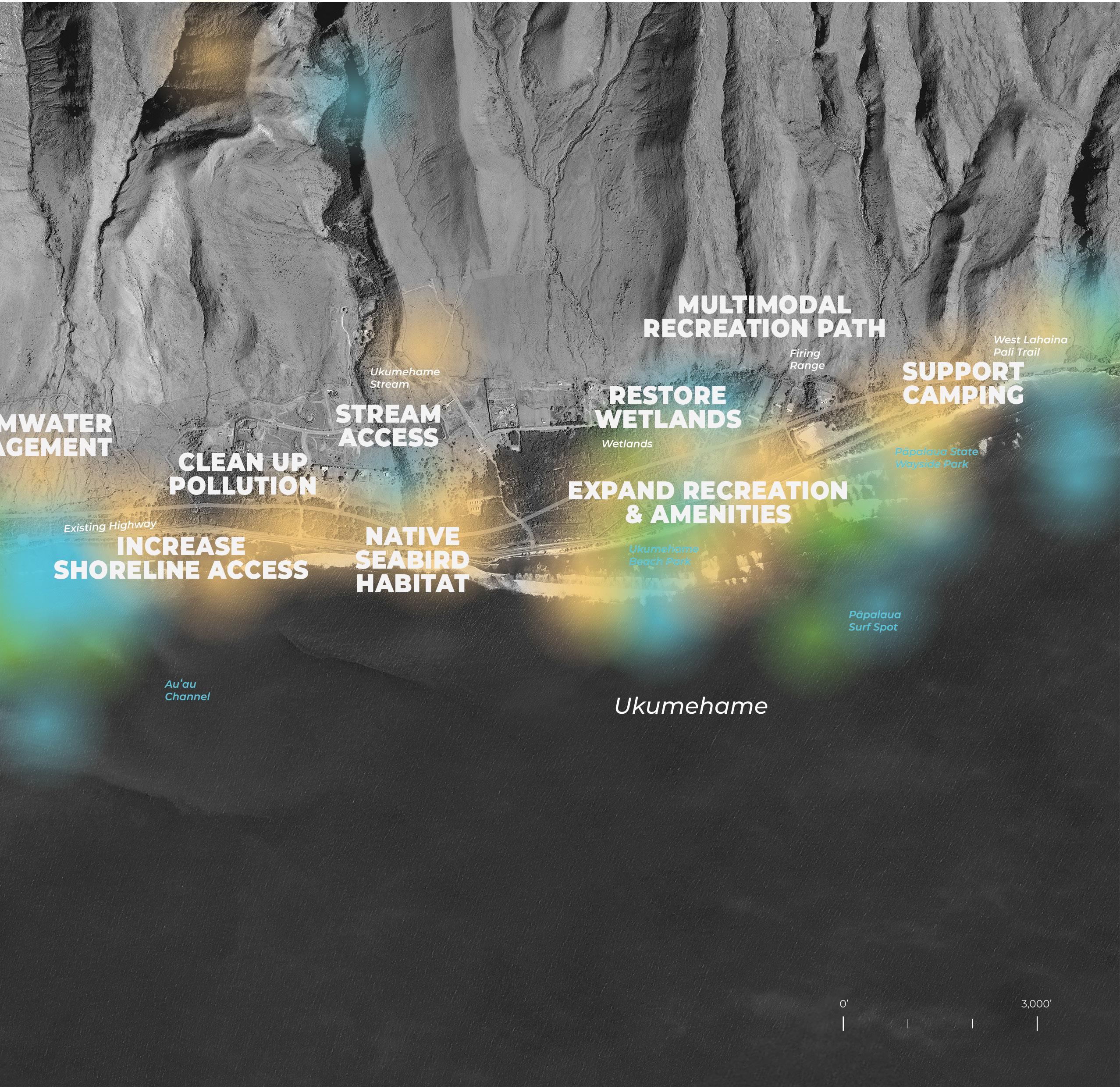
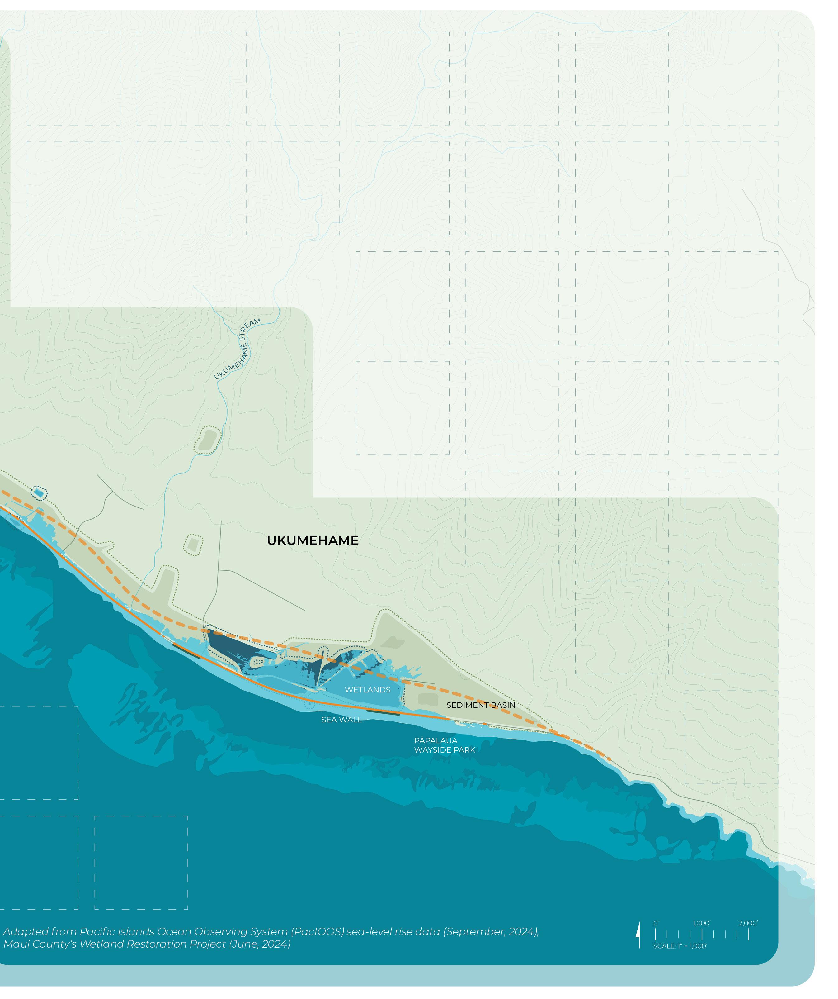
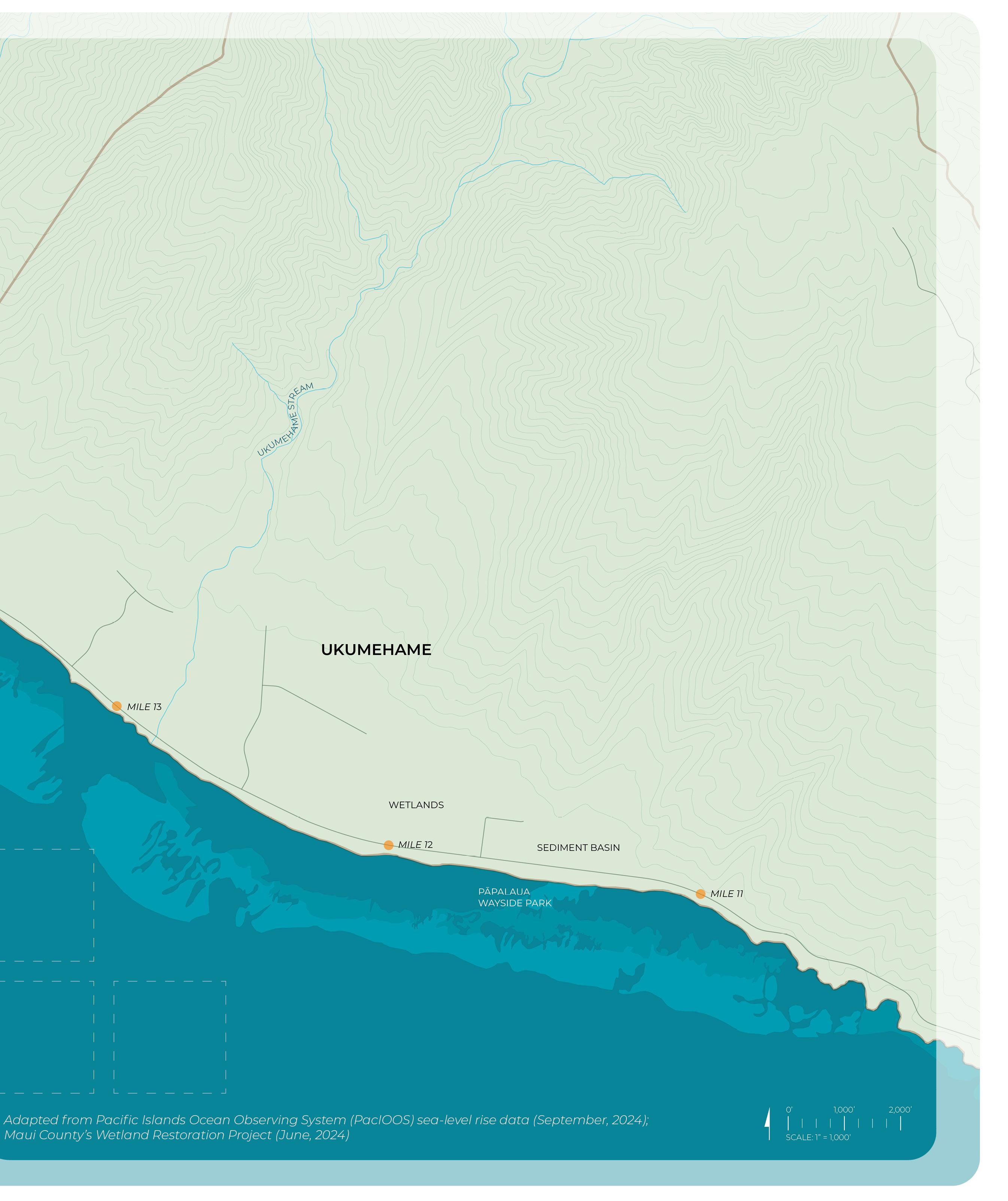
A large-format (14 ft x 5.5 ft), high-resolution aerial map, printed on vinyl, depicted current conditions along the Olowalu-Ukumehame coastline, with key locations, place names, and the proposed highway realignment highlighted. The project team invited participants to engage with the TalkStory Map by leaving comments via color-coded sticky notes in response to four prompts:
Your favorite place and why
Your go-to outdoor activity
Opportunities for future public space
Places you avoid and why
Participants could contribute multiple notes for each category, enabling a wide range of perspectives and insights. For the two virtual community and stakeholder engagement events, the project team prepared a digital whiteboard version of the talk-story map. Participants could either leave virtual sticky notes themselves, speak during the Zoom meetings, or leave written comments in the meeting chat room for UHCDC staff members to transcribe and post on the digital board. This process ultimately revealed how residents and stakeholders currently interact with the coastal environment and highlighted locations of cultural and personal significance.
Materials included in this section:
Engagement Event Activity Photos
Talk-Story Map (Materials Provided to Participants)
Talk-Story Map (Results)
Summary and Analysis
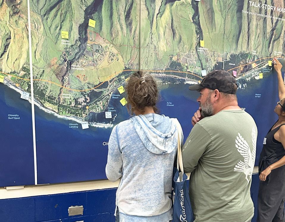
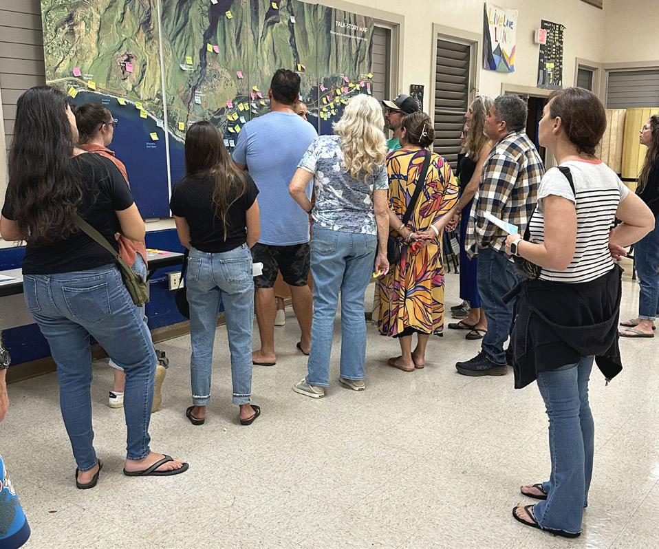
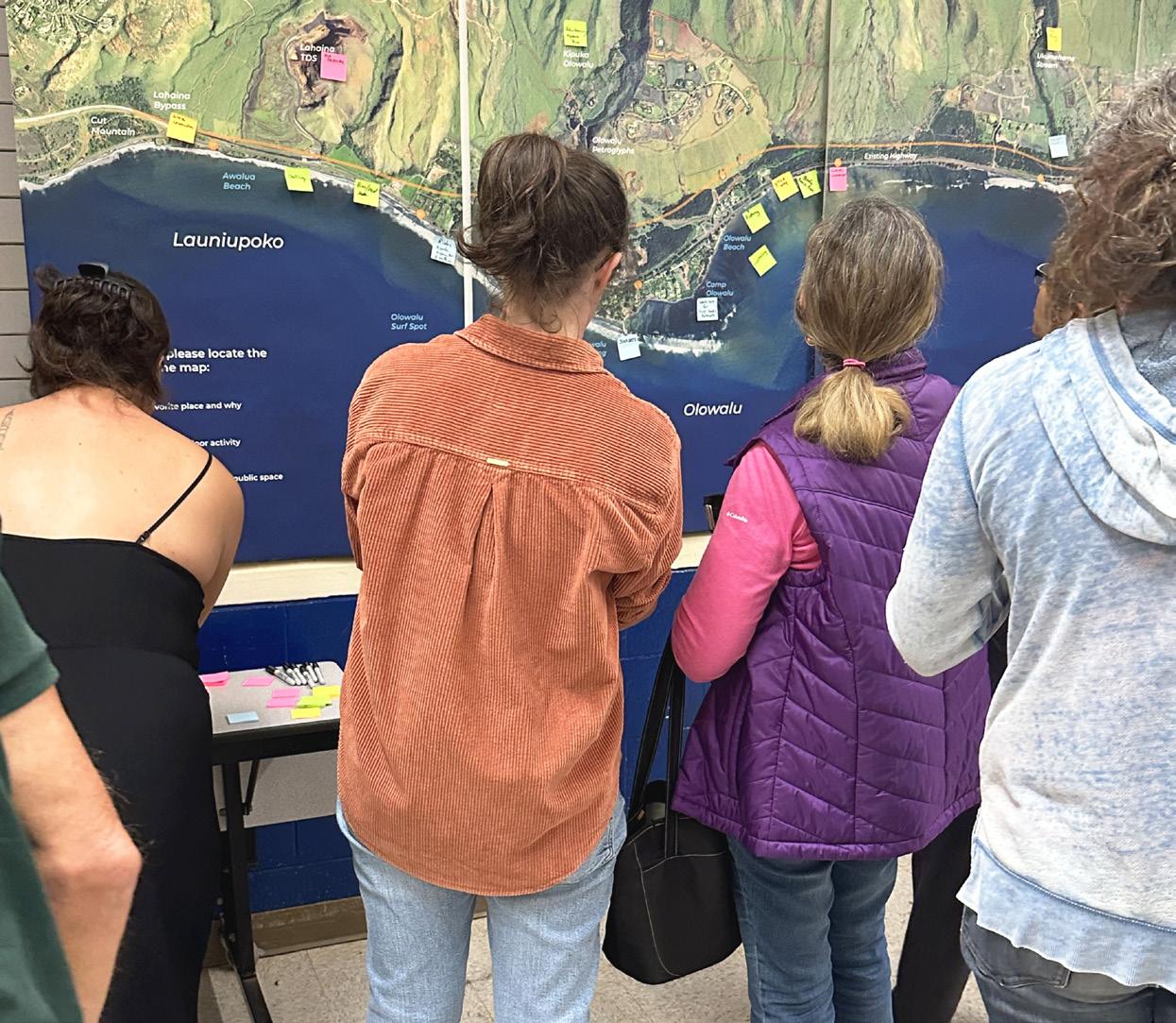
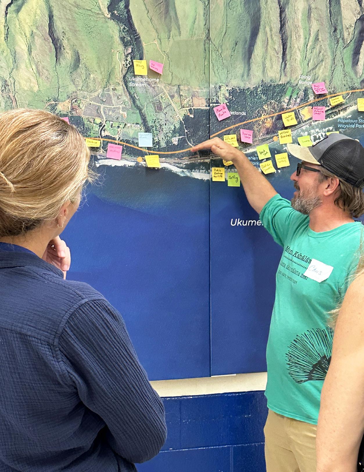
Workshop participants interacting with the Talk-Story Map (Images: UHCDC)
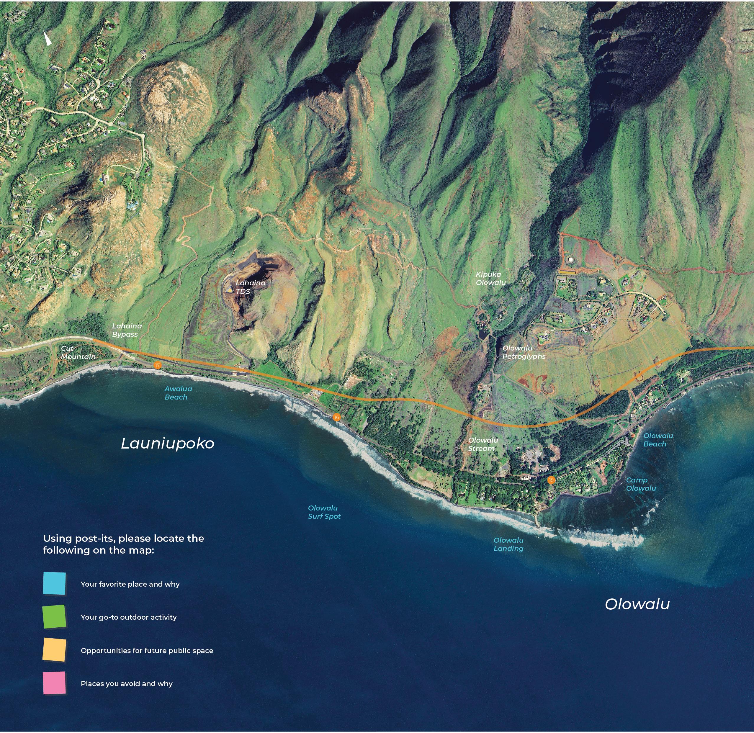
Talk-Story Map provided to participants for feedback (original size: 14’ x 5.5’, reduced in scale for summary report).
In-Person and Virtual Engagement Event Results (2/6/25, 2/11/25, 2/13/25)
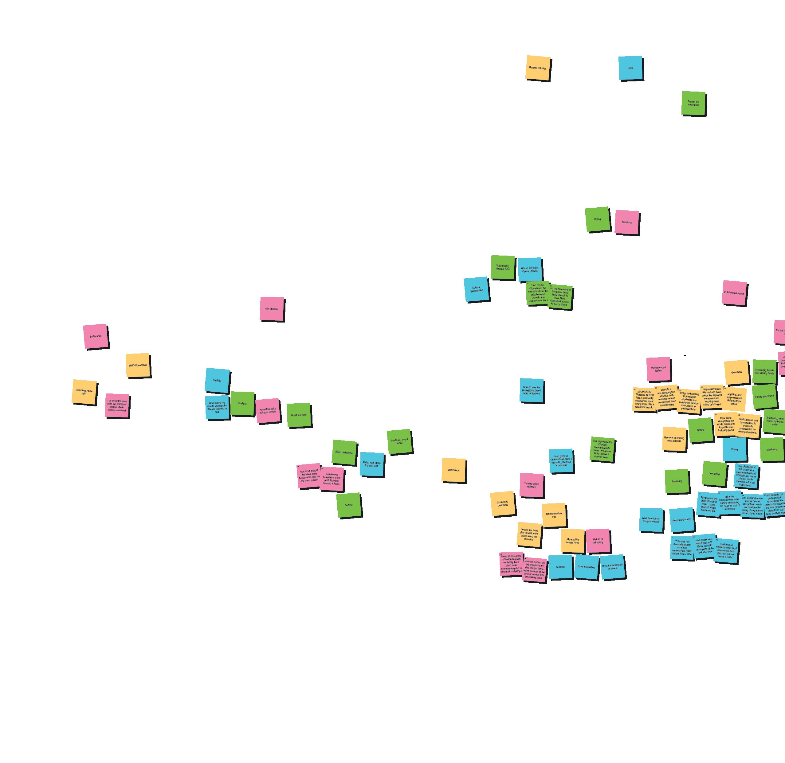
Numerous favored locations were concentrated around mile marker 14, recognized as a popular hub for go-to water-based recreational activities that emphasize the area’s connection to marine life and aquatic ecosystems. The stretch between mile marker 14 and the firing range was identified as having significant
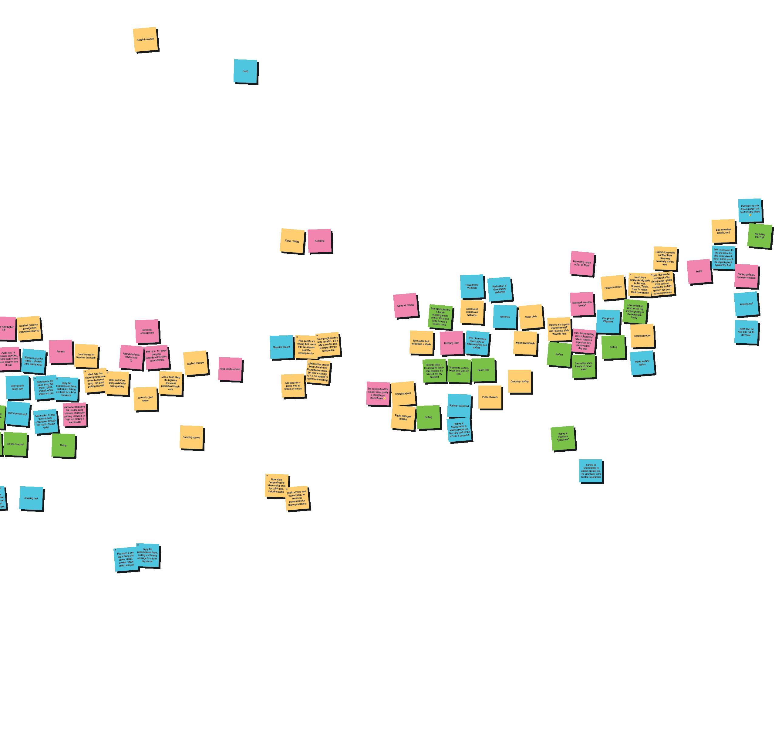
potential for public space, while areas people tended to avoid were often associated with trash dumping and houseless encampments. Overall, the comments highlighted the importance of recreation, access to open space, and the preservation of natural features.
INITIAL COMMUNITY AND STAKEHOLDER ENGAGEMENT Sticky Note Zoom-In: In-Person and Virtual
As a local, I avoid the whole area because it’s right on the road. people would never campthere in the past. Now the demand is huge.
Sticky Note Zoom-In: In-Person and Virtual
I would like to be able to walk to the beach along the shoreline
I used to love going to the landing with my family, but it often feels unwelcoming due to others kinda taking it
been going to Olowalu town since I was a kid, the food is delicious
truly appreciate Olowalu center.recycling/waste
We lucky to have close to town.
over for parties. It's the only place my dad can get in the water because of the ease of access with the landing ramp.
colonies
Sticky Note Zoom-In: In-Person and Virtual
Protect the watershed
Volunteering
Malama ʻĀina
Cultural opportunities
When I am home, Kipuka Olowalu
I like Kipuka Olowalu and the view Lihau from the area between Olowalu and Ukumehame, but I 1/2 2/2 am not Kama'aina to this place. I was lucky enough to have Nate Naho'oikaika about ka nani o Lihau.
History: love the petroglyphs (need more protection)
As a local, I avoid the whole area because it’s right on the road. people
STOP SPEAR FISHING IN THIS AREA, especially commercial spear fishing tours. It is a wonderful area to promote a non-consumptive activities both recreational and commercial, such as snorkeling, diving, and Commercialboating. snorkeling tour companiesinstructionsprovide to participants to responsibly enjoy this reef and avoid things like improper sunscreen use, touching coral, killing or taking of
How about designating the whole makai area for public use, public access, and conservation, to ensure its
truly appreciate the Olowalu center.recycling/waste We are so lucky to have it close to town.
As a local, I avoid the whole area because it’s right on the road. people
STOP SPEAR FISHING IN THIS AREA, especially commercial spear fishing tours. It is a wonderful area to promote a non-consumptive activities both recreational and commercial, such as snorkeling, diving, and Commercialboating. snorkeling tour companiesinstructionsprovide to participants to responsibly enjoy this reef and avoid things like improper sunscreen use, touching coral, killing or taking of
anything, keeping distance turtles
How about designating the whole makai area for public use, including parks, 1/2
we need more
Snorkeling, beach time with my family
access, and conservation, to ensure its preservation for future generations.
This discharge at teh corner is a stormwater hazard. HOKWO has lots of photos. Likely connects to the old inland pond
Avoid mm 14 because crowding, limited parking and deep sand on side of road
Stretch is good for babies – shallow, calm, sandy water
Make sure this doesn’t just become a new homeless camp...set some parking lots with anything, and distanceproper from turtles
Fav place is any place along this shore. I paint, snorkel, whale watch and just enjoy the peacefullness there, surfing and fishing are huge for a lot of my friends
Snorkeling, when there's no brown water
Snorkeling
/ snorkel
Mile marker 14 has the only sand channel out through the reef to deeper water
awesome snorkeling but usually avoid because of difficulty parking, crowded, or high surf making it inaccessible
would like to be to walk to the beach along the shoreline
over for parties. It's the only place my dad can get in the water because of the ease of access with the landing ramp.
This discharge at teh corner is a stormwater hazard. HOKWO has lots of photos. Likely connects to the old inland pond Fav place is any place along this shore. I paint, snorkel, whale watch and just enjoy the peacefullness there, surfing and fishing are huge for a lot of my friends
I am a 6th generation part native hawaiian and work in the industry.boating livelyhoodMy is dependant on access to this area. we need more day use moorings in this area. We teach responsible and sustainable reef use for human interaction, we do not condone the taking of any marine life,and try to inspire
2/3 3/3
(more other sites corals were tested from in W. Maui), Good to guide parts of the reef where we can focus on mitigating other local stressors to help give heat tolerant corals a better
and educate our participants to understand this important ecosystem and how people can impact it in both good and bad ways.
Sticky Note Zoom-In: In-Person and Virtual
Snorkeling, beach time with my family
diving, and Commercialboating.
snorkeling tour companiesinstructionsprovide to participants to responsibly enjoy this reef and avoid things like improper sunscreen use, touching coral, killing or taking of 4/5 anything, and keeping distanceproper from turtles
How about designating the whole makai area for public use, including parks, public access, and conservation, to ensure its preservation for future generations. 1/2 2/2
Avoid mm 14 because crowding, limited parking and deep sand on side of road
Constant presence + management restoration clean-up
Snorkeling, when there's no brown water
Kidsʻ favorite beach spot
Stretch is good for babies – shallow, calm, sandy water
Mile marker 14 has the only sand channel out through the reef to deeper water Fav place is any place along this shore. I paint, snorkel, whale watch and just enjoy peacefullness surfing are huge my
Sticky Note Zoom-In: In-Person and Virtual
risk
Local access for beaches (old road)
Abandoned cars, fluids / toxic (I)
Homeless encampment
enjoy the peacefullness there, and fishing huge for a lot of friends
awesome snorkeling but usually avoid because of difficulty parking, crowded, or high surf making it inaccessible
Make sure this doesn’t just become a new homeless camp...set some parking lots with gates and hours and prohibit after hours parking
MM 13.5 - 14; illegal dumping, abandoned vehicles, encampments
Lots of trash along the highway, houseless population living in cars 1/2 2/2
access to open space Camping spaces
Fav place is any
Mile marker 14 has the only sand channel out through the reef to deeper water
awesome snorkeling because of difficulty parking, crowded, or high surf making it inaccessible
access to open space
Fav place is any place along this shore. I paint, snorkel, whale watch and just enjoy the peacefullness there, surfing and fishing are huge for a lot of my friends
Camping spaces
Sticky Note Zoom-In: In-Person and Virtual
How about designating the whole makai area for public use, including parks, public access, and conservation, to ensure its preservation for future generations. 1/2 2/2
Plus, people are driving their trucks into the streams near the encampmentseven though barriers were installed. It's a pity to see the lack of respect for the environment.
public access around both Olowalu and Ukumehame stream - but how to manage so it is not trashed or used for car washing
Sticky Note Zoom-In: In-Person and Virtual
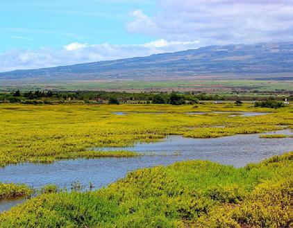
Ukumehame Wetlands
truly appreciate the Olowalu center.recycling/waste We are so lucky to have it close to town.
Restoration of Ukumehame Wetlands!
But I understand the coastal water quality is struggling at Ukumehame ��
Favorite place –Ukumehame beach park because it’s where I met my husband
Access and education at wetlands
Wetlands lovebeachUkumehame park for whale watching and surfing.
Snorkeling, surfing, beach time with my keiki
Nice public park w/facilities + shade
truly appreciate the Olowalu center.recycling/waste We are so lucky to have it close to town.
trash
Access and education at wetlands
But I understand the coastal water quality is struggling at Ukumehame ��
lovebeachUkumehame park for whale watching and surfing.
Favorite place –Ukumehame beach park because it’s where I met my husband Snorkeling, surfing, beach time with my keiki
Public bathroom facilities
Surfing at Ukumehame is always special too. The view back to the ko’olau is gorgeous
Sticky Note Zoom-In: In-Person and Virtual
Camping at Pāpalaua
Love setting up camp for the day and just playing in the water with family
Improve and expand Ukumehame BP and Pāpalaua State Wayside Park camping spaces
used to love surfing here but stopped when i noticed a huge drain pipe emptying into this area
Snorkeling, when there's no brown water
is always special too. The view back to the ko’olau is gorgeous
Ukumehame Wetlands
Access and education at wetlands
Restoration of Ukumehame Wetlands!
lovebeachUkumehame park for whale watching and surfing.
Wetlands
Move firing range out of W. Maui
Improve and expand
Ukumehame BP and Pāpalaua State Wayside Park
Sediment retention "ponds"
camp and
used to love surfing here but stopped when i noticed a huge drain pipe emptying into this area
Snorkeling, when there's no brown water
Need more family-friendly parks in this area.
Showers, Toilets, Trees for shade.
Think Launiupoko park. But also be prepared for the strong winds - plants trees that can sustain the 60 MPH gusts in this areacoconut grove etc. 1/2 2/2
Love setting up camp for the day and just playing in the water with family
camping spaces
Sticky Note Zoom-In: In-Person and Virtual
Pali trail! Iʻve only done a portion of it but I love the views ��
MM 11 because it’s the first place the cliffs come down to sand. Great launch for kayaking back against the Pali.
Fishing garbage, homeless garbage
I really love the reef here but it’s dirty now.
Sticky Notes Summary and Analysis: In-Person and Virtual Engagement Events
Work here for surf comps / retreats
Been going to Olowalu town since i was a kid, the food is delicious I love taking my keiki to
I really love the reef here but it’s dirty now.
I am
Cultural opportunities Kids favorite beach spot
MM 11 because it’s the first place the cliffs come down to sand. Great launch for kayaking back against the pali.
I love the landing for its views!
Mile marker 14 has the only sand channel out through the reef to deeper water
Pali trail! I’ve only done a portion of it but i love the views :) History: love the(needpetroglyphs protection)more
Amazing reef Mantastationfeeding Sunsets
Fav place is any place along this shore. I paint, snorkel, whale watch and just enjoy
The there,peacefulness surfing and fishing are huge for a lot of my friends 1/2 2/2
Surfing at Ukumehame is always special too. The view back to the Ko’olau is gorgeous
Ranked by Mentions
• Surfing Spots
Ukumehame, Pāpalaua, and Launiupoko; highlighted for their great surf, scenic views, and connection to livelihood.
• Coastal Recreation Areas
Mile Marker 14, Pāpalaua and beach side camping places, thriving reef areas, and anywhere along the shore; visited for snorkeling, diving, whale watching, fishing, peacefulness, relaxation, painting, camping, and use of sand channel through the reef.
• Culturally and Historically Significant Places
Petroglyphs, Olowalu town, and Kipuka Olowalu; highlighted for cultural opportunities, and historical connections.
• Scenic Views and Nature
Ukumehame wetlands, and the view of the Koʻolau mountains from the shoreline.
• Biking and Walking Trails
The bike path, and the Pali Trail; highlighted as a favorite for both riding and walking.
Ranked by Mentions
• Surfing
Most frequently mentioned activity, with specific spots like Pāpalaua (“Grandmas”) and Ukumehame Beach Park.
• Snorkeling
A top activity, often mentioned alongside clear water conditions.
• Beach Time
Includes family beach outings, shelling, and general enjoyment of the shoreline.
• Hiking
Popular trails like the Pali Trail were highlighted.
• Fishing and Diving
Noted as key ocean activities.
• Biking and Walking
Appreciation for pedestrian-friendly areas.
• Environmental Stewardship
Volunteering (Mālama ʻĀina) and protecting the watershed were valued.
• Recreation and Events
Paintball and event venues were mentioned as additional activities.
Outdoor Activities
Future Public Space Opportunities
Places Avoided

birds Water birds Public bathroom facilities Camping space Removal of erodingportionsroad
/ hiking
colonies Bike amenities (shade, etc.)
Greenway / bike path
Add benches and picnic area at bottom of stream Bike recreation hub Improve and expand
colonies
showers West Maui Greenway connection Wetland boardwalk
Outdoor long walks on West Maui Greenway eventually starting here
Camping / surfing
More accesspublic / use
Seabird colonies
the lack of respect for the environment Camping spaces Access and education at wetlands I would like to be able to walk to the beach along the shoreline Access and education at wetlands
to
Connect to greenway
How wholedesignatingaboutthe makai area forparks,publicuse,including publicaccess,andconservation, to ensure futurepreservationitsfor generations.
Constant presence + management restoration clean-up
Local access for beaches (old road) Nice public park w/ facilities + shade Seabird colonies
Access to open space
Ranked by Interest
• Greenway and Bike Infrastructure
Strong support for the West Maui Greenway connection, bike paths, recreation hubs, and shaded amenities.
• Public Access and Open Space
Desire for more public access to beaches, removal of eroding road portions, and improved walking access along the shoreline.
• Environmental Protection and Conservation
Emphasis on seabird colonies, water birds, wetland boardwalks, and watershed restoration efforts.
• Parks and Facilities
Interest in a public park with facilities, including benches, picnic areas, bathrooms, showers, and shaded areas.
• Camping and Outdoor Recreation
Demand for camping spaces, with mentions of surfing and hiking amenities.
• Restoration and Management
Call for constant presence, management, and clean-up efforts to maintain and protect the area.
• Expansion of Existing Parks
Suggestions to improve and expand Ukumehame Beach Park and Pāpalaua State Wayside Park.
• Education and Awareness
Interest in access and education at wetlands to promote environmental stewardship.
Favorite Places
Outdoor Activities
Future Public Space Opportunities
Places Avoided

Ranked by Concern
• Houseless Encampments
The most frequently mentioned issue, with multiple references to avoiding areas near encampments due to safety, garbage, and environmental concerns.
• Illegal Dumping and Abandoned Vehicles
Concerns about trash, abandoned cars, and toxic fluids making certain areas unappealing or unsafe.
• Traffic and Road Safety
Issues with bottlenecks, difficulty turning left on the highway, and general congestion.
• Environmental and Fire Risks
Fire hazards, ash disposal, and sediment retention ponds were noted as concerns.
• Road Relocation
Suggestions to move the road higher (mauka) to address environmental and safety concerns.
• Overcrowding and Parking Issues
Mile markers 13.5-14 were highlighted due to overcrowding, deep sand, and limited parking.
• Poor Water Quality
Concerns about coastal water quality at Ukumehame.
• Unpleasant Recreational Areas
Avoidance of areas due to fishing and homeless-related garbage, lack of hiking opportunities, and concerns over the firing range.
Favorite Places
Outdoor Activities
Future Public Space Opportunities
Places Avoided

Heat map analysis of comments left during in-person and virtual engagement sessions indicates the importance of the coastline. Opportunities identified are located throughout the project area, with an emphasis along the existing Honoapiʻilani Highway.
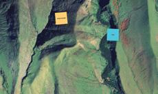
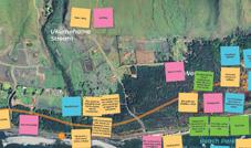
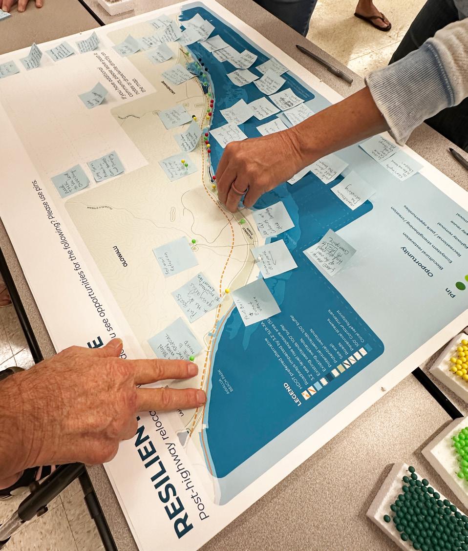
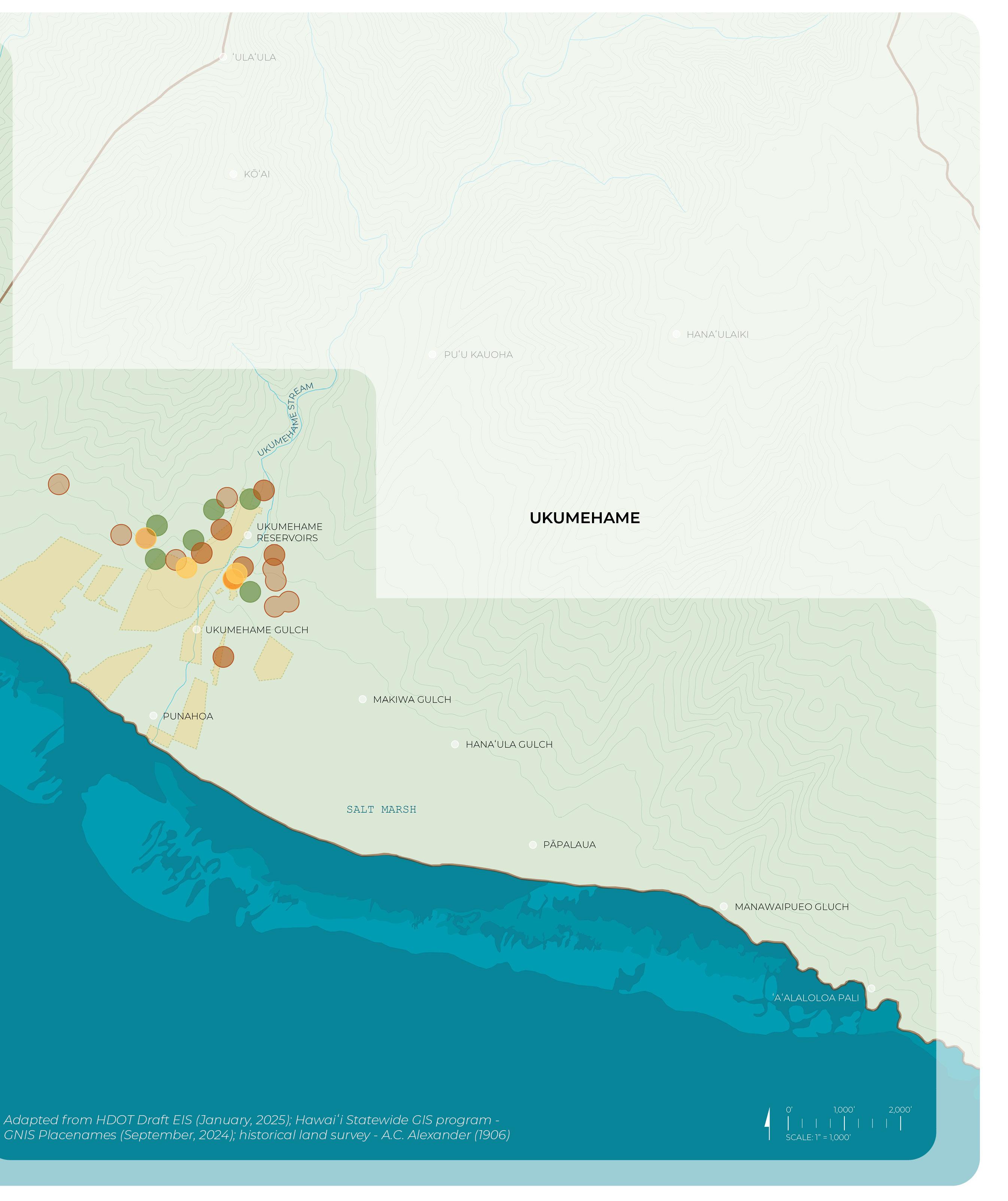
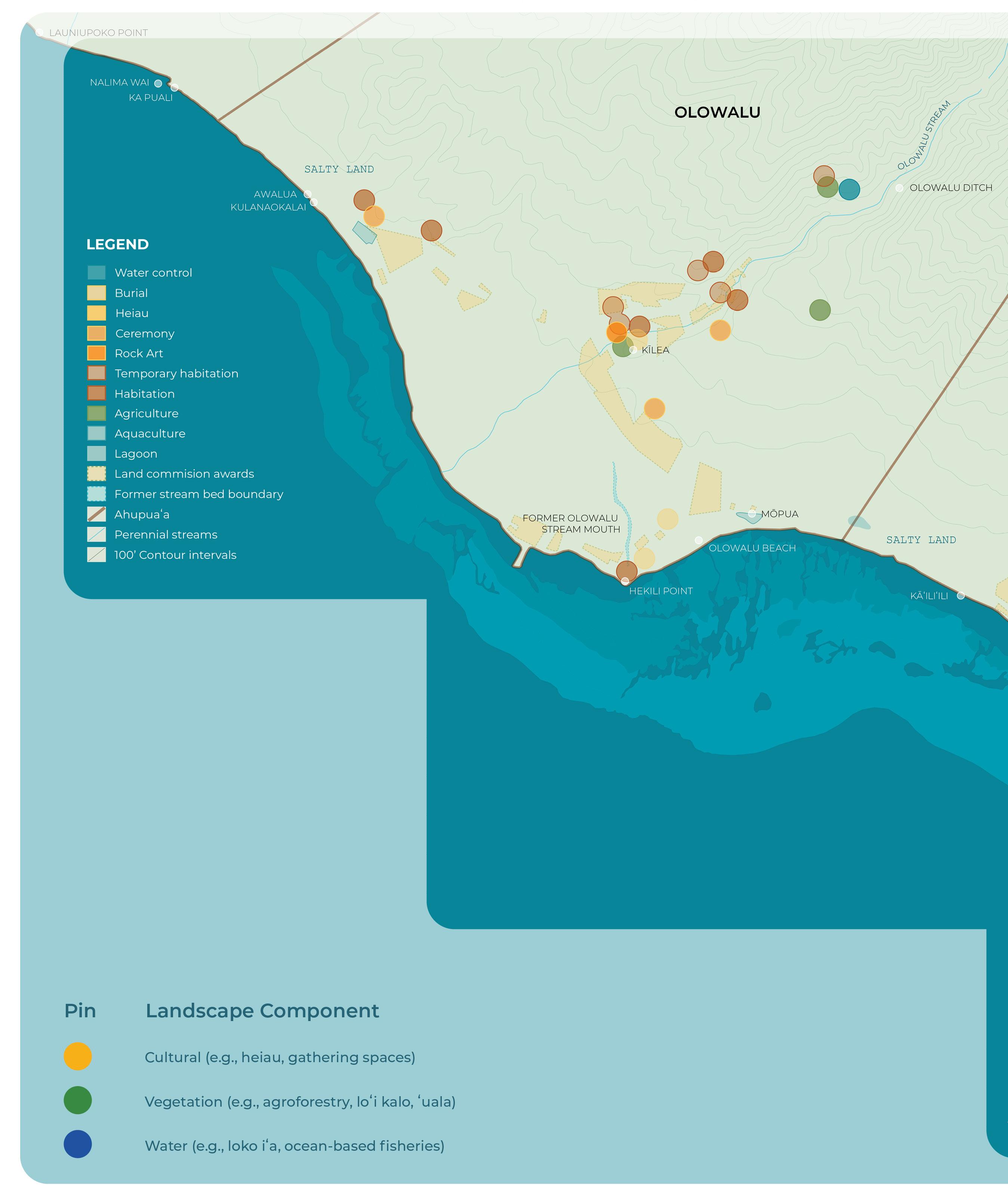
Effective coastal visioning must consider entire watersheds, as conditions in upper elevations directly impact the coastal environment. The second interactive exercise focused on collecting feedback at the scale of the Ukumehame, Olowalu, and Launiupoko ahupuaʻa, emphasizing the interconnectedness of upland and low-lying ecosystems.
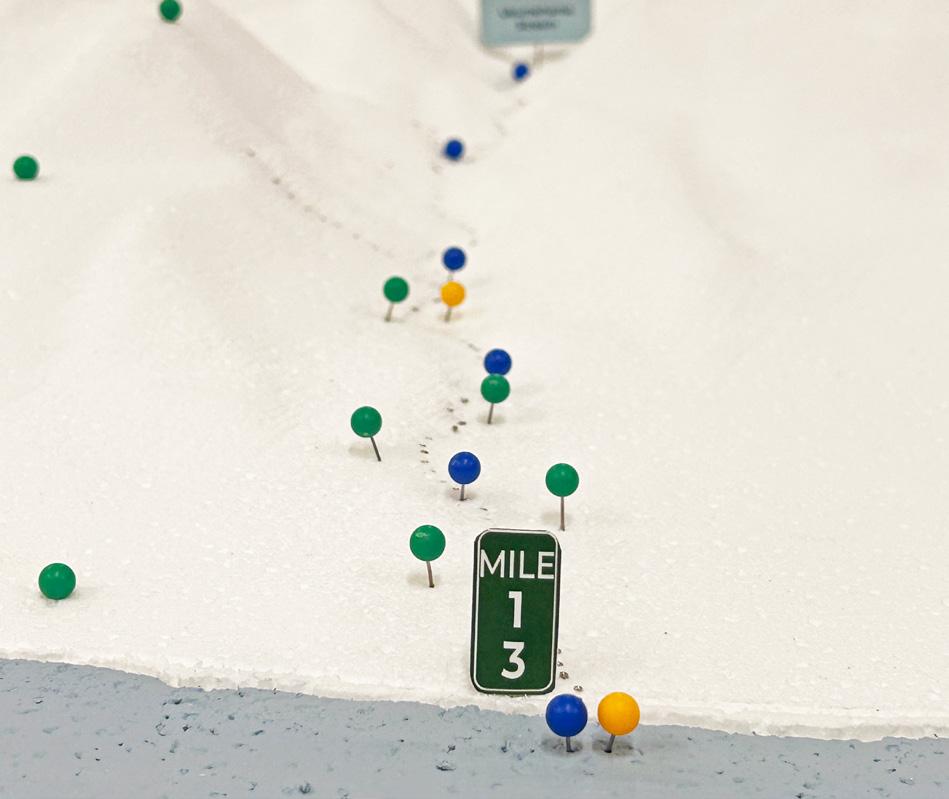
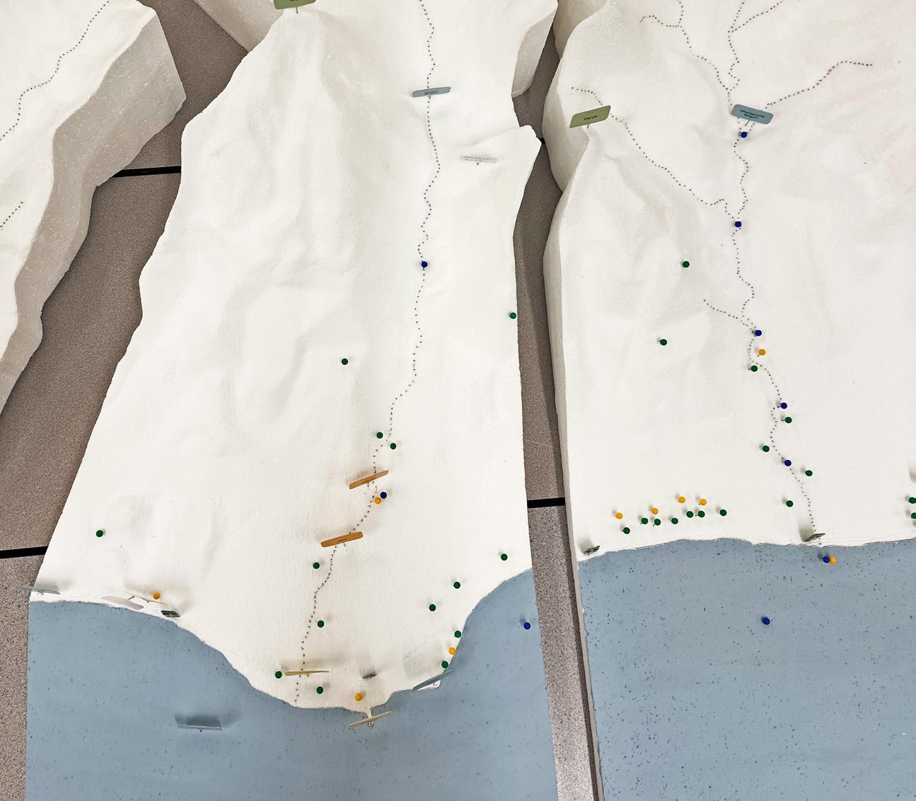
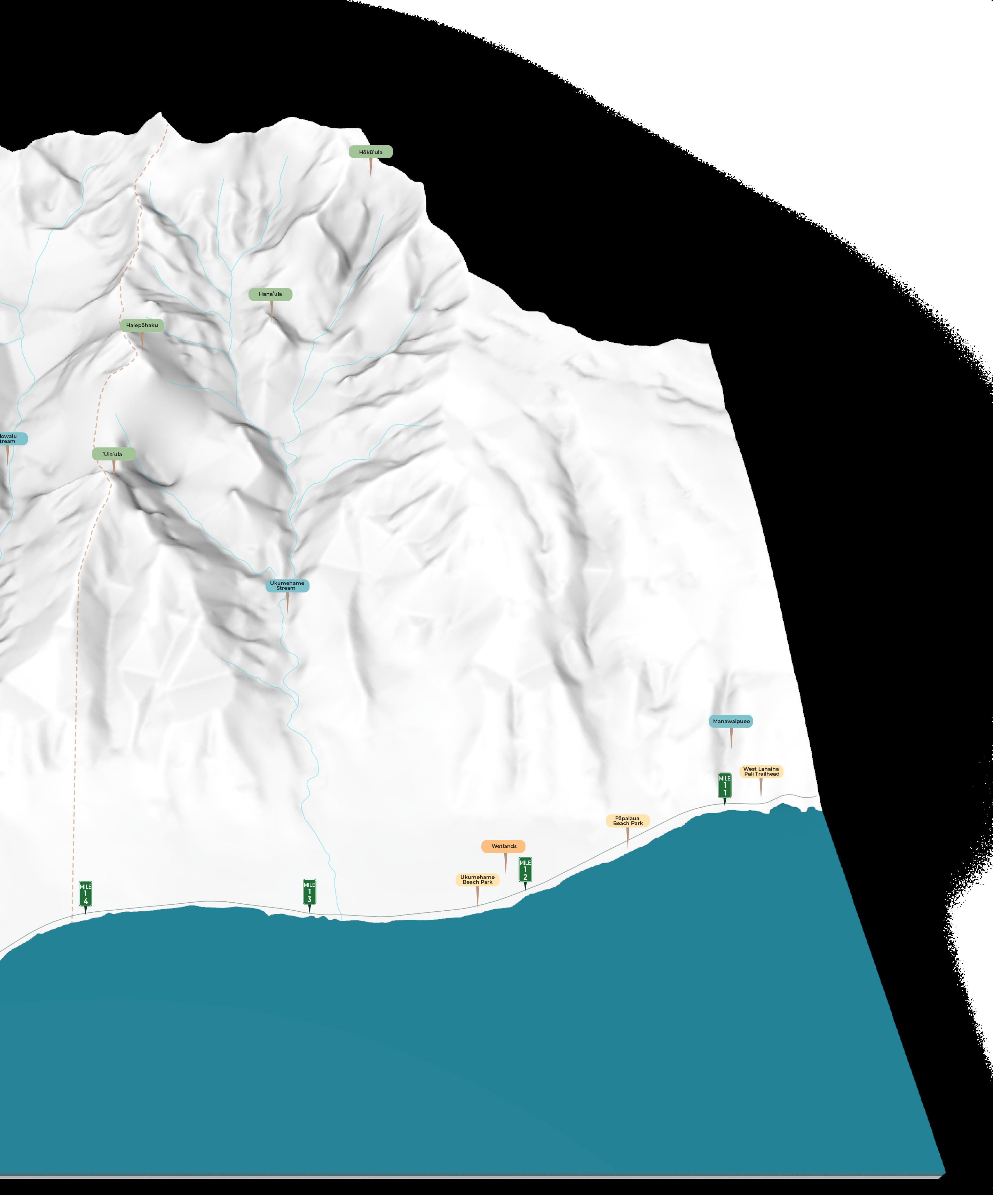
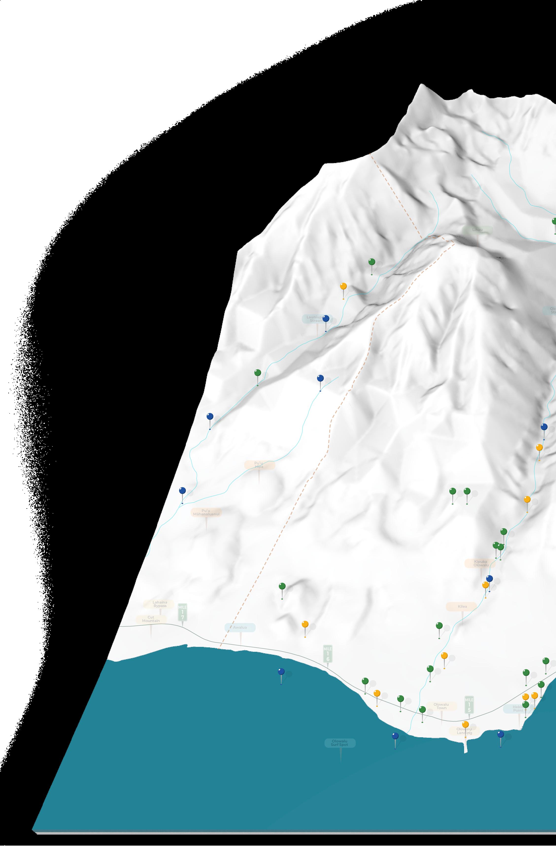
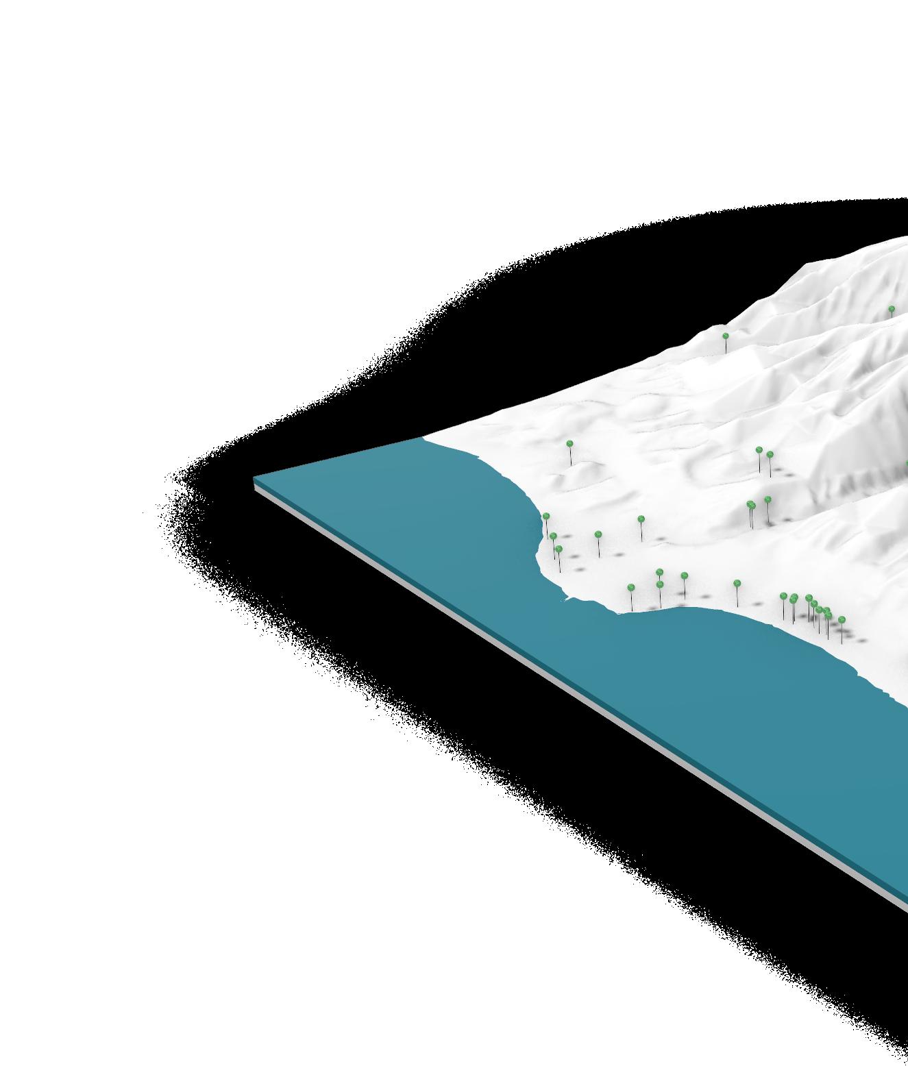
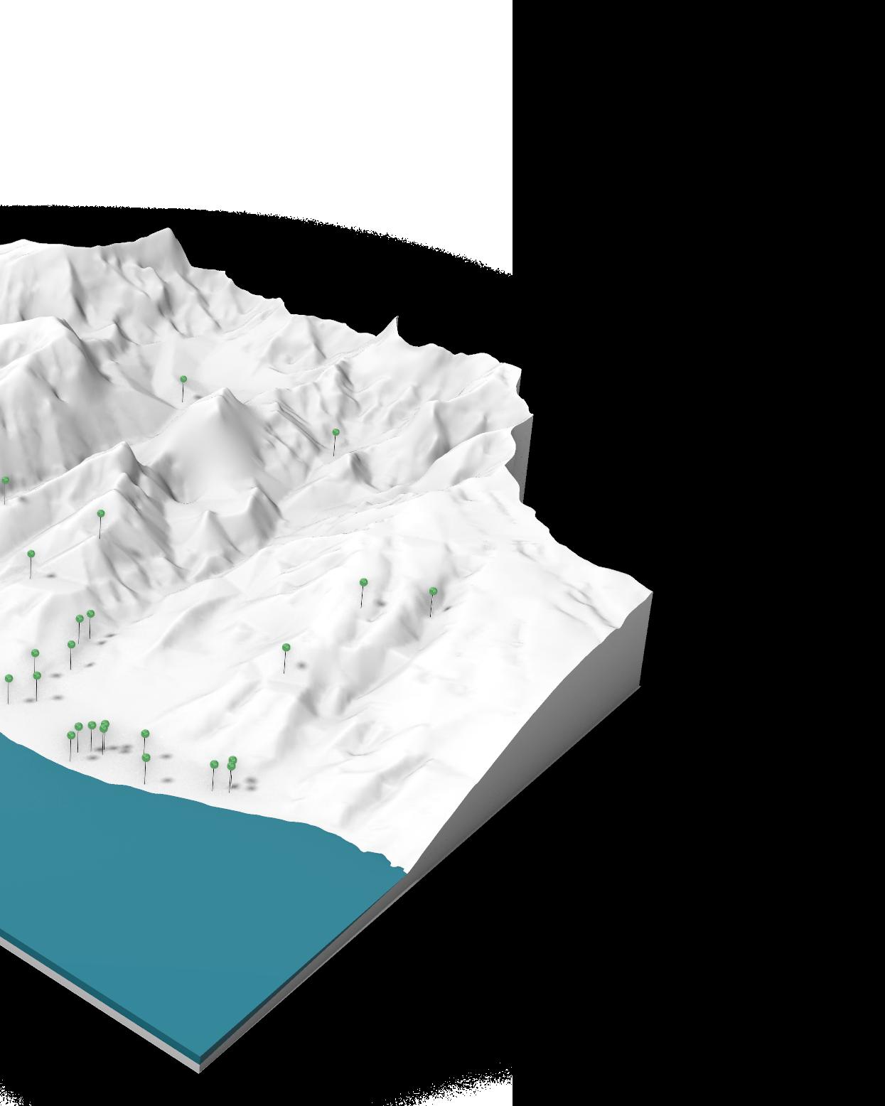
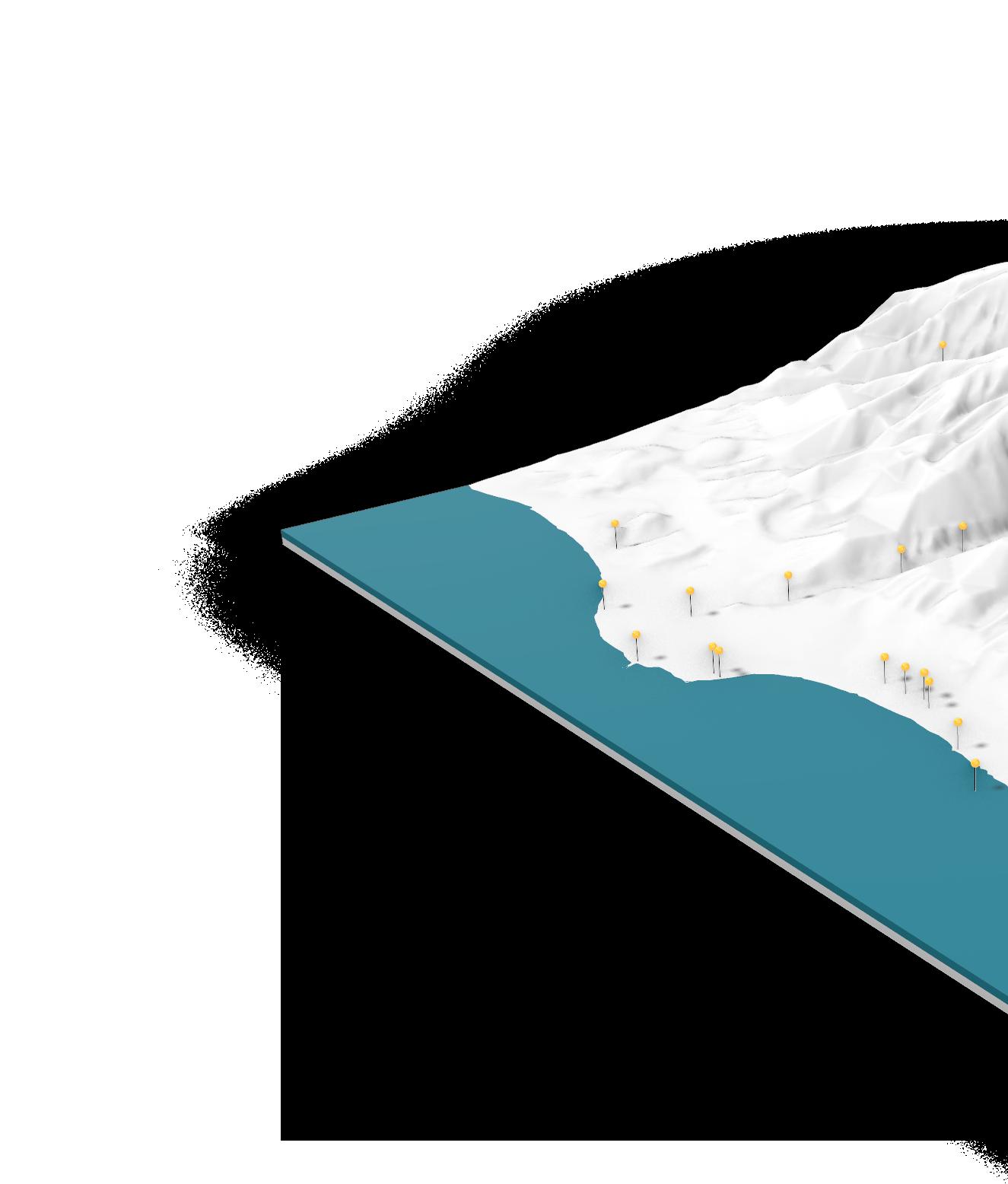
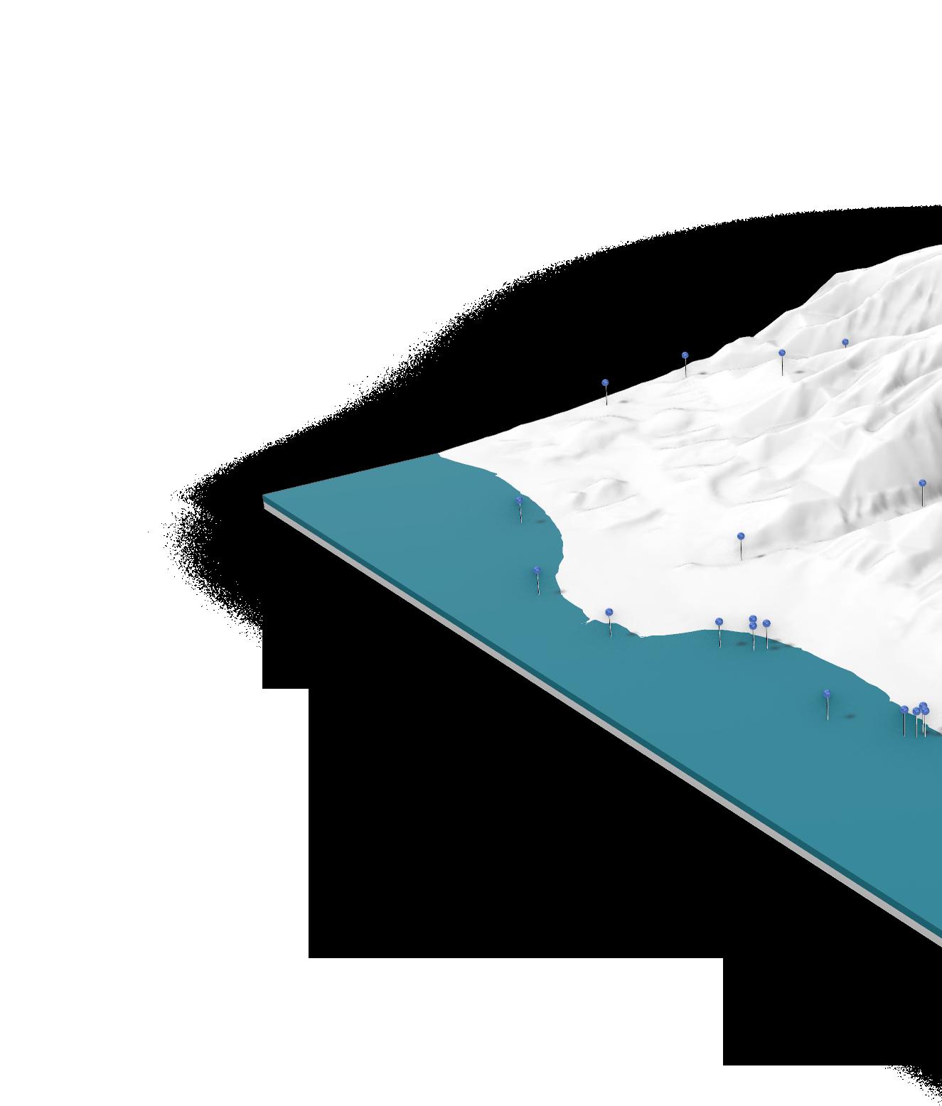
To facilitate this discussion, the UHCDC project team fabricated a 4’ x 4’ 3D physical topography model, providing a scaled representation of the region’s geography. The model highlighted key features that included streams, mountain peaks, mile markers, the current Honoapiʻilani Highway, and culturally significant place names.
Alongside the model, two supplementary components provided cultural and ecological context:
• A map of Hawaiian Place Names (Wahi Pana) within the project area, illustrating historically and culturally important sites.
• A draft of TNC’s Ahupua‘a Snapshot, offering a mauka to makai assessment of environmental conditions, land use, and key ecological features within the Olowalu-Ukumehame ahupua‘a.
The project team asked participants to identify places in the model where they saw opportunities for cultural, ecological, or hydrological improvements and encouraged them to leave written comments, elaborating on specific opportunities. Additionally, community members and stakeholders were given the opportunity to label any unidentified locations that were not already pinpointed on the model and leave sticky notes with comments and feedback.
The community’s engagement with the model broadly highlighted the importance of restoring cultural, ecological, and hydrological aspects, particularly focusing on vegetation, while emphasizing the need for resilience along stream corridors and coastal zones.
Materials included in this section:
Engagement Event Activity Photos
Ridge-to-Reef Model (Materials Provided to Participants)
Ridge-to-Reef Model (Results) Summary and Analysis
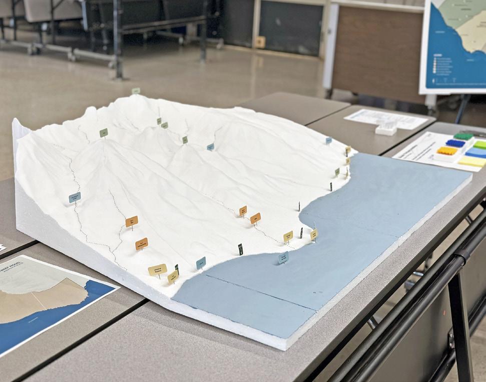
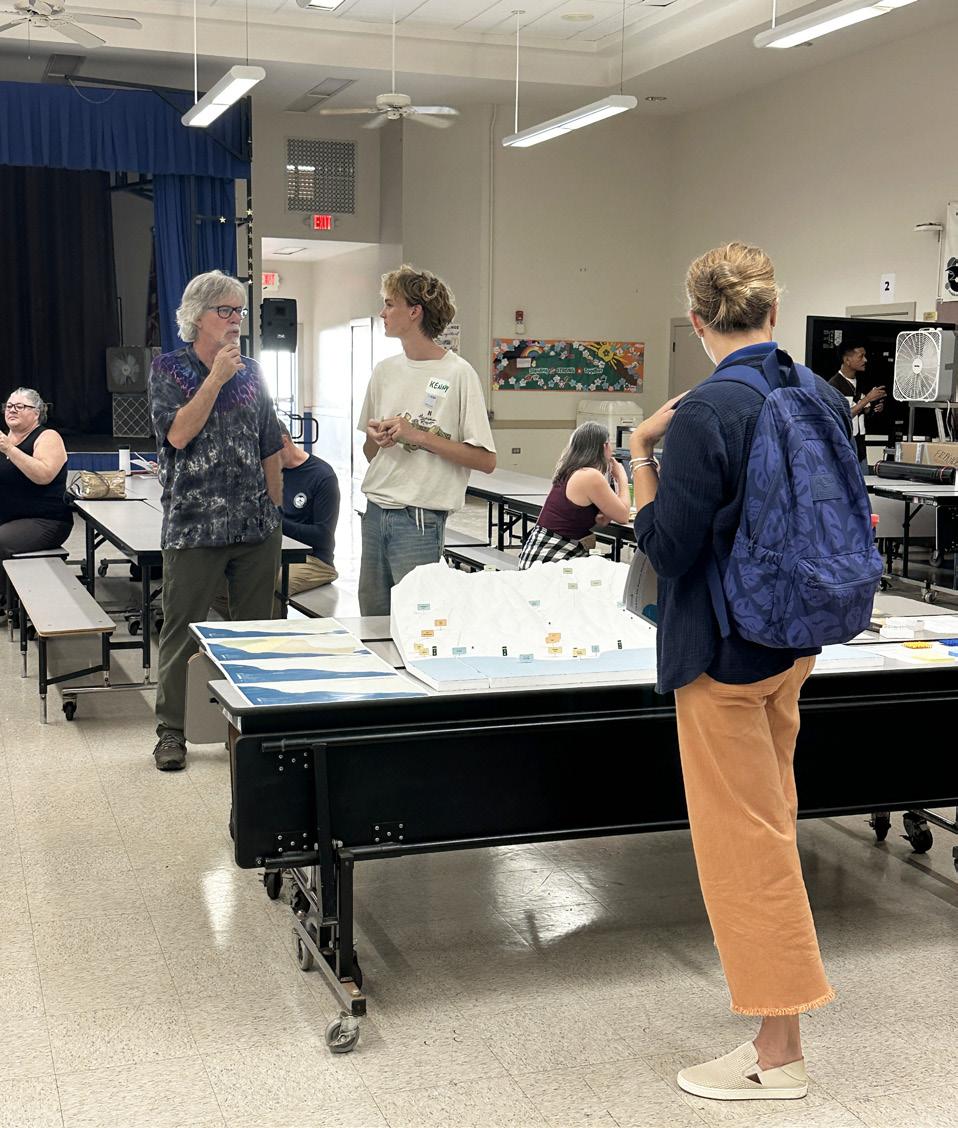
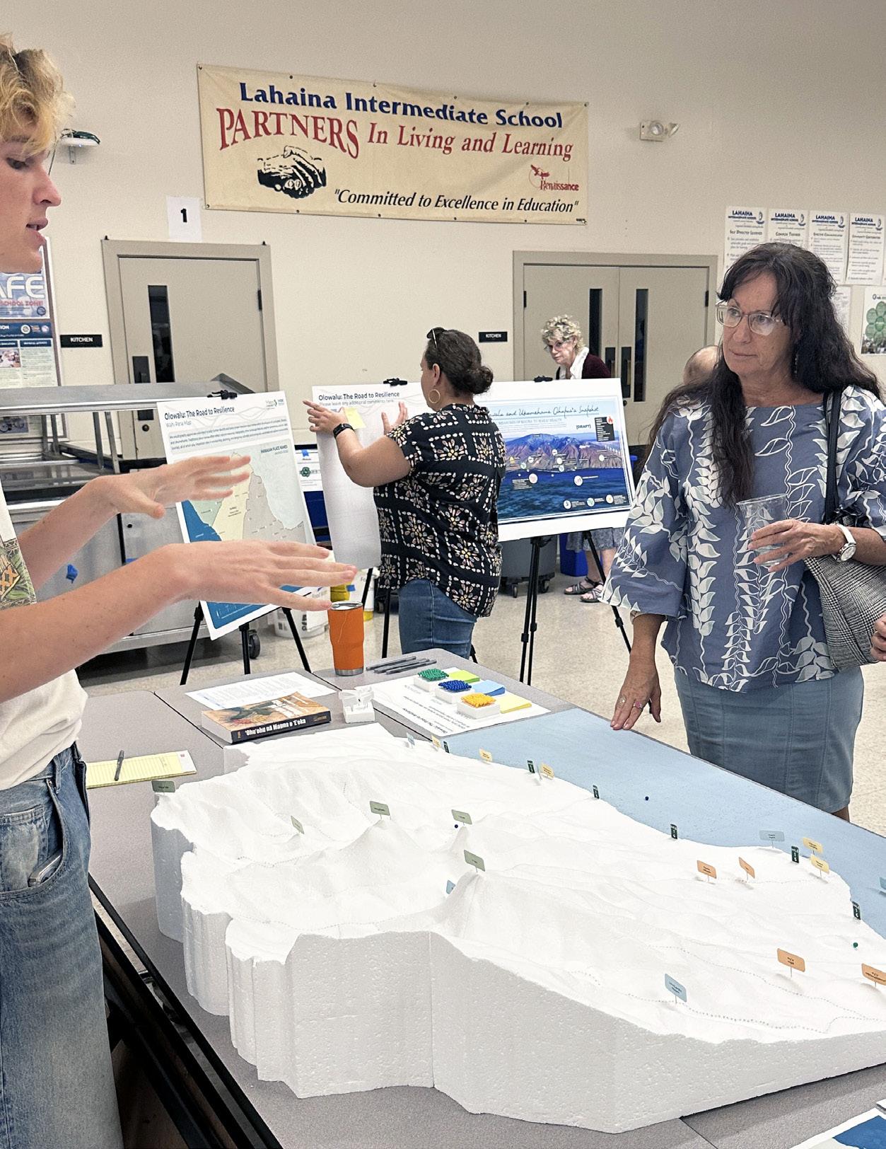
Workshop participants interacting with the large, physical ridge-to-reef model (Images: UHCDC)
Accompanying Materials (In-Person and Virtual Engagement Events)


We would greatly appreciate your input and help in further identifying and honoring proper Hawaiian place names within the ahupuaʻa of Launiupoko, Olowalu, and Ukumehame. Traditional place names often reflect natural resources, topography, other landscape features, weather phenomena, and stories, all of which play important roles in envisioning, planning, and designing culturally and ecologically sustainable and resilient environments.
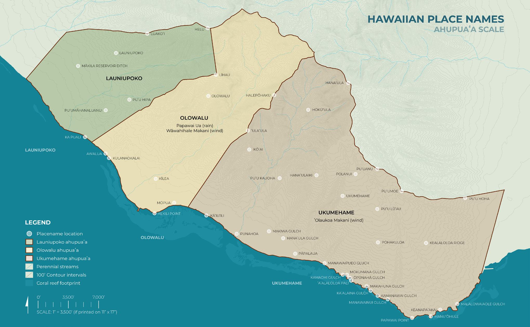
The accompanying materials played a crucial role in enhancing participant engagement and providing cultural and ecological context to the discussion. The Wahi Pana Map helped ground the conversation in historical and cultural knowledge by showcasing traditional Hawaiian place names and their significance within the Launiupoko, Olowalu, and Ukumehame ahupua‘a.
This resource emphasized how place names often reflect natural resources, topography, and local stories, all of which contribute to planning more culturally and ecologically sustainable interventions.
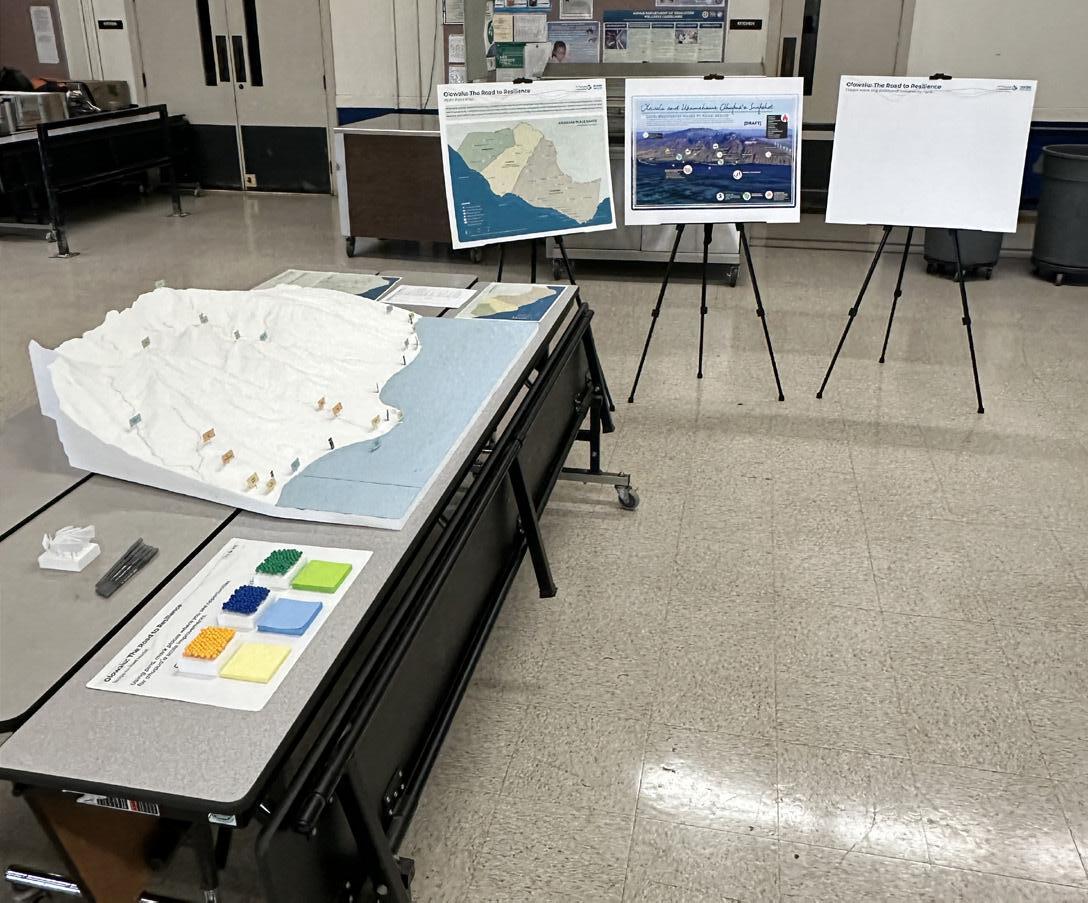
Ridge-to-reef model and accompanying materials
Additionally, The Nature Conservancy’s Ahupua‘a Snapshot--result of earlier community engagement efforts--provided a mauka to makai (mountains to sea) assessment of environmental conditions and key features within the study area. The draft version of this resource outlined critical threats such as erosion, flooding, habitat degradation, and sea level rise, while also identifying opportunities for ecological restoration, conservation efforts, and community-driven stewardship.
This visual representation helped participants understand the interconnectedness of upland and coastal systems and consider potential solutions from a watershed-scale perspective.
Provided Materials (In-Person and Virtual Engagement Events)
Using pins, mark places where you see opportunities for ahupuaʻa scale improvements.
Vegetation

Cultural

Water


In-Person and Virtual Engagement Event Results (2/6/25, 2/11/25, 2/13/25)
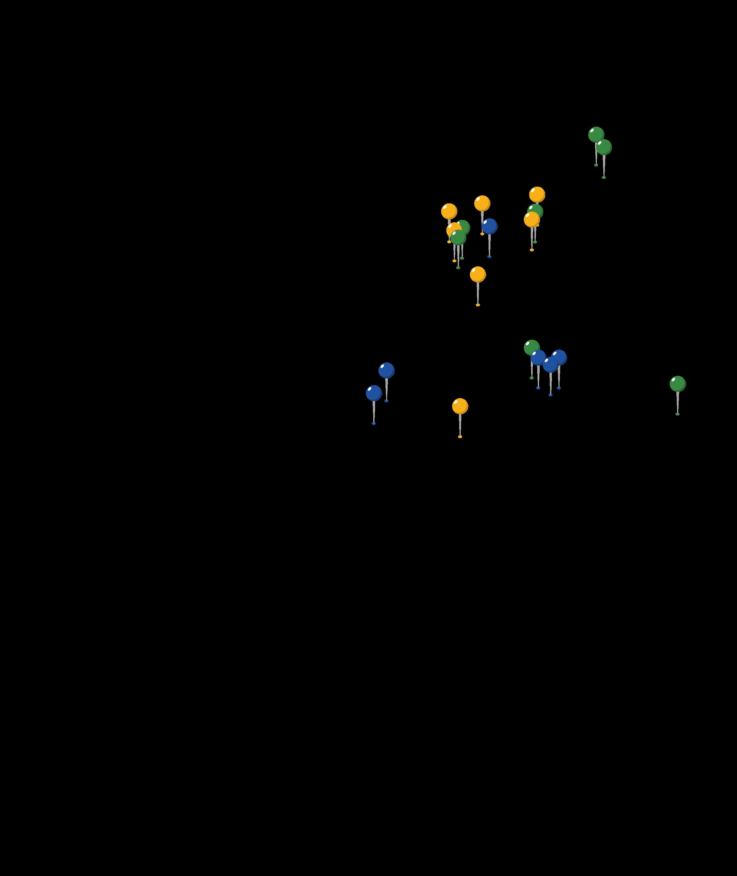
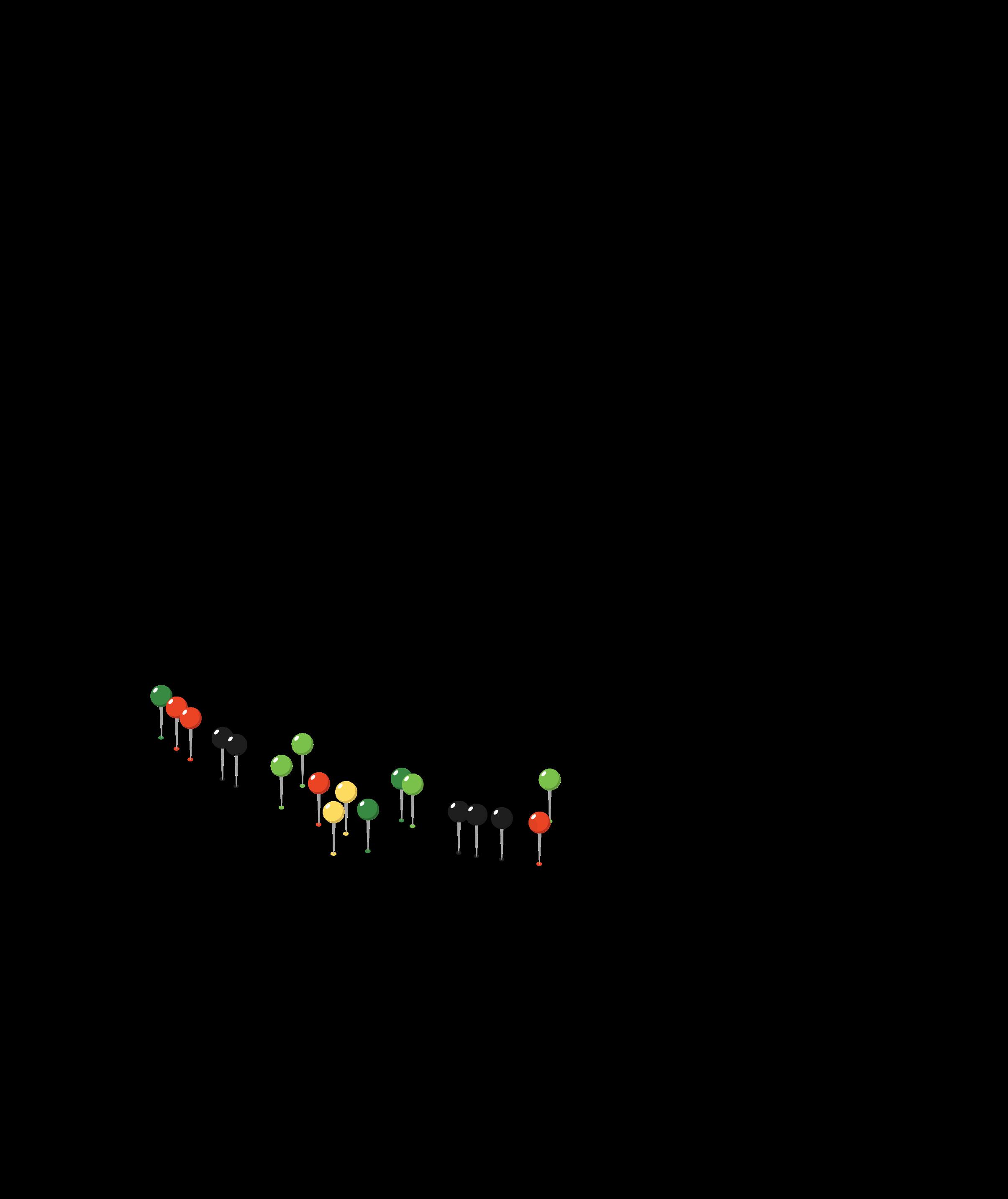
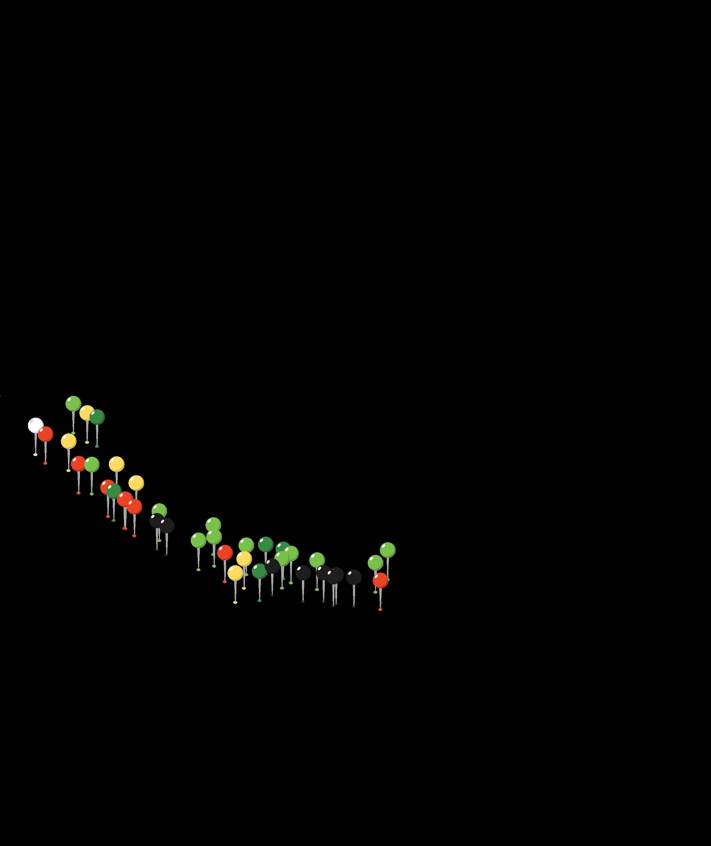
The Ridge-to-Reef Model exercise captured key community priorities across the Ukumehame, Olowalu, and Launiupoko ahupua‘a, with a total of 102 pins placed.
The large number of vegetation-related pins highlights a strong focus on native plant restoration, erosion control, and watershed health, while water-related pins emphasize concerns about stream flow, freshwater quality, and impacts of sediment on the Olowalu Reef. The cultural pins reflect a commitment to preserving significant sites and improving access, reinforcing the value of traditional ecological knowledge (TEK) in resilience planning.


Sustainable Agriculture and Land Management:

Use goats to reduce fire risk, remove invasive trees, and plant native/edible vegetation along the highway. Expand tree planting (mauka to makai).
Ecosystem and Habitat Restoration:
Restore native habitats, wetlands, and reefs by replanting vegetation and cleaning up pollution. Remove seawalls and restore dunes to support coastal health.
Tourism and Recreation Management:
Protect Olowalu and Puʻu Kilea from over-tourism, limit upslope recreation for habitat recovery, maintain surf access with proper infrastructure, and establish resident-only campgrounds.
Infrastructure and Community Concerns:
Address homelessness through enforcement and support services.
Add goats to the dry grassy areas - prevent fires
Balanced development that considers the long-term health of the coast
You all rightexpressedhavethe approach to protecting the land and ocean for future generations, and all the plants and animals affected by it. Thank you so much!!
In-Person and Virtual Engagement Event Summary and Analysis
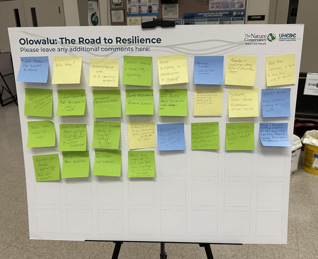
Culture-Related Sticky Notes Left by Participants
Gathering spaces with shaded areas, walkways, and places to connect with nature.
Archaeological sites - identify and protection/ management.
Community space around ukumehame stream mouth. Deter dumping in Ukumehame & clean up.
West Maui Greenway on Hwy 30 & drop down access for vehicles.
Beaches and park area along bottom of Ukumehame stream.
Ensure West Maui Greenway gets incorporated into this plan
Make sure coastline is protected for uses beyond recreation
Work with NativecommunityHawaiian to broaden waterwaysthe by relocating rocks.
Honoring traditional wisdom and Hawaiian stewardship practices to guide the way forward.
Study place names, learn from them, for example traditional plant names, etc. (be as place specific as possible) Do it all (hydrological, ecological and cultural restoration)Everywhere!
Environmental and Waterway Management:

Partner with the Native Hawaiian community on waterway improvements, enhance water flow by relocating rocks, prevent dumping and conduct regular cleanups.
Recreational and Community Spaces:
Incorporate the West Maui Greenway, develop parks and beach areas near Ukumehame Stream, create a community space at the stream’s mouth.
Infrastructure and Accessibility: Provide vehicle access from Highway 30 to the Greenway.
Cultural and Historical Preservation:
Protect and manage archaeological sites and address concerns related to Puʻu Kilea.
In-Person and Virtual Engagement Event Summary and Analysis
Water-Related Sticky Notes
Left by Participants
Stream Protection:
Preserve and protect all streams from mauka to makai to maintain natural water flow and ecosystem health.
Wetland and Waterway Restoration:

Restore wetlands, remove barriers that disrupt natural processes, and improve waterway flow to support ecological balance.
Ecosystem Management:
Focus on maintaining existing activities rather than adding new ones, especially limiting mauka hiking to reduce environmental strain.
RIDGE-TO-REEF MODEL
Synthesis of In-Person and Virtual Event Results

Results of the Ridge-to-Reef Model engagement activity (in-person and virtual events combined) highlight community member and stakeholder priorities and themes at the ahupua’a scale.
Opportunity locations marked by workshop attendees are concentrated along stream corridors and coastal zones. The majority of pins placed by participants focused on ecological opportunities, particularly vegetation (51 pins), water (34 pins), and cultural (17 pins).
Key themes that emerged include protecting mauka areas and streams, native forest rehabilitation, wetland restoration, pollution cleanup, and preserving the mauka-to-makai relationship. These priorities emphasize the community’s focus on restoring natural ecosystems, improving water quality, and strengthening watershed resilience.

Categories:
Ecological Opportunities
Cultural Opportunities
Hydrological Opportunities
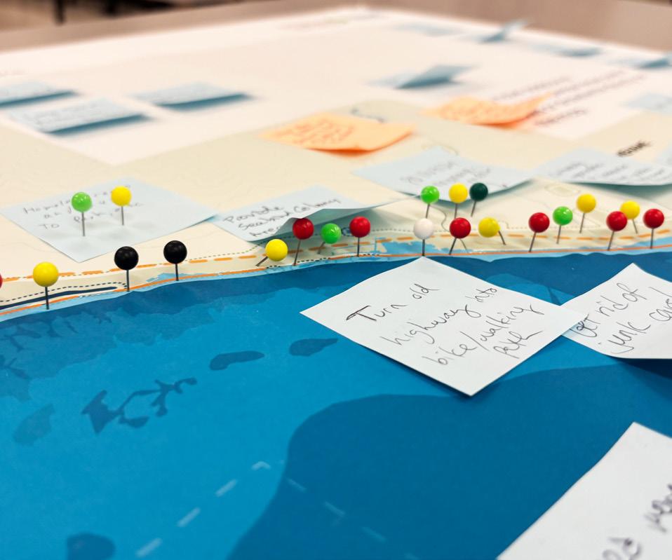
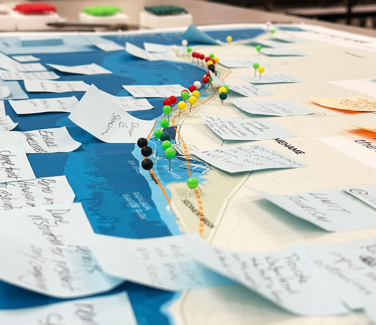
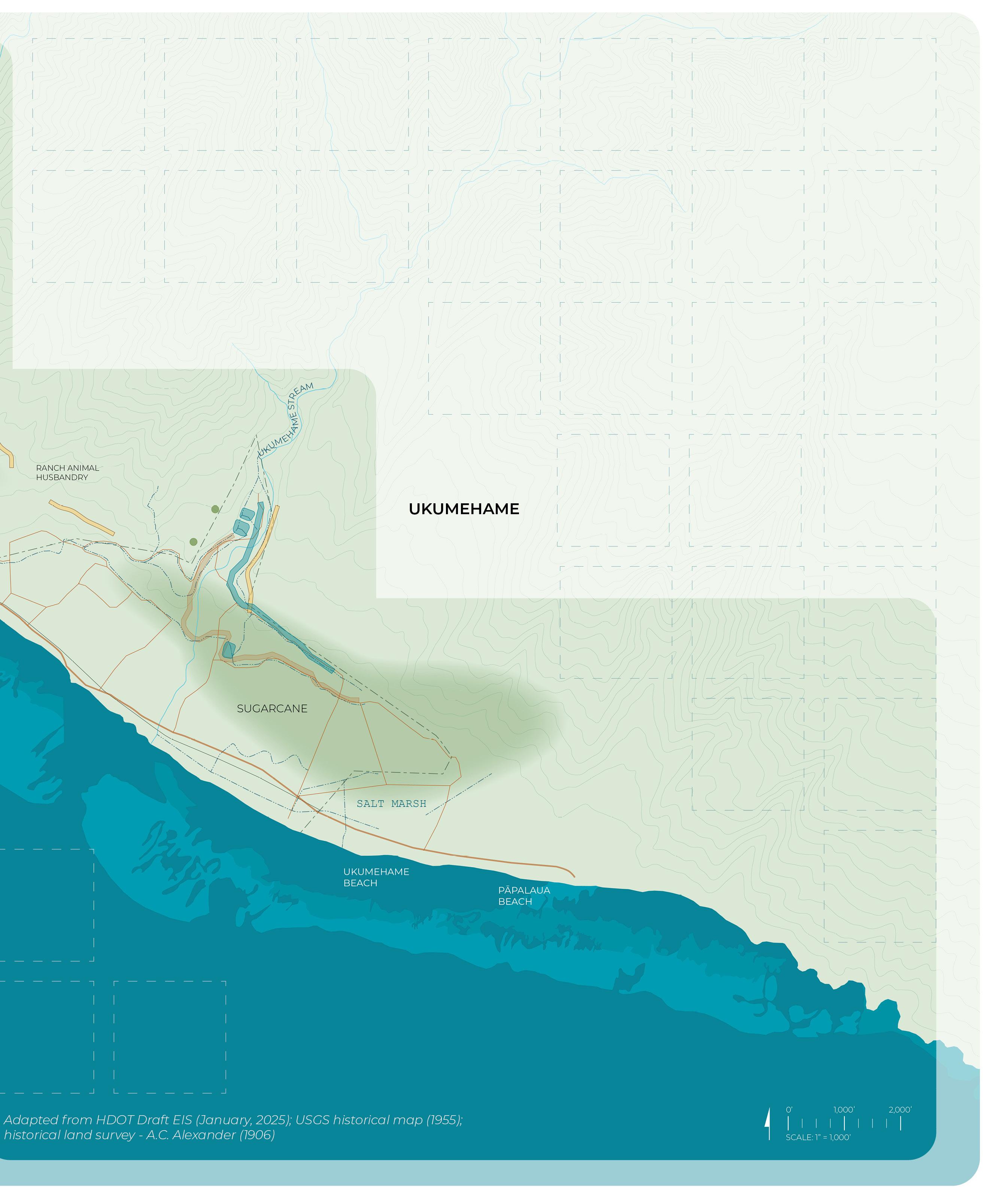
This interactive mapping exercise engaged stakeholders in a timeline-based coastal visioning activity, designed to explore how historic land uses within the project area have shaped the presentday landscape and to identify future opportunities for resilience. The activity was structured around three maps, each illustrating a different time period: pre-Western contact, plantation era, and future conditions.
The project team asked participants to place pins and provide written comments on the maps to share insights, concerns, and ideas, in response to questions about coastal changes and potential interventions:
• Pre-Contact Map: Identify landscape components (cultural, vegetated, hydrological) that should be maintained or restored, drawing from traditional land use to guide contemporary resilience strategies.
• Plantation Era Map: Identify the environmental consequences of plantation era land uses (e.g., sedimentation, altered waterways, land degradation), while also noting landscape elements worth preserving.
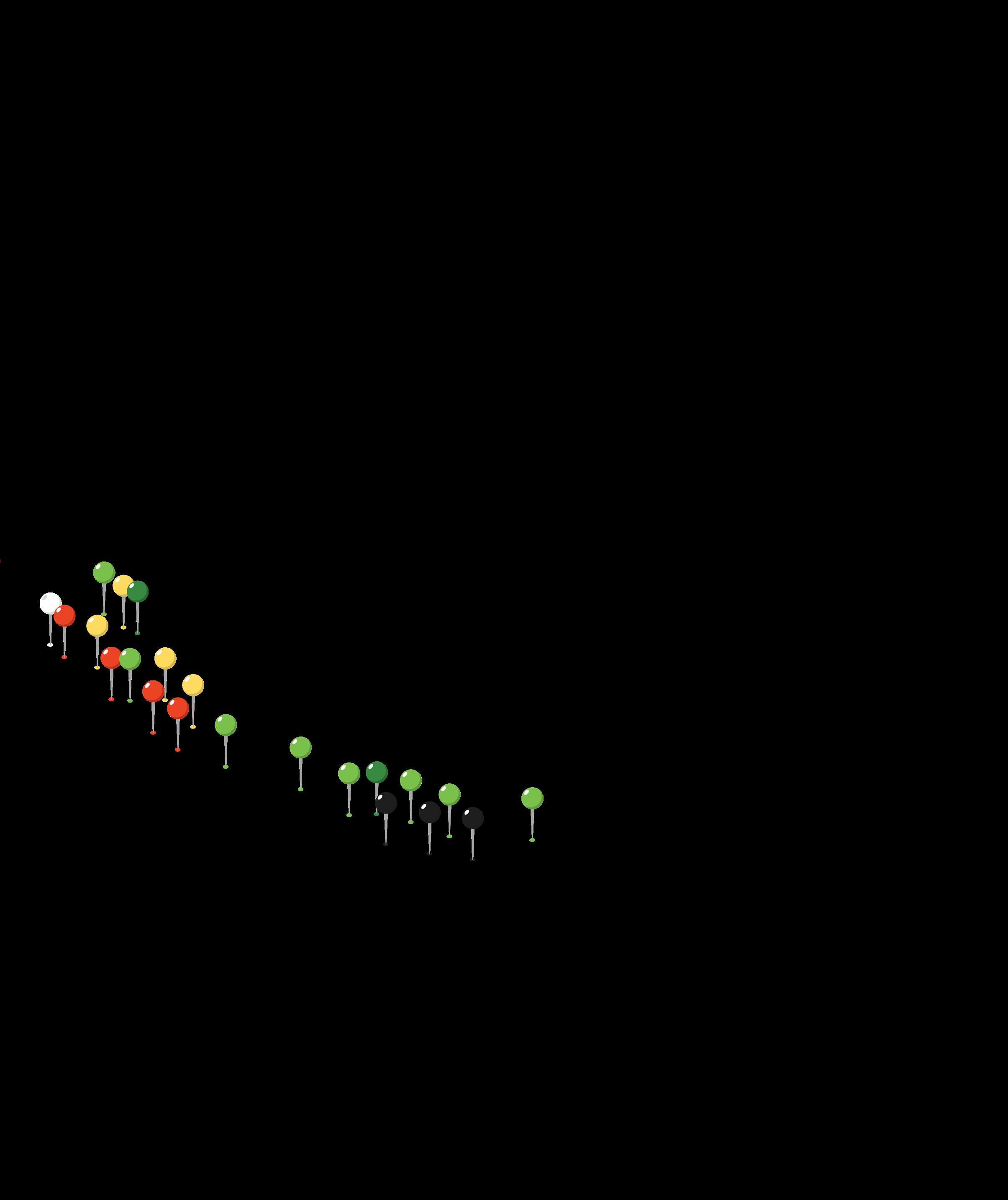
• Resilient Future Map: Highlight opportunities for biocultural restoration sites, ecosystem strengthening, recreational enhancements, highway reuse or removal, and seawall removal.
As a supplement to the three maps, the project team provided participants with educational boards focusing on nature-based solutions (NbS), traditional ecological knowledge (TEK), and sea-level rise adaptation intended to inform responses.
Materials included in this section:
Engagement Event Activity Photos
Coastal Interventions: Pre-Contact, Plantation Era, Resilient Future (Materials Provided to Participants) Coastal Interventions: Pre-Contact, Plantation Era, Resilient Future (Results) Summary and Analysis
Workshop participants interacting with engagement materials (Images: UHCDC)
Provided Materials

Using pins, please mark landscape components that you would like to see maintained or restored.
In-Person Engagement Event Results, Summary, and Analysis (2/6/25)
Important to find out where the heiaus are from Aunties and Uncles for future places to not touch.
Cultural Water
Pins placed and comments left indicate that participants recognized the potential to strengthen biocultural restoration efforts at and around Kipuka Olowalu. Additionally, participants highlighted coastal opportunity locations.
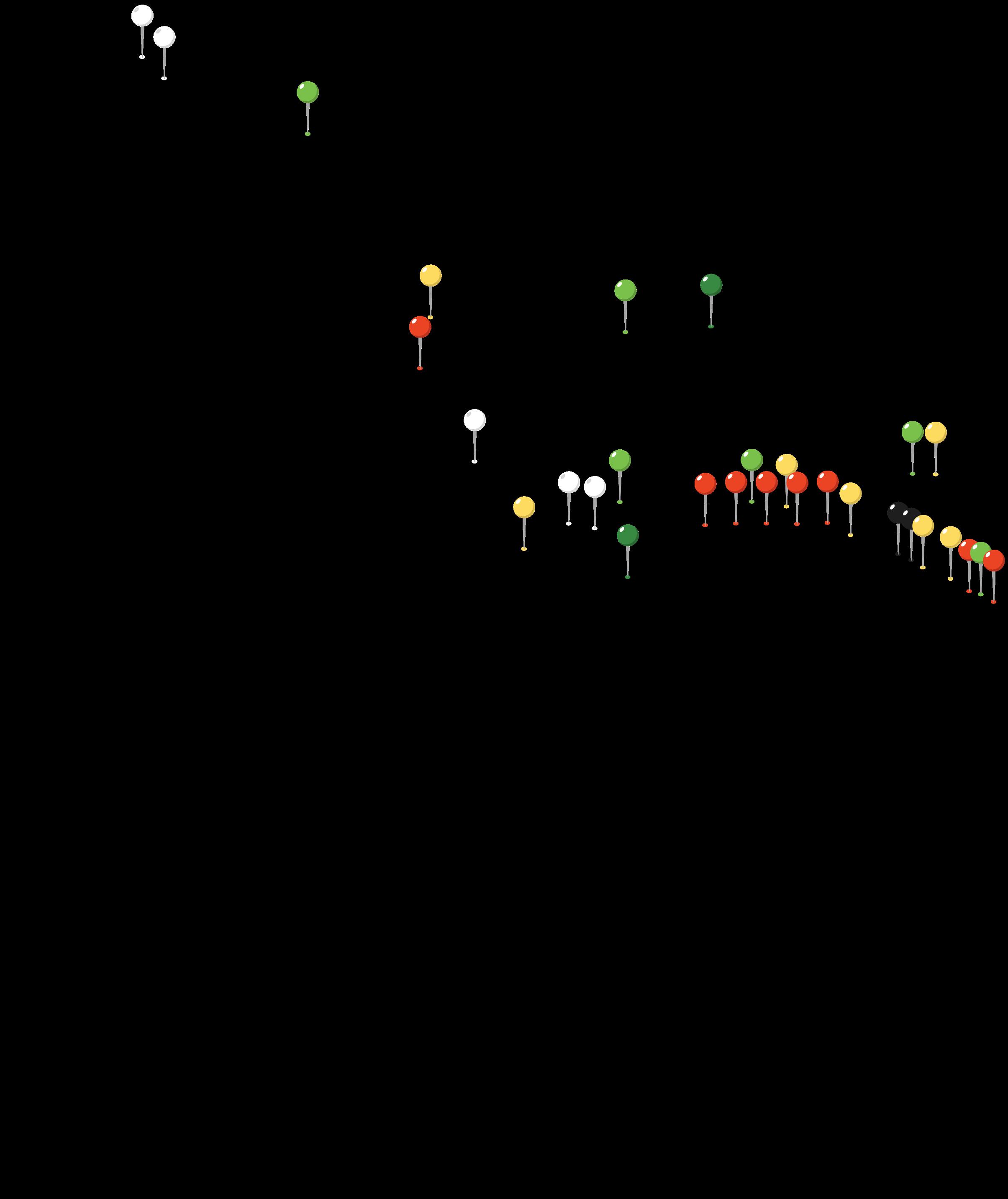
Pin Placement by Map Legend Category

Agriculture Habitation
Aquaculture
Burial VEGETATION

Agriculture Habitation Burial Ceremony Rock Art

Agriculture Habitation
Aquaculture Burial Ceremony


Provided Materials
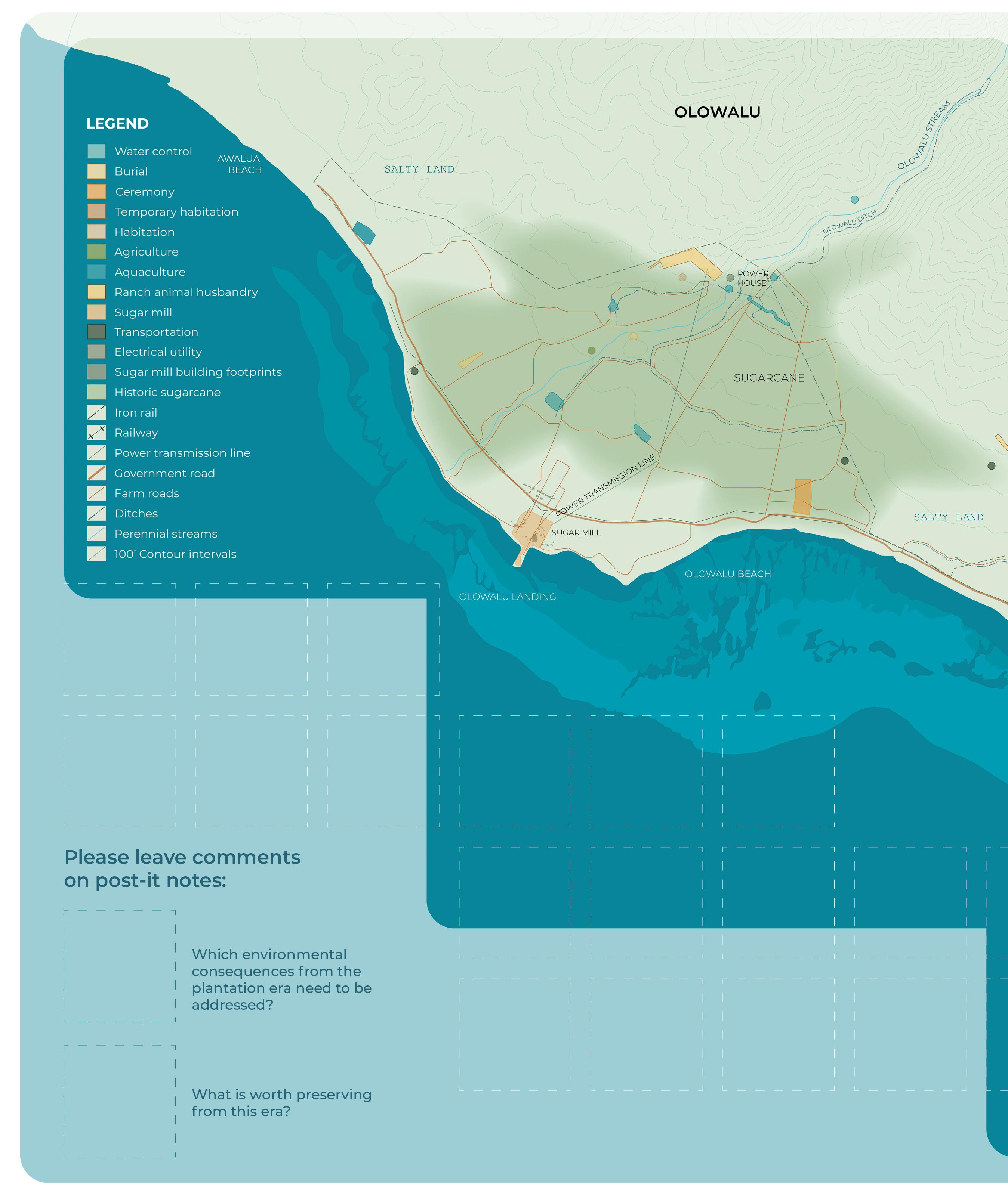
Which environmental consequences from the plantation era need to be addressed? What is worth preserving from this era?
Engagement Event Results (2/6/25)
Remediate soil
Modified stream passage route
Old cane roads became muddy conduits
Remediate soil and waters in polluted area like sugar mill with bio remediation and public park
Malama the remaining ohana who still live there ʻohana Nahoʻoikaika
Stream access for recreation
Get rid of cat colony at the landing Erosion and invasive grasses
Plastic out of the soil! It’s all over the place
Get all the old plastic and piping out of the soil
Restore cultural sites destroyed by plantation Dry/dead grasses near and under telephone lines. No clearing of invasives
Preserve Olowalu sugar mill Runoff Legacy pollutants
In-Person Engagement Event Summary and Analysis (2/6/25)
cane roads became muddy conduits
Remediate soil and waters in polluted area like sugar mill with bio remediation and public park
Plastic out of the soil! Its all over the place
of the old plantation camp behind the store Dry/dead grasses near and under telephone lines. No clearing of invasives Get all the old plastic and piping out of the soil Get rid of cat colony at landingthe
Restore cultural sites destroyed by plantation
trees!
Old cane haul roads preserve and use for West Maui Greenway Run-off from fallow fields
and waterresilienceresource reservoirs-
• Address soil and water pollution through remediation and bio-remediation.
• Remove plastic and legacy pollutants from the land.
• Manage erosion, invasive species, and problematic vegetation.
• Modify stream routes and restore old cane roads.
• Ensure safe recreational access to streams and address wildlife concerns (e.g., cat colonies).
• Care for local families and communities (ʻohana Nahoʻoikaika).
• Restore and preserve cultural sites and the Olowalu sugar mill.
• Address environmental issues such as runoff from fallow fields and the resilience of water resources (e.g., reservoirs).
• Re-purpose old cane haul roads for sustainable projects like the West Maui Greenway.
• Highlight and preserve local agricultural heritage, including mango trees.
• Focus on the importance of local agriculture and as part of the area’s native flora.
• Reflect on the historical significance of the old plantation camp located behind the store, representing a key part of local heritage.
• A general reference to the area’s past, encompassing its cultural and historical developments.
What is worth preserving from this era?
Cultural and Historical Preservation
Ecological Restoration and Remediation

Which environmental consequences from the plantation era need to be addressed?
Ecological Restoration and Remediation
Cultural and Historical Preservation
Pie chart summarizing number of written comments left during the in-person event on the Coastal Interventions: Plantation Era mapping exercise, organized by thematic category.
Provided Materials

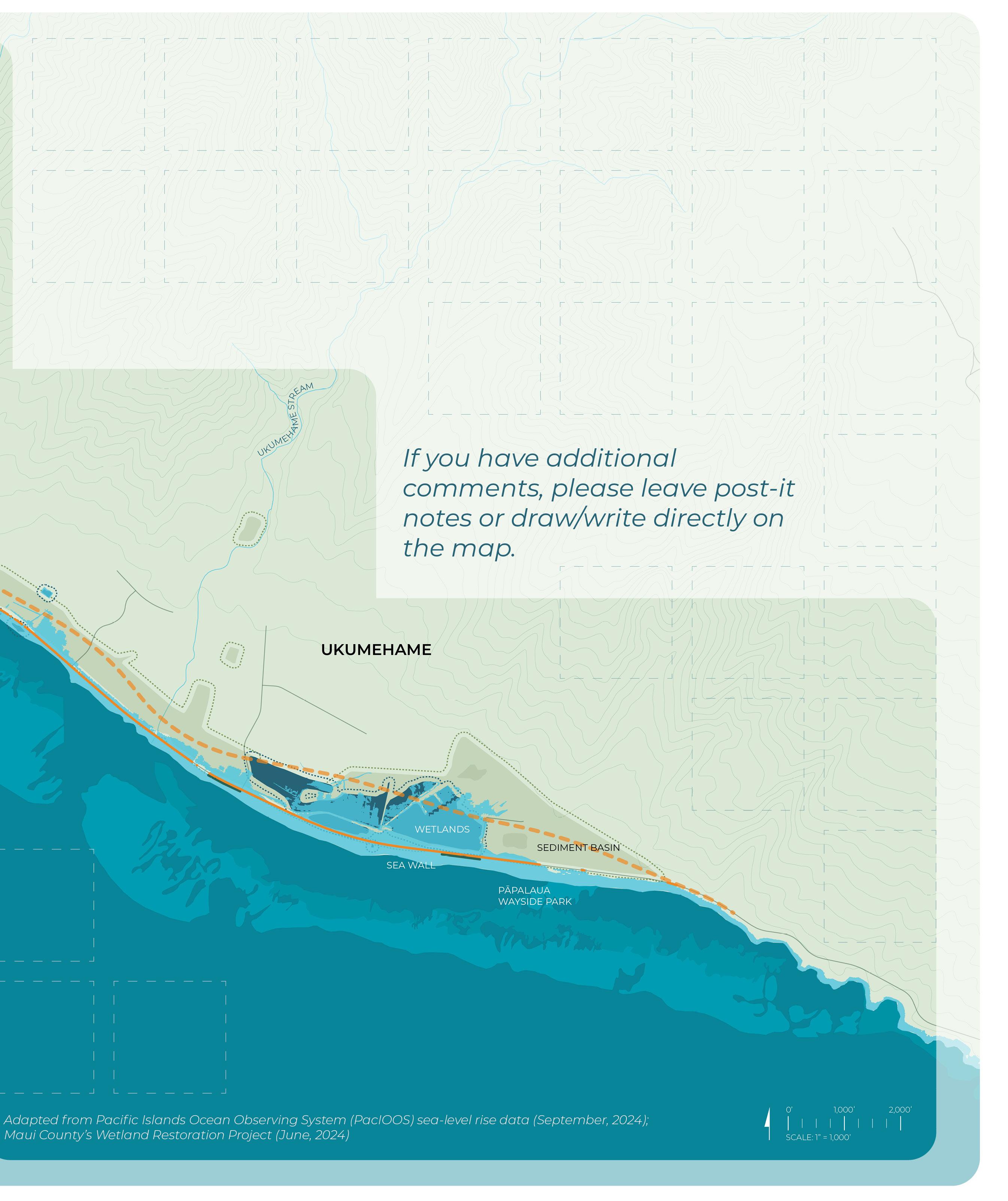
Post-highway relocation, where do you see opportunities for the following? Please use pins.
Results (2/6/25)
Land makai of the new highway needs to all be greenspace No trash and law breaking at mile marker 13
West Maui Greenway
Catch basin for when temporary disposal site is moved
ball and event venue Everything makai of highway should be park, open space, and cultural activities
Put goats in the dry grassy areas to maintain and prevent fires Homeless camp and dump to park, etc.

Quiet at shoreline
Limit tourism
Beach park with bathrooms, showers at Ukumehame
Remove seawalls
Permits for resident only camping
Raised highways to minimize impact through wetland area
Get rid of junk cars
Native forest restoration
Use sections of the highway that are farthest from the water for parking (for beach use) remove most of the road
Charge tourists parkingresidents free
Bathroom facilities at Ukumehame and Papalaua
Grow vegetation, taro, watercress, etc. in all stream beds and wetlands
Consistent presence and management at mile marker 13.5 Oʻopu habitat
Provide waterbird habitat along with wet land, loʻi kalo development
Remove or seriously mitigate transmission lines to prevent seabird collisions and fires
Assure mauka nesting seabirds are protected from alien mammals
At bottom of access roads - bathroom facilities, greenway, and paths to beaches
More coconuts and less kiawe along shoreline
Pollution management
Dune restoration
Partner with Hawaiian organizations for restoration
Plant Milo trees for shade and to slow erosion
Shrimping in Ukumehame stream
Open space
Lama lama (fishing torch) or heʻe by Camp Pecusa (Olowalu)
Park and walk down to the beach
Culturally informative and interactive based parks with enforcement for pollution mitigation
Maintain existing space for people Beach parks along the entire stretch
Safe parking and clean beaches
Keep the current highway as a dirt road for biking, walking, horseback riding
Maintain the landing
Virtual Engagement Event Results (2/11/25, 2/13/25)
If left in place, the existing highway may eventually act as a hardened shoreline, leading to significant impacts such as beach loss and loss on critical habit.
There was a cost analysis in the book Thinking about Traffic in West Maui and what Judith said.
Honoring traditional wisdom and Hawaiian stewardship practices to guide the way forward.
Thriving native shorelines, Healthy coral reefs supporting marine life and naturally buffering waves.
Take knowledge from historic land use (native tree plantings)
Restored fishponds that blend tradition with sustainability, protecting marine habitats.
Public beaches with open access for everyone to enjoy.
Think of the reduction in miles driven
Gathering spaces with shaded areas, walkways, and places to connect with nature.
Balanced development that considers the long-term health of the coast.

I’m not a scientist, but many old time farmers say it doesn’t rain like it used to. In my 65 years, I’d say the same. We should embrace weather trends and not try to get more water when rainfall is going down (maybe).
Remove all sea walls, remove existing highway in areas that already will be underwater
Remove sea walls and highway sections that intersect with 3.2 ft SLR-XA at times based on planned triggers. Create an adaptation plan similar to DPR’s beach park adaptation plan for Hoaloha BP under development.
Perhaps remove the highway and encourage more native vegetation and wetlands near Ukumehame and places of the road that get wet during king tides? Just a thought...
Expand recreational & park opportunities at Ukumehame and encourage native vegetation with educational signs and information.
Coastal area is such a special place for gathering/collecting, and we should keep the space open for people who use the coastline
Recreation focused away from the coastline, and reserve the coastline as a space for people to come together, gather
In terms of re-imagining public spaces – Papalaua Wayside Park that is in the SLR-XA zone with the sedimentation basin directly mauka, Ukumehame Firing Range, wetlands, archaeological sites, etc. is somewhere I could see creative (and challenging) landscape architecture solutions (that incorporate nature-based solutions). Especially as a cul-de-sac is proposed here in the HDOT EIS proposed alternative.
Remove sea wall west of Papalaua Wayside Park, create layered living shoreline systems, turn old highway into elevated boardwalk, and (re)establish salt marsh.
Any proposed work should not accelerate the impacts of SLR and erosion to impact the reliability of the realigned highway
Considering removal of the existing highway in areas of known nene habitat to help protect the species
I can concur, from the data, that rainfall has been declining since the 80s, and are predicted to continue to decline.
If we put a tunnel through the mountain from Wailuku….you could eliminate the road past Maʻalaea all the way to Olowalu.
In-Person and Virtual Engagement Event Results (2/6/25, 2/11/25, 2/13/25)
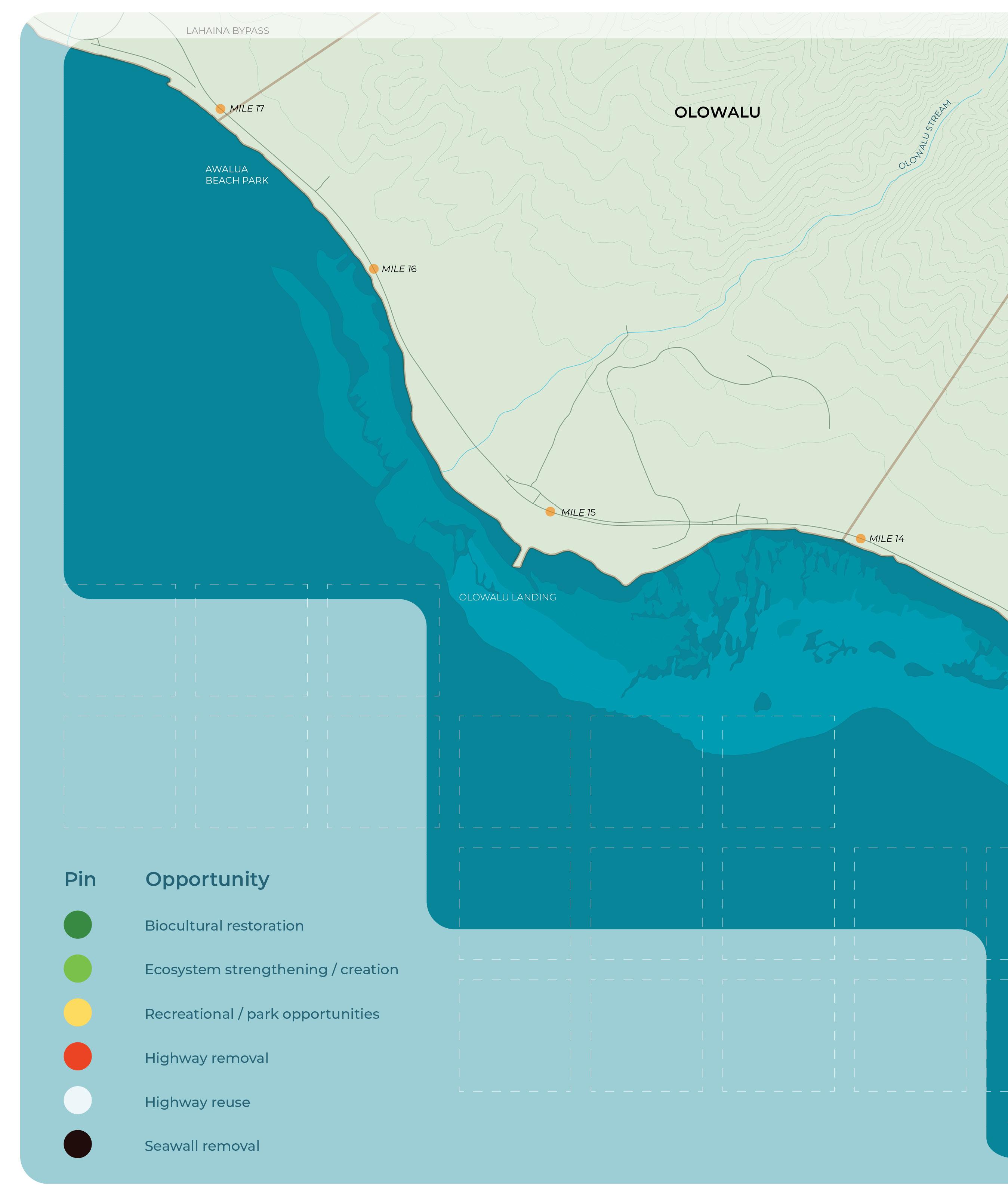
Combined Pins Placed Per Category
Ecosystem Strengthening / Creation
Biocultural Restoration
Recreational / Park Opportunities
Highway Removal
Seawall Removal
Highway Reuse
Synthesis of In-Person and Virtual Event Results
Written responses from the Resilient Future: Coastal Interventions activity reveal a strong emphasis on ecological restoration, expanding parks and open spaces for recreation, and removing the existing highway. Participants frequently highlighted opportunities to enhance coastal resilience and public access. The five most commonly used words were: highway (12), remove (8), park (7), Ukumehame (6), and beach (6), reflecting key priorities in re-imagining the coastal area.
• Native forest and wetland restoration
• Shoreline restoration (dunes, salt marshes, living shorelines)
• Habitat protection for wildlife (waterbirds, seabirds, nene)
• Vegetation and tree planting (e.g., Milo trees, native plants)
• Restoration of critical habitats (e.g., Oʻopu, shrimping, seabird colonies)
• Sea level rise adaptation and shoreline protection
• Coastal erosion and sediment management
• Ecosystem management to support biodiversity and natural balance
• Protection of wildlife from threats (e.g., alien species, habitat destruction)
• Long-term planning for roads and access impacted by sea level rise
• Coastal infrastructure adaptations to prevent environmental impact (e.g., removing seawalls)
• Sustainable infrastructure development (e.g., highway removal, raised highways, greenways)
• Conversion of old highway sections into bike and walking paths
• Traffic management and mobility (e.g., parking, bike paths, pedestrian access)
• Incorporation of Hawaiian stewardship and cultural practices in planning
• Development of culturally informative parks and educational spaces
• Promotion of traditional practices (e.g., fishing, gathering, and coastal activities)
• Educational programs and cultural interpretative signage
• Preservation of coastal areas for traditional practices and gathering
• Homelessness management and prevention of illegal dumping
• Waste management (e.g., removal of junk cars, pollution mitigation)
• Pollution control and enforcement at key locations (e.g., mile marker 13)
• Management of tourism (limits, parking fees, and resident access)
• Green spaces for community activities and environmental restoration projects
• Creation and improvement of parks, camping areas, and public spaces
• Safe, clean beaches and open spaces for families and the public
• Public access to beaches, parks, and recreational areas
• Development of public spaces for gathering, fishing, and cultural activities
• Development of facilities for recreation (e.g., tables, bathrooms, shaded areas)
In-Person and Virtual Engagement Event Results (2/6/25, 2/11/25, 2/13/25)
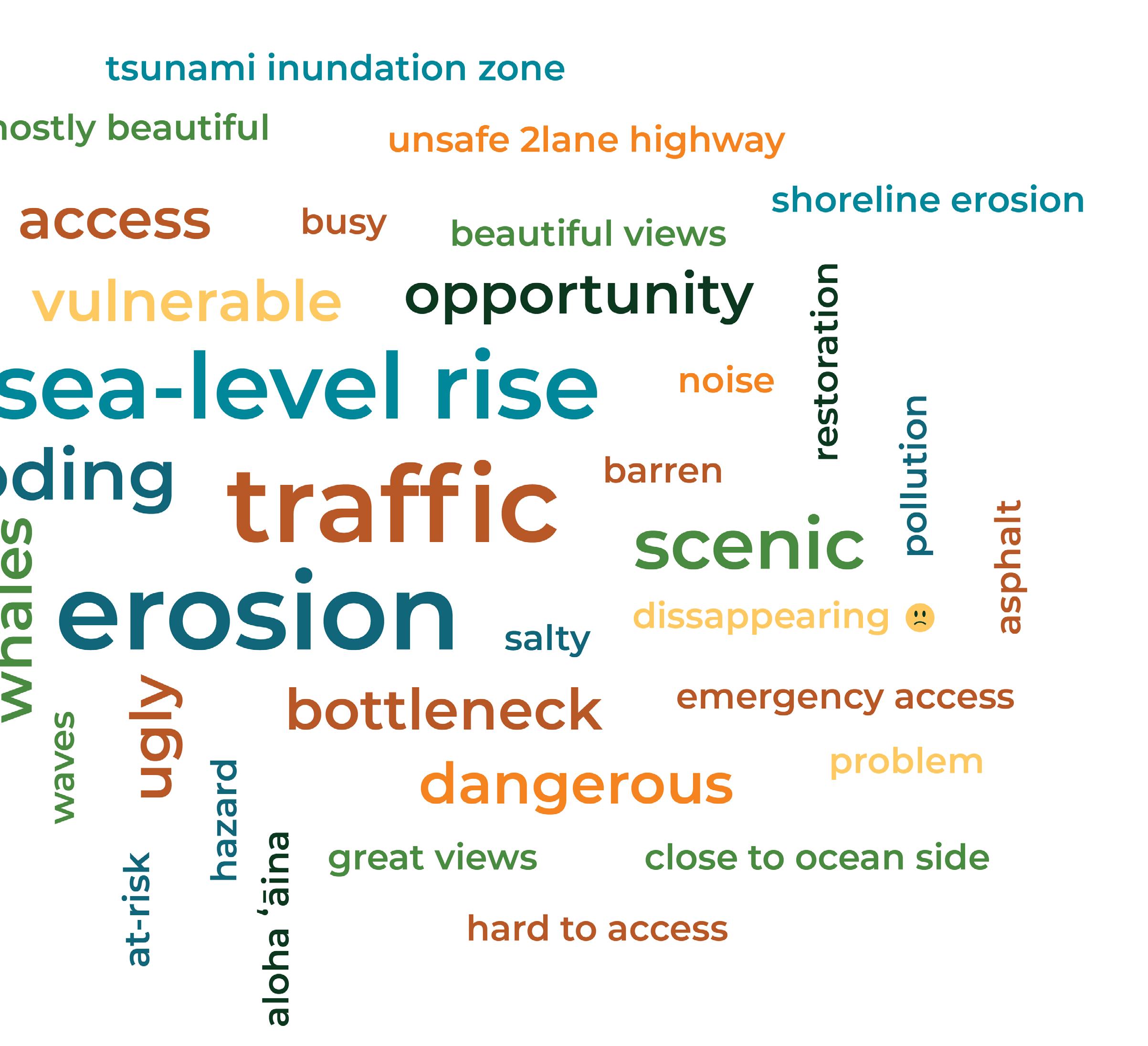
After today’s meeting, what word comes to mind when you think about the future of the coastal area?
At the end of the in-person engagement event, participants were invited to respond to an exit question displayed on a whiteboard: “After today’s meeting, what word comes to mind when you think about the future of the coastal area?” This final exercise encouraged reflection on the discussions and ideas shared throughout the event.
As with the entry question, participants wrote their responses directly on the whiteboard. During the two virtual events, participants answered the same question through Mentimeter, a digital engagement tool that allowed them to submit responses in real time.
The resulting word cloud visually summarizes the collective sentiment from both in-person and virtual participants. In the graphic, larger words indicate more frequent mentions, illustrating key themes. The responses revealed a shared vision for resilience, sustainability, and the opportunity that the relocation of the Honoapiʻilani Highway brings.
Top responses from participants were:
• Resilience (6)
• Hope (3)
• Wetlands (3)
• Living shorelines (2)
• Malama (2)
• Opportunity (2)
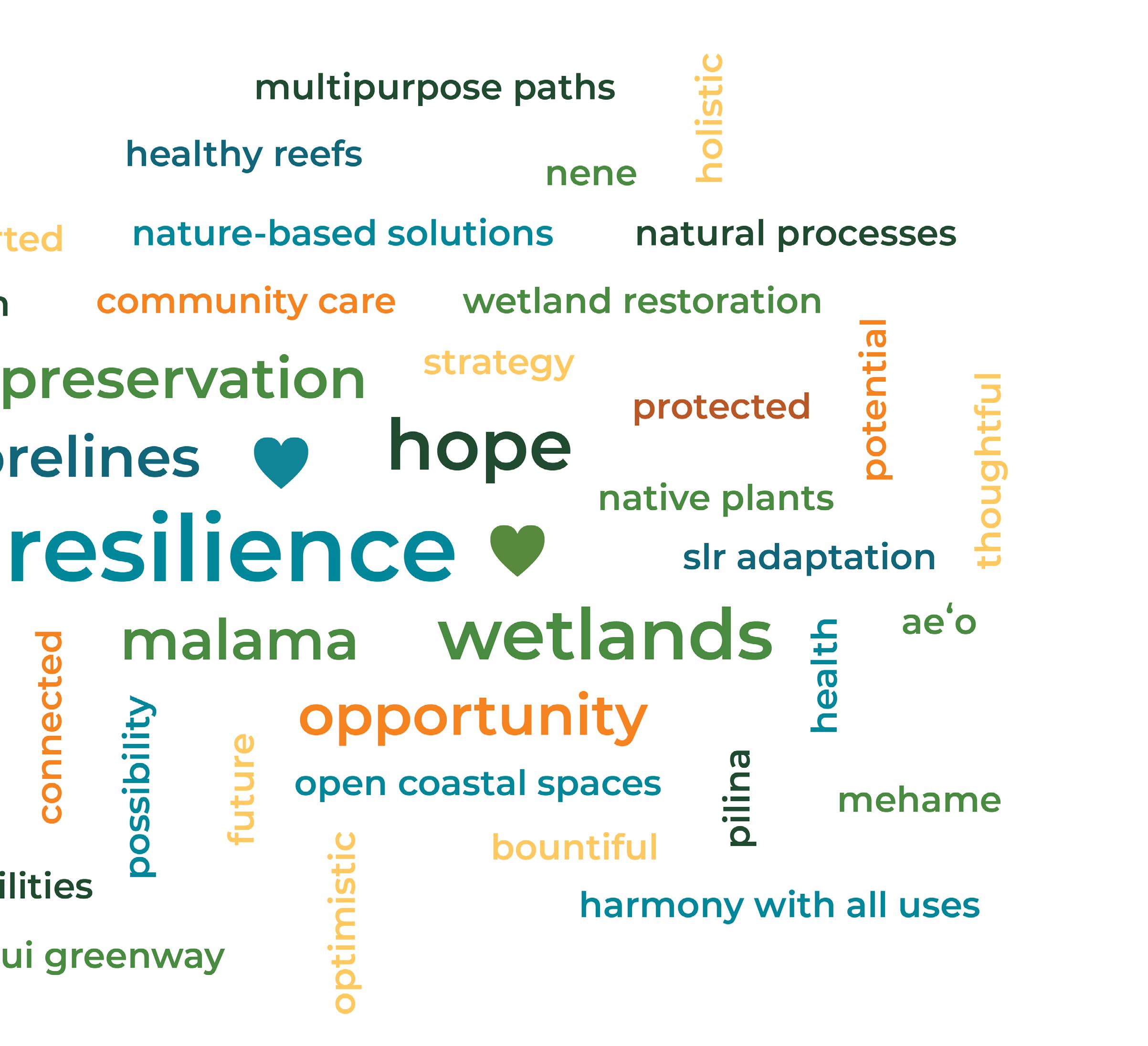
Categories
Blue/green: Nature-Based Solutions, Traditional Ecological Knowledge, restoration
Orange/yellow: General action words, retreat, etc.