LIVING ON THE WATER
A RESILIENCY TOOLKIT FOR STILT-HOUSE VILLAGES OF LAKE MARACAIBO
BY DANIEL ABRAHAMCHAIR: MARTHA KOHEN CO-CHAIR: JEFFREY CARNEY


A PROJECT IN LIEU OF THESIS PRESENTED TO THE COLLEGE OF DESIGN, CONSTRUCTION AND PLANNING OF THE UNIVERSITY OF FLORIDA IN PARTIAL FULFILLMENT OF THE REQUIREMENTS FOR THE DEGREE OF MASTER OF ARCHITECTURE SPRING 2022
UNIVERSITY OF FLORIDA
I would like to acknowledge and give my warmest thanks to my committee members, Professors Martha Kohen and Jeffrey Carney, who guided me throughout the process, and felt the excitement of the topic alongside me. Their input, comments, and suggestions were paramount to this body of work.
matches. Finally, I would like to thank my motherland, Zulia, and its people, for teaching me indelible lessons, worth sharing with the world in bodies of work like this one, and for giving me a part of my identity that I am extremely proud of. May you be raised on palms and golden laurels.
I would like to acknowledge my parents, Daniel Abraham and Noralis Gandica, who have always lovingly supported me on my dreams of becoming an architect ever since I was a child, nurturing and encouraging them throughout the years. Any words of mine would fall short to express the level of gratitude and love that I have towards them.
I would like to acknowledge my friends and colleagues in the architecture program, who gave insight and showed interest and support on the process, specially to two of my best friends and roommates, Anthony Maldonado, and Ezra Rossi, who shared alongside me the complete process of going through the masters research project; the amount brotherhood and solidarity that we displayed towards each other is something that I am proud of and that I treasure deeply. I would like to acknowledge a special someone, Hana Čičević, for the joy that she brought to this process of mine, alongside an immense amount of smiles and chess
1.1. LIVING ON THE WATER
LAKE MARACAIBO, STAGE OF A LIFESTYLE
2.1. CASE STUDY: DAVID GOUVERNEUR’S PLANNING
DESIGN FOR
INFORMAL SETTLEMENTS: SHAPING THE SELF-CONSTRUCTED CITY
CASE STUDY: NAS’ PRESERVING OUR PLACE
CASE STUDY: NLÉ ARCHITECTS’ LAGOS WATER COMMUNITY
2.4. CASE STUDY: PLAN:B ARQUITECTOS’ EMBERA ATRATO MEDIO
3.1 TROUBLED WATERS
CONCLUSIONS
ANALYSIS
HISTORICAL
4.1.2. MID XIX CENTURY
4.1.3. MID TO LATE XIX CENTURY
4.1.4. LATE XIX CENTURY TO EARLY XX CENTURY
4.1.5. EARLY XX CENTURY TO PRESENT DAYS (AÑU TRADITION)
4.1.6. EARLY XX CENTURY TO PRESENT DAYS (CRIOLE)
4.2. DOCUMENTING THE ARCHITECTURE
4.2.1. GENERAL DIMESIONS AND MATERIALS
4.2.2. SPATIAL DIVISIONS AND PROGRAMS
4.2.3. CLIMATIC STRATEGIES
4.3. CASE STUDIES
4.3.1. CASE STUDY: CEUTA DE AGUA
4.3.2. CASE STUDY: SAN TIMOTEO DE AGUA
4.3.3. CASE STUDY: TOMOPORO DE AGUA
4.3.4. CASE STUDY: CONGO MIRADOR
4.3.5. CASE SUTDY: SANTA ROSA DE AGUA
4.3.6. CASE STUDY: SAN RAFAEL DE EL MOJAN
4.3.7. CASE STUDY: SINAMAICA
4.4. THE PLAZA
4.4.1. SINAMAICA DE AGUA’S PLAZA
4.4.2. CEUTA DE AGUA’S PLAZA
5.1. DESIGN INTENT
5.1.1.
5.1.2.
SELECTION
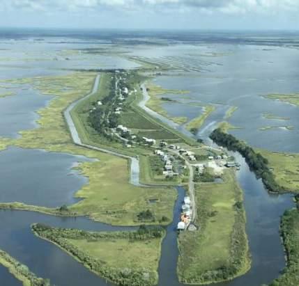
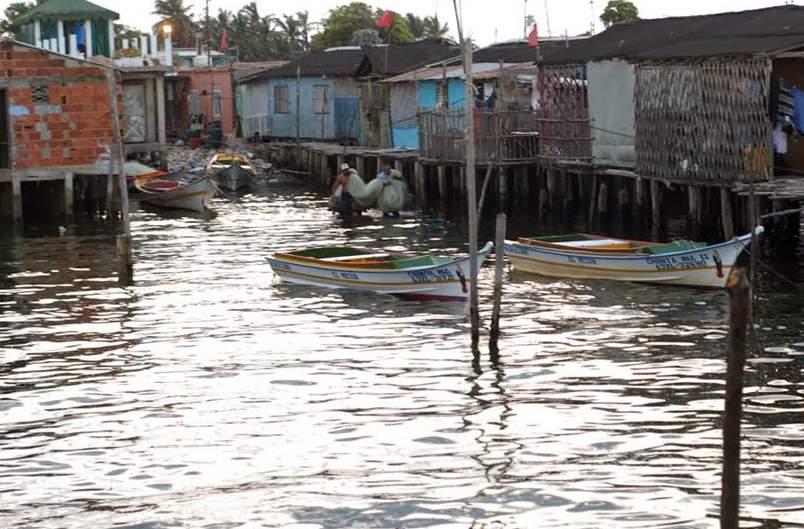
The waters of Lake Maracaibo have been inhabited by the Añu people’s stilt house-settlements uninterruptedly for centuries. The particular sight that these settlements create gave the region it’s name, Venezuela, meaning ”Little Venice.” In these water settlements, kids learn how to swim before they learn how to walk. Boats replace cars and buses as the method of transportation. Fishing and agriculture are the family trade, the young learning from their elders. Goods are ferried from the land based cities, specially from Maracaibo, the regional capital. Water is almost a character itself, with which they have a communion, and a deep sentiment of respect. For the Añu, water represents the totality of all the things created. Water surges become a sign of change, either of climate or in people’s life. It’s a symbol of life as well a one of disaster and chaos, thus, water becomes supreme, bringer of life and death.
it’s ability to adapt to different landscapes that combine water and land features, the design intention is to create a model community up the rivers that feed the Lake, since the water is cleaner and the challenges of the troubled waters can be diminished to an extent, able to house migrants from the current water settlements.
In the following research project it will be explored how can the water settlement evolve, with adaptive measures to the 21st century, being able to be sustainable and give resiliency to the communities which incur in their use. The study focuses on the vernacular architecture, which is the stilt house, it’s design, it’s evolution, it’s capacity to evolve with new materials and programmatic spaces, and
In order to allow the migration of these communities, a prototype village model will be designed, taking into consideration the local needs and culture need to be put in the forefront of the strategy, which as of now revolve around the lack of infrastructure. In order to create a coherent and cohesive urban fabric and community dynamics, what was learned from the seven case studies, which are the still standing water settlements, will be taken heavily as reference, in order to develop a fabric which allows for the natural expansion of the family dwelling, the connectivity between houses, and the circulation of boats.
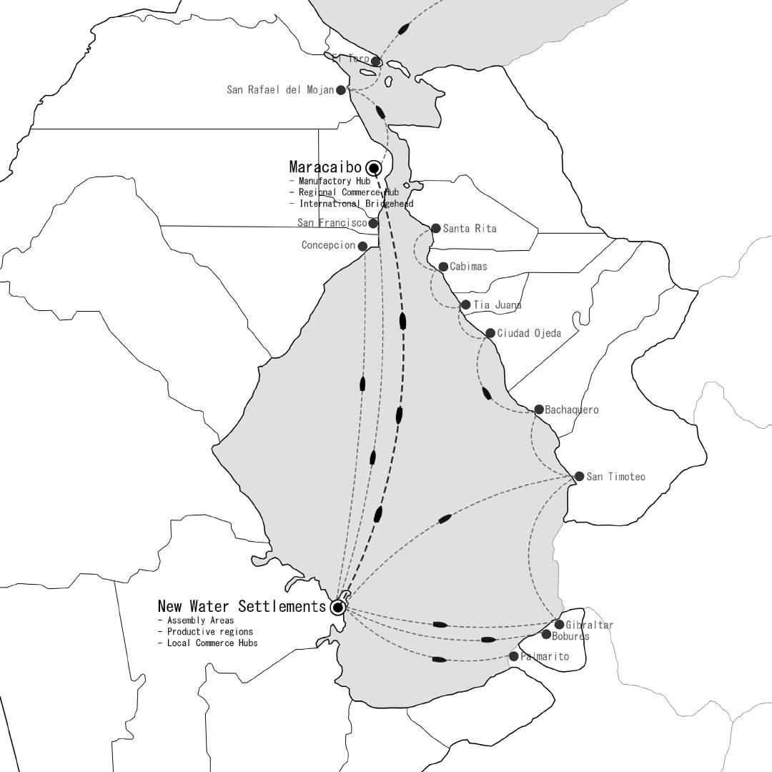
A network of new riverine water settlements that can be developed from the prototype village model, in which each settlement can become productive hubs for agriculture, pisciculture, and local commerce is one of the aims of the proposal. In order to do achieve said goal, the proposed infrastructure includes a cultural and commercial plaza, capable of linking the residential and productive parts of said communities.
The idea is to preserve this way of living as much as possible, in tune with nature, and in tune with the waters of a landscape that has always captured the hearts of those that are live near them. This culture can endure, being a model for the world in how to deal and live along water, which are concepts that these days are more relevant than ever, with the threat of climate change and sea level rise looming in a not so distant future.
Figure 1: New Water Settlements and their possible relationships with other cities in Lake Maracaibo
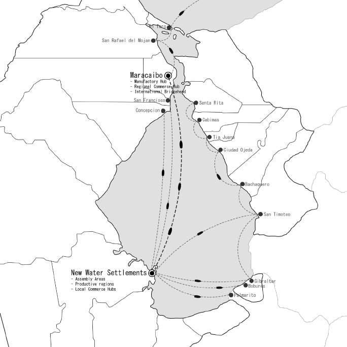
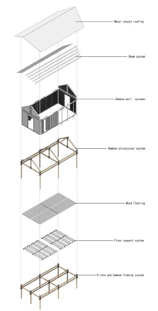
Figure 2: System of construction developed for a new stitlhouse model
In August 1499, the expedition of Spanish explorer Alonso de Ojeda, cartographer Juan de la Cosa, and Italian Merchantman and Explorer Amerigo Vespucci discovered Lake Maracaibo to the eyes of the Old World, along with villages of stilt houses sitting on its waters. Vespucci describes that they found “edifications on the sea like the ones in Venice, [built] with a lot of skill”. This comparison with Venice originated a diminutive term, Venicuela, to designate the gulf that gave entrance to Lake Maracaibo, or “Lake Coquivacoa” as it was known to some indigenous tribes, which appears in the first map traced and published by Juan de la Cosa in 1500. (Gasparini, 2005). The name was hispanized into Venezuela, which was adopted as the official name of the region, and the subsequent country which encompasses Lake Maracaibo, the Gulf of Venezuela, and adjacent territories.
This phenomenon of humans living on the water is not an isolated case. On the contrary, it is an architectural solution that can be observed in many places around the globe throughout the centuries in many cultures. Just like Venice, the settlements of Lake Maracaibo were built on water in order to protect their inhabitants, the Añu, from their invading Caribbean neighborhoods.
The builders of such villages were the Añu, an indigenous people belonging to the Arawak linguistic family, that have inhabited the Lake uninterruptedly for centuries. The denomination paraujano is also used to identify them. This term comes from the also members of the Arawak linguistic family, neighboring Wayuus’ words pararu, which means coast of the sea, and añu, which means people, creating a term to distinguish themselves from the “people of the coast”. (Gasparini et al, 2005)
Besides providing a defense against attackers, historically, living on the water provided conditions that where favorable for the dwellers. Besides providing a source of potable water, given that the Añus inhabited the shores of a lake, it gave them easy access to fishing, which is their main economic activity and source of their diet. It also provided a solution to climatic conditions characterized by temperatures of 35 °C (95 °F), being cool thanks to the evaporation of water and the breezes of the Lake. The water dwellers also developed throughout the centuries mechanisms to practice agriculture on the water, with their crops being fed by the surrounding liquid. The transportation of people and goods also revolves around water, with boats being the main method of transport, allowing them to cover large distances in a very fast pace. Additionally, the construction materials used by the indigenous tribes grew on the water as well, in the form of different species of mangroves, making it convenient to live in the water, close to them.
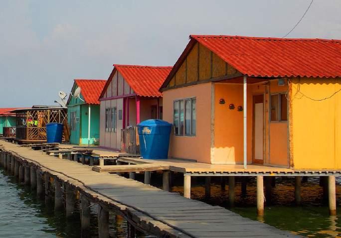
In the region of Zulia, where Lake Maracaibo is located, the creole population recognized the benefits of the lifestyle of the Añu ethnicity, prompting the creation and expansion of new urban settlements of varying scales on and towards the Lake’s water, specially in the 20th century, during the golden age of the Oil Industry, where many platform workers would adopt the stilt houses as their dwellings.
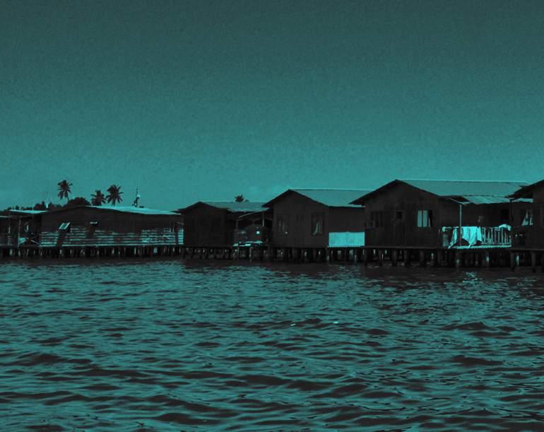
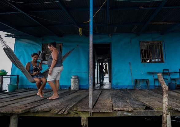
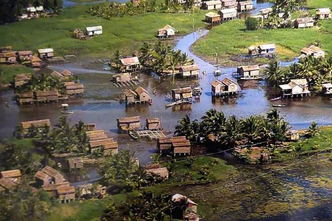
on the shores of the Lake, the stilt house is an iconic, yet exotic picture. An object that all recognize even by silhouette, yet most have never seen in person, despite their geographical closeness. A fragment of the past that still lingers, a living proof of generations of tradition and adaptation to a landscape that changes more than people
seem to realize.
In these water settlements, kids learn how to swim before they learn how to walk. . Boats replace cars and buses as the method of transportation. Fishing and agriculture are the family trade, the young learning from their elders. Goods are ferried from the land based cities, specially from Maracaibo, the regional capital. Water is almost a character itself, with which they have a communion, and a deep sentiment of respect. For the Añu, water represents the totality of all the things created. Water surges become a sign of change, either of climate or in people’s life. It’s a symbol of life as well a one of disaster and chaos, thus, water becomes supreme, bringer of life and death.
Being myself from the same shores, growing up with this image of what living on water looks like, and how this vernacular architecture is part of my cultural heritage, my interests as an architect cannot help but to shift towards imagining what challenges and changes the typology will face as we move forward into the 21st century, in times characterized by climate change and post-industrialization.
With several settlements still standing after centuries of uninterrupted habitation, with five of them being well recorded, the stilt house is an image that is imprinted in the consciousness of the average Zulian, and a source of pride for the Marabinian identity. For those who grow
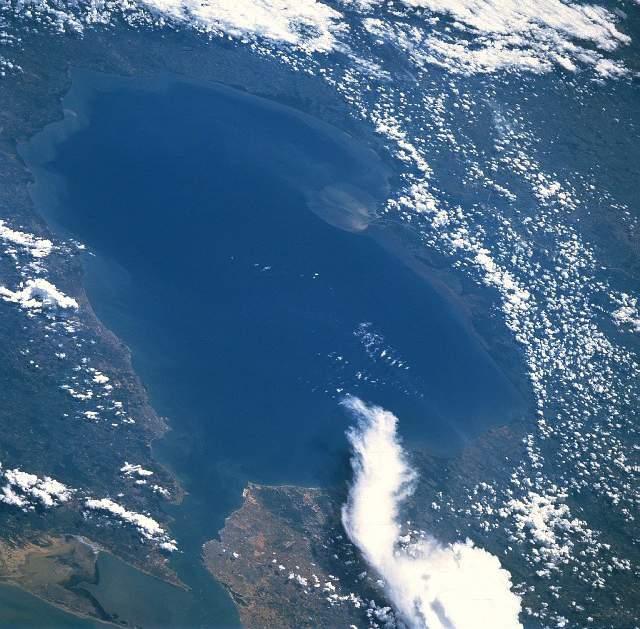
Lake Maracaibo, in Spanish Lago de Maracaibo, actually a tidal bay, serves as the setting where all the water settlements of the Añu people were established. It is an inlet in the Caribbean Sea, lying in the Maracaibo Basin, Zulia State, of Northwestern Venezuela.
deformation created by the collision of the Caribbean Plate with the South America in the Cenozoic Era, which formed a belt of fore-land basins across northern South America. (Mann et al., 1970) Some of its tectonic history dates back to the Jurassic Era, making it one of the oldest Lakes in the world.
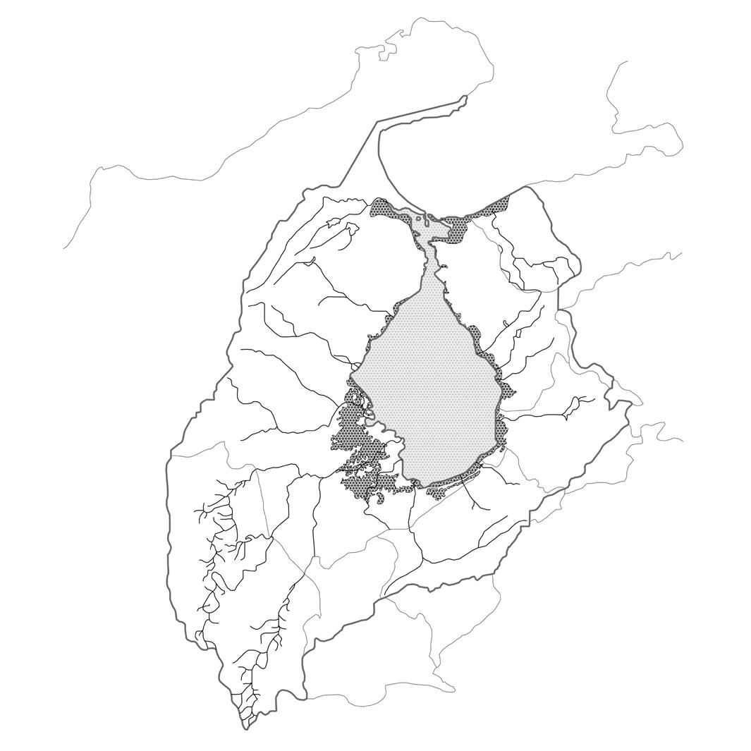
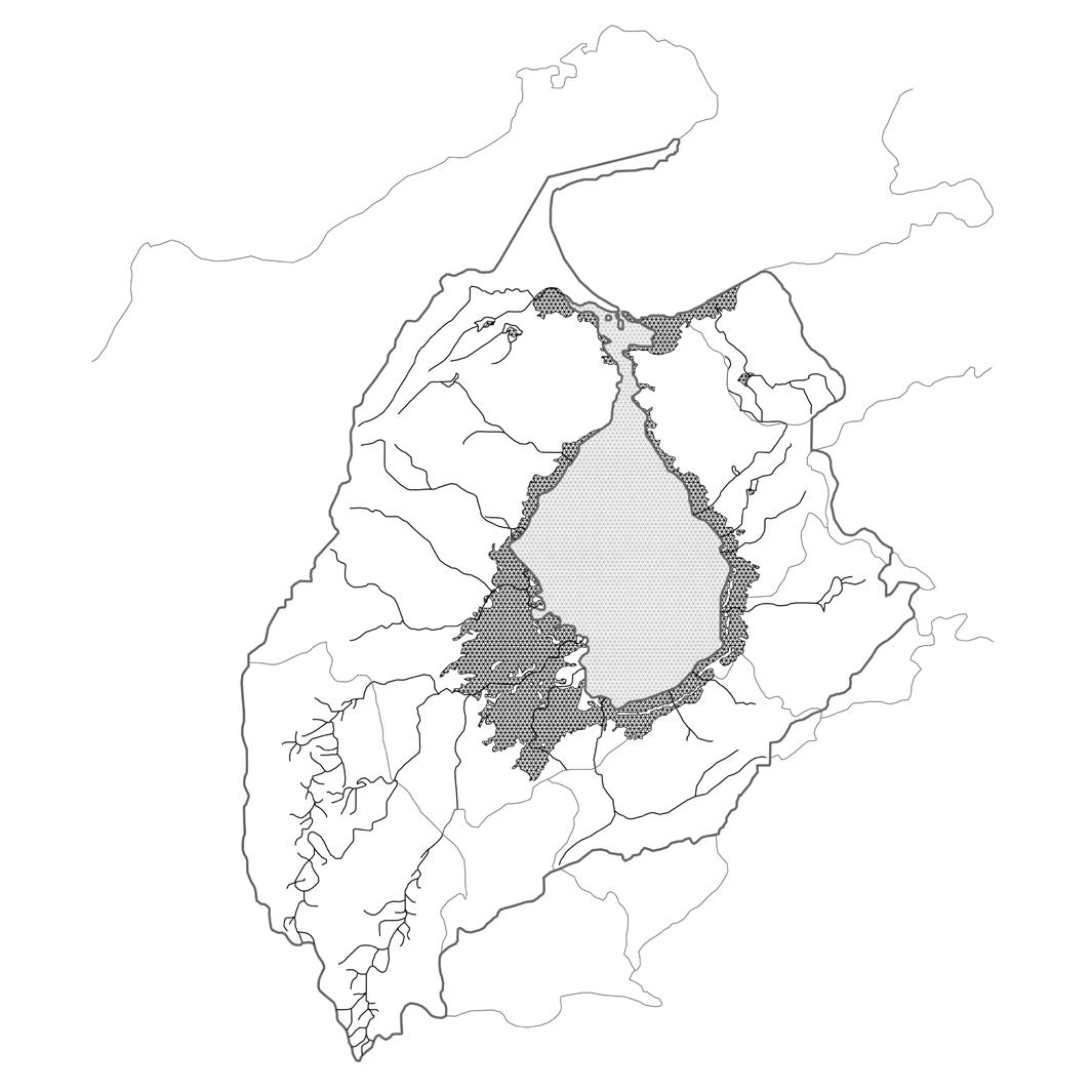
Considered to be the largest Lake in South America, it extends 130 miles (210 km) southwards from the Gulf of Venezuela and varying in width between 75 miles (121 km) in its widest point and 6 miles (10 km) in its narrowest and covering a total area of 5,130 square miles (13,280 square km). (Britannica, 2020) Much of the water that it receives comes from the Atlantic Ocean, making the northern waters brackish, while the southern ones are fresh, coming from at least 135 affluent rivers at the south, west, and east, being the Catatumbo River the most important one. It is flask-shaped, narrowing rapidly in the vicinity of Concepcion and Punta Cabimas, and empties through a long, shallow, narrow channel into the Gulf of Venezuela at San Carlos. (Liddle, 1946)
The Lake Maracaibo Basin is surrounded by two big mountain ranges. The Cordillera de Merida to the southeast, which is an extension of the Andes Mountains, and the Sierra de Perija to the west. The basin lies in a region of
The state of Zulia, comprising the territory of the former Spanish province of Maracaibo had always leaned towards autonomy. It did not join the Republic of Venezuela in 1811, preferring to stay loyal to the Spanish crown, being captured by Venezuelan patriots in 1823, when it joined the now independent Venezuela. This situation created an antecedent for the region’s isolation, and the development of sense of autonomy. The very nature of Maracaibo and its vassal cities’ geographical condition was both a challenge and an advantage. Transportation was only possible through ferry towards the eastern shores, and thus, the rest of the country. Vehicles and manufactured goods all had to cross via maritime transport in order reach the rest of the world. This made for a population that was known for its independent thought and character. Matrimonial alliances proved to be a way of acquiring political and economical power, which contributed to the creolization of many of the indigenous families, specially in the settlements close to Maracaibo. And the ones in the eastern shores of the Lake. Pro-independent sentiments, and rivalries with the capital due to Caracas’ centralist policies also contributed to furthering the isolation of a region that heavily depended on commercializing goods coming from the Andean regions, and the products of the plantations around the Lake.
Figure 8: Maracaibo Province, 1840. Note the presence of water settlements like Sinamaica, Tomoporo, Misoa (now San Timoteo), and Congo Mirador.
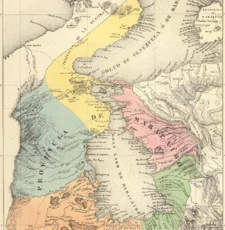
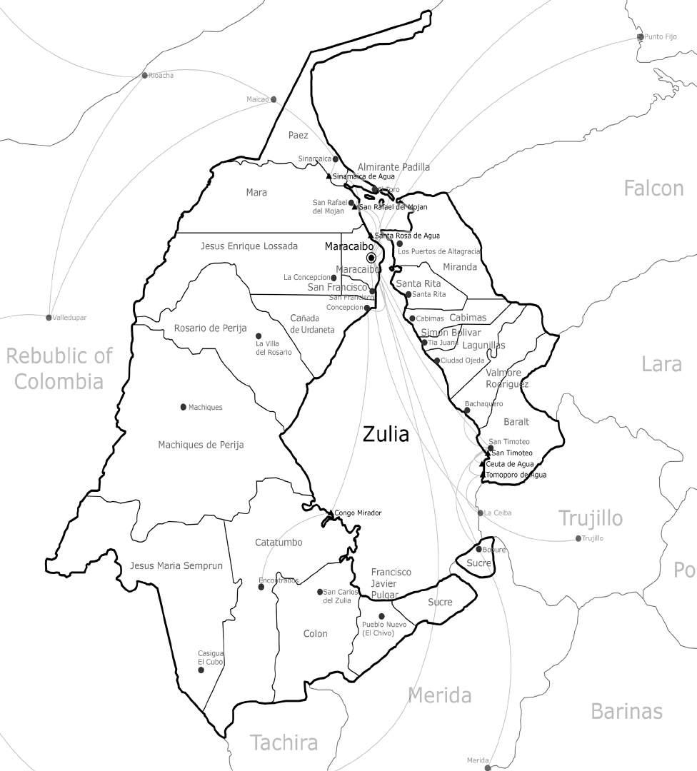
Figure 9: State of Zulia’s political subdivisions and economic relationships
David Governeur’s 2014 book discusses in great length the concept and the reality of the informal city. The informal city is self-built, self-managed, with qualities listed by Governeur himself, noting that it ”evolved with great dynamism, presenting strong social ties, encompassing informal economies, and producing compelling organic forms.” He argues that architects and urban planners should look at the these type of settlements when it comes to thinking of a developing world and its fast-growing urban centers.
are generated spontaneously in the informal settlements, concentrating in only working on those aspects that informality cannot solve itself. Generally speaking, the aspects that need to be addressed are: access to drinking water, foods at accessible prices, and adequate sanitary conditions; additionally, the facilitation of connectivity and efficient mobility; the existence of basic services, public spaces, infrastructure, and communities equipped with health, education and recreation facilities.
He also notes the great challenges that the informal city faces, ”limited accessibility and mobility, endure unsanitary conditions, and lack public space and services, resulting in urban areas that are incomplete and submissive to the formal city.” These are all infrastructure related issues, and informality itself cannot solve those problems alone. Prejudice is also mentioned as an obstacle in the way to solve the aforementioned obstacles, since the informal city is looked down as a problem to be solved, instead of a condition to be embraced.
As a solution, Governeur proposes the Informal Supports (I.S.), which aim to take advantage of the conditions that
The success of these Informal Supports strategies requires the integration of the private sector, which can participate and aid in all phases od the initiative; the improvement and refinement of the public institutions that regulate and supervise the development of the informal city; and new perspectives when it comes to planners and designers’ way of approaching informality.
Taking into account that a great deal of Governeur’s studies where conducted in Venezuela, his infrastructureoriented approach is deemed extremely relevant to the informal water settlements.
Figure 10: Masterplan sketched by Governeur showing spaces to be abilited for community use (green)
Figure 11: Ecology of relationships, natural and social, generated in the informal city
possible exploitation by the partners.
NAS’ team publicized in 2019 a field guide to take communities through engagement, resilience, resettlement, and regeneration, in the face of environmental and developmental pressures. Their work focused on the tribes of the Isle de Jean Charles, Louissiana, but is intended to be applicable to any community facing the aforementioned challenges.
The document mentions tribal-led planning processes, showing an intent of creating a system than can adapt to native populations, where councils with tribe leaders can provide input alongside experts, in order to achieve that vision in tune with the whole community’s plans for the future.
The guide states as one of its objectives the preservation of life-ways, and deems it as important as the ability to provide infrastructure. In order to do so, this strategy proposes to navigate the community needs, and keeping those needs at the forefront of the planning process.
It is clearly stated several times that this guide is not ”a prescriptive template because specifics contexts, including history, geography, environment, and politics matter deeply and vary greatly across communities.” Instead, it is a resource guide for community empowerment and informed decision-making in community-led adaptation.
It is established that the designer needs to have a vision, which should be in tune with the communities goals for the future. The community’s values and characteristics must be clear to the designer. Sitting down and actually talking about those future needs, hopes, and dreams is signaled as one of the best tools in the process.
The consideration and preservation of life-ways, communities’ needs, and the vocalization of the stakeholders opinions are factors that are deeply related in the aim and scope, specially since we are dealing with a community that is native in its origin, and with a very defined lifestyle and culture
Partners are recognized as a necessary element in the success of any innitative. Nevertheless, it is also recognized that clarity, honesty, and an stablished declaration of principles is needed, in order to avoid
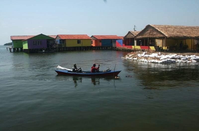
The Lagos Water Community Project is a proposal developed by NLÉ Architects, led by its founder, Nigerian architect Kunlé Adeyemi, as an effort to address the challenges that climate change and rapid urbanization pose to vulnerable water communities, such as the Makoko coastal community, located in the city of Lagos, Nigeria, Africa’s biggest city, with a population that the UN estimated in 21 million inhabitants. (Campbell, 2012) Conceived and developed in 2012 after construction had begun for the firm’s prototype of a floating school designed for the same community, hoping to develop different typologies such as homes, community centers, and playgrounds that would join the Makoko’s Floating School, “to gradually cultivate a new type of architecture and urbanism on water.” (NLÉ, 2012) The scope of the project demanded that the architects not only had to understand the vernacular architecture, but also the demographics, socioeconomic, and environmental risks, as well as local government policies and interests. In that regards, the firm stated that “Makoko is an innovative, economical, and contemporary model for coastal African cities.”
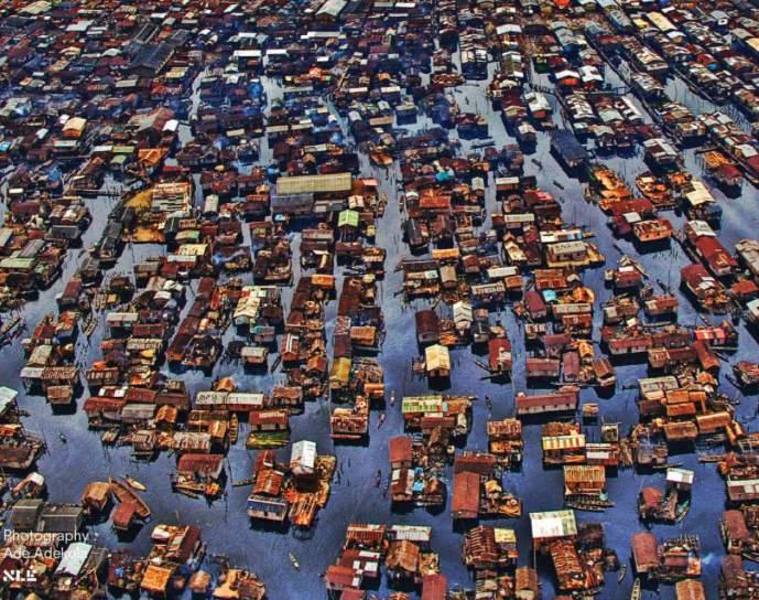
Figure 16 (Top Right): NLÉ’s vision of the community once the prototype is produced en masse
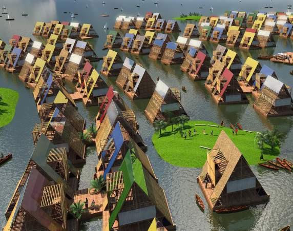
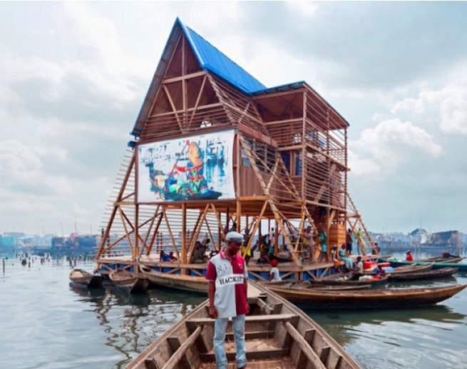
Figure 17 (Bottom Right): Structural Section, showing the different enviromentally friendly systems at work in the
Built in a fashion that supposedly was generated by the vernacular way of construction, the first prototype collapsed in a heavy rainstorm that all vernacular buildings easily could withstand. The causes of the failure of this project are numerous. In terms of the architecture, it failed to recognize a height limit of one story, that all the buildings in the surrounding context expressed. It also required heavy maintenance, despite its seemingly locally supplied materials. Timbers needed to be replaced, plastic barrels to keep it afloat, and metal chains to keep it anchored. The initial fundings of these constant resupplies came from NGOs, showing that the project was unsustainable for the resources available to the Makoko community. There was a lack of coordination between the stakeholders, the firm, and governmental organizations, which traduced in a lot of mismanagement and lack of responsibility once it finally collapsed.
determine the ultimate destiny of this project, considering that the firm has developed more prototypes that aimed to address the issues of the failed first one, but its legacy already includes a conversation generated by it, concerning the possibilities of water-based communities, and the importance of developing socioeconomic platforms and strategies between communities and public entities, along with environmental and infrastructural ones, when it comes to resiliency architecture.
This project, and its analysis, awakes questions that involve the whole architectural community and resiliency efforts. What is the legacy of experimenting with the poor? Whom really benefits in the trials and errors carried out in marginalized communities? Gaestell remarks that “there is a persistent risk of doing harm, dashing hopes, and eroding trust with trial and error, no matter how virtuous the objectives. It is the duty of the powerful to minimize that risk as much as possible.” The future is yet to
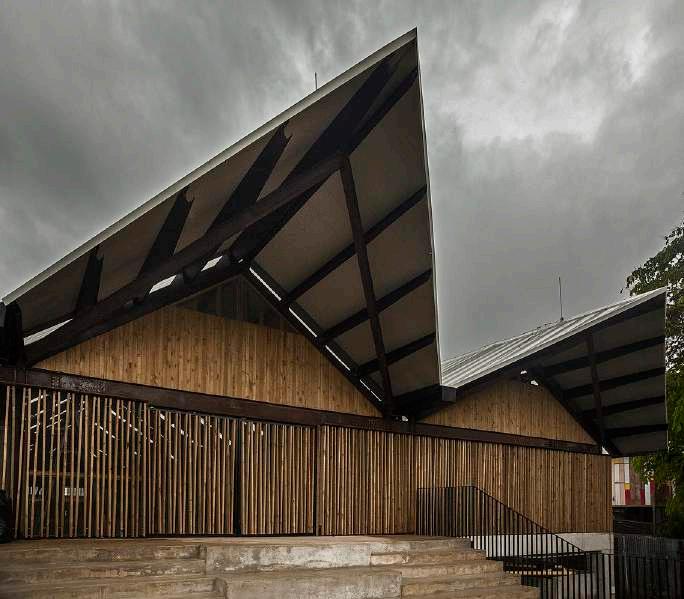
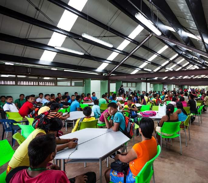
This project was aimed to be an effort to provide infrastructure to indigenous communities. The concept consist in a school that can be used by the members of the community by short and constant periods of time, in which they sleep, eat and live from high school programs, allowing them to not have to live their tribes permanently.
big urban area where shipped, trying to minimize the costs due to budget restrictions. The understanding of the surrounding available resources, and the minimization of the carbon footprint involved in the construction of the school demonstrates how deeply into consideration where the principles of sustainability.
A interesting feature is the flexible character of the architecture, when it is not being used as an educational institution, it serves as a flexible street that can be used cross from one side of the town to another, with offices, and services flanking it. This makes it a urban element capable of strengthening the character of the community, giving it a place of gathering, learning, and growing.
Overall, this project is one where respect was shown towards indigenous populations and their needs, and the environments that they inhabit. There is a clear comprehension of the existing urban fabric, and it is embraced by the project, facilitating transportation through the town’s grid, enhancing connexions between its inhabitants.
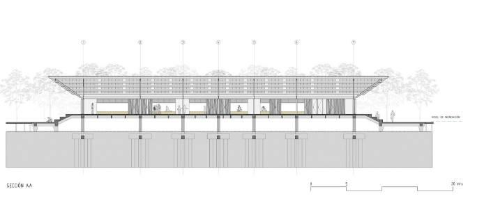
The conditions of the surrounding context are similar to those of many water settlements. Floodings are usual, giving that it is located in the rain forest of Colombia, so a stilted slab was chosen as the optimal structural solution. The materials below the flood level are waterproof, as well as the steel metal structure that is able to resist the humid environment. The use of local woods where avoided due to them being all endangered species, so pine wood grown close to Medellin, the closest
Figure 19: Section of the school, with flood line signaled
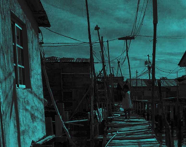
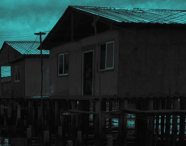
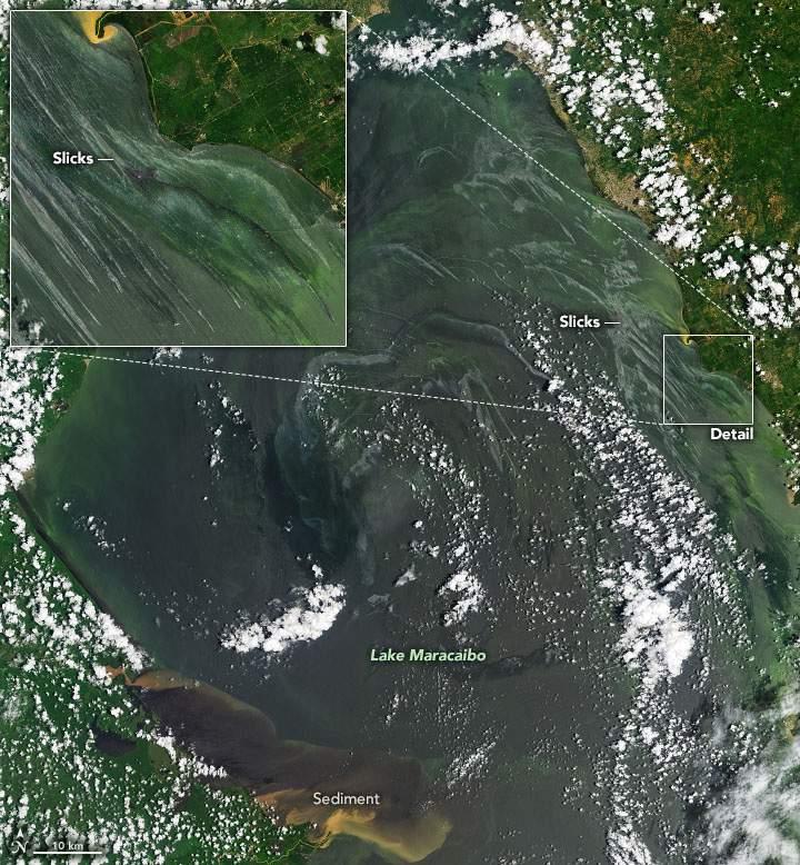
Lake Maracaibo has been “a source of great abundance— particularly fossil fuels and fish—for the people of Venezuela. Now Lake Maracaibo is mostly abundant with pollution from leaking oil and excess nutrients.” (Carlowicz, 2021) Thousands of oil wells have been drilled on the Lake, fist by the foreign companies from 1914 until 1976, and then by the national oil company, PDVSA, until present days. That represents almost a century of pollution, product of the frequent leaks and dumped ballast and waste by the massive ships that transport the crude out. In the last decade, the national oil industry has experienced decay, product of mismanagement, corruption, and lack of investment. “Venezuela’s oil production stood at 3.2 million barrels a day 10 years ago, it’s now down to less than one million.” said an article by Guillaume Decamme in 2019. The decay has been catastrophic for the Lake’s environment. Environmental groups, and human rights activists reported that as many as 40,000 to 50,000 oil leaks and spills occurred in the last decade, with many more being able to occur due to many aging pipelines being unmaintained.

Locals’ boats and nets finish the day drenched in petroleum. The black tides poison the waters, and the shrimps and crabs that the local people fish become poisoned as well, becoming a hazard for the consumers.
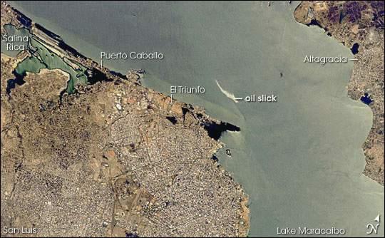
Figure 25: Photo taken by NASA on September, 2021, showing oil slicks in the Lake’s water that are visible from space
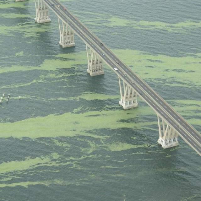
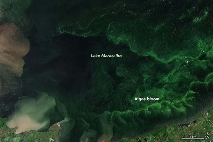
Large concentrations of Blooming algae are also current problem for the Lake and its inhabitants. Lemna obscura, commonly known as duckweed, it’s a non-toxic algae species that naturally blooms in the Lake ecosystem. Growing up in Maracaibo in the early 2000s, I was witness of the vast blooms that would cover the surface of the waters, rendering them to a grassy-green color. They would clog ships’ engines and suffocate marine species. 2004 was a year of great blooming, thanks to the nutrients coming from nearby farmlands as waste. To these days, the water is still nutrient-rich, prompting the massive blooming of this year, 2021, that NASA’s astronauts were able to spot and capture even from space. NASA deemed the widespread greenery “another sign of distress.” (Carlowicz, 2021)
The waters near the mouth of the Lake have also become more estuarine, as a result of the dredging of the strait that was significantly expanded between the decades of the 1930s-1950s to allow the traffic of bigger ships. The salinization of the waters threatens the mangroves which provide the Añu’s the materials for their traditional construction method, as well as the fishes that they consume.
The environmental negligence of the Venezuelan government has prompted some to say that “[the administration] should be tried for ecocide” considering that “Caracas’ environmental record is a nightmare” (Berg et al. 2021)
All these problems paint a very clear picture, the Lake has become sick. A continuous way of life spanning more than five centuries, that of life in communion with water, is being threatened with extinction. Sicknesses are boiling, economic conditions are unstable and uncertain. Thousands of people, marginalized, forgotten by a post-industrial society that has not considered their way of living as nothing more than a picturesque image of the past, a character on the fairytale of the genesis of the country’s name, a tourist attraction not worth saving.
Informality is another characteristic of these settlements. The dwellings are made by the owners and local community members. As it is common in informal settlements, the access to basic infrastructure is another challenge that the communities face. Can the changes introduced to the local architecture include infrastructure accessibility?
This is a lifestyle that has, so far, stood the test of time. It is a powerful resilient way of life, that encompass economic sustainability and living sustainability. However, right now, it is in jeopardy. How can a way of living that relays heavily on waters can survive when those same waters become sick? What I would like to pursue is the preservation of this lifestyle, dependent of both water and land, that possesses a very unique and defined architecture, with a heavy cultural importance for the region that it inhabits. The local vernacular has a set of parameters that had guaranteed the resiliency of the water dwellers. What are the changes that it can endure? What are the flexibilities and what are the constants? Could it allow the incorporation of new technologies and materials?
All these questions aim to steer these communities to a model that is capable of incorporating them into the 21st century, capable of enduring the challenges of climate change, and capable of having a stronger prescience and voice in the world stage. It is important to remember that when concepts like sea level rise are mentioned, these informal settlements on the water are amongst the must vulnerable ones. So adaptability and change are embraced, looking forward into the future, instead of condemning this communities to dwell into idealized yet obsolete models of the past, vulnerable to today’s and tomorrow’s challenges.

The stilt house typology of Lake Maracaibo has been able to endure for centuries thanks to its ability to change throughout time. The inhabitants of the Lake have been able to incorporate new materials and morphologies, showing a process of self refinement, and a desire to pursue optimal living conditions, taking into account the aspects of climatic comfort, defense, cultural integration and assimilation, and personal aesthetics.
Figure
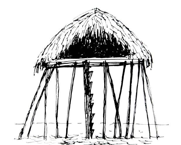
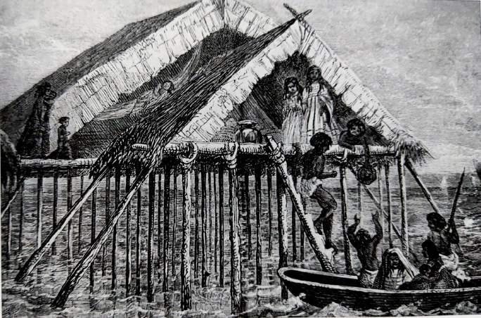
The stilt houses of this period are described in the writings of Amerigo Vespucci in La Lettera, published in Florence in 1506, describing: ”big dwellings, in the shapes of huts, settled on top of very thick stilts and having doors and entrances in the shape of suspended bridges that allowed one house to go to all the others, since there was a network form house to house.” Scholars of the time state that this dwellings were able to perfectly protect their inhabitants from the waters bellow and the water from the sky, as well as allowing them to live far away from the mosquitoes that roamed the land.
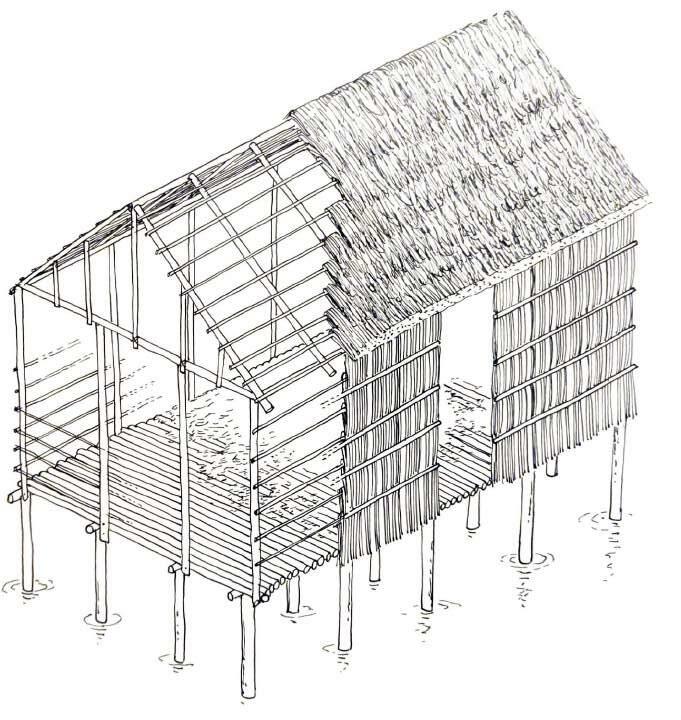
The dwellings from this period lacked walls, with two pitched roofs that ran all the way to the platform in which people lived, and did their daily activities. Beams protruded from the sides of the roof, probably functioning as a structural support for the roof, extending it in a way to the depths of the Lake.
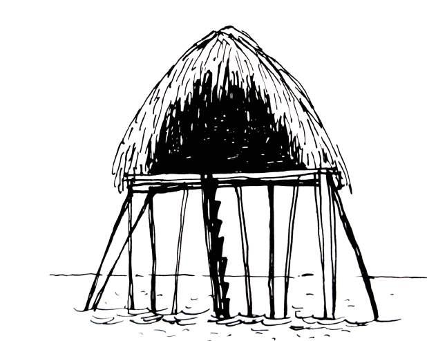
The idea of an entrance was an implicit boundary in the composition. Perhaps it was not needed, taking into account that the platform was sitting 2 meters (6.5 feet) above the surface of the water, with a perpendicular post with carved steps serving as the entryway to these constructions.
Codazzi would have his Resumen de la Geografia de Venezuela published. The culmination of 8 years of field studies throughout the Venezuelan territory. In it, he describes indigenous tribes living in the Lagoon of Sinamaica, Lagunillas, Tomoporo and Moporo, in which “many families gather, living in huts raised on stilts of vera wood in the middle of the water…the houses being covered by enea, and fabricated on stilts raised a couple of feet from the waters.”
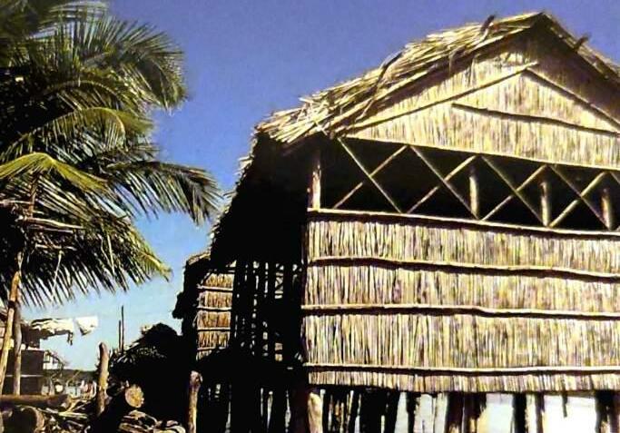
The houses of this period still presented a two-pitched roof without walls. Lateral bracing elements are still present, going all the way to the lake-bed. A name for the material in which these roofs is given a name in the recordings: enea.
Enea is a thatch like material made out of dried Cyperus, which was weaved by the Añu women, and found locally in the marshlands of the Lake, specially in the areas sounding the Sinamaica Lagoon.
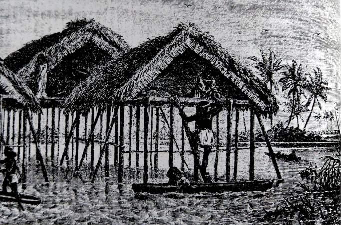
The German naturalist Anton Goering describes in 1870 that to access these houses one had to climb a post with steps. “Each house was divided in two parts, the front, which serves a double use as an entrance and kitchen, and the back, which serves a living room and dormitory. Weapons and utensils were orderly placed on the corners, and women’s clothing hanged above on strings extended from one extreme of the ceiling to another.”
The stepped pole is still a present element of the architectural composition, and required certain degree of skill of its users. It would be later abandoned in favor of more practical solutions, and a lack of need for defensive mechanisms agaist invaders.
The most important characteristic that transpires from Goering’s recording and the drawings of the era is the subdivision of spaces. The kitchen is placed near the entrance, composed of a wall-less big opening, allowing the heat and smoke of the kitchen’s fire to quickly exit the structure, keeping the living and sleeping quarters cool.
Furniture is still nowhere to be found in the dwellings. Hanging them from the ceiling or placing it directly on the platform were the ways of storaging belongings.
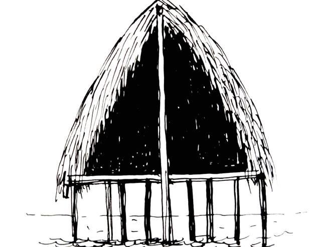
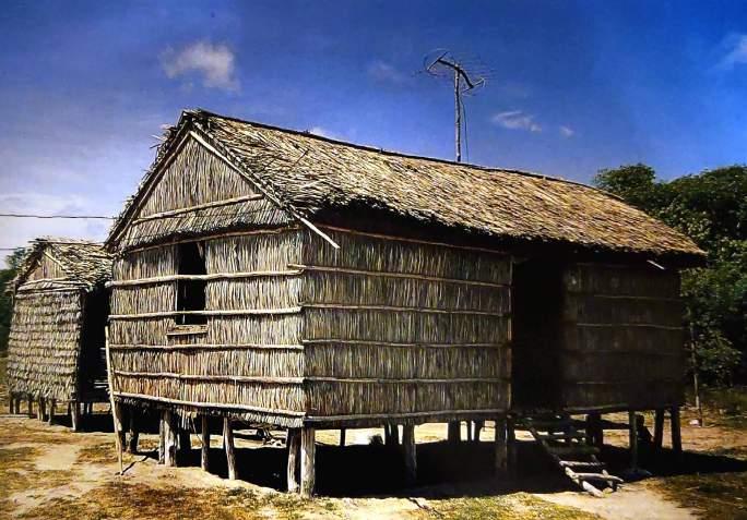
In the waning years of the XIX century the influence of European and creole influences begin to manifest in the vernacular architecture. Houses with very short walls supporting the roofs appear in the water communities. These walls were made of the same type of wooden sticks that made out the stilts. This allowed for higher roofs, which in turn allowed for more ventilation.
The platforms became closer to the water surface by almost a meter (3 feet approx.), This rendered the stepped pole obsolete, since now people were able to hop from a boat or canoe to the platform.
Some of these walls even had round openings, in possible emulation to the portholes of passing ships. These would be the precedent for the incorporation of a typical window, in the shape of a rectangular opening.
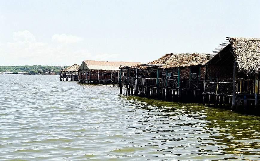
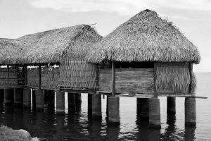
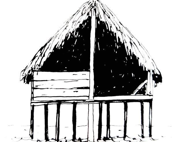
Figure 36: Typical Añu stilthouse, nowadays found mostly in the Sinamaica Lagoon, which has become an icon of the region and the Lake
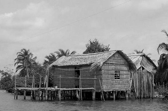
Figure 37: Drawing by Graziano Gasparini depicting the evolution of the stilt house
By the XX century, stilt houses present tall walls, made out enea, just like roofs. On these walls, well defined and very intentional rectangular openings are made in order to compose the door frame and the windows, which remain always open, in order to allow the circulation of wind, resulting in cooler spaces.
Two pitched roofs are the most common ones, but hipped roof make an appearance, and predominate during the decade of the 50s, falling out of fashion in present days thanks to the introduction of other building materials, like zinc sheets, which became a popular replacement for enea on the roofs.
In terms of spatial subdivision, the houses became remarkably more complex, with areas of the house becoming more defined in terms of program, such as a well established kitchen space, sleeping quarters, depot, work platforms (planchada), among others. Some people even made compounds made out of several stilt structures, in order to expand the house, showing an ability of the typology to grow through annexes, connected by suspended bridges.
Nowadays, this remains the most affordable way of building a new stilthouse for the people of these water settlements.
The oil companies would employ locals to work in the fields. This would allow many eastern water villages to flourish. Such are the cases of San Timoteo (former Misoa), Lagunillas, Tomoporo, and Ceuta de Agua, which would grow both economically and demographically. This phenomenon causes the demographics of these settlements to change, their population being mostly Venezuelan creoles. Yet, it is interesting that the use of stilt houses continued to be the norm, despite the absence of the original Añus in the area.
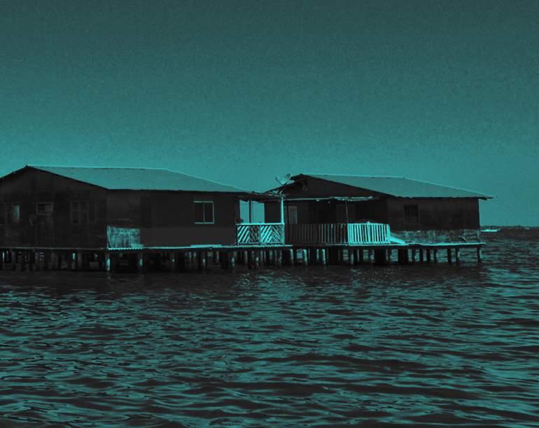
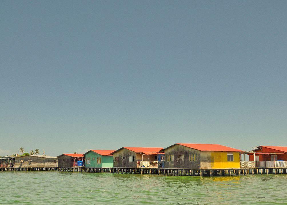
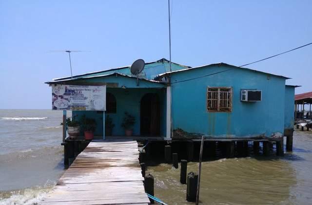
Figure 38: Creole stilt house, made out of more modern materials. These are the predominate in the typology nowadays

The international presence in the area would inspire the inhabitants of these eastern water settlements to implement different materials in the process of construction. The oriental villagers, lacking mangle wood and enea, managed to get from the oil companies the material that they needed to build. “[W]ood came from the huge boxes used to import machinery, and zinc sheets where easy to obtain since it was routine to prop-up, dismantle, and relocate warehouses. That is why most of the houses in these villages have wooded floors and walls, and zinc roofs.” (Gasparini, 2005)
Concrete stilts also became a common sight after World War II since it became easier to collect materials. The stilthouses have always been made out of collectible materials, so it no surprise that the material palette increased.
Figure 39: Drawing by GrazianoGasparini depicting the evolution of the stilt house
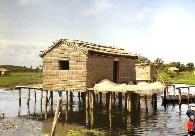
The typical stilt house would consist in a rectangular single-spaced dwelling of 6 meters (20 ft.) by 3.60 meters (12 ft.) on average. Floors are suspended above water at a height of 1.30 meters (4 ft. approx.) by mangle wood stilts sunk to the bottom of the Lake. Height above water may variate between 50 cm to 70 cm due tidal changes. (1.6 ft. to 2.3 ft.) .)
as an expensive alternative the mangle wood stilts. Walls may be painted with bright colors,in order to display the taste and individuality of the owners, in Antillian and Marabinian fashion. Many entryways are decorated with pottery and plants.
The walls and roofs would be made out of enea, a material made out of dry Cyperus, with a thickness of 30 cm (1 ft.), porous enough to let the breeze to enter and cool the space, propped on mangle wood frames. This material selection is a response to a climatic condition characterized by temperatures of 35 °C (95 °). The placing of the windows in the short sides, and entrances on the long side of the rectangular plan seem to mitigate the climate conditions as well. (Gasparini, 2005)
In the case of having more resources available, pine wood, zinc sheets, or even concrete might replace the enea as a wall material. If it can be afforded, zinc sheets most of the time are the preferred material for stilt houses done in the creole style. Concrete pylons have been seen
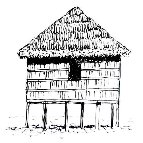
Figure 40: Typical structure of stilt house with enea walls and roof
It is frequent to see additional spaces added to the original rectangular single space, with the purpose of determining the functions of the home unit and resolving day to day necessities as the family grows.
children to play throughout the day.
One of the most common annexes is the kitchen. When it is not placed as a subdivision of the main open space, it is placed in an additional adjacent building, connected by a walkway. This is mostly done by Añu builders, since the Crioles follow more westernized ideals of living. The only difference that this additional building has with the main one is that its walls possess extensive openings to let the heat and the smoke out. The kitchen is usually a box made out of planks, filled with sand and ash, placed at tableheight.
The Añus are a matriarchal society, in the sense that the house belongs to the mother. When a daughter marries, a new house is erected next to the mother’s, with the husband moving in next to the mother-in-law. This results in the creation of compounds in the areas around the Sinamaica Lagoon.
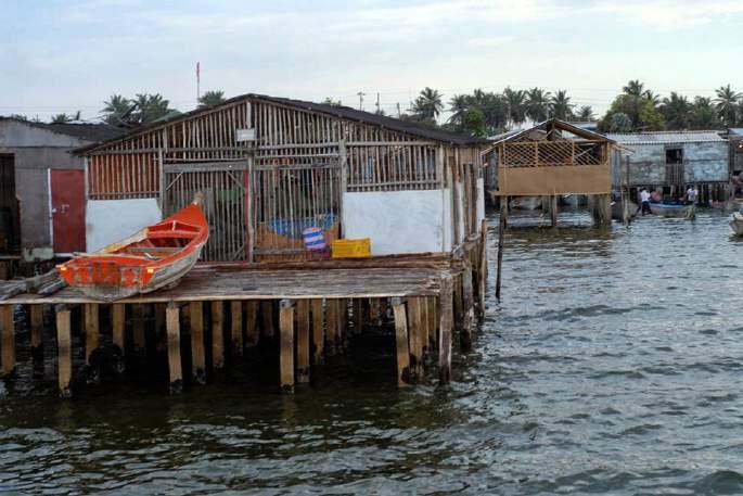
“Another very frequent annex is a sort of terrace in front of the house, along the facade, known by the name of planchada…[that] has the same height level as the rest of the floor of the house.” (Gasparini, 2005) It is very important for those houses that do not have access to land since it is here where the boats and canoes are docked. Loading and unloading operations also take place in the planchada, as well as the fixing of the fishing nets and storing of materials. They also provide a space for the
Figure 45: Compound made out of different houses of a single family
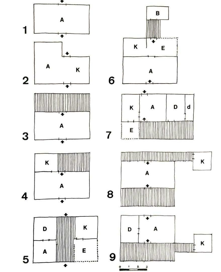
“The habitable spaces of the stilt houses present a great variety of solution, despite the volumetric typology’s repetitive similarity.” (Gasparini, 2005) Gasparini present us with some spatial configurations commonly seen in the stilt houses of the Sinamaica Lagoon.
Figure 1 shows the most modest and smallest of dwellings, consisting only of a common area. The addition of a kitchen can be seen in figure 2, as boundary-less annex to the common area. In figure 3, a planchada can be seen added to the common area. The presence of a kitchen with partitions and a planchada take place in figure 4, being this one of the most common configurations.
Figure 5 shows a house with a planchada splicing it in the middle, similar to the plan of a trot house, kitchen separated from common and sleeping areas, with an enramada or open shaded space. In figure 6, a bathroom structure can be seen connected to the main house by a walkway.
One of the most complex configurations can be observed in figure 7, with very defined spaces for sleeping, cooking, storing, and working. Figures 8 and 9 are examples of kitchens placed in adjacent buildings, connected to the main house by walkways.
Figure
Common Area
Spatial
Due to the very hot and humid climate in which the stilt houses are built, their builders adopted a series of strategies to mitigate the effects of the heat. Separating the kitchen from the main living spaces reduces the effects of a possible internal heat source, as previously mentioned. Added to that are the walls and roofs made out of a 30cm (1 ft.) thick barrier of enea, which allows some cool breeze in without the material heating too much, with their lightweight construction systems are ideal for the climate that they inhabit.
two-pitched roofs and hipped roofs also help to vertically elongate the space, allowing for the hot air to rise, while the cool air that comes with the breezes stays bellow, at the living level.
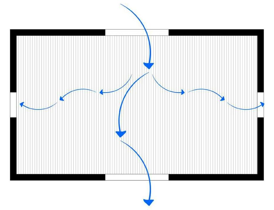
The suspended-from-the-ground nature of the stilt houses prevent them from absorbing heat from the ground, while catching high velocity breezes underneath the living spaces. In relationship with the winds and the sunlight, most stilt houses seem to be orientated from North-East to South-West, with their longer side having one or two small openings that serve as windows, while the shorter sides are usually reserved for large openings that function as door. These doors always come in pairs, one on each short side, to allow for cross-ventilation. In some cases the location of the doors and the windows may switch, if the surrounding conditions do not make their ideal placement convenient, but from a climate performance point of view, the aforementioned configurations are the preferred ones. Both
Meteoblue’s wind rose for Maracaibo places most of the wind hours coming from the NNE, with more than 4000 yearly hours, at speeds oscillating between 3 and 12 miles per hour. It is safe to say that the orientation of most of the houses are not arbitrary, but rather a thought-out response to environmental characteristics. It can be seen in many communities where the stilt houses adopt an angular orientation instead of an oblique one regarding the shores, trying if possible, to have the door openings facing the North-East ir order to catch the cool breezes.
Figure 51: Stilt house elevations showing the windows and door openings commonly found in the typology
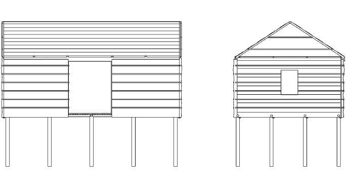
Figure 52: Meteoblue’s wind rose for the area of Maracaibo. Source: https://www.meteoblue.com/en/weather/historyclimate/climatemodelled/ maracaibo_venezuela_3633009

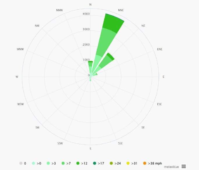
Figure 53: Dwellings at Sam Timoteo facing North-East
Figure 54: Streets at Santa Rosa de Agua facing North-East. Some of the doors might be placed between house and house, to catch wind
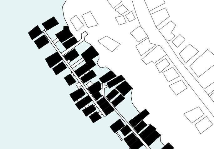
Figure 55: Cross-ventilation diagram of a single-spaced stilt house. The openings, wether they be doors or windows, are always placed in pairs, facing each other in the opposite sides of the dwelling in order to allow the pass of wind. The stilt nature of the house also allows it to catch some high velocity winds underneath the living level
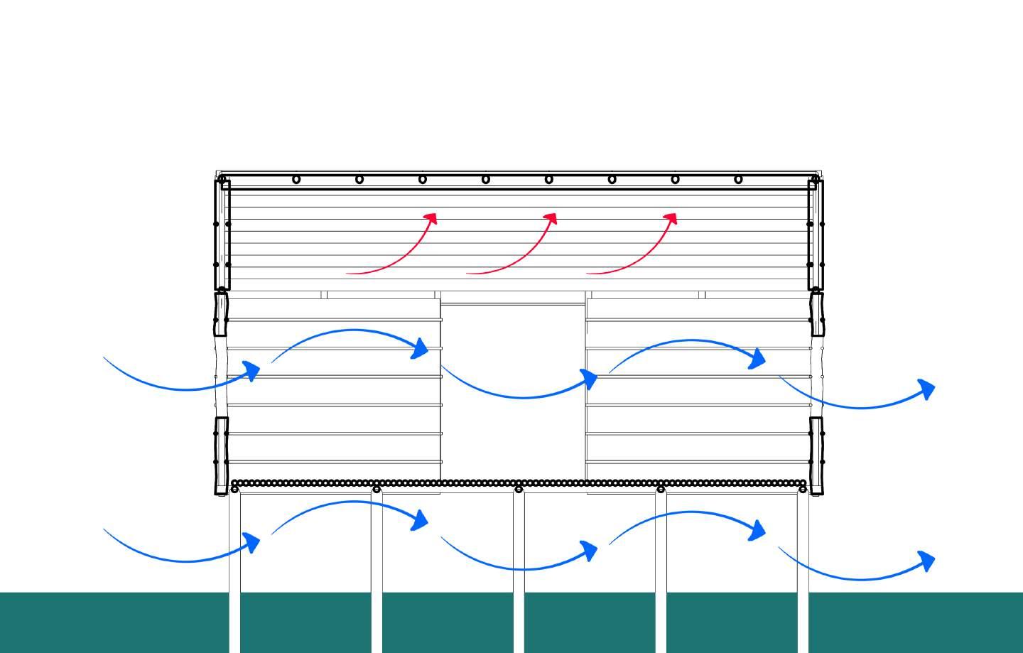
Figure 56: Plan view showing how the North-East orientation is desireable, since it catches the breezes comming most of the year from that direction
This is a lifestyle that has, so far, stood the test of time...
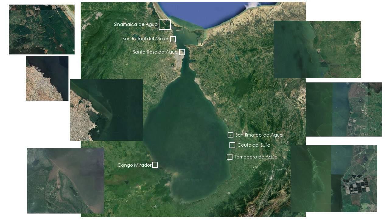
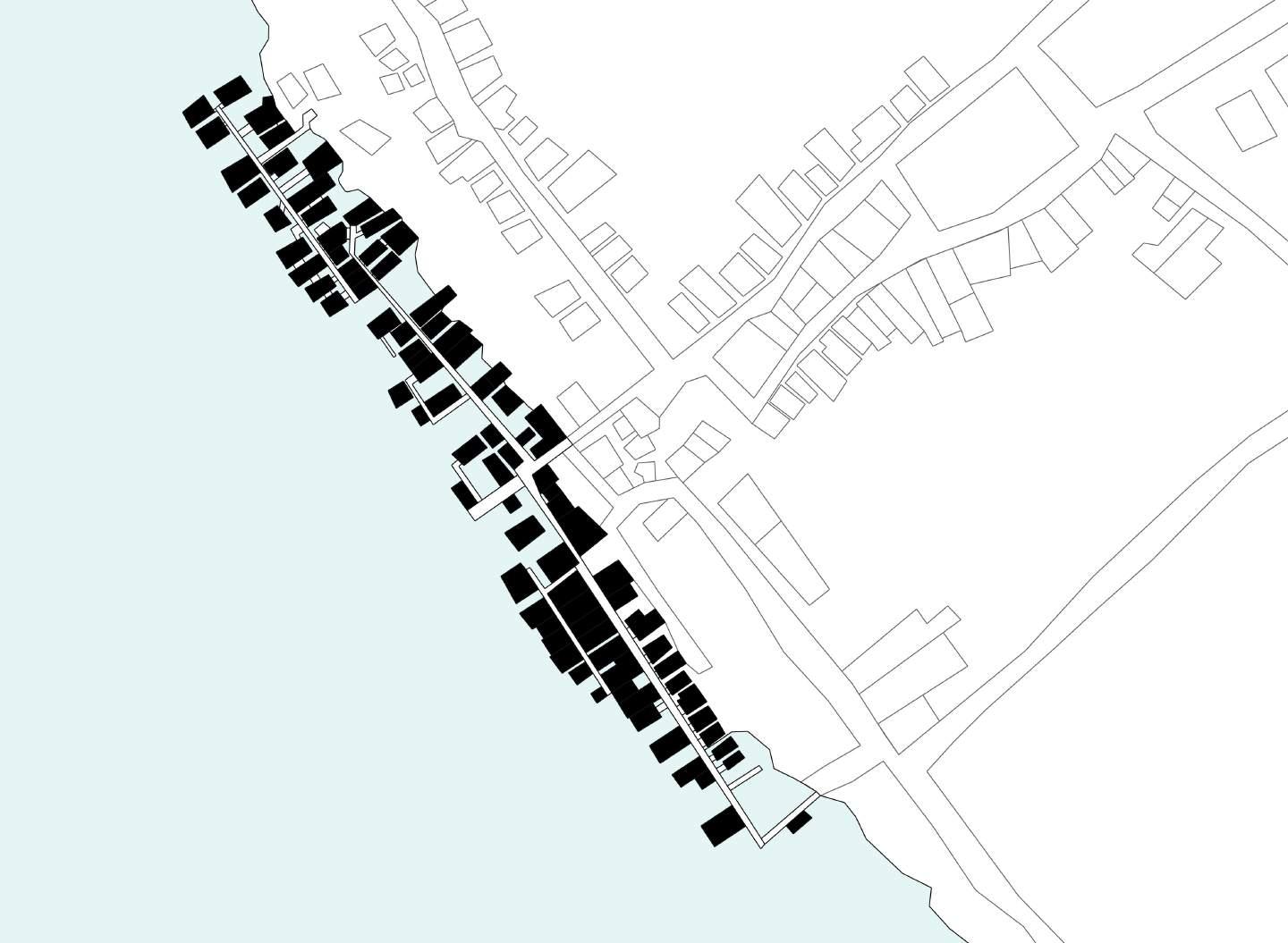
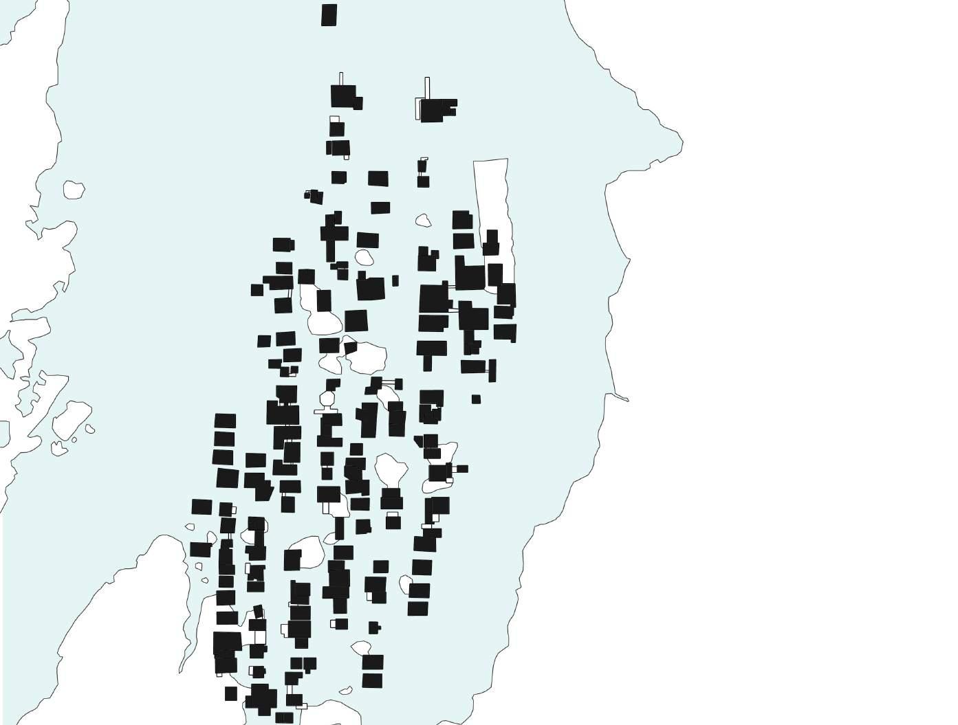
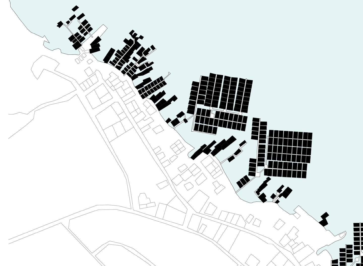
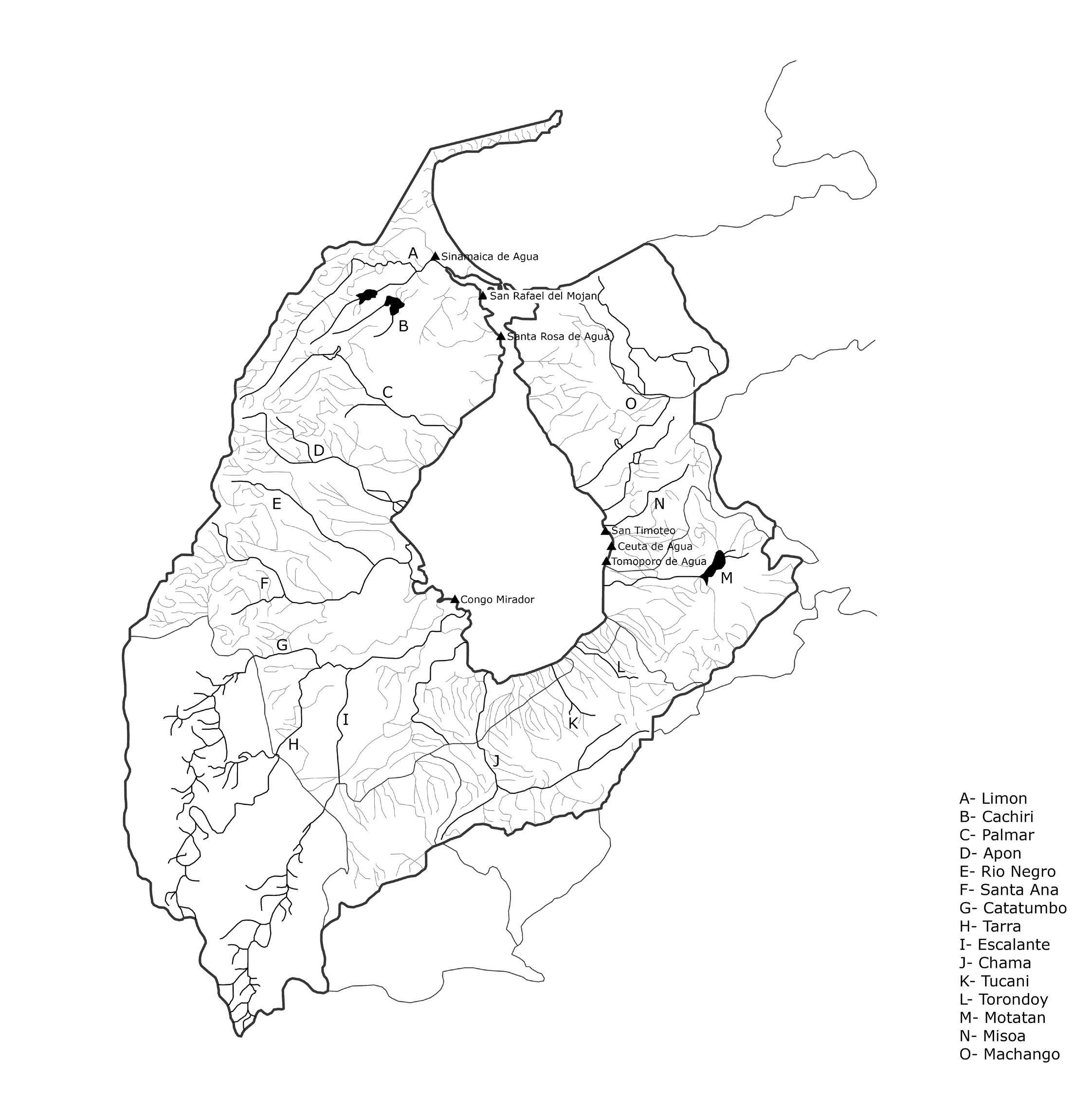
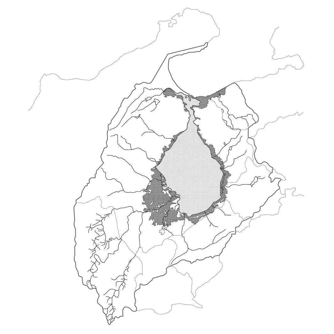
Of all the historical water settlements around the Lake only seven still remain in their stilt-house original nature:
1. Sinamaica de Agua
2. San Timoteo
3. Ceuta de Agua
4. Tomoporo
5. Congo Mirador (Catatumbo)
6. Santa Rosa de Agua
7. San Rafael de El Mojan
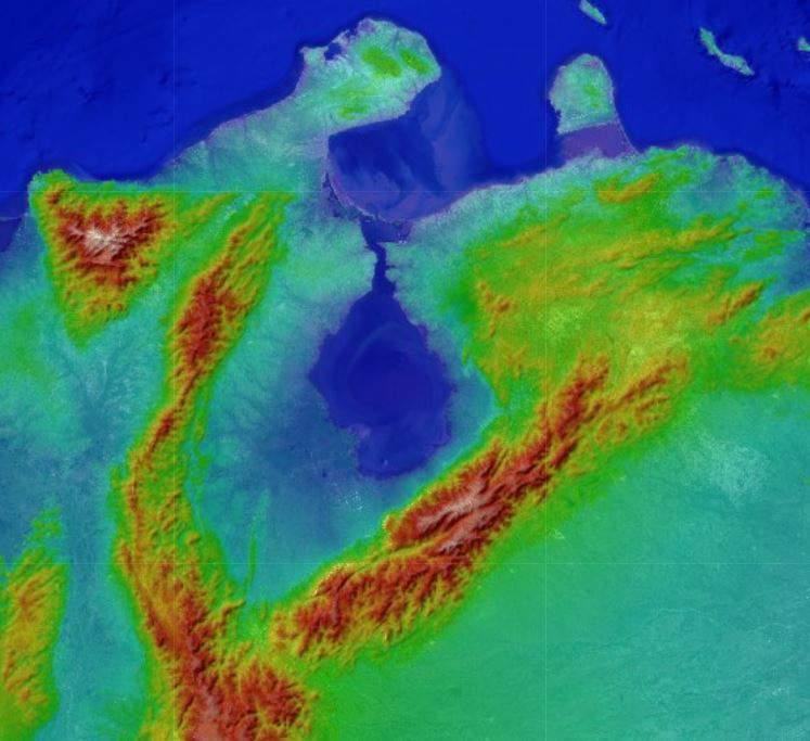
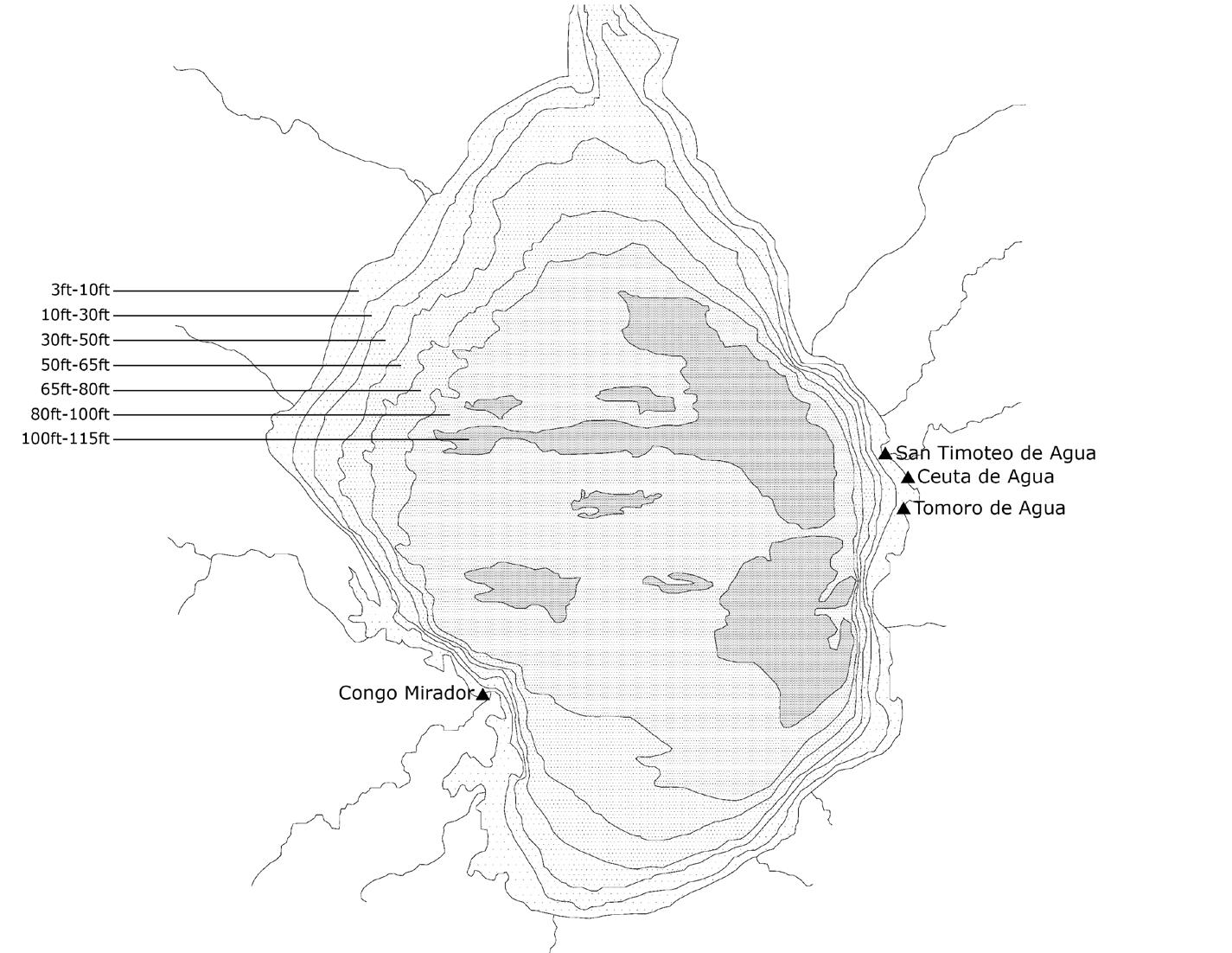
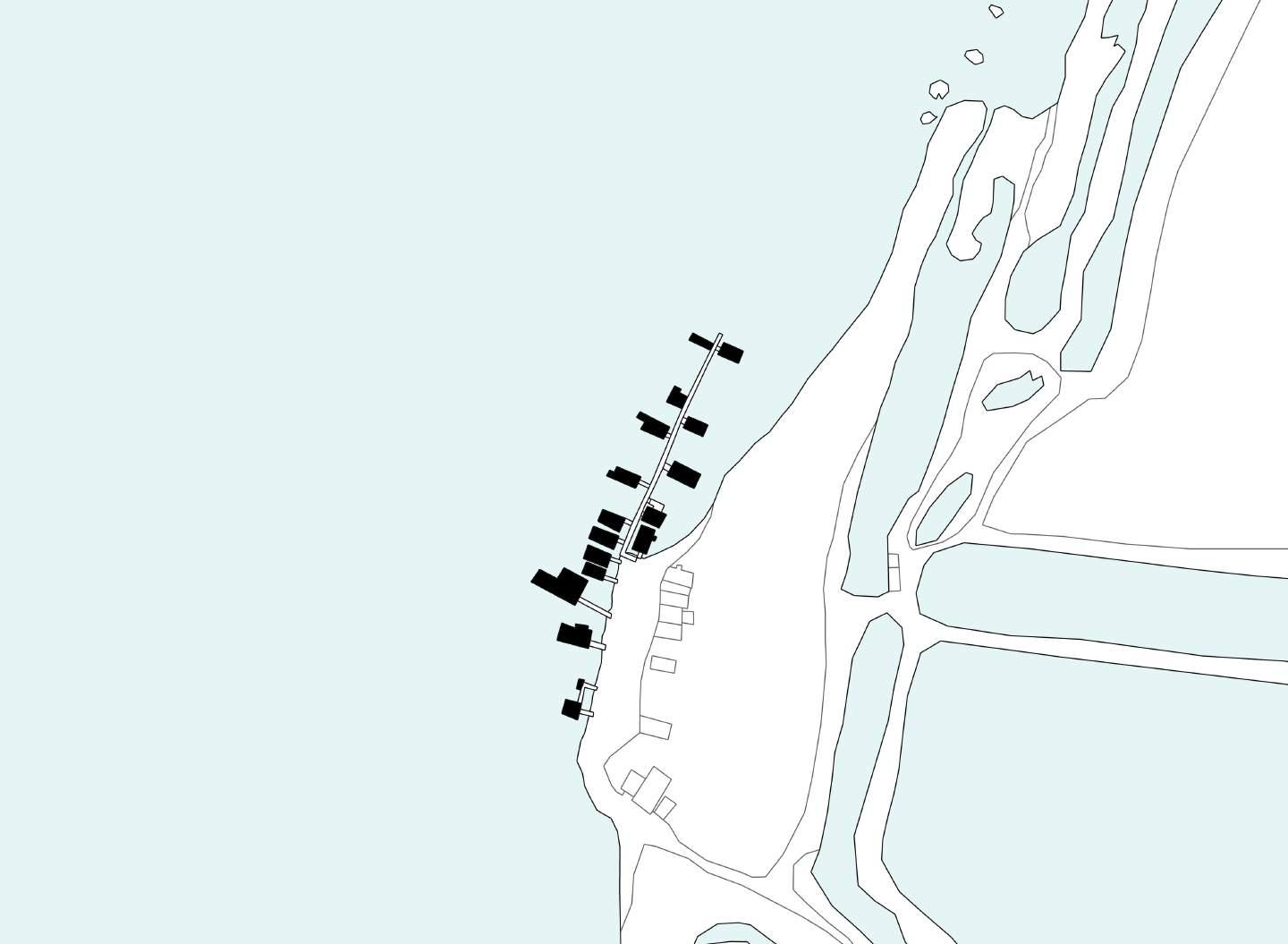
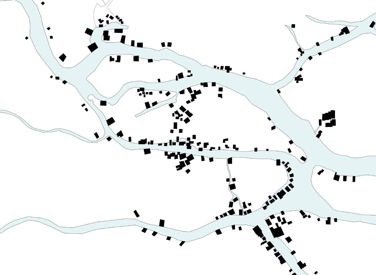
Most of these settlements are located near the mouths of affluent rivers. Sinamaica de Agua is located on the delta of the Limon River, Congo Mirador is located in the mouth of the Catatumbo River, the most important of the Lake’s affluents; while San Timoteo, Tomoporo, and Ceuta de Agua are located between the mouths of the Misoa and Motatan rivers. The reasoning for this preference for the settlements’ location may be the possibility to easy access for navigation and commerce with other towns upriver.
Maracaibo seems to be logic behind the location of this populations. Proximity to the mouth of the Lake would also allow for fishing and commercial opportunities in the Gulf of Venezuela and the nearby Antilles. The settlers of the water-villagers also preferred shallow waters, which allowed the easy emplacement of the stilts and modification of their surroundings. There are very deep regions in the eastern shores. It would be on these deep regions where the majority of the water-based oil wells would be established, allowing the oriental water settlements to flourish during the oil industry golden days.
In the case of Santa Rosa de Agua and San Rafael de El Mojan, a close proximity to the commercial hub of
Figure 57: Depths of Lake Maracaibo and its relationship with water settlement’s location
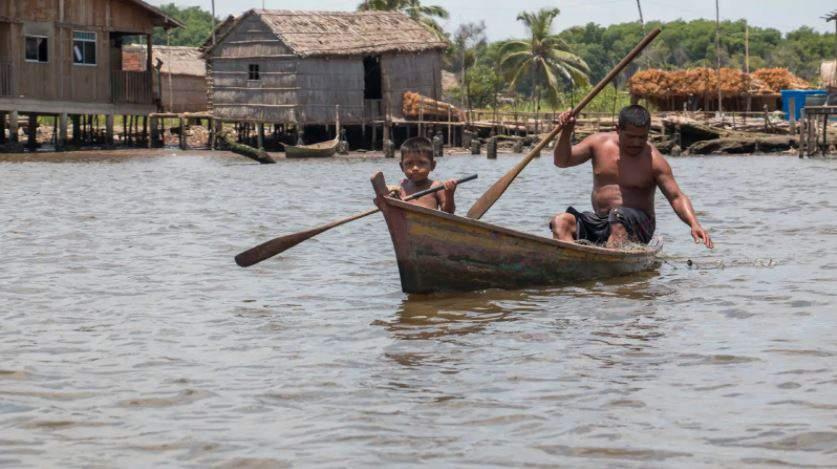
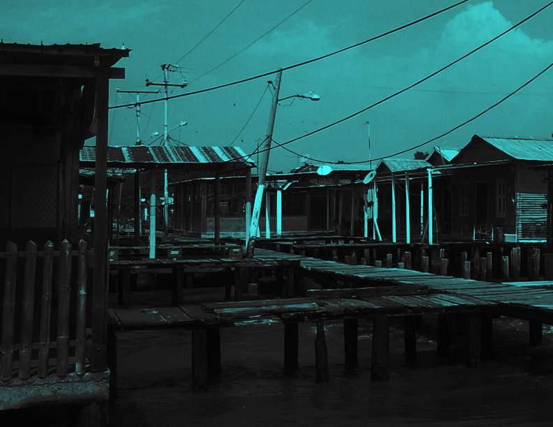
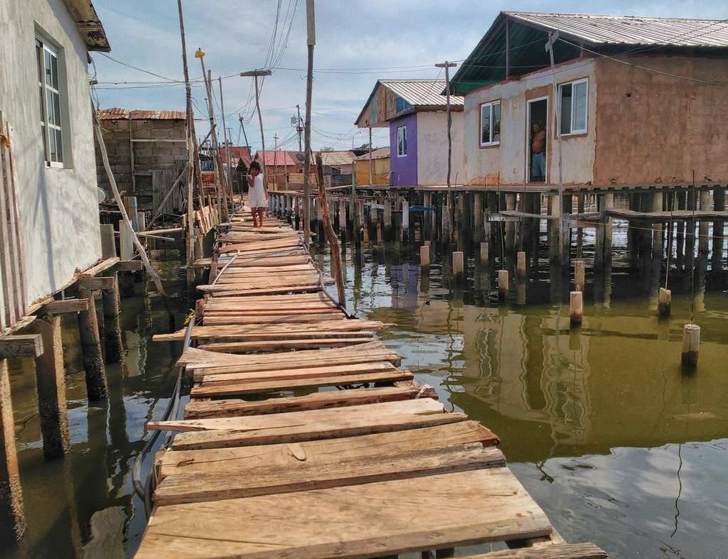
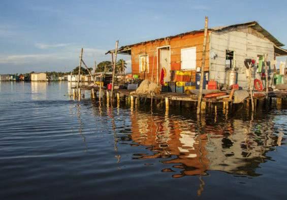
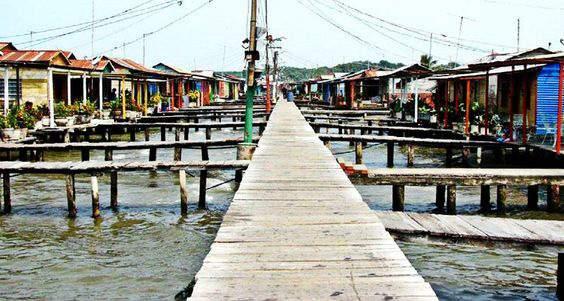
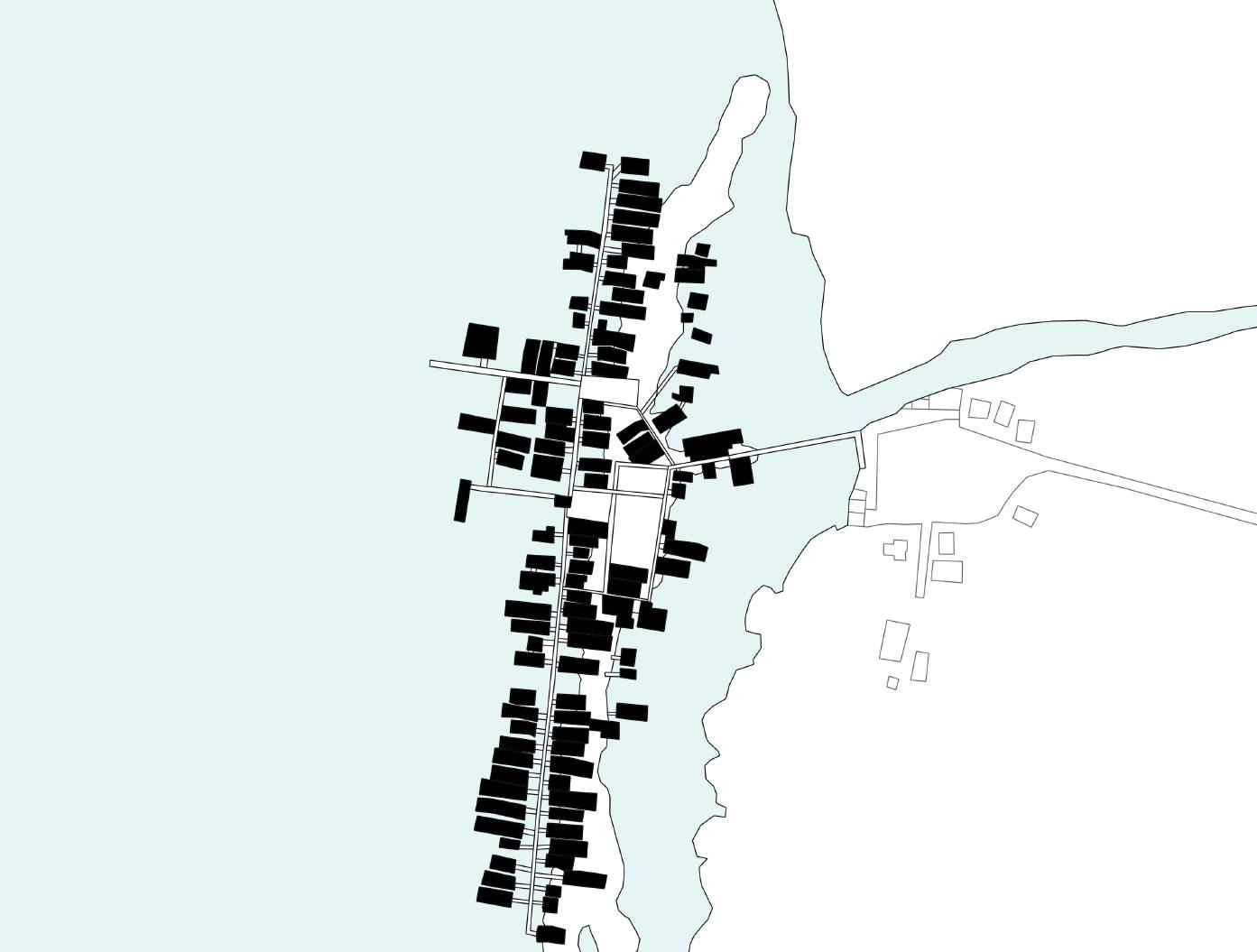
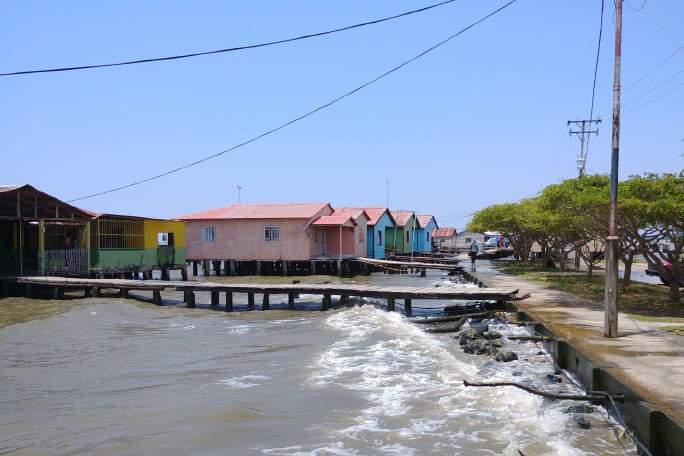
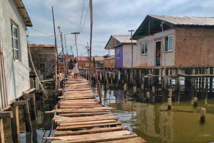
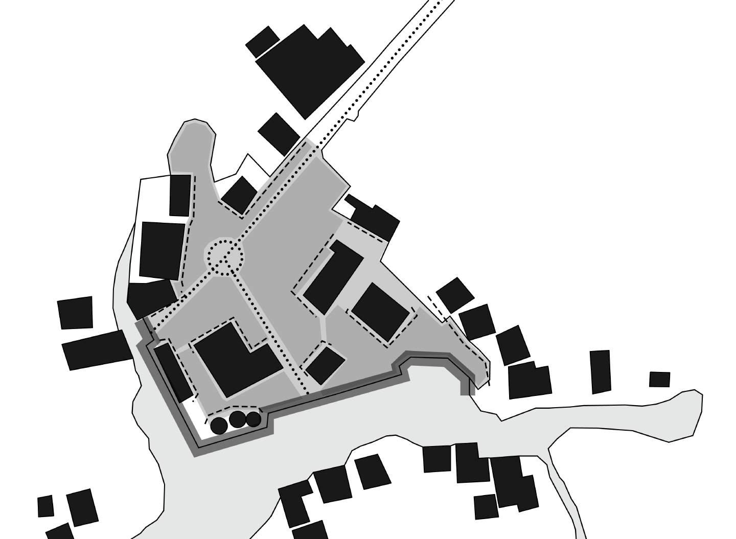
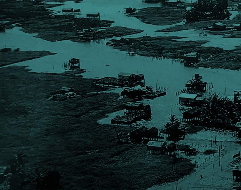
Ceuta de Agua (Ceuta of Water) is, as many other water settlements, mainly a fishermen’s village. As one enters the village, through a 200 meters long walkway made out of wooden planks, some of them rotting or in bad shape, one can see children playing and laughing, when they are not swimming on the water. Their natural element is the water, to the point where “Ceutan children learn how swim before they learn how to walk” (Gutierrez, 2005)
In this village, a network of walkways can be seen used as streets, with rows of houses aligned one in from of the other along them. Only mere meters separate one house from the next one next to it. Partition walls between house and house are non-existent.
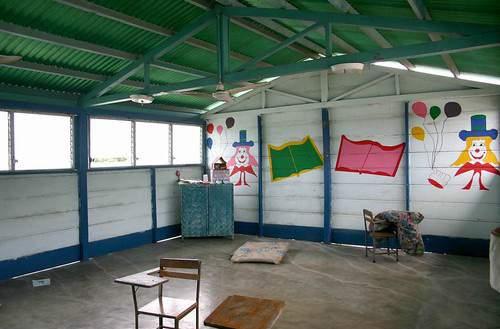
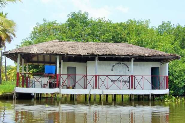
Besides houses, there are some buildings that serve different programs. A school (E) near the main access way to the land, that provides learning spaces 176 minor under the age of 16.Classes are not given in the evening hours to avoid the scorching heat, since none of the three classrooms of the education building possess ventilation system. Another building is a platform (A) without walls or ceiling that is used to perform cultural acts and community gatherings. This non-programmed space serves as the fulcrum for many of the streets of this settlement, affecting the
This settlement lies to the west of the small city of Mene Grande, which became the workhorse of development after the discovery of huge oil reservoirs in 1914, and the establishment of the oil well Zumaque I that same year, the first well in Venezuelan soil. An era of exploitation of the natural resource began, prompting the Caribbean Petroleum Co. to establish in 1917 the San Lorenzo Refinery, the first one to be established in the country, with several yards populated by oil tanks. It was in the oil industry where the inhabitants of San Timoteo, both water and land residents, would find employment as workers and perforation engineers for almost a century. The prosperity that came with petroleum money allowed for the developments of welldefined sectors, and streets, that extended to the waters through roads that suddenly turn into wooded walkways flanked by stilt houses, as if inspired by the coming and going ships of oil workers from the settlement, going to work on barges in the middle of Lake Maracaibo.
of the waters.
This settlement also follows the wooden walkway street pattern, reading almost as an extension of the urban fabric found on land toward the water. Most buildings found propped up on stilts are dwellings, since other programmatic buildings are near on the land part of San Timoteo, with the exception of a store (S) which sit on top
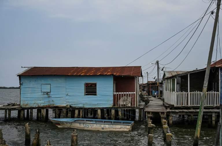
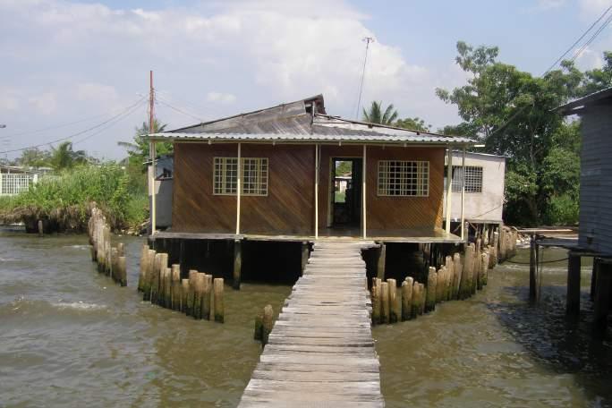
Figure 62: Stilt house of San Timoteo, with a wooden finish on it’s facade and a palisade around it
Figure 63: Wooden walkway and houses
Tomporo de Agua, perhaps the smaller settlement amongst the water villages around Lake Maracaibo, depends on fishing and nearby oil extraction activities as means of economic sustainment. Former national oil company Lagoven stablished in the 1986 a well in the proximal waters denominated TOM1. PDVSA, actual national oil company,established another one in 1999, denominated TOM-7, that used to produce 16,000 barrels a day. Exxon Mobile afterwards discovered a reserve that prompted the establishment of a field of 25 wells. Nowadays there are two oil perforation fields, field Lagotreco, on the nearby waters, and field Tomoporo, which sits on land, not too far from the settlement where some of its workers reside.
Figure 65: Stilt house of San Timoteo, with a wooden finish on it’s facade and a palisade around it
There are some modern houses constructed in the land nearby, giving this settlement an interesting duality of a modern, more robust land portion on one side of its main street, and an one more traditional looking side sitting on the water, light looking, and more separated from the street, through individual walkways that connect each house to the mainland.
The only programmed building is a local house that doubles as a restaurant for the inhabitants and passing oil industry workers.
Figure 66: Local house doubling asthe town’s restaurant
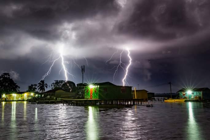
Congo Mirador is probably more famous for being the place where the unique atmospheric phenomenon, the Catatumbo Lightning (Relampago del Catatumbo in Spanish) can be best seen. It is a constant lighting storm, of over 200 discharges per minute, that happens almost every night of the year. This settlement, that sits in the Catatumbo river’s delta, is perhaps one of the most isolated ones. Walkway streets are not present in the fabric of it. Instead, the houses are placed within a greater distance from one another as to create waterways in which boats function as cars.
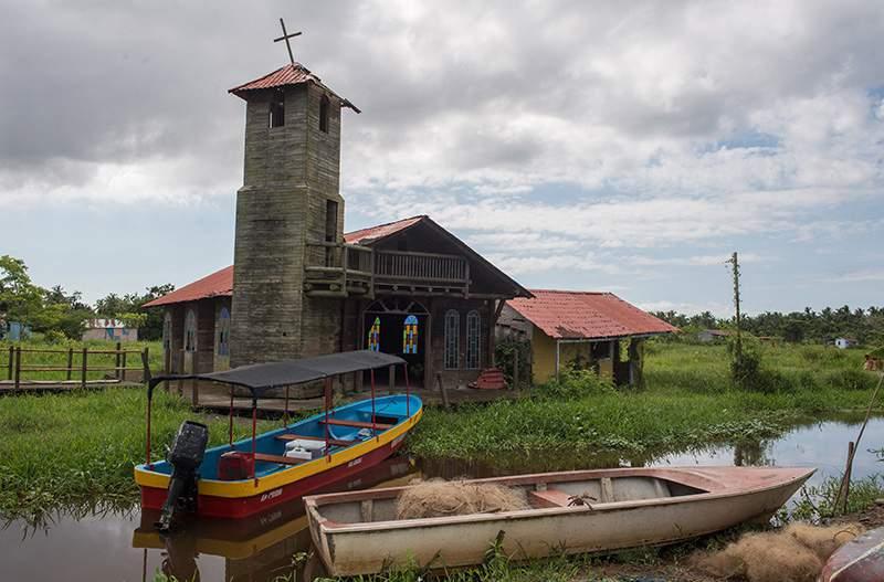
There is a church (C) in the community, as well as a couple of little stores and tourist stops. Nevertheless, the church nowadays only serves as a decaying symbol, since masses are not currently given in it. Tourism is one of the main economic activities of this settlement, since local and foreign tourists are attracted to the settlement and it’s natural phenomenon.
Sedimentation has happened in the area where Congo Mirador sits, with mud making it harder to navigate its canals. Eventually, plants grow in the mud, having landlocked several houses of the town.
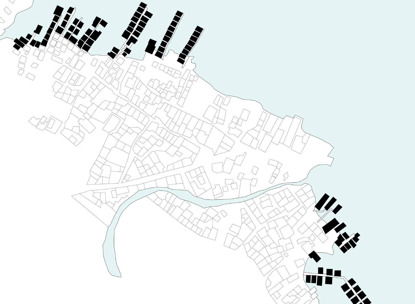
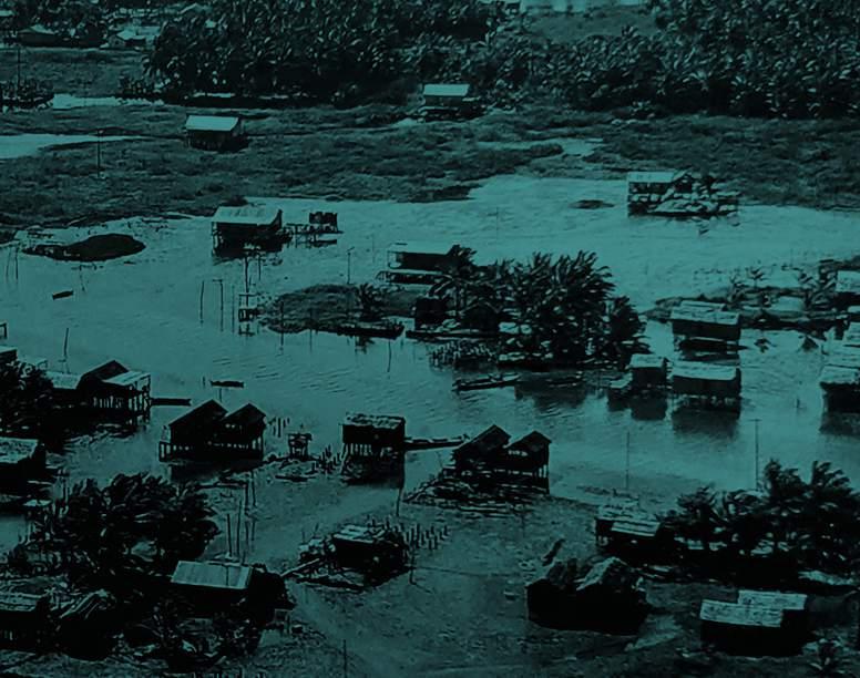
Santa Rosa de Agua is a settlement that grew in the northern are of the regional capital of Maracaibo. This has made it in turn a sort of slum of the city, standing out because of its watery nature. The proximity to the big city created additional problems for the community, like marginalization and higher criminality. The trade off is a proximity to the infrastructure of the city, and its commerce hubs.
Wooden walkways are used as an extension of the streets that exist on land, with houses organized in rows as well. However, these wooden streets are isolated from one another, creating the idea of little water neighborhoods that communicate with each other through the land roads.
Figure 71: Interior of the local school (S). Note the lack of furniture and marks left by rising tides on the floor slab
In this settlement, religious and education buildings are located inland, with many restaurants being the other program propped up on stilts. The owners take advange of the exoticism of the stilt house to attract customers from the neighboring land communities.
The closeness to the Lake’s mouth and exit to the Caribbean sea allows many of the people that live in Santa Rosa to commerce with the Dutch Antilles in the span of a day round trip.
Figure 72: Ceuta’s main street
Capital of the Mara municipality, San Rafael de El Mojan started first inhabited by Añu settlers, who raised herds of goats and coconut plantations. Eventually growing with time until adquiring enough importance to become the seat of local power north of Maracaibo.
Just like other water settlements located near urbanized land areas, most of El Mojan’s facilities are located inland. This community is equipped with a sports arena (A), several local churches, and a range of commercial buildings.
Most of its houses are arranged in neighborhood connected by wooded walkways, in pier-like fashion. It sands out in plan due to the relentless rhythm that some of its houses create. These houses are part of a government initiative to provide housing to indigenous people. Nevertheless, the same infrastructure problems that many water settlements possess still remain.
Geographically, it is close to Colombia, having commercial ties with cities in the Goajira region, specially Maicao, on the other side of the border, which allows its inhabitants to practice commerce internationally at a small and medium scale.
Figure 75: Different material variety can be seen in El Mojan
Sinamaica de Agua is the water settlement that stays the truest to the Añus’ traditional methods of construction. They deem the traditional materials cheaper and easier to acquire. Other materials can be found in this community, but their use is subjected to the economic opportunities of the owners.
It is different for all it’s sister settlements in the sense that the houses are arranged in compounds, consisting in a main house, belonging to the mother (and head of the family), with the daughters’ houses surrounding it, in which they live with their husbands. Additional support annexes are also integral parts of these compounds, like depots, outhouses, and kitchens.
It is the largest one in extension too, with named areas like Puerto Cuervito, La Boquita, Caño Morita, Nuevo Mundo, El Cañito, La Ponchera, and Boca del Caño. The boundaries of these areas are as fluid as the waters in which they sit, which are the waters of the Sinamaica Lagoon, by the Limon river.
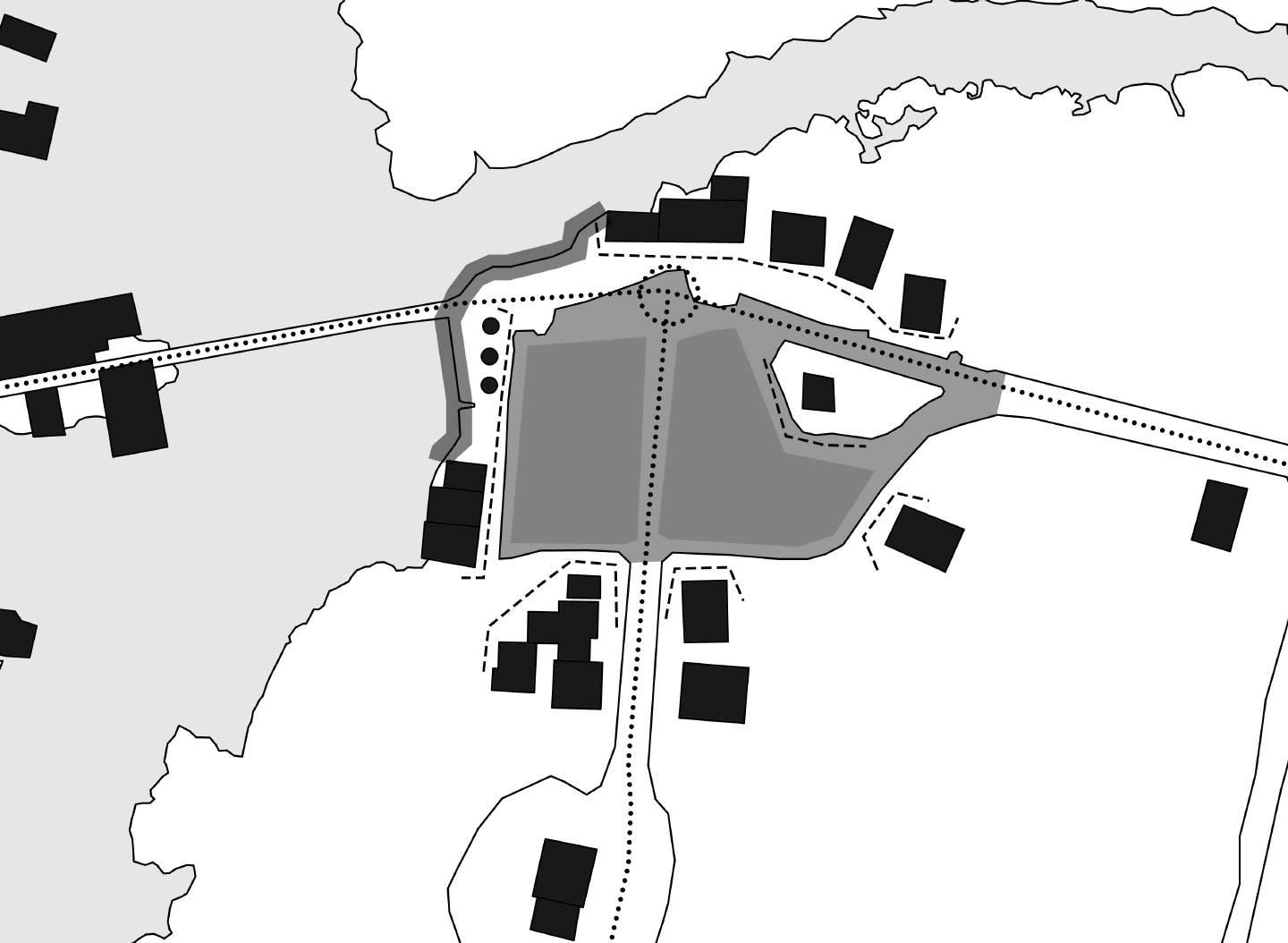
There is a school (E) of intermittent use, a local church (C), and a small commercial hub (S) inland, Puerto Cuervito, where the locals resupply the fuel for
Many of the water settlements possess an anchoring point to land, in the shape of an open area surrounded by programmatic buildings that aim to serve the whole community. Trucks that bring in vital resources, such as water, gasoline, and other supplies. This make these makeshift plazas spaces for the whole community to come together,allowing the interaction of neighbors.
Sinamaica de Agua’s Plaza is one that serves as the water and gasoline refilling station for the whole riverine community. The neighbors of the water settlement commute in their motor boats to it, anchoring them in the small marina on it. A gas station, several restaurants and convenience stores aim to supply them with basic goods. There’s even a small Bolivar Plaza, a staple of Venezuelan urbanism, on it, with dirt as flooring material. The big opening space in the middle is made to allow the supply trucks to come in, drop off, and then turn around to leave. This open area is connected to a dirt road that leads to the bigger transportation infrastructure of the region, connecting by land the water community with the rest of the country. Not so far from it, other programmatic buildings can be found, such as a school, and a the local church.
Ceuta de Agua’s Plaza, similarly to that of Sinamaica, serves as the supply refilling space of the community. The open space designated for the truck to come and turn around is even more evident in this case, with the presence of an island curb that serves as the fulcrum for such motion of the vehicle. Small restaurants and stores flank the plaza, reinforcing the commercial nature of it. Interesting in the case of this plaza is the presence of a walkway that connects the walking infrastructure of the water community with the spaces on dry land. Just like it’s homologue in Sinamaica, the local school is not too far from it.
Having studied how the vernacular architecture in which the stilt house, it’s design, it’s evolution, it’s capacity to evolve with new materials and programmatic spaces, and it’s ability to adapt to different landscapes that combine water and land features, the design intention is to explore how can the water settlement can evolve into the 21st century, being able to be sustainable and give resiliency to the communities which incur in their use.
To make these new settlements sustainable, economic engines are going to be necessary as components, as well as social components, and residential components.
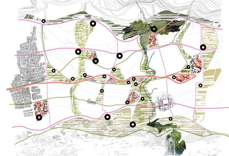
As of now, the sickness of the Lake is the biggest obstacle of the aforementioned resiliency of the water people, so considering an scenario in which the Lake remains polluted and the livelihood at risk, the following proposal is to create a model community up the rivers that feed the Lake, since the water is cleaner and the challenges of the troubled waters can be diminished to an extent, able to house migrants from the current water settlements.
In order to create a coherent and cohesive urban fabric and community dynamics, what was learned from the seven case studies will be taken heavily as reference. The idea is to preserve this way of living as much as possible, in tune with nature, and in tune with the waters of a landscape that has always captured my heart for as long as I have had memory. This culture can endure, being a model for the world in how to deal and live along water, which are concepts that these days are more relevant than ever, with the threat of climate change and sea level rise looming in a not so distant future.
In order to allow the migration of these communities, a prototype village model will be designed, taking into consideration the need of infrastructure noted in Governeur’s hypothesis. The local needs and culture need to be put in the forefront of the strategy, which as of now revolve around the lack of infrastructure.
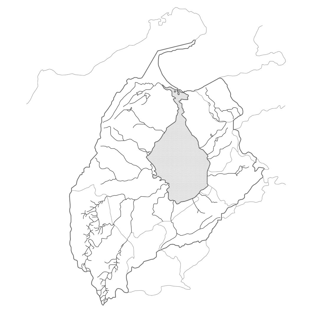
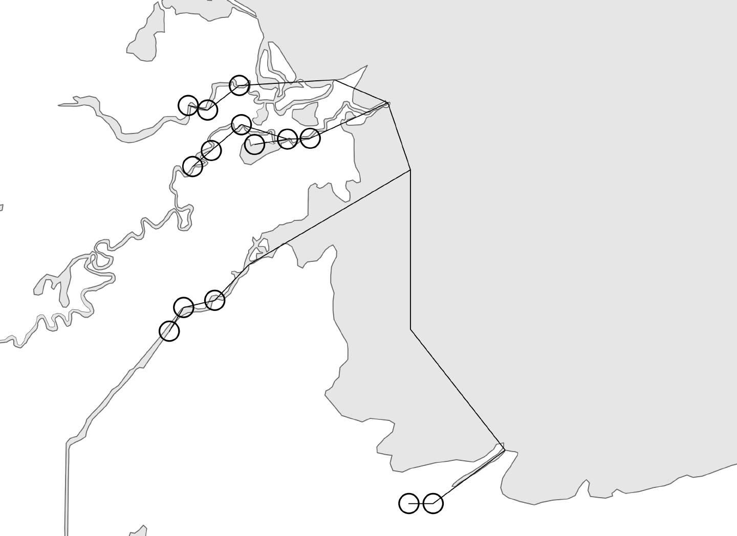
Figure 82: Lake Maracaibo Basin, with tributary rivers that bring clean water to the Lake
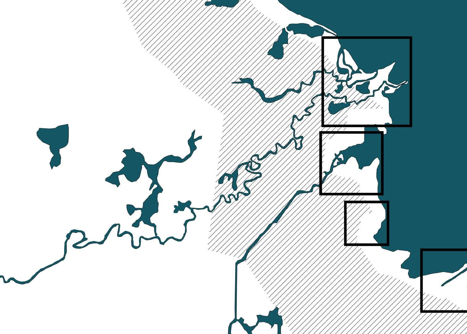

Of all the rivers in the Lake Maracaibo basin, the ones in the southwestern region of the Lake are the most optimal for the new model settlements to develop. That is because the lands on that region are fertile, and the waters of the nearby rivers are clean, allowing the implementation of an array of economic activities to support livelihoods and create jobs for the populace.
These rivers, mainly the Catatumbo, followed by the Tarra, Escalante and Chama are also ideal for navigation as a means of transportation. Water bodies represent pieces of infrastructure already available for use, with such rivers being like watery highways,where both people and goods could be ferried from settlement to settlement, to big cities like Maracaibo, and even to international waters.
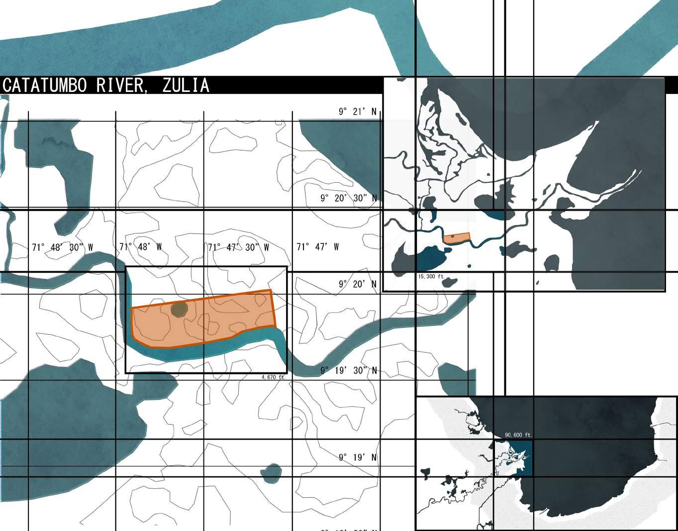
The Catatumbo river in particular is being selected as a site because it’s delta possess multiple ramifications that could house possible prototype settlements, with widths that vary between 200 and 400 feet, making it optimal for navigation. Additionally, this river is not prone to great flooding, which makes it safe for such developments to occur alongside them.
The terrain of the site is relatively flat, with the average terrain height varying between 8 and 16 feet above sea level. The site’s location on these relative high-grounds puts it in a relative safe place when compared to other areas in the region when it comes to sea level rise.
The observed site would remain above water in the case of a 4 feet sea level rise, which is a plausible scenario within the next fifty years. In more extreme scenarios, were sea level rises of 8 ft. and 16 ft, possible semi-submersion of the site could be possible. However, it is worth remarking that the stilt-standing condition of the water settlement already accounts for the possibility of floods or increase of sea level.
River reverse flow in the case of extreme weather conditions remains a possibility, although hard to predict and debatable unlikely to happen in most conservative possible scenarios for the next fifty years.
Figure 85: Sea Level Rise of 0 ft.
Figure 86: Sea Level Rise of 4 ft.
Figure 87: Sea Level Rise of 8 ft.
Figure 88: Sea Level Rise of 16 ft.
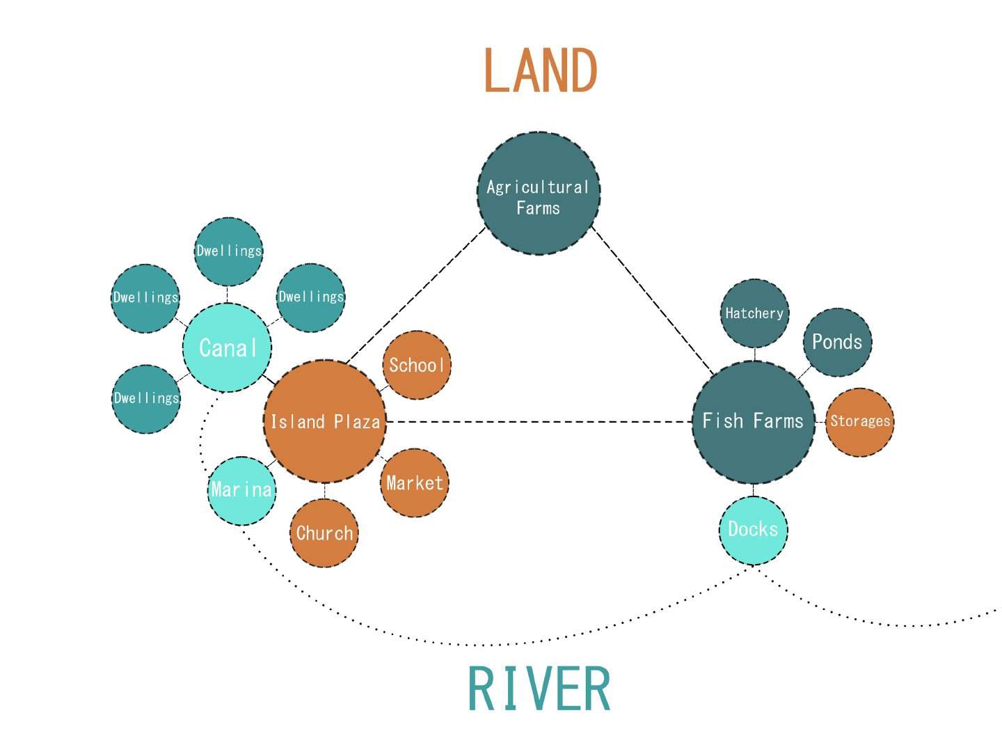
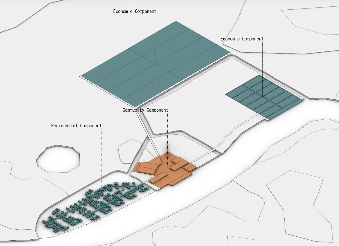
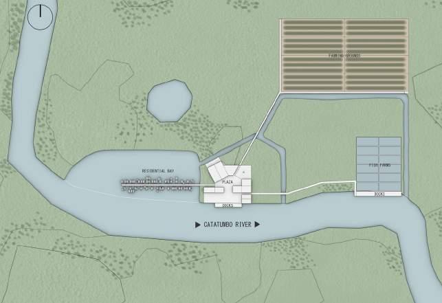
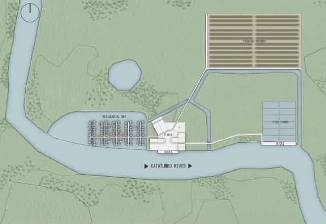
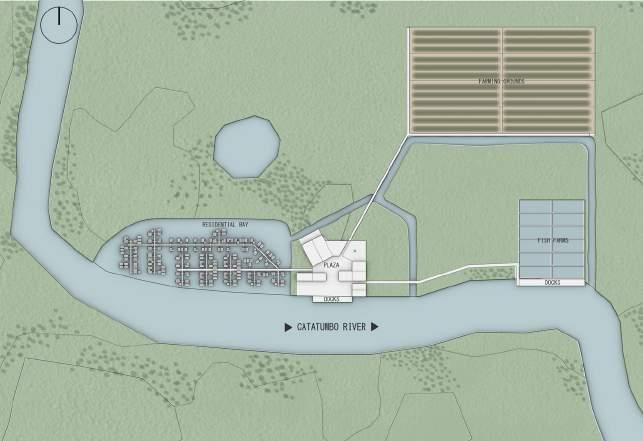
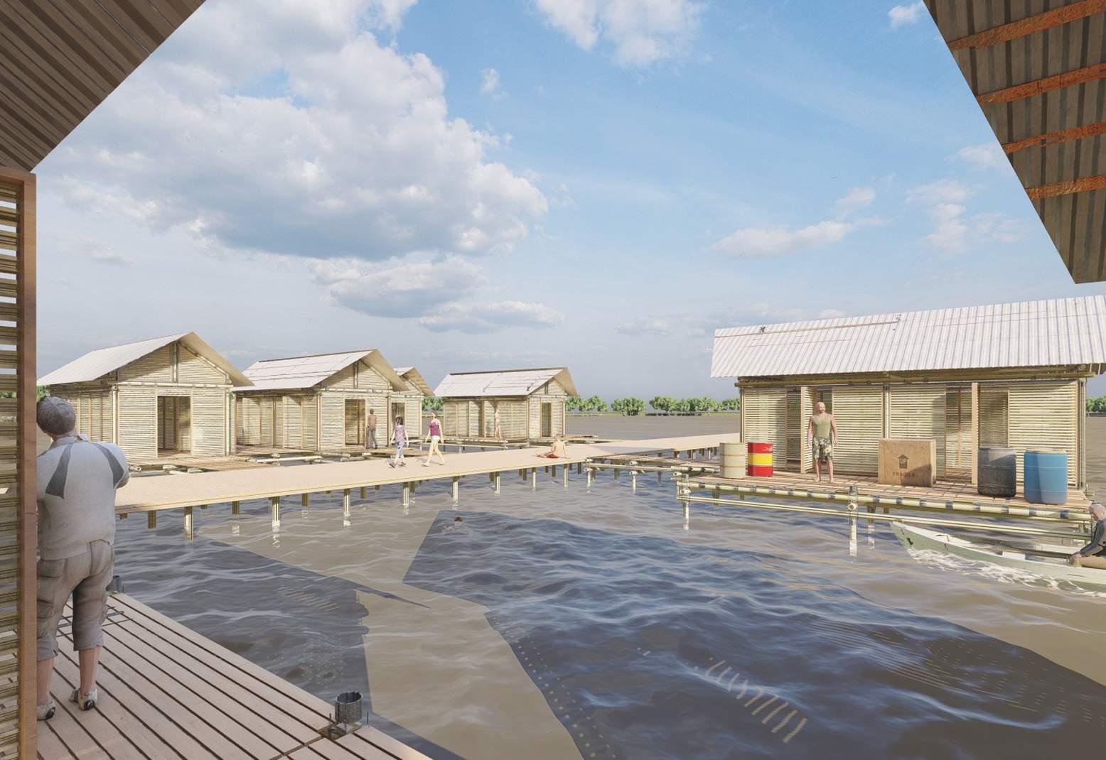
The schematic design of the prototype community involves the placement of the residential component in careful and systematic juxtaposition with the social and economical components.
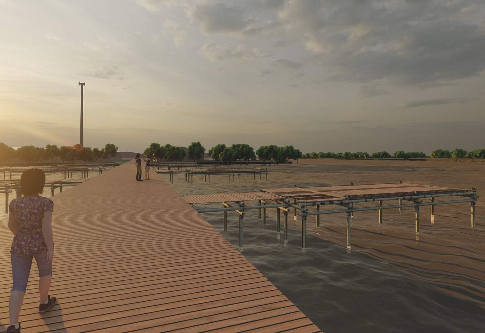
A canal or bay would need to be created alongside the river, in order to shield the dwellings from the river’s currents, while allowing the dwellings on stilts to be surrounded by water, which in turn would give access to the residents to use the waters as a way of transportation.
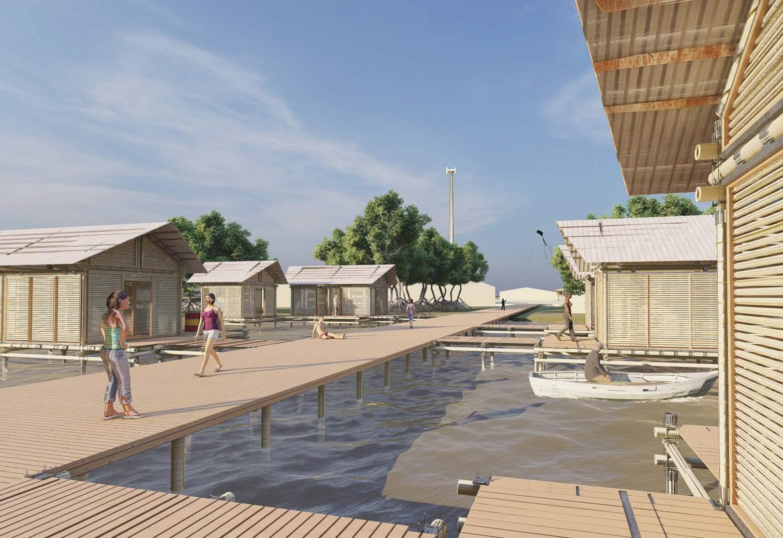
The dwellings would all be interconnected by a series of walkways, that would serve as pedestrian infrastructure, just like on it’s predecessors. The main road of said walkways would connect the residential zone with the Plaza, the community component of the settlement, located on dry land alongside the river, where programmatic buildings would be located, like the school, the church, and the market, which consolidate the communal aspect of the settlement, and would provide the residents with services. One of the plaza’s flanks would be touching the water, in the shape of a marina, allowing products and people to be ferried in and out of the community itself. The plaza with it’s marina would serve as the receiving point of the community to the external world.
The economic components, in the shape of agricultural and fish farms would be connected to the plaza both by land and water. In the case of both farms, clean water as a constant resource is needed, specially in the case of fish farms. Said fish farms would have next to them the basic component of modern operations of the same nature, such as hatcheries, growing ponds, and storage areas. Next to them, touching the riverine waters, docks would allow produce to be sold in the big cities to be easily shipped off. In the case of the agricultural farms, a varied array of vegetables, fruits, grains, and other vegetable species could be cultivated by the inhabitants, for both local and outside consumption. Pedestrian roads would simultaneously connect them to the plaza, the center and fulcrum of circulation throughout the settlement.
The idea is to create a closed circle system that is able to make the prototype settlement a self-sustaining one, able to provide economic and social resilience to the Añu people. It is to be noted that to make viable the planning and execution of all the aforementioned mechanisms, further consultation with professional experts in the areas of agriculture, aquaculture, and anthropology would be needed.
If the prototype settlement proves viable, it could be the first of many future settlements alongside the rivers.
The urban fabric of the prototype settlement is one that could happen in many shapes and forms. Perhaps it develops in a Linear Fashion (A), like the fabrics observed in Ceuta de Agua and Tomoporo, where a central street connects all the neighbors together. Perhaps it could occur in the shape of Finger Neighborhoods (B), like the ones observed in very water-connected settlements in the state of Florida, such as Clearwater and Cape Coral. In such scenario, parallel streets would develop alongside a central main artery. It is very likely however, that the most plausible scenario is one in which the urban fabric starts from a linear (A) or finger neighborhood (B) but grows organically in a fabric (C) made out of shapes and forms that a planner’s vision maybe does not account for, as necessity, social and familial grouping occurs as the settlement, alongside its population grows. After all, the waters settlements always have had a self-built and self-organized nature, which should be respected and accounted for.
Adaptability and change are embraced, looking forward, into the future...
Venezuela, which opens the opportunity for the stilthouse communities to spearhead what could be a profitable and reinvigorating activity for the region, and the country.
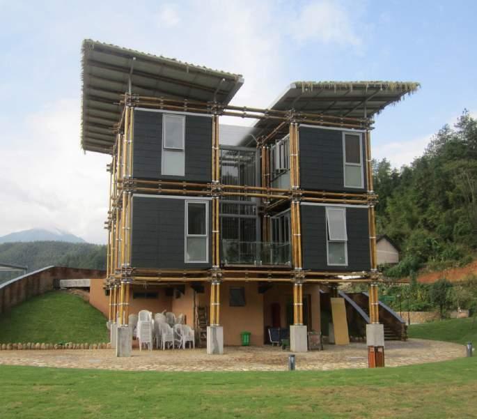
Part of the design intent is the conceptualization of a 21st century stilthouse model, capable of being sustainable in terms of economy and climate, and capable of providing resiliency to its users.
Some of the observed benefits of the material include, but are not limited to:
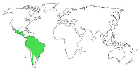
One material in particular stands out as a good candidate, the Guadua genus of bamboo, part the neo-tropical group of woody bamboos, commonly found throughout Central and South America. It’s habitats include lowland tropical forests, which makes it compatible with the ecosystem of the site.
It is sought after for its versatility, flexibility, lightness, strength, hardness, endurance and aesthetic appeal.
It is undemanding, fast growing and virtually pest free. It has a growing number of consumers, most notably in Europe and North America.
It is widely used as a construction material in countries like Colombia, Ecuador, and Brazil, where it is used as a structural and decorative material for both buildings and furniture. In Ecuador specifically, it has become a source of revenue for rural communities that grow it and sell it for profit. Operations like Central del Bambú Andoas (CENBA, “Nu Tenka Pa’ Ki” Demonstrative Bamboo Farm, Guambu, and the Regeneration Field Institute are just but examples of organizations that have incurred in such practices, demonstrating the economic viability and the architectural versatility of the material.(permatree.org)
It is fast growing, with some species growing at a rate of up to 100cm in 24 hours. This makes bamboo a good alternative to using hard timbers that have taken decades to grow.
Can be grown on site.
Currently, there are no operations of this nature in
Figure 95: Guadua bamboo logs ready after threatment, ready to be used
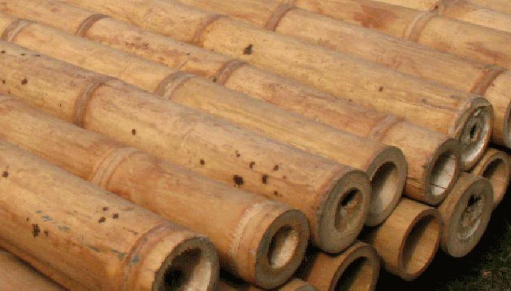
Figure 96: Distribution of neotropical woody bamboos, in which Guadua is included
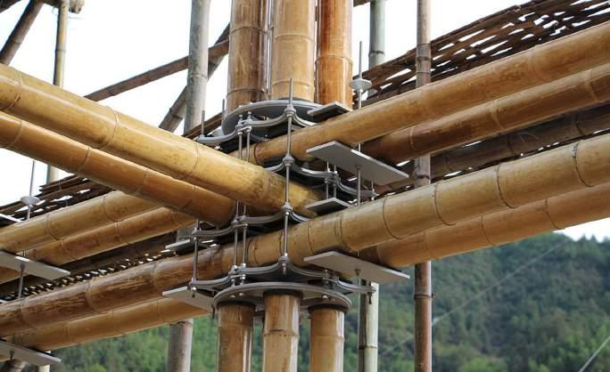
In the quest of finding precedents of dealing with the bamboo logs structurally and aesthetically, Studio Cardenas Conscious Design’s Energy Efficient Bamboo House in Baoxi stood out to me as a designer. They were also dealing with the concept of incorporating a naturally available, low carbon emitting, material, like bamboo, into an industrialized market, giving room to modularity to play a key role in the architecture.
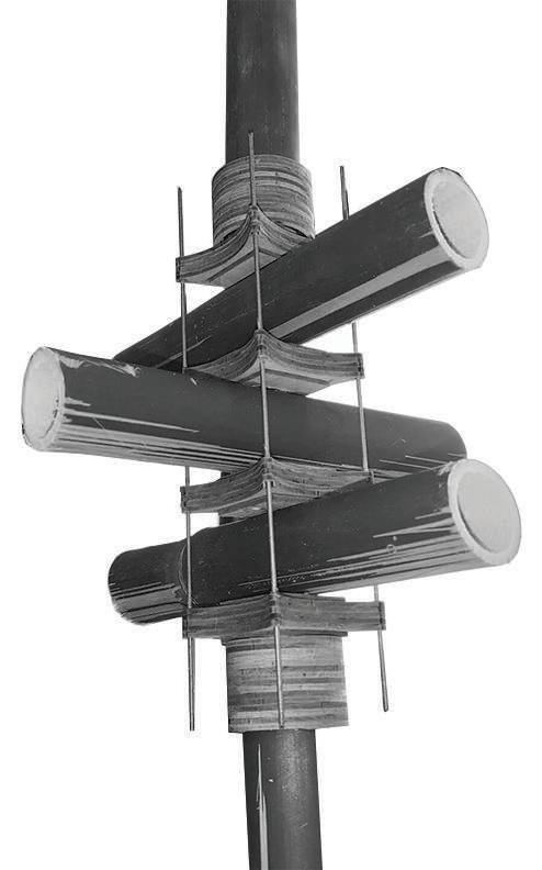
Cardenas’ approach to designing joints and structures with the material is something to be emulated, as to preserve the self built nature and local tradition of the houses of the community.
For Studio Cardenas, sustainability ”is not only the use of natural materials such as bamboo but to design appropriate construction solutions: Designing dry-mounted connections not to weaken bamboo through perforation nor fill it in with concrete, and also to allow the replacement of bamboo poles if needed.”(ArchDaily, 2017)
Thinking about maintenance and understanding the nature of the material is something that is paramount to making sustainable architecture wholeheartedly sustainable.
Studio Cardenas also found out throughout the design process that making the architecture modular in nature, standardizing the pieces, reduced construction costs, optimized good quality control, and achieved an harmonious aesthetic impact.
One of the aspects of the architecture of the house that became extremely relevant was the intent of making it’s assembly relatively easy, so that local workers could do it swiftly on site. Since the stilt houses of Lake Maracaibo are built by members of the community, I found that Studio
This project served as an example of what modularity and standardization, joined by the use of local sustainable materials, can look like, and the result is beautiful and functional architecture available at low costs.
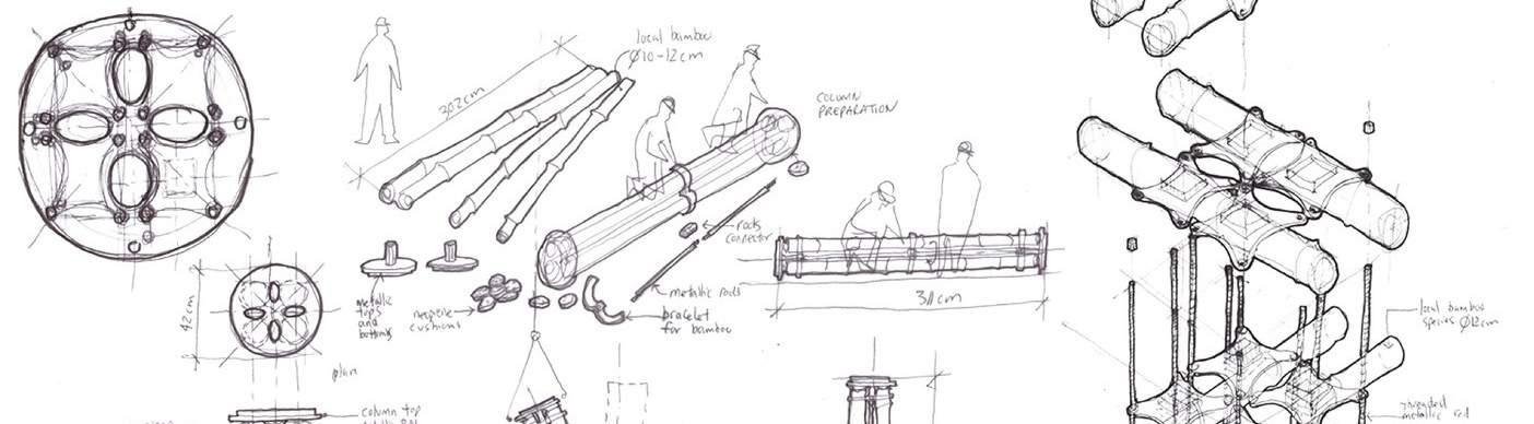
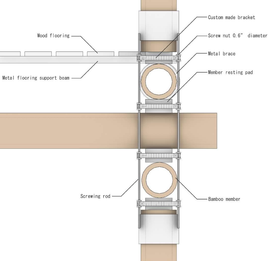
In order to get familiar with the material, scaled down physical model was developed using bamboo members, in a structural composition inspired by the joints created by Studio Cardenas. The aim was to understand the nature material, its flexibility, and easiness to cut; and to conceive ways of connecting the bamboo members without the need of piercing them, in order to not compromise the material’s structural integrity. The would-be-metal members were simulated with wood and tied together with piano wires, which simulated screw rods.
The joint created in the experiment was carried out into the final design of the new stilt house model.
Being the design of the whole prototype community a task that would require more time than the one allotted for this Master Research Project, and the imperative need of consultants, the scope of a final design for this body of work will focus on the development of a first phase, focused on the dwelling...
The idea behind the materials that compose the structure of the prototype dwelling is that the standardized pieces not made out of bamboo, which would have to be composed by corrosion resistant metals instead, could be mass produced in foundries and workshops in the local industrial and commercial hub, the city of Maracaibo, and then shipped off as part of a building kit to the New Water Settlements, in the rivers of the Southwestern regions of the Lake. All bamboo components would be grown and harvested on site, on the agricultural farms, where Guadua would be harvested for local buildings’ construction, and for selling and shipping to other regions in and out of Lake Maracaibo, profiting the inhabitants.
affordable and sustainable for an emerging local economy. The use of a locally, fast grown material, like bamboo also contributes to diminishing the carbon footprint and cost of construction, all in efforts to keep that respect and harmony with the environment which are values of the Añu culture.
All the manufactured pieces would be standardized and cataloged, so that the inhabitants of the water settlements could order them easily as a kit. The standardization of pieces also diminish their cost of manufacture, making them
Figure
A would-be-manufactured
the
Figure 104: Possible relationships of the New Water Settlements with existing towns and cities around Lake Maracaibo, specially with Maracaibo, the regional capital, were the manufactured metal pieces of the structural system would be
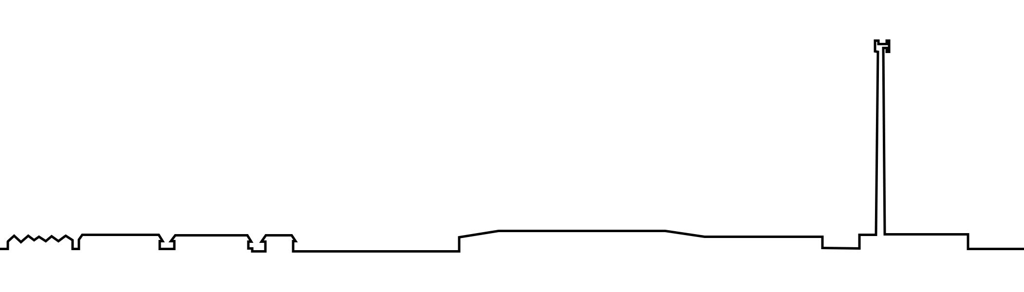
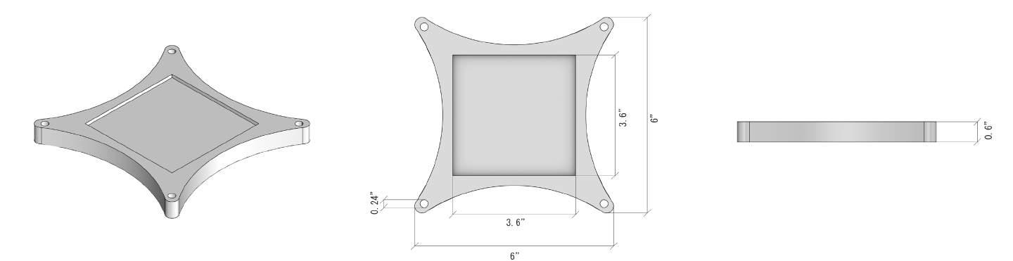
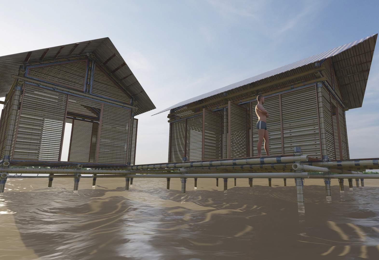
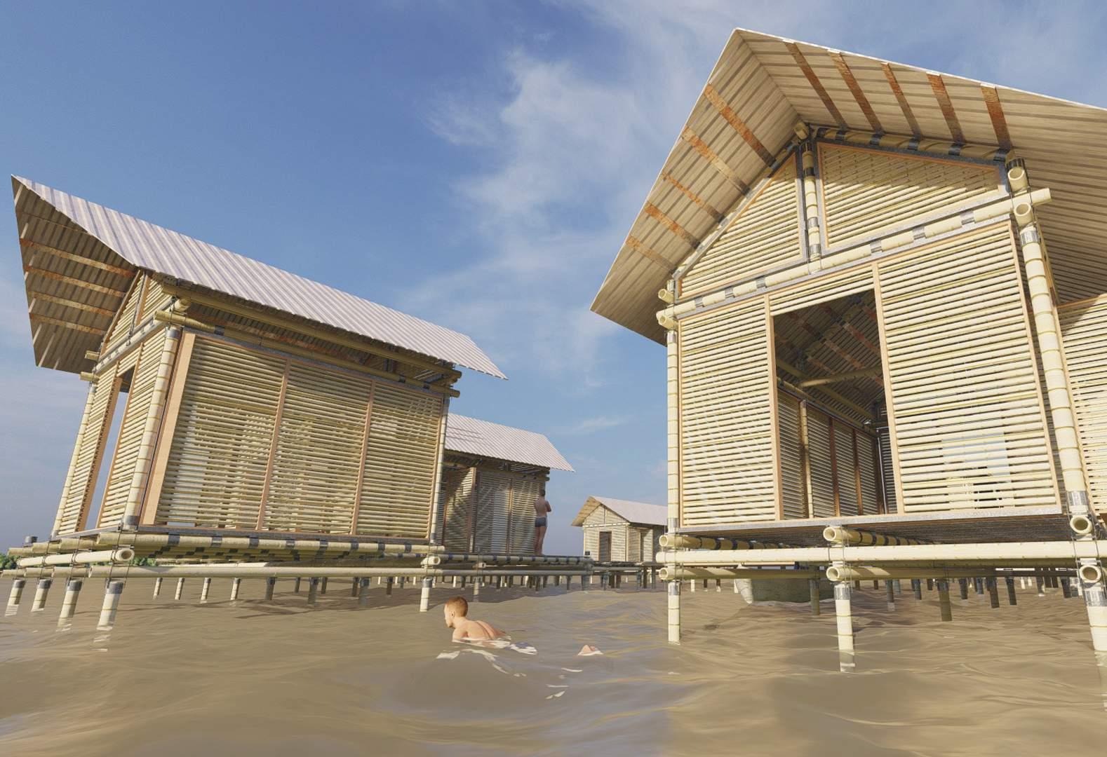
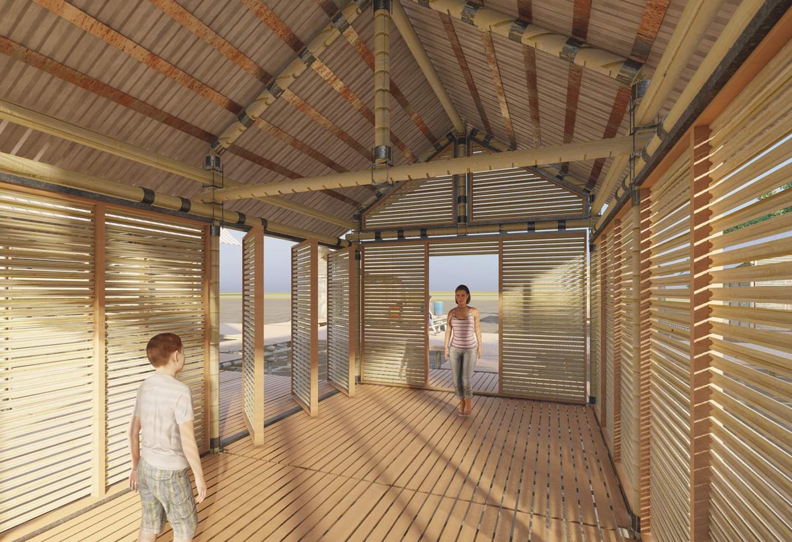
The system of construction in which the dwelling is built consists of a modular system that starts with an initial platform, assembled on site on the water, keeping the stilt house nature of the traditional vernacular. The platform would then receive the structure of the house, inspired by bamboo scaffolding, on which the enclosure systems would be attached. The shape of said structural system consists on a modern reinterpretation of the traditional structural system of the stilt house, with columns on the four corners of the dwelling module, which hold the beams that support a two-pitched roof. The morphology of the modern model attempts keep the silhouette of the traditional stilt house, to make it both familiar and recognizable to both it’s inhabitants and the Zulian public.
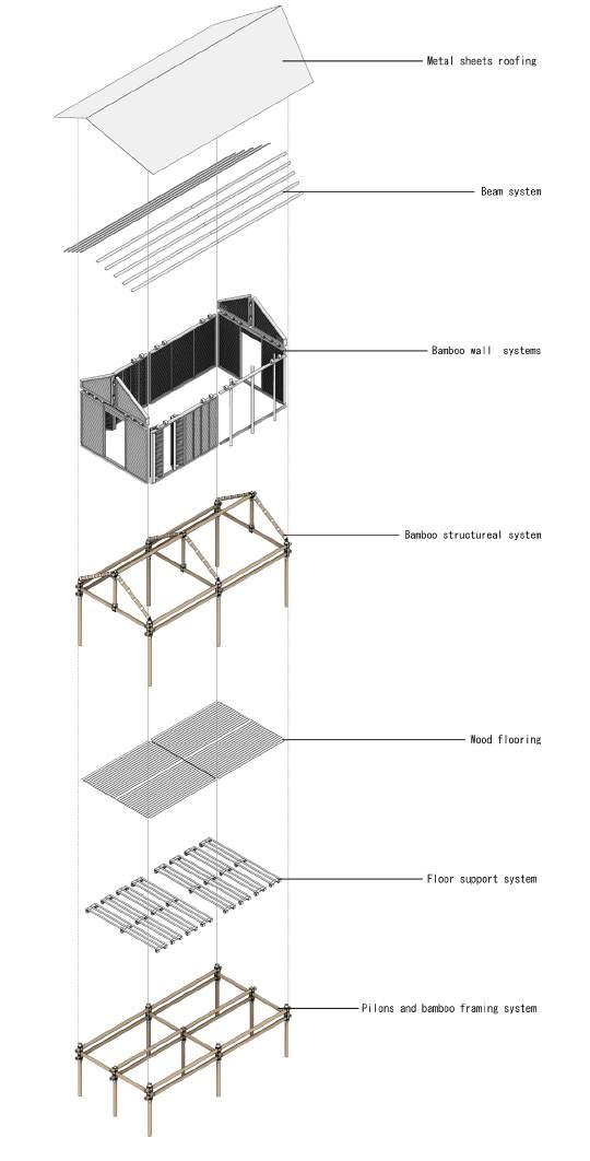
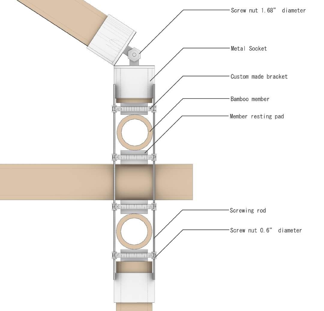
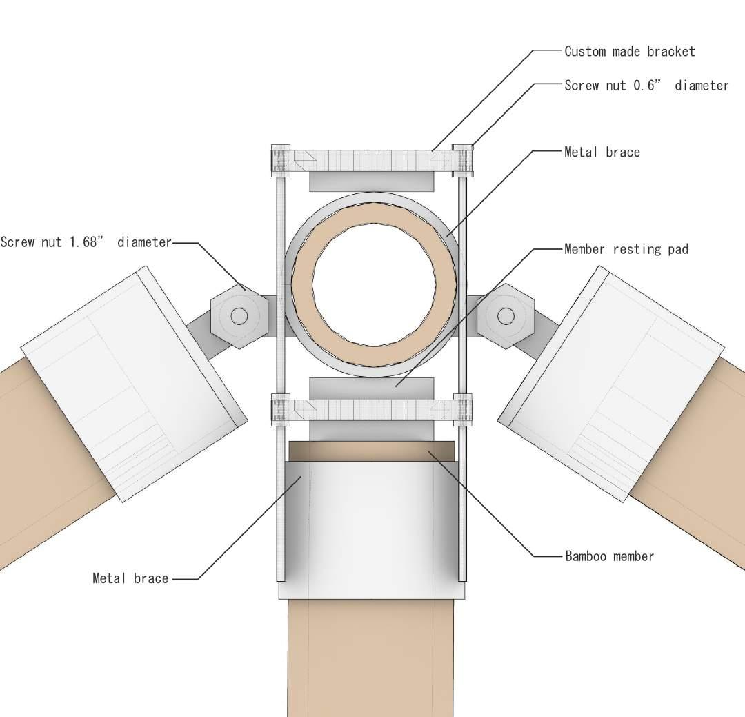
A great amount of effort was put into the joints that make the house’s structure. The intention was not to pierce the bamboo members, instead choosing a pressure-based locking mechanism, akin to the one used by Studio Cardenas in the Baoxi Energy Efficient Bamboo House, in order to make their assembly easy and swift for the local people of the water settlements. The joints consist on bamboo members on different axes resting on top of each other, tightly secured by screw rods and nuts mechanisms. These joints happen where the flooring platform meets the stilts, where the columns meet the beams that hold the roof, and on the roof’s ridge.
Figure
Structural System Exploded
View
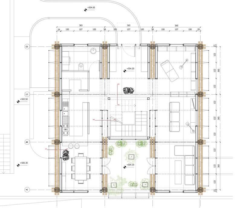
The principles of the aforementioned structural systems are used on the design to compose a modular system that is able to give room to it’s users to replicate the myriad of housing compounds studied on the research portion of this project.
subdivide it however they deem necessary. The intention of the design is not to tell the story that every human tailors for himself/herself inside the microcosm of the dwelling, but rather provide the stage in which said story can be narrated.
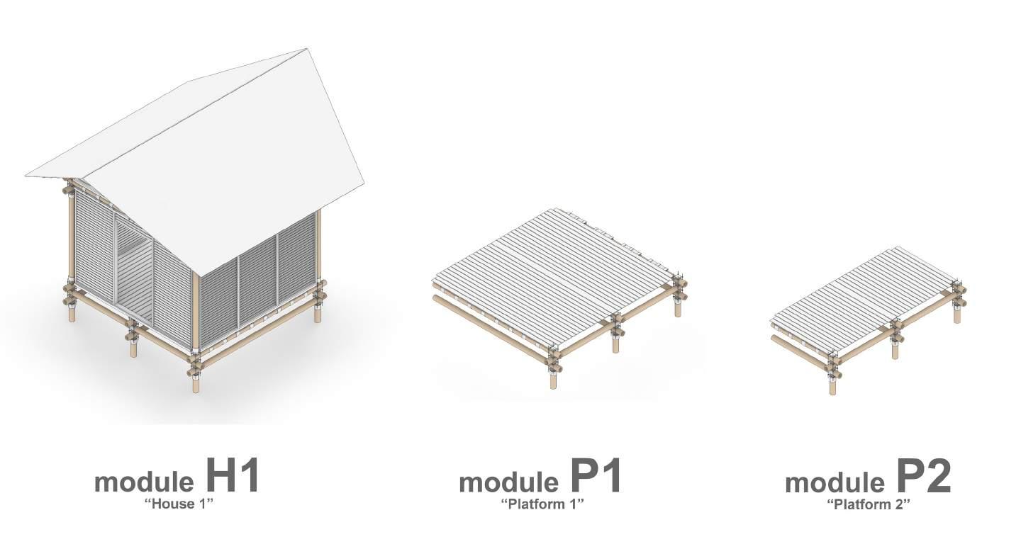
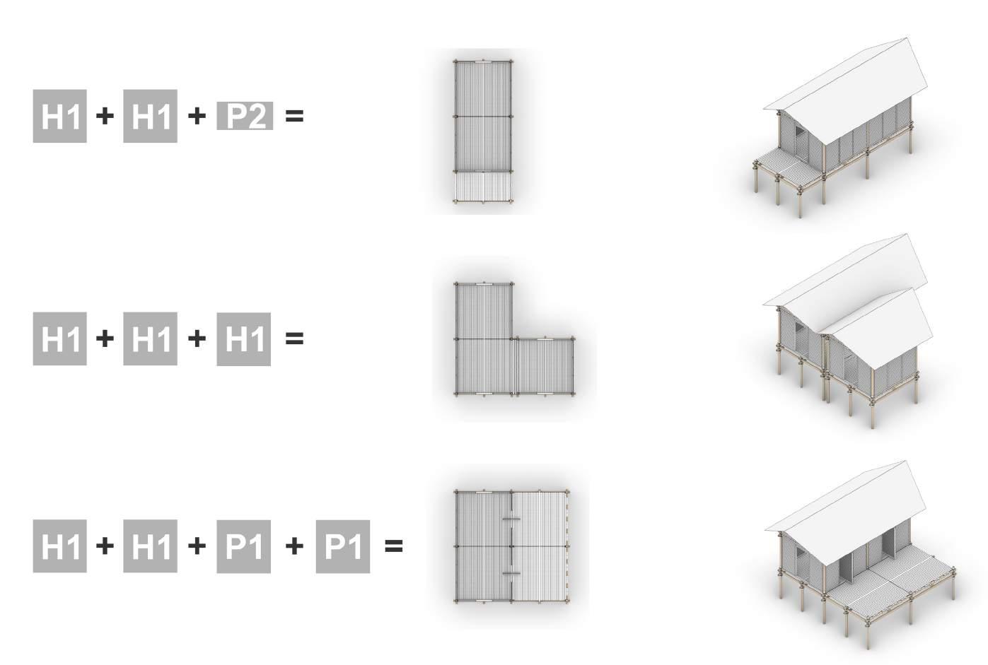
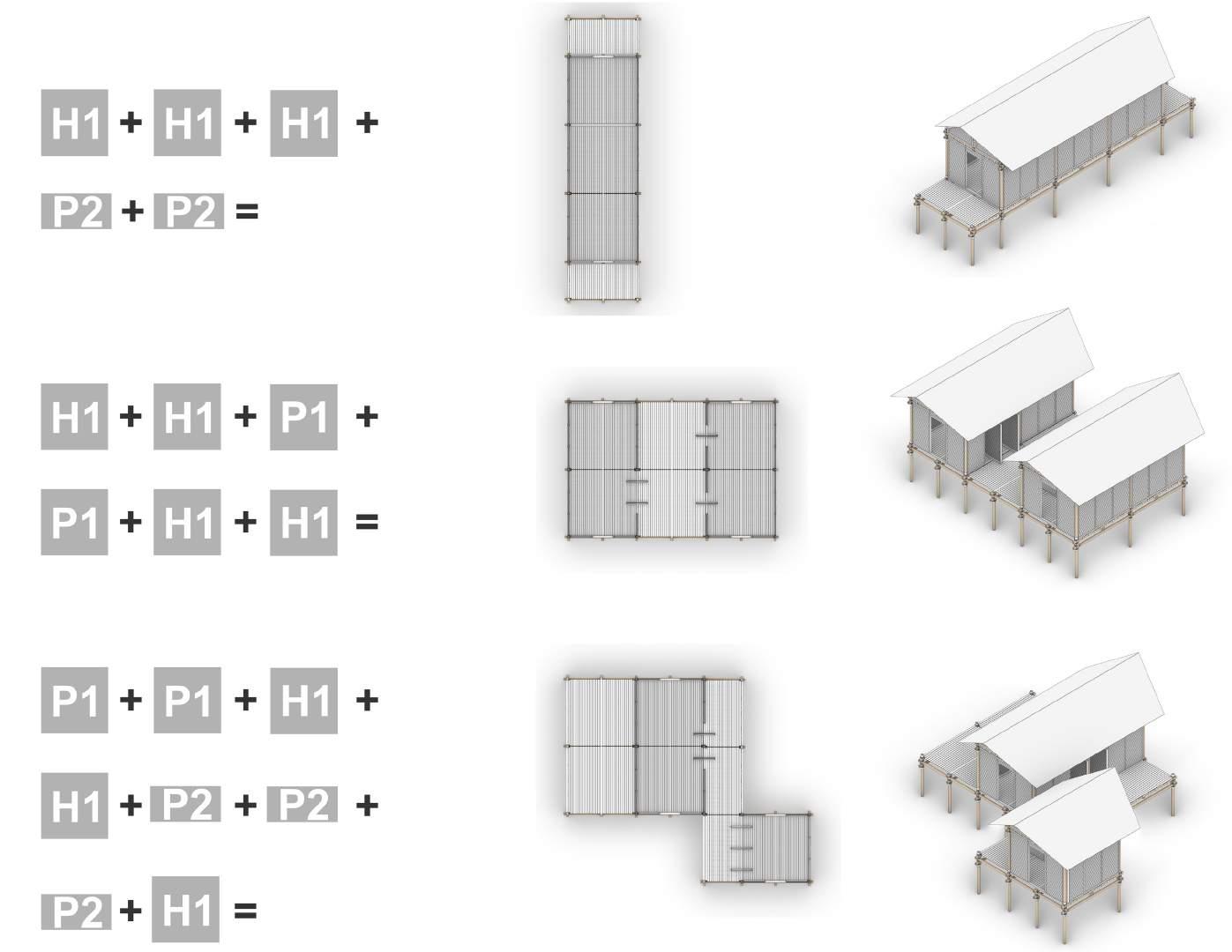
The main module is the housing module H1, also known as ”House 1” module. This module possesses a flooring system, as well as enclosed boundaries with both walling and roofing systems attached to it’s structural members. This module could be joined with others of its kind on any of its sides, expanding the interior habitable space of the dwelling. This also allows the dwelling to grow over time as the users’ desires and needs evolve.
The possibilities that the created modular system allows are many, and the limitations are up to the users and their needs. The results can vary from elongated dwellings, to compounds of several housing units joined together in order to house several nuclei of a same family.
Aiding the H1 module are the P1 and P2 modules, ”Platform 1” and ”Platform 2” respectively. These modules consist of platforms built with the same system of construction. P1 aims to serve the purposes that the enramada and the planchada serve in the traditional stilt house, that is, of being the place were cargo is loaded and unloaded, were fishermen tend their nets, and were boats are docked. The P2 module is narrower than its P1 counterpart, due to its more circulatory nature, serving more as a walkway rather than a place to stop or work.
Users can fully customize the interior of the dwelling, and
Figure
of the developed
of
Figure
compound
that could be created
the different modules of the developed system of construction
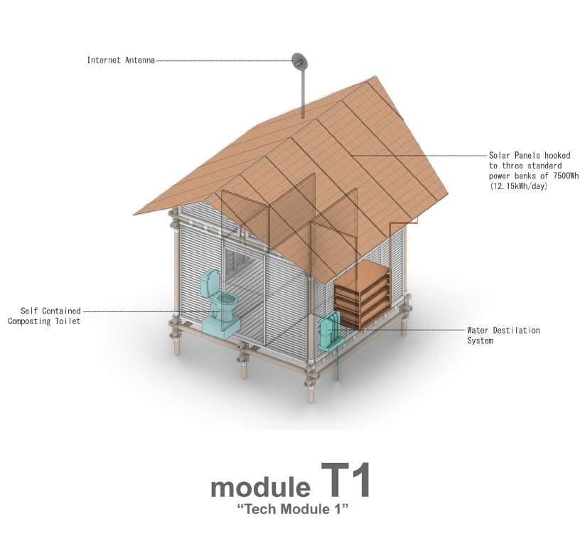
As previously stated, one of the issues that many stilt house settlements present is the lack of basic infrastructure, Following the conclusions of David Gouverneur’s work, providing basic infrastructure such as electricity, potable water, processing of residual waters, and access to the Internet, which is a paramount resource in the XXI century, since it allows every voice to be heard and every bit of information to be reachable.
kitchens, small TVs, light-bulbs, and mobile devices’ charging ports.
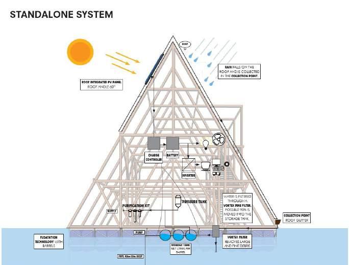
The ”Tech Module 1”or module T1, aims to be an additional module that could be attached to any of the dwelling compositions previously displayed, bringing that reach of the XXI century to the inhabitants of the water settlements.
- Potable Water: Drinking water can be easily accessible with the aid of a home water distillation system, that could make the water of the river available and optimal for human consumption.
There are four basic infrastructure services that the T1 module aims to provide to each individual dwelling compound: - Electricity: With the aid of the engineer Luis Suberviola as an external consultant, calculations were made to determine the capacity of energy production of the 30 square meters of roof of the module. It was determined that with three standard power banks of 7500Wh, the 30 square meters of roof worth of solar panels could generate 12.15 kWh per day, which is enough to support a limited, but significant amount of house appliances, such as electric
- Residual Water Treatment: Self-contained composting toilets could prevent the disposal of organic waste into the waters that surround the community.
- Internet Access: Internet could reach each dwelling with the aid of small antennas that would link up with a central receiving antenna in the plaza area of the prototype community, allowing each household to communicate with the world.
One of the features of the modular system created for the XXI century stilt house model is the possibility for personal customizations. The wall system aims to be an operable one, allowing cross-ventilation for cooling the inside of the dwelling, being able to be controlled by the users. An array of possibilities can be chosen by the users, giving them different ways of having openings to allow the outside into the inside, in terms of both breeze and views. Users could also choose to create their own wall system, understanding that the house is man’s own stage for life-long storytelling.
The wall systems created as options are all developed from bamboo systems of construction, making the most out of the different scales in which this construction material comes in.
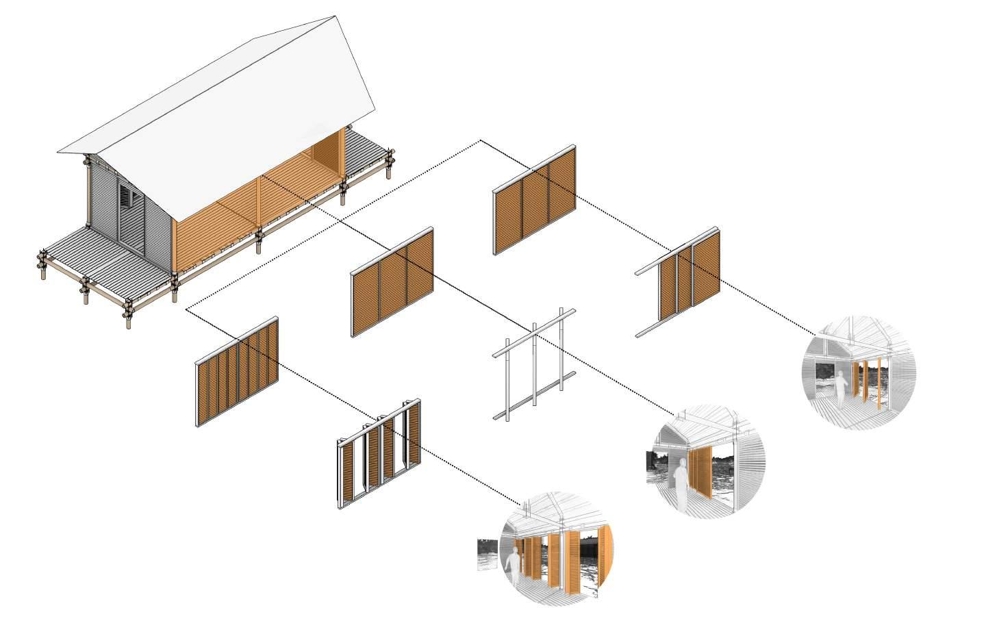
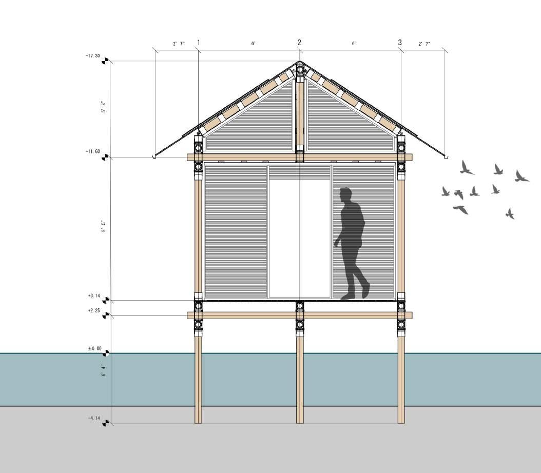
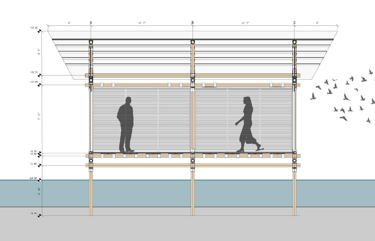
Figure 113: Initial platform built in place alongside the main street of the settlement’s residential fabric, were eventually the strucutre of the house will be raised, and possible annexes will be added
The lifestyle of the water settlements of Lake Maracaibo is one that has proven to be valid, resilient, and capable of adaptation; possessing values that are worth preserving, specially in this day and age, were our approach to interacting with water through our built environment is on the verge of being redefined. Living in tune with the natural medium, respecting and revering our bodies of water, not taking more than we need from our environment, and conceiving architectural expressions made with local materials are values that could make a difference in how we tackle, as a species, current and future challenges related to climate change, sea level rise, and sustainability in a post-industrial world.
Despite living so close to them throughout my youth, the research performed for this body of work has thought me so much that I did not know about the Añu, their architecture, and their values. I feel humbled to the point of developing reverence for a culture that has been able to keep their traditions and lifestyle throughout so many centuries, being sustainable and resilient, and it is my wish and hope that they can keep enduring for many centuries more, evolving and adapting in their own way towards the future.
As an architectural designer, I hope that the ideas developed in this body of work are able to keep inspiring that adaptability and ability to change that characterizes the water settlers. I also hope that said ideas can keep evolving, getting refined with time. Phases II and III, the social component made of the plaza, and the economic component made out of the fish farms and agricultural farms, respectively, are the next step in the design of the scheme that conforms the prototypical new water settlement. Optimistically, in the future, they can be fully conceived and defined by either myself, or another enthusiastic young designer, who hopefully will find value in the water settlements, and their creators, the Añu.
As a Zulian, I hope that these ideas are only the start of a long conversation, one that could perhaps reach back home, and even bigger stages in the world, were the knowledge and values of the Añu can be shared and discussed...
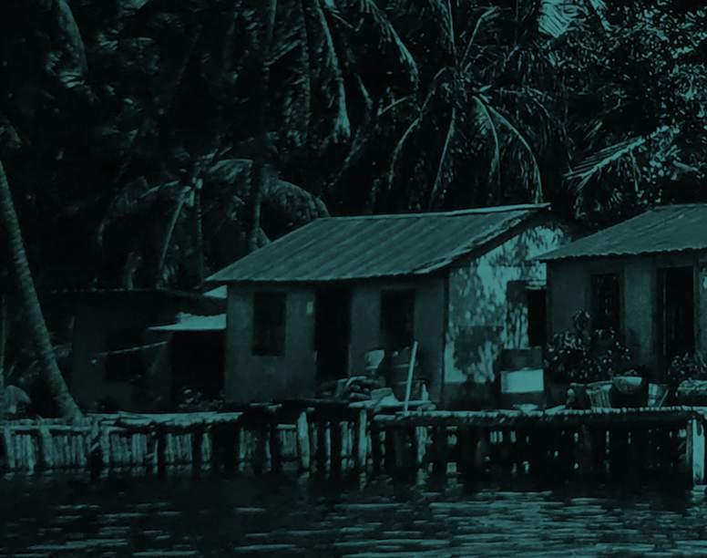
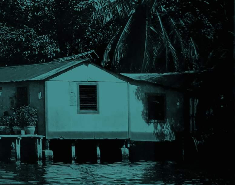
Aguado, Fray Pedro de. Historia de Venezuela. Tome 1. Madrid: Imprenta y Editorial Maestre. 1950.
Berg, Ryan. Tahtinen, Lauri. Venezuela’s Maduro Should Be Tried for Ecocide. FP. 14 May 2021. https://foreignpolicy. com/2021/05/14/venezuela-ecocide-maduro-icc/. Accessed 16 November 2021.
Britannica, The Editors of Encyclopaedia. Lake Maracaibo. Encyclopedia Britannica, 17 Feb. 2020, https://www.britannica. com/place/Lake-Maracaibo. Accessed 1 November 2021.
Carlowicz, Michael. Troubled Waters. NASA Earth Observatory. NASA. 25 Sep. 2021. https://earthobservatory.nasa.gov/ images/148894/troubled-waters. Accessed 16 November, 2021.
Codazzi, Agustin. Atlas fisico y político de la Republica de Venezuela. Paris: Lith. de Thierry Freres. 1840.
Ducamme, Guillaume. Lake Maracaibo: olluted by a permanent black tide. Phys.org. 3. Oct. 2019. https://phys.org/ news/2019-10-lake-maracaibo-polluted-permanent-black.html Accessed 16 November, 2021.
Energy Efficient Bamboo House / Studio Cardenas Conscious Design [Energy Efficient Bamboo House / Studio Cardenas Conscious Design] 13 Apr 2017. ArchDaily. Accessed 13 Apr 2022. <https://www.archdaily.com/868926/energy-efficientbamboo-house-studio-cardenas-conscious-design> ISSN 0719-8884
Gasparini, Graziano., and Luise. Margolies. Arquitectura indígena de Venezuela. 1. ed. Caracas: Editorial Arte, 2005. Print.
Goerin, Anton. La Goajira. In Cuadernos Personales de Aristides Rojas. Caracas: Biblioteca Nacional. 1870.
Gouverneur, David. Planning and Design for Future Informal Settlements: Shaping the Self-Constructed City. 1st ed., Routledge, 2018.
Gutierrez, Pepe. Haciendo Surf En El Lago Maracaibo. Flickr, 6 Apr. 2005, https://www.flickr.com/photos/ pgutierrez/7334992484/. Accessed 15 November 2021.
Liddle, Ralph Alexander. The Geology of Venezuela and Trinidad. 2d ed., rev. and enl. Ithaca, N.Y: Paleontological Research Institution, 1946. Print.
Kabaru, Christopher. “Exploring Existing Bamboo Operation in Coastal Ecuador.” GaiaVerso, 24 Nov. 2020, https://www. permatree.org/bamboo/exploring-existing-bamboo-operation-in-coastal-ecuador/.
Makoko Floating School / NLÉ. (n.d.). Accessed February 15, 2021, from https://www.archdaily.com/344047/makoko-floatingschool-nle-architects
Mann, Paul., Escalona, Alejandro. Regional Geologic and Tectonic Setting of the Maracaibo Supergiant Basin, Western Venezuela. AAPG Bulletin, American Association of Petroleum Geologists, 1 Jan. 1970, https://archives.datapages.com/ data/bulletns/2006/04apr/BLTN05031/BTLN05031.HTM?doi=10.1306%2F10110505031.
Maracaibo City and Oil Slick, Venezuela. NASA Earth Observatory. NASA. 23 February, 2007. https://earthobservatory.nasa. gov/images/7848/maracaibo-city-and-oil-slick-venezuela. Accessed 16 November. 2021
Martin, Esteban. “Relaciones diversas relativas a la expedición de Ambrosio Alfinger. 9 de junio de 1531, hasta el 2 de noviembre de 1533”. In Descubrimiento y conquista de Venezuela: Textos históricos contemporáneos y documentos fundamentales. Pp. 51-337. Caracas: Biblioteca de la Academia Nacional de la Historia, Fuentes para la Historia Colonial de Venezuela, vol. 55. 1962.
Prado, Rafael, et al. “Ceuta: Espacio e Identidades En Un Pueblo De Agua.” Opcion, vol. 25, no. 58, Apr. 2009, http:// ve.scielo.org/scielo.php?script=sci_arttext&pid=S1012-15872009000100006. Accessed 28 Sept. 2021.
Preserving Our Place: A Community Field Guide to Engagement, Resilience, and Resettlement: Community Regeneration in the Face of Environmental and Developmental Pressures. Tribal Resettlement, 2019, https://static1.squarespace.com/ static/5672cfb1d82d5e366e753691/t/5dfc077ef8a68c27967cc40c/1576798088266/FINAL+FIELD+GUIDE+reduced.pdf. Accessed 19 Apr. 2022.
Schröder, Stéphane. “What Is Guadua Angustifolia?” Guadua Bamboo, Guadua Bamboo, 9 Nov. 2021, https://www. guaduabamboo.com/blog/what-is-guadua-angustifolia. Accessed 13 April, 2022.
Vila, Marco Aurelio. Antecedentes coloniales de centros poblados de Venezuela. Caracas: Universidad Central de Venezuela, Facultad de Humanidades. 1978.
Wagner, Erika. Los pobladores palafíticos de la Cuenca de Maracaibo. Caracas: Cuadernos Lagoven, 1980.
Wilbert, Johannes. “Los Añu (Paraujano).” In Etnología contemporánea. Vol. 2, edited by Roberto Lizarralde and Haydée Seijas, 15-32. Los aborígenes de Venezuela, edited by Walter Coppens and Bernarda Escalante. Monograph no. 29. Caracas: Fundación La Salle de Ciencias Naturales, Instituto Caribe de Antropología y Sociología, 1983.
All figures in this project not listed below were created by the author.
3. Sandoval Bavaresco, Luis Eduardo. “Santa Rosa De Agua.” Flickr, 27 July 2007, https://www.flickr.com/photos/ luismanati/911906400. Accessed 18 Apr. 2022.
4. Cobo Buschbeck, Dagne. “Sinamaica: La Magia Del Pueblo De Agua.” FOTOS | Sinamaica: La Magia Del Pueblo De Agua, El Estimulo, 12 Oct. 2017, https://elestimulo.com/fotos-sinamaica-la-magia-del-pueblo-de-agua/. Accessed 18 Apr. 2022.
5. Oscarnav. “Palafitos En El Lago De Maracaibo.” File:Palafitos Lago De Maracaibo.jpg, Wikimedia Commons, 16 Oct. 2011, https://commons.wikimedia.org/wiki/File:Palafitos_Lago_de_Maracaibo.jpg. Accessed 19 Apr. 2022.
6. “Lake Maracaibo Topographic Map, Elevation, Relief.” Lake Maracaibo, https://en-us.topographic-map.com/maps/d06k/ Lake-Maracaibo/. Accessed 19 Apr. 2022.
7. “STS51F-46-77.” Earth from Space - Image Information, NASA, Aug. 1985, https://eol.jsc.nasa.gov/Collections/ EarthFromSpace/printinfo.pl?PHOTO=STS51F-46-77. Accessed 19 Apr. 2022.
8. Codazzi, Agostino. “Provincia De Maracaibo.” David Rumsey Historical Map Collection, David Rumsey Historical Map Collection. David Rumsey Map Collection, https://www.davidrumsey.com/luna/servlet/detail/RUMSEY~8~1~20072~590065:Provincias-de-Maracaibo,-Coro-y-Me?sort=Pub_Date%2CPub_List_No%2CSeries_No&qvq=q:Codazzi%20Agustin%201793%20 1859;sort:Pub_Date%2CPub_List_No%2CSeries_No;lc:RUMSEY~8~1&mi=16&trs=67. Accessed 19 Apr. 2022.
10. Gouverneur, David. “Informal Armature.” Planning and Design for Future Informal Settlements: Shaping the SelfConstructed City, 1st ed., Routledge, 2018.
11. Gouverneur, David. “The Informal Armatures.” Planning and Design for Future Informal Settlements: Shaping the Self-Constructed City, 1st ed., Routledge, 2018.
12. “Isle De Jean Charles.” Preserving Our Place: A Community Field Guide to Engagement, Resilience, and Resettlement: Community Regeneration in the Face of Environmental and Developmental Pressures, Isle De Jean Charles, 2019, https://static1.squarespace.com/static/5672cfb1d82d5e366e753691/t/5dfc077ef8a68c27967cc40c/1576798088266/ FINAL+FIELD+GUIDE+reduced.pdf. Accessed 19 Apr. 2022.
13. “Time and Space Chart.” Preserving Our Place: A Community Field Guide to Engagement, Resilience, and Resettlement: Community Regeneration in the Face of Environmental and Developmental Pressures, Isle De Jean Charles, 2019, https://static1.squarespace.com/static/5672cfb1d82d5e366e753691/t/5dfc077ef8a68c27967cc40c/1576798088266/ FINAL+FIELD+GUIDE+reduced.pdf. Accessed 19 Apr. 2022.
14. Photography NLÉ. “Makoko Community.” Makoko Floating School, NLÉ, 2012, https://www.dropbox.com/ sh/4tn551o5181b5rd/AABGu_7GJVOqcv-aA0RJCOC8a?preview=120420_Makoko_Research_Document_NLE.pdf. Accessed 19 Apr. 2022.
15. Photography NLÉ. “Makoko Floating School 9Prototype I).” Makoko Floating School, NLÉ, 2012, https://www.dropbox. com/sh/4tn551o5181b5rd/AABGu_7GJVOqcv-aA0RJCOC8a?preview=120420_Makoko_Research_Document_NLE.pdf. Accessed 19 Apr. 2022.
16. NLÉ. “Floating Community.” Makoko Floating School, NLÉ, 2012, https://www.dropbox.com/sh/4tn551o5181b5rd/ AABGu_7GJVOqcv-aA0RJCOC8a?preview=120420_Makoko_Research_Document_NLE.pdf. Accessed 19 Apr. 2022.
17. NLÉ. “Standalone System.” Makoko Floating School, NLÉ, 2012, https://www.dropbox.com/sh/4tn551o5181b5rd/ AABGu_7GJVOqcv-aA0RJCOC8a?preview=120420_Makoko_Research_Document_NLE.pdf. Accessed 19 Apr. 2022.
18. Gaestel, Allyn. “A Resident Looking at the Collapsed School in Makoko, Nigeria.” The Story behind Kunlé Adeyemi’s Makoko Floating School Collapse, Archinect, 2 Mar. 2018, https://archinect.com/news/article/150052644/the-story-behindkunl-adeyemi-s-makoko-floating-school-collapse. Accessed 19 Apr. 2022.
19. Plan b: arquitectos. “Section B.” Embera Atrato Medio School / Plan:b Arquitectos, ArchDaily, 2014, https://www. archdaily.com/557120/embera-atrato-medio-school-plan-b-arquitectos. Accessed 19 Apr. 2022.
20. Alejandro Arango. “Untitled.” Embera Atrato Medio School / Plan:b Arquitectos, ArchDaily, 2014, https://www. archdaily.com/557120/embera-atrato-medio-school-plan-b-arquitectos. Accessed 19 Apr. 2022.
21. Julian Castro. “Untitled.” Embera Atrato Medio School / Plan:b Arquitectos, ArchDaily, 2014, https://www. archdaily.com/557120/embera-atrato-medio-school-plan-b-arquitectos. Accessed 19 Apr. 2022.
22. Plan b: arquitectos. “Site Plan.” Embera Atrato Medio School / Plan:b Arquitectos, ArchDaily, 2014, https://www. archdaily.com/557120/embera-atrato-medio-school-plan-b-arquitectos. Accessed 19 Apr. 2022.
23. NASA. “Maracaibo City and Oil Slick, Venezuela.” NASA Earth Observatory, NASA, 2007, https://earthobservatory. nasa.gov/images/7848/maracaibo-city-and-oil-slick-venezuela. Accessed 19 Apr. 2022.
24. Decamme, Guillaume. “Oil Pollution in the Lake Has Left Water Poisoned.” Lake Maracaibo: Polluted by a Permanent Black Tide, Phys.org, Oct. 2019, https://phys.org/news/2019-10-lake-maracaibo-polluted-permanent-black.html. Accessed 19 Apr. 2022.
25. NASA. “Troubled Waters.” NASA Earth Observatory, NASA, 25 Sept. 2021, https://earthobservatory.nasa.gov/ images/148894/troubled-waters. Accessed 19 Apr. 2022.
26. CarlosL. “Invasión De La Planta Acuática Lemna Obscura En El Centro Del Estrecho Del Lago De Maracaibo.” Figura 7 - Uploaded by Patricia Urrego, ResearchGate, 10 Oct. 2004, https://www.researchgate.net/figure/Figura-7-Invasion-de-laplanta-acuatica-Lemna-obscura-en-el-centro-del-estrecho-del-lago_fig7_311953823. Accessed 19 Apr. 2022.
27. NASA. “Troubled Waters.” NASA Earth Observatory, NASA, 25 Sept. 2021, https://earthobservatory.nasa.gov/ images/148894/troubled-waters. Accessed 19 Apr. 2022.
28. Contreras, David. Twitter, 28 Sept. 2015, https://twitter.com/davidcontrerasx/status/648655765851516928. Accessed 19 Apr. 2022.
29. Gasparini, Graziano. “Evolucion del Palafito.” Arquitectura Indígena De Venezuela, [Caracas], 1st ed., Editorial Arte, 2005.
30. Unknown Author. “Lake Dwellings of Santa Rosa near Maracaibo.” The Popular Science Monthly, New York, Popular Science Pub. Co., Etc., New York, NY, 1895.
31. Gasparini, Graziano. “Evolucion del Palafito.” Arquitectura Indígena De Venezuela, [Caracas], 1st ed., Editorial Arte, 2005.
32. Unknown Author. “Maracaibo Dwelling. /Nnatives Embarking From A Palafito Dwelling At Lake Maracaibo. Line Engraving, 19Th Century.” n.d.
33. Gasparini, Graziano. “Evolucion del Palafito.” Arquitectura Indígena De Venezuela, [Caracas], 1st ed., Editorial Arte, 2005.
34. Hernandez, Mileska. “En El Caso De Los Indígenas Venezolanos Las Principales Viviendas Como Parte De La Arquitectura Se Trataron De Palafitos Construidas a Partir De La Madera. .” Pinterest, Gabox Toro, https://pin. it/7diHgg9. Accessed 19 Apr. 2022.
35. Gasparini, Graziano. “Evolucion del Palafito.” Arquitectura Indígena De Venezuela, [Caracas], 1st ed., Editorial Arte, 2005.
36. Jons, Andry. “Laguna De Sinamaica, Maracaibo, Venezuela.” Visit Laguna De Sinamaica, Maracaibo, Inspirock, https://www.inspirock.com/venezuela/maracaibo/laguna-de-sinamaica-a2227641775. Accessed 19 Apr. 2022.
37. Gasparini, Graziano. “Evolucion del Palafito.” Arquitectura Indígena De Venezuela, [Caracas], 1st ed., Editorial Arte, 2005.
38. Rodriguez, Misael. “Palafito, Lago De Maracaibo, Venezuela.” Pinterest, https://pin.it/1yV5xWc. Accessed 19 Apr. 2022.
39. Gasparini, Graziano. “Evolucion del Palafito.” Arquitectura Indígena De Venezuela, [Caracas], 1st ed., Editorial Arte, 2005.
40. Gasparini, Graziano. “Estructura de, Palafito.” Arquitectura Indígena De Venezuela, [Caracas], 1st ed., Editorial Arte, 2005.
41. Gasparini, Graziano. “Palafito.” Arquitectura Indígena De Venezuela, [Caracas], 1st ed., Editorial Arte, 2005.
42. Parra, Federico. “View of Stilt Houses in Congo Mirador, Zulia State, Venezuela.” In Venezuela, a Village on Stilts Slowly Succumbs to Mud, EagleNews, 4 Oct. 2021, https://www.eaglenews.ph/in-venezuela-a-village-on-stilts-slowlysuccumbs-to-mud/. Accessed 19 Apr. 2022.
43. Parra, Federico. “The stilt homes in the Venezuelan village of Congo Mirador are now effectively in a swamp with snakes, toads and parasites that are irrevocably changing the ecosystem.” In Venezuela, a Village on Stilts Slowly Succumbs to Mud, EagleNews, 4 Oct. 2021, https://www.eaglenews.ph/in-venezuela-a-village-on-stilts-slowly-succumbs-tomud/. Accessed 19 Apr. 2022.
44. Barrios, Kitsson. Santa Rosa De Agua, Behance, 7 Feb. 2016, https://www.behance.net/gallery/29777977/Santa-Rosa-deAgua/modules/191747119.
45. Parra, Federico. “Aerial view of stilt houses in Congo Mirador, Zulia state, Venezuela.” In Venezuela, a Village on Stilts Slowly Succumbs to Mud, EagleNews, 4 Oct. 2021, https://www.eaglenews.ph/in-venezuela-a-village-on-stiltsslowly-succumbs-to-mud/. Accessed 19 Apr. 2022.
46. Gasparini, Graziano. “Palafito y Planchada” Arquitectura Indígena De Venezuela, [Caracas], 1st ed., Editorial Arte, 2005.
47. Gasparini, Graziano. “Palafito y Anexo del Fogon” Arquitectura Indígena De Venezuela, [Caracas], 1st ed., Editorial Arte, 2005.
48. Parra, Federico. “View of Stilt Houses in Congo Mirador, Zulia State, Venezuela.” In Venezuela, a Village on Stilts Slowly Succumbs to Mud, EagleNews, 4 Oct. 2021, https://www.eaglenews.ph/in-venezuela-a-village-on-stilts-slowlysuccumbs-to-mud/. Accessed 19 Apr. 2022.
49. Arteaga Quintero, Ariana. “Así Se Ven Los Palafitos Sobre Congo Mirador, Otra Población Al Sur Del Lago, Muy Cerca Del Río Catatumbo. Foto: Arianna Arteaga Quintero.” Por Qué La NASA Declaró Al Lago Maracaibo La Capital Mundial De Los Relámpagos, La Opinion, 3 May 2016, https://laopinion.com/2016/05/03/por-que-la-nasa-declaro-al-lago-maracaibo-lacapital-mundial-de-los-relampagos/. Accessed 19 Apr. 2022.
50. Gasparini, Graziano. “Configuraciones Espaciales.” Arquitectura Indígena De Venezuela, [Caracas], 1st ed., Editorial Arte, 2005.
52. Meteoblue. “Wind Rose for the Area of Maracaibo.” Simulated Historical Climate & Weather Data for Maracaibo, Meteoblue, https://www.meteoblue.com/en/weather/historyclimate/climatemodelled/maracaibo_venezuela_3633009. Accessed 19 Apr. 2022.
59. Gutierrez, Pepe. “Aula de maternales e infantil.... obsérvese el mobiliario y las marcas en el suelo de haber subido el nivel del agua en varias ocasiones...“ Haciendo Surf En El Lago Maracaibo. Flickr, 6 Apr. 2005, https://www. flickr.com/photos/pgutierrez/7334992484/. Accessed 15 November 2021.
60. Mirabal, Monica. “Ceuta. Estado Zulia, Venezuela.” Pinterest, https://pin.it/70YYqKP. Accessed 19 Apr. 2022.
62. Cabrita, Yajaira. “Palafitos Ubicados En San Timoteo Capital Del Municipio Baralt.” Puerta De Agua, Blogger, 30 Apr. 2012, http://septimapoesia.blogspot.com/2012/04/palafitos-ubicados-de-san-timoteo.html. Accessed 19 Apr. 2022.
63. AFP. “Incluso, La Caza De Palomas, Conejos, Báquiros o Venados, Antes Una Diversión, Se Realiza Ahora Ante La Imposibilidad De Visitar Las Carnicerías Por Los Altos Precios, Cuentan Pobladores.” Aprender a Pescar y Cazar: El Desafío De Algunos Venezolanos Para Comer [FOTOS], El Comercio, 19 Mar. 2019, https://elcomercio.pe/mundo/venezuela/ crisis-venezuela-aprender-pescar-cazar-desafio-venezolanos-comer-fotos-video-noticia-nndc-618125-noticia/?foto=8. Accessed 19 Apr. 2022.
65. Vicente, Jose. “Tomoporo De Agua.” Lugares Únicos: Tomoporo De Agua. (¿Un Pueblo Flotante?), HiveBlog, 2018, https://hive.blog/spanish/@josevbc/lugares-unicos-tomoporo-de-agua-un-pueblo-flotante. Accessed 19 Apr. 2022.
66. Vicente, Jose. “Un humilde hogar lleno de experiencias divertidas, sabores extraordinarios y gran calidez humana.” Lugares Únicos: Tomoporo De Agua. (¿Un Pueblo Flotante?), HiveBlog, 2018, https://hive.blog/spanish/@josevbc/lugaresunicos-tomoporo-de-agua-un-pueblo-flotante. Accessed 19 Apr. 2022.
68.Parra, Federico. “Iglesia de Congo Mirador” In Venezuela, a Village on Stilts Slowly Succumbs to Mud, EagleNews, 4 Oct. 2021, https://www.eaglenews.ph/in-venezuela-a-village-on-stilts-slowly-succumbs-to-mud/. Accessed 19 Apr. 2022.
69. Piontek, Jonas. “Village of Congo in Venezuela.” A Place Were Lightning Strikes 300 Days a Year, The New York Times, May 2016, https://www.nytimes.com/2016/05/17/science/in-venezuela-the-lightning-capital-of-the-world.html. Accessed 19 Apr. 2022.
71. López, José. “Santa Rosa De Agua.” Santa Rosa De Agua: El Pueblo Que Dio Nombre a Venezuela, Noticia Al Dia, 27 Apr. 2021, https://noticialdia.com/especiales/santa-rosa-de-agua-el-pueblo-que-dio-nombre-a-venezuela/. Accessed 19 Apr. 2022.
72. Contreras, David. Twitter, 28 Sept. 2015, https://twitter.com/davidcontrerasx/status/648655765851516928. Accessed 19 Apr. 2022.
74. Cedeño, Alfredo. Palafitos De El Mojan, Blogger.com, 6 Oct. 2013, http://textosyfotos.blogspot.com/2013/10/palafitosde-el-mojan.html. Accessed 19 Apr. 2022.
75. Cedeño, Alfredo. Palafitos De El Mojan, Blogger.com, 6 Oct. 2013, http://textosyfotos.blogspot.com/2013/10/palafitosde-el-mojan.html. Accessed 19 Apr. 2022.
77. Gasparini, Graziano. “Laguna de Sinamaica.” Arquitectura Indígena De Venezuela, [Caracas], 1st ed., Editorial Arte, 2005.
78. VENEZUELA: ISLA DE TOAS AND THE SWIMMING VILLAGES, Vagabundler, https://vagabundler.com/venezuela/isla-de-toas/. Accessed 19 Apr. 2022.
95. Bambusa Estudio. “GUADUA ANGUSTIFOLIA KUNTH.” BAMBÚ GUADUA, Bambusa Estudio, 2018, https://bambusa.es/ caracteristicas-del-bambu/bambu-guadua/. Accessed 19 Apr. 2022.
96. Clark, Lynn. “ Distribution of Neotropical Woody Bamboos.” Bamboo Biodiversity, Iowa State University, 2005, https://www.eeob.iastate.edu/research/bamboo/maps.html. Accessed 19 Apr. 2022.
97. LIB – Longquan International Bamboo Commune. “Detail.” Energy Efficient Bamboo House / Studio Cardenas Conscious Design, ArchDaily, 2016, https://www.archdaily.com/photographer/lib-longquan-international-bamboo-commune. Accessed 19 Apr. 2022.
98. LIB – Longquan International Bamboo Commune. “Southern Facade.” Energy Efficient Bamboo House / Studio Cardenas Conscious Design, ArchDaily, 2016, https://www.archdaily.com/photographer/lib-longquan-international-bamboo-commune. Accessed 19 Apr. 2022
99. Studio Cardenas. “First Floor Plan.” Energy Efficient Bamboo House / Studio Cardenas Conscious Design, ArchDaily, 2016, https://www.archdaily.com/photographer/lib-longquan-international-bamboo-commune. Accessed 19 Apr. 2022
100. Studio Cardenas. “Diagram.” Energy Efficient Bamboo House / Studio Cardenas Conscious Design, ArchDaily, 2016, https://www.archdaily.com/photographer/lib-longquan-international-bamboo-commune. Accessed 19 Apr. 2022
Soñar despierto, frente a la luna con las pupilas llenas de sol, brisas del Zulia, canción de cuna no olvido nunca tu acariciar...
- Gloria Alba Molero Espinoza