DESC9202 Water Sensitive Design
Assignment 2
SID: 500629091
2
1. INTRODUCTION 2. SITE ANALYSIS 3. WSUD STRATEGIES 4. MASTERPLAN STRATEGIES 5. SITE STRATEGIES 6. PLOT STRATEGIES 7. CONCLUSION 8. REFERENCES 3 4 6 7 8 13 12 10
Table of Contents
Report Objective
The report is designed around a site given along Georges River, it creates a conceptual design for water sensitive treatment of water for the site and create water efficiency for this site in the best way possible keeping in mind the physical attributes and flooding on site. This assignment is set to develop a set of water sensitive design objectives, there has to be a need to restore the hydrology of the site to what it can be before the development, improve the quality of water, create a way to save water and bring residents closer to water by creating activities around water. The report will also outline water sensitive design solutions to close the gap between how water now moves on site now and the best scenario that can be achieved, as well as describe the benefits and drawbacks of each strategy.
The technologies considered for this repost must be considered well researched and fit well depending on the site conditions and sized according to the objectives.


About Georges River
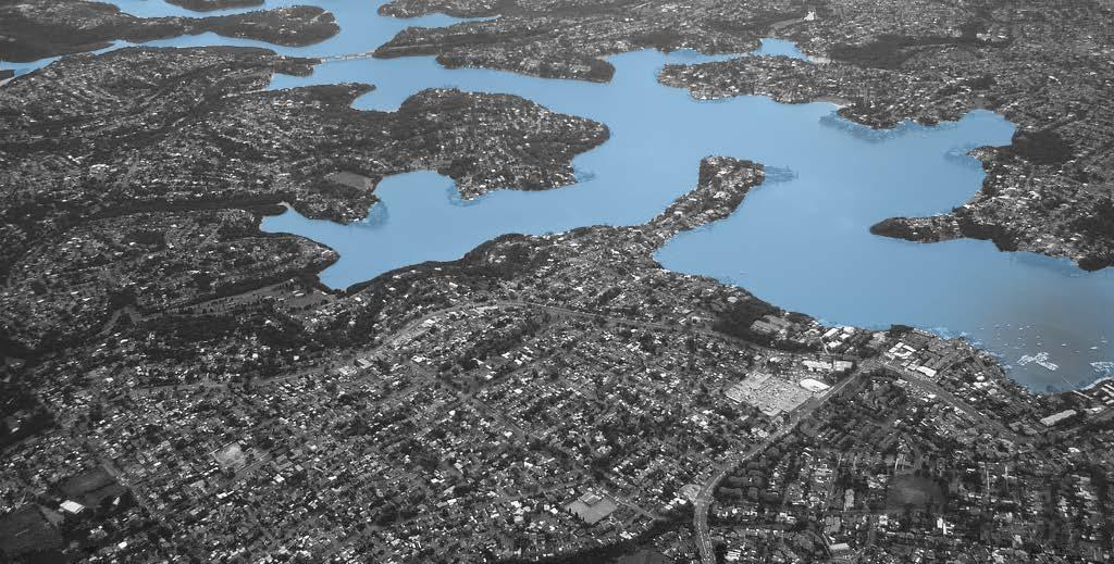
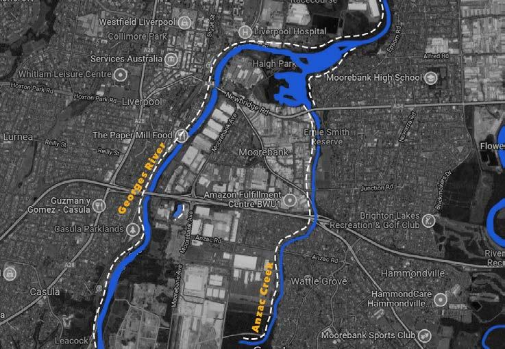
The Georges River is an Urban river that stats in Illawarra in south Sydney and ends in Botany Bay. The Georges River consists of fresh water before Liverpool Weir and becomes saltier water towards the mouth.
The River has a number of tributaries like Cabramatta Creek, Bunburry Creek, prospect Creek, Williams Creek, Mil Creek, Anzac Creek, Salt Pan Creek, and Woronora Creek. The river catchment has 1.4 million residents, 454 kinds of fauna, 30 kinds of riverside vegetation communities and 29 ecologically endangered communities (Georges Riverkeeper 2022).
The “Urban Stream Syndrome” applies to Georges river as well. This takes place when with the increase in urban landscapes that leads to larger volumes of storm water entering the river as compared to natural greener landscapes. Creeks in urban areas turn into canals that input polluted water into the main river body. There are also varied things like litter pollution, erosion flooding, sewage overflow that affect the water quantity and quality of river water (Georges Riverkeeper 2022).
The Georges River is one of the most prone to flooding in NSW. There have been some large flooding occurrences in 1956, 1969, 1975, 1976, 1986 and 1988. The flood in 1873 was one of the worst during which the water rose by 10.5 meters, this was a 1 in 100 years flooding event (Georges Riverkeeper 2022).


Climate change has an impact on our livelihoods and behaviours and survival of many species. Changes in climate patterns such as reduced rainfall, intense flooding and storms, Sea level rise will all have an effect on Georges river and its catchment area.
There are activities for residents in the catchment to engage in along the Georges River, with activities like swimming, fishing, cycling, bush walking boating, but most of these activities are along the river closer to the mouth of the river towards Botany Bay. There are limited and very few things for the residents along the rest of the river (Georges Riverkeeper 2022).
Methodology
The report addresses to need to meet a number of WSUD objectives for the site. The objectives are met through various scales- Masterplan level, Site level and plot level with different WSUD for these levels. The flooding control strategies for plots has been derived from Flood Resilient Building Guidance for Queensland Homes.
A lot of the other WSUD Strategies are derived from the objectives that need to be met and the existing site conditions. The City of Ryde Water Sensitive Urban Design Guidelines acts like a guide for various strategies and using the various technologies. The research for the site is collected through various documents like ‘Boot Land’, Moorebank, NSW Ecological Impact Assessment of Remediation and the Georges Riverkeeper website as well. This helped establish the problems on site and the existing conditions in the area and the catchments for Georges River, through which the objectives were establishes and technologies put in place.
3
Plot Level Site Level Masterplan level Site 1. INTRODUCTION
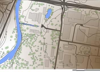
Fig 1: Georges River Catchment Map (Source: NSW Government 2016)
Site Context
The site location is within the Georges River catchment, most of stormwater runoff drains into the Georges river, located towards the west of the site. The site has various kind of land uses like residents, industries, defense grounds, mining, and agriculture spaces. The area also includes protected vegetated spaces, drinking water catchments (Parsons Brinckerhoff 2015).
There are a few waterbodies on site and close to the site as follows (Parsons Brinckerhoff 2015):
1. Georges River: This is the main waterway receiving storm water from the surrounding areas.
2. Amiens Wetland: The Amiens wetland. It serves a catchment of 5.9 ha. The wetland is for receiving water from the M5 motorway and acts as a detention basin. The water from this wetland gets released into the Georges river vis a pipe.

3. Anzac creek: It is densely vegetated permanent waterbody, this vegetated density acts as a treatment for stormwater flow. The creek is in terrible condition and deteriorated with sluggish and allows for very little water movement. The creek ultimately drains into Lake Moore on the Georges River.
4. Defence land ponds: the main defence land site contains four ponds for water quality treatment, and once there is an overflow it is discharged not Georges river through informal channels over land. Discharge of stormwater from the Project site to the Georges River is currently majorly unmanaged.
Pollutants in the Area
The water quality in Liverpool is largely affected by pollution and the kinds of land use in the region, as well as management practices that are not satisfactory. The freshwater in the region is affected by algal blooms caused by excess nutrients like phosphorous and nitrogen. Sewage discharge and overflow from industrial lands are one of the cause of increased nutrients and sediments in the region. The particles get easily transported into the georges river specially if there is less vegetation to reduce this flow (Liverpool City Council, 2022).
Flooding in the Region
Flooding in this region of the river is due to a fluvial process, caused by the runoff of the catchment in response to rainfall. The site area has been impacted by flooding by the Georges River. The most recent flood took place in 1988, with an annual probability of 5%. The flood caused more than 1000 properties being under water along the river (Parsons Brinckerhoff 2015; GHD 2015). The map below (Fig: 2.2) shows the existing flood risk zones for the region.
4
2. SITE
Liverpool Weir
ANALYSIS
Lake Moore
Amiens Wetlands
Georges River
Fig 2: Water bodies on site (Source: Author 2022 ) Fig 3: Flooding on site (Source: Author 2022)
Current Land Use
The site has mostly industrial land. Along the banks of the Georges River there is some public recreation spaces, with residential land use on the north east of the site (GHD 2015).
Contours
The site is almost flat and gently undulating with no steep slopes. The banks of the river are well vegetated. The site has terraced landscapes with gradual and low elevations or slopes. As the contours are gentle the water will flow at a slower pace towards the Georges River (GHD 2015).
Strengths
Contours: The slope on site is gradual and thus the storm water flows slower and not forceful, this helps for the water to seep into the ground.
Water body: There is an existing narrow open stream that guides storm water to Georges River. It has riparian vegetation along the stream as well.
Built up area: 60% of the site is currently hard surface area which means 40% of the site has natural surface that allows for enough water to seep into the ground and reduce storm water flow.
Weaknesses
Public space: The public recreational space is located west of thr georges river. this is inaccessible for the people living on the east bank.
Land zoning: The site has mainly industrial land which leads to increased pollution and no mixed use of land with reduced amenities.
Pollution: There are pollutants from the site that the stormwater will train into the Georges River.
Flooding: There is heavy and low amounts of flooding on site accoording to the 100 year flood line and needs to be considered when designing
5 Site chosen
Georges River
Fig 7: Current Existing Site (Source: Author 2022)
Fig 4: Site (Source: Author 2022)
Fig 5: Land Use (Source: Author 2022)
Fig 6: Contours (Source: Author 2022)
3. WSUD STRATEGIES
The Water Sensitive Urban Design Strategies will aim to benefit the Georges river and the surrounding neigbourhood in various ways. The WSUD objectives applied will benefit the river by improving the water quality, conserving the water, Improve the biodiversity, and hydrology on site and across the river as well as create more interactions with the water that will aid in creating awareness about water sensitivity in the community. This report addresses 5 major aims through which the Water sensitive design objectives were established.
Aims of the report:
1. Reuse water for at least 80% of non potable uses
2. Treat Rainwater on the plot
3. Increase water interactive recreational spaces
4. Increase and improve the biodiversity on site
5. Make the site resilient to the 100 year flood line
Objectives Description Planning level
1) Reduce the affect of flooding across the region
2) Improve the streetscapes and walkability
3) Improve the quality of storm water runoff
4) Reduce the quantity of storm water runoff
5) Reduce the demand of water in each household

6) Re-use rainwater on site for non potable uses

7) Improve and provide spaces for public Recreation


Use wetlands as a strategy to reduce the amount of floods on site. Wetlands absorb excess water by retaining it as well as returning it to the ground increasing the under ground water table (Department of the Environment and Energy 2016).
Streetscape are opportunity to treat storm-water close to the source, improving amenity and livelihood by mitigate the impacts of the urban heat island, and help by reducing excess storm-water from entering waterways (CRC for Water Sensitive Cities 2018).
Improve the quality of storm water to minimise pollutants getting into Georges River by incorporating WSUD measures. This will help improve health of water bodies and aquatic wildlife. This will in turn help in improving ocean water (Organica Engineering Pty Ltd 2019).
Average annual volume reduction can often be achieved through the implementation of permeable pavement systems, retention and/or infiltration systems (Organica Engineering Pty Ltd 2020).
Water-efficient appliances and fixtures, helps keep water use at sustainable levels (energy.gov.au, 2022).
Masterplan Level
Site level
Masterplan level
Plot Level Site Level
Site Level
Site Level
Plot Level
Reusing rainwater for plots will reduce the demand on fresh water from outside the site keeping water use in check.
Provide spaces to be outside encouraging them to interact with their surroundings and improving their livelihood.
8) Adaptation for flooding on site Designing landscapes for reducing flood affecting a community. Using materials, construction systems for houses that help to withstand considerable inundations by actively mitigating the effects of, and minimising the cost of flooding (The State of Queensland, 2019).
9) Improve the ecological network and habitat for the site


10) Improve awareness and interaction with water bodies on site

Integrate WSUD in a way to increase biodiversity, and provide habitat for wildlife (Habitat Creations Management 2021).
Plot Level
Site and Masterplan Level
Site and Plot Level
Site and Masterplan Level
Provide a space for environmental education, conservation and eco-tourism. A space to observe and create awareness about Water Sensitive Urban Design Strategies (Jaggers 2021).
6
4. MASTERPLAN STRATEGIES


Objectives Met: 1, 7, 9, 10

Wetlands
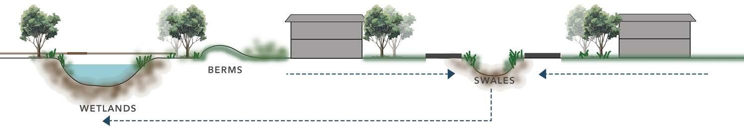
The Wetlands on the edge of the river will aid in managing the overflow from the river and act as retention ponds. They can also store water and act as a buffer during droughts. In addition to this they can be breeding grounds for habitats to grow and add biodiversity and vegetation in the region (Department of the Environment and Energy, 2016).
Green- Grid
Green grids in the region can mitigate Urban Heat Island effect and add to the making the water cleaner and ecology of the area. The green grid will contain native vegetation and trees for Liverpool such as: Broad Leaved Apple, Swamp Oak, Cabbage Gum. These native trees will help in retaining the biodiversity on the region without putting pressure for extra maintenance of the trees as they are local to the region and riparian trees (Birdlife Australia 2018).
Recreation
The pathways going across the wetlands will act as a space for recreation. like walking, cycling or even bushwalking. These spaces will act like observational decks for people to understand how wetlands work and biodiversity of the region. It will be a way through which the community can interact with water.
Case Study- Hunter Wetlands:


The masterplan strategy focuses on mitigating the effects of flooding by providing the rivers wedge with wetlands that can take the excess water overflowing from the Georges River. The aim of the wetlands is to be able to manage the floods along with provide space for biodiversity to thrive. The wetlands will also act as places for recreation for the community and a place for learning and awareness about ecology and the wetlands. The wetlands will have provision of activities like walkways, cycleways and nature trails.
Along with this a green grid is proposed across the masterplan, which will build on the regions existing open spaces by linking the trees lined on streets, corridors, waterways, open spaces, and parks. The tree canopy helps in reducing the urban heat island effect, they also aid in providing cleaner water and air, as well as reducing noise pollution. Making the community more resilient and absorbent to external forces.

The urban tree canopy is a form of green infrastructure that mitigates the urban heat island effect. The urban tree canopy also supports cleaner air and water and provides local habitat. Trees remove fine particles from the air and help insulate against urban noise pollution, particularly important along busy roads. The urban tree canopy can also help make communities more resilient by reducing the impact of heat waves and extreme heat (Greater Cities Commission, 2020).
The Hunter Wetlands Centre forms an important part of the neighbourhood, this hunter wetland includes the community centre. The wetland provides as a space for environmental education, conservation and eco-tourism. Through educational activities the wetlands are a place for the general public to get to know about wetlands and contribute to its conservation. The wetlands provide a variety of including guided tours, dip-netting, birdwatching, painting, volunteering, canoeing and walking. These spaces are informal learning environments simply by observing the wetland (Jaggers 2021).
7
Fig 8: Masterplan (Source: Author 2022)
Fig 9: School students at the Hunter Wetlands Centre (Source: Hunter Wetlands Centre Australia )
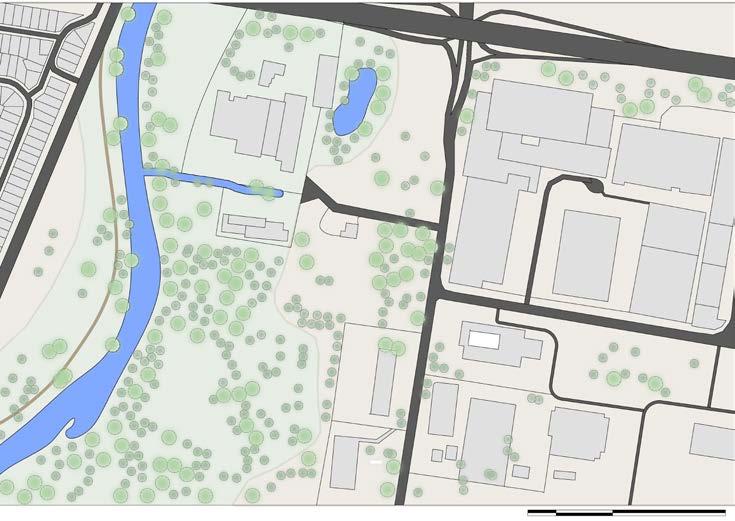
Proposed Site Conditions

Site Area:

Built : Unbuilt
Number of houses:
Persons per house:
Total number of people:
WSUD Sizing to
Size of Swale:
Size of Wetlands:
20000 sq.m 60 : 40 32 houses 3 people 96 people
120m length 1200 sq.m
The sizing of the WSUD Strategies is done to achieve the following:
• 85% reduction in the mean annual load of Total Suspended Solids (TSS)
• 65% reduction in the mean annual load of Total Phosphorus (TP)
• 45% reduction in the mean annual load of Total Nitrogen (TN)
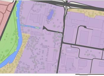
Various strategies will be applied on site. The swales on site will transport water from the site to the wetlands while removing TSS. They will transport water into the wetlands that will help in getting rid of the remaining nutrients. The wetlands will also provide a space fro recreation and ecology to grow. The berms on site will prevent the water from flowing back and make it flow towards the swales. In the end the gross pollutants trap will trap solid waste such as litter and coarse sediment that might have gotten collected on the way. Finally the High Flow Bypass will convey excess water into Georges river when the wetlands are overflowing.
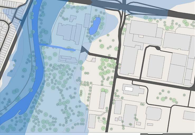
8 5. SITE STRATEGIES
Wetland High Flow Bypass and Swale Swale Wetland Swale Wetland Berms Berms
To Georges River
Covered Water Chanel
Gross Pollutant Trap
To Georges River
Fig 10: Site Plan Proposal (Source: Author 2022)
Fig 11: Water Flow Diagram (Source: Author 2022)
A
Fig 12: Conceptual section AA’ (Source: Author 2022)
Case Study- The Common Swales:
The Common is a Macleod suburb residential street with large, tree-lined strips in the middle that separate the two sides of the road. The strips are divided by open swales covered by grass. The swales are intended to collect stormwater and filter out contaminants before it is directed into underground stormwater drains that eventually go into Darebin Creek (Darebin City Council 2017).
When it rains, The Common’s swales collect rainwater runoff. Stormwater drains from the road surface through a series of inlets in the kerb that surrounds the median strips. The inlets are shaped with huge rock beds to stop litter and waste and restrict the flow of water, reducing soil erosion. Water flows through these rock layers before entering the swales (Darebin City Council 2017).
Objectives Met:

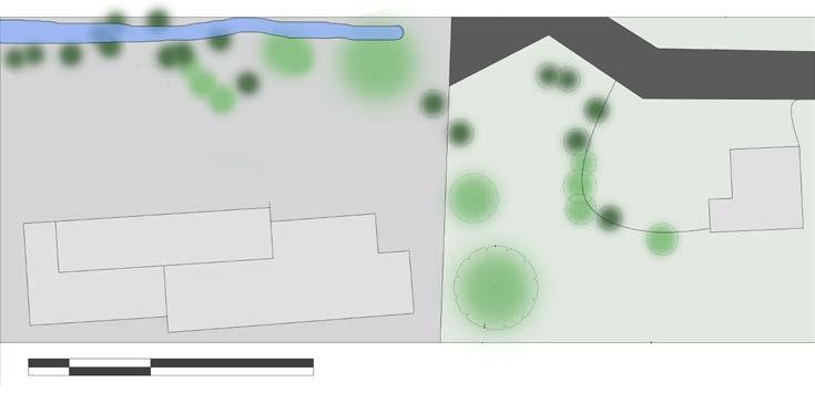
Wetlands
The wetlands on site will helpin preventiong flooding and also aid during conditions of draught. Apart form this wetlangs can act as an enhancer for ecology of the surrounding areas (Department of the Environment and Energy 2016).
Swales
The swales along the roads are designed to collect stormwater and filter out pollutants(TSS), (Darebin City Council 2017). They direct water underground stormwater drains that eventually lead to Wetlands.
Highflow Bypass
The wetland high flow bypass channel allows for excess water to flow around the wetland without damaging the plants specially during floods (Melbourne Water 2022).
Recreation
Creation of public amenities around the wetlands like walking tracks will increase communities inetraction with water and the ecology of their surroundings thus increasing their knowledge about water (Agency of natural resources 2022)


Berms
The berms are mounds which have vegetations covering it made of compacted soil. The berms on site are placed inn a way to divert water away from the houses and into the swales, they also help in preventing the backflow of water, and thus avoid adversely affecting properties on site (The State of Queensland 2019).
Native Vegetation
Planting along streetscapes with native vegetation will be beneficial to the community as it will add urban tree cover, improve water and air quality and reduce urban heat island effect. this will make it a friendlier neighbourhood and increase walkability (CRC for Water Sensitive Cities 2018).


9
3, 4, 7, 8, 9, 10
2,
5. SITE STRATEGIES
To Georges River
Fig 13: Site Plan Proposal (Source: Author 2022)
Fig 14: Side view of swale (Source: Darebin City Council 2017)
Case Study- Flood Resilient Homes Queensland:

The kind of design by use of various materials, construction systems, landscaping options that can resist significant and multiple inundations while actively minimising the effects and lowering the cost of floods. Flood resilient design allows residents to store things before to flooding, then post flooding clean, repair, and rapidly re-enter with minimum long-term disturbance to everyday life (The State of Queensland 2019).
• Flood-resilient design prepares buildings to endure and recover from flooding occurrences while enhancing daily living and quality of life. It takes into account the materials used, construction methods, and home style.
• Flood-resilient design allows homeowners to safely store things before to a flood event, and then simply clean, repair, and rapidly re-enter with minimal long-term disturbance. Homeowners can actively limit or mitigate the consequences of floods by using flood-resilient architectural features.

• One method for residents to be better prepared for flooding is through flood-resilient design (The State of Queensland 2019).
Proposed Plot Conditions

Plot Area:
Roof Area:

Water Usage for 3 people/day:

Non potable rainwater demand/ yr:
Total Water Supplied
Water needs met for Non potable uses:
Rain Water Tank Sizing:
Volume of water:
Tank Size:
10 6. PLOT STRATEGIES
246
140
447 L/day 89.76 KL/year
82% 7.0 KL 2m L x 1m W x4mH
sq.m
sq.m
73.58 KL/year
Fig 17: Section of a flood resilient house (The State of Queensland 2019).
Fig 15: Upper level of house (NSW Government 2020).
Fig 16: Lower level of house (NSW Government 2020).
Fig 18: Water usage quantities by Sydney water (Source: Author 2022).
Objectives Met:

Rain Garden Permeable Paving Roof Filter tank Rain water tank
The plot has strategies for the build form and the landscaping as well. The landscaping includes a rain garden to soak in more water during rain and reduce stormwater runoff, the paving on site is also done through permeable paving thus reducing hard surfaces and allowing for the water to seep in. The house will have appliances that will reduce the water demand, appliance such as showers and taps that will reduce the flow of water. Adding to this the roof will collect water during rains in the rain water tank. this rainwater will meet 82% of non potable water usage. The trees and shrubs planted on the plot will add to the native vegetation on site increasing the biodiversity and deceasing soil erosion. The material used for the built form will need to be water resistant so as to be resilient during flooding events since the site falls under the 100 year flood line. Using a double brick and veneer external wall makes the house durable with minimal maintenance costs. Weep holes or vents need to be provided on the external walls to allow the water to leave faster post flooding. Glazed brick or clay tiles can act as even more durable external barriers to natural flooding hazards (The State of Queensland 2019).

Rain Garden
Rain gardens help to collect rain water and are planted with water plants. They help to reduce the amount of storm water runoff and also adapt to the natural landscapes, while trapping a number of pollutants (The State of Queensland 2019).
Permeable Paving
Permeable paving helps in reducing the stormwater runoff on site and allow the water to seep underground and then join the main water body through an underground pipe (The State of Queensland 2019).
Rainwater tank
Rainwater tanks on site collect the runoff from the roof. The water first does into a filtration tank before entering the rainwater tank. The filter helps to remove any litter that might have been carried from the roof.
Appliances
Water-efficient appliances and fixtures, helps keep water use at sustainable levels (energy.gov.au, 2022). Use of such appliance also saves money and electricity. Water is used the most by washing machines, showers and taps (energy.gov.au, 2022).


Materials
For a flood resilient house it is necessary to use Water-resistant materials along with composite construction systems. For example, double brick and brick veneer can be used as external alls with weep holes. These are easy maintenance and will allow the water to leave through weep holes (The State of Queensland 2019).
11
6. PLOT STRATEGIES
Roof Filter Tank
Fig 18: Water usage quantities by Sydney water (Source: Author 2022).
Rain Water Tank House
Non- Potable Uses
Native trees/ Shrubs
The report has suggested strategies at three levels, the masterplan, site and plot level. At each of the levels the strategies have met their Water sensitive design objectives. The aim of the report has been met. The WSUD strategies are resilient to flooding. They encourage people to interact with water building awareness and learning on site. The wetlands used throughout the site level and masterplan level account for flooding and are hot spots for biodiversity to thrive. Along with this additional strategies are added as a back up option like berms and Wetland high flow bypass that help to direct water away from the wetland and properties that might be damaged. The WSUD strategies are capable of reducing the following:
• 85% reduction in the mean annual load of Total Suspended Solids (TSS)
• 65% reduction in the mean annual load of Total Phosphorus (TP)
• 45% reduction in the mean annual load of Total Nitrogen (TN)
The rain water gathered from the roof also reduced dependency on mains water supply by 82% for non potable uses. Thus the report has met all the aims and objectives for Water Sensitive Urban Design.
The report also has a few disadvantages, the number of houses on the site area are far lesser than what could have been added, this is because, for making the site resilient to flooding a certain amount of wetlands were required on site. This reduced the are for the number of homes that could have been added. But since it is necessary to think about the risks on site it is necessary to make the site resilient to flooding and have fewer houses than make a large number of homes get exposed to this risk and have an negative impact on their livelihoods.
Further research can be developed for this topic that can deal with existing ecology on site and to what extent will WSUD have an impact on this ecology. Further learning outcomes for students for various ages can be established by providing various activities for different age groups to increase water awareness. The activities can be more integrated and interactive with water. An additional report is needed to address design for the neighbourhood through community consultation and understanding the communities needs.

7. CONCLUSION
References
Agency of natural resources, 2022. Wetland functions and values: recreational values and economic benefits. [Online] Available at: https://dec.vermont.gov/watershed/wetlands/functions/benefits [Accessed 13 November 2022].
Birdlife Australia, 2018. Liverpool City Plant List. [Online] Available at: https://www.birdsinbackyards.net/content/plantlist/Liverpool-City-Plant-List [Accessed 10 October 2022].
CRC for Water Sensitive Cities, 2018. Randolph Avenue streetscape upgrade. [Online] Available at: https://watersensitivecities.org.au/solutions/case-studies/randolph-avenue-streetscape-upgrade/ [Accessed 20 October 2022].
Darebin City Council , 2017. The Common Swales, Darebin: Darebin Water. Department of the Environment and Energy, 2016. Wetlands and resilience to natural hazards. [Online] Available at: https://www.dcceew.gov.au/water/wetlands/publications/factsheet-wetlands-resilience-natural-hazards [Accessed 28 October 2022].
Department of the Environment and Energy, 2016. Wetlands and resilience to natural hazards. [Online] Available at: https://www.dcceew.gov.au/water/wetlands/publications/factsheet-wetlands-resilience-natural-hazards [Accessed 25 October 2022].
energy.gov.au, 2022. Households. [Online] Available at: https://www.energy.gov.au/households/water-efficiency [Accessed 10 October 2022].
Georges Riverkeeper, 2022. Enjoy the river. [Online] Available at: https://georgesriver.org.au/enjoy-the-river [Accessed 28 October 2022].
Georges Riverkeeper, 2022. Flooding of the Georges River. [Online] Available at: https://georgesriver.org.au/learn-about-the-river/flooding-the-georges-river#:~:text=The%20Georges%20 River%20is%20considered,%2C%201978%2C%201986%20and%201988. [Accessed 25 October 2022].
Georges Riverkeeper, 2022. Learn about the river. [Online] Available at: https://georgesriver.org.au/learn-about-the-river [Accessed 2 November 2022].
Georges Riverkeeper, 2022. Ongoing challenges for the urbanised Georges River. [Online] Available at: https://georgesriver.org.au/learn-about-the-river/ongoing-challenges-the-urbanised-georges-river [Accessed 1 November 2022].
GHD, 2015. ‘Boot Land’, Moorebank, NSW, Ecological Impact Assessment of Remediation, Liverpool: GHD.
Greater Cities Commission, 2020. Increasing urban tree canopy cover and delivering Green Grid connections. [Online] Available at: https://greatercities.au/north-district-plan/sustainability/city-its-landscape/increasing-urban-tree-canopy-cover-and [Accessed 10 November 2022].
Habitat Creations Management, 2021. WSUD: The rise of Urban Wetlands and Waterways.[Online] Available at: https://www.habitatcreations.com.au/post/wsud-the-rise-of-urban-wetlands-and-waterways [Accessed 1 November 2022].
Jaggers, W., 2021. Wetlands Australia 34: Hunter Wetlands: The synergies between conservation and education, Sydney: Department of Climate Change, Energy, the Environment and Water. Liverpool City Council, 2022. Water Quality. [Online] Available at: https://www.liverpool.nsw.gov.au/environment/water-and-waterways/water-quality [Accessed 5 November 2022].
Melbourne Water, 2022. Constructed wetlands. [Online] Available at: https://www.melbournewater.com.au/building-and-works/stormwater-management/options-treating-stormwater/constructed-wetlands [Accessed 18 October 2022].
NSW Government, 2020. Low Rise Housing Diversity Design Guide, s.l.: NSW Government.
Organica Engineering Pty Ltd , 2020. A guide for water sensitive urban Design, South Australia: Water Sensitive SA.
Parsons Brinckerhoff, 2015. Hydrology, groundwater and water quality, Liverpool: Parsons Brinckerhoff.
The State of Queensland, 2019. Flood Resilient Building Guidance for Queensland Homes, Brisbane: The State of Queensland.

