
15 minute read
Management of Naturally Occurring Asbestos Area in Republic of Korea

from EEG Journal - February 2020 Vol. XXVI, No. I (2)
by Association of Environmental & Engineering Geologists (AEG)

SUNGJUN YOON Chonnam National University, 77 Yongbong-ro, Buk-gu, Gwangju 61186, Republic of Korea
KYUBONG YEOM 11 Doum6-ro, Sejong Special Self-Governing City, Republic of Korea
YONGUN KIM BYUNGNO PARK JAEBONG PARK HYESU KIM HYEONYI JEONG YUL ROH* Chonnam National University, 77 Yongbong-ro, Buk-gu, Gwangju 61186, Republic of Korea
Key Terms: Naturally Occurring Asbestos, Construction, Management, Site Investigations
ABSTRACT
The Republic of Korea Government has adopted a whole-of-government approach in the management of naturally occurring asbestos (NOA) through a nationwide asbestos management plan. Regional and detailed mapping, and examination of NOA effects are still ongoing for NOA management by indoor air, noise and asbestos management division, Ministry of Environment. Plans by the Korea Rail Network Authority are under way to rebuild the Janghang double-track railway. The proposed Jannghang double-track railway route is through an area of high NOA probability that has serpentine and ultramafic rock. Chrysotile, tremolite, and actinolite asbestos were among the rocks identified within the project site (initial planning line and the operational design line). The level of asbestos in most soils was low (0.25 percent), while some soils contained 0.75 percent asbestos. Monitoring and analyses of air quality revealed below 0.01 fibers per cm 3 (f/cc). However, there were no traces of asbestos detected in the groundwater and stream water. Despite the low asbestos content of the soil and rock, the disturbance of NOA-containing soils and rocks during railway construction could trigger the release of asbestos fibers into the air. NOA mitigation plans and measures are necessary for workers and residents during the construction of the railway.
*Corresponding author email: rohy@jnu.ac.kr
INTRODUCTION
The Korean Peninsula consists of three Precambrian massifs, from north to south, the Nangrim, Gyeonggi, and Yeongnam Massifs, which form the basement rocks. All three Precambrian massifs consist of unclassified high-grade gneiss complexes and overlying supracrustal sequences. The Precambrian massifs are joined by two intervening belts, the Ogcheon and Imjingang belts. The Gyeongsang Supergroup comprises the Gyeongsang basin and other small basins. In the Korean Peninsula, the most recent volcanic activity occurred between the Cretaceous and Early Tertiary periods and was closely related to the contemporaneous plutonism (Figure 1; Kim et al., 1999. Due to these geological characteristics, there are two main ultramafic rocks known to have naturally occurring asbestos (NOA) in the Republic of Korea, serpentinite and metamorphosed carbonate rocks. NOA is formed through the reaction of olivine in ultramafic rocks with hydrothermal fluids or as a result of hydrothermal alteration of dolomite (Lee and Park, 1995; Woo and Kang, 1999; Woo and Suh, 2000; Woo and Kim, 2003; Song et al., 2004; Kim and Woo, 2005; Koh et al., 2006; Park et al., 2012; and Jung et al., 2014, with references).
3Mg 2 SiO 4 ( Olivine ) + SiO 2 + H 2 O → 2Mg 3 Si 2 O 5 ( OH ) 4 ( Serpentine ) .
5CaMg ( CO 3 ) 2 ( Dolomite ) + 8SiO 2 + H 2 O → Ca 2 Mg 5 Si 8 O 22 ( OH ) 2 ( Tremolite ) + 3CaCO 3 + 7CO 2 .
(1)
(2)
Figure 1. Geologic map of Korean Peninsula published by KIGAM (1995).

Figure 2. A sample of regional NOA maps (Hongsung-gun, scale = 1:50,000).
Development in the NOA areas, where rock and soil contain NOA at construction sites, has resulted to asbestos hazards. Disturbance of the materials within NOA areas increases the possibility of asbestos fibers being released into the air. Diseases that are associated with asbestos occur as a result of cumulative and long-term respiration exposure to airborne asbestos. To address this challenge, the Republic of Korean Government adopts a whole-of-government approach to managing NOA through a nationwide asbestos management plan. Currently, there are ongoing surveys, including regional and detailed NOA mapping, and examination of NOA effects to aid NOA management. The Korean Ministry of Environment carried out a regional NOA mapping project from the year 2010 to 2017. A detailed NOA mapping project by the Ministry of Environment commenced in 2013 and is still ongoing. According to

Figure 3. A sample of detailed NOA maps (Susan-myeon, scale = 1:25,000).
the regional NOA survey, NOA areas in the Republic of Korea cover about 5.48 percent (2,154 mi 2 ) of the land area. Ultramafic rocks, which are the most likely to contain NOA, are found in parts of Chungnam, Kyonggi, and Gyeongbuk provinces. Metamorphosed basic rock, which are scattered locally, are moderately likely to contain NOA. The least likely rocks to contain NOA are metamorphosed carbonate rocks and metamorphic rocks, which are found in parts of Chungbuk, Chungnam, Jeonbuk, and Gangwon provinces. However, field investigation has shown that some of metamorphosed carbonate rocks, which are scattered locally, are likely to contain NOA.
The objective of this study is to present the status of regional and detailed mapping of NOA and to examine the effects of NOA in the Republic of Korea and then introduce the Janghang Railway Project as an example of an investigation into development in NOA areas.
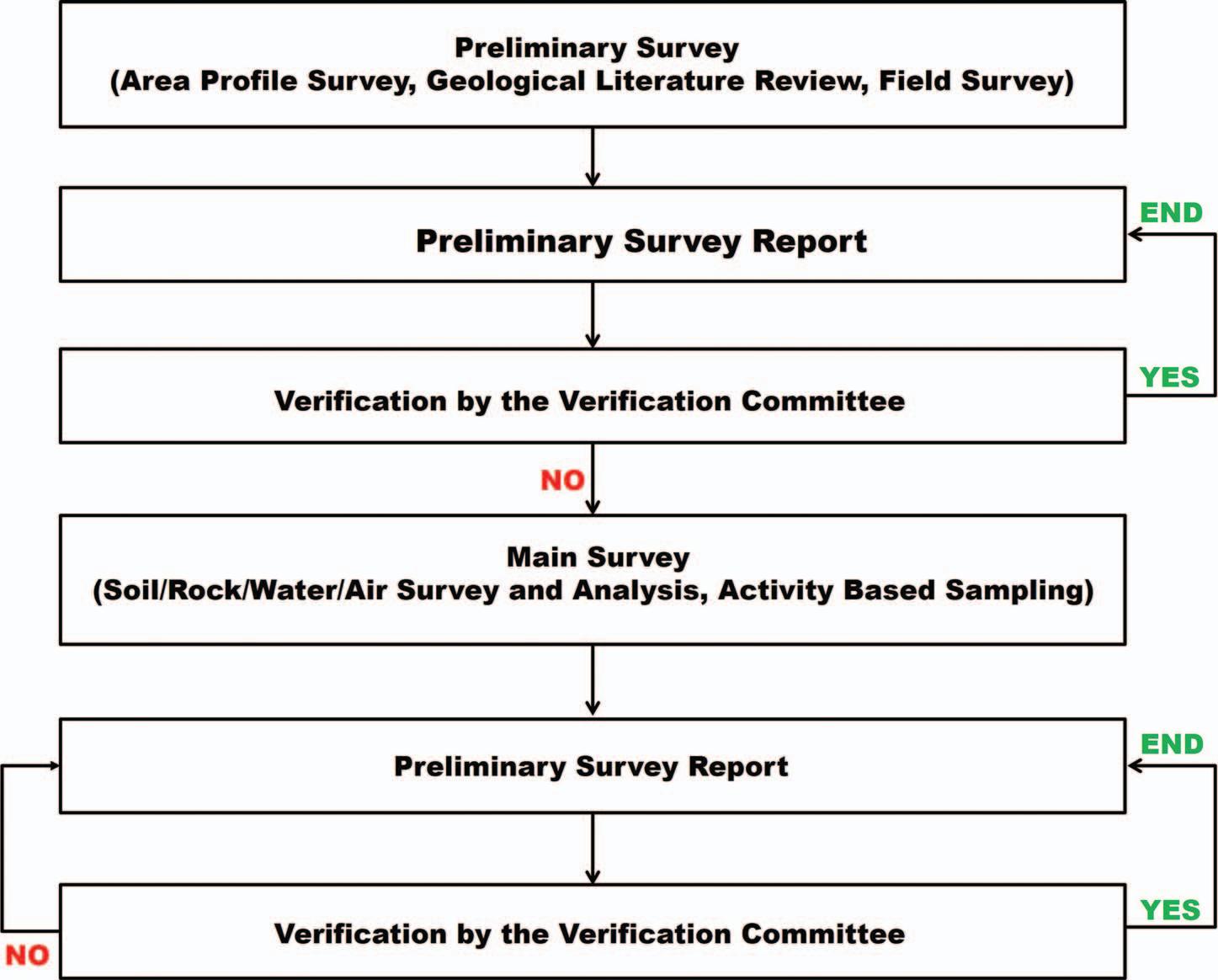
Figure 4. Examination procedures of NOA effects in Republic of Korea.
REGIONAL AND DETAILED MAPPING OF NOA AND EXAMINATION OF NOA EFFECTS
The Asbestos Safety Management Act (2012), which contains the general regulations on asbestos, including asbestos-containing materials, asbestoscontaining building materials, and NOA, was enacted in 2012 in the Republic of Korea. It includes a method to conduct both regional and detailed mapping and for examination of NOA effects. The brief field survey and mapping used to generate the regional NOA map (scale = 1:50,000) were based on Ministry of Environment, Korea, Notification 2018-23 (2018a), Mapping Technique of Naturally Occurring Asbestos, Asbestos Safety Management Act. Geologic maps published by the Korea Institute of Geoscience and Mineral Resources (KIGAM, 1995) and the relative likelihood for the presence of NOA in the rocks formed the basis for NOA mapping. The Republic of Korean classification of relative likelihood for the presence of NOA is very similar to that of Placer County, CA, USA (Higgins and Clinkenbeard, 2006). There are four categories of areas of relative likelihood based on rocks as listed below:
(1) area most likely to contain NOA, which includes ultramafic rock and serpentine rocks (serpentinite); (2) area moderately likely to contain NOA, which includes metamorphosed basic rocks; (3) area least likely to contain NOA, which includes metamorphosed carbonate rocks and metamorphic rocks (e.g., schist and gneiss); and (4) fault or shear zones, which may locally increase the likelihood for the presence of NOA where they exist in or adjacent to areas that are most likely to contain NOA (buffer zone = 500 m on each side of the fault line).
The regional NOA map consists of information such as the relative likelihood for the presence of NOA, defunct asbestos factories, deposits, abandoned asbestos mines, occurrences, and faults (Figure 2). Counties where geologic and soil mapping for detailed NOA mapping (scale = 1:25,000) was done were selected based on the regional NOA map, development, population, etc. Mapping of the detailed NOA map (scale = 1:25,000) was based on Ministry of Environment, Korea, Notification 2018-23 (2018a), Mapping Technique of Naturally Occurring Asbestos, Asbestos Safety Management Act. Additionally, it was based on geologic maps published by KIGAM, the regional NOA Map, and geologic and soil surveys. The project is still ongoing. The detailed NOA map includes information such as the area of NOA presence, defunct asbestos factories, deposit locations, abandoned

Figure 5. Geologic map of the Janghang Double-Track Railway Project area.
asbestos mines, occurrences, and faults (Figure 3). Based on the detailed NOA map, analysis of NOA effects is conducted to establish the health risks of residents as a result of exposure to NOA-containing rocks and soils. Examination of NOA effects is based on Ministry of Environment, Korea, Notification 2018-23 (2018b), Method of Examination of NOA Effects, Asbestos Safety Management Act. The examination of NOA effects is divided into two categories: preliminary survey and main survey. The objective of the preliminary surveys is to determine the need for the main survey by collecting data through analysis of local conditions such as land use, population distribution, literature review on NOA, and field surveys. The main survey is dependent on the results of the preliminary survey. The main survey entails investigation of asbestos in rocks, soils, water, and air at the selected area (near or around residential areas) for purposes of assessing the health risks to the local population posed by NOA. The NOA Verification Committee should verify the
Table 1. Number of soil, air monitoring, and water samples for NOA survey.
Classification Surface Soil (0–0.1 m) Subsurface Soil (0.1–0.4 m) Deep Soil (0.4–1 m) Total
Soil
Original planning line 40 22 6 68 Working design line 68 19 9 96 Total 108 41 15 164
First Sampling Second Sampling Third Sampling Total
Air
Original planning line 14 14 14 42 Working design line 15 15 15 45 Total 29 29 29 87
First Sampling Second Sampling Total
Water
Groundwater 8 8 16 Stream water 3 3 6 Total 11 11 22
Classification Borehole Number of Samples
Core
Original planning line Tunnel section (L = 310 m) 2 10 Cutting section (L = 2,684 m) 18 67 Bridge section (L = 6,490 m) 32 38 Working design line Tunnel section (L = 1,145 m) 30 153 Cutting section (L = 4,869 m) 38 255 Bridge section (L = 4,520 m) 87 87 Total 207 610 Outcrop
Original planning line 16 Working design line 25 Total 41
NOA = naturally occurring asbestos.
results of the preliminary survey. The committee then decides whether or not to conduct the main survey. The main survey should be conducted urgently if deemed necessary (Figure 4).
JANGHANG DOUBLE-TRACK RAILWAY PROJECT
The Korea Rail Network Authority is planning to rebuild the Janghang double-track railway. The proposed Janghang double-track railway will traverse an area of high NOA probability with rocks such as serpentinite or ultramafic rock. Based on the geological maps of Hongsong and Daecheon (KIGAM), serpentinite or ultramafic rocks occur as exposed, isolated bodies in the Precambrian Kyeonggi gneiss complex located within the railway project area (Figure 5). Furthermore, there are abandoned asbestos mines such as the Singokri mine and the Daeheung mine adjacent to the proposed railway track. The local media and environmental lobby groups have raised concerns regarding the generation of dust potentially containing asbestos during implementation of the project.
Soil, air, and water samples were collected and analyzed in compliance with the Korean Ministry of Environment survey guidelines to evaluate the general risk as a result of the NOA (Table 1). Surface soil sampling, ambient air monitoring, and water sampling were conducted, and the asbestos was subsequently analyzed to determine the concentration of NOA within the project area. Rock core drilling and field surveying for the rock samples were performed and analyzed to determine qualitative amounts of asbestos (Table 2). Polarized light microscope (PLM), X-ray diffraction (XRD), phase contrast microscope (PCM), scanning electron microscope and energy dispersive Xray spectroscope (SEM-EDS), and transmission electron microscope and energy dispersive X-ray spectroscope (TEM-EDS) analyses were utilized to characterize the types and contents of the asbestos.
PLM and XRD analyses of the rocks and soils revealed that the rocks and soils contained chrysotile, tremolite, and actinolite asbestos (Tables 3 and 4). The asbestos concentrations of soil in the project area varied depending on the type of geologic unit and ranged from below detection limit to about 1percent as analyzed by the 400 point-counting method of CARB 435 using PLM (Table 4). The majority of the soils’ asbestos content was low (0.25 percent). SEM-EDS analyses of the rocks and soils revealed that tremolite asbestos was more fibrous as compared with chrysotile and actinolite asbestos, which can grade into asbestiform morphology (Figure 6). PCM and TEM analyses
Table 3. Asbestos analyses of core and outcrop samples.
Boreholes with Number of Samples of Detected Classification Borehole Asbestos Detected Samples Asbestos Detected Asbestos Type
Core Chysotile, tremolite, actinolite Original planning line
Tunnel section 2 1 10 1 Cutting section 18 6 67 13 Bridge section 32 13 38 14 Working design line
Tunnel section 30 19 153 49 Cutting section 38 27 255 72 Bridge section 87 12 87 12 Total 207 78 610 161 Outcrop Chrysotile, tremolite, actinolite Original planning line 16 1 Working design line 25 4 Total 41 5
Classification Number of Samples Not Detected
<0.25% 0.25%–1.0%
>1.0% Detected Asbestos Type
Original planning line 68 (40)* 42 (21) 21 (14) 5 (4) — Chysotile, tremolite, actinolite Working design line 96 (68) 78 (52) 17 (15) 1 (1) — Total 164 (108) 120 (73) 38 (29) 6 (5) —
* Sampling station number indicated by ( ).
of ambient air samples recorded lower than 0.01 fibers per cm 3 (f/cc), which is below the legal threshold (0.01 f/cc), and asbestos was not detected in any of the water samples (Table 5).
Although the asbestos content of the soil was below the legal threshold (1 percent), the dust mitigation measures and work management practices adopted for the project plans should keep generation of any such dust to a minimum. Additionally, the air-quality monitoring program, which is integrated with dust-control measures, should guarantee that asbestos-containing dust does not leave the site at concentrations sufficient to pose health risks to workers or the general public. CONCLUSIONS
The NOA survey project, which entails regional/detailed NOA mapping and analysis of NOA effects, is currently ongoing for purposes of NOA management in the Republic of Korea. A survey for detailed NOA mapping (scale = 1:25,000) is currently ongoing based on the Ministry of Environment, Korea, Notification 2018-23 (2018a), Mapping Technique of NOA, Asbestos Safety Management Act. The Korea Rail Network Authority is planning to rebuild the Janghang double-track railway. The proposed Janghang double-track railway is expected to traverse

Figure 6. SEM-EDS analyses of chrysotile, actinolite, and tremolite asbestos.
PCM (f/cm 3 ) TEM (f/cm 3 )
Classification
>0.01 0.01–0.0022
< Detection limit
>0.01 0.01–0.001 0.001–0.0001
< Detection limit
Air
Number of first sampling 0 9 20 0 0 0 4 Number of second sampling 0 14 15 0 0 0 4 Number of third sampling 0 4 25 0 0 0 1 Total 0 27 60 0 0 0 9 *
Water Number of first sampling TEM (>7 MFL) Number of second sampling TEM (>7 MFL**) Groundwater 8 0 8 0 Stream water 3 0 3 0 Total 11 0 11 0
*9 air samples were randomly selected from 87 air samples for TEM analysis. **MFL: million fiber per liter.
an area of high NOA probability, which has serpentine or ultramafic rock. Although the asbestos content of the soil and rock is low, the dust mitigation measures and work management practices adopted for project plans should maintain generation of any such dust to a minimum. In addition, the air-quality monitoring program, which is integrated with dust-control measures, should guarantee that asbestos-containing dust does not leave the site at concentrations high enough to pose health risks to workers and the general public.
ACKNOWLEDGMENT
We are grateful to Mr. Jeong in CCRF for XRD and Dr. Moon in KBSI-Gwangju for SEM-EDS analyses.
REFERENCES
Asbestos Safety Management Act, 2012, Asbestos Safety Management Act: Electronic document, available online at http://www.law.go.kr/lsInfoP.do?lsiSeq = 199137&efYd = 20180529#0000 (In Korean.) Higgins, C. T. and Clinkenbeard, J. P., 2006, Relative Likelihood for the Presence of Naturally Occurring Asbestos in Placer County, California: California Geological Survey Public Information Offices Special Report 190. Jung, H. M.; Shin, J. D.; Kim, Y. M.; Park, J. B.; and Roh, Y., 2014, Mineralogical characteristics of naturally occurring asbestos (NOA) at Daero-ri, Seosan, Chungnam, Korea: Economic and Environmental Geology, Vol. 47, No. 5, pp. 467–477. (In Korean.) Kim, J. H.; Na, G. C.; Yang, S. Y.; Won, J. K.; Lee, D. Y.; Lee, J. H.; Lee, C. J.; Choi, D. K.; Choi, H. I.; Yoon, S.; Park, C. E.; Jeon, M. S.; Kim, H. S.; Oh, M. S.; Park, Y. A.; and Jo, S. K., 1999, Geology of Korea: Sigma Press Book Company, Seoul, Korea, 802 p. Kim, Y. T. and Woo, Y. K., 2005, Serpentinization of olivine and pyroxene in Chungnam serpentinites, Korea: Journal of Korean Earth Science Society, Vol. 26, No. 3, pp. 297–304. (In Korean.) Koh, S. M.; Park, C. K.; and So, W. J., 2006, Preliminary study on the formation environment of serpentinite occurring in Ulsan area: Journal of the Mineralogical Society of Korea, Vol. 19, No. 4, pp. 325–336. (In Korean.) Korea Institute of Geoscience and Mineral Resources (KIGAM), 1995, Geological Maps: Electronic documents, available online at https://mgeo.kigam.re.kr/map/main. do?process=geology_50k (In Korean.) Lee, J. J. and Park, B. J., 1995, A geochemical study on genesis of Ulsan serpentine deposits: Journal of the Korean Earth Science Society, Vol. 16, No. 1, pp. 9–19. (In Korean.) Ministry of Environment, Korea, Notification 2018-23, 2018a, Mapping Technique of Naturally Occurring Asbestos: Electronic document, available online at http:// www.law.go.kr/admRulInfoP.do?admRulSeq=2100000116349 (In Korean.) Ministry of Environment, Korea, Notification 2018- 23, 2018b, Method of Examination of NOA Effects: Electronic document, available online at http://www. law.go.kr/admRulInfoP.do?admRulSeq= 2100000135990 (In Korean.) Park, G. N.; Hwang, J. H.; Oh, J. H.; and Lee, H. M., 2012, Occurrence and mineralogy of serpentinite from Bibong Mine in Chungyang area, Korea: Journal of Mineralogical Society of Korea, Vol. 25, No. 1, pp. 9–21. (In Korean.) Song, S. H.; Choi, S. K.; Oh, C. H.; Seo, J. E.; and Choi, S. H., 2004, Petrography and geochemistry of the ultramafic rocks from the Hongseong and Kwangcheon areas, Chungcheongnam-Do: The Korean Society of Economic and Environmental Geology, Vol. 37, No. 5, pp. 477–497. (In Korean). Woo, Y. K. and Kang, H. J., 1999, Alteration of serpentinites on Weolhyeon serpentine ore deposits in Hongseong County, Choongnam, Korea: Journal Korean Earth Science Society, Vol. 20, No. 2, pp. 189–198. (In Korean.) Woo, Y. K. and Kim, S. H., 2003, Original rock and serpentinization of serpentinites on serpentine ore deposits in Cheongyang, Choongnam, Korea: The Korean Association for Science Education, Vol. 34, pp. 181–196. (In Korean.) Woo, Y. K. and Suh, M. C., 2000, Petrological study on the ultramafic rocks in Choongnam area: Journal Korean Earth Science Society, Vol. 21, No. 3, pp. 323–336. (In Korean.)


