24 minute read
Geologic Investigations for Compliance with the CARB Asbestos ATCM

from EEG Journal - February 2020 Vol. XXVI, No. I (2)
by Association of Environmental & Engineering Geologists (AEG)

BRADLEY G. ERSKINE* Erskine Environmental Consulting, Inc., 401 Marina Place, Benicia, CA 94510
Key Terms: ATCM, NOA, Ultramafic Rocks, CARB, Franciscan Complex
ABSTRACT
The California Air Resources Board Airborne Toxic Control Measure for Construction, Grading, Quarrying, and Surface Mining Operations (ATCM) provides requirements for the evaluation for naturally occurring asbestos (NOA) on a construction site. There are two compliance triggers: (1) a determination that the site is located within a geographic ultramafic rock unit, defined as a geographic area designated as an ultramafic rock on referenced maps, and (2) the presence of NOA, serpentinite, or ultramafic rock. The California Geological Survey requires that NOA evaluations be conducted by a licensed professional geologist. However, under the ATCM, a professional geologist is required only when a property owner wishes to demonstrate that a geographic ultramafic rock unit is not actually represented by ultramafic rocks. The professional geologist who must advise whether the ATCM applies at a construction site is therefore placed in a precarious position. Does a limited desktop review of geologic maps meet any standard of practice? If the ATCM is triggered by the presence of asbestos, is the geologist negligent if no evaluation is recommended or conducted? Could geologic units be pre-screened for asbestos potential? Using case studies and geologic data in the city of San Francisco and East Bay, this presentation reviews these issues and provides a context for the geologist to conduct the appropriate level of investigation for compliance with the ATCM.
INTRODUCTION
California geology is exceedingly complex and among the most diverse in the world. Igneous crystallization and metamorphic mineralization processes, combined with past and present tectonic activity, have produced a diverse range of rocks and minerals, many of which are or were economically significant. Gold in the Sierra Nevada foothills, rare earth elements near Mountain Pass, and tourmaline in the Pala District east of San Diego are but a few examples.
*Corresponding author email: Erskine.geo@gmail.com
Asbestos, primarily chrysotile, was one economically important mineral that was mined for its use in building materials. The KCAC mine in the Coalinga District was once the largest asbestos mine in the world and was the last asbestos mining operation in the United States when it closed in 2002. To illustrate how common asbestos is in California, consider that chrysotile is a ubiquitous component of serpentinite, the California state rock. Serpentinite is exposed in the Sierra Nevada foothills and in a western belt that extends from the Klamath Mountains to as far south as Santa Barbara.
Based on several studies by the U.S. Environmental Protection Agency (EPA) and the U.S. Agency for Toxic Substances and Disease Registry (ATSDR), notably the Clear Creek Management Area near Coalinga (U.S. EPA, 2008) and the El Dorado Hills exposure studies (U.S. ATSDR, 2011), California implemented the nation’s most developed regulations and guidance documents to mitigate the potential exposure to asbestos on construction sites. An example (and the subject of this article) is the California Air Resources Board (CARB) asbestos Airborne Toxic Control Measure for Construction, Grading, Quarrying, and Surface Mining Operations (ATCM), which provides requirements for the evaluation of naturally occurring asbestos (NOA) on earth-disturbing construction sites (CARB, 2002). When the ATCM is triggered via criterion listed in Section (b)—Applicability, mandatory asbestos-specific dust control measures are required by CARB, and perimeter air monitoring may be required at the discretion of the regional Air Pollution Control District. The two relevant compliance criteria specified in the Applicability section are the following:
Subsection (b)(1): “Any portion of the area to be disturbed is located in a Geographic Ultramafic Rock Unit”; or
Subsection (b)(2): “Any portion of the area to be disturbed has naturally-occurring asbestos, serpentine, or ultramafic rock.”
The criterion in subsection (b)(1) refers to a “Geographic Ultramafic Rock Unit,” defined in the ATCM as follows:
Geographic Ultramafic Rock Unit means a geographic area that is designated as an ultramafic rock unit or ultrabasic rock unit, including the unit boundary line, on any of the maps referenced in Appendix A.
Ultramafic and ultrabasic rocks are equated within the ATCM, and defined as follows:
Ultramafic Rock means an igneous rock composed of 90 percent or greater of one or a combination of the following iron/magnesium-rich, dark-colored silicate minerals: olivine, pyroxene, or more rarely amphibole. For the purposes of this section, “ultramafic rock” includes the following rock types: dunite, pyroxenite, and peridotite; and their metamorphic derivatives.
Thus, a geographic ultramafic rock unit (GURU) is not a physical lithologic unit; rather, it is an ultramafic unit where represented as such on a map. However, most of the maps referenced in Appendix A of the ATCM are large-scale compilations of maps often from the late 1950s and 1960s of varying detail and quality, and a desktop review of these maps is the specified procedure to comply with subsection (b)(1) of the ATCM. For compliance with subsection (b)(1), there is no requirement to do the following: Map review by a licensed professional geologist Verify in advance of a compliance determination that the referenced maps correctly represent the distribution of geologic units Conduct a review of other geologic maps that may be available Review the associated reports that provide the basis for the mapping Field check the maps, which is standard professional geology practice In addition, it is incorrectly assumed that the maps accurately depict all occurrences of ultramafic rocks and are absent where not depicted.
The criterion in subsection (b)(2) refers to a physical presence of ultramafic rocks or asbestos but is silent on the methodology that should be employed to verify that NOA, serpentinite, or ultramafic rocks are actually present on a site. The only specified requirement for a geologic assessment is provided within the Exemption section of the ATCM as follows:
Geologic Evaluation: The Air Pollution Control Officer may provide an exemption from this section for any property that meets the criterion in subsection (b)(1) if a registered geologist has conducted a geologic evaluation of the property and determined that no serpentine or ultramafic rock is likely to be found in the area to be disturbed. Before an exemption can be granted, the owner/operator must provide a copy of a report detailing the geologic evaluation to the Air Pollution Control Officer for his or her consideration.
Therefore, the ATCM requires a geologic assessment only when the owner of a site wishes to prove that the geologic map depicting the presence of a GURU is incorrect and underlying rocks at a site are in fact not ultramafic in composition. It does not require that the geologist verify that asbestos is not present.
For compliance with subsection (b)(2), there is no requirement to verify or provide a geologic opinion as to whether NOA, serpentine minerals, or ultramafic rock are present or not likely to be present. Subsection (b)(2) cannot be adequately addressed without a geologic assessment that meets the standard of practice for professional geologists.
The ATCM in Practice
Subsections (b)(1) and (b)(2) of the ATCM indicate that notification to air districts and asbestosspecific dust control measures are triggered when asbestos is present or “likely to be present” on a site, including chrysotile and the five amphiboles compositions named in the ATCM’s definition of asbestos. Some California agencies have expanded the definition of NOA to include amphiboles and other minerals that were not mined commercially and incorporated into building materials. In practice, however, the standard has become largely serpentinite-centric with the assumption of chrysotile being the primary target mineral. Amphibole-bearing rocks, generally igneous and metamorphic rocks that are not ultramafic, are overlooked in the process. For example, the San Luis Obispo Air Pollution Control District publishes an online map, “Areas of Concern Near Known Serpentinite Rock Formations,” that is used to determine whether the ATCM is triggered. Three air districts publish maps that are drawn from asbestos-potential maps compiled by the California Department of Conservation, and these derivatives are used to determine whether the ATCM is triggered: the El Dorado County Air Quality Management District following Churchill et al. (2000), the Placer County Air Pollution Control District following Higgins and Clinkenbeard (2006a), and the Sacramento Metropolitan Air Quality Management District following Higgins and Clinkenbeard (2006b). Of these, only the map of the Sacramento Metropolitan Air Quality Management District includes within potentially NOA-bearing areas, a unit that is not defined as a GURU in asbestos-potential maps, whereas in other air district maps, only GURUs are mapped.
The State of California requires NOA evaluations, including review and interpretation of geologic maps, to be conducted by a professional geologist (Clinkenbeard et al., 2002). However, under the ATCM, a geologist conducting a geologic assessment is required only
when a property owner wishes to demonstrate that a site within a GURU is not actually underlain by serpentinite or other ultramafic rocks (refer to the previous section that describes a geologic exemption within the ATCM). The professional geologist who must advise whether the ATCM will be triggered at a construction site is therefore placed in a precarious position. Does the restricted desktop review of geologic maps, with varying and uncertain quality and accuracy, meet any standard of practice? Because the ATCM is triggered by the presence of asbestos, can the geologist be found negligent if no additional evaluation is recommended or conducted, particularly if relying on the air district potential maps? What is the appropriate level of inquiry? Is it possible that an unlicensed geologist who often makes this determination can provide an informed opinion? These questions are probed below using theoretical and actual case studies.
Compliance Using Review of Geologic Maps as Specified in the ATCM
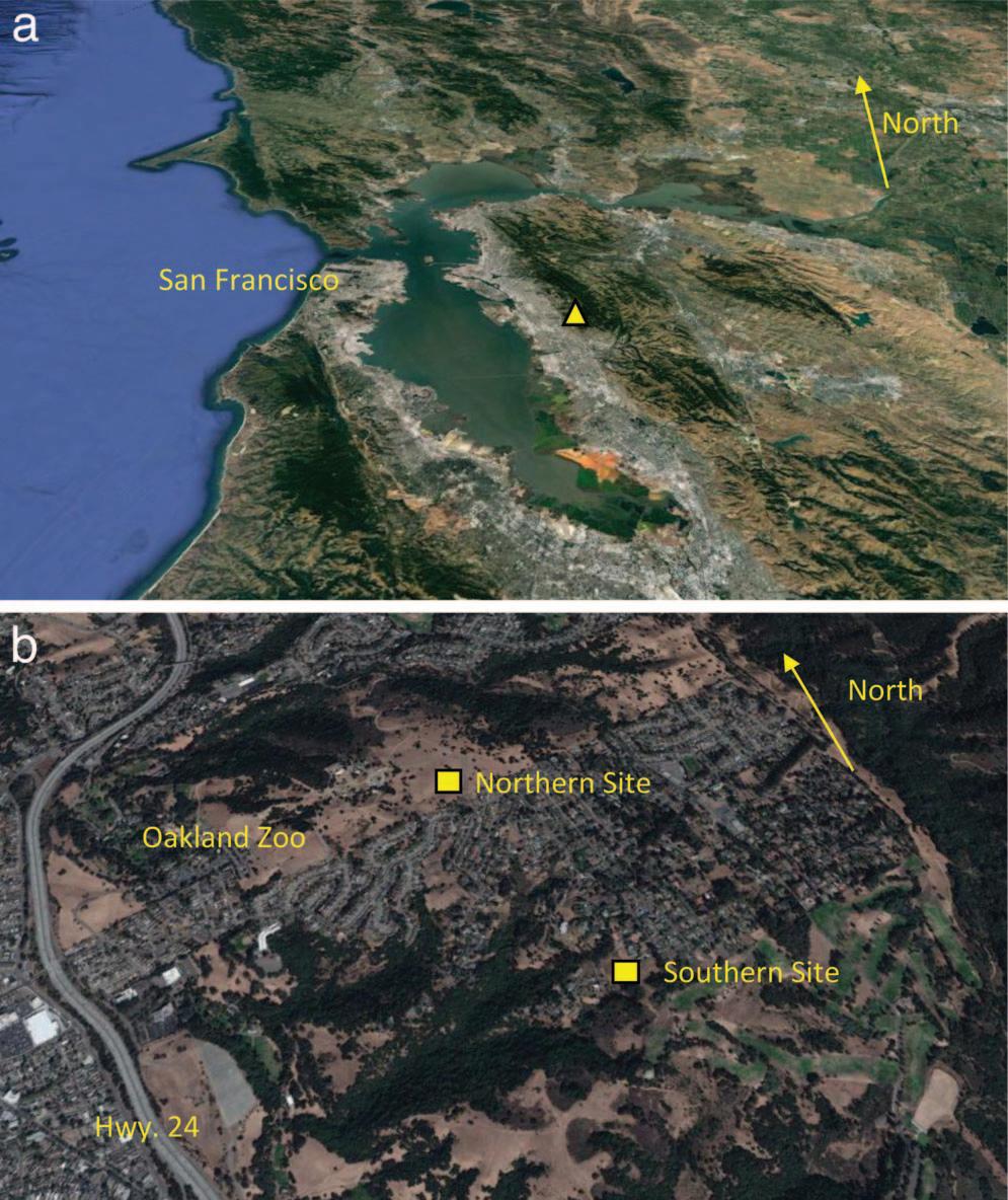
Assume that a professional geologist is tasked to determine whether an Asbestos Dust Mitigation Plan (ADMP) is required by a local air district at two development sites located near each other in the Oakland hills of California. Assume also that the only criterion of interest to the air district is subsection (b)(1), which is generally the case. In this example, the two sites selected reside in the Oakland hills near the Oakland Zoo (Figure 1a and b). Following the protocol of the ATCM, the geologist is referred to the geologic map of the San Francisco–San Jose quadrangle (Wagner et al., 1990) to determine whether the sites are located within a GURU. If this large-scale (1:250,000) compilation map is used as specified, the sites fall in unit “KJF,” which is denoted as the Franciscan Complex (Figure 2). The legend of the map denotes Franciscan mélange by horizontal lines, which are not indicated at the location of the sites. Ultrabasic rocks are indicated to the east, colored dark purple on the map. Thus, the requirement under subsection (b)(1) has been satisfied, and without further assessment, these sites would not require notification to the air district, nor would an ADMP or air monitoring be required.
However, the professional geologist would undoubtedly know that a review of only the specified map is not sufficient because it is a compilation of many sources of varying quality and accuracy. Other map resources are available and would be consulted. One source is the San Francisco Bay Area geologic map by the U.S. Geological Survey (Graymer et al., 2006). When plotted, the sites fall within unit “fsr,” which denotes Franciscan Complex mélange (Figure 3). A professional geologist may conclude that the ATCM is not triggered
Figure 1. (a) Google Earth oblique photograph showing the location (triangle) of the two sites in the Oakland hills east of San Francisco, California. (b) Google Earth oblique photograph showing the locations (squares) of the northern and southern sites in the Oakland hills, California. Highway 24 and the Oakland Zoo are shown for locational reference.
because the site does not fall in a GURU as defined, even though the reference to mélange suggests the potential for serpentinite to be present.
Another important resource is the national geologic map database, which is easily accessed on the Web (https://ngmdb.usgs.gov/ngmdb/ngmdb_home.html). The locations of the two sites are plotted in Figures 4 and 5. Note that the database is a compilation of
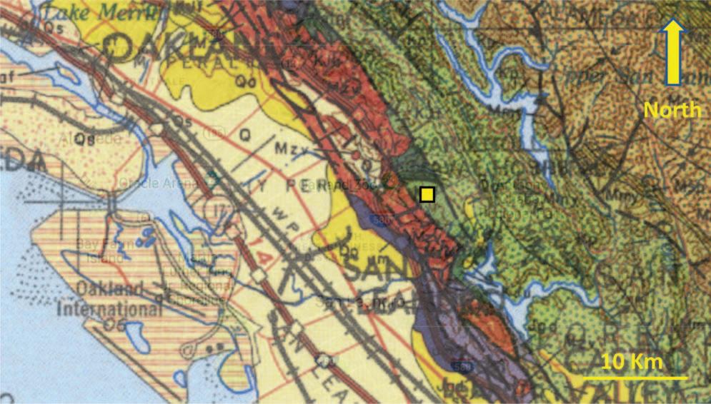
Figure 2. Location of the two sites (square) on the geologic map prescribed in Appendix A of the ATCM (Wagner et al., 1990).
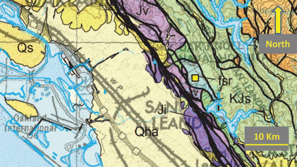
Figure 3. Site location (square) on the U.S. Geological Survey map of the San Francisco Bay region (Graymer et al., 2006). The unit “fsr” denotes Franciscan mélange.
many maps, and in this case, the sites fall near the intersecting corners of four map quadrangles. The southern site, shown on a map by Graymer (2000), falls within unit “KJfm”: Franciscan mélange. Again, the unit is not a GURU as defined, and an ADMP is not required. The map for the northern site, however, has been replaced by a map by Dibblee (2005a), placing the northern site within a very different rock unit, “Ob”: Coast Range Ophiolite. This unit is denoted in the legend as “ultramafic rocks, mostly gabbro and diorite.” In this case, the determination of whether the site lies in a GURU will differ depending on which map is used.
Further Investigation through Assessment of Asbestos Potential
Several air districts have developed guidance for how to determine a project’s applicability to the ATCM, one example being the Placer County As
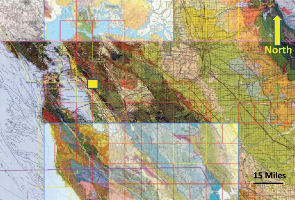
Figure 4. Sites (square) plotted on the compilation map as depicted on the U.S. Geological Survey National geologic map database (Graymer, 2000).

Figure 5. The two sites plotted on the image from U.S. Geological Survey geologic map database as it appeared at the time of this publication. The northern and eastern quadrants are mapped by Dibblee and Minch (2005a, 2005b, 2005c). The southwestern quadrangle is mapped by Graymer (2000).
bestos Dust Mitigation Plan Guidance for NOA (Placer County, 2014). The guidance document states that the ATCM is applicable when the site is located in a GURU or “has naturally-occurring asbestos, serpentine or ultramafic rock as determined by owner/operator, registered geologist or the District APCO.”
Professional geologists are aware that a geologic map review is the first step of a geologic investigation and should not be the sole source used to assess whether asbestos may be present on a site (note the reference to the presence of “asbestos” as a trigger in subsection (b)(2) of the ATCM). When assessing a site for ATCM applicability, the geologist should conduct an appropriate inquiry following the standard of practice for geologists in California. This standard begins with protocols within the Guidelines for Geologic Investigations of Naturally Occurring Asbestos in California (Clinkenbeard et al., 2002). The assessment could take an investigatory path similar to “Phase I Environmental Assessments” designed to assess whether chemical spills, releases, or uncontrolled use of hazardous chemicals may have occurred at the site and whether further action in the form of a “Phase II soil and groundwater investigation” is warranted. For NOA, the site could be evaluated on the basis of NOA potential: sites with underlying rock and soil with a high NOA potential (e.g., serpentinite and former asbestos mines and prospects) could be assumed to have an asbestos concentration greater than 1 percent, and dust control and Occupational Safety and Health Administration (OSHA) compliance measures be implemented without further investigation. If the determination of concentrations relative to the ATCM 0.25-percent surfacing and cover threshold or the Cal/OSHA 1 percent threshold for “Class II Work” is important, then a soil and rock
investigation is needed. Rocks or soil with moderate NOA potential require further investigation, beginning with a literature and map review, followed by a site verification. The professional geologist would then develop an opinion as to whether a “Phase II” rock and soil investigation is warranted.
The concept of asbestos potential is well documented in several publications by the California Geological Survey (Churchill et al., 2000; Higgins and Clinkenbeard, 2006 a, 2006b). Of these, Higgins and Clinkenbeard (2006a) is particularly important because it assigns high, medium, and low NOA potential to the various geologic units in that region, provides the basis for each designation, and presents an NOA potential map. However, the professional geologist should not rely solely on the map and should use it and the concepts provided within the publication to arrive at his or her own conclusions. For example, alluvium is listed as low potential, but further evaluation may show that a particular alluvial unit may have been sourced from rocks with high NOA potential and therefore is also a high potential unit. A rock unit that has been assigned a moderate NOA potential may be heterogeneous, and individual sub-units underlying a particular site may be of high or low NOA potential. Only an appropriate site-specific investigation by a professional geologist that includes a field assessment can differentiate which of the two is most likely.
Programmatic Implementation of NOA Potential Mapping: An Example
The concepts regarding asbestos potential provided in Higgins and Clinkenbeard (2006a) are gaining acceptance by geologists, and techniques that utilize these concepts have been developed to prevent exposure to workers and the public. One excellent example is the program implemented by the San Francisco Public Utilities Commission (SFPUC) Department of Health and Safety for their internal use. The SFPUC owns large tracts of land across northern California associated with the extensive network of facilities, reservoirs, and pipelines of San Francisco’s Hetch Hetchy water delivery system. A database of NOA potential that was produced by a professional geologist, (Figure 6) covers the counties where SFPUC facilities reside. The local detailed segment of this map is reviewed when soil disturbance that may produce exposure to dust is expected at a work site, which ranges in scope from large construction projects to small weedwhacking tasks for fire suppression purposes. Based on the review, a follow-up assessment that may include a site visit and testing for NOA may be initiated.

Figure 6. NOA potential map of northern California produced from SFPUC’s NOA potential GIS database (not published; for internal use only and not available to the public). Green = high NOA potential, predominantly serpentinite and other ultramafic rocks; orange = moderate NOA potential, predominantly metamorphic rocks where regulated amphiboles are likely to be present in certain rock units.
Further Evaluation Following Geologic Map and NOA Potential Map Review
A professional geologist tasked with an NOA evaluation at a site should, at a minimum, provide data to determine whether a regulatory threshold may be exceeded. For earthmoving projects, the primary regulatory agencies are CARB for the protection of off-site receptors and Cal/OSHA for the protection of on-site workers. In the case of the CARB ATCM, the threshold is “No Asbestos Detected” (note that the 0.25 percent threshold specified within the ATCM refers to post-construction covering and surfacing applications, not excavation). There is no threshold specified for excavation activities during construction. Cal/OSHA regulations are triggered when asbestos is present in any amount (the 1 percent threshold in the regulation triggers additional engineering controls and personal monitoring). Thus, the threshold that triggers compliance response actions during a typical construction project is “No Asbestos Detected” as measured with an appropriate lower limit of detection or analytical sensitivity. It follows that the threshold that geologists should use to assess whether a geologic assessment is appropriate is that “asbestos is not likely to be present” rather than “asbestos is likely to be present.”
Both the California Geological Survey and SFPUC produced NOA potential maps that depict the relative likelihood for the presence of NOA. In both cases, the high-likelihood rocks are serpentinite and other ultramafic rocks. It is generally assumed that asbestos is likely to occur in these rocks, and Cal/OSHA and CARB regulations are automatically triggered. Both of the NOA potential maps tend to designate nonmetamorphic and sedimentary rocks as low potential. Both maps include a third category: rocks with a moderate potential for asbestos to be present. This
group includes metamorphic rocks where amphiboles are likely to be present. Should these rocks be further investigated considering that the threshold by the two agencies cited above is “No Asbestos Present”? The answer is yes, as will be illustrated in the following example.
Consider the Franciscan Complex in northern California and compare the non-serpentinite component in two locations. The first is the city and county of San Francisco, where tectonic terranes of relatively unmetamorphosed Franciscan Complex rocks are separated by two serpentinite mélange belts. The second is the Franciscan Complex in the Diablo Range southeast of San Francisco, where the Franciscan Complex is present as a blueschist-grade mélange (for details regarding the tectonic histories of various Franciscan Complex terranes, see Wakabayashi, 2015). Using the criteria presented by Higgins and Clinkenbeard (2006a), SFPUC designated the greenstone metabasalt as moderate potential. However, further evaluation of the greenstone metabasalt in both locations indicate that the greenstone should be redesignated, one to high potential and the other to low potential, as described below.

Franciscan Greenstone in the Diablo Range
The Diablo Range Franciscan rocks were studied during SFPUC’s Calaveras Dam Replacement Project (CDRP) as part of an extensive NOA control and monitoring program. The rocks outcropping at this location were subducted to relatively deep levels and subjected to low-temperature/high-pressure blueschist facies metamorphism. Through the metamorphic process, blueschist rocks originated in which fibrous glaucophane amphibole crystallized, as shown in Figure 7a and b. Erskine and Bailey (2018) showed through a fiber dimensional analysis that the glaucophane met the characteristics of the asbestiform habit. Testing of the blueschist by transmission electron microscopy revealed asbestiform glaucophane concentrations that exceed 20 percent by weight and more than 200,000 million fibers per gram (MFG). The U.S. Geological Survey concurred and recently designated glaucophane at the CDRP as a known occurrence of asbestos. Thus, the greenstone at the CDRP site, as well as the other metamorphic rocks of the Franciscan in the Diablo Range, has a high likelihood for asbestos to be present.
Franciscan Greenstone in San Francisco
Greenstone of the Marin Headlands terrane collected near Lands End in north San Francisco and at the Marin Headlands show that these rocks did not
Figure 7. (a) Hand specimen of fibrous blue glaucophane crystallizing within greenstone at the CDRP construction site, northern Diablo Range, California. (b) Thin-section photomicrograph of greenstone in the northern Diablo Range showing fibrous glaucophane (blue mineral) crystallizing within a matrix hosting relic greenstone porphyroclasts. Photomicrograph taken under plane polarized light.
reach blueschist facies metamorphism, as evidenced by well-preserved primary structures and textures and no glaucophane (Figure 8a). In thin section, primary intersertal structure is recognizable, with skeletal plagioclase phenocrysts set in a fine-grained matrix (Figure 8b). No indication of glaucophane or other low-temperature/high-pressure mineralization was present in these rocks, and asbestos was not detected by transmission electron microscopy in the samples tested. Therefore, with further verification, the NOA potential for these rocks may be downgraded from moderate to low likelihood for asbestos to be present.
SUMMARY AND CONCLUSIONS
The CARB ATCM provides criteria to evaluate regarding whether a site is subject to mandatory asbestos dust control measures and potential air monitoring.
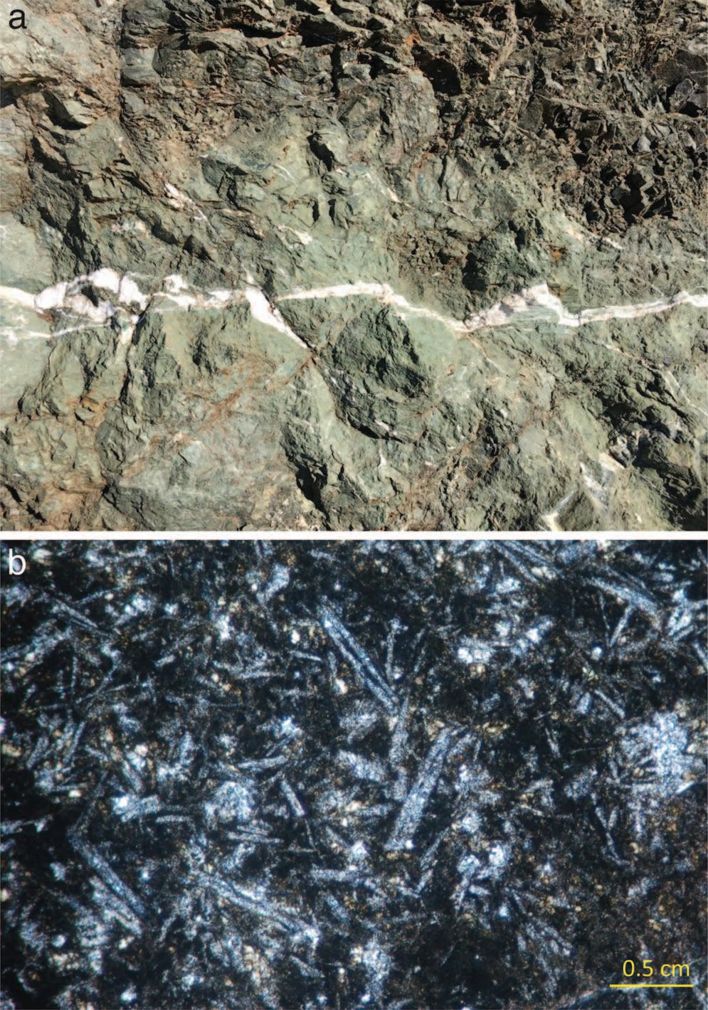
Figure 8. (a) Outcrop of greenstone (metabasalt) at Lands End in San Francisco. No evidence of blueschist metamorphic index minerals (glaucophane or lawsonite) is present. (b) Thin-section photomicrograph of greenstone showing primary plagioclase within a fine-grained matrix. Photomicrograph taken under crossed polarizing light.
The evaluation process, however, falls far short of the standard of practice for professional geologists.
The following conclusions and recommendations are offered based on the information and data presented in this article: All assessments, including the preliminary review of geologic maps, should be conducted by a professional geologist as defined by the state licensing board. The ATCM requires that a professional geologist conduct an assessment for the purposes of an exemption from the GURU rule and envisions that a geologist who could detect unforeseen asbestoscontaining rock and soil will be on-site. It does not, however, require that a professional geologist conduct the initial assessment through the review and interpretation of geologic maps. The initial assessment is the most important phase of the ATCM process, and the review and interpretation of geologic maps by unqualified persons for the purpose of assessing NOA potential presents a high risk of misinterpretation. The procedure outlined in the ATCM where a determination is made solely through a desktop review of maps is inadequate to assess the likelihood of asbestos to be present at a site. Geologic maps provide a representation of the distribution of rocks and structure as observed by the mapper and do not include information regarding asbestos. Rock units are identified differently depending on the context of the map; for example, serpentinite may also be mapped as ultramafic rocks, mélange, or incorporated without identification into a larger unit. Smaller bodies or those with poor exposure may be missed altogether. A review of geologic maps should be the first step in an investigation, as is standard practice, to be followed by further characterization that includes a site visit and perhaps soil and rock testing. More consideration should be given to subsection (b)(2) in the Applicability section, which refers to the presence of asbestos as a trigger for compliance with the ATCM. The determination of whether asbestos is or is not present requires far more inquiry than a map review. The professional geologist should conduct a reasonable level of inquiry before he or she may conclude that “asbestos is not likely to be present.” While NOA potential maps are powerful tools, further assessment, including a field reconnaissance at a minimum, is needed to adequately assess the likelihood for asbestos to be present. The determination that the ATCM is triggered should be tied to the permitting process in the same manner as asbestos in buildings materials. Building demolition permitting requires an asbestos inspection conducted by a California Department of Occupational Safety and Health–certified asbestos consultant. Similarly, a grading permit should require an NOA assessment report by a qualified professional geologist. At present, some California air districts have such a system, but the majority do not.
REFERENCES
California Air Resources Board (CARB), 2002, Asbestos Airborne Toxic Control Measure for Construction, Grading, Quarrying and Surface Mining Operations: Publication No. 2001-07-29, 23 p. Churchill, R. K.; Higgins, C. T.; and Hill, B., 2000, Areas More Likely to Contain Natural Occurrences of Asbestos in Western El Dorado County, California: California Department of Conservation Open-File Report 2000-2002, 66 p.
Clinkenbeard, J. P.; Churchill, R. K.; and Lee, K., 2002, Guidelines for Geologic Investigations of Naturally Occurring Asbestos in California: California Geological Survey Special Report 124, 85 p. Dibblee, Thomas W. Jr. and Minch, J. A., 2005a, Geologic Map of the Oakland East Quadrangle, Contra Costa & Alameda Counties California. Dibblee Geological Foundation Map DF-160. Dibblee, Thomas W. Jr. and Minch, J. A., 2005b. Geologic Map of the Las Trampas Ridge Quadrangle, Contra Costa & Alameda Counties California. Dibblee Geological Foundation Map DF-161. Dibblee, Thomas W. Jr. and Minch, J. A., 2005c. Geologic Map of the Hayward Quadrangle, Contra Costa & Alameda Counties, California. Dibblee Geological Foundation Map, DF-163. Erskine, B. G. and Bailey, M., 2018, Characterization of asbestiform glaucophane-winchite in Franciscan Complex blueschist, northern Diablo Range, California: Journal of Toxicology and Applied Pharmacology, Vol. 361, pp. 3–13. Graymer, R. W., 2000, Geologic Map and Map Database of the Oakland Metropolitan Area, Contra Costa and San Francisco Counties, California. U.S. Geological Survey Report MF-2342. Graymer, R. W.; Moring, B. C.; Saucedo, G. J.; Wentworth, C. M.; Brabb, E. E.; and Knudsen, K. L., 2006. Geologic Map of the San Francisco Bay Region, United States Geological Survey: Scientific Investigations Map 2918. Higgins, C. T. and Clinkenbeard, J. P., 2006a, Relative Likelihood for the Presence of Naturally Occurring Asbestos in Placer County, California: California Geological Survey Special Report 190, 54 p. Higgins, C. T. and Clinkenbeard, J. P., 2006b, Relative Likelihood for the Presence of Naturally Occurring Asbestos in Eastern Sacramento County, California: Geological Survey Special Report 192, 43 p. Placer County, 2014, Asbestos Dust Mitigation Plan (ADMP) Guidance for Naturally Occurring Asbestos: Revision 14, May 21, 2014, 11 p. U.S. Agency for Toxic Substances and Disease Registry (U.S. ATSDR), 2011, Evaluation of Community-Wide Asbestos Exposures: El Dorado Hills Naturally Occurring Asbestos Site, El Dorado Hills Boulevard, El Dorado Hills, California: EPA Facility ID Can000906083, 194 p. U.S. Environmental Protection Agency (U.S. EPA), 2008, Clear Creek Management Area Asbestos Exposure and Human Health Risk Assessment: 75 p. Wagner, D. L.; Bortugno, E. J.; and McJunkin, R. D., 1990, Geologic Map of the San Francisco-San Jose Quadrangle (set of five sheets). California Division of Mines and Geology Regional Map 5A. Wakabayashi, J., 2015, Anatomy of a subduction complex: Architecture of the Franciscan Complex, California, at multiple length and time scales: International Geology Review, Vol. 5, Nos. 5–8, pp. 669–746.


