BIM 2022
by: Anthony Renteria
ArcGIS GeoBIM: Connecting Projects in Context
D
espite the narrowing of the gap between GIS and BIM over the last few years, Architecture, Engineering, and Construction (AEC) firms and their clients are still battling with disparate data on multiple platforms and are still struggling to provide a single authoritative view of project data to communicate project information easily and securely. ArcGIS GeoBIM delivers an innovative, easy-to-use, web-based experience for project teams to explore and collaborate on BIM projects and issues using data from multiple systems in a geospatial context.
WHAT IS ARCGIS GEOBIM?
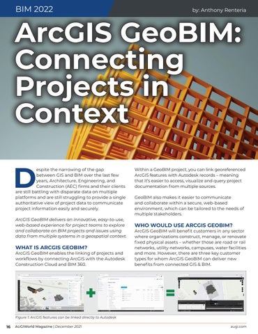
ArcGIS GeoBIM enables the linking of projects and workflows by connecting ArcGIS with the Autodesk Construction Cloud and BIM 360.
Within a GeoBIM project, you can link georeferenced ArcGIS features with Autodesk records – meaning that it’s easier to access, visualize and query project documentation from multiple sources. GeoBIM also makes it easier to communicate and collaborate within a secure, web-based environment, which can be tailored to the needs of multiple stakeholders.
WHO WOULD USE ARCGIS GEOBIM?
ArcGIS GeoBIM will benefit customers in any sector where organizations construct, manage, or renovate fixed physical assets – whether those are road or rail networks, utility networks, campuses, water facilities and more. However, there are three key customer types for whom ArcGIS GeoBIM can deliver new benefits from connected GIS & BIM.
Figure 1: ArcGIS features can be linked directly to Autodesk
16
AUGIWorld Magazine | December 2021 augi.com


