ESALA 2024
Master of Architecture
DAIRE’S AIRC:
EDGE EFFECTS || DERRY/LONDONDERRY, NI

Iain Scott
Mark Bingham
DAIRE
 LondonDerry 1800
Henry Brocas
LondonDerry 1800
Henry Brocas

III
This catalogue is part of a collection published by the Edinburgh School of Architecture and Landscape Architecture (ESALA), Edinburgh College of Art, University of Edinburgh. It documents student design work produced in the Master of Architecture (MArch) programme in 2023-24. Each catalogue describes one of the following six design studios in the MArch programme. The full collection is available to view online at issuu.com/eca.march.
Catalogues 2023-24:
Architecture as Support Structure.
Close Encounters: Berlin.
Crossing Tangier.
Daire’s Airc.
Grounding Naples Vol. 2
Radical Harvest: Earth/Care/Reuse.
Published in 2024 by The University of Edinburgh, under the Creative Commons Attribution Non-Commercial Non-Derivative 4.0 International License (CC BY-NC-ND 4.0).
Scott, Iain, and Mark Bingham. Daire’s Airc:EdgeEffects: Eco-tones&theEcologicalCondenser(Derry/Londonderry,NI).
Edinburgh: University of Edinburgh, 2024.
Text © Authors, 2024.
Images © Authors and Contributors, 2024.
Daire’s Airc
ISBN (paperback): 978-1-912669-75-2
ISBN (eBook) 978-1-912669-67-7
ESALA 2024
Master of Architecture
DAIRE’S AIRC:
EDGE EFFECTS || DERRY/LONDONDERRY, NI
Iain Scott
Mark Bingham
DA IR E
URBAN FUSION: DENSIFYING DAIRE
ELLIE WILKES
ISABELLA INNOCENZI
CHING-EN LIN
CHRIS PIRRIE
ELLIE WILKES
CHRIS PIRRIE
- DAIRE’S AIRC IAIN SCOTT | MARK BINGHAM 1 CONTENTS
G2
G1
THE RESTITUTION OF ‘STANLEY’S WALK’ & MARY BLUES BURN ASTRID MCINTYRE MATTHEW JOHNSON KE WANG 01 05 03 07 02 06 04 THE HARVEST BOW ISABELLA INNOCENZI RE-ROOTING FORGOTTEN CONNECTIONS MATTHEW JOHNSON
RE-PURPOSING
OF
RE-PLENISHING AND
DAIRE’S LANDSCAPES
(THE) RUIN
THE URBAN
INFOBAHN
DAIRE’S REVERENCE ASTRID MCINTYRE COMPACTING DAIRE CHING-EN LIN (E)MERGING & (SUB)MERGING KE WANG 16 48 20 50 34 60 26 56 40 ACKNOWLEDGEMENTS 128130 BIBLIOGRAPHY & IMAGE REFERENCES
G3
GREEN CORRIDOR
PATHWAY
SUN 11 15 16 BRIDGING THE BOGSIDE TOBIA GRAZIANI UNEARTHING DERRY LUCAS JONES RE-WILDING & RE-BRIDGING DAIRE VIVI HSIA
RE-BIRTH
DE-COLONISING DAIRE
GE
WATERS
GUO HEALING THE FORGOTTEN LANDSCAPE OF DAIRE’S BOGSIDE BERAT UGUR REGISTERING THE ANTHROPOCENE HANNAH ORD DAIRE & THE ‘ANTI-MONUMENT’ WENHAO SUN 68 70 100 96 80 112 74 108 88 116 08 12 10 14 09 13
FOUNTAIN
& ECOLOGICAL
XIANG GAO WENHAO
DAIRE’S
XIANG GAO
YUHE
RECLAIMED
LUCY
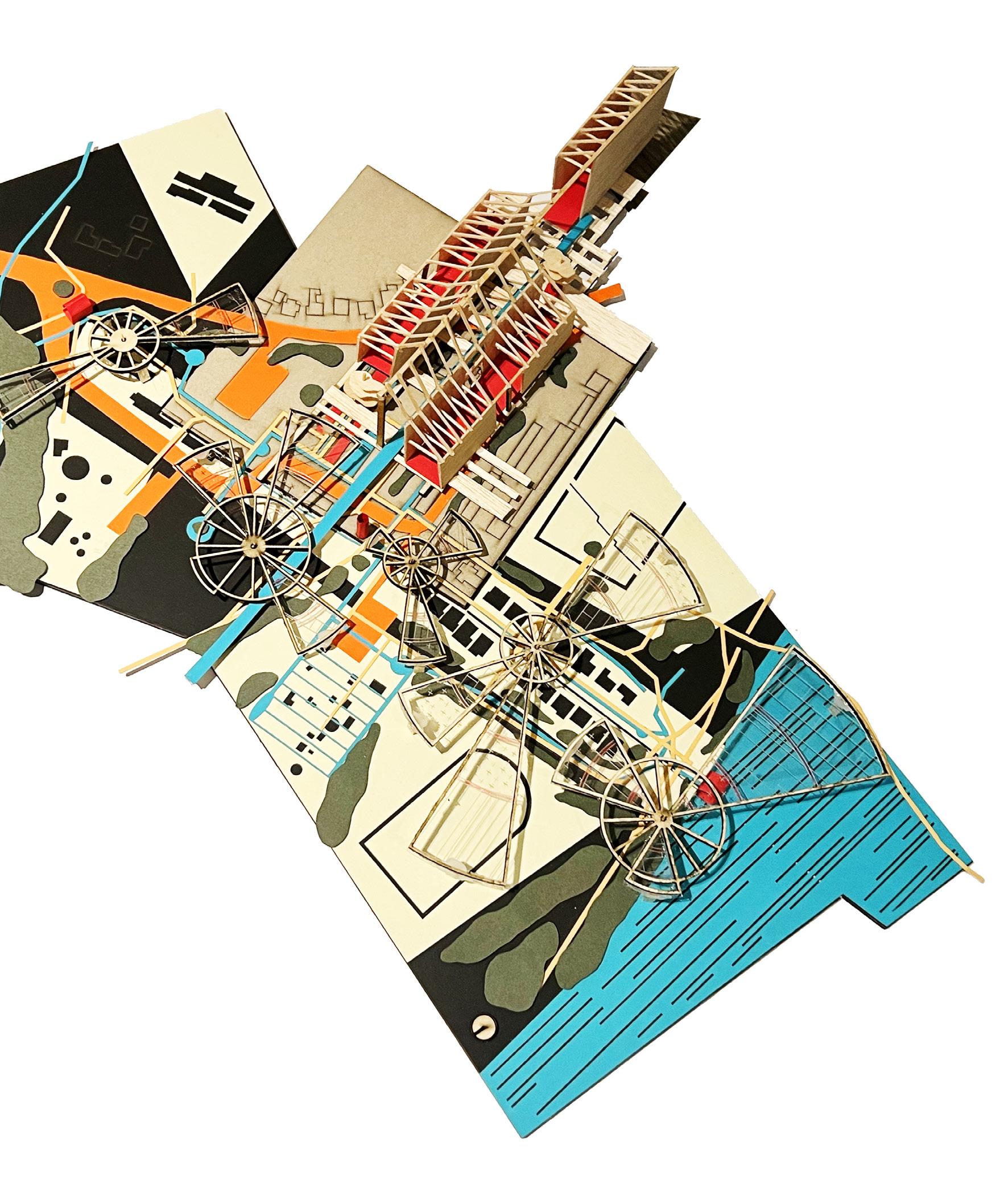
 Reclaimed Waters.
Field Model Installation, Printworks Studio. MDF, timber, card, steel.
Lucy Guo
Reclaimed Waters.
Field Model Installation, Printworks Studio. MDF, timber, card, steel.
Lucy Guo
DAIRE’S
AIRC
EDGE EFFECTS, ECO-TONES & THE ECOLOGICAL CONDENSER (DERRY/LONDONDERRY, NI).
This two-year Master of Architecture studio invites students to propose a series of architectural and landscape projects, which we term ‘ecological condensers,’ through the critical apparatus of a carefully researched and constructed environmental thesis. Drawing poetic inspiration from the myth of a global flood that destroys ‘all life’ as described in the book of Genesis, we operate across scales from the metropolitan to the bodyscale. We enhance revealed natural and urban eco-tones while proposing sustainable indigenous ecologies and habitats for both human and nonhuman species in the context of a radically changing climate. We employ the Irish Gaelic word ‘Airc’ (English: ‘Ark’) as our neo-mythical term for the ecological condenser.
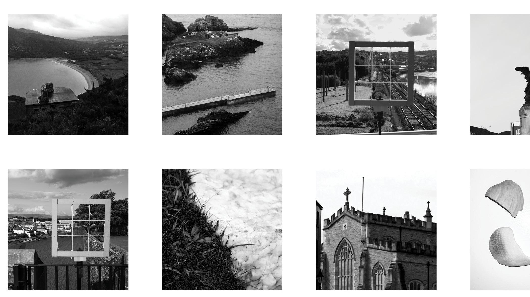
During the opening semester of the two-year program, we ‘flooded’ the studio with our concepts, ideas, and concerns in the city of Daire/Doire/ Derry/Londonderry, Northern Ireland. We began with a thorough and exhaustive process of critical investigation and interrogation to uncover existing ‘edge effects’ or eco-tones in the city of Daire and its surrounding metropolitan landscape. Immersive and bespoke fieldwork methods enabled a deeper understanding of the ontological forces of place and allowed for speculations around a small-scale structure that transforms an existing edge effect and enhances biodiverse relations between human and nonhuman species.
As we physically, digitally, and metaphorically walked our selected edges, we uncovered, recorded, unpicked, and extracted narratives. Through
1 IAIN SCOTT AND MARK BINGHAM | DAIRE’S AIRC
 Foyle Bridge, View from Culmore Road
Photograph, Daire Field Trip.
Ching-En Lin
Foyle Bridge, View from Culmore Road
Photograph, Daire Field Trip.
Ching-En Lin

careful interpretation, translation, and curation, these narratives inform our thesis explorations and drive material and ephemeral interventions in the temporal city. We have witnessed the narrowing of the ecotone at ecological, sociological, and urban levels, where diversity and uniqueness are replaced by monoculture and predictability. We talk, draw, and model together, working through a process of iteration. We have gathered big data using digital tools and devices but have also slowed down and spent time embracing a physical process of field research, drawing, and modelling.
The core idea of the studio is to research and investigate ‘edge effects’ (changes in population or community structure that occur at the boundary of two or more habitats) and the ‘in-between’ they generate, referred to in ecology as the ‘eco-tone’ (a region of transition between two biological communities). The edge effect is an ecological concept that describes how there is a greater diversity of life in the region where the edges of two adjacent ecosystems overlap, such as land/water or forest/grassland. At the edge of two overlapping ecosystems, species from both systems can be found, as well as unique species that aren’t found in either ecosystem but are specially adapted to the conditions of the transition zone between the two. We contend that at natural, urban, and sociological levels, the edge effects and their resultant eco-tones in the city of Daire and its surrounding landscape have become hugely depleted.
Our city of investigation is known as both Derry and Londonderry. Derry (originating from the Irish Gaelic – ‘Daire,’ meaning ‘oak grove’) and Londonderry – the English prefix being added in 1613 by James I of England. Both names are in common usage today, largely dependent upon socio-religious affiliations. As urban and architectural speculators and ‘agitators,’ we employ the Irish Gaelic term ‘Daire’. Daire is the secondlargest city in Northern Ireland. The old walled city lies on the west bank of the river Foyle, which is spanned by two road bridges and one footbridge. The city now covers both banks (City-side on the west and Water-side on the east).
The city, along with its River Foyle and Lough Foyle to the North, sits in the Foyle basin in the north-west corner of Northern Ireland. It is a postglacial landscape formed over millions of years within the Antrim plateau. The recorded history of Daire begins around 545AD with the ‘Annals of
3 IAIN SCOTT AND MARK BINGHAM | DAIRE’S AIRC
Ulster’ (Ulster being one of the four traditional Irish provinces) recording the inception of a monastery, ‘The Doire of Calgach’ or ‘Oakwood of Calgach,’ founded by Collum Cille (St. Columba). The name was changed from Derry to Londonderry in 1613 during the Plantation of Ulster to reflect the fortification of the city by the City of London Guilds and the establishment of the Honourable Irish Society. The Plantation of Ulster was the organized colonization (plantation) by people from Great Britain during the reign of King James I. Most of the settlers (or planters) came from southern Scotland and northern England. Small, privately funded plantations instituted by wealthy landowners began in 1609. Most of the colonized land had been confiscated from the native Gaelic chiefs or earls, several of whom had fled Ireland for mainland Europe in 1607 following the Nine Years’ War against English rule. Derry was the principal plantation in Ulster.
The legacy of the Plantation remains disputed. According to one view, it has created a society segregated between native Catholics and settler Protestants in Ulster and created a Protestant and British concentration of people in north-east Ireland. This argument also sees the Plantation as one of the long-term causes of the Partition of Ireland in 1921, where the north-east of Ireland remained part of the United Kingdom as Northern Ireland. It can also be seen as a generator of ‘The Troubles.’ The Troubles (also known as the Northern Ireland conflict) was a conflict between Irish nationalists and the British government that lasted around 30 years from the late 1960s to the late 1990s.
WEAP Drawings & Individual Research Inquiry:
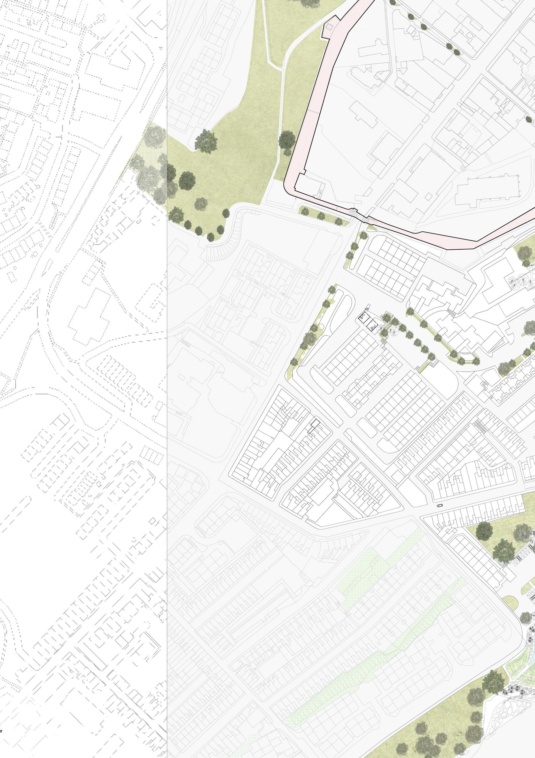
Our first concern as a studio was to find ways of recording, analysing, and representing existing ‘edge effects’ or ‘eco-tones’ operating within a defined ‘field of concern.’ These existing edge effects operate within physical, socio-political, environmental, and technical realms. Beginning with an exhaustive desktop process, we carefully researched, constructed, and drew a series of maps related to a ‘Field of Concern’ anchoring ourselves to one quarter of the walled city and moving out to a selected eco-tone or ‘thin place’ at the edge of the city or further out to the surrounding landscape. We framed these mappings as ‘WEAP’ drawings, recording the environmental phenomena of Water, Earth, Air, and People across
IAIN SCOTT AND MARK BINGHAM | DAIRE’S AIRC
 Malin Head
Photograph, Daire Field trip
Vivi Hsia 5
Malin Head
Photograph, Daire Field trip
Vivi Hsia 5
 WEAP Installation
Photograph&Photoshop, Printworks Studio
Lucy Guo
WEAP Installation
Photograph&Photoshop, Printworks Studio
Lucy Guo
three principal time zones. Namely, agricultural, industrial, and digital (the present). The WEAP research drawings dive into deep time and the evolution of place, engaging with the geomorphology, ecology, hydrology, climate, and forms of human settlement over time. Data does not exist to always allow for a completely empirical representation of phenomena across all time periods. This is to be expected. We encouraged the development of carefully deducted and constructed ‘fictions’ in the event of archival data being unavailable.
This exhaustive data set, produced through an iterative process over several weeks, allows for a broad but critical understanding of the interaction of these various phenomena over time in the city of Daire. As a further parameter defined by our ecological remit, we selectively recorded the habitats and environments of animal and vegetal species which reside(d) within the particular element of investigation.
Fieldwork:
A physical process was central to our field trip activities, and prior to going to Daire we asked students to prepare method statements elaborating process, techniques, and tools for their work in the field. Decisions of paper type, texture, level of transparency, and size of sheet are critical to the research and design process through setting parameters. To physically record field observations we needed to consider materials and techniques which were appropriate for use in an external environment, material sources and tools prepared in advance, combined with materials in the field. These decisions become the equivalent of your instrument if you were a musician, or canvas if you were a painter. They become deeply entangled with individual cognitive processes. By asking students to work in this way, to slow down, take an immersive route and focus on the limits presented by the scale, material, and tools you are using a calm often enters the creative space evoking a certain creative freedom and atmosphere.
Edge Structure:
Following the field trip, students began to consider more carefully the selected edge where they would propose an architectural intervention or ‘edge structure,’ the central premise being that through a careful
7 IAIN SCOTT AND MARK BINGHAM | DAIRE’S AIRC
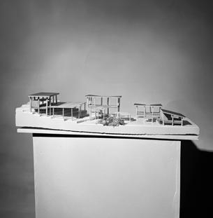
 Studio Exhibition
Installation, Printworks Studio. MDF, timber, card, steel.
Photography Lucy Guo
Studio Exhibition
Installation, Printworks Studio. MDF, timber, card, steel.
Photography Lucy Guo

9

manipulation of the site, ground, and a selected set of architectural elements and components we can enhance, subvert, or transform the existing edge effect previously uncovered and accommodate both human and non-human activities as part of a shared constructed and natural habitat. According to the zoological theory of van Uexküll, the environment of the animal is represented by a series of signs or marks called ‘carriers of significance.’ These marks or ‘signifiers’ constitute everything that carries interest and meaning for that species. According to the perceptual theories of James Gibson, principally set out in ‘The Ecological Approach to Visual Perception,’ a ‘niche’ is the sum of a set of signifying marks that together constitute an animal’s ‘world.’ A niche is that place into which an animal quite simply fits and it is made up of features of terrain, significant objects, shapes, textures, colours, boundaries, and other animals. We carefully constructed and drew thoughtfully crafted models and drawings of the critical context related to the proposal, including the surroundings or ‘niche’ of a particular form of animal life. Supporting micro-vegetal ecologies were also recorded and represented. The ‘edge structure’ was not to be imbued with any pre-determined program, beyond some form of human and nonhuman activity. The structure was to harness some form of environmental element or habitat, potentially returning to one or more of the four themes of the WEAP, water, earth, air, and people. The ‘edge-structure’ was to be seen as a ‘test-bed,’ laboratory project, or prototype for the spatial, material, environmental, and tectonic prerogatives of the semester 2 Field & Airc project.
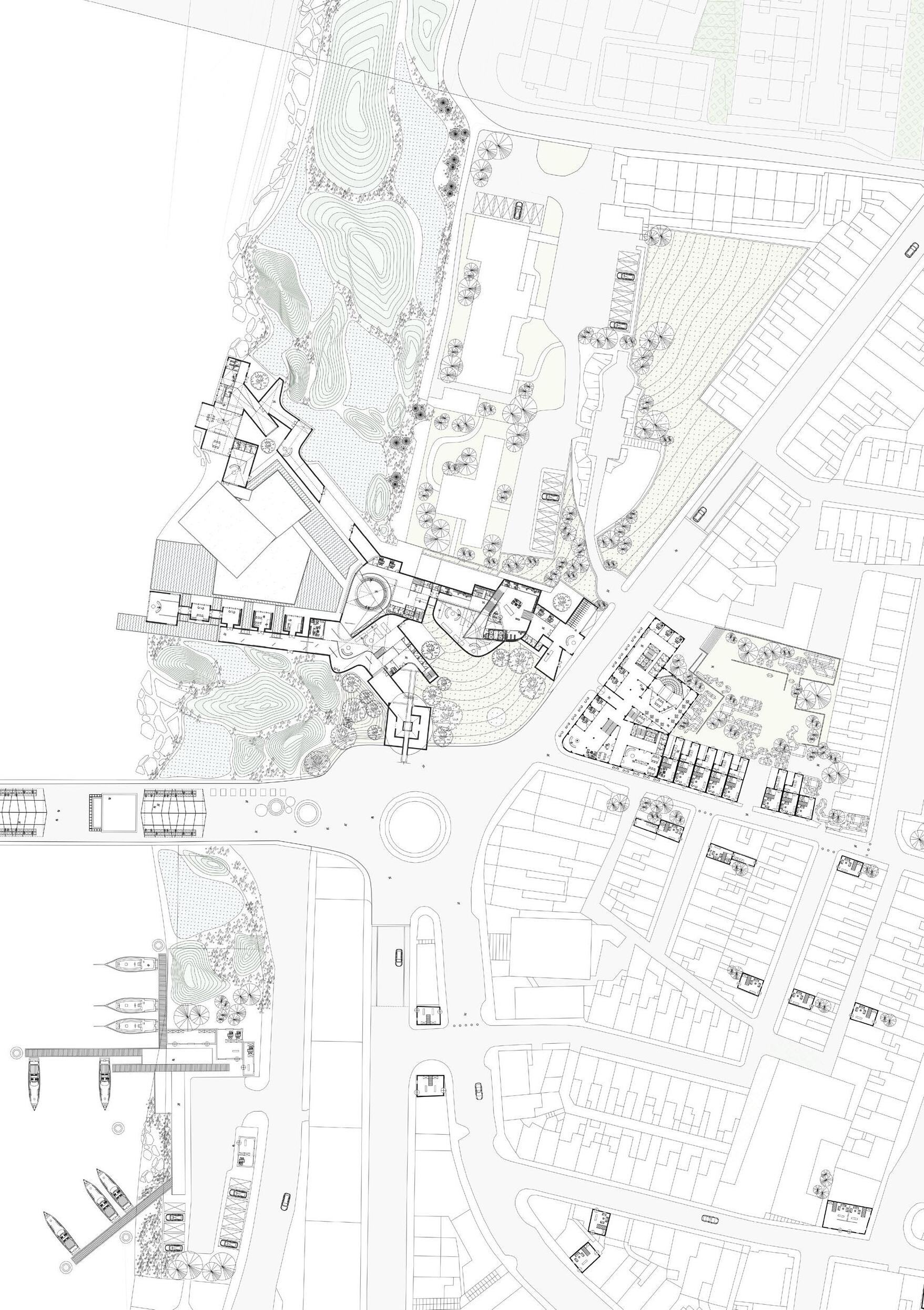
The Field & the Airc:
In semester 2 we concerned ourselves principally with ‘The Field’ and the early development of an ‘Airc’ or ecological condenser which would be in harmony with it.
We began a series of investigations and propositions centred on ‘the field’ and its various edges or ‘ecotones’. Again working in groups we made a series of drawings and models from week to week which speculated on the transformation and re-modelling of the field, driven by the concerns of the individual theses. These representations engaged with existing ontological and environmental forces and pressures which impact human and nonhuman inhabitants of the field. Groups and individuals then developed
IAIN SCOTT AND MARK BINGHAM | DAIRE’S AIRC
an urban, ecological spatial strategy within which individual Airc projects could situate themselves in a fundamental relationship to the elements of water, earth, air, and people.
In the second part of semester 2, we began to work on our individual sites within the field and to develop our Airc project, to be developed as an individual built form or as a series of smaller interventions. The programme was to be carefully researched and developed with innovation encouraged. The project and its surrounding landscape would house various habitats and activities for both human and non-human occupants and to be communicable in drawings, models, and film from the metropolitan to the field scale.
Outcomes:
In a place as contested as the city of Daire, students have worked intensively to generate a thesis that responds to the issues which have presented themselves and been revealed through careful and painstaking research and propositioning. A particularly rich series of thetic strands in a series of charged and contested locations have emerged including:
Proposing a new ‘archi-digital’ typology that reinterprets and re-uses abandoned urban artifacts by abstracting and repositioning them into new states of spatial and material agency, renewing the historic human-river agency through a dynamic engagement with a replenished indigenous ecology; restoring a lost city pathway linking ‘the city of the Living’ and ‘the city of the Dead’ which re-threads lost ecologies of wetland and meadow back into the urban weave, establishing a ‘landscape of reverence’ that pulses with historical and ecological significance; integrating regenerative agricultural plots within Daire’s urban core to promote sustainable living and food production, woven with woodland corridors and civic gathering spaces to enhance community cohesion and health; supporting a ‘regenerativereturn’ to a new Bogside urban-landscape paradigm of cascading civic spaces with green and blue connectivity through which water moves, rushes, is slowed, and retained, for the health and well-being of human and non-human citizens of the forgotten landscape and its supported ecologies; advocating for a future Daire city model fostering denser, well-connected neighbourhoods in harmony with natural space and a rewilded riverside;
11 IAIN SCOTT AND MARK BINGHAM | DAIRE’S AIRC

proposing a re-conception of the city’s engagement with its monumental enclosure through the lens of human and ecological interaction, stitching together segregated urban tapestries, to weave a contiguous civic space that transcends the traditional separations wrought by the old stonework; encouraging Daire to look to the past to reinterpret and revitalize its relationship with water for a post-Anthropocene future, through the active conservation of marine crafts and the preservation of important riverine historical and ecological artifacts; revitalizing the urban park and the future of park architecture and programming to celebrate structured and common activities within the revitalized landscape; creating a new Daire waterfront to restore the once vibrant ecosystem along the riverbank, reforging connections between the city community and the river’s natural ecology in a project which revitalizes and repurposes abandoned commercial retail space.
Architectural projects include a new city crematorium, a centre of material re-use and recycling; a future skills hub and community gathering place; creative arts display and exhibition space that recalibrates the civic relationship to historic walls within the city; programs related to food production and consumption in the shape of markets, community kitchens, and an urban farm; laboratory and knowledge exchange programs centred on indigenous species and habitat regeneration within ecologically enriched water-based landscapes; outdoor theatres and community hubs; with various programs contributing to the well-being of both human and nonhuman inhabitants of Daire.
Video Recording For Movement Analysis On The City Wall
Photograph, Daire Field Trip
IAIN SCOTT AND MARK BINGHAM | DAIRE’S AIRC
Ching-En Lin
Name Surname and Name Surname

Sunday 13th October, 2019.
13
Via Enrico Pessina, Avvocata. 14:20,
Maria Mitsoula.

Looking Towards Ferryquay Gate 1900
Photographer Unknown.

URBAN FUSION: DENSIFYING DAIRE G1
ELLIE WILKES
ISABELLA INNOCENZI
CHING-EN LIN
CHRIS PIRRIE

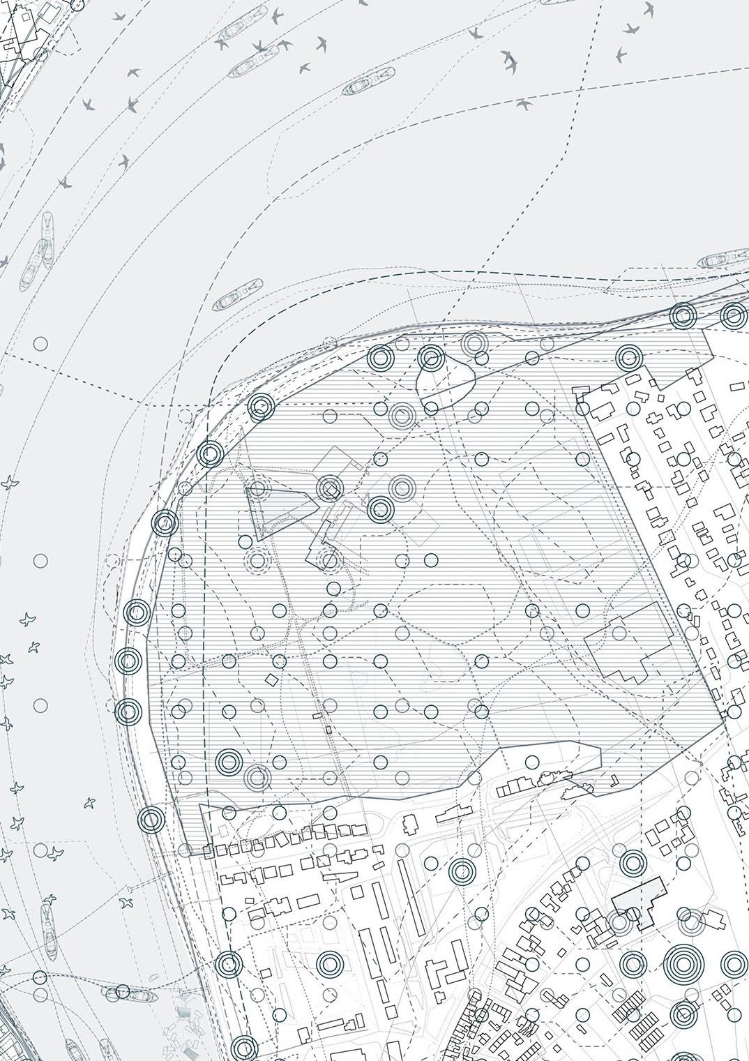
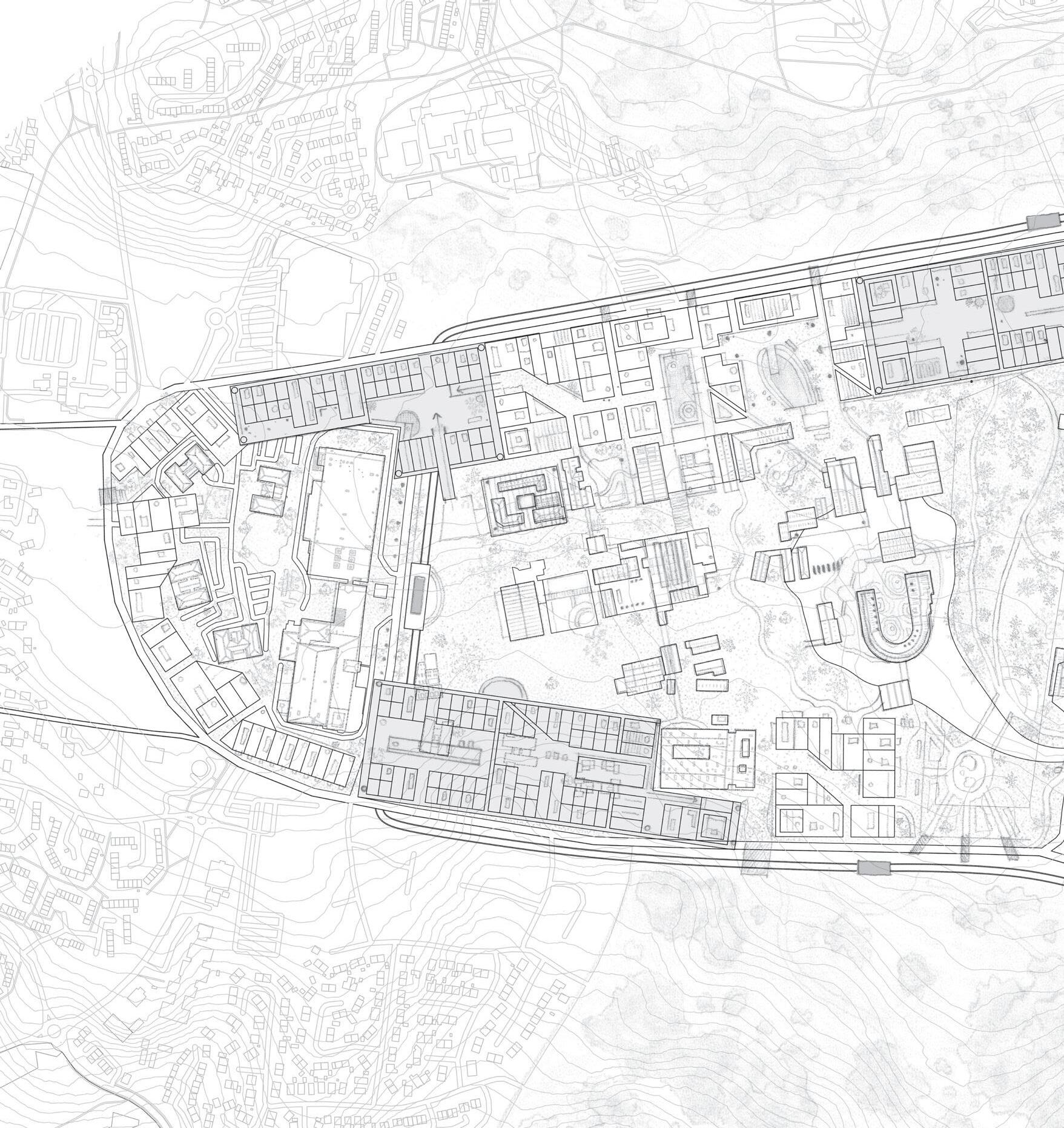
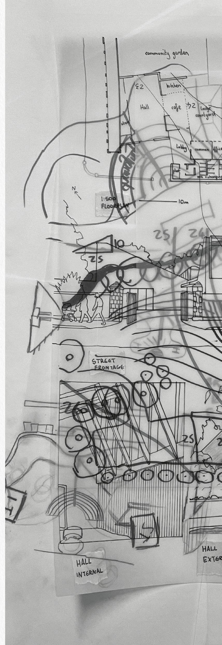
This group urban strategy presents a visionary concept for 21st-century Daire, highlighting enhanced social connectivity, accessibility to productive green and blue spaces, innovative data storage with energy exchange and sustainable urban densities in compact neighbourhoods. Through innovative design strategies, the project envisions a cityscape that fosters community interaction, promotes environmental stewardship, and optimizes urban living. Features include pedestrian-friendly pathways, green corridors, sustainable public transport systems, and local food production networks, all supported by novel energy solutions. This conceptual vision aims to create an ecologically vibrant and resilient urban environment. The framework is illustrated through four pivotal projects: ‘St. Columb’s Park Fulcrum’ reactivates Daire’s principal historic park to benefit both people and local wildlife; ‘Daire Haven’ integrates cultural and wellness facilities within a densely planned neighbourhood along the river; ‘The Harvest Bow’ focuses on community-centred sustainable food production in Daire’s Waterside area and ‘The Urban Infobahn’ envisages an urban river-side park, including data and co-working hubs in energy exchange with river ecologies. Together, these projects articulate a collective vision for Daire’s future.
VIsion for a New Daire
Urbanscalecombinedproposal, drawing.


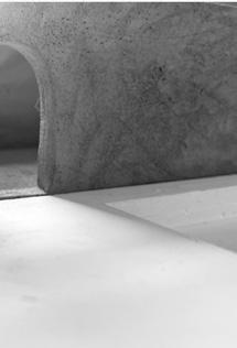
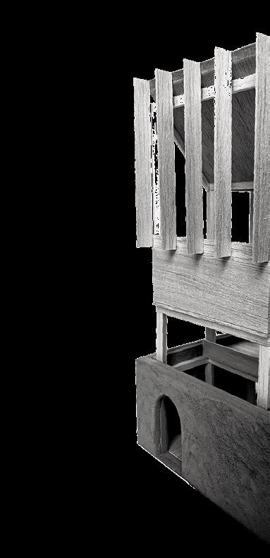
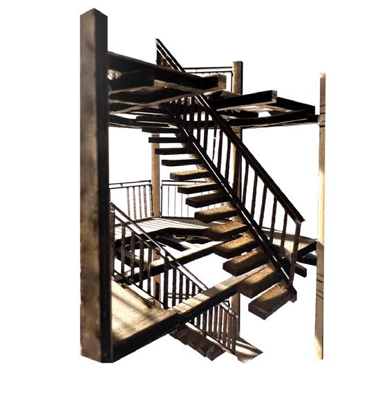
 The Nesting Tower
‘ArchitecturesofDestruction’, detail model, posed
Ellie Wilkes
The Nesting Tower
‘ArchitecturesofDestruction’, detail model, posed
Ellie Wilkes


19
Site: The Foyle embankment: Derry’s historic Shipquay and Strand Road Programme: Mixed-use energy production with data storage, digital and physical resources for local businesses, increased access to blue space and the cultivation of the Foyle’s historic oyster beds.
THE URBAN INFOBAHN
‘THE
HEAT SINK’
ELLIE WILKES


This thesis seeks to bridge the gap between society and knowledge-based infrastructure in Daire, Northern Ireland, by utilising remnants of its past, present, and future to foster new opportunities through architecture.
“Technicity”, a neologism coined by Gilbert Simondon, references the relationship between ecology and technology, and the extent to which technologies mediate, supplement and augment collective identity. The thesis delves into the complexities of Daire’s economic decline to propose a new urban ‘archi-digital’ typology that harnesses ecological identity through technological advancement and edge computing. This approach reinterprets artifacts of disuse and perceived collapse by abstracting and repositioning them into new states of spatial and material agency. This methodology is applicable to broader issues faced by shrinking cities, addressing the intricate challenges of power, technology, and space-ownership.
“Architectures of Destruction” explores the spatial experience along the river’s edge, renewing the historic human-river agency through a dynamic engagement with an enhanced indigenous ecology. “The Heat Sink” seeks to recalibrate this relationship by using material processes at an urban scale to rejuvenate the city centre. This urban proposition seeks to unite two of Daire’s most underutilised networks; Project Kelvin and the river Foyle, culminating in a programme that combines energy production with data storage, digital and physical resources for local businesses, increased access to blue space and the cultivation of the Foyle’s historic oyster beds.

01

21

Edge Data Centre and Water Networks Airc Section Insitu Airc Model Studio Exhibition Photograph Energy, Ecology, Agency Programme axonometric sketches Sectional Model, Posed with Historical Shipquay Image Projection Previous Left Previous Right Right Above


ELLIE WILKES | THE URBAN INFOBAHN 23


 Urban Scale Conceptual Floorplan
Digital Cities LiDAR & photogrammetry experiments
Right Above
Urban Scale Conceptual Floorplan
Digital Cities LiDAR & photogrammetry experiments
Right Above

ELLIE WILKES | THE URBAN INFOBAHN 25
Site: Quay Docks (former Fort George site), Daire, Northern Ireland Programme: Art galleries, workshops, performance hall, psychotherapy clinic, civic square

COMPACTING DAIRE: ENHANCING ECOLOGY, SOCIAL RELATIONS, AND WELLBEING
‘THE
DAIRE HAVEN’: FORTIFYING CULTURE, HEALING, AND CREATIVITY
CHING-EN LIN
This thesis explores the interaction between human infrastructure and nature in Daire through the examination of three significant sites: the Foyle Bridge, the subterranean landfill at Bay Road Park, and the industrialised water inlet at Quay Docks. It examines how these sites shape ecological atmosphere, aiming to prompt introspection on the subject before expanding to assess architecture’s role in enhancing sensory perception, addressing mental health concerns and the decline of Daire’s public realm. A concerning pattern of sub-urban sprawl out from the historic Walled City, characterized by uniform development lacking civic infrastructure, prompts a deeper investigation into sustainable urban strategies for the 21st century.
The thesis identifies the Pennyburn industrial neighbourhood as a focal point for these urban challenges, proposing solutions that include the densification of key areas coupled with natural restoration. This approach advocates for a compact city model that reintegrates natural spaces into urban settings, fostering denser, interconnected communities. Central to this urban vision is ‘the Airc’, positioned between a former military fort and a polluted inlet, it aims to restore the River Foyle’s edge to its preindustrial, ecological condition. The Airc serves as a dynamic cultural and environmental hub, offering a venue for art, therapy, and community engagement within a re-wilded landscape.

02


CHING-EN LIN | COMPACTING DAIRE 27

Architecture Co-Existing With the Wilderness Ground floor plan
Ecological
Sunken
Courtyard and Exhibition Room Section across theatre
Previous Previous Above
Daire in 100 Years: A New Form of Urban Living on the Pennyburn Industrial Site Urban Plan

CHING-EN LIN | COMPACTING DAIRE 29


 Private Consultation Room Viewing Towards Sunken Courtyard Visual Render
The Interplay Between Natural Elements and Consultation Hall 1:50 sectional model
A View From The Piers Decking Towards River Foyle Photograph Daire Haven and the Walled City Photograph
Private Consultation Room Viewing Towards Sunken Courtyard Visual Render
The Interplay Between Natural Elements and Consultation Hall 1:50 sectional model
A View From The Piers Decking Towards River Foyle Photograph Daire Haven and the Walled City Photograph
CHING-EN LIN | COMPACTING DAIRE 31
Top Left Left Left Above

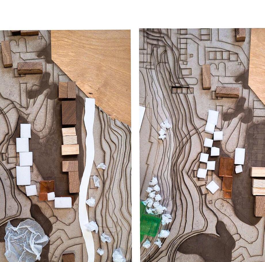
Marking The ‘Field’, Semester 2
Photograph&Photoshop, Printworks Studio.
Lucy Guo

33
Site: Lapwing Way, Derry.
Programme: Community Hub with Kitchen and Dining & Winter Garden.
03 THE HARVEST BOW


AN AGRICULTURAL-SOCIAL NETWORK
ISABELLA INNOCENZI
The city of Daire is characterized by significant community disparities and widespread food insecurity, highlighting a pressing need for accessible, sustainable networks of nutrition. This thesis proposes the integration of regenerative agricultural plots within Daire’s urban core to enhance food security and promote sustainable living. Mirroring the wild green areas from Daire’s past, forested corridors will be established to form an extensive pedestrian network, interlaced with agricultural nodes where residents can engage directly with food production.
This new landscape not only reconnects the people of Daire with the land but also fosters ecological unity through the cohabitation of humans, cultivated land, and rewilded green spaces. Anticipated future flooding is incorporated into the design, transforming water challenges into assets by creating a water-based civic public realm. These spaces will channel water to community planting plots, optimising agricultural production and enhancing urban drainage.
Architectural interventions within this network are designed to cultivate a sense of belonging and community cohesion. By merging the built environment with these natural elements, the project aims to unite Daire’s residents around the themes of sustainable food production and communal living. It also envisions a forward-looking Daire where community-focused urban planning and sustainability in food production and consumption are at the heart of the city’s future development strategy.


35


An Agricultural-Social Field Project Field Plan The Field Section
Field Installation Studio model and Exhibition photograph (behind)

ISABELLA INNOCENZI | THE HARVEST BOW
Previous Previous Left Above
The Airc Exploded Airc Axonometric

Architectures of Destruction
Photograph+Drawing, ‘Fieldwork Curation’.
Ellie Wilkes

39
Site: St. Columb’s Park, Daire.
Programme: Landscape amphitheatre and new civic park thresholds with associated community spaces, comprising performance practice spaces for local dramatic societies, knowledge exchange hall and internal theatre.
04


RE-PLENISHING AND RE-PURPOSING
DAIRE’S LANDSCAPES OF (THE) RUIN
ST COLUMB’S PARK FULCRUM
CHRIS PIRRIE


The Anthropocene era has been defined by a significant human impact on the planet, prompting reflection on society’s fascination with ruins. This thesis explores this concept through the lens of the peripheral Boomhall Estate, which serves as an early and pivotal influence. The estate, located on the north-west bank of the river Foyle, 2.4 miles northeast of Derry’s historic City Walls, played a strategic role during the Siege of Derry in 1689. Today, it comprises ancient oak woods and agricultural lands that encompass the ruins of an 18th-century Georgian Classical house and stables. These ruins, gradually reclaimed by nature, offer a rich tapestry of history and ecology. A key question emerges as to whether the techniques and materials of contemporary place-making will provide future generations with a similarly romantic and rich spatial experience.
The architectural project proposed herein, ‘St Columb’s Park Fulcrum’, aims to revitalize the urban park by rethinking the future of park architecture and programming. It celebrates natural thresholds and landscapes, fostering a vision for a healthy, ecologically vibrant Northern Irish parkscape. This project challenges the ongoing loss of structured landscapes and seeks to re-establish a connection with the natural environment through the proposing of out-door theatre and supporting community spaces.

41


 Reactivating St. Columbs Park Project Field Proposal
A Slice through the Assembly Airc Section
Reactivating St. Columbs Park Project Field Proposal
A Slice through the Assembly Airc Section
Topography Strategic
Previous Left Above Above
Spatial Atmosphere of Interior And Exterior Airc Model Photographs Amphitheatre Adapting the Existing
Site Model


RE-PLENISHING AND RE-PURPOSING DAIRE’S LANDSCAPES OF (THE) RUIN 43
CHRIS PIRRIE |

Re-plenishing and Re-purposing Daire’s Landscapes of (the) Ruin St.Columb’sParkFulcrum, massing model, posed. Photography, Chris Pirrie

CHRIS PIRRIE | RE-PLENISHING AND RE-PURPOSING DAIRE’S LANDSCAPES OF (THE) RUIN 45

Daire Haven: a place of safety or refuge
AircRenderinUrbanContext, Ching-En Lin
The Harvest Bow: Morning shadow
AircRender, Isabella Innocenzi

47

G2
THE RESTITUTION OF ‘STANLEY’S WALK’ & MARY BLUES BURN
ASTRID MCINTYRE
MATTHEW JOHNSON KE WANG
Running south-west and to the eastern side of Daire’s walled city runs a fractured ecological corridor in the form of poorly maintained green spaces, sports playing fields, depleted woodland and cemetery; a semi-urban landscape profoundly lacking in ecological diversity. This shared Field Strategy is centred around removing the Lecky Road flyover and reinstating the historic route from the south end of the Walled City, west toward Daire City Cemetery, previously named ‘Stanley’s Walk’. To mitigate surface water flooding and direct flood water away from the lowest lying areas of the Bogside, the strategy also involves the reinstatement of Mary Blue’s Burn, a historic stream left behind after Daire Island was connected to its surrounding landscape through the draining of the historic, bog and wetland. Stanley’s Walk crosses Mary Blue’s Burn, intersecting at a new civic, urban square with SUDS pond and supporting ecologies, forming the portal to a new Gaelic- speaking School for Daire and Daire crematorium. The burn forms part of a connected green and blue network, allowing the free movement of humans and other species, complementing the Airc projects which sit within it’s ecological corridor.


The Restitution of ‘Stanley’s Walk’ & Mary Blues Burn : Urbanscalecombinedproposal, drawing.
49
Site: Celtic Park, Bogside, Daire Programme: City Crematorium
05

DAIRE’S REVERENCE
DAIRE CREMATORIUM
ASTRID MCINTYRE
This thesis delves into the liminal spaces of Daire, those thin places where the veil between the temporal and the eternal feels almost transparent. Echoing a Celtic notion, it explores how heaven and earth are but a whisper apart in locales saturated with memory and meaning. At the heart of this investigation lies Daire City Cemetery, a place etched with the deep imprints of personal reflection and historical tumult.
Proposing a restoration of this vital pathway, the thesis advocates for a pedestrianized revival of Stanley’s Walk, transforming it into a vital urban pathway that reconnects the walled city to the cemetery. This reimagined route would rethread lost ecologies of wetland and meadow back into the urban weave, establishing a ‘landscape of reverence’ that pulses with historical and ecological significance.
Central to this landscape of memory and hope is Celtic Park, the heartland of Gaelic Football in Daire, now somewhat adrift from its community. The project aims to anchor the park anew, linking it with the reinvigorated Stanley’s Walk and extending this connection to a proposed city crematorium, thereby knitting together a continuous tapestry of communal spaces, where the city might reconcile with its past and embrace its ceremonial rhythms anew. Through this, the thesis seeks to sculpt ‘thin places’ into the fabric of Daire, making the city a testament to both its enduring spirits and the living breath of its people.


51

Proposed Landscape Design and Internal Plan of the Crematorium Ground Floor Plan Re-Scritping Drawing of Daire Mapping identified ‘Thin Places’ within the city. Previous Above

ATRID MCINTYRE | DAIRE’S REVERENCE 53


 Archiving Daire’s Landcsape
Fieldexperimentations, Daire Field Trip
Photography, Ke Wang
Archiving Daire’s Landcsape
Fieldexperimentations, Daire Field Trip
Photography, Ke Wang


55
Site: Intersection of re-instituted Stanley’s Walk And Mary Blue’s Burn Programme: ‘Gaelscoil’ Irish Language Primary Schools, with Community Spaces and Associated Landscape
06

RE-ROOTING FORGOTTEN CONNECTIONS
FOSTERING
DAIRE’S SOCIAL, LINGUISTIC AND ECOLOGICAL NETWORKS.
MATTHEW JOHNSON
Early analysis of a fractured green network from Daire’s historic walled city to its south-west edge identified a depleted community-centre and one of Daire’s ‘Gaelscoil’ Irish language primary schools, situated between

cluster of buildings with a sensitive proposal which fosters supportive learning with appropriate thresholds between distinct user groups. Situated within a shared, wider urban strategy, the community-focused spaces will face a new public square and pond where the re-instated Mary Blues Burn and Stanley’s Walk intersect. Teaching spaces for the Gaelscoil are grouped to the west, with direct connections to the adjacent woodland for immersive, outdoor learning. Rooting the adult-focused community functions and the Gaelscoil in the replenished ecological context emphasises project themes of tranquility, nature, and embodied movement.


57


MATTHEW JOHNSON | RE-ROOTING FORGOTTEN CONNECTIONS
the
and
Long Section Early Sketch Cutting Through the Airc and Site to understand the steep topography. Plan and Perspective Images of Field Model Collage of Site Plan, Airc, Model and Field Model Previous Previous Above 59
Designing
Airc Photography
Model
Site: South-West Side of Daire City and the North Bank of The River Foyle Programme: Ecological Observation & Investigation Units, Laboratory, Sample Cultivation, Reporting, Exhibition, Library, Shop, Accommodation, Public Experiential Pathway and Sensory Tower.

(E)MERGING & (SUB)MERGING
AN ECOLOGICAL INSTITUTE OF SENSORY DELIGHT
KE WANG
Daire City, Northern Ireland, is marked by a stark conflict between its urbanised artificial structures and natural landscapes, a tension exacerbated by looming climate change and urban expansion. The river Foyle, a historic cultural and ecological pathway, faces persistent flooding challenges. Historically, Mary Blue’s Burn fragmented the landscape into what was known as Daire Island, fostering extensive wetlands and a rich ecological tapestry. Urban development is centred around the densely populated Walled City, with the “Diamond” at its heart, extending through Bishop Street towards the river—an axis symbolizing the push of urbanisation. This thesis explores the evolving conflict at the crucial intersection of Bishop Street and Mary Blue’s Burn by the River Foyle. It examines how this convergence of historically significant elements—urbanisation, natural landscapes, and water bodies—navigates the dual pressures of flooding and urban growth. The research anticipates the emergence of “ruins” in spaces where neither urban nor natural elements take precedence due to oscillating boundaries driven by flooding and city expansion. The envisioned future landscape includes the speculative development of a semi-public ecological institute situated in a regenerated wetland. This institute aims to facilitate public engagement with wetland ecosystems, providing sensory delight to its citizens and providing a civic-minded architectural response to environmental and ecological challenges. As Bishop Street risks submersion, the re-emergence of Mary Blue’s Burn could redefine the urban and ecological landscape of Daire.
07

Sectional Model of Airc Exhibition photograph Above 61


KE WANG | (E)MERGING & (SUB)MERGING 63

Occupying the Flooded Edge Field Plan of Flooded Site in 2080
A Space for Research Section through Laboratories and Sensory Tower
Proposed and Retained Section of Airc and adjacent Public Spaces
Defining an Urban Corridor and Destination An Aerial View of Airc from Bishops Gate
Previous
Previous
Previous
Above
Spread
Left
Right

KE WANG | (E)MERGING & (SUB)MERGING 65
 The Guildhall Photograph, Daire Field trip. Ching-En Lin

67
G3
FOUNTAIN GREEN CORRIDOR & ECOLOGICAL PATHWAY
XIANG GAO WENHAO SUN
This project explores the urban neighbourhood stretching between Daire’s walled city at Ferryquay Gate and the River Foyle at Craigavon Bridge, an area traditionally known as ‘The Fountain’, marked by historical industrial success followed by sharp decline from the 1980s. This decline has led to widespread building abandonment and depopulation. Furthermore, the civic and environmental quality of the public realm has significantly deteriorated due to continued neglect and decay. On a social level people from the area have experienced high levels of unemployment, homelessness and mental illness, with the resultant crime and decline in community spirit this inevitably brings.
To counter these negative, historic urban forces, we propose the development of a ‘Fountain Green Corridor’ running around the south-eastern edge of the walled city to help revitalise urban life and ecology and to prepare for potential future flooding that is predicted to reshape the city’s landscape. This proposal will integrate a series of innovative design strategies such as the greening of hard urban pathways, the restoration of the existing historic built fabric and the rejuvenation of abandoned buildings and industrial sites that can restore civic pride and social connectivity. This green urban pathway will merge with the riverside and its water-based ecologies, forming a new civic gateway to the centre of the city.

Fountain Green Corridor & Ecological Pathway
drawing.
Urbanscalecombinedproposal,
69
Site: The Fountain & Craigavon Bridge, Daire Programme: Community & Visitor Information hub. Foyle Ecological Lab and exhibition space.
DAIRE’S RE-BIRTH: COMBINING URBAN ORDER & NATURAL SYSTEMS.
THE ‘WILD-GRASS’ REGENERATION PROJECT.
XIANG GAO


“The Wild Grass Regeneration Project” is a long-term programme for urban and ecological sustainability in the Northern Irish city of Daire that spans across time, space and human and non-human ecologies .Wild grass (Poaceae) is a large and nearly ubiquitous family of monocotyledonous flowering plants commonly known as grasses. With around 12,000 species grass is the fifth-largest plant family, and is extremely resilient to environmental change.
The aim of “The Wild Grass Regeneration Project” is to systematically enhance the health and well-being of ‘wild grass’ on both sociological and ecological levels through the promotion of community-based, adaptive systems of growth and self-regeneration. By cross-referencing ‘sporophyte dispersal theory’ at the bio-ecological level and ‘self-organisation theory’ at the sociological level, the project proposes to adapt and build new processes of urban regeneration and operation which grow organically from the existing but depleted urban framework to meet specific needs of the population. This new urban eco-system can serve a rebirth of environmental conservation at an ecological level and effective self-governance on a sociological level, through the material transformation of urban townscape, buildings and landscapes, eventually re-shaping the lifestyle and culture of the area and its people.
08
 Daire’s Re-birth: An Urban Strategy to Reactivate the Water-earth Threshold Urban Plan
Ground Floor Plan and the Proposed Topography Airc Floor Plan
Daire’s Re-birth: An Urban Strategy to Reactivate the Water-earth Threshold Urban Plan
Ground Floor Plan and the Proposed Topography Airc Floor Plan
71
A View from the Vibrant Community Street towards the River Foyle Render Slicing through the Craigavon Bridge Urban Site Section Above Next Left
Next
Right Next Bottom


XIANG GAO | DAIRE’S REBIRTH 73
Site: North side of Daire City and between the Fountain field and the shopping mall Programme: Foyle Future Skill Centre, Cafe, Greenhouse, Meeting, Bookstore, Multimedia, Exhibition, Restaurant, Professional Classroom, Accommodation

DAIRE & THE ‘ANTI-MONUMENT’
FOYLE FUTURE SKILLS
WENHAO SUN
CENTRE
‘Daire & the Anti-Monument’ examines the complexity of societal hierarchies and power structures within the city. This place is characterized by distinct states of inclusion and exclusion, belonging and alienation. In society, physical monuments and power structures are typically erected to celebrate human achievements and cultural dominance. However, alongside these symbols of power, counter-monuments often emerge in more ephemeral forms, such as poems, songs, graffiti or gatherings that challenge prevailing ideologies. The post-modern view of monuments tends to oppose the historical, ‘master narrative’ – proposing as a counter-cultural alternative the notion of the ‘anti-monument’, notably different as a spatial and material artefact in its conception, duration, and utilisation.
The project proposes a conceptual axis—an urban, architectural intervention designed as an anti-monument. This urban structure challenges conventional urban planning to promote a radically, re-imagined Daire. As a direct response to this problem the architectural programme proposed is for a ‘Future-Skills Hub’ and Community Gathering Place to be housed in the abandoned industrial complex of Carlisle House, Carlisle Road Methodist Church and surrounding buildings.
09

75

An Aerial View Indicating Programme Distribution Airc Axonometric Entering A Threshold Moment Airc Render Material Expression And It’s Relation With The Occupants Airc Render Previous Behind Right

WENHAO SUN | DAIRE & THE ‘ANTI” MONUMENT 77

Mapping Across Timelines: Species Migration, Human Activity, Natural Landscape and Industries
GroupWeap,Semester1
Lucy Guo, Ellie Wilkes, Hannah Ord, Vivi Hsia

79
Site: Foyleside Shopping Centre, 19 Orchard St, Londonderry Programme: Food/Seasonal Produce Market, Maker’s Market, Maker’s Space, Community Gathering space, Gallery, Urban landscaping.
RECLAIMED WATERS
RE-ASSEMBLING WATER ECOLOGIES AND THE URBAN LANDSCAPE OF THE RETAIL MALL
LUCY GUO
“Reclaimed Waters” is an architectural thesis project that aims to integrate the urban landscape of Daire with the River Foyle. This project seeks to restore the once vibrant eco-system along the riverbank, heavily influenced by the area’s industrial heritage, and to reforge connections between the city community and the river’s natural ecology. In the current digital age, where online shopping predominates, traditional physical retail outlets are experiencing a notable decline. This shift in consumer preferences offers a significant opportunity for urban revitalisation and re-purposing, especially in areas with dense commercial development. The project initiates at the Foyleside Shopping Centre, which is ideally located adjacent to the City walls, offering expansive views of the River Foyle. The proposed architectural intervention is part of a comprehensive seventy-year masterplan. This plan proposes a multifunctional development that includes recreational areas, bustling markets, innovative housing solutions, educational facilities, and community pools. The centrepiece of this initiative is the creation of a new ecological waterfront that reinvigorates the river’s edge and promotes environmental responsibility among the urban population. This masterplan envisions a harmonious blend of nature and urban life, encouraging sustainable living and greater community engagement with the natural world.


10


81


Journey from the Diamond to the Foyle Airc Axonometric A Soft Edge in the Urban Landscape Urban Elevation through the Airc and community building Existing and New Conditions Photography of proposed landscape with drawn existing mall axonometric Proposed and Retained Structural Axonometric showing retained mall facade (red) and proposed (green) A Community Entrance Materiality render Previous Previous Above Right top Right


LUCY GUO | RECLAIMED WATERS 83


 A Matrix of Photographed Field Samples, Photograph, Daire Field Trip Tobia Graziani


87
Site: Free Derry Museum, Bogside, Daire. Programme: Material workshops & hub with café and exhibition space.
BRIDGING THE BOGSIDE
BREAKER SPACE + MAKER SPACE
TOBIA GRAZIANI

‘Bridging the Bogside’ investigates the urban morphology of Daire’s Bogside, aiming to revitalise an area that has been a focal point of social conflict for generations. Originating with the 17th-century walled city, Daire has expanded outwards, significantly altering the Bogside’s relationship to its historic ecological context, previously defined by a bog and Mary Blue’s burn, which formed an important ecological edge. Through urban expansion, these natural features have disappeared, being replaced by a nondescript network of roads, pathways and buildings which lack any coherent hierarchy or legibility locally or within the broader city context. This thesis explores the concept of ‘urban formalisation’ and the potential for urban-ecological coexistence across three scales: City, Field and Airc. By more formally linking the Bogside to the physical and cultural fabric of Daire, it proposes to forge a robust urban identity for the community, transcending its fragmented past to embrace a more integrated and vibrant future. ‘Bridging the Bogside’ focuses on the field scale, proposing a pedestrian pathway from Butcher’s Gate to the project site, addressing potential future flooding with landscaped berms and a structural pier system supporting indigenous ecologies. The Airc proposal, adjacent to the Museum of Free Derry, envisions a neighbourhood gathering place and maker-space program, promoting community equity and resourcefulness through material recycling and up-cycling.
11

Physical Airc Model constructed using 3.2 mm plywood and acrylic panels on an mdf base Above 89


TOBIA GRAZIANI | BRIDGING THE BOGSIDE
Urban Proposition Field Drawing Airc Model Situated Within Field Context Studio exhibition photograph Above Adjacent 91
Bridging
The Bogside.


The Breaker + Maker Space Isometric of the Airc Proposition Above


93

Reflecting the Foyle
Photograph, Daire field trip
Ching-En Lin

95

Site: Peace park, adjacent to the Guildhall, Daire Programme: Community archive and exhibition with boat-building workshops


REGISTERING THE ANTHROPOCENE
THE
PEOPLE’S ARCHIVE OF THE FOYLE
HANNAH ORD

Since the founding of Daire, the Foyle River has been a vital source of sustenance for its human and non-human inhabitants, flora, and fauna. In agrarian times, the city engaged directly with the river, supporting its life and growth. In the Anthropocene epoch, Daire has progressively distanced itself from the Foyle, disrupting this natural connection and diminishing its once vibrant riparian habitats.


This thesis confronts the river’s present state of alienation, envisioning a future where Daire re-establishes its bond with the water in anticipation of rising flood levels driven by climate change. Initial research focused on the diminishing habitats of Atlantic salmon, using this species as a proxy to investigate the broader decline of riparian ecologies and the city’s estrangement from the river. This historical disconnection is underscored by the endangerment of vernacular artifacts associated with riverine activities and fishing, once central to local culture but now facing obsolescence.

To counter this trend, a new River Foyle - ‘People’s Archive of the Anthropocene’ is envisaged with dedicated space to curate and re-engage historical ties to the river. Supporting the active conservation of marine crafts and the preservation of important historical and ecological artifacts, the project fosters a renewed communal and ecological connection with the river.
12

97

The Artisanal Stages of Irish Boat Building digital drawing and 3D modelling Through the Boat Building Workshops to the Envisioned Littoral Edge of River Foyle. Section
The Airc: Sectional model through airc corridor and gathering space Airc physical model Defining a new relationship between the future waterfront and historic structure Field physical model The Fishing Histories of the Foyle Hand drawing & collage
Previous Previous Previous Above
Previous

99
Site: Programme:
13
RE-WILDING & RE-BRIDGING DAIRE
ADAPTIVE RE-USE THROUGH A CONNECTED ARTS BASED TOWNSCAPE
VIVI HSIA

‘Re-wilding and Re-Bridging Daire’ investigates the dynamic tension between urban architecture and the natural environment, focusing on the critical depletion of natural green spaces. It proposes re-wilding as a strategic urban solution in Daire, where disconnections between the City and Waterside areas manifest in both physical barriers and socio-cultural separation.
The study identifies key areas from the historic Diamond in the centre of the walled city to contemporary developments around St Columb’s Park and the Peace Bridge, addressing waterfront adaptation strategies in anticipation of rising river levels whilst redefining civic spaces to be resilient and inclusive. It advocates for innovative urban planning that fragments existing city blocks to form new pedestrian pathways, complemented by the greening of public spaces and the adaptive re-use of neglected buildings for the production and display of civic and community arts. This thesis envisions the physical restructuring of urban spaces but also aims to cultivate a re-wilded mindset among residents, fostering a new ecologicalarts district that harmonises built environments with natural ecosystems transforming both the city’s landscape and its social fabric.

101


 An Unfolded Analysis Shipquay place and 5-17 Foyle Street, Unfolded Elevations of buildings to be adaptively reused. A connected relationship Field section illustrating new urban moments from the diamond to the waterside.
Right Bottom
An Unfolded Analysis Shipquay place and 5-17 Foyle Street, Unfolded Elevations of buildings to be adaptively reused. A connected relationship Field section illustrating new urban moments from the diamond to the waterside.
Right Bottom


VIVI HSIA | REWILDING & RE-BRIDGING DAIRE 103


Ground Floor Plan Of Airc Proposal New opportunities for circulation and connectivity to the walled city. Establishing An Ecological Edge Between Adapted Gallery Space And The Walled City. Sectional model of Airc.
VIVI HSIA | REWILDING & RE-BRIDGING DAIRE 105
Left Right
 The Port of Derry Drawing , 1790
Artist J.Nixon
The Port of Derry Drawing , 1790
Artist J.Nixon

107
Site: Walled City, Daire, Northern Ireland. Programme: Civic Art exhibition (indoor & outdoor) with ecological garden space and supporting functions.
UNEARTHING DERRY
A SPACE TO GROW
LUCAS JONES


From the moment Daire was settled, it was embroiled in the tendrils of control, conflict, and the iron hand of colonialism — its walls, hitherto both a bastion and a spectacle, encapsulating not only the city’s chronicles but also its chained ambitions.
Advertised as beacons of historical allure, these walls delineate a past vigorously alive yet, cradling the city in a relentless embrace that stifles the urge for renewal. Innovation gasps for breath under the oppressive weight of history, the city’s narrative a looping echo along the pathways where tourists tread, circling the relics of strife and stagnation. This thesis endeavours to cast off these historical shackles, proposing a re-conception of the city’s engagement with its monumental enclosure, seeking to revitalise the walls through a novel lens of interaction through art. To stitch together the segregated urban tapestries, weaving a contiguous civic space that transcends the separations wrought by the old stonework. These proposed places for people and art, lush with native Irish greenery, echoing the verdant whispers of the island’s heritage — aspire to transform these historical divides into unifying landmarks, morphing spaces of protection into spaces of connection, where the city’s past, present, and future converge in a harmonious symphony of civic life.
14

109

The Flooding Against The Wall City Site Plan Bridging The Edge Structure To The Field Strategy Exhibition, Axonometric Drawing And The Map Material Expression Within The Wall City Massing Model Architectural Elements Of Power Hand Drawings Previous Behind Top Right Right


LUCAS JONES | UNEARTHING DERRY 111
Site: Bogside, Daire, Northern Ireland.
Programme: Bogside Community Learning and Well-being Hub

HEALING THE FORGOTTEN LANDSCAPE OF DAIRE’S BOGSIDE
ARCHITECTURES OF WATER, TRANQULITY & COMMUNITY
BERAT UGUR
Daire’s historic Bogside has been an important strategic edge between the city’s fortified walls and its inclined landscape to the north and west, for hundreds of years the heartland of its catholic, republican community. The loss of the area’s natural properties of wet landscape has occurred through human development over time, depleting the natural ‘eco-tone’ and replacing it with a socio-political ‘edge effect’ of separation and isolation. This thesis proposes a ‘regenerative- return’ to a Bogside urban-landscape paradigm of green and blue connectivity for the rehabilitation of the health and wellbeing of human and non-human citizens of the Bogside.
A civic waterscape threads its way through the heart of the Bogside community, connecting reservoirs, culverts and areas of future flood-risk in a spatially rich system of green and blue urban ecology, supporting a series of regenerated civic spaces. This new harmonic, urban ‘eco-system’ has at its own heart the re-established old Foyle Tributary of Mary Blue’s Burn with surrounding wetland ecosystem.
On the north-facing hillside across Lecky Road is an architecture rooted in a replenished aquatic landscape; a series of cascading spaces housing human activities through which water flows and stays, supporting the indigenous planting of the forgotten landscape and enhancing civic placemaking with restorative potential for people and ecology.
15

Field Proposition Along A New Water System Behind 113
 Malin Head
Photograph, Daire Field trip
Lucy Guo
Malin Head
Photograph, Daire Field trip
Lucy Guo

115
Site: Waterside, Daire.
16
DE-COLONISING DAIRE
YUHE GE
Programme: Educational spaces, community gathering and hydro-ecological civic space.


FROM ‘CONFLICT-INFRASTRUCTURES’ TO ‘AQUA-ECOLOGIES’.
De-colonising Daire’ revisits the colonisation of Northern Ireland’s Ulster region by the London guilds in the 17thC, traditionally viewed through the lens of religious conflict between catholics and protestants. It introduces an alternative perspective that attributes the British colonisation to resource depletion from climatic shifts during the Little Ice Age (1590s-1850s) rather than religious motivations. Taking our gaze from the past to the future, the world faces another moment of climate emergency—global warming (since the 1850s), leading to a new global form of colonisation driven by predicted rising sea-levels with the harnessing of big data and vital survival resources such as freshwater. Historical and field research in Daire predicts not only rising river levels but significant surface water flooding of the city over the next 50 years and beyond.
Addressing this anticipated fresh-water crisis, this thesis proposes a decolonial approach to freshwater harvesting and sustainable hydrology aimed at restoring lost rivers and their ecological agency. It explores the integration of citizens’ daily interests and activities with hydrological and ecological restoration as part of a new, urban ‘aqua-ecology’. By considering waterbased landscapes as essential urban infrastructure, the project seeks to align civic performativity with ecological water-regeneration. The core architectural project is situated in the Waterside neighbourhood of Daire, taking in part as it’s canvas the historic conflict infrastructure of the former military barracks Ebrington Square. Spatial programmes focused around water, ecology, education, and community gathering along with the replenishment of local indigenous flora and fauna forming part of waterbased landscapes illustrate the contribution urban and architectural design can make to addressing the climate emergency.


117


YUHE GE | DE-COLONISING DAIRE 119
 Daire Studio Exhibition
Installation, Printworks Studio. MDF, timber, card, steel.
Photography Lucy Guo
Daire Studio Exhibition
Installation, Printworks Studio. MDF, timber, card, steel.
Photography Lucy Guo

121

Exhibition Photographs
‘The Daire Haven’: Fortifying Culture, Healing, And Creativity
Ching-En Lin

123
 St Columb’s Park Fulcrum
Project by Chirs Pirrie
Photography by Ching-En Lin
St Columb’s Park Fulcrum
Project by Chirs Pirrie
Photography by Ching-En Lin

125
 Daire Studio Exhibition Plan
01
Astrid McIntyre
Xiang Gao
01 02 03 02
Wenhao Sun
Lucas Jones
03
Berat Ugur
Astrid McIntyre
Matthew Johnson
04
Ke Wang
Ellie Wilkes
Hannah Ord
04 05
Lucy Guo

04 05 06 07 08 05 Yuhe Ge 06 Isabella
07 Chris
08
Innocenzi
Pirrie
Lin 04
Ching-en
Tobia Graziani
127
Vivi Hsia
BIBLIOGRAPHY
Principal Texts
Uexkull, J V. (2010). A Foray into the World of Animals and Humans. Minnesota Gibson, J. J. (1979). The Ecological Approach to Visual Perception. Boston: Houghton Mifflin Hall, E. T. (1966). The Hidden Dimension. Garden City, NY: Doubleday &Co. Mostafavi, M. 2010. Ecological Urbanism. Lars Muller Zumthor, P. (2006) Atmospheres: Architectural Environments, Surrounding Objects. Birkhauser Pallasmaa, J. (1996) The Eyes of the Skin: Architecture & the Senses. J. Wiley & sons. Ni Dochartaigh, K. (2021) Thin Places.
Further Reading
Barnes, J. (1989) A History of the World in 10 ½ Chapters. Ch.1 ‘The Stowaway’. (A Novel) Friel, B. (1973) The Freedom of the City (A play set in Daire during ‘The Troubles’). Friel, B. (1980) Translations (A play about language and landscape in 19thc Ireland).
Book Chapters & Journal Articles
Fonseca, M. F. (2008) Edge Effect. In ‘Encyclopaedia of Ecology’. Pp 1207-1211. Ed. Jorgensen & Fath. Academic Press.
Kelly, L. (2003) Language, Memory & Conflict: Acts of Interrogation. In ‘De-territorialisations: Revisioning Landscape & Politics’. Pp 309-320. Ed. Dorrian & Rose. Blackdog Publishing.w Web-links
Derry & Strabane Strategic Growth Plan 2017-2032. https://www.derrystrabane.com/Subsites/CommunityPlanning/An-Update-on-Our-Community-Plan
Derry & Strabane Local Development Plan LDP (2032) draft documents. Particularly Part F (Place-making & Design Vision), Includes Derry & Strabane settlement studies part A & B. https://www.derrystrabane.com/Subsites/LDP/LDP-draft-Plan-Strategy-(dPS)/LDP-Plan-Documents
Web-site of The Great Parchment Book by the Honourable Irish Society. A fantastic resource on the history of the Ulster Plantations. Films text and fantastic images. Managed by the London Metropolitan Archive. https://www.greatparchmentbook.org/
Irish Government – Department for Communities: Historic Environment of Ireland web-page. Full information on the Derry Walls Conservation plan and Management Plan. Relevant policy documents. Also contains a link to the Historic Environment Record of Northern Ireland (HERoNI). https://www.communities-ni.gov.uk/articles/ derry-walls#toc-3
Videos
Built Ecologies: Architecture and Environment | MoMA https://www.moma.org/research/ambasz/built-ecologies
IMAGE REFERENCES
Cover
- Water, Earth, Air, People Drawing Lucy Guo, Vivi Hsia, Hannah Ord, Ellie Wilkes, Isabella Innocenzi
Prologue
- LondonDerry 1800 Henry Bocas
- Reclaimed Waters Lucy Guo
Daire’s Airc
2-3 Foyle Bridge, View from Culmore Road Ching-En Lin
5 Malin Head Vivi Hsia
6 WEAP Installation Lucy Guo
8-9 Studio Exhibition Lucy Guo
12-13 Video Recording For Movement Analysis On The City Wall Ching-En Lin
14-15 Looking Towards Ferryquay Gate 1900 Photographer Unknown
[Edge Effects || ]
18-19 The Nesting Tower Ellie Wilkes
38-39 Architectures of Destruction Ellie Wilkes
78-79 Water, Earth, Air, People Drawing Lucy Guo, Vivi Hsia, Hannah Ord, Ellie Wilkes
Epilogue
120-121 Daire Studio Exhibition Lucy Guo
122-123 ‘ The Daire Haven’: Fortifying Culture, Healing, And Creativity Ching-En Lin
124-25 St Columb’s Park Fulcrum Chris Pirrie, Ching-En Lin
126-127 Daire Studio Exhibition Plan Astrid McIntyre
130 Semester 2 Brief Sketch Mark Bingham
132-133 Movement On Edges Vivi Hsia
129

Semester 2 Brief Sketch
Mark Bingham
ACKNOWLEDGEMENTS
Tutors
Iain Scott
Mark Bingham
Students
Xiang Gao, Yuhe Ge, Tobia Graziani, Lucy Guo, Vivi Hsia, Isabella Innocenzi, Matthew Johnson, Lucas Jones, Ching-En Lin, Astrid McIntyre, Hannah Ord, Chris Pirrie, Wenhao Sun, Berat Ugur, Ke Wang, Ellie Wilkes
Visitors
Kate Carter, Susana Do Pombal Ferreira, Killian Doherty, Derek Fraser, Andrea Faed, Jack Green, Adrian Hawker, Mark Hilley, John Brennan, Sepideh Karami, Miguel Paredes Maldonado, David Seel, Ruta Turcinaviciute, Dorian Wisniewski
Technical Consultants
Malcom Cruikshank, Paul Diamond, Paul Charlton & Rachel Collie
Daire’s Airc: Edge Effects || edited by Lucy Guo and Ellie Wilkes
Tobia Graziani, Ching-En Lin, Mark Bingham and Iain Scott
The format of this catalogue has developed annually, evolving from the inaugural catalogue series produced for the ESALA MArch studios 2017-18, designed by Emma Bennett and Rachel Braude.
Printed by J Thomson Colour Printers Ltd., Glasgow
131
 Movement on Edges
Photograph&Photoshop, Castle Gate Daire Feild Trip
Vivi Hsia
Movement on Edges
Photograph&Photoshop, Castle Gate Daire Feild Trip
Vivi Hsia

133


