Resepi
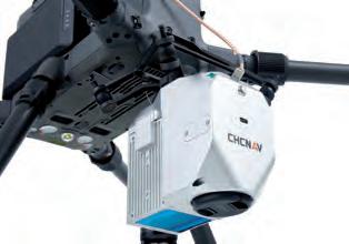
RESEPI – The Complete Lidar & RGB Payload Solution Inertial Labs has designed the Remote Sensing Payload Instrument – RESEPI – as a cost-effective solution for extremely accurate remote sensing applications. RESEPI utilizes a high-performance Inertial Labs GPS-aided Inertial Navigation System (INS) with NovAtel RTK/PPK dual antenna GNSS receiver, integrated with a Linuxbased processing platform. The processing platform enables data-logging to a USB thumb-drive and supports an external cellular/radio modem for receiving RTCM corrections. RESEPI can be used with commercially available Lidar scanners such as Velodyne, Quanergy, Ouster, RIEGL, Livox and Hesai. All components are mounted into one compact and lightweight enclosure and bore-sighted. Point cloud software is fully automated to provide optimized PPK results. Completely Modular A third-party GNSS receiver and Lidar can be used, while Inertial Labs provides everything else required for assembling, calibrating and bore-sighting RESEPI, including training. This allows clients to maintain existing relationships and meet local production requirements, while retaining full control for customization. A Complete Remote Sensing Solution Lidar, the required cables, mounting brackets, vibration isolator, Lidar calibration, bore-
A digital terrain model, a digital surface model, and a digital elevation model (from top to bottom).
sighting, post-processing (PPK) and point cloud software utilizing the Waypoint post-processing engine from Hexagon | NovAtel, are all available upon purchase of the RESEPI. In this way, clients and valueadded resellers can focus on growing their business rather than developing the payload product.
RESEPI Produces Georeferenced Lidar Point Clouds A Lidar point cloud is a collection of millions, or even billions, of points that are used to accurately map an environment in a way similar to how a pointillism painting creates a picture. Each of these points has a location in a known coordinate system (local or global),
Weight
0.370kg (w/o Lidar and Camera)
Power consumption
12W (w/ Velodyne VLP-16)
Position accuracy
0.5cm (PPK) / 1cm + 1ppm (RTK)
Attitude accuracy
< 0.01deg pitch & roll; < 0.05deg heading
Available Lidar scanners
Velodyne, Quanergy, Ouster, RIEGL, Livox, Hesai
Road construction point cloud.
76
76-77_inertiallabscasestudy.indd 76
06-09-21 15:15