14 minute read
Commercial & Industrial Character
Commercial and Industrial Character
While initially characterized as a town or a village, Brooklyn was first referred to as a city beginning in 1834. At this time, the formerly rural character of Brooklyn began to change. Farmland was gradually replaced by warehouses and factories. As this newly formed industry grew, infrastructure developed around it with the establishment of the LIRR. The rail line was intended as a shipping route with the ultimate goal of connecting New York to Boston and facilitating the easy transport of goods.1
Brooklyn’s waterfront south of Atlantic Avenue also began to develop as an important industrial area at this time. The ports not only allowed for commuting between Brooklyn and Manhattan and served as an arrival point for various immigrant groups, but they also represented important commercial shipping routes. By 1900, ferry docks, warehouses, factories, and pier sheds lined the Brooklyn waterfront. The New York Dock Company, which controlled much of the area after 1901, built many new buildings and warehouses to house the massive amounts of cargo and commercial goods that were arriving from all across the world.
The 1904 land use maps for Cobble Hill and Boerum Hill show not only that the amount of industry in the area had increased significantly since the late 1800s, but also that a greater diversity of industries was present. There were seventeen locations related to the wagon and carriage industry, fourteen locations related to metalworking, eleven carpenters, one candy factory, one underwear factory, and one brewing company. According to the maps, industry tended to be located in proximity to major lines of transportation, namely along Atlantic Avenue, Court Street, and Smith Street.
After the 1916 zoning law called for the separation of uses, industry began to move towards the outer perimeters of what would eventually become the Cobble Hill and Boerum Hill Historic Districts. The 1929 map reveals not only this movement of industry, but also the decline of the carriage industry, corresponding to the rise of the automobile and automotive industry. By the time of the Cobble Hill designation in 1968, all of the industry had moved outside the borders of the districts. Today, essentially all of the industry is completely gone from the area.
1 http://www.lirrhistory.com/lirrhist.html
Commercial Land Use Map Source: student-created infographic
Historic District Boundary Study Area Boundary
Land Use
Commercial
Legend Mixed Commerical/Residential Histo Commric Distericrict al/OfficeBoundary Stud Indust y Area rial/ManufaBoundary cturing
Land Use Commercial
Mixed Commerical/Residential
Commerical/Office
Industrial/Manufacturing
Atlantic Avenue features a unique commercial atmosphere with locally owned businesses and historic storefronts which often find themselves on the ground floor of rowhouses or apartment buildings. Typical storefronts were built with large bays of glass to display the wide assortment of merchandise available to pedestrians passing by.1 The storefronts are not only significant for their architectural style and details but also for the commercial history of the neighborhoods that they represent. In addition, their presence added activities to the street, giving block frontages more transparency and contributing to a pedestrian-friendly environment.
The history of Atlantic Avenue can be traced back to the 1700s, when it was a private road terminating at Ralph Patchen’s farm on the East River.2 This country lane then became District Street and was the southernmost boundary of the Village of Brooklyn, incorporated in 1816.3 According to the 1846 Ludlum map, District Street was substituted by Atlantic Street, and the name “Atlantic Avenue” was not adopted until the 1870s. The 1869 Dripps map is the earliest atlas that used Atlantic Avenue by its current name.4 5
The story of this commercial street starts with the port. The western end of Atlantic Avenue met with a line of waterfront storehouses, which served the traffic coming downriver from the Erie Canal. Shipping activities along the waterfront spurred business development on Atlantic Avenue. From 1836, a new ferry service was introduced and passengers would commute to Whitehall Street in Manhattan.This regular service between Brooklyn and Manhattan supported a thriving commercial port and also brought business to Atlantic Avenue, from the corridor to the port. For the brief period from 1844 to 1859, the Long Island Rail Road sent passengers under the avenue through a tunnel — which is still remnant.6 With geography as an advantage, Atlantic Avenue developed a commercial atmosphere in 19th century. At the end of the century, the artery was defined by fashionable shopping along with waterfront commerce and manufacturing firms. 1 Atlantic Avenue Local Development Corporation Website, History, http://atlanticave.org/about-us/history/ 2 Atlantic Avenue BID Website, "Why Atlantic Ave," 2015. Accessed 2016. http://www.atlanticavebid.org/ setting-up-shop/why-atlantic-ave/ 3 Ibid 4 Ludlum, Silas; Britt, Richard, Map of the Third Ward of the City of Brooklyn, Brooklyn, 1846. 5 Dripps, Matthew, Map of Kings County, N.Y. J. & B. McLellan, 1869. 6 “Atlantic Avenue, Brooklyn” http://forgotten-ny.com/2007/05/atlantic-avenue-brooklyn/ 7 “124-128 Atlantic Avenue” Six to Celebrate. http://6tocelebrate.org/site/124-128-atlantic-avenue/ 8 Brooklyn Historic Atlantic Avenue Walking Tour, Atlantic Avenue Betterment Association 9 “Cobble Hill Historic Designation Report” Landmarks Preservation Commission (1969). p. 62
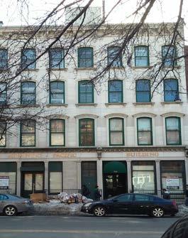
124-128 Atlantic Avenue, c. 1922 Source: Eugene Armbruster, courtesy of the Brooklyn Historical Society

124-128 Atlantic Avenue ,2016 Source: student photograph
One of the most iconic shops was the dry goods store Journeay and Burnham’s (built 1851) which had its home on this block from 124-128 Atlantic Avenue.7 This four-story dry-goods shop, on this site since 1851, was celebrated as "headquarters in Brooklyn for bargains and low prices."8 The shop left the Atlantic Avenue location in 1898, but the Italianate commercial building it once occupied still stands today (as a dentist’s office). This building cuts through
the block, and its rear façade can be seen on the North Side of Pacific Street.9

Atlantic Avenue in 1855 source: 1855 Perris map According to the 1855 Perris maps, Atlantic Avenue was largely built by that time and storefronts covered blocks west of Clinton Street (Maps of 1855 and 1855 storefronts).1 Atlantic Market stood at the corner of Hicks Street and Atlantic Avenue, where SUNY Downstate Medical Center is located today. In the second half of the 1850s, new development continued to move towards the east, as well as storefronts. In the 1860 Perris map, block frontages were mostly completed and storefronts were more noticeable, since they started to be evenly spread along the Avenue.2 Atlantic Avenue first rose to prominence during the civil war. Shipping activity along the Brooklyn waterfront became an important part of the lifeline that supported troops far to the south with war supplies. As a result, Atlantic Avenue soon emerged as the center of shippingrelated commerce, making business highly profitable for its numerous merchants.3 “By the late 19th century, Boerum Hill in general and Atlantic Avenue in particular enjoyed an era of prosperity unequalled in its history. By this time, a great influx of Scandinavian families had arrived--Atlantic Avenue was known as Swedish Broadway--they opened many of the handsome stores whose remnants still remain.” According to 1886 Sanborn maps, when the block fronts were all finished, storefronts covered every building on Atlantic Avenue, not including business firms and institutions.
With dynamic business activities, Atlantic Avenue was constantly evolving with regards to its fabric and the content of stores. In the 1930s and 1940s, an influx of Middle Eastern immigrants came as a result of the construction of the Brooklyn Battery Tunnel on Manhattan’s Lower West Side, which had been home to a sizeable Middle Eastern community.4 This group of newcomers took over the storefronts from old generation businesses and established their own shops between Clinton and Court Streets. Their restaurants and stores offer specialty foods from the Middle East as well as Mid-Eastern music, books, clothing, and other assorted items.5 These businesses flourished on Atlantic Avenue until they declined in the 1950s when New York City began the construction of the Brooklyn-Queens Expressway. However, in the 1960s, antiques shops began to cluster there, as well as on adjoining blocks, spurring an economic revitalization. In 1972, a special zoning district was established in the Atlantic Avenue between Court Street and Flatbush Avenue with regulations specifically designed to protect the avenue’s scale and character, including original architectural features such as its Victorian-era storefronts. he guidelines tried to ensure that new development would match the existing low-scale fabric and that ground floors would be used for commercial activity. In addition, specific materials and colors were provided as well as certain percentages of glazing in order to maintain consistency throughout the street.
In the 1990s, the Atlantic Avenue Association Local Development Corporation published A Guide to Atlantic Avenue Zoning Regulations. The guidebook offered additional recommendations to advance the conservation effort and provided a guideline to identify and preserve historic storefronts. In 2004, when the City created the Special Downtown Brooklyn District, Atlantic Avenue’s regulations were retained as the Atlantic Avenue Subdistrict.

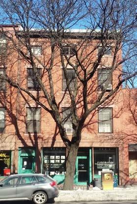
103 Atlantic Avenue Source: student photograph
1 Perris, William, Maps of the City of Brooklyn, Brooklyn, 1855 2 Perris, William, Maps of the City of Brooklyn, Brooklyn, 1860 3 A Guide to Atlantic Avenue Zoning Regulations, Atlantic Avenue Association Local Development Corporation, 199 4 “Atlantic Avenue, Brooklyn” http://6tocelebrate.org/site/middle-eastern-businesses/ 5 Atlantic Avenue BID Website, Why Atlantic Ave http://www.atlanticavebid.org/setting-up-shop/why-atlantic-ave/ 6 Brooklyn Historic Atlantic Avenue Walking Tour. Atlantic Avenue Betterment Association. In 1896, Irish immigrants Jere J. Cronin and his brother founded this funeral parlor, one of few businesses remaining from the 1800s. Mr. Cronin opened in number 103 and then moved to 115.6
1855 Storefronts map

1860 Storefronts

1886 Storefronts

1904 Storefronts

The above infographics track the gradually increasing number of storefronts on Atlantic Avenue from the mid 19th centry to the early twentieth century. Source: student-created infographics


110 Atlantic Avenue Source: student photograph 180 Atlantic Avenue Source: student photograph 164-168 Atlantic Avenue Source: student photograph
Before 1900, Scranton & Co. sold “groceries, wines, liquors etc.” at 110; in 1884 annual sales were recorded at $150,000. Saturday evenings, men from Brooklyn Heights “would repair for dinner to one of the numerous chop houses [on Atlantic Avenue], and there indulge in the real old English fare which was then prevalent.” — James M. Callender, 1927 7. Today the Avenue is still a popular “watering hole,” but the “fare” is greatly diversified — now featuring cuisine from all over the world. This four-story commercial building has a castiron façade, an unusual feature for Atlantic Avenue. The wrought-iron railings at the window openings are separated by smooth pilasters rising up the three stories above the ground level. It is capped by a Neo-Grec bracketed cornice. Aside from the storefront, which was replaced, the façade retains its original materials and configuration.2
1 Brooklyn Historic Atlantic Avenue Walking Tour. Atlantic Avenue Betterment Association. 2 Perris, William, Maps of the City of Brooklyn, Brooklyn, 1855 3 "Atlatni Avenue, Brooklyn." Historic Districts Council. Accessed April 15, 2016. http://6tocelebrate.org/site/164-atlantic-avenue-166-168-atlantic-avenue/ These mercantile buildings display the importance of architecture as a means of representing and advertising businesses in the 19th century. The quality of the materials and attention to details, such as stone quoins and bracketed roof cornices, is exceptional. They were designed in a simplified Italianate style and the center of 166-168 Atlantic Avenue has a prominent central gable. As evidenced by the painted sign, the buildings were home to a shop selling shipbuilders’ goods. In the mid-19th century, Atlantic Avenue was host to a number of nautical goods manufacturers and dealers. These buildings were restored and converted to residential units in 2006, and the painted sign got a fresh coat of paint. Note the ornate parapet on 177 Atlantic Avenue, a commercial building directly across the street.3
Today, Atlantic Avenue retains its commercial character. However, the historic fabic may not be intact. After speaking with the community and through our own surveys, we have found that these Special Purpose District guidelines are not entirely effective. From the community, we heard issues of owners and new developers not following these guidelines and that the rules are not often enforced. We also found that these guidelines are potentially driving owners to historicize the storefronts, meaning they make the storefronts look 19th century without any original fabric or documentation telling them what it had looked like.
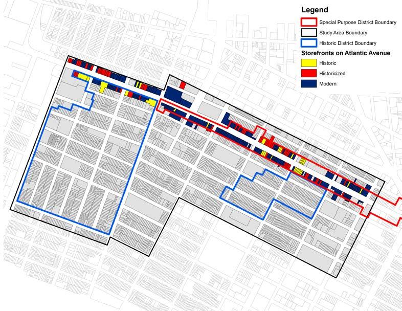
As part of the study we investigated and identified significant storefronts on Atlantic Avenue by combining archival research and in-field documentations. First, we identified building dates and development patterns through historical maps and land conveyances. By visiting study blocks, we looked carefully for historic details and materials. The next step was to research historic photos (if any) and compare them with our own graphic documentation. With all the findings integrated, we were able to identify significant storefronts. The storefronts can be considered significant by being in either of the two categories: historic, which means that they retain all historic design or fabric; historicized, which means the storefronts might have partial restorations and recreations but are still significant because they retained some or all of their historic character. Of the 263 storefronts sureyed on Atlantic Avenue, 105 were considered to be significant storefronts, but just 42 of these were historic, while the rest (63 total) were historicized in some way (see the map on the next page).
Despite these alterations, the storefronts that exist today are still significant because of their historic details and designs, their locally owned businesses, their contribution to the streetscape and the collective memory remaining they invoke.

407 Atlantic Avenue - historic storefront Source: student photos

477 Atlantic Avenue - "historicized" storefront Source: student photos
Historic Storefront Map
Historic storefronts are not only important on Atlantic Avenue, but also on Court Street, Smith Street, as well as some corner stores throughout the study area. This map shows the location of historic or historicized storefronts in the neighborhoods. Historic storefronts contribute much to the overall character of the neighborhood, and it is troubling to see how limited this typology actually is in the study area.


Above and right: 394-402 Atlantic Avenue; bottom right: 394 Atlantic Avenue Source: student photos

From 394 - 402 Atlantic there is a string of 5 rowhouses, with the block’s longest stretch of historic and restored storefronts. These storefronts contain historic elements, but have been recently restored and painted. Much of the paneling and ornament lacks the detail expected in an original work, but careful attention to detail and thought has been given to them. 394 is a good example of this, where the paneling on the doors and below the storefront is not the workmanship of a historic storefront.


Above: 405 Atlantic Avenue; Upper right: 407 Atlantic Avenue; Bottom right: 409 Atlantic Avenue Source: student photographs
According to maps, three storefronts on 405-409 Atlantic Avenue presented as early as 1855. By 1930 and 1970’s photos, they stayed almost the same: the heights, form, show windows and door placements are all similar to their 1930s appearance. The show windows are on the east facade, followed by the doors of the shops and the gates to the upper residences. Today, these storefronts are protected by new paint and are in good conditions, except that the cornices are slightly deformed. Show window and cornices of 405 Atlantic were made out of cast iron. They all have thin piers, but only 405 and 407 Atlantic Avenue have scallops brackets on top of the piers. In addition, the cornices of 405 and 407 are very simple and geometric and yet 409 has a storefront which exhibits neo-grec features, indicating it has undergone possible renovation.


Chain Stores
Along with the issue of losing historic storefronts, the community is worried about the increase of chain stores coming into the area. Chain stores come in and want to put their specific branding on the storefronts, which affects the look of the streets and leads to the potential loss of more historic storefronts. In addition, chain stores are affecting the neighborhood financially. Residents are concerned that the chain stores, which have a large financial backing and long-term business plans, are driving out small businesses. Rents are now higher for commercial space because of these chain stores, and small businesses often cannot afford to pay it. In addition, many residents believe that the small business owners and renters are typically more engaged in the community than chain stores, which often have owners or workers that do not live in the area.
This map indicates the location of chain stores in the study area: the majority are on the corner of Atlantic Avenue and Court Street, where two major commercial roads meet.
Study Area Boundary
Historic District Boundary
L Locatioegendn Of Chain Stores
Study Area Boundary
Historic District Boundary


