
24 minute read
Recommendations
Policy Recommendations
Our recommendations are broken in both broader, city-wide policy recommendations and specific, neighborhood-level recommendations. Our first recommendations concern the policy of the Landmarks Preservation Commission and the New York City Department of Planning.
Education-city level
We feel is opportunity for historic districts to stand as a model of resilience for the city. They should perform as the best neighborhoods and help protect the cultural values and livelihood of their residents. This might sound utopian, but one of the mandates of the NYC Landmarks Law is “to (b) safeguard the City’s historic, aesthetic, and cultural heritage.” Analysis found that within the study area, the expectations of the NYC Landmarks Law has not been utilized to its full extent, and buildings are being protected primarily for aesthetic reasons without acknowledgment of the cultural and social fabric that makes these places significant. Thus we recommend, broadly, that the LPC take steps to ensure that districts throughout the city are recognized for their cultural significance - and while it has already started to do so, such as is the case of Stonewall Inn, the LPC needs to continue to take steps in this direction.
We also suggest further education of the community and general public on the Landmarks Law in New York City. In general, the public still feels that a historic district imposes so many regulations upon homeowners that they can no longer make any changes to the fabric of their buildings. As we have shown in this study, through some examples of new buildings in historic districts, this is not the case. However, the Landmarks Commission needs to improve its education of the public regarding historic preservation in order to better promote preservation as an accessible option to all.
Corner of Dean and Smith Street Source: student photo
Affordability-city level
Affordability is a major concern in n today’s political climate. Given the current direction of the deBlasio administration in promoting the Zoning for Quality and Affordability legislation and focusing on affordable housing, preservationists need to re-evaluate the ways in which the field engages with housing and affordability. One of the main goals of the New York City Landmarks Law is the increase and stabilization of property values. At the time this law was created, increasing property values was an important goal and incentive to convince New Yorkers to district, as well as a measure of success for districting. However, as property values across New York City increase, housing becomes more unaffordable, and as our community values change overall, this goal of the Landmarks Preservation Commission has become outdated. Historic districts around the country are increasingly criticized for their lack of incomediversity. While this study found that areas between and around the historic districts in the study area are unaffordable, the most unaffordable blocks within the study area fall within the historic districts.
ZQA addresses this to some extent, but the stigma and controversy that historic districts increase property values and squeeze out income diversity is still an issue. To address this issue, the New York City Landmarks Commission needs to consider its relevance in contemporary society. If the intention of the historic district is to create more protect buildings as well as diversity and inclusion, we need to think about additional parameters for landmarking in a new era. The Landmarks Law should be reviewed and should be updated to become more responsive to contemporary societal needs.
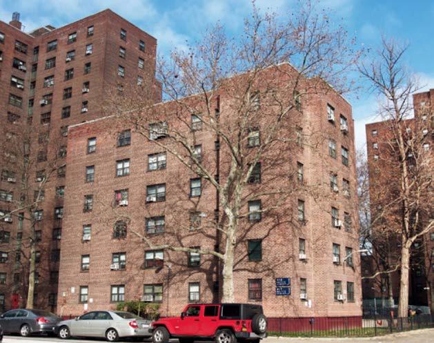
Gowanus Houses source: Student Photo
Density-city level
Our data has shown a definite decrease in density as rowhouses are converted to single family units. At the same time, the world and city’s populations continue to rise. Landmarks and Historic Districts are under scrutiny as so many of these buildings, including those in our study area, are low-scale structures. If Historic Districts are to become a model of resilience, they need to allow for higher density in the existing buildings; the alternative being demolition in order to build higher density towers.
We therefore recommend further research into the decrease of density over time, and the subsequent use of this research to keep population density high by disincentivising the loss of units and conversion of multi-unit dwellings into single units with an increased property tax. This may be a policy that requires a partnership between New York City Landmarks and the Department of City Planning if kept only within the Historic Districts. However, this is also an issue outside of Historic Districts as well as. We therefore also suggest that City Planning consider limiting the conversion of multi-family buildings to singlefamily units.
Rowhouses source: Student photo

Parking-city level
Based upon our research, we recommend an alleviation of parking requirements inside historic districts. This study found subterranean parking poses a serious threat to the structural integrity of many landmarked buildings. Our study area in particular has remained largely car-dependent and the community complains about lack of parking. However, the Cobble Hill and Boerum Hill Historic Districts, as well as most other historic districts in New York City, are easily connected by public transportation. Therefore, we suggest the removal of these parking requirements in Historic Districts in order to preserve the historic structures and to promote the use of public transportation.

State Street source: Student Photo
New historic district-neighborhood
We propose a new historic district on Atlantic Avenue from Third Avenue to Hoyt Street due to a dwindling number of original historic storefronts. We found that the special purpose district guidelines on Atlantic Avenue have not effectively protected these storefronts, do not protect from demolition, and make only superficial requirements mandatory, rather than protect the commercial typology in general. As we have done in-depth research on Atlantic Avenue we feel it is in the neighborhood’s best interest that this section (not covered by the Cobble Hill or Brooklyn Heights Historic Districts) should have a greater level of protection than it has had in the past in order to preserve the importance of these mixeduse, historic storefront typologies. While we do recognize other stakeholder interests in expanding the historic districts in general - specifically the Boerum Hill Historic District, our research indicates that these row houses are in good condition, display high levels of integrity, and are not in immediate danger of demolition, and are therefore not in our primary recommendations for the area.
With the creation of this district, we also recommend that the Atlantic Avenue Special Purpose Subdistrict regulations either be revised or removed altogether as they are not adequately serving the needs of the community or the built fabric.
Third Avenue Cobble Hill Historic District
DeGraw Street
Proposed Historic District Source: student-created infographic
Court Street

Atlantic Avenue Smith Street
Boerum Hill Historic District
Warren Street Third Avenue
Proposed Historic District
Small business easements-neighborhood level
In reference to community concerns for the loss of small business in the area, we propose an easement program to encourage independently-owned small business development on Atlantic Avenue.
Contingent upon the proposed Atlantic Avenue historic district designation, we propose to introduce a facade easement program that will reward business owners who preserve their small-scale storefronts in plan and facade with charitable tax deductions. The Internal Revenue Service (IRS) stated in 2004 that in order for buildings to be eligible for the easement associated charitable tax deduction, the building should either be individually listed on the National Register of Historic Places, or be certified contributing structure to an historic district. 1
The amount of the deductible tax varies as it is determined during the appraisal of each individual building, but it generally ranges from 10% to 15% of the property’s fair market value.2 With the reduced cost to the landlord, we hope the owners would subsequently lower the rental rate to help preserve the small businesses (mom and pop shops) along Atlantic Avenue, Court Street, and Smith Street. Meanwhile, as the easement receiver (The New York Landmarks Conservancy or the NYC Department of Environmental Protection) can exercise its legal right to enforce the easement in the case that the building owner(s) fail to maintain the condition in compliance. In short, it ensures that the storefronts’ current and future owners to take good care of the architectural heritage in the years to come. 1. Internal Revenue Bulletin: 2004-28. IRS. July 12, 2004. https://www.irs.gov/ irb/2004-28_IRB/ar09.html 2. New York Easement Law
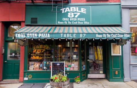
87 Atlantic Avenue
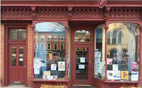
Source: Student Photo
410 Atlantic Avenue Source: Student Photo
Cultural overlay district-neighborhood
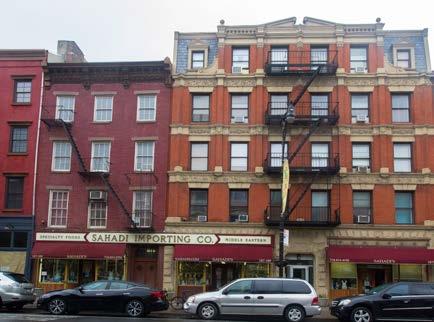
The second priority is the protection of sites of cultural heritage along Atlantic Avenue. For sites of Syrian cultural heritage, we propose an overlay district. For example, Sahadi’s Importing at 187 Atlantic Avenue was established as early as the 1890s in Manhattan, and has been in business in Brooklyn since 1948. While not the original occupants of the building, three generations have worked at Sahadi’s, and have had a significant presence in the community. This building is protected by the Brooklyn Heights Historic District for its architectural significance only. As another example, Tripoli Restaurant served as a Lebanese restaurant and a site of cultural heritage for the greater Syrian community for nearly 50 years until it was replaced by a coffee shop. While these sites are protected for their aesthetic value to the neighborhood, they are not currently protected as sites of cultural heritage. Thus, we recommend that the Landmarks Commission designate a cultural overlay district over the western part of Atlantic Avenue (from Court Street to Hicks Street).
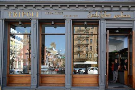
Tripoli Restaurant source: Student Photo
Sahadi’s Source: Student Photo
Commemorative plaques-neighborhood level
For the historic port buildings along Atlantic Avenue, especially the Marine Life Savings Building at 122 Atlantic Avenue(122 Atlantic Avenue,1922), which is also included in the Brooklyn Heights historic district, we propose partnering with Place Matters (122 Atlantic Avenue,Now), an organization that has created a census of historic sites in New York City and created plaques to commemorate these buildings, to bring attention to the stories behind the architecture, and to help identify, promote, and protect such places in New York City.

source: Student Photo
122 Atlantic Avenue,Now source: Brooklyn Historical Society Atlantic Avenue
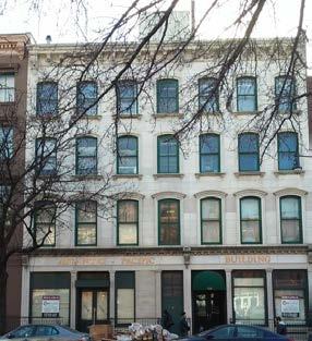

122 Atlantic Avenue,1922 source: Brooklyn Historical Society Plaques source: Brooklyn Historical Society
Community Engagement
We feel it is important to draw on the area’s rich resources to keep the community culturally engaged. The area is known for its Brownstoner history, a group of residents and preservationists who have built a healthy network within the community. The Brownstoner legacy is one that is well known, but with shifting demographics, we feel that is incumbent for these individuals to engage new generations in the power of preservation within this rich cultural landscape. There are already diverse platforms in the area that provide a base from which to engage new generations. These include the Atlantic Antic in the fall, hosted by the Atlantic Avenue Local Development Corporation, that draws large crowds (image) and the Invisible Dog artist community in Boerum Hill, that we found has already utilized the diverse cultural history of the area to reactive a small art scene in the neighborhood, and uses their warehouse space at 47 Bergen Street to draw in new businesses targeting younger generations outside the neighborhood.


Installations
To draw upon the strong community already in place, we recommend several installations that respond to the lack of cultural commemoration in the study area. The installations call attention to aspects of the study area’s cultural heritage that might not be reflected in the architectural fabric, yet are essential to an understanding of these neighborhoods’ pasts
Facade Rewind
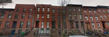
This installation calls attention to an arbitrary historic district boundary line, looking at the southern edge of Cobble Hill Historic District at a particular spot on DeGraw Street in the study area. One side of the street is inside the district (block 324), one side is outside (block 332). The installation uses simple cloth screens and projectors to superimpose the facades from 1930s tax photos onto the current buildings. The projection reveals a high level of continuity on both sides of DeGraw Street, leading us to ask where the historic district boundaries should really be drawn, and to question the arbitrary lines of the original historic district. In the 1930s these buildings had the same level of historic integrity, and arguably still do even today, despite their random inclusion/ exclusion from the historic district.

Block 324 source: Google Street view

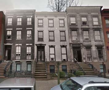
Block 332 (Projected with 324 facades)
Through the technology of scratch and sniff wallpaper, visitors are invited to consider the presence of a throughblock brewery stable that once stood on this site on Dean Street between Third Avenue and Nevins Street, currently a park. In the early 1900s the stable served the Long Island Brewery located just a block away at the corner of Dean Street and Third Avenue.
The photograph inside the “stall” is from a Brooklyn Daily Eagle profile in 1900 of a carriage house in Park Slope, at a time when horses were central to transportation. The smells here include horses, hay and stable equipment, and serve as a provocative reminder of the site’s ephemeral sensory past: very different from its present, but still valuable to us
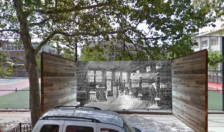
Original site of brewery stable - Dean Street between Third Avenue and Nevins Street Source: student photograph and The Brooklyn Daily Eagle (photograph inside "stall")
Flavor Paper Located at 216 Pacific Street in the study area, Flavor Paper describes itself as a “futuristic production facility & showroom for custom, hand-screened wallpaper.” Despite its modern appearance, Flavor Paper’s products could be utilized in this historic preservation installation. Although scratch and sniff is not a traditional preservation technology, the participation of local stakeholders is essential to the success of these installations.
Bakery
Here the scratch and sniff wallpaper reveals the Syrian bakery that used to occupy this storefront at 199 Atlantic Avenue. Installed in the store windows, the image on the right is of a young woman pouring aromatic Turkish coffee; in the next window a woman holds out a tray of Syrian “meat pies.” The images are printed with the smell of strong coffee and pastry.
Flavor Paper Located at 216 Pacific Street in the study area, Flavor Paper describes itself as a “futuristic production facility & showroom for custom, hand-screened wallpaper.” Despite its modern appearance, Flavor Paper’s products could be utilized in this historic preservation installation. Although scratch and sniff is not a traditional preservation technology, the participation of local stakeholders is essential to the success of these installations.

Original site of Syrian Bakery - 199 Atlantic Avenue Source: student photograph and The Brooklyn Daily Eagle (photograph inside "stall")
Materials & Documentation Recommendations
The physical fabric of these buildings has been well maintained and relatively unchanged over time. In many cases, change depended on the desires of individual property owners, but landmark designation or community projects could help to educate owners about the history of the neighborhood, the ways in which it has changed, and the ways in which its building materials continue to age. Education might sway future policy decisions and neighborhood goals towards protecting the existing fabric of these buildings. We recommend documentation projects, inclusion of non-rowhouse typologies in designation efforts, recognition and maintenance of trees, and specific mitigation measures for deteriorating brownstone and wood. Finally, we have identified areas for future study.
Documentation Measures
In order to better understand changes in building condition and integrity through time, we relied primarily on historic photographs. Some photographs were captured by local archivists, some by the LPC during designation of historic districts, and a major portion of the photographs were originally captured by the City for tax collection purposes. However, this approach was limited. Since the photos collected by the City were for tax purposes, not much attention was given to the photo quality. High quality photographs are essential for determining a building’s physical condition. Though the tax photos from the 1980s were of much better quality, they are limited in number. Furthermore, the LPC photographed buildings exclusively within the historic districts and not throughout our study area as a whole.
This studio recognizes 2016 as a moment of rapid change in the neighborhood. As such, we recommend documenting conditions and features within the study area now, so that future studies will be able to adequately assess the effects of present-day changes on the future condition and character of the neighborhood. Specifically, we think it is important to document vulnerable materials and sites such as existing brownstone or wood (map for Vulnerable Materials) and sites flagged for development (map of Soft Sites).
We recommend that documentation tasks be undertaken as a collaborative effort between local interest groups and the Landmarks Preservation Commission. Local interest groups, such as the Boerum and Cobble Hill Associations, are interested in mobilizing community members to take action to protect the existing buildings. These groups would also likely be successful in leveraging the local community to invest time and funds in documentation projects. Software such as tablet surveying applications, photo-annotating software, or 3-dimensional photo scanning programs are available for free on open source platforms or for a relatively low cost. If community groups are interested in completing these documentation projects, local preservationists or students of preservation could train community researchers. After a few community members know how to use annotating or photo-scanning software, they can pass on the knowledge to other homeowners, institutions, or business owners. In turn, these projects could be archived so that future researchers will have accurate snapshots of the neighborhood.
Tablet applications, such as PhotoSuite’s image annotation app would allow for more detailed surveying of buildings within the study area. The application allows text and sketch layers to be added on to survey photographs: surveyors can note facade materials, locations of material replacement or deterioration, or clarification of images. Survey information collected directly onto tablets does not need to be scanned or digitized before being shared, archived, or analyzed. The groups doing the documentation can, however, prepare the data to be archived, which can later be added to a database. Fig. Map for Vulnerable Materials
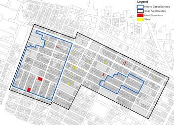

Fig. Map of Soft Sites
Drone photography is another method of digitally documenting the neighborhood. Already used in real estate marketing, drone photography allows for the collection of accurate and high-quality images and video from a variety of vantage points. Drone photographs and video can easily document buildings from eye-level and above, allowing for documentation at various scales including streetscapes, individual buildings, and even features placed high on facades. However, drone photography is in the progress of becoming highly regulated. The FAA (Federal Aviation Administration) has proposed a set of drone laws, and recreational drones are required to register with the FAA.
Finally, vulnerable features in the neighborhood can be documented using photogrammetry software such as Agisoft PhotoScan. This software uses photographs to construct dense, three-dimensional point clouds that represent objects within a hundredth of a centimeter. These point clouds can be archived as accurate representations of features. Or, the point clouds can be used in conjunction with other platforms such SketchFab and AutoCAD, allowing the data to be shared or used in the creation of detailed 3D models or visualizations. We recommend that features are documented with Agisoft PhotoScan at regular intervals (such as every five years). Multiple point clouds can be compared using other software platforms such as CloudCompare, which can compute the differences between two point clouds and create a heat map that showing which areas have deteriorated the most. This would allow researchers to accurately quantify and record deterioration, as well as visualize deterioration in a compelling way. As a test for this technique, we simulated these documentation cycles in a laboratory setting. A sample of brownstone with an existing patch repair was documented using photogrammetry, then “deteriorated” and documented again. We simulated deterioration by chipping at the stone. The point clouds were then compared, and we produced a graphic which showed areas where change had occurred. If repeated over time in the field, it would be possible to visually represent the areas of brownstone features or facades that are disappearing the fastest.
Condition Before
Condition After

Change
Recognition and Maintenance of Trees
Taking into account the aesthetic value that trees add to the streetscape as illustrated by the tax photo comparisons, as well as recent studies that cite “reduced energy use, improved water quality, optimized property values and commercial benefits, and increased human health and well-being,” this studio recommends expanded attention to the maintenance and preservation of trees.1
Drawing upon the success of the volunteer-run Cobble Hill Tree Fund charitable trust “responsible for planting more than 200 trees and raising funds for planting and maintenance,” the studio recommends that Boerum Hill establish and implement a similar organization intended to involve and educate the community residents in the importance of tree maintenance to the character of the area.2 However, relying upon historic districts to preserve the treescape does not acknowledge the importance of trees in areas outside the historic districts. Therefore, we further recommend that city entities responsible for urban forestry (such as NYC Parks) implement volunteer programs outside the historic district boundaries and partner with volunteer organizations like the Cobble Hill Tree Fund.
The study also recognizes the challenges involved with sustaining these urban ecological resources. Trees are susceptible to urban environmental stressors such as traffic, insects and domestic animals, and air quality. With the interest of mitigating these threats, we recommend installing tree guards to protect the root systems of the trees. Tree guards are currently inconsistent in the study area, which is especially problematic for trees on streets with high levels of pedestrian traffic. A precedent for this suggested campaign was launched in 2011 by the Myrtle Avenue BID with grant funding. Existing designation reports provide no provision for the maintenance of trees, as the majority of them were planted after designation. Because of this, the trees currently in the historic districts are susceptible to reaching maturation and life capacity within a relatively narrow timespan. We recommend the development of a maintenance and replacement schedule for trees within the historic districts, which should include an assessment of vitality and life expectancy for the current treescape.
This correlates to another recommendation aimed at mitigating the negative effects of urban ecology on trees. More in-depth research into species characteristics and how to best cultivate the existing and future treescapes should be undertaken. The vast majority of the trees in this study area are of the species commonly known as the London Plane Tree, which is included on the NYC Parks list of Asian Longhorned Beetle Quarantine Species. Trees of this species may need to be replaced in the future.
1. USDA/Forestry Service Report 2. Cobble Hill Tree Fund website
Preserving Remaining Brownstones and Wood Frame Buildings
“True” brownstone buildings once made up a significant part of the study area’s building stock. Even today, we have observed a tendency to restore building facades to look like brownstones, albeit in stucco. And as seen from our data, most of the remaining brownstones are in an extremely dilapidated condition. It may be helpful to note that the brownstone on institutional buildings has fared much better than the brownstone on rowhouses; this could be due to the fact that on institutional buildings, brownstone was used as masonry blocks while on rowhouses and elsewhere, brownstone was applied as an exterior veneer. Ornamental lintels still exist on many rowhouses, even though the facades have been replaced by stucco. Brownstone is vulnerable to weathering from natural causes (mainly moisture in the form of rainwater and freeze/ thaw cycles), and its durability is also comparatively lower than other stones (like granite or marble) owing to the nature of its formation. However, measures can be taken to slow the rate of deterioration, and we recommend that brownstone building owners follow the rules set by the New York Landmarks Conservancy in “The Brownstone Guide: Maintenance & Repair Facts for Historic Property Owners.”
Wood seems to have fared better than brownstone in the study area, as a larger number of wood buildings are present today. Wood is quite significant in the study area because of its prevalence in earlier times and due to the more recent tendency to replicate the appearance of wood with vinyl siding. Wood presents a fire hazard as well as numerous maintenance challenges, perhaps explaining why most of these buildings have disappeared from the study area. With this in mind we recommend that owners be made aware of the “Rowhouse Manual” published by the LPC, which details the importance of architectural details and materials (such as wood siding).
Further Study
We recommend more in depth research on the commercial corridors of Smith Street and Court Street. The west side of Court Street is protected by the Cobble Hill Historic District, but the east side has seen significant development and an increase in chain stores. Smith Street is entirely unprotected by any landmarking of districting tool. As we were limited in the amount of time available to complete this study, we were only able to perform in-depth investigations of Atlantic Avenue, and feel that, having identified historic storefronts as crucial to the character of the area, these two commercial corridors should be further investigated for possible designation. We also recommend increased emphasis on secondary typologies in the study area. As mentioned earlier in the historical development of the area, the original designation reports focus on the character and value of the rowhouses, leaving out other typologies. The conservation study shows that Cobble Hill contains a number of non-rowhouse typologies, especially institutional buildings. Also, the areas encompassed by the proposed expansion of the historic district include a mix of building typologies, including walk-up apartments, industrial, and institutional buildings. Finally, the analysis of case study blocks suggests that the existing historic districts have not been successful in limiting change in buildings that are not rowhouses. As such, we suggest that future studies and reports explain the history of these typologies, emphasize their role in the development of the neighborhood, and advocate for their preservation. This should, at minimum, be incorporated into contemporary discussions of the Boerum Hill expansion. Increased emphasis on a variety of typologies could provide an opportunity to preserve buildings that are under-represented in the existing districts, more common in the proposed sections, and an integral part of the area’s history.
A similar study based upon of tax photograph analysis can be carried out to look for evidence of changes in building typology, materials, condition, integrity over time. Based on the findings from a small number of case study blocks, (the drastic variation in average conditions of properties in blocks right outside of Boerum Hill district, the difference in condition between rowhouses and other typologies within Cobble Hill district, the tendency to revive historical building styles) further study encompassing the whole study area could support or disprove the trends discussed in the “material, conditions, and integrity” section.
Additionally, if this study is repeated with a wider area, or at a different time in the future, we have identified a few lucrative topics of investigation that were left out of this study. Researchers could investigate: the prominence of painted brick facades through time (as discussed in the integrity section), addition and removal of fire escapes as they relate to multi-family conversion of rowhouses, the integrity and condition of ironwork, or the changing character of storefronts and commercial districts through time. In regard to painted facades, researchers might be able to shed light on the integrity of existing materials if they track cases where buildings were painted. We suspect that paint may have been removed by sandblasting or other techniques that could compromise the quality of the base material. Additionally, it would be interesting to investigate the origins of this aesthetic and preference towards bare-brick, when a portion of the building stock has been painted over at least the past seventy-five years. Smith Street Source: student photograph


