

Land, Sea, Disturbance
Landscape Approach in Disaster Recovery and Planning
Kenya Endo National University of Singapore Master of Landscape Architecture / Tacloban Studio ReportDISCLAIMER
This work is a product of students’ outcome from National University of Singapore (NUS), Master of Landscape Architecture Year 2 students, LA5701 MLA Studio, “Country”), semester 1, academic year 2023-24. The findings, interpretations, and conclusions expressed in this work do not necessarily reflect the views of any of the institutions. In addition, the team does not guarantee the accuracy of the data included in this work. The report reflects public information available up to November, 2023.

RIGHTS AND PERMISSIONS
The material in this work is subject to copyright. This work may be reproduced, in whole or in part, for noncommercial purposes as long as full attribution to this work is given. Any queries on rights should be addressed to the editor; Kenya Endo (email address is available from the NUS Department of Architecture website).
ISBN No. 978-981-94-0223-6
© Individual Contributors 2023

TACLOBAN, PHILLIPINES
Nearly 10 years have passed since super Typhoon Yolanda devastated 70% of Tacloban City, Leyte Island in the Philippines. Located at one of the most vulnerable regions to natural disaster risks in the world, this research -based studio begins with investigating the recovery process from this unprecedented storm surge, and how the government and local people are preparing for the next.
Students have conducted group field surveys at three distinctive coastal Barangays, from rural to highly urban, together with their pairing relocation sites. Ground-level observation and various local voices, including informal settlers to the mayor, will form the source of understanding the protagonist of student’s design proposal.
The design process started off with a critique of the current city’s build-back-better outcomes, and then, as a counterproposal, students will explore the alternative— that incorporates landscape perspectives in the recovery and preparedness schemes. The approach, strategies, and spatial interventions should address how recurring disturbances along the land-sea interface are viewed from the locals, and what speculative relationships can empower their lives.
Instructor: Kenya Endo, Lecturer, NUS Department of Architecture
Collaborator:
Ven Paolo B. Valenzuela, NUS Asian Research Institute
Local Knowledge Providers:
Patrick Adams G. San Juan (JICA), Isidoro Malaque III (UP-Mindanao), Vanessa Ayllon, Nellicee Mabini (North West Samar State University), Bryan Steven, Patricia Otida (former UP-Mindanao students).
Students:
Jiaxin Jiang, Jin Xin, Medha Verma, Shi Yi, Wang Junyu, Wu Yueyang, Xinrui He, Xinyi Li, Yuxin Chen
Mid, Interium, and Final Review Panelists:
Dixi Mengote-Quah, Dorothy Tang, Evi Syariffudin, Herbert Dreiseitl, Jean You, Melissa Yip, Yun Hye Hwang, Yukio Hasegawa
Special thanks to Ar. Vanessa Ayllon for supporting the reconnaissance trip in July 2023, as well as field survey in September.

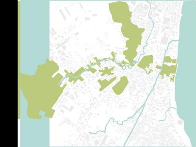
N Source: Microsoft Bing Map Copyright 2024 Maxar 0 500m
TABLE OF CONTENTS
Site Information
Stundent Reflection
Tacloban
Group Site Analysis: Vulnerability of Coastal Living
Group Master Concept: Land, Water, and Life
Integrated Water Management LI XINYI
Resilient Islands WU YUEYANG
Evolving Line SHI YI
Palo
Group Site Analysis: Rebuild Livelihood: Safety-Economy-Society
New Planning Principles for the Transformation of Agriculture WANG JUNYU
Palo Blood Vessel HE XINRUI “Circulate themselves” CHEN YUXIN
Basey
Group Site Analysis: Unlocking Resource in Basey
From Riskscape to Resilient Seascape MEDHA VERMA
Symbiotic Marine Ranch JIN XIN
Weaving Waterways JIANG JIAXIN

5 9 11 11 15 19 27 35 43 43 47 55 63 71 71 75 79 87


SITE
Tacloban city is the 1st class highly urbanized city in the Eastern Visayas region of the Philippines, and serving as the regional hub. Tacloban’s geographic location lies in the path of the 20 typhoons on average that hit the country every year, and its physiographic characteristics makes the “funnel effect” which tends to invite strongest storm surges 1). In 2013, Typhoon Yolanda’s impact was sever; about 16 million people were affected, of which approximately 4 million people were displaced in total, due to its wind speed exceeding 378km/h, and storm surges of 4-6m high. 80% of the reported causalities were from Easter Visayas, which is the second poorest region in the country 2). Within Tacloban city, 28,734 houses were damaged, and this was due to the fact that many dangerous zones along the coasts were occupied by informal settler and their families. Thus, both geographical and social vulnerability have heightened the disaster risk, and its consequential damage to the city. Shelters, infrastructures, services, industries were all heavily affected, with estimated economic loss at around 12.9B USD 3).
Palo and Basey are the neighboring municipalities of Tacloban, and we have investigated the recovery processes in these semi-urban as well as rural communities too. In other words, studio members were split into 3 groups, and detailed site studies were conducted at their respective
sites—Tacloban, Palo, and Basey. The studio is interested to reveal how design interventions respond to the context, such as settlement density, resident’s occupation, proximity to natural environment, etc. At the end of the day, we should be able to identify parameters, priorities, and principals that define the planning direction for resilience.
For such purpose, individual design response required specificity to the site, however, it is equally important to understand which parts of the response are transferrable to other areas, and which parts aren’t.
1) Tacloban Recovery and Sustainable Development Group. Proposed Tacloban Recovery and Rehabilitation Plan. 2014 March.
2) For statistical summary, please refer to; GFDRR World Bank Group. Typhoon Yolanda Ongoing Recovery-Recovery Framework Case Study. 2015 May. https:// reliefweb.int/report/philippines/philippines-typhoon-yolanda-ongoing-recovery-recovery-framework-case-study-august
3) National Economic and Development Authority, Reconstruction Assistance on Yolanda, 2013 (https://reliefweb.int/report/philippines/reconstruction-assistance-yolanda-implementation-results)
Photos on the left: © Ven Paolo B. Valenzuela06 | Site
Tacloban Studio: Land, Sea, Disturbance


LI XINYI
This studio has provided me with invaluable insights into the complex disaster landscape of the Philippines. Through comprehensive exploration, I’ve delved deeply into the natural processes crucial for sustainable urban development. One standout aspect was studying the intricacies of the modified river systems and understanding the pivotal role sediment plays in ambitious reclamation project in Tacloban. Witnessing the synergy between ecological understanding and innovative design was truly eye-opening and has expanded my perspective in ways I never imagined.


 WU YUEYANG
Reflecting on the Tacloban design studio, it stands out as my most challenging and enriching experience in two years. Through field trips, research, and stakeholder interviews, I learned to address complex issues like climate and property rights. The studio emphasized gathering meaningful information and designing with purpose for local communities.
SHI YI
The topic of Tacloban Studio is challenging and unique. The progress of developing strategies to recover site vitality is highly site-specific and considers actual policies, making it an excellent exercise in critical thinking and phased strategy design. The field trip to Tacloban deeply impressed me, providing genuine insights into the local living conditions and aiding in understanding urban development and social conflicts.
HE XINRUIThis studio session profoundly illustrated the limitations of human agency in the face of catastrophic events, deepening my understanding that landscape architecture alone cannot rescue the world. We can, however, strive to mitigate the effects of disasters and enhance the effectiveness and quality of the recovery process afterward. An important aspect is how to actualize a design or idea once it emerges. The path from inspiration to implementation is critical and often fraught with challenges. Although there may be well-conceived recovery plans, implementing them can be daunting due to various obstacles, from bureaucratic hurdles to resource limitations. As aspiring landscape architects, our role extends beyond designing. It involves navigating these complexities to bring our visions to life.


WANG JUNYU
Studio in Tacloban brings me to a big picture of “Landscape under Disaster”. What is “Build Back Better”? What is the role that landscape architect can play in such a huge and complex urban reconstruction project? Can poverty and resource allocation be solved by design? Or does it depend on policy? It is a unique experience for me.
CHEN YUXIN
As a student, when I encountered a disaster-related topic in the past, it was easy for me to take the perspective and mission of a savior, and to use my common sense of living in the city to judge the good and bad of the local people’s lives, and to provide what we consider to be a good solution and a good space. However, during the visit to this studio and seeing the results of 10 years of post-disaster reconstruction, it was hard to imagine that they had been living in what we would consider a very “temporary space” for 10 years. When the concepts of temporary and permanent broke the common sense thinking, it made me realize that landscape interventions and the spaces’ possibilities that should be defined by the users rather than the designers.

MEDHA VERMA
The overseas studio was an interesting exploration into how ecological planning can support local livelihoods while addressing pressing challenges such as the impact of climate change, notably rising sea levels. Engaging in fieldwork in the Philippines and interacting with various stakeholders enriched my understanding of the complex issues at hand and informed the design process.

JIN XIN
The studio led me on an enchanting journey through the realm of landscape design. Engaging in a week-long exploration alongside local scholars and students in the Philippines opened my eyes to a new dimension of contemplating natural disasters: they need not be solely viewed through a lens of adversity but also a challenging opportunity. Witnessing the profound love for life and nature exhibited by the local community amidst the transition from disaster to normalcy deeply moved me. It continuously fuels and inspires within me the quest for a more sustainable coexistence between humanity and natural calamities.

JIANG JIAXIN
The relocation of disaster-affected communities may not necessarily present an optimistic outlook. Instead, it can lead to disruptions in livelihoods, inconvenient infrastructure, and a loss of community belonging. Thus, rather than blindly relocating coastal disaster communities to safer areas, considering the establishment of on-site disaster-adaptive landscapes may better safeguard the human rights of vulnerable groups.
Studio: Land, Sea, Disturbance 10 | Stundent Reflection
Tacloban

TACLOBAN: Vulnerability of Coastal Living
The core of Tacloban team’s proposal lies at their “phased approach” to transform the urban coastal landscapes. The team acknowledges the government’s future vision of reclaiming the Cancabato Bay for economic development.
“If it were to be done, what steps should be taken?”, considering the uncertainty (e.g. time, investment), people (who will be affected by its consequence), and disaster preparedness (stormsurge during- and post-development).
To reflect such contextual constraints, the team deployed rather a “soft approach”, as opposed to one-directional engineering approach. Here, the ecological processes are the ones driving and facilitating the development outcome.
The team emphasized that they do not intend to draw a “masterplan”, but more to indicate the “process” of development. The final outcome shown below is a placeholder; implying the flexibility to be adjusted based on any “disturbance” that may occur within this area.
Three members collaborated well to achieve a compelling large scale proposal; repurposing waterways as a means to transport sediment [Xinyi], reimagining land reclamation into a series of island formation [Yueyang], and at the end, weaving the islands, causeway, and Tacloban’s historic district into a vibrant waterfront [Shi Yi].
(Kenya Endo)

Tacloban Studio: Land, Sea, Disturbance 12 | Tacloban


Land, Water, and Life
Sustainable Development of Tacloban
LI XINYI, WU YUEYANG, SHI YITacloban has a profound maritime history, with its survival and development closely intertwined with marine resources. Besides economic dependence, Tacloban’s residents have cultivated a deep cultural connection with the ocean. However, alongside the reliance on the ocean, disasters have also been brought forth. Tacloban frequently experiences the impact of typhoons, with the potential for significantly increased wave heights and intense storm surges during major typhoons, severely affecting people’s livelihoods. Typhoon Yolanda, in particular, had a massive impact on the region.
In response to these challenges, the government aims to relocate people to the north and construct robust walls to withstand the forces of the ocean. Simultaneously, plans involve extensive land reclamation to transform the bay into an economic zone. However, the construction of the Northern New City and seawall project in Tacloban is still in its early stages. People’s livelihoods are facing challenges, lacking designated living spaces during this transitional period.
We propose a new future development plan for the coastal areas of Tacloban. A crucial missing component is the transitional plan. Our plan focuses on a phased implementation, divided into three main components: water systems, land reclamation systems, and transportation and entertainment systems. By structuring and overlapping timelines, we have divided the entire plan into five stages. Each stage does not have a specific completion time but relies on local funding and resource availability. Even if progress is hindered, completed projects can still provide practical value for local residents. Our proposal aims to achieve disaster resilience, create job opportunities, restore ecological balance, and activate urban development and the cultural and entertainment industry.
15 | Tacloban Tacloban Studio: Land, Sea, Disturbance

Tacloban City Development
Housing distribution


Tacloban boasts a profound maritime history, with its survival and development intricately tied to marine resources. Its evolution stems from its wharves, where the ocean provides abundant fishing opportunities and serves as a
for
and
exchange. Fishing traditions, navigation skills, and maritime beliefs have
Tacloban: People's Lifestyle

Many residents of Tacloban make a living through fishing, and along the coast, there are numerous piers and seafood markets. This maritime-dependent livelihood not only meets the local residents’ food needs but also provides economic opportunities for the city Additionally, the ocean serves as venues for leisure and entertainment activities, with beaches and seaside parks becom-ing places for community gatherings and cultural celebrations, offering residents spaces for relaxation and enjoyment.
Sense of belonging Cultural activity II Livelihood Fishing Santo Niño Shrine & Heritage Museum cultural heritage Level of content conflict conflict Cultural corridors vs. high natural risks tacloban city public market informal houses informal houses aquaculture jetty San Fernando school Gaisano Capital Real Sangyaw Festival Live and recreational Fishery work nature risk Risky area Risky area life safety fishing Fishery work vs. high natural risks 1944 Fishing development 2012 before Yolanda Fishery Embankment 2023 after Yolanda
trade
cultural
woven
Tacloban’s history
way of life. Tacloban City Map Legends formal pier informal pier aquaculture low risk fishing route ferry route 0.1 0.25 0.5km Industrial Pier 16 | Tacloban Tacloban Studio: Land, Sea, Disturbance
focal point
through
and
Deconstruction Data


Weather Data


Legends extremely high risk high risk medium risk low risk city building city boundary 0.2 0.5 1km Tacloban City Hazard Map Strom surge & Tsunami & Flood
Of the 28,734 totally damaged houses in our city, 9o% are along the coast. (1.2 million) The number of partially damaged houses is 17,643. 28 of the city's 136 barangays have coasts and lowlands considered as danger zones. These danger zones are mostly occupied by informal settler families. 60.31% of Leyte people affected 49.21% of Samar people affected All the city's 7 hospitals (2 gov't, 5private) and 17 barangay health centershave sustained major structural andequipment damage. 90% Death toll: More than 6,300 Damaged housing in coastal TACLOBAN Leyte Samar 07Nov 12nn 07Nov 6pm 08Nov 5am 08Nov 12nn 09Nov 12nn Yolanda Track -Diameter: 800 kilometers -Wind gusts: 378 kph -In 5 category hurricane wind scale

New Vision for the Future
After summarizing and analyzing the existing land-use map of Tacloban and incorporating disaster resilience and the perspectives of people during the transitional phase, we have put forth a comprehensive set of new development plans, focusing specifically on the coastal areas of Tacloban’s city center. Our proposal emphasizes controllability and flexibility, providing the city with a more adaptable operational space during the developmental transition. This design is not only more sustainable but also aligns more closely with the local needs.
Balance Nature Disaster City Development 18 | Tacloban
Integrated Water Management
Reshaping Rivers for Flood Mitigation and Coastal Reclamation in Tacloban
This initiative aims to mainly tackle Tacloban’s requirement for sedimentation in coastal reclamation through a comprehensive water management strategy combing natural process. By modifying the river channels and constructing reservoirs strategically, the plan seeks to alleviate local flooding while concurrently addressing sediment deposition concerns. From a water perspective, the restructured channels will reduce flood risks and protect communities, particularly those residing informally along the riverbanks. Simultaneously, the reservoir is anticipated to be a vital future freshwater reserve, crucial given Tacloban’s persistent water scarcity issues, ensuring the sustainable growth of water resources. From a soil perspective, this project aims to utilize the natural force of river currents to transport sediment. Simultaneously, it involves using the modified river channels to transport soil excavated from the base of the reservoirs. These sediments, collected through the modified river system, will be repurposed to replenish and expand coastal areas, enhancing resilience against erosion and supporting sustainable development initiatives. In terms of geography and context, the project involves segmenting the river into five sections: an extension into the natural mountain area, widening the river channel in rural zones, gentling the urban residential riverbanks, establishing a durable transport channel with a reservoir, and linking it to the estuary.
LI XINYI19 | Tacloban Tacloban Studio: Land, Sea, Disturbance
In particular, the design will prioritize the step-by-step development of the reservoir channel. It will intricately connect with the neighboring urban environment and effectively address local flooding problems through an integrated drainage system. Another focal point will be the strategy for redirecting the channel to manage sediment flow toward various reclamation sites. Visual illustrations will demonstrate the sequential progress of these channel switches over time. Through innovative engineering and environmental management, this initiative endeavors to transform Tacloban’s water system into a multi-functional resource, simultaneously curbing flooding risks and contributing to the ecological and infrastructural advancement of the region.
Focus on water conflict storyline
Based on our preliminary investigation, heavy rainfall and annual typhoons have long affected coastal residents. Particularly, those in informal settlements face water scarcity issues alongside conflicts arising from the need for water. The government proposed a plan for coastal defense against disasters by reclaiming land from the sea. However, the reality is that the construction timelines are excessively long, and there isn’t enough funding to complete the project. As a result, the people of Tacloban continue to endure disasters of varying scales.

Rural area: mixed with green space and residential area
Unexploited land: at the foot of the mountains and the origin of the river

Open space nearby ridge and connected to river
Potential channel for natural riverimpact Green open spaces along the coast
Open space / green park
Affected residential area
Potential area
Focus on potential context of current river system
We’ve noticed the significant potential of the local river, both for collecting excessive rainfall and for using its sediment-carrying force to transport material for coastal reclamation. This map focuses on the existing river system. The map shows two rivers passing through urban and suburban areas, presenting potential open green spaces and densely residential areas which are susceptible to disasters. Based on the context, areas near the river with potential for redevelopment can be categorized into four types.
21 | Tacloban Coastal line greenfieldisation Mountains up to 200m high 48m+ 193m+ 104m+ 55m+ 40m no-build zone
55m+ 800m
MangonbangonRiver Ditch
Original river
N
Tacloban Studio: Land, Sea, Disturbance


In the water strategy, the focus could be on amplifying the river’s force through a water system, encompassing the collection of rainwater from the mountains, expanding the riverbank, and integrating it with the drainage system of floodprone residential areas. In addition, reservoirs and floodplains can be utilized simultaneously for regulation. Using dams can alter the river’s direction to transport materials for coastal reclamation from different locations at different times


In the water strategy (top), the focus could be on amplifying the river’s force through a water system, encompassing the collection of rainwater from the mountains, expanding the riverbank, and integrating it with the drainage system of floodprone residential areas. In addition, reservoirs and floodplains can be utilized simultaneously for regulation. Using dams can alter the river’s direction to transport materials for coastal reclamation from different locations at different times of the year.
In the green strategy diagram (middle), there’s potential to extend the river to the mountains, soften and widen the riverbanks through open spaces, leading continuously to the coastal areas. Specifically, the intersection between the ridge and the improved river can be considered for renovation. Integrated with the residential area, the modified river can collect more precipitation, benefiting residents in flood-prone areas. However, those residing too close to the river might face the possibility of relocation.
In the soil strategy (bottom), sediment can erode from the river on steep terrain. During transport, extending the riverbank can aid in sediment addition. Additionally, while excavating reservoirs, the resulting soil can be used for coastal reclamation. At the end of the canal, soil collection for reclamation is possible. Apart from using the river’s force for soil transport, the consideration of transport via both ships and trucks simultaneously is viable.
Enhance the impact force of the river Switch the riverforce Original river Extend the riverbank Floodplain -potential for wetland Connect to drainage system of floodable residential area Collect rainfall Dam Dam Weir Reservoir -for Water Storage & Flood Control Riverfall from mountain
In the green strategy diagram, there’s potential to extend the river to the mountains, soften and widen the riverbanks through open spaces, leading continuously to the coastal areas. Specifically, the intersection between the ridge and the improved river can be considered for renovation. Integrated with the residential area, the modified river can collect more precipitation, benefiting residents in flood-prone areas. However, Strategy diagram - to context Soften green corridor Interated with residential area Ridge Connected to mountain Soften and widen the riverbank through open space Green open space Residential area affected by river High risk Low risk Ecological value Move to other open space Altered river can gather increased rainfall for residents living in areas prone to flooding Sediment source Sediment transport Soil from mountain with steep terrain Soil from extending riverbank process Natural river deposition transport Canal shipping Trucks transportation In the process of excavating reservoirs, the resulting soil can be utilized for coastal reclamation Erode Transport Collect Strategy diagram - to sediment In the soil strategy, sediment can erode from the river on steep terrain. During transport, extending the riverbank can aid in sediment addition. Additionally, while excavating reservoirs, the resulting soil can be used for coastal reclamation. At the end of the canal, soil collection for reclamation is possible. Apart from using the river’s force for soil transport, the consideration of transport via both ships and trucks simultaneously is viable.
of
22 | Tacloban


Due to uncertain funding and an extended project timeline, the schedule can be flexible.
Here, the strategies are arranged logically in the timeline to ensure that each period has its relevance and effectiveness. Summarizing the three aspects, the strategy begins with increasing the river’s capacity, encompassing softening/ widening the riverbank for urban/rural areas, constructing canals to optimize waterways, followedby developing upstream river areas in the mountains, and reducing the flow of other tributaries using dams.
Masterplan Rural area Natural area Urban area Coastal area 800m Residential area River natural reserve Suburban river park Urban drainage Floodplain green park Reservoir Urban canal Estuary coastal park Canal Upstream Downstream The masterplan spans from natural areas to rural, urban, and residential areas, extending all the way to the coastal region with different design. Timeline Strategy Softening / widening the riverbank for urban/rural area Constructing canals to streamline waterways Developing upstream river areas in the mountains Reducing the flow of other tributaries -Dam Consolidating tributary volumes Summarizing the three aspects, the strategy begins with increasing the river’s capacity, encompassing softening/widening the riverbank for urban/rural areas, constructing canals to optimize waterways, followed Introducing water sources River depth 3m+ 2m+ 2m+ Water volume River speed/ Hydraulic force of the river 6m+ Controlling water volume Switch to next river Canal Connect to Reservoir Constructing reservoirs Greening the floodplain Modifying the canal for the second phase of coastal reclamation Natural impact of river -Sediment Canal transport-Sediment Increasing the river’s capacity Downstream Upstream Strategy
diagram - Timeline


In the rural area, the canal could be utilized for rain gardens using green spaces, improving the living environment for informal settlements along the river. In the urban canal, the river deepens, allowing boats to transport soil, and providing people with access to the riverbank, functioning as a linear river park
Rural - Urban area
These sections explore the relationship between canals and various urban textures. In the rural area, the canal could be utilized for rain gardens using green spaces, improving the living environment for informal settlements along the river. In the urban canal, the river deepens, allowing boats to transport soil, and providing people with access to the riverbank, functioning as a linear river park
Rural - Urban area 3m+ 6m+ 6.5m 2m+ 0m+ Rural canal 5m 4m+ 6m+ 6.5m 2m+ 1m15m
24 | Tacloban
Reservoir
- Floodplain area
Reservoir
- Floodplain area
How the reservoir Develop


Reservoir - Floodplain area - how the reservoir develops
This area explores the phased construction of the reservoir while maintaining its functionality. Primarily, it utilizes dual waterways for transportation, employing a staged excavation process that involves sequential digging and later connecting it to the river. This method allows for the natural collection of rainwater, simultaneously expanding the reservoir. This approach could potentially be utilized for connecting future mountainous reservoirs using a similar method.
This area explores the phased construction of the reservoir while maintaining its functionality. Primarily, it utilizes dual waterways for transportation, employing a staged excavation process that involves sequential digging and later connecting it to the river. This method allows for the natural collection of rainwater, simultaneously expanding the reservoir. This approach could potentially be utilized for connecting future mountainous reservoirs using a similar method.
This area explores the phased construction of the reservoir while maintaining its functionality. Primarily, it utilizes dual waterways for transportation, employing a staged excavation process that involves sequential digging and later connecting it to the river. This method allows for the natural collection of rainwater, simultaneously expanding the reservoir. This approach could potentially be utilized for connecting future mountainous reservoirs using a similar method.


This section illustrates the relationship between the upstream, downstream, and the reservoir. During upstream flooding, excess water can be diverted to the reservoir via an overflowing channel.To ensure a certain water level downstream for navigation, the reservoir can release water by opening its gates when the water level is lower than that of the reservoir.
This section illustrates the relationship between the upstream, downstream, and the reservoir. During upstream flooding, excess water can be diverted to the reservoir via an overflowing channel.To ensure a certain water level downstream for navigation, the reservoir can release water by opening its gates when the water level is lower than that of the reservoir.

This section illustrates the relationship between the upstream, downstream, and the reservoir. During upstream flooding, excess water can be diverted to the reservoir via an overflowing channel.To ensure a certain water level downstream for navigation, the reservoir can release water by opening its gates when the water level is lower than that of the reservoir.
How the reservoir Develop
When flooding (over 3m) Upstream Downstream Overflowing channel Weir + Floodplain Reservoir Dam
0m -5m -10m -5m -3m 2m 3m
25 | Tacloban Tacloban Studio: Land, Sea, Disturbance
Model Display
Model Display

Reservoir - Floodplain area
model to explore the relationship between the reservoir, canal, and floodplain. The model reveals how the floodplain is susceptible to flood impacting the densely populated area below
Using a model to explore the relationship between the reservoir, canal, and floodplain. The model reveals how the floodplain is susceptible to flood overflow, impacting the densely populated area below
Using a model to explore the relationship between the reservoir, canal, and floodplain. The model reveals how the floodplain is susceptible to flood overflow, impacting the densely populated area below


Coastal area - Estuary
Using a the model to explore the estuary, simulating how the river will flow in the final stage and how the riverbed texture will evolve, as shown in the pic.
Using a the model to explore the estuary, simulating how the river will flow in the final stage and how the riverbed texture will evolve, as shown in the pic.
Using a the model to explore the estuary, simulating how the river will flow in the final stage and how the riverbed texture will evolve, as shown in the picture.
 Reservoir - Floodplain area
Coastal area - Estuary
Reservoir - Floodplain area
Reservoir - Floodplain area
Coastal area - Estuary
Tacloban Studio: Land, Sea, Disturbance 26 | Tacloban
Coastal area - Estuary
Resilient Islands
Navigating a Sustainable Future through Staged Reclamation in Tacloban
WU YUEYANGTacloban, a city by the sea, has a long history connected to the ocean and faces challenges from typhoons. In 2012, a severe typhoon wrecked 80% of the area, leading to a two-part plan by the government: protection and development. For protection, they want to move people north and build a strong wall to defend against ocean forces. Simultaneously, they plan to transform the bay into an economic zone through large-scale reclamation.
But there’s a crucial missing piece—a transitional plan. Considering risks and local needs, a gradual approach is crucial. Instead of one big solution, the project suggests taking small steps suited to local conditions. Unlike traditional methods, this plan aims to create a partnership between people and nature. Focusing on estuary sediment banks, reclamation areas, and bays, we use sediments as the base to reduce the manual effort of reclamation from 100%, and at the same time create natural slope protection sedimentary wetlands to reduce engineering pollution. It looks at disaster prevention, habitat creation, and human activities. The goal is to slowly reconnect Tacloban with the ocean, reducing the need for artificial construction. This should boost resilience, bring back opportunities, and help the local economy.
In the final stages, the coastline will slowly move outward, due to different land needs, ordinary residents and development investors occupy different areas creating a layered city layout. As time passes, human activities and urban development will unfold, layer by layer. This approach ensures a balanced coexistence with the ocean, securing a sustainable and prosperous future for Tacloban.
27 | Tacloban Tacloban Studio: Land, Sea, Disturbance


Inspirations from: Delta formation at the mouth of the Po in the Adriatic Sea, vintage engraved illustration. From the Universe and Humanity, 1910.

Design


Different shapes and position of breakwater will greatly affect the amount of sediment captured. Through different experiments, better shapes can be tested.
Different
the
sediment
Through different
better
can
tested. 28 |
Breakwater Design
shapes and position of breakwater will greatly affect
amount of
captured.
experiments,
shapes
be
Tacloban
Breakwater


Eco-bricks can be covered with seawater, and water can be collected when the water recedes, giving organisms the opportunity to temporarily inhabit or live.


Used for rearing juvenile fish, in these ponds the fry develop into fingerlings.


Phase 1: Aquaculture


Phase 1: Aquaculture
Reduce carbon emissions and bring better economic returns: Aquatic shellfish farming such as oysters and mussels can not only bring better economic benefits, but also absorb carbon and purify coastal waters. Algae cultivation at the bottom of the food chain can convert carbon dioxide into green health food with high market value.
Reduce carbon emissions and bring better economic returns: Aquatic shellfish farming such as oysters and mussels can not only bring better economic benefits, but also absorb carbon and purify coastal waters. Algae cultivation at the bottom of the food chain can convert carbon dioxide into green health food with high market value.
Eco bricks
Fish breeding&farming
Mature fish farm Shellfish and algae farming
Healthy, sexually mature male and female fish are collected for breeding and also used to raise fingerlings to market size.
Aquatic shellfish farming such as oysters and mussels & algae farming. Reduce carbon emissions and bring better economic returns.
Uca
Turbo cornutus
Patella vulgata
Milkfish
current current activelyfeed eatparticles filtersmallerparticlesout nitrogen phosphorus activelyfeed absorb
Egret Sunlight
29 | Tacloban

buildingbreakwater Asthefirststepoftheproject,breakwaterprovides securityalongthecoastandmakesriversedimentationmoreefficient.
aquaculturedevelopment
Theemergenceoftidalflatshascreatednewmarine habitats,whichprovidebetterlivingspaceforfish andshellfishandalgae,whichisconduciveto aquaculture.
startdepositingDuetotheobstructionofbreakwater,thesediment broughtbytheriverbegantodeposit,formingtidal flatsandchangingtheecologicalenvironment.

ecologicalsustainability
Sustainableaquacultureandtheenvironment promoteeachother,andvegetationalongthecoast stabilizessediment
Phase 1 Transition to Phase 2
1 2 3 4 30 | Tacloban Phase 1 Transition to Phase 2 Tacloban Studio: Land, Sea, Disturbance


The internal land area of the sea wall embankment is large, in this way, the reinforcement of these sea mud and soft soils can be carried out in time sequence and in blocks, and project supervision and quality are easy to control.
step 1: Construction of continuous water-proof sea wall cofferdam Use assembled precast concrete panels to form under-ground continuous cofferdams step 2: Drain sea Use water pumps directly exposing sea water sea mud soft soil alluvium weathered granite The internal land area of the sea wall embankment mud and soft soils can be carried out in time quality are easy to control. step 1: Construction of continuous water-proof sea Use assembled precast concrete panels to form under-ground step 2: Drain sea water Use water pumps to drain out the seawater in the wall, directly exposing the sea mud and soft soil seabed. step 3: In-situ reinforcement Various terrestrial used to reinforce the situ, such as dredging consolidated Use water pumps to drain out the seawater in the wall, step 3: In-situ reinforcement of marine mud soft soil Various terrestrial soft soil foundation treatment methods are used to reinforce the sea mud soft soil inside the cof-ferdam in situ, such as dredging trenches for drainage. alluvium weathered granite consolidated clay layer
breakwater Layered-filling type A Layered-filling type B sea bed reclamation completed building construction base under construction being leveled A A‘ A A‘ rendering view point
Phase 2: Rendering & Section
Phase 2: Rendering & Section, Construction Technology
31 | Tacloban Tacloban Studio: Land, Sea, Disturbance
relocatedhousingbycoastarea cityandmarineparksarea
stormsurgewaterstorage
stormsurgeprecipitation

stormsurgeprecipitation

Island water management module
waves
aquaculturearea
marsh wetland system greenland buffer system town release back into sea treated town runoff for irrigation islandwatertreatment Phase 3: Island water management marsh wetland system greenland buffer system town runoff town treatment & water reuse release back into sea treated town runoff for irrigation 1 in 10 storm surge zone 1 in 20 storm surge zone 1 in 50 storm surge zone 1 in 100 storm surge zone non flood zone protected zone hidden dike 1:20 islandwatertreatment hazardprotection 32 | Tacloban
dischargeprecipitation preventthetidefromlanding
module
Phase 3: Island water management
habitat&ecologyplan


Phase 4: Ecology management

The structure of the master plan responds to complex seasonal conditions such as flooding and storm surges through the strategic integration of treatment systems, working together to create habitats for different fish, bird, and plant species. This includes not only natural experiences such as mud beaches, tidal marshes, and mangrove wilderness regeneration, but also creative strategic solutions for biodiversity wetlands such as wetland purification tanks and fish hatcheries.

tidal brackish wetlands aquaculturehidden breakwater tidal brackish wetlands mudflats & marsh lands low tide zone mean tide zone high tide zone bird habitat marine walkway ecology safety commercial & industrial residential water body island phase I island phase II island phase III inland
& biodiverse park
& marsh lands

Phase 4: Toursim
Together, the infrastructure and habitats provide a uniquely local experience of fishing cultures, customs and traditions across a diversity of regenerated brackish and freshwater ecosystems.

Phase 4: Toursim
Together, the infrastructure and habitats provide a uniquely local experience of fishing cultures, customs and traditions across a diversity of regenerated brackish and freshwater ecosystems.

tourismexperience tidal brackish wetlands aquaculture-scape
mudflats
mangrove
scenic corridor bridge ferry routine water sports area main road
forest
tradition fishing ordinary tourism projects kayak products(woven,fish) wet market rich history mangrove ferry tour souvenir cultural propaganda experiential tourism double experience fishing routine tour tacloban commercial street immersive culture centre discover & protect unique experience
Tacloban
Evolving Line
Tacloban, a vibrating coastal city, faces the dual challenge of potential natural disasters and continuous urban expansion. To address these issues, our project focuses on reducing the city’s vulnerability to natural disasters while gradually developing the infrastructure of a reclaimed Tacloban inner bay, including transportation networks and shipping terminals. The ultimate goal is to transform this area into a comprehensive public open space center and cultural corridor. Given Tacloban’s current coastal population engaged in fishing and aquaculture, the most vulnerable area coincides with the city’s vital cultural corridor. Therefore, the first step in the new city’s development is the construction of a robust causeway on the city’s outer edge to ensure safety within the bay. As our reclamation progresses, I plan to connect the old city with the newly created sea area, preserving some port functions. The causeway will serve as both a transportation link and an import-export hub, facilitating the movement of fishermen, construction materials, and dredging activities. As the reclamation steps advance, the transportation network will become more efficient, connecting the causeway to the existing city center. I will strategically plan enhanced urban open spaces at the junction of the cause-way and the original city center, relocating informal settlers to the newly reclaimed sea area. In the long term, the integration of ports, open spaces, and cultural exhibition buildings will give rise to Tacloban’s new cultural and transportation hub, combining seamlessly with the developed islands from the reclamation efforts.
SHI YI
35 | Tacloban Tacloban Studio: Land, Sea, Disturbance


The cultural buildings serve as an important urban axis and the main activity area of Tacloban, but are surrounded by many informal houses and restored buildings. This restricts the movement of people and is also at risk of being destroyed by natural disasters.
The cultural buildings serve as an important urban axis and the main activity area of Tacloban, but are surrounded by many informal houses and restored buildings. This restricts the movement of people and is also at risk of being destroyed by natural disasters.
Balyuan Amphitheater Santo Niño Parish Church Plaza Libertad Tidal embankment 2016-2023 Balyuan Amphitheater Santo Niño Parish Churchextremely high risk high risk medium risk low risk culture corridor
Plaza Libertad Tidal embankment 2016-2023
Santo Niño Parish Church
extremely high risk high risk medium risk low risk culture corridor Cultural Heritage Life and Safety Disaster Prevention Reconstruction
Life Insurance Urban Development Infastructure Design Concept 36 | Tacloban
Land, Sea, Disturbance Culture
Plaza Libertad
Tidal embankment 2016-2023
from Typhoon
Yolanda
Tacloban Studio:
Corridor
Design
Concept


Phase 5 public activity and amenities livelihood and work natural disaster risk Existing status public activity and amenities livelihood and work natural disaster risk Phase 1 public activity and amenities livelihood and work natural disaster risk Phase 4 public activity and amenities livelihood and work natural disaster risk Main transport network system Development areas ZOOM IN SITE pier


Phase 2 and 3 public activity and amenities livelihood and work natural disaster risk Phase 4 public activity and amenities livelihood and work natural disaster risk Phase 4 and 5: Integration of cultural public spaces and sea walls Phase 4: Road connectivity and clearing of public space Phase 5: Protecting the coastline and increasing activities Phase 4 and 5: Integration of cultural public spaces and sea walls Phase 4: Road connectivity and clearing of public space Phase 5: Protecting the coastline and increasing activities Areas to be redeveloped Phase 5 Road connectivity and creating public spaces Phase 5 Protecting the coastline and increasing activities Main gathering and viewing points Future public areas


Phase 5: Marina experience expansion reduce disaster risk expand the pier second stage of reclamation public open space Coastal line reinforcement service and exhibition buildings 20 50 100m 0m 5m 7m -5m high way service building waterfront revetment central lawn City hall exhibition building terminal 5m 0m casueway section 4-5
enhancing Marina Experience
Embankment (linear development) and

Viewing and water activities
Viewing and water activities
A wide range of activities are available on the growing activity platform, and kayak touring facilities can be developed on the shallow bay.
A wide range of activities are available on the growing activity platform, and kayak touring facilities can be developed on the shallow bay.

Shipping terminal
Shipping terminal
A movable door at the causeway allows access to boats during normal times and can be closed to protect against waves during critical times.
A movable door at the causeway allows access to boats during normal times and can be closed to protect against waves during critical times.
40 | Tacloban
Disturbance
Tacloban Studio: Land, Sea,
Combination of costal open space and embankment

Phase 4 and 5: Integration of cultural public spaces and sea walls
Combination of costal open space and embankment

0m 0m 0m 5m 5m 5m
Section A-Retreat & Viewing Platform
Section B-Sea Wall & Viewing pathway
A B C 41 | Tacloban
Section C- open-air theatre & Viewing pathway
Tacloban Studio: Land, Sea, Disturbance
niño
santo
city hall
UPVTC oblation statue price mansion niño parish church leyte-samar heritage center casueway embankment & open space culture corridor public plaza kayak area view point port Arial view of developed coast line and historic downtown
Modonna of Japan
PALO: Rebuild Livelihood: Safety-Economy-Society
Palo team’s argument starts off with questioning the definition of “resilient”. In order for the residents to rebuild their lives in a better way than before, what aspects are crucial? Three foundational pillars of “safety”, “economy”, and “society”, stems from student’s onsite investigation; visiting multi-relocation sites, and talking to the residents to understand their pressing issues. One of the notable issues for instance, include the risk of flooding, lack of water and other basic utilities. In other words, many relocation sites tend to overlook one of the pillars, and therefore, residents are not able to sustain their lives there.
The core of the group proposal aligns with the government’s initiative on developing the inner lands for a resilient living. Three members of the group cooperated to accelerate the process of transition in a timely and synchronized manner, whereby livelihoods for the residents are secured, basic infrastructures are constructed, and coastal protection is achieved.
In terms of inner land livelihood, [Junyu] focused on the innovation of the agriculture industry in Palo. She examined an alternative planting pattern, plot subdivision system, as well as operational mechanisms that bring higher tolerance to natural hazards. The establishment of irrigation infrastructure was explored by [Xinrui]. New construction of a 24.8km canal was proposed to secure water resources for agricultural products as well as for household usage in Palo’s inner Barangays. Her extremely bold idea of a new waterway was coupled together with a new road network to inject development to the inner lands. [Yuxin], on the other hand, tackled coastal development; a phased embankment design that does not disregard informal settlers’ choice of living nearer to the coast. Her design scenarios take into account all stakeholders; private developers, authroties, informal settlers, and mangrove habitats as a consortium.
(Kenya Endo)


New Planning Principles for the Transformation of Agriculture
WANG JUNYUThe main crops in Palo’s inland rural agricultural areas are coconut and rice. In the post-Typhoon Yolanda reconstruction efforts, the management of farmland did not construct disaster-adapted farming communities and largely maintained in situ reconstruction. Instead, Farmland fragmentation is the main feature of farmland titling in the Philippines, which is farmed on a household basis. This has resulted in low yields and poor disaster resilience of farming communities. This project intends to highlight a phased implementation of climate-resilience agriculture (CRA) planning principle. The farmland farming pattern is re-planned using farm-scale divisions, flood zones and accessibility as indicators. A HYBRID INTEGRATED agricultural composition model is developed to make the community more resilient to risks. Firstly, a table of feasible CRA farming space interventions is presented based on the principles of climate resilient agriculture in the Philippines. The table differentiates between the different scales that can correspond to different kinds of farming patterns. This is a menu of options. The first step is for the planner to use the new priority list to plan the farmland, and then to modify the CRA according to the scale of the farmland, from small to large. Finally the bridge between primary and secondary industries is built to provide opportunities for the new generation.
47 | Tacloban Tacloban Studio: Land, Sea, Disturbance

Important and Vulnerable Zones in Large Agricultural Tracts

Important and Vulnerable Zones in Large Agricultural Tracts
Important and Vulnerable Zones in Large Agricultural Tracts
Crops are mainly rice and coconut. The agricultural area is flat and sparsely populated. Coconut plantations are located along the river and are more resistant to flooding. In the post-Typhoon Haiyan reconstruction efforts, the management of farmland did not construct disaster-adapted farming communities and largely maintained in situ reconstruction.
Crops are mainly rice and coconut. The agricultural area is flat and sparsely populated. Coconut plantations are located along the river and are more resistant to flooding. In the post-Typhoon Yolanda reconstruction efforts, the management of farmland did not construct disaster-adapted farming communities and largely maintained in situ reconstruction.

Farmland Fragmentation Family based farming
Farmland Fragmentation: Family based farming
Crops are mainly rice and coconut. The agricultural area is flat and sparsely populated. Coconut plantations are located along the river and are more resistant to flooding. In the post-Typhoon Haiyan reconstruction efforts, the management of farmland did not construct disaster-adapted farming communities and largely maintained in situ reconstruction.
The predominantly household form of farming is relatively inefficient and unproductive, and poorly adapted to various hazards. According to statistics, the average size of paddy fields cultivated per household is 1.3 ha, and the average size of coconut plantations per household is 1.8 ha.
The predominantly household form of farming is relatively inefficient and unproductive, and poorly adapted to various hazards. According to statistics, the average size of paddy fields cultivated per household is 1.3 ha, and the average size of coconut plantations per household is 1.8 ha
48 | Palo Tacloban Studio: Land, Sea, Disturbance

Against Vulnerability and economic promotion
A phased implementation of Climate-Resilience Agricultur (CRA) planning principle.
The farmland farming pattern is re-planned using farmscale divisions, flood zones and accessibility as indicators.
A HYBRID INTEGRATED agricultural composition model is developed to make the community more resilient to risks.
Against Vulnerability and economic promotion
Against Vulnerability and economic promotion
Against Vulnerability and economic promotion
Vulnerability and ecopromotion
A phased implementation of climate-resilience agricultur (CRA) planning principle.
A phased implementation of climate-resilience agricultur (CRA) planning principle.
A phased implementation of climate-resilience agricultur (CRA) planning principle.
A phased implementation of climate-resilience agricultur (CRA) planning principle.
The farmland farming pattern is re-planned using farm-scale divisions, flood zones and accessibility as indicators. A HYBRID INTEGRATED agricultural composition model is developed to make the community more resilient to risks.
The farmland farming pattern is re-planned using farm-scale divisions, flood zones and accessibility as indicators. A HYBRID INTEGRATED agricultural composition model is developed to make the community more resilient to risks.
The farmland farming pattern is re-planned using farm-scale divisions, flood zones and accessibility as indicators. A HYBRID INTEGRATED agricultural composition model is developed to make the community more resilient to risks.
The farmland farming pattern is re-planned using farm-scale divisions, flood zones and accessibility as indicators. A HYBRID INTEGRATED agricultural composition model is developed to make the community more resilient to risks.

New Planning Priorities Princi- the spatial intervention of Intercropping is one of the most important methond of CRA. It depends on the scales.
49 | Tacloban

Spatial Operations Typology for Climate-Resilience Agriculture
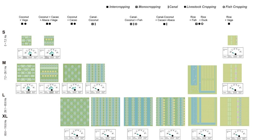
The elements of spatial agricultural operations for building CRAs - intercropping and agroforestry - are first proposed. targeted choices at different scales depending on the land ownership situation on the ground.
spatial intervention of Intercropping is one of the most important methond of CRA. It depends on the scales.
Spatial Operations Typology for Climate-Resilience Agriculture (CRA)
The elements of spatial agricultural operations for building CRAs - intercropping and agroforestry - are first proposed. targeted choices at different scales depending on the land ownership situation on the ground.
The spatial intervention of Intercropping is one of the most important methond of CRA. It depends on the scales.
Spatial Operations Typology for Climate-Resilience Agriculture
the
50 | Palo
Disturbance
Tacloban Studio: Land, Sea,

Specific Site2 - Planning Priorities
Specific Site1 - Planning Priorities
Principles Responding to Rice Scenario
Principles Responding to Coconut Scenario
Due to the flat topography of Palo’s inland agricultural terrain, along with its fragementation, the specially shaped agricultural boundaries make individual design sites non-universal, so an abstract land patterning approach is proposed to experiment with the feasibility of Climent Resilience Agriculture.
Due to the flat topography of Palo’s inland agricultural terrain, along with its fragmentation, the specially shaped agricultural boundaries make individual design sites non-universal, so an abstract land patterning approach is proposed to experiment with the feasibility of Climate Resilience Agriculture.
51 | Palo Tacloban Studio: Land, Sea, Disturbance

Specific Site1 - Planning Priorities
Specific Site2 - Planning Priorities
Principles Responding to Coconut Scenario
Principles Responding to Rice Scenario
Due to the flat topography of Palo’s inland agricultural terrain, along with its fragementation, the specially shaped agricultural boundaries make individual design sites non-universal, so an abstract land patterning approach is proposed to experiment with the feasibility of Climent Resilience Agriculture.
52 | Palo Tacloban Studio: Land, Sea, Disturbance

Ideal Mapping of Philippine Fragmentation Farming (Family Based)

Ideal Mapping of Philippine Fragmentation Farming (Family Based)
Ideal Mapping of Philippine Fragmentation Farming (Family Based)
Ideal Mapping of Philippine Fragmentation Farming Ideal Mapping of Philippine Fragmentation Farming (Family Based)

 Phase 3: Conversion of all medium-sized & large fields to CRA cropping pattern
Phase 4: Establishment of the secondary sector and expansion of the barangay
Phase 1: Integration of farmland scales & Rectification of agricultural land according to local conditions patterns
Phase 2: Conversion of all small fields to CRA cropping pattern
Phase 3: Conversion of all medium-sized & large fields to CRA cropping pattern
Phase 4: Establishment of the secondary sector and expansion of the barangay
Phase 1: Integration of farmland scales & Rectification of agricultural land according to local conditions patterns
Phase 2: Conversion of all small fields to CRA cropping pattern
Flood Prone & Transport Accessiblity Rice average farm size Coconut average farm size 180m 120m 3.42 HA 1.44 HA
Phase 1: Integration of farmland scales & Rectification of agricultural land according to local conditions patterns
Phase 2: Conversion of all small fields to CRA cropping pattern
Phase 3: Conversion of all medium-sized & large fields to CRA cropping pattern
Phase 4: Establishment of the secondary sector and expansion of the barangay
Small coconut liquor factories, built along the river, where coconuts are harvested and transported directly there by boat.
Building is above the river bank and can be used as an evacuation centre

The fill and dig of canal construction can be balanced and the extra soil can lift the topography of new neighbourhoods and factories.
Aerial view Senario
Cooperative coconut farms and factories
Proximity to roads makes it easy to transport products out
Newly settled residents54 | Palo
Aerial view Senario Cooperative coconut farms and factories
Tacloban Studio: Land, Sea,
Disturbance
Palo Blood Vessel
New form of infrastructure
HE XINRUIPalo Blood Vessel aims to address the various challenges in developing Palo Leyte City after Typhoon Yolanda, because the residents are still dealing with the lasting effects of Typhoon Yolanda, which caused severe damage to the coastal regions. After the disaster, the government set a 40-meter no-build zone, forcing coastal villages to relocate to inland resettlement areas. However, even after seven years, residents in these resettlement areas still need more infrastructure, including issues with water access, electricity, transportation, flood, and job opportunities, which has resulted in the standard of living not fully recovering to pre-disaster levels. Some residents have secretly returned to risky coastal areas.
The project aims to establish a 24.8km transportation way from the Leyte Metropolitan Water District to the city center of Palo to ensure the flow of resources, agricultural products, and people. Therefore, one of the project’s primary goals is to create a main canal and expressway that extends outward based on different land uses, forming branches with varying widths of infrastructure; this ensures a continuous supply of clean drinking water and promotes agricultural irrigation. Additionally, it aims to mitigate flood risks and address energy supply during natural disasters such as typhoons. Strengthening infrastructure, employing resettlement people with construction skills, and focusing on developing energy and agricultural nodes create more job opportunities and attract coastal residents to move inland voluntarily.
In the future, Palo is expected to become the new government center on Leyte Island, indicating the possibility of significant expansion will require more robust infrastructure to support the growing population. The project stimulates inland urban development by enhancing infrastructure, laying the foundation for Palo’s future growth. The goal is to improve residents’ living standards and conditions, address various disasters, and “build back better.”
55 | Palo Tacloban Studio: Land, Sea, Disturbance

After being resettled for seven years, residents still face problems with basic infrastructure, including issues with water access, electricity, transportation, flood, and job opportunities, which has resulted in the standard of living not fully recovering to pre-disaster levels. Some residents have secretly returned to risky coastal areas.
Situation Question
After being resettled for seven years, residents still face problems with basic infrastructure, including issues with water access, electricity, transportation, flood, and job opportunities, which has resulted in the standard of living not fully recovering to pre-disaster levels. Some residents have secretly returned to risky coastal areas.
Traffic Distance Move Back Water Safety Buy Mineral Water Flood Issues of the current situation56 | Palo
Disturbance
Tacloban Studio: Land, Sea,

Master Plan Vision 2053
This is future vision of the whole Palo infrastructure system. Main part is from water treatment plant to Palo city center. Passing through Castilla, Anahaway and Happy Land. The remaining four lines serve as extensions of this main line to the city, making the city’s infrastructure system a complete network. Source:
This is future vision of the whole Palo infrastructure system. Main part is from water treatment plant to Palo city center. Passing through Castilla, Anahaway and Happy Land. The remaining four lines serve as extensions of this main line to the city, making the city’s infrastructure system a complete network.
Infrastructure
Water Treatment Plant
Binahaan River
Malirong River
Bangon River
Binahaan River
Electric Supply Castilla habitat City Center Airport of the future Leyte Goverment Center
Balilit Gacao
Tacloban
Capirawan Cangumbang Tacuranga San Joaquin San Antonio Water supply: Happy Land Legend Stream Main Road River Drain Water Flow 4 Water Flow 3 Water Flow 2 Water Flow 1 Low Medium High Flood Hazard Storm Surge 0.5-1.5 (m) 2 3 (m) Orchard Energy Node Agriculture Node Short Term Infrastructure Long Term Infrastructure Residential Forest Farmland 0 1 0.5 2 Kilometers ¯ N Infrastructure
Anahaway
Master Plan Vision 2053
Tacloban Studio: Land, Sea, Disturbance 57 | Palo
Opportunity
Constriction Phase 1 (top left)
The government hired resettlement people who have construction skills to build the main canal, which can help improve their living conditions. Building outward from the three villages can greatly shorten the construction period.
Constriction Phase 2 (top right)
Extending from canal to both sides to connect the perimeter, forming a network. Different extension strategies are designed according to different land types around the river
Constriction Phase 3 (bottom left)
Strengthen the construction of nodes to attract more people to move to the inland. the node includes energy nodes and agriculture nodes which depend on the surrounding landuse.
Constriction Phase 1 The government hired resettlement people who have construction skills to build the main canal, which can help improve their living conditions. Building outward from the three villages can greatly shorten the construction period. Job Opportunity Constriction Phase 2 Extending from canal to both sides to connect the perimeter, forming a network. Different extension strategies are designed according to different land types around the river Job Opportunity Constriction Phase 3 Strengthen the construction of nodes to attract more people to move to the inland. the node includes energy nodes and agriculture nodes which depend on the surrounding landuse. Job
58 | Palo Tacloban Studio: Land, Sea, Disturbance
River
Scan Frequency: 50Hz
Average Speed: 120kts

Bangon River
Scan Frequency: 40Hz
Average Speed: 120kts
110m
Source:
Malirong River
Scan Frequency: 40Hz
Average Speed: 120kts
ALT.: 30m
Distance to city center: 12.5km Water demand: 541.5m³/d
Demand: 3610KWh/d
Anahaway
ALT.: 19m
1238
Distance to city center: 8.1km Water demand: 371.4m³/d Electricity Demand: 2476KWh/d
ALT.: 8m
4152 Distance to city center: 3.8km Water demand: 1245.6m³/d
Water supply Happy Land Palo City Center
Demand: 8304KWh/d
Short Term Infrastructure
The extensive main canal spans 24.8km, descending from a water treatment plant at 110m altitude to Castilla at 30m, Anahaway at 19m, and Happy-land at 8m. Covering a sizable water catchment area of 14.4 km², it culminates in the heart of Palo, ensuring comprehensive water distribution.
The extensive main canal spans 24.8km, descending from a water treatment plant at 110m altitude to Castilla at 30m, Anahaway at 19m, and Happyland at 8m. Covering a sizable water catchment area of 14.4 km², it culminates in the heart of Palo, ensuring comprehensive water distribution. Electric Supply Castilla
7m
to city center: 0km
Short Term Infrastructure
Water
Normal Time Water Supply Disaster Time electricity Supply Normal Time electricity Supply Disaster Time Water Supply
ALT.:
Distance
Treatment Plant
ALT.:
Distance to city center: 24.8km
POP.:1805
Electricity
POP.:
POP.:
Electricity
Binahaan
Tacloban Studio: Land, Sea, Disturbance 59 | Palo


In Castilla, the vulnerability of solar panels and portions of the village to 1-2m floods underscores the critical need for river flood discharge design. Additionally, multifunctional emergency flood discharge zones have been implemented to safeguard residents’ property and ensure their safety in the face of potential hazards.


the
and
In Anahaway, agricultural land development strengthens links between the main river channel and existing irrigation channels. This strategy entails creating high-yield zones and flooded areas in response to prevailing conditions, optimizing agricultural productivity through thoughtful adaptation to the current environment.

Shuttle Bus Station Main Canal Orchard Emergency Inundation Area Water Storage Solar Panel Castilla Resettlements Emergency Inundation Area Crop Packaging Storage Area Farmland Orchard Anahaway Main Canal Irrigation Channel Shuttle Bus Station Loading Parking Lot
In Castilla,
vulnerability of solar panels
portions of the village to 1-2m the critical need for river flood discharge design. Additionally, multifunctional emergency discharge zones have been implemented to safeguard residents’ property and
Anahaway Perspective Section
In Anahaway, agricultural land development strengthens links between the main river channel and existing irrigation channels. This strategy entails creating high-yield zones and flooded areas in response to prevailing conditions, optimizing agricultural productivity through thoughtful adaptation to the current environment.
Castilla Perspective Section
Anahaway Perspective Section
60 | Palo


In Happy Land’s residential zone, characterized by multifunctional land, integration with the main river serves as a flood discharge area, reducing village flood risks during high-water periods.
During the dry season, it transitions into communal space for activities or a drying area, particularly useful during intense farming periods.
In Happy Land, where forests contend with steep terrain and landslide risks, the strategic planting of tree species and the implementation of retaining walls work synergistically to purify watersheds.
This process enhances the connection of precipitation-guided water to main rivers, amplifying the transportation of vital water resources.
Emergency Inundation Area Emergency Inundation Area Happy Land Emergency Inundation Area Farmland Main Canal Channel Shuttle Bus Station Water Storage Water Purification Water Purification Water treatment plant Water Storage
Area Farmland Water Purification Biological Purification Water treatment plant Water Storage Mini Dam 61 | Palo
In Happy Land’s residential zone, characterized by multifunctional land, integration with the main river serves as a flood discharge area, reducing village flood risks during high-water periods. During the dry season, it transitions into communal space for activities or a drying area, particularly useful during intense farming periods.
Happy Land Perspective Section B In Happy Land, where forests contend with steep terrain and landslide risks, the strategic planting of tree species and the implementation of retaining walls work synergistically to purify watersheds. This process enhances the connection of precipitation-guided water to main rivers, amplifying the transportation of vital water resources.
Happy Land Perspective Section A
Happy Land Perspective Section B

In the future, Palo is expected to become the new government center of Leyte Island. Happy Land will serve as a water energy node to support urban development, provide more employment opportunities and welcome citizens to live here, making it a real happy land.
citizens to live here, making it a real happy land.
Happy
Land
Energy Node Perspective
In the future, Palo is expected to become the new government center of Leyte Island. Happy Land will serve as a water energy node to support urban development, provide more employment opportunities and welcome
Happy Land Energy Node Perspective
62 | Palo
Studio: Land, Sea, Disturbance
Tacloban
“Circulate themselves”
After Typhoon Yolanda in 2013, the City of Palo, one of the stricken regions and the municipal centre of Leyte Island, is integrating its disaster preparedness and mitigation strategies to a large extent with its urban development plans.
As part of the three core strategies, Palo is planning to relocate residents from the coast to the inland, with the resettlements being integrated with urban development and expanding primarily inland. At the same time, the coastal area is strongly labelled as uninhabitable, and it is hoped that more development will take place along the coast based on the current urban base and connecting to Tacloban in the north, with embankments to ensure the safety of the coastal development areas. The current implementation of the plan contains multiple contradictions, such as the indigenous people of the coast do not want to be evicted from their lands, it is difficult for the government’s vision of development to move forward, and that embankments are not a non-permanent disaster prevention solution.
The project will focus on coastal informal settlement communities, challenging the current government paradox of ‘not allowing residents to live in the area but allowing development with a higher risk of loss’. By proposing multi-layer non-traditional embankment structures to replace the original embankment with limited functionality, allowing space for overlapping development. Detention ponds and mangrove forests are able to withstand different levels of hazards while the articulation with the elevation creates a grey space allowing for informal settlements. Through these more resilient and less intrusive landscape strategies and planning, a new scheme is created that combines coastal housing, disaster prevention and development. Releasing residents from the passive choices affected by policies and natural disasters, allow coastal residents to manage their own residences over time, rather than relying on institutionalized resettlement-focused residential practices.
CHEN YUXIN63 | Palo Tacloban Studio: Land, Sea, Disturbance

PROPOSED FRAMEWORK
The new framework allows for informal settlement of coastal populations, providing time for full development inland, while the new disaster prevention strategies balances the conflict between urban development and indigenous settlement sovereignty and promotes collaborative co-development.

FOCUSED SITE ANALYSIS ---- PARADOX BETWEEN EVACUATION AND DEVELOPMENT Coastal areas where the Government plans core development almost overlap with storm surge risk areas. At the same time, the government’s hard-line policies have put pressure on these informal settlements to evacuate. However, development and disaster prevention should not be built at the expense of the rights of vulnerable groups.
64 | Palo
Disturbance
Tacloban Studio: Land, Sea,


Multi-Layer Non-Traditional Embankment Typology 1
The spatial variations and different heights take on the functions of breakwater, embankment, and detention to cope with storm surges. Multi-layer reduces the amount of work required for a single construction compared to an extremely large and single-function embankment.

Multi-Layer Non-Traditional Embankment Typology 2
The reconfiguration of space has led to a reorganisation of land functions, with developers attracted to safer places due to different levels of safety against different levels of storm surge. At the same time there will be a lot of grey space where the risk is not as great, providing the potential for informal settlements to be inhabited.


Multi-Layer Non-Traditional Embankment Typology 3
Existing site resources such as irrigation channels will be reused for water storage and drainage as the city develops, providing a second barrier to strong storm surges that break through the embankment. With the reuse of irrigation channels and mangroves nursery, these areas will be used as natural tourism resources to attract tourists and bring economic benefits.


TYPOLOGY 1--- DEFENCE VARIOUS MAGNITUDES STORM SURGES TYPOLOGY 2--- DEFENCE HIGH IMPACT STORM SURGES MUTI-LAYER NON-TRADITIONAL EMBANKMENT TYPOLOGY 1 The spatial variations and different heights take on the functions of breakwater, embankment, and detention to cope with storm surges. Multi-layer reduces the amount of work required for a single construction compared to an extremely large and single-function embankment. MUTI-LAYER NON-TRADITIONAL EMBANKMENT TYPOLOGY 2 The reconfiguration of space has led to a reorganisation of land functions, with developers attracted to safer places due to different levels of safety against different levels of storm surge. At the same time there will be a lot of grey space where the risk is not as great, providing the potential for informal settlements to be inhabited. MUTI-LAYER NON-TRADITIONAL EMBANKMENT TYPOLOGY 3 Existing site resources such as irrigation channels will be reused for water storage and drainage as the city develops, providing a second barrier to strong storm surges that break through the embankment. With the reuse of irrigation channels and mangroves nursery, these areas will be used as natural tourism resources to attract tourists and bring economic benefits. TYPOLOGY 3--- DEFENCE
VARIOUS MAGNITUDES STORM SURGES
STORM SURGES

TYPOLOGY 2--- DEFENCE HIGH IMPACT STORM SURGES
MAGNITUDES STORM SURGES


TYPOLOGY 3--- DEFENCE VARIOUS MAGNITUDES STORM SURGES

MAGNITUDES STORM SURGES
66 | Palo
Tacloban Studio: Land, Sea, Disturbance
SCHEME
CONSTRUCTION PROCESS --- SAME TIME & SAME PLACE
The structure construction will be carried out without affecting the current informal settlements. As the structure continues to be refined, the development and informal settlements will change accordingly. At the end of the process, a secure sea and land interface will be constructed where development and informal settlements co-exist.
PHASE 1: STRUCTURED

PHASE 2: SUCCESSION

PHASE 3: FORWARD

Inland Informal Settlements Moving Grey zone
Scheme Construction Process --- Same Time & Same Place
The structure construction will be carried out without affecting the current informal settlements. As the structure continues to be refined, the development and informal settlements will change accordingly. At the end of the process, a secure sea and land interface will be constructed where development and informal settlements co-exist.
Twoards67 | Palo
MASTER PLAN --- THE RECONFIGURATION OF COASTAL SOCIETY
With the completion of the new structure, informal settlements will spontaneously find relatively safe “grey zones”. The matured mangrove forests and the resilient areas based on the original irrigation canals will have the opportunity to be developed into natural public spaces, providing more value to the city’s development.

Master Plan --- The Reconfiguration of Coastal Society
With the completion of the new structure, informal settlements will spontaneously find relatively safe “grey zones”. The matured mangrove forests and the resilient areas based on the original irrigation canals will have the opportunity to be developed into natural public spaces, providing more value to the city’s development.
68 | Palo
Disturbance
Tacloban Studio: Land, Sea,


PHASE 2: SUCCESSION

As the structure is initially completed, the original embankment is partially dismantled, and the transfer of the informal settlement provides space for subsequent structures to be built. Development begins on the completed structure. At the same time mangroves and renovated irrigation channels began to grow, gradually replacing the existing water edges.


Nursery Module Surge Reduction The modules protect mangrove seedlings from wave damage during growth, while the holes in the modules allow for the extension of tree roots. In phase 1, modules simultaneously take on the role of reducing storm surge by changing the direction of the waves. Surge Reduction growth, while the holes in the modules allow for the extension of tree roots. In phase 1, modules simultaneously take on the role of reducing storm surge by changing the direction of the waves.


Phase 1: Constructed (top left)
The already established single-functional embankment will be retained in this phase, and the govern¬ment will begin to intervene to build some of the new structures, avoiding the existing informal settle¬ments, whose inhabitants will be able to live temporarily along the coast and maintain their livelihoods in the cities.
Mangroves:
Mangroves along the shoreline will be planted through the nursery module, which protects the small mangroves from light storm surges that can hinder growth. The module also helps to slow down the intensity of the water flow. Residents of these informal settlements will also have the opportunity to be employed in planting mangroves.
Phase 2: Succession (bottom left)
As the structure is initially completed, the original embankment is partially dismantled, and the transfer of the informal settlement provides space for subsequent structures to be built. Development begins on the completed structure. At the same time mangroves and renovated irrigation channels began to grow, gradually replacing the existing water edges.

The built-up development area and sea-land structure will drive continued development inland and provide new job opportunities. Residents will have the option of maintaining their livelihoods but taking the risk of mild storm surges,
70 | Palo
First Defence Added Value As the mangroves grow, they will be the first line of defence to protect Palo City, slowing down the intensity of the storm surge. The mangrove forests in front of the Development will bring added economic value to the development.
PHASE 3 --- MANGROVES
BASEY: Unlocking Resource in Basey
This team’s strong emphasis was placed on “natural resources” of Basey. They have found that after Yolanda, especially, Basey has started to rely heavily on external resources to circulate the primary industry in the region. How can Basey be able to produce resources internally and sustainably?, and at the same time, add premium to the products that they’ve created to boost the local economy? When Tacloban is hit by another storm surge, what role will Basey hold to mitigate the crisis of the city? Considering its rural context, Basey team collectively worked together to find a new mechanism that utilizes local products, wastes, and human resources to full extent.
Spatial intervention was, therefore, a combination of structural and non-structural solutions. [Medha] explored a new embankment typology that is primarily made out of organic waste harvested from the area, in order to alleviate the wave power along the coast. [Jin Xin] took a transect between land-sea interface and off-shore to restore the milkfish habitat, which connotes as underwater breakwater. [Jiaxin] analyzed the local hydrology holistically, and came-up with a scheme that restructralizes the agricultural landscapes for a better yield, with an improved irrigation system. The project’s protagonist was placed on local women, and empowering them by incentivizing Banig weaving tradition.
(Kenya
72 | Basey
Endo)


74 | Basey
Disturbance
Tacloban Studio: Land, Sea,
From Riskscape to Resilient Seascape
MEDHA VERMAAddressing the dual challenge of securing coastal communities in Basey while supporting their livelihoods, the project aims to mitigate the vulnerability of 29% of populated shorelines to storms. Many of these regions lack adequate buffer plantations or mangrove belts, heightening the risk of damage. Although the urban barangay, Palaypay, has effectively implemented a concrete seawall to protect the urban core, replicating this approach in low-income barangays may not be feasible. Acknowledging the unique challenges faced by these communities, the project explores alternative solutions that consider their economic dependence on the ocean, particularly in fishing villages. The proposed solution involves the implementation of nutrient-emitting landforms, seamlessly integrating a hybrid green -grey wave breaker to establish a resilient barrier against storm surges. Configured in a convex formation, these landforms not only create a protective sea zone along inhabited coasts but also nourish local marine life and present opportunities for diversifying livelihoods. The concept of nutrient-emitting sea landforms can be further tested in real sea water and wave conditions to refine it into a practical solution for disaster resilience in numerous sea-dependent communities in Asia and globally. This initiative seeks to rethink the approach to coastal protection by offering a sustainable and adaptable solution that caters to the specific needs of diverse coastal communities. The envisioned outcome is a transformative model that not only safeguards against natural disasters but also fosters economic resilience in tandem with the delicate ecosystems of these regions.
75 | Basey Tacloban Studio: Land, Sea, Disturbance

Coastal Settlements in Basey

Coastal Settlements in Basey

Basey, north of San Pedro Bay, faces high risk due to its funnel-like turbances from the Philippine Trench. About 29% of the shoreline, susceptible to 6m waves, seen in Typhoon Yolanda. Barangays with heightening damage risks. Post-disaster debris threatens marine ing fish stocks for years. Despite a mandated 40m buffer, rebuilding dependencies. A vital solution involves embracing disaster with a
Basey, north of San Pedro Bay, faces high risk due to its funnel-like geography, intensifying disturbances from the Philippine Trench. About 29% of the shoreline, housing fishing communities, is susceptible to 6m waves, seen in Typhoon Yolanda. Barangays with concave shapes lack buffers, heightening damage risks. Post-disaster debris threatens marine ecology and livelihoods, impacting fish stocks for years. Despite a mandated 40m buffer, rebuilding continues due to livelihood dependencies. A vital solution involves embracing disaster with a comprehensive, long-term plan.
Concept Development
The initial defense line, shaped convexly to mitigate wave energy, reimagines wave breakers. This innovative design integrates multifunctionality and porosity, supporting both ecology and livelihoods while ensuring effective protection.
Basey, north of San Pedro Bay, faces high risk due to its funnel-like geography, intensifying disturbances from the Philippine Trench. About 29% of the shoreline, housing fishing communities, is susceptible to 6m waves, seen in Typhoon Yolanda. Barangays with concave shapes lack buffers, heightening damage risks. Post-disaster debris threatens marine ecology and livelihoods, impacting fish stocks for years. Despite a mandated 40m buffer, rebuilding continues due to livelihood dependencies. A vital solution involves embracing disaster with a comprehensive, long-term plan.
76 | Basey Tacloban
Sea, Disturbance
Studio: Land,
Nutrient Emitting Wave Breaker

Nutrient Emitting Wave Breaker
A gabion toe wall serves as a framework with an accessible pocket for nutrient-rich materials like coconut coir, shells, and fish bones. This fosters diverse coastal economies, including seaweed, oyster, shrimp farming, and fisheries. Local government support in development, followed by leasing to fisher families for maintenance and harvesting, creates a community-driven incentive. This approach encourages not only the preservation of the landform but also active contributions to resilience.
A gabion toe wall serves as a framework with an accessible pocket for nutrient-rich materials like coconut coir, shells, and fish bones. This fosters diverse coastal economies, including seaweed, oyster, shrimp farming, and fisheries. Local government support in development, followed by leasing to fisher families for maintenance and harvesting, creates a community-driven incentive. This approach encourages not only the preservation of the landform but also active contributions to resilience.
77 | Basey Tacloban Studio: Land, Sea, Disturbance

Existing Coastal Edge
Settlements exhibit a gradient, ranging from permanent brick-and-mortar houses to vulnerable temporary structures with thatch and bamboo near the sea, posing high-risk exposure. Unlike ur¬ban areas, most fishing villages lack seawalls, leading to erosion. Floating fishing houses, utilized by fish cage cultivators, lack buffers, facing heightened damage risk during the storm season from July to November. Post-Typhoon Yolanda, local fishery sources remain severely limited.

Design Vision
Innovating for high-risk shores, implement convex wave barriers to minimize disruption to local fisheries and ecology. Secure the form with geo-fiber sheets, incorporating a sea-facing side with robust materials for seaweed cultivation and oyster farming. Floating houses anchored on the sheltered side. Envisioned over 5 years, this pilot project can evolve into a new economic model, featuring experiential activities like oyster and seaweed cultivation, offering walkable connected landforms as an attractive addition to Basey, fostering livelihood diversification.
Design
Innovating for high-risk shores, implement convex wave barriers to minimize disruption to local fisheries and ecology. Secure the form with geo-fiber sheets, incorporating a sea-facing side with robust materials for seaweed cultivation and oyster farming. Floating houses anchored on the sheltered side. Envisioned over 5 years, this pilot project can evolve into a new economic model, featuring experiential activities like oyster and seaweed cultivation, offering walkable connected landforms as an attractive addition to Basey, fostering livelihood diversification. 78 | Basey Tacloban Studio: Land, Sea, Disturbance
Existing Coastal Edge
Vision
Symbiotic Marine Ranch
As a coastal municipality on Samar Island, fishery has always been one of Basey’s primary industries. For livelihood convenience, fishermen often prefer to live by the sea where prone to be affected by stormsurges. However, years of experience with the ocean have allowed them to gradually master the skills of surviving from stormsurges and quickly recovering their livelihoods after the disaster. In 2013, Super Typhoon Yolanda hit Basey, causing significant losses to Basey but also garnered global attention. A decade later, with various assistance, Basey’s fisheries seem to have regained their past vitality. However, research reveals that compared to before Yolanda, Basey’s fisheries have become more dependent on external aid, and the once abundant marine resources have become increasingly limited.
Milkfish, the national fish of the Philippines, is also a major fisheries product in Basey, holding significant economic and cultural value locally. The project starts from the lifecycle of Milkfish, studying the dynamic relationship between Basey’s fisheries, marine ecology, and stormsurges. It chooses a transect for research, categorizing it into three aspects based on site types: coast, intertidal, and offshore. The project proposes three strategies prospectively :symbiosis with mangroves, symbiosis with tidal, and symbiosis with coral reef—to explore the possibility of linking daily product activities with ecological restoration.The design uses native plants Nipa and fish processing by-products fishbones as main materials, aiming to make full use of local resources and gradually achieve the independence of Basey’s fisheries with minimum input.
Finally, based on historical stormsurgere cords, the project speculates the return time of stormsurges with different intensities, introducing the concept of large and small disaster cycles. Combining the frequency of fishing activities and the disturbance tolerance of ecological restoration, it proposes an operational mode that integrates coast, intertidal, and offshore into a consistent system. The goal is to provide fishermen with stable income during normal times while allowing local marine resources to keep fluctuate rising during in the long-term facing different levels stormsurges.
XIN
JIN
79 | Basey Tacloban Studio: Land, Sea, Disturbance

80 | Basey
Tacloban Studio: Land, Sea, Disturbance
Milkfish Lifecycle

HABITAT RESTORATION MECHANISMS

81 | Basey
Storm Surge Impacts on Milkfish Habitat
Tacloban Studio: Land, Sea, Disturbance
Tacloban Studio: Land, Sea,
(2017)
Storm Surge Heights & Return Period
RETURN PERIOD CALCULATION

Large Disaster Cycle & Small Disaster Cycle
https://doi.org/10.1007/s11069-018-3252-9

179 Historical cyclone track data from JTWC (2017)

Maximum surge heights at a (a)10-year return period and (b) a 50-year return period

Maximum surge heights at a (a)10-year return period and (b) a 50-year return period

Overall Strategy Return Period Calculation
Source: Socorro Margarita T. Rodrigo, Cesar L. Villanoy, JericC. Briones, Princess Hope T. Bilgera, Olivia C. Cabrera, Gemma Teresa T. Narisma; Nat Hazards (2018) 92: 1305-1320, https://doi.org/10.1007/s11069-018-3252-9
82 | Basey
OVERALL STRATEGY
Disturbance
Bilgera Olivia C. Cabrera, Gemma Teresa T. Narisma ; Nat Hazards (2018) 92: 1305-1320,
Princess Hope T. Bilgera Olivia C. Cabrera, Gemma Teresa T. Narisma ; Nat Hazards (2018) 92: 1305-1320,
LARGE DISASTER CYCLE & SMALL DISASTER CYCLE
source: Socorro Margarita T. Rodrigo, Cesar L. Villanoy, Jeric C. Briones, Princess Hope T. Bilgera Olivia C. Cabrera, Gemma Teresa T. Narisma ; Nat Hazards (2018) 92: 1305-1320,
STUDY TRANSECT

83 | Basey
Tacloban Studio: Land, Sea, Disturbance
Study Transect


84 | Basey
Intertidal: Symbiotic with Tidal
Coast: Symbiotic with Mangrove
Oyster Accumulation Oyster Growing
Provide Reattach Surface Coral Growing


SYMBIOTIC WITH
CORAL REEF
Seagrass Spreading Seagrass Medow 85 | Basey
Tacloban Studio: Land, Sea, Disturbance
Offshore: Symbiotic with Coral Reef

Trans-habitat Relationship
86 | Basey
Disturbance
Tacloban Studio: Land, Sea,
Weaving Waterways
JIANG JIAXINThe project is located in Basey, on the island of Samar in the Philippines, a rural area predominantly engaged in agriculture and Banig weaving industry. The research reveals that despite the rich natural resources in the area, poverty persists. Therefore, the project focuses on unlocking local resources. Reasons for the low utilization of resources include a lack of agricultural water management technology and facilities, as well as risks brought by various disasters such as floods, storm surges, and landslides.Hence, this project aims to plan an efficient, resilient, and multifunctional water infrastructure to address the issues of insufficient water during dry season and flooding in the rainy season, thereby improving resource utilization. Simultaneously, the project considers edges of rice paddies as an opportunity for Tikog cultivation, reducing the dependence of the Banig industry on external sources.
In terms of design methodology, the project draws inspiration from the formation mechanism of the local agricultural landscape, namely, maximizing the acquisition of water resources through vertical rivers or foothills. On a planar level, the project utilizes GIS to analyze results from the USGS DEM (30m precision) as the basis for planning. This includes determining the design boundaries through basin delineation, planning watersheds and new water routes through flow accumulation, and specifying agricultural activity types and spatial distribution through drainage density, including coconut, rice, integrated farming (rice+fish/shrimp/crab), and wetland farming. Vertically, the project designs spatial hierarchies and patterns to cope with floods and seasonal variations in water levels for different industrial activities. Additionally, the project integrates industrial activities with the local community through transportation (water and land routes), ultimately achieving the integration of space and people.
87 | Basey Tacloban Studio: Land, Sea, Disturbance

Development Dilemma in Basey 1 Water Issues in Agriculture


Development Dilemma in Basey:
Water Issues in Agriculture
Development Dilemma in Basey 2
Development Dilemma in Basey 2
Insufficient Supply of
Insufficient Supply of Tikog
In the context of climate change, rainfall patterns have become increasingly difficult to predict. This exacerbates Basey’s challenges in water resources, including flooding in the rainy season and a lack of irrigation water during the dry season.
Insufficient Supply of Tikog
In addition to agriculture, the Banig weaving industry is Basey’s second mainstay, predominantly led by local women. Currently, Basey lacks dedicated Tikog cultivation areas and primarily imports Tikog from nearby cities for local Banig production.


Flooding in rainy season Lack of irrigation water in dry season In addition to agriculture, the Banig weaving industry is Basey’s second mainstay, predominantly led by local women. Currently, Basey lacks dedicated Tikog cultivation areas and primarily imports Tikog from nearby cities for local Banig production.
Tikog (Sagittaria sagittifolia Linn.)
Banig Tikog
Basey
Tikog In addition to agriculture, the Banig weaving Currently, Basey lacks dedicated Tikog production. 30km -Raw material of Banig -Grow in swampy area & rice field Tikog (Sagittaria sagittifolia Linn.)
In addition to agriculture, the Banig weaving industry is Basey’s Currently, Basey lacks dedicated Tikog cultivation areas and production. -Raw material of Banig -Grow in swampy area & rice field (Sagittaria sagittifolia Linn.)
of irrigation water during dry
Flooding in rainy
2500m Current River System & Agriculture Dustribution River Sea Rice Coconut Mangrove Build-up area 2500m Current River System & Agriculture Dustribution River Sea Rice Coconut Mangrove Build-up area Design Boundary
Lack
season
season
88 | Basey


Spatial Utilization Iteration 1
Program Selection
Spatial Utilization and Program Selection, based on Flow Accumulation & Drainage Density Map
Available water resources in certain area
Types of water-related industrial activities

Integrated farming (rice+fish/shrimp/crab)
Wetland farming

Waterbody
Classify specific industrial activities from the perspective of water demands based on the drainage density map, including coconut plantation, rice field, integrated farming (rice&fish, crabs, shrimps), and wetland farming.
Classify specific industrial activities from the perspective of water demands based on the drainage density map, including coconut plantation, rice field, integrated farming (rice & fish, crabs, shrimps), and wetland farming.
Flow accumulation Volume Drainage density Volume&proximity
Rice
Coconut
Drainage density value
(no color area) 6.364-9.544 3.182-6.363 9.545-12.726 12.727-15.907 > 10000 > 1000 > 4000 > 300 Flow accumulation value
0-3.181


Spatial Utilization Iteration 2-1
Wetland Farming Refinement

Based on the distribution of salt and freshwater as well as plant habits, mangrove forests are planted in the salt water area, Nipa palm in the transitional section and Taro in the freshwater area.
Spatial Utilization Iteration 1 Wetland Farming Refinement
Based on the distribution of salt and freshwater as well as plant habits, mangrove forests are planted in the salt water area, Nipa palm in the transitional section and Taro in the freshwater area.
Spatial Utilization Iteration 2 Integrated Farming (Rice+X) Refinement
Firstly, select product types based on the demand in the Philippine aquaculture market. Similarly, divide the aquaculture areas based on the distribution of salt and freshwater and the characteristics of aquatic products. Finally, determine the cultivation area for different products based on the ranking of market demand.
Spatial Utilization Iteration 2-2
Firstly, select product types based on the demand in the Philippine aquaculture market. Similarly, divide the aquaculture areas based on the distribution of salt and freshwater and the characteristics of aquatic products. Finally, determine the cultivation Rice+fish
Rice+milkfish Rice+prown Mangrove Waterbody
mix (milkfish+tilapia)
Rice+crab mix (green+orange mud crab)
Orange Mud Crab (Scylla olivacea)
Green Mud Crab (Scylla serrata)
Giant freshwater prawn (Macrobrachium rosenbergii)
Tilapia (Oreochromis spp.)
Salt water Fresh water Area allocation
Tilapia Orange
Green mud
Market demand
Milkfish (Chanos chanos)
Milkfish Giant freshwater prawn
mud crab
crab
Proposed
Nipa
Current
Salt water Fresh water
Buffer
Mangrove
Buffer Fishery
Cuisine Erosion control Natural dye Banig 90 | Basey Tacloban
Sea, Disturbance
Taro
mangrove
palm Waterbody
mangrove
Nipa palm (Nypa fruticans)
Roof&wall
(Rhizophora mangle)
Taro (Colocasia esculenta Linn)
Studio: Land,

Flooding Adaption Strategy
According to the disaster map obtained from the Basey government, it is evident that due to the low-lying topography within this basin, a significant portion of farmland is susceptible to flooding, particularly in the downstream section. Based on the spatial distribution characteristics of flood risk levels, appropriate flood response strategies will be proposed for different types of farmland.


Flooding Adaption Strategy Rice Field
In areas with different levels of flood risk, different quantities of channels are established to en¬sure that excessive water in the rice field is efficiently drained, thereby reducing the loss of crop yield during the flood season.


Flooding Adaption Strategy Coconut Plantation
In addition to the installation of drainage ditches, coconut plantations need to have their ground slopes adjusted to allow for drainage.
91 | Basey
period Rainy season Dry season
Flooding
Nipa pipe (pump water into the farmland) Proposed waterways Functioning areas in high precipitation
In areas with different levels of flood risk, different quantities of channels are established to ensure that excessive water in the rice feld is efficiently drained thereby reducing the loss of crop yield during the flood season. Low Moderate High Flooding susceptibility Flooding
Coconut Plantation In addition to the installation of drainage ditches, coconut plantations need to have their ground slopes adjusted to allow for drainage. Low water level (dry season) Middle water level (normal season) Warning water level (flooding season) High Moderate Low Flooding susceptibility High Moderate Low According to the disaster map obtained from the Basey government, it is evident that due to the low-lying topography within this basin, a significant portion of farmland is susceptible to flooding, particularly in the downstream section. Based on the spatial distribution characteristics of flood risk levels, appropriate flood response strategies will be proposed for different types of farmland. Susceptibility High Moderate Low According to the disaster map obtained from the Basey government, it is evident that due to the low-lying topography within this basin, a significant portion of farmland is susceptible to flooding, particularly in the downstream section. Based on the spatial distribution characteristics of flood risk levels, appropriate flood response strategies will be proposed for different types of farmland.
Flooding Adaption Startegy Rice Field
Adaption Startegy


The spatial characteristics in this area include the distribution of mangroves along the river, surrounding coconut plantations. This spatial pattern can be considered as a local manner of adapting storm surges. Due to more than half of the coconut plantation in this region being located in a high-risk storm surge area, and the erosion of seawater leading to soil salinization, agricultural productivity is reduced. Additionally, common methods to control soil salinization, such as freshwater flushing, are challenging to implement in estuarine areas surrounded by salty water.


Storm Surge Adaption Strategy: Mangrove Replacement of Coconut Plantation
The specific steps include: (1) Extending a new finger-like river channel inward to provide growth space for mangroves. (2) Planting mangrove belts along the river. (3) Expanding existing
mangrove forests inward, forming a mangrove ring along the coconut plantation. (4) Ultimately, establishing a mangrove matrix in the area. During disasters, this area can serve as a buffer zone against typhoons and storm surges. During normal times, people can engage in fishing activities in this region. High Moderate Low

According to the disaster map obtained from the Basey government, it is known that the estuary is a high-risk area for storm surges. Surge Susceptibility High storm surge susceptibility Moderate storm surge susceptibility Current mangrove Waterbody Rice Coconut Nipa Road Planning boundary Storm Surge Area The spatial characteristics in this area include the distribution of mangroves along the river, surrounding coconut plantations. This spatial pattern can be considered as a local manner of adapting storm surges. Due to more than half of the coconut plantation in this region being located in a high-risk storm surge area, and the erosion of seawater leading to soil salinization, agricultural productivity is reduced. Additionally, common methods to control soil salinization, such as freshwater flushing, are challenging to implement in estuarine areas surrounded by salty water. Therefore, considering the strategy of progressively transitioning coconut into mangroves is being explored as a response to storm surges. 200m 3 yrs 10 yrs 20 yrs 50 yrs New waterways Mangrove belt Mangrove ring Mangrove matrix Phase 1 Phase 2 Phase 3 Phase 4 3 yrs 10 yrs 20 yrs 50 yrs New waterways Mangrove belt Mangrove ring Mangrove matrix Phase 1 Phase 2 Phase 3 Phase 4
Storm Surge Adaption Strategy


Low water level (dry season)
Section A-A 1:2000 Seasonal Flexibility in Rice,
Middle water level (normal season)
Warning water level (flooding season)


Integrated&Wetland
Integrated farming Integrated farming Wetland farming Rice Coconut 1 2 3 1 Banig module 2 Boat stop 3 Planting selection Seasonal Flexibility in Rice, Integrated with Wetland Farming Area 93 | Basey Tacloban Studio: Land, Sea, Disturbance
Farming Area


Tacloban Studio: Land, Sea, Disturbance
Overall Layout
Banig module in wetland farming area (dry season)
94 | Basey
Rice field & integrated farming area (flooding season)
 Kenya Endo, Lecturer
Post-disaster reconstruction and the role of landscape architects for it has been my research interest for a long time. Witnessing the process of Japan’s recovery after the Great East Japan Earthquake on March 11th, 2011, I came to question the approach for recovery: how can we “live together” with disasters rather than going against natural forces. Landscape Approach in Disaster Recovery and Planning was a challenge to seek alternative ideas by taking Tacloban’s recovery as a case study. Our attempt was to reconcile the disruptions that natural disasters bring to the land and sea interface, as well as the post-disaster politics that raises conflicts between residents and the authorities.
I deeply appreciate the student’s dedicated effort on tackling such a challenging topic throughout the semester. Especially, 1-week field survey in Tacloban, Palo, and Basey must have been a “culture shock” for them, in a way that the environment, people’s lives there were authentic. Thinking and designing with such contextual understanding is extremely important for us, but at the same time, not so easy to do. We were fortunate to have a lot of support from the local collaborators, residents, officials from the municipalities, and experts in this field of disaster risk mitigation. The studio couldn’t be successful without the support from all. Thank you very much.