
11 minute read
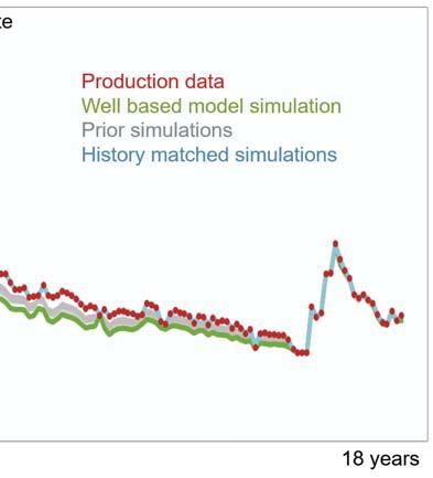
More reliable production forecasting


David Riffault, Toni Uwaga, Pablo Cifuentes, Adnan Khalid and Rémi Moyen, CGG, explain how multi-scale ensemble-based history matching was used to forecast production for a gas field in Asia.
Production forecasting is a basic requirement for planning the future development of a field, optimising reserve recovery and selecting the optimum location for new wells. However, the task can be challenging owing to the complexity of the reservoir and the scarcity of available data. Understanding uncertainty in the reservoir model is key, so stochastic methods that generate a range of model realisations are preferred for uncertainty assessment. However, this approach leads to a large number of models that can be cumbersome to handle in a conventional workflow. As a result, CGG has developed a new technology that can help to optimise an existing reservoir model by maintaining a fine balance between all the elements being considered during the model building process and a field’s production history data. Multi-scale ensemble-based history matching is an eff icient, automated approach that is designed to update a large set of model realisations in order to assimilate production data and hence provide a high-quality set of models tuned for production forecasting.


Due to its simplicity and flexibility, ensemble-based optimisation, known as EnOpt, is a widely used method for history matching.1,2,3 It assimilates production history data into a set of model realisations, called a prior ensemble, which reflects the uncertainties and correlations between spatial properties (e.g. porosity, permeability and net-to-gross ratio) and can integrate many sources of information, such as well logs, geological knowledge and seismic data.
Although EnOpt provides satisfactory history matches of the production data by updating the prior ensemble, it can corrupt the information contained in this ensemble due to spurious correlations and may create geologically implausible scenarios.
To better preserve the information contained in the prior ensemble, CGG’s new EBMatch software applies the multi-scale ensemble-based optimisation method (MS-EnOpt). It breaks down the spatial properties of the prior ensemble (using a second-generation wavelet transform) into coefficients that are both localised in space and frequency and represent the information in the model at different scales, i.e. degrees of coarseness.4,5
Instead of updating the full prior ensemble frequency content, as EnOpt does, the first iterations of the multi-scale approach only update the subset of the coarse-scale parameters. Owing to the sparse representation property of the wavelet transform, the spatial properties are well represented using only this coarse subset (Figure 1). The simulated flow response of the model is greatly affected by changes at this scale without corrupting the ensemble (limiting the impact of the spurious correlations).6 Coarse-scale coefficients characterise large geological features, such as channels and depositional structures, while fine-scale coefficients characterise smaller structures often located around the wells, such as flow barriers and high-permeability layers. As the iterations progress, the parameterisation is gradually refined by introducing finer-scale coefficients to further reduce the mismatch. Only a few iterations are needed to integrate the model detail provided by the fine-scale coefficients so that the introduction of high-frequency content, often associated with noise, remains limited.
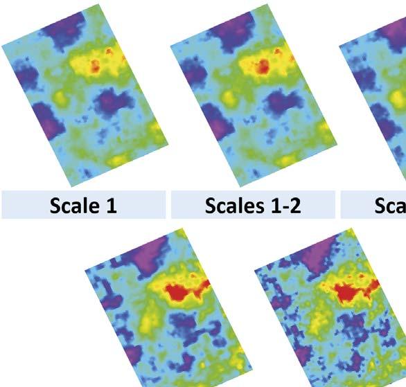
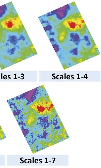
Figure 1. Second-generation wavelet decomposition and reconstruction of a grid porosity model using only the chosen-scale parameters. Top: the reconstruction of the porosity model using only the coarsest-scale parameters. Owing to the sparse representation of the transform, geological features are still clearly identified. Bottom: the full reconstruction of the model using all-scale parameters (equivalent to the original porosity model before decomposition). Figure 2. Generation of a seismic-constrained ensemble of models. First, a well-based model of porosity and Vshale is built from well logs and a conceptual model. Then, a petrophysical inversion is performed to assimilate impedances from a seismic stochastic inversion using a calibrated petroelastic model. The resulting ensemble is a set of porosity and Vshale realisations constrained by the seismic attributes and consistent with the petrophysics and the geology.

The following case study discusses a gas field in Asia with over 20 years of production history. The reservoir is composed of variable-quality sands where porosity-preserving chlorite is present, which greatly affects the fluid flow.
A static model of porosity and shale volume (Vshale), called a well-based model, was created from well log data. A depositional conceptual model was also used as a background trend to ensure the geological observations in wells were respected.
To integrate the seismic data into the reservoir modelling workflow, stochastic acoustic inversion was run to generate 100 realisations of high-resolution impedance models. All wells were used for the stochastic inversion, with missing elastic logs estimated from the available
petrophysical logs using petroelastic models (PEMs). The PEMs were calibrated at well locations with a full suite of logs and using data from laboratory rock sample experiments.
This set of 100 grid models of P-wave impedances (Ip), generated from the geostatistical inversion, matched both the acquired seismic and the well logs.
The well-based geostatistical models and the stochastic inversion results were then reconciled using ensemble-based petrophysical inversion (Figure 2).7 Using the porosities from the petrophysical inversion as a background trend, 100 permeability models were modelled from a sequential Gaussian simulation (SGS).
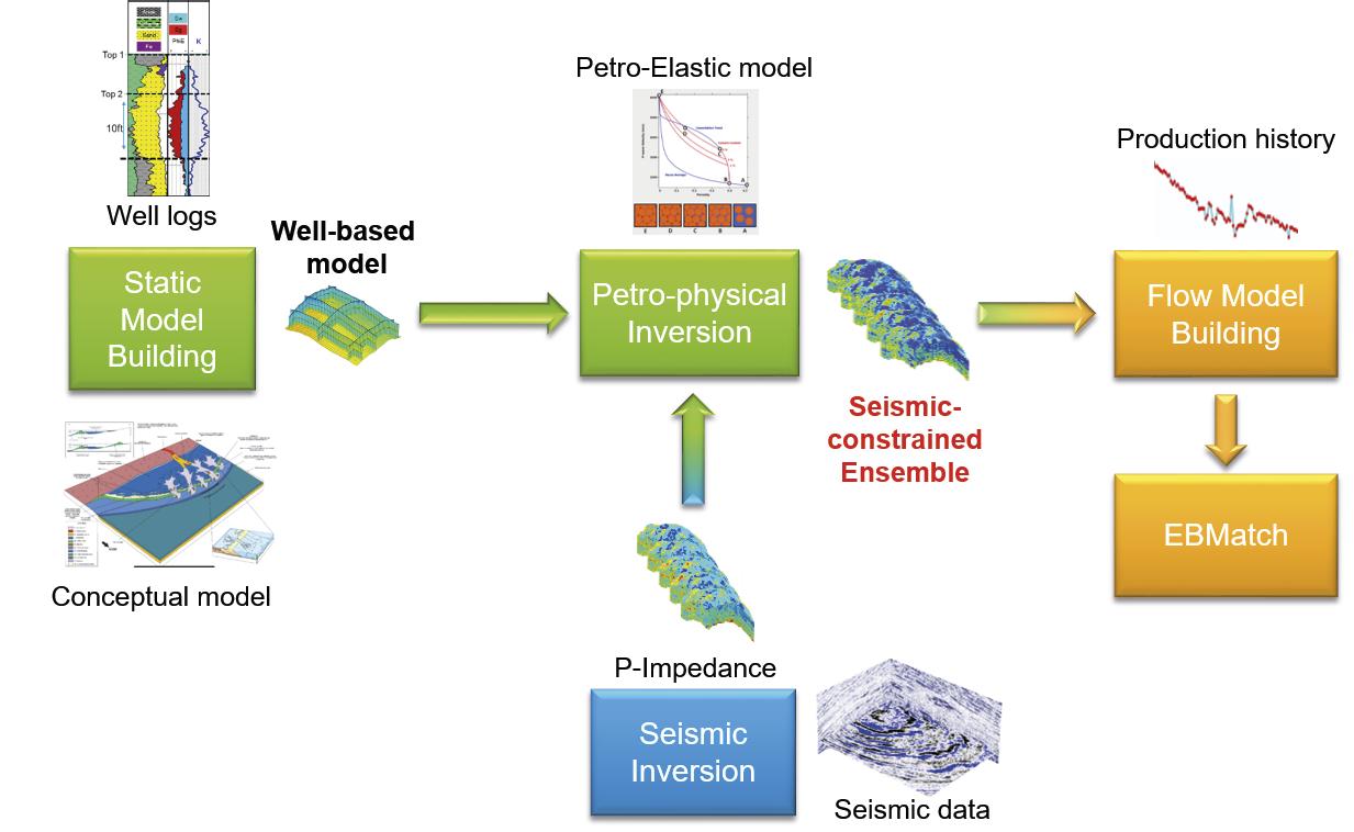
The petrophysical inversion generated models with a lower average porosity value when compared with the well-based model (Figure 3). Wells are mostly drilled in high-quality reservoir zones and are therefore not always representative of the entire reservoir. The assimilation of seismic data suggests the porosity is overestimated away from the wells in the well-based model.
Validity of the ensemble
In order to quantify the quality of the resulting ensemble a flow simulation was performed (without any history matching) on the well-based model and on the 100 seismic-constrained models generated by the petrophysical inversion.
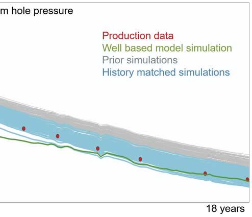
When compared with observed bottomhole pressure measurements, the simulated pressures obtained by these flow simulations showed much better accuracy for the seismic-constrained models than the well-based model (green and grey curves in Figure 4). This is the result of the integration of the seismic attributes and rock physics studies during the petrophysical inversion, reducing the inter-well porosity values and improving the quality of the ensemble.
Assimilating production data
After the prior ensemble of static porosity, Vshale and permeability models were carefully created from all available geological, petrophysical and geophysical data, a multi-scale ensemble-based history matching workflow was used. This ensured that the information in the model was not corrupted during the history matching. Figure 3. Left : average porosity maps of the well-based model before petrophysical inversion, top, and of one realisation (#13) of the petrophysical inversion, bottom. The circle highlights a decrease in the porosity away from the wells based on the information in the seismic data. Top right: the histogram of the porosity values around the wells shows the same distribution for wells and models before and aft er the petrophysical inversion. Bottom right: the histogram of the porosity for the entire grid shows a decrease in porosity for all models aft er petrophysical inversion.
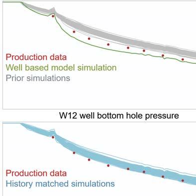
Figure 4. Top: field gas production rate for the first 18 years of production. Red dots are the actual production history. Bottom: W12 well bottomhole pressure is represented for the first 18 years of production. Red dots are actual pressure history. The green curve is the simulated result of the static model before the petrophysical inversion. Grey curves represent the 100 simulated models aft er the petrophysical inversion but before the history matching, showing that the match was improved by integrating the seismic data. The blue curves are the 100 simulated models aft er multi-scale history matching. History-matched gas production curves are a perfect match and are therefore stacked on top of each other.
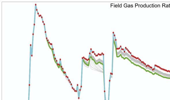

The production data used for the history matching were the gas production rate (GPR), as the primary data to be matched, and the well bottomhole pressure (WBHP), as the secondary data to be matched. Of the 22 years of production history available, only the first 18 years were used for history matching. This meant that the remaining four years could be used to quality control a pseudo-forecast from the models.
A localisation area was defined around each of the eight producer wells to restrict property changes around them and hence further reduce the risk of spurious correlations. These areas followed a structural trend of 45˚(north east – south west) to honour the geological depositional model. A north/south sealing fault was used to divide the areas into two groups and assign each well to either the eastern or western part of the reservoir. This ensured wells located on the western part were not used to update the models on the eastern part. The size of the localisation changed according to the iteration scale: areas were larger for the coarsest scales and smaller for the finest scales.
EBMatch iterations were run from scale 1 (coarsest) to scale 7 (finest). A perfect match with the GPR was achieved, and the bottomhole pressure match was also greatly improved (Figure 4).
Quality control of the changes in the grid properties during the multi-scale history matching showed changes were mostly made in the coarse-scale content. The prior ensemble had therefore been well preserved with very little editing of the fine-scale content (Figure 5).
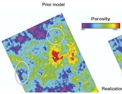
Figure 5. Porosity map (layer 30 of 43) from realisation 8. On the right, the porosity is the final result from the multi-scale history matching, and it remains very close to the prior model on the left . Changes are only visible around the wells highlighted by the circles and are due to the last fine-scale iterations. Large-scale changes in the first iterations can only be seen when looking at the low-frequency content.
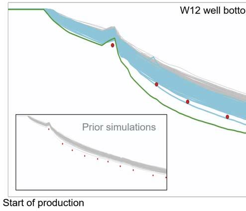
Figure 6. W12 well bottomhole pressure forecast (purple) over four years. Red and purple dots are well pressure measurement data. Top: the forecast is obtained using the ensemble before history matching, in grey, and before the petrophysical inversion, in green. Bottom: the forecast is obtained from the multi-scale history-matched ensemble. Only red values are used as a constraint for the history matching. This pseudo forecast presents a more accurate match of the last two purple values used for quality control.

Forecasting
To quantify the quality of the ensemble generated by the multi-scale ensemble-based history matching, a pseudo-forecast of the GPR for four years was made on both the prior ensemble and the multi-scale history-matched ensemble of models. The four years of production history that was excluded from the history match was used as quality criteria to evaluate the forecast results.
The results of the pseudo-forecast test show the prior ensemble overestimated the bottomhole pressure (Figure 6), while a more accurate prediction of the pressure was achieved by the multi-scale history-matched ensemble.
Conclusion
For this case study, the integration of multiple sources of reservoir information brought a significant benefit for production forecasting. First, an ensemble-based petrophysical inversion made it possible to create multiple reservoir property scenarios that were all consistent with the rock physics study, the geological model building and the geophysical data. Then, a proprietary multi-scale ensemble-based history matching workflow tool was used to integrate production data while preserving all previously assimilated information. This approach ensured that the models chosen as being the most representative of the actual reservoir were not only the ones with the best history match, but also the ones that respected all the available information with an effective integration of the seismic data into the dynamic workflows. This will produce a group of accurate forecasts going forward. Furthermore, this means that multi-scale ensemble-based history matching can be used to provide a range of forecast scenarios from an ensemble of models that incorporates the key uncertainties of the reservoir, effectively integrating different data sources – such as seismic, log and core data – and providing engineers with a deeper insight for field development planning and production management.
Acknowledgments
The authors wish to thank KOC for permission to show the field data from this case study. Field data images courtesy of KOC.
References
1. EVENSEN, G., ‘The ensemble Kalman filter: theoretical formulation and practical implementation’, Ocean Dynamics, Vol. 53, No. 4 (November 2003), pp. 343 – 367. 2. AANONSEN, S.I., NAEVDAL, G., OLIVER, D.S., REYNOLDS, A.C., and VALLES, B.,
‘The ensemble Kalman filter in reservoir engineering – a review’, SPE Journal,
Vol. 14, No. 3 (September 2009), pp. 393 – 412. 3. OLIVER, D.S., and CHEN, Y., ‘Recent progress on reservoir history matching: a review’, Computational Geosciences, Vol. 15, No. 1 (January 2011), pp. 185 – 221. 4. GENTILHOMME, T., OLIVER, D. S., MANNSETH, T., CAUMON, G.,
MOYEN, R., and DOYEN, P., ‘Ensemble-based multi-scale history-matching using second-generation wavelet transform’, Computational Geosciences, Vol. 19,
No.5 (August 2015), pp. 999 – 1025. 5. DE LIMA, A., GENTILHOMME, T., RIFFAULT, D., ANYZEWSKI, S. A., and
EMERICK, A. A., ‘Multi-Scale Ensemble-based Data Assimilation for Reservoir
Characterization and Production Forecast: Application to a Real Field’, paper presented at OTC Brasil, Rio de Janeiro, Brazil, (October 2017). 6. CHEN, Y. and OLIVER, D.S., ‘Multiscale parameterization with adaptive regularization for improved assimilation of nonlocal observation’,
Water Resources Research, Vol. 48, No. 4 (April 2012). 7. MOYEN, R. and GENTILHOMME, T., ‘Adaptive Ensemble-Based Optimisation for
Petrophysical Inversion’, Mathematical Geosciences (October 2020).


