5 minute read
Pinpointing the right location


Mehdi M. Laichoubi and Sylvain Decombe, SKIPPER NDT, France, discuss the use of magnetic technology to locate and map buried steel pipelines.

Buried pipelines are the most secure and efficient mean to transport vital resources for our communities. A precise mapping of such infrastructures is a critical input to Geographic Information Systems (GIS) used to ensure the safety and integrity of these networks. The safety impact of such an information is twofold: prevent any threat due to third party excavations, and monitor any ground movement


Figure 1. UAV with SKIPPER NDT’s embedded technology.
Figure 2. Description of the inspection protocol and data analysis process. on unstable slopes (landslides) that could affect the pipeline structure.
According to the 2019 Common Ground Alliance report1 , which promotes effective underground infrastructure damages prevention, incidents are on the rise and reached an all-time high. In 2019 a total of 532 000 excavation-related damages to underground facilities were recorded in the US alone, representing a 4.5% increase compared to the 2018 estimate. The human, environmental and financial costs of these incidents are significant. In the US, over a 10 year period, third-party damage on gas networks caused 363 fatalities, 1392 injuries and US$800 billion in financial losses.
Damages to buried pipeline due to third party intervention are a global concern. In Belgium, an excavator’s impact on a buried gas pipeline resulted in an explosion two weeks later, with a high number of casualties, 24 dead and 132 seriously injured.
Addressing the challenge of third-party damages to buried infrastructures is a pressing issue for operators and regulators. Some countries have started to enforce stringent legal requirements. In France, a government decree2 mandates operators to map critical pipelines, at a precision of at least 40 cm laterally (X,Y) and vertically (Z).
SKIPPER NDT has developed a buried pipeline positioning technology using magnetic mapping. This solution, which combines magnetometry and topography measurements, provides significant competitive advantages compared to existing tools in terms of: ) Data accuracy: proprietary algorithms automatically process the acquired data, minimising human error and measurement bias.

) Continuous measurement: data is acquired continuously along the right-of-way. It ensures that no area of interest is missed thanks to a high-resolution magnetic view of the pipeline and its underground environment. This is especially useful in the case of pipeline intersections.
) Operator safety and field accessibility: the versatility of our equipment and detection methods allows UAV-based inspections on previously inaccessible locations while ensuring the field operator safety.
Moreover, the technology is contactless and does not require any modification of the pipeline’s operating conditions. The processed results of the network’s location (latitude, longitude, and altitude/depth of cover) are provided in various formats to be compliant with the client’s GIS system.
The equipment and methods involved in the SKIPPER NDT georeferencing technology will now be detailed, and its efficiency illustrated through a real case study.
Equipment and methods
Data acquisition tools: tailor-made, patented, highprecision equipment In terms of hardware, the SKIPPER NDT team has patented a ground-based mobile equipment that can be pulled by
an operator or towed by a vehicle. SKIPPER NDT has also released a UAV-based solution for its magnetic inspections. Both tools embark for the most part the same equipment: ) Five triaxial fluxgate magnetometers.
) GNSS with a centimetric precision.
) Inertial Measurement Unit (IMU).
) Ground distance sensors (Lidar, Infrared and Ultrasonic sensors). This is UAV specific.
) Proprietary electronic card for data integration.
In order to record the most granular level of magnetic field and avoid any interferences, a tailor-made electronic system was developed in collaboration with prime research centres. It allows the combination of high resolution magnetic measurements (nanotesla-level) with centimetriclevel spatial resolution on a UAV agnostic embedded material.
SKIPPER NDT data processing: proprietary protocols and algorithms To reach optimal levels of magnetic field sensitivity, SKIPPER NDT has developed specific acquisition protocols to increase the native resolution of its magnetometers while compensating for signal interferences. Systematic sensors’ calibration and level control resulted in a tenfold resolution improvement.
Regarding its algorithms, SKIPPER NDT has implemented ten methods to obtain precise planimetric and altimetric positions according to various configurations of field acquisitions. The result is a robust measurement protocol under various operational conditions and terrain types.
Information gathered through visual inspection on the field and client’s data integration allows us to enrich the deliverables and correlate magnetic phenomena on the network.
Inspection protocol: general principles The inspection’s objective is to perform a magnetic map of the pipeline’s right-of-way between two points (Marker A and Marker B). Using one of our two available tools described before, the operator will map the area where the pipeline is thought to be located (orange dashed line, Figure 2). This will enable the generation of a magnetic map that will include the pipeline location as well as its surroundings. In some cases, a current injection on the pipeline is required during the inspection. It is injected at the cathodic protection cabinet or at the test point. The current does not exceed 10 amps.
The suit of proprietary algorithms will then interpret the data. The variety of processing

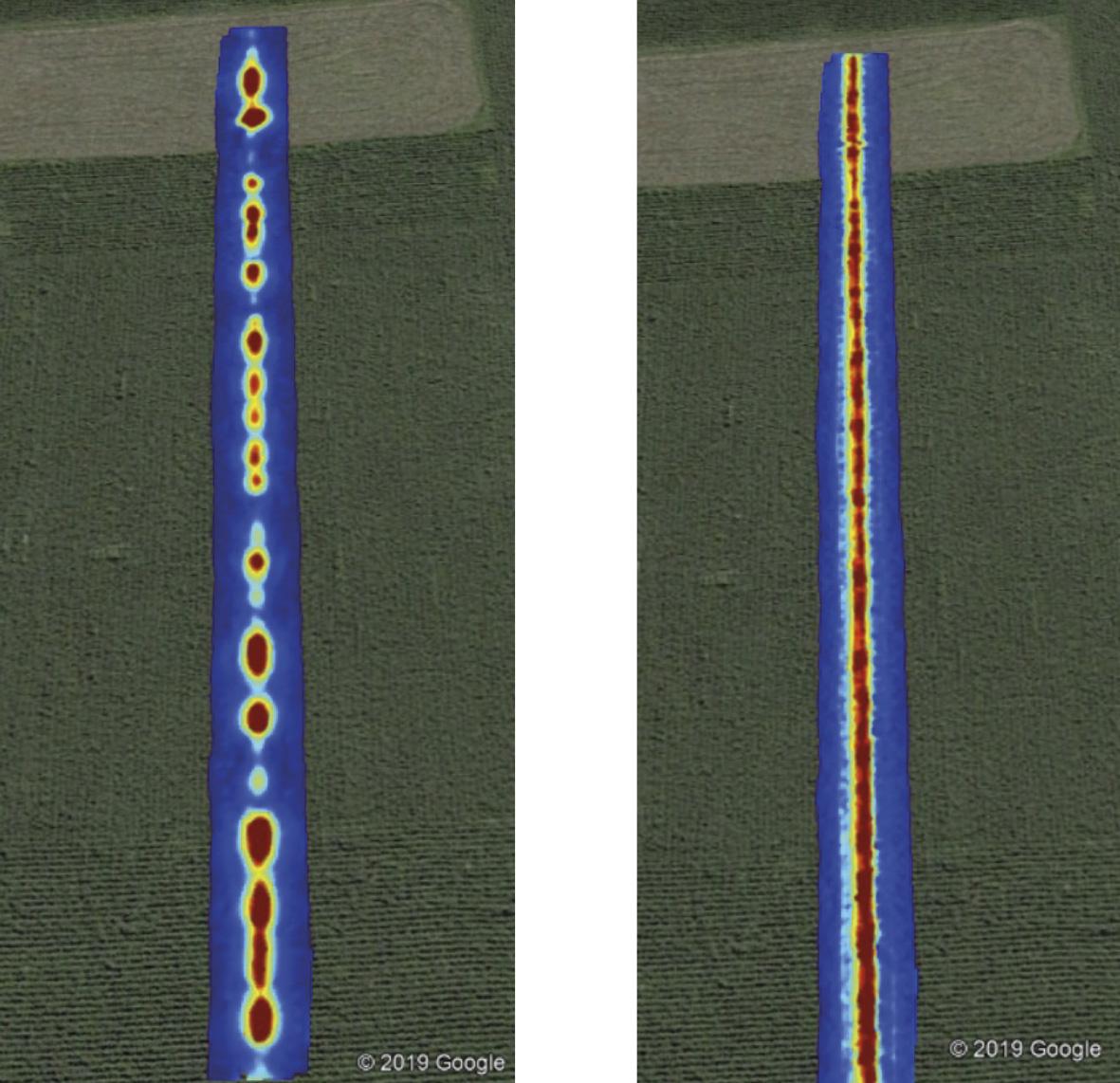
Figure 3. Resulting magnetic maps of the previous inspected area. The two maps rely on the same dataset but treated with different algorithms.


