Engineering With Nature An Atlas
®
Some materials in this publication are subject to copyright restriction. For permission to reproduce, display, or distribute any part of this publication, please communicate with relevant points of contact, including those listed in the Acknowledgements.
Engineering With Nature An Atlas
®
Published 2018. Printed in the United States of America Engineering With Nature is the intentional alignment of natural and engineering ® processes to efficiently and sustainably deliver economic, environmental, and social benefits through collaboration. www.engineeringwithnature.org Sponsoring Agency
Publisher
Project Team
U.S. Army Engineer Research and Development Center 3909 Halls Ferry Road Vicksburg, Mississippi 39180-6199 Project Lead: Todd Bridges Project Managers: Michelle Bourne and Jeff King Editor: Holly Kuzmitski Designer: Emily Moynihan Technical Advisor: Burton Suedel
ISBN
Ebook: 978-1-7325904-0-3 Hardback: 978-1-7325904-1-0 Paperback: 978-1-7325904-2-7
DOI
http://dx.doi.org/10.21079/11681/27929
Report Number Citation
Cover Photo
ii
Headquarters, U.S. Army Corps of Engineers 441 G Street Northwest Washington, District of Columbia 20314-1000
ERDC/EL SR-18-8 Bridges, T. S., E. M. Bourne, J. K. King, H. K. Kuzmitski, E. B. Moynihan, and B. C. Suedel. 2018. Engineering With Nature: an atlas. ERDC/EL SR-18-8. Vicksburg, MS: U.S. Army Engineer Research and Development Center. http://dx.doi. org/10.21079/11681/27929. A series of chevrons, or river training structures, in the Upper Mississippi River. Chevrons are designed to be an economically and ecologically sound alternative to routine dredging. (Photo by the USACE Applied River Engineering Center)
Foreword
Creating Value by Engineering With Nature We rely on natural processes and landscapes to sustain human life and well-being. Our energy, water, infrastructure, and agricultural systems use these processes and landscapes to satisfy our most basic human needs. One motivation, therefore, for protecting the environment is to sustain the ecosystem goods and services upon which we depend. As we emerge from the sixth decade of modern environmentalism, there is a growing international awareness of opportunities to efficiently and effectively integrate natural and engineered systems to create even more value. These opportunities are being realized through innovative • • • •
application of scientific and engineering principles to design, construct, and implement efficient systems; use of natural processes and systems to maximize benefit; development of integrated systems to produce a more diverse array of economic, environmental, and social benefits; and collaborations and partnerships across perspectives, disciplines, and organizations to deliver better outcomes.
A large and growing community of interests and organizations around the world are contributing to these advancements in practice. The Engineering With Nature (EWN ) ® ® initiative in the United States—led by the U.S. Army Corps of Engineers (USACE), along with its partners and collaborators—is pursuing a vision for water infrastructure based on the intentional alignment of natural and engineering processes to efficiently and sustainably deliver economic, environmental, and social benefits through collaboration. The EWN Strategic Plan 2018-2023 is guiding actions to broaden and deepen partnerships, expand capabilities, and increase application and communication in order to deliver, demonstrate, and document the approach’s benefits. Sharing practices and progress across the international community is essential for building momentum for future integration of natural and human systems. This book was developed to communicate the diversity of projects, contexts, and organizations
iii
that are advancing worldwide progress in this field. Because “seeing is believing,” we’ve emphasized visual depictions of projects (with brief narrative descriptions) to give interested readers and practitioners alike a tangible sense of the potential to engineer with nature. This representative collection of projects was assembled from contributions made by many different organizations and countries to illustrate the broad range of motivations and outcomes that can be served. Many more projects could have been included, and we’re planning future volumes of the EWN Atlas to present new collections of projects that capture even more opportunity and potential. People and communities around the world are looking for improved integration across interests, further practical innovation, and added value from public and private investments in engineered and natural infrastructure. With respect to these goals, I hope you are inspired by the beautiful projects in this atlas and the many benefits that can be achieved by Engineering With Nature.
Todd S. Bridges, PhD Senior Research Scientist, Environmental Science National Lead for Engineering With Nature
®
iv
Innovating New Aproaches as a Global Community of Practitioners Engineering With Nature is an important initiative for the U.S. Army Corps of Engineers. When we leverage natural systems and processes through integrated water resources management, we can develop more sustainable solutions and systems. By broadening our view of potential outcomes, we can find ways to deliver a broader array of services, benefits, and value from investments made in infrastructure systems. Innovation and adaptive management are key elements to advancing our engineering practice and Engineering With Nature. Trying something new—developing and implementing new approaches, methods, and practices—involves taking risks. We use risk-informed decision making to guide our application of new approaches. We adaptively manage those risks as we learn and adjust our approach. The project examples highlighted in this book illustrate the diverse opportunities and growing community of organizations and practitioners that are contributing to Engineering With Nature. A global community of practitioners provides a means for learning from others and capitalizing on the insights gained to develop better projects in the future. Strong partnerships provide a foundation for successful projects. I hope you enjoy learning from the projects in this book while considering future ways that you can contribute to Engineering With Nature.
James Dalton Director of Civil Works U.S. Army Corps of Engineers
v
Developing Integrated Natural Flood Risk Solutions Working with natural processes to manage flood and coastal erosion risks is an important theme in the UK Government’s new national 25-year plan for the environment. Engineering With Nature, or “Natural Flood Management” as we often refer to it, is an important tool in flood risk toolbox and can bring fabulous environmental benefits too. Approaching flood risk with softer engineered solutions is not new to our engineers. For years, many of our beaches have been managed to take the energy out of stormy seas to protect our coasts, and in the northeast of England, flood water has been stored in catchments on the “Ings”—and old Norse word for flood meadows—for generations. What is new is a better understanding of how we can work collaboratively to provide the most effective blend of solutions. Too often, the conversation has been about a false choice between hard or soft engineering—as if there were conflict or competition between them. We’re proud to have been able to contribute nine case studies to the Engineering With Nature Atlas. I hope you’ll be inspired by the projects in the Atlas from across the world and use it to continue to build our capacity to collaborate with each other and with nature to protect people from environmental hazards and to enhance the environment for wildlife.
John Curtin Executive Director, Flood and Coastal Risk Management Environment Agency of England
vi
Utilizing EWN Solutions Adaptively For the Netherlands, a country which is below sea level for about 30% and flood-prone for about 60% of its surface, Engineering With Nature approaches are essential to improve our flood safety in an adaptive manner, while also achieving other societal goals such of ecosystem services, navigation, or recreation. As such, it influences not only the safety but also the quality of life for many millions of people living in those areas. The Dutch Delta Program stipulates the Dutch national policy and associated programs, backed up by a Delta Law and a Delta Fund. It firmly connects our adaptive flood safety approach with spatial quality ambitions, increasing our nations resiliency to sea level rise and potentially more extreme weather due to climate change. Engineering With Nature is one of the innovative approaches and has actually become the preferred option in many Dutch cases. However, it also involves a different approach as we are working in and with dynamic systems. Upfront modelling, full scale testing, intensive stakeholder consultations, and a careful project management and monitoring of its effects all become essential disciplines for a successful project. Our adaptive approach may also result in minor or major maintenance, contrary to conventional “hard engineering,” requiring appropriate long-term financial provisions. Rijkswaterstaat and the Dutch Regional Water Authorities are proud that several Dutch case studies have been included in this atlas. With the Atlas we intend to inspire other Nations and its authorities to keep an “open eye” and increasing our scientific understanding to the immense challenge lying ahead to keep our world safer for future flooding and making it a “better place to live” at the same time.
Cees Brandsen Managing Director for Water, Transport and the Environment Rijkswaterstaat
vii
During construction, the U.S. Army Corps of Engineers (USACE) Philadelphia District pumped 667,000 cubic yards of sand onto the beach at Brigantine, NJ, following Hurricane Sandy. Work was completed in 2013. (Photo by USACE Philadelphia District)
viii
Foreword
Contents
iii
Introduction
1
Background
2
The EWN Initiative
2
International Projects and a Global Pursuit of Nature-Based Solutions
5
The EWN Initiative and Connectivity to NNBF
6
Beaches and Dunes
9
Deer Island Aquatic Ecosystem Restoration Mississippi Sound, Mississippi, United States
10
Hondsbossche Dunes Petten, the Netherlands
14
Delfland Sand Motor Pilot The Hague, the Netherlands
18
Murrells Inlet Beneficial Use of Dredged Material Murrells Inlet, South Carolina, United States
22
North Norfolk Coast Restoration Norfolk, East Anglia, England, United Kingdom
26
Long Beach Island Coastal Storm Damage Reduction Long Beach Island, New Jersey, United States
30
Taumanu Reserve–Onehunga Foreshore Restoration Auckland, New Zealand
34
Galveston Beach Nourishment at 61st Street Galveston, Texas, United States
38
Oriental Bay Foreshore Restoration Wellington, New Zealand
42
ix
Wetlands Braddock Bay Restoration Lake Ontario, Greece, New York, United States
48
Hamilton Wetlands Restoration Novato, California, United States
52
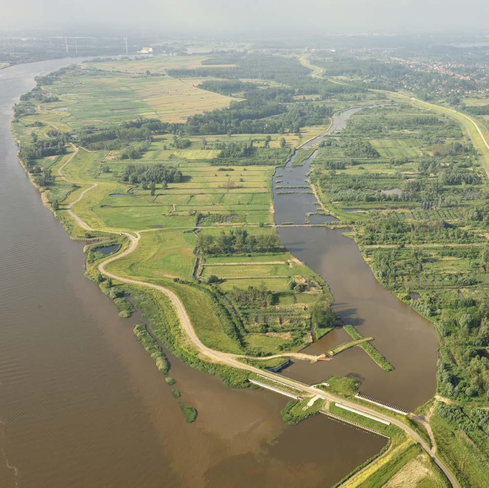
Salt Marsh Development Marconi Delfzijl Port of Delfzijl, the Netherlands
56
Savannah Harbor Dredged Material Containment Areas Savannah Harbor, Jasper County, South Carolina, United States
60
Salt Marsh Development with a Mud Motor Koehoal, Tzummarum, the Netherlands
64
Sears Point Wetland Restoration San Pablo Bay, Sonoma County, California, United States
68
Blackwater National Wildlife Refuge Marsh Resiliency Cambridge, Maryland, United States
72
Duluth 21st Avenue West Demonstration Project Superior Harbor, Duluth, Minnesota, United States
76
Dredged Sediment in an Uncontrolled Diversion West Bay, Louisiana, United States
80
Islands
x
47
85
Mordecai Island Restoration Barnegat Bay, Ocean County, New Jersey, United States
86
Horseshoe Bend Island Lower Atchafalaya River, Louisiana, United States
90
Evia Island Bird Habitat Galveston, Texas, United States
94
Cat Island Chain Restoration Green Bay, Wisconsin, United States
98
Redistribution and Impacts of Nearshore Berm Sediment Chandeleur Barrier Islands, Louisiana, United States
102
Reefs
107
MacDill Oyster Reef Shoreline Stabilization Tampa, Florida, United States
108
Coffee Island Oyster Reefs Portersville Bay, Alabama, United States
112
Oesterdam Sand Nourishment Project Oesterdam, Eastern Scheldt, the Netherlands
116
Swift Tract Oyster Reef Breakwaters Bon Secour National Wildlife Refuge, Baldwin County, Alabama, United States
120
Riverine Systems
125
Eugene Field Park Restoration Project Chicago, Illinois, United States
126
Slowing the Flow at Pickering Pickering, North Yorkshire, England, United Kingdom
130
Horner Park Restoration Project Chicago, Illinois, United States
134
Stroud Rural Sustainable Drainage Systems Stroud, Gloucestershire, England, United Kingdom
138
River Glaven Restoration Project Hunworth, Norfolk, England, United Kingdom
142
Springhouse Run Stream Restoration Washington, District of Columbia, United States
146
Levee Setbacks and Floodplains
151
Belford Natural Flood Management Scheme Belford, Northumberland, England, United Kingdom
152
Missouri River Levee Setbacks Missouri River, Iowa and Missouri, United States
156
xi
xii
Kalkense Meersen Cluster Scheldt River, Flanders, Belgium
160
Medmerry Managed Realignment Scheme Selsey, West Sussex, England, United Kingdom
164
Alkborough Flats Managed Realignment Alkborough, North Lincolnshire, England, United Kingdom
168
Redman Point– Loosahatchie Bar Environmental Restoration Mississippi River near Memphis, Tennessee, United States
172
The Polders of Kruibeke Kruibeke, Belgium
176
Use of Vegetation and Natural Materials
181
Building with Nature in Indonesia Demak, Northern Java, Indonesia
182
Sankey Natural Flood Management Initiative Sankey Valley, St. Helens, England, United Kingdom
186
Dunn Creek Confluence Habitat Restoration Kootenai River, Libby, Montana, United States
190
Bowmont Catchment Initiative Town Yetholm and Kirk Yetholm, Scottish Borders, United Kingdom
194
Beneficial Use Site 4A Vegetation Workshop Chocolate Bayou Channel, Brazoria County, Texas, United States
198
Making Space for Water Kinder Scout, Derbyshire, England, United Kingdom
202
Lower Boulder Creek Ecosystem Restoration Project Boulder County, Colorado,United States
206
Skagit River Rehabilitation of Flood Control Works Skagit County, Washington, United States
210
Environmental Enhancement of Infrastructure
215
Ashtabula Harbor Breakwater Tern Nesting Habitat Ashtabula, Ohio, United States
216
Milwaukee Harbor Breakwater Fish Habitat Demonstration Project Milwaukee, Wisconsin, United States
220
Cleveland Harbor East Arrowhead Breakwater Demonstration Project Cleveland, Ohio, United States
224
Houtrib Dike Pilot Project The dike between the cities of Lelystad and Enkhuizen, the Netherlands
228
Fowl River Private Living Shorelines Theodore, Alabama, United States
232
Rich Revetments: Enhancing Hard Substrates for Ecology Zierikzee/Sint Annaland, the Eastern Scheldt, the Netherlands
236
Soo Locks Fish Habitat Restoration Sault Ste. Marie, Michigan, United States
240
Mud Mountain Fish Passage Buckley, Washington, United States
244
Conclusion
249
Acknowledgments
253
xiii
Introduction USACE and its contractor, Great Lakes Dredge and Dock Company, are building a dune and berm system on Long Beach Island, NJ. This design will reduce storm damage to this coastal community. (Photo by USACE Philadelphia District)
xiv
Introduction
Introduction Connecting projects around the world
1
Background
Introduction
This atlas is a collection of 56 projects that illustrate a diverse portfolio of contexts, motivations, and successful outcomes. The projects were developed collaboratively to integrate natural processes into engineering strategies that support navigation, flood risk management, ecosystem restoration, or other purposes. Developing projects that combine natural and engineered systems to produce more value and a broader array of benefits is gaining increasing attention worldwide. This atlas was created in order to highlight and share examples of this practice—and efforts to simultaneously achieve engineering, environmental, and social benefits—from around the world. These projects are presented and considered in this atlas using an Engineering With Nature lens as a ® means of revealing the use of nature-based approaches and the range of benefits that can be achieved.
The EWN Initiative The EWN initiative formally began in 2010 within the U.S. Army Corps of Engineers as an approach for highlighting good past practice examples while advancing current and future capabilities. The initiative has grown to include a number of partner organizations and collaborators in the U.S. and abroad. The EWN initiative supports more sustainable water resources practices, projects, and outcomes by pursuing the intentional alignment of natural and engineering processes to efficiently and sustainably deliver economic, environmental, and social benefits through collaboration (www.engineeringwithnature.org).
2
Introduction Humber Estuary, located near Alkborough in the United Kingdom. The photo illustrates a single breach cut into low-lying farmland; the breach has facilitated restoration of the estuary and provided additional flood storage capacity for the Trent River. (Photo by ERDC)
3
There are four critical elements that define the EWN approach:
Using science and engineering to produce operational efficiencies Using natural processes to maximize benefit
Introduction
Increasing the value provided by projects to include social, environmental, and economic benefits Using collaborative processes to organize, engage, and focus interests, stakeholders, and partners Throughout this book, the four critical elements that define progress and success related to EWN are used to describe each of the representative projects. In this way, we illustrate the efficiencies that can be gained; the interconnectivity of natural and engineered systems; the array of project benefits that can be produced; and the power of collaboration in project development.
Pelicans utilizing bird habitat on Gaillard Island, an island created by USACE Mobile District and located in Mobile Bay near Mobile, AL. (Photo by USACE Mobile District)
4
International Projects and a Global Pursuit of Nature-Based Solutions
Introduction
The established and growing interest in using nature-based approaches in the development of water resources and infrastructure is reflected in formal policies and programs in many different countries. The World Association for Waterborne Transportation Infrastructure (PIANC) developed its Working with Nature philosophy to promote the development of navigation infrastructure projects using an ecosystem approach in order to enable win-win solutions (www.pianc.org). The Rijkswaterstaat and the EcoShape program in the Netherlands have developed the Building with Nature approach, along with supporting guidelines, to advance “a new approach to hydraulic engineering that harnesses the forces of nature to benefit environment, economy and society” (www.ecoshape.org). The Environment Agency of England has developed its program for Natural Flood Management and a supporting Evidence Directory that describes a large number of nature-based approaches for reducing flood risks. Representative projects from these initiatives and others are included in this book to illustrate efforts that leverage natural processes to produce a range of functions and benefits, including engineering goals. The principles, practices, projects, and programs associated with Working with Nature, Building with Nature, and Engineering With Nature are global examples of the interest and support that exist for integrating nature within the planning, design, construction, and operation of engineered projects to serve a wide range of purposes related to water resources and infrastructure. Projects included in this atlas from countries outside of the U.S. are identified using a globe symbol (below) to emphasize the international aspect of the effort.
5
The EWN Initiative and Connectivity to NNBF
Introduction
The development and use of Natural and Nature-Based Features (NNBF) is one example of Engineering With Nature that has received considerable attention internationally. NNBF is a term used to refer to landscape features that are developed to provide engineering functions relevant to flood risk management while producing additional economic, environmental, and social benefits. The EWN initiative is working to expand opportunities for NNBF application by supporting research and development, technology transfer, and stakeholder engagement. Examples of NNBF include beaches and dunes, islands, forests, wetlands, and reefs, among other types of features. These features occur naturally on fluvial and coastal landscapes and can be constructed through human engineering (i.e., they are nature-based).1 NNBF represents an opportunity to achieve both flood risk management and ecosystem restoration goals. Flood risk managers are interested in leveraging natural systems to attenuate floodwaters while expanding the range of services (to include environmental and social benefits) provided by infrastructure systems. Scientists and engineers supporting ecosystem restoration projects are interested in understanding where and how projects could be located and designed to provide engineering services related to flood risk management, in addition to the environmental benefits the restoration will provide. Projects in the Atlas that were developed as NNBF projects; i.e., to produce flood risk management and other benefits, are designated using the following symbol:
The brief project descriptions summarize the flood risk management and other benefits provided by the project. Considerable attention is being focused on quantifying the engineering and other benefits produced by NNBF. Readers interested in learning more about these and other projects in the Atlas are encouraged to contact the relevant points of contact listed in the acknowledgments section of this book. 1 Bridges, T. S. et al. 2015. Use of Natural and Nature-Based Features (NNBF) for coastal resilience. ERDC SR-15-1. Vicksburg, MS: U.S. Army Research and Development Center.
6
Left: Goliath Reef Balls were installed to protect natural shorelines and provide habitat near the Gulf Intracoastal Waterway in West Galveston. (Photo by ERDC)
Introduction
Below: The USACE Philadelphia District is renourishing Dewey, Rehoboth, and Bethany Beaches, Delaware, as part of a regular project in 20011–2012. Work was completed at South Bethany Beach, Fenwick Island, and Lewes, Delaware, in 2011. The projects are designed to reduce storm damage to public and private infrastructure. (Photo by Ann Cameron Siegal, USACE Philadelphia District)
Above: Spiny softshell turtle relishing the restored habitat in the Horner Park project. (Photo by USACE Chicago District) Right: A USACE biologist counts bird nests at a newly constructed bird island at Savannah Harbor Dredged Material Containment Area 12A, 2014. (Photo by Tracy Robillard, USACE Savannah District
7
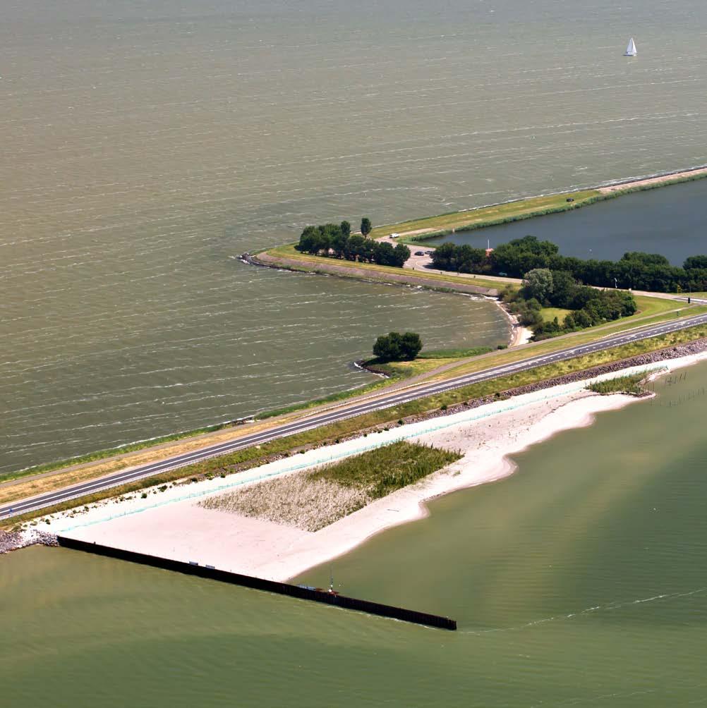
Beaches and Dunes The Sand Motor, 2012. (Photo by Rijkswaterstaat Joop van Houdt)
8
Beaches and Dunes
Beaches and Dunes
Protecting coastlines & enhancing recreation
9
Deer Island Aquatic Ecosystem Restoration Beaches and Dunes
Mississippi Sound, Mississippi, United States
Located in the Mississippi Sound, Deer Island is a narrow, four-and-a-half-mile-long body of land that protects the city of Biloxi by acting as a buffer for wind and wave energy. In the 25 years preceding the restoration, however, strong storms and hurricanes breached the west end of the island, reduced island elevations so that they were too low to support marsh vegetation, eroded the island’s beaches, and impaired forested areas. The intent of the Deer Island Aquatic Ecosystem Restoration Project (AERP), which was a joint effort by the U.S. Army Corps of Engineers (USACE) Mobile District (SAM), the Mississippi Department of Marine Resources (MDMR), and local stakeholders, was to restore the island and create long-term beneficial use capacity for material dredged from the nearby Biloxi Harbor Navigation Project. Completed in 2013, the Deer Island AERP created approximately 215 acres of new habitat for terrestrial and aquatic species. This project received a Certificate of Recognition as a World Association for Waterborne Transport Infrastructure (PIANC) Working with Nature project, and was also recognized through receipt of the 2013 Western Dredging Association (WEDA) Environmental Excellence Award for Navigational Dredging.
10
11 Beaches and Dunes
Producing Efficiencies
Beaches and Dunes
In the past, different organizations had attempted to fill Deer Island’s west end breach with dredged material and concrete rubble; however, the area continued to breach. For this effort, the project delivery team buried two large geotubes filled with dredged material that was the optimal grain size for site conditions; the team obtained the material from a borrow site nearby. This cost-effective approach to repairing the breach made resources available for an intensive planting effort. On the restored west end breach, approximately 300,000 native grasses, forbs, herbs, vines, trees, and shrubs were planted to enhance the creation of natural sand dunes and to stabilize the island. Along the southern shoreline, approximately 325,000 grasses were planted to stabilize the beach and the marsh areas created by the beneficial use of dredged material.
Using Natural Processes The restoration design included the creation of a lagoon—about 19,000 feet in length and covering an area of approximately 100 acres—in the area located between the northern limit of the post-project southern shoreline and southern limit of the preproject southern shoreline. The lagoon was utilized for the beneficial placement of approximately 170,000 cubic yards of fine-grained sediment dredged from the Biloxi Lateral Navigation Channel. Placement of fine-grained dredged material in the lagoon will allow valuable marsh habitat to be created and will build a more resilient shoreline against future storm events. The remaining lagoon area provides an economically feasible placement option for material obtained from future maintenance dredging activities. Previous page: Beach profiles after reaching equilibrium through natural processes. (Photo by USACE) Right: Diverse habitats protected and restored using Engineering With Nature principles. (Photo by USACE)
12
Broadening Benefits
Beaches and Dunes
The project provided significant environmental benefits for the region. The restored portions of the island provide large colonies of least terns and black skimmers with a sizable increase in nesting and foraging habitat; the restoration also protects valuable foraging and nesting habitat for bald eagles and osprey. The city of Biloxi gained a stronger buffer from storm events; an area better suited for recreation (e.g., for beach going, bird watching, and angling); an increase in related business opportunities for the local community; and a cost-effective and environmentally acceptable beneficial use site for the placement of dredged material.
Promoting Collaboration The Deer Island AERP was a joint effort by USACE SAM, MDMR, and local stakeholders. Restoration efforts for Deer Island have received multiple lines of support from federal, state, and local levels. The conceptual design incorporated the community’s water quality, safety, and recreation needs. Through a collaborative approach with stakeholders, the team developed solutions for the environmental and resource use challenges traditionally faced in this area. This project also attracted significant, fortuitous publicity from local television and newspapers when a loggerhead sea turtle nested on the restored southern shore of the west end breach—the first time in 20 years a sea turtle nesting event took place on any Mississippi beach—and her hatchlings emerged shortly thereafter.
Top: Aerial view of the innovative lagoon created at Deer Island. (Photo by USACE) Bottom: Interior least terns and black skimmers on Deer Island post-restoration. (Photo by USACE)
13
Beaches and Dunes
Hondsbossche Dunes Petten, the Netherlands
Having been categorized as one of the ten weakest points along the Dutch coastline, the Hondsbossche and Pettemer sea dike no longer met safety standards. The structure would need to be fortified to stand 4 meters higher and 20 meters wider; if these specifications were met, the dike was projected to then be capable of withstanding a one-in-tenthousand-year superstorm, one of the Dutch government’s safety requirements. However, the existing infrastructure behind the dike made these modifications unfeasible. Instead, the regional water board opted to strengthen the coastline itself by creating broad dunes and beaches. A soft, natural barrier of 30 million cubic meters of dredged sand was placed on the sea side of the dike by EcoShape to create a soft, shallow foreshore with a variety of dune habitats. The newly strengthened shoreline—including the dike—was completed in 2015, then renamed “Hondsbossche Dunes.” Shortly afterwards, an innovation project was set up, running from 2015 to 2018. The aim of this project was to learn more about efficient sand nourishment that contributes added value to nature and leisure.
14
15 Beaches and Dunes
Producing Efficiencies This project represents a unique opportunity to study how nature responds to a sand nourishment on a large scale. Three research themes were identified: (1) predictability of habitat development, (2) geometry development, and (3) visitor perception of the project.
Beaches and Dunes
An improved understanding of these issues is crucial to developing the optimal design of future sand solutions. A clearer picture will also be provided of realistic possibilities for the management and maintenance of these solutions. The research results will provide new knowledge about where soft approaches deliver added value and about possible financial benefits in comparison with hard solutions. The Hondsbossche monitoring program will be linked to ongoing scientific research on the use of sand for reinforcement projects.
Using Natural Processes The dune was strategically designed to be shaped naturally over time by aeolian processes without loss of overall sand volume; this is one respect in which the project is an excellent example of Building with Nature. The aeolian transport process was facilitated by the use of brushwood screens; variation in terrain elevation; vegetation; and cross-shore dune profile shape. The project’s design also included humid dune slacks, a feature that will enable wetland development—thereby providing a habitat that is typically diverse in species.
Previous page: The Hondsbossche Dunes during construction. (Photo by Van Oord Boskalis joint venture—Hondsbossche and Pettemer Sea Defence) Right: Viewing point at the developing humid dune slack. (Photo by EcoShape)
16
Broadening Benefits The Hondsbossche Dunes project harmonizes multiple, simultaneous functions: providing coastal safety, stimulating the local economy, and enhancing natural habitat are just a few examples of the benefits this project delivers. The design consists of a soft shallow foreshore (the beach) with various dune habitats; the area now attracts a large number of visitors. The connected systems make up the area’s primary flood defense while providing the required spatial quality. Bike paths were also constructed along the dunes to afford additional recreation opportunities to the public.
Beaches and Dunes
Promoting Collaboration The innovation project was executed by EcoShape and funded by an alliance of the Dutch Flood Protection Program; Hollands Noorderkwartier Regional Water Board; and the EcoShape research consortium, which consists of several partners: the Rijkswaterstaat, HKV, Witteveen+Bos, Deltares, Wageningen University & Research, and Arcadis. At every stage of the project, stakeholder engagement has been a priority. In the dialogue phase of the tender stage, communication between the tendering contractors and relevant stakeholders—including the public—was carefully organized. After award of the contract, interaction with the public was organized again, since the project activities attracted a large number of visitors. Information was posted at the project location itself, at a visitors’ center, and online; communication was presented from the perspective of both the client and the contracting consortium. Top: The future humid dune slack. (Photo by EcoShape) Bottom: Planted marram grass on the new dunes. (Photo by EcoShape)
17
Beaches and Dunes
Delfland Sand Motor Pilot The Hague, the Netherlands
The Delfland Sand Motor experiment was a new coastal maintenance strategy designed to harness the power of winds, waves, and currents. The strategy will help protect part of the Dutch coast, while encouraging the development of new beach and dunes, as well as the valuable flora and fauna associated with them. In contrast to typical sand nourishment projects, this was a single mega-nourishment operation that deposited a large quantity of sand in a single location in 2011. The traditional approach to sand nourishment was to maintain the shoreline and to safeguard the hinterland by making smaller-volume sand deposits more frequently, which repeatedly disturbed the ecosystem. A total of about 12 million cubic meters is nourished every year. It is expected that this volume will increase significantly in the coming decades due to sea level rise. This project was undertaken by Rijkswaterstaat, the Province of South Holland, and the EcoShape consortium consisting of partners Royal Haskoning DHV, Wageningen University & Research, Deltares, Van Oord and Boskalis.
18
19 Beaches and Dunes
Producing Efficiencies
Beaches and Dunes
The project was unique in that a much larger quantity of sand was deposited at one time to accomplish the results of multiple nourishments. This meganourishment operation deposited 21.5 million cubic meters of sand in a single location, with the height of the deposit rising to five meters above the mean sea level. The traditional approach to sand nourishment had been to maintain the shoreline using a volume of two to five million cubic meters of sand at a time; as a result, the ecosystem was disturbed more often. Since the Sand Motor was completed in 2011, it has been closely monitored, and an extensive research program has been established that will include detailed studies of the project’s evolution and the driving forces behind it, whether they are physical, ecological, or social. Preliminary results show that it has behaved as predicted thus far and that the expected lifetime of the Sand Motor will be longer than the projected 20 years.
Using Natural Processes The wind and currents are gradually redistributing the sand along the shoreface, beach, and dunes. By using natural processes to spread the sand, this innovative approach aims to limit the disturbance of local ecosystems, while also providing new areas for nature and more leisure opportunities. The strategy of concentrating nourishment operations is seen as a climate-robust and an environmentally friendly way of countering coastal erosion.
Previous page: The Sand Motor, 2012. (Photo by Rijkswaterstaat Joop van Houdt) Right: Kitesurfers on the Sand Motor. (Photo by Leo Linnartz)
20
Broadening Benefits
Beaches and Dunes
The surplus sand creates new areas for nature and leisure. Nature is disturbed much less frequently than in the standard five-year cycle of smaller nourishments, and there is more time for the development of new ecosystems with more biodiversity. Seals have been visiting the area, and a rare plant species has been found growing on a newly formed juvenile dune. The Sand Motor has become a highly popular location for wind-, wave-, and kite-surfers. The Sand Motor has also become a focal point for coastal research and innovative coastal management solutions.
Promoting Collaboration The Sand Motor pilot is a collaborative effort involving Rijkswaterstaat, the Province of South Holland and the EcoShape consortium, consisting of partners Royal Haskoning DHV, Wageningen University & Research, Deltares, Van Oord and Boskalis. Beach restaurant owners and stakeholders from the fields of leisure, nature, and swimmer safety are involved in the planning, operation, and maintenance process.
Top: The Sand Motor plants emerging near the dunes. (Photo by Leo Linnartz) Bottom: The Sand Motor beach, 2016. (Photo by Jurriaan Brobbel)
21
Beaches and Dunes
Murrells Inlet Beneficial Use of Dredged Material Murrells Inlet, South Carolina, United States The Murrells Inlet Navigation Dredging Project, completed in 2017 by the U.S. Army Corps of Engineers Charleston District, is an excellent example of Engineering With Nature. The project was initiated to return the federal channel and the smaller A, B, C, and D channels to the authorized depth to allow boats of various sizes to enter and exit the inlet. Dredged material from the entrance channel, the deposition basin, and two inner channels was used beneficially after placement on the front beaches of Garden City Beach; the effort raised the beach elevation by 9 feet, making the beach a protective buffer for the infrastructure behind it. Material was also placed in Huntington Beach State Park at the terminus of the southern jetty. This project created numerous engineering and environmental benefits, including a reduced need for local beach nourishment, increased habitat for a variety of bird species, and erosion control. This effort will also help mitigate impacts from any future storms and reduce future maintenance costs for the federal government.
22
23 Beaches and Dunes
Producing Efficiencies
Beaches and Dunes
In response to the requirement of maintaining federal navigation channels, the design of the Murrells Inlet Navigation Dredging Project includes strategic placement of dredged material from the entrance channel and two inner channels. Dredged material is placed at the terminus of the southern jetty to address erosion concerns of the jetty while also creating foraging and nesting habitat for a variety of bird species. The dredged material is also placed along the nearby front beaches to provide nourishment. These areas are nearby to the channels being dredged; therefore, they are least-cost placement area options.
Using Natural Processes The design of this project uses natural processes to maximum benefit by strategically placing dredged material to address erosion concerns; as a result, foraging habitat is created for endangered shore birds and nesting habitat is created for colonial-nesting waterbirds. The dredged material is also used as beach nourishment for local beaches north and south of the entrance channel.
Previous page: Looking west at the jetty tiein. (Photo by USACE Charleston District) Right: Looking northwest (inland) from near the base of the jetty. (Photo by USACE Charleston District)
24
Broadening Benefits Beneficially placing dredged material behind the south jetty resulted in the creation of foraging habitat for endangered shore birds and nesting habitat for colonial-nesting waterbirds. The material also provided erosion protection for the south jetty and offered cost savings due to the close proximity of the placement area to the navigation channel. Placement of material along the front beach of adjacent areas helped reduce the need for beach nourishment by the local community.
Beaches and Dunes
Promoting Collaboration Before material was placed adjacent to the south jetty within Huntington Beach State Park, the project team consulted with state and federal environmental agencies for their opinions on the proposed placement. The project was strongly supported by Huntington Beach State Park, which monitors birds on the placement area, and by the U.S. Fish and Wildlife Service, which supported the creation of foraging habitat for the endangered piping plover.
Top: Garden City Beach before placement of dredged material (looking south). (Photo by USACE Charleston District) Bottom: Garden City Beach after placement of dredged material (looking south). (Photo by USACE Charleston District)
25
Beaches and Dunes
North Norfolk Coast Restoration Norfolk, East Anglia, England, United Kingdom
The North Norfolk Coast has high landscape, biodiversity, and geodiversity value, with a range of statutory designations for conservation. The risk of saline flooding to farmland as well as to freshwater or wet grassland conservation sites, property, and infrastructure is managed through a suite of measures, including seawalls and natural barriers. A series of schemes has been developed by the Environment Agency of England over the past 15 years, driven by the Shoreline Management Plan (SMP) and other initiatives that work with natural processes. EU LIFE, a European Union funding instrument for environment and climate change, funded this project. It also enabled implementation of a realignment (or restoration) project at Brancaster in 2002 (approximately 0.75 kilometers of frontage). The realignment project restored dune function; created 7.5 hectares of intertidal habitat; and protected and enhanced freshwater habitat.
26
27 Beaches and Dunes
Producing Efficiencies Although an adaptive management approach has been proposed for the future, defenses are at risk from extreme events. The need to respond to extensive seawall breaching in the 2013 surge event led to a redesign of the Blakeney Freshes structures. The redesign allowed for the possibility that overtopping might occur in future storms, but the modifications would result in less structural damage.
Using Natural Processes
Beaches and Dunes
The schemes had different designs, but they all addressed the need to work with natural processes and allow coastal evolution in order to provide flood and coastal erosion protection, while also protecting freshwater habitats and enhancing coastal/brackish habitats. Works included Brancaster: deteriorating rock armor (rip-rap and gabions) fronting sand dunes were removed to allow roll-back and the development of a more natural form; Holme Dunes: dragon-tooth fencing was used to aid sand trapping in front of an eroding dune ridge, which protects the freshwater area and property; and Cley to Salthouse: restoration of the natural functioning shingle barrier beach after decades of intervention to facilitate natural post-storm recovery and maintain appropriate flood protection while reducing or removing maintenance requirements.
Previous page: Brackish and saline habitats at Cley Marshes, 2017. (Photo by Oli Burns, Environment Agency) Right: Shingle washover fan at Cley Marshes, 2017. (Photo by Oli Burns, Environment Agency)
28
Broadening Benefits These projects were developed as a means of attaining the principal goals of improving the standard of flood and coastal erosion protection and conserving and enhancing the environment; however, these projects in combination have also improved the aesthetic value of the coastline and created habitats that are more resilient to the effects of climate change.
Promoting Collaboration
Beaches and Dunes
The North Norfolk Coast case study is an important example of gradually building confidence and trust in Working with Natural Processes (WwNP) among stakeholders and the public. Successful implementation of multiple small-scale measures over several years— for example, providing protection against the 2013 tidal surge event and improving the resilience of the shoreline to subsequent storms—has significantly contributed to the process of consensus building. This is a valuable lesson for areas where WwNP measures are viewed as inferior to hard engineering.
Top: Realigned tidal reach of the River Glaven, 2017. (Photo by Oli Burns, Environment Agency) Bottom: Dynamic shingle beach at Salthouse, 2017. (Photo by Oli Burns, Environment Agency)
29
Beaches and Dunes
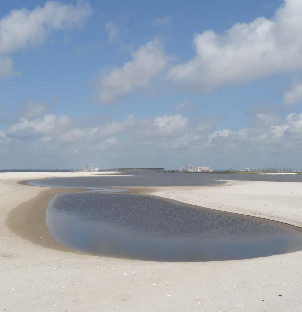
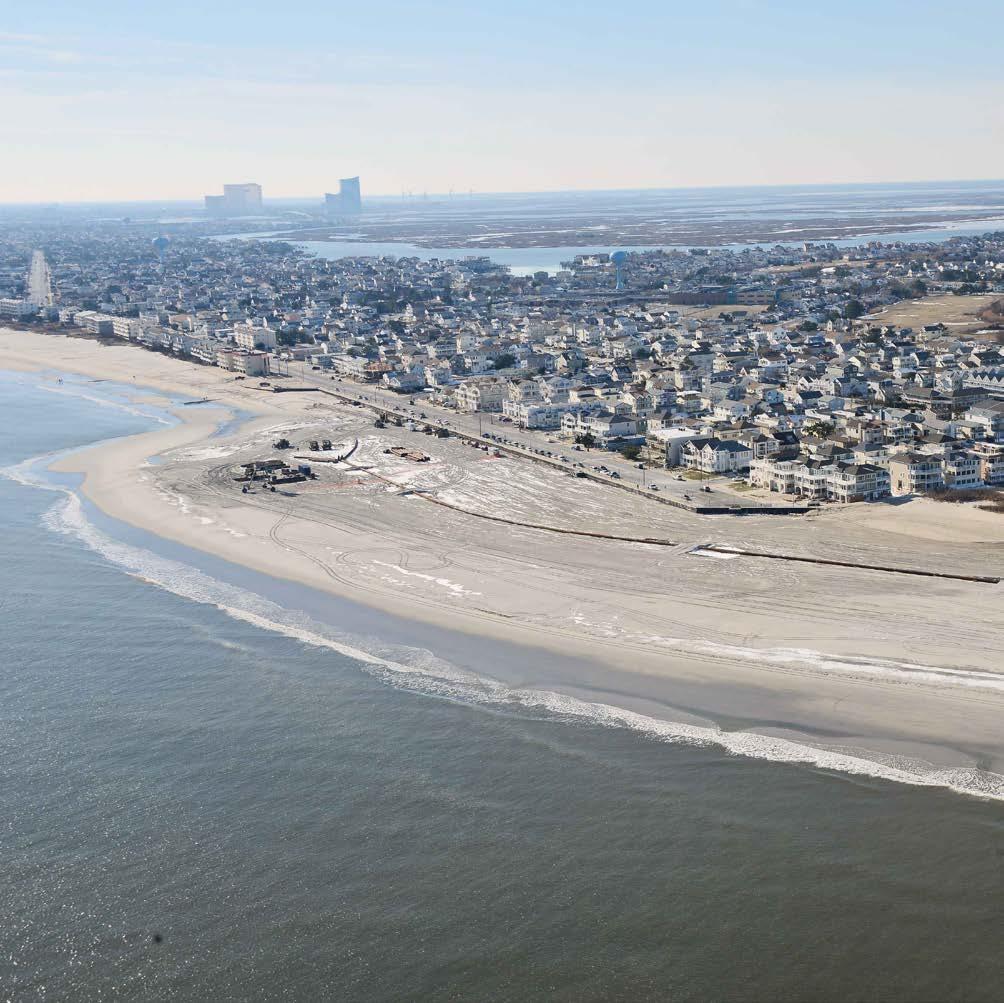
Long Beach Island Coastal Storm Damage Reduction Long Beach Island, New Jersey, United States Long Beach Island (LBI) is an eighteen-mile-long barrier island that reaches from Barnegat Inlet to Little Egg Inlet, along the Atlantic coast of southern Ocean County, New Jersey. Coastal storms, hurricanes, and northeasters regularly impact this area. This project consisted of creating a berm and dune extending along the oceanside of the island; these nature-based features were designed to minimize flooding and coastal storm damage for the island’s communities. The features were built with sand obtained from an offshore borrow source. Incorporated into the Natural and Nature-Based Features project plans were periodic sand nourishments every 7 years for 50 years. A joint effort by the U.S. Army Corps of Engineers (USACE) Philadelphia District (NAP), and the New Jersey Department of Environmental Protection (NJDEP), this project’s initial construction at LBI’s Surf City was completed in 2006, at Harvey Cedars in 2010, and at Brant Beach in 2012. Portions of the LBI were refurbished by NAP in 2012 and 2013 following Hurricane Irene and Hurricane Sandy, respectively. In 2016, the Great Lakes Dredge and Dock Company completed initial construction of the project.
30
31 Beaches and Dunes
Producing Efficiencies
Beaches and Dunes
Sand was obtained from nearby offshore sources to construct a berm and a dune for the purpose of protecting the communities on the island from wave and storm damage. The overall length of the berm and dune system is approximately 16 miles. A berm is a raised shelf-like barrier; the berm in this project was 8 feet above sea level, 125 feet long, and 300-400 feet wide, depending on which part of the island’s beach the section was situated upon. The dune was built to measure 22 feet above sea level at its highest elevation and 30 feet wide at its crest. Three hundred forty-seven acres of planted dune grasses and 540,000 linear feet of sand fencing were included as part of the project to stabilize the dune, protect it from wind and water, and keep it from migrating, thereby minimizing the amount of sand renourishment that has to take place in the future.
Using Natural Processes Both dunes and berms are features that are created on beaches as a result of natural processes involving sand and wind (in the case of dunes) and sand and sea (in the case of berms). In this project, these features protect the island from wave and storm damage by diminishing ocean wave energy and storm surge during extreme weather events. In particular, the berm and dune prevent erosive processes from reaching areas further inland.
Previous page: The USACE Philadelphia District pumps sand onto Brant Beach, NJ, in 2013. The work is part of an effort to restore the coastal storm risk management project from damages associated with Hurricane Sandy. (Photo by USACE Philadelphia District) Right: USACE and its contractor, Great Lakes Dredge and Dock Company, are building a dune and berm system on Long Beach Island. Work is designed to reduce storm damage to infrastructure. (Photo by USACE Philadelphia District)
32
Broadening Benefits This project has tremendous social and economic value, as it was designed to mitigate erosion, flooding, and property damage that can result from storms, hurricanes, and other extreme weather events. The revitalized beach will also improve recreational opportunities for the island’s inhabitants and visitors. The plantings will provide habitat for wildlife— an environmental benefit.
Promoting Collaboration Beaches and Dunes
This project was a joint effort between the USACE and the project sponsor and cost-sharing non-federal partner, NJDEP. In 2014 USACE awarded a contract to the Great Lakes Dredge and Dock Company to complete initial construction of the project.
Top: The creation of the dunes included measures such as planting dune grasses and installing sand fencing to stabilize the dune, protect it from wind and wave action, and prevent migration, thereby minimizing future sand renourishment. (Photo by USACE Philadelphia District) Bottom: The USACE Philadelphia District and its contractor, Great Lakes Dredge and Dock Company, are pumping approximately 8 million cubic yards of sand onto Long Beach Island, NJ. The Dredge Dodge Island is shown in the distance. Work is designed to complete the dune and berm system and reduce future storm damage. (Photo by USACE)
33
Taumanu Reserve– Onehunga Foreshore Restoration Beaches and Dunes
Auckland, New Zealand Taumanu (Taāumanu) Reserve is a recreational park created in 2015 on land reclaimed from the Manukau Harbour in Auckland’s southwest. The project was executed by the Auckland Council and the New Zealand Transport Agency and planned by the environmental and engineering consultancies, Tonkin & Taylor Limited and Aecom; landscape designs were executed by Isthmus. The head contractor, the New Zealand construction firm Fulton Hogan Ltd., provided the project management and construction services required to transform project designs into a reality. The creation of Taumanu Reserve was initiated and driven by a passionate and well-organized community wanting to restore the foreshore that was once accessible to them; the foreshore was cut off from the community when the state highway was built across the Onehunga Bay in the mid-1970s. Taumanu Reserve is composed of 6.8 hectares of new coastal reserve; nine beaches formed from either sand or gravel; 1.5 kilometers of shared use path; a gateway pedestrian footbridge over a motorway integrating reserves; a festival lawn for public events; a boat ramp; and a car park with toilet and shower facilities. The project won the World Architecture News Transport Award-2016 (for Taumanu Bridge) and the New Zealand Institute of Landscape Architects Nzila Award of Excellence—te karanga o te tui (Māori design excellence)—2017.
34
35 Beaches and Dunes
Producing Efficiencies The challenge was to deliver the beach’s and reserve’s technical functions in a dynamic coast environment while successfully incorporating the cultural, social, and cultural requirements of multiple stakeholders within a fixed budget that included design, approvals, and construction.
Beaches and Dunes
The commitment to using a nature-based framework for design required the understanding, coordination, and layering of many technical and subject matter experts’ input—including those outside engineering, such as landscape architects and flora and fauna experts—as well as input from contractors for construction efficiencies. The layering of expert input ultimately resulted in increased resilience and decreased costs throughout the project cycle and efficient construction programming.
Using Natural Processes The layering approach started with nature and involved three steps: (1) using the natural environment to determine the starting point for each design element; (2) applying technical engineering to design a functional piece of infrastructure; and (3) overlaying the functional infrastructure with multiple layers of enhancements that would improve the aesthetic, ecological, cultural, and social outcomes that the infrastructure would achieve. An example of the layered development approach used in this project is the creation of lava flow headlands in lieu of rock groynes, or “groins.” These reflect the adjacent environment and have a natural appearance; their ecological function is also enhanced. The headlands enabled the creation of nine beaches formed from either sand or gravel. The beaches are based on the processes that were observed and modelled from around the wider Manukau Harbour’s coastline. Previous page: A formed hill creates land-to-land access to the newly formed recreational park. (Photo by Tonkin & Taylor) Top: Naturalistic headland controls surround visitors stepping down to the main beach. (Photo by Tonkin & Taylor) Bottom: Thousands of native plants—instead of fencing and signs— provide enhanced habitat and access control. (Photo by Tonkin & Taylor)
36
Broadening Benefits
Beaches and Dunes
Numerous environmental benefits were realized; for example, there were significant water quality improvements made to Onehunga Bay that reduced Escherichia coli (E. coli) and brought the water up to safe swimming standards. A return to more natural coastal processes in the bay and restoration of the environment was delivered, as was increased biodiversity of the Manukau Harbour through the selection of plants and provision of habitats that promote biodiversity. Increased resilience and decreased costs were also realized by working strategically with the site’s existing natural features. The primary social benefit is a strong sense of community ownership towards the reserve, an attitude that was built through a collaborative working process and Māori-inspired design choices.
Promoting Collaboration A complex landscape of treaty negotiations was traversed between the region’s Māori and the Crown; as an indirect consequence, negotiations were also conducted between the Auckland Council and the Crown. A Mana Whenua Kaitiaki (the persons and/ or agents who perform the tasks of guardianship over a particular resource or area) Group (MWKG) was formed as a forum for engagement on matters of significance for Mana Whenua (Māori with authority over the land). The MWKG formation produced a large number of positive outcomes, including stormwater quality improvements, Mana Whenua input into plant design and selection, and the inclusion of two Pou Whenua (artworks) incorporated into the project plan. Top: A network of shared-use paths and reserves provide a range of recreational opportunities and access. (Photo by Tonkin & Taylor) Bottom: Headland controls informed by natural lava flows are part of the natural character of this area. (Photo by Tonkin & Taylor)
37
Beaches and Dunes
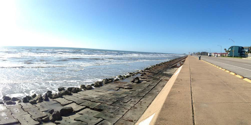
Galveston Beach Nourishment at 61st Street Galveston, Texas, United States
The beach nourishment effort on Galveston Island at 61st Street is an excellent example of a beneficial use of dredged material project working in harmony with Engineering With Nature principles. Completed in 2015, the project work was executed by Great Lakes Dredge and Dock Company under contract to the U.S. Army Corps of Engineers (USACE) Galveston District (SWG). Sediment from periodic ship channel dredging and maintenance was placed on the site to help rebuild the beach at 61st and Seawall Blvd. This effort provided recreational benefits for the local Galveston population; additionally, the rebuilding of Galveston’s beaches helped attract tourism from nearby Houston, a city with a metro area population of 6.3 million. Since the dredged material in this case was placed on the beach, the project also helped retain future capacity within other types of dredging placement areas.
38
39 Beaches and Dunes
Producing Efficiencies
Beaches and Dunes
As part of a long-term strategy to build public beaches, provide storm surge protection, and increase property value, the project utilized sediment that would normally be placed in an area without recreational or economic benefit to local communities. By utilizing sediment that was native to the area on a beach that experienced erosion, the beach could be rebuilt in a manner that was ecologically responsible and historically correct. Before placement, the sediment was analyzed for any potentially harmful compounds; it was also evaluated for grain size and mineralogical makeup. These samples were processed and analyzed to help SWG monitor the changes the sediment underwent throughout the dredging and placement process.
Using Natural Processes The dredged material was removed from the navigation channel during routine channel maintenance and pumped out onto the beach. The rebuilt beaches better dispersed the natural wave energy during high-tide periods.
Previous page: Before and after pictures of beach nourishment on Galveston Island at 61st Street. (Photo by USACE Galveston District) Right: The finished project utilizes both the new beach’s soft structure and the existing hardened sea wall structure. (Photo by USACE Galveston District)
40
Broadening Benefits
Beaches and Dunes
This project restored a beach that had receded up to the current storm surge barrier. This effort represents restoration of hundreds of feet of beach that over a century of storm events and erosion had depleted. Dredging of the federal channel is necessary to maintain navigable waterways, and this beneficial use project allowed USACE to work with a cost-sharing sponsor to place the material along the coastline. This beach is essential for storm surge protection, is an important economic driver for the island’s tourism industry, and will increase local property value.
Promoting Collaboration Through federal, state, and local collaboration, the beach at Galveston Island’s historic seawall was renourished. This was a collaborative undertaking between the Galveston Park Board of Trustees, Texas General Land Office, and the SWG.
Top: During construction, Great Lakes Dredge and Dock Company helped restore the beach to historical proportions. Picture taken from location of dredge discharge pipe, facing the Galveston seawall. (Photo by USACE Galveston District) Bottom: The completed project renourished the beach to restore storm surge protection, provide an important economic driver for the island’s tourism industry, and increase local property values. (Photo by USACE Galveston District)
41
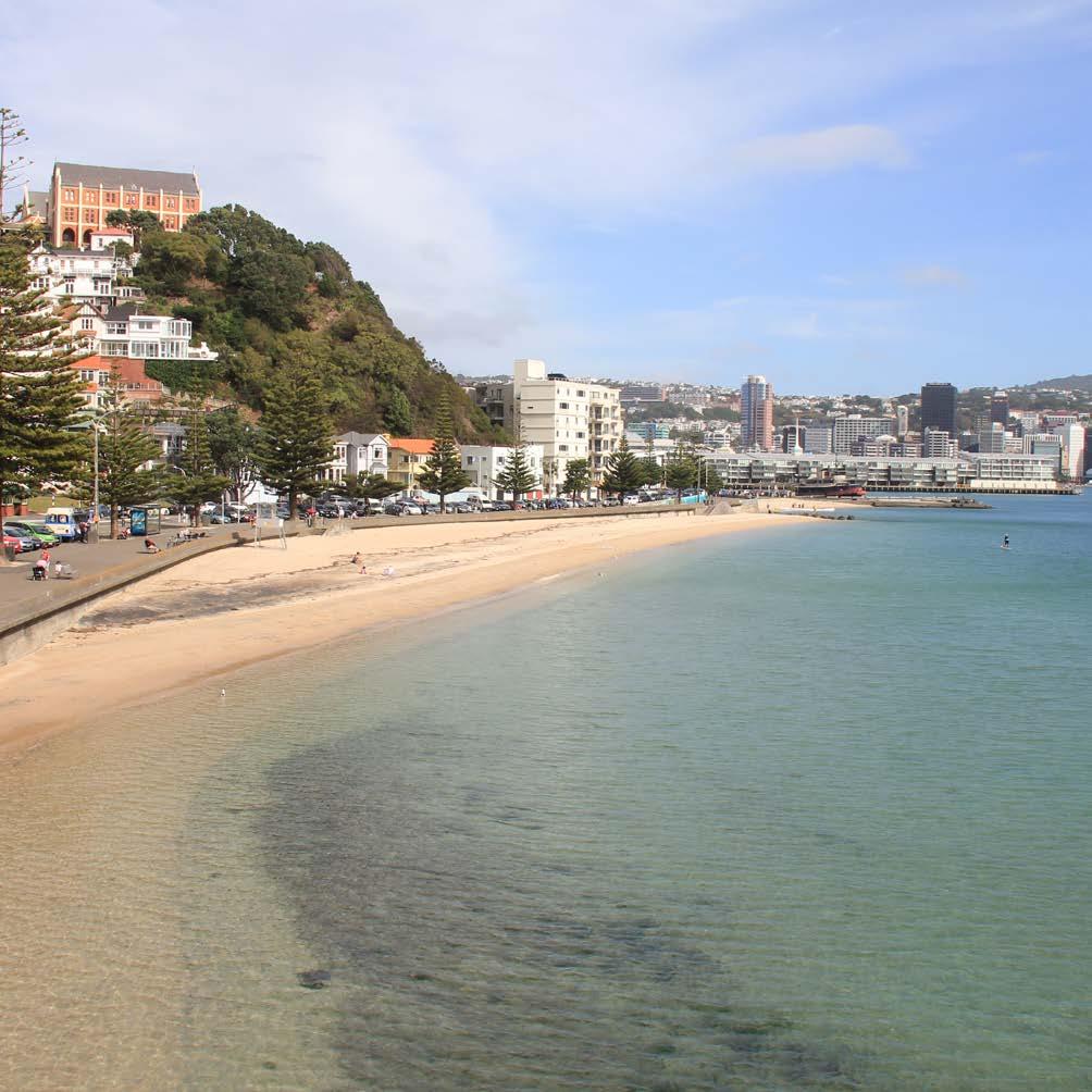
Oriental Bay Foreshore Restoration Beaches and Dunes
Wellington, New Zealand
Oriental Bay is one of Wellington’s most recognizable landmarks and the only beach readily accessible from the city center. The location is much loved by Wellingtonians and visitors alike. In response to the depletion of sand from the Oriental Bay beaches, the condition of the public amenities, and the increasing recreational demand from the inner city, Wellington City Council engaged the environmental and engineering consultancy, Tonkin & Taylor Limited (T+T), in 2001 to undertake the design, consenting, and construction supervision of the project. The project focused on improving the beaches and the stormwater system using naturebased solutions; the public amenities were also upgraded. The beaches in Oriental Bay have now been enlarged, covered in golden sand, and—most importantly—are now dynamically stable. New public amenities have been constructed, including a pier, a sea platform, toilets and changing sheds, a refreshment kiosk, and a playground. The promenade has been widened and resurfaced, new seating and feature lighting installed, and the car-parking capacity has been increased. The flooding problems that occurred along Oriental Parade have also been overcome.
42
43 Beaches and Dunes
Producing Efficiencies A multidisciplinary team led by T+T was formed that included architects, urban planners, landscape architects, planners, and community communication experts to develop a design for the project and to manage the process. An interactive design process was established to ensure that solutions to the challenges that the unique location presented were design-led. The overall design objective was to enhance those values of Oriental Bay that naturally contribute to its popularity and ensure the project resulted in minimal visual intrusion. In the regulatory approval process, the proposed design received over 900 responses; only 4 percent were in opposition.
Beaches and Dunes
Using Natural Processes The design challenge was to have no visible engineering structures but still have a stable and dry high-tide beach and improved catchment discharge via the stormwater network. The location of Oriental Bay—immediately adjacent to the inner city, on a major arterial road, and with relatively steep bathymetry—posed a number of design and construction challenges. The dynamic Wellington climate means Oriental Bay can experience wide extremes in weather, from calm days to northerly gales gusting well over 100 kilometers per hour, as well as two-and-a-halfmeter-high waves. A number of innovative nature-based solutions were used. These included forming a submerged sill along the steepest part of the nearshore area to prevent offshore sand loss; augmenting headland controls to retain sand within the beach and to divert stormwater through; installing offshore submerged breakwater to slow alongshore losses and provide improved ecological habitat, and designing sand gradings to reduce wind-blown losses.
Previous page: View west along the main beach towards the city center. (Photo by Tonkin & Taylor) Right: The beach is improving public amenities and access and is popular for bird roosting. (Photo by Tonkin & Taylor)
44
Broadening Benefits The success of the Oriental Bay Foreshore Restoration project is that visitors to the area today can see no sign of the engineering structures that underpin the enhancement works. The structures are a discreet part of the Bay’s improved natural character, facilities, and beach environment. There has been increased use of the space for public events, such as beach volleyball tournaments and fireworks displays, and public use of the now-dry beach area has increased dramatically, having a beneficial effect on the economy through the many restaurants and cafés that are adjacent to the Bay.
Promoting Collaboration Beaches and Dunes
In addition to the broad multidisciplinary project team, a key feature of the project was the strong partnership forged between the project team and Wellington City Council. Throughout the project, the Council was involved in providing feedback on the design concepts and articulating Wellington residents’ requirements, including a specially formed community liaison group. Community involvement was achieved through open days, presentations to boards and ratepayers’ associations, press releases, and a system to collect and respond to public feedback promptly through the design and construction process, whether the feedback was criticism or praise.
Top: The design of the structural controls at Freyburg Beach were inspired by the natural features at the Giant’s Causeway in Ireland. (Photo by Tonkin & Taylor) Bottom: The three new beach features along Oriental Bay. (Photo by Tonkin & Taylor)
45
Wetlands Aerial view of tidal wetlands in the Inner Harbor Navigation Canal (IHNC) near New Orleans, LA. (Photo by USACE New Orleans District)
46
Wetlands
Wetlands
Creating natural defenses & aquatic habitats
47
Braddock Bay Restoration Wetlands
Lake Ontario, Greece, New York, United States
Over the past 200 years, significant portions of original Great Lakes coastal wetlands have disappeared; 123 acres of emergent wetland—shallow-water wetland with herb and grasslike vegetation—were lost in Lake Ontario’s Braddock Bay alone. The U.S. Army Corps of Engineers (USACE) Buffalo District (LRB) implemented the Braddock Bay Ecosystem Restoration Project to save and reestablish 340 acres of this large coastal wetland area. The final project plan enhances existing wetland habitats for fish and wildlife and protects these areas from erosive forces that would lead to further loss. Implementation of the Braddock Bay Ecosystem Restoration project began in 2016 with Phase I of the project, which is now complete. It included the excavation of approximately 10 acres of channels and potholes within the existing marsh; invasive plants were also removed from the area. These actions will increase vegetative diversity and improve Braddock Bay’s fish and wildlife habitats. Phase II, slated to be completed in 2018, includes the dredging of the boat channel, the construction of a barrier beach to protect the bay from future erosion damage, additional treatment of invasive hybrid cattails and phragmites, and the creation of new emergent wetlands.
48
49 Wetlands
Producing Efficiencies To improve resiliency of Braddock Bay’s coastal wetlands, a barrier beach in the form of a breakwater with nature-based features was constructed. The barrier beach provides the same protections that the historical natural barrier beach provided at this location. The barrier beach was constructed using a long rubblemound breakwater to form the backbone of the beach with two rubblemound terminal groins attached. Next, a threeacre headland beach was constructed; finally, two headland rubblemound breakwaters were built. The newly constructed barrier beach has reduced interior wetland erosion and restored the natural littoral drift processes for lake sediment; it also contributed to turning some Braddock Bay areas back into lowenergy systems.
Wetlands
Using Natural Processes Barrier beach protection, which gradually eroded away over the course of time, was documented at Braddock Bay as far back as the 1800s. For this project, a barrier beach was constructed in the mouth of the Bay to attenuate wave energy and function as the Bay’s historical sandspits once did. A network of channels and potholes were also excavated across 10 acres in the existing marsh to improve the diversity of physical conditions that would lead to a more varied vegetative community. The barrier beach will protect the existing wetlands from erosion and restore Braddock Bay to a low-energy system. Lower wave energy and reduced turbidity in the water of the Bay is expected to enhance and expand the diversity of the existing submerged aquatic vegetation community. With a more than 90 percent drop in activity since 2005, the local marina had suffered a large cut in revenue and Bayarea property values have been threatened; this restoration project should eventually lead to increased activity at the marina as well.
Previous page: The USACE, with the contractor, Wesson Group LLC, constructed the Braddock Bay Ecosystem Restoration Project located in Greece, NY, on the Lake Ontario shoreline. (Photo by USACE Buffalo District) Right: Monitoring of native plant species that have recolonized as a result of the project’s implementation. (Photo by USACE Buffalo District)
50
Broadening Benefits
Wetlands
Habitat diversity and augmented protection of emergent marsh habitat will lead to numerous social, environmental, and economic benefits. The prospect of engaging in much-improved wildlifedependent recreation activities, such as hunting and birdwatching, will draw enthusiasts to the area. There has already been a documented 90 percent increase in the diversity of wetland vegetation in restored areas of the project. The restored vegetation diversity in the Bay, including its varied, emergent marsh meadows, will be an important source of spawning habitat to Lake Ontario fish species, such as the northern pike. Migrating waterfowl utilize the Bay, and black tern—an endangered species in the state of New York—previously used the area as a nesting site; it is hoped they will return.
Promoting Collaboration The project is being conducted under the Great Lakes Restoration Initiative through a partnership between USACE, the U.S. Environmental Protection Agency, the New York Department of Environmental Conservation, and the Town of Greece. Project planners coordinated with local, state, and federal stakeholders and consulted experts to develop the optimal restoration plan. Several public meetings were held to inform the community about restoration proposals and to solicit comments and concerns. Project planners and the community, widely recognizing the Bay as a vital resource to the area, also obtained the support of Chuck Schumer, senator from New York. Top: Biologist Josh Unghire and civil engineer Mitchell Hares toured Braddock Bay in 2017 to monitor progress of the native plants that were planted by USACE. (Photo by USACE Buffalo District) Bottom: Constructed barrier beach at Braddock Bay, Greece, NY. (Photo by USACE Buffalo District)
51
Wetlands
Hamilton Wetlands Restoration Novato, California, United States
The Hamilton Wetlands site is located 25 miles north of San Francisco on the northwest edge of San Pablo Bay. It was diked and dried nearly 100 years ago to make the land suitable for commercial purposes, part of a trend that reduced marsh acreage by 95 percent in the San Francisco Estuary. This effort impacted both coastal resilience and habitat for endangered species. The Hamilton Wetlands site, like most of the diked and converted baylands, subsided significantly—by approximately 2 meters—over the last 100 years. To restore it, the U.S. Army Corps of Engineers (USACE) San Francisco District (SPN) deposited 5.9 million cubic yards of dredged material into the diked baylands between 2008 and 2013. This dredged material raised the overall elevation to within 1 to 2 feet of target marsh elevations over the tidal portions of the site and was also used to create berms approximately 0.85 meters tall. The berms were placed in the tidal areas to disrupt the fetch, reduce wave heights, and promote further sediment accretion, thereby accelerating the restoration process by decades.
52
53 Wetlands
Producing Efficiencies The project uses natural processes to balance restoration costs, time, and success. Berms help slow the water that is brought in with the tide, allowing sediment to fall out of suspension and accrete on the future marsh. This process will provide the last foot of sediment, which should be fine-grained, the optimal texture for plants to take root. Meanwhile, the berms are currently at marsh elevation, allowing pockets of marsh vegetation, pickleweed, and California cordgrass, to develop early in the project and serve as source areas for seeds and vegetation as the rest of the site achieves marsh elevation.
Using Natural Processes Wetlands
Allowing nature to bring the last foot or two of sediment onto the site is not only less expensive than the direct placement of dredged material, it also ensures that as-built elevations are not too high for marsh development and that tidal creeks can evolve naturally. Once marsh elevations are achieved, the berms will facilitate the marsh’s ability to keep pace with sea level rise via the same processes, ensuring the long-term stream of benefits. Already in the third year of monitoring, 30 percent of the site is vegetated, and 83 species of waterbirds have been observed using the site.
Previous page: The restored fringing marsh is in foreground. A berm with vegetation on top, located mid-left of the photo, showing accreted sediment behind it—Engineering With Nature in action at Brandon Beach, 2018. (Photo by USACE San Francisco District) Right: Breach and instrument station with recovered fringing marsh at Brandon Beach, 2018. (Photo by USACE San Francisco District)
54
Broadening Benefits Expediting the accretion of the site serves multiple goals. Two endangered species rely on California salt marshes, so rapid establishment of marsh on the site is critical. Restoring these diked former baylands is also a regional priority for maintaining coastal resilience, especially as sea level rise accelerates. The Hamilton Wetlands fringing berm is now part of a public trail system around the entire bay, helping to connect residents to the natural beauty of the area without compromising the ecosystem or habitat.
Promoting Collaboration Wetlands
Restoration of Hamilton Wetlands was made possible through a joint venture between USACE SPN and the California State Coastal Conservancy. Dredged material was supplied through USACE’s dredging of the Oakland Port and other local operations. A native plant nursery was established at the site to supply plantings for upland and seasonal wetland portions of the restoration project, utilizing teams of volunteers and serving as science, technology, engineering, and mathematics (STEM) outreach to local students. In addition to professional monitoring, bird surveys are conducted by citizen scientists. Eventually, the site may become part of the U.S. Fish and Wild Service San Pablo Bay Wildlife Refuge along with other recently restored marshes in the north San Francisco Estuary.
Top: A snowy egret at the Hamilton Wetlands site. (Photo by USACE San Francisco District) Bottom: Mid-construction overview of Hamilton Wetlands Restoration Project; airfield still visible. (Photo by USACE San Francisco District)
55
Salt Marsh Development Marconi Delfzijl Wetlands
Port of Delfzijl, the Netherlands
At the far northeast coast of the Netherlands, in the United Nations Educational, Scientific and Cultural Organisation (UNESCO) World Heritage-listed Wadden Sea, salt marsh development has been underway since 2014 using sediment from the Port of Delfzijl and the Dollard Estuary. The overarching goal of this project is to improve a variety of natural habitats in the Delfzijl region while simultaneously contributing to the region’s economy through improved spatial quality—particularly with regard to recreation and nature viewing. Flood protection was also a high priority, as was building a connector between the city and the estuary. The salt marsh is a valuable natural area and ecosystem that also mitigates the effects of subsidence and sea level rise. This test site will provide EcoShape, the organization executing the work, with important knowledge about the successful development of natural salt marshes. The project was commissioned by the municipality of Delfzijl, and it is part of the “Marconi Buitendijks” regional development effort, which addresses a number of major issues faced by the municipality: a shrinking population, sea-level rise combined with subsidence, and the poor ecological condition of the Dollard.
56
57 Wetlands
Producing Efficiencies The experiment used different percentages of fine sediments and tested various types of wave-attenuation structures, such as semipermeable barriers. Tests are also being conducted with samphire seed—either sowed or supplied naturally—to stimulate development of the salt marshes. The trial will generate knowledge about how salt marshes can be created, developed, or restored under difficult circumstances.
Using Natural Processes
Wetlands
Only a pioneer-stage salt marsh is being created, together with the right abiotic conditions. From that point forward, natural processes are expected to begin playing a larger role in providing sediment. In due time, the pioneer salt marsh is expected to naturally grow into a mature salt marsh.
Previous page: Applying sandy substrate for the salt marshes. (Photo by Petra Dankers) Right: Sampling activities during the samphire trial. (Photo by Marin van Regteren)
58
Broadening Benefits The goal is to investigate the best way to restore salt marshes by reusing sediment while enhancing nature. The effort is expected to contribute to water quality and coastal defenses, to the attractiveness of the coast and to the local ecology, while also providing recreational opportunities.
Promoting Collaboration
Wetlands
This project came to fruition as a result of extensive stakeholder participation and government commitment. The key collaborating parties met regularly, which germinated firm commitment in all stakeholders. During the fine-tuning of the plans, updates were shared regularly with stakeholders and promising solutions involving Building with Nature were created. EcoShape was appointed by the municipality of Delfzijl to study saltmarsh development. The Wadden Fund provided financial support for knowledge development relating to salt-marsh construction. The remaining amount will be financed by the EcoShape partners themselves, Wageningen University, Royal HaskoningDHV, Deltares, and Arcadis.
Top: A satellite image of the Ems Dollard Estuary with extensive sedimentation. (Image from Copernicus Sentinel data) Bottom: Marconi salt marsh development plan (thin strip, left in the foreground). (Image by Anoula Voerman)
59
Savannah Harbor Dredged Material Containment Areas Wetlands
Savannah Harbor, Jasper County, South Carolina, United States
The Savannah Harbor Navigation Project’s (SHNP) Dredged Material Containment Areas (DMCAs) are confined disposal facilities for dredged material. The material is collected by the U.S. Army Corps of Engineers (USACE) Savannah District (SAS) on an on-going basis during Savannah Harbor maintenance operations and from SHNP activities currently underway in Savannah, Georgia. The DMCAs are managed to mitigate for lost wetland habitat that results from these USACE activities in the Savannah Harbor and for modifications to the DMCAs themselves. A long-term management strategy (LTMS) was developed to maintain specific quantities of wetland and openwater habitat to benefit seasonal waterbirds. A series of five DMCAs are subject to a deposition of dredged material rotation program; some DMCAs receive the material for a period of three years while other DMCAs remain dry. This rotation pattern serves to create open water habitats for waterfowl and other waterbirds on the DMCAs receiving dredged material, while mudflat and wetland habitats are available for shorebirds on the dry DMCAs. The rotation approach also promotes settling of material that helps extend the life of individual DMCAs. Additional material can be added to enhance levees around those DMCAs scheduled to receive dredged material. Four- and eight-acre islands created in the DMCAs provide nesting habitat for numerous shorebirds and colonial waterbirds.
60
61 Wetlands
Producing Efficiencies Engineering and construction of the DMCAs in the Savannah Harbor increases efficiency of maintenance dredging operations by providing nearshore dredged material disposal options. Open water and wetland habitats provided by the DMCAs serve to meet mitigation compliance requirements and allow for the ongoing operational efficiency of local and regional operations. A series of five DMCAs are on a rotation schedule to receive dredged material. The DMCAs receiving dredged material function as open water habitat for waterfowl and other waterbirds, while dry DMCAs serve as mudflat and wetland habitat for shorebirds.
Wetlands
Using Natural Processes Due to human development, the meandering nature of the Savannah River has diminished and coastal sedimentation processes have been impaired. The result is lowered availability of shallow open water and wetland, mudflat, sandspit, and island habitats. The LTMS maintains a rotation schedule for dredged material disposal operations that has been successful in maintaining year-round availability of over 200 hectares of open water and 260 hectares of wetland/ mudflat habitats. Consequently, LTMS maintains habitat that would have been available if there were no human development in the area. In addition, islands created with dredged material in the DMCAs provide avian breeding sites that are separate from the mainland and that offer some protection from mammalian predators of shorebirds and colonial waterbirds. Previous page: American white pelicans are frequent users of the DMCAs. (Photo by Stevan Calver, USACE Savannah District [retired]) Right: Dunlins, greater yellowlegs, and other shorebirds using the DMCAs. (Photo by Stevan Calver, USACE Savannah District [retired])
62
Broadening Benefits The construction of the DMCAs and the implementation of the LTMS increase the social and economic benefits provided to the local, regional, and national economies by enabling important harbor and port infrastructure construction that promotes national and international commerce. Long-term monitoring of the seasonal waterbird communities from 1994 to 2012 revealed that the DMCAs provide important habitat to many regionally identified waterbird species of concern, including state- and federal-listed species, such as the least tern.
Wetlands
Promoting Collaboration During construction of the DMCAs and implementation of the LTMS, USACE Savannah District personnel consulted with state and federal agencies, such as the U.S. Fish and Wildlife Service (USFWS) and the National Marine Fisheries Service, to ensure incorporation of all stakeholder concerns. The USFWS approved the final mitigation plan and provided input about and approval of the seasonal avian community monitoring effort.
Top: Waterfowl such as this male wood duck use the habitat being generated in the DMCAs. (Photo by Stevan Calver, USACE Savannah District [retired]) Bottom: A view of a DMCA that has received dredged material in the past and now provides shallow water and mudflat habitat for regional waterbirds. Photo taken from the edge of a berm surrounding the impoundment. (Photo by Stevan Calver, USACE Savannah District [retired])
63
Wetlands
Salt Marsh Development with a Mud Motor Koehoal, Tzummarum, the Netherlands
The project Salt Marsh Development with a Mud Motor focused on the potential for furthering the development of salt marshes in the Wadden Sea by making optimal use of the sediment transportation capacity of ambient flows. Approximately 1.3 million cubic meters of mostly fine sediment is dredged annually from the harbor basins in the Port of Harlingen to maintain navigability. The dredged sediment is usually deposited in a designated disposal area in the Wadden Sea near the harbor. During typical operations, an unknown but possibly large proportion of the dredged sediment flows back into the port relatively quickly. This Building with Nature study, which is scheduled to be completed by EcoShape in 2018, suggests an alternative approach to sediment management: beneficially using the dredged sediment by depositing it further north of Harlingen and allowing natural processes to spread the sediment to nearby salt marshes.
64
65 Wetlands
Producing Efficiencies
Wetlands
During the winters of 2016 and 2017, part of the sediment dredged from the Port of Harlingen (470,000 cubic meters in total) was deposited upstream from the targeted tidal flat and salt marsh study site. It is expected that this mud will be transported by the flood-dominated tidal currents to the study site. Within the project, detailed measurements of suspended sediment transport processes and sedimentation of the salt marshes and tidal flats were conducted. Studies on the influence of biota on salt marsh extension were also carried out. To determine how much of the disposed sediment was transported towards the target area, a tracer experiment was conducted. A fluorescent tracer was applied; the tracer had a particle-size distribution and behavior similar to sediment dredged from the Port of Harlingen. After mixing each sediment tracer with sediments in the hopper, the tracer particles were expected to be encapsulated in flocs formed by the natural sediments; therefore, they would all behave similarly. The results indicated that after five weeks, 80 percent of the mud disposed reached the intertidal area where salt marsh enhancement is desired, compared to only 20 percent from the original disposal location.
Using Natural Processes Sediment is becoming an increasingly valuable resource, especially in view of accelerating sea level rise. The Mud Motor will serve as a semi-continuous source of sediment for salt marshes. Higher mud concentrations in the currents that feed a salt marsh will probably accelerate marsh-development processes, while maintaining the desired gradients that are associated with natural salt-marsh development.
Previous page: The Mud Motor serves as a semi-continuous source of sediment for the salt marsh. (Photo by Martin Baptist) Right: Tracer experiment. (Photo by Martin Baptist)
66
Broadening Benefits The Mud Motor is expected to generate three beneficial effects: (1) less recirculation towards the harbor—and consequently less maintenance dredging; (2) promotion of salt marsh growth and stability, thereby improving the Wadden Sea ecosystem and providing defense towards sea level rise; and (3) stabilization of the dike foreshores, and therefore less maintenance work on the dike.
Promoting Collaboration
Wetlands
The project was carried out by EcoShape consortium partners (Wageningen University & Research, Deltares, Arcadis, Royal HaskoningDHV and Van Oord) together with the Port of Harlingen and the local nature management nongovernmental organization It Fryske Gea. The applied research project by EcoShape is coupled with a fundamental research program financed by the Netherlands Organisation for Scientific Research (NWO); the program involves two PhD researchers and a postdoctoral researcher.
Top: Mud Motor salt marsh. (Photo by Martin Baptist) Bottom: Measuring sedimentation from the Mud Motor at the designated salt marsh location. (Photo by Wageningen Marine Research)
67
Sears Point Wetland Restoration Wetlands
San Pablo Bay, Sonoma County, California, United States
The 2,327-acre property at Sears Point, a site located along the northern edge of San Pablo Bay, had subsided, or sunk, by 6 feet over the course of the past century. A tidal marsh area that had been diked and drained for agricultural, infrastructural, and other uses, it was susceptible to flooding, particularly with the projected rise in sea level in the next 100 years. In 2004, the Sonoma Land Trust (SLT) purchased the site, with the goal of restoring it to tidal marsh. In 2015, after implementing the restoration plan, the levee was breached in two separate locations, allowing tidal flow to return to approximately 1,000 acres of the property. Round marsh mounds were also built to attenuate windwave energy and the flow of water, allowing sediment accretion, a process by which sediment settles out of the water, to naturally build up the marsh elevation. The project was implemented by SLT, Ducks Unlimited, and many other partners; it provides flood risk reduction and restores critical habitat for wildlife. In 2016, the Bay Trail was opened, offering recreational opportunities to the community.
68
69 Wetlands
Producing Efficiencies
Wetlands
Five hundred marsh mounds were constructed using sediment excavated in place. The mounds were distributed in various locations on the property, including in front of the levee as a protective measure. The mounds were used to slow down the flow of water so that 6 feet of sediment could accrete naturally on the site, providing optimal conditions for vegetation to take root and propagate, eventually making the marsh fully functional. By altering agricultural practices and implementing watershed management efforts, 400 acres with seasonal wetlands were also improved, along with nearly 1,000 acres of upland grasslands and riparian corridors. A sloped levee offers flood defense to nearby roads, rails, and farmland while providing upland habitat and refuge for wildlife during storm events.
Using Natural Processes The 500 mounds were designed to slow waves and water flow, so that the sediment will settle out of the water and naturally build up the marsh. Accreting the sediment through this natural process will ensure that the grain size is optimal, and that the chemistry and elevation develop exactly as the marsh requires—all necessary conditions for marsh vegetation to take root and propagate to form a fully functional marsh. The mounds may also provide refuge for wildlife in an otherwise open tidal basin and restore hydraulic functionality by promoting the creation of channels over time. Previous page: Marsh mounds and numerous birds. (Photo by Corby Hines) Top: Marsh mounds emerge from stormwater in early 2015. (Photo by Stephen Joseph) Bottom: Sears Point after 2014 storms. (Photo by Stephen Joseph)
70
Broadening Benefits
Wetlands
This project provides social benefits: the public can now hike and enjoy nature on the Bay Trail. Interpretive talks and bird walks have also been presented, through which the public can walk the tidal marsh and ask docents questions. The site offers economic benefits, as it acts as a buffer against flooding associated with extreme weather events and sea level rise; environmental benefits are realized through an increase in carbon sequestration and an improvement in the quality of water entering the Bay. Environmental benefits also include the provision of habitat for endangered species such as the salt marsh harvest mouse and the Ridgway’s rail.
Promoting Collaboration The funding for the land acquisition and its restoration came from numerous federal, state, and private partners; execution of the project was primarily a collaboration between SLT and Ducks Unlimited.
Top: View of restoration site from top of Cougar Mountain, 2015. (Photo by Corby Hines) Bottom: Construction of the tidal basin. (Photo by Robert Janover)
71
Blackwater National Wildlife Refuge Marsh Resiliency Wetlands
Cambridge, Maryland, United States
Blackwater National Wildlife Refuge (Blackwater) provides three major types of habitat— forest, marsh, and shallow water—to a wide variety of wildlife and plantlife. Since 1938, however, 5,000 acres of marsh has been lost. Models suggest that, as sea levels rise, virtually all of the preserve’s current tidal wetlands in the Chesapeake Bay could erode by the end of the 21st century. Since returning the area to its precolonial state would not be feasible, this wetland restoration project became a small part of the long-term strategy package developed by a partnership of the U.S. Army Corps of Engineers (USACE) Baltimore District (NAB), U.S. Fish and Wildlife Service (USFWS), The Conservation Fund, and Audubon Maryland-DC to ensure that Blackwater’s tidal wetlands endure. The project involved a process called thin-layer placement; this effort marked the first time the process was successfully executed in the Chesapeake watershed. In 2016, sediment dredged from the Blackwater River was placed at a deliberate thickness on 40 acres of marsh surface with the goal of raising the marsh surface to a level necessary for resiliency and for stimulating the growth of native marsh grasses. Based on its effectiveness, significance, and innovation, the Blackwater National Wildlife Refuge Marsh Resiliency project was designated runner-up in the 2017 American Society of Adaptation Professionals Prize for Progress in Adapting to Climate Change.
72
73 Wetlands
Producing Efficiencies Since it was infeasible to bring the refuge back to its precolonial state, the project’s focus pivoted to preserving what was still viable by mitigating the changes that had already occurred and any projected for the future, with respect to sea level rise and subsidence, or sinking of land. For this project, 26,000 cubic yards of clean dredged material from a nearby location, the Blackwater River, was beneficially used for raising the marsh surface through a process called thin-layer placement.
Using Natural Processes Wetlands
The primary objective of this project, placing sediment to raise the marsh’s elevation by 4–6 inches, will naturally and efficiently deliver a suite of associated benefits to Blackwater’s wetland ecology. Oxygen will more easily reach marsh vegetation’s roots, allowing native grasses to propagate. Healthier marsh vegetation will then be a source of more sustainable bird habitat. The slow disintegration of the marsh’s root zone due to excess water from flooding should reverse, extending the life of the marsh by several decades. The process should transform the site to high marsh habitat, which will also attract the black rail and saltmarsh sparrow. Previous page: Enhancing Blackwater Refuge wetlands strengthens coastal protection for the area and provides habitat for a variety of species. (Photo by Tim Welp, ERDC) Right: Sediment dredged from the adjacent Blackwater River was placed at a thickness of a few inches (centimeters) on 40 acres of marsh surface (at left) to stimulate growth of native marsh grasses and ultimately improve resilience. (Photo by Tim Welp, ERDC)
74
Broadening Benefits
Wetlands
Known informally as the “Everglades of the North,” Blackwater serves as a buffer for extreme weather events to the town of Cambridge and lower Dorchester County. The area was also designated as a “Wetland of International Importance” by the Ramsar Convention and was named a priority wetland in the North American Waterfowl Management Plan. An Internationally Important Bird Area, Blackwater is home to the largest breeding population of American bald eagles on the East Coast north of Florida. Blackwater is also a habitat for the largest natural population of the formerly endangered Delmarva Peninsula fox squirrel.
Promoting Collaboration The wetland restoration project is a small part of the long-term strategy package devised by a partnership of USACE NAB, USFWS, The Conservation Fund, and Audubon Maryland-DC, the Town Creek Foundation, and others. The primary goal of the project is to ensure that Blackwater’s tidal wetlands survive as sea level rises. The $1.1 million for this project was funded with federal grants for coastal resiliency projects that were instituted after Hurricane Sandy in 2012. Top: The project is accessible by road, making it a prime spot for bird watching. (Photo by Tim Welp, ERDC) Bottom: Sediment from the adjacent Blackwater River (the body of water flowing through the photograph) was strategically placed in degraded adjacent marsh to elevate and improve the habitat. (Photo by Tim Welp, ERDC)
75
Duluth 21st Avenue West Demonstration Project Wetlands
Superior Harbor, Duluth, Minnesota, United States
The U.S. Army Corps of Engineers (USACE) Detroit District (LRE) initiated a three-year pilot project in 2013 to use federal navigation channel dredged sediment to contribute to the restoration of shoreline habitat. The restoration area is located in the 21st Avenue West Channel Embayment of the Duluth-Superior Harbor, at the border of the states of Minnesota and Wisconsin. Strategically placing dredged sediment in three different locations in the 21st Avenue West Channel Embayment over a three-year period supports the restoration of shallow-bay aquatic habitat, aiding in the delisting of the St. Louis River Estuary as an Area of Concern (AOC). The St. Louis River Estuary was so designated under the 1987 Great Lakes Water Quality Agreement. Various parties (USACE, the U.S. Environmental Protection Agency (USEPA), and the states of Wisconsin and Minnesota) are remediating and restoring the estuary, thereby eliminating beneficial use impairments (BUIs)—a change in chemical, physical, or biological integrity that would impair a Great Lakes system—so the estuary can be removed from the list, or delisted. BUIs in the SLRE include degradation of benthos and loss of fish and wildlife habitat.
76
77 Wetlands
Producing Efficiencies The objective of this effort was to identify and develop low-cost, shallow-water dredged material placement methods, utilizing both engineered and natural processes that maximize the habitat value of the dredged material used for AOC habitat restoration projects. Finding cost-effective approaches for material handling that achieve the desired habitat is critical for development of future shoreline habitat restoration projects in the Great Lakes.
Wetlands
Cost-effective engineering methods for shallow-water placement of dredged material that maximize habitat value were identified for future habitat restoration projects. A shallow-water placement/estuary hydraulic model was developed and validated during this project. The model can be adapted and applied to other habitat restoration projects in the St. Louis River Estuary AOC and to other habitat restoration projects in the Great Lakes.
Using Natural Processes A pilot-scale demonstration project was constructed at the study site over a three-year period starting in 2013, to evaluate alternative engineering approaches for achieving a variety of habitats that promote colonization by desired submerged and emergent aquatic plants, macroinvertebrates, and fish species. Current circulation patterns at the study site were analyzed to determine optimal placement of sediment for natural sediment transport processes to develop and promote creation of a diverse shoreline habitat. Previous page and right: Installed turbidity curtain across 21st West Avenue embayment during the pilot project dredging event in 2013. The sediment being dredged is mechanically offloaded through a transfer box before being hydraulically placed inside the silt curtain (yellow line) to create shallow water habitat. Surface turbidity is visually apparent both inside (right) and outside the silt curtain due to dredging activities and other sources of turbidity in the harbor. (Photo by USACE)
78
Broadening Benefits The strategic placement of dredged sediment is producing greater environmental benefits for invertebrate, fish, and submerged aquatic vegetation communities compared to previous practices. This project is applying innovative engineering approaches for constructing shallow water habitat designed to restore submerged and emergent aquatic vegetation that improves fish and wildlife habitat. These benefits will likely lead to increased recreational fishing opportunities and direct support of local economies.
Wetlands
Promoting Collaboration The USACE LRE and U.S. Army Engineer Research and Development Center Environmental Laboratory successfully completed the project in cooperation with other federal, state, and local stakeholders. The project was conducted in cooperation with the USEPA, U.S. Fish and Wildlife Service, the states of Minnesota and Wisconsin, the city of Duluth, and Duluth Seaway Port Authority.
Top: The USACE Manitowoc Crane and Tug John R. Asher were used to create shallow water habitat. (Photo by USACE) Bottom: The James R. Barker arriving in Duluth, MN. (Photo by USACE Detroit District)
79
Dredged Sediment in an Uncontrolled Diversion Wetlands
West Bay, Louisiana, United States
The U.S. Army Corps of Engineers (USACE) New Orleans District (MVN) is using Engineering With Nature (EWN) concepts and adaptive management to strategically place dredged sediment from the Mississippi River federal navigation channel and an adjacent non-federal anchorage area. The sediment placement will improve the functionality of the West Bay River Diversion Project, restore coastal marshes, and reinforce degraded banklines. Banklines are necessary in the federal navigation channel for maintaining the channel’s integrity, and marshes are required behind the banklines to ensure bankline stability over time. Berms, or artificially created ridges, were constructed from sediment dredged from the channel and were used to adaptively manage the river’s flow through the diversion to promote sediment deposition in the bay, thereby creating marsh habitat behind the banklines. The success of earlier berms was evaluated and additional berms were constructed based on lessons learned. The construction of the river diversion project was completed in 2003; the strategic placement of dredged material continues today. The project is reversing coastal loss in the bay and ensuring integrity of the federal navigation channel.
80
81 Wetlands
Producing Efficiencies The West Bay dredged sediment placement area located just above the Mississippi River’s head of passes—the point where the river splits into three separate directions—is unique in that it is within the receiving basin of an active river diversion project. After its construction in 2003, the diversion mimicked a natural crevasse, or a fissure in the river embankment, and substantially scoured West Bay while developing an underwater network of distributary channels. Dredging actions between 2003 and 2017 employed innovative sediment placement practices that worked in concert with the river diversion towards development of an artificial subdelta. The practices and diversion also reinforced the bankline between the river and bay through the development of marsh habitat whose expanse can be measured in square miles.
Wetlands
Using Natural Processes The project is utilizing EWN by taking advantage of natural processes in concert with sound engineering principles to maximize benefits and improve operational efficiencies. As part of the strategic placement of sediment in West Bay, the MVN has installed islands made from dredged sediment, referring to them as “Sediment Retention and Enhancement Devices” (SREDs). The SREDs are being used as strategically constructed berms to adaptively manage the river’s flow through the diversion and to encourage settling of sediment in the bay. The MVN also strategically placed sediment at the lower corner of the diversion and elsewhere in the bay to utilize the diversion’s energy to relocate the sediment and shore up the bay side of the bankline by restoring marsh habitat. Another SRED was installed to the south to help protect the bay from wave energy originating from the Gulf of Mexico, thereby increasing the effectiveness by which wetland habitat is being restored. Previous page: The construction of SREDs is creating shallow water habitat for native species such as the American lotus. (Photo by USACE New Orleans District) Right: An artificial sub-delta was developed with marsh habitat by strategic placement of dredged sediment. (Photo by USACE New Orleans District)
82
Broadening Benefits Because of the bay’s size (approximately 12 square miles), it has the potential to provide dredged material capacity for the foreseeable future, increasing value to the USACE. Monitoring has confirmed the bankline has been successfully stabilized with sediment through the creation of adjacent marsh habitat and distributary channels that formed in the roughly 3 square miles on the north end of the bay. The project has substantially broadened the environmental benefits associated with marsh-associated vegetation, fish, birds and other animals living in the project area. These benefits will likely lead to increased recreational fishing and bird-watching opportunities in direct support of local economies.
Wetlands
Promoting Collaboration The USACE MVN worked with various sponsors between 2003 and 2017 to fund the project’s dredging actions. Sponsors included the Coastal Wetlands Planning, Protection and Restoration Act (CWPPRA), federal Operations and Maintenance (O&M) authority, and the Louisiana Coastal Area Beneficial Use of Dredged Material program (LCA-BUDMAT). The collaborative process of leveraging Plaquemines Parish and Louisiana state funding through the LCABUDMAT program has helped focus stakeholder interests.
Top: Emergent marsh colonizing the area creates habitat for diverse species while ensuring bankline stability over time. (Photo by USACE New Orleans District) Bottom: The marsh being created is also providing habitat for colonial waterbirds. (Photo by USACE New Orleans District)
83
Islands Behind the dredge California, the river island at Horseshoe Bend on the lower Atchafalaya River, Louisiana, is being self-designed by the strategic placement of sediment upriver(lower right), which allows the river’s energy to disperse the sediment. The dispersed sediment contributes to the island’s growth, thus creating environmental and other benefits. (Photo by Wings of Anglers, courtesy of Great Lakes Dredge and Dock Company)
84
Islands
Islands
Discovering placement solutions with multiple benefits
85
Islands
Mordecai Island Restoration Barnegat Bay, Ocean County, New Jersey, United States
In 2015, the U.S. Army Corps of Engineers (USACE) Philadelphia District (NAP) and a contractor, Barnegat Bay Dredging Company of Harvey Cedars, implemented an Engineering With Nature coastal restoration project on Mordecai Island, New Jersey. The purpose of the project was to fill in an erosional cut that separated the north end of the island from its main portion. The team dredged New Jersey Intracoastal Waterway (NJIWW) shoals and used the material beneficially as thin-layer placement to fill in the Mordecai Island marshland. The island contributes to a diversity of sea- and birdlife by providing a variety of habitats, such as open marsh, exposed mud flats, and eelgrass beds; additionally, the island protects the Back Bay areas of Long Beach Island, contributing significantly to local coastal resiliency.
86
87 Islands
Producing Efficiencies
Islands
Repurposing clean dredged material from the NJIWW off the western shore of Mordecai Island, USACE NAP placed sediment to elevate the eroded subtidal marsh to an emergent habitat. Placing the material on Mordecai Island reduced the distance for pumping—reducing costs associated with time and fuel—and maintained capacity in confined disposal facilities (CDFs), where less pristine material could potentially be placed. The project also took advantage of innovations in material placement by targeting the discharge pipe at specific areas of the island that had been severely impacted by historical erosion. This project advanced our knowledge of thin-layer placement techniques, which offer an efficient mechanism for targeting the placement of dredged material.
Using Natural Processes Areas impacted by erosion were restored to elevations that were comparable to pristine areas of the island. Multiple shoreline stabilization strategies have also been employed around the island, including the planting of marsh grass and the addition of bio-logs seeded with mussels. The plants help to stabilize the newly placed, dredged material; they also increased the biodiversity and function of the marsh area by reestablishing the ecosystem and providing added connectivity. With the island sections reconnected, additional wave attenuation was also afforded a coastal community that is immediately adjacent to Barnegat Bay: Beach Haven, New Jersey. Previous page: The USACE Philadelphia District completed dredging and placement operations in 2015 at Mordecai Island near Long Beach Island, NJ. USACE worked with the state and several nonprofit organizations to dredge material from the federal channel of the New Jersey Intracoastal Waterway and beneficially use it to restore sections of the marsh. (Photo by USACE Philadelphia District) Right: Marsh vegetation was planted to stabilize newly placed materials while enhancing ecological functions. (Photo by USACE Philadelphia District)
88
Broadening Benefits
Islands
Economic benefits include the placement of material on Mordecai Island, an effort that reduced the distance for pumping, as well as any costs associated with time and fuel. The effort also maintained capacity in CDFs, where less pristine material could potentially be placed. Environmentally, reestablishing the island and its vegetation increased the primary productivity of the bay system. Areas of sand were also created that offer bird-nesting habitat, including for diamond back terrapins and locally threatened black skimmers. From a social standpoint, the local communities are able to recreate around the island on small boats and bird watch. A local marina is also now protected from wave action and boat traffic that can be found on the Atlantic Intracoastal Waterway (opposite side of Mordecai Island from the Marina area).
Promoting Collaboration In addition to NAP, the project team included nonfederal sponsor and property owner, Mordecai Land Trust; non-federal sponsor, New Jersey Department of Environmental Protection; and stakeholders, Little Egg Harbor Yacht Club and U.S. Fish and Wildlife Service. The team developed the best solution to reduce erosion given the high-energy environment while making the best use of limited funds and resources to achieve the primary project goal and limiting impacts to present and future wildlife habitat. Top: The USACE Philadelphia District and its contractor, Barnegat Bay Dredging Company, conduct dredging operations and marsh restoration at Mordecai Island, NJ, in 2015. USACE is dredging critical shoals from the New Jersey Intracoastal Waterway and using the material to restore a portion of Mordecai Island marshland. (Photo by USACE Philadelphia District) Bottom: Upon completion of placement of dredged material, the north end is now reconnected to the main portion of the island, contributing significantly to coastal resiliency. (Photo by USACE Philadelphia District)
89
Horseshoe Bend Island Islands
Lower Atchafalaya River, Louisiana, United States
This project, Horseshoe Bend Island—an island self-designed by the strategic placement of sediment on the Atchafalaya River—is an excellent example of using natural systems and processes to engineer with nature. In 1999, placement site capacity for shoal material dredged from Horseshoe Bend had reached its upper limits. The U.S. Army Corps of Engineers (USACE) New Orleans District (MVN), seeking to meet the anticipated disposal requirements for future channel maintenance, evaluated three possible solutions. The third alternative was selected: using the dredged material to enhance the creation of an island and wetlands. In 2002, MVN, Weeks Marine, Inc., Great Lakes Dredge and Dock Company, and Mike Hooks, Incorporated, began placing dredged sediment upriver, allowing the river’s energy to disperse the sediment; quantification of benefits associated with the effort began in 2012 by the U.S. Army Engineer Research and Development Center and MVN. The project resulted in numerous engineering and environmental benefits, including a reduced need for dredging and increased habitat for a variety of species. This project won the 2015 Western Dredging Association Gold Environmental Excellence Award, the 2017 Western Dredging Association Adaptation to Climate Change Award, and the 2017 Dredging and Port Construction Innovation Award. The project was also certified in 2017 as a World Association for Waterborne Transport Infrastructure (PIANC) “Working with Nature” project.
90
91 Islands
Producing Efficiencies Dredged material mounds consisting of shoal material removed from a federal navigation channel during routine channel maintenance were strategically placed upriver of a persistent sandbar and were dispersed naturally by river currents. Placement of the sediment was conducted every 1 to 3 years; these activities nourished and contributed to the development of the approximately thirty-five-hectare island mid-river.
Using Natural Processes
Islands
The project reduces demands on limited resources, minimizing the environmental footprint of the project and enhancing the quality of project benefits. The following project benefits were quantified based on available data: improvement of the environment or ecosystem sustainability, c a r b on s e q u e s t r at i on , nut r i e nt sequestration, research opportunities, and navigation support and maintenance.
Previous page: The dredge California is dredging the new navigation channel formed on the east side of the island (upper left). (Photo by Wings of Anglers, courtesy of Great Lakes Dredge and Dock Company) Right: A juvenile tricolored heron was observed in nests on the island during nesting season. (Photo by ERDC)
92
Broadening Benefits The Horseshoe Bend Island landscape and landform characteristics produced multiple environmental benefits, such as a successful wading bird rookery and abundant and diverse invertebrate communities. Economic and social benefits include reducing the overall cross sectional area of the river, increasing the river’s flow through the navigation channel, and reducing shoaling and maintenance dredging requirements.
Promoting Collaboration Islands
Before sediment was placed in mounds upriver of the sandbar, the project team consulted with the U.S. Fish and Wildlife Service (USFWS) and the Port of Morgan City to obtain feedback and support on the innovative proposed sediment placement approach as a more sustainable alternative to filling in wetlands or dumping the sediment in Atchafalaya Bay. USFWS provided visual inspections of the island and the Port of Morgan City provided commercial vessel data used for quantifying navigation benefits associated with the project.
Top: A juvenile snowy egret was observed in nests on the island during nesting season. (Photo by ERDC) Bottom: The American alligator was observed camouflaged in shallow water on the island. (Photo by ERDC)
93
Islands
Evia Island Bird Habitat Galveston, Texas, United States
Evia Island is a beneficial use of dredged material project completed in 2001 by the U.S. Army Corps of Engineers (USACE) Galveston District (SWG). Since the 1980s, Galveston Bay has lost over half its salt marsh habitat and most of its natural nesting islands due to subsidence, erosion, and development. The project site offered a large placement area for sediment excavated by a dredge during general maintenance of federal channels. Strategic placement of sediment within a confined barrier created 2,800 acres of marsh and a six-acre mixture of scrub shrub and wetland habitats. Evia Island now provides a manageable, controllable, and protected environment for rare and endangered coastal birds. This project is a prime example of using local ecosystems, natural processes, and nature-based features to engineer with and complement nature. Evia Island is now managed and maintained by Houston Audubon (HA).
94
95 Islands
Producing Efficiencies The utilization of nature-based features has minimized the environmental footprint associated with placing sediment in unconfined placement areas. Creating Evia Island not only provided much-needed space for placement of dredged material, it also mitigated the steady loss of salt marsh and nesting habitat. The diversified design of the island, which features a lagoon and a wide variety of vegetation, provides habitat for multiple bird species. The island was armored with rock, and the beach was protected by a breakwater.
Using Natural Processes
Islands
Dredged material was placed within a confined boundary in an area thought to be most beneficial and favorable to local, rare, and endangered nesting birds. After the island was fully established, sustainable landscaping and cover were added to help attract birds to the island. A portion of the bird habitat was planted with trees and shrubs, and the remaining portion was left with little to no vegetation to provide a natural environment for a variety of bird species. A quiescent lagoon was incorporated with tidal flushing. In addition, rock armor provides algal substrate and crustacean habitat.
Previous page: Evia Island was designed and built in partnership with the Beneficial Uses Group (BUG), an unprecedented coalition of eight governmental agencies, to identify ways to utilize dredged material in an environmentally and economically responsible manner. Satellite Image of Evia Island. (Map data by Google Earth, Google) Top: The island provides habitat diversity, featuring a lagoon (left section in photo) and a wide variety of vegetation. The island was armored with rock, and the beach is protected by a breakwater to prevent erosion. (Photo by USACE Galveston District) Bottom: The brown pelican heavily utilizes the island for a variety of activities. (Photo by USACE Galveston District)
96
Broadening Benefits
Promoting Collaboration Evia Island was designed and built in partnership with the Port of Houston Authority: this entity was the cost-sharing sponsor of the project; SWG; the Beneficial Uses Group (BUG); and HA. This project led to the formation of the BUG as an unprecedented coalition of eight governmental agencies to identify ways to utilize dredged material in an environmentally and economically responsible manner. HA currently maintains the island.
Top: Black skimmers, gull-billed terns, royal terns, and Sandwich terns are seen utilizing the constructed non-vegetated beach. (Photo by USACE Galveston District) Middle: The rock armor used to protect the island serves as habitat by a variety of birds. (Photo by USACE Galveston District) Bottom: Terns’ eggs are on hard substrate, which serves as nesting habitat on the island. (Photo by USACE Galveston District)
97
Islands
Evia Island was constructed after the widening and deepening of the ship channel created a need for dredged material placement options. Creating the island with locally dredged material was a costacceptable beneficial use placement option and would eliminate the concern of bay bottom damage and negative water quality impacts. The island now attracts over 100 pairs of nesting brown pelicans every year. Additionally, it has become home to great blue herons, great egrets, snowy egrets, and tricolored herons in the vegetated area as well as black skimmers, gull-billed terns, royal terns, and Sandwich terns in the low- or non-vegetated areas. The birds use the lagoon for foraging, rearing, and loafing.
Islands
Cat Island Chain Restoration Green Bay, Wisconsin, United States This project will reconstruct the Cat Island chain, which was lost to high water and intense storms in the 1970s. In 2013, a two-and-a-half-mile-long wave barrier along the remnant Cat Island shoals was constructed in partnership with the Brown County Port Authority. Over the course of 20 years, the U.S. Army Corps of Engineers (USACE) will utilize clean dredged material from the navigation channel to shape three islands with naturally developing contours and habitat to foster a variety of beach and wetland types, both on and off the islands. Engineering this project in concert with nature and adaptive management practices will lead to important lower bay habitat recovery and will benefit sport and commercial fisheries, colonial nesting water birds, shorebirds, waterfowl, marsh nesting birds, amphibians, turtles, invertebrates, and fur-bearing mammals. The Detroit District (LRE) and its employees were recognized by the 2014 Chief of Engineers Awards of Excellence Program’s Environmental Merit Award for this project.
98
99 Islands
Producing Efficiencies In-water placement of dredged material at a location near the navigation channel to restore habitat while utilizing adaptive and cooperative management has resulted in a 50 to 60 percent reduction in maintenance dredging costs. Since initiation of Cat Island activities and as a result of this reduction in dredging costs, over a million cubic yards of maintenance dredging has been completed.
Using Natural Processes
Islands
At Cat Island, dredged material is generally placed in strategic locations and distributed via wave and wind action, creating a naturally developed and diverse habitat. Utilizing natural processes has decreased cost of operations and maintenance and has already begun to show signs of successful habitat creation with multiple mating pairs of the endangered piping plover.
Previous page: Aerial view of Cat Island chain. (Photo by Steve Seilo, Photodynamix) Top: Snowy owls perched on the rubble. (Photo by Tom Prestby, University of Wisconsin–Green Bay) Bottom: Adult and juvenile Caspian terns foraging at Cat Island. (Photo by Tom Prestby, University of Wisconsin–Green Bay)
100
Broadening Benefits Utilizing Engineering With Nature practices at Cat Island has led to the creation of a multi-purpose, beneficial-use facility for dredged material, increased coordination with other agencies, diversified habitat to provide sanctuary for endangered species, and provided opportunity for scholarship and education to university and local students and organizations. The project also led to greater operational efficiencies, resulting in economic benefits to USACE, the federal government, and U.S. taxpayers.
Promoting Collaboration Islands
The project is managed as a partnership between the USACE LRE; Port of Green Bay, Brown County; U.S. Environmental Protection Agency; U.S. Fish and Wildlife Service; Wisconsin Departments of Transportation and Natural Resources; Lower Fox River/Green Bay Natural Resources Trustee Council; University of Wisconsin Sea Grant Institute; and University of Wisconsin-Green Bay.
Top: A group of American white pelicans feeding. (Photo by Tom Prestby, University of Wisconsin–Green Bay) Bottom: Male piping plover nestling a chick on Cat Island. (Photo by Tom Prestby, University of Wisconsin–Green Bay)
101
Islands
Redistribution and Impacts of Nearshore Berm Sediment Chandeleur Barrier Islands, Louisiana, United States As part of the emergency response plan to the Deepwater Horizon oil spill, the Louisiana Office of Coastal Protection and Restoration Authority (CPRA) suggested that the State of Louisiana construct sand berms to mitigate the effects of oil. Two berms were built between 2010 and 2011; one to protect the highly sensitive Chandeleur Island chain— located in the Chandeleur Sound along the eastern edge of southern Louisiana—and the other to protect inland wetland ecosystems. Though it was not the primary intended purpose, the constructed berms mimicked nearshore beneficial use of dredged material (BUDM) applications that are utilized for barrier island nourishment and restoration. A study was undertaken to evaluate the evolution of the Chandeleur Island berm and the impacts of berm sediment on the northern Chandeleur Island. It was found that substantial amounts of the sand berm moved westward; most of its sediment was ultimately transported onto existing island features or across the island and into Chandeleur Sound. The project became a living example of the benefits nearshore berm placement offers, especially to adjacent habitat nourishment.
102
103 Islands
Producing Efficiencies It is estimated that approximately 86 million cubic feet of dredged sediment was utilized to construct the Chandeleur Island sand berm. Berm sediment lifted the elevation of existing emergent marsh and shoals and created new shoals, resulting in increased colonization and productivity of emergent vegetation and submerged aquatic vegetation. The redistributed sediment also encouraged island feature stability in the maintenance of areal extent and the quantity and quality of vegetation present.
Islands
Using Natural Processes Most of the berm eroded within 18 months of construction. If the berms are evaluated as BUDM applications, then marine and coastal processes (i.e., storm-induced scouring, breaching, overwashing) can be used to describe how berm sediment was redistributed within the island system, thereby nourishing the horizontal and vertical extent of existing and newly created island features. These changes are largely due to the influx of high-quality quartz sediment that was redistributed from the berm. Previous page: Oblique aerial photo depicting the overwashing and redistribution of berm sediment onto and bayside of existing Chandeleur Island features. (Photo provided by Karen Morgan, USGS) Right: Colonization and recovery of emergent vegetation on newly created shoals in overwash and drift zones. The marsh integrated with additional sediment acts as a buffer for high-energy wave activity and extreme weather impacts. (Photo provided by Karen Morgan, USGS)
104
Broadening Benefits Vegetation plays an important role in a marsh’s capacity to act as a buffer for highenergy wave activity and extreme weather impacts. The build up and reinforcement of the island also ensures its availability as a habitat for wildlife such as the brown pelican, the least tern, the piping plover, and loggerhead sea turtles.
Promoting Collaboration
Islands
The effort to create the berms and evaluate them was a collaboration between multiple federal and state agencies, including the U.S. Army Corps of Engineers, the Louisiana Office of Coastal Activities, the Louisiana Office of CPRA; Louisiana Governor Bobby Jindal; and others. Data for the study were collected and processed by federal and state agencies, universities, and private sector companies.
Top: Pipe used for pumping sediment from hydraulic cutter-head dredge to placement area. Sand berms were constructed along sensitive barrier islands to reduce impacts from the Deepwater Horizon oil spill. (Photo by Louisiana Coastal Protection and Restoration Authority) Bottom: Operating dredge plant used to convey sediment to the Chandeleur Island project site. High quality quartz sand being sourced from Hewes Point borrow site. (Photo by Louisiana Coastal Protection and Restoration Authority)
105
Reefs Reef Balls, made with marine-friendly concrete, are used by USACE to create breakwaters while providing additional marine habitats similar to that of natural reef systems. (Photo by USACE Galveston District)
106
Reefs
Reefs
Stabilizing shorelines and creating habitat
107
Reefs
MacDill Oyster Reef Shoreline Stabilization Tampa, Florida, United States
The MacDill Air Force Base (AFB) Oyster Reef Shoreline Stabilization Project demonstrates Engineering With Nature at work. This project, which was a collaborative effort between MacDill AFB and Tampa Bay Watch, was developed to provide an alternative to “hardened” shorelines and uses marine-friendly materials to create a living system that restores natural stabilizers. The creation of near-shore oyster reefs reduces wave energy, encourages sediment accumulation, and restores the natural coastal vegetation that traditionally protected the shoreline from erosion. The project offers three principle benefits, including shoreline stabilization, water quality improvement, and habitat enhancement. This project was executed in five phases beginning in 2004 and concluding in 2012, and won the Future of the Region Award for Natural Resources and Environment in 2014.
108
109 Reefs
Producing Efficiencies In response to increased erosion along the shoreline, marine-friendly materials small enough to be installed by hand were placed within the intertidal environment—parallel to the shoreline—creating a living system of oyster reef. The reef dissipates wave energy and traps sediment, encouraging establishment of native vegetation. This living shoreline is self-maintaining, regrowing quickly when impacted by storm events, and adjusting naturally to gradual sea level change.
Using Natural Processes Reefs
Creation of nearshore reef stabilizes the shoreline by reducing wave energy, trapping sediment deposits, and allowing salt marsh and mangrove habitat to establish along the barren shoreline. Additionally, the oyster reef increases marine habitat, providing refuge, food, and structure for a host of motile and sessile marine organisms.
Previous page: The near-shore oyster reef installed along the southeastern corner of MacDill AFB before 2008 allowed salt marsh to establish and fully stabilize the site by 2015. (Photo by Jason Kirkpatrick, MacDill AFB Environmental Office) Top: The southeastern corner of MacDill AFB in 2008 soon after completion of the near-shore oyster reef. (Photo by Peter Clark; Tampa Bay Watch) Bottom: Volunteers place Lo-Pro Reef Ball units (or concrete oyster domes) by hand to facilitate the creation of oyster reef in the intertidal environment. (Photo by Peter Clark; Tampa Bay Watch)
110
Broadening Benefits
Reefs
Volunteer reef-building events were conducted, which created opportunities to educate the community on coastal ecosystems and also provided economic benefits through the use of voluntary labor. More than 1,490 volunteers and 4,480 person hours have been contributed to reef building and planting salt marsh. In addition to stabilizing the shoreline, this innovative yet cost-effective living system approach for natural shoreline stabilization improved water quality and enhanced upland and marine habitat diversity. Baitfish, mullet, minnows, conch, blue crabs, sheephead, heron, ibis, egret, and raccoon either utilized the reef as habitat or accessed the reef for food. The project decreased erosion along the eastern shoreline, particularly at the southeast corner. The stabilized shoreline prevented the loss of natural resources and coastal habitat and protected an archaeological site and government assets.
Promoting Collaboration This community-based coastal restoration project was a collaborative effort between MacDill AFB and Tampa Bay Watch, a non-profit organization focused on education and the restoration of Tampa Bay. Considered innovative when it began in 2004, the project garnered both financial and hands-on support from multiple partners, including the U.S. Fish and Wildlife Service, the National Oceanic and Atmospheric Administration, Hillsborough County, and the Tampa Bay Estuary Program.
Top: Looking south across the Phase I site in 2003 before oyster reef construction begins. (Photo by Peter Clark; Tampa Bay Watch) Bottom: Looking south across a fully stabilized Phase I site in 2015. (Photo by Jason Kirkpatrick; MacDill AFB Environmental Office)
111
Coffee Island Oyster Reefs Reefs
Portersville Bay, Alabama, United States
At Coffee Island, The Nature Conservancy (TNC) used ReefBLK, Reef Balls, and bagged shell to create 1.02 miles of vertical oyster reef in an effort to restore eroding shorelines, to restore oysters along with their associated ecological benefits, and to create fisheryrelated jobs in Mobile County. This effort also created approximately 20 acres of seagrass and marsh habitat, protecting approximately 7,492 feet of shoreline, which has a total area of 3.44 acres. This project, completed in 2010, employed a robust monitoring program— and the results from this program are evidence of significant oyster settlement rates, substantial increases in juvenile finfish, and an overall reduction in erosion rates along the adjacent shorelines. Coffee Island is one of two implementation sites under the project “Coastal Alabama Economic Recovery and Ecological Restoration Project: Creating Jobs to Protect Shorelines, Restore Oyster Reefs and Enhance Fisheries Production,” funded through a National Oceanic and Atmospheric Administration American Recovery and Reinvestment Act grant.
112
113 Reefs
Producing Efficiencies Unlike traditional shoreline protection methods of building vertical bulkheads and other hardened structures, creating oyster reefs using ReefBLK, Reef Balls, and bagged shell traps sediment and offers a more natural approach to shoreline protection that enhances critical habitats for many species of plants, fish, and invertebrates.
Using Natural Processes
Reefs
Oyster reefs create natural breakwaters that reduce wave energies and help slow the rate of erosion. By constructing the hard substrate needed for oysters to settle and grow, this project promotes oyster reefs that will protect Coffee Island as well as create habitat for invertebrates and fish species— benefits that have not been achieved with traditional shoreline hardening.
Previous page: Aerial view of oyster reef breakwaters at Coffee Island. (Photo by Joe Bay Aerials) Right: Sandpipers foraging on Reef Balls. (Photo by Mary Kate Brown, The Nature Conservancy)
114
Broadening Benefits Unlike traditional hardened structures, living shorelines offer numerous benefits. This project has served as a barrier to waves and effectively slowed the erosion of Coffee Island; additionally, the project has also allowed the island to grow by trapping sediment behind the reef, creating salt marsh habitat. Oyster settlement has been rapid on the reefs, and hermit crabs, stone crabs, and oyster drills are abundant. The project also helped create local jobs for oystermen, shrimpers, and workers from the concrete industry and promoted healthy fisheries that can sustain livelihoods. This project employed 33 full-time workers and contributed to paychecks for 152 positions in the coastal Alabama community, with a total of 72,570 hours worked at the two implementation sites.
Reefs
Promoting Collaboration This project brought together officials from federal, state, and local governments; researchers from local universities; contractors from local businesses; and people from the local community who were hired to work on this project. The Nature Conservancy executed this project with funding from the National Oceanic and Atmospheric Administration (NOAA). This project increased public awareness of the kinds of environmental and socioeconomic benefits that restoration projects can contribute to an area.
Top: Oyster reef breakwater constructed from ReefBLK. (Photo by Mary Kate Brown, The Nature Conservancy) Bottom: Reef Balls form a breakwater. (Photo by Mary Kate Brown, The Nature Conservancy)
115
Oesterdam Sand Nourishment Project Reefs
Oesterdam, Eastern Scheldt, the Netherlands After construction of the Eastern Scheldt storm surge barrier in 1986, the Eastern Scheldt tidal basin started to evidence a strong increase in the rate of intertidal flat erosion—at a rate of 45 hectares per year. This sharp increase affected the available feeding time for important migrating bird species; the lowered foreshore also resulted in a wave load increase on the dikes. To mitigate these impacts, the Ministry of Infrastructure and Water Management (Rijkswaterstaat) researched possible solutions and implemented the Oesterdam Sand Nourishment Project in 2013. The project consisted of dike foot nourishment and large-scale nourishment around the tidal flat, with a total volume of approximately 460,000 million cubic yards of sand. To prevent nourishment erosion, a number of man-made oyster reefs were placed along the edges of the nourishment. Monitoring conducted during the period of 2013-2017 revealed fast recovery of benthic species and biomass following the nourishment effort. The sand nourishment prevented the tidal flat from eroding further and created a sheltered habitat for benthic species on the tidal flat. The reefs develop over time into living solid structures, with only a small effect on nearby sand stabilization. The monitoring was executed by the partners of the Centre of Expertise Delta technology: HZ University of Applied Sciences, the Royal Netherlands Institute for Sea Research, Wageningen Marine Research, and Deltares.
116
117 Reefs
Producing Efficiencies Along the Dutch North Sea coast, large sand nourishment projects are preventing erosion of the coastline. This “soft solution” is a proven concept, but it had not yet been implemented in tidal bays like the Eastern Scheldt. Wave modeling shows that the sand nourishment at the dike foot resulted in a lowering of the wave load and forestalled dike maintenance. Oyster reefs can act as bioengineers, and this knowledge was used for the design of several artificial reefs, in the hopes that the reefs would develop into living structures capable of effectively trapping sediment.
Reefs
Using Natural Processes Waves and tides are transferring sand from the nourishment area to the tidal flat, preventing further erosion. The created shelter behind the nourishment area supports the development of benthic species. The man-made oyster reefs, initially consisting of oyster shells in iron mesh cages, are developing into living reefs that are strong enough to resist wave load. In the longer term, these reefs will grow with the rising sea level.
Previous page: Oyster reefs at the front of the sand nourishment, 2017 (reef dimensions: 100 x 8 m, 330 x 26 ft). (Photo by Matthijs Boersema) Right: Students of the HZ University of Applied Sciences are counting cockles. (Photo by Matthijs Boersema)
118
Broadening Benefits After the Oesterdam Sand Nourishment Project was completed, many people became attracted to this area for sport and recreation, with kite-surfing becoming particularly popular. The valuable tidal flats are now better protected, and birds are using the area to feed on shellfish. Since the dike foot nourishment is decreasing wave load, dike maintenance can be postponed, resulting in a direct economic benefit.
Promoting Collaboration
Reefs
In 2010, the collaborative process was initiated with the Ministry of Infrastructure and Water Management; the environmental conservation organization, Natuurmonumenten; and the province of Zeeland—all having agreed to promote and support environmental protection at the project location. The project team consisted of members from several organizations, such as the Rijkswaterstaat, the HZ University of Applied Sciences, Wageningen Marine Research, Deltares, and the Royal Netherlands Institute for Sea Research (NIOZ). Several stakeholder meetings were organized to focus on mutual interests and to address local stakeholders’ concerns. Monitoring of the project’s impact on the local area was a valuable activity that brought stakeholders together. Top: Oesterdam sand nourishment and four oyster reefs in 2016. (Photo by Edwin Paree) Bottom: Northern tip of the sand nourishment (2016), in yellow-brown color, on top of the tidal flat. (Photo by Edwin Paree)
119
Swift Tract Oyster Reef Breakwaters Reefs
Bon Secour National Wildlife Refuge, Baldwin County, Alabama, United States
The Swift Tract site is located along an actively eroding vegetated shoreline owned by the State of Alabama and managed through the Weeks Bay National Estuarine Research Reserve. At about 5 miles in length, this shoreline represents one of the longest continuous stretches of undeveloped shoreline in Mobile Bay. Erosion rates in this area were estimated to be at approximately 1 foot/year, according to historical imagery. In an effort to reduce wave energies and help slow the rate of erosion, oyster reef breakwaters were constructed by The Nature Conservancy (TNC) in 2012, using Hesco barriers, which are galvanized steel modular baskets. The barriers were installed, then filled with gabion stone; a six-inch layer of oyster shell was placed over the top, then along the front and rear sides. The total Swift Tract reef breakwater measures 1,860 feet (567 meters) and includes five individual reef segments. Pre- and post-construction monitoring parameters included oyster settlement, depth profiles, and shoreline position.
120
121 Reefs
Producing Efficiencies The use of Hesco barriers was an innovative approach to breakwater construction. The breakwater dimensions were engineered for this specific location to ensure the breakwaters were large enough to reduce wave energy and provide habitat for oyster settlement, but were not oversized, which could unnecessarily disrupt natural processes and increase costs. The layer of oyster shell on top of the rocks provided the preferred material for oysters to settle upon but reduced the volume of oyster shell—an expensive and limited resource—required for the project.
Reefs
Using Natural Processes Natural processes were used to maximize benefits by creating a living shoreline that uses more natural bank stabilization techniques to maintain valuable habitat. The oyster reef breakwaters were constructed with a layer of oyster shells to reduce shoreline erosion, protect salt marsh habitat, and restore ecosystem diversity and productivity in Mobile Bay. The breakwaters are expected over time to develop into reefs, providing added reproductive and foraging habitat and shelter from predators.
Previous page: Swift Tract aerial photo. (Photo by Joe Bay Aerials) Right: Oyster reef breakwaters protecting the salt marsh habitat. (Photo by Mary Kate Brown, The Nature Conservancy)
122
Broadening Benefits This living shoreline project offers multiple additional benefits when compared to traditional bank stabilization techniques. The oyster reef breakwater reduces shoreline erosion, protects salt marsh habitat, and restores ecosystem diversity and productivity. Protecting the salt marsh and increasing the cover of reef habitat protects a rich source of food for shrimp, crabs, and sport fishes such as red drum, which feast on organisms that are abundant in salt marshes and reefs. Reef construction and associated activities has also injected millions of dollars into the area and created numerous jobs.
Reefs
Promoting Collaboration TNC collaborated with partners from the Alabama Department of Conservation and Natural Resources and the Weeks Bay National Estuarine Research Reserve to create a project that would help protect and restore the state’s natural resources. This collaboration also included outreach and education activities to inform the public about the benefits of habitat restoration projects.
Top: Breakwaters attenuating waves at Swift Tract. (Photo by Mary Beth Charles, The Nature Conservancy) Bottom: A great blue heron forages behind the reefs. (Photo by Mary Kate Brown, The Nature Conservancy)
123
Riverine Systems Early construction of the Kissimmee River Restoration Project. (Photo by USACE Jacksonville District)
124
Riverine Systems
Riverine Systems Strengthening and restoring natural waterways
125
Eugene Field Park Restoration Project Riverine Systems
Chicago, Illinois, United States The Chicago River was once a wide, slowly moving marshland that supported a variety of wildlife with its lush aquatic plant communities of reeds, sedges, and rushes. Over time, the city of Chicago’s development led to the relocation and the channelization of the river’s north branch that runs diagonally through the sixteen-acre Eugene Field Park. The riverbed was also paved with concrete to transport water downstream more rapidly. The unintended consequences of these engineering decisions were that the river depleted the marshes, the life-giving marsh vegetation was destroyed, and the area became particularly vulnerable to flooding. In 2011, the U.S. Army Corps of Engineers (USACE) Chicago District (LRC) contracted ENCAP, Incorporated, to restore the wetlands. Completed in 2014, non-native plant and tree species were replaced with native specimens; 150-year-old, native white oaks were preserved in a natural oak savanna environment; and rock riffles were constructed across the river to stabilize upstream riverbanks and provide valuable aquatic habitat. The project earned the 2014 Conservation and Native Landscaping Award from Chicago Wilderness for outstanding efforts to address environmental problems and restore lost function and native biodiversity in the Chicago region.
126
127 Riverine Systems
Producing Efficiencies The park is now an ecological preserve in the heart of Chicago that residents value not only for its aesthetic appeal, but also for its role in helping to mitigate local flood effects. One way the project maximized operational efficiencies was by reusing the removed fill from the wetland to build up an adjacent ballfield out of floodplain—all while restoring the site’s hydrogeomorphology. Restoration of the wetlands also included determining groundwater levels for low periods and river flooding effects for high periods. Additionally, a water control structure was engineered to allow the floodwaters to naturally drain from the wetland once flooding recedes.
Riverine Systems
Using Natural Processes The ecologists and engineers used clues from the former ecosystem to help design restoration actions that removed ecological stressors, such as wetland fill, and allowed natural processes to restore the native wetland habitat, which will function as temporary floodwater storage. The stream’s habitat was restored with the installation of riffle structures—a riffle is usually a component of a natural river’s anatomy. The riffle structures reduce shear stress and stream power on the stream banks and naturalize sediment bedload transport, thus reducing potential for future streambank erosion. The planting plan of the site restored the site’s native plant communities (wetland, riparian, prairie, and oak savanna), which are tolerant of flood disturbances and provide abundant food and cover for resident and migratory animals. The native plant communities are also largely self-sustaining, reducing operation and maintenance costs of the site. Previous page: Pickerelweed with blue flag iris at Eugene Field, 2014. (Photo by Sarah Gross, U.S. Army) Right: Yellow coneflowers at Eugene Field, 2014. (Photo by Sarah Gross, U.S. Army)
128
Broadening Benefits The project removed 20,000 cubic yards of fill from the floodplain; a noticeable difference during small flood events has already been observed. Social benefits included a new, drier adjacent ballfield. The project also provides educational opportunities for hundreds of local schoolchildren annually: Eugene Field Park House now has an onsite Ecolab for children. Restored native plant communities provide food and shelter for both migrating and resident wildlife.
Promoting Collaboration Riverine Systems
Collaboration was implemented through phone calls, face-to-face meetings and site visits (walk-throughs) with the local sponsor and local residents during all phases of the project, such as planning, design, and construction. Some initial concerns were focused on the adjacent ballfield and the loss of the open land—which was mowed grass—where the wetland was to be restored, because these areas were used as play areas by pet dogs. Some local residents also had misconceptions that the team was destroying an ecosystem, rather than restoring one. Local non-profit environmental groups, such as the Friends of Chicago River, supported the project from the start. The project now carries whole-hearted support.
Top: Red-winged blackbird at Eugene Field, 2014. (Photo by Sarah Gross, U.S. Army) Bottom: Eugene Field Ecosystem Restoration Project, 2013. (Photo by USACE Chicago District)
129
Riverine Systems
Slowing the Flow at Pickering Pickering, North Yorkshire, England, United Kingdom
This partnership project was led by Forest Research in 2009 and completed in 2015 to help reduce flood risk for the town of Pickering in North Yorkshire. The overall goal for the project was to demonstrate how the integrated application of a range of land management interventions and measures can help reduce flood risk at the catchment scale while providing wider benefits for local communities. A strong local partnership was formed that led to an agreed-upon set of measures designed to reduce the chance of flooding in the town from 25 to 4 percent or less in any given year.
130
131 Riverine Systems
Producing Efficiencies
Riverine Systems
An integrated application of a range of land management interventions and measures was investigated to help reduce flood risk at the catchment scale. A set of seven measures were planned—including constructing low-level berms in the Pickering Beck catchment to increase flood storage capacity within the floodplain; planting 50 hectares of riparian woodland in the Pickering Beck catchment and 30 hectares of floodplain woodland in the neighboring catchment of the River Seven at appropriate sites to delay and reduce flood flows; constructing 100 large woody debris dams in the Pickering Beck catchment and a further 50 in the River Seven catchment to increase floodplain storage and delay flood flows; and planting 5 hectares of farm woodland on sensitive soils to increase soil infiltration and reduce rapid surface runoff, erosion, and sediment delivery to watercourses. These were targets, all of which were achieved or exceeded apart from the woodland planting.
Using Natural Processes This project used several natural processes, such as constructing earth berms and woody debris dams and planting various woodland areas in key locations to maximize the benefits provided to the local communities. The project has been very effective at delivering a set of measures that are expected to meet the target level of flood protection for the town of Pickering by increasing flood storage capacity, delaying flood flows, and reducing run-off and erosion rates. Approximately 130,000 cubic meters of flood storage was provided by the implementation of various measures in the Pickering catchment, and an additional 7,000-8,000 cubic meters of flood storage was provided in the River Seven catchment. Previous page: Check dams formed from heather bales to help slow runoff within moorland drains and gullies. (Photo by Tom Nisbet, Forest Research) Top: View of low-level berm during the construction phase. (Photo by Tom Nisbet, Forest Research) Bottom: One of the 167 large woody debris dams placed within stream channels to slow the flow and reconnect flood waters with the floodplain; note that waters pass freely underneath during low-moderate flows. (Photo by Tom Nisbet, Forest Research)
132
The project gained a very strong national profile and is well cited as a case study demonstrating the value of working with natural processes. Of special note has been the project’s role in helping guide and integrate the implementation of government policy on flood-risk and land-use management. In particular, the project’s success has underpinned key regional and national initiatives on Woodlands for Water, including the use of opportunity mapping to identify priority locations for planting to reduce flood risk, and the introduction of a Woodland for Water grant payment per hectare under the previous English Woodland Grant Scheme.
Promoting Collaboration To fund the construction of the low-level berm, which was the most expensive measure, a funding package was secured with substantial partner investment from Ryedale District Council, North Yorkshire County Council, the Regional Flood Coastal Committee, and Pickering Town Council, along with a grant in aid from Department for Environment, Food and Rural Affairs (Defra) and the Environment Agency. Defra was the lead funder for the wider project, while Forestry Commission England, the North York Moors National Park Authority and Natural England funded the land management measures.
Top: View of completed low-level berm following revegetation of grasscrete surface. (Photo by Tom Nisbet, Forest Research) Middle: One of the large woody debris dams holding back flood waters during a flood event on the Pickering Beck. (Photo by Tom Nisbet, Forest Research) Bottom: Another of the large woody debris dams extending onto the floodplain to enhance flood water storage during high flows. (Photo by Tom Nisbet, Forest Research)
133
Riverine Systems
Broadening Benefits
Riverine Systems
Horner Park Restoration Project Chicago, Illinois, United States
Horner Park is located in Chicago, Illinois, on the north branch of the Chicago River. The relatively long, narrow, fourteen-acre restoration area, which includes 2,600 feet of riverbank, meets up with Montrose Avenue to the north, Irving Park Road to the south, runs along the Chicago River to the east, and into a section of Horner Park to the west; the area is a backdrop for the existing athletic fields. This project is part of the overarching U.S. Army Corps of Engineers (USACE) Chicago District’s (LRC) goal to restore and reconnect sustainable habitat along the Chicago River. To restore the area to its natural state, as much as was feasible given the totality of current site conditions, the plan reestablished stream hydraulics and morphology; restored the riparian zone (where the land and river interface) habitat and vegetation; restored the oak savanna habitat; and prevented and removed invasive species. Both the design and the construction efforts were funded by the Great Lakes Restoration Initiative (GLRI). This project will be implemented by contractors for USACE LRC; USACE LRC is working in partnership with the Chicago Park District (CPD). The project is due to be completed in 2018, when invasive species control activities have been executed.
134
135 Riverine Systems
Producing Efficiencies
Riverine Systems
At the request of CPD, USACE LRC completed an evaluative study of the area. One finding was that significant erosion was occurring along the riverbanks due to a variety of factors. The problems contributing to the erosion were all interrelated: steep riverbanks are less than ideal environments for establishing a native riparian community, including native herbaceous ground cover and shrub cover; and the banks’ steep grade, coupled with the lack of herbaceous vegetation, led to significant areas of bare dirt that were likely to erode at a faster rate than would areas heavily armored by herbaceous vegetation. Regrading the riverbanks, removing invasive species—including invasive tree species—and establishing native herbaceous, shrub, and tree species were all necessary steps towards combating the erosion as well as providing enhanced wildlife habitat.
Using Natural Processes The invasive European buckthorn understory was removed, along with larger native trees, such as silver maple and green ash, which could grow quite aggressively. With the removal of these elements, the upper habitat zone, or canopy, became more open, allowing a highly diverse, native herbaceous understory to develop. The addition of native seeds and young plantings also enhanced the healthy understory. In addition, regrading the riverbanks improved the connection of the riparian zone to the Chicago River, creating better habitat for reptiles and amphibians.
Previous page: Young trees and native vegetation help stabilize the streambank along the Chicago River at Horner Park. (Photo by USACE Chicago District) Right: A diverse array of grasses and flowers create a robust native community. (Photo by USACE Chicago District)
136
Broadening Benefits This project corrects serious issues that contributed to erosion along the banks of the Chicago River, while contributing recreational trails for residents’ enjoyment and preserving a native habitat for the future. The project improves wildlife migration corridors, in particular for valuable waterfowl species, by increasing the quantity of quality aquatic and riparian habitats— including native plant and insect diversity. The effort also provides public education opportunities about the important historic and current Chicago River ecosystem.
Promoting Collaboration Riverine Systems
USACE LRC was contacted by CPD about park users’ concerns regarding riverbank and parkland conditions. USACE LRC completed a study to investigate these concerns; the results eventually led to this ecosystem restoration effort. USACE LRC and CPD participated in four public meetings conducted by the Horner Park Advisory Council (HPAC) to discuss aspects of the project and listen to public comment. USACE LRC also met with HPAC to present the plan and maintained contact with HPAC throughout the lifecycle of the project. USACE LRC received and responded to comments from the U.S. Fish and Wildlife Service, the Department of Natural Resources, the Historic Preservation Agency, and the Nottawaseppi Huron Band of the Potawatomi and the Kickapoo Tribe. GLRI funded the restoration project’s design and construction.
Top: Native plantings create habitat for pollinators. (Photo by USACE Chicago District) Bottom: Cobble bars help prevent erosion and stabilize the banks. (Photo by USACE Chicago District)
137
Riverine Systems
Stroud Rural Sustainable Drainage Systems Stroud, Gloucestershire, England, United Kingdom Stroud and nearby communities have historically suffered from flooding. Following a report published by the Environment Agency of England (EA) on potential opportunities for Natural Flood Management (NFM) in the Frome catchment and resulting benefits, a formal partnership was set up between Gloucestershire County Council, the EA, the Regional Flood and Coastal Committee, and Stroud District Council to implement the Stroud Rural Sustainable Drainage (RSuDs) project. Work began in 2014 in an effort to implement a wide range of measures designed to reduce flood risk by slowing peak flows and attenuating high flows while simultaneously improving water quality and restoring biodiversity. By 2017, the project had worked with 16 land managers—12 private and 4 non-governmental organizations—to construct or implement over 300 various NFM interventions, including 162 large woody debris dams installed in four tributaries; 50 minor deflectors; 9 culverts and soakaways; 1 dry stone wall deflector; 3 spring-fed and 3 solar-fed cattle-drinking troughs; 5 large earth berms; 7 small earth berms or check dams; 1.2 kilometers of streamside fencing; and 1 large, dry pond.
138
139 Riverine Systems
Producing Efficiencies An area of 52.5 square kilometers, or 21 percent of the Stroud Frome catchment, now drains through numerous NFM structures. Comparing EA river gauge data for a rain event in 2016 (36 millimeters in 12 hours) with a rainfall event similar in magnitude and intensity in 2012 suggests that these measures reduced peak river levels in the Stroud Valley by up to 1 meter. Some 53 properties were at 20 percent annual probability of flooding but did not do so in this event.
Riverine Systems
Using Natural Processes The primary driver from the local community was to see measures in place on the ground and not a period of protracted planning and evaluation. The project officer therefore focused on working with the National Trust and Gloucestershire Wildlife Trust in the Frome catchment, developing and implementing a wide range of measures working with natural processes, from woody structures in streams to soakaways on forest road culverts. Natural processes were enlarged and improved; systems that occur by chance in nature were mimicked. Previous page top: Slad Brook in flood on Stroud Slad Farm 2016; attenuation behind large woody leaky dam. Bottom: Large woody structure, Snows Farm Nature Reserve, Dillay Brook (Slad catchment). (Photos by Chris Uttley, Stroud District Council) Top: : Earth bund in meadow, Ebworth Estate (National Trust). (Photo by Chris Uttley, Stroud District Council) Middle: Naturalistic whole tree structures, Painswick Stream, Cranham Woods National Nature Reserve (NNR). (Photo by Chris Uttley, Stroud District Council) Bottom: Floodplain woody barriers, Snows Farm Nature Reserve, Dillay Brook (Slad catchment). (Photo by Chris Uttley, Stroud District Council)
140
Broadening Benefits All measures are designed to work with natural processes and have multiple benefits: large woody debris improved in-stream habitat by cleaning downstream reaches of silt and impeding the progress of silt downstream; woody debris itself created habitat for invertebrates, fungi, and lower plants; targeted defoliation allowed light to reach riparian areas, increasing plant diversity; erecting fences kept stock out of watercourses, thereby decreasing silt pollution; and measures to reduce soil erosion also reduced silt loads reaching watercourses.
Following extensive community consultations on contemporary schemes, it was widely accepted that protection against major flood events was not viable and would have an unacceptable impact on the local environment and landscape. The local community proposed that NFM options be investigated. Working with the community through a local action group, Water 21, the EA undertook a series of catchment walkovers and informal discussions with landowners to establish the scope and potential locations of NFM measures. The partners, organizations, and stakeholders involved in this project include Severn and Wye Regional Flood and Coastal Committee, EA, Gloucestershire County Council, National Trust, Gloucestershire Wildlife Trust, University of Gloucestershire, Butterfly Conservation, Woodland Trust, and Severn Rivers Trust.
Riverine Systems
Promoting Collaboration
Top: Large woody structure, Snows Farm, Dillay Brook (Slad catchment). (Photo by Chris Uttley, Stroud District Council) Bottom: Natural resources—Wales visit—to large floodplain structures on Snows Farm Nature Reserve. (Photo by Chris Uttley, Stroud District Council)
141
Riverine Systems
River Glaven Restoration Project Hunworth, Norfolk, England, United Kingdom
The River Glaven had become severely modified, with canalization, over-deepening, and impoundment common along most reaches. Over time, embankments were created to protect the adjacent floodplain farmland, causing a large area of floodplain to become disconnected from the main river system. The River Glaven Conservation Group’s (RGCG) goal was to improve the river corridor habitat by returning the river to a more natural state. Toward this end, the RGCG restored natural river processes and reconnected the river with its floodplain. The effort, which was completed in 2010, also contributed to an experience base that would serve the RGCG on other projects.
142
143 Riverine Systems
Producing Efficiencies Heavy machinery was used to remove around 400 meters of embankments with the objectives of reconnecting hydrological processes between the river and floodplain; maximizing the amount of floodwater that can be stored on the floodplain; and providing other ecosystem services, such as improving water quality and habitat. Flood peak attenuation was also achieved as part of the overall objectives to improve natural river–floodplain connectivity and associated ecosystem services.
Riverine Systems
Using Natural Processes The r iver restoration me asures reestablished natural processes and features, including pools, riffles, and meanders. These measures could change from their current forms—for example, river sinuosity may develop further and channel bars will change over time—and are thus self-sustaining as they allow the river to establish in a more natural way. Embankment removal alongside the River Glaven at Hunworth has created a more natural flood-pulsed hydrological regime, characterized by regular, short-duration inundation of the floodplain meadow. This is designed to improve river–floodplain ecosystem functioning. Previous page: Phase 2 of the river restoration included remeandering sections of the river. (Photo by Ian Shepherd, River Glaven Conservation Group) Top: Embankment removal in Phase 1 of the restoration. (Photo by Ian Shepherd, River Glaven Conservation Group) Bottom: Post-remeandering construction and prerevegetation in Phase 2. (Photo by Ian Shepherd, River Glaven Conservation Group)
144
Broadening Benefits
Riverine Systems
By reconnecting the river to its floodplain, this project has led to the improvement of plant and invertebrate biodiversity. Since the restoration was completed at Hunworth, the European Union’s Water Framework Directive classification of the water body has improved from moderate ecological status to good. Reconnecting the River Glaven to the floodplains at Hunworth provides additional benefits by maximizing floodwater storage on the floodplain and improving water quality. In addition, the River Glaven scheme included the construction of a new visitor center and interpretation boards, resulting in educational benefits.
Promoting Collaboration The work was completed in partnership with the landowner, Stody Estate; Wild Trout Trust; Environment Agency of England; Norfolk Wildlife Trust; RGCG; University College London (UCL) Queen Mary University of London (QMUL); and Professor Richard Hey and the Centre for Environment Fisheries and Aquaculture Science. A three-year hydrological monitoring program was established to assess the hydrological connectivity post restoration, and was led by UCL and QMUL. Top: A more natural flood-pulsed hydrological regime, characterized by regular, short-duration inundation of the floodplain meadow, was created in Phase 1. (Photo by Carl Sayer, University College London) Bottom: Recovering bank revegetation post-restoration construction. (Photo by Carl Sayer, University College London)
145
Springhouse Run Stream Restoration Riverine Systems
Washington, District of Columbia, United States The U.S. Fish and Wildlife Service (USFWS) selected Springhouse Run, a major tributary of Hickey Run—which in turn feeds into the Anacostia River and eventually into the Chesapeake Bay—as a stream restoration demonstration project after conducting an assessment of the stream and its surrounding area in 2005. The project goal was to restore Springhouse Run into a self-maintaining, fully functional state while integrating it aesthetically with the U.S. National Arboretum (Arboretum). Restoring the stream’s natural processes along with its associated riparian (strips of vegetation, including trees, shrubs, and grasses) buffers would enable Springhouse Run to self-regulate its water quality and, as a consequence, improve the water quality of the other water bodies it merges with. The project transformed pollutant-tainted water flowing from urban storm sewers and drainage ditches into a natural stream that self-cleans and removes excess nutrients and sediments by utilizing ponds, pools and riffles, and—in the stream’s surrounding environment—native plants, soil, stones, gravel, and wood chips. A testament to the success of the project, the river herring have returned to Springhouse Run from the Anacostia River. The project was implemented by the Arboretum, USFWS, and the District of Columbia, Department of Energy & Environment, Watershed Protection Division (DOEE) through a U.S. Environmental Protection Agency (USEPA) grant. The work was completed in 2017 by Underwood and Associates using their state-of-the-art Regenerative Design process.
146
147 Riverine Systems
Producing Efficiencies
Riverine Systems
Restoring Springhouse Run to its natural, selfmaintaining state was the principal goal of this project. To reach this state, the stream had to be redesigned to effectively transport and clean the water, while harmonizing aesthetically with the Arboretum. Replacing the soils with stones and gravel helps move the water down into and through the ground, which cleans the water—until the water rises back up out of the ground, at times as a spring, sometimes rejoining the flow of the stream. Applying natural design principles and reconnecting the stream to the adjacent floodplain were other strategies for retuning the stream to its natural state. The successfully restored stream naturally reduces sediment pollution and excess nutrients that would ultimately reach Chesapeake Bay habitats.
Using Natural Processes The goal was attained by achieving the objective of adding a riparian zone, which acts as a buffer for polluted runoff into the stream; provides wildlife with food and habitat; and helps anchor stream banks. Improving the diversity and quality of instream habitats by adding natural pools and riffles and improving water quality by utilizing design strategies that regulate temperature and sediment are also natural processes that contributed to achieving the goal. Wood chips and tree trunks and limbs were scattered throughout the site to ignite the natural process of generating the organic carbon required for microbial habitats, which regulate nutrients and sediments. Previous page: A section of restored stream that abuts a mature stand of hardwoods. (Photo by Tim Welp, ERDC) Right: Natural pools and riffles added as part of the Spring House Run Restoration effort. (Photo by Jeff King, ERDC)
148
Broadening Benefits The project will convey a variety of benefits. The restored tributary will prevent erosion while also creating better habitat for wildlife; it will naturally filter the water and prevent upstream pollution from affecting downstream bodies of water, such as the Chesapeake Bay; it is aesthetically pleasing, and it is a source of pride to the local community.
Promoting Collaboration Riverine Systems
This project was the result of a relationshipbuilding process that lasted 10 years. The process involved raising general awareness about the problem; building public support for the solution—which was the project; and working together to achieve project goals. Funded by USEPA, the project was completed by Underwood and Associates through collaboration between USFWS, the Arboretum, and the DOEE.
Top: Visitors tour a completed section of Spring House Run Restoration Project. (Photo by Jeff King, ERDC) Bottom: Adding natural pools and riffles improved diversity and quality of in-stream habitats. (Photo by Tim Welp, ERDC)
149
Levee Setbacks and Floodplains Phase I restoration area of Kissimmee River floodplain under a light blanket of morning fog. (Photo by Brent Anderson, South Florida Water Management District)
150
Levee Setbacks and Floodplains
Levee Setbacks and Floodplains Mitigating flood risk through natural processes
151
Levee Setbacks and Floodplains
Belford Natural Flood Management Scheme Belford, Northumberland, England, United Kingdom The Belford Burn is a small stream that runs through the center of Belford Village against private garden boundaries and walls. Belford village flooded 10 times between 1997 and 2007, with a history of flood events dating back to 1877. The six-square-kilometer catchment is predominantly in rural areas upstream of the village. Traditional flood defenses were not suitable due to high costs, lack of space for infrastructure, and low population. After the flood in 2007, the Environment Agency of England (EA) delivered an alternative catchment-based solution to the problem and commissioned Newcastle University to monitor the catchment, conduct hydraulic modelling, design run-off attenuation features (RAFs), engage with landowners and the community, and appoint specialist contractors to deliver the interventions. Since construction began in 2008, 45 RAFs have been constructed (amounting to 12,000 cubic meters of storage) and only one property has been impacted by flooding. This project resulted in the concept of Catchment Runoff Management Plans, which manage flow pathways directly by storing, slowing, and filtering farmland runoff. The features are multipurpose and address water quality trap sediment, create new habitats, and store and attenuate flood flow. This project was awarded the Robert Stephenson Award from the North East branch of the Institution of Civil Engineers in 2012 for using small features instead of traditional infrastructure for flood protection.
152
153 Levee Setbacks and Floodplains
Producing Efficiencies
Levee Setbacks and Floodplains
Catchment monitoring of rainfall, river level, and river flow began in winter 2007, and the first four RAFs were constructed in September 2008. Once the RAFs were constructed, water level sensors were installed in each of these RAFs to monitor response during storm events. The monitoring network expanded in 2009 with the addition of two more temporary river level gauges, a permanent EA flow gauge, and an EA rain gauge. Monitoring of individual RAFs has shown that they are able to have a significant impact (up to 10 percent reduction) on the flood peak in small-tomedium events.
Using Natural Processes The EA funded the application of an upland catchment management program with the support of the North East Regional Flood and Coastal Committee. This followed early evidence gathered as part of a research project at Nafferton Farm, where cornerof-field ponds and ditch management were used to mitigate high flows. The approach presented in the proactive study was to install passive intervention on farms to control large volumes of runoff. Belford’s upland catchment management program began in September 2008 and has involved the construction of approximately 45 individual mitigation elements using natural processes in the form of small storage features, ditch management, large woody debris, and soil berms installed across fast runoff pathways. These features offer not only flood protection but additional benefits not provided by traditional flood-protection structures.
Previous page: Runoff attenuation—leaky dam installed to capture surface flows. (Photo by Alexander Nicholson, Newcastle University) Right: Leaky barriers installed to slow the flow in channel. (Photo by Nicolas Barber, Newcastle University)
154
Broadening Benefits
Levee Setbacks and Floodplains
The features are multipurpose and address water quality, trapping sediment, creating new habitats, and storing and attenuating flood flow. New woodland planting in the riparian area replaced sycamore trees, which were felled to create the large woody debris dams, with lower-growing native tree species. The trees do not have large canopies and allow more light to enter the woodland, which enables a greater amount of vegetation to develop on the woodland floor. Apart from helping to create greater floodplain roughness during periods of sudden flood, the vegetation provides a richer habitat to small mammals and birds. Habitat for the great crested newt, a European protected species, was restored in one online RAF in particular.
Promoting Collaboration This project was a partnership between the EA, North East Regional Flood and Coastal Committee, Newcastle University, and local landowners. A PhD study funded by the Engineering and Physical Sciences Research Council through the Flood Risk Management Research Consortium and the EA was initiated to monitor and develop hydraulic tools to measure and simulate the impact of Natural Flood Management (NFM) in the Belford catchment. From a landowner and community engagement perspective, the project has been profoundly successful.
Top: Simple leaky dam construction technique. (Photo by Alexander Nicholson, Newcastle University) Bottom: Surface water attenuated by leaky dam. (Photo by Mark Wilkinson, Newcastle.University)
155
Levee Setbacks and Floodplains
Missouri River Levee Setbacks Missouri River, Iowa and Missouri, United States
The existing alignment of the Missouri River levee system has been recognized as having breach and foundation distress from underseepage and boil activity resulting from hydrologic conditions and flow constrictions. The repetitive cycle of repairing levees in place after each major flood event has lead to increased Operations and Maintenance (O&M) and Repair, Replacement, and Rehabilitation (R,R&R) costs and increased flood risk; the cycle has also raised general concern over the effective level of protection. Following the 2011 Missouri River flood event, the levee sponsors for L-575 were given the option to pursue a nonstructural alternative (NSA) under the U.S. Army Corps of Engineers (USACE) Disaster Operations Public Law 84-99 program. One NSA option is the levee setback, which relocates a segment of the levee from its current alignment near the banks of the river to a location farther back from the banks. The L-575 levee setback was completed under the USACE Missouri River Recovery Program for the middle reach due to integrity concerns. The project reconnected part of the Missouri River to its floodplain, providing increased and improved habitat for fish and some species of vegetative communities—such as cottonwood—that are likely to reestablish with time.
156
157 Levee Setbacks and Floodplains
Producing Efficiencies The project provides decreased hydrologic loading, decreased flood velocities, and reduced erosion and scour. Best management practices included levee setback placement on more suitable geotechnical foundations and increased resiliency. The economic benefits provided by a levee setback alternative are directly related to its hydrologic and geotechnical conditions.
Levee Setbacks and Floodplains
Using Natural Processes A levee setback alignment takes advantage of better geotechnical conditions—opening up habitat potential—and an increase in flood conveyance. Increased conveyance decreases water surface elevations and subsequent pressure on levees, thereby increasing the level of resiliency provided by the system. Decreased water surface elevations may lead to a slight decrease in O&M and R,R&R activities.
Previous page: An aerial panoramic view of Missouri River Levee L-575, 2012. (Photo by Dave Crane, USACE Omaha District) Right: Work in 2012 repairing the middle breach in levee L-575 near Hamburg, Iowa, is substantially complete. The setback levee restores the level of risk reduction at the site to its preflood status. (Photo by Kevin Wingert, Systems Restoration Team, USACE Omaha District)
158
Broadening Benefits
Levee Setbacks and Floodplains
Increasing benefits while enhancing engineering design is one of the goals of Engineering With Nature. Some of the multiple benefits realized from levee setback practices are ecosystem sustainability; hazard mitigation; reduced navigation maintenance; increased recreational opportunities; aesthetics; cultural, spiritual, and educational opportunities; climate regulation; and additional acres of fish and wildlife habitat.
Promoting Collaboration By working together with federal agencies, such as the Natural Resources Conservation Service, and state agencies, such as the Iowa Department of Natural Resources, and by utilizing agencies’ respective programs, such as the USACE Missouri River Recovery Program, levee sponsors and USACE realized natural ecological benefits while reducing costs.
Top: An aerial view of an intentional breach in levee L-575 near Hamburg, Iowa, 2011. The intentional breach was created by the local sponsor and approved by USACE following a full breach of the levee. The intentional breach was conducted by the sponsor to delay the time in which the area behind the levee would flood. The levee is located at River Mile 552 in Atchison County, MO. (Photo by USACE Omaha District) Bottom: Work repairing the lower breach in levee L-575 began recently with construction crews placing hydraulic fill into scours and beginning to build the base for the setback levee alignment. The work will restore the level of risk reduction at the site to its preflood status. (Photo by Kevin Wingert, Systems Restoration Team, USACE Omaha District)
159
Levee Setbacks and Floodplains
Kalkense Meersen Cluster Scheldt River, Flanders, Belgium
The Scheldt River is a major waterway for inland navigation, connecting the Belgian ports of Ghent and Antwerp. The open delta towards the North Sea, however, poses serious inundation risks. The Belgian government’s Sigma Plan addresses these risks by strengthening the embankments and developing Flood Control Areas (FCA) to reduce flood risks along the Scheldt and its main tributaries. Climate change and associated projected sea level rise conditions were also factored into the plan. To create the FCAs, the original flood protection dikes along the Scheldt were lowered and new dikes were constructed deeper inland at a height suitable for providing flood protection (this is referred to as “the Sigma height”). With strict targets imposed by the European Union, enhancing nature is an equally important goal for the Sigma Plan. At the Kalkense Meersen Cluster, different solutions were devised—and the first completed in 2013— to enrich nature inside FCAs. The project was certified as a World Association for Waterborne Transport Infrastructure (PIANC) “Working with Nature” project in 2018.
160
161 Levee Setbacks and Floodplains
Producing Efficiencies
Levee Setbacks and Floodplains
Extensive modelling by the Flanders Hydraulics Laboratory optimized both the size and location of the FCAs. In order to create diverse forms of estuarine nature, or habitat, a number of innovative solutions were devised. The University of Antwerp provided the idea for the combination of FCAs with reduced tidal influence. The Institute for Nature and Forest Research provided valuable input for returning tracts of land that had been taken from the river and protected by dikes—usually for agricultural purposes—to the land’s original form (this is known as depoldering). The concept of non-tidal attachment was created by the project managers based on their combined experience in engineering and biology. The non-tidal attachment was created by making a small opening in an existing sluice to let water in at high tide. On the other side, a fish ladder was built to allow excess water to drain out. This refreshes part of the water at high tide, controls the water level, and allows for fish migration.
Using Natural Processes At the Kalkense Meersen Cluster, the Scheldt River has a mean tidal amplitude of 3.5 meters. The tides and the tidal energy are used in different ways. After depoldering, the area is open to the Scheldt, and the natural processes of erosion and deposition will develop mudflats and tidal marshes. In the reduced tidal area, only a part of the tide is allowed in; hence, a slower rate of deposition will occur, leaving more capacity as a FCA. In the non-tidal attachment, an even smaller fraction of the tidal wave is used to replenish an artificial lake, while allowing for fish migration.
Previous page: Bergenmeersen sluice. (Photo by Yves Adams / Vildaphoto.net) Right: Paardeweide non-tidal attachment. (Photo by Yves Adams / Vildaphoto.net)
162
Broadening Benefits
Levee Setbacks and Floodplains
The mudflats and marshes are of extreme importance as they are situated in the freshwater section of the Scheldt. This freshwater tidal habitat is critically endangered in Europe. In the absence of salt, willow trees will thrive and a form of temperate-climate mangrove forest will develop. Some iconic species, such as beaver and Twaite shad, are already making a comeback after more than 100 years. A total of more than 200 bird species have been counted by volunteers since the opening of the first areas in 2013. The project incorporates trails and wooden walkways inside the FCAs and asphalt bicycle routes on the embankments. As a result, tourism in the form of hiking, biking, and bird-watching is thriving.
Promoting Collaboration The Sigma Plan was executed by De Vlaamse Waterweg nv and the Agentschap voor Natuur en Bos (the Agency for Nature and Forests). The Sigma Plan has a well-developed model for stakeholder consultation. Meetings are held on a national level with stakeholder groups; e.g., agricultural organizations and nongovernment organizations; as well as on the local level with municipalities, residents, and farmers. As a result, important adaptations were made to the project: using local soil for dike building, making several adaptions to the project perimeter, and contracting local farmers for nature maintenance tasks.
Top: Freshwater intertidal marsh. (Photo by Yves Adams / Vildaphoto.net) Bottom: Bergenmeersen FCA normal tide. (Photo by Yves Adams / Vildaphoto.net)
163
Levee Setbacks and Floodplains
Medmerry Managed Realignment Scheme Selsey, West Sussex, England, United Kingdom
The Medmerry Managed Realignment Scheme (plan) in West Sussex was constructed by Team Van Oord and the Environment Agency of England (EA). The project came about through a combination of a need to improve flood risk management to West Sussex communities, and a requirement of the EA’s Regional Habitat Creation Program to create intertidal habitat. The scheme is comprised of the largest realignment, or restoration, of open coast in the United Kingdom. New flood banks were built from approximately 500,000 cubic yards of clay obtained from on-site borrow pits. The augmented borrow pits then contributed to the intertidal habitat area, which is revealed at low tide. The project, which was completed in 2013, provides a one-in-one-hundred-year standard of defense— representing an increase from a one-in-one-year standard prior to implementation—to 348 properties. The project has won several awards, including the Environmental Excellence Award for Dredging for Coastal Reinforcement in 2016; the World Dredging Association Conference’s Coastal Resilience Environmental Award in 2016; The Prime Minister’s Better Public Building Award, and the Civil Engineering Project of the Year, both received as part of the 2014 British Construction Industry Awards.
164
165 Levee Setbacks and Floodplains
Producing Efficiencies T he manage d re a l i g n me nt w as implemented by constructing clay embankments on a retired alignment, tying into high ground where possible, and defending all residential and commercial properties in the hinterland. The seaward ends of the embankment are protected and tied in with rock. The scheme links to adjacent private defenses built around the same time by Bunn Leisure’s holiday park.
Levee Setbacks and Floodplains
Using Natural Processes As an alternative to traditional forms of flood risk management, this scheme used natural processes to reduce local flooding by creating new salt marsh on the seaward side. This marshland was designed to absorb wave energy and reduce the amount of water that could overtop existing defenses. In addition to flood protection, the salt marsh provides a rich habitat for wildlife, promotes infiltration, stores water, and reduces the runoff rate into the estuary.
Previous page: Medmerry coastline with partial inundation. (Photo by the Environment Agency of England) Right: Medmerry coastline prior to realignment works. (Photo by the Environment Agency of England)
166
Broadening Benefits The project has increased recreation and tourism opportunities and led to the creation of new green infrastructure, such as 10 kilometers of new and replacement footpaths, bike paths, and horse trails. The scheme has also created new habitat and led to biodiversity gain, creating 183 hectares of intertidal habitat and 80 hectares of transitional grassland. Mitigation was also provided for 50 hectares of a freshwater Site of Special Scientific Interest (SSSI)—a United Kingdom conservation designation indicating an area is protected—within and around the realignment area.
Levee Setbacks and Floodplains
The EA has leased the land to the Royal Society for the Protection of Birds (RSPB) to manage as a nature reserve, mostly on ninetynine-year lease. RSPB has leased much of it to tenants (some of whom are former owners) for conservation grazing and arable use, both landward and seaward of the new sea wall, creating a mosaic of land use and habitat.
Promoting Collaboration The EA worked with local residents and interest groups to establish the Medmerry Stakeholder Advisory Group, which consisted of over 20 individuals and/or groups. The project team members were Mackley, the EA, the RSPB, Arcadis and Jacobs. As mentioned previously, the construction effort was led by Team Van Oord. Most of the land required for the project was acquired through voluntary purchase by the EA of three complete farms, excluding farmhouses, at a cost of around 10 million British Pounds. Some of the land purchase was subject to overage. The RSPB owned part of the land used for the project and contributed it. Following completion, the land acquired by the EA has been leased to the RSPB—primarily on a ninety-nine-year lease—to manage as a nature reserve. Top: Water vole mitigation habitat two years after its creation. (Photo by Pippa Lewis, the Environment Agency of England) Middle: New public view point at Medmerry. (Photo by Pippa Lewis, the Environment Agency of England) Bottom: Medmerry at high tide. (Photo by the Environment Agency of England)
167
Levee Setbacks and Floodplains
Alkborough Flats Managed Realignment Alkborough, North Lincolnshire, England, United Kingdom
Alkborough Flats is the location of an Environment Agency of England (EA) coastalmanaged realignment (or restoration) scheme, completed in 2006, in the Humber Estuary. The scheme was constructed by Volker and Stevin and is one of the largest managed realignment sites and one of the largest flood storage schemes in Europe. It is located on the south bank of the inner Humber Estuary at the confluence of the River Ouse and the River Trent. Inundation of the Alkborough Flats provides a massive flood storage area that is sufficient, according to EA predictions at the time of the site design, to reduce high-tide levels over a large part of the upper estuary by up to 150 millimeters. At a projected annual sea level rise of 4 millimeters per year until 2025, and then 8.5 millimeters per year until 2055, the analysis at the time of construction indicated that the Alkborough Flats scheme would modify the regime to account for 25 years of climate change impact.
168
169 Levee Setbacks and Floodplains
Producing Efficiencies Providing flood storage at Alkborough makes it possible to defer improvements to other flood defenses in the tidal rivers upstream of the site. These upstream defenses would likely have otherwise been needed sooner to counter the effects of sea level rise.
Using Natural Processes Levee Setbacks and Floodplains
An approach was developed to create a relatively small breach to permit inundation of the site by normal tides, together with an adjoining overspill weir, to make flood storage within the site easier during extreme events. The use of a twenty-meterwide breach was the preferred arrangement because it met one of the primary project objectives of creating intertidal habitat while limiting the impacts of the scheme on other uses of the estuary—in particular, navigation and environmental interests.
Previous page: Aerial image of the Alkborough Flats and managed realignment. (Photo by petersmith.com) Right: Berm with planted grasses adjacent to marsh habitat located in Alkborough Flats Managed Realignment. (Photo by Environment Agency of England)
170
Broadening Benefits Ten years since site creation, the project has achieved numerous benefits. The scheme has increased flood protection over an area extending along both the River Ouse (from the Humber Bridge to Goole) and the River Trent (as far as Keadby Bridge).
Levee Setbacks and Floodplains
New intertidal bird and fish habitat has been developing at the inundation zone; the new habitat includes reed beds, saltmarsh, and mudflats—these areas will help replace comparable areas lost in other sections of the estuary due to rising sea levels. The scheme has also provided the public with a system of footpaths and natureviewing opportunities.
Promoting Collaboration Designed by Halcrow and constructed by Volker Stevin, the scheme was created through a partnership involving the EA, Natural England, Associated British Ports and Lincolnshire County Council. Most of the site area was purchased by the EA and Natural England (at the time known as English Nature) in 2003, using external funding made available by HM Treasury, the United Kingdom’s finance ministry, and the Regional Development Agency.
Top: View from Julian’s Bower turf maze overlooking Alkborough Flats Managed Realignment. (Photo by Tim Welp, ERDC) Bottom: Overlooking the wetlands on Alkborough Flats Managed Realignment. (Photo by Environment Agency of England)
171
Levee Setbacks and Floodplains
Redman Point– Loosahatchie Bar Environmental Restoration Mississippi River near Memphis, Tennessee, United States This project is part of a landscape-scale conservation plan, “Restoring America’s Greatest River.” The primary objective for this project was to restore river flow to 11.25 miles of secondary channel habitats through the construction of 11 notches in 8 dikes, 1 chevron, and 2 roundpoints. Rock dikes constructed in the 1960s to keep flow contained in the main navigation channel led over time to the unintended consequences of decreased productivity of nesting interior least terns, restricted riverine fish movement, significant loss of aquatic habitat in areas outside of the main channel, and degraded river-connected wetlands. The project was conducted in a secondary channel area of the Mississippi River from 2008 to 2009 by the Lower Mississippi River Conservation Committee (LMRCC). The effort was primarily undertaken to improve recreational opportunities for the public and habitat conditions for wildlife; habitat for three federally listed species of wildlife in particular were targeted: the pallid sturgeon, the fat pocketbook mussel, and the interior least tern.
172
173 Levee Setbacks and Floodplains
Producing Efficiencies
Levee Setbacks and Floodplains
The U.S. Army Engineer Research and Development Center fisheries team identified secondary channel habitats as essential to the lifecycles of three endangered species in the Lower Mississippi River: the interior least tern, the pallid sturgeon, and the fat pocketbook mussel. Conditions identified from life history and habitat studies were used by U.S. Army Corps of Engineers (USACE) Memphis District (MVM) engineers to develop engineering modifications that restored flows into these important habitats with no detrimental effects on the navigation and flood control missions. The MVM developed a small-scale, physical, moveable-bed model—or micro model—for this reach of the Mississippi River; the model was used to ascertain how to deliver modifications that would maximize the response to environmental changes while avoiding impacts to navigation.
Using Natural Processes Environmental modifications were strategically located, allowing the river to naturally recreate a lowwater channel through the project area during seasonal high flows. This process will decrease the possibility of future sedimentation; the effort will also allow fish passage, increase the creation of natural habitat for a variety of fish and bird species, and provide additional recreational opportunities to the community. Previous page: A trackhoe excavates rock to make a notch in a dike as part of the project. (Photo by USACE Memphis District) Top: Flow during low-water stages is restored through a notched dike within the secondary channel. (Photo by USACE Memphis District) Middle: A bathymetry profile conducted through postconstruction monitoring efforts measures bed elevations within the secondary channel. (Photo by USACE Memphis District) Bottom: This photograph shows sand deposition within the secondary channel during low-water stages prior to restoration efforts. (Photo by USACE Memphis District)
174
Broadening Benefits
Levee Setbacks and Floodplains
The resulting habitat benefits not only the three endangered species, but also a host of recreational and commercial fish species, neotropical migratory birds, and migratory shorebirds. The project promotes naturebased tourism by providing recreational access into the 11.25-mile reach outside the navigation channel, which is near the large metropolitan area of Memphis, Tennessee. This project also provides opportunities for conservation education.
Promoting Collaboration Using collaborative processes to organize and focus interests, stakeholders, and partners resulted in a project that provides benefits to a variety of ecological communities and human interests. This project was identified by a coalition of state and federal agencies, designed by USACE, funded by the U.S. Fish and Wildlife Service, and constructed by the LMRCC. The work was conducted in collaboration with the Mississippi River Trust, U.S. Geological Survey, U.S. Environmental Protection Agency, and U.S. Department of Agriculture Natural Resources Conservation Service.
Top: This photograph shows a stone roundpoint structure creating habitat complexity within the secondary channel. (Photo by USACE Memphis District) Bottom: Ron Nassar from the Lower Mississippi River Conservation Committee talks to Jeff Woods from the television program Mid-South Outdoors about the project. (Photo by USACE Memphis District)
175
Levee Setbacks and Floodplains
The Polders of Kruibeke Kruibeke, Belgium
In 1976, a flood broke through the levees in the municipality of Ruisbroek, Belgium, causing significant damage and forcing more than 2,000 people to be evacuated. In response to this event, the Belgian government developed the Sigma Plan as a means of protecting the Seascheldt Basin from future flooding. As part of the Sigma Plan, 13 flood control areas (FCAs) were designed and constructed. The Polders of Kruibeke is the 13th of these FCAs, having been completed in 2015. This area is by far the largest floodplain in Flanders, spanning over 600 hectares (approximately 1,482 acres) of land in the municipality of Kruibeke. In 2005, the Sigma Plan was updated to incorporate new knowledge about climate adaptation. All new FCAs—including the Polders of Kruibeke—are founded on four pillars: safety, ecology, recreation, and economy. The most important pillar is, of course, safety. The Polders of Kruibeke are designed to store excess water from the Scheldt River during storm tide, thus reducing the risk of flooding in urban areas along the Seascheldt Basin. Along with its safety function, the area has been designed to improve the environment by incorporating meadow bird habitats, mudflats and marshes, wetlands, and alluvial forests.
176
177 Levee Setbacks and Floodplains
Producing Efficiencies An FCA is a relatively simple solution that effectively improves the safety of tidal river areas. The height of the overflow levee is very important to ensure enough water can flow into the FCA and thus reduce as much of the storm tide (the storm surge) as possible. Afterwards, a discharge sluice is used to let the water return to the Scheldt River.
Levee Setbacks and Floodplains
Using Natural Processes Normally the overflow levee doesn’t flood, and the area can be used as both farm land and nature reserve. By using a controlled reduced tide system (CRT) within an FCA, tidal nature can be developed. To achieve this goal, tidal waters are let into the area through a raised intake sluice. The higher position of this sluice ensures a variation in the water levels necessary for the development of marshes within tidal nature. Marshes are essential for restoring the silicate balance in the Scheldt River, providing essential building stones for diatoms at the bottom of the food web.
Previous page: The Polders of Kruibeke were inaugurated in 2015. (Photo by Vilda) Right: Purple loosestrife, commonly found near wet meadows and marshes. (Photo by Vilda)
178
Broadening Benefits The FCA offers a valuable and rich nature reserve, easily accessible from nearby towns. Throughout the area, many footpaths, trails, and roads were built to appeal to both local citizens (for example, local fishermen and equestrians) and tourists. Various local businesses have benefited from the increased public attention, and many more have shown interest in becoming part of this growing tourist attraction. The area also provides numerous educational opportunities for all ages. Since its inauguration in 2015, thousands of people have visited the Polders of Kruibeke to enjoy the beauty of the area and the peace and quiet it offers.
Levee Setbacks and Floodplains
Promoting Collaboration The Sigma Plan was executed by De Vlaamse Waterweg nv (The Flemish Waterways plc) and the Agentschap voor Natuur en Bos (the Agency for Nature and Forests). Although there was quite a bit of resistance to the project initially, the attitude of many slowly changed to a more positive one over the course of time, thanks to an effective and wellthought-out communication strategy. This strategy was built upon the extensive mapping of the pros and cons for the different stakeholders. By gathering this information, specific efforts could be made for different stakeholders, which led to a positive change in their perception of the project. Today there are many project ambassadors, including some individuals who were at first very skeptical about the project. The Polders of Kruibeke were also a pilot area for many European Union funding projects; the effort led to integrated water management knowledge exchange and implementation between member states.
Top: De Vlaamse Waterweg nv and Kruibeke’s Cultural Affairs Council gave local artists the opportunity to liven up the intake sluice with colorful graffiti. (Photo by De Vlaamse Waterweg nv) Bottom: As a nature-friendly alternative, electric vehicles are used to guide visitors through the area. (Photo by De Vlaamse Waterweg nv)
179
Use of Vegetation and Natural Materials USACE used adaptive management to strategically place dredged sediment to control the river’s flow through the West Bay diversion, ensuring bankline stability and creating marsh habitat. (Photo by USACE New Orleans District)
180
Use of Vegetation and Natural Materials
Use of Vegetation and Natural Materials Exploring alternative interventions
181
Use of Vegetation and Natural Materials
Building with Nature in Indonesia Demak, Northern Java, Indonesia
Communities in Northern Java are suffering from coastal erosion affecting hundreds of kilometers of coastline. In some areas, more than 3 kilometers of land—including entire villages—have already been engulfed by the sea. Eventually, 30 million people in Indonesia may be affected by coastal erosion. As a solution to this problem, a stable coastline in Northern Java is being built through an innovative Building with Nature approach. This project, which was started in 2015 and is scheduled to conclude in 2020, has initiated the construction of permeable structures that help to establish a healthy sediment balance. Once the near-shore seabed level is sufficient, mangroves will establish naturally and will serve as another natural defense against further erosion. This project won The Vernufteling Award 2016, a prestigious Dutch engineering award for innovative engineering solutions in the Netherlands. On behalf of EcoShape, Wetlands International coordinates the initiative in partnership with the Indonesian Ministry of Marine Affairs and Fisheries, and Indonesian Ministry of Public Works and Human Settlements, the consultancy agency Witteveen + Bos, and others.
182
183 Use of Vegetation and Natural Materials
Producing Efficiencies The main causes of the erosion problems are the removal of mangrove belts for aquaculture development, construction of coastal infrastructure that disturbs sediment build-up from offshore sources, and groundwater extraction, which causes land subsidence and river canalization. The Building with Nature approach is being introduced to address these causes, employing the strategies of integrating mangrove and river restoration, smallscale engineering, and sustainable land use.
Use of Vegetation and Natural Materials
Groundwater abstraction is a global cause of soil subsidence in many areas of the world. Therefore, informed decisions can only be made by first mapping water demands, planning water availability, considering water safety, and through dialogue. The Building with Nature Consortium is exploring the potential to shift to surface water and severely reduce groundwater extractions, but it is better to first map all the water demand, which the project partners encourage through multi-stakeholder dialogue.
Using Natural Processes A model is being developed for sustainable aquaculture that provides space for mangrove restoration and requires less use of chemicals in order to enable vulnerable communities and economic sectors to prosper, to be more self-reliant, and to increase their hazard resilience. Permeable barriers have been built from poles and brushwood to dampen the waves and capture sediment. Once the near shore bed level rises enough, mangrove beds will regenerate naturally, creating a natural defense that will protect the hinterland from further erosion. The objective is to replicate and scale up the Building with Nature approach to other rural and urban areas. Building with Nature is innovative and site specific and it operates in areas where the understanding of systems is limited and where changes are dynamic.
Previous page: Aerial overview of the project area showing sediment accumulation behind permeable barriers installed to capture sediment. (Photo by Pro57) Right: Building permeable dams together with local communities. (Photo by Nanang Sujana)
184
Broadening Benefits
Use of Vegetation and Natural Materials
The goal is to build a stable, restored mangrove coastline that reduces erosion and enables inclusive economic growth, one that can adapt to sea level rise so that communities in Demak are safe and can prosper. This is being accomplished through an inspiring Building with Nature pilot in which a paradigm shift is triggered towards water infrastructure solutions that align the interest of economic development with care for the environment. The alternative “business as usual” scenario will lead to a fully flooded area with evacuated villages and land loss due to land subsidence and erosion.
Promoting Collaboration The measures for the project will be rooted in community development plans and government master planning for sustainable development. A strategy of learning-by-doing has been adopted and the knowledge gained and the lessons learned are being shared widely to support the sound replication of this approach. This sharing will be accomplished through capacity building, knowledge exchange, and embedding in policies and planning. Building with Nature in Indonesia is a program advanced by EcoShape, Wetlands International, the Ministry of Marine Affairs and Fisheries, the Ministry of Public Work and Human Settlement, Witteveen+Bos, Deltares, Wageningen University & Research, United Nations Educational, Scientific and Cultural Organisation-Delft Institute for Water Education, Von Lieberman, Blue Forests, Diponegoro University, and local communities.
Top: Semi-permeable barriers and natural mangrove—Desa Bedono. (Photo by Pro57) Bottom: Farmers in Demak are trained through coastal field schools to develop, test, and implement best practices, such as generating farm inputs locally to reduce cost in an ecologically sound way. With the help of government programs, the trained villagers pass on their insights through new training in other villages. (Photo by Boskalis)
185
Use of Vegetation and Natural Materials
Sankey Natural Flood Management Initiative Sankey Valley, St. Helens, England, United Kingdom A series of Natural Flood Management (NFM) strategies were implemented in 2012 in the Sankey Valley in Northwest England. The NFM initiative was spearheaded by St. Helens Council but was ultimately embraced by the broad partnership of organizations that comprise The Mersey Forest. A monitoring study conducted by the Universities of Liverpool and Newcastle found that four engineered log jams—commonly referred to as “leaky dams,” constructed by Groundwork Charity as part of the initiative—improved water quality, trapped sediment, and attenuated floodwater in the catchments. The water attenuation, in particular, contributes in a small way to the protection of Blackbrook, a downstream community that has flooded three times since 2000, with a 5 percent chance of flooding in any given year. The Environment Agency of England (EA) then led three environmental outcome days, building seven more leaky dams. The initiative was profiled by the EA in the Working with Natural Processes-Evidence Directory; by Economics for the Environment (Eftec) consultants and the Green Alliance in their Natural Infrastructure Schemes in Practice publication; and by the Institution of Civil Engineers, in an engineering sustainability-themed paper.
186
187 Use of Vegetation and Natural Materials
Producing Efficiencies
Use of Vegetation and Natural Materials
According to a study completed by the two local universities, the four leaky dams improved water quality by reducing phosphate by 94 percent. The study also found the dams trapped sediment: 792 cubic meters of sediment were projected to accumulate in the reservoirs by 2035, which would have resulted in the loss of a third of the reservoirs’ capacity. Additionally, the structures were found to have attenuated 2,500 cubic meters of floodwater in the catchment.
Using Natural Processes Natural leaky dams are typically created from pieces of wood—although living vegetation may be added to the structure— that accumulate in rivers themselves, and on river banks and floodplains. These dams usually occur naturally along rivers when trees fall into the water and get snagged in an area; the dams are also sometimes the result of beaver activity, although these tend to be more air-tight. Leaky dams can be engineered and built through human effort to restore rivers and floodplains, and to slow and store floodwater. The woody barriers provide a number of benefits, such as water quality improvement, habitat provision, and climate regulation.
Previous page: Willow-arch shelter belt across a modelled area of sheet overland flow. (Photo by Carl Smethurst, The Mersey Forest) Right: Engineered log jam, built by the Groundwork Trust and funded by Natural England. (Photo by Michael Norbury, The Mersey Forest)
188
Broadening Benefits
Use of Vegetation and Natural Materials
In the community of Blackbrook, there are 18 properties at flood risk, including three businesses and a major commercial traffic lane; the leaky dams delivered so far offer a small, incremental reductions in flood risk. With more attenuation targeting flood peaks, the greater the reduction of risk for Blackbrook. Leaky dams—both natural and engineered—provide habitat diversity by creating pools and varied channel morphology while also improving water quality. The structures support fish and macroinvertebrate life cycles and provide nutrients for aquatic organisms; the dams also provide basking and perching sites for reptiles and birds. The barrier of willow shelter belt intercepts sheet overland flow. A footpath tunnel was also created to enhance recreational opportunities and the aesthetics of the area.
Promoting Collaboration The first four leaky dams were funded by Natural England and built by the Groundwork Charity. Detailed hydraulic modeling to understand the effect of NFM features was funded through the EA. The EA then built seven more leaky dams through three environment outcome days. The initiative was brought about by a wide-ranging partnership of multiple stakeholders: public, private, and charitable organizations. The Mersey Forest is a partnership of seven local authorities (Cheshire West and Chester, Halton, Knowsley, Liverpool, Sefton, St. Helens and Warrington); landowners; the Forestry Commission; Natural England; EA; businesses, including United Utilities; and most importantly, local communities. Top: Engineered log jam, built by the Environment Agency of England through their environmental leave days. (Photo by Michael Norbury, The Mersey Forest) Bottom: Willow-arch created under the Forestry Commission woodland grant scheme. (Photo by Michael Norbury, The Mersey Forest)
189
Use of Vegetation and Natural Materials
Dunn Creek Confluence Habitat Restoration Kootenai River, Libby, Montana, United States
Following the construction of Libby Dam in 1972, the Kootenai River downstream of the dam continues to be impacted by altered hydrology, changes in nutrient, wood, and sediment loading, and changes in water quality. These changes have altered riparian processes and affected aquatic and terrestrial habitat, resulting in a degraded ecosystem relative to historical conditions. The U.S. Army Corps of Engineers (USACE) Seattle District (NWS) developed a comprehensive design, which was implemented in 2015, to improve salmonid habitat in the Kootenai River downstream of Libby Dam by partially mitigating for the loss of wood recruitment (i.e., accumulations of large wood, or log jams) to the river below the dam. The project area is located in the reach of the Kootenai River between Libby Dam and the Fisher River, approximately three miles downstream of the dam. The purpose of this project is to rehabilitate—and to the extent possible, restore—natural processes related to large woody debris in the reach.
190
191 Use of Vegetation and Natural Materials
Producing Efficiencies
Use of Vegetation and Natural Materials
The accumulation of large wood, commonly known as log jams, in forested stream ecosystems contributes to the ecosystems’ health, especially as regards invertebrate and fish habitat and sediment retention. In the case of Kootenai River, the reach downstream of Libby Dam lacks sediment and wood due to the existence of the dam. Existing large wood complexes are older and have degraded; as a result, they have ceased to function at an optimal level and limit the river’s ecosystem function potential. As a pilot project, engineered log jams (ELJs) were constructed to restore, in part, the function of wood in the river downstream of Libby Dam.
Using Natural Processes The ELJs were constructed in a manner that will allow the structures to “rack” large and small woody debris—sourced from upstream of the dam—that will be placed in the river downstream of the dam and upstream of the project. The ELJs were constructed to be self-maintaining in light of the lack of bedload movement and recruitment. They were engineered to sustain one-hundred-year flood events from Libby Dam. Previous page: Engineered Log Jams (ELJs) constructed in the river downstream of Libby Dam provide fish habitat for ESAlisted bull trout and resident rainbow and cutthroat trout. (Photo by Gregory Hoffman, USACE Seattle District) Top: Libby Dam prevents downstream movement of nutrients, wood, and sediment. (Photo by Susan James, USACE Seattle District) Bottom: ELJs constructed along the river mimic natural woody debris. (Photo by Gregory Hoffman, USACE Seattle District)
192
Broadening Benefits
Use of Vegetation and Natural Materials
There was an opportunity to take advantage of the need to protect important cultural resources at the mouth of Dunn Creek, which are Confederated Salish and Kootenai Tribes sites. There was also a desire to improve fish and riparian habitat in the same general vicinity and create a project to accommodate both needs while also considering interests of other stakeholders—including anglers. The project is part of a larger suite of projects intended to increase riparian and riverine functionality downstream of Libby Dam.
Promoting Collaboration USACE NWS at Libby Dam worked with several local stakeholders, including the Montana Chapter of Trout Unlimited; Montana Fish, Wildlife and Parks; U.S. Forest Service, Lincoln County; and Kootenai Tribe of Idaho to develop a conceptual plan for projects on USACE property on the Kootenai River.
Top: Libby Dam is a multipurpose facility, providing flood risk management, hydropower, species conservation and recovery operations, and recreation. (Photo by Susan James, USACE Seattle District) Bottom: The Dunn Creek Confluence Project is the first of multiple river engineering projects planned to enhance ecosystem function of the Kootenai River downstream of Libby Dam. (Photo by Gregory Hoffman, USACE Seattle District)
193
Use of Vegetation and Natural Materials
Bowmont Catchment Initiative Town Yetholm and Kirk Yetholm, Scottish Borders, United Kingdom
The Bowmont Water is a headwater of the River Tweed. The valley has a history of significant flood events. Following extreme floods in 2008 and 2009, the Tweed Forum, through the Cheviot Futures initiative, began to look at more natural ways to tackle coarse sediment problems and manage flood risk. Measures such as bank-protection engineered log jams (ELJs), bar-apex ELJs, and flow restrictors have been installed in the catchment. Large areas of trees have also been planted on the floodplains of the catchment, coupled with pockets of upland planting. Monitoring of these measures began in 2012.
194
195 Use of Vegetation and Natural Materials
Producing Efficiencies The bar-apex ELJ designs were inspired by work commissioned by the Scottish Environment Protection Agency (SEPA), which looked at similar constructions in the United States. Two types of riverbankprotection ELJs have been installed to reduce riverbank erosion and sediment inputs from these sources.
Use of Vegetation and Natural Materials
Using Natural Processes The designs were intended to mimic naturally occurring log jam features and to help stabilize coarse sediment movement. In 2017, a significant (twelve-hectare) area of planting was established at Swindon Haugh in the Bowmont valley to stabilize gravels and provide woodland cover.
Previous page: The planted tree enclosure at Swindon Haugh. The aims of the planting and the exclusion of livestock were to reduce riverbank erosion and sediment input to the river. Additional aims were to improve biodiversity and mitigate climate change impacts. (Photo by Stephen Addy, James Hutton Institute) Right: Wooden flow restrictors on the Elm Sike. These structures, installed in 2013, were designed to slow floods and capture coarse sediment. (Photo by Stephen Addy, James Hutton Institute)
196
Broadening Benefits
Use of Vegetation and Natural Materials
The native woodland planting has helped to add biodiversity to the catchment. This will gradually develop over the decades as the woodland canopy matures, providing food, shade, and cover, particularly for woodland birds. Tree planting also contributes to the wider climate change policy of increasing carbon sequestration where possible. The bank and river bed stabilization will also contribute to river diversity—in particular, to trout, eel, and salmon populations— which will, in turn, increase otter numbers; the otter has been designated a European protected species, affording it the highest level of protection possible.
Promoting Collaboration The main river corridor is part of the River Tweed Site of Special Scientific Interest. Permission was required from SEPA and Scottish Natural Heritage for each of the log jams and bank restoration works. Landowner negotiations included formal contracts between the owner and Forestry Commission Scotland. Other agreements were sought with farmers through the Scotland Rural Development Program. This included a Natural Flood Management measure, “Floodplain Management,” which provided funds for 40 hectares of lessintensive grazing of the floodplain. Top: A cross slope hedge planted at Kelsocleuch. The hedge is designed to intercept surface runoff and add biodiversity. (Photo by Stephen Addy, James Hutton Institute) Bottom: A bank-protection ELJ designed to reduce riverbank erosion on the Kelsocleuch Burn. (Photo by Stephen Addy, James Hutton Institute)
197
Use of Vegetation and Natural Materials
Beneficial Use Site 4A Vegetation Workshop Chocolate Bayou Channel, Brazoria County, Texas, United States In 2012, a long-term management plan was implemented by the U.S. Army Corps of Engineers (USACE) Galveston District (SWG) to beneficially utilize dredged material from the Chocolate Bayou Channel on a periodic basis over a twenty-year timeframe. The beneficial use project would create and augment approximately 560 acres of marsh and bird-nesting habitat within the Chocolate Bayou Channel. As a complement to this beneficial use of dredged material effort, certain features were applied to enhance engineering objectives while maximizing environmental benefits. The containment dike was reinforced with a combination of Reef Balls and articulating concrete mattresses, and vegetation was added to work synergistically with the other two elements to prevent the dike from eroding. The dike over time self-recruited vegetation through succession, but eventually areas lacking or sparse in vegetation experienced severe erosion, compromising the integrity of the dike. In 2017, the U.S. Army Engineer Research and Development Center (ERDC) repaired the areas where vegetation had not taken hold, again using natural materials—this time, native plant species and coir materials.
198
199 Use of Vegetation and Natural Materials
Producing Efficiencies
Use of Vegetation and Natural Materials
Due to the wave-attenuating properties of the native plant communities, the erosive forces on the dike were diminished, preventing costly future repairs. Threefoot-diameter Reef Balls were designed and fabricated with a special kind of concrete to replicate and attract creation of natural oyster reef; they were used, along with articulating concrete mattresses, to reinforce the dike.
Using Natural Processes Reef Balls at Beneficial Use Site 4A have selfrecruited oysters, adding natural stability and resilience to the dike. Articulating concrete blocks allowed for vegetation establishment and oyster colonization in between the interstices. Plant species act as an erosion protection mechanism by attenuating waves and binding soil particles. Desirable plant species (coral bean, desert saltgrass, yaupon holly, seashore paspalum, and Carolina wolfberry) are able to propagate to inhibit invasive undesirable plant species (sea myrtle).
Previous page: Recently vegetated portion of the dike showing saltmarsh cordgrass immediately after planting activity. (Photos by ERDC) Right: Workshop participants received instructions from a USACE-ERDC facilitator during planting activity. (Photo by ERDC)
200
Broadening Benefits
Use of Vegetation and Natural Materials
The creation of Beneficial Use Site 4A provided a cost-acceptable placement option for locally dredged material. Environmental benefits include habitat enhancement for the sooty tern and interior least tern, which are known to utilize the project site for wintering and nesting activities, respectively. Socio-economic benefits include the attraction of birdwatchers into the area. In addition, the 2017 effort was conducted as part of a workshop offered to an interagency group. The workshop provided attendees with a hands-on experience in novel planting techniques as well as perspectives and instructions for incorporating Engineering With Nature principles into coastal projects. The workshop trained engineers, scientists, and project managers in new techniques to manage dredged material placement areas using native vegetation. Workshop participants gained experience in harvesting, planting, transplanting, plugging, soil modification, coir log installation, and broadcast seeding techniques.
Promoting Collaboration The USACE SWG and Texas Park and Wildlife Department (TPWD) implemented the 2012 effort, with the USACE SWG conducting the reef-ball deployment and the TPWD seeding the vegetation, which subsequently self-established. In preparation for the 2017 workshop planting activity, the ERDC project team consulted with local, state, and federal agencies (National Oceanic and Atmospheric Administration, National Marine Fisheries Service, U.S. Fish and Wildlife Service, TPWD, Texas General Land Office), and the Natural Resources Conservation Service via teleconferences and a series of meetings to obtain their input on mutually beneficial planting options and to comply with regulatory requirements. Top: Workshop facilitators (USACE-ERDC scientists) prepared the workshop site for planting prior to the arrival of participants. Preparation consisted of setting up staging areas, staking, flagging, and marking. (Photo by ERDC) Middle: Reef Balls and newly installed coirlogs bordering the planted areas immediately after planting activity. (Photo by ERDC) Bottom: Workshop participants received briefing from USACE Galveston District staff. (Photo by ERDC)
201
Use of Vegetation and Natural Materials
Making Space for Water Kinder Scout, Derbyshire, England, United Kingdom
The primary objective of the Making Space for Water project was to demonstrate how restoration can aid in reducing flood risk while also creating wider benefits. This project was executed in two phases (2009-2015) by the Moors for the Future Partnership; the project provided evidence about the impact of bare and eroding peat stabilization on upland blanket bog habitat in the South Pennine Moors Special Area of Conservation (SAC). An ecological restoration toolkit used to restore blanket bogs for Natural Flood Management (NFM) benefits was tested within one-hectare experimental headwater catchments, and attempts were made to identify the mechanisms through which NFM benefits are realized.
202
203 Use of Vegetation and Natural Materials
Producing Efficiencies In the upland catchment for the River Trent, moorland restoration, gully and grip blocking, and changes in land management are all actions that have been identified. Hydraulic modelling, as part of the Lower Derwent Flood Risk Management Strategy, demonstrated that upstream land management could offset the impact of climate change to benefit Derby, providing benefits during smaller, more frequent flood events.
Use of Vegetation and Natural Materials
The project has been effective in providing empirical evidence about the NFM benefits of severely degraded (bare peat) blanket bog habitat stabilization. Bare peat restoration by revegetation and gully blocking offered benefits for downstream flood risk reduction by “slowing the flow” in peatland headwater catchments; modelling demonstrated the benefits at larger catchment scale.
Using Natural Processes The facultative nurse grass crop was designed to temporarily stabilize the bare peat surface and ameliorate environmental conditions so the target “blanket bog” plant species could become established. The grass species only survive as long as top-up treatments of fertilizer are applied. Only one grass species used in the nurse crop mix persists: wavy hair grass, which is a blanket bog species. Dwarf shrub heath plants were planted into the nurse crop and these readily became established. Sphagnum was also introduced. Replicated trials of the different forms of Sphagnum available to date have been conducted. Ongoing monitoring shows that Sphagnum has become established and cover is increasing on the site. Locally sourced stone and timber gully dams were constructed in order to slow water velocities and trap sediments. These dams filled with sediment and peat, and these channels will become vegetated over time.
Previous page: Sphagnum moss holds up to 20 times its weight in water. (Photos by Moors for the Future Partnership) Right: Bare peat in need of stabilization. (Photo by Moors for the Future Partnership)
204
Broadening Benefits Within the project, 84 hectares of severely damaged blanket bog habitat within the SAC, the South Pennine Moors Special Protection Area, the Dark Peak Site of Special Scientific Interest, and the Peak District National Park (European Union designations) have been stabilized.
Use of Vegetation and Natural Materials
Vegetation recovery was also monitored, with available results showing that by 2014, after four growing seasons, bare peat cover had declined by 88 percent, replaced mainly by a dominant cover of grasses (mainly wavy hair grass) and acrocarpous mosses. Restoration by revegetation and gully blocking has led to a reduction of depth to the water tables and peak storm discharge; an increase of overland flow production and stormflow lag times; and attenuating storm hydrograph shape.
Promoting Collaboration The Environment Agency of England’s Making Space for Water project was funded by the Department for Environment, Food, and Rural Affairs and delivered by the Moors for the Future Partnership. This Partnership includes the National Trust, Peak District National Park, the Royal Society for the Protection of Birds, Natural England, Severn Trent Water, the Yorkshire Water Environment Agency, United Utilities, and Pennine Prospects. The blanket bog stabilization/ restoration methods tested for NFM benefit in this project are commonly and widely delivered across the country. It is a standard method within Higher Level Stewardship plans and approved by Natural England and landowners. Top: Stone dams trap sediment and slow the water velocity. (Photo by Moors for the Future Partnership) Bottom: Airlifting materials onto the site. (Photo by Moors for the Future Partnership)
205
Use of Vegetation and Natural Materials
Lower Boulder Creek Ecosystem Restoration Project Boulder County, Colorado,United States This reach of the Lower Boulder Creek floodplain was completely altered by gravel mining in the 1960s and 1970s. The floodplain and creek meander belt were mined, and the stream was realigned into a straight channel with low levees built on its banks. As a result, the riparian habitat and wetlands were significantly modified, and invasive plants posed a problem. Restoration of the Lower Boulder Creek, which was completed in 2016 by the U.S. Army Corps of Engineers (USACE) Omaha District (NWO) in partnership with the Boulder County Parks and Open Space Department (BCPOSD), included creating a meandering creek for approximately 6,400 feet between where it leaves and rejoins the existing channel alignment. Natural stream geomorphology was restored by creating riffle-pool complexes, point bars, and numerous in-stream large woody debris structures. The hydrologic connection of the stream to the floodplain was also restored, along with a low floodplain bench that created temporary to seasonally flooded wetlands. These wetlands consisted of herbaceous, shrub, and tree plantings tolerant of prolonged periods of inundation. Riparian connectivity and sustainable habitat diversity have been restored as a result of the project.
206
207 Use of Vegetation and Natural Materials
Producing Efficiencies
Use of Vegetation and Natural Materials
Efficiency in project construction was achieved by using materials that were found on-site, including cobble and large woody debris. These materials were used as in-stream habitat structures, as topsoil and willow poles, and for wetland plantings. The excavated material was also used to fill the pre-existing channel as well as a portion of two pre-existing reclaimed gravel mine pits. These actions effectively replaced water used in the project, and offset the sponsor’s water augmentation requirements at those sites in accordance with Colorado water law.
Using Natural Processes The new channel was designed to allow natural hydraulic processes to form a stable, meandering stream alignment. The sinuous channel alignment resulted in riffle and pool complexes with depth diversity—ultimately benefiting aquatic species. In addition to a more natural channel design, native and locally sourced trees, shrubs, and herbaceous species— including willow poles—were harvested and planted along the streambank and floodplain to prevent erosion and increase habitat value by providing shade, food, and cover for terrestrial and aquatic species. The use of native species will increase bird activity; this increase has already been observed along the shoreline.
Previous page: Lower Boulder Creek Ecosystem Restoration Project, 2018. (Photo by Ron Beyer, USACE Omaha District) Top: Lower Boulder Creek, pre-project condition, 2015. (Photo by Harry Weddington, USACE Omaha District) Bottom: Lower Boulder Creek, channel and riffle restoration, 2016. (Photo by Harry Weddington, USACE Omaha District)
208
Broadening Benefits
Use of Vegetation and Natural Materials
Reconnecting the creek with its natural floodplain provided economic and societal benefits, such as improved water quality and reduced potential for flashier flooding. Numerous environmental benefits were provided in the form of restored riparian habitat for native species’ foraging, breeding, and wintering. Less than 3 percent of land in Colorado is considered riparian; however, 75 percent of wildlife species in the state are dependent on those riparian areas during all or a portion of their lifecycles. Construction and monitoring of the project also provided localized economic benefits for workers and a higher quality of life for the residents of Boulder County.
Promoting Collaboration Throughout the feasibility study and construction process, the USACE has partnered closely with Boulder County Parks and Open Spaces (BCPOS) to achieve common program goals of ecosystem restoration and enhancement of natural features. This was achieved by realizing the BCPOS vision first identified in their 1998 master plan. Coordination was conducted with numerous agencies, including the U.S. Fish and Wildlife Service, the Natural Resources Conservation Service, Colorado Parks and Wildlife, Colorado Department of Health, Colorado State Engineer’s Office, and Colorado State Historic Preservation Office. The project was designed in close collaboration with the Urban Drainage and Flood Control District and BCPOS to ensure it was low maintenance, it did not impact drainage in the basin, and it preserved existing water rights. Top: Lower Boulder Creek, channel meander and floodplain bench construction, 2016. (Photo by USACE Omaha District) Bottom: Lower Boulder Creek, wildlife and restored channel meander, 2016. (Photo by Harry Weddington, USACE Omaha District)
209
Use of Vegetation and Natural Materials
Skagit River Rehabilitation of Flood Control Works Skagit County, Washington, United States
The U.S. Army Corps of Engineers (USACE) Seattle District (NWS) completed a combined total of 60 emergency levee repairs in 2007 and in 2011 on the lower Skagit River. Habitat features that could function as riverine edge habitat were incorporated with the repairs; the riverine edge habitat had been lost over the years as a result of numerous riverbank modifications within the lower Skagit River Valley. Thirteen levee repair sites with mitigation features were subsequently studied to evaluate whether they sufficiently compensated for the loss of habitat functions—specifically those functions impacting juvenile salmon—in terms of meeting project goals. Overall, most features examined in 2017 were functioning as planned, providing rearing and refuge habitat as well as foraging opportunities; the features also improved the riparian corridor.
210
211 Use of Vegetation and Natural Materials
Producing Efficiencies
Use of Vegetation and Natural Materials
To provide compensatory mitigation for any detrimental effects of levee repair on edge habitat, the USACE NWS and project sponsors developed a multi-purpose tool, the Habitat Capacity Mitigation Tool (HCMT), to achieve the most significant on-site impact reductions and to evaluate off-site mitigation opportunities. The concept of focusing on riverine edge habitat was developed over the course of several Skagit Technical Working Group meetings. The HCMT combined the goal of establishing and meeting target conditions, the factors of salmon’s density dependence and the Skagit River’s carrying capacity, and the need for mitigating for edge habitat impacts.
Using Natural Processes To improve river edge complexity and in-stream rearing habitat, laybacks, single logs along the levee toe, unanchored woody debris piles, and anchored rootwads were installed. As a means of providing refuge opportunities, edge complexity during highflow events was increased by installing double and triple willow lifts, habitat weirs/groins, fish benches, and layback transition zones. Foraging opportunities were provided by establishing dense vegetation communities along the levee slope and in the riparian areas at the top of the bank by installing single willow lifts and bank plantings. The riparian corridor was enhanced by planting native tree species landward of the levee to provide river shading and a seed source for natural recruitment in the riparian zone. Previous page: Woody debris is an essential component for salmon rearing and refuge habitat complexity. Large logs with rootwads were laid on the riverward bench of the levee as a mitigation feature that delivers benefits to fish during high river flows. (Photo by USACE Seattle District) Right: USACE Seattle District used a crane to install 1,200 linear feet of large logs with rootwads attached. Two boulders anchor each log to the riverbed to ensure longevity of the installed mitigation feature. (Photo by USACE Seattle District)
212
Broadening Benefits
Use of Vegetation and Natural Materials
The Skagit River has been designated as critical habitat for three salmonid species listed under the Endangered Species Act (Chinook, steelhead, and bulltrout). The lower Skagit River provides migratory and rearing habitat for eight anadromous salmonid species. Due to the significance of the Skagit River to salmonid species and as a stock source for salmon populations in other Puget Sound rivers, USACE NWS mitigation efforts focused on the habitat requirements of these species. Salmon, in particular, are important for several reasons: they are a barometer of ecosystem health, they bring ocean nutrients to rivers and streams, and they are a source of food to other wildlife and humans. The cultures, livelihoods, and diets of Pacific Northwest Native American tribes have always focused on salmon. Important from an economic standpoint as well, a robust salmon population supports the region’s commercial, recreational, and tribal fishing industries.
Promoting Collaboration While USACE NWS initiated the concept and calculation method of the Habitat Capacity Mitigation Tool (HCMT), a technical working group developed the multiple features and principles for the HCMT’s implementation. Representatives from NWS, the Skagit Diking Districts, the Skagit River System Cooperative, the National Marine Fisheries Service, and the U.S. Fish and Wildlife Service prioritized impacts and determined which environmental enhancement features were sufficient to provide compensatory mitigation. Top: Installation of large logs with rootwads at the toe of the levee provides lowvelocity refuge habitat for juvenile salmon on their migratory route to the estuary. Since installation in 2011, additional woody debris has recruited to create a longer and wider area of habitat benefits. (Photo by USACE Seattle District) Bottom: Native willow species along the riverbank provide softer, more complex, and slower-velocity fish habitat compared to bare riprap. Biologists install willow stakes during levee repair work and the willows become fully grown in 3–7 years. (Photo by USACE Seattle District)
213
Environmental Enhancement of Infrastructure The habitat created for the common tern was integrated into a redesign of the breakwater repair in Ashtabula Harbor, Ohio. Although the breakwater is not attached to land, the breakwater is still accessible by boat. (Photo by ERDC)
214
Engineering structures to include beneficial habitat
215
Environmental Enhancement of Infrastructure
Environmental Enhancement of Infrastructure
Environmental Enhancement of Infrastructure
Ashtabula Harbor Breakwater Tern Nesting Habitat Ashtabula, Ohio, United States
This demonstration project utilized design features built into Ashtabula Harbor Breakwater—a rubble mound structure used to protect the Ashtabula Harbor—to create nesting habitat for a state-listed endangered bird species, the common tern. The design features were initially incorporated during the first phase of the project, which was implemented in 2013. Toe blocks were cast with deep recesses in the top; the recesses, when filled with gravel, created an area that the tern would use for nesting. In 2014, a second phase of construction was completed that doubled the size of the nesting area. The project broadened the benefits provided by the breakwater and demonstrated that options can be economically employed during maintenance activities that increase infrastructure benefits consistent with U.S. Army Corps of Engineers (USACE) Engineering With Nature (EWN) principles. The U.S. Environmental Protection Agency’s Great Lakes Restoration Initiative (GLRI) and the USACE Dredging Operations and Environmental Research (DOER) program sponsored the development of the nesting habitat site, which was constructed by The Nature Conservancy (TNC) in coordination with USACE Buffalo District (LRB).
216
217 Environmental Enhancement of Infrastructure
Producing Efficiencies
Environmental Enhancement of Infrastructure
The repair material consisted of pre-cast concrete blocks. Large blocks were used to form the base, or toe, of the structure, and smaller angled blocks were used to create the side slope with cap blocks at the crest. The design used modified toe blocks that were cast with a deep recess in the top that could be filled with gravel suitable for a nesting habitat. Several drain holes were included so that water would not accumulate in the recesses. The recess was also set in from the edges of the blocks so that the lip would unlikely be broken as a result of harsh environmental elements. In each corner of the recesses, PVC pipe was cast into the blocks to create sleeves that could accommodate posts that were part of the avian competitor/predator exclusion measures; these measures were also part of the habitat design efficiencies.
Using Natural Processes During the development phase of this demonstration project, TNC was consulted and recommended reestablishing a breeding colony at this site. By demonstrating the value of repaired breakwaters for common tern nesting habitat, it is expected that similar harbor restoration efforts in the future may provide significant nesting habitat. This would lead to the eventual recovery of common tern populations in the Great Lakes Region.
Previous page: The habitat was constructed on top of the existing breakwater to reduce potential impacts to the habitat by storm-induced waves. (Photo by Mike Guilfoyle, USACE) Right: Exclusion measures included fencing and cables, which were integrated into the habitat design to discourage use by gulls and reduce predation by local bald eagles. Pea gravel of a size known to be used by the common tern for nesting was used as a substrate. (Photo by Mike Guilfoyle, USACE)
218
Broadening Benefits
Environmental Enhancement of Infrastructure
The common tern is native to the Great Lakes, but it has become locally extinct in many regions, including Ashtabula, as a result of habitat loss and competition by more aggressive gull species. These impacts have directly contributed to the species being listed as an Ohio endangered species. This project specified design changes as part of repairing a breakwater while producing greater environmental and social benefits by providing nesting habitat for the statelisted (Ohio) endangered common tern. Significant economic benefits were realized by leveraging a USACE project to add habitat.
Promoting Collaboration Human-made nesting habitat for the common tern and other tern species has been successfully executed within the Great Lakes and other regions. TNC, with expert consultation from the Ohio Department of Natural Resources and the New York Department of Natural Resources, implemented this project in coordination with LRB and constructed the nesting habitat area. The U.S. Environmental Protection Agency’s GLRI and the USACE DOER program sponsored the development of the nesting habitat site.
Top: Common tern decoys were strategically placed to help attract terns to the habitat. (Photo by Mike Guilfoyle, USACE) Bottom: The habitat stretches along a section of breakwater that is not attached to land, reducing potential predation from mammals. (Photo by Mike Guilfoyle, USACE)
219
Environmental Enhancement of Infrastructure
Milwaukee Harbor Breakwater Fish Habitat Demonstration Project Milwaukee, Wisconsin, United States
The Milwaukee Harbor Breakwater Fish Habitat Demonstration Project—the breakwater is a rubble mound structure built to protect Milwaukee Harbor—was developed as part of an approach that focuses on broadening the environmental, economic, and social benefits that structures can provide. The benefits can be easily integrated as part of ongoing maintenance or new construction activities. The project was designed by the Wisconsin Department of Natural Resources (WDNR) in coordination with the U.S. Army Corps of Engineers (USACE) Detroit District (LRE) and completed in 2014. The design consisted of a five-hundred-foot-long by ten- to fifteen-foot-wide fish habitat that was built using smaller stone than what is typically used for maintenance projects. This project was intended to help planners determine whether suitable habitat can be created as part of the harbor breakwater by making simple, low-cost modifications to the design of the rubble mound used to repair the structure.
220
221 Environmental Enhancement of Infrastructure
Producing Efficiencies The modified breakwater design includes incorporation of a gently sloped spawning bed of stone topped with cobble on the harbor side of the structure. The modified design is providing a means of increasing habitat availability for various native fish species—thus contributing to long-term sustainability of these species.
Environmental Enhancement of Infrastructure
Using Natural Processes Modifications were made to the project design through selection of stone size and slope of the built structure. The design was modified to produce a gentler slope to create fish spawning beds on the interior (harbor) side slope of the rubble mound repair. The heterogeneity of the selected stone sizes and variation in elevation are more reflective of natural reefs, and the new design is intended to serve as a spawning bed for lithophilic spawning fish such as walleye, lake perch, and smallmouth bass.
Previous page: The large six-to-ten-ton stones used for repairs appear above the water level in this photo of the Milwaukee Harbor side of the breakwater after repairs had been completed on this section. (Photo by ERDC) Right: Close-up photo of the smaller stones placed underwater; the stones were integrated into the repair design of the Milwaukee Harbor breakwater to serve as fish habitat. (Photo by ERDC)
222
Broadening Benefits
Environmental Enhancement of Infrastructure
The demonstration is attracting native fish back to the harbor, leading to increased recreational fishing opportunities and direct support of the local economy. The demonstration is also supporting plans for using a similar approach in other Great Lakes locations, further contributing to restoration of native fish species throughout their historical territory.
Promoting Collaboration There is a distinct lack of fish habitat in Milwaukee Estuary in general and in Milwaukee Harbor in particular, although such habitat was present historically in the estuary. For this reason, there was keen interest and willingness by the WDNR to work closely with USACE engineers to redesign the breakwater repair to create fish habitat.
Top: The fish habitat was incorporated into the repair design on the harbor side of the breakwater to reduce impacts from wave action from Lake Michigan. (Photo by ERDC) Bottom: Working closely with the Wisconsin Department of Natural Resources, the appropriately sized stone was identified for inclusion in the breakwater repair to attract a variety of native fish. (Photo by ERDC)
223
Environmental Enhancement of Infrastructure
Cleveland Harbor East Arrowhead Breakwater Demonstration Project Cleveland, Ohio, United States The East Arrowhead Breakwater—a rubble mound structure built to protect the entrance to Cleveland Harbor—had deteriorated over time due to wave damage from Lake Erie open waters. Routine maintenance of the breakwater was needed to preserve safe navigation in Cleveland Harbor. The U.S. Army Corps of Engineers (USACE) Engineer Research and Development Center (ERDC) partnered with the USACE Buffalo District (LRB) to design and implement modifications to LRB’s normal breakwater repair procedures at this site in 2012. As an Engineering With Nature demonstration project, this involved adapting the design of the standard concrete toe blocks used for breakwater maintenance. The toe blocks would be modified in shape and surface texture in three different ways to create habitat opportunities otherwise not present for Great Lakes species. After monitoring results were evaluated, shapes and textures found to best serve as habitat to native species were selected to be incorporated more broadly across future navigation repair and maintenance projects. This work was funded through the U.S. Environmental Protection Agency’s Great Lakes Restoration Initiative (GLRI) and managed by the Great Lakes National Program Office.
224
225 Environmental Enhancement of Infrastructure
Producing Efficiencies
Environmental Enhancement of Infrastructure
Seventeen toe blocks were installed and monitored in the repair section. Three separate block modifications were investigated to determine how each would perform as habitat: (1) a protected, indented shelf to serve as a fish refuge and potential spawning area; (2) a dimpled block surface texture to provide invertebrate habitat; and (3) a grooved block surface texture to provide invertebrate and juvenile fish refuge. The grooved block surface was found to work best at adding habitat, regardless of the block’s orientation.
Using Natural Processes The basic scientific premise is that the existing smooth blocks offered limited opportunity for epifaunal organisms to attach and become established due to lack of protection from currents and waves. Adding crevices and grooves to the surface provided angular and protected areas where better attachment surfaces and some level of protection from hydrodynamic forces was provided, affording organisms opportunities to become established.
Previous page: An armor stone repair using concrete blocks of various sizes and shapes are interlocked to repair some sections of Cleveland Harbor breakwater. The top of the redesigned toe blocks are at the water level at right, anchoring the slope blocks above. (Photo by ERDC) Right: The standard rubble-mound breakwater repair, as shown here on the lake side of the Cleveland Harbor breakwater, does not provide aquatic habitat beyond what is provided incidentally. (Photo by ERDC)
226
Broadening Benefits The design modifications are producing greater environmental benefits on breakwater structures for invertebrate and fish communities compared to previous practices. These benefits will likely lead to increased recreational fishing opportunities and direct support of local economies.
Environmental Enhancement of Infrastructure
Promoting Collaboration This project is helping USACE and Great Lakes stakeholders evaluate opportunities for enhancing aquatic habitat in and around similar structures through lowcost measures that might be implemented as part of routine maintenance, scheduled repairs, or modifications.
Top: The slope stones shown here are placed on top of the toe blocks beneath, which remain under water for most of the year, providing increased habitat value above what is provided using the smooth surface of the typical toe block design. (Photo by ERDC) Bottom: Toe block surface textures were modified with horizontal ridges as one of three adaptations to the standard design. (Photo by ERDC)
227
Environmental Enhancement of Infrastructure
Houtrib Dike Pilot Project The dike between the cities of Lelystad and Enkhuizen, the Netherlands
The Houtribdijk is a dike in a lake environment. When a dike becomes inadequate for its intended purpose, the traditional approach to dike reinforcement—building a bigger dike—is usually the first option that comes to mind. In this case, however, creating a sandy foreshore was an alternative solution that was more attractive for several reasons: it was cheaper to install and maintain than a traditional dike upgrade and it is more sustainable and improves nature and leisure facilities in the area. The sandy foreshore was constructed in 2014; in 2015, a section was partially planted with a variety of vegetation. The different conditions will be monitored and evaluated for their effectiveness. This pilot project was implemented as part of EcoShape’s Building with Nature innovation program. The Rijkswaterstaat’s Dutch Flood Protection Program was the project’s client.
228
229 Environmental Enhancement of Infrastructure
Producing Efficiencies
Environmental Enhancement of Infrastructure
A sandy foreshore to strengthen a dike is already a proven solution on seashores. For lake environments, however, more evidence is needed about the foreshore’s effectiveness and usefulness under specific circumstances. This pilot project was designed to provide answers to questions about the impact of waves on the foreshore and the effect of vegetation growth on the stability of the foreshore. This knowledge can be used to shape future location criteria for this solution. The foreshore test section was monitored for four years, from 2014-2018; monitoring includes water level and wave strength measurements. Two cameras were installed to photograph the site every hour and a topographic survey was conducted several times per year. All the data collected will be analyzed to answer the research questions. This pilot program has already provided important information and insights since its construction, and this knowledge has already been applied to other reinforcement projects.
Using Natural Processes A sandy foreshore is created by depositing a large quantity of sand in front of a dike and is constructed with a shallow, vegetated slope. This body of sand attenuates the waves and consequently eliminates or reduces the impact of the waves on the dike, thereby eliminating the need to strengthen the dike.
Previous page: The pilot section in 2016 from the south side. (Photo by Jurriaan Brobbel) Right: The pilot section in 2016 from the north side. (Photo by Jurriaan Brobbel)
230
Broadening Benefits
Environmental Enhancement of Infrastructure
The goal of this pilot project—which was part of the Dutch Flood Protection Program—was to test a sandy foreshore that protected the dike by reducing wave action against the dike. In this location, a sandy foreshore is cheaper to install and maintain than a traditional dike upgrade. This approach is also more sustainable and provides opportunities for enhancing natural habitat and creating new recreational possibilities in the area.
Promoting Collaboration EcoShape collaborated with several administrative bodies and stakeholders in the area, including the initiator of the project, Rijkswaterstaat. The following organizations also contributed to the success of the project: research institutions, Deltares and Alterra Research Institute at Wageningen University & Research; contractors, Boskalis and Van Oord; and engineering companies, Arcadis, Royal HaskoningDHV, and HKV – Lijn in Water. Deltares and Alterra were in charge of the monitoring program; Arcadis was responsible for the overall program management.
Top: The pilot section shortly after construction in 2014. (Photo by Mennobart van Eerden) Bottom: Close-up of the test section for vegetation. (Photo by Jurriaan Brobbel)
231
Environmental Enhancement of Infrastructure
Fowl River Private Living Shorelines Theodore, Alabama, United States
The Fowl River Private Living Shorelines demonstration projects consist of two living shorelines constructed by The Nature Conservancy (TNC) for private landowners whose property is adjacent to Fowl River. The shorelines for both properties were hardened by failing bulkheads and were experiencing erosion caused from boat wakes during the busy summer recreation season. The 2014 Fowl River Private Living Shoreline 1 project was the first to use the innovative method of retrofitting an existing bulkhead with gabion baskets planted with native marsh species. The construction of tiered gabion baskets stabilized approximately 50 feet of shoreline by mimicking the natural slope found on the river banks; this method restored near-shore habitat that had been lost when the bulkhead was built. The Fowl River Private Living Shoreline 2 project was constructed in 2017 and utilized the same innovative concept of stabilizing an existing bulkhead using tiered gabion baskets; this time, they were also filled with dredged sediment, then planted with the native marsh grass. In addition, 40 feet of natural shoreline and an existing marsh island were protected by two gabion-basket breakwaters. This project incorporated beneficial use of dredged sediment removed from a nearby canal to provide sediment for the living shoreline and marsh restoration; the project protected 200 feet of shoreline and enhanced 720 square feet of marsh.
232
233 Environmental Enhancement of Infrastructure
Producing Efficiencies
Environmental Enhancement of Infrastructure
These projects used an innovative hybrid living shoreline design that provides a green, or environmentally friendly, alternative solution to shoreline stabilization for private property owners with existing grey infrastructure such as bulkheads. The design beneficially used locally dredged sediment in gabion baskets to reduce the height of boat wakes, thereby stabilizing the shoreline and providing a suitable habitat for native marsh species to grow. Bulkheads are commonly found along shorelines in the United States and this is an approach that could be suitable for nationwide implementation.
Using Natural Processes The natural slope that is mimicked with the tiered design reduces wave energies more efficiently than traditional vertical bulkheads. Native grasses stabilize the beneficially used dredged sediment and create habitat that is lost when a bulkhead is constructed. In addition, native grasses filter water and remove excess nutrient runoff.
Previous page and right: Completed bulkhead retrofit with marsh grasses. (Photo by Jacob Blandford, The Nature Conservancy)
234
Broadening Benefits
Environmental Enhancement of Infrastructure
The design of these living shorelines leaves the failing bulkhead in place and stabilizes the structure, saving the landowner the cost of removal. Beneficial use of dredged sediment was also a cost-saving measure. While the cost of this method is still slightly above the cost of a bulkhead, it is expected that costs could decrease if this method becomes a more popular solution. This green alternative provides additional environmental benefits compared to traditional grey infrastructure by creating a riparian zone with marsh habitat.
Promoting Collaboration These projects are demonstration sites executed by The Nature Conservancy. The private landowners have been very willing to allow site visits by prospective landowners considering this approach who are interested in viewing implemented examples.
Top: Construction of the first private living shoreline. (Photo by Mary Kate Brown, The Nature Conservancy) Bottom: Planting the first private living shoreline. (Photo by Carlton Ward Jr., The Nature Conservancy)
235
Environmental Enhancement of Infrastructure
Rich Revetments: Enhancing Hard Substrates for Ecology Zierikzee/Sint Annaland, the Eastern Scheldt, the Netherlands Many dikes and other hard coastal defense structures around the world are in need of reinforcement in order to meet the changing safety standards associated with sea-level rise. During the dike design and construction phases, increased attention is being given to sustaining the biodiversity attached to these artificial substrates. Ecologically friendly designs were implemented at various locations in the Eastern Scheldt as a part of dike reinforcement projects. For this Projectbureau Zeeweringen effort, which lasted from 2013 to 2017, designs were created from different materials to enhance the natural richness of the dike revetment, the dike foot, and the lower foreshore. For example, concrete dike revetment was designed with small holes to increase both moisture content and attachment opportunities for wildlife. This project showcased how Building with Nature techniques for enhancing species habitat during a reinforcement project can be implemented without significantly increasing the project’s costs.
236
237 Environmental Enhancement of Infrastructure
Producing Efficiencies
Environmental Enhancement of Infrastructure
The design with diamond-shaped pits embedded in the standard concrete blocks is a cost-effective way to enhance biodiversity on dikes. Fabrication requires only a minor adaptation of the standard molds used in the production process. This is less costly than other successful approaches, such as the use of a lava stone topping, which is typically glued to the top of the revetment blocks. The design of the diamond-shaped pits was based on the size of marine invertebrate bodies present on the dike’s hard substrate; the pit design was also based on the settlement requirements of seaweed—both considerations provided project designers with information about the specifications necessary for optimizing the development of a natural rock community.
Using Natural Processes Creating a substrate with more opportunities for enhancing seaweed growth and for providing bird and marine organism habitat involved utilizing ongoing natural biological processes. These biological processes tend to create a complex network of mutually dependent species, in which one species creates new opportunities for other species. The experiment demonstrates that new modified concrete block revetments can lead to significant differences in shortterm biodiversity. Alternative surface adaptations of the concrete block revetments could increase the pace at which the ideal conditions are reached.
Previous page: Channeled wrack is a rare species in the Netherlands. It grows well on blocks with basalt fragments. (Photo by Tim van Oijen) Top: Collection data about sea weed species, biomass, and marine organisms on dike revetments with different (eco)substrates, 2017. (Photo by Tim van Oijen, HZ University of Applied Sciences) Bottom: Measurement of the seaweed coverage on mastic asphalt with ecological adaptations such as oyster shells and cockles. (Photo by Edwin Paree, Rijkswaterstaat)
238
Broadening Benefits
Environmental Enhancement of Infrastructure
The innovations are providing an environmental benefit manifested in species richness and biomass. The social benefit is that the very concept of “green dikes” tends to hold tremendous appeal for local citizens. Economic benefits can be realized by the CO2 fixation resulting from the seaweed and algae growth. Creating species habitats and natural values within a dike reinforcement project will likely contribute additional economic benefits, since the activity should eliminate the necessity to compensate for environmental value in another location.
Promoting Collaboration Deltares, the Dutch Ministry of Transport, Public Works and Water Management Water INNovations Programme (WINN), the Ministry of Infrastructure and the Environment (Rijkswaterstaat), Projectbureau Zeeweringen, Waterschap Scheldestromen all contributed to this effort in some capacity. The workshops that were conducted from the project’s inception were an important part of its success. Construction companies, suppliers, government personnel, and employees and scientists from various fields took part in these workshops in order to learn from each other and discuss mutual interests. Dike construction, by necessity, has as its primary focus water safety, but this project managed to broaden this one-dimensional approach to incorporate other easily attainable goals, such as creation of ecological habitats. Top: Overview of the dike at Sint-Annaland nine months after placement of the revetment. There are clear differences in seaweed development between the different block types. (Photo by Edwin Paree) Middle: Seaweed samples are analyzed in the laboratory, by students of the HZ University of Applied Sciences, to determine the biomass. (Photo by Edwin Paree) Bottom: The production of concrete blocks with holes to improve ecological development at the factory plant of Haringman Betonwaren. (Photo by Matthijs Boersema, HZ University of Applied Sciences)
239
Environmental Enhancement of Infrastructure
Soo Locks Fish Habitat Restoration Sault Ste. Marie, Michigan, United States
The Soo Locks project is an example of integrating Engineering With Nature (EWN) practices and principles with U.S. Army Corps of Engineers (USACE) water operations activities. The flow out of Lake Superior is controlled by man-made water retention structures that form a dam across the head of the St. Marys River, controlled by Compensating (Comp) Works gates. Immediately downstream of the gates, the St Marys Rapids is approximately 28 hectares of large rock substrate and fast-flowing water habitat. Comp works gate position adjustments have historically been made using manual cranks, resulting in quick gate position adjustments, causing flow rates and water levels in the Rapids to change abruptly, negatively impacting fish habitat by stranding fish when gates are closed and flushing out eggs and fry when gates are opened. This project, implemented by USACE Detroit District, modeled the local hydrodynamics of the river so that automation of four of the Comp Works gates via electric motors can be optimized to improve fish habitat immediately downstream; the automation of the gates is scheduled to be completed by 2018.
240
241 Environmental Enhancement of Infrastructure
Producing Efficiencies
Environmental Enhancement of Infrastructure
This gate automation will result in gradual gate position adjustments over longer periods of time, yielding more measured fluctuations in flow rates and water level elevations. Gate adjustments currently made over the course of 10 minutes would be made over the course of hours or days, which will more closely mimic natural fluctuations in flow rates and enhance fish habitat. Ecosystem responses to the hydraulic conditions in this area is a critical component of the evaluation of water level regulation plans for the upper Great Lakes system and will enable USACE to manage the resource adaptively.
Using Natural Processes Optimizing gate operations to improve marginal riverine habitat is a cost-effective and efficient means of increasing suitable habitat for a wide variety of fish. The St. Marys Rapids provide critical spawning, rearing, and feeding habitat for many macroinvertebrate and fish species. Native whitefish, lake sturgeon, trout, perch, and pike, along with recently introduced salmon species occur here, making this a world-class fishery, and also one of the top fly fishing destinations in North America. Thus, the project is of local, regional, and trans-boundary significance, with widespread applicability across many lock and dam structures owned by the USACE.
Previous page: The old Compensating Works gate motors built 100 years ago are manually operated and cause rapid changes in water levels, reducing the quality of the fishery habitat in the St. Marys Rapids downstream. (Photo by Justin Wilkens, ERDC) Right: The St. Marys Rapids consist of a variety of substrate types that provide habitat for numerous species of fish, as well as for birds and waterfowl. (Photo by Justin Wilkens, ERDC)
242
Broadening Benefits
Environmental Enhancement of Infrastructure
The project—automating the Comp Works gates along the U.S. side—will maximize habitat value of the rapids while maintaining other USACE regulation plan objectives. The improvement in the regulation of water through the Comp Works will improve the river rapids habitat for Lake Sturgeon and multiple other warm- and coldwater fish species that have been negatively impacted by habitat loss in the St. Marys River. Recreational fishing in the St Marys River is a year-round industry for the local area, and enhancing fish habitat will keep that industry—and the other industries associated with it—viable as well, yielding numerous economic and social benefits.
Promoting Collaboration Ecosystem responses to the hydraulic conditions in this area is a critical component of the evaluation of water level regulation plans for the upper Great Lakes system and will enable the USACE to manage the resource adaptively. The project is of local, regional, and transboundary significance, and includes stakeholders from the U.S. Geological Survey, U.S. Environmental Protection Agency, U.S. Fish and Wildlife Service, Great Lakes Fisheries Commission, St. Marys River Fisheries Task Group, Michigan Department of Natural Resources, Lake Superior Water Control Board, Ontario Ministry of Natural Resources and Fisheries, and Lake Superior State University.
Top: Permanent EWN displays are positioned on the observation platform of the Soo Locks Visitors Center, which attracts up to 500,000 visitors each year. (Photo by Justin Wilkens, ERDC) Bottom: Roughly 7,000 vessels hauling 86 million tons of cargo pass through the Soo Locks annually. Soo Locks provide the connection between Lake Superior and the Lower Great Lakes. (Photo courtesy of Michelle Briggs, USACE)
243
Environmental Enhancement of Infrastructure
Mud Mountain Fish Passage Buckley, Washington, United States
Mud Mountain Dam in Enumclaw, Washington, was constructed in 1948 by the U.S. Army Corps of Engineers (USACE) as a means of protecting area residences and businesses from flooding. While the dam itself was being developed, USACE also constructed a trap-and-haul facility to enable fish passage upriver. The facility captures Endangered Species Act (ESA)-listed salmon and other species, and—as part of operations—conveys the fish by truck upstream from the dam. The 70-year-old trap-and-haul facility, which was designed to move 20,000 fish annually, falls short of meeting current fish-passage needs. After a 2014 National Oceanic and Atmospheric Administration (NOAA) National Marine Fisheries Service (NMFS) Biological Opinion (BiOp) issued redesign recommendations, it was decided that a new facility should be built so these recommendations could be addressed. The new facility is designed to transport 60,000 fish per day. Projected to be completed in 2020, USACE Seattle District (NWS) broke ground on the project in 2018; the Kiewit Infrastructure West Company was awarded the contract by USACE to build the facility.
244
245 Environmental Enhancement of Infrastructure
Producing Efficiencies
Environmental Enhancement of Infrastructure
The fish (including threatened Chinook salmon, steelhead and bull trout, as well as Coho, pink, and chum salmon) will swim through five gates to an entrance pool; next, they will swim up a fish ladder with 10 pools to two presort holding pools. The fish will then travel through augers to distribution/sort flumes where they will get loaded into a truck, moved to the Muckleshoot Indian’s broodstock collection, or monitored. The fish will then be transported upstream of the dam, where they will be released into the river via a flume. Trucks with a capacity to carry 4,500 gallons per trip will transport up to 60,000 fish in one day; as a means of comparison, the trucks currently in use have a holding capacity of only 1,200 gallons per trip. The smaller-capacity trucks will be maintained with the new fleet.
Using Natural Processes The facility’s design works with the natural forces provided by the White River to maximize fish passage efficiency. A series of fishway entrances 7 feet high with a half-foot to two-foot head drop head drop will be used with a forty-foot-wide broadcrest weir 400 cubic feet per second that is gravity fed to direct fish through the passage. A combination of ice harbor baffle (for Coho and steelhead), orifice (pink/Chinook) salmon and water supply chimney weirs and pools is being designed to facilitate the upstream and downstream movement of fish consistent with the swimming speeds of the target fish and to provide resting areas. Once completed in 2020, it will be the largest trap-and-haul fish passage facility in the U.S.
Previous page: Masses of pink salmon eddying near the existing barrier. (Photo by the Puyallup Tribe) Top: Current fish trap loading salmon. (Photo by the Puyallup Tribe) Bottom: Excavator clearing the shoreline areas along the river, preparing for construction of the new facility. (Photo by USACE Seattle District)
246
Broadening Benefits
Environmental Enhancement of Infrastructure
The new facility will provide a number of benefits. It will safely transport a larger number of ESA-listed Chinook salmon and steelhead and bull trout up the White River so they can reach spawning and rearing grounds. This will ensure these populations will grow to even healthier numbers, providing ecological benefits to the wildlife in their ecosystems and economic benefits to people involved in industries associated with them. The runs in the new facility are crucial to the recovery of these fish species throughout Puget Sound. Additionally, the fish are also important to the recovery of endangered Puget Sound orcas that rely heavily on Chinook salmon for food. The facility will also help ensure Muckleshoot and Puyallup Tribes’ treaty rights to fish on the White River.
Promoting Collaboration For the new facility’s design, USACE integrated input from approximately 150 employees from three different districts; two architecture and engineering firms; the Muckleshoot Indian Tribe; the Cascade Water Alliance; and the NMFS. Over the course of the project, USACE will continue to collaborate with all stakeholders, including the NOAA, the U.S. Fish and Wildlife Service, the tribes, and state of Washington officials to ensure that the final fish passage design incorporates measures needed to ensure safe passage of ESA-listed salmon and trout upstream and downstream of Mud Mountain Dam. Top and middle: Completed physical model of the new barrier structure and fish passage facility located downstream of Mud Mountain Dam in Buckley, Washington. The model is a 1:20 scale of the planned facility USACE Seattle District is currently designing. (Photo by USACE Seattle District) Bottom: Complete CAD design of the new barrier structure and fish passage facility. (Image provided by Bill Dowell, USACE Seattle District)
247
Conclusion Bayou Caddy Shoreline Stabilization Project near Waveland, MS, part of the broader Bayou Caddy Ecosystem Restoration Project to improve the resiliency of the Mississippi coastline. (Photo by USACE Mobile District)
248
Conclusion
Conclusion Recognizing EWN opportunities and encouraging action
249
Conclusion Several key points can be emphasized in reference to the collection of projects presented in this atlas:
Conclusion
1. There is widespread interest among a diversity of organizations in the approach to project development we call Engineering With Nature. Since the initial stages of its development, there have been countless inquiries about the EWN Atlas. These inquiries led to the contribution of project information and photos by many organizations and individuals excited by the book’s topic. In total, more than 200 organizations are named in the pages of this atlas as contributing to the development of the 56 projects included; these organizations span a broad range of economic, engineering, environmental, and social interests. The response to our call to share these projects, and to learn from that exchange, has been enthusiastic and overwhelming. 2. The four elements of Engineering With Nature are readily evident in successful efforts to integrate natural processes into water resources projects. A long list of characteristics, criteria, or metrics could potentially be used to describe the projects contained in this atlas. However, the four EWN elements that were used to characterize the projects—producing efficiencies, using natural processes, broadening benefits, and promoting collaboration—are fundamental to advancing the integration of natural and engineered systems and producing the benefits such integration can generate. The projects included in the Atlas were developed by different programs, organizations, and countries, yet the four elements were clearly evident in every case. 3. The range of Engineering With Nature applications is very broad in terms of context and purpose. The goals behind the projects in the Atlas range from navigation infrastructure support and flood risk management to habitat development and species conservation. In all cases, the projects were intended to serve multiple functions and objectives. The particular combination of objectives to be achieved in a specific case is, of course, driven by context. The projects assembled in this atlas demonstrate the wide range of objectives that can be achieved through Engineering With Nature, as well as the opportunity to develop pragmatic solutions using multi-purpose projects.
250
4. It takes a diverse team to develop Engineering With Nature solutions and projects. The composition of the project team—partners, stakeholders, and technical team members—is critical to the development of multi-purpose, nature-based projects. The multi-objective nature of EWN projects provides a broader base for developing partnerships that will contribute materially and/or financially to the project. The planning, design, engineering, and construction of these projects will also integrate and balance a broader range of disciplines than more conventional, narrow-purpose projects. As reflected by the projects in the Atlas, this diversity provides the basis for very creative solutions.
Conclusion
5. Communication is a key to success. The projects included in this atlas represent a small subset of projects worldwide that fit the model of EWN. The purpose of this book was to provide a means for sharing information about the principles and practices of EWN in the form of tangible, constructed projects. Interest and action supporting naturebased solutions continues to build around the world. Continuing to share information about these projects will help to sustain momentum and support within this community of practitioners. With the completion of this book, we have already begun to plan for the second volume. In the meantime, please visit our website (www.engineeringwithnature. org) periodically for the latest information about activities, articles, research, and projects associated with Engineering With Nature.
251
Gaillard Island, built by the U.S. Army Corps of Engineers Mobile District in 1979, has become an environmental showcase, and home to thousands of birds, including the brown pelican. (Photo by USACE Mobile)
252
Acknowledgments The following individuals were members of the project team responsible for developing Engineering With Nature: an Atlas: Todd Bridges, Michelle Bourne, Jeff King, Holly Kuzmitski, Emily Moynihan, and Burton Suedel. The project team members wish to thank the following individuals and their respective organizations for contributing the project information and photos that ultimately resulted in this publication.
Beaches and Dunes Deer Island Aquatic Ecosystem Restoration is located in the Mississippi Sound, Mississippi, United States. Project information and photos courtesy of Jennifer Brown, U.S. Army Corps of Engineers Vicksburg District. For more information concerning this project, please contact Jennifer Brown by email at Jennifer.G.Brown@usace.army.mil. Hondsbossche Dunes is located in Putten, the Netherlands. Project information and photos courtesy of EcoShape, unless otherwise indicated. For more information concerning this project, please contact EcoShape by email at info@ecoshape.nl. The Delfland Sand Motor Pilot is located in The Hague, the Netherlands. Project information and photos courtesy of EcoShape, unless otherwise indicated. For more information concerning this project, please contact EcoShape by email at info@ecoshape.nl. Murrells Inlet Navigation Dredging Project is located in Murrells Inlet, South Carolina, United States. Project information and photos courtesy of Diane Perkins and Jesse Helton, U.S. Army Corps of Engineers Charleston District. For more information concerning this project, please contact Diane Perkins by email at diane.perkins@usace.army.mil. North Norfolk Coast Restoration is located in Norfolk, East Anglia, England, United Kingdom. Project information and photos courtesy of James Hamilton, Lydia Burgess-Gamble, and Oli Burns, The Environment Agency of England. For more information concerning this project, please contact Oli Burns by email at oliver.burns@environment-agency.gov.uk. Long Beach Island Coastal Storm Damage Reduction is located on Long Beach Island, New Jersey, United States. Project information and photos courtesy of U.S. Army Corps of Engineers
253
Philadelphia District. For more information concerning this project, please contact Keith Watson by email at keith.d.watson@usace.army.mil. Taumanu Reserve–Onehunga Foreshore Restoration is located in Auckland, New Zealand. Project information and photos courtesy of Richard Reinen-Hamill, Tonkin and Taylor. For more information concerning this project, please contact Richard ReinenHamill by email at RReinen-Hamill@tonkintaylor.co.nz. Galveston Beach Nourishment at 61st Street is located in Galveston, Texas, United States. Project information and photos courtesy of Frederick Fenner and Coraggio Maglio, U.S. Army Corps of Engineers Galveston District. For more information concerning this project, please contact Coraggio Maglio by email at Coraggio.Maglio@usace.army.mil. Oriental Bay Foreshore Restoration is located in Wellington, New Zealand. Project information and photos courtesy of Richard Reinen-Hamill, Tonkin and Taylor. For more information concerning this project, please contact Richard Reinen-Hamill by email at RReinen-Hamill@tonkintaylor.co.nz.
Wetlands Braddock Bay Restoration is located in Lake Ontario, Greece, New York, United States. Project information and photos courtesy of U.S. Army Corps of Engineers Buffalo District. For more information concerning this project, please contact the Buffalo District by email at braddock.bay@usace.army.mil. Hamilton Wetlands Restoration is located in Novato, California, United States. Project information and photos courtesy of Elizabeth Murray, U.S. Army Engineer Research and Development Center. For more information concerning this project, please contact Elizabeth Murray by email at Elizabeth.O.Murray@usace.army.mil. Salt Marsh Development Marconi Delfzijl is located in the Port of Delfzijl, the Netherlands. Project information and photos courtesy of EcoShape, unless otherwise indicated. For more information concerning this project, please contact EcoShape by email at info@ecoshape.nl. Savannah Harbor Dredged Material Containment Areas is located in Savannah Harbor, Jasper County, South Carolina, United States. Project information and photos courtesy
254
of Michael Guilfoyle, U.S. Army Engineer Research and Development Center. For more information concerning this project, please contact Michael Guilfoyle by email at Michael.P.Guilfoyle@usace.army.mil. Salt Marsh Development with a Mud Motor is located in Koehoal, Tzummarum, the Netherlands. Project information and photos courtesy of EcoShape, unless otherwise indicated. For more information concerning this project, please contact EcoShape by email at info@ecoshape.nl. Sears Point Wetland Restoration is located in San Pablo Bay, Sonoma County, California, United States. Project information and photos courtesy of Heather Ah-San, Sonoma Land Trust. For more information concerning this project, please contact Heather Ah-San by email at heather@sonomalandtrust.org. Blackwater National Wildlife Refuge Marsh Resiliency is located in Cambridge, Maryland, United States. Project information and photos courtesy U.S. Army Corps of Engineers Baltimore District and Tim Welp, U.S. Army Engineer Research and Development Center. For more information concerning this project, please contact Danielle Szimanski by email at Danielle.M.Szimanski@usace.army.mil. Duluth 21st Avenue West Demonstration Project is located in Superior Harbor, Minnesota, United States. Project information and photos courtesy of U.S. Army Corps of Engineers Detroit District and Burton Suedel, U.S. Army Engineer Research and Development Center. For more information concerning this project, please contact Burton Suedel by email at Burton.Suedel@usace.army.mil. Dredged Sediment in an uncontrolled Diversion is located in West Bay, Louisiana, United States. Project information and photos courtesy of U.S. Army Corps of Engineers New Orleans District and Burton Suedel, U.S. Army Corps of Engineers Engineer Research and Development Center. For more information concerning this project, please contact Burton Suedel by email at Burton.Suedel@usace.army.mil.
Islands Mordecai Island Restoration is located in Barnegat Bay, Ocean County, New Jersey, United States. Project information and photos courtesy of Monica Chasten, U.S. Army
255
Corps of Engineers Philadelphia District. For more information concerning this project, please contact Monica Chasten by email at Monica.A.Chasten@usace.army.mil. Horseshoe Bend Island is located in Lower Atchafalaya River, Louisiana, United States. Project information and photos courtesy of Burton Suedel, U.S. Army Engineer Research and Development Center. For more information concerning this project, please contact Burton Suedel by email at burton.suedel@usace.army.mil. Evia Island Bird Habitat is located in Galveston, Texas, United States. Project information and photos courtesy of Frederick Fenner, Andrea Catanzaro, and Alton Meyer, U.S. Army Corps of Engineers Galveston District. For more information concerning this project, please contact Andrea Catanzaro by email at Andrea.K.Catanzaro@usace.army.mil. Cat Island Chain Restoration is located in Green Bay, Wisconsin, United States. Project information and photos courtesy of Jonathon Imbrunone, U.S. Army Corps of Engineers Detroit District. For more information concerning this project, please contact Jonathon Imbrunone by email at Jonathon.T.Imbrunone@usace.army.mil. Redistribution and Impacts of Nearshore Berm Sediment is located in Chandeleur Barrier Islands, Louisiana, United States. Project information and photos courtesy of Glenn Suir, U.S. Army Engineer Research and Development Center, and Karen Morgan, U.S. Geological Survey. For more information concerning this project, please contact Glenn Suir by email at glenn.m.suir@usace.army.mil.
Reefs MacDill Air Force Base Oyster Reef Shoreline Stabilization Project is located in Tampa, Florida, United States. Project information and photos courtesy of Jason Kirkpatrick, MacDill Air Force Base. For more information concerning this project, please contact Jason Kirkpatrick by email at jason.kirkpatrick.2.ctr@us.af.mil. Coffee Island Oyster Reefs is located in Portersville Bay, Alabama, United States. Project information and photos courtesy of Jacob Blandford, The Nature Conservancy. For more information concerning this project, please contact Jacob Blandford by email at jacob.blandford@tnc.org.
256
Oesterdam Sand Nourishment Project is located in Oesterdam, the Eastern Scheldt, the Netherlands. Project information and photos courtesy of Matthijs Boersema, HZ University of Applied Sciences. For more information concerning this project, please contact Matthijs Boersema by email at matthijs.boersema@rws.nl. Swift Tract Oyster Reef Breakwaters is located in Bon Secour National Wildlife Refuge, Baldwin County, Alabama, United States. Project information and photos courtesy of Jacob Blandford, The Nature Conservancy. For more information concerning this project, please contact Jacob Blandford by email at jacob.blandford@tnc.org.
Riverine Systems Eugene Field Park Restoration Project is located in Chicago, Illinois, United States. Project information and photos courtesy of the U.S. Army Corps of Engineers Chicago District and Brook Herman, U.S. Army Engineer Research and Development Center. For more information concerning this project, please contact Brook Herman by email at Brook.D.Herman@usace.army.mil. Slowing the Flow at Pickering is located in Pickering, North Yorkshire, England, United Kingdom. Project information and photos courtesy of James Hamilton and Lydia Burgess-Gamble, The Environment Agency of England, and Tom Nisbet, Forest Research. For more information concerning this project, please contact Tom Nisbet by email at tom.nisbet@forestry.gsi.gov.uk. Horner Park Restoration Project is located in Chicago, Illinois, United States. Project information and photos courtesy of Nicole Toth and Jason Zylka, U.S. Army Corps of Engineers Chicago District. For more information concerning this project, please contact Nicole Toth by email at Nicole.L.Toth@usace.army.mil. Stroud Rural Sustainable Drainage Systems is located in Stroud, Gloucestershire, England, United Kingdom. Project information and photos courtesy of James Hamilton, Lydia Burgess-Gamble, and Brian Smith, The Environment Agency of England. For more information concerning this project, please contact Brian Smith by email at brian.smith@environment-agency.gov.uk. River Glaven Restoration Project is located in Hunworth, Norfolk, England, United Kingdom. Project information and photos courtesy of James Hamilton and Lydia Burgess-Gamble,
257
The Environment Agency of England, and Carl Sayer, University College London. For more information concerning this project, please contact Carl Sayer by email at c.sayer@ucl.ac.uk. Springhouse Run Stream Restoration is located in Washington, District of Columbia, United States. Project information and photos courtesy of Jeff King and Tim Welp, U.S. Army Engineer Research and Development Center. For more information concerning this project, please contact Jeff King by email at JeffreyK.King@usace.army.mil.
Levee Setbacks and Floodplains The Belford Natural Flood Management Scheme is located in Belford, Northumberland, England, United Kingdom. Project information and photos courtesy of James Hamilton, Lydia Burgess-Gamble, and Alexander Nicholson, The Environment Agency of England. For more information concerning this project, please contact Alex Nicholson by email at alexander. nicholson@environment-agency.gov.uk. Missouri River Levee Setbacks is located in Missouri River, Iowa and Missouri, United States. Project information and photos courtesy of the U.S. Army Corps of Engineers Omaha District. For more information concerning this project, please contact Tony Krause by email at tony.d.krause@usace.army.mil. Kalkense Meersen Cluster is located in the Scheldt River, Flanders, Belgium. Project information and photos courtesy of Dominiek Decleyre, Sigma Plan. For more information concerning this project, please contact Dominiek Decleyre by email at dominiek.decleyre@vlaanderen.be. Medmerry Managed Realignment Scheme is located in ‘Selsey, West Sussex, England, United Kingdom. Project information and photos courtesy of James Hamilton, Lydia Burgess-Gamble, and Pippa Lewis, The Environment Agency of England. For more information concerning this project, please contact Pippa Lewis by email at pippa.lewis@environment-agency.gov.uk. Alkborough Flats Managed Realignment is located in Alkborough, North Lincolnshire, England, United Kingdom. Project information and photos courtesy of James Hamilton, Lydia Burgess-Gamble, and Sue Manson, The Environment Agency of England. For more information concerning this project, please contact Sue Manson by email at susan.manson@environment-agency.gov.uk.
258
Redman Point–Loosahatchie Bar Environmental Restoration is located in the Mississippi River near Memphis, Tennessee, United States. Project information and photos courtesy of Paul Hartfield, USFWS. For more information concerning this project, please contact Paul Hartfield by email at paul_hartfield@fws.gov. The Polders of Kruibeke is located in Kruibeke, Belgium. Project information and photos courtesy of Joris Van der Vorst, De Vlaamse Waterweg. For more information concerning this project, please contact Joris Van der Vorst by email at Joris.VanderVorst@vlaamsewaterweg.be.
Use of Vegetation and Natural Materials Building with Nature in Indonesia is located in Demak, Northern Java, Indonesia. Project information and photos courtesy of EcoShape, unless otherwise indicated. For more information concerning this project, please contact EcoShape by email at info@ecoshape.nl. Sankey Natural Flood Management Initiative is located in the Sankey Valley, St. Helens, England, United Kingdom. Project information and photos courtesy of Mike Norbury, The Mersey Forest. For more information concerning this project, please contact Mike Norbury by email at Mike.Norbury@merseyforest.org.uk. Dunn Creek Confluence Habitat Restoration is located in the Kootenai River, Libby, Montana, United States. Project information and photos courtesy of Greg Hoffman, U.S. Army Corps of Engineers Seattle District. For more information concerning this project, please contact Greg Hoffman by email at Gregory.C.Hoffman@usace.army.mil. Bowmont Catchment Initiative is located in Town Yetholm and Kirk Yetholm, the Scottish Borders, United Kingdom. Project information and photos courtesy of James Hamilton and Lydia Burgess-Gamble, The Environment Agency of England, and Stephen Addy, The James Hutton Institute. For more information concerning this project, please contact Stephen Addy by email at Stephen.Addy@hutton.ac.uk. Beneficial Use Site 4A Vegetation Workshop is located in Chocolate Bayou Channel, Brazoria County, Texas, United States. Project information and photos courtesy of Tosin Sekoni, U.S. Army Engineer Research and Development Center. For more information concerning this project, please contact Tosin Sekoni by email at Tosin.A.Sekoni@usace.army.mil. Making Space for Water is located in the River Trent upland catchment, Kinder Scout, Derbyshire, England, United Kingdom. Project information and photos courtesy of James
259
Hamilton and Lydia Burgess-Gamble, The Environment Agency of England, and Debra Wilson, Peak District National Park. Agency. For more information concerning this project, please contact Debra Wilson by email at Debra.Wilson@peakdistrict.gov.uk. Lower Boulder Creek Ecosystem Restoration Project is located in Boulder County, Colorado, United States. Project information and photos courtesy of Ron Beyer, U.S. Army Corps of Engineers Omaha District, and Christopher Haring, U.S. Army Engineer Research and Development Center. For more information concerning this project, please contact Ron Beyer by email at Ronald.S.Beyer@usace.army.mil. Skagit River Rehabilitation of Flood Control Works is located in Skagit County, Washington, United States. Project information and photos courtesy of Nancy Gleason, U.S. Army Corps of Engineers Seattle District. For more information concerning this project, please contact Nancy Gleason by email at Nancy.C.Gleason@usace.army.mil.
Environmental Enhancement of Infrastructure Ashtabula Harbor Breakwater Tern Nesting Habitat is located in Ashtabula, Ohio, United States. Project information and photos courtesy of Burton Suedel, U.S. Army Engineer Research and Development Center. For more information concerning this project, please contact Burton Suedel by email at burton.suedel@usace.army.mil. Milwaukee Harbor Breakwater Fish Habitat Demonstration Project is located in Milwaukee, Wisconsin, United States. Project information and photos courtesy of Burton Suedel, U.S. Army Engineer Research and Development Center. For more information concerning this project, please contact Burton Suedel by email at burton.suedel@usace.army.mil. Cleveland Harbor East Arrowhead Breakwater Demonstration Project is located in Cleveland, Ohio, United States. Project information and photos courtesy of Burton Suedel, U.S. Army Engineer Research and Development Center. For more information concerning this project, please contact Burton Suedel by email at burton.suedel@usace.army.mil. Houtrib Dike Pilot Project is located between Lelystad and Enkhuizen, the Netherlands. Project information and photos courtesy of EcoShape, unless otherwise indicated. For more information concerning this project, please contact EcoShape by email at info@ecoshape.nl.
260
Fowl River Private Living Shorelines is located in Theodore, Alabama, United States. Project information and photos courtesy of Jacob Blandford, The Nature Conservancy. For more information concerning this project, please contact Jacob Blandford by email at jacob.blandford@tnc.org. Rich Revetments: Enhancing Hard Substrates for Ecology is located in Zierikzee/Sint Annaland, the Eastern Scheldt, the Netherlands. Project information and photos courtesy of Matthijs Boersema, HZ University of Applied Sciences. For more information concerning this project, please contact Matthijs Boersema by email at matthijs.boersema@rws.nl. Soo Locks Fish Habitat Restoration is located in Sault Ste. Marie, Michigan, United States. Project information and photos courtesy of Burton Suedel and Justin Wilkens, U.S. Army Engineer Research and Development Center. For more information concerning this project, please contact Burton Suedel by email at burton.suedel@usace.army.mil. Mud Mountain Fish Passage is located in Buckley, Washington, United States. Project information and photos courtesy of Fred Goetz, U.S. Army Corps of Engineers Seattle District, and Russ Ladley, Puyallup Tribe. For more information concerning this project, please contact Fred Goetz by email at Frederick.A.Goetz@nws02.usace.army.mil.
261
Form Approved OMB No. 0704-0188
REPORT DOCUMENTATION PAGE
The public reporting burden for this collection of information is estimated to average 1 hour per response, including the time for reviewing instructions, searching existing data sources, gathering and maintaining the data needed, and completing and reviewing the collection of information. Send comments regarding this burden estimate or any other aspect of this collection of information, including suggestions for reducing the burden, to Department of Defense, Washington Headquarters Services, Directorate for Information Operations and Reports (0704-0188), 1215 Jefferson Davis Highway, Suite 1204, Arlington, VA 22202-4302. Respondents should be aware that notwithstanding any other provision of law, no person shall be subject to any penalty for failing to comply with a collection of information if it does not display a currently valid OMB control number. PLEASE DO NOT RETURN YOUR FORM TO THE ABOVE ADDRESS.
1. REPORT DATE
2. REPORT TYPE
October 2018
3. DATES COVERED (From - To)
Final
4. TITLE AND SUBTITLE
5a. CONTRACT NUMBER
Engineering With Nature: An Atlas
5b. GRANT NUMBER 5c. PROGRAM ELEMENT NUMBER
6. AUTHOR(S)
5d. PROJECT NUMBER
Bridges, Todd, S. Bourne, Ellen, M. King, Jeff, K. Kuzmitski, Holly, K. Moynihan, Emily, B. Suedel, Burton, C.
468913
5e. TASK NUMBER 5f. WORK UNIT NUMBER
7. PERFORMING ORGANIZATION NAME(S) AND ADDRESS(ES)
8. PERFORMING ORGANIZATION REPORT NUMBER
US Army Engineer Research and Development Center Environmental Laboratory 3909 Halls Ferry Road, Vicksburg, MS 39180-6199
ERDC/EL SR-18-8
9. SPONSORING/MONITORING AGENCY NAME(S) AND ADDRESS(ES)
10. SPONSOR/MONITOR'S ACRONYM(S)
Headquarters, US Army Corps of Engineers 441 G Street Northwest Washington, DC 20314-1000
USACE HQ
11. SPONSOR/MONITOR'S REPORT NUMBER(S)
12. DISTRIBUTION/AVAILABILITY STATEMENT
Approved for public release; distribution is unlimited. 13. SUPPLEMENTARY NOTES 14. ABSTRACT
The Engineering With Nature (EWN) initiative formally began in 2010 within the US Army Corps of Engineers. EWN is the intentional alignment of natural and engineering processes to efficiently and sustainably deliver economic, environmental, and social benefits through collaboration. The initiative is building upon good past practices while advancing current and future capabilities that support more sustainable water resources practices, projects, and outcomes. Over the years, EWN has grown to include a number of partner organizations and collaborators in the US and abroad. This book highlights successful projects and the contexts in which these projects were developed; it also introduces the reader to the wide range of organizations advancing worldwide progress in this field today. Through its striking project photographs and its brief narrative descriptions, the book gives interested readers and practitioners alike a tangible sense of the potential to engineer with nature. 15. SUBJECT TERMS
Beaches, Environmental engineering, Environmental monitoring, Environmental management, Environmentalism, Flood plains, Infrastructure (Economics), Islands, Levees, Reefs, Sand dunes, Technology transfer, Wetlands 17. LIMITATION 18. NUMBER OF ABSTRACT OF PAGES
16. SECURITY CLASSIFICATION OF: a.
REPORT
Unclassified
b.
ABSTRACT c.
Unclassified
THIS PAGE
Unclassified
SAR
281
19a. NAME OF RESPONSIBLE PERSON
Dr. Todd Bridges
19b. TELEPHONE NUMBER (Include area code)
601-634-3626
Standard Form 298 (Rev. 8/98)
Prescribed by ANSI Std. Z39.18
ISBN: 978-1-7325904-0-3
264