

METROPOLITAN KNOTS
University of Virginia
School of Architecture
BUVa - BARCELONA PROGRAM 2024
Catalunya field trip, Banyoles lake


BUVa Fall 2024. Barcelona BUVa NEW CONECTIONS
An architecture abroad program is about living and discovering. When we, as architects, travel, we act as explorers in unfamiliar places. An architecture program abroad offers a unique opportunity to learn by physically experiencing spaces. It’s an adventure—a chance to test and expand your architectural knowledge and ideas. The bUVA Urban Design Program helps UVA students grow both as architects and as global citizens. Living and immersing oneself in a dense Mediterranean city like Barcelona for three months, using it as an urban and social laboratory, allows participants to deeply enhance their architectural and personal skills. This is a program of learning through exploration, enjoyment, and creation. Barcelona always offers the perfect blend of learning through both work and enjoyment. It’s a magical place to study architecture.
Nature and City. Metropolitan Knot
This bUVA 24 semester has been another outstanding experience. Our students—our explorers—have discovered and embraced the essence of Barcelona. The hidden neighborhood of La Marina del Prat Vermell, located on the far side of Montjuïc Mountain, has been an incredibly stimulating site due to its fragmented urban condition. This developing southern quarter of Barcelona presents an urgent need for connection—not only to the city’s core but also to the sea and surrounding natural landscapes (Montjuic Mountain and Llobregat River). La Marina del Prat Vermell offers a unique urban opportunity to reimagine and design a new piece of Barcelona’s urban mosaic. It’s a chance to create a neighborhood that integrates seamlessly with the metropolis and the surrounding landscape, potentially forming a new metropolitan knot that bridges the city with nature and the sea.
Mies and Jefferson.
In 1929, Mies van der Rohe built the Barcelona Pavilion for the International Exposition held in the Catalan city. This modern architectural masterpiece allowed Mies to envision a new future architecture. This small but catalytic building ignited one of the most remarkable architectural careers in history.
In 1966, Mies van der Rohe was awarded the Thomas Jefferson Architecture Medal, one of the highest international honors in architecture. Mies was the first architect to receive this award, which has since become one of the most prestigious recognitions in the United States. From the Barcelona Program, we envisioned creating a new relationship between the University of Virginia and the Mies van der Rohe Foundation. Thanks to Dean Malo Huston’s support of the bUVA connecting proposal, I’m delighted to announce that, starting in spring 2025, a new exchange program between the two institutions will begin. This new agreement will establish an annual lecture series featuring architects honored by both institutions, held in both cities. It’s an exciting step forward in strengthening the connection between these two pillars of architectural excellence.

Manuel Bailo Esteve Professor of Architecture
Director Barcelona Urban Design Program Abroad
METROPOLITAN
KNOTS
_ALAR 8010 - 4010 - RESEARCH STUDIO
DAY LIFE
OPEN TALKS
URBAN MATERIALITY
_ARH 5605 - PUBLIC CATALYST
MODERN CITY –MODERN LIFE
_ARH 5613-501 - GAUDI’S LEGACY
CONSTRUCTION OF THE MODERN CITY
_PLAN 5611-501 - BARCELONA URBAN HISTORY
THESIS
METROPOLITAN
ALAR 8010 - 4010 - Research Studio
Manuel Bailo_Professor of Architecture
Eva Beristianou_Assistant Professor
KNOTS

METROPOLITAN

KNOTS

METROPOLITAN KNOTS
Metropolitan Shore Line, Marina del Prat Vermell

This course will be focused on one of the main historical urban topics of Barcelona: the shore line Barcelona is delimited by four main geographic borders. On the North side, the Collserola Mountain defines the biggest park of the city and at the same time determines the limit of the city with the Valles region. On the East side, the park around the Besos river creates one of the most important accesses to the city connecting Barcelona with the Catalonia interior and marks a cut of the coast dividing the city in two different parts. On the West side of Barcelona, the Llobregat river fixes the third natural limit of Barcelona. And industrial zone connected to the harbor area now un redeveloping. Finally, on the South side, the beach defines one of the most popular, reviewed and rebuilt of the city hedge.
The studio will revisit and debate various contemporary urban and landscape topics of Barcelona that are currently under discussion in the architectural realm. Beyond these urban and social topics, the studio will focus on one specific area that defines modern coastal cities: the Metropolitan Shores. The relationship between the city and the seaside has evolved throughout Barcelona’s history and has yet to reach its final form. To define the Barcelona Metropolitan Shoreline, we will concentrate on one crucial metropolitan spot— an urban and landscape friction point. This is an intersection between the city and its geography, where the frictions created by the interactions between infrastructures and natural forces are palpable. Could this area serve as a Barcelona Metropolitan Knot? How this missing piece in the puzzle of the Barcelona shoreline would have to be? A piece that will help to define better the Metropolitan Shoreline of Barcelona.
•
1. Shoreline

In 1992 during the Olympic games, the head Barcelona architect Oriol Bohigas, planed a new façade for the city. He opened Barcelona to the sea. New beaches, sea- walks and a new public space was discovered in the city. Thanks to his urban strategy, Barcelona changed its relationship with its own environment and landscape. The framed city limited by rivers mountains and sea, had opened its main façade to nature, to the Mediterranean Sea.
Although Barcelona has changed its relationship with the sea thanks to Bohigas’s envision, there are some pieces in the shore line that are spaces to be designed. The 3 chimneys of Besos are disconnected from the city, from the “board walk” and from the Forum Area. Today it’s a space in front of the sea lack of urbanity but, at the same time plenty of urban opportunities. It seems to be a space waiting for the city arrivals. A space with an expectant urbanity.
This studio proposes to rethink how the city has to meet the sea and complete the shoreline unfinished today. In the previous BUVa editions we have been working in other shore spots. This year we will have the opportunity to design a latent vacant and brutal intersection.


• 2. Urban junctions
The urban history of the city of Barcelona is a narrative process of occupying vacant spaces. The example of Credà’s grid was the opportunity of connecting, through an infinite abstract junction, the villages that they had grown around the walled city. This studio will keep the same urban repetitive strategy.
Barcelona is a city distinguished for having a rich variety of urban tissues. Different types of geometries linked together fill the spaces between the Besos and Llobregat rivers, and the Collserola mountain and the Mediterranean Sea. Manuel de Solà Morales, in his book “ten Lessons about Barcelona”, explains the process of construction of a modern city through the study of the different urban tissue types. In his book, Manuel Solà Morales describes Barcelona as one of the richest urban laboratories of Europe.
The studio will be based in an area that seems to be waiting for the city arrives. A place with a latent urbanity that needs, through the design, to be revealed for being another city piece in the shoreline chain.
The coincidence of the ronda (highway) Litoral with Montjuic mountain, the sea and the Passeig de la Zona Franca makes this spot a crucial piece for the Barcelona shoreline future. This Metropolitan intersection, at the foot of the mountain, could become both an urban and landscape gateway. It would serve as a new entrance to Barcelona from the south and, at the same time, a new gateway to the sea for the residents of the Marina del Prat neighborhood.


• 3. Nature and City
The beach is one of the most successful public spaces in the modern era. The beach is what we can call the best civic urban “pleasure” place A public space where citizens gather to have leisure time together. Time, sun, and enjoyment are joining in one unique public space. The urban beach is a place where landscape and city are perfectly blended through naked bodies, sun, sand and water.
This thin line between nature and built has been redefined since Romans created the city of Barcelona till today. An urban frame which his morphological condition has changed and effected the citizens’ behavior and character. From a dark, dense walled city protected from the Mediterranean invasions and wars, to a light and airy city opened to the landscape after the Olympic Games in 1992.
Today Barcelona is a city open to the sea. The studio’s site is placed in an abandoned industrial area in front of the water. A place that could be in the future an urban attractor, pulling the city to the beach and creating a new public space where old infrastructures help to join the city whit nature.
Since the second half of past century landscape theories are indagating on the dynamics of the city as an ecosystem. How the city feeds and moves? How the interchange of materials and energy can turn towards a closed cycle, a self-sufficient system? It means reflecting on the productive and energetic sphere of the city and how the contemporary urban structure deals with it. A productive city means vitality and complexity, the challenge is integrating the ecological issues with a public use and the productive/metabolic impulse and need.

• 4. Urban Strategies, urban connectors
The city grows with time. To design the city means to find ways of setting urban strategies which guide the city expand.
The goal of this studio is to define a master plan which pilot to this vacant area to be transformed in an urban space, a public alive space. We will need to determine and design the key moments, the crucial pieces, the urban catalysts to ensure that this urban latent space, today aside of the city, cut by the river and the train will come a part of the Barcelona urban fabric.
Our studio will consist not into design the whole empty site proposed. The studio will focus its forces in defining the Urban catalysts responsible of the transformation of the place. We want to define and design the main urban strategy to change this latent place in an alive public space, a piece of the city.


• 5. Tourism and Housing
Barcelona is one of the most important touristic destinations in the world. More than 10 million of tourist are visiting the city every year. The tourism has transformed the city but at the same time has recently opened a new debate: how many tourists will the city be able to admit without affecting the dayto-day life of its citizens? The new mayor, Ada Colau, won the final city election proposing new ways to preserve the social and urban environment. For example, the abundant tourism flow has forced the approval of new policies that control the construction of Hotels in the city. Today the city is debating how to define a new Tourism model. How to keep the tourism with its clear earns but keeping the original soul of the city? How can Barcelona not be the new Spanish Venezia overwhelmed by the tourism?
The shore line of Barcelona is one to most popular tourist destinations. Thousands apartments have been transformed into tourist apartments. Airbnb is controlling the lease prices of the city. Students and people with low income are forced to move out of the city. The effects of the gentrification caused by the tourism in this part of the city is an issue to consider in the studio debate.
• 6. Climate crisis

The Mediterranean Sea is also under the effects of Climate Change. The Third Catalan Report regarding the Climate Change pronounces a new water level rise of 1’8m above actual sea level, that will have taken place by the end of this century.
This report predicts deep future problems with potable water in the Mediterranean area. The increase of the temperature will define another climate with a new rainfall index with long dry periods. Today the Company “Aigües de Barcelona” (Water of Barcelona) is building a new modern potable system to prevent dry periods but, how does that effect in the design of a new neighborhood in Barcelona? Any urban action in Barcelona will have to consider the Climate Crisis. Barcelona cannot keep growing without taking care of the poor environmental conditions
Catalonia is severely impacted by water scarcity. Many cities are experiencing ongoing restrictions on freshwater, which is affecting not only the residents but also the agricultural catalan economy.
The EU (European Union) has denounced the Barcelona Council for the bad air conditions. The EU has demanded the courts to convict Barcelona council to pay a penalty of 1.600 million Euros for its bad policy.


• 7. Re using old infrastructures
This studio is the opportunity to think about what to do with old abandoned infrastructures. There are many examples of industrial areas transformed into beautiful public spaces. What was once a ruin, a scary place, dirty, and contaminated, has become an amazing and attractive public spot.
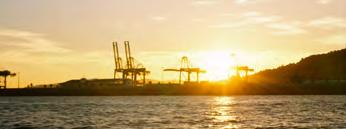
The port infrastructure and industrial zone warehouses could become a future new public space attractor. A place where the scale of these massive structures could help to connect the urban fabric with the waterfront and redefine the image of a modern city.
This is certainly an opportunity to be considered in the future urban design of Barcelona. A masterpiece in the Metropolitan Shoreline of Barcelona.


PROJECT NEXUS
BIOSCAPE BRIDGE


THE THREE LINES

CONNECTING THE TWO SIDES OF MONTJUIC


WHERE MONTJUIC FLOWS
WILDERNESS THROUGH RECLAMATION
FLUJO COMUNITARIO
Located at the South-West side of Mount Montjuic, the site is traditionally regarded as the periphery of Barcelona where Mount Montjuic is a large, physical barrier between the site and the city center. Surrounding highways tangentially touch the site without any pasusing point, which isolates it from the surrounding neighborhoods. Industrial zone near the site radiating from the port, while at the same time, there is a large residential area that is starting to branch into this industrial space of Zona Franca. This area is a slow zone, similar to some in the center city, but it is hostile to human enjoyment and activity through the lack of amenities and public green spaces unlike the ones in the center city.
Where Montjuic Flows works from a city to neighborhood scale to create a pedestrian-oriented community through a juxtaposition of slow-speed and high-speed infrastructure. Through two main strategies, green fingers extending the green axis of Mount Montjuic into Zona Franca to create a more enjoyable and healthier neighborhood, and polycentric nodes which create a slow-zone network that support and expand existing infrastructure and amenities Where Montjuic Flows increases connectivity, reduces urban heat impacts and increases environmental resiliency.

WHERE MONTJUIC FLOWS
Vegetated corridor catalyzing a vibrant pedestrian-oriented community
BEN SHAPIRO & CAL SULLIVAN & ANSON TSE


DESIGN STRATEGIES

LIVABLE CORRIDOR
POLYCENTER ACTIVATION
POLYCENTER ACTIVATION


The combination of the two tactics is to create a vibrant pedestrian community. The three main goals represented by fostering connection, propose public amenities and housing typologies fulfills the need for living, communication and enjoyment. Spaces are scattered in a polycentered way that all amenities are walkable and accessible.
Aside from the programs, these new livable corridors also connects exisitng isolated green spaces and pocket parks. These connection are proposed to continue developing and branching between each other creating a network of green infrastructure.
BEN SHAPIRO, CAL SULLIVAN, ANSON TSE


Amphitheater
Miyawaki


NODE AND ELEVATED CONNECTION


GreenGreenFingerFinger Green Finger Green Finger
Echoing to the branching network and green finger strategy, the project proposed an elevated pedestrian connection from Mount Montjuic towards our proposed node. This carries two main functions which increases human enjoyment of the space: First as a continuous physical connection to the mountain and second to connect existing physical infrastructure to the new planned amenities and housing. The design activates and connects all existing programs along the slope whilst every turning points can easily assess back to the Green Finger.
Miyawaki
FINGER ENTERS
NODE OF URBAN VILLAGE

Green FingerGreen Finger Green Finger Green Finger
PERIMETER BOUNDARY
GREEN FINGER ENTERS
THICKEN EDGE
CONTEXT SCALE AND AXIS ACCESS


HOUSING STRATEGY

STUDIO
512 SF (47.5 SM)
193 UNITS
1-BED
782 SF (72.5 SM) 151 UNITS
2-BED
1280SF (119SM) 192 UNITS


3-BED
1536 SF (142.6 SM) 66 UNITS
VIEWS


FOLIAGE COVERAGE ALONG GREEN FINGER


BEN SHAPIRO, CAL SULLIVAN,
PHASED EXPANSION
Miyawaki Forests
INDUSTRIAL EXPANSION
Barcelona is a densely layered place, and it is common for spaces to carry multiple functions. The industrial area of Zona Franca stands in stark contrast the adjacent neighborhoods of La Marina del Prat Vermell and La Marina de Port. This disconnection between industrial, residential, and urban use is reinforced by the transportation lines of commercial railway and the Ronda Litoral highway that bisect the neighborhoods. It is extremely difficult – and dangerous – for pedestrians, bikers, or anyone who is not using motorized transportation to cross this highspeed transportation boundary.
Before development, this area was the delta land for El Llobregat river extending from the mouth of the river to the base of Montjuïc mountain. In its current state, this same location is dominated by industrial use and has a drastically lower distribution of documented species than the neighboring natural anchors of Montjuïc and El Llobregat.
By referencing the natural history of the site, our project proposal aims to enliven these neighborhoods by introducing connections that facilitate improved pedestrian and bike traffic, and increase habitat space for a variety of species to occupy. We re-envision the transportation corridor as a corridor of biodiversity in partnership with urbanity by creating connections for people and species to move and thrive. By introducing an elevated bridge to promote pedestrian and bike access at strategic points, people have improved access over the transportation lines which also creates better physical and visual access to the harbor. These elevated connective pathways are populated with habitat-specific plant species to support biodiversity as an integrated part of the urban fabric. On the ground, adjacent patches of interstitial areas are reclaimed as habitat. Plants that flower and seed along the path can continue to populate the ground below where they fall. These moves support a more diverse urbanity by enabling ease of navigation for the people and species who make up the life of the city.

BIOSCAPE BRIDGE


Conceptual Masterplan of Zona Franca Bioscape Bridge


Species concentration in the Zona Franca region
OLIVIA MCGEOUGH + MONICA NICHTA


Atlas of native plant species within the Zona Franca region serving as habitats for key species groups
Conceptual graphic of seed diffusal carried by winds impacting interstitial parcels adjacent to Highway B-10


Conceptual section of Bioscape Bridge proposal highlighting improved biodiversity and urban connectivity
Conceptual drawing of Zona Franca highlighting urban and biodiversity connectivity potentials through bridge structures and adaptation of interstitial parcels
OLIVIA MCGEOUGH + MONICA NICHTA

Existing urban and biodiversity concentration zones

Axes of existing urban and biodiversity discontinuity related to B-10 Highway and Commerical Railway placement


Proposed Bioscape Bridge form highlighting connectivity to existing cutlural anchors
Proposed elevated Bioscape Bridge form, offering bike and pedestrian connectivity across B-10 Highway and Commercial Railway


Bioscape Bridge elevated bike and pedestrian path highlighting urban connectivity and multi-modal mobility routes across Highway B-10 and Commercial Railyard
OLIVIA MCGEOUGH + MONICA NICHTA

Landscape and covering qualities of interstitial parcels surrounding B-10 Highway

Existing hydrology and permeability study highlighing opportunity zones for key species


Proposed habitat zones along elevated Bioscape Bridge highlighting key species zones and typical section locations
Proposed planting strategies at interstitial parcels surrounding Bioscape Bridge corridor


Bioscape Bridge elevated ecotypes and key species habitats highlighting biodiversity diffusion throughout adapted interstitial parcels


Pine Forest ecotype locations with highlighted key species
Rock Rose (Cistus Clusii)
Stone Pine (Pinus Pinea)
Key Habitats, Species, and Community Anchors
Youth Engagement Activities
Expanded Access to Industrial District
Short-Toed Tree-Creeper (Certhia Brachydactyla)
Coal Tit (Periparus Ater)
Typical Section at Pine Forest Bridge Typology
Pine Forest


Wetlands ecotype locations with highlighted key species
Key Habitats, Species, and Community Anchors
Runnel Cooling Zones
Species Observation Points
Greater Mouse-eared Bat (Myotis Myotis)
Perez's Frog (Pelophylax Perezi)
Greater Pond Sedge (Carex Riparia)
Naturalized Ponds
BIOSCAPE BRIDGE CONNECTIVE CORRIDOR

Typical Section at Wetlands Bridge Typology
Wetlands
Conceptual Masterplan of Zona Franca Bioscape Bridge
Montjuic is a prominent landmark of Barcelona. Its unique location and topography helped to shape the development of the city itself. As we explored the city on foot, bike, metro, and through drawing and analysis, we found ourself drawn to the mountain again and again.
It is currently impossible to go from one side of the mountain to the other on its southern face. We had to see how true that was for ourselves, so we set out on foot and ran into barriers on every outing.
Through these many explorations, we discovered as much of the South face as we could, finding abandoned sites along the way. Many of them historically rich and beautiful, but entirely inaccessible due to the construction of Ronda Litoral.
After visiting these spaces, we centered our project around connecting these sites and opening the south side of Montjuic to pedestrians. Utimately, our project uncovers lost historic sites and adds pedestrian accessibility to the south face of Montjuic.


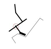
1 TWO GESTURES
Once two gestures were established, we drew connections between desired sites, both well known and found through our explorational visits. The fast path connects Montjuic Cemetary to Plaza de les Drassanes while the slow path connects the Abandoned Quarry, the Lighthouse, the Landing, and Old Anti-Air Battery.
2 TOPOGRAPHY
Placed in the context of topography, a direct connection between the sites clearly becomes infeasible.
3 URBAN FABRIC
Moreover, adding urban context provides other challenges to designing pathways between the desired sites.
4 ADAPTED PATH
Given the challenges presented by topography and existing urban fabric, the path adapts to these elements to connect the desired sites. However, they appear to fall slightly short of the targets (Montjuic Cemetery and Plaza de les Drassanes).
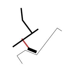
5 EXISTING PATHWAYS
Adding the context of existing pathways in red, the proposed path does in fact connect all desired sites.
6 FINAL MASTERPLAN
The resultant master plan joins all desired sites through an efficient fast path, an experiential slow path, and a historical carved elevator.
SYDNEY CHERRINGTON & HALEY BARNES
SITE EXPLORATION
QUARRY/TRAIN STATION, FAR DE MONTJUIC, HOTEL MONTECARLO/TUNNEL ENTRANCE, CIVIL WAR ANTI-AIR BATTERY


CEMETARY QUARRY EXISTING PATH LIGHTHOUSE
CLIFF LANDING GARDEN PLAZA


MASTERPLANS
TWO PATHS: CREATING TWO EXPERIENCES
The slow path joins uncovered historical moments through taking over old infrastructure where possible and creating new paths on the cliffside of Montjuic. The path connects the Old Quarry, Lighthouse, the Landing, Anti-Air Battery, and Jardins de Mossen, by re-paving existing, underutilized roads. Then, the Lighthouse to the Landing is connected by three original typologies since there was no existing infrastructure there. Overall, the slow path pays homage to sites lost through the construction of the highway.
The fast path connects the new neighborhoods beyond Montjuic to central Barcelona, guided by the context of monumental sites in the area and existing infrastructure. The path starts beyond Montjuic Cemetery where it is well-connected with bike paths, travels at the base of the cliffside where there is currently no accessibility, and ends by Jardins de Mossen where Barcelona bike path infrastructure connects to the center of the city.
PATH 1: PRIORITIZING EFFICIENCY
PATH 2: CONNECTING SITES, UNCOVERING MEMORIES
PATH 1: PRIORITIZING EFFICIENCY
The fast path connects Montjuic Cemetery and Plaza de les Drassanes. To connect these points, nine path typologies were developed in response to existing conditions. Starting at the cemetery, the path takes over the existing cobblestone road currently used for parking. Then, the path travels through the greenspace in front of the cemetery museum. Next, it transitions over the railway into the abandoned quarry. From there, it alternates between mountain paths one and two, the tunnel typology, and path with a pull off depending on the steepness of the cliff. After traveling past the cliff, the path crosses the road and connects with existing bike path infrastructure near Jardins de Mossen. While the path serves as a more infrastructural move, its materiality, synthesized in the collage, honors the stone elements of the places it travels through, bringing an awareness of place to the people traveling on the path.


PATH 2: CONNECTING SITES, UNCOVERING MEMORIES


1 OLD QUARRY & TRAIN STATION
Montjuic used to have many quarries which provided stone to be used in buildings across Barcelona, including the Sagrada Familia. This site was one of them, before they all closed in 1957. On this site lives an old train station, which is no longer in use. It is a beautiful open space at the base of the mountain next to the Montjuic Cemetery. The construction of the highway made both of these spaces inaccessible, depriving the public of celebrating the histories of the place.

2 MAR DE MONTJUIC
Mar de Montjuic is a lighthouse built in 1922 and went out of use in 2000. Located around half way up the mountain at the end of a historic road, it provides gorgeous views of the port, ocean, and the mountain itself. It is currently managed by the Port, but is not open or accessible to the public. Renovations were started, but never completed. It is a beautiful structure, and could be a great destination for locals and tourists alike.


3 HOTEL MONTECARLO & TUNNEL ENTRANCE
The structure at the bottom of the mountain next to the highway is nicknamed Hotel Montecarlo because it used to be a homeless encampment in the 1960s. It serves as an entrance to a network of tunnels inside of Montjuic. These tunnels have a colorful history, including being used in an ride for an amusement park that never came to fruition, being used in the civil war, and it is rumored to even connect to the castle on top of the mountain. There is an amazing lookout point above this structure as well, with spectacular views of the port, the ocean, and of course, Hotel Montecarlo. It is currently unaccessible by foot or bike because of the highway.
4 CIVIL WAR ANTI-AIR BATTERY
This open space next to Jardins de Mossen Costa i Llobera used to be used as an anti-air battery in the civil war, as many spaces in and around Montjuic were. Now, it is used by garden maintence staff as a parking lot/ storage space. It is a beautiful open space with great views of the mountain and its desert plants.
PATH 2: CONNECTING SITES, UNCOVERING MEMORIES


1 OLD QUARRY & TRAIN STATION
The two paths intersect in this space, creating a joint for gathering, resting, and experiencing the site’s unique qualities. The left side of the quarry embraces its natural state, creating a park-like softscape that bleeds into an existing pavement, which is slowly being overtaken by nature as well. The middle has a slight change of elevation, creating a lowered, more intimate gathering space. The right celebrates the quarry’s past, with piles of beautiful rock. They create a maze-like condition, forcing visitors to weave through them, and open around the historic train station.


2 MAR DE MONTJUIC
We envision this lighthouse as becoming a bar, serving as a destination for tourists and locals alike. Its pristine location overlooking the port and the ocean, as well as being the highest point on our second path, makes it the perfect spot to get something to eat or drink while enjoying the views. We want the section to mirror its condensed condition facing the mountain, and open to the expansive experience looking over the cliff’s edge. The plan takes inspiration from the topography lines surrounding it, while keeping the overall shape of the existing historic structure.


PATH 2: SUSPENDED INTERVENTION

The slow path from the Lighthouse to the Landing did not have any existing infrastructure, so we designed the path as a series of three typologies. Starting from the Lighthouse with a stair and path carved on the surface of the mountain, then a suspended bridge, and arriving at the Landing with a straight stair encased in the cliff. The suspended bridge modules are folded to move with the cliff and create moments of rest, and the encased stair section transitions from open to closed moments, making a sculptural void that frames views, and explores the mountain.


PATH 2: CONNECTING SITES, UNCOVERING MEMORIES
3 HOTEL MONTECARLO & TUNNEL ENTRANCE

We want to give access to the tunnels within Montjuic to the public! Using Hotel Montecarlo as an entrance connecting to the fast path, part of these historic tunnels will lead to an elevator bringing people up to the landing above. This landing is a direct connection to the experiential path, and serves as a lookout point over the port and ocean. Another tunnel from this point connects to a different elevator, which takes visitors all the way to the castle at the top of the mountain.


4 CIVIL WAR ANTI-AIR BATTERY

This space serves as the Barcelona city side entrance to the slow path, and opens to Jardins de Mossen Costa i Llobera. Using existing retaining walls to meter the space, the path and various plaza areas create spaces for play, rest, and viewpoints. Ultimately, the spaces created funnel users to the Hotel Montecarlo lookout and to interact with the rest of the experiential path.


Barcelona is a densely built and populated city, with its largest public spaces opening up to the waterfront. On the southern side of Montjüic, however, lies Zona Franca, a developing residential neighborhood outside the city center, with no access to the sea. This isolation from the Mediterranean is due to Ronda Litoral, Barcelona’s main highway, cutting off the residential neighborhood from the industrial harbour on the water.
After exploring Zona Franca numerous times on both the industrial and residential sides of the transportation division, we see an opportunity to design a waterfront access point for the public. By taking advantage of the industrial zone’s unused or empty spaces and current structures, the interventions create active public spaces and a means to encounter the industrial layer without interference.
Our project reconnects the residential area of Zona Franca to the sea through existing avenues, and in doing so creates a destination where the public can coexist with the industrial harbour as well as experience its activity.


MASTERPLANS
METRO LINE
Reactivate existing public space
NEIGHBORHOOD CONNECTION
Reinforce current access pathway
CANOPY CONNECTION
Bridge dense industrial layers between destinations
WAREHOUSE RENOVATION
Construct a public attraction respecting the harbour
by walk
Port Comercial
Zona Franca
METRO LINE
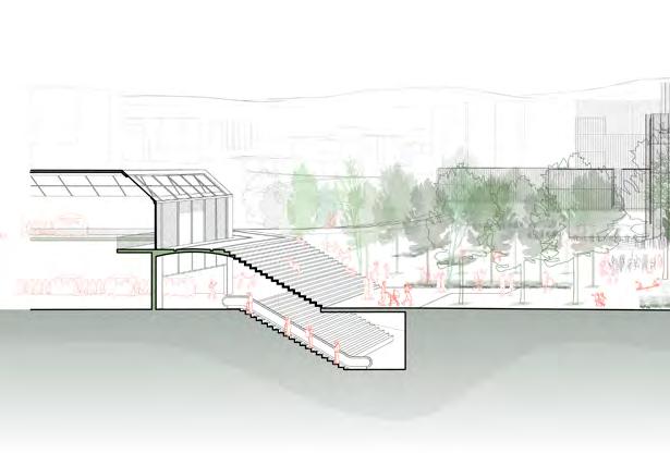
Reactivating Carrer A, an unused bike path under two elevated metro tracks, is the first of the three main lines of our project. The space is beautiful, however it is also massive and underprogramed, driving us to intervene with a design that defines space at a more human scale. In between two of the metro stations along Carrer A, we used the existing concrete structures of the rail line to design a system of hanging walkways that contrast the stereotomic forms with light steel cables suspending the thin platforms. These walkways and platforms not only create a new level of topography drawing people down from the metro stations, but also define spaces beneath them that are now available for programming.


Designing the pathway typology allows opportunity for variation along Carrer A using the standard part, which is an important aspect of reinventing this space for public interest. The platforms can also be suspended at different heights, changing circulation rythyms and programatic possibility in the sectional space.


Stainless Steel Netting
Aluminum-Punched Decking
Garden; Open Seating
Ball Court
METRO + CANOPY JOINT
The moment of intersection between the revitalized metro line and the deck which connects to the warehouse and waterfront is an important joint in our intervention on Zona Franca's industrial harbour. Instead of abruptly stopping the canopy at the metro line, we pushed it through the public space, threading under the elevated rail lines and above the pubic ground level. This move maintains a clear difference in the two paths, both in orientation and structure, but allows them to connect briefly at the elevated walkways that hang beneath the metro platforms. By extending through the metro lines the beginning of the canopy level can be seen from a far in either direction, inviting passerbyes to traverse into the new public space.
Line
Metro Line
Industrial Harbour
CANOPY CONNECTION
Not wanting to disrupt the numerous transportation avenues and cargo areas between the metro line and the warehouses, we erected a canopy for pedestrian passage above the industrial groundlayer. Iterating from a flat platform to the scissor-like levels to address the elevation change from the metro line to the warehouse rennovation, we arrived at this form serving two programatic strategies. The bottom sloped level provides the main circulation corridor between public spaces, while the top deck is slower paced, designed for uninterrupted views extending from Zona Franca and Montjüic over the entire harbour.


02 VIEWING DECK
01 CIRCULATION AVENUE
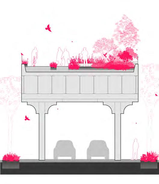
WAREHOUSE RENOVATION
The renovation of two waterfront warehouses creates a destination for people of Zona Franca and Barcelona that reconnects them to the sea. Wanting to respect and not distrupt the industrial ground layer, our parasitic addition uses existing structure to support a new public deck above. The space created offers places to eat, play, and exersize, all while enjoying panoramic views of the harbour. Additionally our renovation includes repurposing the interior from storage space to Barcelona's new fish market. Though the market still operates on an industrial level, people will be able to enjoy the products in the eateries above. And while the renovation is large scale, it has relatively low impact on the port activity below and serves as an optimal joint between public space and industrial activity.


The introduction of supportive arms, joining the new column with the original, not only facilitates structural bracing, but more importantly punches into the warehouse, allowing for a public catwalk layer within. Here pedestrians may watch and experience the intese industrial environment below without interferring in the workflow. The arm concept and shape mimic the harbour's shipping cranes which define the area's skyline.


The catwalks are accessed by staircases descending through the dense truss system, leading to exterior walkways spanning the length of the warehouse. Each warehouse contains two seafood bars so people may percieve the activity below and across, while enjoying fresh fish from the market. Heavy moments on each wall, created by the arm structures, allow for the center of the warehouses to be open and spacious providing optimal views from the catwalks
01
VIEWING CATWALKS
Seafood Bar 1
CONCEPT MODELS


3 MAIN LINES
METRO + CANOPY JOINT


WAREHOUSE ITERATIONS
IMAGINED VIEWS

CANOPY CONNECTION

WAREHOUSE RENOVATION
Nestled at the base of Montjuïc Mountain, between the active port and the industrial Zona Franca, Sans Montjuïc is one of Barcelona’s newest yet most overlooked neighborhoods. Geographically and infrastructurally isolated, it is cut off from both the mountain and the Mediterranean Sea by a network of highways, creating a sense of seclusion and disconnection from its natural and urban surroundings. The design strategy, Flujo Comunitario, seeks to bridge this divide, through reinforcing a sense of community identity and reconnecting the neighborhood to itself, Montjuïc, as well as its historic roots as a former wetland.
The master plan unfolds in two phases, with the first focused on immediate infrastructure and community-building needs. Central to this phase is an integrated water management system linking key community anchors: Infiltration Plaza, the Community Library and Wet-Meadow Park, and the Knot Pools. Utilizing a network of perforated pipes, bioswales, canals, and infiltration meadows that filter and redirect water, residents will be enabled to interact with the environment during periods of both high and low rain. The second phase will extend this strategy throughout the entire neighborhood, fostering a greater sense of community identity and connection to the surrounding landscape.
FLUJO COMUNITARIO
REINTRODUCING WATER TO THE SANS MONTJUIC COMMUNITY
ELLIE DEDRICK, ROSIE WANG, SEAN ALBERTS

ELLIE DEDRICK, ROSIE WANG, SEAN ALBERTS
ANALYSIS: LIMINALITY + HISTORIC WETLANDS


CONCEPT COLLAGE

WATER FLOW DIAGRAM


ELLIE DEDRICK, ROSIE WANG, SEAN ALBERTS
WATER INFILTRATION SYSTEM

ELLIE DEDRICK, ROSIE WANG, SEAN ALBERTS
SITE STRATEGY


MONTJUIC INFILTRATION PLAZA


ELLIE DEDRICK, ROSIE WANG, SEAN ALBERTS


ELLIE DEDRICK, ROSIE WANG, SEAN ALBERTS


BOOKSHELVES


TWO GRIDS SLICE INFILTRATE

ELLIE
DEDRICK, ROSIE WANG, SEAN ALBERTS

INFILTRATION


PLANTING


ELLIE DEDRICK, ROSIE WANG, SEAN ALBERTS
POOL KNOT 3


FIRST FLOOR PLAN SKYLIGHT


WALLS
POOLS SKYLIGHTS


CITY (MARINA DEL PRAT VERMEL)
UNDERGROUNDTUNNEL
ANCHOR

FUNICULAR

SEA
HARBOR
CITY (DRASSANES)
ROAD


TUNNEL | GROUND ANCHOR | HORIZON
FUNICULAR | SKY
PROMENADE :
& DEATH | ELEMENTS OF LIFE


ANCHOR
UNDERGROUND TUNNEL
ANCHOR & PLANS
REACTION TO SITE: GROUND | HORIZON | SKY

TUNNEL (GROUND)
TRAIN (HORIZON)
ROAD (HORIZON)
HARBOR (HORIZON)
FUNICULAR (SKY)
FUNICULAR (RITUAL & TRANSITION)

EXTERIOR MEMORIAL TOMB STONE (MEMORY)
EXHIBITION SPACE (PUBLIC & MEMORY)
TUNNEL (TRANSITION)
CAFETERIA (PUBLIC)
CREMATORIUM (RITUAL)
CIRCULATION CORE (TRANSITION)
GATHERING HALL (PUBLIC)
COLUMBARIUM (MEMORY)
REFLECTION SPACE (MEMORY & RITUAL)
KEY MOMENTS COLLAGE VIGNETTE

2. ANCHOR

3. FUNICULAR
4. SEA
1. TUNNEL
4. SEA
3. FUNICULAR
KEY MOMENTS COLLAGE VIGNETTE


3. FUNICULAR
4. SEA
4. SEA
3. FUNICULAR
Our exploration began with the concept of wilderness in La Zona Franca. Typically understood as untouched land supporting a genuine ecosystem, wilderness evokes a sense of freedom and raw natural beauty. However, in an urban context, achieving this level of protection is often unrealistic. To understand Barcelona’s efforts in fostering wilderness, we looked to the Barcelona Green Infrastructure and Biodiversity Plan. While it succeeds in creating habitats and improving public spaces, it stops short of establishing truly wild conditions.
We conducted a site walk in La Zona Franca to experience the character of abandoned and neglected spaces firsthand. These areas, with minimal human presence but potential for nature’s reclamation, inspired us to imagine them as nature reserves. This vision grants them the necessary time to rewild while integrating them with Catalan holidays, offering limited public access to experience a wild, untouched condition.
We identified three specific sites, each with existing infrastructure that could serve as tools for rewilding and redemption:
Lifeless Park
This site involves reimagining an underutilized park atop a parking structure. By cutting the garage roof along its structural grid and tilting the results down to create perimeters, we aim to reclaim part of the space as a nature reserve.
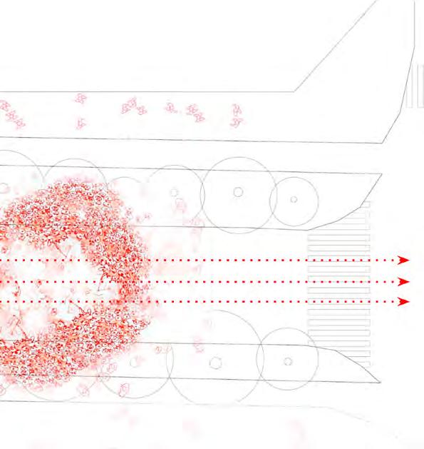
The Harbor
Situated on an active oil facility spanning 150,000 square meters, this site utilizes decommissioned ships and barges to construct a harbor purification system. This system would clean and manage oil spills, reintroducing ecological function to an industrial zone.
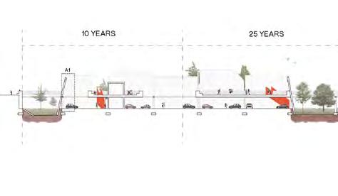
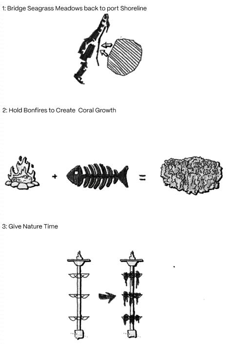
Fire and Water
Focused on reconnecting a seagrass meadow damaged by ship turbulence to the constructed breakwall, this project creates a barbecue platform. Organic matter and ash from the barbecues are stored within the structure and transformed into coral blocks, establishing marine habitat beneath the platform.

WILDERNESS THROUGH RECLAMATION
JACOB KUHN & TOMMY RYAN


JAKE
KUHN AND TOMMY RYAN


KUHN AND TOMMY RYAN


JAKE
KUHN AND TOMMY RYAN


Lifeless Park Harbor Fire and Water


DAYLIFE

Studio class at Potosi with Manuel Bailo

DAYLIFE
Studio class at Potosi Open talk #7 with Josep Llinàs

DAYLIFE


DAYLIFE

Mid Review at Potosi Jury: Rosa Rull + John Comazzi


Final Review at Potosi
Jury: Giovanna Bartoleschi, Miquel Ruiz, Rosa Rull

Visit to Bacelona Forum building + Plaza by Herzog & de Meuron


Barcelona visit to Ulldecona Social Housing by Mias architects & Coll-Leclerc


by BailoRull
Construction Site visit to Stone House


Visit to Santa Clotilde Gardens by
Rubió i Tudurí

OPEN TALKS


PUBLIC CATALYST
ARCH 5605 - Urban Materiality
Manuel Bailo_Professor of Architecture
Barcelona is internationally renowned as a city where urban design is constantly evolving, and architecture profoundly shapes the way of life. It is a city where the voices of architects have historically played a pivotal role in guiding its development and improvement. The 19th-century Cerdà grid and the city’s transformation during the Olympic Games established Barcelona as a place where architecture is deeply ingrained in its culture. It is both an ancient and modern city, where urban design and architecture form a unified identity.
This course focuses on the public realm, exploring how the city has evolved through the design of its public spaces. Students will analyze how public spaces have served as catalysts for urban transformation. The course will introduce students to the city’s scale and landscape design, with an emphasis on materiality. Participants will learn how to use materials and atmospheres to address urban and landscape challenges. Additionally, the course will expose students to innovative urban design and landscape techniques that confront contemporary issues such as climate change and sustainable energy.
The course comprises lecture sessions and studio classes, including desk critiques and presentations. Barcelona will serve as a living laboratory for studying public spaces. The program is divided into two phases. The first phase includes lectures, research, and drawing exercises centered on public space projects completed in Barcelona over the past 40 years. The second phase concludes with a smallscale design proposal for a public space, guided by the principles of Public Catalyst’s theory.

JACOB KUHN & TOMMY RYAN & ROBIN XIAO


HALEY BARNES & SYDNEY CHERRINGTON & ELLIE DEDRICK

JACOB KUHN & TOMMY RYAN & ROBIN XIAO
MODERN CITY - MODERN
ARH 5613 - 501 - Gaudi’s Legacy
Mónica Cruz _Associate Professor
Celia Marín_Associate Professor
Since the transformation of Barcelona during the fourth quarter of the 19th century the shape of the city was established for the times to come, but the rationalistic lines of the city planning that have defined the organization and structure of the streets were not going to define the image of its architecture and its people.
The rising of Modernisme, with Gaudí’s architecture as a paramount example, sets the beginning of Barcelona’s architectural development, constantly hesitating between breaking new ground or claiming a return to tradition. Through a set of parameters to analyse traditional and contemporary architecture the course seeks to identify the dual complexity of Barcelona’s landscape through the concepts of city and architecture, tradition and modernity, technology and technique, place and context.
The course is organized in a series of lectures and field trips, focusing on the question of this complexity, combining historical approaches with contemporary examples of the most groundbreaking architectural tendencies in the city and their engagement to define a local tradition, even a contemporary one.
The evaluation consists in a series of short assignments related to the field trips and lectures. Bringing a carnet to draw and take notes will help the student to make the most of this experience and have enough material to analyse the buildings for the assignments.

MODERN LIFE
ELLIE DEDRICK & AUSTIN SMALL


Cristalleries Planell
Cristalleries
Cristalleries Planell
Casa Vicens
Assingment 4 / Gaudi’s Legacy


Austin Small + Ellie Dedrick
rock white green oral
balcony detail
brick detail
CONSTRUCTION OF THE
PLAN 5611 - 501 - Barcelona Urban History
Josep Parcerisa_Professor of Architecture
Álvaro Clúa_Associate Professor
The city of Barcelona is an on-going urban laboratory. Which role play the ideas and settlements, the geography and history in the shaping of the landscape of this metropolitan city?
The module aims to ask this question through a combination of lectures and on-site visits focused on the analysis and discussions of urban places and their landscapes. Each lecture at school consists on the presentation of one or two theoretical topics ended by a final open discussion.
The field trips are part of the theoretical background of the module and tries to give a close up view. This year, students will have the chance to participate on the events related with the International Biennial of Landscape Architecture that will take place in Barcelona.
The final assignment should be an individual, precise and original contribution on any topic related with the course. The students will be evaluated by a final public presentation of 10 minutes’ length and a short paper illustrated by drawings, photographs, visuals and written arguments.
THE MODERN CITY


JACOB KUHN
JACOB KUHN
AUSTIN SMALL
ELLIE DEDRICK
THESIS
ALAR 8010 - 4010 - Thesis
Manuel Bailo_Professor of Architecture
This seminar provides students with the foundational skills to organize and develop a focused research topic in architecture. Emphasizing the importance of contextual exploration, the course leverages the unique opportunity of studying in a new city, encouraging students to engage directly with its spaces, culture, and architectural character.
Participants will identify and investigate local topics aligned with their academic and professional interests, using the city as a living laboratory for architectural inquiry. Inspired by the methodologies of renowned architects such as Álvaro Siza and Camillo Sitte, students will approach their research with a balance of intuition, observation, and analytical rigor.
Through guided exploration and hands-on engagement with the urban environment, students will uncover the forces shaping architecture and urban spaces, gaining insight into the interplay between design, culture, and context. This seminar fosters a deeper understanding of architectural research as an experiential and reflective process.


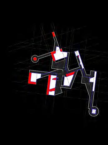
COMPOSITE COLLAGE: OVERLAYING LAYERS OF TIME
COMPOSITE COLLAGE: OVERLAYING LAYERS OF TIME AND SCALE (HUMAN | INDUSTRIAL | CITY) AN INTERSECTION BETWEEN DEATH OF INDUSTRY, AN URBAN JUNGLE, AND HUMAN EXPERIENCE
ROBIN XIAO
Instructors:
Manuel Bailo

Eva Beristianou
Àlvaro Clúa
Mónica Cruz
Celia Marín
Professor of Architecture
Director of Barcelona Program UVa
Assistant Professor
Associate professor
Associate professor
Associate professor
Josep Parcerisa Professor of Architecture
School of Architecture International Studies Office University of Virginia