

UNSW Waseda Joint Studio 2024 August
Location05
Part2 Proposed Masterplan 09
Gordon Kids Friendly09
G1.01 VISION AND CONCEPT12
G1.02 MASTER PLAN AND FRAMEWORK 16
G1.03 OPEN SPACE GUIDELINES24
G1.04 ROAD GUIDE LINE32
G1.05 HOUSING GUIDELINES44
G1.06 DETAIL DESIGN50
Sub Urban Community Connection59
G2.01 VISION62
G2.02 MASTERPLAN66
G2.03 GUIDELINE76
G2.04 STATION DESIGN98
Living With Heritagies115
G3.01 VISION118
G3.02 MASTER PLAN128
G3.03 STRATEGIES136
G3.04 SPECIFIC146
INTRODUCTION
ABOUT UNSW JOINTSTUDIO
Introduction
This is a joint studio between the Waseda students of Yaguchi Lab, UNSW UC Studio, and the University of Hong Kong. Students were expected to work as a group and produce a professional-level urban design document and architectural design proposal for Gordon, NSW, Australia.
This Joint Studio focuses on the design of a resilient multi-functional community on a selected site north of Sydney (Robert Gordon Station) as a model of a replicable built nucleus for livable cities and transport-oriented urban communities that are, at the same time, resilient, sustainable, energy efficient, and able to develop and withstand threats posed by heatwaves, floods, and extreme weather caused by climate change in the coming decades.
In this studio, we plan the guidelines for TOD areas to be effective. This year, three groups decided on the concept of TOD development and proposed guidelines for each group.
Purpose of the Studio
Students will form teams to develop strategies for urban intervention through urban planning or new urban typologies. The project should create a partially autonomous community that connects selectively with the outer urban context and emphasizes meaningful connections between space and life, using three different scales.
・Large (metropolitan) urban scale (XL): relating the site to the city as just one piece of the puzzle - a kit of parts to make the most genuine, exciting and enduring city possible;
・Intermediate (precinct) urban scale (L): integration of public and communal open spaces (streets, plazas, green spaces) with the surrounding buildings, embedding a fine grain of many uses, paying close attention to materiality and amenity;
・Building (development & typology) scale (M&S): resolving a mixed-use building in detail with attention to skyline, footprints, proportion, tectonics, separation, frontage, over-shadowing, amenity and sustainability.
Schedule
The Studio is a three month long studio that began in early April and end in August.Waseda student followed schedule basicly.
Apr/10: Site Analysis (Region + City + Site Scale)/ SWOT
Apr/17: Vision + Precedent Study/ Scale Comp Draft
Apr/24: Vision + Precedent Study/ Scale Comp Draft
May/01: Vision + Analysis Presentation
May/15: Conceptual Framework Diagrams
May/22: Conceptual Framework Plan
Development / Massing Model
May/29: Conceptual Framework Plan
Development / Massing Model
Jun/05: Conceptual Framework Presentation
Jun/19: Conceptual Architectural Design 1
Jun/26: Conceptual Architectural Design 2
Jul/03: Conceptual Architectural Design 3
Jul/10: Conceptual Architectural Design
Presentation
Jul/16: Submit Booklet Presentation
Jul/24: Final Presentation Panel/ Booklet
Aug/05-10: Presentation at UNSW
PROJECT BACKGROUND
TOD Planning
Currently, a transit-oriented development centered around a train station is being planned in New South Wales in light of population growth. This plan aims to increase the maximum height to 21 meters within 400 meters of the station to increase housing density and the number of housing units to prepare for the growing population. 37 stations along the line will be targeted and subject to TOD* planning regulations and 377,000 units will increase in those area.
The area around Gordon Station, which is the subject of this project, is located in the Coolingay Council out of New South Wales. The population of New South Wales is growing, and the Gordon Station area is no exception. About half of the population is born overseas, with a tendency to see a large number of immigrants from the Asian region.
*TOD(Transit-oriented development)
30-year-old urban design approach that proposes compact, walkable, and mixed-use communities organized on central transit hubs inspired by the American architect Peter Calthorpe.
The population information of Gordon,NSW
The concept diagram of TOD planning
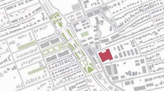
SITE LOCATION
Resional Scale
Gordon is a suburb of Sydney and is part of the Ku-ring-gai council.
Gordon Station provides access to central Sydney in about 30 minutes by train. Express trains also stop at the station, making it convenient for commuting to work or school.
The Pacific Highway and Mona Vale Road pass through the area, allowing easy access to central Sydney and other suburbs by car.


Other Railway LEGEND
Railway(Sydney-Gordon)


LAND USE
USES
Current Situation
In Gordon, many residences are located, and these are surrounded by lush greenery. In the central area around Gordon Station, a complex of areas is formed by stores, restaurants, medical facilities, libraries, councils, etc. The residential area is dominated by upscale single-family homes with large lots and lush gardens. Residential areas are dominated by upscale singlefamily homes with large lots and lush gardens. Along the highways, medium- or high-density condominiums and townhouses are also increasing, catering to a variety of housing needs.
LEGEND
C2 - Environmental Conservation&Management
C4 - Environmental Living
E1 - Local Centre
E3 - Productivity Support
MU1 - Mixed Use
R2 - Low Density Residential
R3 - Medium Density Residential
R4 High Density Residential
RE1 - Public Recreation
RE2 - Private Recreation
SP1 - Special Activities
SP2 - Infrastructure
TRANSPORTATION
Site Scale
From Gordon Station, buses run to nearby suburbs, shopping centers, schools, and hospitals, providing access to a variety of locations via public transportation. Especially during commuting hours, buses run more frequently.


Gordon
Killara
EXISTING CONDITION
Blessed Environment
The area surrounding Gordon Station offers a rich natural environment and quiet residential neighborhoods. The town is dotted with buildings of historical value, and the residents take pride in the scenery.
Specifically, the rich natural environment includes forests where flying foxes nest, rivers including the Stony Side, and green spaces on private land such as golf courses. Many of the houses have gardens and the streets are planted with many roadside trees.
On the other hand, while there is a vast amount of residential land space, commercial and recreational facilities are few in number, with one commercial facility and a series of retail stores along the HWY, where most daily necessities are obtained. area.
As for buildings of historical value, many cultural heritage sites remain, including the station building, library, mansion, and school. Many of them are now museums and retain their functions, and are registered and preserved on the heritage list. However, some of them are within 400 meters of the station, which poses a challenge for development.


GORDON KIDS FRIENDLY
Mao Kobayashi / Shota Honda / Kei Matsumoto

Member

ROLE
Open Space
Detail Plan

ROLE
Flamework Road Design

KEI
ROLE
Housing Design
Detail Design
MATSUMOTO
SHOTA HONDA
MAO KOBAYASHI
CONTENTS TABLE
04ROAD GUIDELINES
03OPEN SPACE GUIDELINES
Sports Promotion Type
Animal Protection Type
Green Space Type
Historic Preservation Type Promotion Of Cultural Learning Type
Pet-friendly Type
Landscape Pallettes
05HOUSING GUIDELINES
Three Housing Types
Apartment In Core Area
Ground Level Design
ADU In Sourrounding Area
06DETAIL DESIGN
Development Concept
Floor Plan
Massing
Playground Perspective
Pedestrian Sidewalk Perspective
01VISION AND CONCEPT
1.1 VISION
We chose the theme of “Gordon Kids Friendly” for our redevelopment plan because the Gordon area has a large number of schools and good educational facilities, including some of the most prestigious schools in the Ku-ring-gai area. However, one of the challenges facing Gordon is a car-dependent society and on-street parking, which creates a difficult environment for children to live in.


1.2 SWOT ANALYSIS


StrengthWeakness
-Rich natural environment
The Stony River and a protected area for flying foxes
-Numerous educational institutions
Many educational institutions from kindergarten to high school, including many old and prestigious schools, are located in the area, making it suitable for raising children.

-Single use
Except for the area in front of the station, the area is a single residential area with large blocks of land.
1.2 SWOT ANALYSIS


OppotunityThreat
-Population Growth
The population is increasing due to the influx of immigrants, and is expected to increase further with the development of the railway line.
-The HUB
Located along the HWY, it is a relay point connecting
-Car dependence
High reliance on cars due to HWY running through the center of the city.
There is a lot of on-street parking, and the area is not suitable for walking. destinations.
Chatswood
Gordon
Hornsby
R=5km
R=5km
AND FLAME WORK MASTER PLAN 02
2.2 CORE AREA CONCEPT
The area within 400 meters is called the core area and the area outside of 400 meters is called the surroundings area, which will be developed differently. The area within the 400-meter radius will be re-planned with apartments and commercial facilities, as the height limit will be relaxed to 21 meters. The core area will also have sufficient green space. In consideration of the surrounding detached houses, the height will be reduced at the end of the 400m. In addition, an open space will be created in front of the station. Streets will be re-planned so that pedestrians and biker will have priority.


Waseda
2.3 LAND USE
Variety of Use
Land use is defined by the location of each town block. In the plan, the area 400m from the station is called the core area and the area outside of 400m radius called the sorrunding area.
Core area
Uses will be combined and urban functions will be concentrated. In particular, many child-oriented functions will be placed inside commercial facilities. In addition, by placing retail stores on the lower floors along the railroad and HWY, the building will be Mixed Use and aim to break away from car dependence by increasing the variety of walking space. As for housing, the project aims to improve the convenience of living space around the station by dividing housing types.
Surrounding Area
The development of back streets will eliminate on-street parking, expand street space, and provide walking and green space. Build some affordabkle housing and develop back roads to eliminate on-street parking and create wide street spaces.
2.4 OPEN SPACE
Multi-generational exchange place
The goal of this program is to create an environment to enjoy learning opportunities as a city for children. Key to the arrangement of open spaces is the creation of a certain sense of space where children can engage with each other. We recommend the new spaces should located in a suburban community area with a large number of schools and a high population density of children.
By adding spaces where children can interact with each other, we excepexted the installation of glow-in-thedark spaces that allow children to experience nature in certain sections of the city.


2.5 PUBLIC TRANSPORTATION
Circulation within the region
Gordon station is mainly used for rail traffic. The distance between the railroad stations is about 800 meters. The existing bus service does not cover all the traffic in the Grodon area, forcing people to travel by car. By increasing the number of bus routes, the project will enable east-west movement across the station, which was separated by the rail line, and will provide a system for people to use public transportation to get around the Gordon area, making it safer for children and more walkable for residents.


Administrative Division
500m Circle Ryde Road
Transit mall
Service circulation
2.6 CIRCULATION
Road Design Typology
This program encourages the use of bicycles for the purpose of providing safe transportation for children. Bicycle lanes should always be provided through the program.There are three different road design typologies.
①Main Road:
The street with about 20 meters wide, including sidewalks. Mainly, indicated the PHW.
②Major Road: Road with the width at least 15 m, including sidewalks.
③Minor Road:
A street less than 15 m wide, including sidewalks. Support movement from residential to public facilities.


This page is intentionally left blank Th T is

OPEN SPACE GUIDELINES 03
3.1 SPORTS PROMOTION TYPE
The area will use existing recreation grounds and sports facilities to encourage children’s physical activity.
[A] Sports facilities: Install courts and tracks for sports like soccer and tennis.
[B] General use: Ensure a level, spacious area for running and group activities.
[C] Safety turf: Cover 70% of the area with turf for safety.
[D] Noise buffer: Plant 3-meter tall trees around the perimeter.
[E] Safety barriers: Install 3-meter barriers to keep equipment contained.


3.2 ANIMAL PROTECTION TYPE
The area is designed to educate visitors about living organisms and ecosystem protection, using a nearby bat sanctuary.
[A] Pond: Create a watering hole to support riparian animals.
[B] Lawn area: Provide green space for shelter management activities.
[C] Observation lawn: Use for observing flying foxes and birds.
[D] Trees: Plant trees to integrate with the surrounding forest.


3.3 GREEN SPACE TYPE
The area’s green space promotes health benefits like lowering blood pressure and relieving fatigue due to the trees’ phytoncide effect.
[A] Forest bathing route: Use existing forest roads and maintain them, choosing trees under 6 meters for side roads.
[B] Open space: Create an inviting area near the forest road entrance.
[C] Tree maintenance: Regularly cut down decaying trees to ensure safety, with trees at least 5 meters high.


3.4 HISTORIC PRESERVATION TYPE
The area utilizes Gordon’s historic resources.
[A]Preserve cultural assets: No alterations should be made to buildings designated as preserved cultural assets.
[B]Central plaza: Place a plaza in the center to encourage interaction with historic assets.
[C]Turf open space: Establish a turfed open space leading to the central plaza to make it inviting for residents.
[D]Tree-lined path: Create a walkable, tree-lined path to draw people into the central plaza.
LEGEND


3.5 RIVERSIDE TYPE
This area will create an environment for residents to engage with water and nature. It will also serve to protect the community from flooding.
[A]Build a retention pond : Preventing Blackbutt Creek from flooding.
[B]Planting vegetation : Reducing river flooding and flood damage. Use sufficient soil to absorb water like a sponge, especially widening the forested area in the upper reaches of the river.
[C]Creating a riverside plaza : including BBQ areas and space for river activities for social interaction.
[D]Mini open space : attracting people to the plaza and riverside.
LEGEND
planned open space trees retantion pond maintaining the housing lawn maintaining the status quo exsisting road river


3.6 PET-FRIENDLY TYPE
The Kulingai area, including Gordon, has around 25,000 pets. A space for people to interact through their pets is needed.
[A] Grassy open space : Creating for a dog run, with plazas designed for different pet types, shaped according to contour lines.
[B] Forest vegetation : Blocking block noise and provide shaded resting areas.
[C] Bicycle parking
[D]Golf course : Keeping for residents to play and socialize.


3.7 LANDSCAPE PALETTE
Native groundcovers
It is a native plant of Ku-ring-gai, groundcover. It is planted at the entrance of open spaces and in open spaces. It is used as turf. It is recommended to refrain from planting non-native turf species and to plant native plants whenever possible.


Native small trees and shrubs
It is a native plant of Ku-ring-gai, small trees and shrubs. They serve to attract wildlife for pollinators. Planting native plants helps to protect the local ecosystem.


Flannel flowerHardenbergia violaceaAdiantum aethiopicumHibbertia scandens
Pandorea pandoranaKennedia rubicundaClematis aristataDianella caerulea
Xerochrysum bracteatum
Boronia ledifoliaPultenaea flexilisGrevillea speciosaBanksia ericifoliaBanksia serrata
Bauera rubioidesAcacia terminalisCeratopetalum gummiferum
Dillwynia retortaZieria smithii
04ROAD GUIDELINES
4.1 ROAD DESIGN
Road Typology
This chapter presents the specific designs for each area. The roads are divided into seven typologies, presenting a total of nine designs. The designs are planned primarily to provide walking space and bicycle paths.
4.2 MAIN ROAD
A) Street Parking
The key to this condition is to limit the number of lanes to one. Instead of setting this condition, a 2-meter-wide bike lane centered on the station would facilitate shortand medium-distance travel.On-street parking spaces will be located on the center line of the street as a place where people visiting the city by car from far away can park. This will allow for wider sidewalks, an outdoor café, and a play wall to create a human-scale space.


4.2 MAIN ROAD
B) Bus Stop
Key to this design is the placement of the bus stop on the sidewalk side. By having the bus stop installed so that it does not block the roadway, it will facilitate the progress of the roadway. Provide a bus stop across the bike path. This will provide a system that allows people to safely move to the sidewalk and smoothly get on and off the bus when boarding and alighting.


4.2 MAIN ROAD
C) Surrounding Area
The road condition outside the 400-meter radius is to limit the number of lanes to two. This is a mid-area between the central city around the station and the suburbs with three lanes of traffic, and will serve as a buffer. On-street parking spaces will be eliminated to accommodate increased vehicle speeds. Plantings along the street are encouraged to protect pedestrians.
4.2 MAIN ROAD
D) Intersection
In this design, bike lane travelers follow the pedestrian signals. The purpose of this condition is to maintain safety when crossing busy arterials. In addition, the roadway will eliminate the off-street parking space near the intersection. Instead, a right turn lane will be provided.

4.3 MAJOR ROAD
A) Along The Railway Line
The most key aspect of this design is the single bike lane. There is a swath of plantings along the line. To ensure the safety of bikers, they will be located away from the plantings along the route. The reason for not cutting down the vegetation is to keep the sound of the rail line from echoing into the residential area.


4.3 MAJOR ROAD
B) Intermediate Road
This design will serve as a connection to schools, open space, and other facilities for bicyclists. Although the PHW was the main roadway to travel on, it will support travel as an interstate.


4.4 MINOR ROAD
C) Residential Road
The most key to this condition is to prohibit on-street parking on the street by residents. Paint the bike lane and make it completely dedicated to bicycles. Create a tree-lined boulevard with large plantings to motivate residents to walk. Lay out crosswalks at 100meter intervals to create a street space that is easy for residents to walk on.


4.4 MINOR ROAD
A) Residential Back Street
This road is a path to introduce ADUs; it will be laid out to connect to the ADUs. As a back road in a residential neighborhood, it will also serve to support communication between residents.
Now, there are lots of street parking in residential road.
(4.3-a) We plan to move those parking in the each housing property. To promote this movement, we introduce new back road,and raise connection.


4.4 MINOR ROAD
B) Transit Mall
We will transform the area around the station into a transit mall. Generally, private vehicles will be prohibited from entering. However, public transportation buses and emergency vehicles, such as ambulances used by hospitals, will be allowed access. Bike lanes will be installed within the transit mall, and the design will accommodate small vehicles as well.


4.5 PEDESTRIAN SIDEWALK
DESIGN
Utilize the wide sidewalks to create spaces where children can be active. They can climb walls, draw pictures on the walls, or let water flow along the walls. In addition to creating activities that use the walls, establish terrace seating for restaurants to create places where parents and children can interact.


HOUSING GUIDELINES
5.1 THREE HOUSING TYPES
Three types of housing will be established: apartments, luxury apartments, and affordable housing. In all, the project aims to add 2,800 housing units, with approximately 2,000 apartments, 300 luxury apartments, and 500 affordable housing units. Affordable Housing will install ADU in existing singlefamily homes.
5.2 APARTMENT IN CORE AREA
Illustrative Plan
For each design, the apartments should fit in with and be located in both the station area and the Pacific Highway-oriented gathering area, and the residential area. In addition, the design of the apartments will prevent abrupt changes in design that would disconnect the areas. To this end, the boundaries of the area will progressively change the character of the apartments. Along Pacific Highway, six-story apartment buildings will be placed, and in the 400-meter radius from the station, three-story apartment buildings will be placed. In the middle of the residential area, the height of the apartment buildings will be randomized to make them less oppressive.The apartments will have a plaza with green space and a swimming pool.
5.2 APARTMENT IN CORE AREA


5.3 GROUND LEVEL DESIGN
Apartment Detail
The figure shows the uses of the functions contained in the ground level of the building: along PHW, the Mainroad, retail will be located and be part of the commercial component; the ground floor of the Generalapartment will essentially contain a parking function available to residents; and the first floor of the Luxuryapartment will contain an open-plan lounge and gymnasium. Luxury apartments will include an openplan lounge and gym.The distance between each of the apartment building wings should be 20 meters each. The purpose of this is to ensure privacy. In addition, plantings will be placed so that the windows of the apartments will not reveal other apartments or private spaces. The back roads lined with these plants will serve as Green way for residents to relax and enjoy nature.


5.4 ADU IN SOURROUNDING AREA
Circulation System
The young couple would live in the main unit and, depending on the number of children they have, could choose to continue living in the main unit or in both the main unit and an accessory unit. After the children leave the nest, the couple would live in the accessory unit and rent out the main unit to a new young couple in their old age. By implementing this system, the land can be used efficiently and can accommodate the increase in population and young families.
Typology
Key to this condition is the installation of ADUs: on residential lots larger than 1400 m2.
There are four different open-space design typologies: (1)detouched type, (2) junior protection type, (3) duplex type, (4) basement type, (5) attouched type, (6) attouched (adove garage) type.
Park
Key to this condition is providing a green space per parcel. This condition will provide a place to engage with nature on an equal basis: for every 45,000m2 of town area, there will be 1500m2 of green space. In principle, they will be located at the edge of the city block. In addition, a port will be placed in each green space to allow shared bicycles to be ridden on the outskirts of Gordon.
Small
DETAIL DESIGN 06
6.1 DEVELOPMENT CONCEPT
The front of the station will be an open plaza. The Gordon Kids Center, a complex of educational and commercial facilities, will be established. To the south of the center, a general hospital will be established to enhance the medical system. To the north of the center, a complex of a police station, fire station, and city hall will be established to ensure the safety of citizens. The station will have a large bicycle parking area to allow access while riding electric bicycles. The station will also include a railroad museum and a café.


6.2 FLOOR PLAN
Ground Level
The ground level will be planned around educational institutions, retail, and educational support facilities.
The front of the station will be a plaza to create an open space.
Parents using Gordon Station will be able to leave their children at the facility and go directly to work.
Since the PHW level is the same as the station building level, a bridge will be installed to improve access to the Gordon Station. Bike parking will be provided at the station building, allowing people to pass through the bridge on their bikes.
GROUND LEVEL
LEGEND
6.2 FLOOR PLAN
Basement 1 Level
This facility will consist mainly of commercial facilities such as a bank, post office, and drugstore, which are necessary in front of the station. A plaza will be located on the east side of the facility, providing a safe playground for children.
BASEMENT 1 LEVEL


6.2 FLOOR PLAN
SECOND LEVEL THIRD LEVEL FOURTH LEVEL
6.3 MASSING
This five-story facility will be planned primarily as a place for children to learn and play. In order to create an open space in front of the station, the south side of the building is designed to be low in height.
Existing retail will also be integrated into this facility, so retail will comprise a large proportion of the building. In addition, outdoor space is provided to create an open space.
With the addition of a science museum, planetarium, and train museum, the project hopes to attract many children from outside the Gordon area as well.
The establishment of sports facilities and a skateboard park will promote people’s health.
FOURTH LEVEL
THIRD LEVEL
SECOND LEVEL
GROUND LEVEL
BASEMENT 1 LEVEL
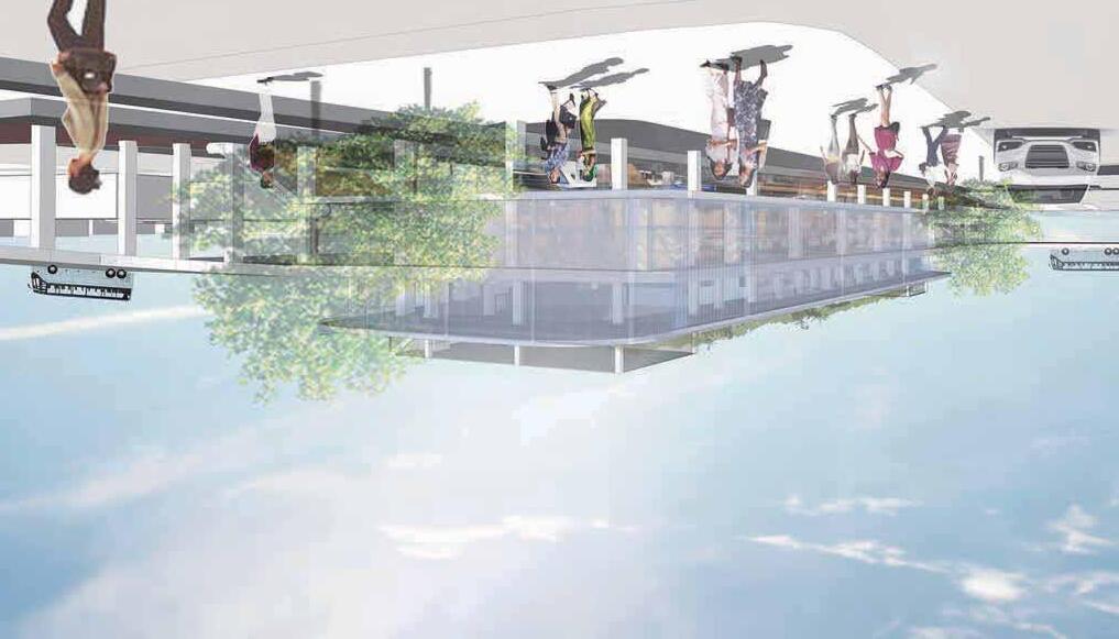
6.4 PLAYGROUND PERSPECTIVE


SUBURBAN COMMUNITY CONNECTION


Rio Arai / HSIEH Yung Ju / Mana Kamesawa

ROLE
Master plan framework
Circulation design
Street design

ROLE
Community park design
Station square design

Member
Residential framework
Station architecture design
MANA KAMESAWA
ROLE
HSIEH YUNG JU
RIO ARAI
CONTENTS TABLE
01
02 VISION
03 GUIDELINES
1.1. Vision
1.2 Concept
1.3 SWOT Analysis
MASTER PLAN FRAMEWORK
2.1 Master Plan
2.2 Urban Design Outline
2.3 Districts
2.4 General Land Use
2.5 Community Bus Network
2.6 Pedestrian Network
2.7 Parking Strategy
2.8 Feeder Bus
2.9 Specific Design Area
3.1 Road Design
3.1.1 Road Design Outline
3.1.2 Specific Design Guidelines
-West Transit Mall
-East Transit Mall
-Underground Highway
-Station Gate Way
-Front of The Park
-R.O.W. 2Lane 19.0 m
-R.O.W. 2Lane 17.0 m
-R.O.W. 1Lane 17.0 m
-R.O.W. 1Lane 15.0 m &
R.O.W Back Alley 15.0m
3.2 Park Design
3.2.1 Park Characteristic
3.2.2 Linear Park Plants Guideline
3.2.3 Perspective
3.3 Residential Design
3.3.1 Residence Design Outline
3.3.2 Design Characteristic
-Multiplex Houses
-Courtyard Houses
3.3.3 Perspective
04 STATION DESIGN
4.1 Gordon Station
4.1.1 Design Concept
4.1.2 Floor Plan
4.1.3 Cross Section
4.1.4 Vertical Circulation
4.1.5 Street Section
4.1.6 Perspective
4.2 Station Square
4.2.1 Design Concept
4.2.2 Building Function
4.2.3 Building Frontage
4.2.4 Circulation & Access
4.2.5 Floor Plan
4.2.6 Perspective
01VISION AND CONCEPT
1.1 VISION
Suburban Community Connection
This project is planned for within 1.2 km of Gordon Station, located in Coolingay on Sydney’s North Shore.It will support the growth of a suburban city with a growing population by addressing TOD design and green space utilization. In the long term, the goal is to create a suburban cit y with access to nature and walkability through the construction of approximately 2,000 new housing units and new TOD design. This will maintain the mental and physical health of the residents. In addition, car-free mobility will enable the city to create an urban system that is CO2 emission-compliant.


LINEAR PARK
STATION SQUARE
GORDON STATION
WEST TRANSIT MALL
EAST TRANSIT MALL
1.2 CONCEPT
IMPROVING 3 CONNECTIONS

GREEN
CONNECTION
TRANSPORT CONNECTION
Connect the rich green space around Gordon with residents’ daily lives.
Designed green areas for everyday lives increase the frequency of use and management.


SOCIAL CONNECTION
The plan aims to achieve car free and to improve walkability. Community buses around Gordon Station and feeder buses running through Chatswood to Wahroonga will improve transport connections. By improving transport connections, people can get easier access to their destinations.


This plan also aims to foster social connection by accommodating differences in age, culture, and lifestyle. We creates spaces where everyone can feel comfortable and connected.
1.3 SWOT ANALYSIS
STRENGTH
Rich Natural Resource
Full of natural greenery and parks.
Diverse Recreational Space
A variety of large-scale recreational area around utilizing natural environment, such as falls creek, link creek, golf course.
Historical and Aesthetic Value
The historical value of surrounding heritage conservation area.
WEAKNESS
Single Land Use
The surrounding land use is predominantly residential area.
Lack of Amenities and Commercial Facilities
Insufficiency of community service both in quantity and quality.
Lack of East-west Public Transportation Connections
The north-south railway and highway severely fragment the east and south area
OPPORTUNITY
Traffic Congestion
Increasing population in the future may cause traffic congestion in the future.
Climate Change
Exacerbation of flood risk caused by climate change.
Overdevelopment
Challenge in preserving the nature resource versus land development.
THREADS
Population Growth
New demands arising from increasing population.
Future Transportation Hub
The railway station may provide high regional accessibility in the future and improve the accessibility to the city center
MASTER PLAN AND FRAMEWORK 02
2.1 MASTER PLAN
Station-Centered Urban Design
The plan is to develop an east-west strip centered on Gordon Station. It improves residents’ living services, incorporates new transit systems, TOD, and new housing to absorb future population growth. To support transportation throughout the area and to achieve a fluid and well-connected urban design, the iconic Gordon Station will be rebuilt and a new station square and transit mall will be created.


2.2 URBAN DESIGN OUTLINE
Transit Mall
In addition to improving access from east to west, the city has made the transition to mixed use, which activates ground level activities; through corridor views, vehicle encroachment for transit public only, and wide sidewalks, the urban design is safe and conducive to the creation of community and economic activity.
Feeder Bus
The Feeder bus station is located about a 15-minute walk from the station.
The route will also pass through hospitals and educational facilities to promote the use of public transportation for commuting to and from work and school.


2.3 15 MINUTES CITY DISTRICTS
15 Mins City Circle
We have established four DISTRICTS that can be reached from any point within 15 minutes by foot or bicycle. Each district has a diameter of 1.2 km. The idea is to reduce long travel time, improve quality of life, promote sustainability, and foster stronger communities.


4 Districts
Each Dsitrict has its own unique green park, city services, and day care center. This will not only facilitate access to basic services, but also promote the mental and physical health of the residents of this municipality, from children to adults.


Service


2.4 GENERAL LAND USE
Mixed Use And Accessibility
A transit mall extending from the station in an eastwest direction will improve accessibility and stimulate economic activity. Housing will be arranged to surround them to accommodate future population growth and provide easy access to city services.
2.5 COMMUNITY BUS NETWORK
Community Bus
Encourage the use of transit to achieve Car Free. The routes are set up to allow access to the station with a trip count of 2 or less, and bus stops are located within 5 minutes of any location.
Line 1 is routed around the Gordon Station area via parks and other major facilities, and West Transit mall is closed to private vehicles, but mobility is made available by community buses.


2.6 PEDESTRIAN NETWORK
Grid Street Pattern
To begin, the existing R.O.W. will be reviewed. In addition, a new sidewalk is planned to be installed in the future. These sidewalks were installed based on 80m intervals. This distance can be covered in about a minute’s walk, creating contact opportunities for residents and an uninterrupted sidewalk space.

Existing Road
New Sidewalk LEGENDS
S = 1/15000
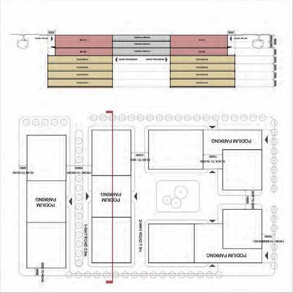
2.7 PARKING STRATEGY
In order to reduce on-street parking and to accommodate the increased use of the four parks and the station square, the number of parking spaces was increased.
To give priority to pedestrian in linear park and station square area, new parking spaces were built under the station square.


2.8 FEEDER BUS
Wahroonga - Chatswood
The Feeder bus was planned to develop not only the area in front of the station, but also the wider city area.
The bus will run as far as Wahroonga, starting from Chatswood, which has been developing as an office district in recent years.
The route will also pass through hospitals and educational facilities to promote the use of public transportation for commuting to and from work and school.


GUIDELINES 03
3.1.1 ROAD DESIGN OUTLINE
Safe And User-Friendly Road Design
The R.O.W. was designed to match the street width, surrounding services, and land use. This will solve the problem of on-street parking making it difficult to utilize the original road space and enable smooth use of the newly installed bus stop.


Under Ground High Way (Liner Park)
West Transit Mall
East Transit Mall
Station Gate Way Front of The Park


3.3.2 SPECIFIC DESIGN GUIDELINES
West Transit Mall ROW


West Transit Mall Perspective


East Transit Mall ROW


East Transit Mall Perspective


Under Ground Highway ROW (Linear Park)


Station Gateway ROW


of the Park


Front
Residence 2 Lanes 19m ROW


Residence 2 Lanes 17m ROW


Residence 1 Lanes 17m ROW


Residence 1 Lanes 15m ROW


3.2.1 PARK CHARACTERISTICS
Nature-Based & Activity Support
Activity Sport Ground
Location: Near tennis court and business area


Natural Child playground
Location: Near pre-school and residential area


Natural Forest + Green Conservation
Location: Near natural conservation


Youth Culture + Recreation and Festival
Location: Near school and residential


Ref: Sequim Bay State Park
Ref: Festival in Zagreb
Ref: Dan Ryan Wood Nature Play Garden
Ref: Levy ParkRef: Moskva River Park
Ref: Ian Potter Child Wild Play Graden
Ref: Luxtent Design
Ref: Nanjing Ecological Science Island
3.2.2 LINEAR PARK PLANTS GUIDELINES
Aesthetic
Forest
Medium to large size trees are predominant, ornamental with colorful flowering trees and shrubs.


Green RealmWandering Garden
Small to medium size evergreen trees are main, diverse shrubs with characteristic shape are selected.


Colorful ground covers are predominent, with small size trees riching the landscape.


Big Blue Lily Turf
Weeping Fig
Mondo Grass
Bull Bay Magnolia
Tanika
Jacaranda Lagerstroemia
Moreton Bay Fig Grey Gum
Banksia Spinulosa
Corymbia Maculate
Swamp Foxtail Grass
Vitex
White Anzac
Globosum
Bronze Rambler
Berkeley Sedge
Callery Pear
3.2.3 PERSPECTIVE


3.3.1 RESIDENTIAL DESIGN OUTLINE
Design Goal
Gordon has been seen continued population growth in recent years: over the 7 year period from 2016 to 2023, its population grew by 1018 people. Assuming that growth continues at the same rate, the population will increase by approximately 3,000 people in the next 20 years.
In addition, the city will be required to provide housing for approximately 3,600 people due to street adjustments, so the goal is to design approximately 2,200 new units of housing.
Strategy
We believe that demand will increase for areas close to the parks and large bus stops which improve accessiblity. Therefore, we plan to build multiplex and courtyard houses within 240 meters (3 minutes walk) and 400 meters (5 minutes walk) from the bus stop, along the bus route.
There are 95 multiplex houses (1710 units) and 76 courtyard houses(532 units).
3.3.2 DESIGN CHARACTERISTICS
Multiplex Houses (Mansion Apartment)
Multiplex housing with a large number of units will be located in areas within 3 minutes of the bus stop. L-shaped houses are located on corner lot To allow for better lighting. The area facing the back street is envisioned to be a common area for the residents of this housing.
If more people live in Gordon in the future, new units can be built in this common area to accommodate population growth.


L-shaped HousesI-shaped Houses


Courtyard Houses
Areas which take 3-5 minutes from the bus stop are often located far from the park. Therefore, courtyard housing is placed so that people can keep green connection at home.
O-shaped houses are located near the park to protect privacy.


Ref: Missing Middle Housing
Ref: Missing Middle Housing
3.3.3 PERSPECTIVE


The page is intentionally left blank.
STATION DESIGN 04
4.1.1 GORDON STATION DESIGN CONCEPT
Improving West-East Connection
Gordon is currently divided into east and west by rail and highway. The new station building will serve as a hub for trains and community buses, facilitating east-west travel for residents. In addition, the station will be a new symbol of Gordon, connecting two transit malls, a linear park, and Station Square.


Ref: Avenue Road Park, Tronto, Canada
Ref: 16th Street Mall, Denver, US
WEST TRANSIT MALL
SQUARE
Ref: Station Square, Pennsylvania, US Ref: Transbay Transit Center, San Francisco, US
4.1.2 FLOOR PLAN
4.1.3 CROSS SECTION
1F Train Station Level
Carrying people to other cities
2F Street Level


3F Bus Terminal Level
Making the connection between east and west Gordon
4F Roof Top Park Level

Providing open space to connect the lifestyle and green
Providing walkable spaces by connecting the topography S = 1/250


4.1.4 VERTICAL CIRCULATION
Vertical circulation including elevators and escalators will provide connection between the different components of the facility.
In addition, the station provides visual connection between different floors by gathering the vertical circulation system.
Escalators & Stairs LEGEND
Elevators
Service Elevators
4.1.5 PERSPECTIVE


Waseda
Making A Vibrant Town Center
4.2.1 STATION SQUARE DESIGN CONCEPT GORDONSTATION
The station square area is designed to be a dynamic center place that all the people can gather here, not only the residents living around, but also the business man and the tourists. A north-south central street connect the southern school and residential area to the north large-scale open space. Two substreet links the west linear park to the east Gordon station. Through setting two square and a lawn, we aim to offer a place to hold both daily activities and city events.

Ref: Edmondson Square, Sydney, Australia

RPA LINEARPA PA PARK
RAVENDERWOOD SCHOOL
MARCHE
4.2.2 BUILDING FUNCTION
Highly Mixed Use
In order to activate the station square area, we propose a mixed-use town center with concentration on business. cultural, retail, community service, R&D, as well as the civic hall at this area.
The retail mainly located at the ground and second level of the buildings. The northern part is served as entertainment, exhibition, and international events.
The southern area is mainly the facilities for community activities and R&D with the consideration of the residential area and school at the precinct.
LEGENDS Hall
Community Service
GORDONSTATION
LAVENSWOOD SCHOOL MARCHE
4.2.3 BUILDING FRONTAGE
Active Frontage Towards Open Space
Built to Line:
The first floor of buildings along the central street, two branch streets and the squares are built-to-line.
Facades along the buid-to-line should have a 70%-75% transparency from from 1 to 5 meters.
LEGENDS
Site Boundary
Build to Property Line
Build to 5m Setback
5m Minimum Setback
Flexible Build Line
S = 1/3000
4.2.4 CIRCULATION & ACCESS
Car-Free Zone
Pedestrian and vehicular access are seperated. Underground parking is provided for the needs of residents and visitors.
There are three types of pedestrian entrance. The Main entrance for visitors, the specific entrance for the users of business, community service and R&D, and the service entrance.
GROUND LEVELB1 LEVEL
Vertical Circulation
Parking Entry/Exit
Main Entrance
Specific Entrance
Service Entrance Ramps
4.2.5 FLOOR PLAN
Ground Level
Retail is prodominent on the ground floor, access facing the street. The standard size of each stores is 5m x10m.
Specific zone is facing the square to hold the new-trend, livehouse, cafe, or experimental activities.
Movie Theatre
Livehouse
Jazz Restaurant 6. Supermarket 7. VR Experience Space
8. Tea Room S = 1/3000
4.2.6 PERSPECTIVE


The page is intentionally left blank.


LIVING WITH HERITAGE


Chia Ying / Yoshino Oka / Kentaro Kurasawa

ROLE
Master plan framework
Circuration design
Street design

ROLE
Residential building strategy
Preservation plan

Member
ROLE
Station architecutre design
Station square design
KENTARO KURASAWA
YOSHINO OKA
CHIA YING
CONTENTS TABLE
1.1 Vision
1.2 SWOT
1.3 Spatial Organisation
1.3.1 Zoning
1.3.2 Connection
1.4 Goal
MASTER PLAN AND FRAMEWORK
2.1 Master Plan
2.2 Landuse Map
2.3 Preservation Plan
2.4 Housing
2.4.1 Density
2.4.2 Footprint
2.5 Circulation Framework
2.5.1 Circuration
2.5.2 Bus Route
STRATEGIES
3.1 Preservation Strategy
3.2 Residential Buildinng Strategy
3.2.1 Middle Housing
3.2.2 Townhouse
3.2.3 Apartment
3.2.4 Shoptop Housing 1
3.2.5 Shoptop Housing 2
3.2.6 Shoptop Housing 3
3.2.7 Retail
3.3 Green Way
04 SPECIFIC PLAN
4.1 Around Gordon Station
4.2 Gordon Station
4.2.1 Plan
4.2.2 Concept
4.2.3 A-A’ Section
4.2.4 B-B’ Section
4.2.5 C-C’ Section
4.3 West - Station Square
4.3.1 Plan
4.3.2 Section
4.4 East - Township Park
4.4.1 Plan
4.4.2 Section
4.5 Life Scene
01 VISION AND CONCEPT
1.1 VISION
“To Conserve The Heritage Resources Along With The Enhancement Of Wellness, Culture And Education”
Federal and Inter-war heritage housing as the notable tangible heritage in Gordon that existed since the 1980s, forming the significant urban wall in the town. Along with the implementation of TOD by the central government, the concern towards the heritage resources in Ku-ring-gai is raised by the community. It is the unneglectable element in the development of Gordon for the future decades.
Multinational neighbourhoods and increasing younger generation in recent years has shown the potential of Gordon as a thriving suburb with increasing population and developing economy along with the high quality of life. Three main concerns, wellness, culture and education that target all age groups and society level of the people in Gordon act as the supplement in the planning of the conservation of heritage resources.

Waseda U and UNSW Joint Studio 2024
1-1 SWOT
1.2 SWOT
ILLUSTRATED MAP
STRENGTH
• Heritage significant township remained with the Federation and Inter-war heritage
• Livable environment with rich nature and desirable ecosystem
• Gordon station as major transportation access linked to city centre, Sydney
• Well-maintained street level facilities which encourages outdoor living and well-being
• Friendly multinational neighbourhood which increases the living population along the years
Ihil estionem as dolupta sum cust ipsam, se am volorro dolum cuscimint qui aut volent ex eriatec essincite nisquos non cus nisquatem quas reres ent velectur soluptamus volore, odisi si doluptatur, ut fuga. Ita nulloriant, iur? Equate volecti de
WEAKNESS
• New development incompatible with existing local context has become alien existence to the context
• Steep gradient topography lowers the walkability and increase dependency on automobile
• Large area of real estate with high price is unaffordable for the young workers
OPPORTUNITY
• Population increases and bring in new business, leading to the increase of commercial value
• Increase in young population and workforce to boost the economic activities
• Bring in new programs for Gordon through optimising the heritage housings
THREATS
• Losing of heritage characteristic due to uncontrolled development policy
• Housing policy of TOD overrides the heritage housing
• Losing of water catchment area (park, neighbourhood green) may lead to the increased flood risk
• Increased housing density with losing of outdoor activity spaces and neighbourhood green lowers the living quality
1.3 SPATIAL ORGANISATION
1.3.1 Zoning
3 zoning of wellness, culture and education includes the existing heritage resources; the boundary of each zoning is decided depending on the existing core programs of the heritage resources. Developing from the existing, new programs and spatial planning input are continued and the characteristics of each zoning are further enhanced with the aim to bring in new elements to increase the quality of life along with the execution of the housing policy.


1.3 SPATIAL ORGANISATION
1.3.2 Connection
Railway line and Pacific Highway that run through Ku-ring-gai has split apart the East and West area of Gordon, creating differences in the phenomenon of both areas. Using the heritage and green elements in Gordon to connect the chill and quietness in the east and commercial happening in the west.
Three main streets - greenway have been chosen, in response to the 3 zoning proposed, wellness, culture and education. Act as the tangible link between east and west, joining the selected existing heritage resources while implementing new programs. Street improvement was proposed in corresponding with the characteristics of targeted programs and users along each street.

1.4 GOAL
Illustrated Map
Gordon will become a civic corridor symbolic of both the history and future of Gordon along the TOD. Flying deck across railways and public green spaces which defines Gordon’s public realm form the linkage of the heritage network. Also, it looks into the future in which new housing strategies prepare Gordon for future housing demand while development promises the coming in of new business and enterprises.


MASTER PLAN AND FRAMEWORK
2.1 MASTER PLAN
Illustrated Map

Development core falls within 800m radius from Gordon station, new services and facilities along with the new medium density housing are being proposed, whereas density strategies change the existing housing footprint. Three designated greenways form the linkage of the natural landscape between east and west Gordon.


2.2 LANDUSE MAP
Heritage-listed Gordon station with new structure covered over the railway line as the development core of the town, surrounded with ground-level activity-driven programs, such as retails, shopping streets, communal lawn as urban living room for Gordon’s community. Development spreads outwards with the selected existing heritage resources integrated as the core in each area, while linking back by the three main axisgreenway as a whole. Residential area surrounds the development core of the town implemented with new density strategy.


2.3 PRESERVATION PLAN
6 main heritage zones formed by the listed existing heritage items from the heritage plan of Ku-ring-gai council. Making heritage-listed Gordon station as the core of the heritage resources, forming the heritage network of Gordon that covers both east and west side of Gordon. Also, significant heritage resources that are not listed are being retained as the notable characteristic of Gordon in the planning.


1. The interwar built Gordon Baptist Church
2. Anglicare - Gordon Quarter
3. Church of St.John the Evangelis
4. Interwar Houses
5. Educational Infrastructure Services Australia
6. Eryldene Historic House and Gardens
2.4
HOUSING
2.4.1 Density
In accordance with the housing policy of TOD, medium density development is concentrated around the centre of the town, while ensuring the minimum 15% of affordable housing in the provided new housing. Highest-storey residential is planned around the development core of the town, descending while spreading outwards from the centre.
Affordable, middle-price and luxury housing types are planned to target the population group of different household size and financial ability, welcoming more young workforce and service workers to Gordon.


2.4 HOUSING
2.4.2 Footptint
In response to the housing policy of TOD, density strategy ranging from duplex to six plex, is implemented to the existing residential for the following decades, aiming to provide roughly 3,500 new housing units in Gordon. Housing amount increases through the implementation of density strategy and introduction of new housing typology.
INCREASED HOUSING STRATEGY
Neighborhood Housing
-Townhouse
-Duplex, Triplex, Fourplex, Sixplex
Shop Top Housing
Apartment
2.5 CIRCULATION STRATEGY
2.5.1 Circulation
Existing residential areas where the location of the houses located close to each boundary has restricted vehicular access in certain residential areas. In correspondence with the implementation of the housing strategy, new vehicular access is planned within the area.
Pedestrian traffic is aimed to be promoted along the 3 greenways, with the street upgrade plan. Also, the station square area and the retails around the are planned as a pedestrian-friendly commercial district with replanned highway traffic that pass through underground tunnels and guided to the station side.


2.5 CIRCULATION STRATEGY
2.5.2 Bus Route
Gordon community bus service is proposed as the alternative to reduce the dependency of private car usage. 500m distance between each bus stop is planned to ensure the maximum coverage of neighbourhood areas, even those which are located far away from the station. To promote the movement among each node within Gordon, and take care of the neighbourhood area which is outside walking distance to Gordon station, aiming to provide direct access for the residents to the station through public transport.


STRATEGIES
3.1 PRESERVATION STRATEGY
The 6 main heritage zones have their own characteristics in response to their own respective zoning of wellness, culture and education. Notable programs of the existing heritage buildings which can represent as the symbol of Gordon heritage are retained while the new programs proposed for the adaptive reuse are linked to the characteristic of each respective zoning.
‘Wellness’ promotes the mental and physical health of the people and support the living quality in Gordon ‘Culture’ fosters the communal engagement of the Gordon community, bringing in new activities or node to street level
‘Education’ provides supportive element to the existing system and encourages informal learning of the community


3.2 RESIDENTIAL BUILDING STRATEGY
Affordable and medium affordability housing can be stacked on sites with property lines up to 18 meters wide, and side-by-side on sites over 18 meters wide. Affordable housing has smaller unit sizes and more compact backyards than medium housing.
3.2 RESIDENTIAL BUILDING STRATEGY
3.2.2 Townhouse
Townhouse typology is introduced to the area which involves the site replanning due to existing unorganised site boundary that restricted the vehicular access to the door front. Duplex housing strategy is implemented in the affordable housing zone.
Townhouse type 1: Locate at the corner end of the residential area that has both side and front access to the road. Vehicular access from the back leads to the parking lots behind the residential units.
Townhouse type 2: Locate at the intermediate part of the residential area. Vehicular access from the lane in between the residential units, leading to the parking lots behind the residential units.
TOWNHOUSE 1
TOWNHOUSE 2
3.2 RESIDENTIAL BUILDING STRATEGY
3.2.3 Apartment
7-storey medium priced apartment with ground floor level split into lobby area and ground floor parking zone.
Basement parking to be accessed by the ramp with gradient 1:10.


3.2 RESIDENTIAL BUILDING STRATEGY
3.2.4 Shoptop Housing 1
Podium Parking At Back
6-storey shop top housing with 2-storey retails at bottom levels to foster the active street levels for everyone while providing convenience of life for the residents. Separated residential entrance from the public level secures the residents’ privacy.


3.2 RESIDENTIAL BUILDING STRATEGY
3.2.5 Shoptop Housing 2
Big Podium Parking In The Middle
Shared podium parking for different residential blocks and retails. Entrance of each residential block is accessed through a green roof garden, which is the communal space for the residents.

3.2 RESIDENTIAL BUILDING STRATEGY
3.2.6 Shoptop Housing 3
Underground
Parking planning is considered to optimise the limited site area and utilise the existing topographic slope.
Basement parking is planned to be accessed by the ramp with gradient 1:10, reducing the podium parking on ground level.

3.2 RESIDENTIAL BUILDING STRATEGY
3.2.7 Retail
Pedestrian friendly commercial districts without vehicular access, creating safety-secured outdoor activity zones which allow kids to run around and users to wander around.


3.3 GREEN WAY
Green Way Section
In accordance with the characteristics of the 3 zoning, the street improvement to enhance the circulation and services for the target user groups, such as the pedestrian path, landscape, street facilities etc.
‘Wellness’ targets old folks and people who exercise ‘Culture’ targets all community ‘Education’ targets students and educational workers
CULTURE

EDUCATION


WELLNESS

SPECIFIC PLAN 04
Waseda U and UNSW Joint Studio 2024
4.1 AROUND GORDON STATION
Development nodes are organised around heritage-symbolic Gordon station, started from the heritage Church of ST. John the Evangelist, continued by the station square and, extended towards the township park on the east.


4.2 GORDON STATION
4.2.1 Plan
The”Flying deck” is a public space, encouraging vertical and horizontal circulation for the users. There are rental rooms, restaurants, and grocery stores on the 1st and 2nd floors. In front of the bus terminal and parking lot, there are waiting room, convenience store, and diner. In the southern part, there are cafeteria and study space for students.
0:Gordon station (existing)
1:Residential apartment (200 units)
2:Parking
3:Waiting room
4:Station office
5:Cafeteria & Study space
6:Convenience store
4.2 GORDON STATION
4.2.2 Concept
Conserve Station And Connect The City
“Flying deck” aims to preserve Gordon station building which has valuable history and connect east-west and north-south areas of Gordon, which are currently separated by railroad tracks and city blocks. Not only housing facilities and parking lots to accommodate population growth, it will provide commercial facilities and public spaces that encourage foot traffic.


Elevator
Escalator
Stairs
4.2 GORDON STATION
4.2.3
Section
Section A-A’
S=1/1000
The Flying deck eases the accessibility of users from Gordon which has significant slope topography. It connects Park ave in the north to the green way , varying elevation levels and providing a comfortable green environment. Also, the access to the station platform from the Flying Deck is enhanced.


①MIYASHITA Park / Japan
It called as”Tokyo's first aerial park”.The aim was to create a new type of urban park that integrates various facilities, centering on a park, and accommodates the interaction and lifestyles of a wide variety of people, creating high-quality urban infrastructure.
https://www.takenaka.co.jp/design/works/miyashita-park/
& Station


②High Line / USA
The High Line is an elevated freight rail line transformed into a public park on Manhattan’s West Side. High Line fought for the High Line’s preservation and transformation at a time when the historic structure was under the threat of demolition.
https://www.adventureclues.com/city-secrets/high-line-elevated-park-nyc/
Connecting North to South with Flying Deck


③Xiaoli Station / China
The masterplan envisages a new, green urban district which focuses on Xiaoli Station. The development creates multi-layered , creating a unique identity for the area.
https://www.chapmantaylor.com/news/chapman-taylors-transport-orientated-masterplan-for-xiaoli-station-and-urban-area-in-xionganchina


⑷Urban living room / China
“Urban Living Room” masterplan, locate in the Qianhai area of Shenzhen, China, which will feature a raised garden 1.2 kilometers long. it’s as a “heart and a new horizon from which people can orient themselves” in an emerging urban center.
https://rshp.com/projects/placemaking/urban-living-room-in-qianhai/
4-2 GORDON STATION
Gordon station connects with the west bus terminal, kiss and ride, which increases the convenience of commuting. In addition,Flying Deck allows direct access to the station square area on the west and township park area on the east.
Section B-B’


Station Square
Township Park
Gordon StationKiss & Ride
Bus Terminal
Flying Deck
4.2 GORDON STATION
4.2.5 C-C’ Section
Section C-C’
At the southern and northern ends, the lower levels are planned for parking lots and the upper levels will be residences, provided with the public spaces in between to foster a liveable environment.


4.3 WEST - STATION SQUARE
4.3.1 Plan
Include Church of ST. John the Evangelist as the frontage of Gordon which to show welcoming gestures to the people who come or return to Gordon. Existence of both heritage church and new Flying Deck within the area reflect the integration of Gordon history and culture around the development nodes.


4.3 WEST - STATION SQUARE
4.3.2 Section

Planning strategy of Flying Deck establishes new bus terminal and enhances linkage between east and west. It also improves the public realm in between the Church of ST.
John the Evangelist as civic celebration node to support Gordon’s vibrant street life culture.


4.4 EAST - TOWNSHIP PARK
4.4.1 Plan
The new park, with Flying Deck and Gordon station as backdrop, located in between the new apartments, is the venue for social integration and outdoor activities for Gordon community. Equipped with sport courts, amphitheatre for community engagement and the playground for kids.


4.4 EAST - TOWNSHIP PARK
Perimeter landscape establishes a continuous green buffer along township park to secure favourable living quality for the mid-rise housing neighbourhood. 4.4.2 Section


4.5 LIFE SCENE
Viewing from the roof level of Flying Deck towards the Church of St. John the Evangelist. It captures the aspirations of Gordon’s vibrant street life culture across levels, in the background of Gordon’s heritage.
Flying Deck infrastructure is the stage for reflecting the engagement of both heritage Gordon station and new development in Gordon. New services and facilities are proposed at each level to support it as the new node in Gordon.


Instructors
Waseda University
・ Tetsuya Yaguchi
University of New South Wales
・ Raffaele Pernice
Participants
Waseda University (Yaguchi Lab)
Group1
・ Mao Kobayashi
・ Shota Honda
・ Kei Matsumoto
Group2
・ Rio Arai
・ Mana Kamesawa
・ Yungju Hsieh
Group3
・ Yoshino Oka
・ Kentaro Kurasawa
・ Chia Ying
University of New South Wales
University of Hong Kong
First Published by Yaguchi Lab.at Department of Architecture, School of Creative Sceience and Engineering, Waseda University.
Supervised by Testuya Yaguchi
Edited by Mao Kobayashi, Shota Honda, Kei Matsumoto, Rio Arai, Mana Kamesawa, Yungju Hsieh, Yoshino Oka, Kentaro Kurasawa, Chia Ying
Published Date 2024/08/04

UNSW Waseda Joint Studio 2024 August

