
14 minute read
Naturally Occurring Asbestos in France: Geological Mapping, Mineral Characterization, and Technical Developments

from EEG Journal - February 2020 Vol. XXVI, No. I (2)
by Association of Environmental & Engineering Geologists (AEG)

FLORENCE CAGNARD* DIDIER LAHONDÈRE BRGM, French Geological Survey, Orléans, France
Key Terms: NOA, Asbestos, Geological Mapping, Regulations, France
ABSTRACT
In France, asbestos was banned by national decree (no. 96-1133) in 1996. The regulatory texts and standards adopted to implement this ban are concerned primarily with asbestos-containing manufactured products and are difficult to apply to asbestos-bearing natural materials (i.e., rocks and soils). Considering problems related to asbestos-bearing natural materials, the French Ministry of Ecology, Sustainable Development, and Energy has mandated the French Geological Survey to map locations where asbestos-bearing rocks are found. Mapping was prioritized to geological domains where naturally occurring asbestos (NOA) was predictable (e.g., the Western Alps and Corsica). These studies integrated field expertise, sampling, and laboratory analysis data to characterize the potential of geological units to contain NOA. Additionally, studies were conducted on geological formations exploited to produce aggregates. These studies were focused on quarries excavating massive, basic or ultrabasic rocks likely to contain NOA and quarries mining alluvium likely to contain asbestos-bearing rock pebbles. These studies highlight the difficulty of establishing robust analytical procedures for natural materials. The distinction between cleavage fragments (resulting from the fragmentation of non-asbestos particles) and proper asbestos fibers is particularly problematic for laboratories. Thus, a recent study by the National Agency for Health Safety, Food, Environment, and Work recommends applying the asbestos regulation to elongated mineral particles (length/depth > 3:1, length > 5 μm, depth < 3 μm) with chemical composition corresponding to one of the five regulated amphibole species regardless of their mode of crystallization (asbestiform or non-asbestiform). The upcoming regulatory changes are part of a decree published in 2017, including the prior identification of asbestos in natural soils or rocks likely to be impacted by
ground-disturbing construction activities. Specific protocols will be defined for sampling, analysis, and characterization of natural materials that may contain asbestos.
INTRODUCTION
In France, the use of asbestos was extensive through most of the 20th century. Asbestos was mined in France from 1920 to 1965, especially in two main quarries localized in the Alps (the Val de Peas mine extracting tremolite-asbestos) and in Corsica (the Canari mine excavating chrysotile). After 1965, the domestic demand for asbestos was satisfied by importation, especially from Canada. In 1977, the first regulation by the international agency for research on cancers classified all the forms of asbestos as carcinogenic. Even though asbestos was known to be harmful since the beginning of the 20th century, protection and prevention measures were adopted later in France. In fact, a complete ban on the use of asbestos in France was declared in 1996 and confirmed at the European level by Directive 99/77/EC, which prohibited any extraction, manufacture, or processing of asbestos fibers.
The issue of naturally occurring asbestos (NOA) has emerged in only the past decade in France, with the first identification of 20 sites containing NOA in 2005 (Dessandier and Spencer, 2005). There is currently no law concerning the specific problem of NOA in France, and the existing regulations concern only “industrial” asbestos. However, a group of researchers working with two French national agencies recently proposed recommended guidelines (ANSES, 2010, 2015, 2017; INRS, 2013). Based on these studies, national regulations concerning NOA are currently in progress.
France is made up of various geological domains consisting mainly of Neoproterozoic to Paleozoic basements partly affected by the Variscan orogeny, juxtaposed with Meso-Cenozoic sedimentary basins, which are locally reworked during the Alpine orogeny (Figure 1). Except the sedimentary basins, many basement lithologies, localized within the Armorican Massif, the Vosges Massif, the Massif Central, the
Figure 1. Simplified lithological map of metropolitan France with the localization on studied areas concerned with projects mapping NOA occurrence susceptibility at a regional scale (1/50,000) (modified from Lahondère et al. 2018 and references therein).
Western Alps, the Pyrenees, and Corsica, are likely to contain NOA. The hazardous lithologies in basement areas concern, in particular, the basic and ultrabasic rocks, the meta-carbonates, and different types of rocks affected by greenschist facies metamorphism (e.g., dolerites and acid magmatic rocks). Another French territory, the island of the New Caledonia, is strongly affected by the NOA issue. Ultrabasic rocks containing significant volumes of NOA cover onethird of the island’s surface. Moreover, New Caledonia is one of the world’s largest producers of nickel ore, concentrated mainly within alteration profiles of ultrabasic rocks.
Aware of the NOA issue, the French Ministry of Ecology, Sustainable Development, and Energy mandated the French Geological Survey (BRGM) to establish a systematic review and mapping of the geological units that may contain NOA. In parallel with these projects, the BRGM was also mandated to establish a list of quarries with potential to contain NOA-bearing rocks. The main results obtained during these projects and associated studies undertaken by the BRGM are presented in this article.
TYPOLOGY OF THE MAIN NOA OCCURRENCES IN FRANCE
NOA in France occurs mostly within basic and ultrabasic rocks. Chrysotile constitutes the most typical asbestiform occurrence, as veins and shear planes localized within serpentinites. Cross veins of chrysotile are extensively developed in the center of serpentinite massifs. Long fibers of chrysotile appear also as slip veins and are crystallized along shear planes within
highly sheared serpentinites, close to tectonic contacts (Lahondère et al., 2019) (Figure 2a-b). Anthophylliteasbestos is also commonly observed, especially in New Caledonia, filling cross veins cutting across serpentinites (Figure 2c-d). In addition, tremolite-asbestos is frequently developed as long asbestos fibers within veins cross-cutting serpentinites or within shear planes (Figure 2e-f). Such tremolite-asbestos occurrences are found extensively within serpentinite massifs, especially in tectonic contacts and/or along the boundaries of these massifs, in close proximity to calcic-rich surrounding rocks, such as meta-gabbros, meta-basalts, or meta-carbonate rocks (Lahondère et al., 2019). Alteration and hydrothermal weathering of tremolite-rich veins and planes result in the formation of white bundles of tremolite fibers, easily dispersible into the air.
Meta-basalts and meta-gabbros may be rich in fibrous and asbestos tremolite and actinolite, which may sometimes be located within synfolial planes and more frequently within open veins at high angles to the foliation, in association with greenschist facies metamorphic minerals such as albite ± calcite ± epidote ± chlorite (Lahondère et al., 2019).
Hydrothermally altered dolerites are also frequently rich in asbestos-actinolite fibers, which are located mainly within shear planes and veins cross-cutting the dolerites (Lahondère et al., 2018) (Figure 2g-h). Other unusual occurrences and non-regulated fibrous minerals can locally be observed and concern, particularly (1) tremolite-asbestos within marbles, (2) fibrous Mgriebeckite within orthogneisses, and (3) fibrous actinolite within hydrothermally altered granitoids.
MAPPING OF POTENTIAL NOA OCCURRENCES AT THE REGIONAL SCALE (1/50,000) AND THE COMMUNE SCALE (1/5,000)
Because of the abundance of rocks having a potential to contain NOA in French territory, the BRGM was mandated to determine the localities of hazardous geological units. A project of mapping (at a regional scale: 1/50,000) geological units that are likely to contain NOA is funded by the French Ministry of Ecology, Sustainable Development, and Energy. This project began in 2009 and is still in progress. Mapping is being conducted in different areas of France (i.e., the Armorican Massif, the Vosges Massif, the Massif Central, the Western Alps, the Pyrenees, and the Corsica) (Figure 1). For each area, a threefold approach is used. First, a determination of lithologies and target zones with potential NOA is made from bibliographic and database compilations. Second, geological mapping is done in the field, followed by the characterization of sampled fibrous minerals by different analytical techniques in the laboratory (polarized light microscopy, transmission electron microcopy, scanning electron microscopy, electron probe microanalysis, and Raman spectroscopy). The final step consists of the drawing of an NOA occurrence susceptibility map at a regional scale (1/50,000 scale) with three NOA occurrence susceptibly classes (1 = none to weak, 2 = medium, 3 = high to very high) (Figure 3). At the end of the project, a list of townships that are likely to contain lithologies characterized by a medium to high susceptibility to contain NOA is established for each studied area.
Following the establishment of the list of these townships, new projects are initiated and funded by local French agencies, such as the Environmental Office of Corsica and the Regional Directorate for Environment, Development, and Housing. The main goal is to establish detailed maps of the NOA occurrences at precise scale. These documents are then included in the territorial development plans. In such projects, the detailed geological mapping does not concern the entire “commune” areas but is focused mainly on key zones (i.e., urbanized zones, potentially constructible areas, towns, hiking paths, tourist areas, and so on) and key roads. A selection of such key zones and roads is realized by GIS treatments of different sources of data, such as planning documents, geological maps, and land cover. Detailed geological mapping is performed in the field and is followed by the analysis of fibrous samples at the laboratories leading to the production of a precise final map of NOA occurrence susceptibility at 1/5,000 scale (Figure 4). Finally, the main emissive outcrops and areas that are likely to release NOA in the air are identified and remediation proposals to fix the problems made.
IDENTIFYING QUARRIES THAT ARE LIKELY TO EXPLOIT NOA-BEARING ROCKS
In parallel with the mapping projects, the BRGM was mandated by the Ministry of Ecology, Sustainable Development, and Energy to identify the quarries that are likely to exploit NOA-hosting rocks. A list of 75 priority quarries exploiting solid rocks has been established and visited. A geological inspection of the sites with sampling was followed by the characterization of fibrous materials in the laboratory. This work led to the establishment of a list of quarries ranked according to their abundance of fibrous minerals. During this project, the difficulty of establishing reliable diagnoses of fibrous minerals, especially the fibrous amphiboles, was underlined. From this, new sampling and analytical protocols are currently being tested and discussed to improve the identification of fibrous versus asbestiform amphiboles in rock materials. The


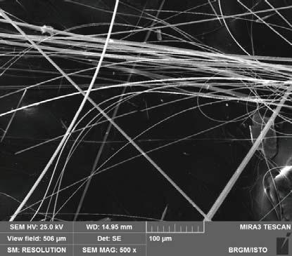
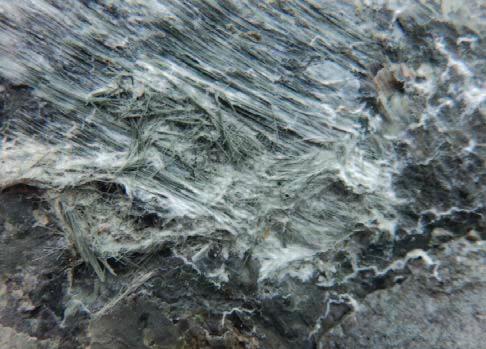

Figure 2. Macroscopic aspects and scanning electron microscopic (SEM) photographs of typical fibrous occurrences in France. (a) Fibers of chrysotile on a shear plane within highly sheared serpentinites (Canari mine, Corsica). (b) SEM photograph of chrysotile fibers within a serpentinite (Corsica). (c) Bundles of antigorite fibers in a serpentinite (New Caledonia). (d) SEM photograph of fibrous antigorite in serpentinite (New Caledonia). (e) Tremolite-asbestos in a serpentinite (Val de Peas mine, Western Alps). (f) SEM photograph of tremoliteasbestos from a serpentinite (Val de Peas mine, Western Alps). (g) Fibrous-actinolite in a shear plane within a hydrothermally altered dolerite. (h) SEM photograph of bundles of fibrous actinolite from a hydrothermally altered dolerite (Massif Central).

Figure 3. Map of NOA occurrence susceptibility of Northern Corsica (France) with three classes (1 = none to weak, 2 = medium, 3 = high to very high) at a regional scale (1/50,000 scale) (modified after Lahondère and Zammit, 2012).
ministry recommended that the problematic quarries conduct supplementary detailed geological mapping and airborne surveys. Results of the supplementary studies allowed the ministry to make final decisions concerning the continuation or cessation of activity at the quarries. Similar studies currently concern alluvial quarries and are especially challenging because several hundred quarries are potentially concerned, involving a wide range of lithologies. This raises new methodological problems concerning primarily the representativeness of the sampling protocol.
CURRENT ACTIVITIES
The expertise gained from all these projects was beneficial for discussions in national working groups on the health effects from NOA hazards, leading to the production of technical recommendations for workers within NOA-bearing lithologies (ANSES, 2010) and the identification of cleavage fragments of amphiboles from quarried minerals (ANSES, 2015). Current activities concern the publication of new regulations and standard definitions.
In parallel to the mapping projects, several research projects pertaining to the NOA issue are under way in the BRGM. The first project concerns the development of the use of hyperspectral imaging combined with geometric data processing approaches to identify, map, and monitor NOA. Such non-destructive approaches provide the potential to detect and map NOA minerals during continuous sampling instead of discrete sampling. In addition, innovative studies are consid


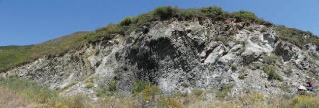
Figure 4. Examples of (a) a regional scale (1/50,000) map of NOA occurrence susceptibility in an area from Northern Corsica with three classes (1 = none to weak, 2 = medium, 3 = high to very high), (b) a detailed (1/5,000 scale) map of NOA occurrence susceptibility in an area from Northern Corsica with three classes (1 = none to weak, 2 = medium, 3 = high to very high) (a–b, modified after Gutierrez et al., 2016), and (c) a photograph of an identified emissive outcrop (ancient pit of serpentinites).
ering the mineral and morphological characterization of non-regulated mineral fibers and atypical fibrous occurrences, such as characterization of fibrous sodic amphiboles and occurrence of actinoliteasbestos within various lithologies, such as granitoids, dolerites, and orthogneisses, as already described in the literature (e.g., Metcalf and Buck, 2015; Lahondère et al., 2018). Finally, studies developed in the BRGM concern the problematic characterization of fibrous amphiboles with the challenge to obtain a robust and reliable methodology to converge similar definitions of fibrous and/or asbestiform minerals. New methodological developments concerning an experimental protocol allowing the release of fibers from a solid rock are under way and benefit from an extensive sampling of different types of amphiboles in the field.
CONCLUSIONS
The NOA issue has been an emerging subject of interest in France for the past decade. Currently, no regulations or national laws concerning the NOA problem exist in France. Different projects have been carried out by the BRGM, leading to the production
of NOA potential occurrences maps at regional and commune scales and to the establishment of a list of quarries potentially exploiting NOA-bearing rocks. Results of such projects allow BRGM and the French government to inform the public and industry about the location of potential NOA-bearing lithologies with the goal to reduce the potential for exposure during human activities such as has occurred, for example, in the United States (Van Gosen, 2007), Australia (Hendricks, 2009), Italy, and California (Churchill and Hill, 2000).
Different research projects are in progress and concern (1) the use of spectral-geometric approaches to the mapping and prediction of NOA occurrences, (2) the characterization of non-regulated and atypical species of fibrous minerals, (3) the development of experimental protocols and methodologies to distinguish cleavage fragments of asbestos, and (4) the development of a database as well as a process for the management and the diffusion of data concerning NOA in France.
ACKNOWLEDGMENTS
The authors gratefully acknowledge the DirectorateGeneral for Risk Prevention of the French Ministry of Ecological and Solidarity Transition, the BRGM and the Corsican Environmental Office for discussions and for their financial support. We thank the reviewers for their constructive comments.
REFERENCES
ANSES, 2010, Affleurements naturels d’amiante. Etat des connaissances sur les expositions, les risques sanitaires et pratiques de gestion en France et à l’étranger: Rapport d’étude, 248 p. ANSES, 2015, Effets sanitaires et identification des fragments de clivage d’amphiboles issus des matériaux de carrière: Rapport d’expertise collective, 218 p. ANSES, 2017, Particules minérales allongées. Identification des sources d’émission et proposition de protocoles de caractérisation et de mesures: Rapport d’expertise collective, 184 p. Churchill, R. K. and Hill, R. L., 2000. A General Location Guide for Ultramafic Rocks in California—Areas More Likely to Contain Naturally Occurring Asbestos: California Department of Conservation, Division of Mines and Energy, Open File Report 2000, 19. Dessandier, D. and Spencer, C., 2005, Recensement et classement des sites naturels amiantifères et des formations géologiques potentiellement amiantifères en France: BRGM/RP-53599, 59 p. Gutierrez, T.; Lahondère, D.; and Cagnard, F., 2016, Reconnaissance des zones naturelles amiantifères sur neuf communes de la région du Nebbio (Haute-Corse): BRGM/RP-66345-FR, 185 p. Hendricks, M., 2009, Naturally occurring asbestos in eastern Australia: A review of geological occurrence, disturbance and mesothelioma risk: Environmental Geology, Vol. 57, pp. 909–926, doi:10.1007/s00254-008-1370-5. Lahondère, D.; Cagnard, F.; Wille, G.; and Duron J., 2019. Naturally occurring asbestos in an Alpine ophiolitic complex (Northern Corsica, France): Environmental Earth Sciences, Vol. 78, doi:10.1007/s12665-019-8548-x. Lahondère, D.; Cagnard, F.; Wille, G.; Duron, J.; and Misseri, M., 2018, TEM and FESEM characterization of asbestiform and non-asbestiform actinolite fibers in hydrothermally altered dolerites (France): Environmental Earth Sciences, Vol. 77, doi:10.1007/s12665-018-7549-5. Lahondère, D. and Zammit, C., 2012, Déclinaison en trois classes de l’aléa “amiante environnemental” dans le département de la Haute-Corse: BRGM/RP-61734-FR, 21 p. Metcalf, R. V. and Buck, B. J., 2015, Genesis and health risk implications of an unusual occurrence of fibrous NaFe3+ amphibole: Geology, Vol. 43, pp. 63–66. Van Gosen, B. S., 2007. Reported Historic Asbestos Mines, Historic Asbestos Aspects and Natural Asbestos Occurrences in the Rocky Mountain States of the United States (Colorado, Idaho, Montana, New Mexico and Wyoming): U.S. Geological Survey Open File Report 2007-1182.


