

Building a Legacy
ISBN: 978-9962-8985-2-8
©All rights reserved. The total or partial reproduction of this book by any means, electronic or mechanical, including photocopying and recording, or by any information storage system, is subject to permission in writing from the City of Knowledge Foundation / Fundación Ciudad del Saber.
Photos on cover and page 6: Sergio Ochoa Photos on pages 4 and 5: Kike Calvo
First edition in Spanish: November 2010 (Print run: 2,000) English-language edition: July 2012 (Print run: 1,000)
Graphic design and prepress: Dos Productions, Inc. (Panama)
Printed in Colombia by Printer Colombiana, S.A. on PROPAL paper, internationally classifed as “environmentally friendly”. http://www.propal.com.co


BUILDING A LEGACY
Essay by Eduardo Tejeira Davis
Edited by Walo Araújo
English translation by Monica E. Kupfer

View of Omar Torrijos Avenue, in front of the City of Knowledge. Photo: S. Ochoa.
Introduction

Our purpose in publishing this book is to document the legacy of the site where the City of Knowledge is located, not only in terms of its history, but also of its architecture, urban planning, and landscaping. Thirteen years have passed since the former U.S. military base of Fort Clayton was transferred to Panama, and this is the frst publication that offers the public a Panamanian account of its historical signifcance.
During the process of research, documentation, and refection that the production of this book involved, we became aware of a great amount of previously unknown
information about this place, about the way it was planned, and the details of its 80-year history as a military base. The research led Eduardo Tejeira—the Panamanian historian and architect in charge of the essay for this book—to identify important issues about the history of this area before the construction of the canal, as well as to recognize new links between this site —which was until recently “foreign” to us—and our country’s history.
Although the guiding theme in this book’s narration is the history of the urban planning and the architectural development of this area, Tejeira establishes signifcant connections with the social, economic, environmental, political,
and cultural history of the civil and military presence of the United States in Panama.
During the past decade, the former military base has been transformed by the City of Knowledge Foundation, adapting it to the needs of a project of the Panamanian State, which was to create a fertile environment in which private companies, the academy, research centers, non-governmental organizations, and organisms for international cooperation can cohabit and collaborate, in order to put knowledge at the service of a more human and sustainable development.
We also thought it was important that this book should provide the public with information about this transformation and the criteria that have inspired it, as well as the measures that have been adopted and the projects that are carried out for the conservation and valorization of the architectural and natural legacy that we received, while always keeping in mind that what our generations are capable of developing will also provide a legacy for those who will follow.
June, 2012.
Jorge R. Arosemena R. Executive Director City of Knowledge Foundation
Aerial view of the City of Knowledge from the southeast (2010). Photo: K. Calvo.
Between the Cruces Trail and the Rio Grande

Detail of a map of the Cruces and Gorgona Trails, dated 1735, drawn by the Spanish military engineer Nicolás Rodríguez. In red, the Cruces Trail; in yellow, the Gorgona Trail. The place where these two trails meet (referred to as “apartamiento” in the language of the time) was more or less one kilometer from the current northern limit of the City of Knowledge, near a place known as Guayabal. Notice the rivers Grande, Cardenas and Caimitillo, which kept their names over the centuries. (AGI, Sevilla, code MP Panama 137).

The City of Knowledge, a large complex of buildings and natural landscapes spread out over 120 hectares, was originally established in 1919 as Fort Clayton, a U.S. military base that reverted to Panama in 1999.
During the eight decades that it was in operation, Fort Clayton—its offcial name was Fort Clayton Army Reservation— was an important link in a system of military installations meant to protect the two entrances to the Panama Canal. As such, it was part of a vast development plan that had a profound effect on the topography and landscapes of the Canal Zone. This network of meticulously planned settlements was unlike anything that had previously existed in Panama.
In Earlier Times
Before the construction of the Panama Canal, Clayton was a rural area located between the Rio Grande and the legendary Cruces and Gorgona Trails1, an area of savannas, wetlands, and rolling hills located about six kilometers from Panama’s urban center. According to British traveler John A. Lloyd, sent to Panama by Simón Bolívar in 1827 to determine the best location for a new trans-isthmian route (either a road or a canal), the old Rio Grande, which is almost forgotten today, had its source “near a mountain called Pedro Miguel: and after receiving several streams, becomes navigable for very large canoes two leagues above its mouth, which is about two miles from Panama.” Back
then, there was a large sand bank at the mouth of the river, where, “at low water, there is not more than two feet water.” 2
Today, this historical landscape of pastures and waterfront swamps is hard to imagine: both the Cruces Trail and the Gorgona Trail were abandoned a century ago, and the towns of Venta de Cruces and Gorgona both disappeared under the waters of the Chagres River and Gatun Lake. The Rio Grande, formerly a twisting and swampy river, was straightened, widened and transformed into the entrance to the Canal.
The only important geographic feature that still exists without major changes is the Cardenas River, an affuent of the Rio Grande that marks the southeast border of
the City of Knowledge. The place named Cardenas has existed for centuries: on a well known map of the Cruces and Gorgona Trails from 1735 preserved in the General Archive of the Indies in Seville, the site, which lies between the two rivers and the Caimitillo River, can be identifed at the northwest edge of Fort Clayton. The only landmark indicated in this whole area, next to the Cardenas River, is a single dwelling with the name of “Don Victoriano,” possibly its owner.
The valley of the Rio Grande went through an initial great transformation between 1850 and 1855 with the building of the Panama Railroad. Once the railway line passed through there, it was no longer a mere backyard of the Cruces and Gorgona Trails. In fact, the last station before Panama, Rio Grande, was located precisely across from the main complex of today’s City of Knowledge. Fessenden N. Otis, who crossed the Isthmus in 1857 and published his experiences under the pseudonym Oran in Harper’s New Monthly Magazine in 1858 and 1859, described the landscape as follows:
“[From Paraiso, the railway continues] over ravines, and curving around the base of frequent conical mountains, gradually descending, until lowlands and swamps, with their dense growths, were around … Crossing by bridges of iron the Pedro Miguel and Caimitillo, narrow tidewater tributaries of the Rio Grande, we passed the Rio Grande station; and from thence, through alternate swamp and rolling savanna, until the muddy bed of the Cardenas River was crossed…”
There are more specifc testimonies from the same period. In 1857, two years after the railroad was completed, German geographer Moritz Wagner traveled throughout the whole trans-isthmian area and described the fora and the geological confguration of each of the route’s sections. His report, published in 18613, included a detailed map by August Petermann, one of the best known cartographers of the nineteenth century, which shows the outline of the large swampy zone between the railroad and Rio Grande that began just across from the station. The map also shows the nearby haciendas
1 The Gorgona Trail, less remembered today than the Cruces Trail, was an alternate route between Panama City and the Chagres River; it was used during the dry season.
2 Source: “Notes Respecting the Isthmus of Panama,” The Journal of the Royal Geographical Society of London, Vol.1, 2nd edition, London, 1833.
3 “Zu einer physisch-geographischen Skizze des Isthmus von Panama,” Ergänzungsheft zu Petermanns Geographischen Mitteilungen, Gotha (Germany).

During the 1880s, the Compagnie Universelle du Canal Interocéanique, under the leadership of Ferdinand de Lesseps, began the construction of the Panama Canal. It acquired most of the railroad company’s shares and large tracts of land along the route. It was at that time that the idea of taking advantage of the Rio Grande for the excavation was proposed.
In the precise French maps from the late nineteenth century one can see the meandering course of the Rio Grande, the canal route, the Rio Grande station, and a village along the tracks that must have been located more or less where the Omar Torrijos Herrera Avenue is today except that at that time, before the landflls, the topography was more irregular.
The Canal Zone was created as a result of the signing of the Hay-Bunau-Varilla Treaty, and its existence entailed a complete spatial reorganization as required for the
construction, management and defense of the interoceanic waterway. It is a well known fact that the U.S. Government originally wanted to build a canal through Nicaragua (not through Panama) but in the end, in 1902, Philippe Bunau-Varilla and his allies, including Oliver Nelson Cromwell and Marcus A. Hanna, convinced the Senate to approve the Panamanian route, as long as certain conditions were met. Since Bogota refused to accept them, Panama declared its independence from Colombia.
In early 1904, Panama handed over the territory of the Canal Zone to the United States for it to use at will. The frst three years were dedicated to works of sanitation and infrastructure; the fnal mammoth stretch began in 1907 with the arrival of Colonel George W. Goethals of the Army Corps of Engineers. The Canal Zone developed almost like a colony, and the plans for restructuring the territory were fne-tuned over time.


This photograph, taken between 1906 and 1907, shows canal workers lining up for a meal at the ICC Kitchen in the Rio Grande camp.
Source: ICC Annual Report, 1907, Panama Canal Authority.
Detail of a French map (1:50,000 scale) of the proposed route for the Panama Canal, ca. 1895 showing the area between Mirafores (where Gustave Eifel proposed the construction of a set of locks) and the Bay of Panama. The Canal’s route is indicated in red and the railroad line in black. Source: Library of the Panama Canal Authority, map in exhibition.
according to the ICC Annual Report of that year. The image above is a colored postcard of the village of Rio Grande published in 1907.
Source: Vicente A. Pascual Collection.

This is how the “Cardenas River Dump”, later known as the “Mirafores Dump” came into being. According to ICC data, it had a capacity for over 10 million cubic yards. Creating it had required dismantling the Rio Grande town and train station, which disappeared without a trace. Here, as in other areas, the land fll changed the topography and raised the ground. The original level of the Rio Grande station was many meters lower than the current level.
There is a large map from 1912 preserved at the Library of the Panama Canal Authority (drawn up during this transition period), in which the site of today’s City of Knowledge already appears as a possible area for military use. It coincides with a property named Cardenas, next to another area called Juan Díaz Caballero, which at one time belonged to Manuel Amador Guerrero, the Republic of Panama’s frst president. In August of that year, the U.S. Congress approved the Canal Zone Act and, on December 5th, by executive decree, the order was given to take possession of “all the land and land underwater” within its borders. The Zonian authorities evacuated the original population and created new settlements, which were different from the old riverfront villages and the temporary camps that had been established as a consequence of the excavations being carried out. there were numerous changes: places were given new names, even the topography was altered.
During the 1908 fscal year, the Isthmian Canal Commission (ICC) created a dump between the rivers Grande and Cardenas. This is how the “Cardenas River Dump”, later known as the “Mirafores Dump” came into being.
Fort Clayton
Fort Clayton, which succeeded the Mirafores Dump, was created as part of a grand plan for the canal’s defense, which started taking shape shortly before the waterway was completed. Even though the international agreements based on the Clayton-Bulwer Treaty of 1850 took for granted that, once built, the inter-oceanic canal would be strictly neutral, the United States insisted on the need for fortifying it. When Panama obtained

Detail of an Isthmian Canal Commission map (1:40,000 scale) that shows the properties that existed in the Canal Zone in 1912. Indicated in pink are the areas assigned to military use; in yellow, the land that belonged to the railroad; in green, the properties that in 1912 were still in private hands. Source: Library of the Panama Canal Authority, map in exhibition.
year later, it assigned the frst $2,000,000 for the work involved. The frst step was to protect both of the canal’s entrances with impressive gun batteries; the most powerful 16-inch guns were the largest in the world at the time. That same year, the frst permanent infantry detachments arrived and were housed in Camp Otis, not far from Camp Elliott. In 1913, plans were approved to build a large base near Balboa and two smaller ones on the Atlantic side: this was the beginning of Fort Amador, Fort Sherman and Fort Randolph, which were offcially named some time later.
The outbreak of World War I in 1914, two weeks before the canal’s opening, triggered the initiation of a truly ambitious defense plan. Within the U.S. military strategy of a century ago, when airplanes had only recently been invented and missiles did not yet exist, defense plans were based on multiple complex operations on land and at sea. In addition to protecting the entrances to the canal, the locks had to be defended, a task that
after the United States declared war on Germany, a committee under the direction of Brigadier General Adalbert Cronkhite was convened with the purpose of identifying the most convenient locations for the construction of these bases. It was suggested that one be built in Gatun (the future Fort Davis) and another one between the Mirafores Dump, Corozal, the Curundu River and Diablo that would come to be known as the Curundu Military Reservation.
This huge base, which included the Mirafores Dump, was formally created by an executive decree signed by President Woodrow Wilson on December 30th, 1919.
Just a few months later, it was decided to change the prosaic name of Mirafores Dump to Fort Clayton in honor of Colonel Bertram Tracy Clayton, who had died in combat in May of 1918 during World War I. The name Clayton didn’t mean anything to Panamanians on the other side of Ancon Hill, but it does have a place in the collective memory of the United States.
Born in Alabama in1862, in the midst of the Civil War, Clayton belonged to a distinguished Southern family. He studied at West Point military academy, where he was a classmate of the renowned General John J. Pershing. Clayton fought in the Spanish-American War of 1898, and from 1899 to 1901, he was a congressman for the state of New York. After failing in his attempt for re-election, he returned to the Army, where he held the position of Quartermaster (in charge of logistics and supplies for the troops) in several places: frst in the Philippines and later in the battlefelds of France, where he died during a German raid. He is buried in Arlington National Cemetery on the outskirts of Washington D.C., and was the highest ranking West Point graduate to have died in World War I.


The enormous Curundu Military Reservation, which included Mirafores Dump, was created by President Wilson in 1919.
Aerial photo of the original Fort Clayton in the 1920s. On the right, between the Canal and the railroad line, one can still see the meandering course of the Rio Grande. Source: Vicente A. Pascual Collection.

Detail of the map entitled Canal Zone and vicinity, Pacifc side, ca. 1963 (1:25,000 scale), adapted for this publication. In orange, the surface area of the former Fort Clayton (its jurisdiction included Curundu). Highlighted is the area of the City of Knowledge today. In green, the limits of the Canal Zone that existed until 1979. Fort Clayton’s surface area, with all its wooded parts, was larger than the districts of San Felipe, Santa Ana, El Chorrillo, Calidonia, Curundu and Bella Vista put together. The City of Knowledge today (120 hectares) is twice the size of Panama’s colonial quarter (Casco Antiguo). Source: Panama Canal Authority.
Fort Clayton and the other military installations in the Pacifc Division covered the southern entrance to the Canal from all sides.
Over time, Fort Clayton was separated from the original Curundu Military Reservation. It was never fully urbanized; a large part of the land was kept as a forest reserve.
Fort Clayton served as an Army base for 79 years. It was one of the military installations of the Pacifc Division—which included Howard, Kobbe, Rodman, Cocoli, Corozal, Albrook, Curundu and Quarry Heights— that covered the south entrance to the Canal from all sides. On the Atlantic side, the forts known as Sherman, Davis, De Lesseps, Gulick, Coco Solo, and Randolph formed a similar protective ring.
Until 1979, the year in which the Canal Zone ceased to exist as a political entity, U.S. military bases coexisted with the territory that was assigned to the Panama Canal itself. Once the Torrijos-Carter Treaties went into effect, the bases existed for a few more years as enclaves surrounded by land that had been returned to Panama. From 1986 to 1999, Clayton was the headquarters of the Southern Command, one of the U.S. Department of Defense’s ten Unifed Combatant Commands. Since 1963, its area of operations included all of South America and the Caribbean.
The built up areas of Fort Clayton grew in several stages until the base reached its peak and maximum population during World War II. Over time, it was separated from the original Curundu Military Reservation, which in the end was reduced to a residential area. In the 1950s, Clayton absorbed this new Curundu area. Fort Clayton was never fully urbanized; its gigantic surface area was larger than San Felipe, Santa Ana, El Chorrillo, Calidonia and Bella Vista put together. A large part of the land was kept as a forest reserve.

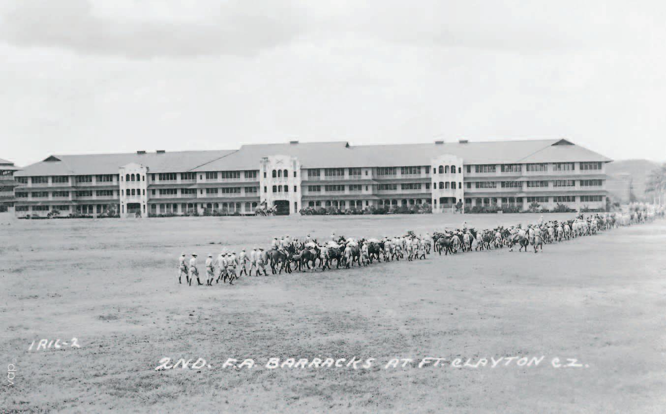
The original base outlined by the Cronkhite Committee was built on the southern end of the assigned land, between the Cardenas River and the railroad lines, precisely over the Mirafores Dump landflls. It included four large barracks for the troops, 26 houses for offcers and “NCOs” (Non-Commissioned Offcers)4, a main building for the administration, and eleven additional structures for stables and warehouses. The 33rd Infantry Detachment, which was the frst to arrive, took possession of the base on October 25th, 1920.
Although there had been a lull in the rhythm of construction in the 1920s, during the following decade the base began to grow. A regiment from the Corps of Engineers, others from the Field Artillery, the Medical Corps, the offces of the Quartermaster, and more, moved there. The population rose from 2,180 (2,117 soldiers and 63 offcers) in 1934 to 3,636 (3,543 soldiers and 93 offcers) in 1939.
The ordinal base was built between the Cardenas River and the railway tracks, exactly over the Mirafores Dump landfll. It included four large barracks for the troops and 26 houses for offcers and NCOs.

4 According to U.S. military jargon, the term “non-commissioned ofcer” refers to sergeants and certain corporals.

Music band on the parade grounds of the original base. Two of the four large barracks that were part of the base can be seen in the background. Source: Vicente A. Pascual Collection.
General headquarters of the original base. Source: Vicente A. Pascual Collection.
Aerial view from the early 1930s, where the frst houses of Colonel’s Row (on the right side) are visible. Source: Vicente A. Pascual Collection.
In 1931, the War Department created the Quartermaster Construction Division Planning Branch, which for a time employed architects and landscape designers of a certain caliber, not simple bureaucrats. As will be discussed later on, well known architects such as Rolland C. Buckley, Gustav Schay, and Harold W. Sander worked in Fort Clayton during the 1930s. Two compounds of great architectural and urban signifcance came into existence during that decade: the Offcers’ Row (or Colonels’ Row) of residential buildings that faced the vast Miller Field, part of which had initially been used as an airfeld, and the Soldiers’ Field (now known as the Central Quadrangle), where the huge Building 104 stands out.
When war broke out in Europe in 1939, Congress in Washington D.C. appropriated 50 million dollars for the improvement of the Canal’s defense system and
The architecture during Fort Clayton’s “golden age” (1930-1945) was characterized by “tropicalized” interpretations of the Mission and Art Deco styles.
President Roosevelt placed the whole Canal Zone under military orders. Fort Clayton grew even more and reached a population of 4,074 (3,927 soldiers y 147 offcers) in 1941, just before the attack on Pearl Harbor. It was at that time that the vast New Post (today’s Parque de los Lagos or Lakes Park) was created on the northwest edge of the fort.
When Clayton reverted to Panama, many of the buildings erected during the Second World War became a part of the City of Knowledge. Only the large hospital (which now belongs to the Caja del Seguro Social, Panama’s social security system), the former nurses’ residence and several sectors assigned for offcers’ residences remained outside the area. These had all been built between 1941 and 1943. After this golden age in the history of Fort Clayton, which was characterized by the widespread use of “tropicalized” Mission and Art Deco styles in its buildings, investment levels dropped.

Aerial view of the Central Quadrangle of the City of Knowledge. Photo: K. Calvo (2010).
Main façade of Building 104 (today the seat of the City of Knowledge Foundation), which was erected in 1933. The building was originally conceived as a gigantic barracks made to house four feld artillery companies. Source: Vicente A. Pascual Collection.


Above: Athletic competition on the base’s track feld (see its location in the plan on page 31). In the background, one can see the ofcers’ houses built between 1932 and 1933.
Below, left: Tents on Miller Field.
Below, right: Former Clayton Hospital (1940-1943), which is today the seat of the Panama Social Security Headquarters. All three images are from the Vicente A. Pascual Collection.

Detail of
plan of Fort Clayton in 1942. Source: National Archives, College Park, Maryland.

During the Cold War, traditional defense systems based on gigantic military deployments became less important: the costs of their maintenance were too high, and they no longer offered protection against attacks from the air. In addition, relations between Panama and the United States were becoming increasingly tense. The possible loss of the Canal Zone was already being predicted in Washington D.C.’s higher circles.
In Fort Clayton (as in the rest of the “Zone”), the architectural and urban concepts took a radical turn. Although the military population of the Canal Zone was drastically reduced—from 67,000 inhabitants in 1943 to 6,600 in 1959— more and more soldiers were coming with their families. In 1961, the number of married personnel had risen to 45%. It became necessary to modify the huge old barracks, where the troops slept in large rooms with no privacy whatsoever, or to replace them with more adequate buildings with multiple
individual dwellings. Right after the Second World War, the restructuration and expansion of the fort was begun, a process that would be developed in four stages from 1947 through 1979.
The frst large housing project was developed on the so-called “Hill 2”5 on the northern edge of today’s City of Knowledge, followed by another compound located on the base’s original grounds (1958-1960). The fnal expansions, so large that they more than doubled the urban area, were carried out between 1965 and 1969, and again from 1978 to 1979, mostly toward the northeast. Several hundred housing units were built as part of the two latter expansion projects that took on a suburban character both in their layout and architectural style.
5

After the end of World War II, Fort Clayton’s architectural scheme was restructured. The frst expansion, a complex that included 36 one-story duplex houses, was carried out between 1948 and 1949.
Group of 38 housing units for corporals and sergeants fnished in 1943 (known today as buildings 301-316, 318-323, and 325-340).
Photo: K. Calvo (2010).
Source: City ok Knowledge Foundation.

FORT CLAYTON’S BUILDING STAGES
1919-1922 (Buildings preserved from the original base)
1932-1940
1940-1941
1942-1943
1948-1949
1958-1965
1965-1979
Limits of the City of Knowledge
Drawing:


The Handover to Panama
From 1979 to 1999, the Canal Zone reverted to Panama in different ways. During these twenty years, the Canal itself was jointly administrated by the United States and Panama. The transitional administrative entity, known as the Panama Canal Commission, was later transformed into the Panama Canal Authority. In order to reorganize the territory, a master plan was drawn up and approved in 1996. The forest reserves became the responsibility of the Autoridad Nacional del Medio Ambiente (National Environmental Authority). The properties on the military bases, which had been inventoried in great detail by the Southern Command, reverted in several stages. Each one of the bases was considered as a separate entity; the main intermediary was the Autoridad de la Región Interoceánica (Authority of the Interoceanic Region), which existed until 2005 and which initiated a privatization process that is still ongoing.
Through Law Decree No. 6 of 1998, the Republic of Panama established the transfer of part of Fort Clayton for the development of the City of Knowledge project.The 120 hectares that the City of Knowledge Foundation received in November of 1999, which are governed by a Master Plan approved in 2009, match what had been the base’s “historic center.” The rest of Clayton was divided into several parts: the forested areas were annexed to the Camino de Cruces National Park, established by law in 1992. The hospital, as has already been mentioned, was assigned to Panama’s Social Security, and urbanized areas were privatized. Nowadays, these areas are subject to the same pressures that are experienced and endured by the rest of the capital city.

Joint U.S.-Panama control at a sentry box in Fort Amador during the transition period. Source: Panama Canal Authority.
On the right: General Map of the Lands and Waters of the Panama Canal Treaty. Source: Panama Canal Authority.


The U.S. Army’s presence in Panama ofcially came to a close in Fort Clayton on July 30th, 1999, with the casing of the colors during ceremonies on the parade ground (today’s Central Quadrangle). Source: Panama Canal Authority
Celebration of the countdown for the fnal transfer of the Canal to Panama, on December 31, 1999. Source: Panama Canal Authority.
Architectural
and Urban Development in the Former Canal Zone


Far from being an isolated case, Fort Clayton was an integral part of the network of civilian and military settlements built by the United States throughout the former Canal Zone.
For this reason, any analysis of the architectural and urban legacy that this former base represents for Panamanians must be based on an understanding of the “Zone” as a whole, not an easy task considering the contradictory opinions still prevalent in our society towards the Canal Zone. The return of these lands to Panama has made it possible to visualize how the present-day site of the City of Knowledge relates to its pre-Canal Zone history, connections that have never been studied.
Most of the permanent settlements in the Canal Zone were created on the basis of the aforementioned Canal Zone Act of 1912. None of the historic towns along the Cruces Trail or the Chagres River were preserved, nor hardly any of the other pre-existing settlements. Places such as Matachin, Gorgona, Buena Vista, Chagres, Rio Grande, and others were erased from the map. Cristobal, a French settlement in Colon, is one of the few surviving sites that date from before 1904, although all the original buildings, including Ferdinand de Lesseps’ mansion, were torn down. Throughout the “Zone,” many historical place names were kept, although in connection with new sites. The American townsite Gatun, for example, has nothing to do with the original Panamanian Gatun.
All townsites related with the operation of the Panama Canal—Balboa with its magnifcent suburbs, Cristobal as rebuilt after 1912, Gatun and Gamboa, among others—were planned, built and rebuilt by the Isthmian Canal Commission or its successors: the Panama Canal, which existed from 1914 to 1951, or the Canal Zone Government and the Panama Canal Company, the two entities created by law in 1950 to replace the Panama Canal. Both disappeared on September 30th, 1979, just before the Torrijos-Carter Treaties (which sealed the end of the Canal Zone) went into effect.
The Panama Canal Company was in charge of the construction and administration of houses, hotels, and commissaries, whereas the Canal Zone Government, with its impressive bureaucratic apparatus, was in charge of the administration of schools, hospitals, and other public buildings. Balboa was the center of it all; the “government palace” was the majestic Administration Building, which had been fnished in 1914.
The military bases were a different matter. These were also highly regulated settlements, although under the specifc direction of the War Department, which became the Department of Defense in 1947. Although work on the Canal had been directed by military personnel from the U.S. Army Corps of Engineers, the administration and the defense of the Canal were two separate worlds. In fact, the Zonian government and the military authorities were in open competition with each other and did not always get along.

PANAMA CANAL COMPANY
Canal Activity Commercial Activity Housing Activity
NAVIGATION
DREDGING
LOCKS
ENGINEERING
SERVICES
TERMINAL
COAL AND OIL
RAILROAD
S. S. LINE
UTILITIES
COMMISSARY
SUPPLY AND SERVICE
HOTELS
CLUBHOUSES
INDUSTRIAL
BUREAU
EMPLOYEES QUARTERS
CANAL ZONE GOVERNMENT
CIVIL ADMINISTRATION
The administrative apparatus of the Canal Zone in action: Gold Roll ofce workers, 1929. Source: Panama Canal Authority.
Previous page: With its colonnade in the Neo-Renaissance style, the Administration Building represents the epitome of Zonian monumentalism. Photo: E. Tejeira.
Source: Panama Canal Authority.


During the frst period, when architecture was all wooden, houses were separated from the ground by small piles and had hip roofs and porches protected with metal screens, a anti-mosquito measure instituted by Gorgas in 1905.


Group of wooden houses in Balboa, built for the Gold Roll in the frst decade of the twentieth century; later demolished. In the background one sees Ancon Hill, which had been deforested due to its exploitation as a quarry. Source: Panama Canal Authority.
Group of wooden houses for executives of the Compagnie Universelle du Canal Interocéanique in Cristobal (originally Christophe-Colomb) at the time of their construction, ca.1883. Source: F. Blanc et Cie., Panama.
The Pedro Miguel camp in 1911, with its wooden houses surrounded by screened-in porches. Source: Panama Canal Authority.
Residence of the Chief Engineer of the Isthmian Canal Commission built in Culebra in 1906 and moved to Ancon in 1914. Today it is the Canal Administrator’s house. Source: Panama Canal Authority.

The Canal Zone in 1913. At the time, the Canal Zone did not yet include all of Gatun Lake. Source: Abbot, 1914.

The architecture the Canal Zone is best known for today is not that of the military facilities, but rather the one developed by the Isthmian Canal Commission and its successors. It all started with the Architect’s Offce created in 1904 to take care of the over two thousand buildings inherited from the French Canal company, and to develop new architectural types based on the demands of the climate, health concerns, and the company’s rigid hierarchies. Under its frst director, New York architect Parker O. Wright, the Architecture Offce designed twenty-four different types of houses, in addition to schools, hotels, clubhouses, and institutional buildings, which were all initially built of wood.
The idea of centralizing this Offce was maintained throughout the Canal Zone’s history, although under different names; in later years it was called the Engineering and Construction Bureau, one of six the Panama Canal Company had for its operations.
During these seventy-fve years (1904-1979), a minimum of four major periods stand out in the development of civilian architecture, all easily identifed based on their formal characteristics: the initial period of wooden camps; the monumental, historicizing architecture in the decade of 1910; the mixed (concrete and wood) construction architecture of the 1930s and 1940s; and modernist architecture from 1950 onwards.

Very little remains from the frst period, with its wooden architecture similar to that of the earlier French Canal company; its most important vestige, which is today almost a relic, is the Canal Administrator’s Residence in Balboa Heights, originally built in Culebra in 1906 and rebuilt in its current location (albeit with some changes) in 1914. The houses, which were separated from the ground by small piles, had hip roofs and porches that were protected with metal screens, an anti-mosquito measure established by Dr. William C. Gorgas in 1905.
After 1910, plans were made on a grander scale. In 1912, Austin W. Lord, the Dean of Columbia University’s School of Architecture, came to Panama to start the design of Balboa, the splendid administrative capital. The following year, the Presidency sent a Fine Arts Commission, under the leadership of sculptor Daniel C. French and landscape architect Frederick Law Olmsted Jr., to make a proposal on how to “beautify” the Canal Zone. Once they were in Panama, its members insisted that such a renovation was unnecessary, but the idea became established that the Canal Zone should have beautiful and monumental public buildings, surrounded by green areas. Instead of wood, which required constant maintenance in Panama’s climate, concrete slabs and plastered block walls were to be used.
Work in Balboa was begun in 1913, initially under Lord’s direction and later—when he left due to differences with Coronel Goethals—under Mario Schiavoni and fnally, under Samuel M. Hitt. The landscape design was directed by William Lyman Phillips, who would later become one of the most prominent professionals in his feld in the United States. The architecture favored at that time, based on the experience of the City Beautiful Movement in the United States and the principles of the École des Beaux Arts in Paris, was a Neo-Renaissance style of grand and sober forms.
The “Spanish” touch, above all in residential architecture, was achieved through the use of white walls, red roof tiles, and ornate brackets of colonial inspiration. The urban plan emerges from a grand central avenue enhanced by royal palms: the Prado.
On the other side of Ancon Hill, the hospital complex originally created by the French in 1881 was made more monumental. This brought about the creation of Ancon Hospital, which was renamed Gorgas Hospital in 1928. Architect Samuel M. Hitt projected a series of spacious neoclassical and neo-Renaissance buildings, all constructed between 1915 and 1919. Unlike the Prado, with its Versailles-like urban rigor, the hospital complex follows the lines of the sinuous topography.
Based on the experience of the City Beautiful Movement in the United States and the principles of the École des BeauxArts in Paris, the preferred architectural standard during the second decade of the 20th century was a Neo-Renaissance style of grand and sober forms.

Audience watching a match on the Ancon Baseball Field, as part of the Fourth of July celebrations in 1912. Source: Panama Canal Authority.
View of Gorgas Hospital, ca. 1920. Today it houses the Ministry of Health. Source: LOC/HABS.
View of Balboa from Sosa Hill, ca. 1920. In the background, the Prado and the Canal’s Administration Building, erected between 1913 and 1914. Source: Panama Canal Authority.

Along with the abandonment of the frst camps, the conclusion of the Canal and the massive reduction of the permanent population, the Zonian government drastically reduced its architectural programs. The most important urban project carried out in inter-war period by the canal company was Gamboa, which developed into a proper town when the Dredging Division was set up there in 1936. A new kind of mixed-construction architecture was used in Gamboa, one which allowed for the use of wood in the buildings’ upper foors. The ground foors, which were most susceptible to damage from termites and humidity, were built in concrete. The buildings continued to be made with hip roofs and wide eaves. Something similar was done in Margarita, a town established near Gatun in 1940, when the construction of the third set of locks was begun, but which was abandoned after Pearl Harbor.
Another important example from that period is New Cristobal in Colon. In 1912, the Canal Zone had received from the Republic of Panama the northeastern quarter of Manzanillo Island. The new settlement was planned with the same rigor as the other towns in the “Zone” (at the time, Colon only reached as far as Central Avenue). Houses and schools were built for the white population that did not ft in the original area of Cristobal, which had become too small once the port facilities were enlarged.

Between the two World Wars, the Canal Company’s most important project was Gamboa, where a new kind of mixedconstruction architecture of both wood and concrete was used.

Mixed-construction houses in New Cristobal, Colon, built in 1929.
Photo: E. Tejeira.
Aerial view of Gamboa, beautifully integrated into the landscape at the spot where the Chagres River meets the Panama Canal. Photo: E. Tejeira.
Mixed construction houses in Gamboa. (1941; Architect: Meade Bolton). Photo: E. Tejeira.

Colon, Boxed In by the “Zone”
For a long time, the city of Colon lived in the shadow of the United States. It was founded in 1850 by the Panama Railroad Company, a U.S. corporation, and in 1904, when the Canal Zone was created, most of its land came under Zonian control.
Cristobal, originally a suburb founded by the French in 1883, became an actual part of the “Zone,”and in 1912 Panama also handed over the northeastern part of Manzanillo Island so that New Cristobal could be established. During the construction of the Canal, the historic center of Colon, which was boxed in between Cristobal and New Cristobal, became a sort of bedroom-city for immigrant laborers, most of whom lived huddled in large wooden tenement houses. After numerous fres, wooden construction was prohibited and a neoclassical Colon came into being, with building rules that were based on Zonian regulations. It was not until 1943 that the control over Colon’s lands reverted to Panama.


Colon’s wooden architecture is now practically nonexistent. The photograph was taken in 1908, not long after the streets had been paved. Source: Underwood & Underwood.
Roosevelt Avenue in Cristobal, 1933. In the background one can see Front Street in downtown Colon.
Recent photograph of the Panama Railroad Company building. Photo: E. Tejeira.


The Canal Zone’s modernist architecture from the time after World War II, which was the product of a complete reorganization begun in 1950, envisaged replacing the remaining wooden buildings with more functionally designed structures: bungalows, semi-detached houses, schools, shopping centers, and hospitals, all of light construction, with no decoration whatsoever, and painted in pastel colors. Some important architects from the United States, above all the Chicago frm of Skidmore, Owings & Merrill, were hired as consultants. This frm was responsible, for example, for the well known archetype of the “breezeway house,” a onefamily home designed to take maximum advantage of the breeze. The model urban project, with its network of roads based on several loops, was that of Los Rios (1952-1954) located between Albrook Field and Fort Clayton, which was followed by Cardenas (1961). Initially, the Zonian community showed no enthusiasm for this new type of architecture: according to some inhabitants, the houses were too plain and looked like “chicken coops”.
The Canal Zone’s post- World War II modernist architecture, which was the product of a complete reorganization begun in 1950, proposed the replacement of the remaining wooden buildings with more functionally designed structures.
Expansion carried out in the Ancon area in 1952. Source: Panama Canal Authority.
Aerial photo of Los Rios, 1955, with its semi-circular roads and dead-end streets, which were considered innovative at the time.
Source: Panama Canal Review, December 2, 1955.
Detail of one of the “breezeway houses” in Diablo Heights, the model for which was designed by the Chicago frm of Skidmore, Owings & Merrill in 1950. The two symmetric wings on the left and right generate a breezeway through the central section, which was used as the dining room. Photo: E. Tejeira
Civilian settlements had open plans, that is, they had neither fences nor sentry boxes. They were really like company towns for the Canal’s employees, and included movie halls, stores, clubhouses, bowling alleys, and other recreational facilities.
The settlements established by the Isthmian Canal Commission and its successors had open plans, that is, they had neither fences nor sentry boxes. They were really like company towns for the Canal’s employees, and included movie halls, stores, club houses, bowling alleys, and other recreational facilities. They had much in common with United Fruit Company’s banana plantations and other American company towns overseas, except that the scale was much grander, more imperial. There was no private ownership of land (which is why some people make reference to “Zonian socialism”), and no one had property rights over their living quarters. Living in the Canal Zone was directly dependent on working there. Every now and then, the Canal Company would rebuild, reorganize, or abandon complete communities, which meant the population had to be relocated. The term “permanence” had limited meaning; nevertheless, there was a strong sense of community, anchored in a surprising number of charity organizations, civic clubs, and religious associations.
Institutionalized racism was one of the most unpleasant features of Zonian society. As early as the time of the building of the canal, the camps were strictly segregated by race and salary ranking—the famous Gold Roll and Silver Roll— a fact that directly infuenced the architecture; non-whites always had worse houses, worse schools and worse community centers than the whites. After World War II, cracks started to appear in the system.
The terms Gold Roll and Silver Roll were replaced by US Rate and Local Rate, which people considered less humiliating. One by one, the segregationist measures in jobs, housing, schools, hospitals, restaurants, movies, and sports facilities were eliminated. The Civil Rights Act of 1964 gave the system its fnal coup de grâce, although discrimination persisted in less obvious ways for a long time.
According to the offcial hierarchy, Balboa and its suburbs—Balboa Heights, Ancon, Los Rios, Cardenas, and Diablo Heights on the Pacifc side—were for employees on US Rate salaries, whereas the more peripheral neighborhoods of La Boca, Paraiso and Pedro Miguel, were for Local Rate employees. At the other end of the “Zone,” Cristobal, New Cristobal and Margarita were the privileged areas, and Rainbow City was their black counterpart.6 Gatun and Gamboa were mixed, albeit segregated. The most exclusive area in the Zonian urban hierarchy was Balboa Heights, which was reserved for the governor and the highest-ranking employees of the Canal Company. Local Rate townsites were gray and impersonal.


Above left: Canal Zone Police. Above right: Curundu Elementary School. Center: a Canal Zone commissary. Bottom left: cayuco races. Bottom right: Balboa Union Church. Source: Panama Canal Authority.


Outstanding within the military landscape were the barracks: huge three or four story dormitories. This type of building did not exist in Balboa, Cristobal or Gamboa.
The military bases, intertwined in a complicated territorial puzzle within the Panama Canal’s system of civilian settlements, were more subordinated to Washington D.C.’s guidelines and had a different structure, a much more hierarchical one, due to the very nature of the chain of command. They were fenced in for security reasons—all had sentry boxes at their entrance gates— and the urban schemes were also more rigid; the buildings (above all the houses) refected their inhabitants’ rank. On the other hand, racial segregation was eliminated in the U.S. Armed Forces long before it was in the Panama Canal.
Until the 1950s, most of the population consisted of troops of single men; the army did not look favorably upon (and for a long time actually prohibited) common soldiers being married. For this reason, the military landscape was dominated by barracks, gigantic three or four story dormitories which did not exist in areas such as Balboa, Cristobal or Gamboa.


The military bases went through architectural stages that were similar, but not identical. There was also an initial phase of wooden camps, of which some houses in Quarry Heights have survived; a monumentalhistoricizing phase with barracks inspired in the plantations of the Old South; and a modernist phase. The most impressive growth, however, took place between the two World Wars, when the building activity in the civilian areas such as Balboa was minimal. The most important compounds in Fort Clayton (the Central Quadrangle and the Lakes Park that will be described in greater detail below) were built precisely during that period.
Postcards from 1960’s published by Dexter Press, Inc., N.Y. Left page, above: US Army Fort Clayton; below: Albrook Air Force Base. This page, above: Howard Air Force Base; below left: Fort Amador; right: U.S. Army School of the Americas at Fort Gulick.
Source: Vicente A. Pascual Collection.

All of Zonian architecture, both military and civilian, had certain common characteristics. To begin with, it all had a very low density in comparison to Panama and Colon. In 1969, the population of Balboa and its suburbs did not reach 6,000 inhabitants, whereas San Felipe, Santa Ana and Chorrillo, with less than half the surface area, were home to twelve times more people. Zonian constructions were also necessarily “tropical,” because air conditioning was not introduced until the 1950s. Cross-ventilation was essential, and the architects in charge would combine closed spaces with semi-open areas—porches or verandas—which offered a transition to the outside. Later on, this “tropicality,” this special character defned by houses with large hip roofs that were surrounded by vegetation, would disappear; and although the residential architecture of the 1950s and 1960s was also based on coping with the rigors of the tropics, it was no longer “unique” nor immediately recognizable as “Zonian” in its style. In the sixties, the use of air conditioning became widespread, and the civilian and military authorities began to close porches and windows. In the process, the older buildings began to lose their charm.
In describing this urban system, Panamanians often portray it as a “garden-city” due to the low density, the curving streets, and the prominence of the vegetation in this unique environment of rain forests and lakes. However, the term is not really precise. The original garden city in England, which Ebenezer Howard dreamed of, was altogether different. The Canal Zone was more similar to the “greenbelt towns” of the 1930s in the United States, which specifcally promoted the public ownership of the land, as well as “the use of forested greenbelts as buffers between urban areas”7 as Kurt Dillon and Roger Trancik have described it.
It is also true that the original decision to reduce the urban areas to a minimum and allow everything else to remain wooded forested was taken very early on, possibly based on a direct recommendation by Goethals himself, who alleged reasons of security; the existence of this thick jungle complicated any invasion by land. The dramatic contrast between the buildings and the natural areas must also be understood cum grano salis: the “natural” is not really all that natural, because the landscapes and vegetation of today are very different from those which existed before the Americans arrived in Panama; some species were even imported from other tropical zones, including Africa and Asia. There were radical interventions in the topography everywhere: landflls, artifcial lakes and hills, channeled rivers. Drainage systems were perfected to such an extent that there were never any puddles of water.
Gatun Dam, possibly the best example of how engineering, architecture and natural landscape were integrated during the building of the Canal. The dam includes not only the spillway, but also all the fat, grass-covered grounds. It is so large that it can only be properly appreciated from the air. Photo: E. Tejeira.
7 Garden City: Progressive Planning and the Panama Canal, exhibition, Manuel E. Amador Hall, University of Panama, 8th Panama Art Biennial, September 2008.
The Buildings and Landscapes of the City of Knowledge


The previous chapter makes it clear that Fort Clayton’s legacy has much in common with that of other bases and the Canal Zone in general. Few buildings are unique, however, due to the fact that a more or less standardized architectural style was employed in all the forts, with certain variations depending on the historical period.
This history is very well documented. Most of the information, including a large collection of architectural plans, is preserved in the United States, mainly at the headquarters of the National Archives and Records Administration (NARA) in College Park, Maryland.
In 2000, immediately after the end of the handover of the Canal Zone, the Southern Command sponsored the publication of a comprehensive monograph entitled Guarding the Gates: The Story of Fort Clayton - Its Setting, its Architecture, and its Role in the History of the Panama Canal, written by Susan I. Enscore, Suzanne P. Johnson, Julie L. Webster and Gordon L. Cohen.8 In this book, each building is described in meticulous detail, albeit strictly within the context of military history.
It is worthwhile to reconsider this heritage from the perspective of Panama’s civil society. Most important within this interpretation are the values that have transcended the political changes over the years, especially those related to architecture, urban planning, and landscape design. These are the values that we hope to understand and preserve for the future.

The Oldest Buildings in the City of Knowledge
Twenty-six houses for offcers and NCOs built from 1919 to 1922 survive from the time of the original Fort Clayton – the base proposed by the Cronkhite Committee in 1919 – all of which have been adapted for offce use.
The original layout of the base was horseshoe-shaped and strictly axial. An almost identical scheme was employed in Fort Davis, built at the same time on the Atlantic side across from the Gatun Locks. Instead of being assigned to the Armed Forces, the responsibility for the design and development of the plans went to the Panama Canal’s Building Division, which had all the necessary technical personnel. The architect was none other than Samuel M. Hitt, who had been in charge of completing the Administration Building in Balboa and of the project for the impressive Gorgas Hospital in Ancon (now the offces of Panama’s Ministry of Health).
Three enormous barracks measuring 146 x 13 meters were built around a large trapezoidal open space, known as the Parade Ground. Each one had enough
space for four infantry companies. There was a fourth, “special” barrack that had three foors rather than two. As mentioned previously, these barracks were all demolished in 1957, when they were replaced by a group of simple duplex houses. (Today, former Fort Davis still has barracks similar to those built in Clayton between 1919 and 1920).
The offcers lived in a different section, separated from the troops by a street and the headquarters building, which no longer exist. Their houses (Buildings 161, 162 and 164-181)9 clearly refect military hierarchy: there was one for single lieutenants, six for married lieutenants, seven for captains, fve for feld offcers, and one for the commander. The captains, feld offcers and commanders were expected to be married and to move to Panama with their families. The only offcer entitled to live with his family in a private, unshared space was the commander, a colonel. His house, located right on the symmetrical axis, was the last one to be built (in 1922), and the most traditional in design. With a wide veranda on three sides and an ample roof, originally shingled, the house resembles the bungalow of a grand 19th century colonial landowner in Africa or Asia. The inside layout is symmetrical: the living room and dining room are located in the middle and there are two bedrooms on each side, one in each corner of the house.
8 This chapter is based in great part on the information in that book.
9 In this book, the numbers correspond to the current scheme, created by the City of Knowledge Foundation in 2006 (see the plan on page 144). The original numeration used by the Americans appears in the 1942 plan on pages 30 and 31.
Original plan of Fort Clayton, 1919. The buildings located along Gonzalo Crance Street and Vicente Bonilla Street that still stand today are marked in green. Source: National Archives, College Park, Maryland.
Building 171 on Gonzalo Crance Street, while it was being refurbished in 2010. Photo: K. Clavo.
Previous page: Aerial photograph taken from the southeast end of the City of Knowledge in 2010. In the foreground on the right, in the shape of an arch, are the buildings on the Gonzalo Crance Street, which were part of the original Clayton complex.
The main façades of the original offcers’ houses look out on large green areas: nine towards the open space formerly known as Miller Field and eleven towards the opposite side.

Perspective view of Buildings 178, 176, 174, 172 and 170 (from left to right), built between 1919 and 1920. Photo: S. Ochoa (2010).
The nineteen houses for other offcers, fnished in 1920, are quite similar to each other and have a design that refects architect Hitt’s academic background. There were six units for single lieutenants; the married lieutenants were housed in buildings with four apartments, and the offcers of higher rank lived in buildings with two apartments each. Every apartment had a kitchen, a laundry area and a bathroom. The commander was entitled to four household servants, the feld offcers had two, and the lieutenants had one.
These houses belong to the neoclassical stage in Zonian military architecture, comparable to what was built in Fort Grant and Fort Amador in the 1910’s. Their strictly symmetrical main facades were decorated with neoclassical pillars. The lieutenants’ houses were statelier: they had double-height pillars in front of large verandas protected with mosquito netting. The buildings for feld offcers and captains, which were smaller because they only contained two apartments each, had a more intimate scale, with pillars placed in a more irregular rhythm.
The main façades of these twenty houses face large green areas: nine look out on the open space formerly known as Miller Field and the other eleven houses face the opposite side. The green areas create a view that gives the whole complex a dignifed and peaceful impression. The current access road (now called Gonzalo Crance Street) originally led to the back doors where the servants’ quarters were located. The back façades, which are relatively unattractive, have no decorative details whatsoever.
On the other side of the horseshoe (and with a view of the Canal), six more houses for NCOs were built, each one for four families (Buildings 112, 113, 114, 116, 124 y 125). These sergeants and corporals were not supposed to live near the offcers but rather near the troops, which is why they were housed on both sides of the “special” barracks. The houses are similar to the lieutenants’ residences, except that they are simpler: the design is of neoclassical inspiration, but without any ornamentation.
The later history of this complex has much in common with what happened elsewhere on the base until its handover to Panama in 1999. In the ffties, the kitchens and bathrooms were redone and louvered windows were installed. Between 1976 and 1978, all the window frames were reduced in order to adapt them to new, smaller, sliding windows. In 1986, the roofs were changed as tiles were replaced with metal sheathing, and air conditioning systems were installed. As of 1981, these houses were occupied by NCOs, rather than by lieutenants or captains.
The commander’s house, located on the base’s axis of symmetry, was the last to be built and the most traditional in its design:


century colonial landowner in Africa or Asia.


The architect in charge of the design and development of plans for the original base was Samuel M. Hitt, the same architect who fnished the Administration Building in Balboa and designed the Gorgas Hospital in Ancon.
The two façades of Building 161, originally built to house six single lieutenants, 1919-1920. Original plan by Samuel M. Hitt. Source: National Archives, College Park, Maryland.
One of the four-family housing units meant for sergeants and corporals. Source: Vicente A. Pascual Collection.
The original commander’s house in Fort Clayton (Building 173), built in 1922. Source: Vicente A. Pascual Collection.
Main façade of Building 112, which faces towards Omar Torrijos Avenue. Photo: S. Ochoa (2010).

Offcers’ Housing in the 1930s
In 1930, it was decided to move the 2nd Field Artillery Battalion from Fort Davis to Fort Clayton, and the housing needs of the troops and its offcers made it necessary to construct new buildings. Residences for offcers were built in a long curved line bordering Miller Field that became known as Offcers’ Row or Colonels’ Row, located exactly on the opposite side from the neoclassical houses built between 1919 and 1922.
The frst fourteen units (Buildings 355-368) were designed according to a single type, which was also used on other bases in the Canal Zone. The construction, for which the Winston Brothers Company of Minneapolis, Minnesota was hired, started in 1932 and fnished in 1933. All materials (with the exception of the sand and stone) were imported from the United States. The architect in charge of the design was Rolland C. Buckley, an American who had arrived a few years earlier and who was also successful as an architect in Panama’s capital city. It should be noted that there are two important projects of his in the city center: the original headquarters of the Compañía Panameña de Fuerza y Luz (Panama’s electric company) on Central Avenue (1932) and the old Century Club (1928-1929), today the Biblioteca Eusebio A. Morales, located across from the Palacio Justo Arosemena, Panama’s Legislative Palace. The latter especially refects the architect’s eclectic taste
In comparison with the offcers’ residences of the previous period, this group shows a better visual integration to the oval shape of Miller Field. There is a wide green strip between the sports feld and the houses around it that serves as a transitional element between the public and private areas. It is separated from the feld by a path and from the houses by another path and a backdrop of palms, trees and shrubs which add to the sense of privacy. Fences were not necessary.
The houses themselves corresponded to a new design philosophy, far removed from the rigors of Neoclassicism. The irregular character of the forms was accentuated by the asymmetry and geometric complexity of the roofs. The lack of monumentality went well with the picturesque quality of the landscaping, which is reminiscent of an English garden. In the Zonian collective memory, this type of house was considered truly “tropical.”
The structure is a concrete skeleton; between the pillars and the beams are small decorative brackets. Instead of raising the whole house above the ground—a solution

that produces dead spaces diffcult to keep clean– the architect placed it directly on the ground and left the frst foor to serve as a service area (maid’s room, garage, laundry, and storage space). The house itself, with its living-dining room in the middle plus its three bedrooms, kitchen, and bathrooms on either side, was on the upper foor, far from any pests. Facing Miller’s Field, each house originally had a wide porch, closed in with broad lengths of mosquito screens and shutters. This was the main façade; the one facing Arnoldo Cano Arosemena Street was the service entrance.
The main prototype for these new houses was designed by Rolland C. Buckley, an architect who also worked successfully in Panama City.

Page on the left: One of the frst fourteen houses on Ofcers’ Row, built between 1932 and 1933, seen from the sports feld of the City of Knowledge. Photo: E. Tejeira (2010).
Above: A house on Ofcers’ Row that shows Rolland C. Buckley’s original design. Source: Vicente A. Pascual Collection.
The former Century Club (1928-1929), located across from the Legislative Palace, was one of Rolland C. Buckley’s well-known projects in Panama City. Photo: E. Tejeira.
Between 1934 and 1935, two more houses were built (Buildings 353 and 354) according to a different design by architect Francis R. Molther, a Cornell graduate who also worked in Panama. They were built by the Panamanian construction company Grebien & Martinz, which was authorized to work in the Canal Zone. This company had a long tradition and was very well known both in Panama and Colon. This time, the tiles were bought in Panama, rather than imported from the United States.
The foor plans are very similar to the earlier houses, except for the fact that these were designed for offcers of higher rank; for this reason, they had more bathrooms and better fnishes. In terms of style, they closely resemble the Mission Style in the United States, characterized mainly by the use of elaborately curved gables. The Mission Style is commonly inspired in California’s colonial baroque style. Nevertheless, in Panama the point of reference for this detail may have been the main façade of the church of Nata, one of the country’s best known monuments.
Five more houses for offcers were built in 1940. This time, they were much simpler because they were meant to be provisional structures, made to fll a temporary need. They are not architecturally pretentious and belong to the type of construction that combines concrete, wood and zinc that went up all over the Canal Zone during the 1930s. Four of these structures (Buildings 349-352) still exist today.
After 1950, houses were modernized in the usual manner. The most signifcant change was the closing in –with conventional doors and windows– of the porches that faced the green areas, eliminating the houses’ original feeling of transparency. In 1988, central air conditioning systems were installed, making natural ventilation unnecessary.


Aerial photograph that shows (in the foreground) the houses on Arnoldo Cano Arosemena Street, formerly known as Ofcers’ Row or Colonels’ Row. Note the ample green spaces in the sports area (the former Miller Field). Photo: K. Calvo (2010).
An image that shows House 353 (the same one that appears in the photograph on the left), shortly after its construction.
Source: Vicente A. Pascual Collection.
A house for ofcers (Building 350) built in 1940. Photo: K. Calvo.
The Church of Nata (18th century) with its curved gable. Photo: E. Tejeira.
House 353 on Arnoldo Cano Arosemena Street, constructed in 1934-1935 by the Panamanian frm of Grebien & Martinz. The architect in charge of the design was Francis R. Molther. Photo: E. Tejeira.
Building 104, the largest and most emblematic structure in Fort Clayton, was originally a huge barracks. Like the frst houses on Colonels’ Row, it was designed by Rolland C. Buckley.
The Central Quadrangle
Today, the central core of the City of Knowledge is the monumental, rectangular complex that was known during the American period as Soldier’s Field.
This complex developed in stages. The frst building to be erected was No.104, the largest and most emblematic structure in all of Fort Clayton. The architect in charge of its design was Rolland C. Buckley, the same one who had been responsible for the project of the frst houses on Offcers’ Row, who drew the corresponding plans in 1932. The contractor was also the same one: Winston Brothers Co. The construction was fnished in 1933.

The huge building (it measures 156 x 22 meters) is remembered today as the last of the Southern 10
Command’s headquarters in Panama, but originally it was no more than a gigantic barracks that housed four feld artillery companies; approximately fve hundred soldiers lived there. On the ground foor, there were dining rooms, day rooms, barber shops, a few offces and the service areas—kitchens, storerooms and refrigeration rooms. The two upper stories were occupied mainly by large dormitories, each of which had sixty beds. The main façade was the one facing the feld; the one towards the canal was originally the rear façade.
Thus it remained until 1961, when it was transformed into the base’s Community Services Center, with a “PX,”10 a post offce, a library, and classrooms. When it was designated as the headquarters for the Southern Command in 1986, it was again transformed, becoming mainly an offce building.
The large dimensions make the building seem almost palatial. Its composition is based on the canons of academic European design, with a division of the main volume into fve sections, following an A-B-C-B-A rhythm that was common in monumental architecture during the 18th and 19th centuries. The original proportions were carefully thought out. The visual rhythms, fnely calculated based on the modulation of the concrete structure (with sections that measured 20 x 20 feet or 6.1 x 6.1 meters), required the distribution of the voids in uneven numbers and the highlighting of the symmetrical axis. Although there are three portals in each longitudinal façade, the one in the center is slightly larger than the other two. The roofs are more prominent in the center and the corners, and the eaves on each foor emphasize the sense of horizontality. Architect Buckley included some details derived from the Art Deco movement and the Mission Style, above all in the portals. The shaded corridor that faces the plaza is an evident reminder of the Hispanic urban tradition.
The original details, recorded in the 1932 plans, had much in common with the houses Buckley had designed for the Offcers’ Row; the panels that originally flled the concrete skeleton, with metal screening and louvers in the windows, were practically identical, granting the building a certain feeling of lightness in spite of its immense size. Unlike the houses on Offcers’ Row, however, the frst foor was separated from the ground by small piles, approximately one meter in height, in keeping with the traditional solution in Zonian architecture.
The Central Quadrangle today. In the background, Building 104, fnished in 1933. To the right, Buildings 102 and 103 (1940). Photo: M. Chapman (2012).

Source: Vicente A. Pascual Collection
Building 100, headquarters for the main offce of the 11th Engineer Regiment, was a unique project in Clayton and in the entire Canal Zone.
The Central Quadrangle came into being when the decision was made to bring the 11th Engineer Regiment to Clayton. In order to have enough housing, it was necessary to build seven new barracks. These were grouped together around the new parade ground, which had an area of 2.3 hectares and was therefore somewhat larger than the original one from 1919.
The frst to be built, in 1936-1937, were Buildings 105 and 106, located on the southern side; the contractor was the Panamanian frm of Novey & Luttrell. The architectural style repeated the guidelines established by Rolland C. Buckley in Building 104: the screened windows with louvers, the modulation based on sections that measured 20 x 20 feet, the eaves on every foor, and the construction on pilings. Each barracks housed between 130 and 150 men. On the ground foor, there were common areas; the dormitories and bathrooms were located on the upper foors.
The fve remaining barracks (Buildings 100-103 and 107) were built between 1939 and 1940; the contractor was Robert E. McKee from El Paso, Texas. Four were made just like the frst two barracks; but the ffth, Building 100, was a special project that is unique in Clayton and in all of the Canal Zone. In addition to the dormitories for 180 men, the building housed the main offces of the 11th Engineer Regiment. From an architectural point of view, it stood out from the other barracks because of its two side wings, which were lower than the main body, and because of the three massive Art Deco portals, probably inspired by the Pueblo style of New Mexico or the famous “Puerta del Sol” in Tiahuanaco, Bolivia. The windows were also different: they no longer had louvers.
Building 100 was converted into the Clayton Elementary School in 1962. Since then, it has housed several schools. The eight buildings around the Central Quadrangle have been greatly modifed since the time they were built, due above all to the installation of air conditioning. In addition, all of the original fenestration was removed, mostly during the 1960s.


Recent photograph of one of Building 100’s Art Deco portals.
Source: City of Knowledge Foundation.
Building 100, administrative headquarters of the 11th Engineer Regiment, shortly after its construction.
Source: Vicente A. Pascual Collection.

The Buildings of the New Post
With the breakout of World War II in 1939, the Canal Zone’s military population increased exponentially and it became necessary to enlarge some of the bases, including Clayton. New housing needed to be built for the troops and the offcer corps.
For the US Army Coast Artillery, a vast expansion was made on the northwest side of the fort, beyond an area that had been used until then for warehouses, parking lots, the fre station and other utilitarian structures; it was known as the New Post. Built between 1940 and 1941, it included seventeen barracks of three different types that were designed to house 100, 150 or 200 men (Buildings 221-225, 227-228, 230-235 and 237-240), all grouped around a large empty polygonal space with a surface area of over seven hectares. The standard barracks prototypes developed in 1939 by the American architect Harold W. Sander were employed. A much smaller building, to be used as the detachment’s main offce, was built on a hill (Building 220, fnished in 1942). The contractor was the U.S. frm of Tucker, McClure, Thompson & Markham, with headquarters in Los Angeles.
On the opposite end of the base, next to the original complex of 1919-1920, three more barracks in the style developed by Sander were constructed (Buildings 128, 129 and 130 on Arnoldo Cano Arosemena Street). These types of barracks, which were also built in Albrook, Corozal, Howard, Davis, and Sherman, were slightly different from the earlier versions on the Central Quadrangle: the windows no longer had louvers and, instead of the Dutch-hip roofs (a combination of gable and hip roofs), the barracks had hip roofs without the two gables, which had been used in traditional Zonian architecture to improve the ventilation inside the roofs. In this case, ventilation was achieved through the installation of ridge ventilators on the rooftops. The
New Post’s barracks also had a very low (2.30 meters) additional foor in replacement of the dead space that previously separated the buildings from the ground; in the fve barracks on the north side, these spaces formed a kind of basement against a sloping ground, but the rest had windows on all four sides.
The frst foor was planned for the common areas (living rooms, dining rooms, kitchens, etc.) and the two upper foors were for the dormitories. There were sleeping quarters for 16 and 32 men, and in the larger barracks they had some for 64 men. The NCOs had separate bedrooms.
The fact that these barracks were designed by Harold W. Sander now has practically been forgotten. Sander has gone down in history as one of the founders of the Modern Movement in Panama, above all because of his association with Octavio Méndez Guardia, with whom he developed well-known projects such as the Caja de Ahorros (a savings bank) on Central Avenue (1948), which was recently demolished; and the Hotel El Panama (1947-1951), which he designed in collaboration with Edward D. Stone. In fact, Sander worked successfully in both territories. When he came to the Isthmus in 1931, he worked in the Canal Zone, but later he expanded his area of activity to include Panama. Before working with Méndez Guardia, he designed Carlos Eleta’s residence in La Cresta (19401941), an eclectic project with an Art Deco undertone. Like no other architect, Sander managed to remain important to two clienteles: one Zonian and the other Panamanian. In the 1950s, when he separated from Méndez Guardia, Sander again worked in the Canal Zone; there he created schools in a modernist style for the Panama Canal Company. The best known is that in Diablo (1960), now occupied by the Policía Nacional (Panama’s National Police).
The New Post’s barracks became practically obsolete by the 1950s, when Fort Clayton’s population diminished and living concepts changed. In most cases, the large sleeping quarters were subdivided or recycled for other purposes. The introduction of air conditioning also led to the closing in of many of the open spaces, a process through which Sander’s buildings lost their character. At the time of the handover to Panama, the only barrack that was still in a state similar to its original form was number 230.

Harold W. Sander has gone down in history as one of the founders of the Modern Movement in Panamanian architecture, above all because of his association with Octavio Méndez Guardia, with whom he carried out several of his most acclaimed projects.

Building 220, which housed the New Post’s main ofces, was built in 1942. Photo: E. Tejeira.
Elevation drawings of standard barracks for 200 men, 1939. Buildings 221, 238 and 240, fnished in 1941, follow this model. Architect: Harold W. Sander. Source: National Archives, College Park, Maryland.
Photograph from the 1940s showing fve of the New Post barracks (current Buildings 221-225, from right to left).
Source: Vicente A. Pascual Collection.
Harold Sander’s Legacy
The fgure of U.S. architect Harold W. Sander, known in the Canal Zone for his designs of barracks and schools, proves that there was some degree of interchange between the closed Zonian world and the Republic of Panama. The famous Hotel El Panama, for example, was a design produced jointly by Sander, Edward D. Stone and Panamanian architect Octavio Méndez Guardia. This interchange explains certain similarities between Panamanian and Zonian architecture during the 1950s and 1960s. It is not coincidental that the very tropical residence designed by Méndez & Sander for Leroy Watson in Altos del Golf (1951) shows a certain similarity with the Breezeway House proposed by the Chicago frm of Skidmore, Owings & Merrill of Chicago for the modernization of Zonian architecture (see page 54); both have H-shaped foor plans, created in order to channel the breeze. This case was not unique; ten, twenty years before, the style for all of Bella Vista was infuenced by the Canal Zone Mission Style. Here and there, there are still apartment buildings directly inspired by Canal Zone barracks.


Above: Hotel El Panama (1947-1951). Architects: Edward D. Stone, Octavio Méndez Guardia and Harold W. Sander. Campo Alegre, an extension of Bella Vista developed in the 1940s, appears in the background. Flatau postcard, ca. 1951.
Bellow: Residence of Leroy Watson in Altos del Golf, Panama City (1951). Architects: Méndez & Sander. Photo: courtesy of Octavio Méndez Guardia.
Apartment building that belonged to David Montefore Toledano (1930), 50th Street, Bella Vista, demolished in the 1980s. Zonian infuence is clearly visible. Photo: E. Tejeira (1977).

Other Housing Complexes
At the time when Architect Rolland C. Buckley was hired to plan the new barracks and offcers’ residences, he also designed a building type for NCO housing. The plans were made in 1931, although the buildings (110 and 111) were not constructed until 1932-1933. Winston Brothers Company was the contractor.
The buildings were located to the northwest of the old barracks, far from the area reserved for the offcers, although with a wonderful view towards the Panama Canal. Since the NCOs are of a lower rank, the apartments were smaller than the houses on Offcers’ Row: they had two bedrooms instead of three. However, from the Omar Torrijos Avenue, the buildings look monumental, since they are symmetrical and have three foors; their corner gables are unique in all of Clayton. Originally, they had the same metal screen enclosures and louvers as the rest of Buckley’s projects. Likewise, the ground foor was used for the servants’ quarters, laundry and storage rooms.

Above: Back façades of Buildings 111 and 110, built for NCOs between 1931 and 1933. Architect: Rolland C. Buckley. Source: Vicente A. Pascual Collection.
Below: Buildings 110 and 111, seen from Omar Torrijos Avenue.
Photo: E. Tejeira.


With the great expansion of Fort Clayton which began in 1939 and was still in the process of development when the attack on Pearl Harbor took place, it became necessary to build many more housing units for offcers and NCOs. For the latter, an empty space north of Miller Field was chosen, separated by a street from the offcers’ area. There, 38 buildings went up, along three parallel paths (301-316, 318-323, 325-340), all of which were fnished by 1943. The new houses for offcers were built further to the north, on rolling hills that are now located beyond the limits of the City of Knowledge.
This new type of architecture was solid and austere, very different from Buckley’s projects of the previous decade. Almost all the buildings for NCOs included two dwellings, which brought about the nickname “tropical duplexes.” Each had a rectangular plan, hip roofs and frst foors that were protected by eaves on all sides. It is noteworthy that, as of this period, Zonian military architecture ceased to include the traditional porches, which the Army’s planners deemed to be superfuous spaces. Instead of the porches, conventional windows were put in place, originally with shutters.
Surprisingly, the differences between offcers’ residences and those for NCOs were no longer as obvious as before; the main distinction was now in terms of size. Building 434, where the base commander lived when he moved out of the original house, was special mainly because of its privileged location on a hill, not because of its appearance.
During the postwar period, architecture took a new turn. Designs that were much more standardized and inexpensive than those of the pre-war years would be developed in the United States. The frst complex of 36 one-story duplex houses for NCOs was built between 1948 and 1949 on the northern end of what is now the City of Knowledge, mainly in the area referred to as “Hill 2”11 (Buildings 371-398). These duplex houses were simple and unpretentious, but provided more spacious dwellings than the earlier houses. Although these were designed taking the tropical climate into consideration, they were the frst buildings in Clayton to break with the traditional image of Canal Zone architecture. In spite of the fact that the urban scale is quite generous, with broad streets and green areas, the complex resembles a typical suburb in Texas or Florida.
Later on, in the 1950s, the large infantry barracks that had been built in 1920 and the old stables located at the southern end of the base near the Cardenas River were demolished. They were replaced by duplex houses that were, for the most part, inexpensive, single-story buildings. These single-story houses, 53 of them in total, were built for NCOs between 1958 and 1960. They came to be known as “Capehart Quarters” because they were based on a Department of Defense housing renewal plan which had been promoted in 1955 by Senator Homer Capehart. The architect in charge was Joseph H. Bryson of the Corps of Engineers in Jacksonville, Florida. Between 1964 and 1965, fve more offcers’ houses were built. They had two foors and were developed according to two types: one with three bedrooms and one with four bedrooms. From this group, Buildings 159 and 160 still survive.12
11
12

One-story duplex houses for NCOs built in 1960 and located on the southern end of the base. Photo: P. Tzanetatos (2009).
In the City of Knowledge’s Master Plan of 2009.
Other buildings based on these two types were built beyond the limits of the City of Knowledge. They still stand today.
Group of buildings constructed for NCOs that were fnished in 1943. There are 38 in total. Photo: P. Tzanetatos (2009).
Unique Buildings
Within the City of Knowledge, several unique buildings that merit special attention have been preserved.
The oldest among them, built one next to the other in an area between the base’s original complex and the Central Quadrangle, are Buildings 108 and 182: the old Enlisted Men’s Service Club and the movie theater. The club was opened in late 1934 and the theater a few months later, in early 1935. Both were planned by the same Panamanian frm, Wright & Schay, and built by the previously mentioned company of Grebien & Martinz. The American architect James C. Wright, who had become well-known for designing the Hospital Santo Tomás when Belisario Porras was President of Panama, and the Hungarian Gustav Schay, probably the best designer in Panama at the time, had numerous clients among the Panamanian upper class; it was around that time that they designed their best private residences in Bella Vista, usually in a Spanish-colonial revival style. They also designed the Jardín El Rancho, a nightclub in the area on the border between Panama and the Canal Zone. In view of the fact that Prohibition was enforced in the United States until 1933, people living in the Canal Zone had to cross into Panama or Colon in order to obtain alcohol. (In the Canal Zone, alcohol was prohibited as of 1913 while in the United States, Prohibition was not instituted nationwide until 1920.) Fourth of July Avenue and some neighboring streets specialized in providing recreation, from cabarets and restaurants to brothels.
Both projects, the club and the theater, were designed following the same Spanish-colonial revival fashion known in Panama as “bellavistino” (in the Bella Vista style), a picturesque and romantic style of irregular forms and decorative details inspired in colonial architecture. It is characterized by exposed stonework imitating masonry, plastered walls, arches, solomonic columns, curved gables and tile roofs. It combined elements of the Mission Style, of the later Spanish Colonial Revival Style (which is somewhat more baroque), and of Peruvian colonial architecture. The architects were told that their designs had to harmonize with Building 104, which had just been fnished, although the fnal results looked much less severe, with less of a military air about them.
The club, which was a beer garden and restaurant for the troops (by 1934, drinking alcohol was allowed), is an L-shaped, one-story building, with an open patio in the back. Later, it became a meeting place for adolescents, and fnally (towards the end of the U.S. period), a daycare center. It has been substantially changed since it was built.
The Enlisted Men’s Service Club and the movie theater (from 1934 and 1935) were the work of the Panamanian frm of Wright & Schay. Both buildings were designed following the Spanish-colonial revival fashion known in Panama as the “bellavistino” style (Bella Vista style).


House that originally belonged to the Toledano family (and after, 1956, to the Duque family) on Fiftieth Street in Bella Vista (1937), one of the best known works by the architects Wright & Schay in Panama City. Photo: E. Tejeira (1986).
Fort Clayton’s second movie theater, built in 1940 and demolished in 1969. It was an exact replica of the 1935 building.
Source: Vicente A. Pascual Collection
Building 108 (former Enlisted Men’s Service Club) as it looks today. Photo: E. Tejeira (2010).
The former Enlisted Men’s Service Club, Building 108, constructed in 1934. Architects: Wright & Schay.
Source: Vicente A. Pascual Collection.

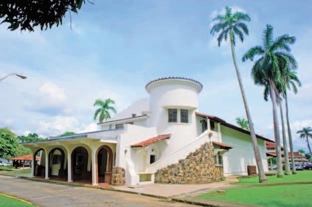
The theater’s Bella Vista - like appearance is emphasized by its unusual corner tower. In fact, it was not the frst movie hall in Clayton. A previous theater —with 150200 seats, located in the original headquarters— had existed as early as the 1920s. As the base grew, it became necessary to build a much larger theater; the new movie hall could accomodate approximately 800 soldiers. The foor plan is quite simple: a rectangular space with a foyer in front and a stage towards the back. The more eye-catching elements—the tower, the circular staircase, the exposed stonework, the baroque details—are concentrated mostly in the front of the building. The curved gables resemble those designed by architect Francis R. Molther for Buildings 353 and 354 on Colonel’s Row, which were mentioned earlier.
Nowadays, the theater itself is a large, enclosed box, but originally it was far more open because it required natural ventilation; the side walls had many screencovered openings. It was later, once the air conditioning system was installed (1954) that it became necessary to block off those openings. In 1957, the main façade was remodeled.
Not long after the theater was completed, the base’s population grew to such an extent that a single movie hall was no longer enough to satisfy the great demand. So the decision was made to build another theater: an exact replica of Building 182, including the tower, was built in 1940. This second theater was demolished in 1969 in order to build the Valent Center, where the City of Knowledge Convention Center is located today.

Above and left: Recent photographs of the former Clayton movie theater, now converted into the Atheneum of the City of Knowledge. Both photographs by K. Calvo (2010).
View of the interior of the former Clayton movie theater as it looked in 2009, before it was remodeled. Source: City of Knowledge Foundation

Another building erected in 1940 was the NCO Club (Building 126, located at the southern end of the base), which was evidently different from the Enlisted Men’s Service Club. Its design imitated the archetype of the barracks for 48 men, architecturally similar to the barracks for 100, 150 and 200 men, except for the fact that it was narrower and had two foors. In addition to the rooms for meetings and events, it included music rooms and a library. The building, fnished in 1940 and modifed in 1961, was almost unrecognizable at the time of the handover.
From the same period (1941) are the base’s garage and gasoline station (Building 200), a very modest structure that stands out for being the oldest of its type still in existence in Panama City. The architecture, with its horizontal lines and its roofs with wide eaves, is typically Zonian; its rigorously symmetrical volumes are very well proportioned and balanced. It had four pumps (later removed) and a housing unit on the upper story. Not far from the gasoline station, a bowling alley (Building 202) was constructed. It was fnished in 1943, remodeled in the late 1960s, and to this day remains well preserved with all of its equipment and interior decoration.

Back to Clayton’s “recreational area:” a few steps from the former Enlisted Men’s Service Club there is a gymnasium (Building 183) that was originally constructed in 1925. It was initially a sort of hangar, a simple rectangle measuring 20 x 49 meters, with a vaulted steel-structure roof. Completely remodeled in 1951, a “nave” was added on each side and the façades were redone, although the central structure apparently kept its original form. The style is a sort of simplifed Art Deco, decorated with brise-soleils. En 1956, it was named Reeder Gymnasium in honor of Colonel Russell Potter Reeder, a former commander of Fort Sherman.
Building 369D, an olympic-size swimming pool, was built in 1948. The same model was used on other bases in the Canal Zone. Before the handover to Panama, the pool was named after Brigadier General Forrest Estey Williford.

Bowling Alley (Building 202). Photo: S. Ochoa (2010).
View of the interior of the recently restored Bowling Alley. Photo: E. Tejeira (2010).


Sports and Recreation Complex
The campus of the City of Knowledge includes a sports area with a gymnasium, a pool and courts for racquetball, tennis, basketball, football and softball, as well as open green areas which are what is left of the huge Miller Field (see page 73 upper image). Since 2001, the Kiwanis Club has administrated the complex through an agreement signed with the City of Knowledge Foundation. This alliance has made it possible to preserve, maintain and improve these facilities for the beneft of all the Panamanians and foreigners who use them every day for sports, recreation and culture.


Left: Exterior view of the gymnasium (Building 183) constructed in 1925 and refurbished in 1951. Right: View of the interior of the same building. Both photos by E. Tejeira (2010).
Above. The pool, built in 1948.
Below: Softball feld in the City of Knowledge sports complex.
Both photos by S. Ochoa (2010).

Between the gymnasium and the pool, in the space originally occupied by the aforementioned replica of the old theater, a second Enlisted Men’s Service Club (Building 184) was constructed, a successor to the one built in 1934. It opened in 1975, two years before the Torrijos-Carter Treaties were signed. Measuring 40 x 46 meters, it is considerably larger than the earlier club. It became known as the Valent Center, named after Othon O. Valent, an outstanding military man. Today it is the Convention Center of the City of Knowledge. Its massive architecture, a product of the 1970s, clearly has nothing to do with Canal Zone tropical tradition; it was planned to incorporate central air conditioning and is a completely closed structure. The contractor was the Dillon Construction Company of Pedro Miguel, and it was the last grand project built on the base.
Finally, the Ecumenical Temple (Building 109), located to the south of the former movie hall, should be mentioned.
The plans for it were brought from Jacksonville, Florida: the architect was Herschel E. Shepard, Jr., with the assistance of the engineering frm of Evans & Hammond.
The fnished building was opened to the public in 1965.
As the name implies, it was not a church for a specifc religious group, but rather a multi-denominational chapel. It contained, among other things, a grand hall, a wedding hall, a choir hall, two meeting rooms, and offces for the chaplain and his assistant. The building itself follows a modernist style, although it attempts to evoke the forms of traditional Christian architecture. The spatial distribution creates a sort of open patio between the “church” itself and the offces and halls, corresponding to what historically would have been the cloister. The building was designed with a central air conditioning system; the clay sunshades serve to flter out the sunlight.

The Ecumenical Temple (Building 109) built in 1965. Architect: Herschel E. Shepard, Jr. Photo: E. Tejeira (2010).
The current Convention Center (Building 184) was originally Clayton’s second Enlisted Men’s Service Club, built in 1974-1975.
Photo: E. Tejeira (2010).
Heritage Issues: What to Preserve?
How to Transform?


From the moment it was created, the City of Knowledge has been responsible for the transformation of a former U.S. military base into an international complex that promotes collaboration between research centers, universities, companies, and international organizations, and which contributes to the development of Panama and the region through the advancement of scientifc, technological and humanistic knowledge.
This transformation process has required the design and implementation of architectural, urban and landscaping projects inspired by principles that the Foundation has developed and perfected over the past few years. Today, the City of Knowledge manages a series of planning mechanisms, which allow for the projection and ordered use and development of its infrastructure and spaces, integrating concepts of sustainability, as well as measures for the conservation of its historical assets, and their adaptation to new requirements.
Although certain efforts have been made in our country to create an inventory of and to protect the cultural assets of the former Canal Zone, our society has not reached a consensus regarding the manner in which they should be preserved. On the other hand, mixed feelings, prejudices and often even a lack of knowledge, continue to exist in Panama regarding the scope and implications of this heritage. Consequently, it has not been an easy task for the City of Knowledge Foundation to defne which properties within the former military complex should be preserved, or how to carry out the transformation of this legacy so that it can serve a new purpose. This is also the reason for the Foundation’s interest in making the development of this process known, in order to incorporate it into a broader refection about the issues of historic preservation.
Panama and its Memories of the Canal Zone
Even though the existence of the Canal Zone is a relatively recent historical fact, most people in Panama, whose average age is just over twenty-fve, are too young to remember it. Although it has only been slightly more than ten years since the withdrawal of the last U.S. military personnel from the country, it has been more than thirty years since the “Zone” ceased to exist as a political entity. In this regard, there is a certain ambivalence in Panama’s collective memory: on one hand, some historical resentment against the Canal Zone still persists and, on the other hand, sometimes there is an exaggerated idealization of it. In contrast to those who feel indignant when they remember the Silver Roll, the tragic events of January 9th, 1964, and other abuses, there are those who feel nostalgia for the commissaries and the PXs13 they remember as consumer paradises. The discussions about these memories, when they come up, vary dramatically depending on the background, the education and the mentality of the people involved.
The most prevalent discussions about the reverted areas have focused on historical, socio-economic, ecological, technological, and legal aspects in relation to the canal itself and to the natural resources of its hydrographic basin, as well as debates about how the urban development of these areas should be carried out. Nevertheless, in Panama refections about the former “Zone” are limited, as many perceive it as something from the past that is irrelevant in the present. The idea Panamanians have of Zonian society tends to be limited to very superfcial generalizations, refecting a separate reality that was close by and yet quite far removed from them. More than half a century ago, the visions of Zonian society proposed in novels such as Luna Verde (Green Moon) or Gamboa Road Gang by Joaquín Beleño were important, written as they were from the unavoidably and uniformly negative perspective of the humiliated Silver Roll workers. Obviously, since then, Panamanians’ points of view have broadened. A recent attempt to offer a more balanced and complex vision was evident in the exhibition The Material Life in the Canal Zone, held at the Museo del Canal Interoceánico (Interoceanic Canal Museum) in Panama City. Then in 2008, one of the most innovative achievements of the 8th Panama Art Biennial, entitled Entering the Canal Zone, was to demonstrate how we still have a long road ahead.
Considering these facts, the paucity of publications about the architectural and urban heritage of the Canal Zone is not surprising. Although the Autoridad del Canal de Panamá (ACP – Panama Canal Authority) and the
Unidad Administradora de Bienes Revertidos (UABR –Offce for the Administration of Reverted Assets), which replaced the Autoridad de la Región Interoceánica (ARI – Authority of the Interoceanic Region), have substantial documentary holdings worthy of study, Panamanian initiatives geared towards getting to know and to divulge this legacy are meager. To date, the only book to have been published in Panama on this specifc topic is Samuel Gutiérrez’s La arquitectura de la época del Canal, 1880-1914 (Architecture during the Time of the Canal, 1880-1914; Panama, 1984).
The scarcity of books about the Canal Zone contrasts with the large number of publications that exist regarding the Casco Antiguo (Panama’s Old Quarter), Panamá Viejo (“Old Panama”)14 and other colonial sites. Obviously, in the Panamanian collective memory these sites are considered “ours” and are intimately related to our national identity, whereas the Zonian heritage is still perceived as “foreign.” At this point, it is worth remembering how the discourse in favor of the preservation of the Spanish heritage, which was practically abandoned during the 19th century, took root after 1903, when it became necessary to build our own legacy as different from that of Colombia. At that time, the defense of our Hispanic past was also nurtured by Panamanians’ opposition to the United States and its overpowering culture.
13 Commissaries were stores for Panama Canal Company employees, and “PXs” (post exchanges) were stores for members of the Armed Forces.
14 Translator’s note: Panamá Viejo refers to the monumental historic complex with the ruins of the frst Panama City, founded in 1519 and destroyed by pirate Henry Morgan in 1671. The
the

Partial aerial view of the City of Knowledge. In the background, Panama City. Photo: K. Calvo (2010).
Casco Antiguo is
historic quarter of the new Panama City, founded in 1673.

The conservation of Zonian heritage confronts other obstacles as well. In 1997, a joint commission of the Instituto Nacional de Cultura (INAC – National Institute of Culture) and the ARI proposed a list of culturally valuable areas and buildings that should be protected,15 an initiative that did not advance due to the opposition of certain U.S. Government offcials who, at the time, still took part in the management of the Canal. In 2003, after the handover of the Canal Zone to Panama, the INAC promoted an ambitious Monuments Law which included the Administration Building in Balboa, but it was never offcially ratifed. Furthermore, the iniciative to include the Canal Area as a “cultural landscape” in the UNESCO List of World Heritage did not prosper.
One important factor that contributes to the general ignorance regarding the value of historic architecture in the Canal Zone is the fact that, in general, 20th century buildings are still not considered heritage sites. It is for this reason (at least in part) that over the past decade we have witnessed the disappearance of many of the historic buildings in the areas of Bella Vista and La Exposición, two centrally located neighborhoods in Panama City. This situation refects the absence of a signifcant social consensus that would make it imperative to save such areas from the effects of the real estate boom. Another problem that underlies these frustrated attempts is the fact that the INAC, the institution responsible by law for identifying and preserving the nation’s cultural heritage, has never had the necessary resources to carry out this task properly. Obviously, the protection of sites such as Balboa and Ancon would create new responsibilities for an institutional system already overwhelmed by its current duties.
In the case of the sites under the administration of the ACP, the matter becomes more complex due to the fact that the management of the Canal and its infrastructure is relatively autonomous in relation to the Nation’s administrative system. Fortunately, in spite of the fact that the ACP does not have specifc conservation plans for the huge architectural, urban and landscaping heritage under its administration, in practice the area is being well protected and maintained. An important example of successful architectural adaptation is the former Balboa High School – the historic site where the crisis of January 9th, 1964, began – a building which was transferred to the ACP. Today it houses the Centro de Capacitación Ascanio Arosemena (Ascanio Arosemena Training Center) that includes the ACP’s institutional library and documentation center, as well as a permanent exhibition of part of its excellent collection of maps and historic photographs.
In Panamanian public opinion, much has been said about the “garden city” and “canal architecture” as positive elements that should provide design guidelines for the reverted areas. In 2000, the Ministerio de Vivienda (Ministry of Housing) passed a law entitled “Special Rules Regarding the Maintenance of the Garden City Character of the Interoceanic Region,” in which the “garden city” is defned as a site where “the elements of the natural landscape and urban elements… interact, thereby creating an optimal space (habitat) for its residents and users.” These rules are geared towards the design of new neighborhoods, although they also establish that certain individual buildings or groups “of special historic interest…will be governed by special regulations.”

The former Balboa High School now houses the Panama Canal Authority’s Ascanio Arosemena Training Center. On the right: Monument to the Martyrs of January 9th, 1964. Source: ACP.
15 The list included forty specifc sites and buildings, located mostly in Balboa and Ancon.
Those regulations don’t exist yet, but in some of the new gated communities in different areas of the former Canal Zone, certain architectural elements of historic Zonian styles are being imitated. In other cases, the sober original architecture is being decorated with neoclassical columns, balustrades and other elements meant to symbolize social prestige and wealth. In Albrook, many of the offcers’ residences from the thirties and forties, sold by the ARI to a relatively wealthy public, have been modifed in this manner. Even the modest duplex houses of the sixties and seventies in the privatized part of Clayton have suffered similar modifcations.
The most important citizens’ efforts for the preservation of the Canal Area’s architectural heritage have been carried out quietly in Gamboa, where isolation and the characteristics of the population (which is very sensitive to matters of conservation) have created the necessary synergies for preserving the site. In Quarry Heights, formerly the most exclusive of all military living quarters, there have also been individual initiatives, in spite of the fact that most of the houses are wooden, usually considered unattractive by the average Panamanian. Even with these isolated efforts, it is a fact that, at this point, there still isn’t a single site or building protected by law in the former Canal Zone.


U.S. Memories of the Canal Zone
The United States cannot be excluded from this panorama of memories because its presence is important even from afar. The way that American collective memory regarding the Canal Zone and its settlements has been formed and documented varies greatly, depending on whether it refers to the civilian or the military spheres.
First and foremost, the fact is that most of the documentation that exists about the “Zone” is to be found in the United States. The National Archives (NARA) in College Park, Maryland, as already stated, hold great
collections of architectural plans and documents from the time of the construction of the railroad and the French Canal, as well as holdings about both the canal and the military areas of the 20th century. In the 1990s, the Southern Command made a complete inventory of its cultural resources, as did the Historic American Building Survey (HABS), which has its image bank on-line on the Library of Congress website.
On the other hand, the former civilian population of the Canal Zone, now growing older and spread out all over the United States, has developed its own memories, which are usually nostalgic, as well as sublimated by the passing of time. They are the exact

opposite of Joaquín Beleño’s point of view, as they leave out all negative memories and any unfattering statistics. They are in no way similar to the provincial and ultranationalist picture Frederick Wiseman presented in his controversial documentary Canal Zone in 1976, which was described by Time magazine as a “nightmare vision” of the American way of life. They also have little in common with the highly critical academic publications by outstanding historians such as Michael Conniff, John Major, Julie Greene, and Herbert and Mary Knapp.16
16
H. and M. Knapp, Red, White and Blue Paradise. The American Canal Zone New York, 1984.
Since the Panama Canal Company’s world allowed some permeability and opened certain spaces to Panamanians, the process of constructing this memory is not exclusively American: today it is shared with certain local groups that are equally nostalgic. Their main spokesmen, greatly circulated on the Internet, are private groups such as the Panama Canal Society with headquarters in Florida and the Panama Historical Society, in addition to websites such as www.czimages. com, www.czbrats.com and www.gozonian.org. The latter site includes a great collection of historical images preserved in the NARA and ACP collections. Memories are centered on the Panama Canal Company and its settlements, churches, civic clubs and schools, above all Balboa High School and Canal Zone College, where many well-to-do Panamanians also studied. Some Silver Roll people and their descendants have created The Silver People Heritage Foundation, which has among its projects the conservation of Zonian cemeteries assigned to the black population: Mount Hope in Colon and Corozal in Panama. Both were mixed and were rigorously compartmentalized according to the citizenship and religion of the deceased.17

17 As long as the Canal Zone existed, the inhabitants of Colon, whether they were Panamanian or foreign, were buried in Mount Hope, which was located in Zonian territory.
For example: M. Connif, Black Labor on a White Canal (Pittsburgh, 1985); J. Major, Prize Possession, the United States and the Panama Canal (Cambridge, 1993); J. Greene, The Canal Builders (New York, 2009);
Specifcally, offcial U.S. history centers around a fencedin sector of the Corozal Cemetery, which is very well tended and where more than 5,000 U.S. citizens are buried, many of them members of the armed forces. In 1982, responsibility for the cemetery’s upkeep was transferred to the American Battle Monuments Commission, a U.S. Government organization that administers twenty-four military cemeteries outside the United States. Nowadays, this cemetery and the new U.S. Embassy are the only two places in the former Canal Zone where the U.S. fag still waves.
The memories of Panama held by U.S. Armed Forces members are very different frome those of the exemployees of the late Panama Canal Company, many of whom often spent their whole lives and made their homes in the Canal Zone. For a member of the U.S. Army, a place such as Fort Clayton, one base among many all over the world, meant something different from what Balboa or Gamboa might have meant to a Zonian. Because of its transitory nature, the military population usually does not focus its memories on particular bases or forts, but rather on the institution itself, on the bonds of camaraderie, shared war experiences, or on having belonged to specifc battalions or units, which explains the existence of so many veterans’ clubs all over the United States.


Belonging to the Army, the Navy, the Air Force, or the Marines was, in fact, very different from being a Zonian; furthermore, there were mutual animosities. As the archeologist and explorer Alpheus Hyatt Verrill wrote in his book Panama of Today in 1927, the Canal Zone was a society of cliques and gossip; according to him, the military were “overbearing,” considering themselves above everyone else, forgetting “that they are servants of the public and, in times of peace, are little more than drones whose salaries are paid by the civilians they look down upon.” In the book The People of Panama (1955), written mostly during José Antonio Remón Cantera’s term as President of Panama, authors John and Mavis Biesanz claim that for U.S. military personnel the adjective “civilian” is pejorative, almost an insult. On the other hand, the civilians resented “the fact that they are not allowed to enter the military installations freely.”
Nowadays, the memory of the U.S. military presence in Panama is kept alive by publications such as the previously mentioned book Guarding the Gates,
published in the year 2000, which includes vignettes about everyday life in the 1920s and recalls exceptional events such as the celebrated visit of General Dwight D. Eisenhower in 1946, or the flming in 1958 of the movie The Naked and the Dead with actor Cliff Robertson.
There is also the Coast Defense Study Group (CDSG), one of whose members, Terrance McGovern, published the book The American Defenses of the Panama Canal in 1999. It should be noted that the CDSG has created a list of endangered military sites, which includes Fort Amador and Fort Randolph in Panama. With obvious pessimism regarding the loss of Amador, the authors of Guarding the Gates also feared the disappearance of Clayton. According to them, the Panamanian Government might repeat what had happened in Amador, where “the vast majority of its buildings have been demolished, and the ones that still stand have little historic or thematic context to unify them… Essentially, Fort Amador no longer exists, and a similar fate could conceivably be in store for Fort Clayton.”
U.S. President Franklin Delano Roosevelt and Panama’s President Harmodio Arias Madrid during a military parade in Clayton in the mid1930s. Source: Vicente A. Pascual Collection.
Monument in Corozal Cemetery. Photo: E. Araújo (2010).
Partial view of Corozal Cemetery today. Photo: K. Calvo (2010).
The Challenges and Diffculties of Converting a Military Base to Civilian Use
What the Southern Command historians feared might happen in Clayton never took place. Nevertheless, it is not surprising that after the handover of the Canal Zone to Panama most of the military installations were divided up according to their new proposed uses. The Master Plan for Amador, for example, incorporated signifcant transformations in accordance with the site’s potential for tourism. In other installations, such as Howard, a tabula rasa will probably be imposed in order to start practically from scratch. Any conversion of a military base is diffcult by defnition, because its rigorous structure is always different from the urban spaces of a civilian and pluralistic society. This is a problem everywhere, including in the United States. There, the ambitious transformation of the former base of Presidio in San Francisco, which is internationally well-known, may be compared with what the City of Knowledge Foundation has undertaken in Clayton.
In today’s Panama, it would be impossible to maintain a U.S. military base as a relic (in case such a plan were even desirable), not just because of the waste of space but also because many of the buildings are not functional for civilian purposes without signifcant changes. In all the bases within the Canal Zone, iron-clad military hierarchies defned the architectural typologies, and the great open spaces were felds meant for parades and exercises. Population density was always very low, and every base had the same common infrastructure. All of them were operated with high maintenance costs: the supposed sustainability of the Zone’s urban complexes is a myth.
The historic quarter of Fort Clayton is a unique case, due to the fact that it has been put to the use of a national project under the centralized administration of a private, non-proft foundation. This type of administration has allowed the implementation of a coherent planning process and the application of intervention criteria that are consistent throughout the whole complex. However, there were no pre-existing formulas for the identifcation and establishment of such criteria.
The area’s size and the low density of the buildings within the site present a signifcant challenge. In a straight line, there are approximately two kilometers between one end and the other of the City of Knowledge’s extensive complex, and its widely dispersed 225 buildings only occupy twelve percent of its 120 hectares; more than two thirds are green areas. As the different parts of the complex are not well interconnected and there are only few shaded sidewalks, moving around within the area is not pleasant for pedestrians, who frequently have to put up with rain, sun and heat, for which there is no protection whatsoever. The worst case was that of the vast central feld of the New Post (now transformed into Lakes Park), which had neither shaded areas nor sidewalks, making it diffcult for new users to take advantage of the site.
There are many other challenges. The great majority of the buildings were originally planned for housing and, as we already know, the great pre-war barracks with their enormous dormitories were transformed as of the 1950s, almost always in violation of their architectural values. Besides, in spite of the solid character of the buildings, the fnishes were generally of low quality. In the 1950s, construction quality decreased; the best example of this are the modest housing units in the previously mentioned Capehart Program.


Presidio in San Francisco, California. Source: The Presidio Trust. Jay Graham (2012).
View of the area in the former Amador military base where the Biomuseum is being built.
Source: Sky Films Panama / Biomuseum (2011).
The Beginnings of the City of Knowledge and its Installation in Clayton
The process that led to the idea of creating the City of Knowledge, which culminated in its installation in the historic quarter of Clayton, took several years. The project was promoted in 1993 by a group of Panamanian businessmen who conceived the idea of creating a “Socratic agora” within the facilities of the reverted areas, under the name of “University of the Americas.” Initially, the facilities of the Panama Canal College (originally Canal Zone College), built in 1962, were considered. In 1994, the proposal was presented to the Government of Panama and it was received with enthusiasm. Later, the idea arose that, next to this entity for higher education, other centers oriented to complementary purposes should be established within an international complex that would be known as the “City of Knowledge,” and that the project should be carried out in one of the former U.S. military bases rather than in the Panama Canal College. At the time, the idea was to take advantage of Albrook Air Force Base, which would soon be reverting to Panama.

In order to carry out this project, the City of Knowledge Foundation was created in July of 1995, with its initial headquarters in a modest duplex house in La Boca, although it soon moved to Building 808 in Albrook.
The fnal choice of Fort Clayton instead of Albrook was the result of the recommendations in the “Feasibility Study for the City of Knowledge,” which the ARI had commissioned in January 1996 from the Academy for Educational Development (AED) in Washington, D.C.
For several months, the working group analyzed several military bases according to a variety of parameters, including size, accessibility, visibility, and image, natural attractions, aesthetic and historic aspects, as well as the potential for expansion. In the fnal report of August 1996, the AED recommended that, rather than becoming a conventional university, the City of Knowledge should form a consortium with already established U.S. and European universities, offering “facilities for research, a supportive infrastructure and attractive residential areas,” among other things. According to this proposal, the City of Knowledge would become a complete city “directly descended from the city-states of the classical world,” the citizens of which would “live and work in close proximity.” In the document drawn up by the AED, the concept of “place” is mentioned with insistence, meaning a site with its own character, history and identity.
In the consultants’ opinion, the base that was best suited to these expectations was Clayton, not Albrook, which they felt would end up being absorbed by the expansion of Panama’s ports. Clayton’s ample and monumental frontage towards the Omar Torrijos Herrera Avenue, with its view of the Canal, would give the City of Knowledge visibility and an urban presence, which Albrook, Howard or Kobbe would never have. The only problem was that Clayton would not be reverting to Panama until three years later, at the end of 1999.
Nevertheless, the AED’s recommendations were followed. In September 1997, Rubén Lachman, Melissa Vallarino y Jorge Riba fnished preparing the Microplan de uso de Clayton para la Fundación Ciudad del Saber (the Micro-Plan for the Use of Clayton for the City of Knowledge), in which they agreed with the AED regarding the high value of Clayton: “in addition to the design of its residential areas, in which one observes a balance between architecture and landscaping, as well as a careful handling of the topography, hydrographic system and environmental conservation, there is an outstanding wide greenbelt on one side and the Panama Canal and its protected shores on the other.”

Based on the Decree-Law Nº 6 of 1998, the Government of Panama established the transfer of 120 hectares of land in Clayton to the City of Knowledge Foundation. The formal transfer of the base to Panama took place on November 30, 1999; the complex was received by Panama’s National Government, which during the same ceremony transferred the corresponding facilities18 to the City of Knowledge Foundation. Two days later, on December 2, 1999, the eleven members in the Foundation’s team at the time entered the Clayton site.
18 The Southern Command followed a strict protocol in transferring its bases to Panama: the authorities handed over sets of plans, asset inventories, and reports on contamination due to asbestos, lead or fberglass, if applicable. Everything in Clayton was transferred in good condition.
Planning in the City of Knowledge during the Early Years
Taking advantage as much as possible of the facilities that already existed in Clayton was always a consideration. Nothing was demolished during the frst years under the administration of the City of Knowledge Foundation. On the other hand, there were no specifc guidelines that established uniform criteria for the interventions on those facilities.
The frst transformations to the buildings, generally modest in nature, were projected and carried out by their users with the approval of the Foundation, which had not yet established a specialized unit in charge of the infrastructure.
An atypical and noteworthy case was that of the UNICEF Regional Headquarters for Latin America and the Caribbean, the frst regional seat of the United Nations in the City of Knowledge, which in 2002 moved into Building 102, a former barracks on the Central Quadrangle. The architect in charge was the Iraqi Shibil H.M. Ali Al Shaibani, who had previously designed the UNICEF offces in Baghdad and Amman. The U.N.’s intervention stands out because it was done with great care; only the fenestration was modifed and the attic redone. Originally just a loft, the attic was transformed into a new foor with a well-lighted terrace that was

Jorge R. Arosemena R., Executive Director, and Juan David Morgan, President of the City of Knowledge Foundation, during the ceremony for the handover of the Clayton facilities by the Government of Panama, on November 30th, 1999.
Source: City of Knowledge Foundation.
Building 102, one of the former barracks on the Central Quadrangle, renovated in 2002 to house UNICEF’s regional ofces. Photo: P. Tzanetatos (2009).
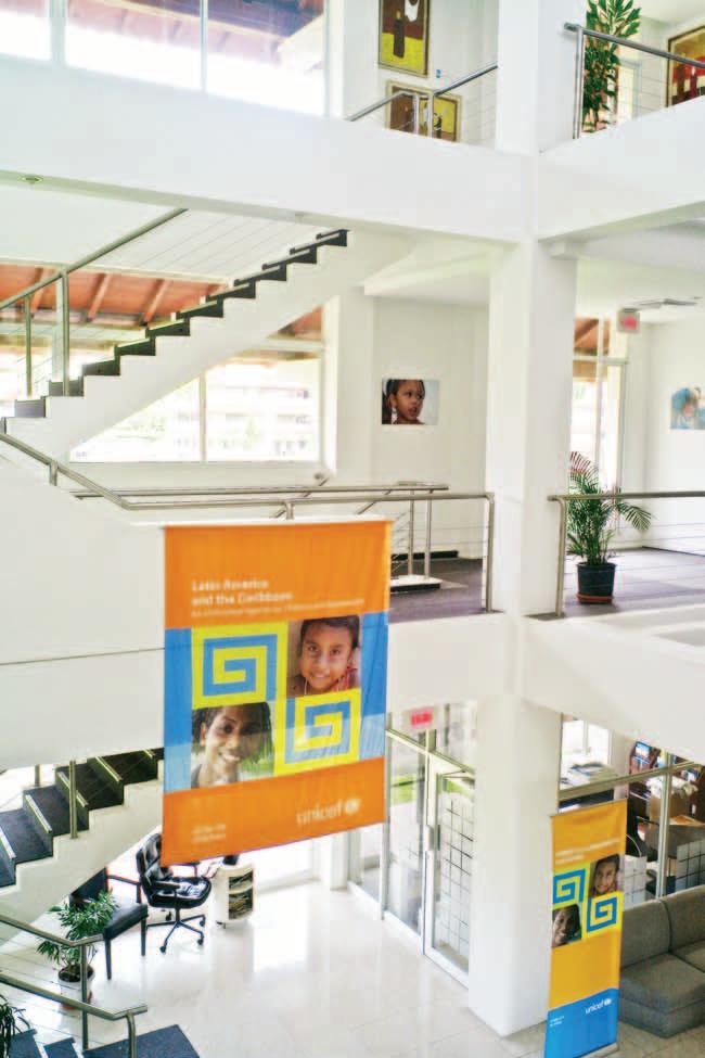
Other early interventions were those carried out in 2003 on Building 116 by Mallol & Mallol Architects for the Louis Berger Group, and on Building 129 (another barracks) by architect Terry Wong for the United Nations’ national offces.
The only new buildings that went up during those years were the headquarters for the Telecarrier Company (Mariela Sagel, 2001-2002) and COPA Airlines’ Training Center (2005-2006). The latter was designed by Mallol & Mallol, although it was substantially altered at the time of its construction.
From the beginning it was proposed that the whole northern area of the City of Knowledge, the former New Post, should house the Tecnoparque Internacional de Panamá (TIP – International Technopark of Panama), one of the City of Knowledge’s key components. The frst institutions that moved there were the SENACYTSecretaría Nacional de Ciencia y Tecnología (National Secretariat for Science and Technology) and the Centro Nacional de Meteorología de Panamá (Panama’s National Meteorology Center), both in 2000, and the frst company was Highlights of Ophthalmology in 2001. No modifcations were made to the buildings in any of these cases.


Façade of Building 110 on Vicente Bonilla Street, shortly after it was refurbished by CATHALAC in 2001. Source: City of Knowledge Foundation.
On left: Interior view of Building 102, headquarters of UNICEF’s regional ofces. Photo: K. Calvo (2010).
Image on the right: Building 116, renovated in 2003 by Mallol & Mallol Architects for the Louis Berger Group. Photo: S. Ochoa (2010).

In 2001, the City of Knowledge signed a technical assistance agreement with the European Union that had among its components the consolidation of the physical infrastructure of the Technopark and in general of the City of Knowledge. In order to carry this out, a competition was organized, which was won by the Spanish company IDOM. Among the consultants who contributed to the project was Joaquín Montero Basqueseaux, a Spanish urban planner with ample experience in the handling of technological parks in the Basque Country. The primary purpose of Montero’s visit to Panama in 2004 was to draw up a proposal for the TIP, although he also developed ideas for a future master plan for the whole City of Knowledge.
Montero defned various objectives for this plan, among them—following the line originally proposed by the AED— the transformation of Clayton into “an authentic city that will promote relationships between its users, as much through its functional organization as through its exterior spaces, in a clearly technological and tropical environment, as signs of the City of Knowledge’s own identity.”
In practice, he proposed transforming Building 104 into the “true social, administrative and representative center” of the institution, taking advantage of its privileged position facing the Central Quadrangle; he also suggested restoring the civic area (the former Enlisted Men’s Service Club, the ecumenical temple and the movie hall—Buildings 108, 109 and 182) to form a new “Center for Meetings and Congresses.” All this would come together with a reforestation plan “reinforcing the idea of the public spaces as necessary elements in the new image of the complex.” He also proposed a plan of new sidewalks to be superimposed on the existing layout.
In his report, Montero outlined some ideas for transforming the old movie theater into a congress center, and the seventeen barracks assigned to the TIP (which were evidently quite run down) into attractive “corporate buildings,” insisting on the preservation of the roofs and eaves. His drawings are eloquent: each one of the buildings would have new glassed-in structures for vertical circulation (elevators), which would symbolize the new technological and tropical image, clearly very different from that of a military base.


What to Preserve?
The criteria for interventions that are presently applied in the City of Knowledge are the result of a thought process which has involved several different stages and multiple points of view.
Since the 1990s, many different—even contradictory— approaches have been proposed for the use of the reverted areas. In the specifc case of Clayton, the people less interested in conservation criticized the waste of space, and proposed taking maximum advantage of the land, preferably with tall buildings such as those in the rest of the Panama City; for them, the historic architecture has no value whatsoever. The opposing point of view, which some criticize as being too nostalgic, favors the strict conservation of all that is there; these were the voices that at one point went so far as to criticize the demolition of the sentry box at the entrance from Omar Torrijos Herrera Avenue. In fact, most of those who declare conservationist postures merely see Clayton’s vast open spaces as a green oasis and a respite from the anguished chaos of Panama City. However, there are only very few people who give serious thought to the issues of the economic viability and the sustainability of maintaining such large unforested green areas.
After a decade of activities in the City of Knowledge, the heritage value of this historic site is widely understood, at least among more informed Panamanians. There is also an awareness regarding the increased value of this property, given the signifcant investments and improvements that have been made.
Among those at the core of the City of Knowledge Foundation there have also been countless discussions regarding preservation. How can preservation efforts be sustained? The most obvious approach is to point out that Fort Clayton is a testimony to the U.S. military presence in Panama, the history of trans-isthmian transit and of the canal itself.

At the time of the handover, the Southern Command removed most of the symbolic memorabilia on its bases, including insignias and commemorative plaques. In Clayton today, one can see empty pedestals such as the one in this photograph. Photo: S. Ochoa (2010).
Partial plan of the City of Knowledge showing conceptual proposals made by Joaquín Montero in 2004. Source: City of Knowledge Foundation.
Sketches by Joaquín Montero from 2004 showing the new glass-enclosed structures for the former New Post barracks. Source: City of Knowledge Foundation.
In 2007, the City of Knowledge Foundation demolished the sentry box located at the entrance on Omar Torrijos Herrera Avenue. Source: City of Knowledge Foundation.
FORMER NAME CURRENT NAME
Dwyer Street Calle Rosa Elena Landecho
Stevens Street Calle Ricardo Murgas Villamonte
Coiner Street Calle Jacinto Palacios Cobos
Gerrard Street Calle Ovidio Saldaña Winthrop Street Calle Víctor Iglesias
Morse Avenue Calle Alberto Oriol Tejada
Craig Avenue Calle José A. Gil
---------- Calle Víctor Manuel Garibaldo
Caples Street Calle Etanislao Orobio William Muir Avenue Calle Arnoldo Cano Arosemena
Gaillard Avenue Calle Vicente Bonilla
Hawkins Avenue Calle Carlos Renato Lara
Hamilton Place Calle Renato Lara
Landrich Place Calle Evelio Lara
Stewart Loop Calle Gonzalo Crance
Saltzman Place Calle Alberto Nichols Constance
Boyles Place Calle Teóflo Belisario de la Torre
Johnson Loop Calle José del Cid Cobos
Romero Place Calle Celestino Villarreta
Davis Loop Calle Ezequiel González Meneses
Pullen Street Pullen Street
Anderson Street Anderson Street Henry Place Henry Place
Wells Place Wells Place Riche Loop Riche Loop


This point of view allows for the development of a discourse in which Clayton fgures as an important link in the history of military architecture since the 16th century, a narrative in which frst Spain and then the United States have had prominent roles. Fort Clayton, as an example from the 20th century, would appear in this scheme together with the fortifcations in Portobelo and San Lorenzo that date from the 17th and 18th centuries and are now World Heritage Sites.
Unfortunately, in contrast with the Spanish colonial heritage, U.S. military architecture still bears the stigma of foreign occupation; only the passing of time will erase this shadow. It may not be coincidental that one of the frst gestures to make Clayton more Panamanian was the replacement of street names, which for the most part honored American military fgures, with the names of the martyrs of January 9th, 196419, a measure implemented by the Municipal Council.
Over time, the City of Knowledge Foundation has opted, in a pragmatic way and without any major ideological stances, to emphasize Clayton’s values in the areas of architecture, urban planning and landscaping. But what is special about this historic area, what distinguishes it from other sites in the former Canal Zone? Unlike the Prado in Balboa and the hospital complex in Ancon, Clayton does not display an architectural style of high aesthetic aspirations or elaborate stylistic discourses. Nor are the interiors particularly outstanding: Building 104 itself, notwithstanding its palatial façade, was
19 The “Martyrs of January 9, 1964” refers to the Panamanians who died during the riots that began that day when students at Balboa High School refused to fy the Panamanian fag next to the U.S. fag, as was required by a new treaty.

originally a large container for troops, with huge dormitory halls distributed over several stories. And let’s not forget the repetitive character of this architecture: the majority of the buildings follow a predetermined type and the landscape of tile roofs is just like in any other of the former Canal Zone bases. The extraordinary drainage system for rain water is a kind of technology that was also applied in other places. The movie theater, the gymnasium, the convention center, and the ecumenical temple are unique buildings, and deserve to be preserved as such, but they are not truly exceptional.
What are we left with? Clayton’s historic quarter’s frst distinguishing feature is its emplacement: it is bordered, on one side, by the Canal—which can be viewed from there in all its grandeur— and on the other, by the hills and forests, which contrast with the methodical layout of the urbanized areas. These are extraordinary views, which must be preserved.

Beyond this, the most outstanding feature, the one that has no equal in Panama, is the grandiose urban concept of the four large complexes created between 1919 and 1941: the remnants of the original horseshoe, the houses on Colonel’s Row, the Central Quadrangle, and the former New Post (today’s Parque de los Lagos or Lakes Park), which make up approximately sixty percent of the City of Knowledge.
View of a cruise ship crossing the Panama Canal, seen from the Alberto Oriol Tejada Street. On the left, Building 104.
Photo: E. Araújo (2010) .
Photos below: K. Calvo (2010).
This chart shows, on the left, the former names of the streets in Clayton that are located within the campus of the City of Knowledge and, on the right, the names assigned to them by Panama’s Municipal Council. They are the names of martyrs who died in the riots of January, 1964, with one exception: Arnoldo Cano Arosemena. The names of the fve streets in the lower section of the chart have not been changed.
Urban Planning, Landscape Design and Hierarchy
The three-dimensional and geometrically ordered representation of hierarchy and social order, in which each building stands out as a sculpture strategically placed within space, was obviously not invented in the Canal Zone; there are many precedents in the United States as well as in other frst-world countries. Due to their very nature, absolutist governments have always provided fertile ground for such displays.
It was in absolutist France where urban planning, landscape design and hierarchy were combined to reach their greatest expression. In the Royal Saltworks of Chaux, for example, which are today on the UNESCO’s World Heritage List, architect Claude-Nicolas Ledoux created a circular plan with buildings that varied according to their use and rank, a clear microcosmic representation of the Ancien Régime. In the center, as if in a solar system, the director’s house presides over the area.


In all four of them, even more so if we consider them as a linked whole, the outstanding features are hierarchy, order, a sense of harmony, and the fact that each unit can be appreciated as a sum of isolated elements, which are often identical or almost so, placed around large empty spaces that encourage peaceful contemplation.
In the original horseshoe, eleven similarly scaled buildings make up an arch next to the green area. From the sports felds, the curve formed by the sixteen colonels’ houses looks like a wide theatrical backdrop. In the Central Quadrangle, the eight barracks create an orthogonal plaza, the only one with this shape in all of Clayton. The space for Lakes Park is generated by the irregular polygon of seventeen barracks. These exceptional features make these four complexes very different to what was built in Clayton after 1945 20, where views and large open spaces were not considered important integrating elements.
Once the decision regarding what should be preserved has been taken, the next question is how much can (or should) be transformed.
The answers have also evolved since the presentation of Joaquín Montero’s plan. Summarizing, the transformation could be formulated as an equation that takes into account the need to preserve the described values and the need to adapt this heritage in order to fulfll the institutional mission of the City of Knowledge. The resulting changes can be considered one more chapter in a sequence that began several decades ago.
Idealized aerial perspective of the Royal Saltworks of Chaux, by Claude-Nicolas Ledoux. Engraving published by the architect in 1804.
The original Fort Clayton complex, built between 1919 and 1922, of which only twenty-six buildings remain standing. The Administration (in the center) and the four large barracks were demolished in the 1950s. Source: Vicente A. Pascual Collection.

The Heritage Issue in the Master Plan
In late 2004 there was a competition – the frst carried out by the City of Knowledge Foundation – to prepare the Master Plan for the Urban Development of the site. The company that won was Grupo Suma, S. A., directed by architect Ariel Espino. The author of this essay also took part in the project. The process of producing and discussing the document took over four years and it was fnally approved by the Dirección de Desarrollo Urbano del Ministerio de Vivienda (Department of Urban Development, Ministry of Housing) in January 2009.21
The general objective of the plan was to “establish order for the City of Knowledge’s growth, making possible the development of new structures and spaces in the campus, within an integral vision and with an adequate provision for infrastructure.” It identifes the areas that require historic preservation and the areas for expansion and densifcation for the development of new activities related to the institution’s mission. Finally, it defnes land use and establishes urban and environmental
21 The Ministry of Housing’s Resolution N°36-2009 approves the Proposal for Land Use and Zoning as well as the Circulation Plan, contained in the Scheme for the Territorial Regulation of the City of Knowledge.
regulations, along with a plan for the network of streets, pedestrian circulation and parking areas.
Within this topic, it is important to comment on the part of the plan that relates to the preservation of the main complexes and the adaptation of the existing buildings to new uses. According to the Master Plan, some of the main buildings and spaces – precisely those described above – are considered areas of mandatory preservation:
• The base’s original buildings
• The houses on the so-called Coronels’ Avenue (now called Arnoldo Cano Arosemena Street)
• The Central Quadrangle and the buildings around it, above all Building 104, headquarters of the City of Knowledge Foundation
• The barracks in Lakes Park (formerly known as New Post)
In addition:
• The area between the ecumenical temple and the pool, where the old movie theater (Building 182) stands out
• The expansion carried out in 1942-1943 (Buildings 301-340, which were originally housing units for NCOs)
For the historic buildings, the plan recommended emphasizing the features that link them to the architectural style of the Canal Zone, for which the plan demands the preservation of the clearly marked volumes, restoring the rows of windows on all the façades, and returning the eaves and the roofs to their original form, strictly prohibiting any dormer windows. It should be noted that the term used was not “restoration,” which is too strict a concept, but rather “adaptation” with greater or lesser liberties, depending on each case.
The Master Plan established provisions for increasing the built-up area by sixty percent over twenty years. The consensus was to preserve all green areas in such a way that the new buildings should be constructed on the footprints of other pre-existing structures.
The plan defned the main spaces for expansion and redensifcation: the area between the Central Quadrangle and Lakes Park, occupied mainly by utilitarian buildings of no great value, the areas defned in the Master Plan as “Hill 1” and “Hill 2”, and the Capehart Program buildings. In these areas, replacing the existing group of buildings with new ones will be permitted as long as the Master Plan’s specifed heights, locations, dimensions, and forms for each site are followed.


This layout, which appears in the City of Knowledge’s Master Plan, shows all the buildings left standing at the time of the handover of Clayton to the City of Knowledge Foundation on November 30th, 1999. In orange, the buildings and complexes identifed in the Master Plan as requiring mandatory preservation due to their historical, architectural and landscape value.
Cover of the publication of the Master Plan for the Urban Development of the City of Knowledge (January 2009).


The signage project implemented in the City of Knowledge Campus in 2007 established three areas: red, green and blue. These colors appear on the diferent supports for signs in order to make it easier to locate specifc buildings.

of simple, rectangular forms, modern materials, a contemporary architectural style (that is, without historicizing pastiches), prominent roofs and/or eaves, and horizontally placed fenestration in the façades.
Main Projects in Historic Buildings
The creation in 2006 of the Dirección de Infraestructura y Servicios (DIS - Infrastructure and Service Department) was an important step in terms of strengthening the City of Knowledge’s capacity to plan, regulate and organize the architectural, urban and landscaping activities on the campus. Since then, the DIS has developed an action plan that is conceptually based on the Master Plan and its Environmental Impact Study, as well as on the wealth of ideas and proposals developed over the years by external consultants and by the Foundation’s team. In addition, the DIS’s work program has been based on experience gained in the formation and operation of this complex, as well as the analysis of the users’ needs, without losing sight of the general panorama and tendencies of Panama’s real estate market.
In 2004, the Foundation began its frst important intervention in a historic building: the transformation of Building 105, located in the Central Quadrangle, into a Training and Business Center with the aim of satisfying the existing demand for multiple-use classrooms. With this project, which took until 2007, the institution developed a model that would later be perfected in other old barracks, in which the attic was refurbished and the central core of the building was adapted for vertical circulation and common services, spaces which would incorporate natural light and air circulation.
Due to their complexity and magnitude, as well as the transformation that they implied for the landscape of the City of Knowledge, the work that stands out most is that carried out in the section previously known as New Post, which was converted into Lakes Park. There, the ten hectares of open space, originally a completely open and inhospitable green area, is being transformed into a large park with two lakes, sidewalks for pedestrians, and a variety of trees.
In terms of remodeling the old barracks, an intervention model was designed that takes into account the need to offer spaces that are fexible enough that they can be easily adapted by their users for different purposes. In order to do this, all inner divisions were removed,
thereby restoring the building’s original open spaces, and the attics were refurbished. In addition, common facilities such as access areas and entrance halls, as well bathrooms and small patios for ducts for the buildings’ central sections, were created. In order to install elevators, glass towers were constructed outside the buildings—their fnal design was developed by the author of this book—in which low-emissivity, insulated glazing was used. Each tower was crowned with a gable roof, which echoes the slope of the original roof.
It should be noted that the original barracks were no more than large containers for people, with a limited relationship to the exterior, in spite of the fact that they included many windows for the sake of ventilation. Today, the glass towers break the sense of confnement and allow for the observation of the park with its lakes and views of the Canal, thereby generating a dialogue between the interior and the exterior that did not exist in the original architectural design. The frst building to be transformed in this manner was Building 227, the headquarters of Florida State University, which was inaugurated in late 2009. By 2010, four additional towers had been built, in such a way that the “unequivocally technological and tropical environment” which Montero had imagined had begun to take shape.


Below: Aerial view in 2010, when the Lakes Park project was initiated. Photo: K. Calvo.
Building 105, where the City of Knowledge’s Training and Business Center is located, the renovation of which was begun in 2004.
Photo: P. Tzanetatos (2009).
The Master Plan’s conceptual proposal for Lakes Park, which includes new sidewalks and changes in the landscape design.


Falta Pie
The new terrace on the recently remodeled upper foor of Building 204. Photo: S. Ochoa (2010).
For the rehabilitation of the former barracks in the New Post, all the interior divisions that were not original were removed. Photo: S. Ochoa (2010).
Building 127, newly renovated.
Photo: E. Tejeira (2010).
View from the new glass tower in Building 227, in 2010, when the Lakes Park project was iniciated. Photo: E. Tejeira.
The new glass-covered tower for elevators in Building 227. Photo: K. Calvo (2010).


The restoration of the old movie theater has been another important project, the frst phase of which began in 2010 keeping the building’s architecture just as it was at the time of its reversion to Panama. In response to the existing demand, its spacious auditorium—which has more than 700 seats—has been equipped with cutting edge audiovisual technology and its stage has been adapted for concerts and other presentations.


Photos of the diferent stages during the renovation of the former Clayton movie theater during 2010. It is now known as the Athenaeum (Ateneo of the City of Knowledge.
Photos: V. Fonseca, K. Calvo and N. Hernández.
Diferent views of the renovation of Buildings 225 and 227 for the headquarters of Florida State University. Source: City of Knowledge Foundation.


It is also important to describe the work that has been carried out in the restoration of the buildings within the base’s original “horseshoe” on Gonzalo Crance Street, buildings originally erected as housing units for offcers. In order to adapt them to their new uses and considering how deteriorated they were, it was frst necessary to restore their structural elements. In carrying out this work, the main criterion has been to respect the original architecture, as recommended in the Master Plan. An example was provided by the project for the regional offces for the United Nations Population Fund in Buildings 178 and 180, and the regional offces for the United Nations High Commissioner for Refugees in Building 171. A challenge common to the renovations of all these buildings has been adapting their main entrances to the side facing the street, onto which they originally had their back façades.
In this same group, something very close to a true restoration has been carried out on Building 173, the frst residence for Clayton’s commander, in order to transform it into a Visitors Center for the City of
Knowledge. This house, which has had a series of different users in the years since its construction in 1922, was never submitted to any major changes, and was quite well preserved at the time of the reversion, with only a few discordant elements. In order to prepare it for its new use, the living room and the dining room have been converted into reception areas, while the four bedrooms, one in each corner, have been reserved for exhibition spaces and meeting rooms. In the process of restoring its outside appearance, all windows bars were removed and its original shingle roof was restored.
Finally, we must mention the proposal for the restoration of the emblematic Building 104, where the City of Knowledge Foundation has its offces. There, a planned refurbishment will restore the exteriors and rationalize the inner distribution—12,000 square meters of useful space—which had become very confusing after many years of transformations.

On the left: Sketches by Eduardo Tejeira Davis with proposals for possible renovations based on the Master Plan. First drawing: Initial proposal for the glass-covered elevator towers in the old New Post barracks. Second drawing: Proposal for the back of the former movie theater, for which a glass covered gallery and the construction of a plaza were projected. Third drawing: Conceptual proposal for renovation of Building 104.
Below: Building 173, which was the frst commander’s residence in Clayton (see photo on page 68), has been transformed into the City of Knowledge’s Visitors Center. Photo: E. Tejeira (2012).

Towards a Sustainable City
In 2008, the Foundation organized an international architectural competition for projects for three new complexes: one in front of the arc of the original horseshoe, another in the transitional space between the Central Quadrangle and Lakes Park, where there had originally been several warehouses, large parking structures and workshops for motor vehicles, and a third complex in the commercial area. A new focus has been developed for these projects, one which attempts to harmonize the new buildings with the historic ones. In all three of them, bioclimatic and environmental sustainability considerations have been fundamental. This new twist refects the fact that the Infrastructure and Service Department of the City of Knowledge incorporated into the Master Plan the strategy of “Sustainable City” which develops a series of principles about building, space management, mobility within the campus, waste management, and communications, with the purpose of transforming the City of Knowledge into a point of reference in the matter of sustainable urban development in Panama.
All the new groups of buildings are being subjected to the LEED 22 Certifcation System, so that they are effcient in their energy and water consumption, healthy, comfortable, multi-functional, with low operating and maintenance costs, and designed to have a long useful life and a positive impact on the environment, the users, and the community.
It is important to mention at this point that in August of 2009 the process to establish the Panama Green Building Council was initiated as part of the global network of Green Building Councils, with the objective of infuencing the manner in which urban development is conceived, including the design, construction and operation of the buildings, in order to achieve environmental, social and economic sustainability. The City of Knowledge Foundation has been a promoter of this new entity and one of its founding members.
Commercial Center
In keeping with the Master Plan, the new commercial center gives priority to pedestrian access while providing an adequate number of parking spaces. The building is surrounded by sidewalks and may be accessed from all three sides. There are terraces for tables next to the surrounding sidewalks, which opens the building and its commercial establishments to pedestrian circulation and makes them visible from passing cars.
The exterior design, which is dominated by the volume of the central covered area, harmonizes with Clayton’s historic surroundings and echoes the former barracks’ large wood and tile roofs.
The building’s design incorporates the international concepts of sustainable design and “green” architecture, in keeping with the requirements of the City of Knowledge’s Master Plan. The proposal integrates elements appropriate for the humid tropics, such as patios, terraces and wide eaves. A distribution of space that allows for natural cross-ventilation and various elements for solar insulation are some of the features that the design takes into account as part of its ecological proposal.
The design of the interior is organized around inner patios that supply natural light and green areas, and gives the building a tropical character. The structure of the commercial areas is fexible in terms of the size of the space assigned to each company. A large covered terrace forms part of a sequence of common areas that contribute to the social life in the City of Knowledge.
The building of the commercial center was begun in February 2011 and will be fnished by September 2012.
Architect: Leonardo Álvarez Yepes (Colombia)


Dormitory Buildings
The dormitory complex includes eight adjoining buildings whose façades face Carlos Renato Lara Street. Towards the back, they face one of the City of Knowledge’s large green areas.
Each building is organized around a large entryway that allows for circulation towards the street and the buildings, with rooms facing the green area. Between each building there are open patios that serve as recreation areas for the students. The social areas of each building are on the ground foor, opening onto the inner patios and the green areas. The design incorporates parasols and blinds to protect the building from excessive sunlight and is based on the use of natural ventilation.


New Buildings for Offces and Laboratories
The two buildings for offces and laboratories considered in the Master Plan’s frst stage of development are located in the transition area (formerly known as the Motor Pool) between the Central Quadrangle and the Lakes Park, across from the Mirafores Locks. Projects for this sector include a built area of approximately 50,000 square meters distributed among eleven buildings that can be developed in independent stages.
This section’s urban planning prioritizes pedestrian circulation, placing the buildings in front of sidewalks and putting the parking spaces mainly in the basement of each building. Both prototype buildings have been designed with open plans, allowing fexibility in terms of the incorporation of different interior technologies, and the adaptation of the inner spaces according to each user’s needs.
The buildings’ design incorporates the international concepts of sustainable design and “green” architecture, taking into account elements that are appropriate to the humid tropics, such as wide eaves, parasols, natural cross ventilation in the common areas, energetic


Architect. Eduardo Crafg (Brazil)
Architect: Carlos Ortiz (Colombia)
The construction of the frst four dormitory buildings was begun in February 2011 and will be fnished by August 2012.


The City of Knowledge
Those who knew Fort Clayton in the 1980s and 1990s are aware that its historic quarter, which was cold, gray and impersonal, in spite of the great quality of its original architectural design, had come to look unattractive and rundown. Its most emblematic buildings had gone through all kinds of modifcations, done mostly without any sense of aesthetics, and even less historic considerations. In a way, the buildings from before World War II had become anachronistic, and were poorly suited to their new requirements.
Today, nevertheless, a signifcant part of the buildings in the City of Knowledge have been restored or will be refurbished according to an established plan. Its carefully tended landscaped areas are open to everyone and look even more attractive now than during their “golden age” sixty or seventy years ago. The programmed urban and landscaping interventions, once they have been carried out, will further transform the hardy environment of a military base into something more like a university campus or a technological park, with bicycle lanes and spaces for pedestrians.
Evidently, the atmosphere one perceives in the City of Knowledge today is very different from that of Clayton at the end of its time as a military base. Its buildings are now occupied by intellectuals and professionals linked to universities, research centers, innovation and technology companies, cooperation organizations, and international NGOs. The City of Knowledge of today is a real place, a site with its own history and identity, the opposite of the impersonal and uniform “non-places” (to use the term coined by the famous French anthropologist Marc Augé) that continue to appear in increasing numbers all around us.

Photos: W. Araújo, P. Tzanetatos, C. Schriefer.

View of the audience at one of the events of the Summer Cultural Program at the City of Knowledge.
Photo: Christian Schriefer (2011).
Bibliography
Abbot, Willis J. Panama and the Canal in Picture and Prose. New York: Syndicate Publishing Company, 1914 Academy for Educational Development. Feasibility Study for City of Knowledge. Washington, unpublished document,1996
Avery, Ralph Emmett. The Greatest Engineering Feat of the World at Panama. New York: Leslie-Judge Company, 1914
Beleño, Joaquín. Gamboa Road Gang: los forzados de Gamboa. Panama: Manfer, S. A., 1991 (originally published in 1959)
Beleño, Joaquín. Luna verde. Panama: Editora Panamá América, 1951
Biesanz, John and Mavis. The People of Panama. New York: Columbia University Press, 1955
Bishop, Joseph Bucklin and Farnham Bishop. Goethals. Genius of the Panama Canal. New York: Harper & Brothers, 1930
Bullard, Arthur. Panama. The Canal, the Country and the People. New York: Macmillan, 1914
The Canal Record. Weekly magazine of the Isthmian Canal Commission, published in Balboa Heights
The Panama Canal Review. Monthly magazine of the Panama Canal Company, published in Balboa Heights
Collins, John O. The Panama Guide. Mount Hope: ICC Press, 1912
Connif, Michael. Black Labor on a White Canal.1904-1981. Pittsburgh: Pittsburgh University Press, 1985
Donoghue, Michael E. Imperial Sunset : Race, Identity, and Gender in the Panama Canal Zone, 1939-1979 Doctoral Thesis, University of Connecticut, 2006
Enscore, Susan, et al. Guarding the Gates. The Story of Fort Clayton – Its Setting, Its Architecture, and Its Role in the History of the Panama Canal. USARSO, 2000
Franck, Harry Alverson. Zone Policeman 88; a Close Range Study of the Panama Canal and its Workers. New York: The Century Co., 1913
Goethals, George W. Government of the Canal Zone. Princeton: Princeton University Press, 1915
Greene, Julie. The Canal Builders: Making America’s Empire at the Panama Canal. New York: The Penguin Press, 2009
Grupo Suma, S.A. Plan maestro de desarrollo urbano de la Ciudad del Saber. Panama: unpublished document, 2009
Gutiérrez, Samuel. Arquitectura de la época del Canal, 1880-1914. Panama: EUPAN, 1984
---. Arquitectura panameña. Descripción e historia. Panama: Editorial Litográfca, S. A., 1966
---. Ciudad jardín y arquitectura tropical en el entorno del canal. Conference delivered at the VI National Architecture Congress. Panama: Grupo JorSal, S. A., 1993
Johnson, Suzanne P. (comp.). An American Legacy in Panama. USARSO, n.d.
Johnson, Suzanne P. (comp.). A History of Fort Amador and Fort Grant. USARSO, n.d.
Johnson, Suzanne P. (comp.). A History of Quarry Heights Military Reservation. USARSO, n.d.
Knapp, Herbert y Mary. Red, White and Blue Paradise. The American Canal Zone at Panama. San Diego: Harcourt, Brace and Janovich, 1984
Lachman, Rubén, Melissa Vallarino and Jorge Riba. Micro - plan de uso de Clayton para la Fundación Ciudad del Saber. Panama, unpublished document, 1997
Lloyd, John A. «Notes Respecting the Isthmus of Panama», The Journal of the Royal Geographical Society of London, Vol. 1, 2nd edition, London, 1833
Major, John. Prize Possession. The United States and the Panama Canal, 1903-1979. Cambridge: Cambridge University Press, 1993
McCullough, David. The Path Between the Seas. New York: Simon & Schuster, 1977
McGovern, Terrance. The American Defences of the Panama Canal. London: The Fortress Study Group, 1999
Meding, Holger. Panama. Staat und Nation im Wandel (1903-1941). Cologne, Weimar and Vienna: Böhlau Verlag, 2002
Message from the President of the United States Transmitting a Report by the Commission of Fine Arts in Relation to the Artistic Structure of the Panama Canal. Washington: Government Printing Ofce, 1913
Ministerio de Vivienda (MIVI). «Normas especiales para mantener el carácter de ciudad jardín en la región interoceánica». Panama: Gaceta Ofcial No. 24,130, September 1, 2000
Ministerio de Vivienda (MIVI). Resolution No. 36-2009. Panama, 2009
Oran (Fessenden N. Otis’s pseudonym). “Tropical Journeyings”. In: Harper’s New Monthly Magazine. Nº CIV, Vol. XVIII, New York: January, 1859
Otis, Fessenden N. Illustrated History of the Panama Railroad. New York: Harper & Brothers, 2nd edition, 1862
Reese, Carol y Thomas. “The Canal Zone and its Legacies,” in 8ª Bienal de Arte de Panamá. Entrar en la Zona del Canal (in press).
Tejeira, Gil Blas. Pueblos perdidos. Panama: Impresora Panamá, 1962
Tejeira Davis, Eduardo. The Architecture of the Panama Canal: Colonialism, Syncretism and Coming to Terms with the Tropics. In: Tzonis, et al., 2001: 154f. (see below)
----. The Panama Canal Area Workshop File. Unpublished document, Monterrey, 2002
----. Panamá. Guía de arquitectura y paisaje. Seville: Junta de Andalucía, 2007
Tzonis, Alexander, Liane Lefaivre and Bruno Stagno (eds.). Tropical Architecture. Critical Regionalism in the Age of Globalization. London: Wiley-Academy, 2001
UNESCO. Ciudad del Saber: una utopía posible. San Jose, Costa Rica, 1996
Ugarte, Jimena. Arquitectura tropical – Tropical architecture. San Jose, Costa Rica: IAT, 2008
USARSO. Historic Properties Management Plan for the U. S. Army South. Unpublished report, 1996
Verrill, A. Hyatt. Panama of Today. New York: Dodd, Mead & Co, 1927
Wagner, Moritz. Beiträge zu einer physisch-geographischen Skizze des Isthmus von Panama. Gotha: Justus Perthes, 1861
World Heritage Committee. Operational Guidelines for the Implementation of the World Heritage Convention UNESCO / WHC, 2008 (see whc.unesco.org)

View of the audience at one of the events of the Summer Cultural Program at the City of Knowledge. (Festival Verde de Cultura Musical) Photo: G. Barrios Altafulla, 2012.

